
Los Alamos County Unincorporated
City Zoning Code
City Zoning Code
ARTICLE II
ZONE DISTRICTS
DIVISION 1. - ZONE DISTRICTS ESTABLISHED
(a)
The following zone districts and overlay zones as shown in Table 1, Zone Districts are hereby established, together with appropriate abbreviations, which may appear on the official zoning map and elsewhere within this development code. Portions of lots within the public right-of-way shall be designated as Unclassified (UNCL) on the official zoning map.
(b)
The overlay zones supplement, but do not replace, the underlying zone districts. In the case of a conflict between the provisions of a zone district and the provisions of an overlay zone, the provisions of the overlay zone shall prevail. Where multiple overlay zones apply to a property, development must comply with all relevant provisions.
DIVISION 3. - SUMMARY TABLES OF BASE ZONE DISTRICT DIMENSIONAL STANDARDS
(Ord. No. 02-342, § 2, 5-2-2023)
Sec. 16-3. - Adoption of the official zoning map.
(a)
The official zoning map is an integral part of this article. It is to be entitled the "Official Zoning Map of Los Alamos County," signed by the chair of the county council and attested to by the county clerk.
(b)
The official zoning map and all revisions shall be maintained in the office of the county clerk. This map, as it may from time to time be revised, or a copy certified by the county clerk to be a true copy of the map or of the map as revised, shall be conclusive on any question of the zone district in which a particular parcel may be located.
(c)
The official zoning map may be amended by an ordinance containing only textual material, or by an ordinance containing textual material and a revision of all or part of the official zoning map. If the amending ordinance contains only textual material, then such amending ordinance shall bear the legend "Revision No._______in textual form, to the Official Zoning Map of Los Alamos County, effective_______." In addition, such changes shall be made to the official zoning map. This is to be signed by the community development director and attested to by the county clerk. If the amending ordinance shall include a revision to all or part of the official zoning map, such amending ordinance shall bear the legend "Revision No._______to the Official Zoning Map of Los Alamos County, effective________," and it shall be signed by the chair of the county council and attested to by the county clerk. In addition, such changes shall be made to the official zoning map. In the event that the official zoning map becomes damaged, destroyed, lost, or difficult to interpret because of the nature or number of amendments, the county council may by resolution adopt a replacement official zoning map which shall supersede the prior official zoning map and shall be identified by the signature of the county council chair.
Sec. 16-4. - Interpretation of zone district boundaries.
Where uncertainty exists as to the boundaries of zone districts as shown on the official zoning map, the following rules shall apply:
(a)
Boundaries indicated as approximately following the centerlines of streets, highways, or alleys shall be construed to follow such centerlines;
(b)
Boundaries indicated as approximately following platted lot lines shall be construed as following such lot lines;
(c)
Boundaries indicated as approximately following county limits shall be construed as following such county limits;
(d)
Boundaries indicated as being an extension of any street, highway, alley line, or lot line shall be construed to be of the same course and bearing as that line extended;
(e)
Distances not specifically indicated on the official zoning map shall be determined by the scale of the map; and
(f)
Where physical or cultural features existing on the ground are at variance with those shown on the official zoning map, or in other circumstances not covered by this section, the planning and zoning commission shall interpret the zone district boundaries.
Sec. 16-5. - Residential zone districts.
(a)
Residential agricultural zone district (RA). The residential agricultural (RA) zone district is intended to accommodate and preserve rural residential and agricultural land uses that are characterized by low-density single-family residential uses on large lots where agricultural, horticultural, and animal husbandry activities may be pursued by the residents for personal use.
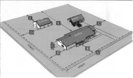
(1)
RA zone district standards.
a.
Animal husbandry activities are permitted, provided they comply with the requirements of chapter 6, Animals.
b.
A maximum of five accessory structures including any carports or garages shall be permitted per lot provided they comply with the following standards:
1.
Except as allowed otherwise below, any accessory structures shall comply with the standards of section 16-18(b).
2.
Accessory structures within the RA zone district are permitted to be a maximum of 20 feet in height.
c.
The use of barbed wire, razor wire, or barbed tape is permitted in the rear yard provided it is not located on lot lines, abutting equestrian trails, public rights-of-way, or county-owned lands and complies with the standards of section 16-59(b).
d.
Not more than one principal dwelling shall be permitted on any parcel, except in the case of cottage development, which shall comply with the standards of section 16-15(a).
(b)
Residential estate zone district (RE). The residential estate (RE) zone district is intended to accommodate semi-rural residential uses characterized by low-density single-family dwellings on large lots.
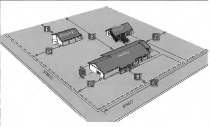
(1)
RE zone district standards.
a.
A maximum of five accessory structures including any carports or garages shall be permitted per lot provided they comply with the following standards:
1.
Except as allowed otherwise below, any accessory structures shall comply with the standards of section 16-18(b).
2.
Accessory structures within the RE zone district are permitted to be a maximum of 20 feet in height.
b.
Not more than one principal dwelling shall be permitted on any parcel, except in the case of cottage development, which shall comply with the standards of section 16-15(a).
(c)
Single-family residential zone districts (SFR-1-6). The single-family residential (SFR-1, SFR-2, SFR-3, SFR-4, SFR-5, SFR-6) zone districts are intended to accommodate single-family dwellings with a variety of lots sizes and dimensions in established neighborhoods to maintain and protect their character.
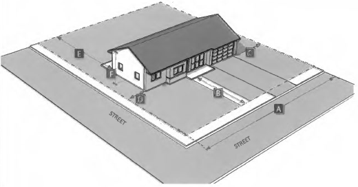
(1)
SFR zone district standards.
a.
All SFR zone districts.
1.
Not more than one principal dwelling shall be permitted on any parcel, except in the case of cottage development, which shall comply with the standards of section 16-15(a).
2.
A maximum of three accessory structures including any carports or garages shall be permitted per lot provided they comply with the following standards:
i.
Except as allowed otherwise below, any accessory structures shall comply with the standards of section 16-18(b).
ii.
Accessory structures are permitted to be located within the required rear setback area, provided that the square footage of the structures shall not exceed 25 percent of the total coverage of the required rear setback area.
b.
SFR-5 zone district. Covered patios, porches, or decks attached to the main structures may extend to a maximum of 40 percent of the distance into the required rear setback area provided they meet the following standards:
1.
The space under the cover is open on at least three sides,
2.
The structure shall not encroach more than five feet into the required front setback area, and,
3.
The eave of the structure shall not project more than two feet into any required setback area.
(d)
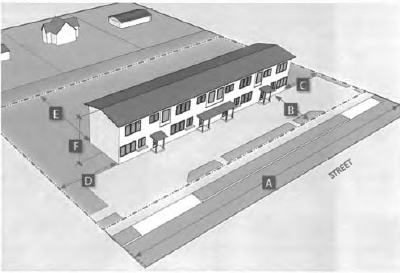
Residential mixed zone district (RM). The residential mixed (RM) zone district is intended to accommodate a variety of low- to medium- density residential dwellings characterized by single-family, duplex, fourplex, and townhouse dwellings.
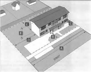
(1)
RM zone district standards.
a.
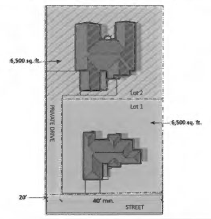
A single-family dwelling on a flag lot is permitted within the RM zone district, provided it complies with the regulations outlined in Table 6: RM Flag Lot Standards.
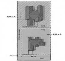
b.
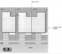
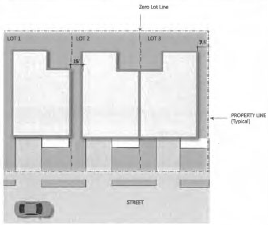
A single-family dwelling on a zero lot is permitted within the RM zone district, provided it complies with the regulations outlined in Table 7: RM Zero Lot Standards.
c.
A maximum of four accessory structures including any carports or garages shall be permitted per lot provided they comply with the following standards:
1.
Except as allowed otherwise below, any accessory structures shall comply with the standards of section 16-18(b).
2.
Accessory structures are permitted to be located within the required rear setback area, provided that the square footage of the structures shall not exceed 25 percent of the total coverage of the required rear setback area.
(e)
Multi-family residential-low zone district (MFR-L). The multi-family residential-low (MFR-L) zone district is intended to accommodate a variety of low- to medium-density housing options characterized by single-family, duplex, fourplex, and townhouses, and small-scale multi-family dwelling types.
(1)
MFR-L zone district standards.
a.
A single-family dwelling on a flag lot is permitted within the MFR-L zone district, provided it complies with the regulations outlined in Table 9: MFR-L Flag Lot Standards.
b.
A single-family dwelling on a Zero lot is permitted within the MFR-L zone district, provided it complies with the regulations outlined in Table 10: MFR-L Zero Lot Standards.
c.
Minimum common open space shall be provided per any applicable standards for the residential uses provided on site pursuant to use-specific standards in section 16-15.
d.
A maximum of three accessory structures including a carport or garage are permitted per lot, provided they comply with the standards of section 16-18(b). Accessory structures within the MFR-L zone district shall not exceed a maximum height of 12 feet.
(f)
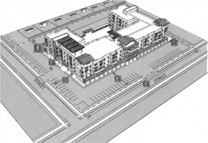
Multi-family residential-medium zone district (MFR-M). The multi-family residential-medium (MFR-M) zone district is intended to accommodate medium-density multi-family housing options, including single-family, duplex, fourplex and townhouse dwellings. The MFR-M zone district may include limited civic and institutional uses and incidental or accessory uses that serve the surrounding residences. This zone district can also serve as a transition between medium-and high-density residential zone districts and other multi-family and/or mixed-use zone districts.
(1)
MFR-M Zone district standards.
a.
Minimum common open space shall be provided per any applicable standards for the residential uses provided on site pursuant to use-specific standards in section 16-15.
b.
A maximum of one accessory structure per ten dwelling units in addition to carports or garages shall be permitted provided they comply with the standards in section 16-18(b).
(g)
Multi-family residential-high zone district (MFR-H). The multi-family residential-high (MFR-H) zone district is intended to accommodate high-density multi-family residential developments characterized primarily by apartments or condominiums, with limited single-family, duplex, fourplex, and townhouse dwellings. The MFR-H zone district may include limited civic and institutional uses and incidental or accessory uses that serve the surrounding residences. This zone district can also serve as a transition between other multi-family, commercial, or mixed-use zone districts.
(1)
MFR-H zone district standards.
a.
Where abutting or adjacent to any residential zone district other than MFR-H, the development shall comply with the neighborhood protection standards of section 16-43.
b.
Minimum common open space shall be provided per any applicable standards for the residential uses provided on-site pursuant to use-specific standards in section 16-15.
c.
A maximum of one accessory structure per ten dwelling units in addition to carports or garages shall be permitted per dwelling site provided they comply with the standards of section 16-18(b).
(h)
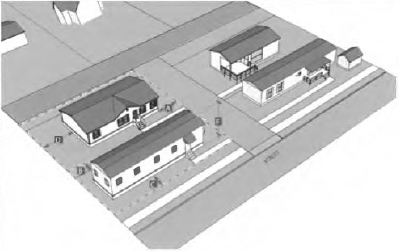
Manufactured home community zone district (MHC). The manufactured home community (MHC) zone district is intended to accommodate manufactured home communities as the predominant residential use alongside other complementary accessory and non-residential activities, which primarily serve residents of manufactured home communities.
(1)
MHC zone district standards.
a.
Manufactured and mobile homes that are not installed on a permanent foundation shall be skirted with materials similar in color, materials, and appearance to the siding of the manufactured or mobile home.
b.
Recreational vehicles may be used as a permanent dwelling in the MHC zone district through the issuance of a conditional use permit per section 16-74(b).
c.
A minimum ten foot separation shall be maintained between all dwellings, including any habitable additions.
d.
A maximum of three accessory structures including any carports or garages shall be permitted per dwelling site provided they comply with the following standards:
1.
Accessory structures themselves comply with the standards of section 16-18(b).
2.
The combined lot coverage of all accessory structures located in the required rear yard shall not exceed 25 percent of the required side and rear setback areas of individual manufactured or mobile home sites.
3.
Each accessory structure shall not be located within 20 feet of the front property line or within 20 feet of a community roadway or three feet of a mobile home community boundary.
4.
Each accessory structure shall be located a minimum three feet from the side and rear community boundary.
e.
All utilities shall be provided to each dwelling site.
f.
All interior, private drives shall provide a minimum 25 foot roadway width including appropriate curbing. No parking of vehicles or storage shall be permitted on the internal roadways.
g.
Off-street parking shall be provided in the amount of one space per dwelling site, plus one guest space for every five mobile home sites.
h.
A minimum eight percent of the total project site where homes are not located on individual lots shall be dedicated to common residential amenities that comply with the standards of section 16-18(l).
i.
Where a manufactured home community abuts a public street, a minimum ten foot wide landscape area shall be developed along the linear length of the street frontage.
j.
Any property line that abuts any residential zone district other than the MHC zone district shall be screened per a Type A buffer in section 16-43.
Sec. 16-6. - Mixed-use zone districts.
(a)
Mixed-use zone district (MU). The mixed-use (MU) zone district is intended to accommodate a vertical or horizontal mix of low- to medium-density residential, office, and commercial land uses outside of the DTLA and WRTC zone districts characterized by more walkable development patterns that are compatible in scale and character with surrounding neighborhoods.
(1)
MU zone district standards.
a.
Where abutting or adjacent to any residential zone district other than MFR-M, MFR-H, and MHC, the development shall comply with the neighborhood protection standards of section 16-43.
b.
Required off-street parking shall be allowed a 25 percent reduction of the amount required in Table 27: Minimum Off-Street Parking Requirements of the off-street parking, loading and queuing section.
c.
Minimum common open space shall be provided per any applicable standards for the residential uses provided on site pursuant to use-specific standards in section 16-15 may be reduced by 50 percent.
d.
A maximum of one accessory structure per ten dwelling units in addition to carports or garages shall be permitted per lot provided they comply with the standards in section 16-18(b).
e.
Accessory structures are permitted to be located within the required rear setback area, provided that the square footage of the structures shall not exceed 25 percent of the total coverage of the required rear setback area.
(b)
White Rock town center zone district (WRTC). The White Rock town center (WRTC) zone district is intended to accommodate a vertical or horizontal mix of low- to medium-density residential, office, and commercial land uses with walkable and active streetscapes within the White Rock town center.
(1)
Applicability. The standards contained in this section shall apply to all new construction, redevelopment, and expansions of existing structures by 25 percent or more of the building floor area on the properties within the White Rock town center as mapped in the official zoning map.
(2)
Purpose. The purpose of this section is to implement the vision established in the White Rock town center master plan by:
a.
Allowing for the compatible integration of residential, civic, commercial, and office uses on a single project site with active commercial and retail uses along arterial and collector street frontages and residential uses above the ground floor or behind a commercial building that fronts the street;
b.
Encouraging a greater intensity of development to attract the people and commerce necessary to create a vibrant and diverse town center; and
c.
Encouraging planning, design, and detailing that reflects pedestrian needs, establishes multi-modal circulation opportunities, and creates memorable civic spaces.
(3)
WRTC zone district standards.
a.
Streetscape design.
1.
Any streetscape improvements within the WRTC zone district shall provide for a minimum six-foot landscape strip and an eight-foot sidewalk to accommodate street trees in the landscape zone and buffer pedestrians from traffic for a pedestrian-oriented environment.
2.
On-street parallel parking spaces at a minimum size of eight feet by 20 feet shall be included on all WRTC zone district streets, except State Road 4, to the maximum extent feasible.
3.
All street furnishings such as streetlights, benches, trash receptacles, and bike racks shall be consistent in appearance to ensure the establishment of a cohesive White Rock town center identity.
4.
Lots abutting a public street are required to provide street trees at a minimum of 25 feet on center on average when mature.
b.
Site design.
1.
On-site pedestrian walkways shall be provided in accordance with division 2, Access and Connectivity and shall be emphasized with landscaping, signage, striping, or decorative hardscape.
2.
Driveways, parking areas, and traffic circulation patterns shall be designed as shared facilities whenever feasible. The design of these elements shall create a unified site plan between the lots in order to gain parking efficiencies, reduce the number of access points, and improve internal and external vehicular circulation patterns.
3.
Multiple building developments shall orient buildings toward and reinforce the corners at major intersections, primary vehicular or pedestrian entrances, public spaces, or other on-site amenities to the maximum extent feasible.
4.
All buildings shall have at least one primary building entrance oriented toward an abutting public street or private street, open space, or toward on-site pedestrian walkways that connect to a public sidewalk to the maximum extent feasible.
5.
Lots abutting Bonnie View Dr. shall orient buildings to address the street as the primary frontage with primary entrances, façade articulation, and glazing standards per section 16-6(b)(3)g.
6.
Lots abutting State Road 4 shall orient buildings to address the street as the primary frontage with primary entrances, façade articulation, and glazing standards per section 16-6-(b)(3)g.
7.
On lots abutting State Road 4, a maximum of one bay of parking (i.e. one drive aisle parked on both sides) is permitted between the front of the building and the street. All other parking shall be located at the rear and sides of buildings.
8.
All service areas (e.g. loading docks, storage yards and trash compactors/dumpsters) should be located in either the rear of the lot or behind the principal structure and/or visually screened so they are out of sight of a public street.
c.
Off-street parking.
1.
Required off-street parking shall be allowed a 25 percent reduction of the amount required in Table 27 Minimum Off-Street Parking Requirements of the Off-Street Parking, Loading and Queuing Section, with the exception of multi-family dwelling uses which shall be required to provide no less than one parking space per dwelling unit.
2.
Parking lots containing 150 or more parking spaces shall divide the parking lot into separate areas each containing less than 150 spaces that are separated from each other by a building, an internal landscaped street, landscaped areas, or landscaped pedestrian walkways to minimize the perceived scale of the parking lot.
3.
Surface parking lots located along public streets shall be screened by a minimum six-foot landscaping buffer or a masonry wall that is at least three feet but not more than four feet high.
4.
Parking structures shall not include any façade that extends longer than 40 feet in horizontal length without the inclusion of architectural elements such as decorative grillwork, louvers, translucent screens, alternating building materials, projection of lintels and portals, and other external features to avoid visual monotony. A change in color alone does not satisfy this requirement.
d.
Neighborhood protection standards.
1.
Multi-family, mixed-use, and non-residential developments abutting low-density residential or the HP-O zone district shall comply with the neighborhood protection standards of section 16-43.
2.
For the purpose of this subsection, low-density development is considered any lot in the RA, RE, SFR, and RM zone districts.
e.
Landscaping, screening and buffering.
1.
Lots abutting a public street shall provide street trees and/or front setback area landscaping per section 16-39(e).
2.
If the proposed lot coverage exceeds 75 percent, the required net lot area requirements of section 16-39(a) may be eliminated, provided required buffering of section 16-43 is met as applicable.
f.
Open space.
1.
Required common residential open spaces for any residential uses as required in section 16-15 may be reduced by 50 percent.
2.
Open spaces such as patios or plazas, shall be distinguishable to allow for safe and well-defined areas of seating or gathering outside of designated vehicular traffic flow. These areas shall be defined with landscape elements, low seat walls, benches, planters, paving patterns, or materials distinguishable from the pedestrian sidewalk, on-site pedestrian walkways and parking areas.
3.
Outdoor dining areas located in the public right-of-way are permitted provided this use shall require a conditional use permit pursuant to the requirements of section 16-74(b) and must comply with the standards of section 16-18(n).
g.
Building design.
1.
The first floor of any street-facing façade shall contain a minimum 20 percent of its surfaces in transparent windows and/or doors.
2.
Building projections, including but not limited to, arcades, balconies, bay windows and cornice features, open porches, canvas-type awnings, and projecting signs may encroach up to ten feet over the public right-of-way provided they have a clearance of ten feet above the sidewalk.
3.
Any portion of a building over 38 feet tall shall incorporate a minimum stepback of ten feet from any front façade facing a public street.
4.
The primary entrance to a building shall be clearly distinguishable from the rest of the building by transparent windows, materials, size, projections or recessions, or other techniques.
5.
Each street-facing façade shall incorporate façade articulation and design techniques such as offsets, recesses, projections, changes in color or materials, or architectural elements such as windows/doors, building projections, or weather protection elements such as sunshades, awnings, or trellises at intervals of every 50 linear feet of the façade to reduce the perceived massing of the building and add visual interest. Side or rear frontage may increase the articulation interval to no more than 100 feet.
6.
All buildings shall use materials that are durable, easily and economically maintained, and of a quality that will retain their appearance over time.
7.
Higher quality building materials and details should be used on building façades facing public streets, internal streets, public spaces, and at primary building entrances and may be transitioned to more economical materials on the side, rear, and service side(s) of the building.
8.
Rooftop-mounted equipment and ground-mounted utilities shall be screened from view from public streets and adjacent properties per section 16-40(d).
(c)
Downtown Los Alamos zone district (DTLA). The downtown Los Alamos (DTLA) zone district is intended to accommodate a vertical or horizontal mix of medium- to high-density residential, office, and commercial land uses with walkable and active streetscapes.
(1)
Applicability. The standards contained in this section shall apply to all new construction and expansions of existing structures by 25 percent or more of building floor area on any property within downtown Los Alamos as mapped in the official zoning map.
(2)
Purpose. The purpose of this section is to implement the vision established in the Los Alamos downtown master plan by:
a.
Allowing for the compatible integration of residential, civic, commercial, and office uses on a single project site with active commercial and retail uses along arterial and collector street frontages and residential uses above the ground floor or behind a commercial building that fronts the street;
b.
Encouraging a greater intensity of development to create a vibrant and diverse urban center;
c.
To provide cohesive and visually interesting building façades in downtown Los Alamos, particularly along the ground floor; and
d.
Encouraging planning, design, and detailing that reflects pedestrian needs, establishes multimodal circulation opportunities, and creates memorable civic spaces.
(3)
DTLA zone district standards.
a.
Streetscape design.
1.
Any streetscape improvements along Central Avenue shall, to the maximum extent feasible, provide a consistent 22 foot frontage zone treatment, to ensure a cohesive Main Street streetscape treatment. This dimension allows for a six-foot curb zone, a six-foot landscape strip, and a ten foot sidewalk.
2.
Any streetscape improvements along all other DTLA zone district streets should mimic the frontage zone described above to the maximum extent feasible, but at minimum provide a six-foot landscape strip and eight foot sidewalk to accommodate street trees in the landscape zone and buffer pedestrians from traffic.
3.
All street furnishings such as streetlights, benches, trash receptacles, and bike racks shall be consistent in appearance to ensure the establishment of a cohesive downtown Los Alamos identity.
4.
On-street parallel parking spaces at minimum size of eight feet by 20 feet shall be included on all DTLA zone district streets, except Trinity Drive, to the maximum extent feasible.
5.
Lots abutting a public street are required to provide street trees at a minimum of 25 feet on center on average when mature.
b.
Site design.
1.
On-site pedestrian walkways shall be provided in accordance with section 16-25(f) and shall be emphasized with landscaping, signage, striping, or decorative hardscape.
2.
Driveways, parking areas, and traffic circulation patterns shall be designed as shared facilities whenever feasible. The design of these elements shall create a unified traffic circulation layout amongst adjacent lots in order to gain parking efficiencies, reduce the number of access points, and improve internal and external vehicular circulation patterns.
3.
New buildings shall orient toward and reinforce the corners of major intersections, primary vehicular or pedestrian entrances, public spaces, or other on-site amenities to the maximum extent feasible.
4.
Unless otherwise exempted by this Code, any building on a lot abutting a public street shall set the front street-facing façade back no more than 15 feet from the property line in order to address the street and reinforce the street edge. No parking areas shall be permitted between the façade and the front property line.
5.
Any building on lots abutting Trinity Drive shall set the front street-facing façade back no more than 100 feet to accommodate one bay of parking (i.e. one drive aisle parked on both sides) between the front of the building and the street. All other parking areas shall be located at the rear and sides of buildings.
c.
DTLA site orientation standards.
1.
All buildings shall have at least one primary building entrance oriented toward an abutting public street or private street, open space, or toward an on-site pedestrian walkway that connects to a public sidewalk.
2.
The maximum front setback may be increased by ten feet if open spaces, such as a courtyard, plaza, or outdoor dining area is provided within the front setback area.
3.
Interior side setbacks on all lots may be reduced to zero feet provided fire walls per the building code are provided between adjoining buildings on separate lots.
d.
Off-street parking.
1.
Required off-street parking shall be provided at 50 percent the amount required in Table 27 Minimum Off-street parking Requirements of the Off-street parking, Loading and Queuing Section, with the exception of multi-family dwelling uses which shall be required to provide no less than one parking space per dwelling unit.
2.
Off-street parking lots are to be located behind or to the side of primary buildings. Unless otherwise exempted in this Code, parking between the front property line and the building is specifically prohibited.
3.
Lots abutting Trinity Drive may provide a maximum of one bay of parking (i.e. one drive aisle parked on both sides) between the front of the building and the street. All other parking shall be located at the rear and sides of buildings.
4.
Access to parking facilities shall be provided from secondary or side streets versus the primary frontage unless no other alternative is feasible.
5.
Surface parking lots located along public streets shall be screened by a minimum six-foot landscaping buffer or a masonry wall that is at least three feet but not more than four feet high.
6.
Parking lots containing 150 or more parking spaces shall divide the parking lot into separate areas each containing less than 150 spaces that are separated from each other by a building, an internal landscaped street, landscaped areas, or landscaped pedestrian walkways to minimize the perceived scale of the parking lot.
7.
All street-facing parking structure façades shall not extend longer than 40 feet in horizontal length without the inclusion of architectural elements such as decorative grillwork, louvers, translucent screens, alternating building materials, projection of lintels and portals, and other external features to avoid visual monotony. A change in color alone does not satisfy this requirement.
e.
Neighborhood protection standards.
1.
Multi-family, mixed-use, and non-residential developments abutting low-density residential or the HP-O zone district shall comply with the neighborhood protection standards of section 16-43.
2.
For the purpose of this subsection, low-density development is considered any lot in the RA, RE, SFR, and RM zone districts.
f.
Landscaping, screening and buffering.
1.
Lots abutting a public street shall provide street trees and/or front setback area landscaping per section 16-39(e).
2.
Lots that exceed a lot coverage of 75 percent may eliminate the required net lot area requirements of section 16-39(a) provided the required buffering of section 16-43 is met.
3.
Rooftop-mounted equipment and ground-mounted utilities shall be screened from view from public streets and adjacent properties per section 16-40.
g.
Open space.
1.
Required common residential open spaces for any residential uses as required in section 16-15 may be reduced by 50 percent.
2.
Open spaces such as patios or plazas shall be distinguishable to allow for safe and well-defined areas of seating or gathering outside of designated vehicular traffic flow. These areas shall be defined with landscape elements, low seat walls, benches, planters, paving patterns, or materials distinguishable from the pedestrian sidewalk, on-site pedestrian walkways, and parking areas.
3.
Outdoor dining areas located in the public right-of-way are permitted provided this use shall require a temporary use permit pursuant to the requirements of section 16-73(o) and must comply with the standards of section 16-19(k).
4.
A north-south network of pedestrian paths or paseos is envisioned to break up the large parcels between 9th and 20th Streets to provide a more walkable pedestrian scale. Development that provides paseos may utilize this square footage toward any required open space provisions provided they comply with the standards below:
i.
A paseo shall be at least 20 feet in width and maintain an unobstructed circulation path at least five feet in width.
ii.
Paseos that form a continuous pedestrian network over multiple blocks should have continuity of street furnishing and paving type/texture.
iii.
Façades fronting paseos should incorporate adequate design detailing (storefronts, doors and/or windows, and accompanying trim, tile mosaics, wall fountains, etc.) that make them inviting for pedestrians.
h.
Building design.
1.
The first floor of any front street-facing façade shall contain a minimum 30 percent of its surfaces in transparent windows and/or doors.
2.
Building projections such as balconies, bay windows and cornice features, open porches, canvas-type awnings, and projecting signs may encroach up to ten feet over the public right-of-way provided an encroachment permit pursuant to section 16-73(d) is obtained and a clearance of ten feet above the sidewalk is maintained.
3.
Any portion of a building over 38 feet tall shall incorporate a minimum stepback of ten feet from any façade facing a public street.
4.
The primary entrance to a building shall be clearly distinguished from the rest of the building by transparent windows and doors, materials, size, projections or recessions, or other techniques.
5.
Each street-facing façade shall incorporate façade articulation and design techniques such as offsets, recesses, projections, changes in color or materials, or architectural elements such as windows/doors, building projections, or weather protection elements such as sunshades, awnings, or trellises at intervals of every 50 linear feet of the façade to reduce the perceived massing of the building and add visual interest. Side or rear frontage may increase the articulation interval to no more than 100 feet.
6.
All buildings shall use materials that are durable, easily and economically maintained, and of a quality that will retain their appearance over time.
7.
Higher quality building materials and details should be used on building façades facing public streets, internal streets, public spaces and at primary building entrances and may be transitioned to more economical materials on the side, rear, and service side(s) of the building.
(Ord. No. 02-342, § 1, 5-2-2023; Ord. No. 02-343, §§ 1, 2, 5-23-2023; Ord. No. 02-370, § 1, 10-7-2025)
Sec. 16-7. - Non-residential zone districts.
(a)
Professional office zone district (PO). The professional office (PO) zone district is intended to accommodate a variety of professional uses such as office, institutional, or research and development activities. This district also is intended to accommodate secondary uses that complement or support the primary workplace uses, such as hotels, restaurants, personal services, and childcare.
(1)
PO zone district standards.
a.
Where abutting or adjacent to any residential zone district other than MFR-M, MFR-H, and MHC, the development shall comply with section 16-43.
b.
The area of any accessory structure shall not exceed 20 percent of the primary building square footage and is subject to site plan review. Any accessory structure shall comply with the standards of section 16-18(b).
(b)
General commercial zone district (GC). The general commercial (GC) zone district is intended to accommodate a variety of medium-scale retail, service, and professional uses serving both neighborhood and county-wide needs. The GC zone district is located along arterials and collectors outside of the DTLA and WRTC zone districts.
(1)
GC zone district standards.
a.
Where abutting or adjacent to any residential zone district other than MFR-M, MFR-H, and MHC, the development shall comply with the neighborhood protection standards of section 16-43.
b.
The area of any accessory structure shall not exceed 20 percent of the primary building square footage and is subject to site plan review. Any accessory structure shall comply with the standards of section 16-18(b).
(c)
Industrial zone district (IND). The industrial (IND) zone district is intended to accommodate a variety of industrial operations such as manufacturing, warehousing, and distribution along with limited accessory commercial uses, while buffering adjacent lower-intensity residential or mixed-use zone districts.
(1)
IND zone district standards.
a.
Where abutting or adjacent to any residential zone district other than MFR-M, MFR-H, and MHC, the development shall comply with the neighborhood protection standards of section 16-43.
b.
The area of any accessory structure shall not exceed 20 percent of the primary building square footage and is subject to site plan review pursuant to section 16-74(i). Any accessory structure shall comply with the standards of section 16-18(b).
(d)
Institutional district (INS). The institutional (INS) zone district is intended to accommodate institutional or civic uses, such as schools, libraries, and transportation facilities, and publicly-owned lands.
(1)
INS Zone district standards.
a.
Any unit of government-owned land within the INS zone district may use the land and structures in order to support community needs and the public health, safety, and welfare.
b.
Where the land is to be used by any other person under a lease or contract with the unit of government, an application for a conditional use permit shall be applied for and acted upon by the planning and zoning commission. Under such circumstances, the land may be put to any use accessory to the governmental use or to any of the uses allowed in the MFR-H, GC, PO, and IND zone districts, as may be appropriate, upon the approval of the application for a conditional use permit.
c.
Where abutting or adjacent to any residential zone district other than MFR-M, MFR-H, and MHC, the development shall comply with the neighborhood protection standards of section 16-43.
d.
One caretaker unit shall be permitted for lots 30 acres to less than 400 acres in area; lots greater than or equal to 400 acres in area shall be permitted one such accessory dwelling for every 200 acres in total area.
e.
The area of any accessory structure shall not exceed 20 percent of the primary building square footage and is subject to site plan review pursuant to section 16-74(i). Any accessory structure shall comply with the standards of section 16-18(b).
(e)
Open space zone districts (OS). The purpose of the open space (OS) zone districts is to protect the natural character of designated public parks and wilderness for a variety of intensities including public recreation, use, and enjoyment. Primary uses are open space and related recreation facilities, picnic and other shelters, and service/ maintenance facilities.
(1)
Applicability. The OS district includes the following four sub-zones, each of which has allowable uses and development standards specified in this Code as noted below:
a.
Public park sub-zone (OS-PP). The public park sub-zone is intended to protect existing county-owned or managed parks.
b.
Recreational open space sub-zone (OS-RO). The recreational open space sub-zone is intended to protect the county's recreational open space resources such as the Pajari to Mountain Ski Area designated for more active recreational use with limited recreation and tourism development such as recreational equipment rentals, souvenir shops, restaurants, and bars.
c.
Active open space sub-zone (OS-AO). The active open space sub-zone is intended to protect the natural character of the county's wilderness areas designated for active public recreation and public use, and enjoyment with limited development such as campgrounds, athletic fields, and stables.
d.
Passive open space sub-zone (OS-PO). The passive open space sub-zone is intended to protect the natural and scenic character of the county's wilderness areas for passive public recreation and public use, and enjoyment that have minimal effect on the land.
(2)
OS zone districts standards (OS-PP, OS-RO, OS-AO, OS-PO).
a.
Motor vehicle use shall be restricted to movement through the zone district on designated roads or to movement on designated roads to uses allowed in the zone district.
b.
Within the OS-PP and OS-RO subdistricts, one caretaker unit shall be permitted for lots 30 acres to less than 400 acres in area; for every additional 200 acres over 400 acres, an additional caretaker unit shall be permitted.
Sec. 16-8. - Planned development overlay zone district (PD-O).
(a)
Purpose. The planned development overlay (PD-O) zone district is intended to be used to increase design flexibility while ensuring that the overall character of the development is consistent with the underlying base zone district and harmonious with the surrounding area in conjunction with a higher density residential (RM, MFR-L, MFR-M, and MFR-H), professional office (PO), general commercial (GC), industrial (IND), or mixed-use (MU, DTLA, WRTC) districts. Desired outcomes include the following:
(1)
Diversify available housing or commercial options with a variety of price ranges, product types, and designs that will appeal to various niche markets and stimulate new development;
(2)
Revitalize downtown Los Alamos (DTLA) and White Rock town center (WRTC) zone districts and eliminate blight by encouraging infill development and redevelopment and promoting higher density residential, commercial, and mixed-use development;
(3)
Enhance environmental quality and sustainability through innovative site planning and design standards that provide greater flexibility for siting buildings while preserving environmentally sensitive areas;
(4)
Ensure compatibility of land uses and architecture and mitigation of development impacts on adjacent property through effective planning and architectural design standards;
(5)
Simplify the development review process through the use of an overlay district with a development plan or site plan, rather than through the request of individual waivers and Code text amendments.
(b)
Applicability/rezoning eligibility.
(1)
A PD-O zone district must contain at least one contiguous acres of land.
(2)
A development plan or site plan that specifies uses, site standards, and development standards, as well as a sketch plan, if the property is to be subdivided, shall be reviewed, and decided in conjunction with the review and decision of the zoning map amendment request.
(3)
A PD-O zone district will not be accepted or approved for any proposed development that could be achieved in substantially the same form through the use of one or more zone districts and/or overlay zone districts.
(4)
The property shall be under a single or common ownership or development control. An agreement in form acceptable to the community development director and acceptable to the county attorney will be required for any proposed PD-O zone district if the property is not owned by a single person or entity. The purpose of the agreement is to assure timely development of the property in accordance with the development plan or site plan and sketch plan approved in establishing the planned development overlay (PD-O) zone district and to hold each and every owner of any interest in the property responsible for the full development of the site in accordance with the applicable plans, development code requirements, and all other legal requirements.
(c)
PD-O Zone district standards.
(1)
The development plan or site plan may contain any of the uses listed in Table 26, provided those uses do not create significant adverse impacts on adjacent sites or neighborhoods. Uses not listed in Table 26 may be considered at the discretion of the review and approving body and shall be indicated on the approved development plan. All allowable uses in the PD-O zone district are subject to the applicable use-specific standards listed for that use in division 2, Use-Specific Standards unless modified by the overlay zone district approval.
(2)
The development plan or site plan may deviate from the minimum standards of the underlying base zone district, provided the development plan or site plan clearly indicates those deviations and those deviations do not create significant adverse impacts on adjacent sites or neighborhoods. Limitations to allowable deviations of a development plan or site plan include:
a.
In any residential zone district, commercial uses shall not exceed five percent of the subject site. No commercial uses shall be allowed unless the primary access of the commercial site abuts those streets designated for the highest traffic usage.
b.
In any mixed-use or non-residential district, the minimum off-street parking requirements for all uses, except mixed use development with residential development in excess of 80 percent of their gross floor area, may be modified by 25 percent.
c.
In any non-residential districts, any residential site development requirements for single family detached and attached dwellings and two-family dwellings shall be as prescribed in the SFR-5 zone district to the maximum extent feasible, except that minimum side yard setbacks of zero feet are allowed. Residential development requirements for multiple-family dwellings shall be as prescribed in the MFR-M zone district to the maximum extent feasible. In no case shall more than 50 percent of the gross floor area be used for residential uses in an underlying non-residential base zones.
d.
In the IND district, residential uses shall not be permitted, and the commercial site development requirements of the GC districts shall apply.
(3)
The development plan or site plan shall comply with the development standard of article IV, Development Standards to the maximum extent feasible. Any deviations from these standards shall be clearly indicated in the development plan or site plan and those deviations shall not create significant adverse impacts on adjacent sites or neighborhoods.
(4)
A development plan or site plan may not deviate from the requirements in section 16-43, Neighborhood Protection Standards designed to protect abutting properties from potential adverse impacts of development.
Sec. 16-9. - Historic protection overlay zone district (HP-O).
(a)
Purpose. The purpose of the historic protection overlay (HP-O) zone district is to preserve and protect the county's unique heritage and identity through the protection of historic sites, structures, and artifacts and through the designation of districts and landmarks of historical or archaeological significance. The HP-O zone district is further intended to:
(1)
Create a reasonable balance between private property rights and the public's interest in preserving the county's historic properties;
(2)
Allow for the preservation, protection, and enhancement of archaeological and historical sites and objects within the county;
(3)
Foster civic pride in the beauty and accomplishments of our past;
(4)
Provide educational opportunities for Los Alamos County residents of all ages;
(5)
Enhance and promote the county's ability to attract tourists and other visitors while respecting the privacy of individual building occupants;
(6)
Promote the continued use, adaptive reuse, and maintenance of historic or architecturally significant properties;
(7)
Ensure that the exterior design and appearance of new structures and improvements within a historic district will be compatible with the established character of that district;
(8)
Provide owners of properties of historic significance with helpful information and other potential incentives for the preservation, maintenance, and improvement of their properties; and
(9)
Establish efficient and simple administrative systems to carry out the purposes of this article utilizing, wherever possible, approval procedures already in existence.
(b)
Authority. As the preservation of historic assets within the county has been determined by the county council to be a legitimate purpose of government, this section is adopted pursuant to and furthers the purposes of NMSA 1978, § 3-21-1 et seq., (Municipal and County Zoning Regulations); NMSA § 3-22-1 et seq., (Historic Districts and Landmarks Act); and NMSA § 18-6-1 et seq., (Cultural Properties Act).
(c)
Designation of historic districts and county landmarks.
(1)
The county council may designate and list individual historic landmarks or historic districts within the county, pursuant to section 16-75(b).
(2)
Historic landmarks and districts shall be designated on the official zoning map.
(3)
Historic designation will result in the creation of an historic protection overlay zone district which will impose regulations on the designated property or district in addition to the zoning regulations already in effect in the underlying base zone districts.
(d)
HP-O Zone district standards.
(1)
Within the boundaries of any HP-O zone, the exterior appearance of any structure shall not be altered; new structures shall not be constructed; and existing structures shall not be demolished until an historic property alteration certificate is approved pursuant to section 16-73(h).
(2)
A historic property alteration certificate shall not be required for:
a.
Ordinary maintenance and repair where the purpose of the work is to preserve the integrity of the structure and/or materials, correct deterioration to the structure, and restore it to its condition prior to deterioration; or
b.
Construction, alteration or demolition involving only interior features of the structure, unless such work impacts the structure's exterior appearance.
c.
Within the boundaries of any HP-O zone, no demolition permit shall be issued by the building official until a HP-O demolition permit application has been reviewed by the HPAB pursuant to the procedures of section 16-73(g).
(3)
An applicant who has been denied a historic property alteration certificate may seek an exemption from all, or portions of, the requirements of this section based on economic hardship by requesting a HP-O economic hardship wavier per the procedures of section 16-74(d). If a request for economic hardship wavier is made, the applicant may not undertake any work on the historic property until and unless the planning and zoning commission makes a finding that an economic hardship exists, and a certificate has been issued.
(4)
No owner of an historic property shall permit such property to fall into a serious state of disrepair so as to result in the deterioration of any exterior architectural feature which would produce a detrimental effect upon the character of the district as a whole or the life and character of the property itself. Examples of such deterioration include deterioration of exterior walls or other vertical supports; deterioration of roof or other horizontal members; deterioration of exterior chimneys; deterioration or crumbling of exterior stucco or mortar; ineffective waterproofing of exterior walls, roof, or foundations, including broken windows or doors; and deterioration of any feature so as to create a hazardous condition which could lead to the claim that demolition is necessary for the public safety.
(5)
Nothing in this section shall be construed as to prevent any repairs, construction alterations or demolition necessary to correct or abate the unsafe or dangerous condition of any structure or site feature or part thereof, where such condition has been declared unsafe or dangerous by the county building official, other applicable county department directors, or federal or state agencies, and where proposed measures have been declared necessary by such departments or agencies. To the maximum practical extent such repairs, alterations, or demolitions shall be carried out in accordance with the standards required by this article.
Sec. 16-10. - Airport operations overlay zone district (AO-O).
(a)
Purpose. The purpose of the airport operations overlay (AO-O) zone is to protect the operations of the Los Alamos County Airport from encroachment of land uses that could inhibit or restrict present airport operations or negatively affect the future growth and operation of the airport. Since the boundaries associated with this overlay are dependent upon the physical boundaries of specific airport features, the boundaries shall change as necessary with respect to any changes in these features.
(b)
Applicability. The standards of this section apply to the Los Alamos County Airport and other properties in all zone districts within the AO-O zone as mapped on the official zoning map.
(c)
Airport influence area. This area is defined as all lands within the Los Alamos County as noted by the airport influence area boundary on the Los Alamos County Airport map. Within this area, the subject property's proximity to the airport shall be disclosed by any person or entity subdividing land. The airport influence area boundary shall be noted in all development proposals.
(d)
Delineation of the airport operations overlay boundary. The boundaries of the AO-O are shown on official zoning map as well as the Los Alamos Airport map and shall be defined as follows:
(1)
Precision instrument runway approach zone. The inner edge of this approach zone coincides with the width of the primary surface and is 1,000 feet wide at a point 200 feet from the end of the precision instrument approach runway of the airport. The primary surface is a surface longitudinally centered on an airport runway, ending at each end of the runway when it has no specially prepared hard surface and 200 feet beyond each end of the runway when it has a specially prepared hard surface. The precision instrument runway approach zone expands outward uniformly to a width of 16,000 feet at a horizontal distance of 50,000 feet from the horizontal surface of the precision instrument runway. The zone's centerline is an outward continuation of the centerline of the runway. The height limit for this zone is defined by a slope extending upward and outward one foot of vertical elevation for each 50 feet of horizontal distance for the first 10,000 feet beginning at the end of and at the same elevation as the primary surface. From 10,000 to 40,000 feet, this slope extends at a rate of one foot of vertical elevation for each 40 feet of horizontal distance.
(2)
Horizontal zone. The horizontal zone is established by swinging arcs of 10,000 feet radii from the center of each end of the primary surface of each runway and connecting the adjacent arcs by drawing lines tangent to those arcs. The horizontal zone does not include the approach and transitional zones. The horizontal zone extends for 10,000 feet as described above to the boundary of the conical zone. The height limit of structures in the horizontal zone is established at 150 feet above the airport elevation of 7,171 feet for a total height limit of 7,321 feet above mean sea level (MSL).
(3)
Conical zone. The conical zone is the area that commences at the periphery of the horizontal zone and extends to a horizontal distance of 4,000 feet. The height limit for this area is defined as a slope extending upward and outward one foot of vertical elevation for each 20 feet of horizontal distance beginning at the periphery of the horizontal zone and extending to a height of 350 feet above the airport elevation.
(4)
Transitional zones. These are the areas that extend outward at 90 degree angles to each runway centerline and extended at a slope of one foot of vertical elevation for each seven feet of horizontal distance from the sides of the primary and approach surfaces to where they intersect the horizontal and conical surfaces. The height limit for these areas is defined as the slope described above, extending to 150 feet above the airport elevation.
(e)
AO-O Zone district standards.
(1)
Development within the AO-O overlay district shall comply with any applicable federal regulations as well as any policies and/or guidelines established by the Los Alamos Municipal Airport for the purpose of regulating encroachments and/or obstructions into navigable airspace.
(2)
Development within the airport influence area shall adhere to all applicable restrictions stated and outlined in F.A.R. Part 77 (Height Restrictions) and F.A.R. Part 150 (Noise and Land Use Compatibility) as amended.
(3)
Development applications within the AO-O overlay district shall consider compatible land uses and proper zoning for properties at the eastern end of the airport property.