
Machesney Park City Zoning Code
ARTICLE III
ZONING DISTRICTS GENERALLY
Sec. Z-24.- Enumeration.
For the purpose and provisions of this chapter, the village is hereby organized into the following districts:
Sec. Z-25. - Zoning maps.
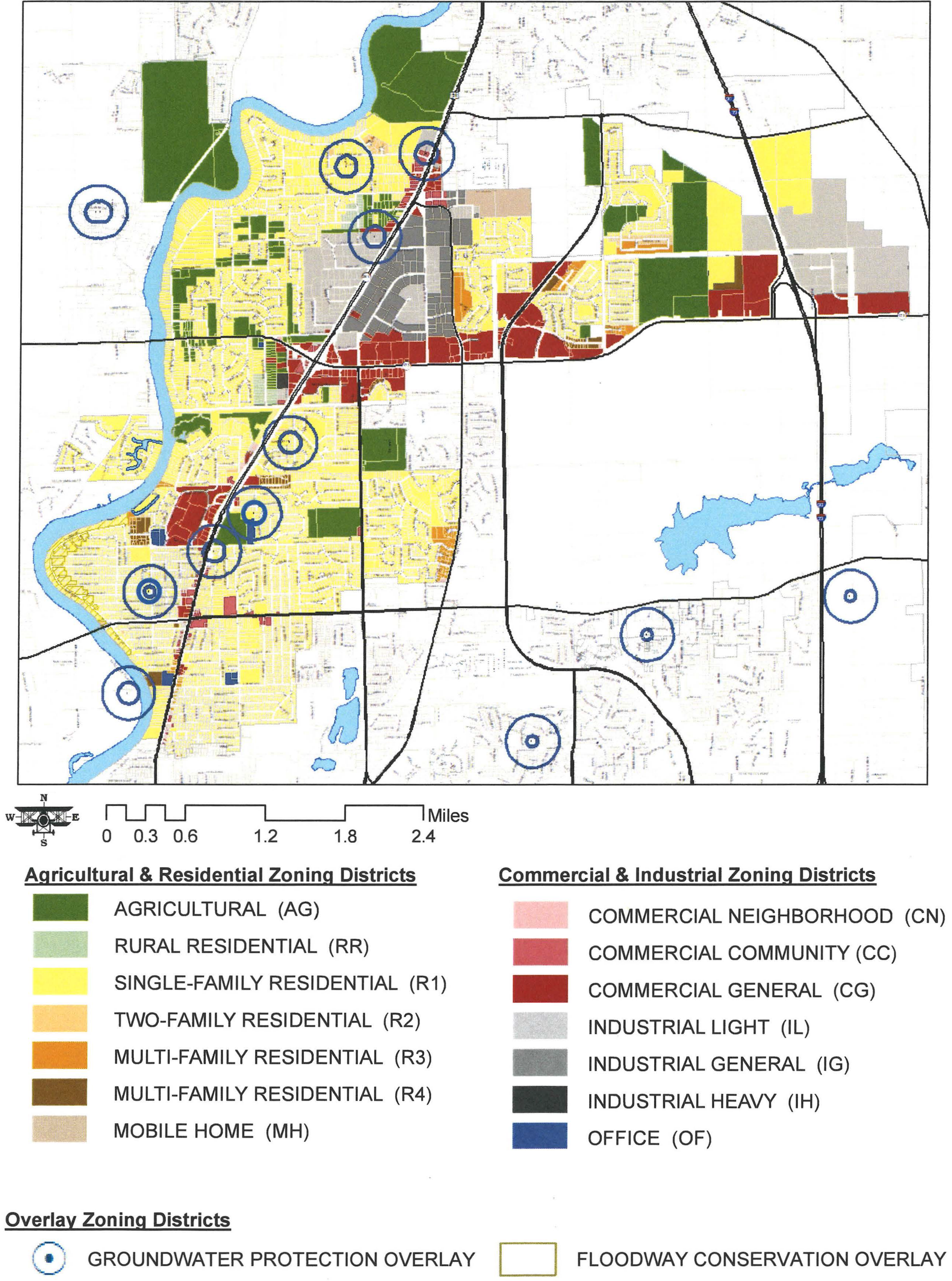
The boundaries of the aforesaid zoning districts are hereby established as shown on the map(s) entitled "Village of Machesney Park Zoning Map, February 8, 1983." These official maps and all explanatory matter thereon and attached thereto are hereby adopted by reference and declared to be part of this chapter.
The "Village of Machesney Park Zoning Map," and all official explanatory matter attached thereto bears the signature of the village clerk and shall be on file in the office of the planning and zoning manager.
MACHESNEY PARK OFFICIAL ZONING MAP—2024
Adopted by The Village Board of Trustees 4/1/2024
(Ord. No. 20-24 , § 1, 4-1-2024)
Sec. Z-26. - District boundaries.
When uncertainty exists with respect to the boundaries of the various districts as shown on the zoning map(s), the following rules shall apply:
(1)
District boundary lines are either the centerline of railroads, highways, streets, alleys or easements, or the boundary lines of sections, quarter sections, divisions of sections, tracts or lots, or such lines extended or otherwise indicated.
(2)
In areas not subdivided into lots and blocks, wherever a district is indicated as a strip adjacent to and paralleling a street or highway, the depth of such strips shall be in accordance with the dimensions shown on the maps measured at right angles from the centerline of the street, or highway, and the length of frontage shall be in accordance with dimensions shown on the map from section, quarter section or division lines, or centerlines of streets, highways or railroad rights-of-way unless otherwise indicated.
(3)
Where a lot held in one ownership and of record on the effective date of this chapter is divided by a district boundary line, the entire lot shall be construed to be within the less restricted district, provided that this construction shall not apply if it increases the less restricted frontage of the lot by more than 25 feet.
Sec. Z-27. - Zoning of streets, alleys, public ways, waterways and rights-of-way.
All streets, alleys, public ways, waterways and railroad rights-of-way, if not otherwise specifically designated, shall be deemed to be in the same zone as the property immediately abutting upon such alleys, streets, public ways or waterways and railroad rights-of-way. Where the centerline of a street, alley, public way, waterway or railroad right-of-way serves as a district boundary, the zoning of such areas, unless otherwise specifically designated, shall be deemed to be the same as that of the abutting property up to such centerline.
Sec. Z-28. - Zoning of new or annexed land.
Land annexed to, or consolidated with, the village shall automatically classify said territory as an agricultural district and if less than five acres, shall be automatically classified as a rural residential district and be subject to all conditions and regulations applicable to said territory in such district until such territory is later zoned in a manner provided by law.
No change in the use of land or existing buildings or structures shall be made until an ordinance designating the zoning district classification of such annexed land is duly adopted by the board of trustees. The owner may petition for said zoning classification simultaneously with the petition for annexation. The village board of trustees may either adopt or deny the recommendation of the planning and zoning commission for the proposed zoning amendment, at the time of adoption of the final ordinance annexing the territory. If the property to be annexed is partially developed, the proper nearest comparable zoning classification shall apply separately or collectively to the undeveloped portions and the developed portions. (Ord. No. 101-89)