
Madison County Unincorporated
City Zoning Code
City Zoning Code
Sec 117-61
Sensitive Lands Overlay SLO Zone
- Scope and purpose. The following provisions of this section apply to the Sensitive Lands Overlay (SLO) Zone:
- Protection of property and public safety from flooding, geologic and other natural and manmade hazards;
- Preservation of:
- Significant geologic features and view corridors;
- Biologically viable watercourses, wetlands, and wildlife habitat;
- Cultural resources; and
- Open space;
- Retention of trees and other native vegetation (except in those cases where a high fire hazard results) which stabilizes steep hillsides, retains moisture, prevents erosion and enhances the beauty of the natural landscape;
- Design and construction of roads, where necessary, in such a way as to minimize scars from cuts and fills and to avoid permanent scarring of hillsides and other sensitive land areas;
- Development of building sites, structures, roads, and rights-of-way in such a manner as to provide for landscaping, surface drainage, parking between and around buildings, and sewer serviceability; and
- Street rights-of-way and grades, lot layouts and structure designs which will aid the objective of reducing excavation and natural topographic disturbances.
- Applicability.
- Application. The regulations contained in this section shall apply to all lands in the county located within the Sensitive Lands Overlay Zone as delineated on the official zoning map.
- Conflicting provisions. This section sets forth provisions in addition to those in chapter 115 and in other provisions of this part. In the event of conflict, the more restrictive provision shall apply.
- Preliminary activities. The requirements of this section shall govern any preliminary surveying, testing, or design-related activities conducted within the Sensitive Lands Overlay Zone for the purpose of exploring, evaluating and/or establishing locations for any permanent improvements.
- Natural resources inventory (NRI).
- NRI required. Before any development plan may be reviewed, a natural resources inventory (NRI) shall be provided for the subject and adjoining properties. The NRI shall address the information regarding the factors set forth in subsection (f) of this section, as they apply to the subject property and to the first 100 feet of adjoining property. _____
- NRI requirements. Each NRI shall address the factors set forth in this section. Natural resource information shall be presented graphically substantially as shown in the next figure. Floodplain elevations for a 100-year flood event shall be shown by topographic delineation at 1-foot intervals.
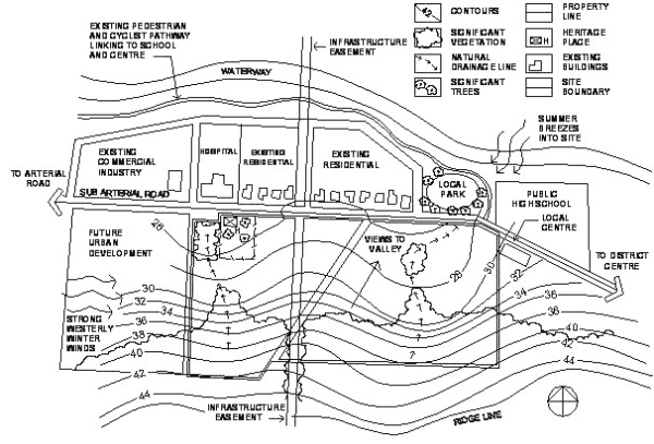
- Streams and floodplains. The NRI shall show all streams and watercourses located on or within 100 feet of the subject property. Perennial and intermittent streams and watercourses will be identified through site inspection and U.S. Geological Survey (USGS) maps. Perennial streams are those which are depicted on a USGS map with a solid blue line. Intermittent streams are those which are depicted on a USGS map with a dotted blue line. The NRI shall also show floodplains for drainage areas over 20 acres as shown on FEMA flood insurance rate maps or more current sources of information. For unnumbered FEMA zones, the developer shall conduct a floodplain analysis to determine flood zones.
- Steep slopes. The NRI shall show existing slopes greater than 20 percent. Slopes between 20 and 30 percent shall be distinguished from slopes greater than 30 percent.
- Sensitive soils. The NRI shall show sensitive soils as identified on any soil survey prepared for a government body. Soil limitations on development shall be noted on the NRI and on the associated concept plan or preliminary plan. Severe soil limitations shall also be noted in a separate report. Soils with severe limitations for development are those which have 1 or more of the following characteristics:
- Seasonal high-water table;
- Subject to flood hazard;
- Poor drainage;
- Wetland/hydric soil conditions;
- High shrink/swell potential;
- Shallow depth to bedrock;
- Excessive slopes; and
- High susceptibility to erosion.
- Wetlands. The NRI shall show all wetlands as defined by the Federal Clean Water Act. The boundaries of wetlands shall be shown on the NRI, or the NRI will contain a notation stating that no wetlands exist on the site. When proposed development will affect or remove wetlands, a report shall be submitted explaining the functional value of the affected wetlands, and measures proposed to mitigate any loss of wetlands.
- Shrubs and trees. The NRI shall show natural shrub and tree stands indicated by recent aerial photos. Such areas shall be delineated by a circumferential line extending to the outer perimeter of the tree canopies. Tree varieties and range of sizes shall be indicated. Trees with 4-inch or greater caliper at a height of 4 feet above ground and located within areas proposed to be disturbed shall be shown.
- Dam or canal break analysis. The NRI shall show the danger reach of areas subject to inundation in the event of dam or ditch/canal bank failure. For all development applications where the property is 1 mile or less downstream of a dam or canal, the applicant shall show the entire danger reach area, footprints of existing structures and spot danger reach water surface elevations on the NRI. For the purpose of regulatory review by the county, a dam or canal breach analysis shall be required:
- When failure of a dam or canal could result in:
- Loss of life, damage to homes, commercial or industrial buildings;
- Damage or inundation of arterial or collector highways; or
- Interruption in the use or service of public utilities.
- When the drainage area to the impoundment is 40 acres or more.
- When failure of a dam or canal could result in:
- Threatened and endangered species. The NRI shall show generally the habitat and location of flora and fauna designated as rare, threatened, endangered, in need of conservation, or listed as watch list species, as determined by the state department of fish and game or the U.S. Fish and Wildlife Service, known to exist on the property proposed for development.
- Existing wildlife. A general description of existing wildlife seen or known to exist on the subject property shall be set forth in a note on the NRI. The note shall address potential wildlife management problems (e.g., displacement, residential interactions, road crossings, movement corridors) related to the proposed development.
- Cultural and historic resources. Cultural and historic resources identified by the county and in the special area and sites element of the Comprehensive Plan.
- Review procedure.
- Conceptual approval. Development within the Sensitive Lands Overlay Zone shall first require the submittal of a proposal which includes the information set forth in subsections (d)(1)a and b of this section.
- A development map, drawn at a scale of 1 inch equals 100 feet or larger, which shows:
- One-foot contour intervals;
- Natural slopes of 25 percent or greater;
- Proposed development layout of lots, roads, schools, churches, parks, open space, fire stations, commercial, cut or fill slopes or area of disturbances, and any other proposed land use;
- All roads with grades in excess of 8 percent;
- Native vegetation, type and location.
- A report which describes:
- Total development area;
- Number of lots or units;
- Proposed residential density in units per acre;
- The area devoted to each use: residential, commercial, recreational, transportation, etc.;
- A statement of the basis for the project design.
- The project developer is also encouraged to consider solar access and orientation in the site design to minimize the obstruction of direct sunlight to adjacent properties and structures. Solar access is the availability of (or access to) unobstructed, direct sunlight. Access to sunlight becomes important if you use solar energy for heating, hot water heating, and/or day lighting.
- A development map, drawn at a scale of 1 inch equals 100 feet or larger, which shows:
- Preliminary approval. Following conceptual approval of the project, the developer shall submit an application for preliminary project approval. The information and reports required for preliminary approval may be in addition to information required for a subdivision application. All required reports shall be prepared by persons licensed to practice their specialty or expertise in the state, if such license for practice is required. In reviewing technical reports, calculations and plans which may be required, the county engineer may find it necessary to obtain the advice of other experts regarding the adequacy of the reports submitted and the validity of the conclusions and recommendations reached in the reports. In such cases the county engineer may consult with such experts, with the reasonable costs of these consultations to be borne by the developer. The county may make payment by the developer of the costs of such consultations a condition of preliminary or final plat approval.
- Final approval. Final approval shall require satisfactory compliance with all of the requirements of the preliminary review, and compliance with all county requirements for final subdivision plat or development application approval.
- Conceptual approval. Development within the Sensitive Lands Overlay Zone shall first require the submittal of a proposal which includes the information set forth in subsections (d)(1)a and b of this section.
- Development requirements.
- Slope limitations. Slope areas in excess of 30 percent may not be developed, and no more than 30 percent of a development's slope areas in excess of 30 percent may be included in the area calculation to determine density. The commission may modify this requirement upon finding that:
- No significant harm will result;
- The proposed modification will result in a more functional and improved plan; and
- The developer/builder agrees to comply with any conditions or requirements imposed by the commission to mitigate any adverse effects which may result from the proposed modification.
- Subdivision, single-family lots. The minimum lot size and yard requirements of the underlying zone shall apply, except that every lot shall have at least 3,500 square feet of buildable area. The buildable area is the area where the slope is 30 percent or less, and shall be completely contiguous and have a minimum dimension of 50 feet. Lots shall allow dwelling units to be located within 250 feet from a public street. All main and accessory buildings shall be built within the buildable area.
- Density limitations. The density limitations of the underlying zone shall apply, except that all buildings shall be built upon the buildable area.
- Stream system buffers. A stream system buffer is a vegetated area, including trees, shrubs, and herbaceous vegetation, that exists or is established to protect a stream system. The stream systems to be included in this section will be the North and South Forks of the Teton River and North (Henry's Fork) and South Fork of the Snake River and the Moody Creek upstream from the mouth of the Moody Canyon. Alteration, improvement, construction or development within this natural area is prohibited for a distance of 200 feet from the high-water mark. Public access points to the stream and river corridors shall be maintained and preserved as stated in chapter 115. A buffer for a stream system shall consist of a vegetated strip of land extending along both sides of a stream and its adjacent wetlands, floodplain or slopes. The buffer width shall be adjusted to include contiguous sensitive areas, such as steep slopes or erodible soils, where development or disturbance may adversely affect water quality, streams, wetlands or other water bodies. The buffer shall begin at the edge of the stream bank of the active channel. Stream system buffers are not to be included within a platted development parcel, but may be used towards minimum natural open space requirements. The required width for all buffers (i.e., the base width) shall be a minimum of 200 feet, with the requirement to expand the buffer depending on:
- Percent of slope. The buffer width added because of percent of slope is as follows:
Percent of Slope Width of Buffer (in feet) 15-17 Add 10 18-20 Add 30 21-23 Add 50 24+ Add 60 - 100-year floodplain. Buffers shall be extended to encompass the entire 100-year floodplain and a zone with a minimum width of 25 feet beyond the edge of the floodplain.
- Wetlands or critical areas. When wetland or critical areas extend beyond the edge of the required buffer width, the buffer shall be adjusted so that the buffer consists of the extent of the wetland, plus a 25-foot zone extending beyond the wetland edge.
- Water pollution hazards. The following land uses and/or activities are designated as potential water pollution hazards, and must be set back from any stream or water body by the following distances:
- Storage of hazardous substances: 200 feet.
- Aboveground or underground petroleum storage facilities: 200 feet.
- Drainfields from on-site sewage disposal and treatment systems (i.e., septic systems): 200 feet.
- Raised septic systems: 250 feet.
- Confined animal feedlot operations: 250 feet.
- Subsurface discharges from a wastewater treatment plant: 200 feet.
- Land application of biosolids: 200 feet.
- Maximum impervious material coverage. The total maximum allowable coverage by impervious material within a project or portion of a project within the Sensitive Lands Overlay Zone shall not exceed 35 percent of the total project area. Areas of roofs and driveways will be estimated and included in the total impervious surface area. The planning commission may allow commercial, institutional, multifamily residential projects to exceed the 35 percent impervious coverage limitation, based upon the recommendations of the county engineer and administrator, and adherence to the following criteria:
- The proposed project demonstrates that it does not create an adverse drainage, erosion control, or other natural hazard; and
- The proposed project meets all other requirements of the Sensitive Lands Overlay Zone and applicable county regulations.
- Percent of slope. The buffer width added because of percent of slope is as follows:
- Slope limitations. Slope areas in excess of 30 percent may not be developed, and no more than 30 percent of a development's slope areas in excess of 30 percent may be included in the area calculation to determine density. The commission may modify this requirement upon finding that:
- Development standards. The following requirements shall apply to all development activities in the Sensitive Lands Overlay Zone:
- Grading, drainage and erosion control.
- A grading and drainage report shall be prepared in which the developer shall describe the methods intended to be employed to control the erosion increase while in construction. The developer is responsible for interim stabilization of all disturbed areas during the period of construction to prevent erosion off-site effects, and for final stabilization once construction is completed.
- Construction on a development site shall be of a nature that will minimize the disturbance of existing vegetation cover. The existing natural area drainage system will be utilized to the maximum extent possible in its unimproved state. Existing drainage channels shall remain as historically located except that roads and utilities may be installed across such channels as approved by the commission and the board. Where these channel modifications are planned, the developer shall obtain applicable Idaho Department of Water Resource and U.S. Army Corps of Engineers permits. The developer shall provide evidence of such applications and permits to the county. Structures and or lots shall be arranged so as to ensure preservation of the required stream buffers, as determined in subsection (e) of this section.
- Facilities for the collection and management of stormwater runoff shall be required to be constructed on development sites as the first step in commencing development of the site. Such facilities shall be designed so as to detain safely and adequately the maximum expected stormwater runoff for a 10-year storm.
- Cut and fill slopes. Cut and fill slopes which are subject to current building codes adopted by the county and shall comply with the following standards, unless otherwise recommended in an approved soils and geology report:
- Cut and fill slopes will not exceed 12 feet.
- Cut and fill slopes shall not exceed a slope ratio of 2 horizontal to 1 vertical.
- No slopes shall be cut steeper than the bedding plane, fracture, fault or joint in any formation where the cut slope will lie on the dip of the strike line of the fracture, bedding plane, fault or joint.
- No slopes shall be cut in an existing landslide, mud flow or other form of naturally unstable slope.
- Fill slopes shall not be constructed on natural slopes steeper than 2:1 (2 horizontal to 1 vertical).
- Vegetation and revegetation. All areas of development sites cleared of natural vegetation in the course of construction of offsite improvements shall be replanted with vegetation which has good erosion control characteristics. New plantings shall be protected with mulch material and fertilized when in conjunction with planting and watering schedule. Persons or firms having expertise in the practice of revegetation (i.e., licensed landscape architects or nurserymen) shall supervise the planning and installation of revegetation cover for the total development site. Vegetation shall be removed only when absolutely necessary, e.g., for the construction of buildings, roads and filled areas, as approved by the county engineer.
- Geology. No structures shall be built on or within 10 feet of any identified faults. No structures or improvements shall be allowed on any area known to be within an active landslide area. Problems associated with development on or near perched groundwater and shallow groundwater shall be mitigated. No structures shall be allowed in any rock fall zone. The fault areas will be shown on the preliminary and final plats.
- Architectural design. The design of buildings proposed for construction in the Sensitive Lands Overlay Zone is encouraged to be visually compatible with the topography and existing vegetation. The use of materials for buildings and fences should blend harmoniously with the natural setting. The commission may review the design and comment on the specified exterior materials and colors for all structures other than single-family dwellings. Exposed foundation walls shall not exceed 4 feet above finished grade at any point.
- Stream buffers. A stream buffer of 200 feet shall be preserved, and no construction, improvements, development, or alterations are to be permitted within this corridor, unless specifically authorized by the administrator and commission.
- Grading, drainage and erosion control.
(Prior Code, title 10, § 4.12; Ord. No. 395, § 2, 5-26-2015)

