
Malabar City Zoning Code
ARTICLE III
DISTRICT PROVISIONS
This article describes the purposes and intent of each zoning district, identifies permitted and conditional uses by zoning district, and provides size and dimensional regulations for respective zoning districts.
Section 1-3.1.- Purpose and intent of districts.
This section presents the basic purpose and intent of each zoning district.
A.
CP "Coastal Preserve." The CP district was originally established by the Town Council through Ordinance Number 7-1-76, § 5.12 and Ordinance Number 7-12-79 § 1. This district is intended to preserve a narrow strip of land east of highway US 1 directly abutting the Indian River Lagoon, a State designated Aquatic Preserve. The district provisions are intended to assist in implementing land use, coastal management, and conservation goals, objectives, and policies within the comprehensive plan. For instance, the district provisions reduce exposure to natural hazards to persons or property as a result of windstorms and high tides; preserve the marine resources of the Aquatic Preserve; and restrict usage to noncommercial piers, boat slips, and docks.
B.
RR-65 "Rural Residential." The rural residential district is established to implement comprehensive plan policies for managing rural residential development at a density not to exceed one and one-half (1.5) acres per dwelling unit. The district is intended to protect and preserve existing agricultural and rural residential lands. These lands are generally developed for agricultural uses or for large lot rural residential home sites. The areas designated for rural residential development generally contain few urban services and the street system is generally incapable of carrying traffic generated by more intense urban development. The district is intended to accommodate and preserve a unique lifestyle which cannot be accommodated in more dense residential areas.
C.
RS-21 "Single-Family Low-Density Residential." This district is established to implement comprehensive plan policies for managing low-density, single-family residential development at a density not to exceed two (2) single-family dwelling units per acre. The RS-21 district is established in order to protect the quality and character of existing and future conventional single-family low-density neighborhoods, preserve open space, and manage future densities in order to assure compatibility with existing developments, natural features of the land, as well as existing and projected public services and facilities within the area.
D.
RS-15 "Single-Family Medium-Density Residential." The RS-15 district is designed to accommodate traditional single-family development on lots not less than 15,000 square feet. The district is established to preserve the stability of existing and future conventional single-family residential neighborhoods, preserve open space, and manage future densities in order to assure that future densities are compatible with existing developments, natural features of the land, as well as existing and projected public services and facilities within the area.
E.
RS-10 "Single-Family Medium-Density Residential." The RS-10 district is established to implement comprehensive plan policies for managing traditional single-family residential development on lots not less than 10,000 square feet. This district is established to preserve the stability of existing and future single-family residential neighborhoods, preserve open space, and manage future densities in order to assure that they are compatible with existing developments, natural features of the land, as well as existing and projected public services and facilities within the area.
F.
R-MH "Residential Mobile Homes." The R-MH district is established to implement comprehensive plan policies for managing high density mobile home residential development. The district is designed for managing mobile home development at a density not to exceed six units per acre. The district is intended to provide sites for mobile home development within existing established mobile home parks.
G.
RM-4 "Multiple-Family Medium-Density Residential." The RM-4 district is established to implement comprehensive plan policies for managing medium-density residential development not to exceed four units per acre. The district is established to ensure sufficient land area for development of medium-density multiple-family residential developments which are fully serviced by adequate public facilities. Sites for medium-density multiple-family residential development shall be located so that they provide a smooth transition between low density residential development and areas developed and/or designated for more intense uses.
H.
RM-6 "Multiple-Family High-Density Residential Development." The RM-6 district is established to implement comprehensive plan policies for managing high-density residential development at a density not to exceed six units per acre. The district is established to ensure that sufficient land is available for developments of high-density residential development and is intended to ensure availability of adequate public facilities.
I.
OI "Office-Institutional." The OI district is established to implement comprehensive plan policies for managing office-institutional development. This district is designed to accommodate businesses and professional offices together with institutional land uses on sites which:
• Have accessibility to major thoroughfares;
• Have potential to be served by a full complement of urban services;
• Contain sufficient land area to accommodate good principles of urban design, including sufficient land area to provide adequate landscaping and buffers to separate existing as well as potential adjacent land uses of differing intensities;
• Accommodate only office buildings and institutional land uses and shall expressly exclude residential uses (except those Community Facilities defined as Nursing Homes and Related Health Care Facilities in 1-2.6.B.10(B)), general retail sales and services, warehousing, and outside storage; and
• Frequently serve as a transition area which buffers residential uses located in one area from a nearby area which accommodates uses of a higher intensity.
• A Malabar Vernacular Style is required for all development along arterial roadways.
J.
INS "Institutional Services." The INS district is established to implement comprehensive plan policies for managing institutional development. The district is intended to accommodate public and semi-public facilities such as government administration buildings; fire, police, and rescue services; health care delivery services; and educational institutions. Land uses such as places of worship, cultural or civic centers, and other similar public or private not-for-profit uses may be included within this district.
K.
CL "Commercial Limited." The CL district is established to implement comprehensive plan policies for managing limited commercial development accessible to major thoroughfares near residential neighborhoods. Such development is intended to provide essential household services in locations highly accessible to residential areas. For instance, sites within this district are intended to accommodate neighborhood shops with limited inventory or goods. Such shops generally cater to the following markets:
•
Neighborhood residential markets within the immediate vicinity as opposed to city-wide or regional market; or
•
A specialized market with customized market demands.
•
A Malabar Vernacular Style is required for all development along arterial roadways.
Areas designated for limited commercial development are not intended to accommodate large-scale retail sales, services, and trade activities, generally serving a city-wide or regional market. Such stores would usually differ from limited commercial shops since the former would usually require a larger floor area, carry a relatively larger inventory and require substantially greater parking area. Uses, which are not intended to be accommodated within the limited commercial area, include the following: large scale discount stores; health spas; supermarket; department stores; large scale wholesaling and warehousing activities; general sales, services or repair of motor vehicles, heavy equipment, machinery or accessory parts, including tire and battery shops and automotive service centers; commercial amusements; and fast food establishments primarily serving in disposable containers and/or providing drive-in facilities. No residential uses shall be located in the limited commercial district.
L.
CG "Commercial General." The CG district is established to implement comprehensive plan policies for managing general commercial development. The general commercial district is designed to accommodate general retail sales and services. Sites designated for CG zoning shall be located in highly accessible areas adjacent to major thoroughfares which possess necessary location, site, and market requirements required by general commercial land use activities.
The general commercial district shall also accommodate commercial trades in strategically designated areas as defined in the conditional use criteria. Development standards within the land development code shall require that site plans incorporate amenities necessary to prevent potential adverse effects on the traffic circulation system, public services, and residential development within the vicinity.
The general commercial district is not intended to accommodate manufacturing, processing, or assembly of goods, sales and services of heavy commercial vehicles and equipment, or related services or maintenance activities; warehousing; uses requiring extensive outside storage; or other activities or trades which may generate nuisance impacts, including glare, smoke, or other air pollutants, noise, vibration or major fire hazards. Finally, no permanent residential housing shall be located within the general commercial district.
The location and distribution of general commercial activities shall be determined based on the following considerations:
•
Trip generation characteristics, impact on existing and plan transportation facilities and ability to achieve a functional internal circulation and landscaped off-street parking system;
•
Location and site requirements based on specific needs of respective commercial activities, their market area, anticipated employment generation, and floor area requirements;
•
Compatibility with and impact on other surrounding commercial activities;
•
Relationship to surrounding land uses and natural systems; and
•
Impact on existing and planned community services and utilities.
•
A Malabar Vernacular Style is required for all development along arterial roadways.
M.
IND "Industrial." The industrial district is established to implement comprehensive plan policies for managing industrial development. In locating industrial districts, consideration shall be directed to selecting sites accessible to rail facilities, terminal facilities, major arterials, labor markets, and necessary urban services. Industrial districts shall not include residential activities. However, residence for night watchman or custodians whose presence on industrial sites is necessary for security purposes may be approved as an accessory use. Industrial districts shall be accessible to major thoroughfares and shall be buffered from residential neighborhoods.
Any additional industrial zoning shall be consistent with the comprehensive plan, including criteria for siting industrial activities, including but not limited to, policy 1-1.3.1, policy 1-1.3.2, and policy 1-1.3.3.
N.
PUD "Planned Unit Development." The PUD district is established to implement comprehensive plan policies for managing planned unit development. The comprehensive plan incorporates policies encouraging innovative development concepts, including mixed use development. The planned unit development is intended to provide a voluntary framework for coordinating objectives of developers which may require departures from established public policy. The planned unit development district provides a management strategy for negotiating innovative development concepts, design amenities, and measures for protecting natural features of the land. The management process shall promote public and private coordination and cooperation. The land development code incorporates detailed regulations, standards, and procedures for implementing the planned unit development concept.
The planned unit development district shall be available as a voluntary approach for managing specific development characteristics and project amenities to be incorporated in residential, commercial, industrial or mixed use development. Developers who voluntarily participate in the process shall bind themselves as well as their successors in title to the stipulations within the development order approving the planned unit development district.
O.
R/LC "Residential and Limited Commercial." The R/LC district is established to implement comprehensive plan policies for managing development on land specifically designated for mixed use Rural Residential and Limited Commercial development on the Comprehensive Plan Future Land Use Map (FLUM). Such Development is intended to accommodate neighborhood shops with limited inventory or goods as well as single family and multiple family structures with a maximum density up to six (6) units per acre. A building(s) or portions of a building may have residential or commercial uses(s), or a combination of both. Residential/ Limited Commercial activities shall generally cater to the following markets:
•
Local residential markets within the town as opposed to regional markets; or
•
Specialized markets with customized market demands.
•
A Malabar Vernacular Style is required for all development along arterial roadways.
Areas designated for mixed use Residential and Limited Commercial development are not intended to accommodate commercial activities, such as large-scale retail sales and/or service facilities or trade activities. These types of commercial activities generally serve regional markets, and the intensity of such commercial activities is not generally compatible with residential activities located within the same structure or located at an adjacent or nearby site. Such stores would usually differ from limited commercial shops; would generally carry a relatively larger inventory; and require substantially greater parking area. Uses, which are not intended to be accommodated within the limited commercial area, include the following: large-scale discount stores; health spas; supermarket; department stores; large scale wholesaling and warehousing activities; general sales, services or repair of motor vehicles, heavy equipment, machinery or accessory parts, including tire and battery shops and automotive service centers; commercial amusements; and fast food establishments primarily serving in disposal containers and/or providing drive-in facilities.
Development of an R/LC parcel shall be intended for one unit per lot, until mixed use is initiated by the property owner. Only then shall single family or multiple family residential uses and commercial uses be mixed with a density no greater than six (6) units per acre in the R/LC district. Such residential uses may be located either within a freestanding structure or within a structure housing both Residential and Limited Commercial activities. Such development is intended to accommodate limited commercial goods and services together with rural residential activities on specific sites designated "R/LC". This residential land use shall permit multiple family residential development, limited commercial development separately where current Infrastructure allows, or as a combination of these uses as regulated by Table 1-3.1 and Table 1-3.3(A).
Residential Dwelling unit(s) shall not exceed commercial use(s) by more than one as regulated by Table 1-3.1.
Commercial use(s) shall not exceed residential dwelling unit(s) by more than one as regulated by Table 1-3.1.
Table 1 3.1. Permitted Combinations of R/LC Land Uses
P.
RVP "Recreational Vehicle Park." The RVP district is established to implement comprehensive plan policies for managing local zoning and site development design criteria on land specifically designated for Recreational Vehicle Park(s) as designated by F.S. ch. 513 entitled Mobile Home and Recreational Vehicle Parks, as well as Chapter 64E-15, Florida Administrative Code.
(Ord. No. 94-4, § 2, 4-3-95; Ord. No. 07-02, §§ 1—4, 4-2-07; Ord. No. 14-01, § 2, 2-3-14; Ord. No. 2021-02, § 2, 5-3-21; Ord. No. 2021-09, § 2, 8-16-21; Ord. No. 2023-02, § 1, 12-4-23)
Section 1-3.2. - Land use by districts.
Table 1-3.2 "Land Use by Districts" stipulates the permitted and conditional uses by district.
Permitted uses are uses allowed by right provided all applicable regulations within the land development code are satisfied as well as other applicable laws and administration regulations. Conditional uses are allowable only if approved by the Town pursuant to administrative procedures found in Article VI. The applicant requesting a conditional use must demonstrate compliance with conditional use criteria set forth in Article VI.
No permitted use or conditional use shall be approved unless a site plan for such use is first submitted by the applicant. The applicant shall bear the burden of proof in demonstrating compliance with all applicable laws and ordinances during the site plan review process. Site plan review process is set forth in Article X.
Cross reference— Alcoholic beverages, ch. 4.
1 Any Bed and Breakfast which is proposed to have more than five (5) living quarters shall only be approved as a conditional use in accordance with Article VI of the Land Development Regulations.
2 Any Arcade Amusement Center and Electronic Gaming Establishment as defined herein shall only be approved as a conditional use in accordance with Article VI of the Malabar Land Development Code.
3 Allowed in RR-65, (1 to 2 residents/beds) as defined in FS Title XXX Chapters 419 & 429
4 ALF Factor of "3" (see section I-2.6.B.13.B, Part I) only applies to RM-4 & RM-6 for ALF's
5 Subject to FL State law association with CS/HB 403 related to Home-based Businesses which outlines allowances and restrictions such as property use, residents, parking, signage, and federal, state and local regulations related to use/storage/disposal of hazardous materials.
(Ord. No. 94-4, § 3, 4-3-95; Ord. No. 97-3, § 2, 3-17-97; Ord. No. 05-01, § 1, 3-7-05; Ord. No. 06-19, § 1, 1-11-07; Ord. No. 12-48, § 2, 1-23-12; Ord. No. 14-01, § 3, 2-3-14; Ord. No. 2016-03, § 1, 2(Exh. A), 10-3-16; Ord. No. 20-02, §§ 1, 2, 3-2-20; Ord. No. 2021-09, § 3, 8-16-21; Ord. No. 2023-01, § 3, 12-4-23; Ord. No. 2024-05, § 2(Exh. A), 7-1-24)
Section 1-3.3. - Size and dimension criteria.
A.
Minimum Lot or Site Requirements for All Uses. Table 1-3.3(A) incorporates required size and dimension regulations which shall be applicable within each respective zoning district, except for Recreational Vehicle Park District, which is specifically described within Section 1-3.3, Item G. All developments shall have a total land area sufficient to satisfy all standards stipulated within the land development code, including but not limited to:
•
Setback requirements;
•
Open space, buffers, and landscaping;
•
Surface water management;
•
Water and wastewater services;
•
Access, internal circulation and off-street parking;
•
Wetland protection; and
•
Soil erosion and sedimentation control standards.
Conventional single family lots shall be required pursuant to square footage requirements stipulated in Table 1-3.3(A). Similarly, more intense development within multiple family residential districts and other specified nonresidential districts shall maintain sites having minimum acreage requirements stipulated in Table 1-3.3(A).
TABLE 1-3.3(A). SIZE AND DIMENSION REGULATIONS
1 Minimum size sites and lots include one-half of adjacent public right-of-way.
2 Minimum setbacks determined from the existing right-of-way line where the yard abuts a public street pursuant to the above cited standards or from the center of the right-of-way pursuant to Table 1-3.3(E) whichever is most restrictive.
3 Setback where rear lot line abuts an alley.
4 Setback shall be greater where side property line abuts a district requiring a larger setback on the abutting yard. In such case the more restrictive abutting setback shall apply.
5 Where any yard of industrial zoned property abuts a residential district, the building setback for such yard shall be 100 feet.
6 Recreation activities maximum Minimum Floor Area shall be .10.
7 In RR-65 Zoning, side and rear setback may be reduced for accessory structures to equal the height of the accessory structure but under no condition be reduced to less than 15 feet. If the height of the accessory structure height is 20 feet, the side and rear setbacks for that building would be 20 feet.
N/A 8 shall mean Not Applicable to Town regulations but may require permitting and approvals from outside agencies.
(I) 9 shall mean Internal Property, or properties not located on a corner lot.
(C) 10 shall mean Corner Property, or Property located on a corner lot.
B.
Area requirements for uses not served by central water and wastewater services. All proposed development within areas not served by central water and wastewater services shall comply with the septic permitting requirements of Brevard County.
C.
Impervious Surface Requirements (ISR) for All Uses. The term "impervious surface" is defined as that portion of the land which is covered by buildings, pavement, or other cover through which water cannot penetrate. The impervious surface ratio requirement controls the intensity of development, by restricting the amount of the land covered by any type of impervious surface.
1.
Calculation of ISR. The impervious surface ratio (ISR) is calculated for the gross site by dividing the total impervious surface by the gross site area. Water bodies are impervious but shall not be included as such in the ISR calcuation.
Cluster development or other site design alternatives may result in individual lots exceeding the ISR, while other lots may be devoted entirely to open space. The Town may require, as a condition of approval, deed restrictions or covenants which guarantee the maintenance of such open space in perpetuity. The ISR requirement shall not be bypassed or reduced. However, the intent is to allow maximum flexibility through calculating ISR on the gross site, and not on a lot-by-lot basis.
2.
Use of Porous Material. Porous concrete, asphalt, porous turf block, or similar materials may be used subject to approval of the Town Engineer.
3.
Compliance with ISR Stipulated in Table 1-3.3(A). All proposed development shall comply with the standards given in the table of impervious surface ratios in Table 1-3.3(A).
Where a proposed development is donating or dedicating land based on a plan approved by the Town, the gross site before dedication or donation shall be used to calculate ISR. This does not relieve the applicant from providing all required on-site buffers, landscaping, stormwater management areas, setbacks, and other required project amenities.
D.
Maximum Building Coverage. The term "maximum building coverage" is defined as a measurement of the intensity of development on a site. For purposes of this Code, maximum building coverage (MBC) is used to regulate nonresidential development.
1.
Calculation of MBC. The MBC is the relationship between the total building coverage on a site and the gross site area. The MBC is calculated by adding together the total building coverage of a site and dividing this total by the gross site area. See figure 1-3.3(D) for a graphic illustration of this concept.
All proposed nonresidential development shall comply with the MBC requirements stipulated in Table 1-3.3(A) for the zoning district in which the development is located.
FIGURE 1-3.3(D). MAXIMUM BUILDING COVERAGE ILLUSTRATION
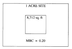
Maximum building coverage for a MBC of 0.20 = 8,712 sq. ft.
E.
Principal Structure Setbacks. Table 1-3.3(A) provides building setbacks for all zoning districts. In addition to these setbacks the required minimum setback shall be measured from the centerline of the right-of-way as in Table 1-3.3(E).
TABLE 1-3.3(E). PRINCIPAL STRUCTURE SETBACKS FROM CENTERLINE OF THOROUGHFARES
F.
Minimum Distance Between Principal Buildings. The minimum distance between principal buildings shall be twenty (20) feet. The distance shall be measured at the narrowest space between buildings and shall not include roof overhang.
G.
Recreational Vehicle Park Zoning District. Recreational vehicle park zoning district shall be to locate and establish areas within the Town which are deemed to be uniquely suited for the development and maintenance of recreational vehicle activities, i.e., travel trailers, motor homes, camping tents, and trailers occupied as temporary living quarters; to designate those uses and services deemed appropriate and proper for location and development within the zoning district; and to establish such development standards and provisions as are appropriate to ensure proper development and functioning of uses within the district consistent with F.S. Ch. 513 entitled Mobile Home and Recreational Vehicle Parks, as well as Chapter 64E-15, Florida Administrative Code, as amended from time to time.
(1)
Principal uses and structures:
a)
Travel trailers, recreational vehicles, motor homes, camping tents and other vehicles with sleeping accommodations.
b)
Management offices and residence (a mobile home may be allowed for a manager's residence only).
(2)
Accessory uses include:
a)
Grocery store.
b)
Bottled/Metered gas sales.
c)
Laundry facilities.
d)
Recreational facilities such as playgrounds, picnic areas, swimming pools, game courts, and recreation hall.
e)
Public utility equipment and facilities.
(3)
Conditional uses:
a)
Marina and boat rental including bait, fishing, and sports accessories sales serving guests of the park and/or the general public.
(4)
Design standards for recreational vehicle parks.
a)
Minimum size: five (5) acres.
b)
Maximum density: fifteen (15) travel trailer/R.V. sites per gross acre of land. This shall also apply to any tent camping areas.
c)
Streets and parking:
1.
Direct access to the recreational vehicle park shall be from an arterial roadway. The administrative office of the park shall be so located as to assure that no recreational vehicles are parked in the right-of-way during the check-in process or while waiting for others to be checked in.
2.
Width of streets. Streets or driveways in a recreational vehicle park shall be private and shall have the following widths:
(a)
A one-way street/drive shall be at least twelve (12) feet in width.
(b)
A two-way street/drive shall be at least twenty-four (24) feet in width.
3.
Street surfacing. All roads or driveways shall be paved meeting town standards.
4.
Road curves. All road curves shall have a minimum turning radius of fifty (50) feet. All cul-de-sacs shall have a maximum length of five hundred (500) feet and terminate in a turning circle having a minimum radius of fifty (50) feet.
5.
Parking. Each R.V. / travel trailer site shall have off-street parking pads for both recreational vehicles and for towing vehicles. The pads shall be composed of a stabilized material meeting town standards to accommodate the size of the vehicle and be composition of materials examples: asphalt, cement, gravel, pavers, or LID methods (pervious asphalt, pervious concrete, etc.)
d)
Buffer strips. A twenty-five (25) foot minimum yard setback shall be provided from all exterior property lines and rights-of-way for the rear and sides of the property and a minimum of fifty (50) foot for roadway frontage of the property. The recreational vehicle park shall be entirely enclosed, exclusive of driveways, at its external boundaries by a solid wall, wood or PVC fence, or evergreen hedge not less than six (6) feet in height. The buffer strip shall be separate from recreational areas, streets, driveways, travel trailer sites (R.V. sites) and utility sites but may be utilized for stormwater drainage and retention purposes. The provisions for buffer strips may be waived or reduced by the Town Council taking into consideration the use of abutting properties. Furthermore, any portion of the property which fronts a public right-of-way will not be required to be enclosed along such right-of-way.
e)
Recreational areas. A minimum of ten percent (10%) of the total land area of a travel trailer park shall be devoted to one (1) or more common use areas for recreational activity. In addition, for every travel trailer and tent site, there shall be allocated an additional one hundred (100) square feet of land for recreational activity.
1.
However, this requirement is not necessary when the proposed development is a density of ten (10) sites per gross acre or less. Such recreational areas shall be exclusive of recreational vehicle sites, buffer strips, street right-of-way and storage areas; however, the periphery of such areas may contain utility sites, and other nonrecreational service buildings, the area of which will be subtracted from the computed "recreational area." Recreational areas shall be easily accessible to all park users and management. Although the required space for recreational usage may be met through more than one (1) recreational site, the minimum size of any such area shall be ten thousand (10,000) square feet. Provision for all common open space and the construction of recreational facilities which are shown on the site plan shall proceed at an equivalent, or greater, rate as the construction of individual recreational vehicle sites.
f)
Tent camping. Areas may be set aside for tent camping in accordance with all provisions of this section, except:
1.
There shall be a stabilized pad on the site for parking of the transportation vehicle.
2.
Tent camping may be permitted on a travel trailer site.
g)
Design requirements for recreational vehicle site.
1.
Minimum size.
a.
Back-in parking sites shall have a minimum area of one thousand five hundred (1,500) square feet with a minimum width of thirty (30) feet and a minimum length of fifty (50) feet.
b.
Drive-through parking sites shall have a minimum area of one thousand two hundred (1,200) square feet with minimum width of twenty (20) feet and a minimum length of sixty (60) feet. Consensus was to remove these sections.
2.
Access. Each R.V. site shall abut on at least one (1) street or driveway within the boundaries of the travel trailer park and access to the site shall be only from such an internal street or driveway.
3.
Setback requirements. No part of a travel trailer placed on a travel trailer site shall be closer than five (5) feet to any site line and ten (10) feet to any street or driveway.
4.
Appurtenances. Temporary appurtenances, such as cabanas and awnings, may be erected on a travel trailer site as long as such appurtenances do not violate the setback requirements as set forth in this section and as long as such appurtenances are capable of being dismantled and stored within four (4) hours.
h)
Provisions of service in recreational vehicle parks.
1.
Service buildings. All service buildings shall comply with the building code and regulations concerning buildings, electrical installations, plumbing and sanitation systems. Service building are intended to accommodate the servicing equipment used for the park maintenance and are not intended to service any recreational vehicle, trailer, camper or equipment of a park guest. No major service or repair of a recreational vehicle shall occur on the park site. For the purposes of this section the term "major service or repair" shall mean any service or repairs to a recreational vehicle which is anticipated to take more than 4 (four) hours to accomplish.
2.
Water supply. An adequate supply of water shall be provided in accordance with the regulatory agencies, Department of Environmental Protection and/or the Department of Health.
3.
Sewage disposal.
a.
All sewage disposal facilities shall be provided in accordance with the regulatory agencies, Department of Environmental Protection and/or the Department of Health.
b.
At least one (1) sanitary dumping station shall be provided in every travel trailer park. Such station shall be readily accessible and well-lighted. The following schedule shall be used in determining additional dumping stations based on the number of sites which are not connected individually to sewer lines: for every fifty (50) sites or fractional part thereof, beyond the first (50) sites, one (1) sanitary dumping station shall be provided.
c.
At least one (1) central bathhouse-restroom facility shall be located within three hundred (300) feet of all camping units which are either not supplied with sewer connections or not capable of utilizing such connections (e.g., tents, camper trailers). Any dispersed bathhouse-restroom facility provided to meet the distance requirement of three hundred (300) feet shall have at least two (2) of each of the following fixtures for men and women: Toilets, urinals, lavatories and showers. Recreational areas shall be located within three hundred (300) feet of a bathhouse-restroom facility.
d.
The minimum number of bath and toilet facilities shall be determined by the latest adopted Florida Building Code.
4.
Lighting. All entrances, exits, streets, and service buildings shall be well lighted during the hours of darkness. Site Lighting shall conform to the Town's adopted Land Development Code, Article V. - General Provisions, Section 1-5.28 entitles Site Lighting. All recreational facilities which are to be utilized during the hours of darkness shall be adequately lighted to ensure the safety of all users of such facilities.
5.
Electricity. All requirements of the National Electrical Code as contained referenced in Malabar Code of Ordinances Chapter 6 must be met.
6.
Service and utility lines. All service utility lines in a travel trailer park shall be installed underground and at a minimum depth of eighteen (18) inches.
7.
Fire protection. The park shall be subject to the rules and regulations of State Statute, State Fire Code, and Malabar Code.
8.
Fuel supply and storage. All installations and tanks furnishing and/or storing any type of gaseous fuels to be used by the occupants of the park shall comply with the Fire Prevention Code of the National Fire Prevention Association, as adopted.
9.
Storage. Outdoor storage of travel trailers is permitted that such storage takes place within an area especially set aside for such use.
10.
Signs. Those signs necessary for directional or safety purposes are permitted. All other signs as per the sign regulations set forth in Article XIX of this code of ordinances.
i)
Development site plan review. As part of the supplementary data required to complete an application for a public hearing for a Recreational Vehicle Park development, a scaled and dimensioned plot or site plan of the development shall be submitted as part of such site plan application pursuant to Article VII (if the site plan is greater than eleven (11) inches by seventeen (17) inches, two (2) copies are needed, as well as a digital copy); and if the application is approved, the Recreational Vehicle Park shall be built in accordance with such a plan. The site plan shall include, but not be limited to, location of all R.V. sites, service areas, drives, streets, signs, buildings, parking, recreational space, setbacks, public utility locations and any other pertinent information. Site plan approval is limited to one (1) year by the Town Council. The provisions of Section 1-7.5 shall apply.
j)
Prohibited uses and Structures. All other uses and structures not specifically or provisionally permitted herein.
(Ord. No. 92-8, § 1(B), (D), (J), 8-18-92; Ord. No. 94-4, § 4, 4-3-95; Ord. No. 96-1, § 1, 3-4-96; Ord. No. 97-5, § 1, 3-17-97; Ord. No. 02-03, § 1, 8-5-02; Ord. No. 03-02, § 1, 2-24-03; Ord. No. 04-08, §§ 1, 2, 7-12-04; Ord. No. 06-05, § 1, 2-6-06; Ord. No. 06-16, §§ 1, 2, 10-2-06; Ord. No. 19-02, § 2, 3-4-19; Ord. No. 19-03, § 2, 3-4-19; Ord. No. 2021-02, § 3, 5-3-21; Ord. No. 2021-09, §§ 4, 5, 8-16-21; Ord. No. 2024-04, § 2(Exh. A), 6-17-24; Ord. No. 2024-05, § 3(Exh. B), 7-1-24)