
Mammoth Lakes City Zoning Code
ARTICLE II
ZONING DISTRICTS AND ALLOWABLE LAND USES
17.16.010. - Purpose.
This chapter establishes the zoning districts applied to property within the Town, determines how the zoning districts are applied on the Zoning Map, and provides general permit requirements for development and new land uses.
(Code 1990, § 17.16.010; Ord. No. 14-02, § 4, 3-19-2014)
17.16.020. - Zoning districts established.
The Town shall be divided into zoning districts which implement the general plan. The zoning districts shown in Table 17.16.030 are hereby established and shall be shown on the Official Zoning Map (Section 17.16.030).
(Code 1990, § 17.16.020; Ord. No. 14-02, § 4, 3-19-2014)
17.16.030. - Zoning Map adopted.
The Council hereby adopts the Town Zoning Map (hereafter referred to as the "Zoning Map"), which is on file with the Department.
(1)
Inclusion by reference. The Zoning Map, together with all legends, symbols, notations, references, zoning district boundaries, and other information on the maps, has been adopted by the Council in compliance with Government Code § 65800 et seq. and is hereby incorporated into this chapter by reference as though it were fully included here.
(2)
Zoning district boundaries. The boundaries of the zoning districts established by Section 17.16.020 shall be shown upon the Zoning Map.
(3)
Relationship to general plan. The Zoning Map shall implement the general plan, specifically, including the land use diagram.
(4)
Map amendments. Amendments to the Zoning Map shall follow the process established in Chapter 17.108.
Table 17.16.030. Zoning Districts
(Code 1990, § 17.16.030; Ord. No. 14-02, § 4, 3-19-2014; Ord. No. 21-01, § 4.c.(exh. 2), 1-20-2021)
17.16.040. - Zoning district regulations.
(a)
Purpose.Chapters 17.20 through 17.32 determine which land uses are allowed in each zoning district, what steps are required to establish each use, and the basic development standards that apply.
(b)
Determination of allowable land uses and permit requirements.
(1)
The land uses allowed by this chapter in each zoning district are identified in use regulation tables as being:
a.
Permitted subject to compliance with all applicable provisions of this chapter, subject to obtaining a building permit or other permit required by this chapter. These are shown as "P" uses in the tables;
b.
Allowed subject to the approval of an administrative permit (Chapter 17.84), and shown as "A" uses in the tables; and
c.
Allowed subject to the approval of a use permit (Chapter 17.68) and shown as "U" uses in the tables.
d.
Uses not allowed and shown as "—" uses in the tables.
(2)
The designations listed above apply strictly to the permissibility of land uses. Applications for site development may require design review pursuant to Chapter 17.88.
(3)
Pursuant to Chapter 17.12 the Director is assigned the responsibility and authority to interpret the requirements of this chapter. Land uses that are not listed in the tables or are not shown in a particular zoning district are not allowed, except where otherwise provided by Section 17.08.030.
(c)
Indoor uses only. All commercial and industrial activities, other than off-street parking, shall be conducted entirely within an enclosed structure, except as may otherwise be allowed in compliance with this chapter.
(d)
Site divided by zoning district boundary. Where a site is divided by one or more district boundaries, each portion of the site in a separate district shall be developed and used in compliance with the requirements of the applicable district.
(Code 1990, § 17.16.040)
17.20.010. - Purpose.
(a)
In addition to the objectives outlined in Section 17.04.010, the specific purposes of the residential zoning districts are to:
(1)
To reserve appropriately located areas for residential use at various ranges of dwelling unit densities and types consistent with the general plan and with sound standards of public health, safety and welfare;
(2)
To ensure adequate light, air, privacy and open space for each dwelling;
(3)
To minimize traffic congestion and to avoid the overloading of utilities by preventing the construction of buildings of excessive bulk or number in relation to the land area around them and the ability of the local infrastructure to support them;
(4)
To protect residential properties from incompatible noise, illumination, unsightliness, odors, smoke and other objectionable influences; and
(5)
To facilitate the provision of utility services and other public facilities commensurate with anticipated population, dwelling unit densities and service requirements.
(b)
Additional purposes of the individual residential zoning districts are as follows:
(1)
RR (Rural Residential) District. This zoning district is intended as an area for single-family rural residential development with larger lots and lower density than the residential single-family zone. Transient occupancy or rental, hotels and motels, and group living quarters uses are not permitted in this zone. Bed and breakfast uses are permitted only with a use permit. Uses permitted are those that are complementary to, and can exist in harmony with, a rural residential neighborhood.
(2)
RSF (Residential Single-Family) District. This zone is intended as an area for single-family residential development. Transient occupancy or rental, hotels and motels, bed and breakfast, and group living quarters uses are not permitted in this zone. Only those uses are permitted that are complementary to, and can exist in harmony with, a residential neighborhood.
(3)
RMF-1 (Residential Multiple-Family) District. This zone is intended as an area for the development of mixed residential uses (single-family dwellings, apartments, and other multiple-family developments). Transient occupancy or rental and hotel and motel uses are not permitted in this zone. Group living quarters uses are permitted only with a use permit. Bed and breakfast uses are permitted. Only those uses are permitted that are complementary to, and can exist in harmony with, such residential developments.
(4)
RMF-2 (Residential Multiple-Family) District. This zone is intended as an area for the development of primarily multiple-family developments. Transient occupancy shall be permissible in this zone subject to the issuance of a use permit. Only those uses are permitted that are complementary to, and can exist in harmony with, such residential developments.
(c)
As used in the descriptions of the RR, RSF, and RMF-1 zoning districts above, the terms "transient occupancy or rental," "hotels and motels," "bed and breakfast," and "group living quarters" shall have the definitions set forth in Sections 17.144.020 through 17.144.050 and Section 17.148.020.
(d)
The limitations on transient occupancy or rental, hotels and motels, bed and breakfast, and group living quarters in the RR, RSF, and RMF-1 zoning districts set forth above (transient use limits), together with this Subsection (d) and Subsection (c) of this section were adopted by the initiative to require voter approval to alter transient rental zoning in residential neighborhoods (initiative). Voter approval (as defined in subsection (e) of this section) is required for any amendment or repeal of:
(1)
The transient use limits;
(2)
This or the immediately preceding subsection; or
(3)
The changing of the zoning of land zoned as RR, RSF or RMF-1 as of December 31, 2014, unless the new zoning maintains the Transient Use Limits applicable to the land being rezoned.
(e)
Voter approval is not required for amendments to this Code that would not affect the transient use limits. Voter approval is not required for amendments to this Code definitions referenced above; provided, however, that the definitions in place as of December 31, 2014, shall apply to the transient use limits. No use permit, modification to use a permit, or other entitlement shall be granted, extended, or enforced, though action or inaction, that is inconsistent with the provisions of the Initiative. For purposes of this section, the term "voter approval" means a majority of the voters voting on a proposed amendment or repeal, voting in favor of the proposed amendment or repeal.
(Code 1990, § 17.20.010; Ord. No. 14-02, § 4, 3-19-2014; Ord. No. 15-02, § 4(exh. A), 3-4-2015; Ord. No. 15-08, § 2, 10-6-2015)
17.20.020. - Residential zone land uses and permit requirements.
(a)
General permit requirements. Table 17.20.020 identifies the uses of land allowed by this chapter in the Residential Zoning Districts, and the permit required to establish each use, in compliance with Section 17.08.020.
(b)
Requirements for certain specific land uses. Where the last column in Table 17.20.020 includes a section number, the referenced section may establish other requirements and standards applicable to the use. The following is a key for the abbreviations used in Table 17.20.020:
Table 17.20.020
Allowed Uses and Permit Requirements for Residential Zoning Districts
(Code 1990, § 17.20.020; Ord. No. 14-02, § 4, 3-19-2014; Ord. No. 15-02, § 4(exh. A), 3-4-2015; Ord. No. 17-10, § 4(exh. A), 11-1-2017; Ord. No. 19-04, § 4(exh. A, a.), 11-6-2019; Ord. No. 19-06, § 4(exh. A, a.), 12-18-2019; Ord. No. 2021-03, § 4(exh. B, § a.), 3-3-2021; Ord. No. 2022-01, § 3(exh. B, § a.), 1-19-2022)
17.20.030. - Residential zoning districts development standards.
Subdivisions, new land uses and structures, and alterations to existing land uses and structures, shall be designed, constructed, and established in compliance with the requirements in Table 17.20.030, in addition to the applicable standards (e.g., landscaping, parking and loading, etc.) in Chapters 17.36 through 17.56. However, where accessory dwelling units (see Section 17.52.055) or urban lot splits/two-unit projects (see Section 17.52.270) are a permitted use, the development standards specified in Chapter 17.52 for the specific land use shall take precedence over the development standards specified below. Additional regulations are denoted in the right-hand column. Section numbers refer to other sections of this chapter while individual letters refer to sections that directly follow the table.
Table 17.20.030
Residential Zoning Districts Development Standards
(A) Density requirements.
(1) RMF-1 and RMF-2 Zones. When the density calculation results in a fraction or decimal (acreage multiplied by allowed density does not equal a whole number) in the RMF-1 and RMF-2 zones and the fraction or decimal exceeds 66 percent of a unit, it shall be rounded up to the next higher whole number. When the fraction or decimal is 66 percent or less it shall be rounded down to the next lower whole number.
(2) RR Zone. Any new subdivision within the RR zone is required to meet all of the development standards (i.e., lot size, area, and density). When the density calculation results in a fraction or decimal (acreage multiplied by density does not equal a whole number) in the RR zone, it shall be rounded down to the next lower whole number (e.g., 1.75 acre parcel multiplied by two units per acre equals 3.5, which is rounded down to three units).
(3) RSF Zone. When the density calculation results in a fraction or decimal (acreage multiplied by density does not equal a whole number) within the RSF zoning district, it may be rounded to the next higher whole number only when all of the following criteria are met:
a. The proposed subdivision does not exceed a density of five lots per acre;
b. The proposed subdivision qualifies for a 40-foot private street right-of-way;
c. The proposed subdivision is ten lots or fewer;
d. The proposed subdivision meets all development standards for the RSF zone, including lot area, lot width and depth, frontage, access and minimum buildable area; and
e. The proposed subdivision is within a previously subdivided neighborhood where existing lot sizes are comparable to those proposed.
(4) Managers unit. One manager's unit for hotels, motels, fractional use projects and multiple-family developments of 20 or more units or defined portions, whichever is greater, or where required by State law, may be excluded from the density calculations. These units may not be sold separately and, in a condominium development, must remain a part of the common area.
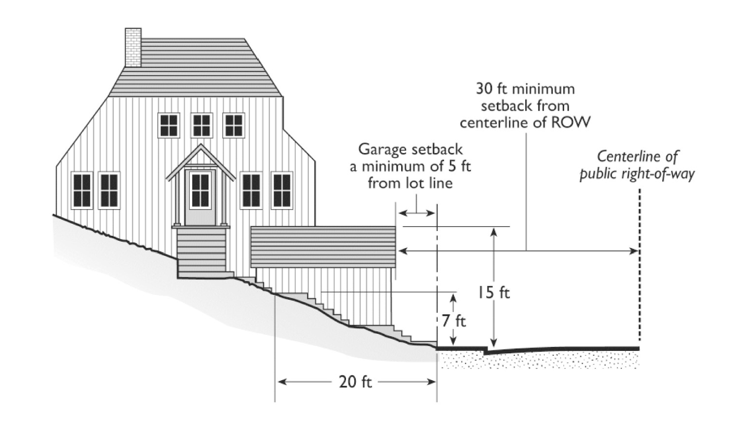
(B) Residential front yard setbacks on steep upsloping lots. A minimum five-foot front or street-side setback shall be allowed for the construction of an attached or unattached private garage and associated entries (not, including rooms), provided that the following conditions are met:
(1) The elevation of the lot, at all points measured 20 feet from the property line adjacent to the street from which access will be taken, shall be at least seven feet above the elevation at the centerline of the street;
(2) No portion of the garage shall exceed 15 feet in overall height as measured from all points along the centerline of the street perpendicular to the garage;
(3) Main entry shall not exceed 15 feet above natural grade;
(4) All required snow storage shall be provided. Snow storage areas shall meet the requirements of Section 17.36.110.
(5) No portion of the garage shall be located closer than 30 feet to the centerline of the street; and
(6) All required parking must be provided. The required exterior space may be parallel to the street within a driveway leading to a garage provided that parking space meets the minimum dimensions and is located entirely outside of the public right-of-way. Alternatively, the required exterior parking space may be located within the front setback area adjacent to the garage, provided that the space is covered. The location of unenclosed parking areas and the garage and entry encroachments must conform to requirements of the adopted residential driveway standards and California Building Standards Code provisions for snow shed from roofs.
(C) Bluffs slope setback.
(1) The distance between any construction above 8,250 feet and a 30 percent or greater slope which occupies more than one-quarter of the parcel shall be 30 feet except as provided below.
(2) Reduction of the 30-foot setback may be permitted when a design is provided that better meets the intent of this regulation to mitigate visual impact from off-site pursuant to the Bluffs EIR. All other mitigation measures must be satisfied, including avalanche hazard impacts, when such a reduction is approved by the Commission through approval of a use permit. Factors to be considered by the Commission in granting a setback reduction include, but are not limited to, location of existing vegetation, lowered building profile, and fit of structure into natural terrain.
(Code 1990, § 17.20.030; Ord. No. 14-02, § 4, 3-19-2014; Ord. No. 15-01, § 4(exh. A, § 26), 1-21-2015; Ord. No. 20-13, exh. A(d), 11-18-2020; Ord. No. 2021-03, § 4(exh. B, § d.), 3-3-2021; Ord. No. 2022-01, § 3(exh. B, § b.), 1-19-2022)
17.24.010. - Purpose.
(a)
Generally. In addition to the objectives outlined in this Chapter, the commercial zones are included in the zoning regulations to achieve the purposes outlined in the neighborhood and district character element of the 2007 general plan, specific to the Main Street and Old Mammoth Road districts. Additional purposes of the individual commercial zoning districts and the manner in which they are applied are as follows:
(1)
Downtown District (D). Downtown District (D) is intended to provide a thriving mix of residential, nonresidential, and lodging uses and a distinctive gateway entry into Town, with a focus on ground-level commercial uses and active frontages. The development standards are intended to concentrate development along Main Street with a focus on shop front buildings that frame the street and provide an animated, pedestrian-friendly environment with high visual quality. The maximum FAR is 2.0. The D zoning district is consistent with the Commercial 2 (C-2) land use designation of the general plan.
(2)
Old Mammoth Road (OMR). The Old Mammoth Road District (OMR) is intended as an arts and culture district oriented toward medium scale commercial development along Old Mammoth Road, emphasizing community serving retail, artist galleries, office and service uses. It is intended to encourage a mix and intensity of uses in a pedestrian-scaled environment at a scale and form that is appropriate to its neighborhood context and adjacent residential uses and forms. The maximum FAR is 2.0. The OMR zoning district is consistent with the Commercial 2 (C-2) land use designation of the general plan.
(3)
Mixed Lodging/Residential (MLR) District. The Mixed Lodging/Residential (MLR) District is intended to allow one or more of a variety of lodging, residential, and nonresidential uses to encourage a mix of uses and emphasize transient occupancy. The maximum FAR is 2.0. The MLR zoning district is consistent with the Commercial 1 (C-1) land use designation of the general plan.
(b)
Floor area ratio. The permissible floor area ratio (FAR) for a particular project or parcel will be affected by applicable design requirements; height, setback, snow storage, parking, and stepback requirements; and other development and dimensional standards. Accordingly, the maximum theoretically possible FAR is not achievable in some instances. Nothing in this chapter or in the Town's general plan waives any design requirement or excuses compliance therewith, or entitles any applicant, project, or parcel to receive the maximum theoretically possible FAR.
(Code 1990, § 17.24.010; Ord. No. 14-02, § 4, 3-19-2014; Ord. No. 16-09, § 4(exh. 1), 12-21-2016)
17.24.020. - Commercial district land uses and permit requirements.
(a)
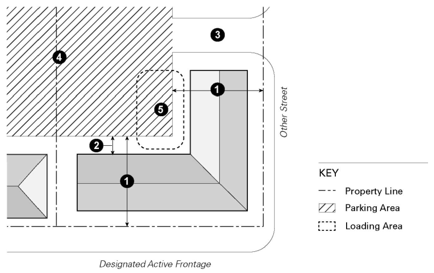
General permit requirements. Table 17.24.020 identifies the uses of land allowed by this chapter in each commercial zone and on designated active frontages (Figure 17.24.020), and the planning permit required to establish each use, in compliance with Chapter 17.08.
(1)
Other uses may be allowed as determined by the Director to be similar to and not more detrimental to uses listed in Table 17.24.020.
(2)
In multitenant centers, wherever there is a change in building occupancy and the new use is similar to or no more intrusive than the previous use and meets all development standards applicable to the previous use, a use permit or administrative permit, if specified for the use, shall not be required.
(3)
Design review is required for proposed projects based on specified criteria as identified in Chapter 17.88.
(b)
Requirements for certain specific land uses. Where the last column in Table 17.24.020 includes a section number, the referenced section may establish other requirements and standards applicable to the use. The following is a key for the abbreviations used in Table 17.24.020:
FIGURE 17.24.020. DESIGNATED ACTIVE FRONTAGES
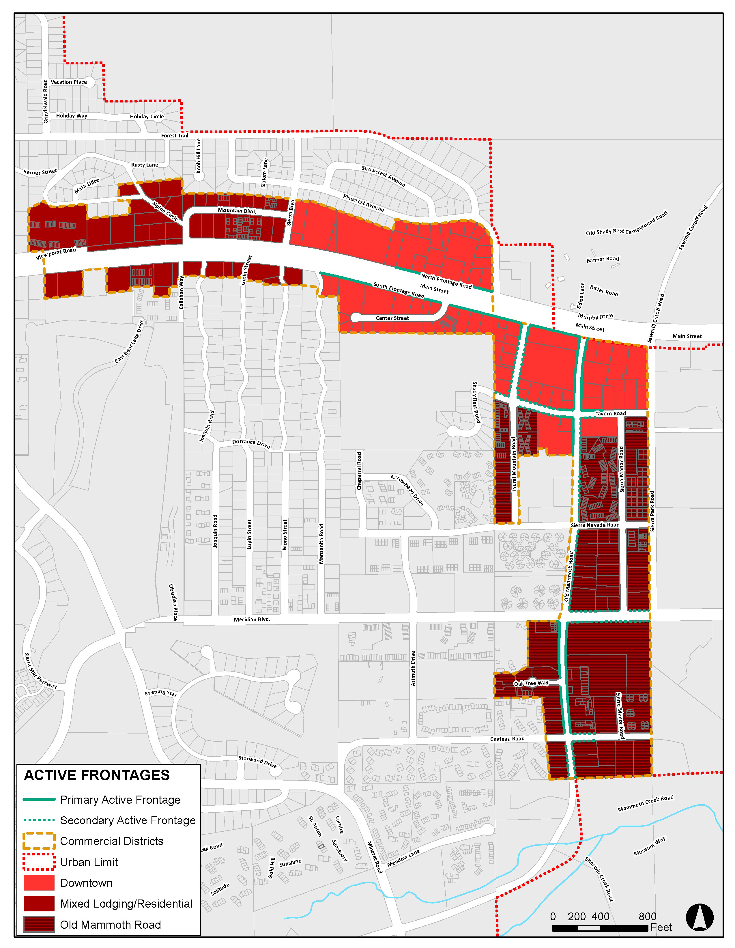
Table 17.24.020
Allowed Uses and Permit Requirements for Commercial Zoning Districts
Specific limitations:
1. Limited to no more than 75 percent of the ground floor area when located along primary and secondary active frontages. A minimum of 25 percent of the ground floor area shall be occupied by uses permitted by right or by administrative permit (i.e., active uses) and shall occupy the building or structure's frontage for a minimum depth of 20 feet (administrative permit required for depths less than 20 feet).
2. Limited to establishments with a gross floor area of 5,000 square feet or less when located on the ground floor along designated active frontages. Administrative permit required if greater than 5,000 square feet.
3. Limited to establishments with a gross floor area of 1,200 square feet or less when located on the ground floor along designated active frontages.
4. Permitted if existing, no new fueling stations allowed.
5. Use shall be completely enclosed in a building of soundproof construction.
6. At least 50 percent of the ground floor designated active frontages shall be occupied by retail or food service uses.
7. Limited to walk-in clientele when located on the ground floor along designated active frontages.
8. Shall be located behind buildings or in structures where other uses are located in the portion of the structure along designated active frontages.
9. Limited to establishments with a gross floor area of 5,000 square feet or less.
10. Allowed only as accessory to a hotel or motel or other lodging use. Administrative permit required if primary use in OMR and MLR districts.
(Code 1990, § 17.24.020; Ord. No. 14-02, § 4, 3-19-2014; Ord. No. 15-01, § 4(exh. A, §§ 2, 3), 1-21-2015; Ord. No. 15-02, § 4(exh. A), 3-4-2015; Ord. No. 16-04, § 2a(exh. A), 5-18-2016; Ord. No. 16-09, § 4(exh. 1), 12-21-2016; Ord. No. 18-02, § 5(exh. A, a.), 3-13-2018; Ord. No. 18-05, § 4(exh. A, a.), 11-19-2018; Ord. No. 19-04, § 4(exh. A, b.), 11-6-2019; Ord. No. 19-06, § 4(exh. A, b.), 12-18-2019; Ord. No. 20-12, § 4(exh. B, § a.), 11-18-2020; Ord. No. 2021-03, § 4(exh. B, § b.), 3-3-2021)
17.24.030. - Commercial district development standards.
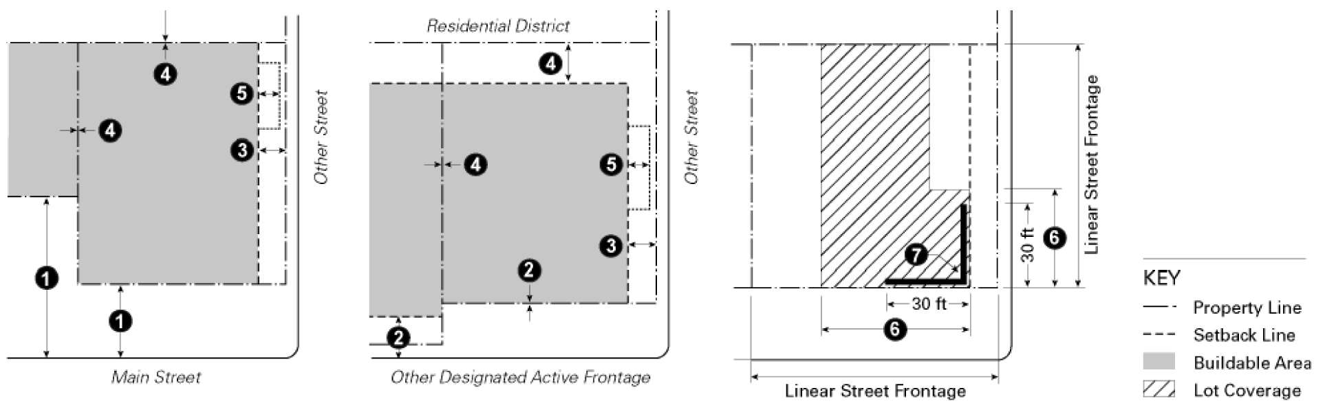
Subdivisions, new land uses and structures, and alterations to existing land uses and structures, shall be designed, constructed, or established in compliance with the requirements in Tables 17.24.030-1 through 17.24.030-5 in addition to the applicable development standards (e.g., landscaping, parking and loading, etc.) in Chapters 17.36 through 17.56. However, where accessory dwelling units are a permitted use, the development standards specified in Section 17.52.055 applicable only to accessory dwelling units shall take precedence over the development standards specified below. Additional regulations are denoted in a right column. Section numbers in this column refer to other sections of this chapter, while individual letters refer to Section that directly follow the table. The numbers in each illustration below refer to corresponding regulations in the "#" column in the associated table.
Table 17.24.030-1. Commercial Districts—Lot Density and Intensity Standards
Table 17.24.030-2. Commercial Districts—Building Placement Standards
 | |||||
|---|---|---|---|---|---|
|
Development
Feature | Requirement by Zone | Additional Regulations | # | ||
| D | OMR | MLR | |||
| Minimum Setbacks (measured from property line unless otherwise stated) | |||||
| Main street and frontage road | 0 feet (B) | 17.36.090;
17.36.100; 17.52.170 | |||
| Other designated active frontage areas | Property line or 15 feet from back of curb, whichever is greater (B) | n/a | |||
| All other streets | 10 feet (B) | ||||
| Interior side and rear |
0 feet, 15 feet adjacent to a
residential district | ||||
| Projections into setbacks | Awnings, overhangs and other elements of a covered walkway, public plaza, or outdoor eating area may project up to 8 feet into the required setback | ||||
| Build-to Requirement | |||||
| Primary active frontage |
Min: 60% of linear street
frontage (C) | ||||
| Secondary active frontage |
Min: 40% of linear street
frontage (C) | ||||
| Corner build area | 30 feet (C) | ||||
A. Reserved
B. Frontage improvements.
a. New development shall provide street frontage improvements in accordance with adopted Town plans (i.e., pedestrian master plan, bikeway master plan, etc.) as determined by the Director and Public Works Director, including, but not limited to, sidewalks, bike lanes, paths, bus stops, and other typical frontage improvements.
b. Except where occupied by a building or used for building access, the property frontage, for a depth of ten feet from the property line, shall be improved so that it functions as a wider public sidewalk; utilized for active outdoor uses such as outdoor dining, or improved with landscaping, public art, or pedestrian amenities such as outdoor seating.
C. Required building areas, active frontage areas. The following building placement requirements apply in designated active frontage areas (see Figure 17.24.020):
a. Build-to requirement. Building facades shall be located within five feet of the required setback line along designated active frontages for the percent of linear street frontage identified in Table 17.24.030-2.
b. Corner build area. Buildings on corner lots along designated active frontages shall be located at or within five feet of the required setbacks on each street frontage within 30 feet of the corner.
c. Exception. The requirements above may be modified or waived by the Director upon finding that:
1. Plazas, courtyards or outdoor eating areas that function as publicly accessible open space with amenities such as seating, landscaping, lighting, and trash/recycle bins are located between the build-to line and building, provided that the buildings are built to the edge of the plaza;
2. The building incorporates an alternative entrance design that creates a welcoming entry feature facing the street; or
3. A larger setback is required to preserve existing mature trees or landscape.
Table 17.24.030-3. Commercial Districts—Height Standards
|
Development
Feature | Requirement by Zone |
Additional
Regulations | # | ||
|---|---|---|---|---|---|
| D | OMR | MLR | |||
| Maximum overall building height | 55 feet | 45 feet | 45 feet for lots with slopes of less than 10%; 55 feet for lots with slopes of 10% of greater |
See
Section 17.36.060 | |
| Minimum building face height | 20 feet, applicable only to primary active frontages | ||||
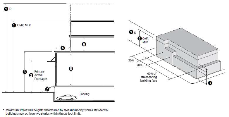
| Maximum building face height along all streets and adjacent to residential districts | 25 feet for 60% of the building face; 35 for 20% of the building face; 45 for 20% of the building face (D) | ||||
| Stepback | Min. ten feet from the building face below (D) | ||||
| Ground floor, nonresidential uses | Min. 14 feet clear from floor to ceiling | ||||
| Ground floor, residential uses | Min. 8 feet clear from floor to ceiling | ||||
| Upper floors | Min. 8 feet clear from floor to ceiling | ||||
| Parking podium | The maximum height of a parking podium visible from the street is 4 feet from finished grade | ||||
D. Building face height. Along street frontages and adjacent to residential districts, the building face shall have a maximum wall height as identified in Table 17.24.030-3 with a minimum stepback of ten feet from that building face to the next higher story, except as provided below.
a. A maximum of 20 percent of the length of the building face may exceed the maximum building face height by up to ten feet without a stepback; and
b. An additional 20 percent of the length of the building face may exceed the maximum building face height by up to 20 feet without a step back.
Table 17.24.030-4. Commercial Districts—Parking and Loading Standards
| Development Feature | Requirement by Zone | Additional Standards | # | ||
|---|---|---|---|---|---|
| D | OMR | MLR | |||
| Setback from street property line | 20 (E) | 20 (E) | 20 (E) | See Chapter 17.44 | |
| Setback from buildings and public plazas | 8 feet; 5 feet walkway, plus 3 feet landscaping; Applicable only to above ground parking | ||||
| Access location | Side street, alley, or rear of property wherever possible (F) | ||||
| Shared access | See additional regulations (G) | ||||
| Curb cuts | Minimized and in areas least likely to impede pedestrian circulation | ||||
| Loading/service areas | Side or rear of lot; must be screened from public ROW | ||||
E. Limitations on location of parking. Buildings shall be placed as close to the street as possible, with parking underground, behind a building, or on the interior side or rear of the site. Parking may be located within the required setback, subject to the following requirements.
a. Underground and partially submerged parking. Parking completely or partially underground may match the setbacks of the main structure.
b. Surface parking. Above ground surface parking may be located within 20 feet of a street facing property line when the Director makes the following findings:
1. Buildings are built close to the public sidewalk to the maximum extent feasible;
2. The parking area is screened along the public right-of-way with a wall, hedge, trellis, or landscaping; and
3. The site is small and constrained such that underground, partially submerged, or surface parking located more than 20 feet from the street frontage is not feasible.
F. Access for Main Street properties. Properties fronting onto Main Street that redevelop to claim an existing frontage road shall incorporate a re-routed access road to the rear of the property. The re-routed access road shall be designed to be continuous with those of adjacent properties, and to provide adequate circulation and emergency access.
G. Shared access. To encourage shared parking and shared access points on public streets, new parking facilities shall be designed to accommodate cross-access to/from adjacent properties to allow parking areas to become joint use facilities even if initially serving only one development. When cross-access for vehicles is deemed impractical by the Director, the requirement for cross-access may be waived if bicycle and pedestrian connections are provided between adjacent properties.
Table 17.24.030-5. Commercial Districts—Additional Standards
(Code 1990, § 17.24.030; Ord. No. 14-02, § 4, 3-19-2014; Ord. No. 15-01, § 4(exh. A, § 4), 1-21-2015; Ord. No. 16-09, § 4(exh. 1), 12-21-2016; Ord. No. 2021-03, § 4(exh. B, § e.), 3-3-2021)
17.24.040. - Commercial district supplemental standards.
(a)
Maximum block length. Block length is limited to 350 feet measured from curb edge to curb edge. A block length up to 600 feet shall only be allowed when a mid-block pedestrian connection is provided or the Director finds that:
(1)
It is not feasible or practical to provide a mid-block pedestrian connection due to the location and configuration of the lot; and
(2)
Safe and convenient pedestrian connections are provided throughout the site and provisions are made to accommodate cross-access to/from pedestrian areas that may be developed on adjacent properties.
(b)
Building orientation and entrances.
(1)
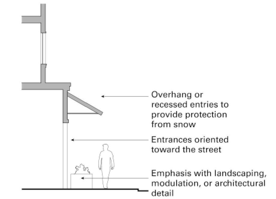
All buildings located on a public street shall be oriented toward and have their primary entrances facing the public street.
(2)
Building entrances shall be emphasized with special architectural, modulation of roof lines or landscape treatments.
(3)
Building entrances shall be designed so that snow does not shed freely into entrances and the buildup of ice and snow within pedestrian areas is minimized.
(c)
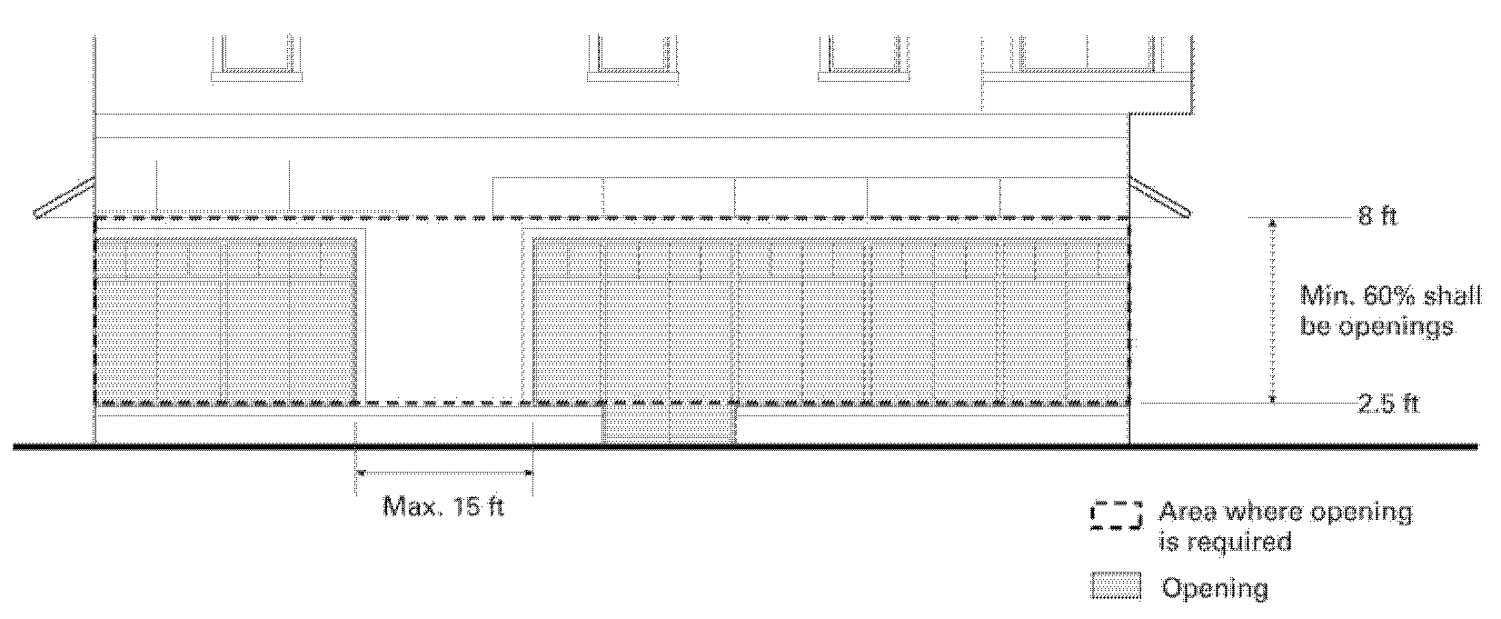
Building transparency and openings for nonresidential uses. Exterior walls facing and within 20 feet of a street, park, plaza, pedestrian walkway, or other public outdoor space shall include windows, doors, or other openings for at least 60 percent of the building wall area located between 2½ and eight feet above the level of the sidewalk. No wall may run in a continuous horizontal plane for more than 15 feet without an opening.
(1)
Design of required openings.
a.
Openings fulfilling this requirement shall have transparent glazing and provide views ten feet in depth into work areas, display areas, sales areas, lobbies, or similar active spaces or into window displays that are at least three feet deep.
b.
Windows on the ground level building facade facing a street shall not be opaque. Shades or blinds, which block the view of a pedestrian into a building for more than five hours a day during daylight hours in the summer, or more than four hours a day during daylight hours when it is not summer, are defined as opaque for purposes of this chapter.
(2)
Exceptions for parking garages. A parking garage that does not incorporate ground-floor nonresidential or residential use or is not otherwise screened or concealed at street frontages on the ground level, must provide a landscaped area at least ten feet wide between the parking garage and public street.
(3)
Alternatives. Alternatives to the building transparency requirement may be approved if the Director finds that the street-facing building walls exhibit architectural relief and detail and are enhanced with landscaping in such a way as to create visual interest at the pedestrian level.
(d)
Building design. Buildings shall be well designed to create a pedestrian-friendly environment and support a vital and active public realm. Buildings shall appear integrated with the natural features and existing buildings in the districts; complement the Eastern Sierra Nevada Mountain setting; and contribute to the Town's village in the trees identity.
(1)
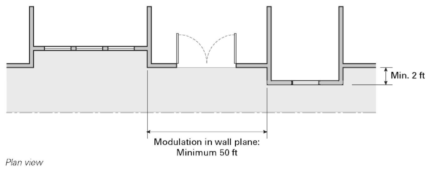
Wall plane modulation. Buildings should exhibit substantial reveals or offsets in the wall plane. Any building face over 50 feet wide shall be broken down to read as a series of buildings or storefronts no wider than 50 feet each to avoid a monotonous flat wall plane. Offsets shall be a minimum of two feet.
(2)
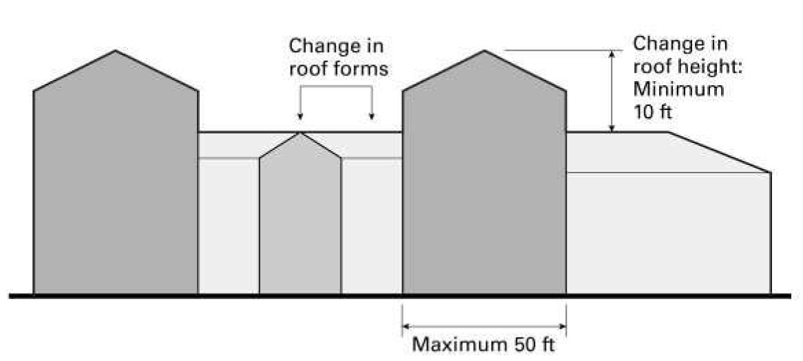
Roof modulation. The roof line of all facades visible from a public right-of-way shall not exceed 50 feet wide without modulation.
a.
Roof modulation shall consist of or be a combination of:
1.
A change in height by a minimum of ten feet; or
2.
A change in form through changes in pitch, plane, and orientation. A pitched roof line segment shall have a minimum slope of 3:12. Acceptable pitched roof types include gable, hip, and gambrel roofs.
b.
Roof modulation shall be incorporated to reflect the interior uses of multitenant buildings and emphasize key building entrances.
c.
Roof designs and modulation should take into account snow and ice storage and shedding and should ensure that pedestrian areas are protected from shedding ice and snow.
d.
Alternatives. Alternatives to the roof modulation requirement may be approved if the Director finds that the roof design is composed of a variety of roof forms that are appropriately scaled and proportioned.
(3)
Vertical relationship. Buildings shall be designed to have a distinctive base (ground floor level), middle (intermediate upper floor levels), and top (either top floor or roof level). Architectural features such as cornices, eaves, parapets, towers, and balconies shall be used, as appropriate, to delineate the base, middle, and top, accentuate setbacks between stories, and terminate rooflines.
(4)
Architectural articulation. Buildings shall include sufficient architectural design features to create visual interest. Different ways that this requirement may be met, include, but are not limited to, those listed below; compliance with this requirement shall be evaluated by the Director in the review process.
a.
Facade incorporates architectural details. The building facades incorporate details such as window trim, window recesses, cornices, belt courses, columns, changes in material, or other design elements in an integrated composition. The use of materials, textures, and colors enhance architectural interest and emphasize details and changes in plane. Buildings shall be designed with four-sided architecture where each exterior wall is designed equivalent to the primary facade in the extent of building articulation and quality of exterior materials, and consistent with the color scheme of the primary facade.
b.
Pedestrian-friendly design features.
1.
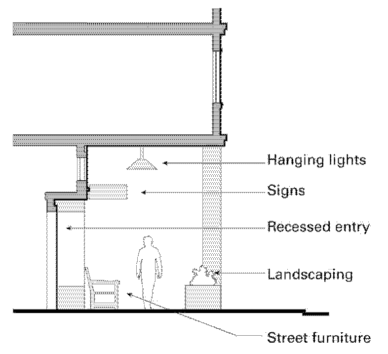
Storefronts. Building frontages along designated active frontages shall be designed to enhance the storefront character of retail areas. Storefronts consist of detailed and composed facades with individual windows set in well-detailed frames. Frontages incorporate features that contribute to pedestrian comfort and interest, such as awnings, recessed entries, arcades, hanging lights, and bracket hung signs. Architectural and ornamental features shall not impede pedestrian routes.
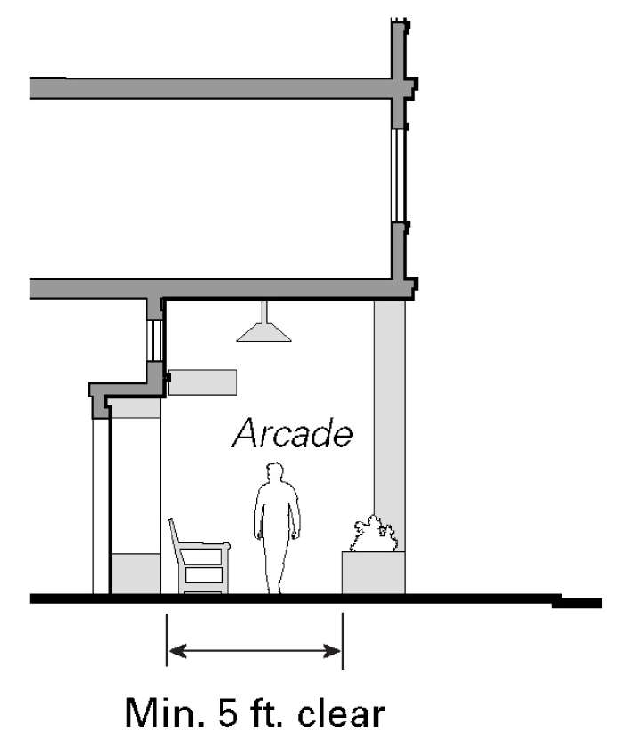
2.
Arcades. The minimum depth of an arcade shall be five feet clear, measured from the back face of the columns to the ground floor facade.
c.
Projections and recesses. All building faces shall exhibit modulation through projections with a significant depth, or a repeated pattern of offsets, recesses, or projections of smaller depth. Balconies, bay windows, or similar repeated elements are encouraged across the length of the facade. This method for achieving architectural articulation is most typically found in the building middle and on buildings that include residential or lodging uses.
(e)
Building materials and construction.
(1)
Building materials. The building base shall be clad in durable high-grade materials from at least the floor slab of the second floor down to one inch of the finished sidewalk grade, and these materials shall wrap corners of exposed interior property line walls a minimum of five feet.
(2)
Construction execution. All construction details and materials shall be of the highest standard and executed to minimize weathering, eliminate staining of the wall surface, and avoid deterioration of materials on adjacent properties or the public-right-of-way.
(f)
Pedestrian access. On-site pedestrian circulation and access must be provided according to the following standards:
(1)
Internal connections. A system of pedestrian walkways shall connect all buildings on a site to each other, to on-site automobile and bicycle parking areas, and to any on-site open space areas or pedestrian amenities.
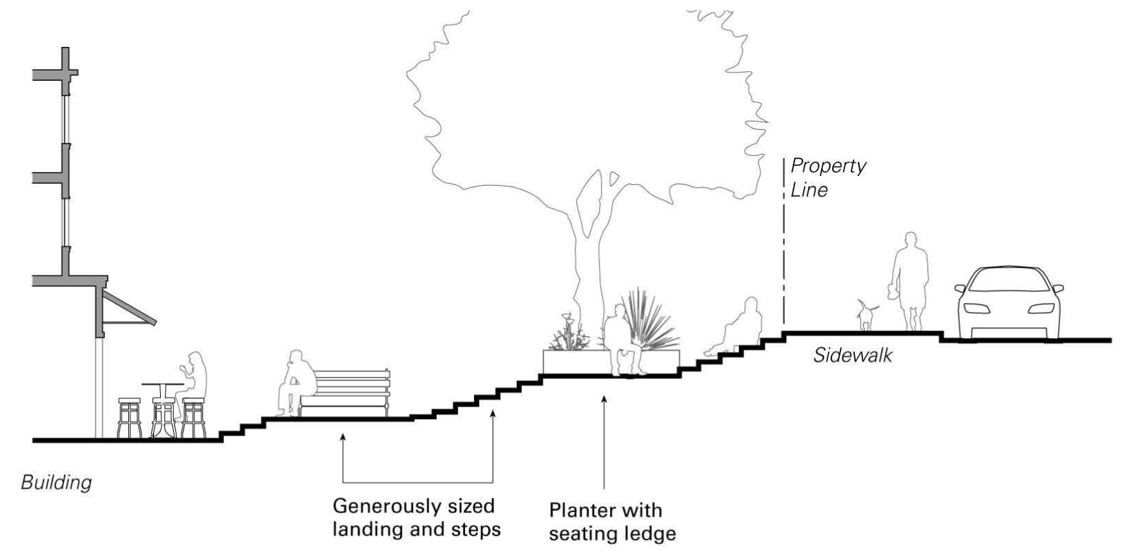
(2)
To street network. Regular connections between on-site walkways and the public sidewalk shall be provided. An on-site walkway shall connect the primary building entry or entries to a public sidewalk on each street frontage. On sloping sites, the walkway between the building and the sidewalk or other public outdoor area shall be designed as usable open space with generously sized steps and landings, with features such as low risers and wide treads, and any planter boxes that include seating ledges.
(3)
To neighbors. Direct and convenient access shall be provided from commercial and mixed-use projects to adjoining residential and commercial areas to the maximum extent feasible while still providing for safety and security.
(4)
To transit. Safe and convenient pedestrian connections shall be provided from transit stops to building entrances.
(5)
Pedestrian walkway design.
a.
Walkways shall be a minimum of six feet wide, shall be hard-surfaced, and paved with permeable materials.
b.
Where a required walkway crosses driveways, parking areas, or loading areas, it must be clearly identifiable through the use of a raised crosswalk, a different paving material, or similar method.
c.
Where a required walkway is parallel and adjacent to an auto travel lane, it shall be raised or separated from the auto travel lane by a raised curb at least four inches high, bollards, or other physical barrier.
(g)
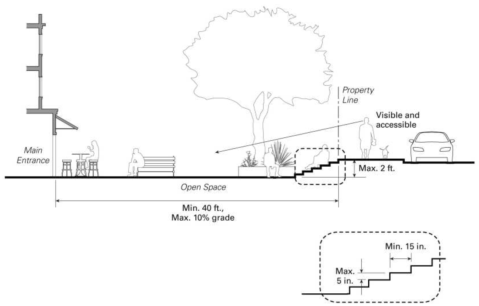
Public open space. Development with 50,000 square feet or more of nonresidential floor area on sites two acres or more in size shall provide public open space in accordance with the following:
(1)
Amount. 40 square feet of public open space for every 1,000 square feet of nonresidential floor area for the first 100,000 square feet of nonresidential floor area, plus 20 square feet of public open space for every 1,000 square feet of nonresidential floor area over 100,000 square feet.
(2)
Location and accessibility. Such public space shall be visible and accessible from a public street, or from on-site areas normally frequented by customers, and shall be accessible during business hours. Areas within required setbacks may count toward the public space requirement.
(3)
Elevation. Such public space located adjacent to the street shall not be elevated or sunken more than two feet from the level of the adjacent sidewalk. Steps providing access to such public space shall have a maximum height of five inches and a minimum tread depth of 15 inches. The elevation requirement may be modified or waived by the Director for sites with steep slopes upon finding that an alternative design is visible and accessible from the street.
(4)
Minimum dimensions. Such public space shall have a minimum dimension of 40 feet.
(5)
Obstructions. Obstructions that impair visibility within the space shall not be permitted unless it is a plaza design feature such as a water feature, public art, or landscaping.
(6)
Seating. A variety of well-designed and comfortable seating types shall be included in the public space. Seating types may include fixed seating, moveable seating, planter ledges, seat walls, and seating steps. A portion of the seating shall be located near the entrance of the public space.
(7)
Amenities. Amenities shall be included that enhance the comfort, aesthetics, or usability of the space, including, but not limited to, trees and other landscaping, shade structures, lighting, drinking fountains, water features, public art, signage or performance areas.
(8)
Usability. A surface shall be provided that allows convenient use for outdoor activity, recreation, and public gathering. Such surface may be any practical combination of high quality plant and hardscape materials such as bricks, stone, concrete, permeable paving, or tile. Surfaces shall be sloped for positive drainage and constructed to withstand snow removal and de-icing maintenance. The maximum slope shall not exceed ten percent. Seating areas and plazas should be located in areas with good solar exposure.
(Code 1990, § 17.24.040; Ord. No. 14-02, § 4, 3-19-2014; Ord. No. 15-01, § 4(exh. A, § 26), 1-21-2015)
17.28.010. - Purpose.
In addition to the objectives outlined in Section 17.04.010, the specific purposes of the industrial zoning district are to:
(1)
To reserve appropriately located areas for viable industrial uses and protect these areas from intrusion by family dwellings or other incompatible uses.
(2)
To protect residential and commercial uses from noise, odor, dust, smoke, truck traffic and other objectionable influences incidental to certain industrial uses.
(3)
To protect industrial uses and structures from hazard and to minimize the impact of industrial uses on the environment.
(4)
To minimize traffic congestion and to avoid the overloading of utilities by restricting the construction of buildings of excessive size in relation to the amount of land around them.
(5)
Provide an area for light industrial and limited service type uses located so as to minimize impacts on adjacent land use patterns and the environment and with development standards to facilitate relocation of existing nonconforming industrial/service uses in commercial zones to designated industrial areas.
(Code 1990, § 17.28.010; Ord. No. 14-02, § 4, 3-19-2014)
17.28.020. - Industrial zoning district land use and permit requirements.
(a)
General permit requirements. Table 17.28.020 identifies the uses of land allowed by this chapter in the industrial zoning district, and the permit required to establish each use, in compliance with Section 17.08.020.
(b)
Requirements for certain specific land uses. Where the last column in Table 17.28.020 includes a section number, the referenced section may establish other requirements and standards applicable to the use. The following is a key for the abbreviations used in Table 17.28.020:
Table 17.28.020
Allowed Uses and Permit Requirements for the Industrial Zoning District
(Code 1990, § 17.28.020; Ord. No. 14-02, § 4, 3-19-2014; Ord. No. 15-01, § 4(exh. A, § 5), 1-21-2015; Ord. No. 16-04, § 2b(exh. A), 5-18-2016; Ord. No. 18-02, § 5(exh. A, b.), 3-13-2018)
17.28.030. - Industrial zoning district development standards.
Subdivisions, new land uses and structures, and alterations to existing land uses and structures, shall be designed, constructed, or established in compliance with the requirements in Table 17.28.030, in addition to the applicable development standards (e.g., landscaping, parking and loading, etc.) in Chapters 17.36 through 17.56. Additional regulations are denoted in the right column. Section numbers refer to other sections of this chapter.
Table 17.28.030. Planning and Building Standards Development Feature Planning
(Code 1990, § 17.28.030; Ord. No. 14-02, § 4, 3-19-2014)
17.32.010. - General provisions.
In addition to the purposes outlined in Section 17.04.010, the following special purpose zones are established because of the special or unique land use character characteristics with which they are associated and because of the need to implement specific sections of the general plan.
(1)
Overlay zones. The special purpose overlay zones are as follows:
a.
Equestrian Overlay Zone (E).
b.
Open Space/Stream Corridor Protection Overlay Zone (OSSC).
c.
Snow Deposition Design Overlay Zone (SDD).
(2)
Special purpose zones. The special purpose zones are as follows:
a.
Airport Zone (A).
b.
Mobile Home Park Zone (MHP).
c.
Open Space Zone (OS).
d.
Planned Residential Development Zone (PRD).
e.
Public and Quasi-Public Zone (P-QP).
f.
Resort Zone (R).
(Code 1990, § 17.32.010; Ord. No. 14-02, § 4, 3-19-2014; Ord. No. 21-01, § 4.c.(exh. 2), 1-20-2021)
17.32.020. - Equestrian Overlay Zone (E).
(a)
Purpose. In addition to the purposes outlined in Section 17.04.010, the equestrian overlay zone is intended to provide areas where the keeping of horses or pack stock is permitted subject to various standards of operation and maintenance which are designed to minimize the impacts of animals on adjacent properties and uses.
(b)
Permitted uses. The equestrian overlay zone shall permit the keeping of horses or pack stock only as a use accessory or subordinate to an existing permitted use on the site; provided, however, that such horses or pack stock are maintained only for the personal use of the members of the family or household residing on the premises. No commercial operations shall be permitted on property that does not belong to members of the family or household residing thereon.
(c)
Property maintenance standards. The keeping of horses in the equestrian overlay zone shall be subject to the following standards:
(1)
The minimum lot size shall be 20,000 square feet;
(2)
A maximum of two horses may be kept on a lot having 20,000 square feet; one additional horse may be kept for each additional 10,000 square feet of lot area;
(3)
No horse may be kept, pastured or penned closer than 50 feet to a dwelling on an adjoining lot, but in no event closer than 25 feet to any property line;
(4)
All requirements of the County Environmental Health Department and Town Police Department (Animal Control) shall be satisfied;
(5)
Barns, stables, or similar structures shall be subject to the setback requirements of the main building but in no case may be located closer than ten feet to any side or rear lot line and shall not exceed 15 feet in height;
(6)
Animal confinement areas, including, but not limited to, pens and corrals, shall be maintained in a clean and orderly manner at all times. Accumulation of waste or other odor or insect producing material is not permitted; and
(7)
Animal confinement areas shall be located at least 50 feet away from any permanent lake or stream. Waste shall be controlled so that it does not wash directly or indirectly into any permanent lake or stream or neighboring properties.
(d)
Initiation of equestrian overlay zone.
(1)
The minimum size for an equestrian overlay zone shall be five acres. Additions to existing (E) zones shall meet the minimum area requirements as stated in Subsection (c)(1) of this section.
(2)
All procedures for initiating an equestrian overlay zone shall be as set forth in Chapter 17.108.
(Code 1990, § 17.32.030; Ord. No. 14-02, § 4, 3-19-2014)
17.32.030. - Open Space/Stream Corridor Protection Overlay Zone (OSSC).
(a)
Purpose. In addition to the purposes outlined in Section 17.04.010, the open Space Stream Corridor Protection Zone is intended to protect sensitive stream and drainage courses from development, to recognize and preserve these environmentally sensitive areas as a community resource, and, to protect water quality and preserve wetland habitat.
(b)
Permitted uses. Permitted uses shall be identified by the underlying zone classification; however, in the open Space Stream Corridor Protection Zone, a use permit shall be required for all uses except for a single-family dwelling on a single lot. Any development rights associated with private property contained within this zone classification may be transferred to other private land holdings subject to the granting of a use permit.
(Code 1990, § 17.32.040; Ord. No. 14-02, § 4, 3-19-2014)
17.32.040. - Snow Deposition Design Overlay Zone (SDD).
(a)
Purpose. In addition to the purposes outlined in Section 17.04.010, the Snow Deposition Design Zone is intended to:
(1)
To identify those areas in Town where avalanche potential has been found to exist after specific investigation and study;
(2)
To minimize health and safety hazards related to avalanche potential; and
(3)
To promote the general public health, safety and welfare.
(b)
Applicability. The SDD zone applies to all areas with potential avalanche hazard due to being located immediately above, adjacent or otherwise within 150 feet of the 30-degree point of an avalanche starting zone, known herein as "areas adjacent to avalanche starting zones" as shown on the Town Zoning Map.
(c)
Use permit required. No development (including building permits, subdivision of land, but not the construction of roads, driveways, and utilities) shall be permitted, without first obtaining a use permit.
(1)
In addition to the requirements of Chapter 17.68, the use permit application shall contain certification by a recognized expert in the field of avalanche occurrence, force and behavior that there will be no greater snow deposition in the related avalanche starting zones and no overall increase in the avalanche hazard in the balance.
(2)
Town staff has the right to hire an expert to provide a second opinion, at the expense of the applicant, to review any of the calculations, studies, reports or certifications required under this section.
(d)
Warning and disclaimer of safety and liability. Avalanches occur naturally, suddenly and unpredictably based on many factors, including slope, exposure, snowpack composition, snowfall rate, wind and temperature. The SDD Zone is considered reasonable for regulatory purposes and is based upon and limited by the engineering and scientific methods of study. The Town does not represent, guarantee or warrant the ultimate safety of any construction, use or occupancy of structures situated in any avalanche area, whether designated or undesignated by this ordinance. Avalanches may occur with forces greater than those set forth in avalanche studies. This article does not represent or imply that areas outside the SDD Zone are free from avalanches or avalanche danger. The granting of any permit or approval for any structure or use, or the declaration or failure to declare the existence of an avalanche hazard shall not constitute a representation, guarantee or warranty of any kind or nature by the Town, or any official or employee, of the practicality or safety of any construction, use or occupancy thereof, and shall create no liability upon or cause of action against such public body, or its officials or employees for any injury, loss or damage that may result thereby. Persons who develop or occupy real property within an SDD Zone or other undesignated avalanche area do so at their own risk.
(Code 1990, § 17.32.050; Ord. No. 14-02, § 4, 3-19-2014)
17.32.050. - Airport Zone (A).
(a)
Purpose. In addition to the purposes outlined in Section 17.04.010, the airport zone is intended to implement the Airport Layout Plan, and the goals and policies in the general plan related to airport facilities.
(b)
Permitted and conditional uses. The following uses shall be permitted where the symbol "P" appears and shall be permitted subject to a use permit where the symbol "U" appears opposite the use. All uses are subject to the Airport Layout Plan and Federal Aviation Administration approval.
Table 17.32.050. Allowed Uses and Permit Requirements for Airport Zoning District
(c)
Development standards. Development standards shall conform to those set forth in the airport layout plan or as otherwise required by the Federal Aviation Administration.
(1)
Design. All facilities shall incorporate architectural, landscaping, signage and site design standards which support the goals and policies of the general plan. The design shall enhance the airport facility to ensure that a first class entry statement for the Mammoth Lakes resort community is maintained. All facilities shall be subject to design review under Chapter 17.88.
(2)
Operations. All facilities and operations shall be maintained in a safe and clean manner.
(3)
Yards, separation. All development shall have yards and separation between buildings and structures to provide adequate space for landscaping, vehicular/pedestrian circulation and emergency access as determined through the design review process. Hangars shall not require separation between structures.
(4)
Parking. Off-street parking, loading and delivery access shall be provided in conformance with parking requirements for similar uses. If similar uses are not listed in other sections of this chapter, adequate parking and access shall be determined through the design review process. The Town may require parking and circulation studies and other documentation to determine adequate parking and access.
(5)
Building height. Required aviation safety structures (e.g., light standards, antennas) maximum 45 feet, all others 35 feet.
(6)
Floor area. Floor area calculations do not include uncovered decks, uncovered parking spaces, or garages.
(7)
Development standards. Except as provided in this section, development standards shall be as specified in the use permit but shall not be less than those specified for similar uses in other zones.
(8)
Lighting. All lighting shall meet the requirements of Section 17.36.030.
(Code 1990, § 17.32.060; Ord. No. 14-02, § 4, 3-19-2014)
17.32.060. - Mobile Home Park Zone (MHP).
(a)
Purpose. The MHP, Mobile Home Park Zone, is intended for the exclusive development of mobilehome parks. All mobilehome parks hereafter established shall be developed in accordance with the provisions and standards of this section. Mobilehomes parks also are intended to offer an alternative mode of housing to the residents of the community.
(b)
Permits required. A Zoning Map amendment is required to rezone property to MHP. In addition, Design Review is also required.
(c)
Park development standards. The following requirements shall apply to the site of a mobilehome park. Additional regulations may be specified by the Commission as conditions of the design review approval:
(1)
Minimum park area: ten acres;
(2)
Minimum park street frontage: 200 feet;
(3)
Minimum site area per unit (density): 5,000 square feet;
(4)
Maximum density: 12 units per acre;
(5)
Minimum yards or setbacks: 20 feet adjoining a street, ten feet adjoining any other lot line;
(6)
Maximum building height: 35 feet; and
(7)
Recreation area: minimum of 50 square feet of recreation area for each mobilehome space.
(d)
Landscaping and screening. All yards and setback areas required for mobilehome parks shall be landscaped in accordance with a site plan approved as a part of the zoning amendment and design review. The landscaping shall be permanently maintained and shall consist predominantly of native or climate adaptive trees and vegetation. Screening shall be provided around the entire park in accordance with the requirements established under design review.
(e)
Interior site development standards. The following requirements shall apply to development of mobilehome spaces and to facilities within a mobilehome park. Additional requirements may be specified as conditions of design review or as conditions of approval for the establishment of an MHP zone:
(1)
Mobilehome space. Each space shall contain a minimum of 4,000 square feet for exclusive use by the occupants of the space. Each space shall have at least 40 feet of width adjoining an access drive and shall have dimensions capable of accommodating a rectangle with minimum dimensions of 45 feet by 65 feet.
(2)
Mobilehome placement. Each mobilehome shall be located not less than ten feet from the boundary of a mobilehome space, except that carports, patio covers, storage buildings, and similar structures accessory to mobilehome may be located not less than three feet from the boundary of a mobilehome space.
(3)
Access drives. All mobilehome access drives within a mobilehome park shall be privately owned, and shall have at least 28 feet of pavement width, exclusive of adjoining parking areas, and shall be constructed to Town standards.
(4)
Landscaping. At least one tree of a native species shall be planted on each mobilehome space.
(5)
Minimum size mobilehome. The minimum size for a mobilehome established within a mobilehome park shall be 12 feet by 50 feet.
(6)
Accessory buildings and uses. Accessory buildings and uses serving the entire mobilehome park, including recreation facilities, laundry areas, mobilehome offices, and maintenance or storage buildings, shall be located at least 50 feet from the boundary of the mobilehome park site. All exterior maintenance or storage areas shall be screened by a six-foot masonry wall, fence, landscaping or a combination thereof.
(7)
Parking. One on-site parking space shall be provided for each mobilehome space.
(8)
Guest parking. Guest parking or recreational vehicle storage areas shall be provided as required by the Commission.
(9)
Skirting. Skirting shall be required and maintained for each mobilehome, which skirting shall be complementary to the design and coloration of the mobilehome.
(10)
Mounting and tie-down. The mounting and tie-down of a mobilehome shall be in conformance with all regulations of the State Department of Housing and Community Development.
(11)
Cabanas. A cabana may be established in conjunction with a mobilehome provided the cabana shall be complementary to the design and coloration of the mobilehome.
(f)
Application requirements. An application for the establishment of a mobilehome park must be accompanied by a general development plan showing the following:
(1)
The location, design and configuration of each mobilehome space;
(2)
The location and design of all accessory or community buildings, facilities and uses;
(3)
The location and design of all access drives, parking areas and storage yards;
(4)
The location and design of all walls, fences, on-site lighting facilities and a landscape palette;
(5)
The location and design of refuse collection facilities; and
(6)
The location and design of all utilities and storm drain facilities.
(g)
Pre-existing mobilehome parks. A pre-existing mobilehome park shall not be deemed nonconforming by reason of failure to meet the minimum requirements prescribed by this chapter, provided that the regulations of this chapter shall apply to the remodeling, enlargement or expansion of an existing mobilehome park, and further provided that a pre-existing mobilehome park on a site less than ten acres shall not be further reduced in area.
(h)
Mobilehome park subdivisions. The subdivision of land for the establishment of a mobilehome subdivision shall comply with all of the requirements of this chapter and all provisions of the Subdivision Map Act, Government Code § 66410 et seq. and Title 16.
(Code 1990, § 17.32.070; Ord. No. 14-02, § 4, 3-19-2014)
17.32.070. - Open Space Zone (OS).
(a)
Purpose. In addition to the purposes prescribed in Section 17.04.010, the open space zone district is intended primarily to be applied to those areas of the Town where it is desirable and necessary to provide permanent open space in conformance with the open space designation of the general plan and to provide for the location and preservation of scenic areas and recreation areas. This zone classification is intended to be applied primarily to lands held under public ownership.
(b)
General permit requirements. Table 17.32.070 identifies the uses of land allowed by this chapter in the open space zone district, and the permit required to establish each use, in compliance with Section 17.08.020. The following is a key for the abbreviations used in Table 17.32.070:
Table 17.32.070
Allowed Uses and Permit Requirements for Open Space Zoning Districts
(c)
Development and performance standards. In the open space zone, standards of development and performance, including parking requirements for those uses requiring a use permit shall be set forth in the conditions of approval.
(Code 1990, § 17.32.080; Ord. No. 14-02, § 4, 3-19-2014)
17.32.080. - Planned Residential Development Zone (PRD).
(a)
Purpose. In addition to the purposes outlined in Section 17.04.010, the planned residential development zone is intended to:
(1)
Facilitate development of areas designated for residential use on the general plan and currently zoned for residential use by permitting greater flexibility and, consequently, more creative and imaginative designs for the development of such residential areas than generally is possible under conventional zoning or Title 16.
(2)
Promote more economical and efficient use of the land while providing a harmonious variety of housing choices, a higher level of urban amenities, and preservation of natural and scenic qualities of open spaces.
(b)
Uses permitted.
(1)
Single-family and multifamily residential development;
(2)
Private residential recreational facilities;
(3)
Utilities;
(4)
Accessory uses and structures incidental to permitted uses;
(5)
Temporary uses as prescribed in Chapter 17.56; and
(6)
Model homes and subdivision sales offices subject to the granting of a use permit.
(c)
Development standards. The following development standards shall apply to all planned residential developments.
(1)
The maximum number of dwelling units permitted in a planned residential development shall be determined by applying the slope and density restrictions and bonuses of the underlying residential zoning district.
(2)
There shall be no minimum area requirement for individual lots or individual dwelling sites in a planned residential development.
(3)
The planned residential development shall be designed and developed in a manner compatible with and complementary to existing and potential residential development in the immediate vicinity of the project site. Site planning on the perimeter shall provide for the protection of the property from adverse surrounding influences, as well as protection of the surrounding areas from potentially adverse influences within the development.
(4)
The following specific site development requirements shall apply to a planned residential development in any residential zone; these requirements are minimums unless otherwise noted:
a.
Site area: 2½ acres;
b.
Site frontage on public street: 200 feet;
c.
Front yard: 20 feet;
d.
Side yard: ten feet;
e.
Side yard, street side: 20 feet;
f.
Rear yard: ten feet;
g.
Building height, maximum: same as underlying zone; and
h.
Site coverage, maximum: same as underlying zone.
(5)
Required open space and recreation areas shall comprise at least 40 percent of the total land area of the planned development. Land occupied by recreational buildings and structures may be counted as required open space.
(6)
Open space may be improved or may be left in its natural state particularly if natural features worthy of preservation exist on the site. Open space left in its natural state shall be kept free of litter and shall at no time constitute a health, safety, fire or flood hazard. Areas devoted to natural or improved flood control channels and those areas encumbered by flowage, floodway or drainage easements may be applied toward satisfying the open space requirement.
(7)
If development is to be accomplished in stages, the use permit approval shall phase improvements and provision of the open space, the construction of buildings, structures and improvements in such open space, and the construction of dwelling units in order that each development stage achieves a proportionate share of the total open space and environmental quality of the total planned development.
(8)
No building, except as provided in this article, shall be located closer than five feet to any interior vehicular lot or any other surfaced area reserved for public use or for use in common by residents of the planned development. Such setback generally shall be measured from the nearest edge of a surfaced area; provided, however, that where no sidewalk exists in conjunction with a public or private street, such setback shall be measured from the nearest edge of the street right-of-way or private road easement.
(9)
No garage or carport having straight-in access from a public or private street shall be located closer than 20 feet from the nearest edge of the sidewalk of such street, or, where no sidewalk exists, from the nearest edge of the street right-of-way or road easement.
(10)
Spacing between buildings shall be a minimum of ten feet. Where a roof sheds snow toward another building, the spacing between buildings shall be increased or alternate design requirements shall be imposed by the Commission.
(11)
All public streets within or abutting the proposed planned development shall be dedicated and improved to Town specifications for the particular classification of street. When the developer desires to retain any streets within the development as private streets, such streets shall be permanently reserved and maintained for their intended purposes by means acceptable to the Commission upon recommendation of the Public Works Director. Other forms of access, such as pedestrianways, courts, plazas, driveways or open parking lots shall not be offered for dedication.
(12)
Planned residential development shall relate harmoniously to the topography of the site, shall make suitable provision for the preservation of watercourses, drainage areas, wooded areas, rough terrain, and similar natural features and areas, and shall be otherwise so designed as to use and retain such natural features and amenities to the best advantage.
(13)
All utilities within a planned residential development shall be placed underground. Appurtenances and associated equipment such as propane tanks, surface-mounted transformers, pedestal-mounted terminal boxes and meter cabinets, and concealed ducts in an underground system may be placed above ground.
(14)
The type, number and location of fire hydrants and other fire protective devices shall be subject to the specifications of the Mammoth Lakes Fire Protection District.
(d)
Performance and environmental standards. In the planned residential development zone, performance and environmental standards for individual projects shall be as specified in the development plan but shall not be less than those specified for similar uses in the residential zones.
(e)
Pre-application procedures. Prior to submitting an application for a planned residential development, the applicant or prospective developer shall hold preliminary consultations with the Director to obtain information and guidance before entering into binding commitments incurring substantial expense in the preparation of plans, surveys and other data.
(f)
Permits required. A planned residential development requires filing of a Zoning Map amendment, zoning text amendment, and use permit in order to establish the zone and development standards.
(g)
Application, development plans and maps. An application for a planned residential development, or modification of an existing planned residential development, shall be prepared, filed, and processed in compliance with Chapter 17.60 and shall include all information specified by the Department.
(h)
Adoption of development plans and maps. The development plans and maps submitted with the application for a planned residential development shall be approved and adopted in accordance with the provisions of Chapter 17.108.
(i)
Amendments to development plans and maps. All development within the planned residential development zone shall comply with the development plans and maps as approved and adopted by the Council. Any amendments to the development plans and maps shall be accomplished in the same manner as an amendment to the zoning regulations as prescribed in Chapter 17.108.
(j)
Findings. As a condition necessary for the granting of a planned residential development zone request, the following findings shall be made:
(1)
That the development at the location proposed is consistent with and conforms to the goals and policies of the general plan or any applicable specific plan for the area;
(2)
That the development and proposed location is consistent with the objectives and standards of the planned residential development zone and the subdivision ordinance;
(3)
That the development at the location proposed and the development standards to be followed or maintained will not be detrimental to the public health, safety or welfare, or materially injurious to properties or improvements in the vicinity;
(4)
That the development will promote or preserve environmental qualities and conserve energy usage and energy resources, including the protection of adequate sunlight for use of solar energy systems; and
(5)
That the development will promote design standards established by the Commission and the Council.
(k)
Accessory uses and structures. Accessory uses and structures shall be located and established as specified on the development plans and maps as approved and adopted by the Council; however, accessory structures shall meet all of the setback requirements for site development as specified in Subsection (c) of this section.
(Code 1990, § 17.32.090; Ord. No. 14-02, § 4, 3-19-2014)
17.32.090. - Public and Quasi-Public Zone (P-QP).
(a)
Purposes. In addition to the purposes prescribed in Section 17.04.010, the public and quasi-public zone is intended to permit adequate identification of areas reserved and developed for public uses other than street rights-of-way, to provide for educational and cultural activities and facilities, to provide for expansion of their operations or change in use, and, to identify and preserve areas of historic and community significance for the enjoyment of future generations.
(b)
General permit requirements. Table 17.32.100 identifies the uses of land allowed by this chapter in the public and quasi-public zone district, and the permit required to establish each use, in compliance with Section 17.08.020. The following is a key for the abbreviations used in Table 17.32.100:
Table 17.32.100
Allowed Uses and Permit Requirements for Public and Quasi-Public Zoning Districts
(c)
Property development standards. The following development standards shall apply to all development in the public and quasi-public zone district.
(1)
Site standards.
a.
Site area: 20,000 square feet;
b.
Site width: 100 feet;
c.
Site depth: 100 feet;
d.
Front yard: 20 feet;
e.
Side yard: 20 feet; and
f.
Rear yard: 20 feet.
(2)
Accessory unit standards. The maximum density for accessory housing is four units per gross acre and subject to RMF-1 development standards.
(3)
Physical wellness and rehabilitation facilities floor area ratio standards. The maximum floor area ratio for physical wellness and rehabilitation facilities is 0.5.
(4)
Screening and landscaping. Standards for screening of facilities and uses and landscaping of the site shall be as specified in the use permit or design review approval.
(5)
Off-street parking. Off-street parking facilities shall be provided for each use as prescribed for similar uses in this chapter.
(d)
Performance and environmental standards. Performance standards shall be as specified in the use permit but shall not be less than those specified for similar uses in other zones.
(Code 1990, § 17.32.100; Ord. No. 14-02, § 4, 3-19-2014; Ord. No. 17-10, § 4(exh. A), 11-1-2017; Ord. No. 19-02, § 4(exh. A, a., b.), 3-6-2019)
17.32.100. - Resort Zone (R).
(a)
Purpose. In addition to the purposes outlined in Section 17.04.010, the resort zone is intended to:
(1)
Provide for the classification and development of parcels of land as coordinated, comprehensive projects so as to take advantage of the superior environment which can result from large scale community planning;
(2)
Allow diversification of land uses as they relate to each other in a physical and environmental arrangement, while ensuring substantial compliance with the provisions; and
(3)
Provide for a zone classification encompassing various types of land uses, such as single-family residential developments, multiple housing projects, professional and administrative office uses, hotels, including attendant support commercial activities, recreational facilities, public or quasi-public uses, or combinations of such uses through the adoption of a master plan and text materials which set forth land use relationships and development standards.
(b)
Uses permitted.
(1)
Those uses designated on the master plan for the particular property as approved by the Council;
(2)
The continuation of all land uses which existed in the zone at the time of adoption of the master plan. Existing land uses shall either be incorporated as part of the master plan or shall terminate in accordance with a specific abatement schedule submitted and approved as part of the master plan;
(3)
Transient occupancy or rental not otherwise explicitly prohibited by the approved master plan for the particular property;
(4)
Utilities;
(5)
Accessory uses and structures incidental to permitted uses;
(6)
Temporary uses as described in Chapter 17.56; and
(7)
Fractional-use projects subject to Section 17.52.120.
(c)
General requirements. The following requirements shall apply to all resort zone properties:
(1)
An application for a zone change to permit the establishment of a resort zone shall include and be accompanied by a master plan for the entire property;
(2)
An application for development of property within a resort zone shall be subject to the approval of a master plan by the Commission and Council;
(3)
The area contained within a proposed resort zone shall be not less than 20 acres;
(4)
A use permit may be required for any land use designation on the master plan;
(5)
If ambiguity exists as to the specific dimensions or extent of any designated area on the master plan, the specific boundaries shall be set by the filing of a record of survey of the parcel in question in conjunction with the filing of a use permit, tentative subdivision, or parcel map, or construction permits;
(6)
The maximum permissible residential density is eight units per acre;
(7)
The maximum permissible hotel/motel density is 16 hotel rooms per acre. For the purposes of calculating residential density, a hotel room, one bedroom unit or studio unit up to a maximum of 850 square feet of living area, shall be considered to equal one-half of a dwelling. Living area is all space within the unit other than the garage and does not include common area hallways or similar spaces in a multiple-family structure;
(8)
The maximum site coverage in a master plan area shall be 50 percent; and
(9)
Existing properties located within a resort zone shall not be subdivided unless the subdivision map is in conformance with an approved master plan.
(d)
Performance and environmental standards. In the resort zone, performance and environmental standards shall be as specified in the master plan or accompanying text consistent with Chapter 17.116. Also, the master plan shall indicate the design theme for the entire project; generally, the theme shall conform to Chapter 17.88.
(e)
Pre-application procedures. Prior to submitting an application for a resort development, the applicant should hold preliminary consultations with the Director to obtain information and guidance before entering into binding commitments or incurring substantial expense in the preparations of plans, surveys and other data. Such preliminary consultations should be relative to a preliminary master plan and other material which expresses the relationship between the various land uses and the development concepts to be employed.
(Code 1990, § 17.32.110; Ord. No. 14-02, § 4, 3-19-2014; Ord. No. 15-01, § 4(exh. A, § 26), 1-21-2015)
17.32.110. - Mammoth Lakes Tourism Business Improvement District (MLTBID).
(a)
Recitals. The recitals set forth in the ordinance from which this section is derived are true and correct, and, together with the findings set forth in this section, constitute the Town Council's findings in support of adoption of the ordinance from which this section is derived.
(b)
Renewal. The Town hereby renews the Mammoth Lakes Tourism Business Improvement District (MLTBID), for a five-year life, beginning September 1, 2023, through August 31, 2028, under the provisions of the Property and Business Improvement District Law of 1994, as set forth in Streets and Highways Code § 36600 et seq.
(c)
Management district plan. The management district plan (plan) dated June 14, 2023, is hereby adopted and approved.
(d)
Activities and improvements.
(1)
General funding of assessment levy. The activities and improvements to be provided to benefit tourism businesses in the MLTBID will be funded by the levy of the assessment. The revenue from the assessment levy shall not be used to provide activities that directly benefit tourism businesses outside the MLTBID;
(2)
Findings. The Town Council finds as follows:
a.
The activities funded by the assessment will provide a specific benefit to assessed tourism businesses within the MLTBID that is not provided to those not paying the assessment.
b.
The assessment is a charge imposed for a specific benefit conferred or privilege granted directly to the payor that is not provided to those not charged, and which does not exceed the reasonable costs to the local government of conferring the benefit or granting the privilege.
c.
The assessment is a charge imposed for a specific government service or product provided directly to the payor that is not provided to those not charged, and which does not exceed the reasonable costs to the local government of providing the service or product.
d.
Assessments imposed pursuant to the MLTBID are levied solely upon each assessed tourism business, and the tourism business owner is solely responsible for payment of the assessment when due. If the owner chooses to collect any portion of the assessment from a customer, that portion shall be specifically called out and identified for the customer in any and all communications from the tourism business owner as the "MLTBID Assessment" or "Tourism Assessment" as specified in the Plan;
(3)
Applicability of assessments. The assessments levied for the MLTBID shall be applied toward sales, marketing, media relations and communications programs, and air service marketing and subsidy programs, and other improvements and activities as set forth in the Plan.
(4)
Assessment on basis of benefit for tourism and commerce. Assessments levied on tourism businesses pursuant to this section shall be levied on the basis of benefit. Because the services provided are intended to increase tourism and commerce at assessed tourism businesses, and to encompass all types of assessed tourism businesses, an assessment based on lodging gross short term room rental revenue, ski and golf activities ticket revenue, and restaurant gross revenue, as detailed herein and in the management district plan, is the best measure of benefit.
(5)
Budget. The assessments for the entire MLTBID will total approximately $6,668,250.00 in year one, commencing on September 1, 2023.
(6)
Bonds. Bonds shall not be issued to fund the MLTBID.
(7)
Boundaries. The renewed MLTBID includes all tourism businesses located within the boundaries of the Town, as shown on the map in Section IV of the management district plan. As used herein, the term "tourism businesses" includes all tourism businesses: lodging businesses, restaurants, retail businesses, golf courses and ski resorts, as described in the management district plan.
(8)
Assessments.
a.
Based on the benefits received, the assessment rate will be tiered as indicated in the table below. The assessment is levied upon and is a direct obligation of the assessed tourism business. However, the assessed tourism business may, at its discretion, pass the assessment on to patrons. The amount of assessment, if passed on to each patron, shall be disclosed in advance and separately stated from the amount of consideration charged and any other applicable taxes, and each patron shall receive a receipt for payment from the business. Further detail on benefits can be found in Section IV of the management district Plan.
b.
Businesses situated within other businesses, such as restaurants located within a hotel or ski resort, will be assessed at the rate for that business type and not at the rate of the other business they are situated in. Certain revenues and businesses will not be assessed as described in Section IV of the management district plan. Assessment rates are:
*Only applicable upon submission and approval of an appeal.
(9)
Appeals. Retail and restaurant businesses are divided into three tiers as described below. All restaurant and retail businesses are assessed at the Tier 1 rate, unless and until an appeal is submitted and approved to be classified as Tier 2 or Tier 3. If a business is reclassified as Tier 2 or 3 upon a successful appeal, the business will be refunded any assessment paid in excess of their Tier classification within the last fiscal year, as described in Appendix 3 of the management district plan. Restaurant and retail businesses may submit appeals following the process described in Appendix 3 of the management district plan.
a.
Tier 1 businesses are those which have at least $150,000.00 in annual gross revenue and receive at least half of their annual gross revenue from visitors;
b.
Tier 2 businesses are those which have between $50,000.00 to $149,999.00 in annual gross revenue, or which do not receive at least half of their annual gross revenue from visitors; and
c.
Tier 3 businesses are those which have $49,999.00 or less in annual gross revenue.
(10)
Collections. The Town will be responsible for collecting the assessment on a monthly basis (including any delinquencies, penalties and interest) from those tourism businesses that are assessed a percentage rate; and collecting the assessment on an annual basis in conjunction with renewal of business licenses or the appeal decision from those tourism businesses that are assessed a fixed amount.
(11)
Owners' Association. The Town Council, through adoption of the ordinance from which this section is derived and the plan, has the right, pursuant to Streets and Highways Code § 36651, to identify the body that shall implement the proposed program, which shall be the Owners' Association of the MLTBID, as defined in Streets and Highways Code § 36612. The Town Council has determined that Mammoth Lakes Tourism will continue to serve as the Owners' Association for the MLTBID. The Mammoth Lakes Tourism board of directors will continue to represent the various assessed tourism businesses. The board will include, at a minimum, the following directors:
a.
One director selected by the Town Council.
b.
One director representing Mammoth Mountain Ski Area.
c.
One director representing the Mammoth Lakes Chamber of Commerce.
d.
Two directors representing assessed lodging businesses.
e.
One director representing an assessed retail business.
f.
One director representing an assessed restaurant business.
g.
Two directors at-large with an interest in tourism.
Adoption of this Ordinance authorizes the Town Council to contract with Mammoth Lakes Tourism to administer the MLTBID.
(12)
Annual report. Mammoth Lakes Tourism, pursuant to Streets and Highways Code § 36650, shall cause to be prepared a report for each fiscal year, except the first year, for which assessments are to be levied and collected to pay the costs of the improvement and activities described in the report. The first report shall be due after the first year of operation of the MLTBID.
(13)
Amendments to enabling legislation. The MLTBID renewed pursuant to this Ordinance shall be subject to any amendments to the Property and Business Improvement District Law of 1994 (Streets and Highways Code § 36600 et seq.).
(Ord. No. 23-05, 6-14-2023)