
Manassas City Zoning Code
ARTICLE VIII
ZONING DISTRICTS8
Editor's note—Ord. No. O-2015-15, § 1, adopted May 11, 2015, amended Art. VIII in its entirety to read as herein set out. Former Art. VIII, Divs. 1—18, §§ 130-242, 130-261, 130-281, 130-301, 130-321, 130-341, 130-361, 130-381, 130-401, 130-411, 130-421, 130-441, 130-461, 130-471, 130-481, 130-501, 130-521, 130-541—130-556, 130-581, pertained to similar subject matter, and derived from Code 1978, §§ 34.1-86, 34.1-103—34.1-120.1; Ord. No. O-2000-10, adopted Dec. 13, 1999; Ord. No. O-2001-07, §§ 34.1-110, 34.1-111, 34.1-112.1, 34.1-113.1, adopted Sept. 25, 2000; Ord. No. O-2001-29, §§ 34.1-103, 34.1-104.1, 34.1-108, 34.1-110, 34.1-111, 34.1-112.1, 34.1-113.1, 34.1-118(D), (E), 34.1-118.4, adopted June 18, 2001; Ord. No. O-2002-22, §§ 34.1-111, 34.1-112.1, 34.1-113.1, adopted Feb. 11, 2002; Ord. No. O-2002-21, §§ 34.1-111, 34.1-112.1, adopted Feb. 26, 2002; Ord. No. O-2002-23, § 34.1-110, adopted Feb. 4, 2002; Ord. No. O-2003-10, § 34.1-110, adopted Dec. 9, 2002; Ord. No. O-2004-17, § 1, adopted Nov. 24, 2003; Ord. No. O-2004-30, § 1, adopted Feb. 23, 2004; Ord. No. O-2004-40, § 1, adopted April 12, 2004; Ord. No. O-2005-13, § 1, adopted Dec. 20, 2004; Ord. No. O-2005-38, § 1, adopted June 20, 2005; Ord. No. O-2006-22, adopted April 10, 2006; Ord. No. O-2006-24, adopted April 10, 2006; Ord. No. O-2008-23, § 1, adopted April 30, 2008; Ord. No. O-2009-01, adopted August 4, 2008; Ord. No. O-2009-08, adopted Dec. 8, 2008; Ord. No. O-2009-12, adopted July 27, 2009; Ord. No. O-2011-21, § 1, adopted May 9, 2011. Additionally, said ordinance renumbered §§ 130-582—130-587 as §§ 130-422—130-427.
DIVISION 4. - OVERLAY DISTRICTS[9]
Editor's note—Ord. No. O-2016-19, § 1, adopted June 27, 2016, effective July 1, 2016, amended Div. 4 in its entirety to read as herein set out. Former Div. 4, §§ 130-401—130-416, 130-421—130-427, pertained to similar subject matter, and derived from Code 1978, §§ 34.1-120.2—34.1-120.7; Ord. No. O-2015-15, § 1, adopted May 11, 2015.
Sec. 130-241. - Use tables.
(a)
Tables 1 and 2 list all use types and all zoning districts where the use type is permitted ("P") or permitted with approval of a special use permit ("S") in accordance with the requirements of Article IX of this chapter.
(b)
All uses defined in section 130-42 and/or listed in Tables 1 and 2 that are not specifically permitted ("P") or permitted with approval of a special use permit ("S") are prohibited.
(c)
Overlay districts: Regardless of whether the use table lists a use type as permitted or permitted with approval of a special use permit, the use type shall be restricted or prohibited by the requirements of any overlay district.
(d)
The "Additional Requirements" column in Tables 1 and 2 is for reference only and is not intended as an all-inclusive listing of all local, state, or federal requirements and regulations applicable to a use type.
1 All uses subject to floor area limit of 10,000 square feet.
2 Refer to section 130-301 for list of uses subject to 25% gross floor area limit.
(Ord. No. O-2015-15, § 1, 5-11-2015; Ord. No. O-2016-19, § 1, 6-27-2016, eff. 7-1-2016; Ord. No. O-2017-01, § 1, 8-22-2016; Ord. No. O-2019-04, 10-22-2018; Ord. No. O-2021-06, § 1, 2-8-2021; Ord. No. O-2022-23, § 1, 7-25-2022; Ord. No. O-2024-03, § 1, 7-28-2023; Ord. No. O-2024-08, § 1, 12-11-2023)
Sec. 130-242. - Prohibition of uses deemed a public nuisance.
No person shall be permitted in any zoning district to conduct any activity that by reason of its nature or manner of operation emits noxious or injurious odors, dust, smoke, particulates, fumes, noise, vibrations, waste, fire, or explosion, and is not otherwise permitted by this chapter. The zoning administrator shall be the agent for the city to make the determination if an activity is a public nuisance under the requirements of this section.
(Ord. No. O-2015-15, § 1, 5-11-2015)
Sec. 130-243. - Retail sales from mobile retail vehicles prohibited.
No person shall be permitted to conduct retail sales on any parcel in the city from any mobile retail vehicle, except as permitted under section 130-104 or section 102-42.
(Ord. No. O-2015-15, § 1, 5-11-2015)
Sec. 130-261. - A-1 agricultural.
(a)
Purpose and intent. The A-1 agricultural district is intended to meet the needs of the community for limited agricultural activities and detached single-family residential development. This district is designed to provide for and encourage development of open space activities and large lot institutional uses providing quality green areas and detached single-family homes at a rural suburban density of approximately one dwelling unit per acre.
(b)
Uses permitted. See section 130-241.
(c)
Minimum lot dimensions:
(1)
Area:
a.
Single-family detached dwelling unit, one acre.
b.
All other uses, ten acres.
(2)
Width:
a.
Interior lots, 100 feet at the front setback line.
b.
Corner lots, 110 feet at the front setback line.
(d)
Minimum setback requirements:
(1)
Front, all structures shall be located a minimum of 35 feet from the front lot line.
(2)
Side, all structures shall be located a minimum of 20 feet from a side lot line.
(3)
Rear, all principal structures shall be located a minimum of 30 feet from the rear lot line.
(4)
Corner lots:
a.
All structures shall be a minimum of 35 feet from the front lot line and 20 feet from any other lot lines abutting a street right-of-way.
b.
All principal structures shall be a minimum of 20 feet from all other lot lines.
(5)
Accessory structures: See section 130-57.
(6)
Building projections, including unroofed decks: See section 130-58.
(e)
Maximum structure height. No structure shall be greater than 35 feet, except architectural features not designed for human occupancy, such as spires, steeples, and silos, which shall not exceed 60 feet in height. Broadcasting or telecommunication towers may exceed these maximum height limits subject to approval of a special use permit in accordance with Article IX of this chapter.
(f)
Off-street parking requirements. See Article VI of this chapter.
(Ord. No. O-2015-15, § 1, 5-11-2015; Ord. No. O-2024-03, § 1, 7-28-2023; Ord. No. O-2024-08, § 1, 12-11-2023)
Sec. 130-262. - R-1 low density, single-family residential.
(a)
Purpose and intent. The R-1 low density, single-family residential district is intended to preserve and promote quality residential-scale architecture and neighborhood character. This district is designed to provide for and encourage development of high-quality detached single-family homes at a low suburban density of approximately 2.9 dwelling units per acre or less.
(b)
Uses permitted. See section 130-241.
(c)
Minimum lot dimensions:
(1)
Area: 15,000 square feet.
(2)
Width:
a.
Interior lots, 100 feet at the front setback line.
b.
Corner lots, 110 feet at the front setback line.
(d)
Minimum setback requirements:
(1)
Front, all structures shall be located a minimum of 35 feet from the front lot line.
(2)
Side, all structures shall be located a minimum of 15 feet from a side lot line.
(3)
Rear, all principal structures shall be located a minimum of 25 feet from the rear lot line.
(4)
Corner lots:
a.
All structures shall be located a minimum of 35 feet from the front lot line and a minimum of 20 feet from any other lot lines abutting a street right-of-way.
b.
All principal structures shall be located a minimum of 15 feet from all other lot lines.
(5)
Unoccupied architectural features, building projections and unroofed decks, see section 130-58.
(6)
Accessory structures: See section 130-57.
(7)
Building projections, including unroofed decks: See section 130-58.
(e)
Maximum structure height:
(1)
No structure shall be greater than 35 feet in height. However, uses permitted by a special use permit and public utility uses may exceed this height subject to approval of a special use permit in accordance with Article IX of this chapter.
(2)
Accessory structure height, see section 130-57.
(f)
Off-street parking requirements. See Article VI of this chapter.
(g)
Frontage on an improved street. See section 130-53.
(Ord. No. O-2015-15, § 1, 5-11-2015; Ord. No. O-2018-02, 12-11-2017; Ord. No. O-2024-03, § 1, 7-28-2023; Ord. No. O-2024-08, § 1, 12-11-2023)
Sec. 130-263. - R-2 moderate density, single-family residential.
(a)
Purpose and intent. The R-2 moderate density, single-family residential district is intended to preserve and promote quality residential-scale architecture and neighborhood character. This district is designed to provide for and encourage high-quality detached single-family homes at a moderate suburban density of approximately 3.6 dwelling units per acre or less.
(b)
Uses permitted. See section 130-241.
(c)
Minimum lot dimensions:
(1)
Area: 12,000 square feet.
(2)
Width:
a.
Interior lots, 80 feet at the front setback line.
b.
Corner lots, 100 feet at the front setback line.
(d)
Minimum setback requirements:
(1)
Front, all structures shall be located a minimum of 35 feet from the front lot line.
(2)
Side, all structures shall be located a minimum of ten feet from any side lot line, and the two side yards shall total a minimum of 25 feet with no side yard less than ten feet wide.
(3)
Rear, all principal structures shall be located a minimum of 25 feet from the rear lot line.
(4)
Corner lots:
a.
All structures shall be located a minimum of 35 feet from the front lot line and 20 feet from any other lot lines abutting a street right-of-way.
b.
All principal structures shall be located a minimum of ten feet from all other lot lines, and the two required side yards shall total a minimum of 25 feet.
(5)
Unoccupied architectural features, building projections and unroofed decks, see section 130-58.
(6)
Accessory structures: See section 130-57.
(7)
Building projections, including unroofed decks: See section 130-58.
(e)
Maximum structure height:
(1)
No structure shall be greater than 35 feet in height. However, uses permitted by a special use permit and public utility uses may exceed this height subject to approval of a special use permit in accordance with Article IX of this chapter.
(2)
Accessory structure height, see section 130-57.
(f)
Off-street parking requirements. See Article VI of this chapter.
(g)
Frontage on an improved street. See section 130-53.
(Ord. No. O-2015-15, § 1, 5-11-2015; Ord. No. O-2018-02, 12-11-2017; Ord. No. O-2024-03, § 1, 7-28-2023; Ord. No. O-2024-08, § 1, 12-11-2023)
Sec. 130-264. - R-2-S small lots, single-family residential.
(a)
Purpose and intent. The R-2-S small lots, single-family residential district is intended to preserve and promote quality residential-scale architecture and neighborhood character. This district is designed to provide for and encourage development of high-quality detached single-family homes at a moderate suburban density of approximately 4.3 dwelling units per acre or less.
(b)
Uses permitted. See section 130-241.
(c)
Minimum lot dimensions:
(1)
Area: 10,000 square feet.
(2)
Width:
a.
Interior lots, 70 feet at the front setback line.
b.
Corner lots, 100 feet at the front setback line.
(d)
Minimum setback requirements:
(1)
Front, all structures shall be located a minimum of 35 feet from the front lot line.
(2)
Side, all structures shall be located a minimum of ten feet from any side lot line, and the two required side yards shall total a minimum of 25 feet with no side yard less than ten feet wide.
(3)
Rear, all principal structures shall be located a minimum of 25 feet from the rear lot line.
(4)
Corner lots:
a.
All structures shall be located a minimum of 35 feet from the front lot line and a minimum of 20 feet from any other lot lines abutting a street right-of-way.
b.
All principal structures shall be located a minimum of ten feet from all other lot lines, and the two required side yards shall total a minimum of 25 feet.
(5)
Unoccupied architectural features, building projections and unroofed decks: See section 130-58.
(6)
Accessory structures: See section 130-57.
(7)
Building projections, including unroofed decks: See section 130-58.
(e)
Maximum structure height:
(1)
No structure shall be greater than 35 feet in height. However, uses permitted by a special use permit and public utility uses may exceed this height subject to approval of a special use permit in accordance with Article IX of this chapter.
(2)
Accessory structure height, see section 130-57.
(f)
Off-street parking requirements. See Article VI of this chapter.
(g)
Frontage on an improved street. See section 130-53.
(Ord. No. O-2015-15, § 1, 5-11-2015; Ord. No. O-2018-02, 12-11-2017; Ord. No. O-2024-03, § 1, 7-28-2023; Ord. No. O-2024-08, § 1, 12-11-2023)
Sec. 130-265. - R-3 townhouses.
(a)
Purpose and intent. The R-3 townhouses district is intended to encourage diversity in housing opportunities at higher suburban densities. The zone is designed to provide flexibility and encourage high-quality design in areas well served by public utilities and infrastructure.
(b)
Uses permitted. See section 130-241.
(c)
Minimum lot dimensions:
(1)
Area: None.
(2)
Width:
a.
Interior lot, 20 feet.
b.
Corner or end unit lots, 30 feet.
(d)
Maximum density:
(1)
Six dwelling units per acre.
(2)
Three to eight attached dwelling units per building.
(e)
Minimum setbacks requirements:
(1)
Attached single-family dwelling and duplex setbacks:
a.
Adjacent to a common wall: None.
b.
Front setback: 20 feet.
c.
Rear setback: 10 feet.
d.
Side setback: 5 feet
e.
Corner setback: 20 feet.
f.
Setback between principal structures: 10 feet.
(2)
Accessory structures: See section 130-57.
(3)
Building projections, including unroofed decks: See section 130-58.
(f)
Maximum structure height:
(1)
No principal structure or private community recreational use shall be greater than 35 feet in height. Uses permitted by a special use permit and public utility uses may exceed this height subject to approval of a special use permit in accordance with Article IX of this chapter.
(2)
Accessory structures: See section 130-57.
(g)
Off-street parking requirements. See Article VI of this chapter.
(h)
Minimum tree canopy requirements. See Article VII of this chapter.
(i)
Open space. A minimum fifteen percent open space shall be provided, excluding utility strips, parking lot islands, and other planting strips. Open space shall provide active or passive areas of such a size to benefit the residents of the development.
(j)
Sign requirements: See Article IV of this chapter.
(Ord. No. O-2015-15, § 1, 5-11-2015; Ord. No. O-2018-02, 12-11-2017; Ord. No. O-2024-03, § 1, 7-28-2023)
Sec. 130-266. - R-4 residential manufactured home parks.
(a)
Purpose and intent. The R-4 manufactured home park district is intended to promote moderate priced housing opportunities by allowing development of manufactured home subdivisions or parks within areas of higher density suburban residential development of approximately six dwelling units per acre. It is the intent of such a park or subdivision to be located and designed in such a manner to avoid detrimental effects on the use or development of adjacent properties.
(b)
Uses permitted. See section 130-241.
(c)
Minimum lot dimensions:
(1)
Area: 4,000 square feet.
(2)
Width: 50 feet.
(d)
Maximum density. Six dwelling units per acre.
(e)
Minimum setbacks:
(1)
Setback from streets, 35 feet from any lot line abutting a street right-of-way or 75 feet from the centerline of an arterial or collector street (as identified in the Comprehensive Plan), whichever is greater.
(2)
Setback from driveways, off-street parking, or any open space, ten feet.
(3)
Setback from all other lot lines, 15 feet or the same as the adjoining property's side or rear setback requirement, whichever is greater.
(4)
Distance between manufactured homes: side-to-side, 25 feet and end-to-end, 20 feet.
FIGURE 1: DISTANCE BETWEEN
MANUFACTURED HOMES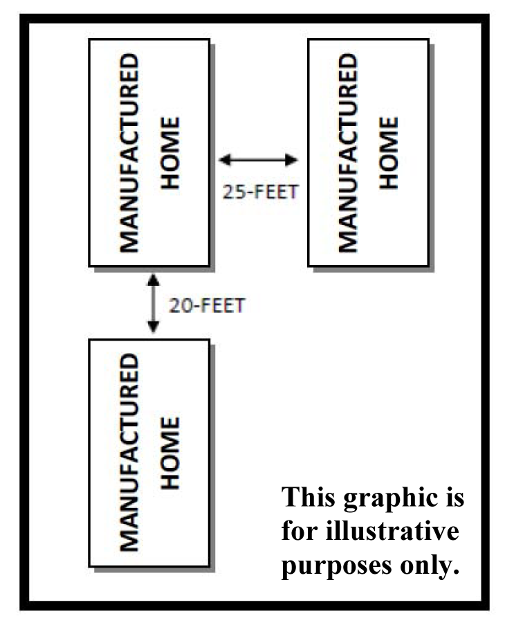
(f)
Off-street parking requirements. See Article VI of this chapter.
(g)
Other open space. Private community recreational uses shall be provided in the minimum amount of 4,000 square feet, plus 50 square feet per dwelling unit, but in no event less than eight percent of the manufactured home park's gross site area.
(h)
Maximum structure height:
(1)
No structure shall be greater than 35 feet in height.
(2)
Accessory structures shall not exceed 50 percent of the height of the principal structure.
(i)
Minimum tree canopy requirements:
(1)
See Article VII of this chapter.
(2)
The required tree canopy shall be provided based on the total area of the original parcel prior to subdivision or construction of any dwelling units.
(Ord. No. O-2015-15, § 1, 5-11-2015)
Sec. 130-267. - R-5 multifamily.
(a)
Purpose and intent. The R-5 multifamily district is intended to encourage diversity in housing opportunities at higher suburban densities. The district regulations are designed to encourage innovative and creative high-quality design in areas well served by public utilities and infrastructure.
(b)
Uses permitted. See section 130-241.
(c)
Minimum lot dimensions:
(1)
Area:
a.
Multifamily: One acre.
b.
Live/work units: 0.5 acres.
c.
Cottage court: See section 130-66.
d.
Duplex: 5,000 sq. ft.
(2)
Width:
a.
Interior lot: 75 feet.
b.
Corner lot: 100 feet.
c.
Cottage court: See section 130-66.
(3)
Open space:
a.
A minimum fifteen percent open space shall be provided, excluding utility strips, parking lot islands, and other planting strips. Open space shall provide active or passive areas of such a size to benefit the residents of the development.
b.
Cottage court: See section 130-66.
(d)
Maximum density:
(1)
Multifamily: Fifteen dwelling units per acre.
(2)
Live/work units: Twelve units per acre
(3)
Cottage court: See section 130-66.
(e)
Minimum setbacks requirements:
(1)
All structures shall be located 30 feet from any street right-of-way line.
(2)
Rear setback: 25 feet
(3)
Side setback: 25 feet
(4)
Setback between principal structures: 10 feet.
(5)
Cottage court: See section 130-66.
(6)
Building projections, including unroofed decks: See section 130-58.
(7)
Accessory structures: See section 130-57.
(f)
Maximum structure height:
(1)
No principal structure or private community recreation use shall be greater than 45 feet in height. Uses permitted by a special use permit and public utility uses may exceed this height subject to approval of a special use permit in accordance with Article IX of this chapter.
(2)
Cottage court: See section 130-66.
(g)
Off-street parking requirements. See Article VI of this chapter.
(h)
Required on-site private community recreational uses.
(1)
Minimum of 500 sq. ft. plus 50 square feet per dwelling unit.
(2)
Cottage court: See section 130-66.
(i)
Minimum tree canopy and landscaping requirements:
(1)
See Article VII of this chapter.
(2)
Cottage court: See section 130-66.
(j)
Accessory structures: See section 130-57.
(k)
Sign requirements. See Article IV of this chapter.
(l)
Special provisions. A proposed development shall not vary from the guidelines outlined in this section, except under unusual circumstances, subject to approval of a rezoning in accordance with Article IX of this chapter. However, such application must specifically outline the waiver, define the need, and provide assurances that the intent of this section is met by the proposed rezoning. Any variation from these guidelines requested by the applicant shall be specifically acknowledged by means of a proffer. Uses cannot be varied or modified under the provisions of this section.
(Ord. No. O-2015-15, § 1, 5-11-2015; Ord. No. O-2018-02, 12-11-2017; Ord. No. O-2024-03, § 1, 7-28-2023; Ord. No. O-2024-08, § 1, 12-11-2023)
Sec. 130-268. - R-6 age-restricted residential.
(a)
Purpose and intent. The R-6 age-restricted residential district is intended to encourage and accommodate development of housing and appropriate supporting institutional uses and services for the demographic population in the city that is 55 years of age or over, including those with specific health care needs. The R-6 district is intended to be located within or on the boundaries of those residential areas designated on the Comprehensive Plan for similar densities or other areas deemed appropriate by virtue of their size, shape, and compatibility with surrounding land uses, including properties planned for commercial and industrial uses.
(b)
Uses permitted. See section 130-241. All dwelling units shall be age-restricted housing.
(c)
Minimum zoning district size. One acre.
(d)
Development guidelines:
(1)
Density shall not exceed the maximum dwelling units per acre as identified in the following table:
(2)
Open space:
a.
A minimum 15 percent open space shall be provided, excluding utility strips, parking lot islands, and other planting strips. Open space shall provide active or passive areas of such a size to benefit the residents of the development.
b.
Cottage court: See section 130-66.
(3)
The maximum height of all structures shall not exceed the height identified in the following table. Roof mounted towers and antennae serving the structure on which they are collocated are exempted from the height restriction if approved by proffer at the time of rezoning, to be compatible with development in the immediate area and reflective of site constraints.
(4)
No structure shall be located less than:
a.
Thirty feet from any street right-of-way line.
b.
No principal structure or private community recreational use shall be located less than 25 feet from any side or rear lot line.
c.
Cottage court: See section 130-66.
(5)
Off-street parking requirements, see Article VI of this chapter.
(6)
Private community recreational uses:
a.
Shall be a minimum 2,500 square feet plus 50 square feet per dwelling unit. Up to half of this space may be within the facility's interior space provided such space is solely reserved for recreational or meeting areas.
b.
Cottage court: See section 130-66.
(7)
Landscaping and tree canopy requirements, see Article VII of this chapter.
(8)
Street trees shall be provided on all streets with a minimum of one tree for every 35 feet.
(9)
Sign requirements, see Article IV of this chapter.
(10)
There shall be no more than two persons occupying any single bedroom.
(11)
Accessory structures: See section 130-57.
(12)
Building projections, including unroofed decks: See section 130-58.
(e)
Operational guidelines:
(1)
Except for emergency needs, deliveries shall be prohibited between the hours of 8:00 p.m. to 7:00 a.m., where such deliveries could be disruptive to the peace and quiet of adjacent residential communities.
(2)
Except for emergency maintenance, exterior building and grounds work or maintenance shall be prohibited between the hours of 8:00 p.m. to 7:00 a.m..
(3)
In order to reasonably ensure the safety of the occupants/residents, physical security of the property should be considered both in the design stage and in operational plans.
(4)
Accessory uses, such as limited retail, personal improvement services, or professional personal services, shall be permitted in congregate care/assisted living housing and nursing homes. Such activities shall only be for the use of the on-site residents and shall be located within the principal structure.
(f)
Special provisions. A proposed development shall not vary from the guidelines outlined in this section, except under unusual circumstances, subject to approval of a rezoning in accordance with Article IX of this chapter. However, such application must specifically outline the variation, define the need, and provide assurances that the intent of this chapter is met by means of proffers. Uses cannot be varied or modified under the provisions of this section.
(Ord. No. O-2015-15, § 1, 5-11-2015; Ord. No. O-2024-03, § 1, 7-28-2023)
Sec. 130-269. - R-7 planned residential.
(a)
Purpose and intent. The R-7 planned residential district is intended to encourage and accommodate housing of various types, sizes, densities, and affordability. It provides for development of high quality housing in a planned setting that can include a wide variation in lot and house sizes with supporting institutional uses and services.
(b)
Uses permitted. See section 130-241.
(c)
Minimum zoning district size. No minimum lot size.
(d)
Development guidelines:
(1)
The overall development shall be consistent with the Comprehensive Plan.
(2)
The maximum height of all structures shall be as follows:
a.
Principal multifamily structures shall not exceed 45 feet in height.
b.
All other principal structures shall not exceed 35 feet in height.
c.
Cottage court: See section 130-66.
(3)
Off-street parking requirements: See Article VI of this chapter.
(4)
A landscaped area of 10 feet for any residential use shall be provided when any R-7 project abuts any "R" district line.
(5)
Tree canopy and landscaping requirements: See Article VII of this chapter.
(6)
Street trees shall be provided on all streets with a minimum of one tree for every 35 feet.
(7)
Accessory structures: See section 130-57.
(8)
Building projections, including unroofed decks: See section 130-58.
(9)
Open space:
a.
A minimum fifteen percent open space shall be provided, excluding utility strips, parking lot islands, and other planting strips. Open space shall provide active or passive areas of such a size to benefit the residents of the development.
b.
Cottage court: See section 130-66.
(10)
Private community recreational uses:
a.
Shall be a minimum 2,500 square feet plus 50 square feet per dwelling unit.
b.
Cottage court: See section 130-66.
(e)
Special provisions. A proposed development shall not vary from the guidelines outlined in this section, except under unusual circumstances, subject to approval of a rezoning in accordance with Article IX of this chapter. However, such application must specifically outline the waiver, define the need, and provide assurances that the intent of this section is met by the proposed rezoning. Any variation from these guidelines requested by the applicant shall be specifically acknowledged by means of a proffer. Uses cannot be varied or modified under the provisions of this section.
(Ord. No. O-2015-15, § 1, 5-11-2015; Ord. No. O-2024-03, § 1, 7-28-2023)
Sec. 130-301. - B-1 business office.
(a)
Purpose and intent. The B-1 business office district is intended to implement the Comprehensive Plan's General Business Corridor Character Area and to provide office development with limited retail and institutional uses. Office development serves as a transition between residential developments and higher intensity non-residential uses.
(b)
Uses permitted. See section 130-241.
(c)
Maximum structure height. No structure shall be greater than 55 feet. This excludes mechanical equipment, which shall not exceed ten feet in height from the maximum building height and shall be screened in conformance with the DCSM. Broadcasting and telecommunication towers, public facilities, and public utility uses may exceed this height subject to approval of a special use permit in accordance with Article IX of this chapter.
(d)
Minimum setback requirements:
(1)
Front, 15 feet from any street right-of-way line.
(2)
Side and rear:
a.
None adjacent to a "B" or "I" district lot line.
b.
25 feet from any "R" district lot line. However, when the structure exceeds 25 feet in height, an additional setback of one foot shall be required for each foot in height above 25 feet.
(e)
Off-street parking requirements. See Article VI of this chapter.
(f)
Open space and tree canopy requirements. See Article VII of this chapter.
(g)
Drive-through windows. Drive-through windows are permitted for all uses in conformance with the DCSM.
(h)
Floor area. Within any building, the uses listed below shall not cumulatively exceed 25 percent of the gross floor area of the building:
(1)
Personal improvement services
(2)
Professional personal services
(3)
Retail sales
(4)
Specialty food shops
(i)
Outdoor display and outdoor storage.
(1)
All uses shall be conducted entirely within an enclosed building with no outdoor storage with the following exceptions:
a.
Outdoor dining may be conducted.
b.
Outdoor display. See section 130-61.
(j)
Screening. To assist in the prevention of the transmission of light, noise, or other deleterious effects from commercial uses into adjacent "R" districts, there shall be provided within the B-1 zone continuous opaque screening and landscape buffer, a minimum of 25 feet in width along the common boundary line between the "R" and the B-1 district. Such screening shall conform to the DCSM.
(Ord. No. O-2015-15, § 1, 5-11-2015; Ord. No. O-2021-06, § 1, 2-8-2021; Ord. No. O-2022-23, § 1, 7-25-2022; Ord. No. O-2024-08, § 1, 12-11-2023)
Sec. 130-302. - B-2 neighborhood commercial.
(a)
Purpose and intent. The B-2 neighborhood commercial district is intended to implement the Comprehensive Plan's Neighborhood Business Character Area and to provide locally-serving office, retail, service, and institutional uses at a scale and level appropriate adjacent to a suburban or traditional residential neighborhood setting.
(b)
Uses permitted. See section 130-241.
(c)
Maximum structure height. No structure shall be greater than 35 feet in height. This excludes mechanical equipment, which shall not exceed ten feet in height from the maximum building height and shall be screened in conformance with the DCSM. Broadcasting and telecommunication towers, public facilities, and public utility uses may exceed this height subject to approval of a special use permit in accordance with Article IX of this chapter.
(d)
Minimum setback requirements:
(1)
Front, 15 feet from any street right-of-way line.
(2)
Side and rear:
a.
None adjacent to a "B" or "I" district lot line.
b.
25 feet from any "R" district lot line. However, when the structure exceeds 25 feet in height, an additional setback of one foot shall be required for each foot in height above 25 feet.
(e)
Off-street parking requirements. See Article VI of this chapter.
(f)
Open space and tree canopy requirements. See Article VII of this chapter.
(g)
Drive-through windows. Drive-through windows are only permitted subject to approval of a special use permit in accordance with the requirements of Article IX of this chapter and in conformance with the DCSM.
(h)
Floor area. The gross floor area of any individual principal use shall not exceed 10,000 square feet.
(i)
Outdoor display and outdoor storage.
(1)
All uses shall be conducted entirely within an enclosed building with no outdoor storage with the following exceptions:
a.
Outdoor dining may be conducted.
b.
Outdoor display. See section 130-61.
c.
No exterior runs or exercise areas are permitted for veterinary hospitals.
(j)
Screening. To assist in the prevention of the transmission of light, noise, or other deleterious effects from commercial uses into adjacent "R" districts, there shall be provided within the B-2 zone continuous opaque screening and landscape buffer, a minimum of 25 feet in width along the common boundary line between the "R" and the B-2 district. Such screening shall conform to the DCSM.
(Ord. No. O-2015-15, § 1, 5-11-2015; Ord. No. O-2021-06, § 1, 2-8-2021; Ord. No. O-2022-23, § 1, 7-25-2022; Ord. No. O-2024-08, § 1, 12-11-2023)
Sec. 130-303. - B-3 city center commercial (Old Town district).
(a)
Purpose and intent. The B-3 city center commercial district is intended to implement the Comprehensive Plan's Downtown Character Area and to provide an attractive and successful mixed-use historic downtown with pedestrian-oriented retail, commercial, and institutional uses along with residential uses at urban densities that attract and serve both local and visitor populations. Recognizing the economic value of the existing historic downtown, it shall further be the intention of this district to encourage the retention and rehabilitation of structures and uses in the district that have historic and/or architectural significance.
(b)
Uses permitted. See section 130-241.
(c)
Maximum structure height.
(1)
No structure shall exceed 55 feet in height, excluding mechanical equipment, which shall be adequately screened. No other architectural features such as false facades and towers, antennas used by broadcasting and telecommunications towers, public facilities, public utility uses, spires, and steeples shall exceed 60 feet in height.
(2)
Cottage court: See section 130-66.
(d)
Minimum and maximum setback requirements:
(1)
Front:
a.
Minimum setback: From any street right-of-way or alley: None.
b.
Maximum setback: No building wall shall be located more than 22 feet from the back of curb of any street.
(2)
Side and rear:
a.
None adjacent to a "B" or "I" district lot line.
b.
10 feet from any "R" district lot line for any residential use.
c.
25 feet from any "R" district lot line for any non-residential or mixed use. However, when the structure exceeds 25 feet in height, an additional setback of one foot shall be required for each foot in height above 25 feet.
(3)
Cottage court: See section 130-66.
(e)
Off-street parking requirements. None required, unless specified as a condition of a special use permit or as required by section 130-303(i)(2) or section 130-303(i)(3).
(f)
Open space and tree canopy requirements: See Article VII of this chapter.
(g)
Drive-through windows. Drive-through windows are only permitted for financial institutions in conformance with the DCSM.
(h)
Outdoor display and outdoor storage.
(1)
All uses shall be conducted entirely within an enclosed building with no outdoor storage with the following exceptions:
a.
Outdoor dining may be conducted.
b.
Outdoor display. See section 130-61.
c.
No exterior runs or exercise areas are permitted for veterinary hospitals.
(i)
Residential uses:
(1)
Single-family detached or duplex dwelling units.
a.
Minimum lot area: 5,000 square feet.
b.
Minimum lot width, interior lots: 70 feet at the front setback line.
c.
Minimum lot width, corner lots: 100 feet at the front setback line.
(2)
Cottage court: See section 130-66.
(3)
Multifamily residential dwelling units are permitted in existing buildings with a final certificate of occupancy issued prior to May 11, 2015, with non-residential B-3 uses in the same building, and which meet the following requirements:
a.
The minimum size of each residential dwelling unit shall be 600 gross square feet.
b.
A minimum of 80 percent of the gross floor area of the building's first floor shall be used for non-residential uses.
c.
A minimum of 1.5 parking spaces per residential dwelling unit shall be provided on-site unless a public or private parking facility is located within 650 feet of the building and the parking spaces within that facility are reserved to meet the minimum parking requirements.
d.
All off-street parking shall be located either within an enclosed courtyard or behind the principal structure and not readily visible from the street right-of-way.
(Ord. No. O-2015-15, § 1, 5-11-2015; Ord. No. O-2017-01, § 1, 8-22-2016; Ord. No. O-2021-06, § 1, 2-8-2021; Ord. No. O-2022-23, § 1, 7-25-2022; Ord. No. O-2024-03, § 1, 7-28-2023)
Sec. 130-304. - B-3.5 city center planned.
(a)
Purpose and intent. The B-3.5 city center planned district is intended to implement the Comprehensive Plan's Downtown Character Area to encourage the mixing of compatible land uses, and to permit flexibility in building design and use. The goals of this district include extending the architecture and feel of historic downtown outside its core areas to create a sense of continuity, permitting increased residential development at urban densities in proximity to the Virginia Railway Express train station, and encouraging high-quality innovative design, infill, and redevelopment projects that are compatible with existing residential and commercial uses.
(b)
Uses permitted. See section 130-241.
(c)
Maximum and minimum structure height and setbacks:
(1)
Maximum heights: Except as otherwise provided, no structure shall exceed 65 feet in height, excluding mechanical equipment, which shall be adequately screened, and decorative architectural detail or other rooftop amenity unfit for habitation.
a.
Structures constructed with a zero lot line setback shall not exceed 55 feet, excluding mechanical equipment, which shall be adequately screened.
b.
Structures or portions of structures exceeding 55 feet shall be set back a minimum of two feet from the lot line for each five feet in additional structure height.
c.
Architectural features, such as false facades, equipment towers, antennas used by broadcasting and telecommunications towers, public facilities, public utility uses, spires, and steeples shall not exceed ten feet in height from the finished building height and shall be adequately screened unless a modification is approved as provided for in section 130-304(l).
d.
Cottage court: See section 130-66.
(2)
Minimum height requirements:
a.
No non-residential/residential mixed-use structure shall be constructed with a height of less than 45 feet or three stories, whichever is less.
b.
No single purpose non-residential use structure shall be constructed with a height of less than 45 feet or three stories, whichever is less.
c.
No single purpose residential use structure shall be constructed with a height of less than 35 feet or two stories, whichever is less.
d.
Cottage court: See section 130-66.
(d)
Minimum and maximum setbacks:
(1)
Abutting any street right-of-way, other than an alley:
a.
Minimum setback: No building wall shall be located closer than 12 feet from the back of curb of any street.
b.
Maximum setback: No building wall shall be located more than 22 feet from the back of curb of any street, unless a courtyard designed to provide for a park, landscaping, or preservation of existing trees, or other significant view shed or unique element is agreed upon and accepted at the time of rezoning or special use permit approval.
c.
When the project design requires utilities to be located along a street right-of-way and a conduit bank cannot be designed to meet the required separation for specific utilities, then the minimum setback of the structure shall be increased to accommodate the area necessary for utility installation.
(2)
When a building abuts any alley, the building wall may be located at a zero lot line.
(3)
No side or rear setbacks are required when abutting any "B" or "I" district occupied by a commercial, office, or industrial use.
(4)
A landscaped area of 25 feet for any non-residential or mixed use shall be provided when any B-3.5 project abuts any "R" district line. However, such area may be reduced, if the residential property owner agrees to such a reduction, either by means of providing an enhanced opaque screening or the acquisition of an offsite easement as evidenced by the recording of an agreement between the B-3.5 owner and the adjoining "R" district property owner(s).
(5)
A landscaped area of 10 feet for any residential use shall be provided when any B-3.5 project abuts any "R" district line.
(6)
Cottage court: See section 130-66.
(e)
Off-street parking requirements:
(1)
Off-street parking shall be provided in accordance with Article VI of this chapter, unless a modification is approved as provided for in section 130-304(l) and except as otherwise provided in this section.
(2)
A multi-level parking structure may be used to provide the off-street parking spaces required by Article VI of this chapter.
(3)
All off-street parking shall be located either within an enclosed courtyard or behind the principal structure and not readily visible from the street right-of-way.
(4)
All off-street parking shall meet the setback requirements of section 130-304(d).
(f)
Open space requirements.
(1)
Open space shall be provided that is equal to, but not less than seven percent of the total site area by means of one or more of the following techniques: traditional surface gardens, landscaped areas, or other gardens or landscaped areas incorporated into the proffered building design by means of planters or other permanently affixed units.
(2)
Cottage court: See section 130-66.
(g)
Tree canopy. See Article VII of this chapter.
(h)
Street trees: Street trees shall be provided on all streets with a minimum of one tree for every 35 feet.
(i)
Accessory structures and building projections:
(1)
Accessory structures: See section 130-57.
(2)
Building projections, including unroofed decks: See section 130-58.
(j)
Drive-through windows. Drive-through windows are only permitted for financial institutions in conformance with the DCSM.
(k)
Outdoor display and outdoor storage.
(1)
All uses shall be conducted entirely within an enclosed building with no outdoor storage with the following exceptions:
a.
Outdoor dining may be conducted.
b.
Outdoor display. See section 130-61.
c.
No exterior runs or exercise areas are permitted for veterinary hospitals.
(l)
Special provisions. A proposed development shall not vary from the regulations and guidelines stated in this section, except under unusual circumstances, subject to approval of a rezoning in accordance with Article IX of this chapter or approval of a special use permit in accordance with Article IX of this chapter. However, such application must specifically outline the variation, define the need, and provide assurances that the intent of this chapter is met by the proposed rezoning. Any variation from this section requested by the applicant shall be specifically acknowledged by means of a proffer or condition. Uses cannot be varied or modified under the provisions of this section
(m)
Density. Residential density shall be established as part of the zoning of a parcel taking into consideration the uses proposed, the size of the parcel being rezoned, the impact on public services, available parking, maximum height of the structure permitted, and an analysis of the Comprehensive Plan standards as they impact the economic health of the City's tax base on a residential to non-residential mix.
(n)
Refuse storage. All refuse storage shall be internal unless a modification is approved as provided for in section 130-304(l).
(Ord. No. O-2015-15, § 1, 5-11-2015; Ord. No. O-2017-01, § 1, 8-22-2016; Ord. No. O-2021-06, § 1, 2-8-2021; Ord. No. O-2022-23, § 1, 7-25-2022; Ord. No. O-2024-03, § 1, 7-28-2023)
Sec. 130-305. - B-4 general commercial.
(a)
Purpose and intent. The B-4 general commercial district is intended to implement the Comprehensive Plan's General Business Character Area and to provide a wide array of retail, office, service, and institutional uses. The businesses within this district are intended to serve both local and regional patrons.
(b)
Uses permitted. See section 130-241.
(c)
Maximum structure height. No structure shall be greater than 55 feet in height. This excludes mechanical equipment, which shall not exceed ten feet in height from the maximum building height and shall be screened in conformance with the DCSM. Broadcasting and telecommunication towers, public facilities, and public utility uses may exceed this height subject to approval of a special use permit in accordance with Article IX of this chapter.
(d)
Maximum structure height. No structure shall be greater than 55 feet in height excluding mechanical equipment, which shall be adequately screened. Broadcasting and telecommunication towers, public facilities, and public utility uses may exceed this height subject to approval of a special use permit in accordance with Article IX of this chapter.
(e)
Minimum setback requirements:
(1)
Front, 15 feet from any street right-of-way line.
(2)
Side and rear:
a.
None adjacent to a "B" or "I" district lot line.
b.
25 feet from any "R" district lot line. However, when the structure exceeds 25 feet in height, an additional setback of one foot shall be required for each foot in height above 25 feet.
(f)
Off-street parking requirements. See Article VI of this chapter.
(g)
Open space and tree canopy requirements. See Article VII of this chapter.
(h)
Drive-through windows. Drive-through windows are permitted for all uses in conformance with the DCSM.
(i)
Outdoor display and outdoor storage.
(1)
All uses shall be conducted entirely within an enclosed building with no outdoor storage with the following exceptions:
a.
Outdoor dining may be conducted.
b.
Outdoor display. See section 130-61.
c.
No exterior runs or exercise areas are permitted for veterinary hospitals.
(j)
Screening. To assist in the prevention of the transmission of light, noise, or other deleterious effects from commercial uses into any adjacent "R" district, there shall be provided within the B-4 zone continuous opaque screening and landscape buffer, a minimum of 25 feet in width along the common boundary line between the "R" and the B-4 district. Such screening shall conform to the DCSM.
(Ord. No. O-2015-15, § 1, 5-11-2015; Ord. No. O-2021-06, § 1, 2-8-2021; Ord. No. O-2022-23, § 1, 7-25-2022; Ord. No. O-2024-08, § 1, 12-11-2023)
Sec. 130-306. - I-1 light industrial.
(a)
Purpose and intent. The I-1 light industrial district is intended to implement the Comprehensive Plan's Godwin Technology Character Area and to provide highly accessible, quality areas that are separated from daily services and residences and are flexible for a variety of business models and scales of operation, including research and development, business offices, light manufacturing, distribution, supply, and related activities.
(b)
Uses permitted. See section 130-241.
(c)
Minimum lot dimensions. None, except that motor vehicle sales and rental, or heavy equipment sales and rental, shall have a minimum lot area of 20,000 square feet for each sales or rental office.
(d)
Maximum structure height. No structure shall be greater than 75 feet in height excluding mechanical equipment, which shall be adequately screened. Uses may exceed this height subject to approval of a special use permit in accordance with Article IX of this chapter.
(e)
Minimum setback requirements:
(1)
Front, 15 feet from any lot line, any street or private access easement right-of way line; or half of a foot for each foot in height of a structure that is over 50 feet in height.
(2)
Side and rear:
a.
None adjacent to a "B" or "I" district lot line.
b.
25 feet from any "R" district lot line. However, when the structure exceeds 25 feet in height, an additional setback of one foot shall be required for each foot in height above 25 feet.
(f)
Off-street parking requirements. See Article VI of this chapter.
(g)
Open space and tree canopy requirements. See Article VII of this chapter.
(h)
Drive-through windows. Drive-through windows are permitted for all uses in conformance with the DCSM.
(i)
Outdoor storage. All uses shall be conducted within a completely enclosed building. All active storage shall either be entirely within buildings enclosed on all sides, or outdoor storage shall be permitted to the side or rear of a principal structure and shall not be located between a principal structure and any adjacent streets. Any outdoor storage area shall be screened on all sides by opaque walls or fences and supplemented by landscaping in addition to the requirements of section 130-306(j) and the DCSM.
(j)
Screening. To assist in the prevention of the transmission of light, noise, or other deleterious effects from industrial uses into any adjacent "R" or "B" district, and to provide screening between outdoor storage and other uses within the I-1 zone, screening shall be required. Such screening and landscape buffers shall conform to the DCSM and shall be provided as follows:
(1)
A continuous six-foot high opaque screen and landscape buffer with a minimum of 25 feet in depth shall be provided along the common boundary line between any "R" district lot line and any I-1 use.
(2)
A continuous six-foot high opaque screen shall be provided around all outdoor storage areas abutting and visible from an adjacent "B" or "I" district, or any street rights-of-way.
(3)
Exterior exercise areas are permitted for veterinary hospitals and shall be screened on all sides with a continuous six-foot high opaque screen.
(k)
Outdoor display See section 130-61.
(Ord. No. O-2015-15, § 1, 5-11-2015; Ord. No. O-2019-04, 10-22-2018; Ord. No. O-2022-23, § 1, 7-25-2022; Ord. No. O-2024-08, § 1, 12-11-2023)
Sec. 130-307. - I-2 heavy industrial.
(a)
Purpose and intent. The I-2 heavy industrial district is intended to provide highly accessible, quality areas for existing heavy industrial uses that are separated from daily services and residences, and are flexible for a variety of business models and scales of operation due to their heavy truck traffic, excessive noise, and/or unique manufacturing needs.
(b)
Uses permitted. See section 130-241.
(c)
Minimum lot dimensions. None, except that motor vehicle sales and rental, or heavy equipment sales and rental, shall have a minimum lot area of 20,000 square feet for each sales or rental office.
(d)
Maximum structure height. No structure shall be greater than 75 feet in height, excluding mechanical equipment, which shall be adequately screened. Broadcasting and telecommunication towers, public facilities, and public utility uses may exceed this height subject to approval of a special use permit in accordance with Article IX of this chapter.
(e)
Minimum setback requirements:
(1)
Front, 15 feet from any lot line, any street or private access easement right-of-way line, unless otherwise specified in this chapter; or half of a foot for each foot in height of a structure that is over 50 feet in height.
(2)
Side and rear:
a.
None adjacent to a "B" or "I" district lot line.
b.
25 feet from any "R" district lot line. However, when the structure exceeds 25 feet in height, an additional setback of one foot shall be required for each foot in height above 25 feet.
(f)
Off-street parking requirements. See Article VI of this chapter.
(g)
Open space and tree canopy requirements. See Article VII of this chapter.
(h)
Drive-through windows. Drive-through windows are permitted for all uses in conformance with the DCSM.
(i)
Outdoor storage. Outdoor storage may be permitted to the side or rear of a principal structure, and shall not be located between a principal structure and any adjacent streets. The outdoor storage area shall be screened on all sides by opaque walls or fences and supplemented by landscaping in addition to the requirements section 130-307(j) and the DCSM.
(j)
Screening. To assist in the prevention of the transmission of light, noise or other deleterious effects from industrial uses into any adjacent "R" or "B" district, and to provide screening between outdoor storage and other uses within the I-2 zone, screening shall be required. Such screening and landscape buffers shall conform to the DCSM and shall be provided as follows:
(1)
A continuous six-foot high opaque screen and landscape buffer with a minimum of 25 feet in depth shall be provided along the common boundary line between any "R" district lot line and any I-2 use.
(2)
A continuous six-foot high opaque screen shall be provided around all outdoor storage areas abutting and visible from an adjacent "B" or "I" district, or any street rights-of-way.
(k)
Outdoor display. See section 130-61.
(Ord. No. O-2015-15, § 1, 5-11-2015; Ord. No. O-2024-08, § 1, 12-11-2023)
Sec. 130-308. - PMD planned mixed use development.
(a)
Purpose and intent. The PMD planned mixed use development district is intended to encourage and accommodate a balance of high quality and attractive housing types, sizes, affordability levels, of housing combined with supporting commercial and institutional uses that provide increased residential services within the PMD and to the City as whole. This zone is encouraged for appropriate locations in the Comprehensive Plan's Mathis and Sudley Medical Character Areas. It provides for development of high-quality residential dwelling units at higher suburban densities in a variety of housing types including single-family detached and attached, apartments, condominiums, and age-restricted housing, and allows mixing of uses in a manner and scale that promotes the City's historic character and encourages a live work environment not specifically dependent on the motor vehicle. This district can include a wide variation in lot and house sizes and can accommodate mixed residential and commercial uses within the same or adjacent structures.
(b)
Uses permitted. See section 130-241.
(c)
Minimum zoning district size. None.
(d)
Proposed residential land area ratio. The development ratio of non-residential to residential shall be based on a residential land area ratio (RLAR) of the site. No less than 30 percent but not more than 60 percent of the land area shall be developed for non-residential uses. In determining the RLAR, the calculation shall be made as follows:
(1)
The generalized development plan (GDP) shall delineate and designate specific areas as either residential uses or non-residential uses. Streets, common interior travelways, and walkways that are designed for both uses shall be excluded from the total site area.
(e)
Development standards and guidelines:
(1)
The overall development shall be consistent with the Comprehensive Plan designation for the subject property.
(2)
Maximum structure height and setbacks. No structure shall be erected, altered, or maintained to a height in excess of the applicable height limitations as established in this section unless a modification is approved as provided for in section 130-308(f).
a.
Structures shall not exceed a maximum height of 75 feet except under the following circumstances:
1.
Structures or portions of structures constructed adjacent to 75 feet of an "R" district line, except R-5, shall not exceed 45 feet in height, excluding mechanical equipment, which shall be adequately screened.
2.
Structures or portions of structures constructed adjacent to an R-5, any "B", or any "I" zoning district shall be set back a minimum of two feet from the lot line for each five feet of additional height above the maximum height requirements of the adjoining district for the first 75 feet from the zoning district line.
b.
Architectural features such as false facades, equipment towers, antennas used by broadcasting and telecommunications towers, public utility, public facility uses, spires, and steeples shall not exceed ten feet in height from the finished building height and shall be adequately screened, unless a modification is approved as provided for in section 130-308(f).
(3)
Accessory structures and Building Projections:
a.
Accessory structures: See section 130-57.
b.
Building projections: See section 130-58.
(4)
All off-street parking requirements shall conform to Article VI of this chapter.
(5)
Landscaping and tree canopy requirements shall meet the requirements of Article VII of this chapter.
(6)
A minimum ten percent open space shall be provided, excluding utility strips, parking lot islands, and other planting strips. Open space shall provide active or passive areas of such a size to benefit the residents of the development.
(7)
Street trees shall be provided on all streets with a minimum of one tree for every 35 feet.
(8)
Required on-site private community recreational uses:
a.
Minimum of 500 sq. ft. plus 50 square feet per dwelling unit.
b.
Cottage court: See section 130-66.
(9)
Minimum setbacks:
a.
Abutting any street right-of-way other than an alley:
1.
Minimum setback. No building wall shall be located closer than eight feet from the back of curb of any street.
2.
When the project design requires utilities to be located along a public street or right-of-way and a conduit bank cannot be designed to meet the required separation for specific utilities, then the minimum setback of the structure shall be increased to accommodate the area necessary for utility installation.
b.
When a building abuts any alley, the building wall may be located at a zero lot line.
c.
No side or rear setbacks are required when abutting any "B" or "I" district occupied by a commercial, office or industrial use.
d.
A landscaped area of 25 feet shall be provided when any PMD project for any non-residential or mixed use abuts any "R" district line. However, such area may be reduced if the residential property owner agrees to such a reduction, either by means of providing an enhanced opaque screening or the acquisition of an offsite easement as evidenced by the recording of an agreement between the PMD owner and the adjoining residential district property owner(s).
e.
A landscaped area of 10 feet for any residential use shall be provided when any PMD project abuts any "R" district line.
f.
Cottage court: See section 130-66.
(10)
Drive-through windows are permitted for all nonresidential uses in conformance with the DCSM.
(11)
Outdoor storage and outdoor display shall meet the following requirements:
a.
All uses shall be conducted entirely within an enclosed building with no outdoor storage with the following exceptions:
1.
Outdoor dining may be conducted.
2.
Outdoor display. See section 130-61.
3.
No exterior runs or exercise areas are permitted for veterinary hospitals.
(f)
Special provisions. A proposed development shall not vary from the guidelines outlined in this section, except under unusual circumstances, subject to approval of a rezoning in accordance with Article IX of this chapter or approval of a special use permit in accordance with Article IX of this chapter. Any waiver from the standards and guidelines shall be specifically acknowledged by means of a proffer or conditions. Uses cannot be varied or modified under the provisions of this section.
(Ord. No. O-2015-15, § 1, 5-11-2015; Ord. No. O-2021-06, § 1, 2-8-2021; Ord. No. O-2022-23, § 1, 7-25-2022; Ord. No. O-2024-03, § 1, 7-28-2023; Ord. No. O-2024-08, § 1, 12-11-2023)
Sec. 130-309. - I-A airport district.
(a)
Purpose and intent. The I-A airport district is intended to implement the Comprehensive Plan's Airport Character Area and protect public health, safety, and welfare at the Manassas Regional Airport. This district provides an area for airport and related business activities and is intended to permit maximum flexibility in the mix of uses, intensity of uses, and the phasing of development, while maintaining minimum development and use standards as recommended by the Airport Master Plan and as required by the Federal Aviation Administration.
(b)
Uses permitted. See section 130-241. In addition, any use that has an integral relationship to aviation and requires the use of airport or aviation facilities on a regular basis and that is not listed as a permitted use may be permitted subject to approval of a special use permit in accordance with Article IX of this chapter.
(c)
Minimum lot dimensions. None.
(d)
Maximum structure height. See section 130-424.
(e)
Minimum setback requirements:
(1)
Front:
a.
Landside. 15 feet from any lot line, any street or private access easement right-of-way line.
b.
Airside. None.
(2)
Side and rear: None.
(f)
Off-street parking requirements. See Article VI of this chapter.
(g)
Open space and tree canopy requirement. See Article VII of this chapter.
(h)
Drive-through windows. Drive-through windows are prohibited for all uses.
(i)
Outdoor display and outdoor storage.
(1)
All uses occurring landside shall be conducted entirely within an enclosed building with no outdoor storage.
(2)
Outdoor dining occurring landside may be conducted.
(3)
Outdoor display. See section 130-61.
(Ord. No. O-2016-19, § 1, 6-27-2016, eff. 7-1-2016; Ord. No. O-2020-08, 12-9-2019; Ord. No. O-2021-06, § 1, 2-8-2021; Ord. No. O-2024-08, § 1, 12-11-2023)
Sec. 130-401. - Purpose and intent.
The City of Manassas seeks to promote the education, prosperity, and general welfare of the public through the identification, preservation, and enhancement of landmarks, buildings, structures, settings, neighborhoods, places, and features with special historical, cultural, and architectural significance. To achieve these general purposes, the City of Manassas intends to pursue the following specific actions:
(a)
To identify, preserve, and protect historic structures, and any other buildings or structures within the city having an important historic, architectural, archaeological, or cultural interest, and any "historic areas" within the city as defined by state law, and areas of unique architectural value.
(b)
To assure that, within the city's historic districts, any construction, reconstruction, alteration, or restoration will be architecturally compatible with the historic structures therein.
(c)
To maintain and improve property values by providing for the upkeep, rehabilitation, and restoration of older structures in a safe and healthful manner, and by encouraging desirable uses and forms of development that will lead to the continuance, conservation, and improvement of the city's historic, cultural, and architectural resources and institutions within their settings.
(d)
To promote tourism and enhance business and industry, and to promote an enhanced quality of life within the city, through the protection of historic, architectural, cultural, and archaeological resources.
(Ord. No. O-2016-19, § 1, 6-27-2016, eff. 7-1-2016)
Sec. 130-402. - Historic overlay districts.
(a)
Establishment. The city council has designated historic overlay districts (HOD) in the city as defined by Article II of this chapter, the boundaries of which are defined on an overlay district zoning map adopted herewith.
(b)
Criteria for establishment. The city council may establish additional HOD's or modify existing ones. Upon request of the council, the architectural review board (ARB), as established under section 130-404, shall prepare and submit a report to evaluate the proposed additional or modified historic district. Such report shall define the proposed HOD boundaries, set out the historic and/or architectural significance of the historic structures to be protected, and evaluate whether the public interest favors creation or modification of an HOD.
(c)
Inventory of properties. The ARB shall maintain an inventory of all properties within the established boundaries of an HOD. The inventory shall designate all structures as contributing or non-contributing as defined by Article II of this chapter.
(d)
Amendments to historic overlay district boundaries. The ARB may propose to the planning commission and/or the city council such amendments as deemed appropriate for the revision to an existing HOD in accordance with zoning map amendment requirements of this chapter.
(e)
Relation to other districts. The HOD shall be in addition to and shall overlay all other zoning districts within its boundaries, so that a parcel of land lying within the HOD will also lie in one or more "A", "R", "B", "P", or "I" districts. The effect is to create a new district, which has the requirements of the underlying district, together with the requirements of the overlay district.
(1)
Exception to front yard setbacks. Within the boundaries of the HOD, the front setback distance requirements for R-1, R-2, and R-2-S districts shall be modified to provide that, where a new single family detached dwelling is constructed, the front setback distance shall be no greater or lesser than the setback distance of the contiguous dwellings. For the purpose of this requirement, any contiguous vacant lot or contiguous dwelling unit separated by a street right-of-way shall not be considered a contiguous dwelling unit. All other requirements of the underlying zoning district shall be in full force and effect.
(2)
Exception to dustless surface requirement. The use of gravel for driveway surfacing shall be permitted for single family detached dwellings located in the HOD in accordance with section 130-205(b).
Figure 1: Front Yard Setback Distance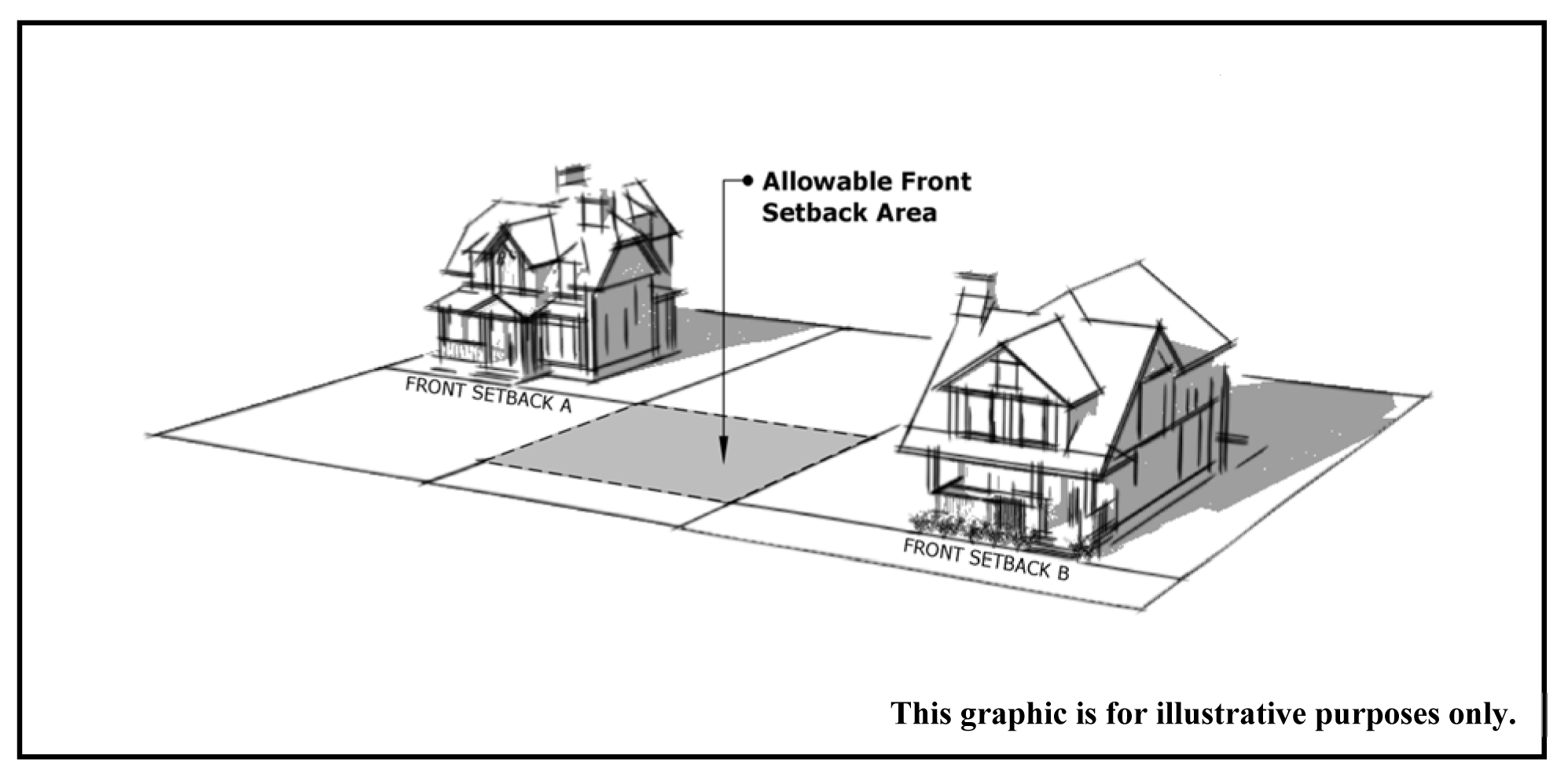
(Ord. No. O-2016-19, § 1, 6-27-2016, eff. 7-1-2016)
Sec. 130-403. - Individually protected properties.
(a)
Establishment. The city council has adopted a list of historic landmarks in the city which shall be individually protected properties. For future inclusion in this list, historic landmarks shall be documented as being at least 50 years old and meet at least one of the following criteria:
(1)
The structure is on the National Register of Historic Places as called for by the United States Congress in the Historic Preservation Act of 1966;
(2)
The structure is on the state landmarks register pursuant to Code of Virginia, § 10.1-2200 et seq.;
(3)
The structure exemplifies or reflects the architectural, cultural, political, economic, social, or military history of the nation, state, or community;
(4)
The structure is associated with persons of national, state, or local historical significance;
(5)
The structure is a good example of local or regional architectural design or exemplifies the local craftsmanship, making it valuable for study of period, style, or method of construction;
(6)
The structure is a work of a nationally recognized architect;
(7)
The structure is attributed to an architect or builder of local prominence; or
(8)
The structure fosters civic pride in the city's past and enhances the city's attractiveness to visitors.
(b)
Amendments to historic landmark list. Following notice to the property owner, the ARB may propose to the planning commission and/or the city council such amendments as deemed appropriate for revision to the historic landmarks list in accordance with the zoning map amendment requirements of this chapter.
(Ord. No. O-2016-19, § 1, 6-27-2016, eff. 7-1-2016)
Sec. 130-404. - Architectural review board.
(a)
Creation. For the general purpose of this chapter, there is created by the city council the architectural review board (ARB). The ARB shall be composed of a minimum of five regular voting members, a majority of whom shall be residents of the city. The members of the ARB shall be appointed by the city council. Members shall have a demonstrated interest, competence, or knowledge in historic preservation.
(b)
Member appointment terms.
(1)
Term of office. A member's term shall be four years.
(2)
An appointment to fill a vacancy shall be only for the unexpired portion of the term vacated.
(c)
Organization. The ARB shall elect from its own membership a chairperson and vice-chairperson who shall serve annual terms and may succeed themselves. The city shall designate administrative staff to the ARB and maintain all records, minutes, and files relating to the ARB meetings.
(d)
Rules:
(1)
The ARB shall meet in regular session at least once a month when an application has been filed for its consideration. It shall meet at least quarterly even if no application has been filed for its consideration.
(2)
Special meetings of the ARB may be called in accordance with the ARB rules and procedures, as adopted and amended.
(3)
A quorum shall be not less than a majority of sitting members.
(4)
The ARB may make, alter, or rescind rules and forms for its procedures and the implementation of the purposes of this division, consistent with the ordinances of the city and the general laws of the commonwealth.
(5)
The ARB shall establish procedures for all matters coming before it for review.
(6)
All meetings shall be open to the public unless the ARB enters closed session as permitted by the Virginia Freedom of Information Act.
(7)
Public notice shall be required in the case of a proposal to demolish, move, or relocate a historic structure in accordance with the public hearing requirements of the State Code and this chapter, mutatis mutandis. However, any person appearing and participating in a public hearing on such a proposal, whether personally or by an authorized representative, waives any defects in notice.
(e)
Powers and duties. The ARB shall approve, approve with modifications, or deny applications for certificates of appropriateness for the construction, reconstruction, exterior alteration, demolition, or relocation of historic landmarks or structures within a HOD. The ARB shall have the following duties, which it may exercise in its discretion but shall exercise upon direction from city council:
(1)
Assist and advise the city council, the planning commission, other city departments and agencies, property owners and individuals in matters involving historic resources.
(2)
Review and propose additional areas or structures to be included in or removed from an HOD or designated as a historic landmark.
(3)
From time to time conduct, or cause to be conducted, a survey of historic resources.
(4)
Upon request of the city council, planning commission, or interested citizens, conduct studies deemed necessary to consider additional historic overlay districts, and means of preservation and utilization of historic assets in the city.
(5)
Develop, adopt, and from time to time modify design guidelines for the city's historic overlay districts, to be considered by the ARB in granting or denying certificates of appropriateness, provided that such guidelines shall be consistent with the Secretary of the Interior Standards for Historic Preservation, the purposes intent of the Historic Overlay District, and with such standards, rules, regulations, and procedures as city council may establish. The ARB may vote to develop or modify design guidelines only after a 60-day period for public comment. The city shall circulate the proposed or modified design guidelines to interested parties and post them on its web page for the duration of the 60-day public comment period. If the ARB makes any policy changes to the design guidelines after receiving public comment, a new 60-day period for public comment shall commence. After the ARB adopts or modifies the design guidelines, the city shall cause them to be published on the city's website and by other means in its discretion.
(6)
Cooperate with, and enlist assistance from, the Virginia Department of Historic Resources, the National Trust for Historic Preservation, and other interested parties, both public and private, in its efforts to preserve, restore, and conserve historic sites, landmarks, buildings, and structures within the city.
(Ord. No. O-2016-19, § 1, 6-27-2016, eff. 7-1-2016; Ord. No. O-2019-04, 10-22-2018)
Sec. 130-405. - Certificate of appropriateness.
(a)
Activity requiring ARB review. Unless exempted by this section, no structure within an HOD, including signs, shall be erected, reconstructed, altered, or restored unless a certificate of appropriateness has been issued by the ARB or, on appeal, by the city council in accordance with this section. Unless exempted by this section, no historic landmark shall be reconstructed, altered, or restored unless a certificate of appropriateness has been issued by the ARB or, on appeal, by the city council in accordance with this section. Unless exempted by this section, no historic structure shall be razed, demolished, or moved unless a certificate of appropriateness has been issued by the ARB or, on appeal, by the city council in accordance with this section.
(b)
Administrative review. Notwithstanding any contrary requirement of this article, the city may review and administratively approve applications for the following exterior changes:
(1)
Alterations to a noncontributing structure that do not substantially change the architectural character or are substantially hidden from view of the street right-of-way.
(2)
Minor alterations to a historic structure that do not substantially change the architectural character or are substantially hidden from view of the street right-of-way.
(3)
The construction of accessory buildings and structures on properties where none of the structures are historic structures and where the construction would be in keeping with the character of the principal structure and surrounding area.
(4)
Reconstruction performed to restore or replace the same as, or nearly the same as practical, a structure to its original documented historical design.
(5)
Banner signs, window signs, and other minor or temporary signs that comply with the established standards of review and any adopted and published design guidelines.
(6)
Alterations to existing residential structures in the Liberia Mansion HOD unless exempt from review under section 130-405(c).
(c)
Exemptions from review. The razing, demolition, or moving of a noncontributing structure is exempt from review for a certificate of appropriateness. In addition, the following minor work or actions deemed not to have permanent effects upon the character of the HOD are exempted from review for a certificate of appropriateness:
(1)
Maintenance of exterior architectural features, including repair and replacement, with the same design, color and material if the city finds that such maintenance:
a.
Does not result in the substantial removal of an exterior feature that is considered to have historic and/or architectural significance; and
b.
Does not perpetuate a condition or treatment that is considered to be inappropriate or incompatible with the historic character or surroundings of the building or structure.
(2)
Repainting of residential structures.
(3)
Repainting of non-residential structures resulting in the same color. At no time shall painting on original masonry be exempt.
(4)
Additions or deletions on residential structures of storm doors or storm windows, window gardens, awnings, air conditioners, or similar appurtenances when installed in or upon existing windows or wall openings.
(5)
Addition or deletion of HVAC mechanical equipment, antennas, skylights, or solar collectors in locations not visible from a street right-of-way.
(6)
Residential driveways and landscaping that involves changes of grade less than three feet in height, sidewalks or paths, retaining walls not exceeding two feet in height at their highest point, fences not exceeding four feet in height at their tallest point, fountains, or ponds as long as the landscaping on the property as a whole is compatible with the character of the property and its surroundings.
(7)
The construction of off-street loading areas and off-street parking containing four spaces or less in a non-residential district.
(8)
Alterations to existing residential structures in the Liberia Mansion HOD where:
a.
The structure is not abutting Portner Avenue or Breeden Avenue or any lot line of the Liberia mansion parcels; and
b.
The structure is not in the viewshed of the Liberia mansion and surrounding open lawn. The Liberia mansion viewshed includes all surrounding points that are in line-of-sight from the Liberia mansion and surrounding open lawn, but excludes points that are beyond the horizon or obstructed by terrain and other features.
(9)
Scope of review. Review of the proposed construction, reconstruction, alteration, restoration, relocation, or demolition of a building or structure shall be limited to exterior architectural features only and the appropriate standards of review specified in section 130-406.
(d)
Validity of certificate of appropriateness.
(1)
Any certificate of appropriateness shall expire on the second anniversary of the date of issuance, unless the owner incurs extensive obligations or substantial expenses in diligent pursuit of the specific project in good faith reliance on the certificate of appropriateness. Such certificate of appropriateness shall expire and become null and void if the authorized work is suspended or abandoned for a period of two years after the activity has been commenced.
(2)
Prior to the expiration of a certificate of appropriateness, upon written request and for reasonable cause, the ARB may extend the validity of any such certificate for a period not to exceed one year.
(Ord. No. O-2016-19, § 1, 6-27-2016, eff. 7-1-2016; Ord. No. O-2020-08, 12-9-2019)
Sec. 130-406. - Standards of review.
(a)
Standards of review for construction and alterations. The ARB shall consider the following criteria in determining whether or not to issue a certificate of appropriateness for construction or alterations:
(1)
Whether the material, texture, color, height, scale, mass, and placement of the proposed addition, modification, or construction are visually and architecturally compatible with the site and the HOD.
(2)
The harmony of the proposed change in terms of overall proportion and the size and placement of elements such as entrances, windows, awnings, exterior stairs, and signs.
(3)
The effect of the proposed change on the historic district neighborhood, setting, or streetscape.
(4)
Whether the proposed method of construction, renovation, or restoration would have an adverse impact on the historic or architectural character of the structure or site, or on adjacent buildings or structures.
(5)
The Secretary of the Interior Standards for Historic Preservation, as may be relevant.
(6)
Any applicable provisions of the adopted design guidelines.
(b)
Standards of review for relocation of a historic structure. The ARB shall consider the following criteria in determining whether or not to issue a certificate of appropriateness to relocate a historic structure:
(1)
Whether moving the historic structure will likely have a detrimental effect on its structural soundness.
(2)
Whether moving the historic structure will have a detrimental effect on the historical aspects of other historic structures in the district.
(3)
If the historic structure is moved to a site within a city HOD, whether the new surroundings are harmonious with the historical and architectural aspects of the historic structure.
(4)
If relocation is the only feasible means of saving the historic structure from demolition or neglect.
(5)
Any applicable provisions of the adopted design guidelines.
(c)
Standards of review for demolition of a historic structure. The ARB shall consider the following criteria in determining whether or not to issue a certificate of appropriateness to raze or demolish a historic structure:
(1)
The historic, architectural or cultural significance, if any, of the specific historic structure, including, without limitation:
a.
The age of the historic structure;
b.
Whether it has been designated a National Historic Landmark, listed on the National Register of Historic Places, or listed on the Virginia Landmarks Register;
c.
Whether, and to what extent, the historic structure is associated with an historic person, architect or master craftsman, or with an historic event;
d.
Whether the historic structure, or any of its features, embodies the distinctive characteristics of a type, period, style, or method of construction, or represents an infrequent or the first or last remaining example within the city of a particular architectural style or feature;
e.
Whether the historic structure is of such old or distinctive design, texture or material that it could not be reproduced, or could be reproduced only with great difficulty or expense; and
f.
Whether, and to what extent, the distinguishing characteristics, qualities, features, or materials of the historic structure remain.
(2)
Whether the historic structure is linked, by age or architectural character, to other historic structures within an HOD, or contributes as one of a group of properties within the HOD whose concentration or continuity possesses collective significance.
(3)
Whether the historic structure is preserving or protecting the historic or architectural character of the HOD, or preserving or protecting an area of historic interest in the city.
(4)
The overall condition and structural integrity of the historic structure, as indicated by studies prepared by a qualified professional and provided by the applicant or other information provided to the ARB.
(5)
Whether, and to what extent, the applicant proposes means, methods, or plans for moving, removing or demolishing the historic structure that preserves portions, features, or materials that are significant to the property's historic, architectural, or cultural value.
(6)
Any applicable provisions of the adopted design guidelines.
(d)
Architectural compatibility. The ARB shall evaluate architectural compatibility by looking at the appropriateness of the architectural features, materials, scale, size, height, and placement of a new structure in relationship to existing structures and to the setting. The ARB shall not require the emulation of existing structures of historic or architectural interest in specific detail.
(Ord. No. O-2016-19, § 1, 6-27-2016, eff. 7-1-2016)
Sec. 130-407. - Application procedures.
(a)
Certificates of appropriateness.
(1)
Requests for certificates of appropriateness shall be accepted only from the record owner of the property involved in such proposal or their agent after authorization in writing.
(2)
Requests for certificates of appropriateness shall be made upon the appropriate application form provided by the city and submitted in accordance with established submission deadlines. Each application shall include the following:
a.
A completed and signed application form.
b.
A written description of the proposed activity.
c.
Samples or brochures depicting materials proposed.
d.
Samples or brochures depicting color choices.
e.
A drawing of sufficient detail to reflect the appearance of the property or structure upon completion of the project.
f.
A nonrefundable filing fee in accordance with a fee schedule established by an uncodified ordinance enacted by the city council, as amended.
g.
If the application has previously been administratively reviewed under section 130-405(b) and denied, a statement to that effect.
(3)
By specific request in a particular case, the ARB and/or the city may require submission of additional information in connection with an application.
(4)
The city may require a pre-application work session meeting with the ARB for applications for new construction.
(5)
Upon receipt of an application for a certificate of appropriateness, the city shall review the submission for completeness and advise the applicant of any omitted information required for review. Once all submission requirements are met, the application shall be set for the next available agenda.
(6)
A copy of the application, together with a copy of all reproducible materials filed by the applicant, shall be forwarded to the ARB members prior to the next meeting.
(7)
The city shall maintain a record of all such applications and of final disposition of the same.
(b)
Administrative approval.
(1)
Requests for administrative approval shall be made in accordance with section 130-63 of this chapter and shall be made upon the appropriate application form provided by the city.
(2)
Should the application not adequately describe the proposed work, the city may require additional information including photographs, sketches, and samples of materials, or such other information as may be necessary to render a decision.
(3)
The city shall apply the standards of review set forth in this ordinance and the design guidelines as may be adopted and published in accordance with this ordinance.
(4)
If the application for administrative approval is denied, the city shall provide its reasons for denial. The applicant may choose to seek ARB approval by applying for a certificate of appropriateness in accordance with the procedures set forth in section 130-407.
(5)
The city shall inform the ARB of administrative decisions at the next regular meeting following the date of such decisions.
(Ord. No. O-2016-19, § 1, 6-27-2016, eff. 7-1-2016)
Sec. 130-408. - Order of other approvals required.
In any case in which an applicant's proposal for a certificate of appropriateness also requires the approval of other approving authorities, the following sequence of review shall apply:
(a)
Board of zoning appeals. Final action by the board of zoning appeals shall precede final action by the ARB. The board of zoning appeals may request the comments of the ARB prior to taking final action.
(b)
Planning commission. Final action by the ARB shall be taken prior to review by the planning commission of a rezoning or special use permit application.
(c)
Site plan approval. Final action by the ARB shall be taken prior to site plan approval.
(d)
Building or zoning permits. Final action by the ARB shall be taken prior to final approval of building or zoning permits.
(Ord. No. O-2016-19, § 1, 6-27-2016, eff. 7-1-2016)
Sec. 130-409. - Approval or denial of applications by the architectural review board
(a)
The ARB shall render a decision upon any request or application for a certificate of appropriateness within 64 days after the item first appears on their agenda for action, unless such period is extended with the concurrence of the applicant.
(b)
Failure of the ARB to render a decision within the time period stated in section 130-409(a) shall entitle the applicant to proceed to the city council for the issuance of a certificate of appropriateness.
(c)
The ARB shall clearly state its reasons for approval, denial, modification, or deferral of an application in the records of the ARB proceedings, with appropriate reference to the standards of review stated in section 130-406.
(d)
The ARB may suggest changes which would make the application approvable. If the applicant agrees with the ARB and determines, in writing, to make the suggested changes, the ARB shall issue the certificate of appropriateness contingent upon such changes.
(Ord. No. O-2016-19, § 1, 6-27-2016, eff. 7-1-2016)
Sec. 130-410. - Appeals of architectural review board decision to the city council.
(a)
An appeal from the ARB decision on a certificate of appropriateness to the city council may be filed when:
(1)
The ARB, in a final decision, denies an application for a certificate of appropriateness. The applicant shall have the right to appeal and be heard before the city council, if a written notice of appeal is filed with the city clerk within 30 calendar days of the ARB's final decision.
(2)
The ARB, in a final decision, approves an application for a certificate of appropriateness, or an application for a certificate of appropriateness to demolish a historic structure. Any opponents of the ARB's decision shall have the right to appeal and be heard before the city council provided the appeal is filed with the city clerk within 30 calendar days after the ARB's decision. An appeal by a third party under this section shall be accompanied by a written petition, signed by at least 25 persons who support the appeal, and own real estate within the HOD or adjacent to the subject property.
(b)
The 30 calendar days shall begin on the next business day after the ARB decision.
(c)
Upon receipt of a notice of appeal, the city clerk shall immediately notify the city manager, who shall, after consultation with the members of the city council, schedule a public hearing before the city council and provide public notice as required by the Code of Virginia.
(d)
Any notice of appeal shall be accompanied by a filing fee in accordance with a fee schedule established by an uncodified ordinance enacted by the city council, as amended, to cover the costs of the public notice.
(e)
On any appeal, the final decision of the ARB shall be stayed, pending the outcome of the appeal before the city council, unless the decision of the ARB denies the right to move, relocate, raze, or demolish a historic structure.
(f)
The city council shall, after giving the required public notice, conduct a full and impartial public hearing on the matter before rendering any decision. The city council shall make a decision in the best interest of the city, taking into account the purposes and intent of the Historic Overlay District.
(g)
After consultation with the ARB, the city council shall affirm, reverse, modify, or remand back to the ARB for reconsideration of the decision of the ARB, in whole or in part. Another appeal may be taken to the city council after any remand.
(h)
The decision of the city council to affirm, reverse, or modify the ARB decision shall be final, subject only to an appeal to the applicable circuit court.
(Ord. No. O-2016-19, § 1, 6-27-2016, eff. 7-1-2016)
Sec. 130-411. - Appeal to the court of record.
(a)
Any applicant or body of at least 25 persons owning real estate within the HOD or adjacent to the subject property who previously appealed to the city council and are aggrieved by a decision of the city council may appeal such decision to the applicable circuit court.
(b)
Such appeal shall be filed as a petition setting forth the alleged illegality of the action of the city council.
(c)
Such petition shall be filed within 30 calendar days after the final decision of the city council.
(d)
The filing of such petition shall stay the decision of the city council pending the outcome of the appeal to the court, unless the decision of city council denies the right to move, relocate, raze, or demolish a historic structure.
(e)
The court may reverse or modify the decision of the city council, in whole or in part, if it finds upon review that the decision is contrary to law or that the decision is arbitrary and constitutes an abuse of discretion, or it may affirm the decision.
(Ord. No. O-2016-19, § 1, 6-27-2016, eff. 7-1-2016)
Sec. 130-412. - Right to demolish a historic structure.
When a historic structure may not be demolished due to the requirements of section 130-406, the property owner shall, as a matter of right, be entitled to raze or demolish it in accordance with the requirements of the Code of Virginia, § 15.2-2306 A.3., second paragraph, as amended. The owner shall submit evidence to support such claim of right to the city, and the city shall determine whether the evidence establishes such a right.
(Ord. No. O-2016-19, § 1, 6-27-2016, eff. 7-1-2016)
Sec. 130-413. - Maintenance and repair required.
(a)
All structures within an HOD and historic landmarks shall be maintained in good repair, structurally sound, and reasonably protected against decay and deterioration. Examples of disrepair include, but are not limited to:
(1)
Deterioration of the exterior of a structure to the extent that it creates, or permits, a hazardous or unsafe condition; or
(2)
Deterioration of exterior walls or other vertical supports, horizontal members, roofs, chimneys, exterior wall elements such as siding, wooden walls, brick, plaster, or mortar, to the extent that it adversely affects the character of the HOD or the structure or could reasonably lead to irreversible damage to the structure.
(b)
The code official shall notify the owner and the ARB of specific instances of failure to maintain or repair. The owner shall have 30 days to remedy such violation. If appropriate action is not taken within the 30 days, the city may initiate appropriate legal action as a violation of this chapter.
(c)
The boarding of a vacant structure within an HOD or a historic landmark shall constitute the alteration of the exterior architectural features of such structure. In the event such boarding is accomplished pursuant to an order from the code official to secure a hazardous structure against entry, the owner shall comply with such order, and within 15 days of the date of such order shall apply for a certificate of appropriateness. In considering any application under this section, the ARB may impose such conditions as may be appropriate to secure or preserve the historic elements of the structure against further loss, damage, or deterioration.
(Ord. No. O-2016-19, § 1, 6-27-2016, eff. 7-1-2016)
Sec. 130-414. - Hazardous buildings or structures.
Nothing in this article shall prevent the razing or demolition of any building or structure without approval of the ARB that is in such an unsafe condition that it would endanger life or property. No such demolition shall commence without written approval of the code official documenting the conditions necessitating such an action.
(Ord. No. O-2016-19, § 1, 6-27-2016, eff. 7-1-2016)
Sec. 130-421. - Purpose and intent.
(a)
The airport impact overlay district (AOD) is established in recognition of airport-related hazards that may endanger lives and property, obstructions that effectively reduce air space and the utility of the Manassas Regional Airport (Harry P. Davis Field), and aircraft-generated noise that may conflict with the use of land and adversely impact the public health and safety and the peaceful use and enjoyment of property.
(b)
Relation to other districts. The AOD shall be in addition to and shall overlay all other zoning districts where it is applied so that any parcel of land lying in the AOD shall also lie in one or more of the other zoning districts provided for by this article. The effect is to create a new district, which has the requirements of the underlying district, together with the requirements of the AOD.
(c)
It is the intent of the AOD to regulate vertical encroachment obstructions within the airport protection area and to regulate land uses within designated existing or projected airport noise impact areas by requiring acoustical performance standards for the noise impact area.
(Ord. No. O-2016-19, § 1, 6-27-2016, eff. 7-1-2016)
Sec. 130-422. - Definitions.
The following words, terms, and phrases, when used in this division, shall have the meanings ascribed to them in this subdivision, except where the context clearly indicates a different meaning:
Airport means Manassas Regional Airport/Harry P. Davis Field.
Airport elevation means the highest point of an airport's useable landing area measured in feet above mean sea level.
Approach surface means a surface longitudinally centered on the extended runway centerline that extends outward and upward from the end of the primary surface at the same slope as the approach surface height limitation slope.
Airport protection area consists of the imaginary conical, horizontal, transitional, and approach surfaces as described and/or delineated on the Airport Imaginary Surfaces Map, as amended.
Conical surface means a surface extending outward and upward from the periphery of the horizontal surface at a slope of 20:1 for a horizontal distance of 4,000 feet.
Day-night sound level (DNL) and level of day-night noise (Ldn) means an expression in decibels, developed as a single number to measure community noise exposure. DNL/Ldn is a method for predicting the effects on a population of the average long-term exposure to environmental noise.
Decibel (dB) means a parameter used to measure the amplitude of sound. dBA is the unit of decibels measured in A-weighted sound pressure level.
Hazard to navigation means an obstruction determined to have a substantial adverse effect on the safety and efficient utilization of the navigable airspace.
Height, for the purpose of determining the height limits in the AOD, the datum shall be mean sea level elevation unless otherwise specified.
Horizontal surface means a horizontal plane 150 feet above the established airport elevation, the perimeter of which coincides with the perimeter of the horizontal surface.
Mean sea level (MSL) means mean sea level as established by USGS maps.
Noise compatibility table (NCT) identifies the uses permitted in the airport noise impact areas and the respective interior noise level standards and acoustical treatment measures for each use in a given noise impact area.
Noise impact area includes all land within the DNL 65 contour as delineated on the Airport Day-Night Average Sound Level Map, as amended.
Obstruction means any structure, growth, or other object, including a mobile object, which exceeds a limited height set forth in section 130-424.
Primary surface means a surface longitudinally centered on a runway. The elevation of the primary surface is the same as the elevation of the nearest point on the runway centerline.
Runway means a defined area on an airport prepared for landing and takeoff of aircraft along its length.
Runway protection zone (RPZ) means an area at ground level prior to the threshold or beyond the runway end to enhance the safety and protection of people and property on the ground.
Safety area includes the airport primary surface, taxiways, and the runway protection zones located at each end of the runway as shown on the Airport Imaginary Surface Map, as amended.
Sound transmission class (STC) means the laboratory rating assigned to a given assembly of materials as it allows the transmission of sound based on a set of 16 one-third octave band transmission loss spectrum (as defined by the American Society of Testing and Materials (ASTM) Standard E413-73 (R1980)).
Transitional surfaces means surfaces that extend outward at right angles (90-degree angles) to the runway centerline and extend at a slope of 7:1 (seven feet horizontally for each foot vertically) from the sides of the primary and approach surfaces to where they intersect the horizontal and conical surfaces.
(Ord. No. O-2016-19, § 1, 6-27-2016, eff. 7-1-2016)
Sec. 130-423. - Establishment of districts and boundaries.
(a)
The AOD is created and designated on the zoning map. These boundaries are based upon and include the two subareas as described and/or delineated in the Airport Imaginary Surfaces Map, as amended, and on the Airport Day-Night Average Sound Level Map, as amended, which is based on the potential five- to ten-year noise impact curves and is subject to periodic updating and amendment.
(b)
The AOD shall be established and amended in accordance with the zoning map amendment requirements of this chapter.
(Ord. No. O-2016-19, § 1, 6-27-2016, eff. 7-1-2016)
Sec. 130-424. - Airport protection area restrictions.
(a)
For the purpose of administering the requirements of this subdivision, there shall be an airport protection area as described in this section and/or delineated on the Airport Imaginary Surfaces Map, as amended. All uses shall conform to the following requirements:
(1)
No structure, object of natural growth, or use of land shall be permitted to penetrate the airport protection area as established in section 130-424, Table 1. Penetration shall include, but not be limited to, any use of land or activity which would cause the intrusion into any of the airport imaginary surfaces of light, glare, smoke, particles, projectiles, radiation, or electrical interference. No use of land or activity shall be permitted within the airport protection area that encourages congregation of wildlife such that it creates a hazard to navigation.
(2)
Except as otherwise provided in this section, no structure shall be erected, altered, or maintained, and no trees shall be allowed to grow in any surface created by this section to a height in excess of the applicable height limitations established for each surface in section 130-424, Table 1.
(3)
Prior to issuance of building permits within the airport protection area, the city shall consult with the Federal Aviation Administration or the State Department of Aviation for determination of potential obstruction, except when:
a.
The proposed construction is interior to an existing structure; or,
b.
The proposed construction is under a maximum height of 90 feet and not in an APA, RPZ, or APT surface.
(Ord. No. O-2016-19, § 1, 6-27-2016, eff. 7-1-2016)
Sec. 130-425. - Noise impact area use restrictions.
(a)
For purposes of administering the requirements of this subdivision, there shall be three airport noise impact areas established to distinguish between the severities of the levels of noise impact so that appropriate uses and acoustical performance standards can be established to mitigate the adverse impacts of aircraft noise to protect the public health, safety, and welfare.
(1)
Greater than 75 dBA, DNL.
(2)
70 to 75 dBA, DNL.
(3)
65 to 70 dBA, DNL.
The boundaries of such noise impact areas shall be established in accordance with the Airport Day-Night Average Sound Level Map, as amended.
(b)
The use of land permitted in the underlying zoning district shall be restricted within the airport noise impact areas in accordance with section 130-425, Table 1. If the use of land is not listed, measures to achieve noise level reduction (NLR) of 35 dB shall be incorporated into design and construction of any structure.
(c)
If a noise contour line divides a parcel or lot, all construction on such lot shall comply with the requirements where the structure is located. When a noise contour line falls upon the proposed location of a principle structure, the lesser of the two standards shall apply.
(Ord. No. O-2016-19, § 1, 6-27-2016, eff. 7-1-2016)
Sec. 130-426. - Interior noise level standards.
(a)
The acoustical treatment requirements of this subdivision are designed to achieve the interior noise levels set forth under section 130-425 and shall apply to the construction of new structures and the alteration or repair of existing structures with enclosed interior space as established under the Uniform Statewide Building Code (USBC). The acoustical treatments required shall comply with the requirements of the USBC to obtain interior noise levels as specified.
(b)
Interior noise level standards shall be reviewed and determined to meet the NLR at the time of building construction plan review. Building construction plan submissions shall include the written certification by an acoustical engineer stating that the construction practices and/or materials of the structure will achieve the specified interior noise level reduction as designated on the NCT.
(Ord. No. O-2016-19, § 1, 6-27-2016, eff. 7-1-2016)