
Manitou Springs City Zoning Code
CHAPTER 18
02. - ZONE DISTRICTS
Sections:
18.02.1. - General Provisions.
18.02.1.1.
Purpose.
A.
This article describes each zone district and their associated dimensional requirements.
18.02.1.2.
Organization.
A.
This chapter is organized into the following sections:
18.02.1 - General Provisions
18.02.2 - Residential Zone Districts
18.02.3 - Commercial and Mixed-Use Zone Districts
18.02.4 - Publicly Owned Land Zone Districts
18.02.1.3.
Boundaries and Zone District Map.
A.
Where uncertainty exists as to boundaries the following rules shall apply:
1.
Property lot lines shall be construed as boundaries.
2.
Public road rights-of-way shall be construed as boundaries.
3.
Railroad or public utility rights-of-way shall be construed as boundaries.
B.
Zone District Map Adopted. The location and boundaries of the zone districts established by this ordinance are shown on the City's Official Zone District Map. The zoning map, together with all data shown thereon and all amendments thereto, is by reference made part of this ordinance.
C.
District Boundaries. Except where otherwise indicated, zone district boundaries shall follow municipal corporation limits, section lines, property lines, right-of-way lines, or extensions thereof. In interpreting the zoning map, unless otherwise specified on the official zone district map, zone district boundary lines are intended to be property lines; centerline of streets, alleys, channelized waterways or similar rights-of-way; the centerline of blocks; section or township lines; or municipal corporate boundaries.
D.
Boundary Clarification. In the event that a zone district boundary is unclear or is disputed on the Official Zone District Map, it shall be the role of the Planning Director to administratively determine the intent and actual location of the zone district boundary.
18.02.1.4.
Measurements.
A.
Density.
1.
Density means the number of dwelling units allowed for each gross acre of land. Density is determined by dividing the number of dwelling units on a site by the gross acreage of the land. To determine the number of residential units to be allowed on a specific parcel of land, any fractional unit shall be rounded down to the next full unit.
2.
The number of dwelling units allowed on a site is based on the presumption that all other applicable standards of this LUDC shall be met. The maximum density established for a zoning district is not a guarantee that such densities may be obtained, nor a valid justification for varying or modifying other dimensional or development standards.
3.
Residential density may be increased by up to twenty-five percent (25%) above the permitted density listed herein if twenty-five percent (25%) or more of the residential units provided are rented or sold at a price that is affordable as determined by the U.S. Department of Housing and Urban Development (HUD) to a household earning one hundred percent (100%) of Area Median Income (AMI) or less as determined by HUD. All affordable units shall be documented by a legal covenant to be deed restricted for a minimum of thirty (30) years.
B.
Setbacks.
1.
A building or structure must meet the minimum setback requirements set forth in the dimensional standard tables for each zone district unless a variance has been granted. Setbacks shall be measured from the property lines. If public infrastructure such as streets or sidewalks are located within the boundaries of a property, then the setback shall be measured from the back edge of the sidewalk or curb located closest to the interior of the subject property.
Figure 18.02.1.3-1: Illustration of How Setbacks are Measured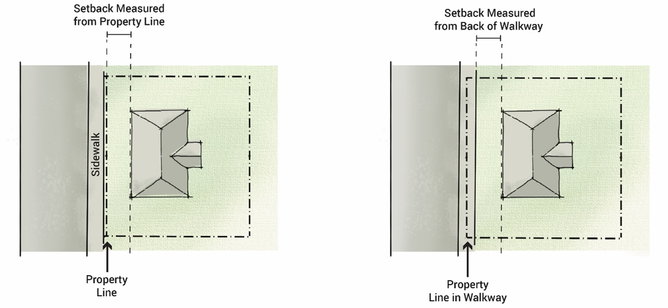
2.
Setbacks for properties adjacent to Fountain Creek shall be measured from the top of bank on the development side of the property, even if the property line extends into the creek.
3.
Where the adjacent properties are zoned differently, the most restrictive setbacks between the two zone districts shall apply to the property being developed.
4.
Setbacks shall be unoccupied and unobstructed by any permanent structure or portion of a permanent structure, with the exception of temporary accessory structures that allow reduced setbacks according to the dimensional standard tables for each zone district.
5.
Common yard features may be permitted within these setbacks. Yard features may include fences, non-structural walls, trellises, and utility poles, posts, yard ornaments, moveable furniture, landscaping, mailboxes, and ornamental light fixtures. Micromobility hubs and bike racks may also be permitted within the setbacks.
6.
On corner lots, an unobstructed line of sight, referred throughout this LUDC as a "vision clearance triangle", shall be maintained for safe flow of pedestrian and vehicular traffic.
a.
The vision clearance triangle is formed by measuring from the point of intersection, a distance of twenty-five (25) feet along the property lines immediately adjacent to a street, road, railroad right-of-way, or nonresidential drive and connecting the points to create a triangle, unless a greater requirement has been designated on CDOT controlled roadways.
b.
Any fence, wall, hedge, shrub, structure, or other obstruction to view that is erected, placed, or maintained within the triangle shall be thirty-six inches (36") in height or less.
Figure 18.02.1.3-2: Vision Clearance Triangle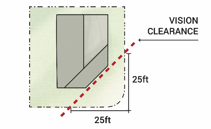
C.
Building Height.
1.
Building height shall be measured as an envelope determined by offsetting the existing ground plane slope of the site vertically to the allowed maximum height specified by the associated zone district. Existing ground plane slope shall be considered the grade or slope of the site prior to any construction. The maximum height of the building shall be contained within the "envelope" created by this offset.
a.
Building height shall be measured from the established finished floor of the building.
b.
The finished floor elevation of the building may cut into the existing slope, however, building height will be measured from the ground plane slope as it will exist at the time of completion but may be no higher than the maximum height allowed as measured from the naturally existing grade prior to construction.
Figure 18.02.1.3-3: Building Height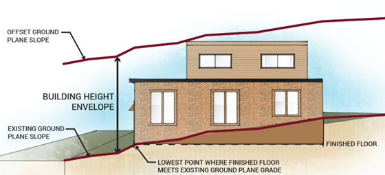
2.
No building or structure shall be erected or altered that will exceed the height limits for the respective zone district, unless specified below:
a.
Within Historic Districts, the maximum building height for the Zone District may be exceeded subject to the Historic District Design Guidelines or approval of a Material Change of Appearance Certification which incorporates steep roof pitches.
b.
Accessory projections. Except as specifically provided elsewhere in this LUDC, the height limitations contained in the dimensional standard tables for each Zone District shall not apply to accessory projections, provided they meet the following criteria for height exceptions:
i.
Architectural features such as such as parapets, pipes, chimneys, heating and venting systems, cupolas, stairwell towers, elevator overrun, roof-mounted solar energy systems, or other similar projections shall not extend more than five (5) feet above the maximum permitted building height of the associated Zone District;
ii.
Church belfries, towers, or spires shall not extend more than five (5) feet above the maximum permitted building height of the associated Zone District provided the largest horizontal cross-section of the belfry, tower, or spire feature does not exceed fifteen percent (15%) of the footprint of the primary structure from which it rises;
iii.
Antennas used for television or radio shall be of a height that is determined by the Planning Director as necessary to comply with Federal Communications Commission regulations and guidance, provided that the height of the antenna structure may not exceed a dimension equal to the distance of the antenna structure from the nearest property line;
iv.
The accessory projection is not constructed for the purpose of providing additional floor area in the building; and
v.
The accessory projection does not interfere with Federal Aviation Administration regulations.
(Ord. No. 1123, § 1(Exh. A), 10-3-2023)
18.02.2. - Residential Zone Districts.
18.02.2.1.
General Residential (GR).
A.
Purpose. To provide areas for a variety of housing types.
B.
Permitted Uses. Applicable uses may be found in Chapter 4, Table 18.04.2-1.
C.
Dimensional Standards. The following dimensional standards apply to this district.
[1] Within the Historic District, subject to the Historic District Design Guidelines, a permanent side setback of less than seven and one-half feet (7'6") may be reviewed and approved, conditionally approved, or denied by the Historic Preservation Commission. At no time without variance approval, shall the side setback be less than five feet (5') or less than a ten feet separation from neighboring buildings/structures including across property lines.
[2] Heights of structures shall be as calculated in the Building Height definition unless property is located within the Historic District and receives a Material Change of Appearance Certification incorporating steep roof pitches, per the Historic District Design Guidelines, as amended. In such cases, building heights shall not exceed thirty feet (30').
[3] Not applicable to ADUs. Pursuant to Section 18.04.3.7(E), "ADUs shall not be located in front yards. The minimum front setback for a detached ADU shall be the rearmost façade of the primary residence. The minimum front setback for an attached ADU shall be the frontmost façade of the primary residence."
Figure 18.02.2.1-1: Illustration of Setbacks for Dwellings with Front Loaded Garage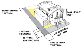
Figure 18.02.2.1-2: Illustration of Setbacks for Dwellings with Rear Loaded Alley
Garage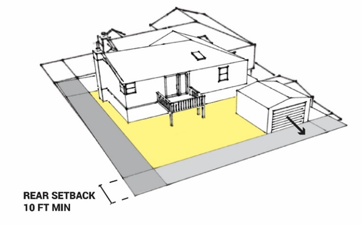
Figure 18.02.2.1-3: Illustration of Setbacks for Dwellings with Side Loaded Alley
Garage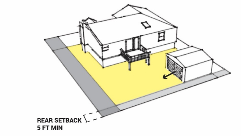
18.02.2.2.
Low-Density Residential (LDR).
A.
Purpose. The Low-Density Residential Zone District is characterized by a variety of detached dwelling unit housing types.
B.
Permitted Uses. Applicable uses may be found in Chapter 4, Table 18.04.2-1.
C.
Dimensional Standards. The following dimensional standards apply to this district.
[1] Heights of structures shall be twenty-five feet (25') as calculated in the Building Height definition unless property is located within the Historic District and receives a Material Change of Appearance Certification incorporating steep roof pitches, per the Historic District Design Guidelines, as amended. In such cases, building heights shall not exceed thirty feet (30').
[2] Not applicable to ADUs. Pursuant to Section 18.04.3.7(E), "ADUs shall not be located in front yards. The minimum front setback for a detached ADU shall be the rearmost façade of the primary residence. The minimum front setback for an attached ADU shall be the frontmost façade of the primary residence."
Figure 18.02.2.2-1: Illustration of Setbacks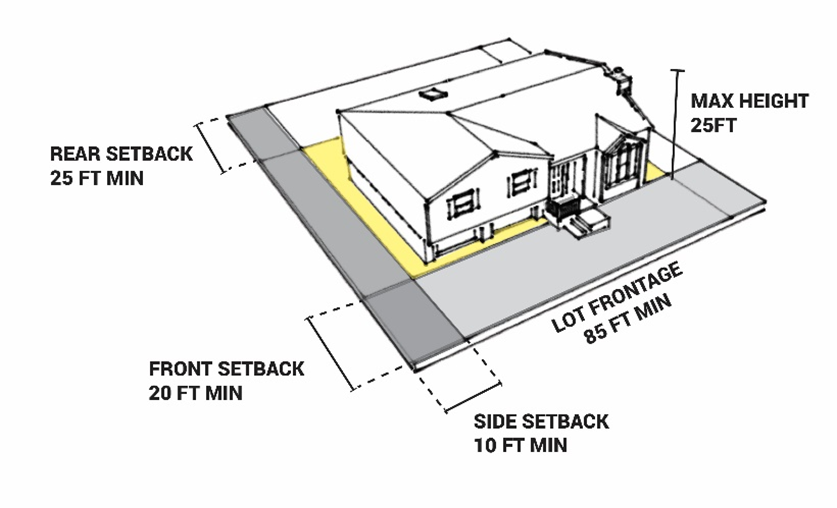
18.02.2.3.
High-Density Residential (HDR).
A.
Purpose. To provide areas for a variety of attached dwelling units or multi-unit dwelling housing types, designed in a manner to create livable dwelling space and well-designed common areas. This Zone District shall be encouraged for redevelopment opportunities at high traffic areas, particularly near Commercial uses along routes served by public transit.
B.
Permitted Uses. Applicable uses may be found in Chapter 4, Table 18.04.2-1.
C.
Dimensional Standards. The following dimensional standards apply to this district.
[1] Subject to building height and scale requirements per Section 18.03.2.4 and 18.03.3.
Figure 18.02.2.3-1: Illustration of Setbacks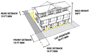
18.02.2.4.
Hillside Low-Density Residential (HLDR).
A.
Purpose. To provide areas of low-density development on hillside lands in a manner that protects ridgelines, steep slopes, wildlife habitat, and heritage trees; and reduces or mitigates natural hazard risks. The primary goal of this district is the protection of key attributes such as topography, native vegetation, connected wildlife corridors, wildlife and pollinator habitats, ecosystems, previously undisturbed scenic areas, and ridgelines of a site.
B.
Permitted Uses. Applicable uses may be found in Chapter 4, Table 18.04.2-1.
C.
Dimensional Standards. The following dimensional standards apply to this district.
[1] Not applicable to ADUs. Pursuant to Section 18.04.3.7(E), "ADUs shall not be located in front yards. The minimum front setback for a detached ADU shall be the rearmost façade of the primary residence. The minimum front setback for an attached ADU shall be the frontmost façade of the primary residence."
1.
Minimum Lot Size - Allowable lot size for traditional development (one detached single household dwelling developed on an existing lot), shall be based on the average percent of slope as computed by the following formula:
S = 100x IxL / A
Where:
S= Average Percent of Slope (%);
I = Contour Interval (feet)—Elevation difference between adjacent contours;
L = Length (feet)—Summation of the measured length of all existing contour lines within the limits of the property line of the parcel being considered;
A = Area (square feet)—Area within the limits of the property boundary of the parcel being considered.
[1] This table is for site planning purposes. Buildings shall not be located on individual slopes with an average slope greater than thirty percent (30%) (even if the average slope on the entire site is less than 30%).
Figure 18.02.2.4-1: Illustration of Setbacks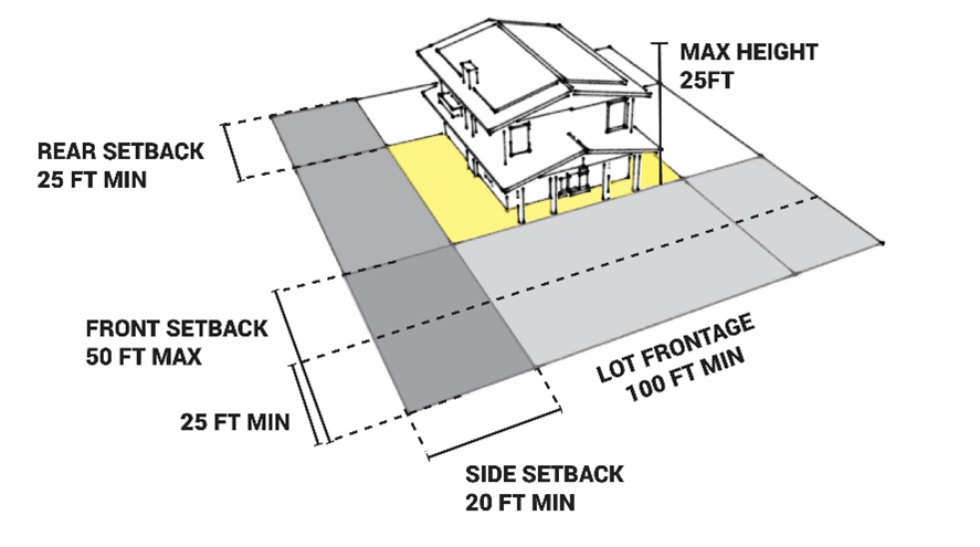
D.
Development Standards. The following development standards apply to all development in the Hillside Low Density Residential Zone District.
1.
All development in the HLDR district shall comply with the Development in Natural Hazards standards pursuant to Chapter 3.
2.
Driveways and utilities shall be located to reduce cut and fill and scarring of the natural landscape to the greatest extent possible.
3.
Significant site features that contribute to the overall community aesthetic shall be identified and preserved to the greatest extent. Examples of such features could include ridgelines, bluffs, rock outcroppings, view corridors, foothills, mountain backdrop, urban forest, floodplains, natural water bodies, natural drainageways, connected wildlife corridors, ecosystems, and heritage trees.
4.
Residences and accessory structures shall be sited on portions of the site with slopes less than thirty percent to protect ridgelines and hilltops.
5.
Development of the area to its fullest potential consistent with the Comprehensive Plan is allowed; however, to assure densities which are compatible with the natural systems and terrain of the hillside area, the maximum density is not guaranteed and relies on the availability of services, topography, access, and surrounding neighborhood character for appropriate design and density.
6.
All driveways shall maintain a slope of twelve percent or less to ensure adequate fire access. A slope of twelve percent or greater may be permitted by the Director upon the applicant demonstrating alternative adequate fire access and the applicant providing interior building sprinklers for all structures on the property.
7.
All landscaping shall adhere to Chapter 3.
(Ord. No. 1123, § 1(Exh. A), 10-3-2023; Ord. No. 1925, § 3, 12-2-2025)
18.02.3. - Commercial and Mixed-Use Zone Districts.
18.02.3.1.
Downtown (DWTN).
A.
Purpose. The Downtown Zone District is characterized by its historic buildings and character, multi-modal transportation options, walkability, access to Fountain Creek, gathering places, public art, and tourist attractions as well as health and wellness offerings such as the nearby mineral springs. This zone serves the residents of the City through the provision of shops, services, restaurants, and civic facilities. It additionally serves year-round tourists with entertainment and family tourism based activities (such as galleries, health spas, shops, restaurants, and museums). The Downtown core values Fountain Creek and the Creek Walk Trail as important recreational amenities that provide pedestrian connectivity throughout the community. It is intended to be a mixed-use zone that provides live/work options and supports the local economy as a vibrant downtown that attracts visitors, employees, and residents.
The Downtown Zone District generally corresponds with the Manitou Springs National and Local Historic Preservation Districts. Properties within these historic districts are required to adhere to the Historic District Design Guidelines, which are intended to foster the preservation of valuable historic structures and the historic character of the City.
B.
Permitted Uses. Applicable uses may be found in Chapter 4, Table 18.04.2-1.
C.
Dimensional Standards. The following dimensional standards apply to this district.
Figure 18.02.3.1-1: Illustration of Setbacks
18.02.3.2
Commercial (C).
A.
Purpose. The Commercial Zone District is characterized by commercial, office, and multi-unit mixed-use residential uses that are an integral part of the City's ability to provide a diverse range of essential and regionally oriented services, tourism-related businesses, and employment opportunities. This Zone District is primarily located along Manitou Avenue outside of the Downtown Zone District west of Highway 24. This Zone District prioritizes gathering spaces and public art as well as access to the Fountain Creek and the Creek Walk Trail for properties on the north side of Manitou Avenue. This district aims to minimize conflicts with adjacent residential and historic areas, floodplains, steep slopes, connected wildlife corridors, wildlife and pollinator habitats, and ecologically sensitive areas.
B.
Permitted Uses. Applicable uses may be found in Chapter 4, Table 18.04.2-1.
C.
Dimensional Standards. The following dimensional standards apply to this district.
[1] Subject to building height and scale requirements per Section 18.03.2.4 and 18.03.3.
Figure 18.02.3.2-1: Illustration of Setbacks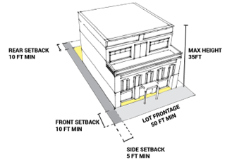
18.02.3.3
Mixed-Use Commercial (MUC).
A.
Purpose. The Mixed-Use Commercial District serves as the eastern gateway to Manitou Springs and is envisioned as a pedestrian friendly hub of retail, higher density residential (standalone or mixed-use), entertainment, and lodging. It promotes mixed-use developments (vertical or horizontal) that retain frontage along Manitou Avenue for commercial uses at the street level while expanding available housing options, as well as live/work housing or apartments. In addition to activating the Manitou Avenue street frontage, this district encourages interaction with the Fountain Creek corridor and prioritizes:
1.
Enhancing the gateway to the City;
2.
Redevelopment of underutilized properties that represent the highest and best use of a site;
3.
Infill development on vacant parcels;
4.
Incorporation of green infrastructure;
5.
Incorporation of public art;
6.
Incorporation of public access to Fountain Creek by providing public walkways, pedestrian bridges, bicycle paths, and/or safe pedestrian connections to the Creek Walk Trail through the site;
7.
Limiting the impact of on-site parking from the streetscape by siting parking lots to the side or rear of the property; and
8.
Establishing the Becker's Lane and Manitou Avenue intersection as the focus of the Urban Renewal Area.
B.
Permitted Uses. Applicable uses may be found in Chapter 4, Table 18.04.2-1.
C.
Dimensional Standards. The following dimensional standards apply to this district.
1.
Projects can qualify for a Development Standard Incentive Award as defined in Table 18.02.3.3-1 below. All land use and development applications within the Mixed-Use Commercial District will be routed through the Urban Renewal Authority (URA) for review, comment, and determination if projects qualify for Development Standard Incentive Awards prior to public hearing, or final determination by City staff.
[1] Subject to building height and scale requirements per Section 18.03.2.4 and 18.03.3.
Figure 18.02.3.3-1: Illustration of Setbacks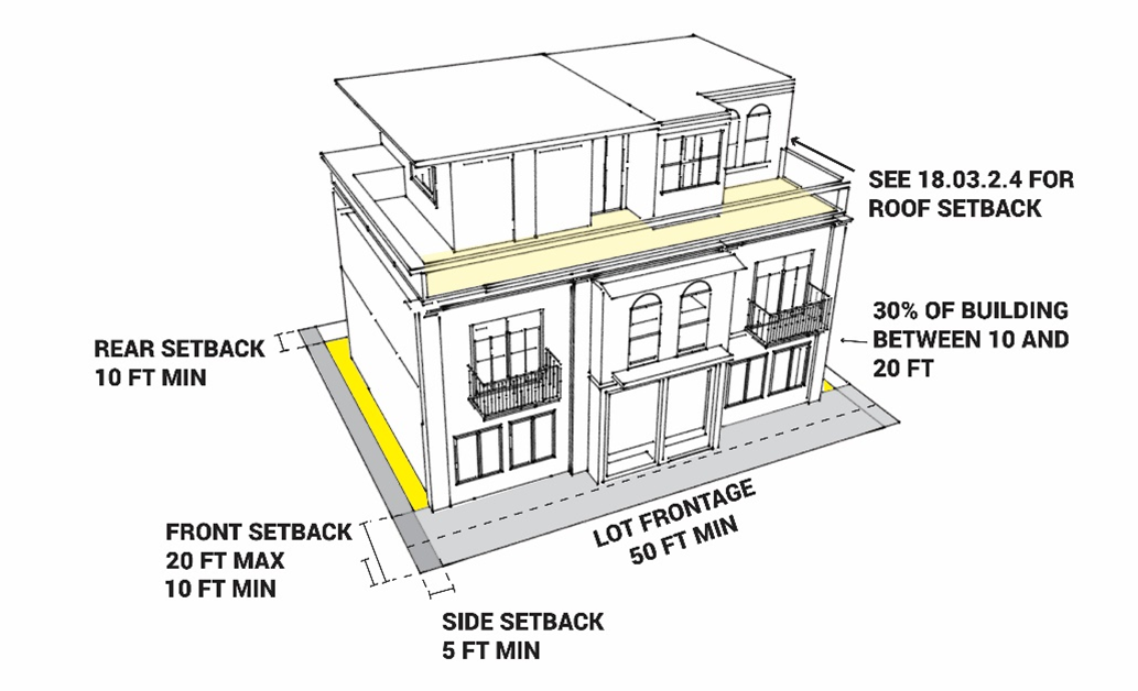
(Ord. No. 1123, § 1(Exh. A), 10-3-2023)
18.02.4. - Publicly Owned Land Zone Districts.
18.02.4.1.
Open Space (OS).
A.
Purpose. The Open Space Zone District provides for areas intentionally left free from development for the preservation of natural resources, including forest lands, connected wildlife and pollinator corridors/habitats, unique biological, physical, topographical, or botanical areas, hazard-prone areas, scenic view sheds; cultural, historic, and archaeological resources.
These areas may represent diverse types of land and possess varied physical and geographical conditions and are important physical, environmental, social, aesthetic and economic resources, which merit protection. The preservation of open space will complement public parks provided by the City and also protect the surrounding mountain backdrop that gives the City its unique character. This character supports the conservation values and significant tourism industry that the City thrives on.
B.
Applicability. This district is established for the passive recreational use by citizens of the City, and to enable applicable lands under City ownership to be rezoned Open Space.
C.
Design Standards.
1.
Buildings are limited to public facilities such as trailhead shelters and restrooms.
2.
For public trails, parking for trailheads is allowed with an approved Open Space Management Plan. All parking areas over two thousand (2,000) square feet shall have on-site water quality and detention facilities in compliance with Title 14 of the Manitou Springs Municipal Code. These facilities shall be designed in a manner to minimize cut and fill and the removal of vegetation, and to minimize impervious surfaces such as paving while promoting pervious surfaces.
3.
No lighting or signage is allowed, other than trail information and trail markers.
4.
Maintenance of the site shall include trash removal, recycling, compost, pet waste removal, forestry management, parking lot maintenance, etc. per an Open Space Management Plan.
D.
Permitted Uses. Applicable uses may be found in Chapter 4, Table 18.04.2-1.
E.
Open Space Management Plan. An Open Space Management Plan shall be submitted to the Parks and Recreation Department for any new open space. The plan shall meet the criteria as outlined in the Parks, Open Space, and Trails Master Plan, or other applicable facilities master plan, and shall be reviewed by the Open Space Advisory Committee.
18.02.4.2.
Park (P).
A.
Purpose. The Parks Zone District is intended for City owned land set aside for use as public recreation and cultural activities. These parks may include playground equipment, athletic fields, tennis courts, swimming pools, and other facilities and programmed activities normally associated with public parks.
B.
Applicability. Approval of permanent public parks require a determination that a public need exists and the use and location are compatible with adjacent land uses. When necessary to make this determination, conditions regarding setbacks from adjacent uses or property lines, landscaping, screening, access, and the placement and size of signs and amount of parking may be approved with the establishment of this zone. A development plan shall be approved before any building permits may be issued or before construction may begin.
C.
Permitted Uses. Applicable uses may be found in Chapter 4, Table 18.04.2-1.
D.
Dimensional Standards. Development standards are determined by the review of the concept or development plan at the time the zone is established, or as amended.
18.02.4.3.
Public Facilities (PF).
A.
Purpose. The Public Facilities Zone District is provided for land which is used or being reserved for a governmental purpose by the City of Manitou Springs, El Paso County, the State of Colorado, the Federal government or a public utility. Generally, the existing or proposed use is a unique governmental or utility service or a governmental function. The term, "public facility", may be used to describe the existing or future use or the character of the ownership of the land. For the purpose of this Section, utility transmission, distribution or collection line rights-of-way or easements and drainage rights-of-way or easements are not required to be designated as public facilities.
B.
Applicability. Approval requires a determination that a public need exists. When necessary to make this determination, conditions regarding setbacks from adjacent uses or property lines, landscaping, screening, access, the placement and size of signs, and amount of parking may be approved with the establishment of the Zone District. Platting and a development plan shall be approved before any building permits may be issued or before construction of any public facility or utility may begin.
C.
Permitted Uses. Applicable uses may be found in Chapter 4, Table 18.04.2-1.
D.
Dimensional Standards. Development standards are determined by the review of the concept or development plan at the time the zone is established, or as amended.
[1] Heights of structures shall be thirty feet (30') as calculated in the Building Height definition, unless a property is located within the Historic District and receives a Material Change of Appearance Certification incorporating steep roof pitches, per the Historic District Design Guidelines, as amended. In such cases, building heights shall not exceed thirty-five feet (35').
(Ord. No. 1123, § 1(Exh. A), 10-3-2023)