
Manitou Springs City Zoning Code
CHAPTER 18
07 - DEFINITIONS
Sections:
18.07.1 - Acronyms.
IBC - International Building Code
IFC - International Fire Code
LUDC - Land Use and Development Code
PPRBD - Pikes Peak Regional Building Department
(Ord. No. 1123, § 1(Exh. A), 10-3-2023)
18.07.2 - Sign Code Terms.
Awning - a shelter or shading material projecting from the exterior wall of a building and composed of a frame.
Building code - the International Building Code, as adopted and modified by this jurisdiction.
Business - a single commercial enterprise or group of enterprises housed within a single building or which utilize the same frontage on a public street.
Commercial - predominantly related to economic interests or commerce.
Deceptive sign - means any commercial sign which is false or misleading.
Digital sign - a sign or part of a sign capable of displaying content or visual displays that the user can electronically or mechanically change by remote or automatic means.
Flashing sign - any directly or indirectly illuminated sign, either stationary or animated, which exhibits changing natural or artificial light or color effects by any means whatsoever.
Freestanding sign - any sign independent of buildings and consisting of self-supporting elements, except sandwich board signs.
Hanging sign - any sign suspended from or supported by a building or wall projecting outward at a perpendicular angle therefrom, or any sign suspended under a marquee, porch, walkway covering, or similar covering structure.
Historic district - that portion of the City within the boundaries of the National Historic District.
Historic sign - any sign that has historic significance as determined by the City council on the recommendation of the Historic Preservation Commission.
Inflatable display - any sign consisting of a flexible material envelope of non-porous material shaped from inserted air or other gas used to promote special events, grand openings, sales and business transitions. Inflatables do not include individual latex balloons under 18" in size.
Mural sign - a type of wall sign that consists of paint applied directly to the exterior wall of a building or structure. Mural signs may not include any additional materials including, but not limited to, electrical components or lighting, dimensional structural elements, or automated methods that cause changes in the appearance of the mural.
Neon sign - a light source supplied by a tube which is built to form letters, symbols or other shapes.
Non-commercial sign - any sign that does not advertise or direct attention to a business, product, service or other commercial activity.
Nonconforming sign - any legally existing sign which does not conform to the regulations of this LUDC, either at the effective date of the regulation establishing this chapter, or as a result of subsequent amendments which may be incorporated into this chapter.
Obsolete sign - any commercial sign, except a historic sign, that was owned or operated by a business, service, attraction, that no longer exists on the parcel.
Occupant - a distinct user of a lot that occupies a lot or designated portion of a lot, regardless of the legal arrangement allowing occupancy between the owner of the building, lot or development and the occupant.
Off-premises sign - any commercial sign placed other than on the parcel of land or premises wherein or upon which the commercial activity in reference is located or conducted.
Official sign - any sign required by law or constructed, placed or maintained by the State, the Federal government or the City. The inclusion of "government" in defining such signs does not intend to subject the government to regulation, but instead helps describe the type of sign that falls within the immunities of the government from regulation.
On-premises sign - any sign placed on the parcel of land or premises wherein or upon which the commercial activity in reference is located or conducted.
Prohibited sign - any sign not permitted within the corporate limits of Manitou Springs.
Public right-of-way - any parcel or portion of land which allows for public pedestrian or vehicular access thereupon.
Roof sign - any sign erected upon or over the roof or parapet of any building.
Sandwich board signs - means temporary freestanding signs constructed in an A-frame style.
Searchlight - an apparatus containing a light and/or reflector for projecting a strong, far-reaching beam in any direction.
Sign - any stationary object, device, symbol, or part thereof, subject to view from a public right-of-way, used to communicate a message or to advertise or identify an object, person, institution, organization, business, product, service, or event by means including words, letters, figures, designs, symbols, logos, fixtures, colors, motion, illumination, or projected images. Displayed merchandise is not considered a sign.
Sign permit - a permit issued for the erection, construction, enlargement, alteration, moving or conversion of any sign, issued pursuant to this LUDC.
Temporary sign - any sign that is intended for a temporary period of display of thirty days or less.
Trailblazer sign - an official sign used to facilitate traffic movement to significant area attractions and points of interest from major City automobile routes along the most safe and direct local streets.
Two-sided sign - any sign with two identical faces no greater than twelve inches apart or connected so as not to exceed a forty-five (45) degree angle.
Wall sign - any sign attached to, painted on, or erected against the exterior of a building or structure.
Window sign - any permanent sign applied to, attached to, or located within twelve inches of the interior of a window which can be seen through the window from the exterior of the structure.
(Ord. No. 1123, § 1(Exh. A), 10-3-2023)
18.07.3 - Zoning and Subdivision Terms.
For the purposes of this chapter, the following definitions shall be used. Words used in the present tense shall include the future; the singular number includes the plural and vice-versa; the word "shall" is to be construed as mandatory; the words "occupied" or "used" shall be construed to mean intended, arranged, or designed to be occupied or used both in the future and present tenses.
A
Abandon - the discontinuation of an activity or use of property for a particular purpose after a period of twelve months.
Accelerated creep - is a geologic hazard involving the slow, gradual, more or less continuous deformation sustained by soil rock materials under gravitational stresses.
Accelerated erosion and siltation - is a process that results in an excessive rate of removal of soil and rock materials from one location and rapid deposit thereof in adjacent areas.
Accessory equipment - any equipment serving or being used in conjunction with a wireless facility, including utility or transmission equipment, power supplies, generators, batteries cables, equipment buildings, cabinets and storage shelters or other structures.
Accessory structure - a structure subordinate to the principal structure and located on the same lot or parcel or an adjacent lot or parcel serving a purpose that is incidental to the principal structure. Accessory structures may include, without limitation, storage sheds, garages and parking areas, children's play equipment, and antennas.
Accessory use - a use subordinate to the principal use and located on the same lot or parcel or an adjacent lot or parcel serving a purpose that is incidental to the principal use.
Administrative review - the application is reviewed by the Planning Department per application procedures detailed within this LUDC.
Alley - a public way reserved as a secondary means of access, utilities, or infrastructure which is used primarily for vehicular service access to the rear or side of a property otherwise abutting on a public street.
Alternative tower structure - an existing or proposed wireless facility that is compatible with the natural setting and surrounding structures and that uses camouflage and concealment design techniques to reduce the visual impacts of those facilities and can be used to house or mount antenna. Examples include manmade trees, clock towers, bell steeples, light poles, traffic signals, existing utility poles and transmission towers.
Antenna - communications equipment that transmits or receives electromagnetic radio frequency signals used to provide wireless service. [Reference: section 29-27-402, Colorado Revised Statutes.]
Attached Structure - a structure having at least five (5) linear feet of wall serving as a common wall with the structure to which it is attached.
B
Base station - a structure or equipment at a fixed location that enables Federal Communications Commission (FCC)-licensed or authorized wireless communications between user equipment and a communications structure network. The definition of base station does not encompass a tower as defined in this Chapter or any equipment associated with a tower. Base station includes:
A.
Equipment associated with wireless communications services such as private, broadcast, and public safety services, as well as unlicensed wireless services and fixed wireless services such as microwave backhaul that, at the time the relevant application is filed with the City under this chapter, has been reviewed and approved by the City under the applicable zoning or siting process, or under another state or local regulatory review process, even if the structure was not built for the sole or primary purpose of providing such support.
B.
Radio transceivers, antennas, coaxial or fiber-optic cable, regular and backup power supplies, and comparable equipment, regardless of technological configuration (including distributed antenna systems (DAS) and small-cell networks) that, at the time the relevant application is filed with the City under this chapter, has been reviewed and approved by the City under the applicable zoning or siting process, or under another state or local regulatory review process, even if the structure was not built for the sole or primary purpose of providing such support.
C.
The definition of base station does not include any structure that, at the time the relevant application is filed with the City under this section, does not support or house equipment described in subsections (A) or (B), above. Reference: 47 C.F.R. § 1.6100 (Wireless Facility Modifications
Berm - an earthen mound designed to provide visual interest on a site, screening of undesirable views, noise reduction, etc.
Bicycle - a vehicle composed of two wheels held in a frame one behind the other, propelled by physical means and steered with handlebars attached to the front wheel.
Bicycle-share rack - any stationary fixture intended to be used for the purpose of securely attaching a bicycle-share bicycle to prevent movement or theft or for storage.
Bicycle-share bicycle - any bicycle available to persons for rental on a short-term basis of less than twenty-four hours.
Bicycle-share business - any business owning, managing, or making available bicycle-share bicycles for hire.
Bicycle-share operator - a person which manages, owns, or operates a bicycle-share business.
Block - a group of contiguous lots bounded by public right-of-way, trail, or open space.
Broadband facility - any infrastructure used to deliver broadband service or for the provision of broadband service. [Reference: section 29-27-402, Colorado Revised Statutes.]
Broadband service - has the same meaning as set forth in 7 U.S.C. sec. 950bb (b)(1) as of August 6, 2014, and for the purposes of this section includes:
•
"Cable service", as defined in 47 U.S.C. sec. 522 (6) as of August 6, 2014;
•
"Telecommunications service", as defined in 47 U.S.C. sec. 153 as of August 6, 2014; and
•
"Wireless service", which means data and telecommunications services, including commercial mobile services, commercial mobile data services, unlicensed wireless services, and common carrier wireless exchange access services, as all of these terms are defined by federal law and regulations. Reference: section 29-27-402, Colorado Revised Statutes.
Buffer - a strip of land or appropriate method located along a property line that separates land uses which may be incompatible from one another.
Building area - the total area bounded by the exterior walls of the building including all such areas that are within the horizontal projection of the roof or floors above.
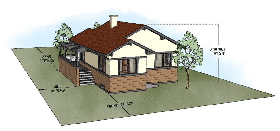
Building height - See Section 18.02.1.4.C.
Buildings - any structure used or intended for supporting or sheltering any use or occupancy.
Business - a single enterprise or group of enterprises housed within a single building which utilize the same frontage. For the purposes of outdoor display, outdoor seating and mobile vending, units within a multiple occupancy building that have individual frontage are each considered a separate business.
C
Camouflage and concealment design techniques - measures used in the design and siting of wireless facilities with the intent to reduce the visual impacts of such facilities to surrounding uses so that the presence of the wireless communications facility is not readily apparent. A wireless facility utilizes camouflage and concealment design techniques when:
A.
The facility is integrated within, or incorporated on, an architectural feature of an existing structure, such as a tower, clock tower, bell steeple, cupola, penthouse, architectural feature or other similar structure and is not readily apparent;
B.
The facility is integrated within, or incorporated on, vertical infrastructure located in the right-of-way such as a traffic signal, flag pole, light pole or other similar structure and is not readily apparent; or
C.
The facility uses a design which mimics and is consistent with landscaping features (such as artificial rocks, trees, and other vegetation), maintains authenticity in its application and is not readily apparent.
City Administrator - as defined per Title 2 of the Manitou Springs Municipal Code.
Collocation - the mounting or installation of broadband service equipment on an eligible support structure for the purpose of transmitting or receiving radio frequency signals for communications purposes. [Reference: section 29-27-402, Colorado Revised Statutes.]
Conditional uses - a use that due to its impact and nature is not expressly permitted in a zone district but may be allowed through City approval as provided for in this code.
Contributing Resource - as defined per Section 17.04.030(F) of the Manitou Springs Municipal Code.
Cool Roof - a roof that has been designed to reflect more sunlight and absorb less heat than a standard roof.
Covenants or restrictive covenants - a contractual agreement between the subdivider or landowner and the buyer of a piece of property that restricts the use of all or portion of the property. The covenant will normally run with the land and will therefore apply to all succeeding owners. Covenants and restrictive covenants are not enforced by this code.
Cul-de-sac - a street open at one end only, providing at the other end special facilities for the turning around of vehicular traffic.
D
Debris fan - is a geologic hazard involving a floodplain that is located at the mouth of a mountain valley tributary stream as such stream enters the valley floor where mud flow and/or debris flows may occur.
Debris flow - a moving mass of loose mud, sand, soil, rock, water, and air that travels down a slope under the influence of gravity. To be considered a debris flow, the moving material must be loose and capable of "flow," and more than half of the solids in the mass must be larger than sand grains.
Deck - a floored structure elevated off the ground and with a permanent foundation that is freestanding or adjoins a house. Must meet the setback requirements for primary structures and may require a building permit from PPRBD.
Defensible space - an area, typically divided into zones, between an improved property and a potential wildfire where the combustibles have been removed or modified.
Density - ratio of a particular type of land use per given area of land.
Design standards or design requirements - all requirements or regulations relating to design and layout of subdivisions and development plans as contained in this LUDC.
Detached Structure - a structure that has no wall in common with another structure, and that is separated by three (3) feet or more from any other structure. Structures that are connected by a covered, unenclosed breezeway shall be considered detached.
Developer - anyone engaging in development.
Development - the division of a parcel of land into two or more parcels, the construction, reconstruction, structural alteration, relocation or enlargement of any structure, any mining, excavation, landfill or other land disturbance; and any use or extension of the use of land, to also include the installation, expansion, and construction of driveways, paving of driveways, installation or expansion of retaining walls and expansion or installation of utilities within a single ownership.
Development activities - those activities which are normally undertaken for the development, construction, rehabilitation or conversion of buildings, including the acquisition of property.
Development agreement - is defined as the agreement between the developer and the City in which the developer's obligations concerning the property being developed, and the time for their performance and completion, are set forth. The development agreement shall establish the period of the vesting of the developer's rights, and shall also provide that, in the event of a breach or default of the developer's obligations, such vested rights may, after notice, be divested.
Docking hub or station - the site of one or more micromobility vehicle parking spaces designated for the purpose of parking, storing, and/or recharging micromobility vehicles and any kiosks, structures, or signage associated with or under the control of a single micromobility-share operation.
Dwelling - one room or a set of rooms constituting a separate, independent habitable space.
Dwelling unit - one or more rooms arranged, designed, and used as habitable space for one household.
Dwelling units per acre (DU/AC) - measurement of how many dwelling units can be located on one gross acre of property.
E
Easements, private - areas within a subdivision or property, other than streets or alleys which are reserved, conveyed or dedicated for private access or utility use within the subdivision.
Easements, public - areas within a subdivision or property, other than streets or alleys which are reserved, conveyed or dedicated for public access or utility use.
Edge of pavement - interface of one material and the adjacent pavement surface, typically located at the location of the curb and gutter.
Electric bicycle - any bicycle which is run on electric power and by pedaling. Also known as an E-Bike. These vehicles are classified as follows:
A.
Class 1: Electrical assisted bicycle equipped with a motor that provides assistance only when the rider is pedaling and that ceases to provide assistance when the bicycle reaches a speed of twenty miles per hour.
B.
Class 2: Electrical assisted bicycle equipped with a motor that provides assistance regardless of whether the rider is pedaling but ceases to provide assistance when the bicycle reaches a speed of twenty miles per hour.
C.
Class 3: Electrical assisted bicycle equipped with a motor that provides assistance only when the rider is pedaling and that ceases to provide assistance when the bicycle reaches a speed of twenty-eight miles per hour.
D.
Class 4: Electric assisted bicycle or moped that has a maximum speed exceeding twenty-eight miles per hour.
Electric scooter - any scooter which is run on electric power and by foot pedaling. Also known as an E-Scooter.
Electric skateboard - any skateboard which is run on electric power and by foot pedaling. Also known as an E-Skateboard.
Eligible facilities request - any request for modification of an existing tower or base station that does not substantially change the physical dimensions of such tower or base station involving:
A.
Collocation of new transmission equipment;
B.
Removal of transmission equipment; or
C.
Replacement of transmission equipment.
Eligible support structure - any tower or base station, provided that it is existing at the time the eligible facilities application is filed with the City.
Essential services - services provided by public and private entities necessary for the exercise of the principal use or service of the principal structure.
Expansive or unstable soils and/or rock - is a geologic hazard involving soils and rock that expands, consolidates, or collapses to a significant degree upon wetting, and/or loading and/or shrinks upon drying.
F
Façade - the exterior side of a building or structure that faces, and is most nearly parallel to, a public or private street, extending from the ground to top of the roof, parapet, or wall and the entire width of the building elevation.
Fence - a structure which serves as decoration, a barrier intended to prevent escape or intrusion, to mark a boundary, or to shield or screen view.
Final Plat - map prepared in accord with the provisions of this LUDC that is presented to the City for approval and that, if approved, will be recorded by the City with the El Paso County Clerk and Recorder.
Freestanding wireless facility - a wireless facility that consists of a stand-alone support structure or tower, antennas and accessory equipment that is not considered an alternative tower structure.
Frontage - the portion of a lot abutting a public or private street measured along the street right-of-way.
G
Garage - any commercial or residential building or structure used primarily for storage of vehicles.
Geologic hazard - a geologic phenomenon that is so adverse to past, current, or foreseeable construction or land use as to constitute a significant hazard to public health and safety or to property. This includes, but is not limited to landslide, rockfall, mud flow, expansive or unstable soils and/or rock, subsidence, unstable or potentially unstable slopes, seismic hazards, debris fans, accelerated creep, and accelerated erosion and siltation.
Geologic hazard area - an area that contains or is directly affected by a geologic hazard.
Good Cause - justifiable and reasonable grounds for why a building permit was not issued by the deadline. Examples of good cause include delays in building permit review by the reviewing agency, inability to secure financing in a timely manner, unforeseen conditions at the property such as soils or drainage problems, and similar causes not solely the result of the applicant's failure to pursue the development with due diligence.
Green infrastructure is a term used to describe the network of natural spaces and corridors in a given area. Green infrastructure assets include open spaces such as parks and gardens, sports fields, woodlands, fields, stormwater drainage ways, lakes, ponds, creeks, as well as trails.
Gross floor area - the area within the inside perimeter of the exterior walls of the building, without deduction of corridors, stairways, ramps, closets, the thickness of the interior walls, columns or other features.
Gross acreage - the total property area of a parcel.
H
Habitable space - any structure containing rooms that are used for living, sleeping, cooking, or eating.
Heritage Tree - as defined in Section 12.38 of the Manitou Springs Municipal Code.
Household - the number of persons occupying each dwelling unit shall not exceed the maximum permitted by the applicable adopted building or safety code, the Housing Habitability Code, or by any applicable state or federal law or regulations, or by affordable housing guidelines applicable to the dwelling unit.
I
Improvements - any alteration to the land or other physical construction associated with subdivisions and building site developments.
Intermodal shipping container - a detachable, pre-fabricated, standardized, reusable, container designed and intended for and customarily associated with transporting cargo on ocean-going ships, trains or tractor trailers, also commonly called cargo containers, transport containers or marine cargo containers. This definition includes Conex and railroad cars.
J
There are no defined terms for this letter.
K
Kelvin - a measurement used to describe the color temperature of a light source. This is the specification that gives a description of the warmth or coolness of a light source.
L
Ladder fuels - fuels that provide vertical continuity allowing fire to carry from surface fuels into the crowns of trees or shrubs with relative ease.
Landscaped area - the area of a site devoted to and maintained for the growing of living plants, trees, ground covers, and nonliving material as allowed by Section 18.03.6, Landscaping and Screening.
Landslide - a geologic hazard involving mass movement where there is a distinct surface of rupture or zone of weakness that separates the slide materials from more stable underlying material.
Limits of disturbance - the area(s) of a site that may be disturbed by grading, clearing of vegetation, or other earth movement during development activities such as construction of buildings or structures, driveways, parking, roads, drainage or stormwater facilities, and/or other improvements and facilities.
Loading area - a completely off-street space or berth on the same lot for the loading or unloading of freight carriers having adequate ingress and egress to the public street, private street, or alley.
Lot area - the total area lying within the peripheral boundary of a parcel of land.
Lot, legally whole platted - a parcel of land having frontage on a public or private street and sufficient in area to meet the minimum lot size, lot frontage, parking area, and other provisions of this code. A lot can include a multiple lot configuration under one tax ID or ownership.
Lot, nonconforming - a lot that was in compliance with the LUDC when created, but that does not meet current requirements of this LUDC.
Lot, corner - a single lot having its front and one side adjacent to two streets (public or private).
Lot coverage - the percentage of a lot which is covered by impervious development, including but not limited to, the footprint of any buildings measured at grade, exterior building stairs, decks, covered porches, stoops, patios, overhangs, garages, carports, gazebos, sheds, outbuildings, and bays or portions of a building that project beyond the foundation and enclosed floor area, driveways, and parking areas. Eaves or roof overhangs three (3) feet and less, cornices, sills, canopies or other similar architectural features, public sidewalks, fences, and private or public streets are not included in calculating lot coverage.
Lot, double-frontage - a single lot having the front and the rear of such lot adjacent to two streets (public or private).
Lot, flag - a lot, the main use or building area of which does not abut a public or private street, but is connected to such street by a narrow strip of land that is part of the lot.
Lot length - is the distance from the front property line to the rear property line measured perpendicularly from the front property line.
Lot lines - the legal, platted boundaries of a parcel of land.
Lot of record - a parcel of land in the City, the deed of which was recorded in the public records of El Paso County, Colorado, on or before July 25, 1973, or a parcel of which that was subsequently annexed to the City that was: a) a platted lot meeting the applicable subdivision requirements of El Paso County, b) a legal nonconforming lot in El Paso County, c) a parcel of land that was legally exempted by El Paso County from platting requirements, or d) a parcel of land in El Paso County created before September 1, 1972.
Lot width - the width of a parcel of land measured at the front property line which is maintained for a majority of the length of the property.
Low-impact development - systems or practices that use or mimic natural processes that result in the infiltration, evapotranspiration, or use of stormwater in order to protect and/or enhance water quality and the associated aquatic habitat.
Lumens - a manufacturer-supplied measure of light emitted from a lamp as indicated by initial lumens, that is, the amount emitted by a new lamp after one hundred (100) hours of seasoning. Lumens are usually listed on lamp packages as "Light Output". Also, the amount of light a bulb produces or a quantitative unit measuring the amount of light emitted from a light source.
M
Manufactured home - any pre-constructed building unit or combination of pre-constructed building units that:
A.
Include electrical, mechanical or plumbing services that are fabricated, formed or assembled at a location other than the site of the completed home;
B.
Is designed for residential occupancy in permanent locations;
C.
Is constructed in compliance with the National Manufactured Housing Construction and Safety Standards Act of 1974, 42 U.S.C. 5401 et seq.; and the related regulations and standards;
D.
Does not have motor power; and
E.
Is not licensed as a recreational vehicle.
Master Plan, Private - a land use plan or map which indicates the desired future physical development of any portions of Manitou Springs. Such a plan is submitted by the developer and is intended as a general summary of their proposal for development.
Master Plan, Public - the comprehensive, long-range plan developed by the City of Manitou Springs to help guide the development of the community.
Maximum extent practicable - that under the circumstances, efforts have been undertaken to comply with the standards, that costs for implementing additional compliance measures clearly outweigh the benefits to the public or would unreasonably burden the project, and that adequate steps have been taken to minimize adverse impacts from noncompliance.
Micro wireless facility - a small cell wireless facility that is no larger in dimensions than twenty-four inches in length, fifteen inches in width, and twelve inches in height and that has an exterior antenna, if any, that is no more than eleven inches in length. Reference: section 29-27-402, Colorado Revised Statutes.
Micromobility - individual, lightweight modes of transportation that are predominantly electrically powered such as electric scooters and e-bikes.
Micromobility fleet - any micromobility vehicles under the ownership or operation by a specific micromobility business or operation.
Micromobility vehicle parking space - any space designated on private property, the public right-of-way, or public property in which a micromobility vehicle may be parked in compliance with the regulations set forth in this LUDC).
Micromobility-share - a micromobility-sharing system or service in which micromobility vehicles are made available to use for short-term rentals.
Micromobility-share rack - any stationary fixture, including charging stations, intended to be used for the purpose of securely attaching a micromobility-share vehicle to prevent movement or theft or for storage.
Micromobility-share vehicle - a category of transport available for public rental which are provided by very light vehicles such as electric scooters, electric skateboards, electric bicycles, wheelchairs, and mobility aids.
Mobile home - a dwelling structure built on a steel chassis and fitted with wheels that is intended to be hauled to a permanent site. This definition includes the use of "tiny homes" that are built upon a trailer.
Monuments - the actual points set on the ground to locate, delineate or describe tracts of land and/or the points set to define a legal description of a tract of land.
A.
"United States Land Survey Monuments" means the points or corners established by the survey of public lands for the United States Government, also the reestablishment or restoration of such corners.
B.
The points or corners set by a Colorado Registered Land Surveyor in accordance with Colorado Revised Statutes, Section 38.36.136, as amended, to define a legal description on the ground.
Mud flow - a geologic hazard involving a moving mass of loose mud, sand, soil, rock, water and air that travels down a slope under the influence of gravity. This includes debris flow.
N
Natural hazard - a source of harm or difficulty created by a meteorological, environmental, or geological event.
Natural hazard area - an area containing or directly affected by a natural hazard.
No build area - portions of a site designated on a plat which, due to steep terrain or significant natural features or vegetation, shall not be built upon, including no alteration of the site through cuts, fills, or any construction and/or development activity.
Nonconforming uses or structures - any structure, or land, lawfully used, occupied, or erected at the time of the effective date of this LUDC or amendments hereto, which does not conform to its current provisions. Any structure conforming in respect to use but not in respect to frontage with area, height, yard, parking, loading, or distance requirements shall be termed a nonconforming structure, not a nonconforming use.
O
Occupancy, long-term - the occupancy or right of occupancy lasting thirty days or more in any sixty-day period.
Occupancy, short-term - the occupancy or right of occupancy lasting for less than thirty days in any sixty-day period.
Open Space - a parcel of land in an undeveloped condition that is suitable for natural areas, wildlife habitat, important natural features, passive recreation activities, or cultural resources.
Outdoor seating area - a space for gathering outside of a building on public or private property.
Overhang - the edge of a roof protruding outward from the side of a building, also called an eave.
P
Parking area - an open space or an enclosed structure used exclusively for the temporary storage of automobiles, meeting the provisions of the parking standards in Chapter 18.03.
Patio - an outdoor area at grade adjoining a building typically used for outdoor lounging or gathering which is paved in brick, concrete, pavers, or similar.
Perfected appeal - an appeal for which all of the required application and filing information has been submitted and accepted for review by the decision-making authority.
Permanent Accessory Structure - a structure over two hundred (200) square feet on residential properties and over one hundred twenty (120) square feet on commercial property, on permanent foundation, the use of which is customarily accessory to and incidental to that of the principal use located on the same lot and that is used as a garage, tool or storage shed, or similar use. Accessory structures shall not be used for human habitation
Plat - a formal subdivision document that is approved and recorded with El Paso County Clerk and Recorder.
Pole-mounted small cell facility - a small cell facility with an antenna that is mounted and supported on an alternative tower structure, which includes a replacement pole.
Portable-on-demand storage container - a purpose-built, detachable, box-like container manufactured out of corrugated or reusable steel or other material designed for and customarily associated with temporary storage of household goods and/or equipment or moving household or dry bulk goods from one place to another.
Property Improvement Permit (PIP) - is the mechanism by which the Planning Department reviews proposed erection, construction, reconstruction, alteration, enlargement, extension, or moving of any building, structure, or portion thereof, and for the alteration of private property as detailed in the application procedures within this LUDC.
Property lines - the boundaries of an ownership parcel which may or may not be whole platted lots.
Public facilities and services impact report - the project specific public facilities and services impact report shall comply with the criteria stated in Section 16.08.040(D) of the Manitou Springs Subdivision Regulations and this definition. This report shall analyze the impact of a proposed project on public facilities and environmental quality, as well as the proportional fiscal impact on the City. The fiscal impact analysis and existing infrastructure capacity and service levels are used as a basis for determining impacts attributable to the proposed project and shall be determined for a ten-year time horizon for only the appropriate municipal funds. The cost of on-site and off-site project impacts on public facilities and services is not borne by the general community. In situations where the project impacts are shown to exceed the capacity of existing public facilities and services, the applicant will demonstrate a means of increasing the capacity of the public facilities and services proportionate to the impact generated by the proposed project. The City has the right to request additional information if the fiscal impact report is not sufficient.
Public uses - any building, structure, or use that is open to the general use, participation or enjoyment of the public and owned by the City, County, State, or Federal government, or a public utility corporation.
Public utility - for the purposes of this code, a public utility is an electricity substation, a gas regulator station, a telephone exchange, a water or sewer pump station, a water reservoir, water and sewer main lines, stormwater facilities, and the accessories used to provide the service.
R
Radial - a line forming right angles with the tangent of any given arc.
Radio frequency emissions letter - a letter from the applicant certifying that the proposed wireless facility will comply with federal law on radio frequency emissions.
Readily apparent - For purposes of determining whether a wireless facility is readily apparent, the phrase means that the facility will be easily recognizable as a wireless facility to a reasonable person viewing the facility as a whole and in the context of any adjacent improvements and landscaping from publicly accessible locations. Methods of design and construction that may assist in reducing the visibility of a facility and reaching a conclusion that a facility is not readily apparent include the use of color mimicking surrounding structures and landscaping, minimizing facility size to the greatest extent feasible, integrating the facility into any adjacent or attached improvements, and positioning the facility in a manner that limits the degree to which the facility projects away from any adjacent structures or landscaping. Due to differences in site characteristics, a determination that a particular wireless facility will not be readily apparent at one location shall not establish a precedent for the same determination for a facility of the same or similar design or construction at a different location.
Regional land use plan - the plan, and any functional elements to the plan as adopted, that was created through the joint efforts of the members the Pikes Peak Area Council of Governments and which was adopted as the Pikes Peak Regional Land Use Plan, as amended.
Replacement pole - an alternative tower structure that is a newly constructed and permitted traffic signal, utility pole, street light, flagpole, electric distribution, or other similar structure of proportions and of equal height or such other height that would not constitute a substantial change to a pre-existing pole or structure in order to support a wireless facility or small cell facility or micro cell facility or to accommodate collocation, and replaces a pre-existing pole or structure.
Replat - the reconfiguration of any existing, legally subdivided lot or lots.
Retaining wall - a wall designed to resist the lateral displacement of soil of or other materials. Retaining walls over four feet in height, or which support a road or other weight surcharge, require engineer-approved plans and a building permit from PPRBD.
Right-of-way - the entire dedicated tract or strip of land that is to be used by the public for circulation and service. The length and width of a right-of-way shall be sufficient to provide adequate accommodations for all the physical features to be included in such right-of-way, as hereinafter established.
Rockfall - is a geologic hazard involving the rapid free- falling, bounding, sliding, or rolling of large masses of rock or individual rocks.
Roof-mounted wireless facility - a wireless facility that is mounted on the roof or any rooftop appurtenance of a legally existing building or structure.
S
Sanitary Facilities - a room containing a sink and a toilet.
Scooter - a vehicle consisting of a footboard mounted on two wheels and a long steering handle, propelled by resting one foot on the footboard and pushing the other against the ground.
Scooter-share - a scooter-sharing system or service in which scooters are made available to use for short-term rentals. The term describes the sharing of mostly electric motor scooters. Also referred to as electric mopeds or electric kick scooters.
Screen - screening shall provide visual barriers between different land uses, enhance the streetscape, provide privacy, and protect uses from wind, dust, noise, traffic, glare, visual disorder, and harmful or noxious effects.
Seismic hazard - is a geologic hazard involving the natural or triggered phenomenon such as ground shaking, fault rupture, or soil liquefaction, generated by an earthquake.
Setback means:
A.
Rear—Located at the rear of the parcel extending across the full width of the lot, immediately behind the principal structure wall.
B.
Side—Located along the side of the yard, extending to the rear yard of the lot, the width of which shall be the minimum horizontal distance between the side lot line and a line parallel thereto through the nearest point of the principal structure or use.
C.
Front—Extends across the full width of the front of the lot, the depth of which shall be the minimum horizontal distance between the front property line and a line parallel thereto to the nearest point of the principal structure.
Signal interference letter - a letter from the applicant certifying that the proposed wireless facility will comply with federal law on signal interference.
Siltation - a process that results in an excessive rate of removal of soil and rock materials from one location and rapid deposit thereof in adjacent areas.
Site for towers - (other than towers in the right-of-way and eligible support structures) the current boundaries of the leased or owned property surrounding the tower or eligible support structure and any access or utility easements currently related to the site. A site, for other alternative tower structures, base stations, micro cell facilities, and small cell facilities in the right-of-way, is further restricted to that area comprising the base of the structure and to other related accessory equipment already deployed on the ground.
Site-specific development plan - the approval of a minor site plan, major site plan, or final plat.
Site plan - a plan, to scale, showing uses and structures proposed for a parcel of land, submitted in compliance with the requirements of this LUDC.
Skateboard - a short narrow board with two or more small wheels fixed to the bottom of either end, on which a person can ride in a standing or crouching position, propelling themselves by occasionally pushing one foot against the ground.
Skateboard-share - a skateboard-sharing system or service in which skateboards are made available to use for short-term rentals. The term describes the sharing of mostly electric skateboards.
Small wireless facility -
A.
A personal wireless service facility as defined by the federal "Telecommunications Act of 1996", as amended as of August 6, 2014; or
B.
A wireless facility where each antenna is located inside an enclosure of no more than three cubic feet in volume, or, in the case of an antenna that has exposed elements, the antenna and all of its exposed elements that could fit within an imaginary enclosure of no more than three cubic feet; and primary equipment enclosures are not larger than seventeen cubic feet in volume. The following associated equipment may be located outside of the primary equipment enclosure and, if so located, is not included in the calculation of equipment volume: electric meter, concealment, telecommunications demarcation box, ground-based enclosure, back-up power systems, grounding equipment, power transfer switch and cut-off switch.
A small cell facility includes a micro wireless facility. Small cells may be attached to alternative tower structures, replacement poles, and base stations. Reference: section 29-27-402, Colorado Revised Statutes.
Solid waste - unwanted or discarded material with insufficient liquid content to be free flowing. Solid waste may be generated by a variety of land uses including agricultural, commercial, industrial, residential, etc.
Stoop - a platform or entrance stairway adjacent to a walkway providing pedestrian access to a building.
Structural alterations - any change in the supporting members of a structure such as foundations, bearing walls, columns, beams, or girders.
Structure - any erection or construction such as a building, towers, lamps, poles, booms, signs, decorations, carports, machinery and equipment. For purposes of Section 18.04.20.1 (Wireless Service Facilities), "structure" means any facility, tower, pole, building, or other structure constructed for the sole or primary purpose of supporting broadband facilities or wireless service facilities. [Reference: section 29-27-402, Colorado Revised Statutes.]
Subdivider - any person, group, corporation, or other entity acting as a unit or any agent thereof, dividing or proposing to divide land so as to constitute a subdivision for the purpose of sale or disposal of land as defined herein. If the subdivider is not the fee owner of the land in question, they shall present to the City the written approval of the fee owner.
Subdivision - the division or consolidation of a lot or lots, tract, or parcel of land into one or more lots, plats, sites, or other divisions of land for the purpose, whether immediate or future, of sale or of building development. It includes re-subdivision, and when appropriate to the context, relates to the process of subdividing or to the land or territory subdivided.
Subsidence - is a geologic hazard involving a process characterized by the downward displacement of surface material caused by natural phenomena such as removal of underground fluids, natural consolidation, or dissolution of underground minerals or by man-made phenomena such as underground mining.
Surface fuels - fuels lying on or near the surface of the ground, including but not limited to leaf and needle litter, dead branch material, downed logs, bark, tree cones, and low-stature living plants.
T
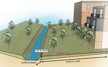
Top of bank - the break in slope between the creek bank and surrounding terrain. The top of bank represents the boundary where normal water flow takes place including the active channel, active floodplain, and their associated banks.
Tower (Broadcasting Tower) - any structure built for the sole or primary purpose of supporting any Federal Communication Commission (FCC)-licensed or authorized antennas and their associated facilities, including structures that are constructed for wireless communications services including, but not limited to, private, broadcast, and public safety services, as well as unlicensed wireless services and fixed wireless services such as microwave backhaul, and the associated site. Reference: section 29-27-402, Colorado Revised Statutes.
Tower, existing or pre-existing - a constructed tower or base station that was reviewed, approved and lawfully constructed in accordance with all requirements of applicable law as of the time of an eligible facilities request, if a tower that exists as a legal, non-conforming use and was lawfully constructed, is existing.
Tower, substantial change - a modification that substantially changes the physical dimensions of an eligible support structure if after the modification, the structure meets any of the following criteria:
A.
For towers other than alternative tower structures or towers in the right-of-way, it increases the height of the tower by more than ten percent or by the height of one additional antenna array, with separation from the nearest existing antenna not to exceed twenty feet, whichever is greater; for other eligible support structures, it increases the height of the structure by more than ten percent or more than ten feet, whichever is greater;
B.
For towers other than towers in the right-of-way, it involves adding an appurtenance to the body of the tower that would protrude from the tower more than twenty feet, or more than the width of the tower structure at the level of the appurtenance, whichever is greater; for eligible support structures, it involves adding an appurtenance to the body of the structure that would protrude from the side of the structure by more than six feet;
C.
For any eligible support structure, it involves installation of more than the standard number of new equipment cabinets for the technology involved, but not to exceed four cabinets; or for towers in the right-of-way and base stations, it involves installation of any new equipment cabinets on the ground if there are no pre-existing ground cabinets associated with the structure, or else involves installation of ground cabinets that are more than ten percent larger in height or overall volume than any other ground cabinets associated with the structure;
D.
For any eligible support structure, it entails any excavation or deployment outside the current site;
E.
For any eligible support structure, it would defeat the concealment elements of the eligible support structure. For purposes of this definition, any change that undermines concealment elements of an eligible support structure shall be interpreted as defeating the concealment elements of that structure; or
F.
For any eligible support structure, it does not comply with conditions associated with the siting approval of the construction or modification of the eligible support structure equipment, unless the non-compliance is due to an increase in height, increase in width, addition of cabinets, or new excavation that would not exceed the thresholds identified in subsections (1), (2), and (3) of this definition. For purposes of determining whether a substantial change exists, changes in height are measured from the original support structure in cases where deployments are or will be separated horizontally, such as on buildings' rooftops; in other circumstances, changes in height are measured from the dimensions of the tower or base station, inclusive of originally approved appurtenances and any modifications that were approved prior to February 22, 2012.
Transmission equipment - equipment that facilitates transmission for any Federal Communication Commission (FCC)-licensed or authorized wireless communication service, including, but not limited to, radio transceivers, antennas, coaxial or fiber-optic cable, and regular and backup power supply. The term includes equipment associated with wireless communications services including, but not limited to, private, broadcast, and public safety services, as well as unlicensed wireless services and fixed wireless services such as microwave backhaul.
U
Unstable - or potentially unstable slopes is a geologic hazard involving an area susceptible to a landslide, mud flow, a rockfall, or accelerated creep of slope-forming materials.
V
Vacation Plat - a map indicating a proposed vacation of a subdivision. A vacation plat does not vacate existing easements or deeded rights of way.
Variance - a legal modification or variation of provision of this code as applied to a specific parcel of land.
Vested Rights - the right to undertake and complete the development and use of property under the terms and conditions of an approved site-specific development plan.
W
Wall-mounted communication facility - a communication facility that is mounted and supported entirely on the wall of a legally existing building, including the walls of architectural features such as parapets, but does not include mechanical screens, chimneys, and similar appurtenances.
Work Goat - a goat brought onto property containing a CSA or crop production farm for the purpose of clearing weeds, hauling materials, or otherwise providing labor for the benefit of the CSA or crop production farm.
X
Xeric/xeriscape - a landscape that is adapted to the soils and climate of the local semi-arid region. Xeriscape landscapes may include plants that are native or not, but that help reduce water use and maintenance when they are properly planned.
Y
Yard (see setbacks) - the space on the same lot with a structure, unoccupied and unobstructed from the ground upward, except for vegetation.
Z
Zone District Map - the map adopted by ordinance by Manitou Springs that delineates the extent of each zoning district boundary and classification within the City, as established by the zoning code.
(Ord. No. 1123, § 1(Exh. A), 10-3-2023; Ord. No. 1925, § 10, 12-2-2025)