
Manitou Springs City Zoning Code
CHAPTER 18
03. - DEVELOPMENT STANDARDS
Sections:
18.03.1. - General Provisions.
18.03.1.1.
Purpose.
A.
This chapter includes standards for development that apply to all new development and redevelopment within the City of Manitou Springs. These standards have been established to promote the health, safety, and welfare of the present and future inhabitants of the community by addressing the relationship between adjacent properties, the transportation network, neighborhood character, and the natural environment.
B.
Development within all Zone Districts shall be designed to preserve open space and promote a layout that is sensitive to scale, identity and natural land features, including, but not limited to, preservation of natural landforms, view corridors, historic sites, wildlife corridors, community trails, multiple modes of transit, and neighborhood connectivity in accordance with the intent of the Manitou Springs Open Space Plan, the Historic District Design Guidelines, and the Comprehensive Plan.
18.03.1.2.
Organization.
A.
This chapter is organized into the following sections:
18.03.1 - General Provisions
18.03.2 - Commercial Site and Building Design Standards
18.03.3 - Residential Site and Building Standards
18.03.4 - Exterior Lighting
18.03.5 - Fencing and Retaining Walls
18.03.6 - Landscaping and Screening
18.03.7 - Alternative Energy and Green Infrastructure
18.03.8 - Mobility Requirements
18.03.9 - Streets, Trails, and Connectivity
18.03.10 - Development in Natural Hazard Areas
18.03.11 - Drainage Plans
18.03.12 - Signs
18.03.1.3.
Applicability.
A.
This chapter applies to all development of land within the municipal boundaries of the City.
B.
No building, structure, or land shall be occupied, built, used, erected, moved, or structurally altered unless in conformity with this Section.
C.
At no cost to the City, all new or expanded development shall connect to the Manitou Springs municipal water and wastewater systems, and the Colorado Springs Utilities gas and electrical systems.
D.
All public utility lines and private service lines shall be placed underground, including telephone and cable television. Distribution or private service lines not located within rights-of-way and in areas of thirty percent (30%) or greater slopes shall be bored.
E.
Any application under any zone shall comply with the provisions of Chapter 5.
F.
Development determined to be a contributing resource within a Historic District shall abide by the requirements of the Manitou Springs Historic District Design Guidelines.
(Ord. No. 1123, § 1(Exh. A), 10-3-2023)
18.03.2. - Commercial Site and Building Design Standards.
18.03.2.1.
Purpose.
A.
The purpose of this section is to ensure that all commercial development is designed in a manner that is consistent with the existing architectural aesthetic of the City.
18.03.2.2.
Applicability.
A.
The following standards shall apply to all new commercial and mixed-use developments and redevelopments, as well as any change of use to commercial or mixed-use, within the Downtown, Commercial and Mixed-Use Commercial Zone Districts within the City of Manitou Springs.
18.03.2.3.
Building Orientation.
A.
Buildings located at the intersection of two public streets shall not extend into the vehicular vision clearance area as defined in Section 18.02.1.4.
Figure 18.03.2.3-1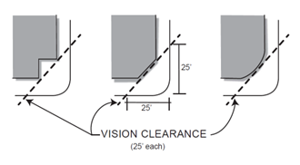
B.
Building entrances shall be identifiable and directly accessible either from public sidewalks or on-site pedestrian walkways. Drive aisles and other vehicular accesses shall not be considered pedestrian walkways.
C.
All buildings shall include thirty percent (30%) transparency by way of window glazing on the street facing, ground level.
18.03.2.4.
Building Height and Scale.
A.
Building height in the High Density Residential, Commercial, and Mixed-Use Zone Districts may vary based on location in relation to setbacks at the right-of-way based on the following:
1.
Buildings shall include a step back of a minimum of ten (10) feet for the portion of building that extends beyond twenty-eight (28) feet in height.
Figure 18.03.2.4-1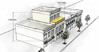
B.
Building façades over fifty (50) feet in length shall vary the front façade by a horizontal dimension of at least five (5) feet such that no more than sixty percent (60%) of the façade extends to the maximum extent of the setback.
Figure 18.03.2.4-2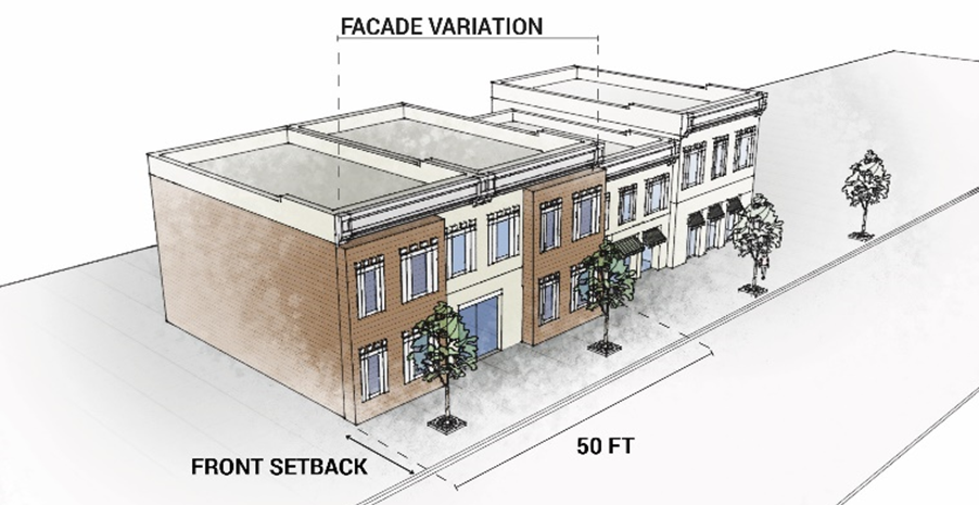
18.03.2.5.
Building Materials.
A.
Roof tops on all commercial or mixed-use buildings shall incorporate a cool roof for at least sixty-five percent (65%) of the total roof surface using roofing materials that have an aged Solar Roof Index (SRI) equal to the below:
1.
For a roof slope less than or equal to 2:12, the initial SRI shall be 82 and the aged SRI shall be 64.
2.
For a roof slope greater than 2:12, the initial SRI shall be 30 and the aged SRI shall be 32.
18.03.2.6.
Development Relative to Fountain Creek.
A.
Purpose. This section is intended to mitigate negative impacts of development on Fountain Creek, such as light pollution, trash and refuse, stormwater runoff, and erosion, while promoting an interface between the built environment and Fountain Creek that encourages pedestrian connections to and from the trail, preserves viewsheds of the creek from adjacent properties, and enhances the recreational experience along the trail.
B.
Design Standards. All properties along Fountain Creek that propose new development or redevelopment that would initiate a development plan application shall incorporate the following design features:
1.
All paved surfaces shall incorporate a curb and gutter, concrete drain pan, or low impact development technique, per Section 18.03.8.10, along the creek side of the development to direct stormwater away from the Creek.
2.
The rear yard setback shall be landscaped in native plant material to blend with the natural ecosystems of the creek.
3.
Trash and refuse containers shall be at least fifty percent (50%) screened from view of the Creek Walk Trail by way of fencing, enclosures, or landscaping to minimize visual impacts and to minimize the opportunity for loose refuse to pollute the creek.
18.03.2.7.
Site Amenities.
A.
All commercial and mixed-use buildings in the Commercial and Mixed-Use Commercial Zone Districts shall include a minimum of four percent (4%) of the site in outdoor amenity space which can include, but is not limited to, outdoor dining, outdoor seating (such as benches or seat walls), public art display, or similar amenities. Outdoor amenity space shall be entirely on the subject property and not in the public right-of-way. The following shall apply to outdoor amenity spaces:
1.
All accent areas, including patios, outdoor seating areas, and plazas shall be comprised of decorative paving (i.e., colored, stamped, or exposed aggregate concrete; pavers, or brick) to differentiate from the primary or public pedestrian sidewalks; and
2.
Fencing used to delineate outdoor seating or extended outdoor space of a building for the express use of that building, shall be a maximum of forty-two inches (42") tall and be comprised of durable materials that are complementary of the architecture.
(Ord. No. 1123, § 1(Exh. A), 10-3-2023)
18.03.3. - Residential Site and Building Design Standards.
A.
Townhome development is exempt from the minimum lot size and internal setback requirements but must meet the density and external setback requirements stated in Chapter 18.02 for the respective Zone District.
B.
Multi-household and commercial structures shall not exceed a height of twenty-eight (28) feet within twenty (20) feet of the side and rear property lines adjacent to an existing single-household unit.
Figure 18.03.3-1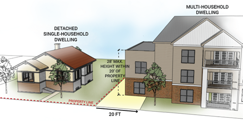
C.
There shall be no more than one principal dwelling unit on one lot in the Low Density Residential, General Residential, and Hillside Low Density Residential Zone Districts.
(Ord. No. 1123, § 1(Exh. A), 10-3-2023)
18.03.4. - Exterior Lighting.
18.03.4.1.
Purpose.
A.
The intent of these standards is to increase safety, reduce crime, minimize the negative impacts of adverse offsite impacts including light trespass and glare on surrounding uses, improve views of the night sky, reduce impact to wildlife habitat, and generally conserve energy.
18.03.4.2.
Applicability.
A.
All exterior lighting for any type of residential or nonresidential development shall comply with the standards of this Section, unless exempted in Section 18.03.4.3 below.
B.
All exterior lighting existing prior to the adoption of this Section shall be brought into compliance with this Section upon application of a Development Plan as required in Chapter 18.06.
18.03.4.3
Exemptions.
A.
This section does not apply to the following:
1.
Lighting within the public right-of-way that is used principally to illuminate roads. Such lighting is owned and maintained by Colorado Springs Utilities.
2.
Lighting of signs, as regulated by Section 18.03.12.
3.
Temporary lighting of construction sites.
4.
Holiday lighting, provided that individual lamps are less than seventy (70) lumens.
5.
Emergency lighting.
6.
Temporary lighting for theatrical, television, and performance areas, or for special events authorized by a Temporary Use Permit.
7.
Lighting required and regulated by the Federal Aviation Administration.
18.03.4.4
General Development Standards.
A.
The submission of an exterior lighting plan is required for any Development Plan application. The plan shall show the location of all exterior lighting, provide manufacturer's cut-sheets, provide a photometrics plan, and describe details such as level of illumination, hours of illumination, and the effects the illumination has on adjoining properties and roadways.
B.
All fixtures must be full cutoff. Existing bulbs being replaced with LEDs need to provide shielding to direct light downward and conceal the light source.
C.
Maximum on-site footcandles shall not exceed ten footcandles. In areas adjacent to buildings, said ten footcandle maximum shall include light spillage from within the building as well as light from signage.
D.
Light levels measured twenty feet beyond the site property line shall never exceed 0.1 footcandles as a direct result of the on-site lighting.
E.
The color-temperature rating of fixture lamps shall not exceed three thousand (3,000) kelvin in order to achieve dark sky compliance.
F.
All light fixtures shall employ automatic lighting controls that extinguish exterior lighting when sufficient daylight is available, such as timers, photo sensitive light controls, photoelectric lighting controller, a building automation system, or a lighting energy management system.
G.
No outdoor lighting may be used in any manner that interferes with the safe movement of motor vehicles on public thoroughfares.
H.
Maximum fixture height for all street lighting shall be eighteen (18) feet and for pedestrian lighting shall be fourteen (14) feet. Lights mounted on a building shall meet the maximum fixture height unless located on a rooftop terrace to illuminate useable pedestrian space or if required for safety by the Building Code.
I.
Lighting for outdoor recreational uses such as baseball diamonds, playing fields, tennis courts, and similar uses shall comply with the following standards:
1.
Maximum permitted light post height: Forty (40) feet.
2.
Maximum permitted illumination at the property line: Two (2) footcandles.
J.
Spacing of street and pedestrian lighting shall be determined at the time of the lighting plan by a lighting specialist based on the amount of light emitted by the fixture to meet the standards in this Section.
18.03.4.6
Lighting Standards for Residential Uses.
A.
Exterior lighting shall be downward directed and no brighter than a sixty-watt incandescent (or equivalent, compact fluorescent or LED rating).
B.
With motion sensors, lighting on dwelling units shall be no brighter than a seventy-five-watt incandescent (or equivalent, compact fluorescent or LED rating).
C.
Residential property uses shall employ proper control methods to minimize light pollution. Methods to control nuisance lighting include proper source, reduced wattage, light shielding fixtures, and proper height and distance of lighting mounts.
18.03.4.7
Prohibited Lighting.
A.
The following lighting types are prohibited from being installed in the City:
1.
Lighting that simulates, imitates, or conflicts with warning signals, emergency signals, or traffic signals.
2.
Blinking or flashing lights and exposed trip lights used to illuminate building façades or to outline buildings.
3.
Searchlights, laser lights, and aerial lasers or holograms.
4.
Lighting in which any single luminaire exceeds twenty thousand (20,000) lumens.
5.
Bare lamps (not housed within a fixture).
(Ord. No. 1123, § 1(Exh. A), 10-3-2023)
18.03.5 - Fencing and Retaining Walls.
18.03.5.1
Purpose.
A.
The purpose of this section is to ensure that all fences and retaining walls meet the City's height and design standards in order to protect the health and safety of the residents.
18.03.5.2
Applicability.
A.
The provisions herein shall apply to all new and infill development and redevelopment subject to a Development Plan application.
18.03.5.3
General Provisions.
A.
All fences and retaining walls must be constructed in a manner that complies with City drainage requirements and standards, and in compliance with any approved drainage plans on file with the City for the subject property.
B.
All fences shall have the finished side facing the public right-of-way, common open space, or other public areas, as applicable. Non-decorative elements such as fence posts and supporting structures, when visible on one side and not the other, shall face inward.
C.
All fencing and retaining walls shall be maintained in good condition, including, but not limited to, replacing or repairing broken components, such as pickets, and repainting.
18.03.5.4
Prohibited Fencing Materials.
A.
Chain-link fencing with or without slats, barbed wire, or other sharp-pointed fencing, materials that cause glare, and electrically charged fencing shall not be used as a material for external boundary fences in any zone district except as required for demonstrated unique security purposes.
18.03.5.5
Fencing and Retaining Wall Location.
A.
In no event shall a fence or retaining wall be located in or extend into any public right-of-way or obstructs reasonable access to utility, irrigation, or drainage equipment, structures, or facilities located within a dedicated easement or right-of-way, by persons who are entitled to gain access to such equipment, structures, or facilities.
18.03.5.6
Fencing Height and Design Standards.
A.
The height of a fence shall be measured from the top of the fence to the finished grade of the lot directly under the fence as such grade existed at the time the fence was constructed. A fence includes all elements, projections, and appendages of the structure. Any berm, wall, or similar feature that is constructed for the purpose of increasing the height of a fence shall be considered to be a part of the fence.
B.
Fences shall be:
1.
No more than six (6) feet high within any rear or side yard;
2.
No more than forty-two (42) inches high within the area constituting the front yard between the front building line and front property line;
Figure 18.03.5.6-1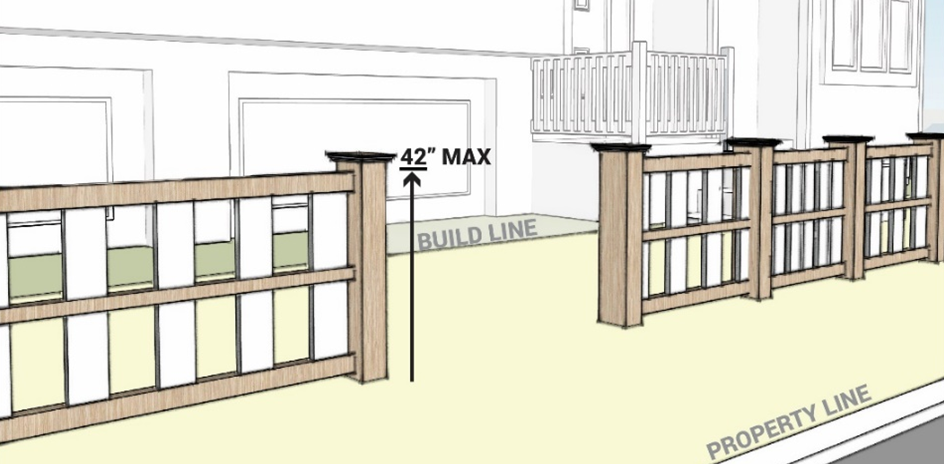
3.
No more than eight (8) feet high when utilized in association with an approved development plan to screen an outdoor storage area from public view that is located within any rear or side yard;
4.
No more than three (3) feet high within a vision clearance triangle as defined in Section 18.02.1.4.
Figure 18.03.5.6-2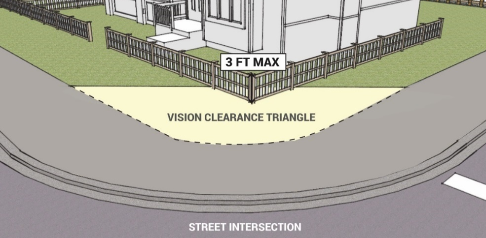
18.03.5.7
Retaining Wall Height and Design Standards.
A.
The height of a retaining wall shall be measured from the top of the wall to the finished grade of the lot at the base of the wall. Any berm, wall, or similar feature that is constructed for the purpose of increasing the height of a wall shall be considered to be a part of the wall.
B.
Retaining wall shall be:
1.
No more than ten (10) feet in height.
2.
Areas between retaining wall tiers shall be a minimum of four (4) feet in width and shall contain living vegetation.
C.
Where a retaining wall located adjacent to a pedestrian walkway such as a trail, parking area, or sidewalk, results in a downward vertical drop of more than thirty inches, a railing at least forty-two inches in height shall be placed along the top edge of the retaining wall to prevent pedestrians from falling over the edge of the retaining wall.
Figure 18.03.5.7-1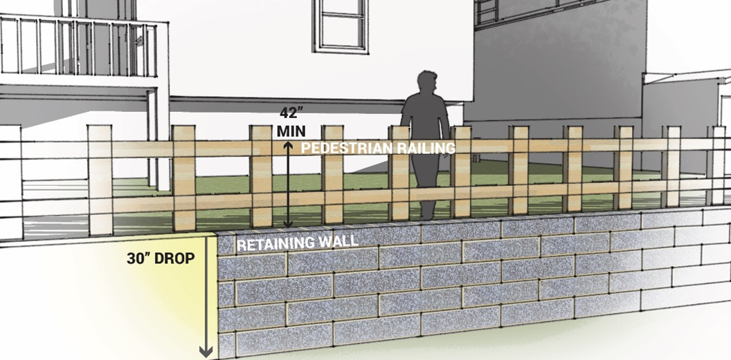
18.03.5.8
Prohibited Retaining Wall Materials.
A.
Retaining wall shall not be constructed of non-pressure treated wood, vinyl, plastic, or other materials that are not customarily sold for retaining walls.
(Ord. No. 1123, § 1(Exh. A), 10-3-2023)
18.03.6 - Landscaping and Screening.
18.03.6.1
Purpose.
A.
The purpose of this section is to establish minimum requirements for the design, installation and maintenance of landscapes that contribute ecologically and aesthetically to the City. Overall, the intent of this section is to achieve the following goals:
1.
Promote water efficiency;
2.
Reduce urban heat island effect;
3.
Preserve, protect and enhance natural features and ecosystems;
4.
Reduce and mitigate current and future natural hazard risk;
5.
Improve visual compatibility within and between developments and differing land uses; and
6.
Encourage innovative and sustainable approaches to landscape design.
18.03.6.2
Applicability.
A.
The provisions herein shall apply to all new and infill development subject to a development plan application.
18.03.6.3
General Landscape Standards.
A.
Where existing native plants are to be retained, drainage shall not be altered so as to be detrimental to the viability of the plants;
B.
All disturbed site areas shall be revegetated and slopes stabilized in conformance with requirements within this Section;
C.
Landscapes shall adhere to the following standard xeriscape design principles to facilitate water conservation:
1.
Improve the soil with organic matter;
2.
Group plants with similar water needs together;
3.
Use appropriate turf varieties to minimize the use of high water bluegrass; and
4.
Use bioswales, water quality ponds, and rain gardens to filter runoff from parking lots, streets, and other impervious surfaces.
D.
Plant material shall consist of native and regionally adapted species per the City of Manitou Springs Official Plant List with selection based on suitability to conditions of the site such as existing plant palette, soil conditions, wildlife habitat, microclimate, water requirements, and the surrounding environment.
E.
Alternatives to the City's preferred plant list may be considered on a case-by-case basis by the Planning Director upon the applicant demonstrating in writing that such alternatives are equally or more suitable to the conditions of the site ecology, habitat, microclimate, and the surrounding environment. Approved alternatives shall be documented on a landscape plan as part of a development plan application.
F.
The following noxious and invasive trees species are prohibited from being planted in Manitou Springs. Existing trees are exempt.
1.
Russian olive
2.
Siberian elm
3.
Tree of Heaven
4.
Ash, Fraxinus species
G.
All landscaped areas shall consist of one hundred percent (100%) ground coverage in living vegetation (trees, ground covers, perennials, wildflower mix, shrubs, ornamental grasses, bulbs, and grass mixes, or turf grass), organic mulch, or rock mulch per the following specifications:
1.
A perimeter zone with a minimum width of five (5) feet shall be protected around any permanent principal or accessory structure and remain free of organic mulch and living vegetation;
2.
At least seventy-five percent (75%) of each landscaped area shall be covered in living vegetation which may include trees, ground covers, perennials, wildflower mix, shrubs, ornamental grasses, bulbs, and grass mixes or turf grass; and
3.
The tree canopy shall not be counted in the seventy-five percent (75%) calculation of vegetative cover.
H.
Up to twenty percent (20%) of required trees may be substituted with shrubs or large ornamental grasses at a ratio of ten (10), shrubs or twenty (20) ornamental grasses per one (1) tree.
I.
Minimum planting sizes on all required landscaping shall be as follows:
1.
Deciduous Canopy Trees: two-inch (2") caliper
2.
Deciduous Ornamental Trees: one-and-one-half-inch (1.5") caliper
3.
Evergreen Trees: six-foot (6') tall
4.
Shrubs and Large Ornamental Grasses: five (5) gallon size
5.
Perennials and Small Ornamental Grasses: one (1) gallon size
J.
Landscaping shall be maintained at a height of no more than thirty-six (36) inches high when located in a vision clearance triangle as defined in Section 18.02.1.4.
K.
Trees shall not be located within five (5) feet of underground electric and cable lines, within six (6) feet of underground gas lines, and within ten (10) feet of underground water and sewer lines.
L.
All planting areas shall be mulched. Mulch shall be contained in the planting bed. Organic mulch shall not include a weed-control barrier under the mulch. Plastic is prohibited for use as a weed control barrier under inorganic mulch.
M.
All landscape areas shall be amended with organic compost.
N.
All plants shall conform to standards for measurements, grading, branching, quality, ball and burlapping as stated in the American Standard for Nursery Stock, (ANSI Z60.1) Edition, American Association of Nurserymen, Inc. (AAN-ASNS) and the Colorado Nursery Act (can).
O.
All irrigation systems shall consist of water efficient equipment.
P.
Guarantee of installation. Required landscape improvements shall be installed within one year of completion of site construction. If construction phased, landscape improvements associated with each phase shall be installed within one year of completion of the associated phase of construction.
Q.
Financial Surety. A financial surety shall be collected and held for the cost of materials and labor associated with the landscape and irrigation improvements if Certificates of Occupancy are sought before installation. The financial surety shall be released upon complete installation of such improvements.
R.
Maintenance. To provide for the ongoing health and appearance of landscape improvements, all landscaping and irrigation shall be maintained and replaced by the landowner or occupant as necessary. All property owners or occupants shall be responsible for maintenance of landscaping within the portion of the public right-of-way between the back of the curb or street pavement and the adjacent property unless the City has specifically agreed in a development agreement to take over maintenance.
18.03.6.4
Submittal Requirements for Landscape Plans.
A.
All Major Development Plan applications shall be accompanied by a landscape plan prepared by a Colorado-licensed Landscape Architect. Minor Development Plans shall be accompanied by a landscape plan but are not required to be prepared by a Colorado-licensed Landscape Architect. All landscape plans shall include the following:
1.
Landscape plan showing plant material sizes at maturity.
2.
Detailed plant list identifying common and botanical names of plant species, specified size of plant material, quantity, and water usage based on the water usage based on the following categories:
a.
High Water Use (requires >36" of precipitation per growing season)
b.
Medium Water Use (requires 23-36" of precipitation per growing season)
c.
Low Water Use (requires 18-23" of precipitation per growing season)
d.
Xeric Water Use (requires up to 18" of precipitation per growing season)
3.
Detail drawings illustrating planting specifications for each type of plant material proposed (trees, shrubs, ornamental grasses, perennials).
4.
Tree preservation table showing how the development application plans to meet the requirements of Section 18.03.6.6 as applicable.
5.
Location of all existing and proposed utilities.
6.
General installation and maintenance specifications.
B.
A preliminary landscape plan (without irrigation plan and/or landscape grading plan) must be prepared by a Colorado-licensed Landscape Architect and may be submitted as part of a development plan with the condition that a final landscape plan (with irrigation plan and/or landscape grading plan, if required) shall be submitted for staff review and approval prior to the issuance of a building permit.
C.
Alternative Compliance. The final decision making body may approve an alternative compliance request where a deviation from the landscaping standards is justified because of site or development conditions that make strict compliance with such standards impossible or impractical. The alternative compliance request shall indicate how the proposed deviations are justified by site or development conditions and illustrate how they will be mitigated by including one of the options from the Natural Resource Protection section of Table 18.03.7.5-1. Deviations may be justified due to the following:
1.
To preserve natural conditions such as watercourses, natural rock formations, or topography;
2.
The presence of easements that prevent landscaping;
3.
Other situations where strict compliance with the standards is deemed impractical as determined by the decision making body.
D.
An irrigation plan shall be required as part of the Final Landscape Plan. The irrigation plan shall be prepared by a Colorado-licensed Landscape Architect or Irrigation Professional and submitted and approved prior to the issuance of a building permit to include the following:
1.
Irrigation tap calculations;
2.
Layout of all irrigation equipment;
3.
Schedule of all irrigation equipment;
4.
Depiction of plant hydrozones which shall take into account plant water demand, slopes, and microclimates;
5.
Statement of water saving methodology; and
6.
General installation and maintenance specifications.
E.
If a separate grading plan is not required as part of the development plan application, then a landscape grading plan shall be required as part of the Final Landscape Plan and shall provide all information necessary to clearly indicate existing and proposed site conditions including, but not limited to:
1.
Existing and proposed contours at two-foot intervals,
2.
Top and toe of manufactured slopes,
3.
Retaining walls with top of wall elevations and finish grade on each side, and
4.
General intent of site drainage.
18.03.6.5
Vegetation Preservation Standards.
A.
Purpose and intent: Preserve and enhance the urban tree canopy.
B.
Applicability: All new and infill development and redevelopment.
1.
Any tree required by the provisions in Section 18.03.6 that fails to survive shall be replaced with the same species or a species with similar mature size in accordance with the planting specifications herein.
2.
All existing trees six-inch (6") caliper or larger proposed for removal on any new or infill development or redevelopment site shall be mitigated at the following rate:
3.
If it is determined by the Planning Director that the required trees replacement trees will not reasonably fit on the site without crowding out other required site or street trees, then the applicant shall work with the Parks and Recreation Department to dedicate trees to local parks or pay into the Parks and Recreation Trees Donations fund.
4.
Measures shall be taken to conserve on-site plants. Vegetation proposed for preservation with any new or infill development or redevelopment shall receive credit toward the required quantity of landscape material at the following rates:
18.03.6.6
Streetscape Landscape Standards.
A.
Purpose and intent: All streetscapes shall be tree lined and include a waterwise and balanced approach to design of plant material for year-round visual interest.
B.
Applicability: The following requirements shall apply to all commercial and multi-household development along collector and arterial streets as well as any single-household subdivisions with tree lawns along local streets in addition to the General Landscape Standards in Section 18.03.6.3.
C.
General design standards:
1.
A minimum of one deciduous street tree is required per forty (40) linear feet of street frontage.
2.
If frontage is less than forty (40) linear feet in length, at least one street tree shall be required and spaced equally between trees on adjacent parcels.
3.
Street trees shall be planted within the right-of-way. If there is not adequate space within the right-of-way, the trees shall be planted within ten (10) feet of the back of the sidewalk.
4.
Street trees shall be watered via automatic underground irrigation system with irrigation lines sleeved under sidewalks and pavement for ease of maintenance.
5.
Street trees shall be limbed up to maintain a minimum eight-foot (8') clearance above all sidewalks.
6.
Tree species planted under or within ten (10) feet of overhead powerlines shall have a mature height of no more than twenty-five (25) feet.
18.03.6.7
Commercial, Mixed-Use, and Multi-Household Development Landscape Standards.
A.
Purpose and intent: To ensure water conscious landscape improvements that are designed to enhance the overall appearance of the development and integrate the project with adjacent land uses and in the surrounding neighborhood.
B.
Applicability: All development in Zone Districts HDR, C, and MUC shall meet the following standards in addition to the General Landscape Standards in Section 18.03.6.3. Development in the Downtown Zone District are exempt from meeting these requirements.
C.
General design standards:
1.
No more than thirty percent (30%) of the total landscaped area shall be comprised of high water use plant material such as irrigated turfgrass.
2.
Landscaping is required around the perimeter of the building along façades that face public streets, transportation corridors, public open space, or Fountain Creek.
a.
A minimum of one (1) tree shall be provided for every forty linear feet (40') of building perimeter landscape area.
b.
A minimum of one (1) shrub or ornamental grass shall be provided for every ten (10) linear feet of building perimeter landscape area.
3.
Landscaping is required around the perimeter of the site, along all side and rear property lines at the following rates:
a.
Consistent with Buffer Type A, per Section 18.03.6.10, when adjacent to another commercial, mixed-use, or multi-household use; or
b.
Consistent with Buffer Type B, per Section 18.03.6.10, when adjacent to a single-household detached, duplex, or attached use.
c.
The area between any fencing and right-of-way shall be landscaped with a minimum of one (1) shrub or ornamental grass for every ten (10) linear feet of fencing.
18.03.6.8
Industrial Development Landscape Standards.
A.
Purpose and intent: To ensure landscape improvements are designed primarily at the public facing building entry to be consistent with commercial landscape standards and at the perimeter for purposes of screening industrial activities from the exterior of the property.
B.
Applicability: All development of industrial uses as listed in the Use Table in Section 18.04 shall meet the following standards.
C.
General design standards:
1.
Landscape areas shall include no more than thirty percent (30%) of the total landscaped area comprised of high water use plant material such as irrigated turfgrass.
2.
The perimeter of the property shall be landscaped with a Buffer Type C, per Section 18.03.6.10.
3.
The area between the primary building façade and the public right-of-way shall meet the commercial design standards detailed in Section 18.03.6.8 with all landscape areas including a minimum of seventy-five percent (75%) live cover.
4.
Parking lots shall be landscaped per Section 18.03.6.10.
18.03.6.9
Parking Lot Landscape Standards.
A.
Purpose and intent: Parking lot landscaping is intended to break up large expanses of pavement, create shade, buffer views of parking lots from adjacent streets and development, and enhance the overall appearance of the site.
B.
Applicability: All parking lots with ten (10) spaces or more shall be subject to the following requirements.
C.
General design standards.
1.
No more than thirty percent (30%) of the total landscaped area shall be comprised of high water use plant material such as irrigated turfgrass.
2.
Provide a minimum of one landscape island per ten (10) parking spaces with a minimum width of five (5) feet.
a.
Each island shall contain one (1) shade tree and seventy five percent (75%) live plant material cover.
Figure 18.03.6.8-1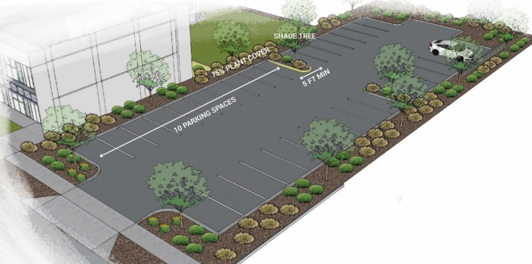
3.
Provide a minimum ten-foot (10') wide landscape area at the perimeter of surface parking lots.
a.
Provide a minimum of one (1) tree per forty (40) linear feet of required perimeter landscape area. If the parking lot perimeter is within ten (10) feet of the side or rear property line then the provisions of Subsection 18.03.6.7.C.3 shall prevail. Where the parking lot perimeter is adjacent to a right-of-way, the provisions of Section 18.03.6.6 shall prevail.
b.
Properties in the Downtown Zone District are exempt from this provision.
4.
Screen headlights from adjacent rights-of-way or residential properties with one of the following options:
a.
A hedge of shrubs and/or ornamental grasses with a minimum height of thirty (30) inches to screen seventy five percent (75%) of the parking lot perimeter;
b.
A berm with a minimum of thirty (30) inches height; or
c.
A wall or solid fence with a minimum height of three (3) feet paired with landscape material for at least fifty percent (50%) of the length of the wall placed on the street or adjacent property side of the wall.
Figure 18.03.6.8-2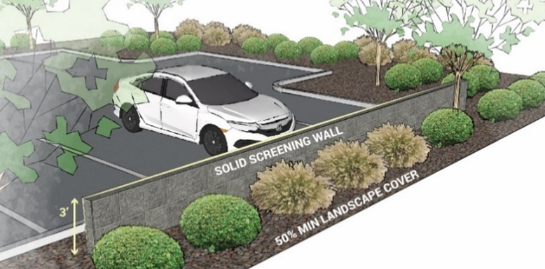
D.
Maintenance of all landscaping within and adjacent to parking lots shall be the responsibility of the landowner.
18.03.6.10
Screening and Buffering.
A.
Purpose and intent. Buffers and screening are intended to minimize conflicts between potentially incompatible, land uses and development on abutting property.
B.
Applicability. Buffers shall be installed between parcels of different use when a property with a more intense use is developed ore redeveloped adjacent to a property with a less intense use. For example, a commercial use shall include a buffer on any property line adjacent to a residential use.
C.
General design standards:
1.
All required buffers shall be located along the entire property line between the two uses and entirely on the developing property's side of the required buffer.
2.
Parking of vehicles and placement of buildings or structures, except for walls, fences, and landscaping, shall not be allowed in the required buffer.
3.
Under no circumstances shall a fence be the only screening material as a buffer between land uses.
4.
Buffer Type A shall be a minimum of ten (10) feet in width and consist of a mix of evergreen and deciduous trees, shrubs and ornamental grasses at the following rates per one hundred (100) linear feet of buffer:
a.
Two (2) trees with a minimum mature height of twenty (20) feet; and
b.
Ten (10) shrubs or large ornamental grasses with a minimum height of five (5) feet. If a six-foot (6') high privacy fence or wall is installed, the shrub and ornamental grass requirement can be reduced by fifty percent (50%).
Figure 18.03.6.9-1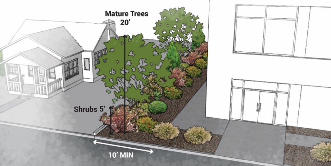
5.
Buffer Type B shall be a minimum of fifteen (15) feet in width and consist of a mix of evergreen and deciduous trees, shrubs and ornamental grasses at the following rates per one hundred (100) linear feet of buffer:
a.
Four (4) trees with a minimum mature height of twenty feet (20') with at least twenty percent (20%) being evergreen; and
b.
Twenty (20) large shrubs with a minimum mature height of five feet (5'), up to thirty percent (30%) can be large ornamental grasses with a minimum mature height of five feet (5'); and
c.
Ten (10) small shrubs or ornamental grasses with a minimum mature height of two feet (2').
d.
If a six-foot high privacy fence or wall is installed, the shrub and ornamental grass requirement can be reduced by fifty percent (50%).
Figure 18.03.6.9-2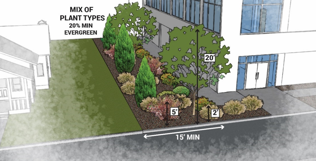
6.
Buffer Type C shall be a minimum of twenty feet (20') in width and consist of a six foot (6') tall solid fence or wall and a mix of evergreen and deciduous trees, shrubs, and ornamental grasses at the following rates per one hundred linear feet (100') of buffer:
a.
Three (3) trees with a minimum mature height of twenty feet (20') with at least thirty percent (30%) being evergreen; and
b.
Fifteen (15) large shrubs with a minimum mature height of five feet (5'), up to thirty percent (30%) can be large ornamental grasses with a minimum mature height of five feet (5'); and
c.
Ten (10) small shrubs or ornamental grasses with a minimum mature height of two feet (2').
Figure 18.03.6.9-3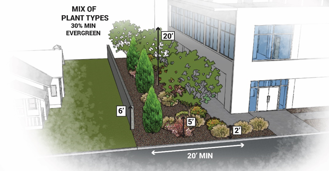
(Ord. No. 1123, § 1(Exh. A), 10-3-2023)
18.03.7 - Alternative Energy and Green Infrastructure.
18.03.7.1
Purpose.
A.
This Section is intended to encourage, support and promote alternative and renewable energy technologies, and to design renewable energy systems that minimize negative impacts to surrounding properties.
18.03.7.2
Applicability.
A.
The provisions herein shall apply to all new and infill development subject to a development plan application.
18.03.7.3
Electric Vehicle Charging Infrastructure.
A.
Charging levels. Electric vehicle charging stations have standardized indicators of electrical force, or voltage, at which an electric vehicle's battery is recharged. There are three common charging levels according to the following specifications:
B.
New construction of detached and attached single-household dwellings with garages and multi-household dwellings with garages shall provide a 240-volt / 40-amp outlet on a dedicated circuit and within five (5) feet of the designated vehicle parking space to accommodate the potential future hardwire installation of a Level-2 electric vehicle charging station for each vehicular parking space.
C.
New parking surface areas of multi-household dwellings and non-residential development shall provide the electrical capacity necessary to accommodate the future hardwire installation of universal Level-2 electric vehicle charging stations at a rate of one (1) charging space for every ten (10) required on-site parking spaces. Parking lots with less than ten (10) spaces are exempt from this requirement.
18.03.7.4
Solar Infrastructure.
A.
It is the City's intent to encourage the use of both active and passive solar energy systems in homes and businesses.
B.
New construction of detached and attached single-household dwellings, multi-household dwellings, and nonresidential buildings shall provide the following infrastructure for future installation of solar energy systems:
1.
Reserve a three-foot by three-foot (3'x3') space for installation of an inverter. Three feet (3') of clearance must be maintained in front of the space for access;
2.
Ensure electric panel has 20% excess capacity for solar back feed.
18.03.7.5
Sustainable Site Improvement Standards and Incentives.
A.
All new residential and non-residential development is required to achieve a minimum of five (5) points from the menu below. Review and approval shall be by way of a Minor or Major Development Plan per Section 18.06.4.12 and 18.06.4.13.
B.
For every five (5) points earned above the required number of points per 18.03.7.5.A., the outdoor amenity space required by Section 18.03.2.7 may be reduced by half with the exception of trails and trail connections that shall not be reduced.
C.
All sustainable site improvements installed to meet the points requirements or installed to receive incentives per Subsection 18.03.7.5.B above, shall be maintained in perpetuity or replaced with a menu item with the same number of points or more points.
D.
All utilized incentives shall be noted on the development plan.
(Ord. No. 1123, § 1(Exh. A), 10-3-2023)
18.03.8 - Mobility Requirements.
18.03.8.1
Purpose.
A.
The purpose of this subsection is to ensure adequate accommodation and functional access and promote flexibility for varying modes of transit in proportion to the generalized demand of different land uses, and to manage parking and congestion in a manner that minimizes impacts on circulation and access.
18.03.8.2
Applicability.
A.
New Development.
1.
All new development shall provide off-street parking and loading areas in accordance with this section.
2.
Minimum parking requirements for (a) new multifamily residential development, (b) adaptive reuse projects of an existing building for completely residential purposes, and (c) adaptive reuse of an existing building for a mix of users where at least fifty percent of the resulting use is residential, do not apply to the areas shown on the Transit Service Area map that is prepared by the Colorado Department of Local Affairs.
3.
The City may require more than one parking space per unit for multifamily residential developments with twenty or more units within the Transit Service Area, if supported by findings and substantial evidence showing that not enforcing said requirement will have a substantial negative impact that cannot be mitigated by other strategies, as outlined in House Bill 24-1304.
B.
Existing Development.
1.
Pre-existing parking configurations and number of spaces are exempt from this section.
2.
Change in Use. Any change in use of existing development shall be accompanied by provision of additional off-street parking as required by the standards of this section for the proposed new use.
3.
Expansion. If an existing structure or use is expanded or enlarged in terms of the number of dwelling units, floor area, number of employees, or seating capacity, any additional required off-street parking and loading spaces required by this section applies only to the expanded or enlarged portion of the structure or use.
18.03.8.3
Minimum Parking Requirements.
A.
Purpose. The purpose of this subsection is to provide baseline minimum ratios for on-site parking to accommodate traffic generated by the range of uses which might locate at the site over time.
B.
Minimum Number of Required Off-Street Parking Spaces. The minimum ratio of off-street parking spaces to be provided for a use is listed in Table 18.03.8.3-1.
1.
All parking ratios are based upon the gross floor area (GFA) contained within the building, unless otherwise stated.
2.
When the computation of the required off-street parking spaces results in a fraction, the requirement is rounded up to the nearest whole interval. Fractions less than one-half are rounded to the next lowest whole number.
3.
Off-street parking provided in a residential area in lieu of garage or carport shall have all-weather surfacing such as concrete, asphalt, compacted gravel, permeable pavers, or other similar materials as approved by the Planning Director.
4.
Not more than twenty-five percent required parking is allowed as compact spaces.
C.
Administrative Adjustments for Existing Uses. For any change of use occurring within existing structures, if the minimum number of required off-street parking spaces cannot be placed on the site in accordance with these regulations without the demolition of a permanent existing structure or damage of significant natural features or vegetation on the site or in the public right-of-way and if written documentation demonstrates that fewer spaces than required are needed because of the nature of the business, hours of operations, or availability of adjacent parking, the Planning Director, may authorize up to ten percent reduction in the total number of parking spaces required on the site.
D.
Uses Not Listed. The required off-street parking spaces for a use not specifically listed in Table 18.03.8.3-1 shall be determined by the Planning Director based upon the requirements of other similar listed uses.
18.03.8.4
Maximum Parking.
A.
Maximum Number of Required Off-Street Parking Spaces. No use shall provide more than one hundred twenty-five percent of the minimum number of parking required, unless the parking area above one hundred twenty five percent is provided in conjunction with any one of the following techniques.
1.
Pervious concrete or grass over supporting plastic or concrete grids;
2.
Underground parking facility;
3.
Solar canopy; or,
4.
Structured parking.
18.03.8.5
Adjustments to Parking Requirements.
A.
Alternative Parking Plan. Applicants requesting reduced or alternative parking must submit an Alternative Parking Plan. Reductions requested outside of the exemptions listed in subsection B below shall pay a fee in lieu to the Mobility & Parking Fund to offset the cost of each requested parking space that is reduced. The Alternative Parking Plan shall be included with the submitted development permit application and include the following:
1.
Evidence of similar uses in similar contexts or other industry standard indicating a lesser number will equally or better meet the intent of this Chapter due any of the following:
a.
The format of the use;
b.
The likelihood that patrons or tenants have reduced car ownership or drive less;
c.
The availability and practicality of walking, bicycling or transit access supporting the use; or
d.
Other transportation demand management plans proposed by the applicant.
B.
Alternative Parking Plan Programs. The following programs are established to mitigate impacts related to surface parking and incentivize practices that implement the goals and objectives of the Comprehensive Plan to promote sustainability, affordability, multimodality, and protection of resources. Programs used shall be included as part of an Alternative Parking Plan. Where parking is required, adjustments permitted by this subsection will be calculated from the minimum number of parking spaces required by land use.
1.
Exceptions to Minimum Parking. The following provisions promote housing attainability, protect historical resources, and encourage sustainable development and longevity of existing building stock within Manitou Springs.
a.
Affordable Housing Exception. The minimum number of required parking spaces may be reduced by twenty-five percent for residential units allocated as permanent affordable housing within a quarter mile of a transit stop. The applicant must demonstrate, either through deed restriction, covenant, or other means of legal documentation deemed acceptable by the City Attorney, that residential units that are sold or rented at a price that is affordable as determined by HUD to a household earning one hundred percent of Area Median Income (AMI) or less as determined by HUD.
b.
Historical Sites Exception. The minimum number of required parking spaces may be reduced to zero on sites listed on the National Register or within a Historic District. Lodging and residential uses shall meet the minimum number of required off-street parking spaces per Table 18.03.8.3-1 above.
c.
Downtown Zone District. Commercial uses within the Downtown Zone District are not subject to the Minimum Number of Required Off-Street Parking Spaces. Lodging and residential uses shall meet the Minimum Number of Required Off-Street Parking Spaces per Table 18.03.8.3-1 above.
2.
Alternative Transportation Options. The following provisions promote the reduction of vehicle miles traveled (VMT). An applicant may reduce the minimum number of required parking spaces by five percent for each of the following programs when the following criteria are met. The approved reduction shall be noted on the Development Plan.
a.
Expanded Bicycle Facilities.
i.
Bicycle Racks shall be provided within a secure area such as a bicycle rack room or locker facility.
b.
Proximity to Transit Hub, High-Frequency Transit Station, or Free or Paid Parking Lot.
i.
The use is non-residential.
ii.
The property has frontage along a high-frequency transit route, as designated in the Comprehensive Plan.
iii.
The property is located within six hundred sixty feet of an improved transit stop providing both shade and seating, or public paid parking lot.
iv.
A direct pedestrian pathway is provided from the Transit Hub, Transit Station, or Parking Lot to the building's main entrance.
c.
Proximity to Trails and Bicycle Facilities.
i.
The property has frontage or direct pedestrian access to a Trail or an existing or planned Bicycle Facility, as designated in the Comprehensive Plan.
d.
Tree Preservation. Minimum parking is reduced by one parking space for each tree twelve inches in diameter at breast height (DBH) preserved, up to a maximum of two parking spaces, or five percent of the total required, whichever is greater.
18.03.8.6
Shared Parking.
A.
Shared Parking. Shared use of required nonresidential parking spaces may occur where two or more uses on the same or separate sites are able to share the same parking spaces because their parking demands occur at different times. Shared use of required nonresidential parking spaces is allowed if the following documentation is submitted in writing with the plan application:
1.
Names and addresses of the property owners that are engaging in a shared parking agreement.
2.
A study performed demonstrating a breakdown of uses, comparing the peak times of weekday night, day, evening, and weekend day and evening hours.
3.
A map of shared parking areas along with number of parking spaces to be shared.
4.
A legal instrument such as an easement or deed restriction that guarantees access to the parking for both uses.
18.03.8.7
Bicycle Parking Requirements.
A.
The following bicycle parking requirements applies to all Commercial and Mixed-Use Zone Districts.
B.
Bicycle parking is required for all principal uses as outlined in Table 18.03.8.2-2.
18.03.8.8
Parking Area Design Standards.
A.
The following dimensional and design standards apply to all parking areas.
B.
Parking Space Dimensions. Table 18.03.8.3-1 and Table 189.03.8.3-2 establish dimensional standards for parking spaces.
Figure 18.03.8.8-1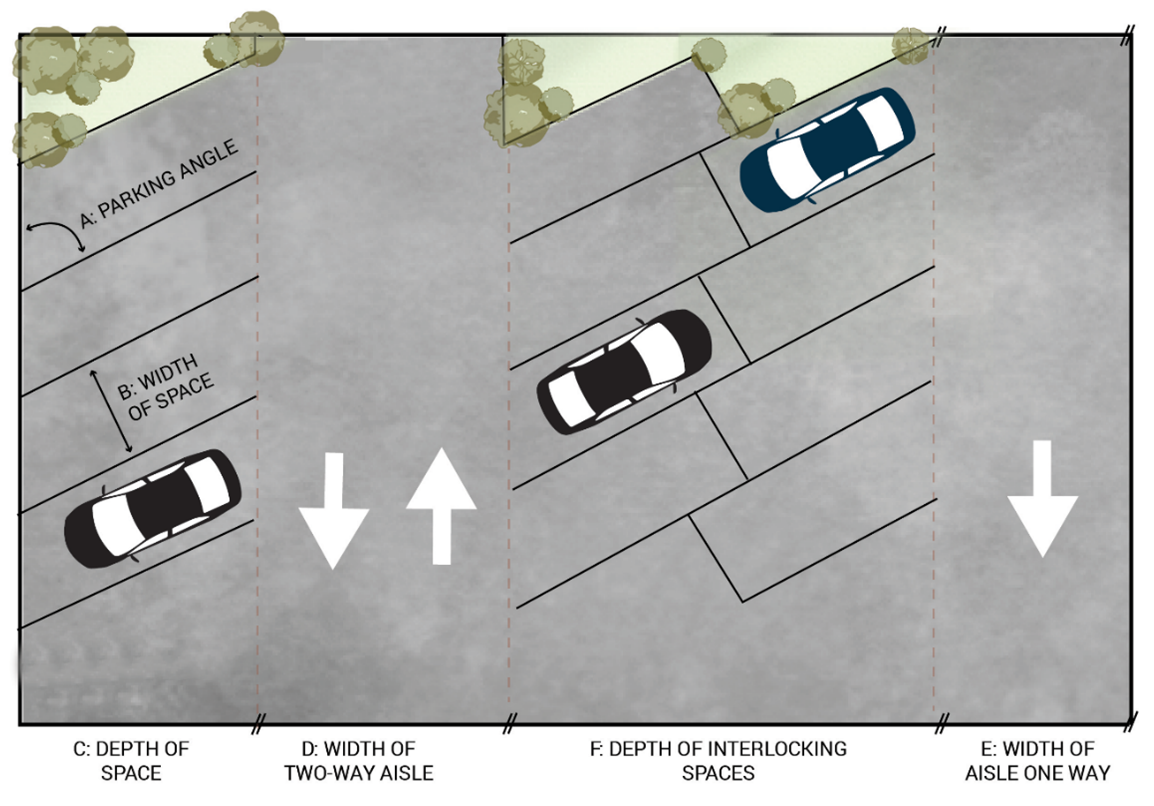
C.
All parking areas shall have all-weather surfacing such as concrete, asphalt, compacted gravel, permeable pavers, or other similar materials as approved by the Planning Director.
D.
ADA accessible spaces shall maintain a direct and clear path to the building that is surfaced to meet ADA requirements.
E.
All parking lot landscaping shall be in conformance with Section 18.03.6.8.
18.03.8.9
Drive Through Facilities.
A.
Stacking Lanes. Vehicle stacking lanes for drive-through uses shall be provided as described below:
1.
Automobile wash, thirty feet behind each bay or stall;
2.
Financial institutions and/or financial transaction facilities (i.e., bill payment windows), thirty feet behind each window or transfer facility;
3.
Restaurants, sixty feet behind a single order and pick-up window. The required sixty-foot distance may be divided between the order and pick-up lanes;
B.
The minimum width of a drive-through lane shall be ten feet;
C.
Required drive-through stacking lanes shall not intersect with pedestrian access to a public entrance of a building; and
D.
Each drive-through lane shall be striped, marked or otherwise delineated.
18.03.8.10
Low-Impact Development (LID) Requirements.
A.
All parking areas that exceed the maximum number of parking spaces required per Section 18.03.8.4, shall incorporate low impact development (LID) techniques, such as bioswales, vegetative filter strips, and rain gardens, to maximize on site infiltration of stormwater for the area in which there are excess spaces. Each LID technique shall be sized and drained to comply with Title 14 of the Municipal Code approved by the Planning Director. Structured parking shall be exempt from this requirement.
1.
Bioswales. Bioswales are vegetated swales planted with a variety of plant species that can tolerate occasional water inundation and serve to transport, store, and allow infiltration of water.
Figure 18.03.8.9-1: Illustration of Bioswale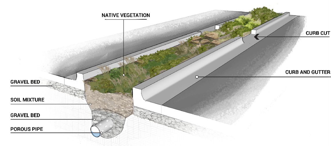
2.
Grassed swales: Grassed swales are designed to convey water over the surface of the ground to a point of disposal and serve to slow the flow of water allowing some particulates to drop out before the water reaches the disposal point.
Figure 18.03.8.9-2: Illustration of Grassed Swale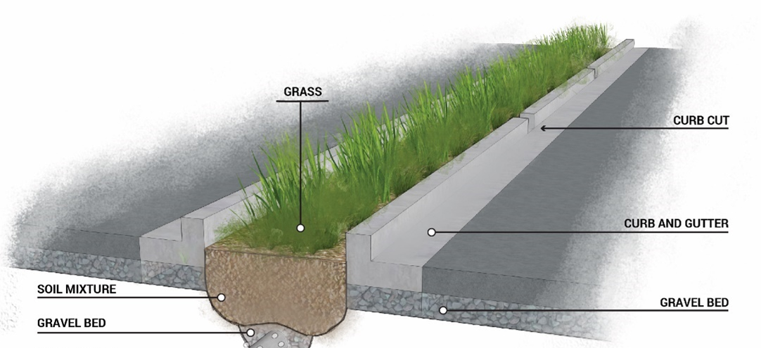
3.
Rain Gardens. Rain gardens are small shallow, depressions planted with a variety of native or ornamental plants that can treat small amounts of runoff to improve water quality.
Figure 18.03.8.9-3: Illustration of Rain Garden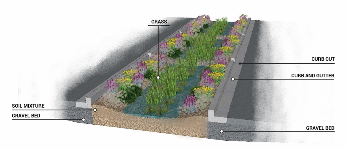
18.03.8.11
ADA-Accessibility Requirements.
A.
Accessible vehicle parking spaces shall be provided in accordance with the applicable building codes and the Americans with Disabilities Act (ADA) standards and guidelines for quantity, design, and location.
(Ord. No. 1123, § 1(Exh. A), 10-3-2023; Ord. No. 1925, § 4, 12-2-2025)
18.03.9 - Streets, Trails, and Connectivity.
18.03.9.1
Purpose.
A.
The purpose of this subsection is to implement the Transportation & Mobility goals and policies of Comprehensive Plan to support an efficient, well-connected multi-modal transportation system that facilitates the movement of cars, transit vehicles, bicycles, pedestrians, goods, and people within Manitou Springs, as well as between Manitou Springs and the surrounding Pikes Peak region.
18.03.9.2
Applicability.
A.
The following standards apply to all public rights-of-way, including streets and trails within the City of Manitou Springs.
B.
All new access (streets and driveways), shall be paved and in accordance with City of Manitou Springs Public Works Standards as amended.
18.03.9.3
Access and Circulation.
A.
Each lot shall be provided with means of physical access to a public or private street or access easement to accommodate ingress and egress for emergency vehicles and others requiring access to the property for its intended use. Access conditions to the lot shall be in accordance with Title 12 and fire department standards.
B.
Vehicular access and circulation shall be provided as follows:
1.
A minimum of two vehicular access points shall be provided to and from the public for all new major subdivisions, or multi-household development that meet the following:
a.
On a site greater than five acres; or
b.
Includes any street frontage greater than three hundred feet in length; or
c.
A combination of items a and b.
C.
For all new subdivisions, the following shall apply:
1.
Public and Private rights-of-way shall be in accordance with Titles 12 & 15 of the Manitou Springs Municipal Code for driveway or service road, including width, angle of approach, grade, pavement, and turnaround; and
2.
Access to accommodate police, fire, and other emergency and/or public services.
18.03.9.4
Names.
A.
The names of streets shall not duplicate, phonetically or alphabetically, any existing street names. Names and numbers shall be approved by the planning department. Any street which is a continuation of an existing street or approximates a continuation shall bear the name of the existing street.
B.
Street names shall be designated as follows:
1.
Boulevard or parkway shall be reserved for roads designated on any major thoroughfare plan having a median divider of sufficient size to allow for landscaping.
2.
Avenue or road shall be reserved for streets of substantial continuity such as major residential streets.
3.
Streets, drives, or lanes shall be reserved for streets of less continuity such as minor residential streets or hillside streets.
4.
Court, place, circle, way, or terrace shall be reserved for streets with no continuity such as public streets that cul-de-sac.
C.
Address Assignment:
1.
Enumeration within the limits of Manitou Springs shall be governed and approved by the Planning Director. Initial numeric address assignment shall be subject to the approval of a subdivision plat. Changes in enumeration may be requested and approved by the Planning Director. The Planning Director shall notify the El Paso County Assessor, the United States Postal Service, the PPRBD's Enumerations Division, Colorado Springs Utilities, and El Paso-Teller County 911 Authority, and other applicable agencies, of an address change.
18.03.9.5
Design of Streets Generally.
A.
Street design standards as indicated in the Roadway Functional Classification Map in the Map Atlas of the comprehensive plan shall be used as guidelines for the planning and construction of multi-modal transportation facilities by setting minimum widths for travel lanes, bike lanes, and sidewalks. Variations in the facilities are intended to guide the planning and design of improvements to existing and new roads to meet the needs of the specific roadway and limitation on rights-of-way due to site specific constraints. Refer to the Roadway Functional Classification map in the Map Atlas of the comprehensive plan for the locations of these street types within the City.
B.
Streets in any subdivision shall connect with those already dedicated in adjoining subdivisions. When adjoining land has not been platted, provisions shall be made to continue the street pattern in the future by the provision of stub streets.
C.
Natural features to be preserved. In the layout of streets and blocks, natural features such as drainage ways, rock formations, soil, vegetation, and topography shall be preserved as much as possible. Cuts and fills shall be minimized and revegetated or treated to prevent erosion according to an acceptable erosion control plan. Grading also shall be reduced as much as possible.
D.
Cul-de-sacs shall not exceed five hundred (500) feet in length and shall be designed with a turn-around of at least one hundred (100) feet in diameter of the right-of-way or by providing a loop street with a minimum centerline radius of sixty (60) feet.
E.
Centerline offsets of intersecting streets shall be avoided, but where necessary they shall not be less than one hundred (100) feet between the centerline of the intersections.
F.
Half streets, where developer only develops half of the street section, are prohibited.
Figure 18.03.9.5-1: Illustration of Half Streets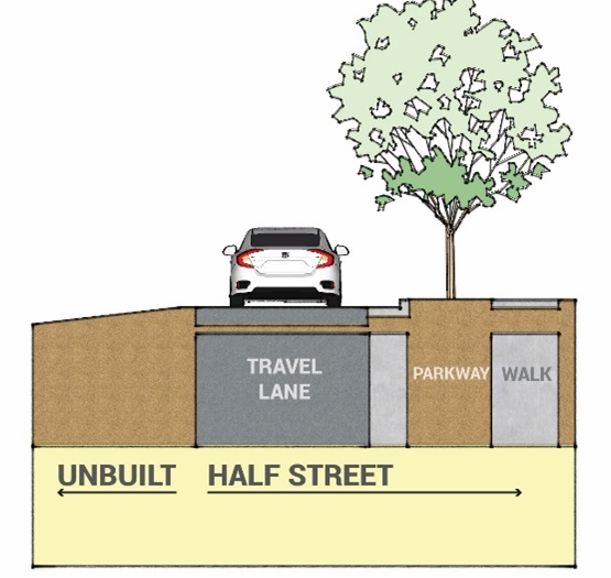
G.
Streets shall be laid out so as to intersect at right angles with allowance for up to ten (10) degrees of variation. More than four approaches to any intersection shall be prohibited.
H.
All street and alley surfaces shall be constructed of all-weather surfacing such as concrete, asphalt, permeable pavers, or other similar materials as approved by the Planning Director.
18.03.9.6
Manitou Avenue Street Design.
A.
Purpose: The purpose of this Section is to highlight the existing dimensional standards and characteristics of Manitou Avenue.
B.
Right-of-Way Width. Sixty-five (65) to Eighty (80) feet.
C.
Number of Moving Lanes. Two lanes.
D.
Access Conditions.
1.
Intersections will generally be at grade.
2.
Intersections and curb cuts shall be limited to as few points as possible.
E.
Traffic Characteristics.
1.
Regulation of traffic shall be accomplished by traffic control devices and channelization.
2.
On-street parking shall be permitted.
3.
Eight-inch vertical curbs required with detached sidewalks.
4.
Medians may be raised or painted.
F.
Design Characteristics.
1.
Grades. Not less than five-tenths of one percent; not more than six percent.
2.
Sight Distance.
a.
Horizontal: four hundred (400) feet minimum.
b.
Vertical: minimum length equivalent to twenty times the algebraic difference in the rate of grade.
3.
Frequency of Intersections. Intersections along Arterial Streets shall be strictly limited.
18.03.9.7
Collector Street Design.
A.
Generally.
1.
Purpose. Collector streets are designed to serve the local needs of the neighborhood and to provide direct access to abutting properties. All traffic carried by collector streets should have an origin or a destination within the neighborhood.
2.
Planning Characteristics.
a.
Collector Streets should be designed to discourage through neighborhood traffic.
b.
Curvilinear and loop streets are desirable.
c.
Sidewalks will be attached to an eight-inch vertical curb.
3.
Design Characteristics.
a.
Grade. Not less than five-tenths of one percent; not more than ten percent.
b.
Site Distance.
i.
Horizontal: one hundred (100) feet.
ii.
Vertical: a minimum length equivalent to ten times the algebraic difference in the rate of grade.
B.
Cross Section Variations for Collector Streets.
1.
Downtown-Parking on Both Sides.
i.
Right-of-Way Width. Fifty (50) feet.
ii.
Multi-modal Facility Characteristics.
i.
Two (2) eleven-foot-wide vehicular travel lanes.
ii.
One (1) eleven-foot-wide center turn lane and loading zone.
iii.
Two and a half feet wide curb and gutter on both sides of street.
iv.
Six-foot wide on-street parking lane allowed on both sides of the street to be used in conjunction with the curb width.
v.
Pedestrian walkway to be provided in addition to fifty-foot right-of-way. Six-foot sidewalks to be provided where appropriate.
Figure 18.03.9.7-1: Downtown Parking on Both Sides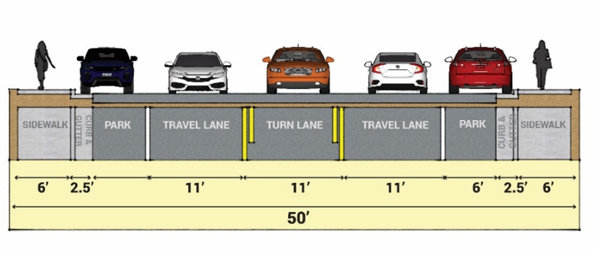
2.
With Sidewalks on Both Sides
i.
Right-of-Way Width. Forty-five (45) feet.
ii.
Multi-modal Facility Characteristics.
i.
Two (2) ten-foot-wide travel lanes.
ii.
Two and a half feet wide curb and gutter on both sides of the street.
iii.
Five-foot wide on-street parking lane allowed on one side of the street to be used in conjunction with the curb width.
iv.
Six-foot wide pedestrian walkway on both sides of the street and setback one (1) foot from the property line.
Figure 18.03.9.7-2: With Sidewalks on Both Sides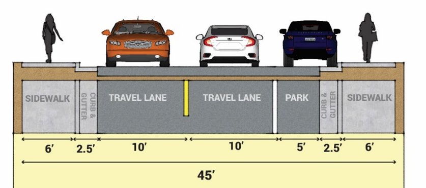
3.
Bike Lane on Uphill Side and No Parking.
i.
Right-of-Way Width. Forty-three (43) feet.
ii.
Multi-modal Facility Characteristics.
i.
Two (2) ten-foot-wide travel lanes.
ii.
Two and a half feet wide curb and gutter on both sides of the street.
iii.
One (1) four-foot-wide bicycle lane to be provided in conjunction with curb width on uphill travel side of the street.
iv.
Six-foot wide pedestrian walkway on both sides of the street and setback one (1) foot from the property line.
Figure 18.03.9.7-3: Bike Lane on Uphill Side and No Parking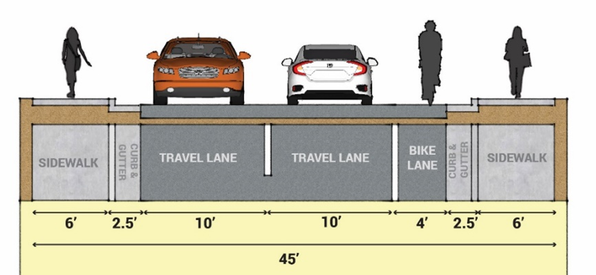
4.
With Parking on One Side.
i.
Right-of-Way Width. Thirty-eight (38) feet.
ii.
Multi-modal Facility Characteristics.
i.
Two (2) ten-foot-wide travel lanes.
ii.
Two-and-a-half-foot wide curb and gutter on both sides of the street.
iii.
Five-foot wide on-street parking lane is allowed on one side of the street to be used in conjunction with the curb width.
iv.
One six-foot wide pedestrian walkway on one side of the street and setback one foot from the property line.
Figure 18.03.9.7-4: With Parking on One Side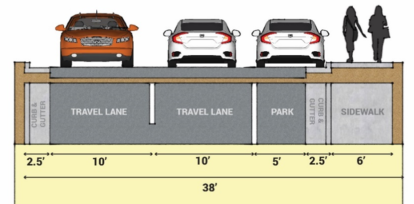
5.
Bike Lane on Uphill Side, No Parking, and Sidewalk on One Side.
i.
Right-of-Way Width. Thirty-seven (37) feet.
ii.
Multi-modal Facility Characteristics.
i.
Two (2) ten-foot-wide travel lanes.
ii.
Two-and-a-half-foot wide curb and gutter on both sides of the street.
iii.
Four-foot-wide bicycle lane to be provided in conjunction with curb width on uphill travel side of the street.
iv.
One six-foot wide pedestrian walkway to be provided on uphill travel side of the street and setback one foot from the property line.
Figure 18.03.9.7-5: Bike Lane on Uphill Side, No Parking, and Sidewalk on One Side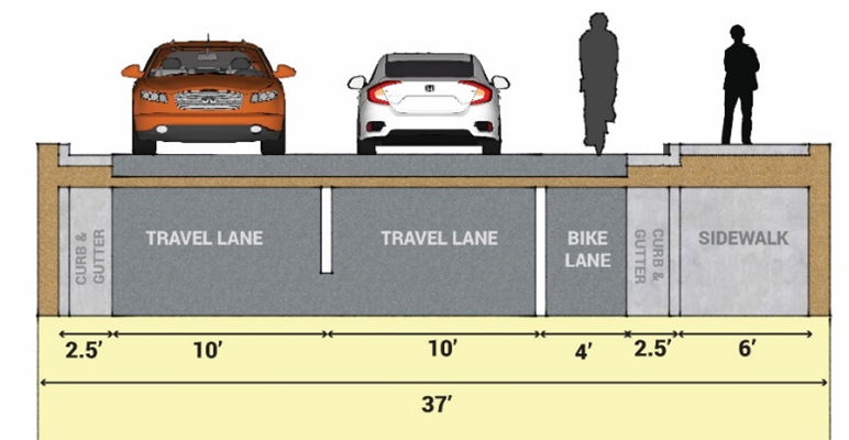
6.
No Bike Lane and No Parking.
i.
Right-of-Way Width. Thirty-seven (37) feet.
ii.
Multi-modal Facility Characteristics.
i.
Two (2) ten-foot-wide travel lanes.
ii.
Two-and-a-half-foot wide curb and gutter on both sides of the street.
iii.
Six-foot wide pedestrian walkway to be provided on both sides of the street and setback one foot from the property line.
Figure 18.03.9.7-6: No Bike Lane and No Parking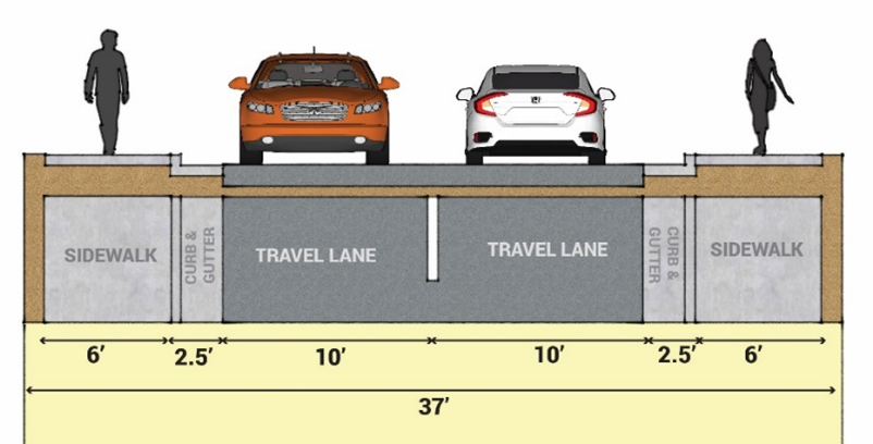
7.
No Bike Lane, No Parking, and Sidewalk on One Side.
i.
Right-of-Way Width. Thirty-three (37) feet.
ii.
Multi-modal Facility Characteristics.
i.
Two (2) ten-foot-wide travel lanes.
ii.
Two-and-a-half-foot wide curb and gutter on both sides of the street.
iii.
One (1) six-foot wide pedestrian walkway to be provided on one side of the street and setback one (1) foot from the property line.
Figure 18.03.9.7-7: No Bike Lane, No Parking, and Sidewalk on One Side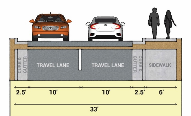
18.03.9.8
Local Streets.
A.
Generally.
8.
Purpose. Local streets are designed to serve the local needs of the neighborhood and to provide direct access to abutting properties. All traffic carried by collector streets should have an origin or a destination within the neighborhood.
9.
Planning Characteristics.
i.
Local Streets should be designed to discourage through neighborhood traffic.
ii.
Curvilinear and loop streets are desirable.
iii.
In subdivision design, local streets will not intersect with arterial streets.
iv.
Sidewalks will be attached to a six-inch vertical curb.
10.
Design Characteristics.
i.
Grade. Not less than five-tenths of one percent; not more than ten percent.
ii.
Site Distance.
i.
Horizontal: one hundred (100) feet.
ii.
Vertical: a minimum length equivalent to ten times the algebraic difference in the rate of grade.
11.
Frequency of intersections. Intersections along collector streets shall be limited to as few points as possible.
12.
Access Conditions. Indirect access to properties is by way of side streets where possible to allow for on-street parking, where applicable. Direct access to residential properties is by way of curb cuts or drive over (ramp type) curbs.
C.
Cross Section Variations for Local Streets.
1.
No Curb/Gutter and Sidewalk on One Side.
i.
Right-of-Way Width. Forty-three (43) feet.
ii.
Multi-modal Facility Characteristics.
i.
Twenty-two foot wide two-directional travel lane.
ii.
Eight-foot-wide swale on either side of the travel lane.
iii.
Five-foot wide pedestrian walkway.
Figure 18.03.9.8-1: No Curb/Gutter and Sidewalk on One Side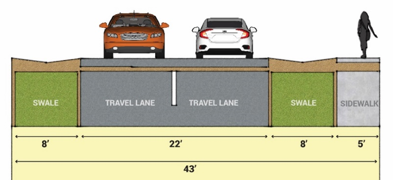
2.
With Parking on One Side and Sidewalk on Two Sides (Two-way Traffic).
i.
Right-of-Way Width. Thirty-seven (37) feet.
ii.
Multi-modal Facility Characteristics.
i.
Sixteen-foot wide two-directional travel lane.
ii.
Two-and-a-half-foot wide curb and gutter on both sides of the street.
iii.
Five-foot wide on-street parking lane to be provided in conjunction with curb and gutter on one side of street.
iv.
Five-foot wide pedestrian walkway to be provided on both sides of the street and setback one foot from the property line.
Figure 18.03.9.8-2: With Parking on One Side and Sidewalk on Two Sides (Two-way Traffic)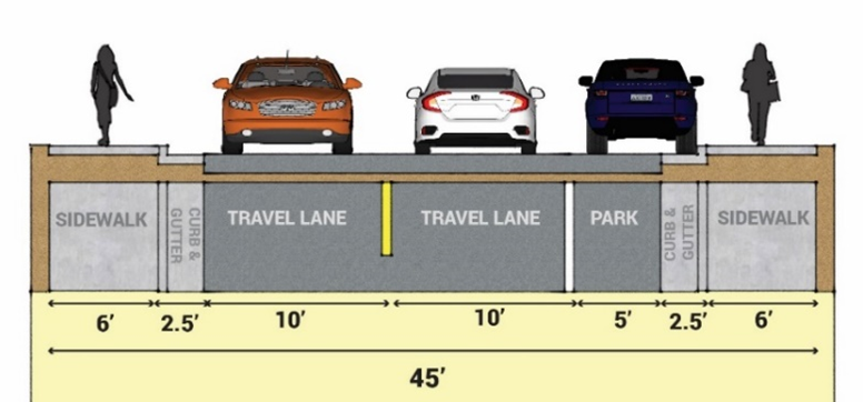
3.
No Parking and Sidewalk on One Side (Two-way Traffic).
i.
Right-of-Way Width. Twenty-eight (28) feet.
ii.
Multi-modal Facility Characteristics.
i.
Sixteen-foot width two-directional travel lane.
ii.
Two-and-a-half-foot wide curb and gutter on both sides of the street.
iii.
Five-foot wide pedestrian walkway to be provided on one side of the street and setback one foot from the property line.
Figure 18.03.9.8-3: No Parking and Sidewalk on One Side (Two-way Traffic)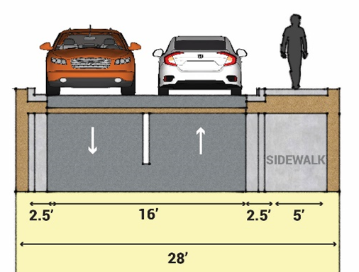
4.
No Parking and Sidewalk on One Side (One-way Traffic)
i.
Right-of-Way Width. Twenty-two (22) feet.
ii.
Multi-modal Facility Characteristics.
i.
One (1) ten-foot travel lane.
ii.
Two-and-a-half-foot wide curb and gutter on both sides of the street.
iii.
One (1) five-foot walkway on one side of the street and setback one (1) foot from the property line.
Figure 18.03.9.8-4: No Parking and Sidewalk on One Side (One-way Traffic)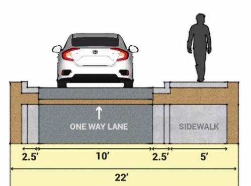
18.03.9.9
Alleys.
A.
Function. Public right-of-way designed to provide access to abutting property at rear lot lines.
B.
Right-of-Way Width. Twenty (20) feet, minimum.
C.
Number of Moving Lanes. One-Direction lane or Two-Directional lanes.
D.
Access Conditions. Provide access to abutting property at rear lot lines.
E.
Traffic Characteristics.
1.
Normally, alleys should intersect at perpendicular angles with streets.
2.
No parking shall be permitted.
F.
Planning Characteristics.
1.
Alleys shall be open at both ends.
2.
Normally, alleys should not intersect with collector streets or arterial streets.
G.
Design Characteristics.
1.
Grade. Not less than five-tenths of one percent; not more than ten percent.
H.
Cross Sections for Alleys.
Figure 18.03.9.9-1: Alley
18.03.9.10
Private Streets.
A.
When Required or Permitted.
1.
The City may require or allow the installation and construction of private streets and the retention and maintenance of those private streets by the developer or another entity acceptable to the City when:
a.
The site, layout of the site, density of units or structures, or other circumstance adversely affects the ability of the City or other governmental entity to adequately provide service or effectively maintain an adequate level of service to the site;
b.
The public health, safety, convenience, and welfare of the citizens, would be adversely affected by requiring a public street; or
c.
A proposed street will not comply with one or more applicable ordinance, regulation, rule, or policy concerning the standards of design or construction for a public street.
2.
The City may approve the installation and construction of private streets when requested by a developer if the Planning Director, City Engineer, and Fire Code Official determine that the proposed private street:
a.
Will protect the public health, safety, and welfare as well or better than if a public street were required; and
b.
Will be maintained by an entity with adequate financial capability to perform routine maintenance and periodic replacement needed to maintain the quality of the street at a level equal or better than that of a public street.
B.
Design and Location
1.
The location and design of a private street or right-of-way shall be subject to the review and approval of the Planning Director, CityEngineer, and the Fire Code Official.
C.
Designation
1.
Each private street approved by the City shall be clearly designated as a private street on the Subdivision Plat, and the plat shall include a note clarifying that the City is not responsible for maintenance of the private street.
(Ord. No. 1123, § 1(Exh. A), 10-3-2023)
18.03.10 - Development in Natural Hazard Areas.
18.03.10.1
Purpose.
A.
The City contains many unique natural resources and sensitive areas, including watercourses, wetlands, hillsides, forested areas, rock formations, and open space. Such areas contribute to the City's quality of life, but are vulnerable to natural hazards such as flooding, improper drainage, geologic hazards, steep slopes, and wildfire. These natural hazard risks and vulnerabilities are identified in the City's adopted Hazard Mitigation Plan. The purpose of this section is to avoid development on hazardous sites, or, when development may occur, to provide appropriate mitigation to protect the public health, safety, and welfare.
18.03.10.2
Natural Hazard Identification and Risk Assessment.
A.
The City adopted a hazard risk assessment in 2017 that concluded the City is at risk for flooding, geologic hazards, and wildfire. This section defines a process to identify specific hazard risk posed by development activity based on the location and development proposal.
B.
Mapping. The City has natural hazard maps to assist in determining if hazardous conditions exist on or near a development site. These maps are available on the City website.
C.
Development Activity. The type, extent, and design of the proposed development must be assessed to fully evaluate hazard risk and possible mitigation strategies to meet relevant local, state and federal regulations.
18.03.10.3
Applicability.
A.
The standards in this chapter shall apply pursuant to the applicability provisions for flood, geologic, and wildfire as specified in the respective sections in this chapter.
B.
All geologic hazard evaluations and wildfire risk assessments, if required, shall be conducted prior to submittal of any development application or in conjunction with the review of the application. No application shall be approved prior to the review of such report with a conclusion that potential issues shall be avoided or mitigated.
18.03.10.4
Limits of Disturbance.
A.
Establishing Limits of Disturbance.
1.
For development subject to one or more natural hazards and the standards identified in this chapter, the applicant shall establish limits of disturbance that identify specific areas of the site where development activities will be contained, consistent with the findings of any technical reports, as applicable. Limits of disturbance shall be indicated on the site plan associated with the submittal of a development application or building permit application.
2.
In establishing limits of disturbance, the applicant shall:
a.
Implement erosion prevention and control measures;
b.
Protect steep slopes;
c.
Protect natural drainage channels;
d.
Protect stream corridors and wetlands;
e.
Preserve the site's natural topography;
f.
Protect existing vegetation; and
g.
Protect existing wildlife habitat.
B.
Standards within the Limits of Disturbance.
1.
Reduced Setbacks. Where appropriate to protect a sensitive area as listed in subsection 18.03.10.4.A.2, if there is no feasible alternative, and if recommended by hazard evaluation, a structure may be located within three (3) feet of a lot line provided:
a.
The proposed structure is at least six (6) feet from any existing structure on an adjacent lot; and
b.
The proposed structure complies with any applicable building and fire code requirements.
2.
Clustering. Clustering of building pads and parking areas may be required to minimize the area of the limits of disturbance.
3.
No Build Areas. Limits of disturbance shall not include slopes greater than thirty (30) percent.
18.03.10.5
Ecological Characterization Study.
A.
Purpose and Applicability. If the development site contains, or is within five hundred (500) feet of, a natural habitat or feature, or if it is determined by the Planning Director, upon information or from inspection, that the site likely includes areas with wildlife, plant life and/or other natural characteristics in need of protection, then the developer shall provide to the City an ecological characterization report prepared by a professional qualified in the areas of ecology, wildlife biology or other relevant discipline.
B.
Submittal. Prior to the submittal of a project development plan application for all or any portion of a property, a comprehensive ecological characterization study of the entire property must be prepared by a qualified consultant and submitted to the City for review. The Director may waive any or all of the following elements of this requirement if the City already possesses adequate information required by this subsection to establish buffer zone(s). The ecological characterization study shall describe, without limitation, the following:
1.
The wildlife use of the area showing the species of wildlife using the area, the times or seasons that the area is used by those species and the "value" (meaning feeding, watering, cover, nesting, roosting, perching) that the area provides for such wildlife species;
2.
The boundary of wetlands in the area and a description of the ecological functions and characteristics provided by those wetlands;
3.
Any prominent views from or across the site;
The pattern, species and location of any significant native trees and other native site vegetation;
4.
The pattern, species and location of all non-native trees and vegetation that contribute to the site's ecological, shade, canopy, aesthetic and cooling value;
5.
The top of bank, shoreline and high water mark of any perennial stream or body of water on the site;
6.
Special habitat features;
7.
Wildlife movement corridors;
8.
The general ecological functions provided by the site and its features;
9.
Any issues regarding the timing of development-related activities stemming from the ecological character of the area; and
10.
Any measures needed to mitigate the projected adverse impacts of the development project on natural habitats and features.
18.03.10.6
Development in Flood Hazard Areas.
A.
Purpose and Intent. The purpose of this section is to promote the public health, safety, and welfare and to minimize public and private losses due to flood conditions to specific areas. Further, these standards are intended to:
1.
Protect human life and health;
2.
Minimize expenditure of public money for flood control projects;
3.
Minimize business interruptions;
4.
Minimize damages to critical facilities, infrastructure, and public facilities;
5.
Reduce the amount of effort and expenditures associated with response, cleanup, and repair following a flooding event; and
6.
Educate the public about the potential risk associated with geologic hazards in Manitou Springs.
B.
Applicability of Flood Hazard Standards.
1.
Adequate floodplain avoidance and/or mitigation is required for all development proposed in the floodplain and shall be reviewed by the Regional Floodplain Administrator for compliance with federal, state, and local floodplain regulations.
2.
Development in Flood Hazard Areas, shall comply with the requirements of the Regional Floodplain Regulations as amended. Flood hazard maps are available in the office of the Regional Floodplain Administrator.
18.03.10.7
Geologic Hazards Evaluation.
A.
Purpose and Intent.
1.
The City of Manitou Springs is located within areas that are susceptible to one or more geologic hazards occurring either on the property or upstream/uphill from the property that could impact the subject property. Below is a list of common geologic hazards found in Manitou Springs; (this list is not exhaustive):
a.
Expansive or unstable soils and/or rock;
b.
Unstable slopes;
c.
Landslide areas;
d.
Flood prone or flood inundation areas, debris flows, and debris fans;
e.
Unstable fill;
f.
Erosion and deposition areas, or highly erodible soils;
g.
Rockfall;
h.
Subsidence;
i.
Shallow water tables;
j.
Groundwater springs or seeps;
k.
Collapsible soils;
l.
Faults;
m.
Upturned or steeply dipping bedrock;
n.
Radioactivity or radon;
o.
Problems caused by features or conditions on adjacent properties; and
p.
Other general geologic or site problems.
2.
The City retains geologic hazards maps which shall be considered for initial review of site hazards prior to site evaluation and addressed in the geologic hazard evaluation.
B.
Applicability and Exemptions.
1.
Applicability of Geologic Hazards Evaluation. Unless exempt under subsection 18.03.10.6.B.4, the geologic hazards standards in this section shall apply to any of the following activities or scenarios:
a.
Any construction of new structures that are located on a permanent foundation, or the expansion of an existing structure by 50% or more;
b.
Any application or development activity requiring a grading permit;
c.
Any of the following development application types:
i.
Major or Minor Development Plans;
ii.
Major or Minor Subdivisions; and
iii.
Subdivision waivers.
d.
An application for development or redevelopment on any property with slopes exceeding thirty percent (30%) within the limits of disturbance; or
e.
Any property in the HLDR zone.
2.
The following applications and development activities are automatically required to prepare a Tier 3 Geologic Hazards Plan and Report:
a.
Major Development Plans;
b.
Major Subdivisions;
c.
Any property with average slope exceeding thirty percent (30%) within the limits of disturbance; or
d.
Any property in the HLDR zone.
3.
The Planning Director, Planning Commission, or City Council may, at their discretion, have any geologic hazard evaluation (Tier 1, 2, or 3) independently reviewed by the Colorado Geological Survey (CGS) or by an independent qualified professional geologist or a qualified professional geotechnical engineer. This separate review shall supplement the City's review and will be considered by the City in making a final determination on the associated land development proposal. The cost of having an independent review and analysis of geologic hazard evaluation reports shall be borne by the developer.
4.
Exemptions from Geologic Hazards Evaluation.
a.
The following types of development activities are exempt from Geologic Hazards Evaluation in this section:
i.
Fences;
ii.
Lighting;
iii.
Poles;
iv.
Signs;
v.
Machinery or equipment;
vi.
Decorative or perimeter walls that do not serve to retain soil, unless supporting a road or other weight surcharge;
vii.
Any replat of a previous subdivision in which no new structures or new building lots are being created and no new development is proposed;
b.
An exemption from these standards does not exempt the applicant from liability and responsibility to evaluate and mitigate known geologic hazards on a site.
5.
Sites with existing studies or reports that are ten (10) years or older shall be subject to the Tier 1 Site Evaluation and Letter procedure below to determine whether the existing study or report is sufficient for the proposed development application, or if changes in conditions warrant a new Tier 2 or Tier 3 evaluation.
C.
Tier 1 Evaluation: Initial Site Evaluation and Letter.
1.
Purpose. To provide initial evaluation of potential geologic hazards concerns related to development activities.
2.
Applicability.
a.
Unless exempt under subsection 18.03.10.6.B.4, the Site Evaluation and Letter shall be required for applications pursuant to subsection 18.03.10.6.B.1. The Site Evaluation and Letter shall also be required for the following application types:
i.
Minor Development Plans;
ii.
Minor Plats; and
iii.
Building permits associated with new construction or additions that exceed fifty percent (50%) of the gross floor area of the existing structure.
b.
An applicant may, at their discretion, proceed directly to a Tier 2 or Tier 3 geologic hazard evaluation. If the applicant moves directly to a Tier 2 evaluation, they assume the risk that a Tier 3 Evaluation may also be required.
3.
Procedure.
a.
Site Evaluation. The property subject to the proposed application or development activity shall be evaluated by a professional geologist or a professional geotechnical engineer at the expense of the property owner or applicant.
b.
Evaluation Letter. Following the site evaluation, the professional geologist or a professional geotechnical engineer shall submit a signed and stamped letter to the Planning Director providing details of the site evaluation. At a minimum, the letter shall:
i.
Include the date and location of the site visit;
ii.
Include photos of the lot and any geologic hazard conditions;
iii.
Include a detailed narrative description of the lot conditions, including slopes; evidence of drainage and any other potential hazards on the site that are listed in Section 18.03.10.6.A.1;
iv.
Confirm that Manitou Springs geologic hazard maps were reviewed in relation to the site;
v.
Provide initial recommendations, if any, to mitigate the potential geologic hazards conditions;
vi.
Determine whether or not the proposed development activity for the site would result in an increased risk to geologic hazards on the site or on adjacent properties; and
vii.
Provide an assessment and recommendation whether or not further study is required through a Tier 2 or Tier 3 Evaluation to address geologic hazard risk.
4.
Review Procedures.
a.
Based on the findings and recommendations of the site evaluation and letter, the Planning Director, in consultation with the CityEngineer, may:
i.
Move the application or permit forward through the applicable approval procedure;
ii.
Seek additional input from the Colorado Geological Survey, qualified professional geologist or a qualified professional geotechnical engineer; and/or
iii.
Require a soils and foundation report.
b.
Following further review of the letter and any subsequent input stated above, the Planning Director may:
i.
Move the application or permit forward through the applicable approval procedure;
ii.
Require a Tier 2 Evaluation: Geologic Hazards Mitigation Study; or
iii.
Require a Tier 3 Evaluation: Geologic Hazards Plan and Report.
D.
Tier 2 Evaluation: Geologic Hazards Mitigation Study.
1.
Purpose. To provide further evaluation of geologic hazards for development activities of certain sites and to provide review and recommendations of proposed mitigation for identified hazards.
2.
Applicability. Unless exempt under subsection 18.03.10.6.B.4, the Geologic Hazards Mitigation Study shall be required for any proposed development activity subject to a Tier 1 Site Evaluation and Letter where such evaluation and letter confirms the presence of geologic hazards that require mitigation, but do not warrant a Tier 3 Geologic Hazards Plan and Report.
a.
Mitigation Study.
i.
The detailed guidelines, criteria, policies, and requirements for preparation, submittal, and review of the Mitigation Study are located in the City of Manitou Springs Geologic Hazards Evaluation Manual.
b.
The applicant shall submit to the Planning Director and City Engineer a study and report of potential mitigation solutions ("Mitigation Study") that lessen the impact of the proposed development activity on the site and on adjacent properties. Such study shall:
i.
Be prepared by a professional geologist or a professional geotechnical engineer;
ii.
Identify potential hazards on the site that are listed in Section 18.03.10.6.A.1.;
iii.
Identify conditions that may pose a hazard to land development activities on the site and on adjacent properties;
iv.
Describe proposed mitigation strategies and how they will reduce or avoid identified hazards;
v.
Describe how the proposed mitigation strategies will reduce or avoid identified hazards on adjacent public or private property;
vi.
Describe how the proposed mitigation strategies will comply with any required soils, foundation, or drainage and erosion control plans and reports pursuant to this section, Chapter 18.04, or other applicable engineering standards; and
vii.
Include applicable calculations to support proposed mitigation strategies.
c.
Mitigation Measures. In cases where geologic hazards are identified, appropriate mitigation measures shall be required in conjunction with the approval of the project, if approval is recommended. Such mitigation measures may include, but not be limited to:
i.
Changes to the proposed site layout;
ii.
Changes to the location of proposed structures;
iii.
Modification of land use types;
iv.
Modification of lot boundaries or building envelopes;
v.
Special foundation designs and over-excavation;
vi.
Mitigation of rockfall and/or debris flow;
vii.
Grading, drainage, and erosion controls;
viii.
Geotechnical engineering solutions; and
ix.
Limitations on irrigated landscapes.
d.
Review Procedures.
i.
The Planning Director and the City Engineer shall review the Mitigation Study as part of the review of the applicable land development application. The City's review shall determine whether the findings, conclusions, and recommendations of the Mitigation Study have been incorporated into the design of the applicable development application or permit, Drainage and Erosion Control Plan, Grading Plan, public improvement construction drawings, or other required documents.
e.
Following initial review of the Mitigation Study, the Planning Director may:
i.
Move the application or permit forward through the applicable approval procedure;
ii.
Seek additional input from the Colorado Geological Survey or other professionals; and/or
iii.
Require a soils and foundation report.
f.
Following further review of the Mitigation Study and any subsequent input stated above, the Planning Director may:
i.
Move the application or permit forward through the applicable approval procedure; or
ii.
Require a Tier 3 Evaluation: Geologic Hazards Plan and Report.
E.
Tier 3 Evaluation: Geologic Hazards Plan and Report.
1.
Purpose. The purpose of the Geologic Hazards Plan and Report is to:
a.
Identify the geologic hazards affecting the development site;
b.
Assess proposed development that could pose a more significant geologic hazard impact;
c.
Analyze potential geologic hazard impacts the proposed development could have on surrounding properties or public facilities;
d.
Identify appropriate mitigation measures that shall be employed to reduce or avoid the identified hazards to acceptable levels so that development may proceed; and
e.
Recommend areas that are not suitable for the proposed development or that pose unacceptable risks for development.
2.
Applicability. Unless exempt under subsection 18.03.10.6.B.4, a Geologic Hazards Plan and Report is required for:
a.
Major Development Plans;
b.
Major Subdivisions;
c.
Any property with average slope exceeding thirty percent (30%) within the limits of disturbance;
d.
Any property in the HLDR district; or
e.
Any application or permit requirement recommended by the Planning Director or City Engineer based on the results of a Tier 1 Site Evaluation and Letter or a Tier 2 Geologic Hazards Mitigation Study.
3.
Procedure.
a.
Geologic Hazards Analysis. A Geologic Hazards Plan and Report, when required, shall be prepared by a professional geologist or a professional geotechnical engineer. The Geologic Hazards Plan and Report shall address the topics listed in this subsection, where applicable. The level of detail and emphasis may vary due to specific geologic conditions of the site or the scale and type of proposed development activity. The detailed guidelines, criteria, policies, and requirements for preparation, submittal, and review of the Geologic Hazards Plan and Report are located in the City of Manitou Springs Geologic Hazards Evaluation Manual.
b.
General Project Description and Certification.
i.
A project description shall be included that presents the overall proposed project details including the size and location of the project and the existing and proposed land uses.
ii.
The professional geologist or professional geotechnical engineer preparing or certifying the Plan and Report shall sign the Plan and Report.
c.
Geologic Hazard Risks. The presence of any of the types of geologic hazards on the site as listed in subsection 18.03.10.6.A.1.
i.
Proposed Cuts into Existing Grade.
a)
Prediction of what materials and structural features will be encountered;
b)
Prediction of stability based on geological factors;
c)
Problems of excavation (e.g., unusually hard or massive rock, excessive flow of groundwater); and
d)
Recommendations for reorientation or repositioning of cuts, reduction of cut slopes, development of compound cut slopes, special stripping above daylight handling of seepage water, setbacks for structures above cuts, etc.
ii.
Proposed Masses of Fill.
a)
General evaluation of planning with respect to canyon-filling and side hill masses to fill;
b)
Comment on suitability of existing natural materials for fill; and
c)
Recommendations for positioning of fill masses, provision for underdrainage, buttressing, and special protection against erosion.
iii.
Recommendations for Subsurface Testing and Exploration.
a)
Cuts and test holes needed for additional geological information; and
b)
Program of subsurface exploration and testing, based upon geological considerations that are most likely to provide data needed by the soils engineer.
d.
Conclusions and Recommendations. The Geologic Hazard Plan and Report shall address the following:
i.
Whether the intended use of the land is compatible with any identified or potential geologic hazards or constraints;
ii.
The development of mitigation procedures or design changes necessary to minimize or abate any hazardous condition, if such mitigation or design change is possible. Each hazardous condition requires a recommendation, which may be a recommendation that the conditions are too severe to warrant development;
iii.
The long-term stability and safety of the proposed project. Discuss the critical planning and construction aspects of the development, including the suitability of using irrigated landscaping, the stability of earth materials, the appropriateness of the proposed grading plans, the need for selective location of project facilities, and the static and dynamic parameters for the design of structures; as applicable; and
iv.
Clearly state the geologic basis for all conclusions.
e.
Mitigation Measures. In cases where geologic hazards are identified, appropriate mitigation measures shall be required in conjunction with the approval of the project, if approval is recommended. Such mitigation measures may include, but not be limited to:
i.
Changes to the proposed site layout;
ii.
Changes to the location of proposed structures;
iii.
Modification of land use types;
iv.
Modification of lot boundaries or building envelopes;
v.
Special foundation designs and over-excavation;
vi.
Mitigation of rockfall and/or debris flow;
vii.
Grading, drainage, and erosion controls;
viii.
Geotechnical engineering solutions; and
ix.
Limitations on irrigated landscapes.
f.
Review Procedures.
i.
The Geologic Hazard Plan and Report shall be reviewed by the Planning Director and/or City Engineer as part of the review of the land development application. The Planning Director shall forward the Geologic Hazard Plan and Report to the Colorado Geological Survey (CGS) for review and comment. The City's review shall determine whether the findings, conclusions, and recommendations of the Geologic Hazard Plan and Report and comments from CGS have been incorporated into the design of the Major or Minor Development Plan, Subdivision Plat, Drainage and Erosion Control Plan, Grading Plan, and public improvement construction drawings, or other required documents. If the City review determines that the submitted study is incomplete or fails to comply with the standards and requirements set forth in this section, the Planning Director may require new or supplemental information.
g.
Recommendations of the Geologic Hazards Plan and Report shall be incorporated, as applicable, into the approval of the Major or Minor Development Plan, Subdivision Plat, Drainage and Erosion Control Plan, Grading Plan, public improvement construction drawings, and building construction plans.
18.03.10.8
Wildfire Mitigation Standards.
A.
Purpose and Intent. Pursuant to the City's wildfire risk assessment, the entire City is at risk for wildfire. Mapping and/or site assessments by the Fire Department may be used to clarify wildfire risk on individual properties within the City or the City as a whole. The standards in this subsection establish minimum regulations for reducing the risk of loss of life or property from wildfire by:
1.
Maintaining vegetation to slow the rate of spread and reduce the intensity of a fire;
2.
Providing a safe area for fire suppression operations; and
3.
Slowing or preventing a fire from traveling in either direction between a structure and vegetation.
B.
Applicability of Wildfire Mitigation Standards. The wildfire mitigation standards in this section shall apply to any of the following activities or scenarios:
1.
An application for a Major or Minor Development Plan for development determined to be at rapid wildfire risk based on the City's Wildfire Risk Map;
2.
An application for a Major or Minor Subdivision for development determined to be at rapid wildfire risk based on the City's Wildfire Risk Map; or
3.
Any required building permit or property improvement permit for a habitable or commercial structure determined to be at rapid wildfire risk based on the City's Wildfire Risk Map.
C.
Procedure. For applications subject to subsection 18.03.10.7.B. the Fire Department will conduct a site assessment to evaluate how fire code standards, as well as the wildfire mitigation standards in subsection 18.03.10.7.D. apply to the proposed development and communicate this information to the property owner.
D.
Wildfire Mitigation Standards. The applicant shall mitigate wildfire hazards to applicable structures through landscaping and maintenance to the maximum extent practicable by:
1.
Maintaining a five (5)-foot perimeter zone that contains only non-organic mulch around structures;
2.
Providing and maintaining a ten (10)-foot primary defensible space area, where vegetation capable of carrying fire has been treated, modified, or removed to slow the rate of spread and reduce the intensity of a fire.
3.
Providing and maintaining a secondary thirty (30)-foot defensible space area within the lot on all sides of structures where:
a.
A minimum separation of ten feet is provided between the edges of tree canopies (or clusters of tree canopies), measured at maturity;
b.
Vegetation and tree canopies maintain a minimum clearance of ten (10) feet from any building;
c.
Branches within six to ten (10) feet above the ground are removed from trees taller than twenty (20) feet in height;
d.
Low-hanging branches at less than one-third (⅓) of the tree's height are removed from trees that are less than twenty (20) feet in height;
e.
Potential fire hazards such as insect infested, diseased, and dead trees and limbs are removed;
f.
Plantings shall be provided pursuant to the City's preferred plant list, except that alternatives to the City's preferred plant list may be considered on a case-by-case basis upon the applicant demonstrating in writing that such alternatives are equally or more suitable to the conditions of the site, ecology, habitat, microclimate, and the surrounding environment;
g.
Planting vegetation in clusters is encouraged, with spacing between clusters often (10) feet or one and one-half (1 ½) times the height of the vegetation, whichever is greater; and
h.
Vegetation shall be maintained, including keeping limbs trimmed, removing surface and ladder fuels, and removing vegetative debris from the ground.
Figure 18.03.10.7-1: Illustration of Defensible Space
E.
Whenever the standards in this section conflict with landscaping standards elsewhere in this LUDC, the standards in this section shall apply.
F.
The Planning Director shall have the authority to modify the wildfire mitigation standards in this section based on a Fire Department recommendation, or through the alternative compliance procedure for landscaping plans in Chapter 18.04.
(Ord. No. 1123, § 1(Exh. A), 10-3-2023)
18.03.11 - Drainage Plans.
18.03.11.1
Purpose and Applicability.
A.
All drainage plans and reports shall meet the design and submittal requirements of the City of Colorado Springs Drainage Criteria Manual.
B.
With the submission of a Final Drainage Report for a project meeting the definition of applicable development site, as defined in Title 14, the engineer of record shall include for each detention and infiltration facility proposed for the project:
1.
A completed Post Construction Stormwater Detention Facility Documentation Form.
2.
An Operations and Maintenance Manual specific to every permanent control measure constructed at the site.
3.
A Private Detention Basin/Stormwater Quality Best Management Practice Maintenance Agreement and Easement.
4.
A completed Stormwater Detention and Infiltration Facility Design Data Sheet for each facility included in the project.
Items 1-3 may be obtained from the Manitou Springs Planning Department.
The Stormwater Detention and Infiltration Facility Design Data Sheet can be downloaded from the statewide notification and compliance portal at: https://maperture.digitaldataservices.com/gvh/?viewer=cswdif
City Planning will review the submitted documentation forms for completeness and accuracy. Upon verification of complete and accurate documentation and data sheets, the owner is responsible for uploading each facility into the statewide reporting portal.
(Ord. No. 1123, § 1(Exh. A), 10-3-2023; Ord. No. 1325, § 1, 6-17-2025)
18.03.12 - Signs.
18.03.12.1
Purpose.
A.
In the interest of public health, safety and welfare, the purposes of this Chapter are:
1.
To encourage the efficient and effective use of signs as a means of communication in the City;
2.
To maintain and enhance the aesthetic environment and the City's ability to attract sources of economic development and growth;
3.
To improve pedestrian and traffic safety;
4.
To minimize the negative effects of signs on nearby public and private property;
5.
To provide a reasonable balance between the rights of persons and entities to communicate through signs, and protecting the public from the visual discord that results from the unrestricted proliferation of signs;
6.
To promote fair and consistent enforcement of these sign standards; and
7.
To ensure that signs are designed and used in a manner to:
a.
Allow persons and entities to use signs effectively for the communication of messages (such as to identify residential dwellings, business establishments and other organizations;
b.
Provide direction to emergency services, motorists and pedestrians, to advertise, and to communicate to the public;
c.
Be consistent with the permitted use of the site and adjacent sites;
d.
Minimize distractions or confusion of motorist, bicyclist, and pedestrians, or obstruct the views of intersection corners, neighboring lands, or other signs;
e.
Lessen visual clutter caused by improper placement, excessive illumination, or animation;
f.
Promote attractive signs consistent with the Manitou Springs Comprehensive Plan and the Manitou Springs Historic District Design Guidelines, as may be amended;
g.
Communicate a message using a reasonable size and number of signs;
h.
Comply with requirements of this Chapter regulating sign size depending on the use in relationship to the scale of the lot frontage, location from which the sign will be viewed, and the building façade with street frontage along which the sign is to be placed;
i.
Protect the public from the dangers of unsafe signs, and require signs to be constructed, installed and maintained in a safe manner; and
j.
With the exception of signs conveying false or misleading information, advertising illegal or criminal activity, or displaying obscenity, the City does not intend by any provision of this Chapter to regulate the content of any sign.
18.03.12.2
Applicability.
A.
All signs within the City must comply with the standards of this Chapter.
B.
Permit Required. No signs requiring a sign permit shall be erected, installed, relocated or displayed without prior City approval and issuance of a sign permit pursuant to Chapter 6 of this LUDC.
C.
Sign Districts. This Chapter regulates sign characteristics by district. The City regulates land use, setbacks, building dimensions, site and building design, and other characteristics by zoning districts in this LUDC. Many of these zoning districts have common characteristics for the purposes of sign regulations, and this Chapter combines zoning districts into common sign districts as designated in Table 18.03.0-1: Sign District Designations.
18.03.12.3
Prohibited Signs.
A.
The following signs are prohibited in the City unless otherwise specifically provided for in this Chapter:
1.
Any sign that is not an official sign and obstructs the view of, may be confused with, or purports to be an official traffic sign, signal or device or any other official sign.
2.
Any sign that obstructs ingress to or egress from a required door, window, fire escape, or other required exit way.
3.
Any sign that is painted upon retaining walls, rocks or natural features.
4.
Any sign that is erected or painted upon any vegetation.
5.
Any temporary, freestanding signs placed in the public right-of-way.
6.
Signs painted or affixed to benches or fences.
7.
Portable signs, except sandwich board signs as permitted by this Chapter and official signs, including those required for by the Uniform Manual on Traffic Control Devices published by the Federal Highway Administration and Colorado Supplements published by the Colorado Department of Transportation.
8.
Any sign which is structurally unsafe constitutes a hazard to safety or health; is not kept in good repair; is capable of causing electrical shocks to persons likely to come in contact with it; or does not conform to the design, structural, and material standards for signs as adopted by the City.
9.
Signs mounted, attached, or painted on motor vehicles, trailers or boats used as advertising, but excluding vehicles actually used in the normal course of an occupant's operations, whether parked or not.
10.
Revolving beacons and searchlights.
11.
Animated signs.
12.
Flashing signs.
13.
Digital signs.
14.
Signs with more than two faces unless approved as part of a planned sign program.
15.
Off-premises signs except as provided for in this Chapter.
16.
Signs designed or allowed to wave, flap, or rotate with the wind, except for flags of less than twenty square feet.
17.
Any sign emitting sound.
18.
Exposed neon tubing within the downtown zone district unless approved as part of a planned sign program and with Historic Preservation Commission approval.
19.
Obsolete signs.
20.
Any sign located within utility or access easements, on public property, or within public rights-of-way, except as allowed in this Chapter or as specifically provided for in a Planned Sign Program.
21.
Inflatable displays except as part of a local event on public property regulated by City Code Chapter 12.24 or other event approved by a Temporary Use Permit - Minor or Temporary Use Permit - Major.
18.03.12.4
General Provisions.
A.
Signs must be constructed according to standards established in the Building Code.
B.
When applicable, building permits must be obtained for signs.
C.
All signs and supporting structures shall be maintained in a good state of appearance and repair. Business or property owners are responsible for the maintenance of all signs.
D.
All occupied premises shall have street numbers, and room identification numbers for lodgings, which shall be easily viewed from adjacent public rights-of-way.
E.
Substitution. Subject to the landowner's consent, a non-commercial message of any type may be substituted for any duly permitted or allowed commercial message or any duly permitted or allowed non-commercial message if the sign structure or mounting device is legal without consideration of message content. The message substitution may be made without any additional approval or permitting. This provision prevails over any more specific provision to the contrary within this Chapter. The purpose of this provision is to prevent any inadvertent favoring of commercial speech over non-commercial speech, or favoring of any particular non-commercial message over any other non-commercial message. This provision does not create a right to increase the total number or area of signs on a parcel, nor does it affect the requirement that a sign structure or mounting device be properly permitted.
F.
Measurement Standards.
1.
Number. The number of signs allowed applies to each occupant of a parcel for a permitted use under this LUDC.
2.
Sign Area.
a.
In General. Sign area means the area that includes the entire face of the sign, frame, artwork, and any spacing between letters, figures and designs, but not including any incidental decoration or the bracing or structure of the sign. For window signs, "sign area" is measured at the extremities of the lettering in each line or from the extremities of any graphic.
Figure 18.03.12.04-1: General Sign Measurement
b.
Multi-Faced Signs. Require Planned Sign Program.
i.
If the faces of a multi-faced sign have the same area, have an interior angle of less than 45 degrees, and are not more than 12 inches apart, then the sign area is the area of one side of the sign. This measurement commonly applies in cases where a sign has two sides of the same size that are parallel to each other.
c.
Where the faces of a multi-faced sign are not the same size, the interior angle formed by the faces is less than 45 degrees, and the faces are not more than 12 inches apart, the sign face area is the area of the larger side of the sign.
d.
If the interior angle formed by the faces of a multi-faced sign is more than 45 degrees, or if the faces are more than 12 inches apart, then the sign face area is the cumulative area of all sides of the sign.
Figure 18.03.12.04-2: Sign Area Measurement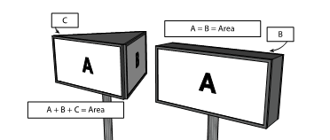
e.
Height. For signs installed on the ground, height is the vertical distance from the average grade level at the base to the highest point of the sign.
f.
Façade Width.
i.
Where this Chapter calculates a sign area allowance based on the width of a building's façade facing a street frontage, the width of the façade is the horizontal distance of the façade at grade on the side of the building facing a public street.
g.
For buildings with multiple occupants, the width of the façade is the horizontal distance of the portion of the façade between party walls or tenant separation partitions for the particular occupant at grade on the side of the building facing a public street.
Figure 18.03.12.04-3: Building Façade Width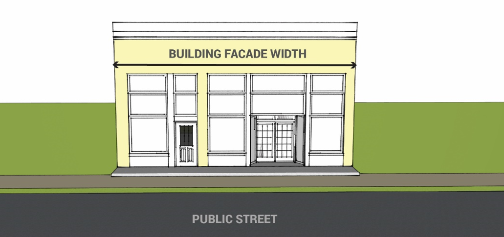
18.03.12.5
Signs Not Requiring Permits.
A.
Signs not requiring permits are not considered in calculating the total area of signs under these provisions.
B.
All Zones. The following signs may be erected and maintained, subject to stated restrictions, without a permit in all zones as defined in the zoning ordinance of the City:
1.
Official signs. To the maximum extent possible, official signs in the downtown zone shall meet the guidelines herein.
2.
Street and lodging room numbers.
3.
Temporary Signs.
a.
Up to two freestanding temporary signs per parcel provided they do not exceed six (6) square feet per side and do not obstruct or impair the safety of pedestrian or vehicular traffic. A 30-day limit for display applies to these two (2) temporary signs.
b.
One additional freestanding sign per parcel that does not exceed six (6) square feet per side and does not obstruct or impair the safety of pedestrian or vehicular traffic. This sign is not subject to the 30-day display limitation for other temporary signs.
4.
Vehicle signs on vehicles operated in the normal course of operations is allowed without a permit, subject to the following limitations:
a.
The vehicle shall have all required state licenses, license plates and inspection stickers and shall be operable.
b.
The vehicle shall be regularly operated, which means that the vehicle shall leave the property on a regular basis for an operational purpose and shall not be parked in excess of twelve (12) continuous hours at the occupant's location. This subsection does not apply to a vehicle used on a regular basis for the occupant's operational purpose that is taken home during nonworking hours and parked or stored on a private residential lot during nonworking hours.
c.
The primary purpose of the vehicle shall not be for the display of signs. In determining whether the primary purpose of such vehicles is for the display of signs, the City shall consider the following criteria:
i.
Whether the vehicle is regularly operated as set forth in paragraph (4)(b) hereof.
ii.
The location of the vehicle when it is parked on or near the property of the occupant for which the sign is provided. The purpose of this subparagraph shall be to prevent the vehicle from being displayed on or near a major street or public right-of-way, unless no other alternative parking area is available.
iii.
Whether the vehicle is parked in a location that is not on or near the property of the occupant for which the sign is provided in a manner so as to constitute a sign. The purpose of this subparagraph is to prevent the vehicle from being displayed on or near a major street or public right-of-way without a valid operational purpose, such as deliveries or repair work.
d.
Vehicle signs shall be magnetic, have vinyl graphics or be painted directly on the vehicle.
C.
Downtown and Commercial Zones. The following signs may be erected and maintained, subject to the stated restrictions, without a permit in the downtown and commercial zones as defined in this Chapter.
1.
Lot perimeter signs. A lot perimeter sign is a sign located outside the right-of-way and within 10 feet of an entrance to a private drive or parking area for a lot. Occupants generally use these signs to direct motorists to parking areas. However, the City does not regulate the content or message of lot perimeter signs.
a.
Number. An occupant may display two lot perimeter signs at each access to a private drive or parking area from a public street.
b.
Area. Lot perimeter signs may have a maximum sign area of three-square feet per sign.
c.
Location. Lot perimeter signs are only allowed outside the right-of-way and within 10 feet of an entrance to a private drive or parking area from a public street.
Figure 18.03.12.05-1: Perimeter Sign Locations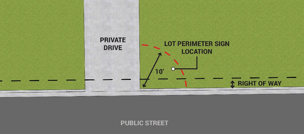
2.
Sandwich board signs, are subject to the following limitations:
a.
The sign shall not constitute a hazard to pedestrian or vehicular traffic, such as blocking site lines, obstructing the free flow of pedestrian or vehicular traffic, or presenting a tripping hazard.
b.
The sign height shall be no more than four feet, and the total square footage no more than eight square feet per side. The sign shall be constructed in a manner that assures safety for pedestrian traffic and stability in all weather conditions.
c.
Sandwich board signs may only be placed directly on the sidewalk in front of an occupant's location related to the sign, unless permitted pursuant to an approved planned sign program. No occupant shall have more than one sandwich board sign.
18.03.12.6
Signs Subject to Permits.
A.
Permit Required. Subject to the stated restrictions, all signs permitted by this Section shall obtain a sign permit unless expressly exempted by Section 18.03.12.5.
B.
The standards in Table 18.03.0-2 and the additional sign standards in this Section apply to all signs controlled by this Section.
C.
Additional Sign Standards.
1.
Total Number.
a.
Lots with a Single Frontage. For each occupant of a lot with a single frontage on a public street, the standards of Table 18.03.0-2 apply to the cumulative number of signs requiring a permit.
a.
Lots with Multiple Frontages.
i.
For each occupant of a lot with two or more adjacent frontages, including corner lots, the cumulative number of permitted signs shall not exceed two signs per frontage, excluding temporary and off-premises signs. Distinct occupants of lots with adjoining but separate frontages may choose to be classified under the provisions of paragraph a, above for occupants having a single frontage so that one frontage may have the number of signs allowed by Paragraph a, above and one frontage is allowed no signage. For lots with non-adjacent frontages, such as lots with street frontages at the front and back of the lot, the total number of signs subject to permit shall not exceed three signs per frontage, excluding temporary and off-premises signs.
b.
Exceptions.
i.
Signs that do not require a permit under this Chapter are not included in the cumulative number of signs allowed.
ii.
In the downtown zone, window and door signs requiring a permit under this Section count cumulatively as one sign for calculation of the number of signs allowed.
iii.
Temporary signs requiring permits under this Section are not counted in the cumulative number of signs allowed.
2.
Area.
a.
Street-Level Occupants. Cumulative sign area per occupant on the ground floor is allowed at the rate of three square feet of sign area per foot of building façade width facing a public street frontage, subject to the district maximum in Table 18.03.0-2.
b.
Upper-Level Occupants. Cumulative maximum sign area per occupant above the ground floor is one square foot of sign area per foot of building façade width facing a public street frontage, subject to an overall maximum sign area of fifty square feet.
c.
The sum of the areas of all window, wall, hanging, roof, and freestanding signs for an occupant shall not exceed the maximum sign area allocated to that occupant.
3.
Window and Door Signs.
a.
Area. Total sign area shall not exceed twenty-five percent of glass area.
a.
Number. Excluding temporary signs, the total number of signs on windows and doors shall not exceed three window signs or two door signs per façade with a frontage on a public street.
4.
Wall Signs.
a.
Location. Signs on wall areas visible from the public right-of-way shall be located a minimum of one foot inward from perimeter edges of walls and shall not project outward from walls more than eight inches.
b.
Area. The cumulative area limitations for all signs applies except for mural signs.
c.
Mural Signs.
i.
Mural signs shall be exempt from size and height limitations and not be counted toward the maximum number of signs permitted on a property.
ii.
The proposed design and placement of the mural shall be included with the sign permit application.
iii.
The Director shall approve a mural sign permit when all of the following criteria are met:
a.
The property owner has given written consent for the mural to be constructed on their property;
b.
The proposed mural promotes and enhances the aesthetic beauty and character of the City;
c.
The proposed mural is artistic in nature;
d.
The proposed mural is a "one-of-a-kind" work of art and does not appear in any other public form including but not limited to advertising, logos, and trademarks and including publications where the mural is used to promote or identify the sponsor in any form; and
e.
The proposed mural does not include offensive or illegal images or language.
5.
Hanging Signs.
a.
Location. Signs shall not extend outward more than four feet from a building wall.
b.
Area. Sign area shall not exceed the district standard stated in Table 18.03.0-2 (exclusive of brackets).
c.
Awnings. Awnings shall not be counted as signs. Lettering (in addition to the allowable sign area under the façade frontage ratio in this Section) may be applied to a fabric awning surface; however, this additional lettering may not increase the allowable sign area by more than twenty-five percent. The calculation for the additional sign area includes a single rectangle, parallel with the ground, that contains all sign copy and decorative embellishments and not the whole surface of the awning.
d.
Number. The number is limited to one per façade with a frontage facing a public street. Signs with multiple sides count as one sign.
e.
Liability. If a hanging sign is in the public right-of-way, the occupant or property owner shall assume full liability for any damages incurred due to the positioning of the sign. The occupant or property owner may be required to agree to this condition in writing before a permit is issued.
6.
Freestanding Signs.
a.
Location.
i.
In the Downtown District, freestanding signs less than eight square feet in size shall be set back from side lot lines a minimum of six feet. Signs more than eight square feet in size shall be set back from all property lines a minimum of six feet. For each additional foot in height over eight feet, there must be an additional one-foot setback. No portion of any sign shall extend into the six-foot setback area.
ii.
In all other commercial districts, freestanding signs shall be set back from all property lines a minimum of ten feet. For each additional foot of height over ten feet, there must be an additional one foot of setback from the adjacent property line(s). No portion of any freestanding sign shall extend into the setback area. Signs less than forty feet from any street corner shall be set back at least ten feet from the public right-of-way.
b.
Area. Sign area shall not exceed the district standard stated in Table 18.03.0-2.
c.
Height. Sign height shall not exceed the district standard stated in Table 18.03.0-2.
d.
Number. The number shall not exceed the district standard stated in Table 18.03.0-2. Signs with multiple sides count as one sign.
7.
Roof Signs.
a.
Roof signs must comply with the district standards stated in Table 18.03.0-2.
b.
Roof signs in commercial zones other than the downtown zone are allowed if not more than ten square feet of the total sign area is above the highest point of the roof. The cumulative limit for sign area also applies.
8.
Signs in Residential Zones.
a.
A sign for a nonresidential use in a residential zone, except those allowed in this Chapter and those allowed for home occupations, require a permit and must comply with the standards in Table 18.03.0-2.
b.
The area allowance for a sign for a nonresidential use in a residential district varies based on the setback from the front property line. Individual sign area shall not exceed twenty square feet at a distance of fifty feet or greater from the front property line and shall decrease in area one and one-half square feet for each ten feet or increment thereof toward the front property line as shown in Table 18.03.0-3: Residential Zone Sign Area Based on Setback.
c.
Signs for a nonresidential use in a residential zone require review and approval of a planned sign program permit as part of the conditional use application, subject to the requirements of the following criteria:
i.
The number and size of signs shall be accessory and subordinate to and consistent with the design of the main structure.
ii.
Wall and hanging signs shall be placed to enhance architectural features.
iii.
Sign materials shall be of wood, painted metal or stained glass or equivalent durable material.
iv.
Typefaces shall be simple, uniform and readable with logos, symbols and borders.
v.
Sign location and typeface shall take into account and be of consistent character to the structure and street and adjacent residential structures.
vi.
Sign area shall be of a size and scale compatible with the neighboring residential area.
9.
Temporary Signs.
a.
Temporary signs must comply with the district standards stated in Table 18.03.0-2.
b.
Location.
i.
In the downtown zone, temporary signs shall be displayed within window areas or on walls located along building's facade, or freestanding and set back a minimum of six feet from the property lines.
ii.
In other commercial zones, temporary signs shall be displayed within window areas or on walls located along building's facade, or free-standing and set back a minimum of ten feet from the property lines.
c.
Sandwich board signs are exempt from this Section.
10.
Neon Lighting. In the downtown zone, a neon sign greater than six square feet in area requires approval by the Historic Preservation Commission. A sign will be reviewed by the Historic Preservation Commission under the criteria of Section 18.03.12.9 in reaching a determination.
11.
Historic Signs.
a.
In the downtown zone, historic signs are permitted regardless of size, height, and obsolescence if approved by the City Council upon recommendation by the Historic Preservation Commission.
b.
In other commercial zones, historic signs are permitted regardless of size, height, or obsolescence if approved by the Planning Commission upon recommendation by the Historic Preservation Commission.
18.03.12.7
Off-Premises Signs.
A.
Only freestanding signs are permitted as off-premises signs. The total area of all off-premises signs per occupant of a lot shall not exceed thirty-two square feet.
B.
No occupant of a lot shall erect, install, or maintain more than two off-premises signs within the City limits.
C.
Off-premises signs are permitted only in commercial zones outside the downtown zone.
D.
Only one off-premises sign is permitted on each property.
E.
An off-premises sign must be at least one hundred fifty feet from another existing off-premises sign along the same street frontage.
F.
No off-premises sign shall be allowed in the public right-of-way, except as allowed for sandwich board signs or pursuant to a Planned Sign Program.
18.03.12.8
Trailblazer signs.
A.
No occupant of a lot located on Manitou Avenue, Park Avenue, Canon Avenue or through the 100 block of Ruxton Avenue, or with other usable sign readily visible from these areas shall be allowed a trailblazer sign.
B.
Trailblazer signs shall be reflective white on green with the total area, shape and placement to be determined by the City.
C.
A maximum of three trailblazer signs will be allowed per use within the City limits, only upon demonstration of need.
D.
Upon request for trailblazer signs the City will determine locations and placement. Criteria will be number of visitors/customers, distance from major streets, clarity of route and safety.
E.
Trailblazer signs may be installed, removed or altered by the City at any such time as recommended by the planning department and approved by the Planning Commission.
F.
Application for trailblazer signs may be initiated by the occupant of a lot to the planning department for consideration by the Planning Commission through the sign permit process. Upon approval of these applications, costs for installation will be the responsibility of the applicant.
G.
Trailblazer signs, if approved, are allowed in any zone district.
H.
The content of trailblazer signs shall be limited to the name of the occupant or specific attraction, graphic indication of direction to be taken and the City logo.
18.03.12.9
Design Standards for Signs.
A.
Signs permitted within the downtown zone shall meet the following standards except for mural signs:
1.
Signs shall not overpower the façade of the building or streetscape. Signs should be subordinate elements of the entire façade. The City may reduce the number and size of signs permitted under this Chapter when the signs do not meet this standard.
2.
Primary signs should be placed flush on the building to be visible for both vehicle and pedestrian traffic and approximately seven to nine feet above the ground. The lower edge of hanging or perpendicular signs should be at least seven feet above grade. Window sign should be between four and six feet above the sidewalk.
3.
Signs related to building uses on upper floors shall attempt to make use of lower floor space for signs. However, upper floor window signs are acceptable but must conform to the standards for lower floor signs.
4.
When available, sign bands on buildings should be utilized for compatibility with the building façade. Traditional sign placement locations are considered more favorable than non-traditional sign placement.
5.
Sign placement should be balanced with structural details like doors and windows so that the building characteristics are dominant over the signage.
6.
Sign materials should be compatible with the building façade and other signs and buildings in the vicinity.
7.
Sign typeface should be of one type of lettering, easily readable, subdued and not overly decorative. The character height of all sign copy shall be nine inches or less.
B.
Signs may not obstruct scenic views from public rights-of-way, residential dwellings, or occupants' establishments.
C.
Utilities to signs shall be concealed whenever possible.
D.
Methods of illumination shall be provided where allowable in a manner which shields light sources from rights-of-way and adjacent properties, to prevent adverse brightness and glare.
18.03.12.10
Design guidelines for signs.
A.
The use of symbols and awnings is encouraged.
B.
The use of vegetation in conjunction with signs is encouraged, i.e., hanging plants, vines, flower boxes, planters, etc.
C.
Freestanding signs accompanied by landscaping bases which consist of well-maintained planters, ferns, rock outcroppings, shrubbery, flowers, waterscapes, or any combination thereof, are encouraged.
18.03.12.11
Planned Sign Program.
A.
The intent of this program is to permit flexibility in the location, design, and materials permitted for signs for business, commercial, institutional, and planned development uses and to allow for flexibility in the size of certain conditional signs within residential districts.
B.
Planned sign programs shall substantially comply with the general regulations contained in this Chapter. These provisions do not alter the permitted sign area for any of these uses, or allow prohibited signs.
1.
Approval Required. Buildings, commercial centers, institutions, allowed businesses in residential areas and planned developments may obtain approval of a planned sign program from the City Planning Director or his/her designee prior to the erection of any signs. All signs erected or maintained within the structure or property shall conform at all times to the planned sign program. Any deviation from an approved planned sign program is unlawful unless and until a revised planned sign program is approved by the Planning Director. The Planning Director may require Planning Commission or City Council review of any sign program which may result in a significant visual impact or is located in an area which has a significant impact upon the image of the City.
2.
Planned Sign Program Application. An application for a planned sign program shall be filed with the planning department. The application shall include all applicable fees. The applicant shall submit the required number of copies as noted on the application form of the following information:
a.
A copy of the approved site plan, or in the case of redevelopment or change of use, a plan showing all existing or approved buildings with the dimensions of building frontage and square footage for each building on site.
b.
Building elevation drawing or sketches indicating the exterior surface design details of all buildings on the site.
c.
Drawings or photo simulation, to scale, indicating the size, materials, method, and intensity of illumination, height, color, sign area, and general location of all signs proposed to be included within the planned sign program.
d.
For buildings whose tenants have not been determined, the location, materials, method and intensity of illumination and maximum area for each sign that an individual occupant is allowed to display.
3.
Failure to comply with an approved planned sign program. A permit for a new planned sign program shall be obtained within ninety days of receipt of notice from the City that:
a.
An existing sign program for any structure does not satisfy the terms of the approved planned sign program, or
b.
Signs displayed in or upon any structure do not comply with the provisions of this Section.
4.
The following signs are allowed when approved as part of a planned sign program:
a.
Signs or building accents, which use exposed neon.
b.
Illuminated window signs.
c.
Illuminated awnings, canopies, and marquees.
d.
The additional freestanding signs permitted under Section 8.
e.
Any sign located within utility or access easements, on public property, or within public rights-of-way, whether public or private except as allowed elsewhere in this Chapter for sandwich board signs.
5.
The Planning Director or his/her designee shall approve a planned sign program only upon finding all of the following criteria are met:
a.
The proposed signs will be constructed in a quality manner and of durable, quality materials.
b.
The value and qualities of the neighborhood are not substantially impacted because of sign size, appearance, location, illumination or quality.
c.
The planned sign program application is compatible with the architectural and historical qualities and character of the community.
d.
The proposed planned sign program is compatible in function, scale and design with surrounding land uses.
e.
That the proposed sign will not create a visual distraction or traffic or safety hazards.
D.
Any decision of the Planning Director may be appealed to the Planning Commission and Planning Commission decisions may be appealed to the City Council pursuant to the provisions in Chapter 6 of this LUDC.
18.03.12.12
Obsolete and Deceptive Signs.
A.
Obsolete and deceptive signs are prohibited. Obsolete signs are prohibited after thirty days of discontinuance of the subject entity, business, service, attraction or event that owned or operated the sign. Business or property owners are responsible for the removal of obsolete and deceptive signs.
B.
This Section does not prohibit historic signs as defined by this Chapter.
C.
Before any sign within the City is determined to be deceptive or obsolete, City Council shall first conduct a hearing on the question, for which notice shall be provided in advance to the owner of the sign and, if other than the owner of the sign, and to the owner of the property on which the sign is placed. The notice shall be sent by regular mail at least fourteen days prior to the date of the hearing. At the hearing, in deliberating on the question of whether or not the sign in question is obsolete, City Council shall consider relevant factors, including the following:
1.
Is the business, service, organization or attraction advertised by the sign still open?
2.
If the business, service, organization or attraction advertised by the sign has customarily only been open for business seasonally, has it been open for business within the proceeding twelve months?
3.
If the business, service, organization or attraction advertised by the sign changed either its name or its address more than twelve months previously, has the sign stated either the former name or the former address for more than twelve months?
4.
If the business, service, organization or attraction advertised by the sign is required by law to pay tax on articles sold in the business, has it paid any sales taxes to the City or county within the preceding twelve months?
5.
If the business, service, organization or attraction advertised by the sign is required by law to have a business license, does it currently have a business license?
6.
If the business, service, organization or attraction operates as a corporation or a limited liability company, does it have a current certificate of good standing from the office of the Secretary of State for Colorado?
7.
The owner of the sign or the property on which the sign is situated shall show cause by whatever relevant proofs he or she may select, including the forgoing factors, why the sign should not be deemed obsolete or deceptive.
18.03.12.13
Nonconforming Signs.
A.
Nonconforming signs in existence on the effective date of this Chapter will be identified by the City. Owners of these signs will be notified of the existence of the regulations in this Chapter and the provisions thereof within one hundred eighty (180) days upon passage of this Chapter. The notice shall also include a description of the sign or signs that have been identified as nonconforming.
B.
The right to retain any nonconforming sign is terminated by any one of the following:
1.
Abandonment of the nonconforming sign for a continuous period of thirty days;
2.
Any dimensional changes of the nonconforming sign after the effective date of this Chapter; or
3.
Damage to or destruction of the nonconforming sign from any cause in which the cost of repair exceeds seventy-five percent of the replacement cost of the sign on the date of damage or destruction. In determining the replacement cost of any nonconforming sign, the cost of the land, or the cost of renting the land, or any factor other than the sign itself, is not included.
C.
All nonconforming signs must conform with the construction and maintenance standards. Obsolete or deceptive signs are not entitled to continue in existence as nonconforming signs.
(Ord. No. 1123, § 1(Exh. A), 10-3-2023)