
Mankato City Zoning Code
ARTICLE IX
- FLOODPLAIN MANAGEMENT
Sec. 10-1209. - Statutory authorization.
The ordinance from which this article is derived is adopted pursuant to the authorization and policies contained in M.S.A. ch. 103F; Minn. R. pts. 6120.5000 through 6120.6200; the rules and regulations of the National Flood Insurance Program in 44 CFR 59 through 78; and the planning and zoning enabling legislation in M.S.A. ch. 462.
(Code 2015, § 10.71(1); Ord. No. O-2022-0912-10, § 10.71(1), 9-12-2022; Ord. No. O-2023-1211-6, § 10.71(1), 12-11-2023)
Sec. 10-1210. - Purpose.
(a)
This article regulates development in the flood hazard areas of the city. These flood hazard areas are subject to periodic inundation, which may result in loss of life and property, health and safety hazards, disruption of commerce and governmental services, extraordinary public expenditures for flood protection and relief, and impairment of the tax base. It is the purpose of this article to promote the public health, safety, and general welfare by minimizing these losses and disruptions.
(b)
The ordinance from which this article is derived is adopted in the public interest to promote sound land use practices, and floodplains are a land resource to be developed in a manner which will result in minimum loss of life and threat to health, and reduction of private and public economic loss caused by flooding.
(c)
The ordinance from which this article is derived is adopted to maintain eligibility in the National Flood Insurance Program.
(d)
This article is also intended to preserve the natural characteristics and functions of watercourses and floodplains in order to moderate flood and stormwater impacts, improve water quality, reduce soil erosion, protect aquatic and riparian habitat, provide recreational opportunities, provide aesthetic benefits and enhance community and economic development.
(Code 2015, § 10.71(2); Ord. of 9-5-2000; Ord. No. O-2022-0912-10, § 10.71(2), 9-12-2022; Ord. No. O-2023-1211-6, § 10.71(2), 12-11-2023)
Sec. 10-1211. - Abrogation and greater restrictions.
It is not intended by this article to repeal, abrogate, or impair any existing easements, covenants, or other private agreements. The standards in this article take precedence over any less restrictive, conflicting local laws, ordinances, or codes. All other ordinances inconsistent with this article are hereby repealed to the extent of the inconsistency only.
(Code 2015, § 10.71(3); Ord. No. O-2022-0912-10, § 10.71(3), 9-12-2022; Ord. No. O-2023-1211-6, § 10.71(3), 12-11-2023)
Sec. 10-1212. - Warning and disclaimer of liability.
This article does not imply that areas outside the floodplain districts or land uses permitted within such districts will be free from flooding or flood damages. This article does not create liability on the part of the city or its officers or employees for any flood damages that result from reliance on this article, or any administrative decision lawfully made hereunder.
(Code 2015, § 10.71(4); Ord. No. O-2022-0912-10, § 10.71(4), 9-12-2022; Ord. No. O-2023-1211-6, § 10.71(4), 12-11-2023)
Sec. 10-1213. - Definitions.
The following words, terms and phrases, when used in this article, shall have the meanings ascribed to them in this section, except where the context clearly indicates a different meaning:
Accessory structure means a structure, as defined in this chapter, that is on the same parcel of property as, and is incidental to, the principal structure or use; an accessory structure specifically excludes structures used for human habitation.
Base flood means the flood having a one percent chance of being equaled or exceeded in any given year. The term "base flood" is synonymous with the term "regional flood" used in Minn. R. pt. 6120.5000.
Base flood elevation (BFE) means the elevation of the base flood, regional flood, or one percent annual chance flood. The term "base flood elevation" is used in the flood insurance study.
Basement means any area of a structure, including crawl spaces, having its floor subgrade (below ground level) on all four sides, regardless of the depth of excavation below ground level.
Building. See Structure.
Channel means a natural or artificial depression of perceptible extent, with definite beds and banks to confine and conduct flowing water either continuously or periodically.
Conditional use means a land use or development that would not be appropriate generally but may be allowed with appropriate restrictions upon a finding that certain conditions, as detailed in this chapter, exist, the use or development conforms to the comprehensive land use plan of the community, and the use is compatible with the existing neighborhood.
Critical facilities means buildings and structures that contain essential facilities and services necessary for emergency response and recovery, or that pose a substantial risk to the public in the event of failure, disruption of function, or damage by flooding. Specifically, this includes facilities identified as Flood Design Class 4 in ASCE 24-14, as amended. Examples include health care facilities, facilities required for emergency response, power generating stations, communications towers, or electrical substations.
Development means any man-made change to improved or unimproved real estate, including, but not limited to, buildings or other structures, mining, dredging, filling, grading, paving, excavation or drilling operations, or storage of equipment or materials.
Equal degree of encroachment means a method of determining the location of floodway boundaries so that floodplain lands on both sides of a stream are capable of conveying a proportionate share of flood flows.
FEMA means Federal Emergency Management Agency.
Farm fence means an open type of fence of posts and horizontally run wire, further specified in M.S.A. § 344.02, subd. 1(a) through (d).
Flood means a temporary rise in the stream flow or water surface elevation from any source that results in the inundation of normally dry land areas.
Flood fringe means the portion of the one percent annual chance floodplain located outside of the floodway.
Flood insurance rate map (FIRM) means an official map on which the Federal Insurance Administrator has delineated both the special flood hazard areas and the risk premium zones applicable to the community. A FIRM that has been made available digitally is called a digital flood insurance rate map (DFIRM).
Flood insurance study (FIS) means the study referenced in section 10-1246, which is an examination, evaluation, and determination of flood hazards, and if appropriate, corresponding surface elevations, or an examination, evaluation, and determination of mudslide (i.e., mudflow) and/or flood-related erosion hazards.
Floodplain means the beds, channel and the areas adjoining a wetland, lake or watercourse, or other source which have been or hereafter may be inundated by the base flood.
Floodproofing means a combination of structural and nonstructural additions, changes, or adjustments to properties and structures subject to flooding, primarily for the reduction or elimination of flood damages.
Floodway means the bed of a wetland or lake and the channel of a watercourse and those portions of the adjoining floodplain which must be reserved to carry or store the base flood discharge without cumulatively increasing the water surface elevation more than one-half foot.
Light-duty truck means any motor vehicle that has all three of the following:
(1)
8,500 pounds gross vehicle weight rating or less; and
(2)
Vehicle curb weight of 6,000 pounds or less; and
(3)
Basic vehicle frontal area less than 45 square feet.
Lowest floor means the lowest floor of the lowest enclosed area (including basement). An unfinished or flood-resistant enclosure, used solely for parking of vehicles, building access, or storage in an area other than a basement area, is not considered a building's lowest floor, provided that such enclosure is not built so as to render the structure in violation of the applicable non-elevation design requirements of 44 CFR 60.3.
Manufactured home means a structure, transportable in one or more sections, which is built on a permanent chassis and is designed for use with or without a permanent foundation when attached to the required utilities. The term "manufactured home" does not include the term "recreational vehicle."
New construction means structures for which the start of construction commenced on or after the effective date of an adopted floodplain management regulation and includes any subsequent improvements to such structures.
Principal structure means the main building or other structure on a lot that is utilized for the property's principal use.
Reach means a hydraulic engineering term to describe a longitudinal segment of a stream or river influenced by a natural or man-made obstruction. In an urban area, the segment of a stream or river between two consecutive bridge crossings would most typically constitute a reach.
Recreational vehicle means a vehicle that is built on a single chassis, is 400 square feet or less when measured at the largest horizontal projection, is designed to be self-propelled or permanently towable by a light-duty truck and is designed primarily not for use as a permanent dwelling but as temporary living quarters for recreational, camping, travel, or seasonal use. Those vehicles not meeting this definition shall be considered a structure for the purposes of this article. The term "recreational vehicle" is synonymous with the term "travel trailer/travel vehicle."
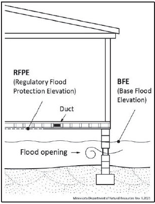
Regulatory flood protection elevation (RFPE) means an elevation that is one foot above the elevation of the base flood, plus any increases in the water surface elevation caused by encroachments on the floodplain that result from designation of a floodway. These increases in water surface elevations are typically identified in the floodway data tables, found in the flood insurance study.
Repetitive loss means flood-related damages sustained by a structure on two separate occasions during a ten-year period for which the cost of repairs at the time of each such flood event on the average equals or exceeds 25 percent of the market value of the structure before the damage occurred.
Stage increase means any increase in the water surface elevation during the one percent annual chance flood caused by encroachments on the floodplain.
Start of construction means includes substantial improvement, and means the date the permit was issued, provided the actual start of construction, repair, reconstruction, rehabilitation, addition placement, or other improvement was within 180 days of the permit date. The term "actual start" means either the first placement of permanent construction of a structure on a site, such as the pouring of slab or footings, the installation of piles, the construction of columns, or any work beyond the stage of excavation; or the placement of a manufactured home on a foundation. Permanent construction does not include land preparation, such as clearing, grading, and filling; nor does it include the installation of streets and/or walkways; nor does it include excavation for a basement, footings, piers, foundations, or the erection of temporary forms; nor does it include the installation on the property of accessory buildings, such as garages or sheds not occupied as dwelling units or not part of the main structure. For a substantial improvement, the term "actual start of construction" means the first alteration of any wall, ceiling, floor, or other structural part of a building, whether or not that alteration affects the external dimensions of the building.
Structure means a roofed building, including a gas or liquid storage tank, that is principally above ground, as well as a manufactured home. Recreational vehicles not considered travel ready, as detailed in section 10-1326(2), shall also be considered a structure for the purposes of this article.
Subdivision means land that has been divided for the purpose of sale, rent, or lease, including planned unit developments.
Substantial damage means damage of any origin sustained by a structure where the cost of restoring the structure to its before-damaged condition would equal or exceed 50 percent of the market value of the structure before the damage occurred.
Substantial improvement means any reconstruction, rehabilitation, addition, or other improvement of a structure, the cost of which equals or exceeds 50 percent of the market value of the structure before the start of construction of the improvement. The term "substantial improvement" includes structures that have incurred substantial damage, regardless of the actual repair work performed. The term "substantial improvement" does not, however, include either:
(1)
Any project for improvement of a structure to correct existing violations of state or local health, sanitary, or safety code specifications which have been identified by the local code enforcement official and which are the minimum necessary to ensure safe living conditions; or
(2)
Any alteration of a historic structure, provided that the alteration will not preclude the structure's continued designation as a historic structure. The term "historic structure" is defined in 44 CFR 59.1.
Variance means the same as defined in 44 CFR 59.1 and M.S.A. § 462.357, subd. 6(2).
Watercourse means a channel in which a flow of water occurs either continuously or intermittently in a definitive direction. The term "watercourse" applies to either natural or artificially constructed channels.
(Code 2015, § 10.72; Ord. No. O-2022-0912-10,§ 10.72, 9-12-2022; Ord. No. O-2023-1211-6, § 10.72, 12-11-2023)
Sec. 10-1245. - Lands to which this article applies.
This article applies to all lands within the jurisdiction of the city within the boundaries of the floodway, flood fringe and general floodplain districts.
(1)
The floodway, flood fringe or general floodplain districts are overlay districts. The standards imposed in the overlay districts are in addition to any other requirements. In case of a conflict, the more restrictive standards will apply.
(2)
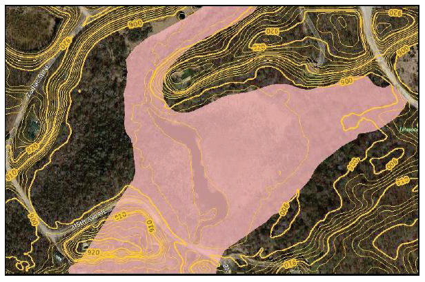
Where a conflict exists between the floodplain limits illustrated on the official floodplain maps and actual field conditions (as illustrated in Figure 1), the base flood elevation (BFE) shall be the governing factor in locating the outer boundaries of the one percent annual chance floodplain.
Figure 1. The mapped floodplain may not always align with on-the-ground countour elevations
(3)
Persons contesting the location of the district boundaries will be given a reasonable opportunity to present their case to the city council and to submit technical evidence.
(Code 2015, § 10.73(1); Ord. No. O-2022-0912-10, § 10.73(1), 9-12-2022; Ord. No. O-2023-1211-6, § 10.73(1), 12-11-2023)
Sec. 10-1246. - Incorporation of maps by reference.
(a)
The following maps, together with all attached material, are hereby adopted by reference and declared to be a part of the official zoning map and this article:
(1)
Flood insurance studies.
(2)
Flood Insurance Study for Blue Earth County and Incorporated Areas, dated February 22, 2024.
(3)
Flood Insurance Study for Nicollet County and Incorporated Areas, dated October 13, 2022.
(4)
Flood Insurance Study for Le Sueur County and Incorporated Areas, dated October 13, 2022.
(5)
Preliminary Flood Insurance Study for Le Sueur County and Incorporated Areas, dated July 14, 2022.
(6)
Flood insurance rate map panels enumerated below:
a.
Blue Earth County panel 27013C0084F, dated February 22, 2024.
b.
Blue Earth County panel 27013C0091F, dated February 22, 2024.
c.
Blue Earth County panel 27013C0092F, dated February 22, 2024.
d.
Blue Earth County panel 27013C0093F, dated February 22, 2024.
e.
Blue Earth County panel 27013C0094F, dated February 22, 2024.
f.
Blue Earth County panel 27013C0105F, dated February 22, 2024.
g.
Blue Earth County panel 27013C0110F, dated February 22, 2024.
h.
Blue Earth County panel 27013C0114F, dated February 22, 2024.
i.
Blue Earth County panel 27013C0115F, dated February 22, 2024.
j.
Blue Earth County panel 27013C0116F, dated February 22, 2024.
k.
Blue Earth County panel 27013C0117F, dated February 22, 2024.
l.
Blue Earth County panel 27013C0118F, dated February 22, 2024.
m.
Nicollet County panel 27103C0410H, dated October 13, 2022.
n.
Le Sueur County panel 27079C0360D, dated July 21, 1999.
o.
Le Sueur County preliminary panel 27079C0360E, dated July 14, 2022.
(b)
These materials are on file at the city (Intergovernmental Center, 10 Civic Center Plaza, Mankato, MN 56001) for public inspection.
(Code 2015, § 10.73(2); Ord. No. O-2022-0912-10, § 10.73(2), 9-12-2022; Ord. No. O-2023-1211-6, § 10.73(2), 12-11-2023)
Sec. 10-1247. - Districts.
(a)
Floodway district. Those areas within Zones AE delineated within floodway areas as shown on the flood insurance rate maps referenced in section 10-1246.
(b)
Flood fringe district. Those areas within Zones AE that have a delineated floodway, but are located outside of it, as shown on the flood insurance rate maps referenced in section 10-1246.
(c)
General floodplain district. Those areas within Zones AE areas that do not have a floodway delineated as shown on the flood insurance rate maps referenced in section 10-1246. This district also includes any additional area encompassed by the regulatory floodplain.
(Code 2015, § 10.73(3); Ord. No. O-2022-0912-10, § 10.73(3), 9-12-2022; Ord. No. O-2023-1211-6, § 10.73(3), 12-11-2023)
Sec. 10-1248. - Annexations.
The flood insurance rate map panels referenced in section 10-1246 may include floodplain areas which lie outside of the corporate boundaries of the city at the time of adoption of this division. If any of these floodplain land areas are annexed into the city after the date of adoption of the ordinance from which this chapter is derived, the newly annexed floodplain lands will be subject to the provisions of this article immediately upon the date of annexation. Annexations into panels not referenced in section 10-1246 require ordinance amendment in accordance with division 10 of this article.
(Code 2015, § 10.73(4); Ord. No. O-2022-0912-10, § 10.73(4), 9-12-2022; Ord. No. O-2023-1211-6, § 10.73(4), 12-11-2023)
Sec. 10-1270. - Permit required.
A permit must be obtained from the zoning administrator to verify compliance with all applicable standards outlined in this article prior to the following uses or activities:
(1)
The erection, addition, modification, rehabilitation, repair, or alteration of any building, structure, or portion thereof. Normal maintenance requires a permit to determine if such work, either separately or in conjunction with other planned work, constitutes a substantial improvement, as specified in section 10-1377(3).
(2)
The construction of a fence, pool, deck, or placement of anything that may cause a potential obstruction. Farm fences, as defined in section 10-1213, are not considered to be an obstruction and, as such, do not require a permit.
(3)
The change or expansion of a nonconforming use.
(4)
The repair of a structure that has been damaged by flood, fire, tornado, or any other source.
(5)
The placement of fill, excavation, utilities, on-site sewage treatment systems, or other service facilities.
(6)
The storage of materials or equipment, in conformance with section 10-1272(b).
(7)
Relocation or alteration of a watercourse (including stabilization projects or the construction of new or replacement dams, culverts, and bridges). A local permit is not required if a public waters work permit has been obtained from the department of natural resources unless a significant area above the ordinary high water level is also to be disturbed.
(8)
Any other type of development, as defined in section 10-1213.
(Code 2015, § 10.74(1); Ord. No. O-2022-0912-10, § 10.74(1), 9-12-2022; Ord. No. O-2023-1211-6, § 10.74(1), 12-11-2023)
Sec. 10-1271. - No permit required.
Certain uses or activities may be exempt from obtaining a permit, such as planting a garden, farming, or other obviously insignificant activities such as putting up a mailbox or flagpole. The continuation of existing uses, when the associated activities do not encroach further on the regulatory floodplain or trigger associated standards in this article, do not require a permit.
(Code 2015, § 10.74(2); Ord. No. O-2022-0912-10, § 10.74(2), 9-12-2022; Ord. No. O-2023-1211-6, § 10.74(2), 12-11-2023)
Sec. 10-1272. - Minimum development standards.
(a)
All development must:
(1)
Be designed (or modified) and adequately anchored to prevent floatation, collapse, or lateral movement resulting from hydrodynamic and hydrostatic loads, including the effects of buoyancy.
(2)
Be constructed with materials and equipment resistant to flood damage.
(3)
Be constructed by methods and practices that minimize flood damage.
(4)
Be constructed with heating, ventilation, duct work, and air conditioning equipment and other service facilities elevated at least up to the regulatory flood protection elevation (RFPE). Water, sewage, electrical, and other utility lines below the RFPE shall be constructed so as to prevent water from entering or accumulating within them during conditions of flooding.
(5)
Be reasonably safe from flooding and consistent with the need to minimize flood damage.
(6)
Be ensured to provide adequate drainage to reduce exposure to flood hazards.
(7)
Not be detrimental to uses in adjoining areas; and
(8)
Not adversely affect the efficiency or restrict the flood carrying capacity of the channel and adjoining floodplain of any tributary watercourse or drainage system.
(b)
Materials that, in time of flooding, are buoyant, flammable, explosive, or could be injurious to human, animal, or plant life shall be stored at or above the regulatory flood protection elevation (RFPE), floodproofed, or protected by other measures as approved by the zoning administrator. Storage of materials likely to cause pollution of the waters, such as sewage; sand; rock; wrecked and discarded equipment; dredged spoil; municipal, agricultural, or industrial waste; and other wastes, as further defined in M.S.A. § 115.01, are prohibited unless adequate safeguards approved by the state pollution control agency are provided. For projects not requiring approvals by the state pollution control agency, adequate safeguards must be approved by the zoning administrator prior to issuance of a permit.
(c)
Critical facilities are to be located so that the lowest floor is not less than two feet above the base flood elevation (BFE), or the 0.2 percent annual chance flood elevation, whichever is higher.
Table 1. Summary of Permitting Requirements for Structures
1 Note: Many of these standards are cross-referenced to avoid duplication.
(Code 2015, § 10.74(3); Ord. No. O-2022-0912-10, § 10.74(3), 9-12-2022; Ord. No. O-2023-1211-6, § 10.74(3), 12-11-2023)
Sec. 10-1273. - Floodway district.
(a)
Permitted uses in floodway. Development allowed in the floodway district is limited to that which has low flood damage potential and will not obstruct flood flows, increase velocities, or increase the water surface elevations of the one percent annual chance flood. The following uses and activities may be allowed with a permit, subject to the standards in subsection (b) of this section:
(1)
Agricultural uses, recreational uses, parking lots, loading areas, airport landing strips, water control structures, navigational facilities, as well as public open space uses.
(2)
Roads, driveways, railroads, trails, bridges, and culverts.
(3)
Public utility facilities and water-oriented industries which must be in or adjacent to watercourses.
(4)
Grading, filling, land alterations, and shoreline stabilization projects.
(5)
No structures, as defined in section 10-1213, are allowed in the floodway district, except structures accessory to the uses detailed in subsections (a)(1) and (c)(1) of this section, which require a CUP under subsection (c)(2) of this section.
(6)
Levees or dikes intended to protect agricultural crops, provided the top of the dike does not exceed the ten percent annual chance flood event.
(b)
Standards for permitted uses in floodway. In addition to the applicable standards detailed in this division:
(1)
The applicant must demonstrate that the development will not result in any of the following during the one percent chance flood: cause a stage increase of zero feet or greater, obstruct flood flows, or increase velocities. This shall be demonstrated through hydrologic and hydraulic analysis performed by a professional engineer, or using other standard engineering practices (e.g., projects that restore the site to the previous cross sectional area). This is commonly documented through a no-rise certification.
(2)
Any development that would result in a stage increases greater than zero feet may only be allowed with a permit if the applicant has applied for and received approval for a conditional letter of map revision (CLOMR) in accordance with 44 CFR 65.12. Map revisions must follow the procedures in division 10 of this article.
(3)
Any development resulting in decreases to the water surface elevation of the base flood identified in the flood insurance study requires a letter of map revision (LOMR) following the procedures in division 10 of this article.
(4)
Any development in the beds of public waters that will change the course, current or cross section is required to obtain a public waters work permit in accordance with M.S.A. § 103G.245 or a utility crossing license in accordance with M.S.A. § 84.415, from the department of natural resources, or demonstrate that no permit is required, before applying for a local permit.
(5)
Any facility used by employees, or the general public must be designed with a flood warning system acceptable to the zoning administrator that provides adequate time for evacuation or be designed to ensure that within the area inundated during the base flood event, the depth (in feet) multiplied by the velocity (in feet per second) is less than four.
(6)
Fill and other land alteration activities must offer minimal obstruction to the flow of floodwaters and be protected from erosion and sediment entering surface waters by the use of vegetative cover, riprap or other methods as soon as possible.
(c)
Conditional uses in floodway. The following uses and activities may be permitted as conditional uses, subject to the standards detailed in subsection (d) of this section and section 10-1353:
(1)
Commercial extractive uses, and storage and stockpiling yards.
(2)
Structures accessory to uses detailed in subsections (a)(1) and (c)(1) of this section.
(d)
Standards for conditional uses in floodway. In addition to the applicable standards detailed in subsection (b) of this section and section 10-1353:
(1)
Extractive uses and storage of materials require the completion of a site development and restoration plan, to be approved by the city.
(2)
Accessory structures. Structures accessory to the uses detailed in subsections (a)(1) and (c)(1) of this section must be constructed and placed so as to offer a minimal obstruction to the flow of floodwaters and are subject to the standards in subsection (b)(3) of this section.
(Code 2015, § 10.74(4); Ord. No. O-2022-0912-10, § 10.74(4), 9-12-2022; Ord. No. O-2023-1211-6, § 10.74(4), 12-11-2023)
Sec. 10-1274. - Flood fringe district.
(a)
Permitted uses in flood fringe. Any uses or activities allowed in any applicable underlying zoning districts may be allowed with a permit, subject to the standards set forth in subsection (b) of this section.
(b)
Standards for permitted uses in flood fringe. In addition to the applicable standards detailed in section 10-1276:
(1)
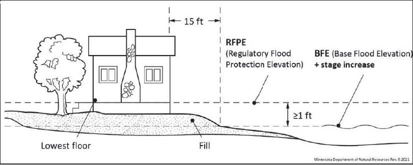
Residential structures. Elevation on-fill. All structures to be erected, constructed, reconstructed, altered, or moved on fill within the flood fringe district shall be placed so that the lowest floor, as defined in section 10-1213, is elevated at or above the regulatory flood protection elevation (RFPE). The finished fill elevation shall be at or above the elevation associated with the base flood, plus any stage increases that result from designation of a floodway. Fill must extend at the same elevation at least 15 feet beyond the outside limits of the structure. Elevations must be certified by a registered professional engineer, land surveyor or other qualified person designated by the zoning administrator. Elevation methods alternative to these fill standards are subject to a conditional use permit, as provided in subsection (c)(1) of this section (Figure 3).
Figure 3. Overview of fill standards for residential structures
(2)
Nonresidential principal structures. Nonresidential principal structures must meet one of the following construction methods:
a.
Elevation on fill. Structures may be elevated on fill, meeting the standards in subsection (b)(1)a of this section. Fill for nonresidential structures is not required to be extended 15 feet beyond the outside limits of the structure.
b.
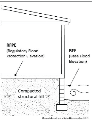
Alternative elevation methods. Structures may have their lowest floor elevated above the regulatory flood protection elevation (RFPE) using methods alternative to the fill standards in subsection (b)(1)a of this section. Such methods include the use of blocks, pilings (Figure 4), filled stem walls (Figure 5), or internally flooded enclosed areas (Figure 6) such as crawl spaces, attached garages, or tuck under garages.
Figure 4. Blocks or pilings
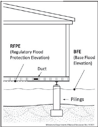
Figure 5. Filled stem wall
Internally flooded enclosed area
Designs accommodating for internally flooded enclosed areas must be certified by a registered professional engineer or architect, or meet or exceed the standards detailed in FEMA Technical Bulletin 1, as amended, as well as the following standards:
1.
The floor of the enclosed area must be at or above the exterior grade on at least one side of the structure.
2.
To allow for the equalization of hydrostatic pressure, there shall be a minimum of two openings below the base flood elevation on at least two sides of the structure. The bottom of all openings shall be no higher than one foot above grade. The openings shall have a minimum net area of not less than one square inch for every square foot of enclosed area subject to flooding, have a net area of not less than one square inch for every square foot of enclosed area subject to flooding, and shall allow automatic entry and exit of floodwaters without human intervention.
3.
Internally flooded enclosed areas shall only be used for the parking of vehicles, building access, or storage. Bathrooms and toilet rooms shall not be allowed. Such areas shall be subject to a deed-restricted non-conversion agreement as well as periodic inspections with the issuance of any permit.
c.
Dry floodproofing. Structures having watertight enclosed basements or spaces below the regulatory flood protection elevation (RFPE) must meet the following standards:
1.
Walls must be substantially impermeable to the passage of water, with structural components having the capacity of resisting hydrostatic and hydrodynamic loads and effects of buoyancy, at least up to the regulatory flood protection elevation (RFPE); and
2.
Must meet the standards of FEMA Technical Bulletin 3, as amended; and
3.
A registered professional engineer or architect shall be required to certify that the design and methods of construction meet the standards detailed in this section.
(3)
Accessory structures. All accessory structures must meet the following standards:
a.
Structures shall not be designed or used for human habitation.
b.
Structures will have a low flood damage potential.
c.
Structures with fewer than two rigid walls, such as carports, gazebos, and picnic pavilions, may be located at an elevation below the regulatory flood protection elevation.
d.
Structures with two or more rigid walls, must meet one of the following construction methods:
1.
Wet floodproofing. Structures may be floodproofed in a way to accommodate internal flooding. Such structures shall constitute a minimal investment not to exceed 576 square feet in size, one story in height, and shall only be used for parking and storage. To allow for the equalization of hydrostatic pressure, there shall be a minimum of two openings on at least two sides of the structure and the bottom of all openings shall be no higher than one foot above grade. The openings shall have a minimum net area of not less than one square inch for every square foot of enclosed area subject to flooding and shall allow automatic entry and exit of floodwaters without human intervention.
2.
Elevation on fill. Structures may be elevated on fill, meeting the standards in subsection (b)(1)a of this section. Fill is not required to be extended 15 feet beyond the outside limits of the structure.
3.
Alternative elevation methods. Structures may have their lowest floor elevated above the regulatory flood protection elevation (RFPE) through methods alternative to the fill standards in subsection (b)(3)d.2 of this section, meeting the standards in subsection (b)(2)b of this section.
4.
Dry floodproofing. Structures may be dry-floodproofed, or watertight, meeting the standards in subsection (b)(2)c of this section.
(4)
Fill. The cumulative placement of fill or other materials for any purpose, up to 1,000 cubic yards, is permitted. Additional fill over 1,000 cubic yards is only permitted if the fill is specifically intended to elevate a structure in accordance with subsection (b)(1) and (2)a of this section, or for a transportation project in accordance with section 10-1296. Fill over 1,000 cubic yards for the purposes other than these purposes requires a conditional use permit as provided in subsection (c)(2) of this section. Materials must be protected from erosion, discharge, and sediment entering surface waters by the use of vegetative cover or other methods as soon as possible.
(5)
Access to the public right-of-way. All new principal structures must provide for vehicular access to the public right-of-way no lower than the base flood elevation (BFE).
(6)
Flood warning system. Any facilities used by employees, or the general public must be designed with a flood warning system acceptable to the city that provides adequate time for evacuation or be designed to ensure that within the area inundated during the base flood event, the depth (in feet) multiplied by the velocity (in feet per second) is less than four.
(7)
Manufactured homes and recreational vehicles. Manufactured homes and recreational vehicles must meet the standards of division 6 of this article.
(c)
Conditional uses in flood fringe. The following uses and activities may be permitted as conditional uses, subject to the standards in subsection (d) of this section and section 10-1353:
(1)
Alternative elevation methods-residential structures. Residential structures with their lowest floor elevated above the regulatory flood protection elevation (RFPE) using methods alternative to the fill requirements in subsection (b)(1) of this section.
(2)
Fill. The cumulative placement of more than 1,000 cubic yards of fill or other materials, when the fill is not being used to elevate a structure or for a transportation project.
(d)
Standards for conditional uses in flood fringe. In addition to the applicable standards detailed in subsection (b) of this section, section 10-1276 and section 10-1353:
(1)
All residential structures with lowest floors elevated through alternative elevation methods must meet the standards for nonresidential structures in subsection (b)(2)b of this section.
(2)
The placement of more than 1,000 cubic yards of fill or other materials (other than for the purpose of elevating a structure or for a transportation project) must comply with a site development and restoration plan approved by the zoning administrator. The plan must detail the anticipated topographic alterations and identify actions to be taken to mitigate environmental impacts, particularly erosion.
(Code 2015, § 10.74(5); Ord. No. O-2022-0912-10, § 10.74(5), 9-12-2022; Ord. No. O-2023-1211-6, § 10.74(5), 12-11-2023)
Sec. 10-1275. - General floodplain district.
(a)
Permitted uses.
(1)
Until the floodway is delineated, allowable uses will be restricted to those listed in the floodway district, section 10-1273.
(2)
All other uses are subject to a floodway/flood fringe determination as provided in section 10-1275(d) in addition to the standards provided in this section. Permitted uses shall be determined as follows:
a.
If the development is determined to be in the floodway district, section 10-1273 applies.
b.
If the development is determined to be in the flood fringe district, section 10-1274 applies.
(b)
Standards for determining flood elevations.
(1)
All development requires a determination of the base flood elevation (BFE). Exceptions to this requirement include projects that restore the site to the previous cross sectional area, such as shore stabilization or culvert replacement projects. Base flood elevations (BFE) may be found using best available data from any federal, state, or other source (including MNDNR's lake and flood elevations online (LFEO) viewer).
(2)
The regulatory flood protection elevation (RFPE) can be determined by assuming a one-half-foot stage increase to accommodate for future cumulative impacts. A stage increase does not need to be assumed along lakes, wetlands, and other basins that are not affected by velocities.
(c)
Encroachment analysis.
(1)
Encroachments due to development may not allow stage increases more than one-half foot at any point, unless through a map revision following the procedures in division 10 of this article. This evaluation must include the cumulative effects of previous encroachments and must be documented with hydrologic and hydraulic analysis performed by a professional engineer or using other standard engineering practices. A lesser water surface elevation increase of than one-half foot is required if, due to the water surface level increase, increased flood damages would potentially result.
(2)
Alterations or changes that result in stage decreases are allowed and encouraged.
(d)
Standards for the analysis of floodway boundaries.
(1)
Requirements for detailed studies. Any development, as requested by the zoning administrator, shall be subject to a detailed study to determine the regulatory flood protection elevation (RFPE) and the limits of the floodway district. This determination must be consistent with the minimum standards for hydrologic and hydraulic mapping standards and techniques, as detailed in Minn. R. pt. 6120.5600, subpt. 4 and FEMA Guidelines and Standards for Flood Risk Analysis and Mapping, as revised. Additionally:
a.
A regulatory floodway necessary to carry the discharge of the one percent annual chance flood must be selected without increasing the water surface elevation more than one-half foot at any point. This determination should include the cumulative effects of previous encroachments. A lesser water surface elevation increase than one-half foot is required if, due to the water surface level increase, increased flood damages would potentially result; and
b.
An equal degree of encroachment on both sides of the stream within the reach must be assumed in computing floodway boundaries, unless topography, existing development patterns, and comprehensive land use plans justify a modified approach, as approved by the department of natural resources.
(2)
Other acceptable methods. For areas where a detailed study is not available or required: Development prohibited in floodways (e.g., most buildings) requires a floodway/flood fringe determination to verify the development is within the flood fringe. This determination must be done by a professional engineer or utilize other accepted engineering practices. The department of natural resources may also provide technical assistance and must approve any alternative methods used to determine floodway boundaries.
(Code 2015, § 10.74(6); Ord. No. O-2022-0912-10, § 10.74(6), 9-12-2022; Ord. No. O-2023-1211-6, § 10.74(6), 12-11-2023)
Sec. 10-1276. - Subdivision standards.
All subdivided land must meet the following requirements. Manufactured home parks and recreational vehicle parks or campgrounds are considered subdivisions under this article.
(1)
All lots within floodplain districts must be suitable for a building site outside of the floodway district.
(2)
Subdivision of lands within the floodplain districts may not be approved if the cost of providing governmental services would impose an unreasonable economic burden on the city.
(3)
All subdivisions must have vehicular access both to the subdivision and to the individual building sites no lower than two feet below the regulatory flood protection elevation (RFPE) unless a flood warning/emergency evacuation plan has been approved by the city.
(4)
The floodway and flood fringe district boundaries, the regulatory flood protection elevation (RFPE) and the required elevation of all access roads must be clearly identified on all required subdivision drawings and platting documents.
(Code 2015, § 10.74(7); Ord. No. O-2022-0912-10, § 10.74(7), 9-12-2022; Ord. No. O-2023-1211-6, § 10.74(7), 12-11-2023)
Sec. 10-1296. - Public transportation facilities.
Railroad tracks, roads, and bridges must be elevated to the regulatory flood protection elevation (RFPE) where such facilities are essential to the orderly functioning of the area, or where failure or interruption would result in danger to public health or safety. Minor or auxiliary roads or railroads may be constructed at a lower elevation where failure or interruption of transportation services would not endanger the public health or safety. All public transportation facilities should be designed to minimize increases in flood elevations.
(Code 2015, § 10.75(1); Ord. No. O-2022-0912-10, § 10.75(1), 9-12-2022; Ord. No. O-2023-1211-6, § 10.75(1), 12-11-2023)
Sec. 10-1297. - Public utilities.
All utilities such as gas, electrical, sewer, and water supply systems to be located in the floodplain must be elevated and/or floodproofed to the regulatory flood protection elevation (RFPE), be located and constructed to minimize or eliminate flood damage and be designed to eliminate infiltration of floodwaters into the systems and discharges from the systems into floodwaters. All public utilities should be designed to minimize increases in flood elevations. New solid waste management facilities, as defined in Minn. R. pt. 7035.0300, are prohibited in the one percent annual chance floodplain. Water supply systems are subject to the provisions in Minn. R. pt. 4725.4350.
(Code 2015, § 10.75(2); Ord. No. O-2022-0912-10, § 10.75(2), 9-12-2022; Ord. No. O-2023-1211-6, § 10.75(2), 12-11-2023)
Sec. 10-1298. - Private on-site water supply, individual sewage treatment systems, and other service facilities.
Private facilities shall be subject to applicable provisions detailed in section 10-1297. In addition, new or replacement on-site sewage treatment systems are to be located to avoid impairment to them or contamination from them during times of flooding, shall not be located in a designated floodway, and are subject to the provisions in Minn. R. pt. 7080.2270.
(Code 2015, § 10.75(3); Ord. No. O-2022-0912-10, § 10.75(3), 9-12-2022; Ord. No. O-2023-1211-6, § 10.75(3), 12-11-2023)
Sec. 10-1325. - Manufactured homes.
Manufactured homes and manufactured home parks are subject to applicable standards for each floodplain district. In addition:
(1)
New and replacement manufactured homes must be placed and elevated in compliance with section 10-1274 and must be securely anchored to a system that resists flotation, collapse, and lateral movement. Methods of anchoring may include, but are not limited to, use of over-the-top or frame ties to ground anchors.
(2)
New manufactured home parks and expansions to existing manufactured home parks must meet the appropriate standards for subdivisions in section 10-1276.
(Code 2015, § 10.76(1); Ord. No. O-2022-0912-10, § 10.76(1), 9-12-2022; Ord. No. O-2023-1211-6, § 10.76(1), 12-11-2023)
Sec. 10-1326. - Recreational vehicles.
New recreational vehicle parks or campgrounds and expansions to existing recreational vehicle parks or campgrounds are prohibited in any floodplain district. Recreational vehicles placed in existing recreational vehicle parks, campgrounds, or lots of record in the floodplain must either:
(1)
Meet the requirements for manufactured homes in section 10-1325; or
(2)
Be travel ready, meeting the following criteria:
a.
The vehicle must be fully licensed.
b.
The vehicle must be ready for highway use, meaning on wheels or the internal jacking system, attached to the site only by quick disconnect type utilities.
c.
No permanent structural type additions may be attached to the vehicle.
d.
Accessory structures may be permitted in the flood fringe district, provided they do not hinder the removal of the vehicle should flooding occur, and meet the standards outlined in sections 10-1272 and 10-1274(b)(3).
(Code 2015, § 10.76(2); Ord. No. O-2022-0912-10, § 10.76(2), 9-12-2022; Ord. No. O-2023-1211-6, § 10.76(2), 12-11-2023)
Sec. 10-1351. - Duties.
A zoning administrator or other official must administer and enforce this article.
(1)
Permit application requirements. Permit applications must be submitted to the zoning administrator. The permit application must include the following, as applicable:
a.
A site plan showing all existing or proposed buildings, structures, service facilities, potential obstructions, and pertinent design features having an influence on the permit.
b.
Location and detail of grading, fill, or storage of materials.
c.
Copies of any required local, state, or federal permits or approvals.
d.
Other relevant information requested by the zoning administrator as necessary to properly evaluate the permit application.
(2)
Recordkeeping. The zoning administrator must maintain applicable records, in perpetuity, documenting:
a.
All certifications for dry floodproofing and alternative elevation methods, where applicable.
b.
Analysis of no-rise in the floodway district, as detailed in section 10-1273(b)(1), and encroachment analysis ensuring no more than one-half foot of rise in the general floodplain district, as detailed in section 10-1275(b)(2) and (c)(1).
c.
Final elevations, as applicable, detailing the elevation to which structures and improvements to structures are constructed or floodproofed. Elevations shall be determined by an engineer, architect, surveyor, or other qualified individual, as approved by the zoning administrator.
d.
Substantial damage and substantial improvement determinations, as detailed in section 10-1377(3), including the cost of improvements, repairs, and market value.
e.
All variance actions, including justification for their issuance, and must report such variances as requested by the Federal Emergency Management Agency.
(3)
Certificate of zoning compliance for a new, altered, or nonconforming use. No building, land or structure may be occupied or used in any manner until a certificate of zoning compliance has been issued by the zoning administrator stating that the finished fill and building floor elevations or other flood protection measures are in compliance with the requirements of this article.
(4)
Notifications for watercourse alterations. Before authorizing any alteration or relocation of a river or stream, the zoning administrator must notify adjacent communities. If the applicant has applied for a permit to work in public waters in accordance with M.S.A. § 103G.245, this will suffice as adequate notice. A copy of the notification must also be submitted to FEMA.
(5)
Notification to FEMA when physical changes increase or decrease base flood elevations. Where physical changes affecting flooding conditions may increase or decrease the water surface elevation of the base flood, the city must notify FEMA of the changes in order to obtain a letter of map revision (LOMR), by submitting a copy of the relevant technical or scientific data as soon as practicable, but no later than six months after the date such supporting information becomes available. Within the general floodplain district, a map revision is only required if development results in stage increases greater than 0.5 feet.
(Code 2015, § 10.77(1); Ord. No. O-2022-0912-10, § 10.77(1), 9-12-2022; Ord. No. O-2023-1211-6, § 10.77(1), 12-11-2023)
Sec. 10-1352. - Variances.
(a)
Variance applications. An application for a variance to the provisions of this article will be processed and reviewed in accordance with M.S.A. § 462.357, subd. 6(2) and this article.
(b)
Adherence to state floodplain management standards. Variances must be consistent with the general purpose of these standards and the intent of applicable provisions in state and federal law. Though variances may be used to modify permissible methods of flood protection, no variance shall permit a lesser degree of flood protection than the regulatory flood protection elevation (RFPE).
(c)
Additional variance criteria. The following additional variance criteria of the Federal Emergency Management Agency must be satisfied:
(1)
Variances must not be issued by a community within any designated regulatory floodway if any increase in flood levels during the base flood discharge would result.
(2)
Variances may only be issued by a community upon:
a.
A showing of good and sufficient cause; and
b.
A determination that failure to grant the variance would result in exceptional hardship to the applicant; and
c.
A determination that the granting of a variance will not result in increased flood heights, additional threats to public safety, extraordinary public expense, create nuisances, cause fraud on or victimization of the public, or conflict with existing local laws or ordinances.
(3)
Variances may only be issued upon a determination that the variance is the minimum necessary, considering the flood hazard, to afford relief.
(d)
Flood insurance notice. The zoning administrator must notify the applicant for a variance in writing that:
(1)
The issuance of a variance to construct a structure below the base flood level will result in increased premium rates for flood insurance up to amounts as high as $25.00 for $100.00 of insurance coverage; and
(2)
Such construction below the base flood level increases risks to life and property. Such notification must be maintained with a record of all variance actions.
(e)
Considerations for approval. The community may consider the following factors in granting variances and imposing conditions on variances and conditional uses in floodplain districts:
(1)
The potential danger to life and property due to increased flood heights or velocities caused by encroachments.
(2)
The danger that materials may be swept onto other lands or downstream to the injury of others.
(3)
The safety of access to the property in times of flood for ordinary and emergency vehicles.
(f)
Conditions of approval. The city may attach such conditions to the granting of variances and conditional use permits as it deems necessary to fulfill the purposes of this article. Such conditions may include, but are not limited to, the following:
(1)
Limitations on period of use, occupancy, and operation.
(2)
Imposition of operational controls, sureties, and deed restrictions.
(3)
The prevention of soil erosion or other possible pollution of public waters, both during and after construction.
(4)
Other conditions as deemed appropriate by the zoning administrator and the city council.
(Code 2015, § 10.77(2); Ord. No. O-2022-0912-10, § 10.77(2), 9-12-2022; Ord. No. O-2023-1211-6, § 10.77(2), 12-11-2023)
Sec. 10-1353. - Conditional uses.
(a)
Administrative review. An application for a conditional use permit will be processed and reviewed in accordance with the provisions in this article.
(b)
Considerations for approval. In passing upon conditional use applications, the city must consider all relevant factors specified in other sections of this article, including those detailed in section 10-1352(e).
(c)
Conditions of approval. In addition to the standards identified in sections 10-1273(d) and 10-1274(d), the city may attach such conditions to the granting of conditional use permits as it deems necessary to fulfill the purposes of this article, including those detailed in section 10-1352(f).
(Code 2015, § 10.77(3); Ord. No. O-2022-0912-10, § 10.77(3), 9-12-2022; Ord. No. O-2023-1211-6, § 10.77(3), 12-11-2023)
Sec. 10-1354. - Notifications to the department of natural resources.
(a)
All notices of public hearings to consider variances or conditional uses under this ordinance must be sent via electronic mail to the department of natural resources respective area hydrologist at least ten days before the hearings. Notices of hearings to consider subdivisions/plats must include copies of the subdivision/plat.
(b)
A copy of all decisions granting variances and conditional uses under this ordinance must be sent via electronic mail to the department of natural resources respective area hydrologist within ten days of final action.
(Code 2015, § 10.77(3); Ord. No. O-2022-0912-10, § 10.77(3), 9-12-2022; Ord. No. O-2023-1211-6, § 10.77(3), 12-11-2023)
Sec. 10-1377. - Continuance of nonconformities.
A use, structure, or occupancy of land which was lawful before the passage or amendment of the ordinance from which this chapter is derived, but which is not in conformity with the provisions of this division, may be continued subject to the following conditions:
(1)
Within the floodway and general floodplain districts (when a site has been determined to be located in the floodway following the procedures in section 10-1275(d), or when the floodway has not been delineated), expansion or enlargement of uses or structures is prohibited.
(2)
Within all districts, any addition, modification, rehabilitation, repair, or alteration shall be in conformance with the provisions of this chapter, shall not increase the flood damage potential or increase the degree of obstruction to flood flows, and where applicable, must be protected to the regulatory flood protection elevation (RFPE).
(3)
If any nonconforming structure is determined to be substantially damaged or substantially improved based on the procedures in section 10-1378, it may not be reconstructed except in conformity with the provisions of this chapter.
(4)
If any nonconforming use, or any use of a nonconforming structure, is discontinued for more than one year, any future use of the premises must conform to this article.
(5)
If any nonconforming structure has utilities, electrical, or mechanical equipment damaged due to flooding, it must be rebuilt in conformance with the elevation requirements in section 10-1272(a)(4) to the greatest extent practicable. This requirement shall apply regardless of the determinations made in section 10-1378.
(Code 2015, § 10.78(1); Ord. No. O-2022-0912-10, § 10.78(1), 9-12-2022; Ord. No. O-2023-1211-6, § 10.78(1), 12-11-2023)
Sec. 10-1378. - Substantial improvement and substantial damage determinations.
Prior to issuing any permits for additions, modifications, rehabilitations, repairs, alterations, or maintenance to nonconforming structures, the zoning administrator is required to determine if such work constitutes substantial improvement or repair of a substantially damaged structure. A determination must be made in accordance with the following procedures:
(1)
Estimate the market value of the structure. In cases where the property has sustained damage, the market value of the structure shall be the market value before the damage occurred and before any restoration or repairs are made.
(2)
Estimate the cost of the project. The property owner shall accommodate for inspection, and furnish other documentation needed by the zoning administrator to evaluate costs.
a.
Improvement costs shall be comprised of the market rate of all materials and labor, as well as the costs of all ordinary maintenance and upkeep carried out over the past one year.
b.
Costs to restore damages shall be comprised of the market rate of all materials and labor required to restore a building to its pre-damaged condition regardless of the work proposed, as well as associated improvement costs if structure is being restored beyond its pre-damaged condition.
(3)
Compare the cost of the project and/or repairs to the estimated market value of the structure and determine whether the proposed work constitutes substantial improvement or repair of a substantially damaged structure, as defined in section 10-1213.
a.
For the purposes of determining whether the proposed work would constitute substantial improvement, the evaluation shall also include all rehabilitations, additions, or other improvements completed since the community has adopted floodplain standards impacting this structure.
b.
If any nonconforming structure experiences a repetitive loss, as defined in section 10-1213, it shall be considered substantially damaged and must not be reconstructed except in conformity with the provisions of this chapter.
(4)
Based on this determination, the zoning administrator shall prepare a determination letter and notify the property owner accordingly. Structures determined to be substantially damaged or substantially improved may not be reconstructed except in conformity with the provisions of this article.
(Code 2015, § 10.78(2); Ord. No. O-2022-0912-10, § 10.78(2), 9-12-2022; Ord. No. O-2023-1211-6, § 10.78(2), 12-11-2023)
Sec. 10-1410. - Uses in violation.
Every structure, fill, deposit, or other use placed or maintained in the floodplain in violation of this article shall be considered a public nuisance.
(Code 2015, § 10.79(1); Ord. No. O-2022-0912-10, § 10.79(1), 9-12-2022; Ord. No. O-2023-1211-6, § 10.79(1), 12-11-2023)
Sec. 10-1411. - Civil remedies.
The creation of a public nuisance may be enjoined and the maintenance of a public nuisance under this article may be abated by an action brought by the city or the department of natural resources.
(Code 2015, § 10.79(2); Ord. No. O-2022-0912-10, § 10.79(2), 9-12-2022; Ord. No. O-2023-1211-6, § 10.79(2), 12-11-2023)
Sec. 10-1412. - Enforcement.
Violations of the provisions of this article constitute a misdemeanor and are punishable as defined by law. The zoning administrator may utilize the full array of enforcement actions available to it, including, but not limited to, prosecution and fines, injunctions, after-the-fact permits, orders for corrective measures or a request to the National Flood Insurance Program for denial of flood insurance. The city must act in good faith to enforce these official controls and to correct ordinance violations to the extent possible so as not to jeopardize its eligibility in the National Flood Insurance Program.
(Code 2015, § 10.79(3); Ord. No. O-2022-0912-10, § 10.79(3), 9-12-2022; Ord. No. O-2023-1211-6, § 10.79(3), 12-11-2023)
Sec. 10-1433. - FEMA floodplain map revisions and new map annexations.
Any revisions to the floodplain maps by the Federal Emergency Management Agency or annexations of new map panels require an article amendment to update the map references in section 10-1246.
(Code 2015, § 10.80(1); Ord. No. O-2022-0912-10, § 10.80(1), 9-12-2022; Ord. No. O-2023-1211-6, § 10.80(1), 12-11-2023)
Sec. 10-1434. - Required approval.
All amendments to this article must be submitted to the department of natural resources for review and approval prior to adoption, for compliance with state and federal rules and requirements. The floodplain article shall not be considered valid until approved.
(Code 2015, § 10.80(2); Ord. No. O-2022-0912-10, § 10.80(2), 9-12-2022; Ord. No. O-2023-1211-6, § 10.80(2), 12-11-2023)