
Mantua City Zoning Code
11.8 Subdivisions
11.8.1 General
11.8.1.1 Purpose
The purpose of this Chapter is to comply with Utah Code (notably §10-9a-6), establish an efficient method for reviewing subdivision applications, and promote the health and general welfare of the Town’s current and future residents by standardizing subdivision design and improvements.
11.8.1.2 Scope Of Applicability
This Chapter applies to all applications or petitions to subdivide land in the Town, regardless of the intended use (commercial, residential, etc.). The requirements of this Chapter do not apply retroactively to subdivision applications or petitions that were approved by the Town prior to the enactment of this ordinance.
11.8.1.3 Interpretation And Conflict Of Laws
Where any provision in this Chapter conflicts with state law, state law shall prevail. Where any provision in this Chapter conflicts with other ordinances enacted by the Town, the provisions in this Chapter shall prevail unless the Town intended such conflicting ordinances not in this Chapter to amend this Chapter.
11.8.1.4 Approved And Recorded Documents Required
- No land shall be subdivided which is located wholly or in part in the Town, except in compliance with this Chapter and Utah Code as adopted and amended.
- A subdivision of land is not valid unless its governing document is approved by the Land Use Authority and properly recorded in the County Recorder’s Office.
- Before the subdivision plat may be filed and recorded in the County Recorder’s Office and before lots may be sold, a subdivision plat shall comply with the municipality’s subdivision ordinances, other ordinances, and state law.
11.8.1.5 Penalty For Noncompliance
It is unlawful to transfer ownership of any parcel of land pursuant to an invalid subdivision. The Town may, in its discretion, void such transfers and impose on the transferor a fine of up to $10,000.
11.8.1.6 Definitions
The following words and phrases, as used throughout Town ordinances, shall have the following meanings. Definitions in a particular title, chapter, or section shall apply narrowly to only that title, chapter, or section. Words and phrases not defined in Town ordinances shall have the meaning defined in state law. Words and phrases not defined in Town ordinances or state law shall have their plain meaning in common usage:
- “Facility owner”, as used in section 11.8.2.4, means the same as that term is defined in state law and includes a canal owner or associated canal operator contact described in various sections of state law.
- "Improvement plan": a plan to complete permanent infrastructure on the subdivision that is essential for the public health and safety, that is required for human occupation, or that is required by applicable law and that an applicant must install in accordance with public installation and inspection specifications for public improvements and as a condition of recording a subdivision plat.
- "Land use authority": An individual, board, or commission appointed or employed by a municipality to make land use decisions. “Land Use Authority” includes any appropriately authorized designees.
- “Land use application”: an application required by the Town and submitted by a land use applicant to obtain a land use approval; this does not mean an application to enact, amend, or repeal a land use regulation.
- “Plat”: An instrument subdividing property into lots as depicted on a map or other graphic representation of land that a licensed professional land surveyor makes and prepares in accordance with §10-9a-603 or §57-8-13 of Utah State Code (as amended).
- “Review Cycle”, as used and further defined in section 11.8.2.5, means the occurrence of the applicant’s submittal of a complete subdivision application; the municipality’s review of that subdivision application; the municipality’s response to that subdivision application; and the applicant’s reply to the municipality’s response that addresses each of the municipality’s required modifications or requests for additional information.
- “State engineer’s inventory of canals”, as used in section 11.8.2.4, means the state engineer’s inventory of water conveyance systems established in state law.
- “Subdivision”: Any land that is divided, subdivided, or proposed to be divided into two or more lots or other division of land for the purpose, whether immediate or future, for offer, sale, lease, or development either on the installment plan or upon any and all other plans, terms, and conditions.
- Subdivision includes:
- The division or development of land, whether by deed, metes and bounds description, devise and testacy, map, plat, or other recorded instrument, regardless of whether the division includes all or a portion of a parcel or lot; and
- Except as provided below, divisions of land for residential and nonresidential uses, including land used or to be used for commercial, agricultural, and industrial purposes.
- Subdivision does not include:
- A bona fide division or partition of agricultural land for the purpose of joining one of the resulting separate parcels to a contiguous parcel of unsubdivided agricultural land, if neither the resulting combined parcel nor the parcel remaining from the division or partition violates an applicable land use ordinance;
- A boundary line agreement recorded with the Office of the County Recorder between owners of adjoining parcels adjusting the mutual boundary in accordance with §10-9a-524 of Utah State Code (as amended) if no new parcel is created;
- A recorded document, executed by the owner of record revising the legal descriptions of multiple parcels into one legal description encompassing all such parcels or joining a lot to parcel;
- A boundary line agreement between owners of adjoining subdivided properties adjusting the mutual lot line boundary in accordance with §10-9a-524 and §10-9a-608 of Utah State Code (as amended) if no new dwelling lot or housing unit will result from the adjustment and the adjustment will not violate any applicable land use ordinance;
- A bona fide division of land by deed or other instrument if the deed or other instrument states in writing that the division is in anticipation of future land use approvals on the parcel or parcels does not confer any land use approvals, and has not been approved by the land use authority;
- A parcel boundary adjustment;
- A lot line adjustment;
- A joining of one or more lots to a parcel;
- A road, street, or highway dedication plat;
- A deed of easement for a road, street, or highway purpose; or
- Any other division of land authorized by law.
- “Subdivision ordinance review”, as used in section 11.8.2.5, means the review by the municipality to verify that a subdivision application meets the criteria of the municipality’s land use and subdivision application ordinances.
- “Underground facility”: means the same as that term is defined in state law.
- “Water conveyance facility”: a ditch, canal, flume, pipeline, or other watercourse used to convey water used for irrigation or storm water drainage and any related easement for the ditch, canal, flume, pipeline, or other watercourse.
11.8.1.7 Subdivision Land Use Authority
- The Land Use Authority for preliminary applications under this Chapter is the Planning Commission. For purposes of subdivision applications, the Planning Commission shall be responsible for the following, but may delegate any responsibility to Town staff:
- Rendering land use decisions related to preliminary applications.
- Reviewing preliminary applications in an impartial manner and according to the standards and deadlines described in this Chapter.
- Holding one public hearing for preliminary applications (when needed).
- Providing feedback to applicants on their preliminary applications.
- Scheduling and holding a pre-application meeting with potential applicants (when requested).
- Keeping application forms (both preliminary and final) and related informational material up to date and publicly accessible and distributing such forms and materials to potential applicants. This task is delegated to Town staff by default.
- Providing notice to entities and parties as required by this Chapter. This task is delegated to Town staff by default.
- Ensuring that documents are properly recorded with the County after final approval as required by this Chapter. This task is delegated to Town staff by default.
- The Land Use Authority for final applications under this Chapter is the Town Attorney. For purposes of subdivision applications, the Town Attorney shall be responsible for the following
- Rendering land use decisions related to final applications.
- Reviewing final applications in an impartial manner and according to the standards and deadlines described in this Chapter.
- Signing final application approvals as required by this Chapter.
- As subdivision application decisions are administrative, not legislative, the Planning Commission is authorized to make any land use decision described by this Chapter without Town Council approval.
- Except when operating as the Appeal Authority, the Town Council shall not require the Planning Commission to approve or deny any subdivision application under this Chapter.
11.8.1.8 Subdivision Appeals
- The Appeal Authority for Town decisions relating to this Chapter, except where otherwise noted, is the Town Council.
- The Appeal Authority shall hear appeals on final decisions made by the Land Use Authorities and shall hear complaints about the conduct of the Land Use Authorities in administering the provisions of this Chapter.
- A party appealing or complaining of a Land Use Authority’s decision under this Chapter must exhaust its remedies under this section (by appealing or complaining to the Appeal Authority) before bringing an action against the Town in a court of law.
- A party who has submitted a subdivision application or petition may appeal or complain to the Appeal Authority under this Chapter. In such an appeal or complaint, the party may appeal or complain only regarding the Land Use Authority’s treatment of that party’s own application; a third party may not appeal or complain of Land Use Authority decisions or conduct.
- A party desiring to appeal or complain of a Land Use Authority decision shall submit to the Appeal Authority the following in writing:
- A brief explanation of the relief the party is seeking, the reason the party submitted its application or petition, the Land Use Authority’s decision and treatment of the application or petition, and why the applicant believes the Land Use Authority misapplied the provisions of this Chapter or abused the discretion given it by this Chapter.
- The most recent version of the application or petition the party submitted.
- Any supplemental documentation or information that the Appeal Authority requests.
- All appeals and complaints must be emailed or mailed to the Town Recorder using the Recorder’s official Town address and/or email account listed on the Town website.
- After receiving a complete appeal or complaint in accordance with this Section, the Appeal Authority shall deliver a decision to the applicant, in writing, no later than 30 calendar days after the Appeal Authority receives the appeal or complaint.
HISTORY:
Version 12/1/2022 With Appendices
Ord 2024-10-17, 10/24/2024
11.8.2 Subdivision Applications
11.8.2.1 Subdivision Application Requirements
- The Town shall not approve, nor shall a party record, any plat or other creating instrument for a new subdivision unless the party has properly applied under this Chapter and received both a preliminary approval from the Planning Commission and a final approval from the Town Attorney.
- To be considered complete, a preliminary subdivision application must include at least the following elements:
- An approved land use application that describes how the property will be used after it is subdivided.
- If the intended use is permitted by right under Town ordinances, the land use application must include citations to the specific ordinance(s) that the applicant believes authorizes the intended use.
- If the intended use requires a conditional use permit or is otherwise conditioned on Town approval, the land use application must include an approved, Town-issued permit authorizing the intended use. Should an applicant seek a use permit concurrently with a related subdivision application, the subdivision application shall be considered incomplete until the use permit is issued.
- If the intended use is prohibited under Town ordinances and requires a variance, the land use application must include an approved, Town-issued variance authorizing the intended use. Should an applicant seek a variance concurrently with a related subdivision application, the subdivision application shall be considered incomplete until the variance is issued.
- A preliminary plat, unless exempt under Section 11.8.2.2, which must be accurate and must be drawn to scale, in detail, and in accordance with generally accepted surveying standards and the acceptable filing standards of the County Recorder’s Office. The preliminary plat must include:
- The proposed subdivision name, which must be distinct from any subdivision name on a plat recorded in the County Recorder's office.
- The boundaries, course, and dimensions of all proposed parcels. All parcels on the plat must comply with the lot size requirements of Section 11.8.4.2.
- The lot or unit reference; block or building reference; street or site address; street name or coordinate address; acreage or square footage for all parcels, units, or lots; and length and width of the blocks and lots intended for sale.
- Every existing right-of-way and recorded easement located within the plat for underground, water, and utility facilities.
- Any known and unrecorded water conveyance facility located, entirely or partially, within the plat.
- Whether any parcel is intended to be used as a street or for any other public use.
- Whether any parcel is reserved or proposed for dedication for a public purpose.
- If any portion of the proposed subdivision is within 300 feet of an Agriculture Protection Area, the notice language found in Utah Code §17-41-403(4).
- If any portion of the proposed subdivision is within 1,000 feet of an Industrial Protection Area, the notice language found in Utah Code §17-41-403(4).
- If any portion of the proposed subdivision is within 1,000 feet of a Critical Infrastructure Materials Protection Area, the notice language found in Utah Code §17-41-403(4).
- If any portion of the proposed subdivision is within 1,000 feet of a Mining Protection Area, the notice language found in Utah Code §17-41-403(4).
- If any portion of the proposed subdivision is within 1,000 feet of a Vested Critical Infrastructure Materials Operation (extracting, excavating, processing, or reprocessing sand, gravel, or rock aggregate where that use is not permitted by Town ordinances), the notice language found in Utah Code §10-9a-904.
- A traffic study, if one is required by an applicable UDOT Access Management Plan.
- An improvement plan, created in accordance with applicable portions of Sections 11.8.3 and 11.8.4 of this Chapter, for all public improvements proposed by the applicant or required by Town ordinances.
- In addition to the requirements in Sections 11.8.3 and 11.8.4, the improvement plan must contain an engineer’s estimate of the cost of completing the required improvements.
- Certifications, including:
- An affidavit from the applicant certifying that the submitted information is true and accurate.
- The signature of each owner of record of land described on the preliminary plat, signifying their consent to the preliminary subdivision application and their intent to dedicate portions of the preliminary plat to the public as described in the application.
- Certification that the surveyor who prepared the plat:
- Holds a license in accordance with Utah Code 58-22; and
- Either
- Has completed a survey of the property described on the plat in accordance with state requirements and has verified all measurements; or
- Has referenced a record of survey map of the existing property boundaries shown on the plat and verified the locations of the boundaries; and
- Has placed monuments as represented on the plat; and
- Has, to the extent possible, consulted with the owner or operator, or a representative designated by the owner or operator, of any existing water conveyance facility located within the proposed subdivision, or of any existing or proposed underground facility or utility facility located within the proposed subdivision, to verify the accuracy of the surveyor's depiction of the:
- Boundary, course, dimensions, and intended use of the public rights-of-way, a public or private easement, or grants of record;
- Location of the existing water conveyance facility, or the existing or proposed underground facility or utility facility; and
- Physical restrictions governing the location of the existing or proposed underground facility or utility facility.
- Certification of approval from the culinary water authority, the sanitary sewer authority, the local health department, the local fire department, and the local public safety answering point.
- An electronic copy of all plans in PDF format.
- Payment of any preliminary-application-processing fees required by the Town (see the Town’s Fee Schedule).
- To be considered complete, a final subdivision application must include the following:
- The Planning Commission’s approval of the applicant’s preliminary application, given within the last 365 calendar days.
- The approved land use application that was accepted during the preliminary application review process.
- Because an improvement plan must be submitted with either a preliminary or final application only, a resubmittal of the approved improvement plan that was accepted during the preliminary application review process is only optional. Accordingly, the approved improvement plan shall not be reviewed as part of the final application, but only as part of the preliminary application.
- A final plat. The final plat should be the version of the preliminary plat approved by the Planning Commission during the preliminary application review process, plus any other immaterial changes (e.g., formatting) necessary to comply with the recording requirements of the County Recorder’s Office.
- A completion assurance for all public improvements required by the improvement plan approved during the preliminary application review, or a statement that such improvements will be completed before development occurs on the proposed subdivision and before the applicant records the plat, as required by Section 11.8.3 of this Title.
- Certifications, including:
- A Title Report or Title Insurance Policy for the land to be subdivided verifying property ownership.
- A Tax Clearance Certificate from the state indicating that all taxes, interest, and penalties owing on the land have been paid.
- An affidavit from the applicant certifying that the submitted information is true and accurate.
- The signature of each owner of record of land described on the plat, signifying their consent to the final subdivision application and their dedication and approval of the final plat.
- Certification that the surveyor who prepared the plat:
- Holds a license in accordance with Utah Code 58-22; and
- Either
- Has completed a survey of the property described on the plat in accordance with state requirements and has verified all measurements; or
- Has referenced a record of survey map of the existing property boundaries shown on the plat and verified the locations of the boundaries; and
- Has placed monuments as represented on the plat; and
- Has, to the extent possible, consulted with the owner or operator, or a representative designated by the owner or operator, of any existing water conveyance facility located within the proposed subdivision, or of any existing or proposed underground facility or utility facility located within the proposed subdivision, to verify the accuracy of the surveyor's depiction of the:
- Boundary, course, dimensions, and intended use of the public rights-of-way, a public or private easement, or grants of record;
- Location of the existing water conveyance facility, or the existing or proposed underground facility or utility facility; and
- Physical restrictions governing the location of the existing or proposed underground facility or utility facility.
- Binding dedication documents, including:
- As applicable, formal, irrevocable offers for dedication to the public of streets, Town uses, utilities, parks, easements, and other spaces.
- If the plat is to be part of a community association, signed and binding documents conveying to the association all common areas.
- Copies, including:
- One electronic copy of the final plat in AutoCAD format (DWG or DXF), Geodatabase format (GDB), or Shapefile format (SHP), with a projection assigned to the file(s) and with the proper metadata that describes what coordinate system/projection the data is assigned to; and
- A PDF document of the final plat and all other plans and supporting documents required by this Chapter.
- Payment of any final-application-processing fees required by the Town (see the Town’s Fee Schedule).
- The Planning Commission (or Town staff, as delegated) shall produce, maintain, and make available to the public a list of the specific items that comprise complete preliminary and final applications and a breakdown of any fees due upon submission or approval of the applications.
- The Planning Commission may require, and the applicant shall provide, additional information beyond the requirements of this Section or those published by the Town relating to an applicant’s plans to ensure compliance with Town ordinances and approved standards and specifications for construction of public improvements and to protect the health and safety of Town residents.
11.8.2.2 Exceptions To Specific Application Requirements
- Agricultural Land:
- Applications to subdivide agricultural land are exempt from the preliminary and final plat requirements (but not the other application requirements) of Section 11.8.2.1 if the resulting parcels:
- Qualify as land in agricultural use under Utah Code §59-2-502;
- Meet the minimum size requirement of applicable Town land use ordinances; and
- Are not used and will not be used for any nonagricultural purpose.
- For subdivision applications for which this exception applies, an applicant may submit to the Town—in place of a plat—a record of survey map that illustrates the boundaries of the parcels.
- If the Town approves a subdivision application based on a record of survey map, the applicant shall record the map, signed by the Town, with the County Recorder’s Office. This shall be done in the same manner as is done for a plat under Sections 11.8.2.6 and 11.8.2.7.
- If a parcel resulting from a subdivision under this exception ever ceases to be used for agriculture, the subdivision shall become invalid. The Town may, in its discretion, impose the penalty in Section 11.8.1.5 and/or require a subdivision amendment before issuing a building permit.
- Minor Subdivisions:
- Applications to subdivide land are exempt from the preliminary and final plat requirements (but not the other application requirements) of Section 11.8.2.1 if the subdivision:
- Results in no more than five parcels;
- Is not traversed by the mapped lines of a proposed street (as shown in the Mantua General Plan), Town easement, or any other land required for public purposes;
- Has been approved by the culinary water authority and the sanitary sewer authority; and
- Is located in a zoned area.
- For subdivision applications for which this exception applies, an applicant may submit to the Town—in place of a plat—both:
- A record of survey map that illustrates the boundaries of the parcels; and
- A legal metes-and-bounds description that describes the parcels illustrated by the survey map.
- If the Town approves a subdivision application based on a record of survey map and metes-and-bounds description, the applicant shall record the map and description, signed by the Town, with the County Recorder’s Office. This shall be done in the same manner as is done for a plat under Sections Sections 11.8.2.6 and 11.8.2.7, except that the Town shall also provide the notice required in Utah Code §10-9a-611(1).
- Development Agreements:
- Subdivisions platted in a valid development agreement are exempt from the application requirements (Section 11.8.2.1) and review and approval requirements (Section 11.8.2.6) of this Chapter.
- Clauses in a valid development agreement with the Town superseded all conflicting requirements in this Title, except where a clause in the development agreement poses a substantial danger to the health and safety of Town residents.
11.8.2.3 Pre-Application Meeting
- A party intending to submit a subdivision application under this Chapter may request a pre-application meeting with the Planning Commission or other Town staff for the purpose of reviewing any element of the party’s proposed subdivision application (preliminary or final). The proposed application need not be complete for purposes of this meeting and may—if the party desires—be limited to a concept plan.
- If a party requests a pre-application meeting, the Town shall schedule the meeting within 15 business days after the request. The meeting shall be scheduled at the earliest convenient opportunity, and, at the option of the party requesting the meeting, shall occur within 20 business days after scheduling.
- The Planning Commission or delegated Town staff shall conduct the meeting, provide feedback on materials as requested by the party, and shall provide or have available on the Town website the following at the time of the meeting:
- Copies of applicable land use regulations,
- A complete list of standards required for the project, and
- Relevant application checklists.
11.8.2.4 Notice To Affected Entities
- Within 15 calendar days after receiving a complete subdivision application under this Chapter, Town staff shall provide written notice of the proposed subdivision to the facility owner of any known water conveyance facility located, entirely or partially, within 100 feet of the subdivision plat, as determined using information:
- From the facility owner under Utah Code §10-9a-211, using mapping-grade global positioning satellite units or digitized data from the the most recent aerial photo available to the facility owner;
- In the state engineer’s inventory of canals; or
- From a surveyor under Utah Code §10-9a-603 (6)(c).
- To give water conveyance facility owners time to provide feedback on subdivision applications, the Land Use Authority shall not approve a preliminary (or related final) subdivision application under this Chapter sooner than 20 calendar days after the applicant submits a complete application. This waiting period does not apply to revised applications the applicant may submit during the application review process.
- A water conveyance facility owner’s failure to provide comments to the Land Use Authority about a subdivision application does not affect or impair the Land Use Authority’s authority to approve the subdivision application.
11.8.2.5 Review
- The Land Use Authority shall review all subdivision applications in accordance with the requirements of this Section before approving or denying those applications.
- For both preliminary and final applications, the review process begins when an applicant submits a complete application.
- The Land Use Authority shall not review an incomplete subdivision application, except to determine whether the application is complete.
- If the Land Use Authority determines that an application is incomplete, it shall notify the applicant of the incompleteness, highlighting any insufficiencies and explaining that the application will not be reviewed until it is complete.
- For both preliminary and final applications, after the applicant submits a complete application, the Land Use Authority shall review and provide feedback to the applicant in a series of “review cycles.”
- A “review cycle” consists of the following phases:
- Phase #1: The applicant submits a complete application (or, if after the first cycle, submits a revised version of the complete application).
- Phase #2: The Land Use Authority reviews the application in detail and assesses whether the application conforms to local ordinances.
- Phase #3: The Land Use Authority responds to the applicant, citing any missing requirements or areas of noncompliance and providing a detailed list of necessary revisions to the applicant. For any required modification or addition to the application or request for more information, the Land Use Authority shall be specific and include citations to ordinances, standards, or specifications that require the modification or addition and shall provide the applicant with an index of all requested modifications or additions.
- Phase #4: The applicant revises the application, addressing each comment or requirement the Land Use Authority made. The applicant must submit both revised plans and a written explanation in response to the municipality’s review comments, identifying and explaining the applicant’s revisions and reasons for declining to make revisions, if any. If the applicant fails to respond to a comment made by the Land Use Authority in its review, the review cycle is not complete and will remain open until the applicant addresses all comments.
Table A – Review Cycles, Hearings, and Timelines by Subdivision Use Type
Use Type
Approval Stage
Max Review Phases
Max Public Hearings
Town Turnaround Deadline*
All Uses
Preliminary
4
1
30 Business Days
Final
1
0
30 Business Days
*Describes the total time (per review cycle) the Town may take to complete both Phase #2 and Phase #3.
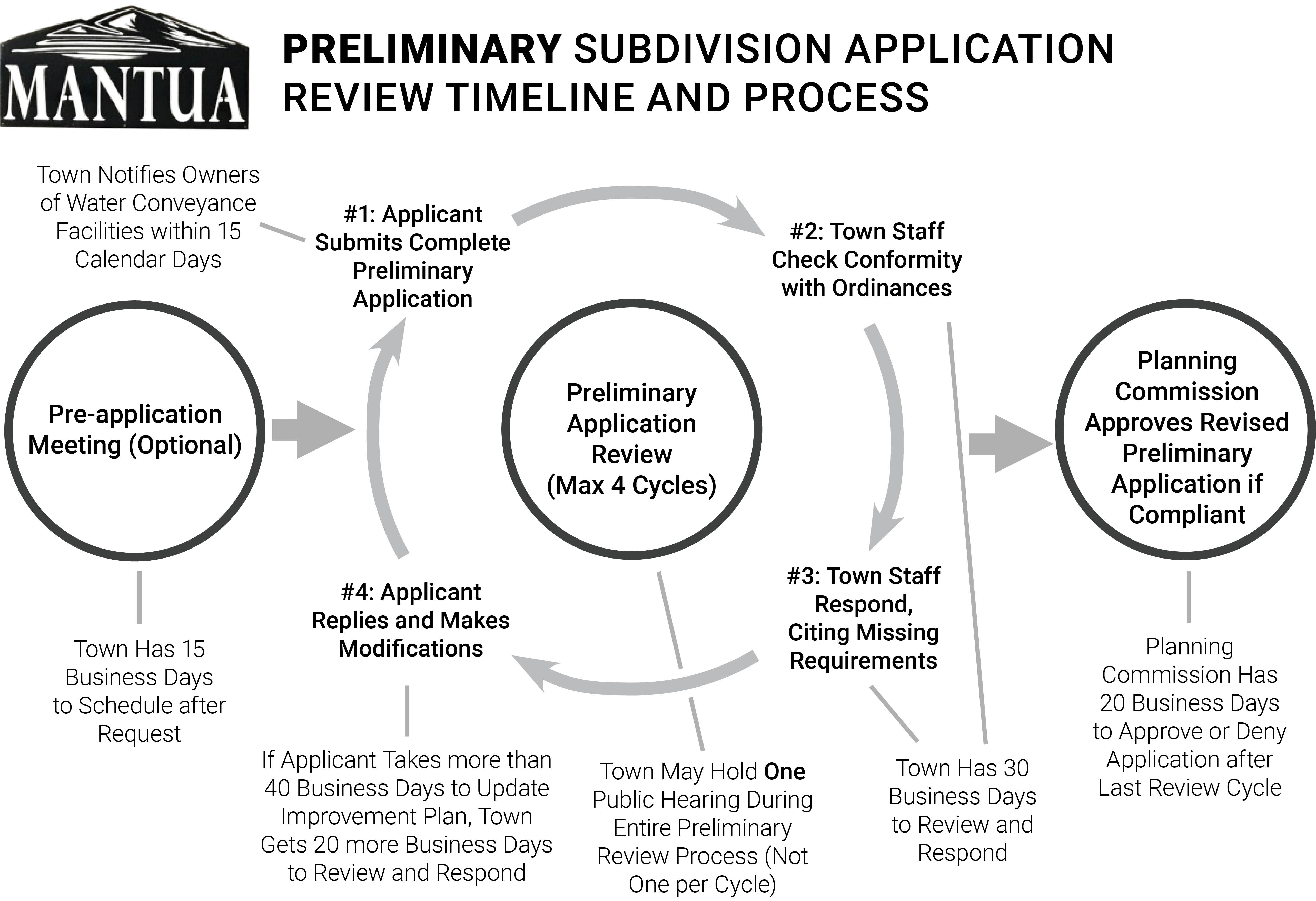
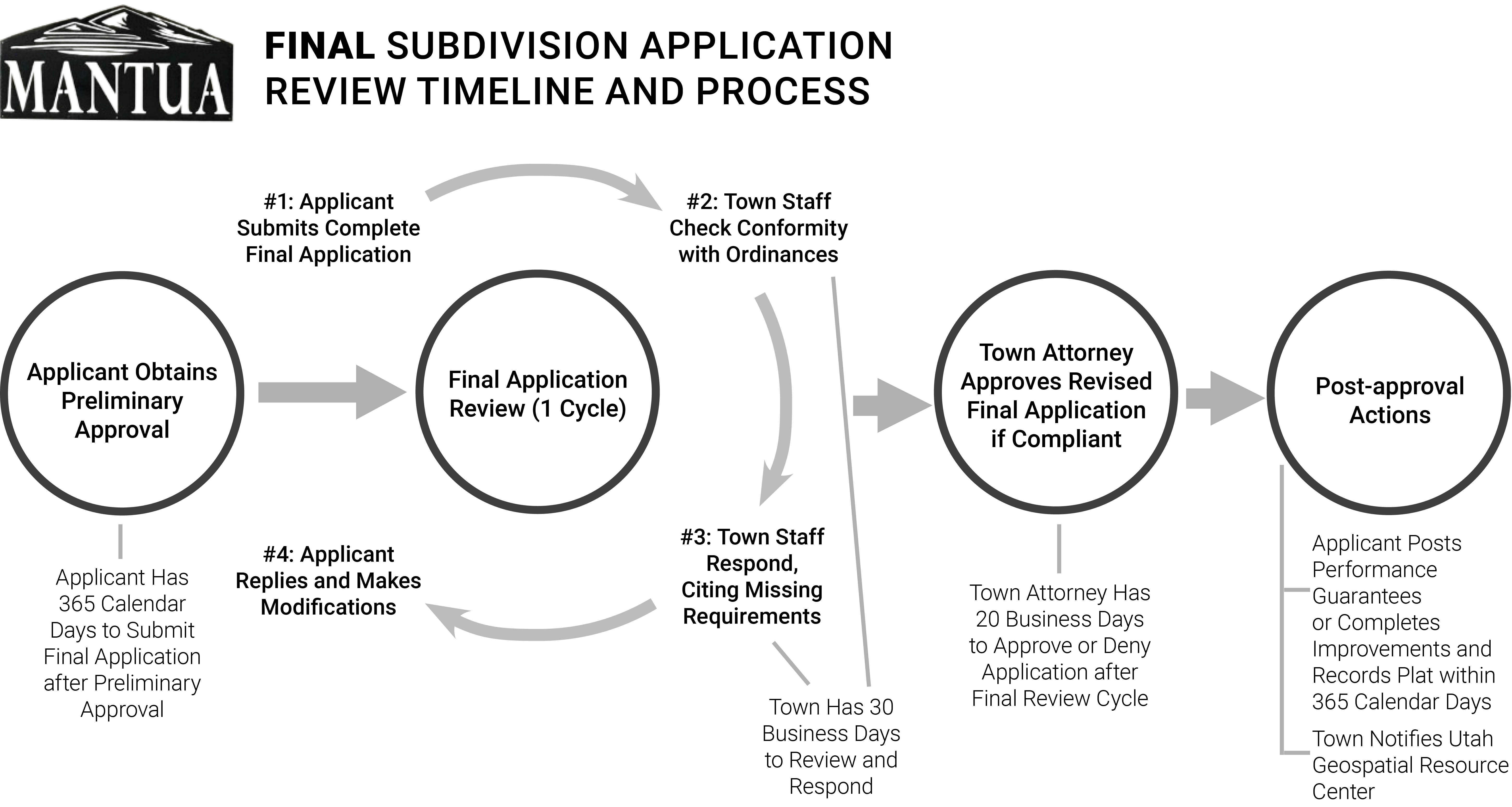
- The Land Use Authority (and other Town representatives or agents) shall adhere to the maximum number of review cycles and the review deadlines described in Table A, except as described below. If no further revisions are needed, the Land Use Authority may end the review process early and approve or deny the preliminary or final application.
- This provision notwithstanding, for any subdivision application that affects property within an identified geological hazard area, the Town is exempt from limits on the number of permitted review cycles and the Town’s deadlines for reviewing and responding (Phases #2 and #3).
- If the applicant makes a material change to a preliminary or final application not requested by the Town at any point in the review process, the Land Use Authority may restart the review process, but only with respect to the portion of the application that the material change substantively affects.
- For preliminary applications, if an applicant takes longer than 40 business days to submit a revised subdivision improvement plan responding to the Town’s requests for modifications and additions (in Phases #1 and #4), the Town shall have an additional 20 business days to review and respond to the revised application (Phases #2 and #3 of the next review cycle or issuing an approval decision).
- For both preliminary and final applications, if an applicant takes longer than 180 calendar days to submit a revised application and respond to the Town’s requests for modifications and additions (Phases #1 and #4), the application shall, at the option of the Land Use Authority, expire. If an application expires, the applicant must restart the subdivision application process.
- If the applicant has not submitted a final application within 365 calendar days after the Land Use Authority notifies the applicant that it has approved the related preliminary application, the related preliminary approval shall expire. In this case, the applicant shall not submit a final application until the Land Use Authority has issued a new preliminary application approval.
- When a preliminary or final application’s review period ends, the Land Use Authority shall approve or deny the respective preliminary or final application within 20 business days.
- If the Land Use Authority has not approved or denied the application within 20 business days after the allotted review cycles are complete, the applicant may request a decision. After such a request, the Town shall, within 10 business days:
- For a dispute arising from the subdivision improvement plans, assemble an appeal panel in accordance with Utah Code §10-9a-511(5)(d) to review and approve or deny the revised set of plans; or
- For a dispute arising from the subdivision ordinance review, advise the applicant, in writing, of the deficiency in the application and of the right to appeal the determination to the designated Appeal Authority.
- After the Land Use Authority provides comments in the last allotted review cycle for a final application, the Town shall not require further modifications or corrections to the application unless those modifications or corrections are necessary to protect public health and safety or to enforce state or federal law or unless the review cycle reset due to the applicant making a material change that the Land Use Authority did not request.
- With the exception of modifications or corrections that are needed to protect public health and safety, that are needed to enforce state or federal law, or that arise from the review cycle being reset, the municipality waives noncompliant subdivision-related requirements that the Land Use Authority does not identify during the review process.
- The applicant shall make reasonable changes, unless prohibited otherwise by a contract or deed, to the subdivision application to accommodate the water conveyance facility to the extent required by Utah Code §73-1-15.5.
- The Land Use Authority may conduct one or more public hearings (up to the number described in Table A) during the review period for a preliminary subdivision application.
- The purpose of these public hearings is to ask questions of the applicant and receive commentary on the technical aspects of the application from affected entities, interested parties, and the public.
- If the Land Use Authority elects to hold a public hearing, the hearing must occur before the end of the Land Use Authority’s preliminary review period (end of Phase #3 of the last preliminary review cycle). Scheduling issues shall not extend the review and approval deadlines in this Chapter.
- The Land Use Authority shall not hold a public hearing during the review period for a final subdivision application.
- Other chapters of this Title notwithstanding, the Land Use Authority shall approve or deny preliminary and final applications under this Chapter after reviewing the complete applications as described in this Section.
11.8.2.6 Approval
- The Land Use Authority shall approve any complete preliminary and final applications made under this Chapter that comply with applicable municipal ordinances.
- The Land Use Authority shall issue all approvals in writing and shall certify the approved final plat, either by signing the plat directly or by attaching a signed certification to the plat.
- The Land Use Authority may refuse to approve or renew any plat, subdivision plan, or dedication of any street or other ground, if deed restrictions, covenants, or similar binding agreements running with the land for the lots or parcels covered by the plat or subdivision prohibit or have the effect of prohibiting reasonably sited and designed solar panels or other energy-conservation techniques from being installed on buildings erected on lots or parcels covered by the plat or subdivision.
11.8.2.7 Post-Approval Actions
- The applicant shall record the approved final plat with the County Recorder’s Office within 365 calendar days after the Land Use Authority approves the final application, provided that the applicant has completed any improvements or posted any performance guarantee required by Town ordinances or described in the approved improvement plan. The applicant shall not record the approved final plat until such improvements are completed or guaranteed in compliance with Town ordinances and the approved improvement plan.
- An approved final plat not properly recorded within the timeline specified in this provision is void, unless the Planning Commission approves an extension.
- An approved final plat operates, when properly recorded, as the Land Use Authority’s acceptance of the dedication of any streets or public places. A properly approved and recorded final plat also vests the fee of any dedicated parcels of land in the municipality for the public for the uses named or intended in the plat.
- Town staff shall submit to the Utah Geospatial Resource Center (so the subdivision can be included in the 911 database), within 30 calendar days after the final application is approved, either:
- An electronic copy of the approved final plat; or
- Preliminary geospatial data that depict any new streets and situs addresses proposed for construction within the bounds of the approved final plat.
- If requested by the Utah Geospatial Resource Center, the Town staff shall:
- Coordinate with the Utah Geospatial Resource Center to validate the information the municipality submitted about the final plat; and
- Assist the Utah Geospatial Resource Center in creating electronic files that contain the information described in the final plat for inclusion in the unified statewide 911 emergency service database.
11.8.2.8 Amending A Subdivision
- The Town Council may vacate a subdivision or a portion of a subdivision by enacting an ordinance to that effect that describes the subdivision or the portion being vacated and recording that ordinance in the County Recorder's Office.
- A property owner or agent of a property owner may correct minor typographical or clerical errors in a document of record by filing with the County an affidavit or other appropriate instrument. This provision does not apply to changing the name of a subdivision, which requires a material amendment described in the following provisions.
- A fee owner of land in a platted subdivision may request a material subdivision amendment by filing a written petition with the Planning Commission. This petition must meet all the requirements for a preliminary subdivision application specified in Section, with the following changes:
- The preliminary plat (or the record of survey map, if applicable) should:
- Depict only the portion of the subdivision that is proposed to be amended;
- Include a plat name distinguishing the amended plat from the original plat;
- Describe the differences between the amended plat and the original plat;
- Include references to the original plat; and
- Meet all the other plat requirements specified in Section 11.8.2.1.2.b.
- The petition must additionally include the name and address of each property owner affected by the petition and the signature of each of those property owners who consents to the petition.
- The petitioner must include with the petition envelopes addresses to each property in the subdivision.
- Upon receipt of an amendment petition, the Planning Commission (or Town staff, as delegated) shall provide notice of the petition to:
- Each utility provider that services a parcel of the subdivision. The Town shall not approve an amendment petition until at least 10 calendar days after noticing these utility providers. The Town may notify the utility providers in any effective manner (email, mail, etc.).
- Each property owner in the subdivision. The Town shall notify these property owners by mail.
- The Planning Commission shall hold a public hearing before approving an amendment petition and within 45 calendar days after the day on which the petition is submitted if:
- A property owner objects in writing to the amendment within 10 days of the Town notifying the property owner by mail, or
- Not every property owner in the subdivision has signed the revised plat.
- Notwithstanding Section 11.8.2.8.6, the Planning Commission need not hold a public hearing if notice has been given to adjoining property owners in accordance with any applicable local ordinance and the petition seeks to:
- Join two or more of the petitioner’s contiguous lots;
- Subdivide one or more of the petitioner's lots;
- Adjust the lot lines of adjoining lots or between a lot and an adjoining parcel if the fee owners of each of the adjoining properties join in the petition, regardless of whether the properties are located in the same subdivision;
- On a lot owned by the petitioner, adjust an internal lot restriction imposed by the local political subdivision; or
- Alter the plat in a manner that does not change existing boundaries or other attributes of lots within the subdivision that are not owned by the petitioner or designated as a common area.
- If the Planning Commission approves the amendment petition, the Planning Commission shall sign the amended plat in the manner described in Section 11.8.2.6.2, and the petitioner shall record the plat, subject to the completion or guarantee of any improvements, as described in Section 11.8.2.7.
11.8.2.9 Lot Line Adjustments
- The fee owners of two parcels may petition to adjust the lot line separating the parcels without a subdivision amendment. Such a petition shall include:
- A record of survey map and a metes-and-bounds description showing the adjustment.
- An explanation of the reason for the adjustment.
- Signatures from all the parcel owners involved in the adjustment.
- Any other information the Planning Commission requests.
- If the adjustment will not result in a violation of a land use ordinance or an adverse development condition, the Planning Commission shall approve the petition.
- If the adjustment is approved, the Planning Commission shall sign the record of survey map and accompanying metes-and-bounds description, and the petitioner shall record the document in the County Recorder’s Office.
HISTORY:
Version 12/1/2022 With Appendices
Ord 2024-10-17, 10/24/2024
11.8.3 Subdivision Improvements
11.8.3.1 Required Improvements
The following improvements are required for all subdivisions, except those that qualify under the Agricultural Land exemption of Section 11.8.2.2.1:
- Utilities, including water, sewer, telephone, cable, gas, and electricity
- All primary buildings requiring culinary water and sanitary sewer services shall be connected to the public culinary water and sanitary sewer systems of Mantua Town.
- All utilities shall be provided underground, with the following exceptions;
- Transformers, pedestals, fire hydrants, and other appurtenances normally associated with “underground” utility installations are permitted on the surface of the ground.
- The development of existing lots in areas of the Town now served with existing above ground utilities, are exempt from this requirement.
- Where possible, underground utilities shall be located within or immediately adjacent to the disturbed areas of a lot or parcel, such as driveways and roadways.
- Generators shall not be allowed as a primary source of energy or an alternative source of energy but may be used as a temporary source of energy when the Mantua Town power system is down.
- Streets, curbs, gutters, sidewalks, and trails, and other improvements described in Section 11.8.3.
- Any other infrastructure (or infrastructure improvement) that is reasonably necessary to meet the needs of the proposed development.
11.8.3.2 Cost Of Improvements
All required improvements shall be made by the applicant/developer, at their expense, without reimbursement by the Town or any improvement district therein, and in accordance with related codes, fee schedules, and ordinances.
11.8.3.3 Completion Of Improvements
- Before a subdivision plat may be recorded, and before a building permit may be issued, all improvements required by this Chapter or other Town ordinances shall be either:
- Completed, inspected, and accepted by the Town, or
- Guaranteed according to Section 11.8.3.5.
- The decision whether to guarantee an improvement or to complete it before recording and obtaining a building permit rests solely with the applicant.
- All improvements are subject to Town inspection before such improvements may be accepted by the Town or considered complete. The Town Engineer shall be responsible for conducting such inspections. Improvements shall be accepted only if they conform to applicable Town ordinances (notably Chapter 11.04 of this Title) and do not pose a risk to public health or safety. All public improvements are subject to the warranty described in Section 11.8.3.5.
- The applicant/developer shall, in accordance with the Town’s Fee Schedule, pay to the Town an inspection fee before the Town shall accept any improvements.
- The provisions of this Chapter do not supersede the terms of a valid development agreement, an adopted phasing plan, or the state construction code.
- For subdivisions for which no performance guarantee has been posted, if the improvements are not completed within the period specified in the approved subdivision improvement plan, the approval shall be deemed to have expired. In those cases where a performance guarantee has been posted and required improvements have not been installed within the terms of such performance guarantee, the Town may thereupon declare the guarantee to be in default and require that all the improvements be installed regardless of the extent of the building development at the time the guarantee is declared to be in default.
11.8.3.4 Maintenance Of Improvements
- The applicant shall be required to maintain all improvements on the individual subdivided lots and provide for snow removal on streets and sidewalks until acceptance of said improvements by the Town Council. If there are any certificates of occupancy on a street not dedicated to the Town, the Town may on twelve (12) hours notice plow the street or effect emergency repairs and charge the same to the applicant. The Town will not normally accept water improvements or street improvements or assume responsibility for either general maintenance or snow removal until over fifty percent (50%) of the lots within the subdivision are built upon.
- The applicant/developer shall be required to file a maintenance guarantee with the Town, prior to acceptance, in an amount considered adequate by the Town Engineer in order to assure the satisfactory condition of the required improvements, including all lot improvements on the individual subdivided lots for a period of one (1) year after the date of their acceptance by the Town and dedication of same.
11.8.3.5 Improvement Guarantees, Completion Assurances, And Warranties
- If an applicant elects to guarantee any required improvement, the applicant shall provide completion assurance for 110% of the cost of the improvement, guaranteeing that the improvements will be completed within two years after the date of the guarantee.
- For the purpose of posting an improvement guarantee, the cost of the improvement shall be determined by an engineer's estimate or licensed contractor's bid.
- The Town shall accept any of the following forms of guarantee for an improvement:
- Escrow. The applicant may make a deposit in escrow with an escrow holder approved by the Town Council, under an escrow agreement approved by the Town Attorney and filed with the Town Recorder.
- Letter of Credit. The applicant may provide a letter of credit from a financial institution approved by the Town Council, under an agreement to complete the improvements that is approved by the Town Attorney and filed with the Town Recorder.
- As improvements are completed, inspected, and accepted by the Town, the Town Council shall, each quarter, at the option of the applicant, issue a partial release of escrow funds proportional to the improvements accepted during the prior quarter.
- Subject to maintenance provisions contained in this Code below, the Town will not accept dedication of required improvements, or release or reduce a performance guarantee, until the Town Engineer has submitted a certificate stating that all required improvements have been satisfactorily completed and until the applicant's engineer or surveyor has certified to the Town Engineer, through submission of detailed "as-built" survey plats of, the subdivision, indicating location, dimensions, materials, improvements and other information required by the Planning Commission and Town Engineer, that the layout of the line and grade of all public improvements is in accordance with the Town approved construction plans for the subdivision and that a title insurance policy has been furnished to the Town and Town Engineer indicating that the improvements have been completed, are ready for dedication to the local government and are free and clear of any and all liens and encumbrances.
- In no event shall a performance guarantee be reduced below 25% retainage of the principal amount until total completion.
- The Town shall not require improvement guarantees for any of the prohibited uses listed in Utah Code §10-9a-604.5(3)(d), including improvements the Town has previously inspected and accepted, private improvements that are not essential to meet the building code, fire code, flood or storm water management provisions, street and access requirements, or other essential necessary public safety improvements adopted in a land use regulation.
- Upon acceptance of all required improvements, the applicant shall warrant that said improvements shall remain free from defects in material and workmanship for a period of 12 months after the date of acceptance by the Town. The subdivider shall be solely responsible for all repairs and maintenance required to keep the improvements in good working condition for this 12-month period.
11.8.3.6 Consumer Protection Legislation And Conflicts Of Interest
- Violations Prior to Permit Issuance: No building permit or certificate of occupancy shall be granted or issued if a developer or his authorized agent shall have violated any federal, state, or local law pertaining to consumer protection of real estate land sales, promotion, or practices, or any applicable conflicts-of-interest legislation with respect to the lot or parcel of land which is the subject of the permit or certificate, until so ordered by a court of competent jurisdiction.
- Revocation of Permits and Certificates of Occupancy: With respect to said lot or parcel of land, in the event a building permit or certificate of occupancy has been granted or issued, it shall be subject to revocation by the Town until so ordered otherwise by a court of competent jurisdiction, provided that in no event shall the rights of intervening innocent third parties in possession of a certificate of occupancy be prejudiced by any such revocation.
- Penalties for Violation: Any violation of a federal, state, or local consumer protection law (including but not limited to: Postal Reorganization Act of 1970; the Federal Trade Commission Act of 1970; Interstate Land Sales Full Disclosure Act; the Truth in Lending Act; the Uniform Commercial Credit Code; State "Blue Sky" laws; State subdivision disclosure acts or conflicts of interest statute, law, or ordinance) shall be deemed a violation of these regulations and subject to all of the penalties and proceedings as set forth in this Code.
HISTORY:
Version 12/1/2022 With Appendices
Ord 2024-10-17, 10/24/2024
11.8.4 Subdivision Design Standards
11.8.4.1 Subdivision Design Standards, Generally
The following standards shall apply to the design and construction of all improvements required by Town ordinances:
- The current (2007) edition of the Manual of Standard Specifications published by the Utah Chapter of the American Public Works Association (APWA), as amended. References to “owner” shall mean Mantua Town and references to “engineer” shall mean Mantua Town’s engineer.
- The current (2007) edition of the Manual of Standard Plans published by the Utah Chapter of the American Public Works Association (APWA), as amended.
- All Town land use, building, and development ordinances.
- Any other requirements in this Title.
11.8.4.2 Lots
- No subdivision is permissible that does not comply with the lot size, frontage, width, depth, and all other requirements of the Town’s Land Use Ordinances.
- No subdivision is permissible where any resulting parcel is more than 50% larger than any other parcel. This prohibition may be waived by the Planning Commission during the preliminary application review process.
- The lot arrangement shall be such that there will be no foreseeable difficulties, for reasons of topography or other conditions, in securing building permits to build on all lots in compliance with the adopted construction and fire codes of the State, this Code, and in providing reasonable driveway access to buildings on such lots from an approved street.
- In areas that are determined to be in high fire danger areas, the building sites shall be located or situated in areas of the development that are less hazardous or are naturally clear of the hazardous vegetation.
- Lot dimensions shall comply with the minimum standards of the Land Management and Development Code. Where lots are more than double the minimum required area for the zoning district, the Land Use Authority may require that such lots be arranged so as to allow further subdivision and the opening of future streets where they would be necessary to serve such potential lots, all in compliance with this Code and these regulations. In general, side lot lines shall be at right angles to street lines (or radial to curving street lines) unless a variation from this rule will give a better street or lot plan. Dimensions of corner lots shall be large enough to allow for erection of buildings, observing the minimum front-yard setback from both streets. Depth and width of properties reserved or laid out for business, commercial, or industrial purposes shall be adequate to provide for the off-street parking and loading facilities required for the type of use and development contemplated, as established in this Code.
11.8.4.3 Plats Straddling Municipal Boundaries, Annexations
- Whenever a subdivision is proposed across land under County jurisdiction, the Land Use Authority may require the annexation of the property involved before approving the proposed subdivision. In general, lot lines and/or roads shall not be laid out so as to cross municipal boundary lines. The annexation may be enlarged at the discretion of the Town to avoid creating islands or peninsulas of incorporated territory that may be difficult to manage. All annexations must comply with the current annexation policy declarations in force at the time the annexation is proposed or a new annexation policy must be prepared and approved.
- If the area in the County is not annexed, the Town and County shall work together in a cooperative arrangement or through an interlocal agreement, if necessary, to insure that the portion of development lying in the County is as compatible as possible with the Town codes, development regulations and General Plan.
11.8.4.4 Ridge Line And Hillside Development
Protection of ridges from development which would be visible on the skyline or from prominent areas or designated vantage points in the Town will be maintained. Hillside developments which disturb the rural agricultural character of the Town will be prohibited unless it can be shown that the development and improvements will be constructed in a way to minimize visual impacts on the Town.
11.8.4.5 Common Open Space
Units shall be designed in the most developable and least visually sensitive portions of the site with common open space corridors separating large developments. This applies to both multi-family and single family as well as commercial projects. The common open space corridors should be designed to coincide with significant vegetation and in many cases, should be left in the natural state. Open space areas will be the maintenance responsibility of the homeowners unless dedicated to the Town. Open space conservation easements dedicated in perpetuity to a Town qualified land trust are encouraged to prevent future development in valuable open space.
- All ownership, conveyance, and modification of common open space corridors must be according to the restrictions found in Utah Code §10-9a-606.
11.8.4.6 Roads, Utility Lines And Concurrence
Roads and all utility lines should be designed to work with the existing grade and cut and fill slopes should be minimized. Roads and utilities should be placed so that disturbance of significant vegetation is minimized. All roads and utilities, whether on or off site, must be installed concurrently with the development.
11.8.4.7 Drainage Ways And Irrigation Ditches
Existing natural drainage and irrigation ditches or rights-of-ways should be maintained and designed around. Notification and/or Approval of Irrigation companies for development may be required in certain circumstances as determined by the Town if the development impacts irrigation works and/or access.
11.8.4.8 Soil Conditions
Consideration must be given to soil conditions and ground water existence and may include appropriate setbacks and conservation requirements.
11.8.4.9 Trails And Sidewalks
- Trails and sidewalks should be provided to allow efficient internal circulation as well as links to adjacent trail systems on other properties. Existing trails should be maintained and incorporated into open space elements of the project. This may include trails for pedestrian, bicycle, or equestrian circulation. Construction of new trails will be required concurrently with the installation of other public improvements.
- Although required trails may not link to adjacent trails immediately, each trail is a vital part of an overall circulation plan. In most cases, the homeowners will be required to maintain the trails.
11.8.4.10 Landscapes And Vegetation
- A separate plan which addresses limits of disturbance and vegetation protection during construction and revegetation of disturbed areas will be required. This shall include construction necessary for all project improvements such as roads and utilities.
- The amount of common and private area available for formal landscaping may be restricted. Agricultural uses of open space will be encouraged using irrigation water for watering, not culinary water. Outside irrigation creates a significant water demand if using Town culinary water and these types of irrigated areas may be limited in the design of the subdivision.
- Building sites or envelopes shall be designed which minimize disturbance of existing vegetation.
11.8.4.11 Fire Sprinkling
Fire sprinkler systems may be required of all projects as determined by the Town Fire Department, whether single family or multi-family. This determination is based upon an analysis of the size of structures, vegetation surrounding the structures and location of the project as it relates to Fire Department response time.
11.8.4.12 Staggered Front Setbacks
In new subdivisions, front setbacks may be required to be staggered with consideration of existing site conditions. The minimum front setbacks shall be consistent with the zone in which the subdivision is proposed.
11.8.4.13 Access From Major And Secondary Arterials
Lots shall not, in general, derive access exclusively from an arterial or collector street. Where driveway access from an arterial or collector street may be necessary for several adjoining lots, the Land Use Authority may require that such lots be served by a combined access drive in order to limit possible traffic hazard on such street. Where possible, driveways shall be designed and arranged so as to avoid requiring vehicles to back into traffic on arterials or collectors.
11.8.4.14 Top Soil Preservation And Final Grading
All lots shall be recovered with top soil with an average depth of at least six (6) inches over the entire area of the lot, except that portion covered by buildings or included in streets, or where the grade has not been changed or natural vegetation damaged. Topsoil shall not be removed from residential lots or used as spoil, but shall be redistributed so as to provide at least six (6) inches of cover on the lots and at least four (4) inches of cover between the sidewalks and curbs, and shall be stabilized by seeding or planting. Slope stabilization and erosion control, as determined necessary by the Town Engineer, will also be required to be installed according to the approved specification.
11.8.4.15 Lot Drainage
Lots shall be laid out so as to provide positive drainage away from all buildings in accordance with the International Building Code and individual lot drainage shall be coordinated with the general storm drainage pattern for the area. Drainage shall be designed so as to avoid concentration of storm drainage water from any lot to adjacent lots.
11.8.4.16 Lawn-Grass Seed And Sod
All lots shall be top soiled and re-vegetated in accordance with this Code to avoid erosion and improve the visual quality of the development. If revegetation is required in a development and conventional landscaping is desired by the developer, at a minimum, lawn-grass seed shall be sown at not less than four (4) pounds to each one-thousand (1,000) square feet of land area. In the spring, the seed shall be sown between March 15 and May 15; and in the fall, the seed shall be sown between August 15 and September 30. All lots shall be seeded from the roadside edge of the unpaved right-of-way back to a distance of thirty (30) feet behind the principal residence on the lot. No final plat approval or certificate of occupancy shall be issued until re spreading of soil and seeding of lawn has been completed; except that between October 1 and March 15, May 15 and August 15, the applicant shall submit an agreement in writing signed by the developer and/or the property owner, with a copy to the Building Official, that re spreading of soil and seeding of lawn will be done during the immediate following planting season as set forth in this section and leave a cash escrow or letter of credit for performance in such amount as shall be determined by the Building Official in accordance with this Code. Sod may be used to comply with any requirement of seeding set forth herein.
11.8.4.17 Debris And Waste
Unless otherwise approved by the Town Engineer and Building Official, no cut trees, timber, debris, earth, rocks, stones, soil, junk, trash, rubbish, or other waste materials of any kind shall be buried in any land, or left or deposited on any lot or street at the time of issuance of a certificate of occupancy, and removal of same shall be required prior to issuance of any certificate of occupancy on a subdivision, nor shall any be left or deposited in any area of the subdivision at the time of expiration of the performance bond or dedication of public improvements, whichever is sooner.
11.8.4.18 Fencing
Each sub divider and/or developer shall be required to furnish and install fences wherever the Planning Commission determines upon the recommendation of the Zoning Administrator that a hazardous condition may exist. The fences shall be constructed according to standards to be established by the Town Engineer and shall be noted as to height and material on the final plat. No certificate of occupancy shall be issued until said fence improvements have been duly installed.
11.8.4.19 Water-Bodies And Water-Courses
If a tract being subdivided contains a water body or course, or portion thereof, lot lines shall be so drawn as to distribute the entire ownership of the water body among the fees of adjacent lots. The Land Use Authority may approve an alternative plan whereby the ownership of and responsibility for safe maintenance of the water body is so placed that it will not become a Town responsibility. No more than twenty-five per cent (25%) of the minimum area of a lot required under the Land Management and Development Code may be satisfied by land which is under water. Where a watercourse separates the buildable area of a lot from the street by which it has access, provisions shall be made for installations of a culvert or other structure, of design approved by the Town Engineer.
11.8.4.20 Roads
- Frontage on Improved Roads:
- No subdivision shall be approved unless the area to be subdivided shall have frontage on and/or access from an existing public street unless such street is:
- An existing state or county highway; or
- A street shown upon a plat approved by the Land Use Authority and recorded in the County Recorder's office. Such street or highway must be suitably improved as required by the highway rules, regulations, specifications, or orders, or be secured by a performance guarantee required under these subdivision regulations, with the width and right-of-way required by these subdivision regulations or the Streets Master Plan. Wherever the area to be subdivided is to utilize existing road frontage, such road shall be suitably improved as provided herein above.
- Whenever the area to be subdivided is to utilize existing road frontage and/or existing road access, such road shall be suitably improved from the closest street that meets Town’s current public street standards, meaning such road shall be suitably improved to the standards provided in this Code and any other applicable standards.
- Grading and Improvement Plan: Roads shall be graded and improved and conform to the Mantua Design Standards Construction Specifications. and Standard Drawings as adopted and shall be approved as to design and specifications by the Town Engineer, in accordance with the construction plans required to be submitted prior to final plat approval. Prior to final plat approval the Town shall make the determination as to whether each street is to be public or private. Such status shall be shown on the plat.
- Topography and Arrangement.
- Roads shall be related appropriately to the topography. Local roads may be curved to avoid conformity of lot appearance and to discourage through traffic. All streets shall be arranged so as to obtain as many as possible of the building sites at, or above, the grades of the streets. Grades of streets shall conform as closely as possible to the original topography with all cut and fill sections adequately stabilized and re-vegetated. A combination of steep grades and curves as well as large cut and fill sections shall be avoided.
- All streets shall be properly integrated with the existing and proposed system of thoroughfares and dedicated rights-of-way as established in the Streets Master Plan or Land Use Maps or Zoning Maps.
- All thoroughfares shall be properly related to specific traffic generators such as industries, business districts, schools, churches, and shopping centers; to population densities; and to the pattern of existing, proposed, and future land uses.
- Minor or local streets shall be laid out to conform as much as possible to the natural topography, to discourage use by through traffic, to permit efficient drainage and utility systems, and to require the minimum number of streets necessary to provide convenient and safe access to property.
- The rigid rectangular gridiron street pattern shall be adhered to, and the use of curvilinear streets, or U-shaped streets shall be allowed only where topography requires as approved by the planning commission.
- Proposed streets shall be extended to the boundary lines of the tract to be subdivided, unless prevented by topography or other physical conditions, or unless in the opinion of the Land Use Authority such an extension is not necessary or desirable for the coordination of the layout of the subdivision with the existing layout or the most advantageous future development of adjacent tracts.
- In business and industrial developments, the streets and other access ways shall be planned in connection with the grouping of buildings, location of transportation facilities, and the provision of alleys, truck loading and maneuvering areas, and walks and parking areas so as to minimize conflict of movement between the various types of traffic, including pedestrian.
- Subdivisions shall be designed to provide adequate emergency access to and from the development. The Land Use Authority may require more than one point of ingress and egress to better facilitate emergency access and escape. The Fire Protection District must approve the street design on large subdivisions.
- Blocks:
- Blocks shall have sufficient width to provide for two (2) tiers of lots of appropriate depths. Exceptions to this prescribed block width shall be permitted in blocks adjacent to major streets, or waterways.
- The lengths, widths, and shapes of blocks shall be such as are appropriate for the locality and the type of development contemplated, but block lengths in residential areas should not exceed one thousand two hundred (1,200) feet or ten (10) times the minimum lot width required in the zoning district, whichever is greater, nor be less than four hundred (400) feet in length. Wherever practicable, blocks along major arterials and collector streets shall be not less than one thousand (1,000) feet in length.
- In long blocks the Land Use Authority may require the reservation of an easement through the block to accommodate utilities, drainage facilities, or pedestrian traffic.
- Pedestrian ways or crosswalks, not less than ten feet (10’) wide, may be required by the Land Use Authority through the center of blocks more than eight hundred feet (800’) long where deemed essential to provide circulation or access to schools, playgrounds, shopping centers, transportation, trails, or other community facilities. Blocks designed for industrial or commercial uses shall be of such length and width as may be determined suitable by the Land Use Authority for prospective use.
- Access to Highway, Arterial or Collector Streets: Where a subdivision borders on or contains an existing or proposed highway, arterial or collector, the Land Use Authority may require that access to such streets be limited by one of the following means:
- The subdivision of lots so as to back onto the highway, arterial or collector and front onto a parallel local street; no direct access shall be provided from the primary arterial or collector, and screening shall be provided in a strip of land along the rear property line of such lots.
- A series of U-shaped streets, or short loops entered from and designed generally at right angles to such a parallel street, with the rear lines of their terminal lots backing onto the highway, arterial or collector roadway.
- Road Names: The applicant/developer, upon consent of the Land Use Authority, shall name all roads at the time of preliminary approval. Names shall be sufficiently different in sound and in spelling from other road names in Box Elder County or Mantua, Utah so as not to cause confusion. A road which is or is planned as a continuation of an existing road shall bear the same name.
- Road Regulatory Signs: The applicant/developer shall erect or post acceptable guarantees ensuring each road sign required by the Town Engineer at all road intersections. All road signs shall be installed before issuance of certificates of occupancy for any residence on the streets approved. Street name signs are to be placed at all intersections within and abutting the subdivision, the type, design and location of which to be approved by the Town Engineer. Street signs shall be designed according to Town specifications and standards.
- Street Lights: Installation of street lights shall be required in accordance with Mantua Design and Specification Standards or as designated and located by the Land Use Authority and shall be approved by the Town Engineer.
- Reserve or Protection Strips: The creation of reserve or protection strips may be permitted adjacent to a proposed street in such a manner as to deny access from adjacent property to such street, provided such a strip is clearly shown on both the preliminary and final subdivision plat.
- Construction Of Roads And Dead-End Roads:
- The arrangement of streets shall provide for the continuation of principal streets between adjacent properties when such continuation is necessary for convenient movement of traffic, effective fire protection, for efficient provision of utilities, and where such continuation is in accordance with the Streets Master Plan. If the adjacent property is undeveloped and the street must be a dead-end street temporarily, the right-of-way shall be extended to the property line. A temporary turnabout shall be provided on all temporary Dead-End streets, with the notation on the subdivision plat that land outside the normal street right-of way shall revert to abutters whenever the street is continued. The Land Use Authority may limit the length of temporary dead-end streets in accordance with the design standards of these regulations.
- Permanent dead-end roads including Cul-de-sacs are not permitted.
- New Perimeter Streets: Street systems in new subdivisions shall be laid out so as to eliminate or avoid new perimeter half-streets. The Land Use Authority may authorize a new perimeter street where the sub divider improves and dedicates the entire required street right-of-way width.
- Widening and Realignment of Existing Roads: Where a subdivision borders an existing narrow road or when the Streets Master Plan, Land Use Maps or Zoning Maps indicate plans for realignment or widening a road that would require use of some of the land in the subdivision, the applicant may be required to improve and dedicate at his/her expense such areas for widening or realignment of such roads that are necessary and for the benefit of the subdivision. Such frontage roads and streets shall be improved and dedicated by the applicant at his own expense to the full width as required by these subdivision regulations.
- Road Surfacing and Improvement:
- All streets shall have a paving width as provided by the Town Standards. Streets except arterial streets shall have a right-of-way of 66 ft. Arterial streets shall have a right-of -way of 80 ft. Right-of way and street standards may be modified from the 66 foot standard if approved as part of the development agreement. The 66 foot right-of-way must be used when calculating the base density of the property. All setbacks shall be as if there was a 66 foot right-of-way.
- All streets which are shown on the Mantua Town Master Street Plan if adopted or the land use/zoning maps, shall be developed according to the size and general location shown on the Street Plan. All streets developed are to be dedicated to the Town as public streets.
- After Sewer and Water and other applicable utilities have been installed by the developer, the applicant shall construct curbs and gutters (if required) and shall surface or cause to be surfaced roadways to the widths prescribed in the pertinent regulations. Said surfacing shall be of such character as is suitable for the expected traffic. Types of pavement shall be determined by the Town Engineer. Adequate provision shall be made for culverts, drains and bridges. All road pavement, shoulders, drainage improvements and structures, curbs, turnarounds, and sidewalks shall conform to all construction standards and specifications adopted by the Town and shall be incorporated into the construction plans required to be submitted by the developer for plat approval.
11.8.4.21 Intersections
- Streets shall be laid out so as to intersect as nearly as possible at right angles. A proposed intersection of two (2) new streets at an angle within ten (10) degrees of perpendicular is required. An oblique street should be curved approaching an intersection and should be approximately at right angles for at least one hundred feet (100’) therefrom. Not more than two (2) streets shall intersect at any one point unless specifically approved by the Land Use Authority.
- Proposed new intersections along one side of an existing street shall, wherever practical, coincide with any intersections on the opposite side of such street. Street jogs with center-line offsets of less than one hundred and fifty feet (150’) shall not be permitted. Where streets intersect major streets, their alignment shall be continuous. Intersections of major streets shall be at least eight hundred feet (800’) feet apart.
- Minimum curb radius at the intersection of two (2) local streets shall be at least twenty feet (20’); and minimum curb radius at an intersection involving a collector street shall be at least twenty-five feet (25’). Alley intersections and abrupt changes in alignment within a block shall have the corners cut off in accordance with standard engineering practice to permit safe vehicular movement.
- Intersections shall be designed with a flat grade wherever practical. In hilly or rolling areas, at the approach to an intersection, a leveling area shall be provided having not greater than a two percent (2%) slope for a distance of sixty feet (60’), measured from the nearest right-of-way line of the intersecting street.
- Where any street intersection will involve earth banks or existing vegetation inside any lot corner that could create a traffic hazard by limiting visibility, the developer shall cut such ground and/or vegetation (including trees) in connection with the grading of the public right-of-way to the extent deemed necessary to provide an adequate sight distance.
- The cross-slopes on all streets, including intersections, shall be three percent (3%) or less.
11.8.4.22 Drainage And Storm
- General Requirements: The Planning Commission shall not approve or recommend for approval any plat of subdivision which does not make adequate provision for storm or flood water runoff channels or catch basins in their opinion. For major subdivisions the drainage plan shall be such that the storm water remains within the subdivision until it can be reasonably accommodated through the drain system. Plans shall be reviewed for compliance with the Mantua Design Standards, Construction Specifications, and Standard Drawings or other standards as may be adopted. The storm water drainage system shall be separate and independent of the sanitary sewer system. Storm sewers, where required, shall be designed by the Rational Method, or other methods as approved by the Town Engineer, and a copy of design computations shall be submitted along with plans. Inlets shall be provided so that surface water is not carried across or around any intersection, nor for a distance of more than six hundred feet (600’) in the gutter. When calculations indicate that curb capacities are exceeded at a point, catch basins shall be used to intercept flow at that point. Surface water drainage patterns shall be shown for each and every lot and block.
- Location: The applicant/developer may be required by the Land Use Authority, upon the recommendation of the Town Engineer, to carry away by pipe or open channel any spring or surface water that may exist either previously to, or as a result of the subdivision. Such drainage facilities shall be located in the road right-of-way where feasible, or in perpetual unobstructed easements of appropriate width, and shall be constructed in accordance with the construction standards and specifications.
- Accessibility to Public Storm Sewers:
- Storm drainage systems shall be constructed throughout the subdivision and be conducted to an approved out-fall. Inspection of facilities shall be conducted by the Town Engineer.
- If a connection to a public storm sewer will be provided eventually, as determined by the Town Engineer and the Land Use Authority, the developer shall make arrangements for future storm water disposal by a public utility system at the time the plat receives final approval. Provision for such connection shall be incorporated by inclusion in the performance guarantee required for the subdivision plat.
- Accommodation of Upstream Drainage Areas: A culvert or other drainage facility shall in each case be large enough to accommodate potential runoff from its entire upstream drainage area, whether inside or outside the subdivision. The developer shall hire a qualified engineer licensed in the State of Utah to determine the necessary size of the facility, based on the provisions of the construction standards and specifications assuming conditions of maximum potential watershed development permitted by this Code and the General or Master Plan. The Town Engineer must review and approve the design.
- Effect on Downstream Drainage Areas: The Town Engineer shall also require the developer's qualified engineer to study the effect of each subdivision on existing downstream drainage facilities outside the area of the subdivision. Town storm drainage studies together with such other studies as shall be appropriate, shall serve as a guide to needed improvements. Where it is anticipated that the additional runoff incident to the development of the subdivision will overload an existing downstream drainage facility, the Land Use Authority may withhold approval of the subdivision until provision has been made for the improvement of said potential condition in such sum as the Land Use Authority and Town Engineer shall determine. No subdivision shall be approved unless adequate drainage will be provided to an approved drainage watercourse or facility.
- Areas of Poor Drainage: Whenever a plat is submitted for an area which is subject to flooding, the Land Use Authority upon recommendation of the Town Engineer, may approve such subdivision provided that the applicant fills the affected area of said subdivision to an elevation sufficient to place the elevation of streets and lots at a minimum of twelve (12) inches above the elevation of the maximum probable flood, as determined by the Town Engineer. The plat of such subdivision shall provide for an overflow zone along the bank of any stream or watercourse, in a width which shall be sufficient in time of high water to contain or move the water, and no fill shall be placed in the overflow zone nor shall any structure be erected or placed therein. The boundaries of the overflow zone shall be subject to approval by the Town Engineer. Development in areas of extremely poor drainage will not be allowed.
- Flood Plain Areas: The Land Use Authority may, upon recommendation of the Town Engineer and when it deems it necessary for the health, safety, or welfare of the present and future population of the area and necessary to the conservation of water, drainage, and sanitary facilities, prohibit the subdivision of any portion of the property which lies within the floodplain of any stream or drainage course. These flood plain areas should be preserved from any and all destruction or damage resulting from clearing, grading, or dumping of earth, waste material, or stumps, except at the discretion of the Land Use Authority.
- Drainage Easements:
- Where a subdivision is traversed by a watercourse, drainage way, channel, river or stream, there shall be provided a storm water easement or drainage right-of-way conforming substantially to the lines of such watercourse, and of such width and construction or both as will be adequate for the purpose. Wherever possible, it is desirable that the drainage be maintained by an open channel with landscaped banks and adequate width for maximum potential volume of flow.
- Where topography or other conditions are such as to make impractical the inclusion of drainage facilities within road rights-of-way, perpetual unobstructed easements at least twenty feet (20’) in width for such drainage facilities shall be provided across property outside the road lines and with satisfactory access to the road. Easements shall be indicated on the plat. Drainage easements shall be carried from the road to a natural watercourse or to other drainage facilities.
- When a proposed drainage system will carry water across private land outside the subdivision, appropriate drainage rights must be secured and indicated on the plat.
- The applicant shall dedicate, either in fee or by drainage or conservation easement of land on both sides of existing watercourses, to a distance to be determined by the Land Use Authority and Town Engineer.
- Low-lying lands along watercourses including the Box Elder Creek, Maple Creek, Dam Creek, Big Creek, and spring drainages subject to flooding or overflowing during storm periods, whether or not included in areas for dedication, shall be preserved and retained in their natural state as drainage ways. Such land or lands subject to periodic flooding shall not be computed in determining the number of lots to be utilized for average density procedure nor for computing the area requirement of any lot.
11.8.4.23 Water Facilities
- General Requirement: Necessary action shall be taken by the applicant to extend or create a safe water supply system for the purpose of providing a water-supply capable of providing domestic water use and fire protection. All improvements whether on or off site shall be constructed and paid by the developer. The impact of the development on the Town’s water system must be determined by the impact analysis process as outlined in municipal ordinances.
- Existing Systems: Where a public water main is accessible, the subdivider shall install adequate water facilities (including fire hydrants) subject to the specifications of the State and Town. All water mains shall be at least eight (8) inches in diameter.
- Approval: Water main extensions and water facilities improvements shall be approved by the Town Engineer and the Land Use Authority.
- Guarantees: To facilitate the above, the location of all fire hydrants, all water storage and supply improvements, and the boundary lines of proposed improvement districts, indicating all improvements proposed to be served, shall be shown on the preliminary plat, and the cost of installing the same, whether on or off the development shall be included in the performance guarantee to be furnished by the developer.
- Ownership of Facilities: Prior to approval of the subdivision plat by the Town Engineer, a determination shall be made by the Town Council and Planning Commission as to the location and extent of facilities to be maintained by Mantua. Private facilities are not permitted.
- Fire Hydrants: Fire hydrants shall be required for all subdivisions. Fire hydrants shall be located no more than four hundred and fifty (450) feet apart and shall be approved by the Fire Department and Town Engineer in accordance with International Fire Code or the more stringent code if a conflict exists between Town and International Fire Codes. In some instances, the Town may determine that due to wild-land fire potential, hydrants will be required to be located no more than three hundred feet (300’) apart. To eliminate future street openings, all underground utilities for fire hydrants, together with the fire hydrants themselves and all other water supply improvements shall be installed before any final paving of a street shown on the subdivision plat.
- Dedication of Water: As a condition of approval of the subdivision, the Land Use Authority shall require each developer to provide usable water for the development for outside and culinary use. The amounts and conditions as provided in the Town's water ordinance(s).
11.8.4.24 Sewage Facilities
- General Requirements: The applicant shall install sanitary sewer facilities in manner prescribed by the Town construction standards and specifications. All plans shall be designed in accordance with current Town, State and EPA rules, regulations, and standards. Necessary action shall be taken by the applicant to extend sanitary sewer service for the purpose of providing sewerage facilities to the subdivision. Off site requirements may be necessary to meet impacts imposed by the development on the Towns Sewer Facilities. The impact analysis required in chapter 1 of this code may be necessary for approval of the development by the Land Use Authority.
- Residential and Non-residential Subdivisions: Sanitary sewerage facilities shall connect with the public sanitary sewer at sizes required by the Town and the Town Engineer. No individual disposal system or treatment plants (private or group disposal systems) shall be permitted in any part of the Town. Sanitary sewerage facilities (including the installation of laterals in the right-of-way and dedication of easements) shall be subject to the Town specifications, rules, regulations, and guidelines and this Code. All subdivisions are required to extend the system to their development. Septic tank and drain-field systems are not permitted.
11.8.4.25 Sidewalks, Curbs, Hiking Trails, Bike Paths, Horse Trails
- Location: Sidewalks, if required, shall be included within the dedicated non-pavement right-of-way of all roads unless an alternate location has been specifically approved by the Land Use Authority. In many cases pedestrian paths separate from the road right of way may be preferable due to snow removal or visual concerns.
- Improvements: Sidewalks shall be improved as required in these regulations and shall be designed to best facilitate their type of use and serve the public interest and safety.
- Pedestrian Paths: Trails, pedestrian paths, and bike paths shall be related appropriately to topography, require a minimum of site disturbance, permit efficient drainage, and provide safe access.
- Other Trails: Walking and hiking trails, bike paths, and horse trails shall be provided by the developer in accordance with the Town Trails Master Plan if adopted and/or where otherwise necessary as determined by the Land Use Authority. Trails should connect traffic generators such as schools, recreation facilities, commercial areas, parks, and other significant natural features. Such trails shall be built to Town specifications and easements shall be dedicated for such trails. The trails shall be constructed at the time of road construction, unless the Land Use Authority determines otherwise, in which case cash deposits shall be required pursuant to this code for improvements.
11.8.4.26 Other Utilities
- Location: Utility facilities including but not limited to gas, electric power, telephone, and cable TV, shall be located underground in new subdivisions wherever underground location does not violate safety standards of the particular utility and where such underground location does not impose any potential additional maintenance burden on the Town's streets and water/sewer personnel in the opinion of the Land Use Authority. Underground service connections for water and sewer shall be installed to the street property line of each platted lot at the expense of the sub divider and shall be marked on the surface, as shall casings or conduits for all other underground utilities as determined by the Town Engineer.
- Easements:
- Easements centered on rear lot lines shall be provided for utilities (private and municipal); such easements shall be at least ten feet (10’) wide. Proper coordination shall be established by the subdivider between the applicable utility companies for the establishment of utility facilities and easements to adjoining properties.
- Where topographical or other conditions are such as to make impractical the inclusion of utilities within the rear lot lines, perpetual unobstructed easements at least ten feet (10’) in width shall be provided alongside lot lines with satisfactory access to the road or rear lot lines. All easements shall be indicated on the plat.
- Where necessary to ensure proper access and maintenance, easement widths shall be increased as required by the Town Engineer or Land Use Authority.
11.8.4.27 Parks, Playgrounds, Recreation Areas And Other Public Uses
- Recreation Standards:
- The Land Use Authority, in its review of each subdivision, shall require that land be reserved and improvements installed for parks and playgrounds or other recreation purposes in locations designated on any Master Plans or otherwise where such reservations would be appropriate and the park would benefit the subdivision and its residents. Each reservation shall be of suitable size, dimension, topography, and general character and shall have adequate access for the particular purposes envisioned by the Land Use Authority. The area shall be shown and marked on the plat, "Reserved for Park and/or Recreation Purposes." The developer will also be required to install improvements to the recreation areas. These improvements will be built to Town specifications. In the event the Town feels it would be in the best interest of the community, money in lieu of property for said park could be considered.
- When recreation areas are required, the Land Use Authority shall determine the number of acres to be reserved using the following formula as a minimum: providing one acre of recreation area for developments up to fifty (50) single family dwelling units and one acre for every fifty (50) units or fractions thereafter. This calculation equates to nine hundred seventy-one (971.2) square feet per single-family dwelling unit. The Land Use Authority shall also determine the level of improvements required. All required improvements shall be built to Town specifications. The Land Use Authority may refer such proposed reservations to the Town official or department in charge of operating parks and recreation for recommendation. The developer shall dedicate all such recreation areas and facilities to the Town as a condition of final subdivision plat approval.
- Minimum Size of Park and Playground Reservations: In general, land reserved for recreation purposes shall have an area of at least one (1) acre. When the percentages from the above formula would create less than one acre, the Land Use Authority may require that the recreation area be located at a suitable place on the edge of the subdivision so that additional land may be added at such time as the adjacent land is subdivided. In no case shall an area of less than one-half (½) acre be reserved for recreation purposes if it will be impractical or impossible to secure additional lands in order to increase its area. This smaller amount will be accepted only when it is on the edge of the subdivision or when the staff feels that the reduced size will result in a functional and usable recreation site.
- Recreation Sites: Land reserved for recreation purposes shall be of a character and location suitable for use as a playground, play field, or for other recreation purposes, and shall be relatively level and dry; and shall be improved by the developer to the Town standards required by the Land Use Authority, which improvements shall be included in the performance guarantee. The Land Use Authority may refer any subdivision proposed to contain a dedicated park to the Town official in charge of parks and recreation for a recommendation. All land to be reserved for dedication to the Town for park purposes shall have prior approval of the Land Use Authority and shall be shown marked on the plat "Reserved for Park and/or Recreation Purposes."
- Alternative Procedure for Subdivisions of Fewer than 25 Lots: Subdivisions, including commercial subdivisions, with fewer than twenty-five (25) lots would result in a land area of less than one-half (l/2) acre to be reserved for recreation facilities. In this case the requirement will be waived and the Town will collect impact fees for the parks.
- Applicability to Land Utilizing Average Density: Any subdivision plat in which the principle of average density or flexible zoning has been utilized shall not be exempt from the provisions of this section, except as to such portion of land which is actually dedicated to the Town for park and recreation purposes. The Town must agree with the placement of required parks within the development. The development agreement document with the developer is proof of Town approval of park placement.
- Other Recreation Reservations: The provisions of this section are minimum standards. None of the paragraphs above shall be construed as prohibiting a developer from reserving other land for recreation purposes in addition to the requirements of this section.
HISTORY:
Version 12/1/2022 With Appendices
Ord 2024-10-17, 10/24/2024

