
Mcgregor City Zoning Code
ARTICLE 3
- ZONING DISTRICTS AND BOUNDARIES
Sec. 3.1. - Establishment of districts.
(1)
In order to carry out the purpose and intent of this ordinance. the City of McGregor is hereby divided into the following Districts:
(a)
"R-20" Single Family Residential District (20,000 sq. ft. lot minimum)
(b)
"R-10" Single Family Residential District (10,000 sq. ft lot minimum)
(c)
"R-7.2" Single Family Residential District (7,200 sq. ft. lot minimum)
(d)
"R-6" Single Family Residential District (6,000 sq. ft. lot minimum)
(e)
"MD" Medium Density Residential District (Zero Lot Line Units, Duplexes, and Townhouses)
(f)
"MF" Multi-Family Residential District (Apartments and Condominiums)
(g)
"MH" HUD Code Manufactured Housing
(h)
"NC" Neighborhood Commercial (Mixed Use- office, service commercial and residential)
(i)
"CBD" Central Business District (Mixed Use- office, retail and residential)
(j)
"CBD-1" Central Business District-1 (Mixed Use- office, retail and residential-subject to parking regulations)
(k)
"GC" General Commercial (Highway and thoroughfare commercial)
(l)
"LI" Light Industrial District (Warehouse and Storage facilities)
(m)
"MI" Medium Industrial District (Assembly and Light Fabrication facilities)
(n)
"HI" Heavy Industrial District (Major Manufacturing facilities)
(o)
"PD" Planned Development District (Mixed Use)
(p)
"H" Historic Overlay District
(Ord. No. O-18-19 , § 1, 10-14-2019; Ord. No. O-08-2023, § 1, 6-12-2023)
Sec. 3.2. - Zoning district boundaries.
The district boundary lines shown on the Official Zoning Map are usually along streets, alleys, property lines, or extensions thereof. Where uncertainty exists as to the boundaries of districts as shown on the Official Zoning Map, the following rules shall apply:
1.
Boundaries indicated as approximately following the centerline of streets, highways or alleys shall be construed to follow such centerline.
2.
Boundaries indicated as approximately following platted lot lines shall be construed as following such lot lines.
3.
Boundaries indicated as approximately following city limits shall be construed as following city limits.
4.
Boundaries indicated as following railroad lines shall be construed to be midway between the right-of-way lines.
5.
Boundaries indicated as approximately following the centerline of streams, lakes, or other bodies of water shall be construed to follow such centerline, and in the event of change in the centerline, shall be construed to move with such centerline.
6.
Boundaries indicated as parallel to or extensions of features indicated in Subsections 1 through 5 above shall be so construed. Distances not specifically indicated on the original zoning maps shall be determined by the scale of the map.
7.
Whenever any street, alley, or other public way is vacated by official action of the City Council or whenever such area is franchised for building purposes, the zoning district line adjoining each side of such street, alley, or other public way shall be automatically extended to the centerline of such vacated street, alley, or way and all areas so involved shall then and henceforth be subject to all regulations of the extended districts.
8.
The zoning classification applied to a tract of land adjacent to a street shall extend to the centerline of the street, unless as a condition of zoning approval, it is stated that the zoning classification shall not apply to the street.
9.
Where physical features on the ground are at variance with information shown on the official zoning district map or when there arises a question as to how or whether a parcel of property is zoned and such question cannot be resolved by the application of Subsections 1 through 8, the property shall be considered as classified "R-20,000", Single Family Residential District, in the same manner as provided for newly annexed territory and the issuance of a building permit and the determination of permanent zoning shall be in accordance with the provisions provided in Section 3.3, Zoning Upon Annexation for temporarily zoned areas.
10.
The location and boundaries of the Districts herein established are shown upon the Official Zoning Map, which is hereby incorporated into this ordinance. Said Official Zoning Map, together with all notations, references, and other information shown thereon and all amendments thereto shall be as much a part of this ordinance as was fully set forth and described herein.
11.
In the interpretation of the location of boundaries of the various districts as shown on the zoning district maps, the following rules shall apply:
a.
The district boundaries are the centerlines of streets or alleys and property or right of way lines unless otherwise shown, and where the districts designated on the map accompanying and made a part of this ordinance are bounded approximately by street, alley, or property lines, the street, alley, or property line shall be construed to the boundary of the district.
b.
District boundaries shown as approximately following shore lines shall be construed to follow such shore lines, and in the event of change in the actual location of the shore line, the boundaries shall be construed as moving with the actual shore line; boundaries shown as approximately following the centerlines of waterways (streams, rivers, canals, lakes, or other bodies of water) shall be construed to follow such centerlines and in the event of change in the actual location of a centerline the boundaries shall be construed as moving with the actual centerline.
c.
Where property is undivided or where the district boundaries do not coincide with the approximate location of streets, alleys, property lines, right of way lines, or waterways, the district boundary lines on the map accompanying and made a part of this ordinance shall be determined by the use of the scale appearing on the map.
d.
Where the district boundaries are otherwise indicated, and where the property has been or may hereafter be divided into blocks and lots, the district boundaries shall be construed to the property lines and where the districts designated on the map accompanying and made a part of this ordinance are bounded approximately by lot lines, the lot lines shall be construed to the boundary of the districts, unless the boundaries are otherwise indicated on the map.
e.
In the case of a district boundary line dividing a property into two (2) parts, the district boundary line shall be construed to be the property line nearest the less restricted district.
(Ord. No. O-3-18, § 1(Exh. A), 3-12-2018; Ord. No. O-11-2023, § 1(Exh. A), 8-14-2023)
Sec. 3.3. - Zoning upon annexation.
1.
All new territory hereafter annexed to the City of McGregor shall be classified as "R-20,000" District, except that any ordinance hereby annexing territory to the City of McGregor may include, as a part thereof, a map or plat establishing the zoning classifications for the area being annexed to comply generally with the Comprehensive Plan of the City of McGregor, as approved by the Zoning Commission of the City of McGregor.
2.
All new territory hereafter voluntarily annexed to the City of McGregor shall be classified as requested of said property owners, unless City Council determines said request to be in direct conflict with the Comprehensive Plan of the City of McGregor.
3.
When new territory has been annexed to the City of McGregor without an accompanying zoning plan, the city zoning commission may hold public hearings to determine whether or not any part of such newly annexed territory should be rezoned to comply generally with the master plan of the City of McGregor.
4.
The owner, lessee, or any other person, firm, or corporation owning, controlling, constructing, supervising, or directing the construction of any building or structure which may be in the process of construction and which is incomplete at the time the land upon which it is situated is annexed to the City of McGregor, Texas, shall apply to the building official for such permits, as are required on construction, authorizing further work and shall attach to the application plans and specifications for the construction of such building or structure subject to a determination that said building or structure would not be to the detriment or against the general welfare of the citizens of the City of McGregor. Should the building official make any requirement, decision or determination which the owner or contractor feels is unreasonable, the owner or contractor or their representative may appeal the decision of the building official to the Board of Adjustments and appeals in the manner prescribed in the building code of the City of McGregor.
(Ord. No. O-11-2023, § 2(Exh. B), 8-14-2023)
Sec. 3.4. - "R-20" Single-Family Residential.
The purpose of the "R-20" Single family Residential District is to provide for compatible land, building, and structure uses primarily oriented to low density residential estate purposes and open space uses. Permitted uses,.lot areas, setbacks. and other requirement<; are designed to encourage the maintenance of a spacious residential setting. with the preservation of natural landscape character.
A.
Permilled Uses. Uses permitted in the "R-20" Single Family Residential District shall be in accordance with Section 2.3 Permitted Use Table.
B.
Property Development Standards. The minimum dimension of lots and yards and the height of buildings shall be as shovvn in the accompanying table and illustration.
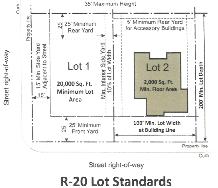
C.
Off-Srreet Parking and loading Requirements. Off-street parking and loading requiiements pertaining to uses allowed in the "R-20" district shall conform to the provisions of "Article 5 Parking and Loading Regulations."
Street side yard setback for garages entered from the side street is 25 feet.
(Ord. No. O-08-2023, §§ 2, 3, 6-12-2023)
Editor's note— Ord. No. O-08-2023, §§ 2, 3, adopted June 12, 2023, renumbered the former §§ 3.4—3.17 as § §§ 3.5—3.18 and enacted a new § 3.4 as set out herein. The historical notation has been retained with the amended provisions for reference purposes.
Sec. 3.5. - "R-10" Single-Family Residential.
The purpose of the "R-10" Single Family Residential District is to provide for compatible land, building, and structure uses primarily oriented to low density residential estate purposes and open space uses. Permitted uses, lot areas, setbacks, and other requirements are designed to encourage the maintenance of a spacious residential setting, with the preservation of natural landscape character.
A.
Permitted Uses. Uses permitted in the "R-10" Single Family Residential District shall be in accordance with Section 2.3 Permitted Use Table.
B.
Property Development Standards. The minimum dimension of lots and yards and the height of buildings shall be as shown in the accompanying table and illustration.
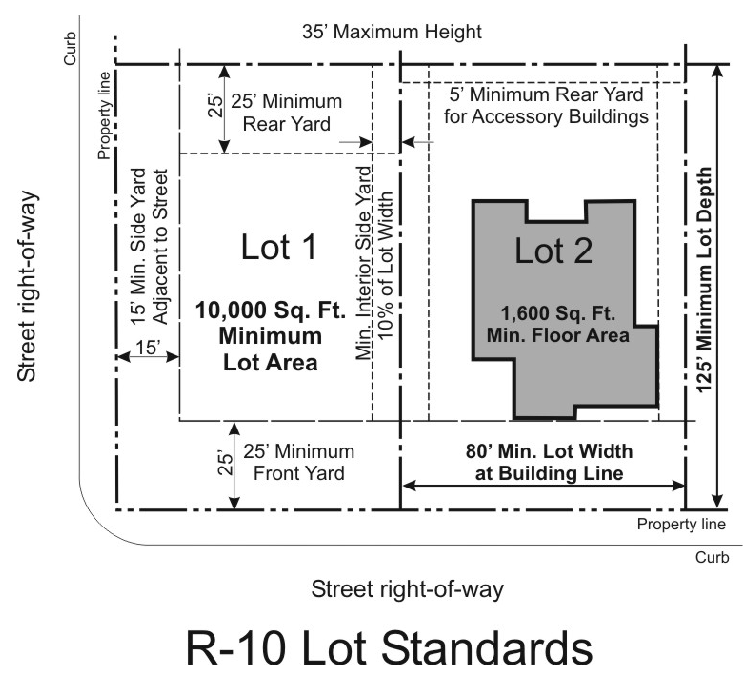
C.
Off-Street Parking and Loading Requirements. Off-street parking and loading requirements pertaining to uses allowed in the "R-10" district shall conform to the provisions of "Article 5 Parking and Loading Regulations."
Street side yard setback for garages entered from the side is street 25 feet.
(Ord. No. O-18-18, § 2, 12-10-2018; Ord. No. O-08-2023, § 2, 6-12-2023)
Editor's note— Formerly § 3.4.
Sec. 3.6 - "R-7.2" Single Family Residential
The purpose of the "R-7.2" Single Family Residential District is to provide for compatible land, building and structure uses primarily oriented to low density residential purposes with single family, detached dwelling units on lots of not less than seven thousand, two hundred (7,200) square feet.
A.
Permitted Uses. Uses permitted in the "R-7.2" Single Family Residential District shall be in accordance with "Section 2.3 Permitted Use Table".
B.
Property Development Standards. The minimum dimension of lots and yards and the height of buildings shall be as shown in the accompanying table and illustration.
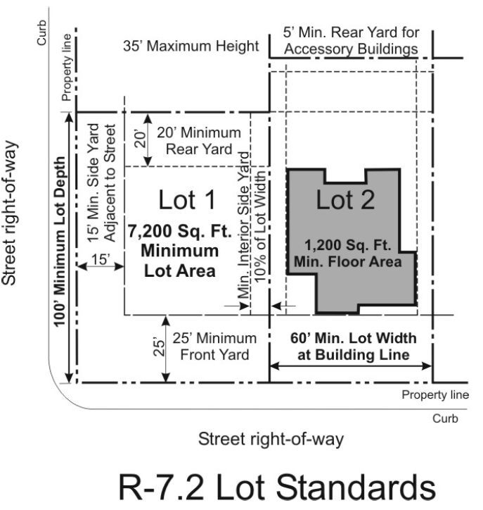
C.
Off-Street Parking and Loading Requirements. Off-street parking and loading requirements pertaining to uses allowed in the "R-7.2" district shall conform to the provisions of "Article 5 Parking and Loading Regulations."
Street side yard setback for garages enter from the side street 25 feet.
D.
Two family dwelling by specific use permit. A two-family dwelling may be placed on a lot in an R-7.2 single family residential district if authorized by a specific use permit. Any person desiring to place a two family dwelling on a lot in an R-7.2 single family residential district must apply for a specific use permit. The Planning and Zoning Commission and the City Council may approve a special use permit authorizing the placement of a two family dwelling on a lot within an R-7.2 single family residential district after appropriate public hearings and finding that the placement of said two family dwelling meets the specific use permit criteria set forth in Section 7.8(D) of this Zoning Ordinance.
(Ord. No. O-10-15, § 1, 7-13-2015; Ord. No. O-18-18, § 3, 12-10-2018; Ord. No. O-08-2023, § 2, 6-12-2023)
Editor's note— Formerly § 3.5.
Sec. 3.7. - "R-6" Single Family Residential.
The purpose of the "R-6" Single Family Residential District is to provide for compatible land, building, and structure uses primarily oriented to low density residential purposes with single family, detached dwelling units on lots of not less than six thousand (6,000) square feet.
A.
Permitted Uses. Uses permitted in the "R-6" Single Family Residential District shall be in accordance with "Section 2.3 Permitted Use Table".
B.
Property Development Standards. The minimum dimension of lots and yards and the height of buildings shall be as shown in the accompanying table and illustration.
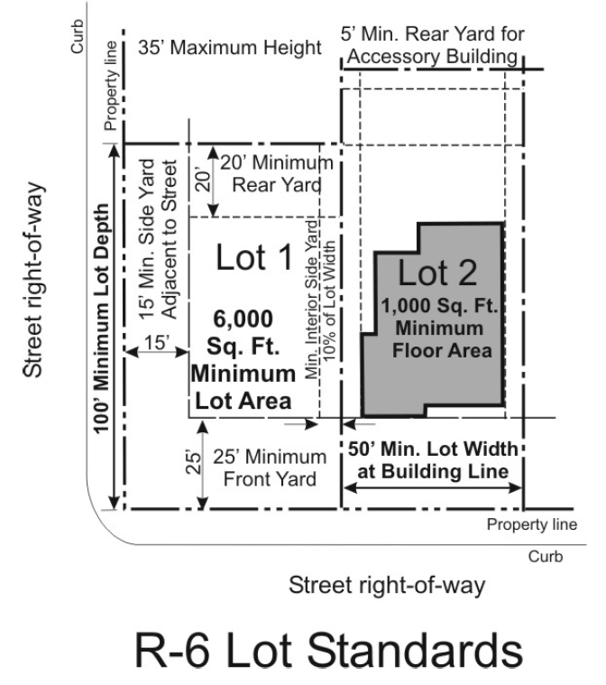
C.
Off-Street Parking and Loading Requirements. Off-street parking and loading requirements pertaining to uses allowed in the "R-6" district shall conform to the provisions of "Article 5 Parking and Loading Regulations."
Street side yard setback for garages entered from the side street is 25 feet.
D.
Two family dwelling by specific use permit. A two-family dwelling may be placed on a lot in an R-6 single family residential district if authorized by a specific use permit. Any person desiring to place a two family dwelling on a lot in an R-6 single family residential district must apply for a specific use permit. The Planning and Zoning Commission and the City Council may approve a special use permit authorizing the placement of a two family dwelling on a lot within an R-6 single family residential district after appropriate public hearings and finding that the placement of said two family dwelling meets the specific use permit criteria set forth in Section 7.8(D) of this Zoning Ordinance.
(Ord. No. O-10-15, § 2, 7-13-2015; Ord. No. O-18-18, § 4, 12-10-2018; Ord. No. O-08-2023, § 2, 6-12-2023)
Editor's note— Formerly § 3.6.
Sec. 3.8. - "MD" Medium Density Residential.
The purpose of the "MD" Medium Density Residential District is to provide for development of a broad range of medium density residential uses compatible office and high-density residential uses adjacent to major thoroughfares in locations which do not have a predominantly commercial character.
A.
Permitted Uses. Uses permitted in the "MD" Medium Density Residential District shall be in accordance with "Section 2.3 Permitted Use Table".
B.
Property Development Standards. The minimum dimension of lots and yards and the height of buildings shall be as shown in the accompanying table and illustration.
a.
For all uses except single-family attached (zero lot line) dwellings: A front yard of not less than twenty-five (25) feet; and two (2) side yards of not less than five (5) feet each, except that:
(1)
A side yard shall not be required where a side lot line is in the same location as a party wall (common wall) of a townhouse dwelling.
(2)
The required side or rear yard adjacent to a lot in an R-10, R-7.2, or R-6 District shall be increased by one foot for each two (2) feet, or fraction thereof, by which the principal structure exceeds twenty-five (25) feet in height.
(3)
A side yard of not less than fifteen (15) feet shall be provided where a side yard is adjacent to a side street.
Street side yard setback for garages entered from the side street is 25 feet.
b.
For a single-family attached (zero lot line) dwelling: A front yard of not less than twenty-five (25) feet; a rear yard of not less than twenty-five (25) feet; and a side yard or yards with a combined width of not less than ten (10) feet, provided that the distance between principal detached structures on adjacent lots shall not be less than ten (10) feet.
(Ord. No. O-08-2023, § 2, 6-12-2023)
Editor's note— Formerly § 3.7.
Sec. 3.9. - "MF" Multi-Family Residential (apartments).
The "MF", Multi-Family Residential (Apartments) District is an attached residential district intended to provide a residential density of up to twenty-four (24) dwelling units per gross acre. The principal permitted land uses will include multi-family dwellings and garden apartments. Recreational, religious, health and educational uses normally located to service residential areas are also permitted in this District. This District should be located adjacent to a major street and serve as a buffer between retail/commercial development or heavy automobile traffic, and medium or low density residential development.
A.
Permitted Uses. Uses permitted in the "MF" Multi-Family Residential District shall be in accordance with "Section 2.3 Permitted Use Table".
B.
Property Development Standards. The minimum dimension of lots and yards and the height of buildings shall be as shown in the accompanying table and illustration.
C.
Additional Height. Cooling towers, roof gables, chimneys and vent stacks may extend for an additional height not to exceed forty feet (40') above the average grade line of the building. Water stand pipes and tanks, church steeples, domes, and spires, school buildings, and institutional buildings may be erected to exceed two and a half (2-1/2) stories in height, provided that one (1) additional foot shall be added to the front yards for each foot that such structures exceed two and a half (2-1/2) stories.
D.
Parking Regulations. Two (2) parking spaces per unit. See Article 5, Parking and Loading Regulations.
E.
Structure Separation.
1.
From main structure to main structure with openings for doors or windows on facing facades, twenty feet (20')
2.
From main structure to main structure without openings, ten feet (10').
3.
From main structure to accessory buildings or pools, ten feet (10').
F.
Site Plan Requirement. An application for change in zoning to the "MF" Multi-family district shall be accompanied with a site plan that clearly illustrates the development concept of the land being rezoned. In addition, any property zoned "MF" that has not had a site plan approved at the time of zoning shall have a site plan approved by the City, upon recommendation of the Planning and Zoning Commission, prior to issuing any building permit for new construction.
(Ord. No. O-08-2023, § 2, 6-12-2023)
Editor's note— Formerly § 3.8.
Sec. 3.10. - "MH" Hud-Code Manufactured Housing.
The purpose of this district is to provide adequate space and restrictions for the placement of HUD-Code manufactured homes in the City within designated subdivisions. This does not include mobile homes as defined in this ordinance. The "MH" District is also established to provide housing densities compatible with existing and proposed neighborhoods by providing alternative housing types both in construction and economy within the "MH" District. No HUD-Code manufactured home shall be allowed on any parcel or lot except on parcels or lots within the "MH" District.
A.
Permitted Uses. Uses permitted in the MH HUD Code Manufactured Home district shall be In accordance with the listed uses in Section 2.3, Permitted Use Table.
B.
Property Development Standards. The requirements regulating the minimum lot size, minimum yard sizes (front, side, and rear), maximum building height (stories and feet), and maximum percent of lot coverage by buildings, as pertains to this district, shall conform with the provisions provided in the Height and Area Regulations for the MH Zoning District.
C.
Additional Height. Cooling towers, roof gables, chimneys and vent stacks may extend for an additional height not to exceed forty feet (40') above the average grade line of the building. Water stand pipes and tanks, church steeples, domes, and spires, school buildings, and institutional buildings may be erected to exceed two and a half (2-1/2) stories in height, provided that one (1) additional foot shall be added to the front yards for each foot that such structures exceed two and a half (2-1/2) stories.
D.
Yard Requirements for Secondary Non-residential Structures. In the MH District, no carport, garage, storage building, office, or caretaker's dwelling, laundry house, or other permitted structure may be located closer than five feet (5') from any side or rear property line. Such structures shall also be subject to front yard requirements above.
Street side yard setback for garages entered from the side street is 25 feet.
E.
Development and Installation Regulations. Any property developed within the "MH" district as a HUD Code Manufactured Home or as a manufactured housing subdivision shall meet the following requirements:
1.
HUD Code Manufactured Homes shall have the axles, wheels, and tow bar or tongue removed and shall be secured to a permanent foundation or footing and piers, all in accordance with manufacturer's specifications.
2.
HUD Code Manufactured Homes must have a minimum of an eighteen-inch crawl space under all homes.
3.
A concrete or asphalt surface with good drainage shall cover the area where a home is to be sited.
4.
Each HUD Code manufactured home site shall have a slab or patio not less than twenty feet in length and six feet in width, comprised of concrete, flagstone, or similar substance installed adjacent to each site.
5.
HUD Code Manufactured Homes shall have permanent steps installed at all exits.
6.
Skirting shall be securely attached between the HUD Code Manufactured home and the ground on all sides within thirty days of home installation. Skirting materials shall consist of materials which are compatible with the design of the home and enhance its appearance. Unpainted or untreated corrugated metal, screen or wire, or lattice-type skirting is prohibited.
7.
Construction, siting, and installation of the homes shall be in conformance with applicable federal, state, and local codes and standards, and each manufactured home shall have affixed a seal of the appropriate federal or state department.
8.
Sanitation, fire protection, and underground utility services shall be provided to each lot in accordance with City ordinances and regulations.
9.
Ingress and egress to the property shall be provided in accordance with City ordinances and regulations.
10.
Drainage and garbage collection rights-of-way, fire lanes, and utility easements shall be provided as required by the City. Such can be accomplished by designating all private interior drives within the project as easements for vehicular access and service.
11.
HUD-Code Manufactured Home subdivisions shall be developed at densities comparable to adjacent residential uses, or have adequate landscape buffering or open space to provide transition of uses. Adequate landscape buffering or open space for transition purposes shall be determined on an individual site basis and shall be subject to the approval of the City Council upon recommendation of the Planning and Zoning Commission.
12.
Any structural alteration or modification of a HUD-Code Manufactured Home after it is placed on the site must be approved by the building official of the City of McGregor. All structural additions shall comply with the City's building codes and ordinances.
F.
Site-built additions. The addition of peaked roof facades, atrium entrances, garages, porches, and patios are encouraged in order to increase the compatibility with conventional single family housing in the City.
G.
Accessory building and structure regulations. Area regulations for accessory buildings or accessory structures shall be in compliance with Section 4.6, Accessory Building and Use Regulations.
H.
Interior Drives for Manufactured Home Parks.
1.
The use of private interior drives must be approved by the City Council upon recommendation of the Planning and Zoning Commission.
2.
Such interior drives shall have a minimum easement width of fifty (50) feet and shall have a minimum paved roadway width of twenty-eight (28) feet.
3.
Public interior streets shall be located within dedicated rights-of-way, and shall have a minimum paved roadway width provided in accordance with the applicable standards in the City of McGregor Subdivision Regulations.
4.
All private interior drives, entrances, and service drives shall be constructed in accordance with City design standards and shall have a six (6) inch rolled curb and gutter of concrete meeting the street standards of the City of McGregor. The developer shall bear the total cost of construction and maintenance of all such improvements, including curb and drainage structures that may be needed.
5.
All parking areas and public streets shall be of concrete or asphalt construction, as approved by the City engineer.
I.
Underground Utilities. All utility lateral and service lines located within a Manufactured Home Park shall be installed underground.
J.
Open Space Area. Open space designated for the use and enjoyment of all residents shall be provided within a HUD Code Manufactured Home subdivision at the ratio of five hundred (500) square feet for each of the first twenty (20) units, and two hundred (200) square feet for each additional unit in excess of twenty (20). Designated open space shall be developed and maintained for recreational and leisure activities and shall be located within the subdivision being developed.
K.
Screening. Screening shall be provided along all perimeter property lines of a HUD-Code Manufactured Home subdivision which do not abut a dedicated street. Said screening wall or fence shall be of a decorative construction. The city council may approve a screening device composed of landscaping material where it can be shown that the planting will be installed and continually maintained in accordance with the intent of this ordinance.
L.
Preservation of Site Assets. When developing a HUD-Code Manufactured Home Subdivision, the following steps shall be taken to preserve on-site assets:
1.
Suitable available topsoil and desirable existing trees, shrubs, and ground cover shall be preserved and protected where practicable.
2.
Topsoil which is suitable and needed for later use in finished grading shall be stripped from areas to be occupied by structures, parking areas, streets and driveways, and from areas to be regraded or disturbed. This topsoil shall be collected and stored on the site in convenient places for future use and shall be free of debris during construction.
3.
Drainage engineering plans for drainage shall be submitted for review to the City at the time of site plan approval. All applicable requirements of the City shall be met.
4.
HUD-Code Manufactured Home Sales: HUD-Code Manufactured Home subdivisions shall be for residential purposes only. Sales of these homes shall be limited to those which become available on the market on an individual basis. Commercial sales and promotion are not permitted.
(Ord. No. O-3-18, § 1(Exh. A), 3-12-2018; Ord. No. O-08-2023, § 2, 6-12-2023)
Editor's note— Formerly § 3.9.
Sec. 3.11. - "NC" Neighborhood Commercial.
The purpose of the "NC" Neighborhood Commercial District is to create a District for office and professional uses and for limited retail uses intended for use by residents of nearby neighborhood areas to supply day-to-day needs and personal services. Neighborhood services should be located on a major street and generally utilize a site adjacent to one or more logical neighborhood service areas. The District can be used as a transition district between more intense uses and residential uses. Permitted uses should be compatible with adjacent residential areas.
A.
Permitted Uses. Uses permitted in the "NC" District as shown in Section 2.3, Permitted Use Table.
B.
Property Development Standards.
1.
The requirements regulating the minimum lot size, minimum yard sizes (front, side, and rear) maximum building height (stories and feet), and maximum percent of lot coverage by buildings, as pertains to this district, shall conform with the provisions provided in the Height and Area Regulations table for the BC Zoning District.
2.
Cooling towers, roof gables, chimneys, vent stacks, or mechanical equipment rooms may project, not to exceed twelve feet (12') beyond maximum building height.
C.
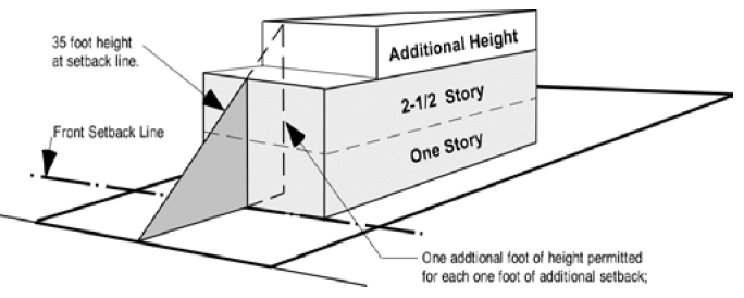
Additional Height. Additional height will be permitted in the "NC" Business Commercial District for each additional foot that a structure sets back beyond the required front setback. For each one foot of additional setback the structure will be permitted one additional foot of height; but shall not exceed a total height of forty-five (45) feet.
D.
Reduced Yard. If the front of the building is dedicated totally to landscaping, the front or side yard adjacent to the street may be reduced by ten (10) feet.
E.
Off Street Parking and Loading Requirements. Off street parking and loading requirements shall be provided as required by Article 5, Off-Street Parking and Loading Requirements.
F.
Sign Requirements. Off street parking and loading requirements shall be provided as required by Article 5, Off-Street Parking and Loading Requirements.
G.
Outside Storage. All principal uses in the "NC" district shall be conducted within a completely enclosed structure. There shall be no outside storage of materials unless properly screened.
(Ord. No. O-3-18, § 1(Exh. A), 3-12-2018; Ord. No. O-08-2023, § 2, 6-12-2023)
Editor's note— Formerly § 3.10.
Sec. 3.12. - "GC" General Commercial.
The purpose of the "GC" General Commercial district is to provide for a variety of office, service commercial, retail commercial and highway commercial businesses and to encourage high quality commercial in convenient locations accessible to major traffic arteries.
A.
Permitted Uses. Uses permitted in the "GC" District as shown in Section 2.3, Permitted Use Table.
B.
Property Development Standards. The requirements regulating the minimum lot size, minimum yard sizes (front, side, and rear) maximum building height (stories and feet), and maximum percent of lot coverage by buildings, as pertains to this district, shall conform with the provisions provided in the Height and Area Regulations table for the "GC" Zoning District.
C.
Additional Height. Additional height will be permitted in the "GC" Business Commercial District for each additional foot that a structure sets back beyond the required front setback. For each one foot of additional setback the structure will be permitted one additional foot of height; but shall not exceed a total height of forty-five (45) feet.
D.
Reduced Yard. If the front of the building is dedicated totally to landscaping, the front or side yard adjacent to the street may be reduced by ten (10) feet.
E.
Off Street Parking and Loading Requirements. Off street parking and loading requirements shall be provided as required by Article 5, Parking and Loading Regulations.
F.
Sign Requirements. Sign requirements shall be provided as required by Article 6, Sign Regulations.
(Ord. No. O-3-18, § 1(Exh. A), 3-12-2018; Ord. No. O-08-2023, § 2, 6-12-2023)
Editor's note— Formerly § 3.11.
Sec. 3.13. - "CBD" Central Business District.
The CBD Central Business District is intended to provide for a wide variety of business, residential, and civic activities within the central core area of the City of McGregor. The district regulations are designed to encourage a mix of functions including retail, service, office, and residential, to create and maintain vitality in the central area as a focus for the community, while recognizing the specific intense urban character of the core.
A.
Permitted Uses. Uses permitted in the "CBD" District as shown in Section 2.3, Permitted Use Table.
B.
Property Development Standards.
1.
There shall be no minimum lot area or width required in the CBD District.
2.
There shall be no height limit in the CBD District.
3.
There shall be no minimum yard requirements in the CBD District, except that:
a.
Any rear or side yard abutting a MD or MH District shall not be less than fifteen (15) feet.
b.
Any rear or side yard abutting an R-10, R-7.2 or R-6 District shall not be less than twenty-five (25) feet.

C.
Additional Height. The required side or rear yard adjacent to a lot in an R-10, R-7.2, R-6, MD or MH District shall be increased by one foot for each two (2) feet or fraction thereof, by which the principal structure exceeds thirty-five (35) feet in height.
D.
Reduced Yard. If the front of the building is dedicated totally to landscaping, the front or side yard adjacent to the street may be reduced by ten (10) feet.
E.
Sign Requirements. Sign requirements shall be provided as required by Article 6, Sign Regulations.
(Ord. No. O-3-18, § 1(Exh. A), 3-12-2018; Ord. No. O-08-2023, § 2, 6-12-2023)
Editor's note— Formerly § 3.12.
Sec. 3.13.1 - "CBD-1" Central Business District-1.
The CBD Central Business District-1 is intended to provide for a wide variety of business, residential, and civic activities within the central core area of the City of McGregor. The district regulations are designed to encourage a mix of functions including retail, service, office, and residential, to create and maintain vitality in the central area as a focus for the community, while recognizing the specific intense urban character of the core.
A.
Permitted Uses. Uses permitted in the "CBD-1" District as shown in Section 2.3, Permitted Use Table.
B.
Property Development Standards.
1.
There shall be no minimum lot area or width required in the CBD-1 District.
2.
There shall be no height limit in the CBD-1 District.
3.
There shall be no minimum yard requirements in the CBD-1 District, except that:
a.
Any rear or side yard abutting a MD or MH District shall not be less than fifteen (15) feet.
b.
Any rear or side yard abutting an R-10, R-7.2 or R-6 District shall not be less than twenty-five (25) feet.
C.
Additional Height. The required side or rear yard adjacent to a lot in an R-10, R-7.2, R-6, MD or MH District shall be increased by one (1) foot for each two (2) feet or fraction thereof, by which the principal structure exceeds thirty-five (35) feet in height.
D.
Reduced Yard. If the front of the building is dedicated totally to landscaping, the front or side yard adjacent to the street may be reduced by ten (10) feet.
E.
Sign Requirements. Sign requirements shall be provided as required by Article 6, Sign Regulations.
F.
Parking Restrictions. The parking restrictions set forth in Chapter 5 of these zoning ordinances apply in any area zoned CBD-1.
(Ord. No. O-18-19 , § 2, 10-14-2019; Ord. No. O-08-2023, § 2, 6-12-2023)
Editor's note— Formerly § 3.12.1.
Sec. 3.14. - "LI" Light Industrial District.
The Light Industrial District is intended to provide for a wide variety of nuisance free industrial uses and compatible related uses. The area, height, yard, and other site requirements are designed to maintain long term quality and economic vitality of development, and to encourage a compatible relationship with adjacent uses.
A.
Permitted uses. Uses permitted in the "LI" District as shown in Section 2.3, Permitted Use Table.
B.
Property Development Standards. The requirements regulating the minimum lot size, minimum yard sizes (front, side, and rear) maximum building height (stories and feet), and maximum percent of lot coverage by buildings, as pertains to this district, shall conform with the provisions provided in the Height and Area Regulations table for the "LI" Zoning District. Additional yard setback requirements:
1.
Any rear or side yard abutting an MD or MH District shall not be less then fifteen (15) feet.
2.
Any rear or side yard abutting an R-10, R-7.2 or R-6 District shall not be less than twenty five (25) feet.
C.
Additional Height. The required side or rear yard adjacent to a lot in an R-10, R-7.2, R-6, MD or MH District shall be increased by one foot for each two (2) feet or fraction thereof, by which the principal structure exceeds forty-five (45) feet in height.
D.
Reduced Yard. If the front of the building is dedicated totally to landscaping, the front yard may be reduced by ten (10) feet.
E.
Off Street Parking and Loading Requirements. Off street parking and loading requirements shall be provided as required by Article 5, Parking and Loading Regulations.
F.
Sign Requirements. Sign requirements shall be provided as required by Article 6, Sign Regulations.
(Ord. No. O-3-18, § 1(Exh. A), 3-12-2018; Ord. No. O-08-2023, § 2, 6-12-2023)
Editor's note— Formerly § 3.13.
Sec. 3.15. - "MI" Medium Industrial.
The purpose of the "MI" Medium Industrial District is to provide for a wide variety of industrial, manufacturing and fabrication uses with area, height, and yard requirements designed to accommodate moderate sized industries and other uses whose operating characteristics require medium to large sites and need to be separated from land uses less intensive in nature and from all residential uses.
A.
Permitted uses. Uses permitted in the "MI" District as shown in Section 2.3, Permitted Use Table.
B.
Property Development Standards. The requirements regulating the minimum lot size, minimum yard sizes (front, side, and rear) maximum building height (stories and feet), and maximum percent of lot coverage by buildings, as pertains to this district, shall conform with the provisions provided in the Height and Area Regulations table for the "MI" Zoning District. Additional yard setback requirements:
1.
Any rear or side yard abutting an MD or MH District shall not be less then fifteen (15) feet.
2.
Any rear or side yard abutting an R-10, R-7.2 or R-6 District shall not be less than twenty five (25) feet.
C.
Additional Height. The required side or rear yard adjacent to a lot in an R-10, R-7.2, R-6, MD or MH District shall be increased by one foot for each two (2) feet or fraction thereof, by which the principal structure exceeds forty-five (45) feet in height.
D.
Reduced Yard. If the front of the building is dedicated totally to landscaping, the front or side yard adjacent to the street may be reduced by ten (10) feet.
E.
Off Street Parking and Loading Requirements. Off street parking and loading requirements shall be provided as required by Article 5, Parking and Loading Regulations.
F.
Sign Requirements. Sign requirements shall be provided as required by Article 6, Sign Regulations.
(Ord. No. O-3-18, § 1(Exh. A), 3-12-2018; Ord. No. O-08-2023, § 2, 6-12-2023)
Editor's note— Formerly § 3.14.
Sec. 3.16. - "HI" Heavy Industrial.
The purpose of the "HI" Heavy Industrial District is to provide for all types of industrial, manufacturing, and noxious uses with area, height, and yard requirements designed to accommodate major industries and other uses whose operating characteristics require large sites and need to be separated from land uses less intensive in nature and from all residential uses.
A.
Permitted uses. Uses permitted in the "HI" District as shown in Section 2.3, Permitted Use Table.
B.
Property Development Standards. The requirements regulating the minimum lot size, minimum yard sizes (front, side, and rear) maximum building height (stories and feet), and maximum percent of lot coverage by buildings, as pertains to this district, shall conform with the provisions provided in the Height and Area Regulations table for the "HI" Zoning District. Additional yard setback requirements:
1.
Any rear or side yard abutting an MD or MH District shall not be less then fifteen (15) feet.
2.
Any rear or side yard abutting an R-10, R-7.2 or R-6 District shall not be less than twenty five (25) feet.
C.
Additional Height. The required side or rear yard adjacent to a lot in an R-10, R-7.2, R-6, MD or MH District shall be increased by one foot for each two (2) feet or fraction thereof, by which the principal structure exceeds forty-five (45) feet in height.
D.
Reduced Yard. If the front of the building is dedicated totally to landscaping, the front yard may be reduced by ten (10) feet.
E.
Off Street Parking and Loading Requirements. Off street parking and loading requirements shall be provided as required by Article 5, Parking and Loading Regulations.
F.
Sign Requirements. Sign requirements shall be provided as required by Article 6, Sign Regulations.
(Ord. No. O-3-18, § 1(Exh. A), 3-12-2018; Ord. No. O-08-2023, § 2, 6-12-2023)
Editor's note— Formerly § 3.15.
Sec. 3.17. - "PD" Planned Development.
The purpose of the "PD" Planned Development District is to encourage flexibility in the use and development of land in order to promote its most appropriate use; to provide a high level of urban amenities; to preserve the quality of the natural environment; and to provide flexibility in the development of land subject to development standards coordinated with the provisions of necessary public services and facilities.
A.
Permitted uses. Uses as specified in the "PD" Planned Development application and shown an approved Planned Development Site Plan.
B.
Property Development Standards.
1.
Minimum Size- A PD must have at least one acre (43,560 square feet) of land.
2.
Ownership- A PD must be under the control of a single landowner or otherwise subject to legal controls that ensure its unified planning and development.
3.
Location- A PD may be located in any zoning district created by this ordinance.
C.
Preapplication Review. Prior to making an application for a PD, a landowner may consult the director of planning to obtain information and guidance before entering into binding contractual commitments or incurring substantial expense in the preparation of plans, surveys, and other data.
D.
Commission Rules. The commission may adopt rules implementing the procedures and requirements contained in this ordinance.
E.
Concept Plan.
1.
Application. A landowner may prepare an application and concept plan for a PD and shall file the required number of the application and concept plan with the planning department together with a filing fee in an amount approved by the city council, payable to the City of McGregor.
2.
Concept plan map. The concept plan shall include a map or maps indicating the following:
a.
Existing topography and a conceptual grading plan for the PD and adjacent land within one hundred (100) feet of the PD.
b.
The zoning classification and permitted land use for land within the PD, and the approximate location of major buildings within the PD and on adjacent sites within three hundred (300) feet of the PD.
c.
A general land use plan showing proposed uses and densities.
d.
A general public facility showing the approximate location of existing and proposed private streets, pedestrian ways, trails, circulation features, public service facilities, and public or community facilities and uses.
3.
Concept plan written statement. The concept plan shall include a descriptive written statement indicating the following:
a.
The architectural and design features of the PD.
b.
A general description of proposed land uses, site development regulations, and performance standards sufficient to govern the preparation and approval of a preliminary and final development plan, including, but not limited to the following:
(1)
Land use regulations.
(2)
Regulations governing density, building floor area, floor area ratio, site coverage, lot size and dimensions, yard requirements, common open space, and landscaping.
(3)
Site development standards applicable at the perimeter of the PD.
4.
Additional Requirements. The concept plan shall also include the following:
a.
A development schedule indicating the anticipated time for the beginning of construction and for the completion of construction for each phase of the PD, if the PD is to be developed in phases.
b.
Evidence that the applicant has sufficient control over the land included in the PD to be able to complete the development of the PD.
5.
Report of director of planning. The director of planning shall review the application and concept plan and shall submit recommendation(s) to the commission.
6.
Action by commission. The commission shall review the concept plan and the director of planning's report and shall submit its recommendations to the council.
7.
Action by council. The council shall hold a following notice of the hearing, wherein it shall consider the application and concept plan and the recommendations of the director of planning and the commission. The council may approve an application and concept plan for a PD if it finds that the PD is consistent with the comprehensive plan, the purposes of this ordinance, and the planned development regulations.
8.
Council Approval. The council shall approve each application and concept plan for a PD as an amendment to the zoning map and ordinance that supersedes all previously existing zoning regulations applicable to the land included in the PD. The amending ordinance shall incorporate the concept plan for the PD, as approved by the council. Each approved PD concept plan shall be shown on the zoning map by the letters "PD" and identified sequentially by order of enactment and by reference to the enacting ordinance.
F.
Planned Development (PD) Plan. No building may be constructed in a PD for which the council has approved a concept plan until the commission has approved a planned development (PD) plan covering the land on which the building will be constructed.
G.
Preliminary and Final Planned Development (PD) Plans.
1.
Application for preliminary PD plan approval. After the council has approved a concept plan for a PD, the landowner shall submit a preliminary PD plan to the commission for its approval. The applicant may submit a preliminary PD plan covering all or some of the land included within the PD. If the PD is to be developed in phases, the applicant shall submit preliminary PD plans for later phases of the PD in compliance with the development schedule contained in the approved concept plan.
2.
Contents of preliminary PD plan. The preliminary PD plan shall be consistent with the approved concept plan and shall include the following:
a.
A tract map showing proposed street lines, lot lines, easements, and dedications.
b.
A land use plan designating uses for each site, and detailed land use regulations, site development regulations, and performance standards applicable to each use or site.
c.
A circulation plan, indicating all existing and proposed vehicular, pedestrian, equestrian, or other circulation or transportation facilities, and showing the location and general design of all parking and loading facilities.
d.
A public services and facilities plan, including requirements for and means of providing all utility services and public facilities necessary to serve the PD. The plans shall include specific requirements for land dedications, installation of improvements by the developer, payment of development fees, and other provisions necessary to implement the public service and facility extension policies of the city.
e.
Schematic preliminary architectural plans and building elevations for all uses sufficient to indicate building height and bulk, general architectural design and appearance, and the arrangement of principal open spaces and uses.
f.
A fully dimensioned site development and landscaping plan showing existing and proposed building locations, site improvements, principal landscape and design features, common open space, and all significant visual features.
g.
Proposals for the maintenance and preservation of common open space.
3.
Concurrent Subdivision Approval. The applicant may submit the tract map in a form sufficient for approval as a plat under the subdivision control ordinance and may request concurrent commission review and approval of the tract map and a plat under the subdivision control ordinance notwithstanding its noncompliance with any requirements in that ordinance if it finds that the preliminary PD plan complies with the provisions of the planned development regulations.
4.
Commission hearing and action. The commission shall hold a hearing on the preliminary PD plan following notice as required by this ordinance.Following the hearing. The commission shall:
a.
Approve the preliminary PD plan as submitted; or,
b.
Approve the preliminary PD plan subject to conditions; or,
c.
Refuse to approve the preliminary PD plan as submitted.
The commission shall be deemed to have approved the preliminary PD plan as submitted if it does not make a decision on the preliminary PD plan within forty-five (45) days following the conclusion of the hearing.
5.
Commission Decision on Preliminary Development Plan. The commission's decision shall be contained in a written resolution, which shall include findings of fact and reasons indicating why the commission has approved or denied approval of a preliminary PD plan or why it has approved a preliminary PD plan with conditions. The findings of fact and reasons shall consider each of the following:
a.
The consistency of the preliminary PD plan with the approved concept plan; and
b.
The adequacy of any common open space included in the PD plan and proposals for the maintenance and preservation of the common open space; and
c.
The adequacy of the circulation plan, public facilities and services plan, preliminary architectural plan, and site development and landscaping plan included in the preliminary PD plan. In determining the adequacy of these plans the commission shall consider as a guide the circulation, pubic facilities and service elements of the comprehensive plan, the zoning regulations applicable to the most comparable zoning district, and the development plan review standards contained in Section 7.6.
6.
Preliminary PD Approval. The commission shall file a resolution approving a preliminary PD plan with the city secretary and shall mail a certified copy to the landowner. The landowner shall be deemed to have accepted a commission resolution approving a preliminary development plan with conditions unless within ten (10) day of receiving a copy of the resolution, he notifies the commission of his refusal to accept the conditions.
7.
Application for Final PD Plan Approval. The landowner shall file an application for the approval of a final PD plan within ninety (90) days of receiving a copy of the commission's resolution approving the preliminary PD plan, unless the commission specifies a different period of time in it's resolution approving the preliminary PD plan.
8.
Commission Action on Final PD Plan. The commission shall approve the final PD plan if it is in substantial compliance with the preliminary PD plan and includes such modifications as are necessary to comply with any conditions attached to the commission's approval of the preliminary PD plan. A final PD plan is in substantial compliance with a preliminary development plan if it does not:
a.
Change the gross density or intensity to use; or
b.
Reduce the area designated for common open space; or
c.
Increase by more than ten (10) percent the floor area of any nonresidential use; or
d.
Increase by more than five (5) percent the total ground area covered by buildings.
9.
Commission Decision on Final PD Plan. The commission's decision shall be contained in a written resolution which shall include findings of fact and reasons indicating why the commission has approved or denied approval of a final PD plan and why the final PD plan is or is not in substantial compliance with the preliminary PD plan.
10.
Phasing Requirements. If a PD is to be developed in phases, the commission may require, in it's resolution approving the final PD plan for each phase, that the density or intensity of the use in the final PD plan for that phase shall not exceed by more then fifteen (15) percent the density or intensity of use approved for the entire PD.
11.
Performance Guarantees. The commission may require, in its resolution approving a final PD plan, that the landowner shall execute easements or covenants and shall furnish a performance bond to ensure the development of the PD in compliance with the final PD plan and to protect the interest of the city if the landowner fails to complete the development of the PD.
12.
Final PD Approval. The commission shall file a resolution approving a final PD plan with the city secretary and shall mail a certified copy to the landowner. The approved final PD plan shall be shown on the zoning map, identified by the corresponding approved concept plan for the PD.
13.
Resubmittal of Plans. If the commission refuses to approve a preliminary or final PD plan, the landowner may resubmit the plan to the commission for reconsideration within thirty (30) days of receiving a copy of the commission resolution disapproving the plan. The resubmitted plan shall include any changes necessary to remedy the reasons identified by the commission in its resolution as its reasons for disapproving the plan.
H.
Building Permits. The building official shall issue building permits for buildings in an area of a PD covered by an approved final PD plan if they comply with the requirements of the approved final PD plan and all other applicable ordinances.
I.
Certificates of Occupancy. The building official shall issue a certificate of occupancy for any completed building in an area covered by an approved final PD plan if the building complies with the building permit, the requirements of final PD plan, and all other applicable ordinances.
J.
Amendments to PD plans.
1.
The council, commission, or the landowner may propose an amendment to an approved PD concept plan. The council may amend a PD concept plan under the same procedures applicable to its initial approval.
2.
The commission or the landowner may propose an amendment to an approved final PD plan. The commission may amend its approval of the preliminary PD plan.
3.
The director of planning may authorize minor modifications or revisions to an approved final PD plan if required by engineering or the circumstances not foreseen when the final PD plan was approved. "Minor modification" means a change in the location, siting, character or height of a building or structure required by engineering or other circumstances not foreseen when the final PD plan was approved. A "minor modification" may not increase the size of the building or structure by more than ten (10) percent, nor change the location of any building or structure by more than ten (10) feet in any direction.
K.
Review of Progress. The director of planning shall annually review each uncompleted PD and shall submit a report on each uncompleted PD to the landowner, commission, and council containing the following:
1.
The summary of the development status and an assessment of the progress toward completion of the PD, including compliance with the development schedule included in the concept plan; and
2.
A statement of any changes in the planning policies of the city, land use, and market trends, or programs for the provision of public services and facilities which in the opinion of the director may affect the completion of the PD.
3.
The commission and council shall review the report of the director of planning and may take any action they consider necessary, including the amendment of the PD concept plan or final plan, as authorized by this ordinance. The council, after giving notice and holding a public hearing, may also revoke it's approval of the concept plan and may adopt a new zoning classification for the area of the PD that is not completed.
L.
Applicability of Development Plan Review. Development plan review, is not required for a PD which is reviewed and approved under this part.
(Ord. No. O-3-18, § 1(Exh. A), 3-12-2018; Ord. No. O-08-2023, § 2, 6-12-2023)
Editor's note— Formerly § 3.16.
Sec. 3.18. - Historic Overlay ("-H" suffix).
The purpose of the "-H" Historic Overlay District is to provide for the recognition and protection of historic buildings, landmarks and other sites of interest in the City of McGregor that have a particular historic significance to the City of McGregor, the county, or the larger surrounding area. This ordinance shall regulate and restrict construction, alteration, reconstruction, or razing of buildings and other structures to maintain heritage and property values.
A.
Designation of Landmarks or Historic Districts. In designating an area or place a historic district or landmark, the city shall consider one of more of the following criteria. A historic landmark or district may be designated if it:
1.
Possesses significance in history, architecture, archeology, or culture of the city, state or nation.
2.
Is associated with events that have made a significant contribution to the broad patterns of local, regional, state, or national history.
3.
Is associated with the lives of persons significant in the past.
4.
Embodies distinctive characteristics of a type, period, or method of construction.
5.
Represents an established and familiar visual feature of the City of McGregor.
B.
McGregor Historic Commission. There is hereby created a commission to be known as the McGregor Historic Commission.
1.
The McGregor Historic Commission shall consist of five (5) members to be appointed by the Mayor and confirmed by the City Council. At least two (2) members of the McGregor Historic Commission must be residents of the City of McGregor. All of the members of the McGregor Historic Commission must be residents of McLennan County, Texas.
2.
McGregor Historic Commission members shall serve for a period of two (2) years and until their successors are duly appointed and qualified. Two (2) members' odd numbered fiscal years and three (3) members shall be appointed in even numbered fiscal years.
3.
The Chairman and Vice Chairman of the McGregor Historic Commission shall be elected by and from the members of the McGregor Historic Commission.
4.
The powers of the McGregor Historic Commission shall include:
a.
Preparation of rules and procedures as necessary to carry out the business of the McGregor Historic Commission.
b.
Recommend adoption of criteria for the identification of historic, architectural, and cultural landmarks and the delineation of historic districts.
c.
Conduct surveys and maintain and update an inventory of significant historic, architectural, archaeological and cultural landmarks and historic districts within the City of McGregor.
d.
Designate resources as landmarks and historic districts.
e.
Create committees from among its membership.
f.
Maintain written minutes which record all actions taken by the McGregor Historic Commission and the reasons for taking such actions.
g.
Bestow recognition upon the owners of landmarks or within districts by means of certificates, plaques or markers.
h.
Increase public awareness of the value of historic, cultural and architectural preservation by developing and participating in public education programs.
i.
Make recommendations to the City Council concerning the utilization of state, federal, or private funds to promote the preservation of landmarks and historic districts within the City of McGregor.
j.
Approve or deny applications for Certificates of Appropriateness pursuant to this ordinance.
k.
Prepare specific design guidelines for the review of landmarks and districts.
l.
Review informally, on an annual basis, the conditions of the properties and possible future needs.
5.
The McGregor Historic Commission meetings shall be called within fourteen (14) days that a Certificate of Appropriateness or Demolition Permit is submitted. Meetings may also be called at any time by the Chairman or on the written request of any two (2) McGregor Historic Commission members. All meetings shall be held in conformance with the Texas Open Meetings Act, Local Government Code Chapter 551.
6.
A quorum of the transaction of business shall consist of three (3) of the McGregor Historic Commission voting members.
7.
A majority of the voting members present will constitute an official vote of the working mechanics of the McGregor Historic Commission, but a minimum number of three (3) affirmative votes will be required to grant a Certificate of Appropriateness.
C.
Certificate of Appropriateness for Alteration of New Construction Affecting Landmarks or Historic Districts. No person shall carry out any exterior alteration, restoration, reconstruction, new construction, or moving of a landmark or property within a historic district, nor shall any person make any change in the appearance of such a property, its colors, light fixtures, signs, sidewalks, fences, steps, paving or other exterior elements visible from a public right-of-way which affect the appearance and cohesiveness of the historic landmark or district, without first applying for a Certificate of Appropriateness from the McGregor Historic Commission.
D.
Certificate of Appropriateness Application Procedure.
1.
Prior to the commencement of any work requiring a Certificate of Appropriateness, the owner shall file an application for such a certificate with the McGregor Historic Commission. The McGregor Historic Commission, shall if requested, aid the property owner in preparation and completion of the application. The application form shall request the following:
a.
Name, address, email address, telephone number of applicant, fax number, detailed description of proposed work.
b.
Location and photographs of the property and adjacent properties (historical photos also may be helpful).
c.
Elevation drawings of the proposed changes.
d.
Samples of materials to be used, to include paint samples and information on any materials to be used.
e.
If the proposal includes signs or lettering, a scale drawing showing the type of lettering to be used, all dimensions an colors, a description of materials to be used, method of illumination (if any), and a plan showing the sign's location on the property.
f.
Site plan if site modifications are requested.
g.
Any other reasonable information which the McGregor Historic Commission may deem necessary in order to visualize the proposed work.
2.
No building permit shall be issued until application for Certificate of Appropriateness has been reviewed and acted upon by the McGregor Historic Commission. The Certificate of Appropriateness shall be in addition to and not in lieu of any building permit that may be required by any other ordinance of the City of McGregor.
3.
The McGregor Historic Commission shall take into consideration the current needs of the property owners, and shall be sensitive to the property owners' financial condition.
4.
The McGregor Historic Commission shall take action on the completed application within twenty-one (21) days from receipt of the completed application, at which time an opportunity will be provided for proponents and opponents of the application to present their views. Said public hearing shall be held within fourteen (14) days of the date of application.
5.
No change shall be made in application of any building permit issuance of a Certificate of Appropriateness without resubmitting to the McGregor Historic Commission and approval thereof in the same manner as provided above.
6.
All decisions of the McGregor Historic Commission shall be in writing and shall be sent to the applicant and a copy filed with the City Secretary's office for public inspection. The McGregor Historic Commission's decision shall state the reasons for denying or modifying any application. If the application is denied, the landowner may appeal to the City Council.
7.
If the McGregor Historic Commission has not made a final decision within thirty (30) days, a Certificate of Appropriateness shall be deemed issued by the McGregor Historic Commission.
E.
Demolition Permit. A permit for the demolition or relocation of a historic landmark or property within a historic district shall not be granted by the Building Inspector without the approval of a complete application by the McGregor Historic Commission.
The McGregor Historic Commission shall review the application within sixty (60) days, during which time it shall consider the state of repair of the building, reasonableness of the cost of restoration or repair, the existing and /or potential usefulness, the purpose behind preserving the structure as a historic landmark, the character of the neighborhood, and all other factors it finds appropriate. If the McGregor Historic Commission determines that, in the interest in preserving historical values, the structure should be preserved, it shall notify the building official that the application has been disapproved. If the application is denied, the landowner may appeal to the City Council.
F.
Ordinary Maintenance. Nothing in this ordinance shall be construed to prevent the ordinary maintenance and repair of any exterior architectural feature of a landmark or property to fall into a serious state of disrepair, without requesting a Demolition Permit, so as to result in the deterioration of any exterior architectural feature which would, in the judgment of the McGregor Historic Commission, produce a detrimental effect upon the character of the historical district as a whole or the life and character of the property itself.
All recommendations of the McGregor Historic Commission shall be in writing and shall be to the applicant and a copy filed with the City Secretary's office for public inspection. The McGregor Historic Commission shall state its reasons for recommendation. No further obligation shall be upon the landowner under this ordinance in regards to the demolition by neglect. However, all other City ordinances must be adhered to.
Examples of such deterioration shall include, but are not limited to, the following:
1.
Deterioration of exterior wall or other vertical supports.
2.
Deterioration of roofs or other horizontal members.
3.
Deterioration of exterior chimneys.
4.
Deterioration or crumbling of exterior stucco or mortar.
5.
Ineffective waterproofing of exterior walls, roofs, or foundation, including broken windows or doors.
6.
Deterioration of any feature so as to create a hazardous condition which could lead to the claim that demolition is necessary for the public safety.
7.
Deterioration of structural elements and the enclosing envelope.
8.
Landscape features.
9.
Deterioration of ornamental features.
G.
Enforcement. All work performed pursuant to a Certificate of Appropriateness issued under this ordinance shall conform to all requirements included therein. It shall be the duty of the Building Inspector to inspect periodically any such work to assure compliance. In the event work is found that is not being performed with the Certificate of Appropriateness, or upon notification of such fact by the McGregor Historic Commission, or such work shall be found to be in violation of appropriate zoning requirements contained herein; the Building Inspector shall issue a stop work order and all work shall immediately cease. No further work shall be undertaken on the project as long as a stop work order is in effect. A decision shall be made by the McGregor Historic Commission concerning the stop work order within five (5) working days, excluding weekends and holidays.
H.
Appeals. Any person aggrieved by a decision of the McGregor Historic Commission relating to a Certificate of Appropriateness or to this section of the ordinance may, within fifteen (15) days of receipt of the written decision, file a written application with the City Council for review of the decision. The decision of the City Council shall be final.
(Ord. No. O-3-18, § 1(Exh. A), 3-12-2018; Ord. No. O-15-18, § 2, 10-8-2018; Ord. No. O-7-21, § 1, 7-27-2021; Ord. No. O-08-2023, § 2, 6-12-2023)
Editor's note— Formerly § 3.17.