
Mead City Zoning Code
Sec. 16-3-90
Measurements and exceptions.
(a)
Density. Maximum density is measured as the number of dwelling units per gross acre of land. Maximum density (the most units per acre allowed) is measured by dividing the number of dwelling units on a lot or parcel by the parcel's gross land area (in acres) excluding existing rights-of-way (prior to development) and bodies of water.
(b)
Lot Area.
(1)
Measurement. Lot area is measured as the amount of net land area contained within the property lines of a lot or parcel, not including streets or rights of way. All minimum lot size standards shall be considered real numbers with decimal precision. That is, ten (10) acres is 10.00 acres only.
(2)
Exceptions. No building permit or development approval shall be issued for a lot that does not meet the minimum lot area requirements of this land use code, except in the following cases.
a.
Utilities using land or an unoccupied building covering less than one thousand (1,000) square feet of site area are exempt from minimum lot area standards.
b.
Detached dwelling unit exemption. The minimum lot area standards of this land use code shall not prohibit the construction of a detached dwelling unit on a lot that was legally platted or recorded before the adoption of this land use code, provided that the dwelling unit is constructed in compliance with all applicable dimensional standards.
(c)
Lot width is measured between side lot lines along a line that is parallel to the street lot line or its chord and located the minimum street setback distance from the street lot line.
(d)
Street Frontage is measured between side lot lines along the street lot line.
(e)
Setbacks.
(1)
Measurement. Setbacks are unobstructed, unoccupied open areas, measured as follows:
a.
Street setbacks shall be measured between the furthermost projection of a structure and any abutting right-of-way line. In the event that lots or parcels abut streets or roads without rights-of-way or inadequate right-of-way, then street setbacks shall be measured as if a right-of-way line had been established for the street or road in accordance with the Town of Mead's "Standard Design Criteria and Construction Requirements" and any applicable, most current adopted Transportation Plan.
b.
Side and rear setbacks shall be measured between the furthermost projection of a structure and the property lines of the lot on which such structure is located.
(2)
Exceptions and permitted encroachments. Setbacks must be unobstructed from the ground to the sky, except that the following features may encroach into required setbacks, as long as they do not interfere with the site triangle of roadways, alleys and streets:
_______________________________________
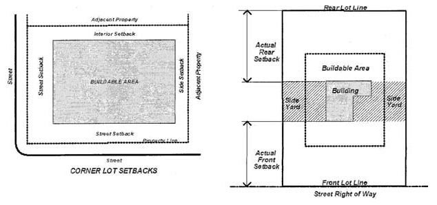
Figure 3.2 Corner Lot Setbacks and Figure 3.3 Measurements of Setbacks
__________________________________________
a.
Landscaping;
b.
Clothesline post;
c.
Driveways, curbs and sidewalks;
d.
Flagpoles;
e.
Heating and cooling units, not to exceed three (3) feet;
f.
Mailboxes;
g.
Overhanging roof, eave, gutter, cornice or other architectural feature and awnings, not to exceed two (2) feet;
h.
Septic systems, wells and underground utilities;
i.
Signs;
j.
Steps, stairs or fire escapes (non-enclosed), not to exceed six (6) feet;
k.
Uncovered, unenclosed terraces or porches, not to exceed six (6) feet within front and rear setbacks only;
l.
Accessory buildings, within required rear setbacks only;
m.
Fences or walls six (6) feet or less in height, if otherwise allowed by Town regulations (Note: fences or walls over six (6) feet in height require a Building Permit and shall be subject to all setback standards); and
n.
Yard and service lighting fixtures and poles.
(3)
Setback averaging. Regardless of the minimum street setback required by the underlying zoning district, street setbacks may be reduced to the average of the existing setbacks of the lots that are on both sides of the subject lot. The following rules apply in calculating the average setback.
a.
Only the setbacks on the lots that abut each side of the subject lot and are on the same side of the street may be used. Setbacks across the street or along a different street may not be used.
b.
When one (1) abutting lot is vacant, or if the lot is a corner lot, then the average is of the setback of the nonvacant lot and the zoning district minimum setback.
(f)
Lot coverage is measured as the percentage of the total lot area covered by buildings and other impervious surfaces. It is calculated by dividing the square footage of impervious cover by the square footage of the lot. Lot coverage = impervious surface area ÷ lot area
(g)
Reserved.
(h)
Height. Measuring Building Height.
(1)
Measurement. The building is measured from the average of finished grade at the center of all walls of the building to the top of the parapet or highest roof beam (whichever is higher) on a flat or shed roof, to the top of the parapet or deck level (whichever is higher) of a mansard roof, or the average distance between the highest ridge and its eave of a gable, hip, or gambrel roof.
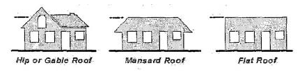
Figure 3.4 Measuring Building Heights
(2)
Exceptions. Zoning district height limits do not apply to belfries, cupolas, spires, domes, monuments, airway beacons, radio/communication towers, structures for essential services, windmills, flagpoles, chimneys, radio/television receiving antennas or chimney flues. Height limits also do not apply to any bulkhead, elevator, water tank or to any similar structure, or necessary mechanical appurtenance extending above the roof of any building if such structure does not occupy more than thirty-three and one-third percent (33?%) of the area of the roof.
(Ord. 653 §1, 2009)
(Ord. No. 1049, § 2(Exh. A), 11-27-2023)