
Mendon City Zoning Code
11 ZONING
DESIGNATIONS
11.02 ESTABLISHMENT OF ZONES
For the purposes of this ordinance, the following zones are created to be applied as necessary to regulate the development of land in the City of Mendon, Utah.
Table 3. Directory of Land Use Notations
| Residential Land Uses | |
| R-1 | Residential District |
| R-2 | Residential |
| P-1 | Public |
| S-1 | Sensitive Areas |
| RA | Residential/Agricultural |
| RC | Residential/Commercial |
| OS | Open Spaces |
| Agricultural Land Uses | |
| A-1 | Agricultural 2.5 acres to 5 acres |
| A-2 | Agricultural from 5 Acres to 10 acres |
| A-3 | Agricultural 10 Acres or more |
| Commercial and Light Industrial Land Uses | |
| C-1 | Commercial/Light Industrial L-I |
| L-1 | Light Manufacturing |
Notes:
(1) Open spaces shall be allowed and encouraged in all zones
(2) A-3 areas are generally located west of the canal or above an elevation of four thousand five hundred and ninety (4590) feet
Adopted by Ord. 2010-03 on 2/11/2010
Repealed & Reenacted by Ord. 2020-07 on 9/10/2020
11.04 BOUNDARIES OF ZONES
The boundaries of each of the said districts are hereby established as shown on the map entitled "Zoning Map of the City of Mendon, Utah," or as hereafter amended, which map is attached and all boundaries, notations and other data shown thereon are made by this reference as much a part of this ordinance as if fully described and detailed herein.
Adopted by Ord. 2010-03 on 2/11/2010
Repealed & Reenacted by Ord. 2020-07 on 9/10/2020
11.06 FILING OF ORDINANCE AND MAP
The ordinance and map shall be filed in custody of the city council of Mendon City and may be examined by the public subject to any reasonable regulations established.
Adopted by Ord. 2010-03 on 2/11/2010
Repealed & Reenacted by Ord. 2020-07 on 9/10/2020
11.08 RULES FOR LOCATING BOUNDARIES
Where uncertainty exists as to the boundary of any district, the following rules shall apply:
- Wherever the district boundary is indicated as being approximately upon the centerline of a street, alley, or block, or along a property line, then, unless otherwise definitely indicated on the map, the centerline of the street, alley, or block, or property line, shall be construed to be the boundary of district.
- Wherever boundary line, of such district, is indicated as being approximately at the center line of any irrigation canal or other waterway or railroad right-of-way, or public land or section line, then the center line shall be deemed to be the boundary of such district.
- Where the application of the above rules does not clarify the zone boundary location, the Board of Adjustment shall interpret the map.
Adopted by Ord. 2010-03 on 2/11/2010
Repealed & Reenacted by Ord. 2020-07 on 9/10/2020
11.10 SINGLE FAMILY RESIDENTIAL ZONE R-1
A. PURPOSE. To provide appropriate locations where low-density residential neighborhoods may be established, maintained and protected. The regulations also permit the establishment of, with proper controls, the public and semi-public uses such as churches, schools, libraries, parks, and playgrounds, which serve the requirements of families. The regulations are intended to prohibit those uses that would be harmful to a single-family neighborhood. Mendon City requires a minimum lot size of five-eights (5/8 = .625 acres) with a minimum lot width of one hundred and ten (110) feet and no more than fourteen (14) lots/dwellings per ten (10) contiguous acres block. Mendon City encourages mixed lot sizes to achieve the average density requirement. "Lot - Block Layout Plan" presents permissible lot configurations. See appendix C. B. PERMITTED USES. The permitted uses are as follows: 1. Single-family dwelling, detached structures 2. Household pets; home occupations 3. Family Food Production in R-1 or Limited Family Food Production in all districts 4. Accessory uses and buildings 5. Agriculture 6. Accessory Dwelling C. CONDITIONAL USES. The conditional uses are as follows: 1. Churches, except temporary revival tents or buildings 2. Libraries, museums, and art galleries 3. Public schools 4. Public parks, public buildings 5. Accessory uses and building customarily incidental to the above uses 6. Residential facilities for elderly persons 7. Accessory dwelling 8. Private park or camping area for temporary recreation D. HEIGHT REGULATIONS. No main building shall be erected to a height greater than thirty five (35) feet or two and one-half (2 1/2) stories, whichever is greater, and no accessory building shall be erected to a height greater than twenty four (24) feet. E. AREA REQUIREMENTS AND FRONTAGE REGULATIONS Table 4. District Requirements
| District Minimum | Area Minimum | Lot Width |
| R-1 | 5/8 Acre (27,225 sq. ft.) | 110 feet |
The lot width shall be measured at thirty (30) feet back from the front lot line.
F. SIDE YARD REGULATION. The minimum side yard for any building shall be ten (10) feet. However, accessory buildings may have a minimum side yard of five (5) feet. For corner lots, the side yard on the side facing the street shall be the same as the front yard.
G. FRONT YARD REGULATIONS. The minimum setback for main buildings shall be thirty (30) feet. The minimum setback for accessory buildings shall be at least five (5) feet behind the front of the main structure except for private garages. If a private garage is closer than ten (10) feet to the house, the garage shall have the same set-back requirements as the building.
H. REAR YARD REGULATIONS. The minimum rear yard for any main building or accessory dwelling shall be thirty (30) feet, and for accessory buildings five (5) feet.
I. DENSITY & LAYOUT. In order to maintain the residential density of Mendon proper, and to promote a mixture of lot sizes, no more than fourteen (14) dwellings are allowed per any given ten (10) contiguous acres in the R-1 zone, less roads, regardless of minimum lot size. New development in the R-1 zone shall follow, as much as possible, the layout of Mendon proper. This includes, but is not limited to the following: a mix of five-eights (5/8) minimum acre lots and larger, and straight North-South and East-West streets which align with existing Mendon City streets which are bordered by swales for stormwater control, where required.
J. SPECIAL PROVISIONS. Quality and appearance of new buildings and landscapes shall be such as to meet or exceed the average quality and appearance or buildings and landscaping placed in the zone during the preceding five (5) years.
K. ACCESSORY STRUCTURE STANDARDS. The accessory structure standards are as follows:
1. A dwelling shall be present on the subject property
2. The accessory structure shall not be used as an additional dwelling, except as provided for by the accessory dwelling provisions of MZC 3
3. The structure shall not be used for commercial or industrial purposes except as provided for under “Level Two Home Occupations” (MZC 3.36 Part D,4)
4. Accessory structures shall be located at least five (5) feet behind front line of the main structure and not be located in any required yard or on any publicly dedicated easement
5. An accessory structure located in the rear yard shall not exceed a height of twenty-four (24) feet. Height shall be measured from the highest point of the roof to the ground. Basement shall not be considered in the height unless the basement is above grade and then only the portion that is above grade will be counted. If the basement is walk-out, half the basement height shall be considered unless all four corners of the structure are covered with earth/stone.
Figure 2. Accessory Requirements for Single Family Residential Lot
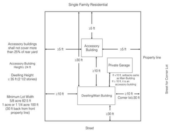
Note: modify drawing for accessory building 5 feet minimum behind front line of main building
Adopted by Ord. 2010-03 on 2/11/2010
Repealed & Reenacted by Ord. 2020-07 on 9/10/2020
Amended by Ord. 2024-03 on 11/14/2024
11.12 MULTIPLE FAMILY RESIDENTIAL ZONE R-2
A. PURPOSE. To provide appropriate locations for multiple family dwellings, the regulations permit a variety of necessary public services and activities. Certain retail and service activities which are in harmony with the intent of the regulations are allowed, subject to control. Multiple family dwellings shall be limited to one (1) unit per 10-acre block at the corner lots only. A duplex will be allowed on five eights (5/8) acre, a three plex on 1 acre, and a maximum of (1) fourplex on a one and one-quarter (1 1/4) acre lot. (reference appendix C Lot - Block Layout Plan.) Bear River Health Authority may impose additional land requirements for any dwelling size beyond a single family unit. Their requirements will take precedence. B. PERMITTED USES. The permitted uses are as follows: 1. Single-family dwelling, attached or detached 2. Multi-family dwelling 3. Home occupations 4. Accessory dwellings. 5. Accessory uses and buildings 6. Agriculture 7. Residential facilities for elderly person C. CONDITIONAL USES. The conditional uses are as follows: 1. Private educational institutions having a curriculum like is ordinarily given in public schools; colleges and universities; child day care or nursery 2. Accessory uses and buildings customarily incidental to the above 3. Museum 4. Church, except temporary revival tent or buildings 5. Club, Lodges, Social Halls 6. Hospital (not including animal hospital) 7. Public Library 8. Public buildings 9. Public park or playground 10. Public Utilities 11. School D. HEIGHT REGULATIONS. Dwellings/Main Buildings shall be erected to a height no greater than two and one-half (2 1/2) stories or thirty-five (35) feet. E. AREA REGULATIONS. The minimum lot area shall be not less than five-eighth (5/8) acre (27,225 square feet) feet for a single family residence. For developments utilizing a shared septic system (upon approval of the Health Authority), the minimum land area per dwelling unit shall be four thousand (27,225) square feet (⅝) for a single family home, single family home with accessory dwelling or duplex. One acre (43,560 square feet) for a triplex and 1.25 acre (54,450 square feet) for a four-plex. Adaptions to these area calculations may be necessitated for septic requirements per Bear River Health Authority and those requirements will take precedence. F. FRONTAGE REGULATIONS. The minimum width of any lot for a main building shall be eighty 110 feet at a point thirty (30) feet back from the front lot line. G. SIDE YARD REGULATIONS. The minimum side yard for any building shall be ten (10) feet. Accessory buildings shall have a side yard of at least five (5) feet. Side yards on a corner lot shall be the same as a front yard on the side facing the street. H. FRONT YARD REGULATIONS. The minimum front yard shall be thirty (30) feet from the property line to the house or other main building. I. REAR YARD REGULATIONS. A minimum of thirty (30) feet is required for any main building or accessory dwelling, and five (5) feet for accessory buildings. On corner lots which rear upon the side yard of another lot, accessory buildings shall be located no closer than five (5) feet to such side yard. J. GROUP DWELLINGS. These buildings shall be considered as one building for the purpose of front, side, and rear yard requirements. The entire group, as a unit, requires one front, one rear and two side yards as specified for single dwelling structures. Group dwellings shall be not be more than two and one-half (2 1/2) stories or thirty-five (35) feet in height. Each two and one-half (2 1/2) story group dwelling development shall have a minimum court of thirty (30) feet in width and forty (40) feet in length, in addition to its required yards. Each one-story group dwelling development shall have a minimum court of twenty (20) feet in width and thirty (30) feet in length in addition to its required yards. In a group dwelling development, no two separate dwelling structures shall be closer to each other than ten (10) feet along the sides or ends of a court.
Adopted by Ord. 2010-03 on 2/11/2010
Repealed & Reenacted by Ord. 2020-07 on 9/10/2020
Amended by Ord. 2024-03 on 11/14/2024
11.14 AGRICULTURAL ZONE A-1, A-2, A-3
- PURPOSE. The A-1 Agricultural Zone has been established as a district in which the primary use of the land is to produce agricultural and livestock products. This Zone has been created to preserve appropriate areas of Mendon, Utah for permanent agricultural use. Uses normally and necessarily related to agriculture are permitted and uses inimical to the continuance of agricultural activity are not allowed. This zone is characterized by dwellings situated on small, part-time subsistence farms. The zone is also characterized by family garden plots and the keeping of animals and fowls for family food production. Representative of the uses within this zone are barns, milking parlors, corrals, row crops, fruits, livestock, pasturing of animals, and dwellings occupied by persons obtaining all or part of their livelihood from the land on which the dwelling is located, but excluding production of fur-bearing animals.
- PERMITTED USES. The permitted uses are as follows:
- Single family dwellings and buildings accessory thereto, when located on a farmstead of at least two and one-half (2 1/2) acres. When lot size is at minimum, livestock numbers will be governed by regulations under Family Food Production
- The production of agricultural produce
- Fruit and vegetable packing plants and produce depots
- Fruit and vegetable stands, provided such stands are temporary and will be moved in the off season and are made exclusively of wood frame or light metal material
- Farm produce sheds, buildings, and cellars.
- Nurseries plants
- Machinery sheds for the storage of farm machinery
- The raising of livestock and poultry
- Barns, corrals, pens, and coops, for the keeping and breeding of animals and fowls
- Chicken hatcheries; milking parlors, and outbuildings accessory thereto
- Poultry killing and dressing
- CONDITIONAL USES. The permitted uses are as follows:
- Public utility buildings and other public buildings
- Schools and churches
- Sewage treatment plants, when approved by the State Department of Health and by the Board of Adjustment
- Water reservoirs and water drainage facilities
- Country Clubs
- Golf courses
- Cemeteries
- Residential facilities for elderly persons
- Tower or Antenna Structure
- Equestrian Park
- Gravel Pit
- Private park or camping area for temporary recreation
- Other similar uses ruled by the Planning Commission to be in harmony with the objectives and characteristics of the zone
- HEIGHT REGULATIONS. Not over thirty-five (35) feet.
- AREA REQUIREMENTS. An area of not less than two (2.5) acres shall be provided and maintained for all permitted uses. However, schools and churches shall have a building site of at least (5) acres. Buildings housing animals and fowls shall be kept a minimum of one hundred and thirty (130) feet from the street. Area requirements for conditional uses shall be as required by the Planning Commission, provided a minimum of two (2.5) acres shall be required.
- WIDTH REQUIREMENTS. The minimum width of any building site for dwellings or other main buildings shall be at least three hundred thirty (330) feet.
Table 5. Agricultural Area and Lot RequirementsDistrict Area Minimum Lot Width A-1 2.5 Acres (108,900 sq. ft) 330 feet A-2 5 Acres (217,000 sq. ft) 330 feet A-3 10 Acres (434,000 sq.-ft.) 330 feet - FRONT YARD REGULATIONS. All buildings and structures shall be set back at least sixty (60) feet from the center of any public road, or forty (40) feet from the right-of-way, whichever is the greater distance. All buildings and structures situated adjacent to state or federally designated highways shall be set back at least fifty (50) feet from the right-of-way line.
- SIDE YARD REGULATIONS. All buildings shall be set back at least ten (10) feet from a side property line, except that a one (1) foot side setback shall be required for accessory buildings and for barns, coops, and sheds which are located adjacent to waterway boundaries or on road rights-of-way. On corner lots, the required setback from the side property line which abuts upon a street shall be the same as the front setback.
- REAR YARD REGULATIONS. All buildings shall be set back from the rear property line at least eight (8) feet, except that no setback shall be required for accessory buildings, barns, coops, and sheds which are located adjacent to a waterway or road right-of-way.
- SIZE OF DWELLINGS. The ground floor area of any single-family dwelling shall be at least eight hundred (800) square feet exclusive of open porches and carports. For other buildings there shall be no size requirements.
- SPECIAL PROVISIONS
- Space around buildings and structures shall be kept free from refuse and debris.
- Domestic water supply and sewage disposal shall comply with State Department of Health requirements, as represented by a letter or other approval there from.
Adopted by Ord. 2010-03 on 2/11/2010
Amended by Ord. 2018-14 on 8/9/2018
Repealed & Reenacted by Ord. 2020-07 on 9/10/2020
11.16 COMMERCIAL ZONE C-1
- PURPOSE. The C-1 Commercial Zone has been established as a district in which the primary use of the land is for retail and service uses. This zone is characterized by a mixture of dwellings, businesses, agriculture developments, and livestock raising. The area contained within this zone is comparatively small and is usually traversed by a major street or highway or is in the central part of a community which it is designed to serve.
Inasmuch as the C-1 Zone includes dwellings and is usually located adjacent to a major road, it is intended that traffic congestion and traffic hazards be reduced to a minimum and that residential amenities in the surrounding area be preserved and protected insofar as possible. To this end, certain requirements about the maintenance of premises and location of buildings, structures, and off-street parking facilities have been adopted. It is the full intention of the City Council and the Planning and Zoning Commission that location and uses granted in the Zone C-1 be free from objection by a majority resident of the community. Any commercial zone or mixed commercial zone will not include sexually oriented business, bars, saloons, private clubs, controlled substance dispensaries or other non-compatible establishments.
All commercial or residential/commercial building permits shall be approved by the city planning and zoning commission prior to review by city building inspector.
The objectives in establishing this zone are as follows:
- To set aside appropriate areas within the city for the development of retail service establishments where the establishments will best serve the needs of the surrounding community
- To prohibit industrial and commercial uses from scattering indiscriminately into the surrounding zones
- To prohibit the use of outdoor advertising signs and billboards separate from the commercial establishment to which they refer, except as noted in other sections of this ordinance
- To reduce the cost of providing fire and police protection and other governmental services
- To provide community-friendly businesses, all C-1 business must have adjacent property owner notification and planning input within six hundred and sixty (660) feet
- PERMITTED USES. The permitted uses are as follows:
- Art shop; artists' supplies shop; athletic goods store; art needlework shop
- Bakery, in which manufacture is limited to goods retailed on the premises only; bank; baby formula service; barber shop; beauty parlor; bicycle shop; bird store; bookstore
- Candy store, catering establishment; camera and photo supplies; clothes cleaning or dry-cleaning agency or pressing establishment, altering and repair of wearing apparel; confectionery; cafe or refreshment stand; cafeteria; Christmas tree sales; china and silver shop; convenience stores including dispensing of fuels
- Dairy products store; drug store; delicatessen; diaper service; dramatics school
- Single family dwelling when located on the second floor of an allowed retail use
- Florist; fruit juice store, frozen food lockers, fruit stand and vegetable stand; fish stores, sidewalk cafe
- Gift shop; grocery; greenhouse; glass and china store; garden supplies store
- Hardware store, not including sale of powered vehicles using motors greater than five (5) horsepower; health food store; hobby supply store
- Ice cream shop; ice store or vending station
- Jewelry store, including repair of jewelry, watches, and clocks
- Laundry, customer self-service only; library, lunch service, commercial locksmith
- Medical and dental clinics and laboratories; milk distributing stations and sale of dairy products, but not including processing or bottling; meat store; museum; music store
- Newsstand notions; nurses' or babysitters agency
- Office, business or professional; optometrist or optician
- Paint and wallpaper store; photographer or sale of photographic supplies; photo studio; post office; plant materials; private schools; popcorn or nut shop; Public Utilities
- Radio and television sales and repairs
- Stationery and greeting card sales; shoeshine shop; shoe repair shop; studios for professional work or teaching any form of fine arts; soft water sales and service, excluding welding or tank repair; schools
- Taxi stand; tailor shop; toy store; tobacco shop; tower or Antenna Structure
- Variety store, limited to selling only items which may be sold by any other use by right in this chapter
- Accessory uses and buildings, customarily incidental to, subordinate to the above uses and devoted exclusively to the main permitted use of the premises
- Automobile service station, including the repairing, painting, or upholstering of motor vehicles
- Manufacture of goods to be sold at retail on the premises, provided such manufacture is conducted within a completely enclosed building and is clearly incidental to the operation in connection with a use permitted in this chapter
- Multi-family dwelling units no more than 35 feet in height and no more than 4 units per structure on 1.25 acres.
- Similar Businesses as determined by the Planning and Zoning Commission
- CONDITIONAL USES. Any use not specifically mentioned under permitted uses that conforms to the general concepts and ideas laid out in Mendon City’s General Plan.
- SPECIAL PROVISIONS. The C-l Zone allows any use permitted in the R-2 Zone, provided those R-2 uses meet the zoning requirements set forth in that chapter. The required yards shall be kept free from refuse, debris, and waste material. All such refuse, debris, garbage, and waste material shall be kept in approved containers. All uses shall be free from objections because of odor, toxic fumes, dust, smoke, noise, vibration, or other causes. Height and yard restrictions are determined and granted by the planning and zoning commission and are defined on each conditional use permit issued.
Adopted by Ord. 2010-03 on 2/11/2010
Amended by Ord. 2017-09 on 10/13/2017
Repealed & Reenacted by Ord. 2020-07 on 9/10/2020
11.18 LIGHT INDUSTRIAL ZONE L-1
A. PURPOSE. To provide areas where industries necessary and beneficial to the local economy may locate and operate. The regulations of the zone are designed to protect and preserve the environment of the zone, the adjacent areas, and the entire community. It is the full intention of the City Council and the Planning and Zoning Commission for locations and uses granted in the Light Industrial Zone L-1 to be free from objection by the majority of residents of the community. B. PERMITTED USES. The permitted uses are as follows: 1. Automobile, major repair 2. Cabinetry Shop 3. Contractor’s yard or shop 4. Farm, garden, or building supply store 5. Food processing and/or packaging plant 6. Fuel sales facility (convenience store/service station) 7. Laundry or linen supply 8. Manufacturing, light and medium (e.g. machine shops, electronics) 9. Nursery 10. Office building 11. Processing plant for agricultural products 12. Research and development facility 13. School (vocational or trade) 14. Warehouse 15. Storage units C. CONDITIONAL USES. Any use not specifically mentioned under permitted uses which conforms to the general concepts and ideas laid out in Mendon City’s General Plan. D. SPECIAL PROVISIONS. Approval of any construction and plat layout must be obtained from the Planning and Zoning Commission and the City Council before construction is commenced The required yards shall be kept free from refuse, debris, garbage, and waste material. All such refuse, debris, garbage, and waste material shall be kept in approved containers. All uses shall be free from objections because of odor, toxic fumes, dust, smoke, noise, vibration, or other causes. City streets, walks, and utility (electricity, culinary water, secondary water for landscape, and sewer) infrastructure is required to be in place as a part of site approval for building. All access roadways shall be design and certified to bear the intended traffic weight loads and at the frequency for which the facility is designed to move materials in and out. E. HEIGHT REQUIREMENTS. Height requirements in the L-1 zone will be thirty-five (35) feet of the boundary of any adjoining zone, no building shall exceed the height limit established for main buildings in such adjoining zone. F. AREA, WIDTH, AND YARD REGULATIONS. Any parcel in the L-1 zone having a lot line in common with a lot in an adjoining zone, or lying across the street or alley from such adjoining zone, the front, side and rear yards, as prescribed for such adjoining zones, shall be maintained in the L-1 zone.
Adopted by Ord. 2010-03 on 2/11/2010
Amended by Ord. 2017-09 on 10/13/2017
Repealed & Reenacted by Ord. 2020-07 on 9/10/2020
Amended by Ord. 2024-03 on 11/14/2024
11.20 SENSITIVE LANDS
- PURPOSE. The sensitive land categorization will provide the maximum in public safety and welfare in the development and design of building sites, roadways, and other service amenities. It will also preserve and enhance the landscape by encouraging the maximum retention of natural features, such as drainage swales, streams, slopes, ridgelines, crests of hills, rock outcroppings, vistas, and natural formations, and will protect existing public service sites and amenities from degradation.
- APPLICABILITY. These regulations shall apply to the following within the Mendon Well Catchment Area and Mendon Springs Delineation Protection Management Area as identified on the Mendon City General Plan Land Use Map:
- New subdivisions
- New roads
- New construction, alteration, moving, or change of use of existing structures adjacent to a natural waterway (as herein defined)
- STANDARDS. The minimum setback for new structures or roads adjacent to any natural waterway shall be fifty (50) feet from the edge of the waterway, or if bounded, then fifty (50) from the boundary thereof. Prior to the initiation of any new development the applicant shall submit documentation showing that the new development will not adversely impact the natural waterway or water quality within the Mendon Well Catchment Area or Mendon Springs Delineation Protection Management Area. At a minimum, said documentation shall be prepared and stamped by a professional engineer registered in the State of Utah and shall contain a description of the hydrology of the site, conclusions on the proposed development, and recommendations regarding measures to protect water quality. The report shall include results of field investigations of the site.
Adopted by Ord. 2010-03 on 2/11/2010
Repealed & Reenacted by Ord. 2020-07 on 9/10/2020
11.22 HILLSIDE OVERLAY AND WATER RUN-ON/RUN-OFF IMPACT
A. PURPOSE. To provide the maximum in public safety and welfare in the development and design of building sites, roadways, and other service amenities where steepness of slope and length may cause unintended damage to areas below and to preserve and enhance the hillside landscape by encouraging the maximum retention of natural features, such as drainage swales, streams, slopes, ridgelines, crests of hills, rock outcroppings, vistas, and natural formations. Also to reduce the impact of water run-on/run-off impact both due to slope and due to natural build up during heavy rains and high clay content soil. B. APPLICABILITY. These provisions shall apply to any proposed construction, grading, filling, clearing or excavation on any hillside that meets or exceeds a slope of fifteen (15) percent. Trail development which does not exceed five (5) feet in width and does not exceed three (3) feet of cut or three (3) feet of fill shall be exempt from these provisions. C. REQUIREMENTS. Prior to the initiation of any construction, grading, filling, clearing, or excavation within the Hillside Overlay, the applicant shall provide the following, prepared and stamped by a professional engineer registered in the State of Utah, to the City Engineer, for review and approval of lot grading plan. See Above Section 1.15. General Requirements: 1. The lot grading plan must be prepared by a civil engineer or land surveyor certified in Utah. 2. The building shall be located or the building site graded so that water will not accumulate at or near the building and will not adversely affect adjacent properties. 3. Artificial embankments and/or retaining walls shall not be allowed unless approved as part of the Building Permit. The maximum embankment slope shall be 3:1 (horizontal to vertical). 4. Existing overland drainage is to be maintained. 5. Proposed improvements within 10’ of the property line shall make assurances that runoff is not directed towards adjacent properties. 6. A minimum slope of two percent (2%) shall be maintained away from the home for drainage purposes. 7. Bare soil areas and soil stockpiles shall be stabilized as soon as practical when the area is inactive or has reached finished grade. 8. Sedimentation/siltation control measures shall be installed prior to construction and offset at a minimum of two feet (2’) from lot lines. 9. Hand-drawn sketches or photographs will not be accepted. Lot Grading Plan Details: 1. Show lot address, entire property line including driveway and street name clearly labeled. If property is on a corner, both street names are to be labeled. 2. Show proposed building envelope or footprint of the proposed home. 3. Show setbacks from all property lines and any existing and/or proposed easements. 4. Show proposed and existing grades and directional slopes with percentage of slope. 5. Show all existing trees showing base diameter. Identify any trees to be removed or affected within area of construction (dripline). 6. Show driveway location, width, culverts, and any changes proposed within the right-of-way. State type of driveway (asphalt, gravel, etc.). 7. Show all existing and proposed retaining walls including height, setback and top & bottom elevations (if applicable). Please note: any retaining wall over four feet (4’) in height must be certified by a Professional Engineer in the State of Utah. 8. Relative elevations are permitted with a benchmark for such elevations identified on the plan. 9. Mendon City limits building on lots at or over 15% grade based on Engineer’s recommendations. Per county restrictions, lots at or over 20% grade may not be built on. D. FINDINGS. Prior to issuance of a permit for construction within the Hillside Overlay District, and based upon the above noted reports, the City Engineer shall determine the following: 1. The site is physically suitable for the design and siting of the proposed development. The development shall result in minimum disturbance of hillside areas. 2. The grading and excavation proposed in connection with the development shall not result in soil erosion, silting of lower slopes, slide damage, flooding, severe scarring, any other geological instability, or fire hazard which would adversely affect the public, health, safety, and welfare. 3. Disruption of existing native vegetation and wildlife habitat is minimized.
Adopted by Ord. 2010-03 on 2/11/2010
Repealed & Reenacted by Ord. 2020-07 on 9/10/2020
Amended by Ord. 2024-03 on 11/14/2024
11.24 STREET DEVELOPMENT
- A. PURPOSE. To outline general requirements and responsibilities for development of city streets. More specific requirements are contained in the city’s standards and specification. B. GENERAL INTENT. It is the general intent of Mendon City that all new street rights-of-way shall be a minimum width of ninety-nine (99) feet with a minimum of twenty-four (24) feet wide asphalt drive strip to allow for future utilities and infrastructure including stormwater, sewer, irrigation improvements. In addition, it is the intent of the city that new utilities or improvements be “bored-in” under existing asphalt street surfaces rather than accessed from the surface by cutting or excavating through the surface. Finally, any damage to existing streets during construction of new streets, buildings or other improvements shall be the responsibility of the developer to repair. C. IMPROVEMENTS COMPLETED PRIOR. All subdivisions and/or development shall have site improvements completed and in place prior to placement of any asphalt, concrete and fill for street(s). D. RESPONSIBILITY FOR CONSTRUCTION. It is the responsibility of the person developing any parcel of land that does not have direct access to a paved city street to extend a new street the full length and width to the new development for a minor or major subdivision and two thirds the width for a single lot or double lot development. This policy is in place for residential, commercial, or light industrial development within Mendon City The new street will include all other requirements as specified for street construction outlined in the city’s standards and specifications. The responsibility may not be passed off to any other entity. In an approved subdivision, all designated streets must be completed prior to issuing any building permits for lots identified within the subdivision or phase of a major subdivision and must extend to all property boundaries. All dead-end streets shall have a hammer head turn-around and be reviewed and approved by the City Engineer, the City Public Works Director and the City Fire Chief. E. APPLICABILITY. The city’s standards and specifications shall apply to any proposed construction, grading, filling, clearing, or excavation on any street. Additional requirements may be imposed on streets exceeding a slope of six (6) percent after additional review and study by the City Engineer and Public Works Director.
Repealed & Reenacted by Ord. 2020-07 on 9/10/2020
Amended by Ord. 2024-03 on 11/14/2024