
Merced City Zoning Code
PART 2
ZONING DISTRICT STANDARDS
Chapter 20.14 - DOWNTOWN ZONING DISTRICTS
Sections:
20.08.010 - Purpose of the residential zoning districts.
A.
Rural Residential (R-R). The R-R zoning district provides an area for single-family dwellings on large lots in a semi-rural environment. The R-R zoning district serves as a buffer between the city's urbanized areas and agricultural land and other environmentally sensitive or resource areas.
B.
Low Density Residential (R-1). The R-1 zoning district is intended to stabilize, protect, and encourage the establishment and maintenance of a suitable environment for detached single-family dwellings, duplexes, and other land uses typically compatible with or authorized by state law for a low-density residential setting. The R-1 zoning district is divided into four (4) subzones (R-1-20, R-1-10, R-1-6, and R-1-5) allowing for a range of minimum lot sizes.
C.
Low Medium Density Residential (R-2). The R-2 zoning district is intended to stabilize, protect, and encourage the establishment and maintenance of a suitable environment for single-family dwellings, duplex homes, limited multi-family dwellings, and other land uses typically compatible with a low to medium-density residential setting.
D.
Medium Density Residential (R-3). The R-3 zoning district provides an area for a full range of residential uses, including single-family dwellings, duplex homes, multi-family dwellings, single room occupancy housing, and other land uses typically compatible with a medium density residential setting. The R-3 zoning district is divided into two (2) subzones (R-3-1.5 and R-3-2) allowing for a range of permitted residential densities.
E.
High Density Residential (R-4). The R-4 zoning district provides an area for the highest density residential uses in Merced. Permitted uses include single-family dwellings, duplex homes, multi-family dwellings, single room occupancy housing, and other land uses typically compatible with a high-density residential setting in close proximity to shopping, transportation, and other facilities.
F.
Mobile Home Park (R-MH). The R-MH zoning district provides an area for mobile home parks with regulations and standards intended to maintain a suitable environment for mobile home park residents.
(Ord. No. 2465, § 2(Exhs. A., B.), 9-19-2016; Ord. No. 2543, § 1, 9-6-2022)
20.08.020 - Land use regulations for residential zoning districts.
A.
Permitted Land Uses. Table 20.08-1 identifies land uses permitted in residential zoning districts.
Notes:
[1] A site plan review permit may be required per Chapter 20.32 (Interface Regulations) regardless of the uses shown in Table 20.08-1.
[2] Reserved.
[3] Only permitted for rooming and boarding houses as an accessory use. The maximum persons allowed are: R-1, R-R, & R-MH (1 person); R-2 (2 persons); and R-3 and R-4 (no limit).
[4] Permitted only on lots six thousand (6,000) square feet or greater at the density permitted in the existing zoning district.
[5] For day care home facilities for adults, a conditional use permit would allow up to twelve (12) adults in care.
[6] Permitted only as an ancillary use to serve residents, not to exceed more than two thousand five hundred (2,500) square feet.
[7] Permitted only for onsite retail for agricultural products.
[8] Permitted only when ancillary to a multi-family use and intended to serve residents only. No exterior display or advertising is permitted. Retail use must be located within the same building as residences.
[9] A minor use permit is required for a cottage food industry home occupation.
[10] Agricultural uses are temporary, transitional uses in the city and should not remain on a permanent basis. The appropriate length of time for the use will be defined in the conditional use permit based on the types of crops, surrounding uses, etc. Hog-raising and onsite sale of products, including wholesale, are prohibited. See Chapter 6.04 (Animal Control) for additional regulations.
B.
Duplex Homes in the R-1 Zoning Districts. One (1) duplex home per lot is permitted in the R-1 zoning districts when the following standards are met:
1.
The lot meets the minimum lot size for the district.
2.
One (1) off-street parking space for each unit is provided consistent with Chapter 20.38 (Off-Street Parking). However, no parking may be required if either of the following is true:
a.
The parcel is located within one-half (½) mile walking distance of either a high-quality transit corridor as defined in Subsection (b) of Section 21155 of the Public Resources Code, or a major transit stop as defined in Section 21064.3 of the Public Resources Code; or
b.
There is a car share vehicle located within one (1) block of the parcel.
3.
Driveways are a minimum twenty (20) feet in length (measured from the garage/carport to the back of the sidewalk or front property line whichever is furthest from the street).
4.
The lot does not have frontage along a designated collector or higher order street as defined in the general plan, or has a circular driveway or other driveway configuration that enables vehicles to enter and exit the site in the same direction and not back out into the street.
C.
Small Houses. Small Houses may be proposed in residential planned development (RP-D), inner village residential (R-IV), outer village residential (R-OV), low density residential (R-1) low medium density residential (R-2), high medium density residential (R-3), and high density residential (R-4) zoning districts. The city may determine that a proposed small house subdivision is not allowed where public facilities and services are insufficient for the proposed development.
1.
Small houses proposed within R-2, R-3, or R-4 zoning districts shall require approval of a site plan review. All subdivisions of land shall receive permits and approvals required by Title 18 (Subdivisions) of the Merced Municipal Code. Small house villages proposed within the R-2 zoning district shall require approval of a conditional use permit.
2.
Residential Design Standards.
a.
Small Houses. Each small house is required to comply with Chapter 20.46.020 of this code, except where specified below.
b.
Small House Villages. Each small house village is required to comply with Chapter 20.46.030 of this code, except where specified below.
3.
Density and Intensity.
a.
One (1) small house is permitted per lot, in districts where small houses are permitted, subject to the regulations contained in this chapter.
b.
Small house villages are permitted in the R-2, R-3, and R-4 districts at the densities permitted in the existing zone district.
a.
Infill lots that do not meet the required lot depth and width requirements may be granted an exception if the director finds that all other development and density standards are met.
b.
Any non-conforming or substandard residential zoned lot in compliance with Chapter 20.50 is permitted to construct one (1) small house as a primary dwelling.
c.
Walls and Fences. Walls and fences shall be provided and developed in compliance with Chapter 20.30 (Walls and Fences).
d.
Parking Standards. Parking shall be provided and developed in compliance with Chapter 20.38 (Parking and Loading).
i.
Within the R-1 and R-2 zoning districts, required off-street parking spaces may not be located within any required exterior setback area, except for required parking spaces for accessory dwelling units on the property.
ii.
Within the R-3 and R-4 zoning districts, off-street parking spaces may be located within required exterior setback areas if the total off-street parking requirement exceeds four (4) spaces.
When the required off-street parking for a single-family or duplex home in any residential zoning district is provided outside of a covered garage or carport, each parking space shall be located and designed so that it may later be covered by a garage or carport structure.
(Ord. No. 2465, § 2(Exhs. A., B.), 9-19-2016; Ord. No. 2502, § 1, 8-19-19; Ord. No. 2543, §§ 2—4, 9-6-2022; Ord. No. 2555, § 1, 9-18-2023)
20.08.030 - Development standards for residential zoning districts.
A.
Basic Standards. Tables 20.08-2 and 20.08-3 identify development standards that apply in residential zoning districts.
B.
Variation in Lot Dimensions for R-1 Subdivisions. The planning commission may approve reduced lot widths for an R-1 subdivision when the following conditions are met:
1.
The subdivision creates at least ten (10) lots.
2.
Excluding corner lots, at least twenty-five (25) percent of the remaining lots are at least five (5) feet above the minimum required width.
3.
Excluding corner lots, no more than forty (40) percent of the remaining lots may be less than the minimum required width.
4.
No lot shall have a depth less than the minimum required depth or a width less than fifteen (15) feet below the minimum required width.
5.
No corner lot may be less than the minimum required width or area.
6.
No more than two (2) lots below the minimum required width may be adjacent to one another.
C.
Residential Design Standards. All residential structures shall comply with the design standards established in Chapter 20.46 (Residential Design Standards). See Figure 20.08-1.
Figure 20.08-1 — Residential Development Standards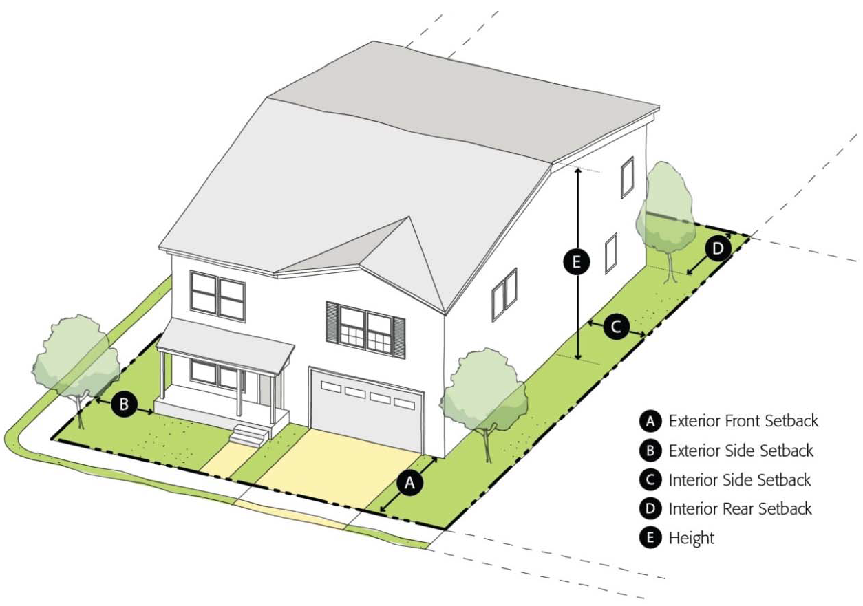
Notes:
[1] Twenty-foot minimum for garages.
[2] Lots located on curved streets, turnarounds, or cul-de-sac bulbs shall meet the minimum lot width requirement at the established front setback line.
[3] Cul-de-sac lots located on the cul-de-sac bulbs shall meet the minimum lot depth requirement measured at the mean horizontal distance between the front and rear lot lines, but at no point shall be less than eight (80) feet in depth.
[4] May be reduced to one-third (⅓) acre if city sewer and water serves the property.
[5] On corner lots, if the yard abuts the exterior front yard of an adjacent lot, then it shall be considered an exterior front yard. Otherwise, it shall be considered an exterior side yard.
[6] Driveway length is measured from the garage/carport to the back of the sidewalk or front property line whichever is furthest from the street.
Notes:
[1] The maximum residential density in the R-MH zoning district is ten (10) dwelling units per acre.
[2] Rear yard minimum ten (10) feet for structures over twenty-five (25) feet in height, an additional one (1) foot per each additional five (5) feet in height.
D.
R-1-5 Subdivisions. Homes for R-1-5 subdivisions shall comply with the following design standards, unless exceptions from individual standards are granted through a minor use permit per Section 20.68.020:
1.
A minimum of twenty-five (25) percent of the front elevations along a street shall have a minimum twenty-five-foot garage setback.
2.
No three-car garages shall be allowed on five thousand-square-foot lots, except on lots with alley access or lots exceeding sixty (60) feet in width.
3.
All subdivisions shall provide a variety of dwelling elevations appropriate for the scale of the project. Elevations shall be approved by the planning division. At a minimum, the same elevations shall not be repeated for adjacent houses. Varied front setbacks and heights are encouraged as ways of achieving variety.
4.
Windows, doors, and garage doors (except recessed garage doors) on the front elevation shall have raised trim in order to provide visual interest and relief.
5.
Plans for two-story structures immediately adjacent to a developed R-1 area shall receive special attention by the planning division. Planning division staff shall consider the relationship of second-story windows, doors, and balconies with the privacy of neighbors, and may require that these features be redesigned or omitted from second-story rear walls.
E.
Exceptions on Required Front Setback. In any residential zoning district, the required front setback may be modified with a minor use permit if at least fifty (50) percent of the homes are already constructed on the same block with front setbacks that are different from the front setback requirement in Table 20.08-2 (Setback and Height Standards for Residential Zoning Districts). In such cases, the modified setbacks shall comply with the following requirements:
1.
The front setback shall not exceed the average of existing front setbacks on the same block.
2.
The front setback shall not exceed the average of existing front setbacks of the two (2) immediately adjoining lots.
3.
For corner lots, the front setback shall not exceed the front setback of the immediately adjoining lot.
4.
The front setback for all lots shall be a minimum of ten (10) feet and a maximum of fifty (50) feet.
F.
Parking.
1.
Within the R-1 and R-2 zoning districts, required off-street parking spaces may not be located within any required exterior setback area, except for required parking spaces for accessory dwelling units on the property.
2.
Within the R-3 and R-4 zoning districts, off street parking spaces may be located within required exterior setback areas if the total off-street parking requirement exceeds four (4) spaces.
3.
When the required off-street parking for a single-family or duplex home in any residential zoning district is provided outside of a covered garage or carport, each parking space shall be located and designed so that it may later be covered by a garage or carport structure.
(Ord. No. 2465, § 2(Exhs. A., B.), 9-19-2016; Ord. No. 2502, § 2, 8-19-19; Ord. No. 2543, §§ 5—7, 9-6-2022; Ord. No. 2555, § 2, 9-18-2023)
20.08.040 - Additional dwelling units on R-1 lots.
A.
General. Up to three (3) single-family dwelling units are permitted on an R-1 lot provided that all of the following conditions are met:
1.
The minimum lot size is fifteen thousand (15,000) square feet for R-1-5; eighteen thousand (18,000) square feet for R-1-6; thirty thousand (30,000) square feet for R-1-10; and sixty thousand (60,000) square feet for R-1-20.
2.
The minimum lot area per dwelling unit is five thousand (5,000) square feet for R-1-5; six thousand (6,000) square feet for R-1-6; ten thousand (10,000) square feet for R-1-10; and twenty thousand (20,000) square feet for R-1-20.
3.
A minimum separation of twenty (20) feet is provided between dwelling units located behind each other.
4.
For dwelling units located side by side on one (1) lot:
a.
The lot has a width of at least one hundred (100) feet.
b.
A minimum separation of ten (10) feet is provided between dwelling units.
B.
Deep R-1 Lots. R-1 lots that are over one hundred fifty (150) feet in depth with an existing dwelling unit may add an additional dwelling unit, provided that the following conditions are met:
1.
The existing dwelling unit existed prior to the adoption of this title.
2.
The existing dwelling unit is located at least seventy-five (75) feet back from the front lot line.
3.
The additional dwelling unit is located on the front half of the lot.
4.
A minimum separation of twenty (20) feet is provided between the two (2) dwelling units.
C.
Rear Dwellings.
1.
No structure to the rear of a principal structure on the same lot shall be used for residential purposes unless it conforms to all the lot area, setback, open space, and off-street parking requirements of this title.
2.
Vehicle access to rear dwellings shall be provided from a public street or alley. The minimum driveway width shall be ten (10) feet for driveways serving two (2) units, and twenty-two (22) feet for driveways serving three (3) or more units.
D.
Dwelling Units Over Garages. Dwelling units occupying an upper story above a garage may be set back three (3) feet from a rear lot line that abuts an alley. The ground floor garage shall be set back five (5) feet from the rear lot line. All other setback and open space requirements must be observed.
E.
Accessory Dwelling Units. Dwelling Units that meet the requirements of Chapter 20.42 shall be permitted in R-1 zoning districts.
(Ord. No. 2465, § 2(Exhs. A., B.), 9-19-2016; Ord. No. 2543, § 8, 9-6-2022; Ord. No. 2555, § 3, 9-18-2023)
20.08.050 - Rural residential zoning district.
A.
Purpose. This section establishes supplemental standards and procedures for properties within the rural residential zoning district. The intent of this section is to maintain the existing rural character of these properties and to allow for continued agricultural uses and operations in addition to residential uses.
B.
Agricultural Uses
1.
Crop, orchard, and vineyard operations are permitted as a primary land use in the rural residential zoning district if a dwelling unit is also located on the property.
2.
The keeping of livestock and poultry shall be a permitted use in the rural residential zoning district subject to the requirements of Merced Municipal Code Section 6.04.081 (Exception to Livestock and Poultry Regulations).
C.
Infrastructure Improvements. Through a special project permit process as outlined in Section 20.68.060, the city council may waive or defer for a specified amount of time requirements for properties in the rural residential zoning district only to install city sewer, city water, curb, sidewalk, streetlights, and other infrastructure improvements consistent with adopted city policies and regulation.
20.10.010 - Purpose of the commercial zoning districts.
A.
Neighborhood Commercial (C-N). The C-N zoning district provides areas for shopping centers and other commercial uses that serve the day-to-day needs of residential neighborhoods. The C-N districts shall have a minimum area of three (3) acres and shall be located only where analysis of the residential population demonstrates that the facilities are justified.
B.
Shopping Center Commercial (C-SC). The C-SC zoning district provides areas for grocery stores, supermarkets, and other retail establishments selling groceries to serve local residents as well as the larger regional market. The C-SC districts shall have a minimum area of five (5) acres.
C.
Regional/Central Commercial (C-C). The C-C zoning district provides areas for a diversity of commercial and residential land uses in the central business district and regional centers. These uses help to support a vibrant retail destination, provide jobs for residents, and accommodate commercial and service uses to meet the needs of community and regional businesses and residents.
D.
Office Commercial (C-O). The C-O zoning district provides a location for a broad range of office uses including professional offices, business offices, medical offices, and regional or "back" offices. The C-O zoning district can also accommodate limited "accessory" restaurant, retail, and service uses that cater to the needs of on-site employees and visitors.
E.
Thoroughfare Commercial (C-T). The C-T zoning district provides areas for auto-oriented commercial uses that accommodate the needs of people traveling on highways and local motorists. The C-T zoning district also accommodates large recreational facilities and heavy commercial uses that benefit from proximity to the highway.
F.
General Commercial (C-G). The C-G zoning district provides areas for heavy commercial and light industrial uses that may impact neighboring uses and often require large parcels and benefit from separation from retail uses. The C-G districts are to be established in areas of four (4) acres or larger.
G.
Business Park (B-P). The B-P zoning district provides a location for employment-intensive uses within an attractive campus-like setting. The B-P zoning district shall primarily allow "back" offices, research and development businesses but also limited commercial retail uses to serve employees in the area. The B-P zoning district shall have a minimum area of five (5) acres.
(Ord. No. 2465, § 2(Exhs. A., B.), 9-19-2016)
_____
20.10.020 - Land use regulations for commercial zoning districts.
A.
Permitted Uses. Table 20.10-1 identifies land uses permitted in commercial zoning districts.
Notes:
[1] A minor use permit may be required per Chapter 20.32 (Interface Regulations) regardless of the uses shown in Table 20.10-1. Allowed Residential densities are as follows: a) 12.1 to 24.0 units/gross acre in the C-O, C-N, C-SC, C-T, C-G, and B-P Districts, but can be approved up to 36.0 units/gross acre with a Conditional Use Permit; and b) 12.1 to 36.0 units/gross acre in the C-C District but can be approved up to two hundred (200) units/gross acre for multi-story buildings over five (5) stories with a conditional use permit.
[2] Residential use on the ground floor is prohibited unless it is located on the back of the property where it is not visible or approved with a conditional use permit.
[3] Allowed only for converted hotels or motels.
[4] Use shall not exceed 20,000 square feet.
[5] 24 hour operations limited to C-T and C-C zones per Chapter 9.08 (Gaming).
[6] Rehabilitation centers for drug, methadone, and alcohol are prohibited.
[7] A conditional use permit is required for establishments smaller than 20,000 square feet.
[8] A site plan review permit is required for alcoholic beverage sales for on-site consumption.
[9] Permitted only as part of a shopping center or other retail establishment with a minimum of 8,000 square feet of floor area devoted to the sale of groceries.
[10] Prohibited in the city center area between 19th and 16th Streets and O Street and Martin Luther King, Jr. Way, including properties fronting on either side of each of the above streets, except vehicle sales showrooms can be allowed.
[11] Includes refreshment stands.
[12] Permitted only as an ancillary use to serve employees, not to occupy more than 5,000 square feet.
[13] Conditional use permit required unless the use is ancillary to a principal permitted use. For restaurants, Conditional Use Permit is required unless the uses are conducted in and entered from within the building with no outside advertising.
[14] A site plan review permit is required for used vehicle sales.
[15] Temporary warehousing and storage only is allowed per the requirements of Section 20.10.030(D).
[16] Provided that a massage establishment permit has not been revoked at that location within 12 months of the application for a conditional use permit and a massage establishment permit is obtained pursuant to Chapter 5.44.
[17] Must have valid certificate from State of California as a massage therapist or massage practitioner pursuant to the Massage Therapy Act (Business and Professions Code Section 4600 et seq.).
[18] Prohibited within one thousand (1,000) feet of schools and six hundred (600) feet of other uses per Section 20.44.160, unless building over twenty thousand (20,000) square feet or exemption granted per Section 20.44.160.
[19] Provided that the business includes a full-service restaurant and the on-site sale of beer, liquor, or wine made by the same business either on-site or off-site.
(Ord. No. 2465, § 2(Exhs. A., B.), 9-19-2016; Ord. No. 2480, § 4, 12-4-2017; Ord. No. 2486, § 1, 3-19-2018; Ord. No. 2522, §§ 1—11, 3-15-2021; Ord. No. 2543, §§ 9—52, 9-6-2022)
_____
20.10.030 - Development standards and guidelines for commercial zoning districts.
A.
General Standards. Table 20.10-2 identifies development standards that apply to all parcels and structures located in commercial zoning districts. See Figure 20.10-1.
B.
Outdoor Operation of Uses.
1.
The outdoor operation of a land use in the C-C and C-N zoning districts shall require approval of a site plan review permit. Outdoor dining in accordance with Chapter 12.36 (Restaurant Encroachment Permits), outdoor recreation, commercial parking lots, and other similar permitted uses that necessitate outdoor operation are exempt from this requirement.
2.
The storage of vehicles, equipment, and materials in the C-T and C-G zoning district shall be either located entirely within a completely enclosed building; or entirely enclosed by a screen fence or hedge not less than six (6) feet high. This requirement shall not apply to retail nurseries or vehicle sales and rental uses.
3.
All land uses shall be located entirely within a completely enclosed building in the B-P zoning district.
C.
Location of Parking and Loading Facilities. Parking and loading facilities in a commercial zoning district shall be set back a minimum of eight (8) feet from an exterior property line when located across the street from a residential zoning district.
D.
Temporary Warehousing and Storage Uses in the Downtown C-C Zoning District. The following uses require a site plan review permit pursuant to Chapter 20.68.050 of this code in the downtown C-C zoning district:
1.
Temporary warehouse and storage uses, but only within existing buildings or structures on properties with environmental issues, restrictions, or limitations identified by local, state, or federal agencies, subject to conditions in Section 20.10.030(D)(2) of this chapter. While warehouse and storage uses are generally prohibited and discouraged in the C-C district, it is recognized by the city that environmental issues, restrictions, or limitations identified by local, state, or federal agencies may limit or prohibit the uses, otherwise permitted or conditionally permitted in this district. The city further recognizes the substantial public and private investment made to both public and private properties in the downtown C-C district and the need for property owners to have a source of funds to meet property expenses as well as to ensure that the public and private investments are protected by preventing these properties from falling into disrepair and becoming blighted. Temporary warehouse and storage use does not include traditional mini-storage where multiple tenants or customers rent or lease storage space from the property owner or mini-storage operator.
2.
The following conditions shall be applied to the site plan review permit for temporary warehouse and storage uses in the downtown C-C district:
a.
When a site plan review permit is granted for any property within the downtown C-C district with environmental issues, restrictions, or limitations identified by local, state, or federal agencies, the use of the property shall have no more than the minimum number of employees for the minimal amount of time required for business operation in order to minimize human exposure.
b.
The site plan review permit shall be valid and last only until remediation of the environmental issue, restriction, or limitation is complete and the environmental issue, restriction, or limitation is officially "closed" by the local, state, or federal agency. The site plan review permit shall be reviewed at least every three (3) years to determine if the need still exists for the restriction. If the need no longer exists, the property shall be brought into compliance with downtown C-C district within ninety (90) days after notice to the property owner.
c.
The site plan review permit shall require that commercial activities occur that are observable through any window facing Main Street at the street and sidewalk level. It is the intent of this condition not to allow window displays of stacked boxes or merchandise. Examples of commercial activities encouraged hereunder shall include, but are not limited to, window display of art, goods, merchandise for sale at a different location by the warehouse or storage user, and public service notices and announcements, with such display shielding warehoused merchandise from any window facing Main Street.
d.
The site plan review permit shall require that proper maintenance and upkeep of the appearance of the building and the property occur during the duration of the site plan review permit including, but not limited to, weed abatement, graffiti abatement, and such other conditions as the site plan review committee determines is appropriate.
Notes:
[1] Minimum of twenty (20) feet required when abutting a residential zoning district.
[2] Minimum of thirty-five (35) feet required when across from a residential zoning district.
[3] Only applies when directly adjacent to residential zones. Exceptions to the height limitations in those cases may be granted by the site plan review committee.
Figure 20.10-1 Commercial Development Standards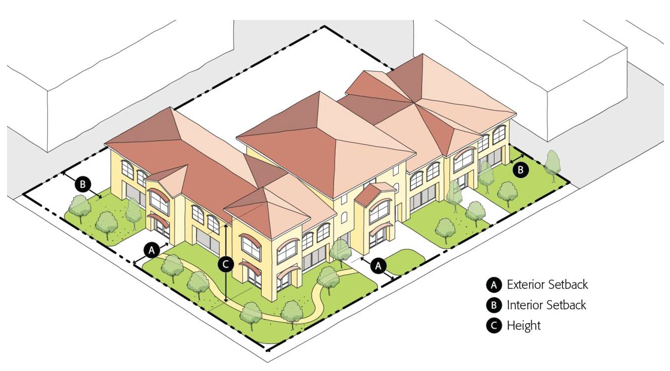
E.
Development Guidelines for the C-C (Regional Centers Only) and B-P Zoning Districts. The city shall consider the following guidelines when reviewing development project applications in the C-C (for regional centers only, outside of the downtown C-C district) and B-P Zoning Districts:
1.
Site Design.
a.
All buildings should relate visually to one another and appear to be part of a unified design theme.
b.
Larger buildings should be broken down into a group of buildings clustered into traditional building compounds or campus configurations.
c.
When multiple structures are proposed as part of a single project, the structures shall be designed to appear as part of an integrated complex within a unified site design and architectural characteristics.
d.
Building entries should be located so that they are easily identifiable. Each project should provide a well-defined entry sequence for pedestrian and vehicular uses from the street to the building.
2.
Building Design.
a.
Buildings shall feature quality design and architectural interest that enhances the aesthetics of the site and general vicinity.
b.
New development should include a variety of building types and designs in addition to the concrete tilt-up type construction which is often used.
c.
Buildings should appear to be of a pedestrian scale. Pedestrian scale building design can be achieved through outdoor patios; awnings, overhangs, and trellises; changes in building massing; changes in building materials and colors; defined building facades with an identifiable base, middle, and top; and other similar features.
3.
Landscaping.
a.
Development projects shall provide adequate, sustainable, drought-tolerant landscaping to enhance the appearance of buildings and provide an attractive environment for employees and the general public.
b.
Landscaping should provide an aesthetically pleasing transition between the building and adjacent sidewalks or pedestrian paths. Landscaping should soften the visual impact of buildings when viewed from the street, parking areas, or adjacent properties.
c.
Landscaping shall be provided along street frontage to provide visual interest, support a unifying character to the street, incorporate on-site storm drainage facilities, and enhance the appearance of individual developments. Landscape elements should be coordinated with adjacent properties to provide a compatible visual character.
4.
Parking.
a.
In order to reduce public views of parking areas, a significant amount of a development's parking area should be located beside or behind the building that it serves.
b.
Surface parking areas should be divided into smaller units to decrease visual impacts associated with large expanses of pavement and vehicles.
c.
Parking areas shall include designated pedestrian access to building entrances.
d.
Visual screening shall be provided for parking areas that can be viewed from adjacent development sites or from public streets. Screening may be in the form of trees and shrubs and/or landscaped berms.
5.
Pedestrian Circulation.
a.
Sidewalks and pathways shall be provided to accommodate pedestrian circulation from parking areas to buildings, between buildings, and to plazas, open spaces, and other outdoor amenities. This pedestrian network should enhance a campus-like appearance of the development site and functional awnings should be added to protect pedestrians from the rain when walking along building frontages of businesses which about each other.
b.
Pedestrian systems should be physically separated from vehicular circulation as much as possible. Areas where the two (2) systems cross or are physically adjacent should be minimized to reduce traffic hazards and make the pedestrian system more efficient, pleasant, and visually attractive.
c.
Intersections where pedestrian routes cross vehicular circulation shall be clearly marked for visual identification by both motorists and pedestrians.
6.
Service Areas.
a.
Loading and service dock areas should be located to the rear or sides of buildings and away from main building entrances and other high visibility areas.
b.
Loading and service docks, truck areas, and outdoor storage areas, shall be screened from public view.
c.
Service areas should be visually unobtrusive and integrated with each building's architecture and site design.
7.
Utilities and Backflow Preventers.
a.
Utility cabinets and meters shall be contained within the building or otherwise fully screened.
b.
Backflow prevention devices shall be fully screened from public view through the use of landscaping, berms, low walls, or other screening techniques.
8.
Waste Storage.
a.
Trash bins shall be located within a trash enclosure at all times and screened from public view. Gates shall remain closed and secured except during pick-up.
b.
Trash enclosures should be located away from main entry driveways if feasible.
c.
Trash enclosures shall be constructed of durable materials with color, texture, and architectural detailing that is consistent with the overall site and building design.
d.
No materials, supplies, equipment, service vehicles, finished or semi-finished products, raw materials, or articles of similar nature shall be stored or permitted to remain outside of buildings or be visible from adjacent properties or adjoining streets.
9.
Signs and Lighting.
a.
All signs and exterior lighting shall be designed to support a unified design theme within a development area.
b.
Multiple-tenant buildings and complexes shall develop a master sign program that supports a unified design theme within a development area. The master sign program, to be approved by the planning commission, site plan review committee, or through an administrative conditional use permit for signs, shall establish requirements for consistent use of sign materials, location, size, height, color, and lighting.
(Ord. No. 2465, § 2(Exhs. A., B.), 9-19-2016)
20.12.010 - Purpose of the industrial zoning districts.
A.
Light Industrial (I-L). The I-L zoning district provides areas for manufacturing, wholesale, and storage activities that meet city standards to ensure compatibility with surrounding areas and that maintain and strengthen the economic base of the city. I-L districts shall have a minimum size of five (5) acres.
B.
Heavy Industrial (I-H). The I-H zoning district provides areas for a full range of industrial land uses, including operations that necessitate the storage of hazardous or unsightly materials, and encourages sound industrial development by providing and protecting an environment exclusively to insure the protection of surrounding areas. I-H districts shall have a minimum size of ten (10) acres.
(Ord. No. 2465, § 2(Exhs. A., B.), 9-19-2016)
20.12.020 - Land use regulations for industrial zoning districts.
A.
Permitted Uses. Table 20.12-1 identifies land uses permitted in industrial zoning districts.
Notes:
[1] A site plan review permit may be required per Chapter 20.32 (Interface Regulations) regardless of the uses shown in Table 20.12-1.
[2] Limited to fitness, gymnastics, and other similar recreational sports and health facilities.
[3] Permitted only as an ancillary showroom use for goods manufactured onsite, not to occupy more than ten (10) percent of the total building floor area unless a site plan review permit is obtained for additional floor area.
[4] May be permitted only as an ancillary use to serve employees, not to occupy more than two thousand five hundred (2,500) square feet with no outside advertising, unless a conditional use permit is obtained.
[5] Limited to fleet operations only.
[6] All manufacturing of materials listed in the Section 20.12.020.B is prohibited unless the planning commission determines otherwise through a conditional use permit.
_____
B.
Prohibited Uses. The manufacturing of the following materials are prohibited unless the planning commission determines otherwise through a conditional use permit process.
1.
Asphalt, cement, charcoal, and fuel briquettes.
2.
Aniline dyes, ammonia, carbide, caustic soda, cellulose, chlorine, carbon black and bone black, creosote, hydrogen and oxygen, industrial alcohol, nitrates of an explosive nature, potash, pyroxylin, rayon yarn, and hydrochloric, nitric phosphoric, picric, and sulphuric acids.
3.
Coal, coke, and tar products, including use in other manufacturing; explosives, fertilizers, gelatin, animal glue, and size.
4.
Turpentine, matches, and other than water-based paint.
5.
Rubber and soaps, including fat rendering.
6.
Flour mill.
7.
Processing of nitrating of cotton or other materials; magnesium foundry; reduction, refining, smelting and alloying of metal or metal ores; refining petroleum products, such as gasoline, kerosene, naphtha, lubricating oil, distillation of wood or bones; storage, curing or tanning of raw, green or salted hides or skins.
8.
Stockyards or slaughterhouses, except for poultry, animal feed or sales yard, fertilizer yard; slag piles.
9.
Storage of fireworks or explosives, except where incidental to a permitted use.
10.
Any other use which is determined by the planning commission to be of the same general character as the above uses.
(Ord. No. 2465, § 2(Exhs. A., B.), 9-19-2016; Ord. No. 2480, § 4, 12-4-2017)
20.12.030 - Development standards for industrial zoning districts.
A.
General Standards. Table 20.12-2 identifies development standards that apply to all parcels and structures located in industrial and manufacturing zoning districts. See Figure 20.12-1.
Figure 20.12-1 Industrial Development Standards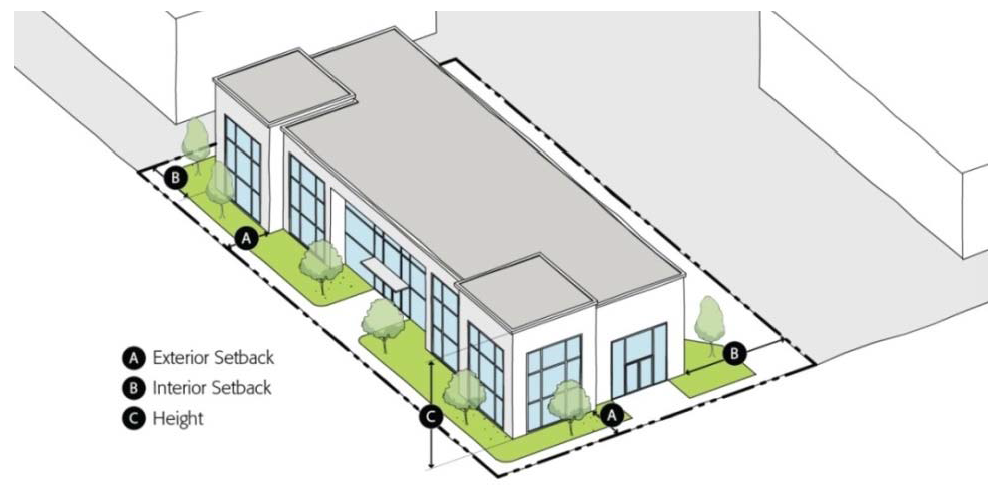
Notes:
[1] When a parcel is located on a block with forty (40) percent of the parcels occupied by structures with exterior yards of less than fifteen (15) feet, the minimum setback shall be equal to the average exterior setback of structures on the block.
[2] Interior yards less than twenty (20) feet are permitted for building in compliance with the Fire Code with approval of a site plan review permit.
[3] The maximum height of industrial structures when directly adjacent to residential zones will be established with the site plan review permit/interface process, based on impacts to the adjacent residential uses. Industrial structures shall also comply with the Merced County Airport Land Use Compatibility Plan.
B.
Industrial Buffer Yards.
1.
Industrial Buffer Yard Defined. An industrial buffer yard is an area of plantings and walls that shields neighboring residential properties from negative impacts created by industrial land uses.
a.
When Required. An industrial buffer yard is required for any development within an industrial zone that is adjacent to a residential zone.
b.
Buffer Yard Standards.
(1)
Industrial buffer yards shall be located along the outer perimeter of a property line abutting a residential zone. See Figure 20.12-2.
(2)
Residential side of the wall shall be landscaped and maintained by the property owner of the industrial use.
(3)
The minimum width of an industrial buffer yard shall be twenty-five (25) feet.
(4)
Industrial buffer yards shall include a solid masonry or equivalent wall no less than six (6) feet in height.
(5)
Industrial buffer yards shall be planted with a mix of drought-tolerant, deciduous and evergreen trees and shrubs of suitable type, size, and spacing to achieve screening year-round.
(6)
All plantings within an industrial buffer yard shall be maintained in a manner consistent with landscaping maintenance standards in Chapter 20.36 (Landscaping).
(7)
Paved surfaces, except sidewalks, shall be prohibited within industrial buffer yards. Buffer yards shall not be used for parking, driveways, trash enclosures, building areas, or any other activity associated with the primary use on the property.
Figure 20.12-2 Industrial Buffer Yards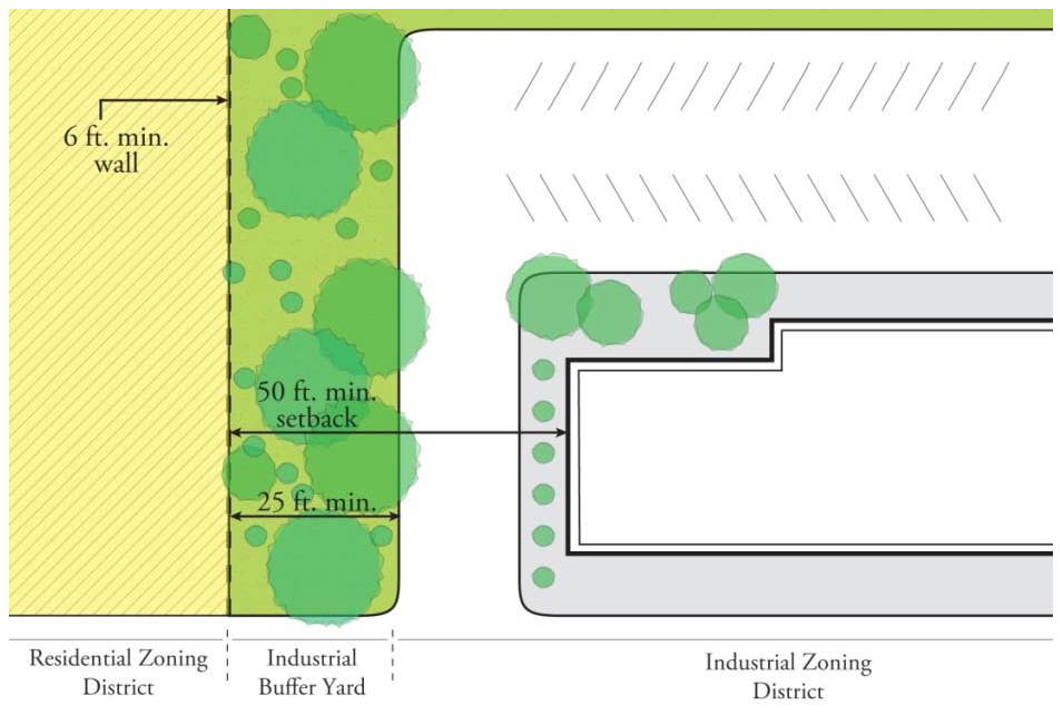
C.
Performance Standards. All land uses and structures in the industrial zones shall comply with the following performance standards. Applicants are responsible for providing compliance evidence for all applicable performance standards.
1.
Noise.
a.
Maximum Exposure. No operation or activity shall transmit any noise exceeding 70 dBA between 7:00 a.m. and 9:00 p.m. and 60 dBA between 9:00 p.m. and 7:00 a.m. beyond the property line. Any uses abutting residential zoning shall not transmit any noise between 10:00 p.m. and 7:00 a.m. beyond the property line. If any operation or activity proposed exceeds the maximum decibel level stated in this section, the applicant must submit a plan to mitigate noise in order to obtain building permits.
b.
Exceptions. Upon written application from the owner or operator of an industrial or commercial noise source, the review authority, as part of a permit approval, may conditionally authorize exceptions to local noise emission standards, including the times of day described in "a" above, based upon analysis supported by the department of development services, in the following situations:
(1)
Infrequent noise;
(2)
Noise levels at or anywhere beyond the property lines of the property of origin when exceeded by an exempt noise in the same location; and
(3)
If, after applying best available control technology, a use existing prior to the effective date of this zoning ordinance is unable to conform to the standards established by this section.
2.
Vibration. No ground vibration, excluding vibration generated from motor vehicles, which is discernible by human senses for more than tree (3) minutes or more duration in any 1 (one) hour, is permitted beyond the property line.
3.
Odor. No objectionable odor or noxious gas emission which is discernible at any point beyond the property line is permitted.
4.
Air Quality. All uses shall comply with applicable local, state, and federal laws and regulations regarding contaminants and pollutants. This requirement includes, but is not limited to, emissions of suspended particles, carbon monoxide, hydrocarbons, odors, toxic or obnoxious gases and fumes.
5.
Heat. No use shall generate heat so that increased ambient air temperature or radiant heat is measurable at any exterior lot line.
6.
Radioactivity. No radiation of any kind shall be emitted in quantities which are dangerous to humans.
7.
Industrial Waste.
a.
All uses are prohibited from discharging liquid, solid, toxic, or hazardous wastes onto or into the ground and into streams, lakes, or rivers. Discharge into a public or private waste disposal system in compliance with applicable local, state, and federal laws and regulations is permitted.
b.
Wastes detrimental to a public sewer system or a sewage treatment plant shall not be discharged to a public sewer system unless they have been pretreated to the degree required by the authority having jurisdiction over the sewerage system.
c.
The handling and storage of hazardous materials, the discharge of hazardous materials into the air and water, and the disposal of hazardous waste in connection with all uses shall be in conformance with all applicable local, state, and federal regulations.
d.
All burning of waste materials accessory to any use shall comply with the San Joaquin Valley Air Pollution Control District rules and regulations.
e.
The disposal or dumping of solid wastes accessory to any use, including, but not limited to, slag, paper, and fiber wastes or other industrial wastes, shall be in compliance with applicable local, state, and federal laws and regulations.
8.
Exterior Lighting. Direct light shall not extend beyond a property line into a lot occupied by a single-family home. Lighting shall not create a source of glare visible from a neighboring single-family home. The minimum illumination level for area intended shall be one (1) foot candle.
9.
Electromagnetic Interference. Devices which generate electromagnetic interference shall not cause interference with any activity outside the property upon which the device is located. Public utilities shall comply with all applicable state and federal regulations.
10.
Fire and Explosive Hazards. All uses involving the use or storage of combustible, explosive, caustic, or otherwise hazardous materials shall comply with all applicable local, state, and federal safety standards and shall be provided with adequate safety devices against the hazard of fire and explosion, and adequate fire-fighting and fire suppression equipment in accordance with the requirements of the fire marshal.
(Ord. No. 2465, § 2(Exhs. A., B.), 9-19-2016)
20.14.010 - Purpose of the downtown zoning districts.
A.
Downtown Core (D-COR). The purpose of the D-COR zoning district is to maintain and enhance a vibrant downtown core with a diversity of land uses. The D-COR zoning district supports downtown as a destination for arts, entertainment, retail, and dining uses, with housing that contributes to the vitality of the area. The design of development helps to create a pedestrian-friendly environment and an active public realm. A mixture of land uses and higher intensity development supports transportation options, including walking, bicycling, and use of transit.
B.
Downtown Office (D-O). The purpose of the D-O zoning district is to accommodate a concentration of office uses that support a vibrant and dynamic downtown. The D-O zoning district accommodates a variety of land uses, including personal services in addition to office uses. In the D-O zoning district buildings are designed to support an active and inviting public realm. The D-O zoning district creates an attractive environment for businesses and employers that enhances the economic vitality of the community. The D-O zoning district also serves as a buffer between more intensive development in the D-COR zoning district and surrounding residential neighborhoods.
C.
Downtown Commercial (D-CM). The purpose of the D-CM zoning district is to encourage growth and investment in commercial areas adjacent to Merced's downtown core. New development in the D-CM zoning district will provide amenities for adjacent residential neighborhoods and enhance the appearance of gateways into downtown. Development supports a pedestrian-friendly environment with buildings located near the front sidewalk and parking located to the side or rear. A variety of land uses, including residential, commercial, and office, contribute to an active and inviting environment.
(Ord. No. 2465, § 2(Exhs. A., B.), 9-19-2016)
20.14.020 - Land use regulations for downtown zoning districts.
A.
Permitted Uses. Table 20.14-1 identifies land uses permitted in downtown zoning districts.
Notes:
[1] A site plan review permit may be required per Chapter 20.32 (Interface Regulations) regardless of the uses shown in Table 20.14-1.
[2] Residential use on the ground floor is prohibited unless it is located on the back of the property where it is not visible or approved with a conditional use permit.
[3] Prohibited as a single use unless approved with a conditional use permit. Permitted as part of a residential mixed-use project.
[4] Prohibited in the city center area between 19 th and 16 th Streets and O Street and Martin Luther King, Jr. Way, including properties fronting on either side of each of the above streets.
[5] Rehabilitation centers for drug, methadone, and alcohol are prohibited.
[6] A conditional use permit is required for new and used vehicle sales but only in small showrooms, not large parking lots.
(Ord. No. 2465, § 2(Exhs. A., B.), 9-19-2016)
20.14.030 - Development standards for downtown zoning districts.
A.
Parcel Dimensions and Intensity. Table 20.14-2 identifies required parcel dimensions and maximum development intensity standards in the downtown zoning districts.
B.
Building Form and Placement.
1.
Basic Standards. Table 20.14-3 identifies building form and placement standards in the downtown zoning districts. See Figure 20.14-1.
Notes:
[1] Ten (10) feet min. from property line adjacent to a single-family home.
[2] Fifteen (15) feet min. from property line adjacent to a single-family home.
[3] Height limits only apply where directly adjacent to residential zones and in those cases, exceptions to the height limitations may be granted by the site plan review committee.
2.
Increased Exterior Setbacks. In exception to Table 20.14-3 above, a maximum of forty (40) percent of the building frontage may be set back up to twenty-five (25) feet from an exterior property line to provide a space for public and semi-public amenities such courtyards or outdoor seating areas with the approval of a minor use permit. See Ⓖ in Figure 20.14-1.
Figure 20.14-1 Downtown Development Standards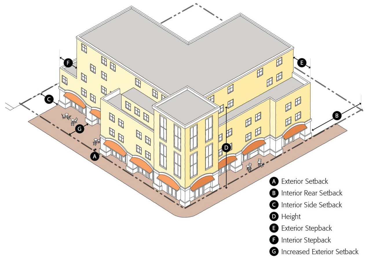
C.
Parking (Only applies in D-COR zone). Exceptions to the following standards (C1, C2, C3, & C4) may be granted by the director of development services through the issuance of a minor use permit.
1.
Location.
a.
Surface parking shall be located only to the rear or side of buildings, unless approved with a minor use permit. See Figure 20.14-2. Surface parking is only allowed towards the back of the building with access on alleys and screening, which would block visibility of a surface parking lot from the exterior streets, unless otherwise approved with a minor use permit.
b.
Parking completely or partially underground may match the setbacks of the main building, but shall be screened from view.
2.
New Driveways. For parcels served by a rear alley, new driveways for vehicular access shall be off the alley only. New driveways off the front or side of the parcel may be approved with a minor use permit. To approve the minor use permit, the director of development services must make the following findings:
a.
The driveway is necessary to provide vehicle access to the property.
b.
The design and placement of the new driveway minimizes impacts on pedestrians to the greatest extent possible.
Figure 20.14-2 Downtown Parking Location and Buffers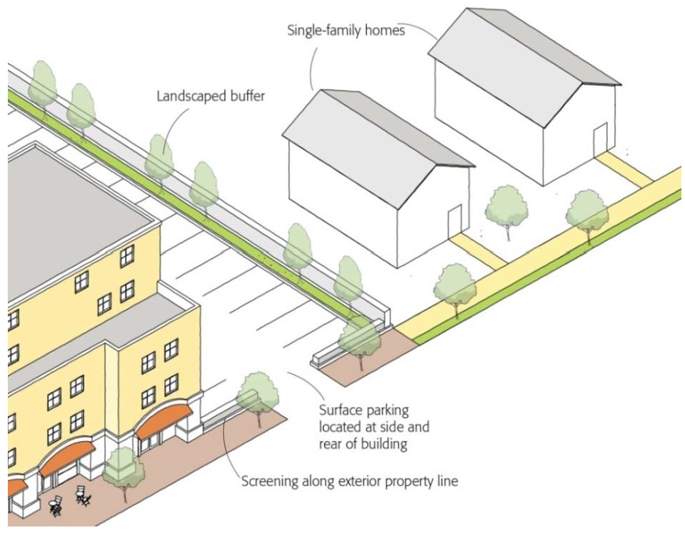
3.
Buffers and Screening.
a.
Surface parking located adjacent to an exterior property line shall be screened along the public right-of-way with a decorative wall, hedge, trellis, or landscaping at least three (3) feet in height. See Figure 20.14-2.
b.
A landscaped buffer at least three (3) feet wide and six (6) feet tall shall be located for any surface parking adjacent to a single-family home. See Figure 20.14-2.
4.
Parking Structure Design.
a.
All exterior walls of parking structures shall feature materials that maintain a common architectural character with the structure served by the parking structure.
b.
Parking structure facades shall be broken-up through the use of textured concrete on exterior walls, the incorporation of planters and trellises at each parking level, and other architectural treatments to minimize large blank walls without architectural relief.
c.
Parked vehicles at each level within the structure shall be shielded from view from adjoining streets through the use of architectural appurtenances and landscaping.
D.
Street-Level Building Design (Only applies in the D-COR zone). Exceptions to the following standards (D1, D2, D3, & D4) may be granted by the director of development services through the issuance of a minor use permit.
1.
Building Orientation. Buildings shall be oriented towards a public street with the primary entrance to the site or building directly accessible from an adjacent sidewalk. The director of development services may allow buildings and their primary entrances to be oriented toward a public space. The primary entrance to a building shall not be oriented towards surface parking. See Figure 20.14-3.
Figure 20.14-3 Building Orientation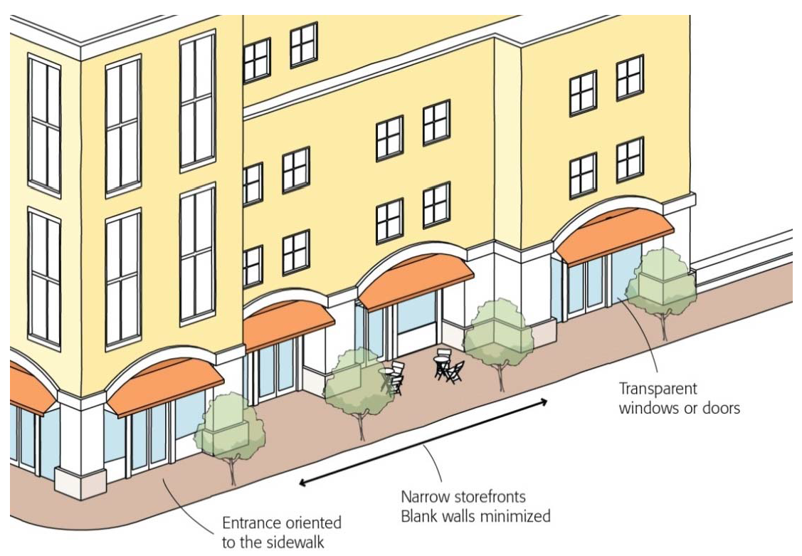
2.
Blank Walls. The maximum length of an unarticulated/blank building wall shall be ten (10) feet in the D-COR zoning district, and twenty-five (25) feet for all other downtown zoning districts, unless otherwise approved with a minor use permit. Architectural articulation shall have similar pattern as other adjacent buildings to provide cohesive design in the neighborhood. See Ⓗ in Figure 20.14-4. Building articulation may be provided by:
a.
Doors, windows, and other building openings;
b.
Building projections or recesses, doorway and window trim, artwork displays, and other details that provide architectural articulation and design interest;
c.
Varying wall planes, heights or contrasting materials and colors; and,
d.
Awnings, canopies, or arcades to reinforce the pedestrian scale and provide shade and cover from the elements.
Figure 20.14-4 Downtown Blank Wall and Storefront Width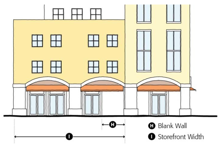
3.
Storefront Width. The maximum building/storefront width in the D-COR zoning district shall be fifty (50) feet and one hundred (100) feet in all other downtown zoning districts, unless otherwise approved through a minor use permit. Larger buildings shall be broken down into a pedestrian-scale rhythm with individual building bay width of twenty-five (25) to fifty (50) feet. See Ⓘ in Figure 20.14-4.
4.
Ground Floor Building Transparency.
a.
The ground floor street-facing building walls of nonresidential uses shall provide transparent windows or doors with views into the building for a minimum of forty (40) percent of the building frontage located between two and one-half (2½) and seven (7) feet above the sidewalk. Fifty (50) percent of the transparent windows or doors area shall remain clear to allow views into the building. See Figure 20.14-5.
Figure 20.14-5 Downtown Ground Floor Building Transparency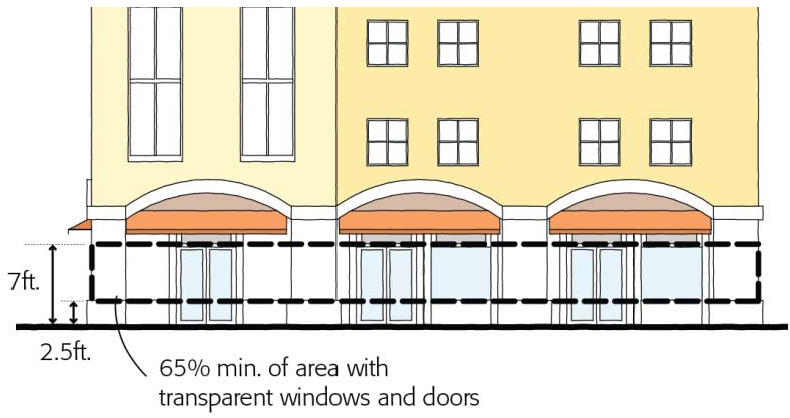
b.
Exceptions to this transparency requirement may be allowed with a minor use permit if the director of development services finds that:
(1)
The proposed use has unique operational characteristics which preclude building openings, such as for a cinema or theater; and,
(2)
Street-facing building walls will exhibit architectural relief and detail, and will be enhanced with landscaping or artwork in such a way as to create visual interest at the pedestrian level.
(Ord. No. 2465, § 2(Exhs. A., B.), 9-19-2016)
20.16.010 - Purpose of the urban village zoning districts.
A.
General. The urban village zoning districts are intended to promote the development of high quality neighborhoods in new growth areas of Merced. These neighborhoods are characterized by a mixture of land uses that enable residents to easily walk and bike to a variety of destinations. A diversity of housing types, including single-family homes and multi-family housing, expand affordable housing options for all income levels. A network of interconnected streets allows for safe and convenient circulation that minimizes traffic congestion on major roadways. The location, type, and intensity of new development support increased transit use and expands transportation options for residents and workers. Development in the urban villages zoning districts supports a high quality design environment with a distinctive sense of place enjoyed by residents, workers, and visitors.
The urban village zoning districts implement the urban village concept in the general plan. This concept envisions urban villages consisting of three (3) components: A commercial or mixed-use commercial core, an inner village residential area, and an outer village residential area. The basic form of the urban village concept is illustrated in Figure 20.16-1.
B.
Inner Village Residential (R-IV). The R-IV zoning district allows for higher density residential development within an urban village. The R-IV zoning district accommodates a range of housing types, including apartments, townhomes, and other forms of multi-family housing. The R-IV zoning district supports higher density housing located in close proximity to transit, employment uses, and commercial areas. The R-IV zoning district also may function as a buffer between village commercial areas and surrounding lower-density residential neighborhoods.
C.
Outer Village Residential (R-OV). The R-OV zoning district allows for lower density residential uses within an urban village. Typical housing types within the R-OV zoning district include single-family homes, duplex homes, and second units. The R-OV zoning district accommodates single-family neighborhoods located in close proximity to public amenities such as parks and schools as well as neighborhood-serving retail and service uses.
D.
Village Commercial (C-V). The C-V zoning district functions as the center of activity within an urban village. The C-V zoning district accommodates a diversity of land uses, including commercial, residential, and civic uses. Development in the C-V zoning district supports a pedestrian-friendly environment and encourages the use of transit. Local streets, sidewalks, and bicycle paths provide safe and convenient access to the C-V zoning district from surrounding residential neighborhoods. The C-V zoning district meets the day-to-day shopping needs of area residents and provides a central gathering place for the use and enjoyment of surrounding neighborhoods.
Figure 20.16-1 Urban Village Concept (Sample Layout)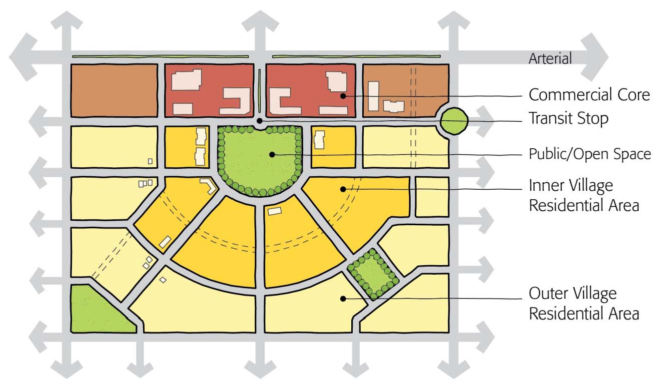
(Ord. No. 2465, § 2(Exhs. A., B.), 9-19-2016)
20.16.020 - Land use regulations for the urban village zoning districts.
A.
Table 20.16-1 identifies land uses permitted in the urban village zoning districts.
Notes:
[1] Prohibited as a single use unless approved with a conditional use permit. Permitted as part of a residential mixed-use project.
[2] All activities, including the overnight boarding of animals, shall occur indoors.
[3] Must meet minimum density requirements of ten (10) dwelling units/acre.
(Ord. No. 2465, § 2(Exhs. A., B.), 9-19-2016; Ord. No. 2502, § 3, 8-19-19)
20.16.030 - Development standards/guidelines for urban village zoning districts.
A.
Development Standards. Table 20.16-2 identifies development standards that apply in the urban village zoning districts.
Notes:
[1] Porches may be setback a minimum of ten (10) feet from the front property line.
[2] Ten (10) feet min. from property line adjacent to a single-family home.
[3] Height limit only applies where directly adjacent to residential zones. In those cases, an increase in height may be approved with a site plan review permit.
B.
Additional Standards and Guidelines. Proposed projects within urban village zoning districts shall comply with the following additional standards and guidelines. Further guidance for residential and commercial development within urban villages is provided in Chapter 6—Urban Design of the Merced Vision 2030 General Plan.
1.
Land Use and Intensity.
a.
R-OV zoning districts shall be located no more than one (1) mile from a neighborhood-serving commercial use or a C-V zoning district.
b.
R-IV zoning districts shall be located within a one-fourth (¼) mile walking distance of a neighborhood-serving commercial use or a C-V zoning district.
c.
The average minimum density of all residential uses shall be no less than four (4) du/acre for the R-OV zoning district and ten (10) du/acre for the R-IV zoning district.
2.
Transportation Options.
a.
R-IV zoning districts shall be located within one-fourth (¼) mile of an existing or planned bus service.
b.
R-OV and R-IV zoning districts shall have direct access to a neighborhood-serving commercial zoning district without having to cross a street designated as a "Minor Arterial" or higher order street.
3.
Housing. Each R-IV zoning district shall allow for the development of the following housing types with no single housing type making up more than fifty (50) percent of the total number of housing units in the zoning district.
a.
Single-family homes on lots of four thousand five hundred (4,500) square feet or smaller.
b.
Second units
c.
Duplexes
d.
Multi-family dwellings
e.
Live/Work Units
f.
Single-Room Occupancy (SRO) units
4.
Street Network.
a.
A network of interconnected collector and local streets shall provide direct connections into the C-V zoning district from the R-OV and R-IV zoning districts. In no case shall trips to internal destinations within a square mile area bound by arterials be forced onto an arterial street.
b.
Interconnected pedestrian and bicycle paths shall be provided throughout the C-V, R-IV, and R-OV zoning districts.
c.
Bicycle/pedestrian connections are provided at the end of at least fifty (50) percent of all cul-de-sacs.
d.
A minimum of fifty (50) percent of all blocks within an R-OV or R-IV zoning district shall be no more than five hundred (500) feet in length.
5.
Village Commercial Guidelines. The following guidelines shall apply in the C-V zoning district only.
a.
The principal entry of the building should front a public space, such as a street, park, or plaza, and not a parking lot. Buildings should be as close to the sidewalk as possible to promote a walkable environment.
b.
There should be no instances of surface parking located between a building and an exterior property line.
c.
There should be no unarticulated/blank building walls exceeding twenty-five (25) feet in length facing a collector or higher order street.
d.
All ground-floor building walls of nonresidential uses that face a collector or higher order street should provide transparent windows or doors with views into the building for a minimum of fifty (50) percent of the building width.
e.
Mixed use, office, and residential uses are encouraged on the upper stories of commercial buildings within the C-V zoning district.
(Ord. No. 2465, § 2(Exhs. A., B.), 9-19-2016)
20.18.010 - Purpose of the public use and agricultural zoning districts.
A.
Parks and Open Space (P-OS). The P-OS zoning district provides areas for public parks and recreational facilities to serve existing and future residents.
B.
Public Facility (P-F). The P-F zoning district provides areas for land uses and facilities owned and operated by governmental agencies.
C.
Public Parking District (P-PK). The P-PK zoning district provides a location for parking lots that are available for use by the public at no cost for minimum periods of time in each 24-hour period.
D.
Agriculture (A-G). The A-G zoning district provides space for continued agricultural uses within the City of Merced's City limits. This zone replaces the previous A-1-20 zoning district and applies to all land zoned A-1-20 within the city. Minimum size of an A-G district is twenty (20) acres.
(Ord. No. 2465, § 2(Exhs. A., B.), 9-19-2016)
20.18.020 - Land use regulations for the public use and agricultural zoning districts.
A.
Permitted Land Uses. Table 20.18-1 identifies land uses permitted in the public use and agricultural zoning districts.
Notes:
[1] Permitted only as part of a larger park or recreation use.
[2] Permitted only when associated with an agricultural use which constitutes the primary use on the property.
[3] Permitted only when part of a multistory structure that provides on-site public parking area equal to or greater than the square footage of the parcel minus the required setbacks and driveway approaches.
[4] Permitted uses only include outdoor recreational facilities with minor improvements and public stables for riding academies, which is subject to animal density requirement.
[5] Minimum of fifty-five (55) percent of the parking space are available for use by the public at no charge for a minimum of four (4) hours during every 24-hour period; and a maximum of forty-five (45) percent of the parking spaces are available for lease to neighboring businesses to meet the parking requirements for those businesses.
[6] Limited to one (1) stand for the display and sale of produce raised on the premises. More than one (1) stand may be allowed upon approval of a site plan review permit.
[7] Conditional use only includes packing facilities of products raised on the premises.
[8] Fast-food restaurants prohibited.
[9] The use must conform with the regulations in Merced Municipal Code Chapter 6.04 (Animal Control).
[10 Conditional use permit is required only for the water storage and reservoir for the agricultural uses; minor use permit is required for all other uses.
[11 Also applies to land zoned A-1-20.
(Ord. No. 2465, § 2(Exhs. A., B.), 9-19-2016)
20.18.030 - Development standards for public use and agricultural zoning districts.
A.
General Standards. Table 20.18-2 identifies development standards that apply to all parcels and structures located in public use and agricultural zoning districts.
Notes:
[1] Minimum required setbacks shall be the same as the abutting zoning district. Multiple setback standards may be applied to different parts of the lot if multiple zoning districts are adjacent.
[2] Fifteen (15) feet of setback required if adjacent to a residential zoning district and/or use.
[3] Minimum separation requirement shall apply between dwelling units, between dwelling unit and building for agricultural use, and between buildings for agricultural use.
[4] Also applies to land zoned A-1-20.
[5] Increases in height may be approved by a site plan review permit.
(Ord. No. 2465, § 2(Exhs. A., B.), 9-19-2016)
20.20.010 - Urban transition (U-T) zoning district.
A.
Purpose. The purpose of the U-T zoning district is to allow the lawful continuation of land uses on land that is annexed to the city but not proposed for immediate urban development.
B.
Land Use Regulations. The following land uses shall be permitted in the U-T zoning district:
1.
Any legally established and operated use in full compliance with the Merced County Code existing at time of the annexation of the property to the city.
2.
New agriculture uses, but not including hog raising, if such uses are in compliance with all other laws and ordinances, provided there is no retail sale of products on the premises.
3.
Large and small residential day care facilities.
4.
Home occupations.
C.
Development Standards. Structures within the U-T zoning district shall comply with the applicable county development standards in effect at the time of annexation, except as provided below.
1.
Height. Buildings shall not exceed a height of forty (40) feet for principal buildings and twenty-five (25) feet for accessory buildings, except that these heights may be exceeded by any legal buildings as they existed at the time of annexation.
2.
Yards. The required yards that existed for the subject lot at the time of annexation to the city shall be the minimum required yard areas, except for new or enlarged accessory buildings of a legally permitted primary use and dwelling units, which may have a minimum exterior yard area of twenty (20) feet and a minimum interior yard area of ten (10) feet.
3.
Residential Density. Except for accessory dwelling units permitted under Chapter 20.42 (Accessory Dwelling Units), residential density of the lot may not be increased.
D.
Existing Land Uses.
1.
Land in the U-T zoning district may continue with any legal and lawful use that existed in the county without time limit. However, this authority to continue such uses is not intended to legalize uses or structures operating or existing contrary to the terms of any other law or ordinance.
2.
Any major expansion in use, density, or other measurement of size or intensity shall require a change to a zoning district other than the U-T zoning district. The director of development services shall determine whether a proposed change to an existing use will require a change to a zoning district other than the U-T zoning district.
E.
Annexation Requirements. At the time of annexation, the property owner shall submit a written statement and site plan on a form provided by the city that describes the use, height, area, lot, yard, and parking characteristics of the subject property. Those characteristics that were legally established and existing in the county at the time of annexation will be permitted to continue in the city within the U-T district upon annexation. A record of these property characteristics will be established and will become part of the U-T zoning district for the subject property. If the property owner does not submit the written statement and site plan as required by this section, then the city may prepare its own written statement in order to complete the zoning process upon annexation.
(Ord. No. 2465, § 2(Exhs. A., B.), 9-19-2016; Ord. No. 2502, § 4, 8-19-19)
20.20.020 - Planned Development (P-D) zoning districts.
A.
Purpose. The purpose of the planned development (P-D) zoning districts is to allow for high quality development that deviates from standards and regulations applicable to other zoning districts within Merced. The planned development zoning districts are intended to promote creativity in building design, flexibility in permitted land uses, and innovation in development concepts. The planned development zoning districts are also intended to ensure project consistency with the general plan. Planned development zoning districts provide land owners with enhanced flexibility to take advantage of unique site characteristics to develop projects that will provide public benefits for residents, employees, and visitors to Merced.
B.
Types of PD Zoning Districts. There are two (2) types of planned development zoning districts: The planned development (P-D) zoning district and the residential planned development (RP-D) zoning district. The RP-D zoning district is identical to the P-D zoning district except that only residential land uses are permitted in the RP-D zoning district and a larger project size is required for the P-D zoning district.
C.
Permitted Land Uses. In all planned development zoning districts, permitted land uses shall conform to the applicable general plan designation, provided that such land uses are shown on the official site utilization plan for the particular P-D zone as approved by the city council, and except that in the RP-D zoning district, only residential land uses shall be permitted.
D.
Minimum Project Size. Minimum project size in the planned development zoning districts shall be as follows:
1.
Planned Development (P-D) zoning district: Three (3) acres minimum.
2.
Residential Planned Development (RP-D) zoning district: Ten thousand (10,000) square feet minimum.
3.
Planned development projects located within the area shown in Figure 20.20-1 shall be exempt from these minimum project size requirements.
E.
Pre-Application Conference. Prospective applicants are encouraged to request a pre-application conference with the planning division before completing and filing an application for the establishment of a planned development or a revision to a planned development. At the pre-application conference, prospective applicants shall describe the general concepts of the development project, including site layout, land uses, standards, circulation, and other information necessary to describe key aspects of the project. The planning division shall provide preliminary feedback on the described development project relative to project consistency with city policies. The planning division shall also review with the prospective applicant submittal requirements and the process for application review and action by the planning commission and city council.
F.
Application Submittal. An application for a planned development establishment or revision shall be filed in compliance with Chapter 20.66 (Permit Application and Review). The application shall include the information and materials specified by the planning division, in addition to the materials required for approval of a preliminary site utilization plan, as described below.
Figure 20.20-1 Areas with No Minimum Project Size Requirement for
Planned Development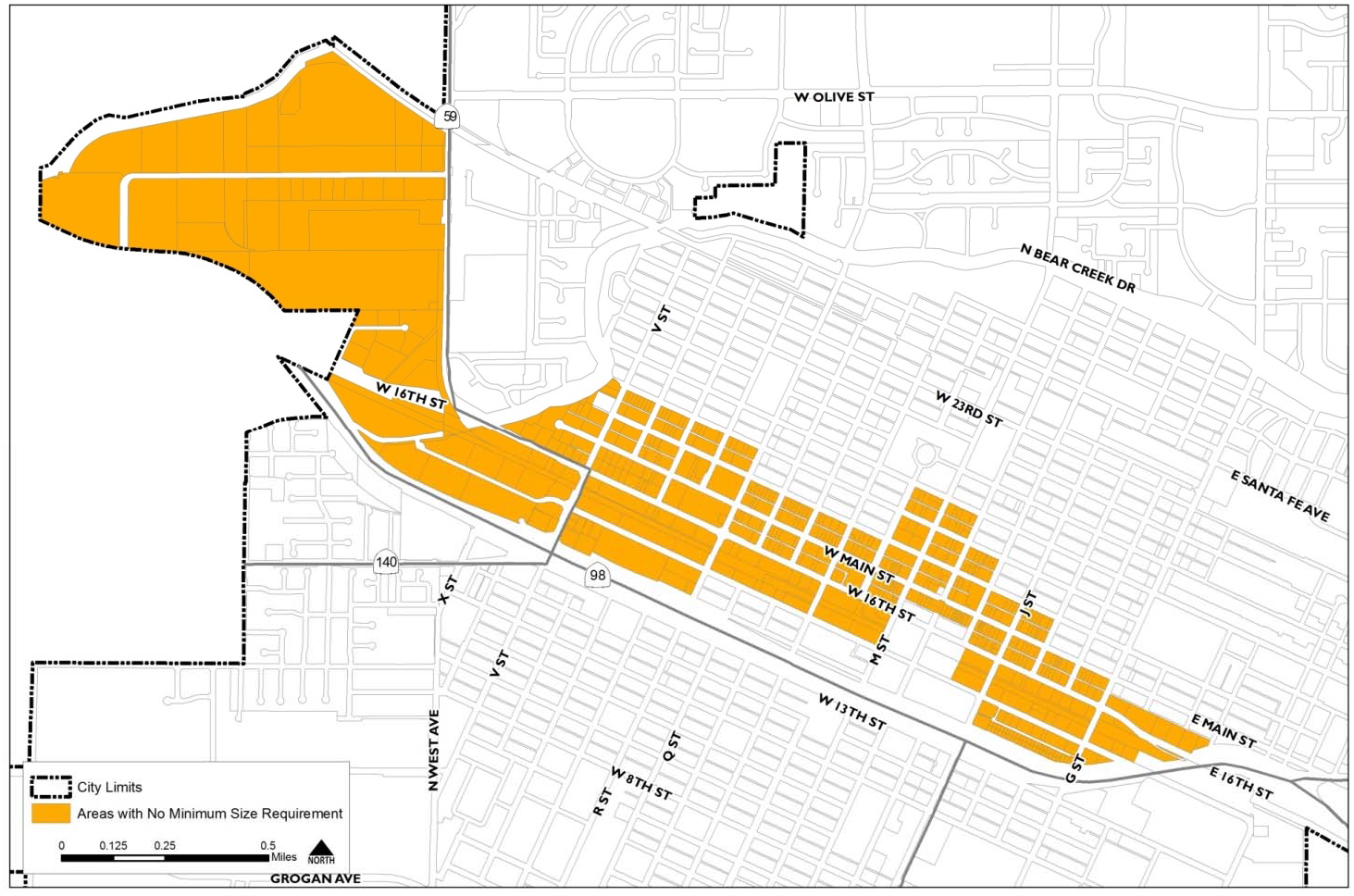
G.
Preliminary Site Utilization Plan. Applications for approval of a preliminary site utilization plan (preliminary SUP) shall include the following materials:
1.
Project Description. The applicant shall provide a written description of the project proposed within the planned development zoning district. The project description shall include a narrative statement of the project's objectives and a statement of how the proposed project will comply with general plan goals and policies for the land use designation of the project site. The project description may also include a diagram illustrating the proposed project.
2.
Site Map. The application shall include maps depicting the existing topography, on-site structures and natural features, mature trees, and other significant vegetation and drainage patterns. The map shall show the proposed planned development zoning district zone boundaries and all properties within five hundred (500) feet of the site boundary. The map shall be accompanied by a description of the type and condition of mature trees.
3.
Site Utilization Plan (SUP). The applicant shall provide an overall diagram of the site utilization. This diagram shall illustrate the overall development concept, including proposed land uses, buildings, circulation, transit facilities, landscaping, open space, and any other significant elements in the proposed site. Phases shall be clearly indicated if multiple phases are proposed.
4.
Parcel or Subdivision Map. If the project within the proposed planned development zoning district zone involves the subdivision of land, the application shall include a tentative parcel map or tentative subdivision map as required by Title 18 (Subdivisions) of the Merced Municipal Code.
5.
Infrastructure. The application shall include a written description of the infrastructure necessary to serve each phase of the project proposed within the planned development zoning district.
6.
Special Provisions for Planned Development Prezoning at Annexation. For applications for planned development prezoning prior to annexation to the city, the director of development services may waive or defer any or all of the above requirements for the preliminary site utilization plan as long as the final site utilization plan contains all the above requirements in addition to the requirements in Section 20.20.020.M when approved prior to development.
H.
Planning Commission Review and Recommendation.
1.
The planning commission shall hold a public hearing on the planned development establishment or revision application as required by Chapter 20.80 (Zoning Ordinance Amendments). The planning commission shall consider the full application at this hearing, including the preliminary site utilization plan.
2.
The planning commission shall forward a written recommendation, and reasons for the recommendation, on the proposed planned development establishment or revision and preliminary site utilization plan to the city council. The recommendation shall be based on the findings in subsection J (Findings), in addition to the zoning ordinance map amendment findings specified in Section 20.80.060 (Findings and Decision).
I.
City Council Review and Decision. Upon receipt of the planning commission's recommendation, the city council shall conduct a public hearing and either approve, approve in modified form, or deny the planned development establishment or revision and preliminary site utilization plan. The city council may approve the application only if all of the findings in subsection J (Findings) below can be made, in addition to the zoning ordinance map amendment findings specified in Section 20.80.060 (Findings and Decision).
J.
Findings. The city council may approve an application for planned development establishment or revision with accompanying preliminary site utilization plan only if all of the following findings can be made:
1.
The proposed development is consistent with the goals, policies, and actions of the general plan and any applicable specific plan and community plan.
2.
The site for the proposed development is adequate in size and shape to accommodate proposed land uses.
3.
The site for the proposed development has adequate access considering the limitations of existing and planned streets and highways.
4.
Adequate public services exist or will be provided to serve the proposed development.
5.
The proposed development will not have a substantial adverse effect on surrounding property, will be compatible with the existing and planned land use character of the surrounding area, and will enhance the desirability of the area and have a beneficial effect.
6.
The proposed development carries out the intent of the planned development zoning district by providing a more efficient use of the land and an excellence of site design greater than that which could be achieved through the application of established zoning standards.
7.
Each individual unit of the proposed development, in each phase as well as the total development, can exist as an independent unit capable of creating a good environment in the locality and being in any stage as desirable and stable as the total development.
8.
Any deviation from the standard ordinance requirements is warranted by the design and additional amenities incorporated in the development plan, which offer certain unusual redeeming features to compensate for any deviations that may be permitted.
9.
The principles incorporated in the proposed development plan indicate certain unique or unusual features, which could not otherwise be achieved under the other zoning districts.
K.
Ordinance Approving the Development Plan. If the city council approves the establishment of a planned development zoning district, it shall do so by adoption of an ordinance and adoption by reference of the preliminary site utilization plan. The ordinance shall also include any other provisions that the city council finds to be necessary to constitute the regulations for use, property maintenance, and property improvement in the planned development zoning district.
L.
Effect of Site Utilization Plan. All proposed development and new land uses within a P-D zone shall comply with the approved site utilization plan. Land uses not shown on the site utilization plan are not permitted.
M.
Final Site Utilization Plan. Prior to or concurrent with applications for any building permits within a planned development zoning district, a final site utilization plan (final SUP) shall be approved by the site plan review committee, unless the director of development services determines that the final SUP should be referred to the planning commission for approval because of substantial modifications or more than three (3) years have passed since the preliminary SUP was adopted. The final site utilization plan shall include:
1.
Land Use. The final site utilization plan shall include a map showing the location of each land use proposed within the site, including open space and common areas. The land use map shall be accompanied by a narrative description of permitted land uses, allowable accessory uses, and uses allowed with a conditional use permit. Only those uses specifically listed above are allowed in the planned development, unless the uses are allowed in the zoning district that matches the P-D's General Plan Land Use Designation per Table 20.06-01.
2.
Subdivision Map. If the project involves the subdivision of land, the application shall include a tentative parcel map or tentative subdivision map as required by Title 18 (Subdivisions) of the Merced Municipal Code. The proposed parcels shall have, at least, minimum parcel area and minimum parcel dimensions.
3.
Circulation/Transit. The final site utilization plan shall include map and descriptions of the major circulation features within the site including vehicular, bicycle, pedestrian and transit facilities; traffic flow of internal traffic; and existing and proposed public streets and sidewalk improvements.
4.
Public Facilities and Open Space. The application shall include the amount (in square feet or acres) and percentage of site area that will be dedicated for all types of open space, including proposed recreational facilities and amenities; and any public facilities, including public utility easements, public buildings and public land uses. The map(s) with location and dimensions of each open space shall be also submitted.
5.
Development Standards. The final site utilization plan development standards shall identify all development standards that apply within the site, including parcel dimensions, density, setbacks, structure height, building architecture and design, parking, and landscaping requirements, which assures the suitable integration of the P-D into the neighborhood or area in which it is located. Applicable conditions of approval, mitigation measure, and terms of any development or legislative action agreement, where appropriate, shall be included. If no development standards are established, the standards of the zoning district that matches the P-D's General Plan Land Use Designation per Table 20.06-01 shall apply.
6.
Single-Family Residential Development Standards. The final site utilization plan shall demonstrate that all single-family residential development complies with the following standards:
a.
Garages. A minimum of twenty-five (25) percent of garages fronting a street shall have recessed doors (by at least one (1) foot) for dwelling units with the standard twenty (20) foot setback. A minimum of twenty-five (25) percent of the garages along a street shall have greater setbacks which are five (5) feet greater than the minimum setback for the remainder of the dwelling unit. No three-car garages are allowed for lots five thousand (5,000) square feet or smaller, except on lots with alley access or lots exceeding sixty (60) feet in width.
b.
Elevations. Projects shall incorporate a variety of dwelling elevations. Varied setbacks, some two-story houses, front porches, bays and balconies are encouraged as ways of achieving variety; and windows, doors, non-recessed garage doors on the front elevation shall have raised trim in order to provide visual interest and relief.
c.
Neighborhood Compatibility. Projects shall be designed to be compatible with adjacent single-family residential neighborhoods. The director of development services shall consider the relationship of second-story windows, doors, and balconies with the privacy of neighbors, and may require that these features be redesigned or omitted from second-story rear walls.
d.
Landscaping. Front yard shall contain landscaping, including trees, lawn, or other type of drought-tolerant groundcover, shrubs, and an irrigation system, to be installed prior to occupancy.
N.
Revisions to a Planned Development. A public hearing by the planning commission and city council shall be required prior to approval of significant revisions to the preliminary or final site utilization plan (SUP) which involve changes in land use, expansion or intensification of development or changes in the standards of development. The director of development services shall determine, on a case-by-case basis, those instances where a revision to the preliminary or final SUP is necessary, following the same procedure as the original application. Changes in an approved preliminary or final SUP which do not involve changes in land use, expansion or intensification of development or changes in the standards of development may be approved by the site plan review committee if such changes are consistent with the purposes, character, and conditions of the P-D.
O.
Minor Changes. Minor changes to an approved site utilization plan shall be approved as specified in Section 20.72.050 (Changes to an Approved Project).
P.
Identification. Each P-D zone shall be numbered, the first adopted being shown on the zoning map as "P-D (1)" and each zone subsequently adopted being numbered consecutively.
Q.
Individual Projects within a Planned Development. After the final SUP has been approved, individual projects within a planned development shall require a site plan review permit or minor use permit at the discretion of the director of development services prior to development to address conformance with the final SUP.
(Ord. No. 2465, § 2(Exhs. A., B.), 9-19-2016; Ord. No. 2543, §§ 53—56, 9-6-2022)
20.22.010 - Purpose of overlay zones.
A.
General. Overlay zones establish additional standards and regulations to specific areas, in addition to the requirements of the underlying base zoning district.
B.
Conflicts. Whenever a requirement of an overlay zone conflicts with a requirement of the underlying base zoning district, the overlay zone shall control. When two (2) or more overlay zone requirements conflict, the director of development services shall determine the appropriate requirement.
(Ord. No. 2465, § 2(Exhs. A., B.), 9-19-2016)
20.22.020 - Airport environ (/AE) overlay zone.
A.
Purpose. The airport environs (/AE) overlay zone identifies areas in the City of Merced where additional requirements apply to ensure the compatibility of land uses and development with operations at the Merced Regional Airport.
B.
Applicability. The /AE overlay zone applies to land within the City of Merced designated as an airport influence area in the airport land use compatibility plan (ALUCP) for the environs of the Merced Regional Airport.
C.
Land Use Regulations. All development projects and land use actions proposed within the /AE overlay zone shall comply with the compatibility criteria specified in the ALUCP, excluding those criteria specifically overruled by the city council in a manner consistent with Public Resources Code Section 21676.
20.22.040 - Urban residential (/UR) overlay zone.
A.
Purpose. The /UR overlay zone is intended to encourage high quality residential development in Merced's downtown and other urban neighborhoods. The overlay zone identifies permitted residential building types that reflect the traditional scale and character of these neighborhoods. These building types are permitted in addition to the use allowed by the underlying base zoning district. The /UR overlay zone increases choices for property owners and residents, promotes high quality design, and supports a vibrant and welcoming downtown area.
B.
Site Plan Review or Minor Use Permit Required. A site plan review or minor use permit shall be required per Table 20.22-1 for the construction of permitted residential building types that do not conform to the standards of the base zoning district.
C.
Building Types.
1.
Building Type Defined. A building type is a particular kind of structure with its own recognizable identity. Building types are defined primarily by their form (mass, scale, and design) with building function being of secondary importance.
2.
Permitted Building Types. Permitted residential building types in the /UR overlay zone are based on the underlying base zoning district. Table 20.22-1 (Permitted Residential Building Types) identifies permitted residential building types in the /UR overlay zone by residential zoning district.
D.
Development Standards.
1.
General. The development standards that apply to building types in the /UR overlay zone shall be as specified in this section. If the standards in this chapter conflict with the underlying base zoning district, this section shall govern.
2.
Standards for All Residential Building Types. Following standards shall apply to all permitted building types.
a.
Orientation. Front entrances to buildings shall face onto or be clearly visible from a public street or alley.
b.
Corner Lots. Buildings on corner lots shall feature well-articulated facades for each street frontage.
c.
Pathways. A pathway shall connect the adjacent public sidewalk to a building's front entry.
d.
Parking and Access.
(1)
Alley-Loaded Buildings. For buildings served by an alley, vehicle access to the lot is allowed only through the alley. When an alley is present, vehicle parking areas, including garages, carports, and surface parking spaces, shall be set back from the front lot line a minimum of fifty (50) percent of the total lot depth and screened from the public street. Utilities, above ground equipment, trash containers, and other services shall be accessed only through the alley.
(2)
Front-Loaded Buildings. For front-loaded buildings without an alley, vehicle parking area, including garages, carports, or surface parking spaces, shall be set back a minimum of five (5) feet from the front façade of the building.
3.
Standards for Individual Residential Building Types. Individual building types within the /UR overlay zone shall comply with standards described below. Diagrams of building types are for illustrative purposes only and do not establish or imply any requirements not specified in the text or tables of this section.
a.
Small Lot Single-Family Homes.
(1)
Definition. Small lot single-family homes are detached residential structure on a small lot. (This can include zero-lot line homes.)
Figure 20.22-1 Small Lot Single-Family Home Example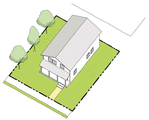
(2)
Standards. Small lot single-family homes shall comply with the development standards shown in Table 20.22-2, unless otherwise approved through the minor use permit or site plan review permit process.
Notes:
[1] Front porches may be setback ten (10) feet from the front property line.
[2] The minimum rear setback shall be five (5) feet when abutting an alley.
b.
Carriage Homes.
(1)
Definition. An accessory dwelling unit located above a detached or semi-detached garage structure.
Figure 20.22-2 Carriage Homes Example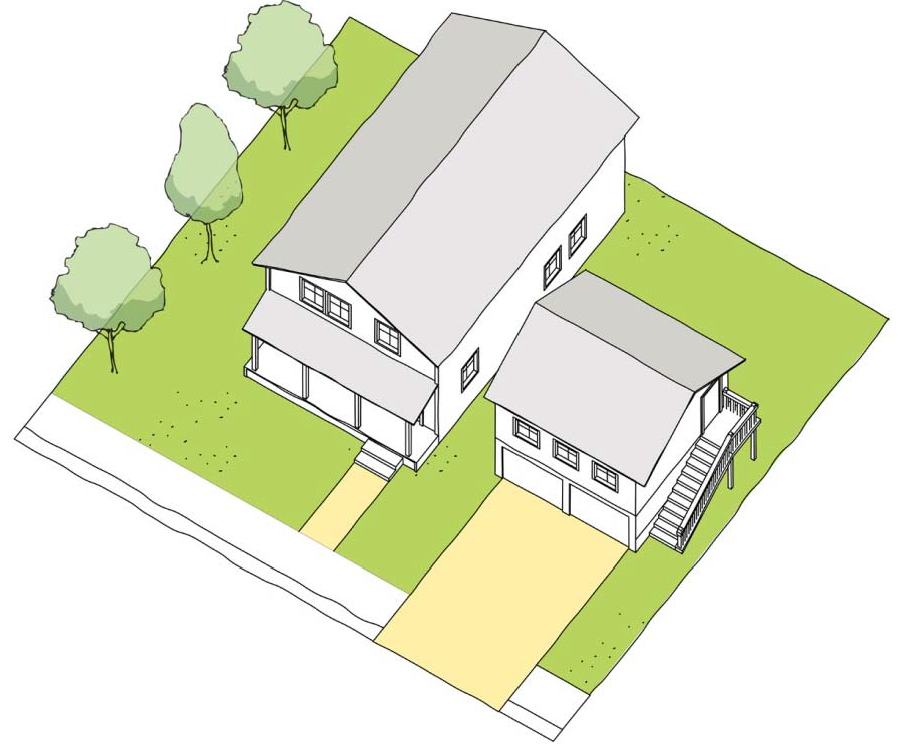
(2)
Standards. Carriage homes shall comply with the development standards shown in Table 20.22-3, unless otherwise approved through the minor use permit or site plan review permit process.
Notes:
[1] Twenty (20) feet required for driveways.
c.
Side Yard Homes.
(1)
Definition. An alley-loaded single dwelling unit with one (1) active side yard.
Figure 20.22-3 Side Yard Homes Example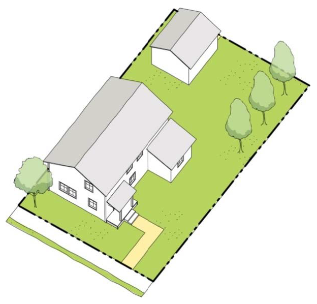
(2)
Standards. Side yard homes shall comply with the development standards shown in Table 20.22-4, unless otherwise approved through the minor use permit or site plan review permit process.
(3)
Pedestrian Access. The main entry to a side yard house shall be through either the building façade facing the active side yard or the front street-facing façade.
(4)
Frontage. The building façade fronting the active side yard shall feature a porch; and the active side yard shall front the street on a corner lot.
d.
Duplexes, Triplexes, and Fourplexes.
(1)
Definition. A residential structure that contains two (2) to four (4) dwelling units that are either stacked or placed side-by-side and appear as a large single-family house.
Figure 20.22-4 Duplexes, Triplexes, and Fourplexes Example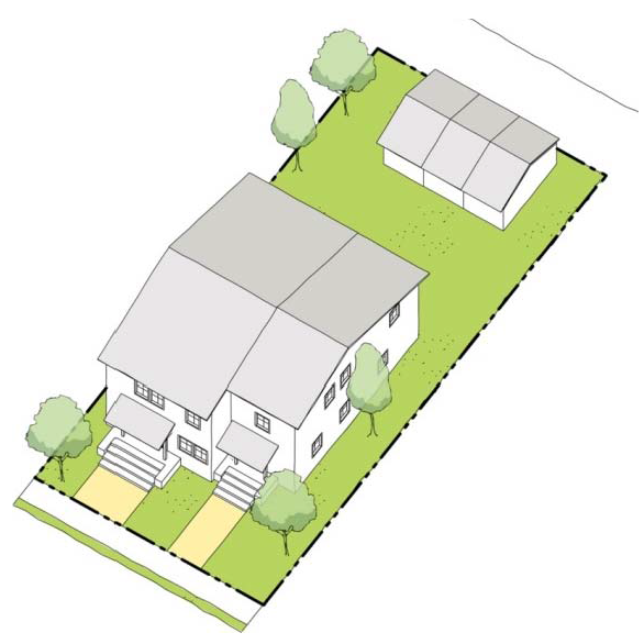
(2)
Standards. Duplexes, triplexes, and fourplexes shall comply with the development standards shown in Table 20.22-5, unless otherwise approved through the minor use permit or site plan review permit process.
;sz=8;Notes:
[1] The minimum rear setback shall be five (5) feet when abutting an alley.
e.
Rosewalk.
(1)
Definition. A grouping of detached dwelling units arranged in two (2) rows on either side of a common green.
Figure 20.22-5 Rosewalk Example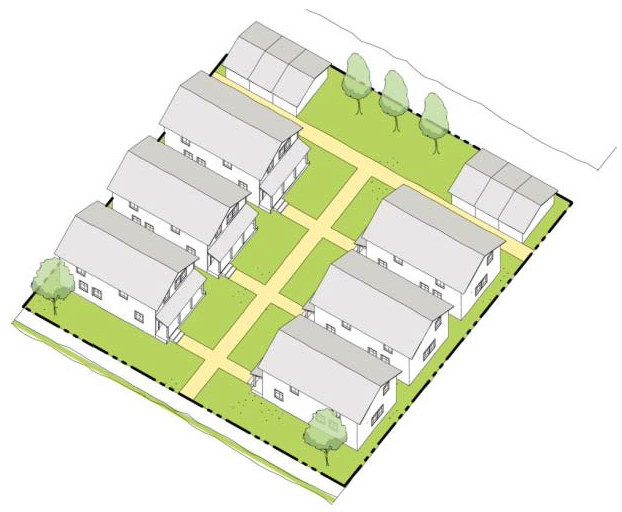
(2)
Standards. Rosewalk shall comply with the development standards shown in Table 20.22-6, unless otherwise approved through the minor use permit or site plan review permit process.
f.
Bungalow Court.
(1)
Definition. A grouping of detached single-family homes arranged around a shared courtyard that is typically perpendicular to the street.
Figure 20.22-6 Bungalow Court Example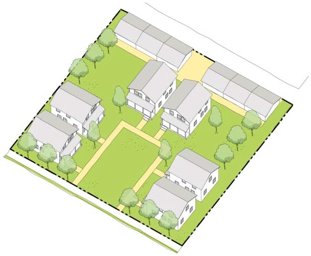
(2)
Standards. Bungalow courts shall comply with the development standards shown in Table 20.22-7, unless otherwise approved through the minor use permit or site plan review permit process.
Notes:
[1] The minimum rear setback shall be five (5) feet when abutting an alley.
(3)
Pedestrian Access.
a)
The primary pedestrian entry to a bungalow court shall be provided from a public sidewalk adjacent to the central courtyard.
b)
The main entry to each unit shall face either the central courtyard or a public street.
(4)
Central Courtyard.
a)
The central courtyard shall be a shared space accessible to all building residents.
b)
Pathways shall be provided from each unit to the central courtyard and from the central courtyard to a public sidewalk adjacent to the site.
c)
The central courtyard shall be visible from the primary street frontage.
d)
The amount of impervious surface in central courtyard shall not exceed fifty (50) percent of the total courtyard area.
g.
Townhomes.
(1)
Definition. A single-family home attached to one (1) or more other single-family homes in a linear arrangement.
Figure 20.22-7 Townhomes Example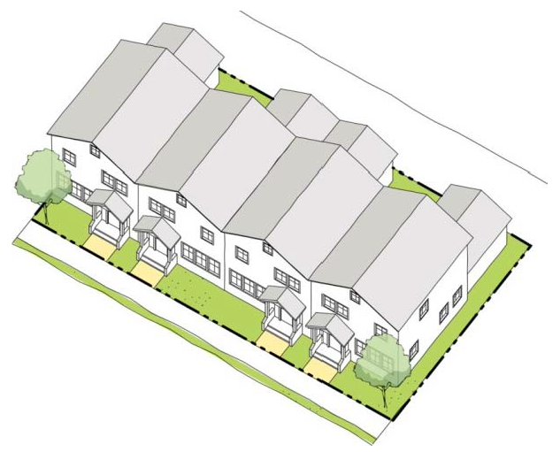
(2)
Standards. Townhomes shall comply with the development standards shown in Table 20.22-8, unless otherwise approved through the minor use permit or site plan review permit process.
h.
Side Court Apartments.
(1)
Definition. A 2- to 3-story structure that contains multiple dwelling units and most of its dwelling units facing an active side yard.
Figure 20.22-9 Side Court Apartments Example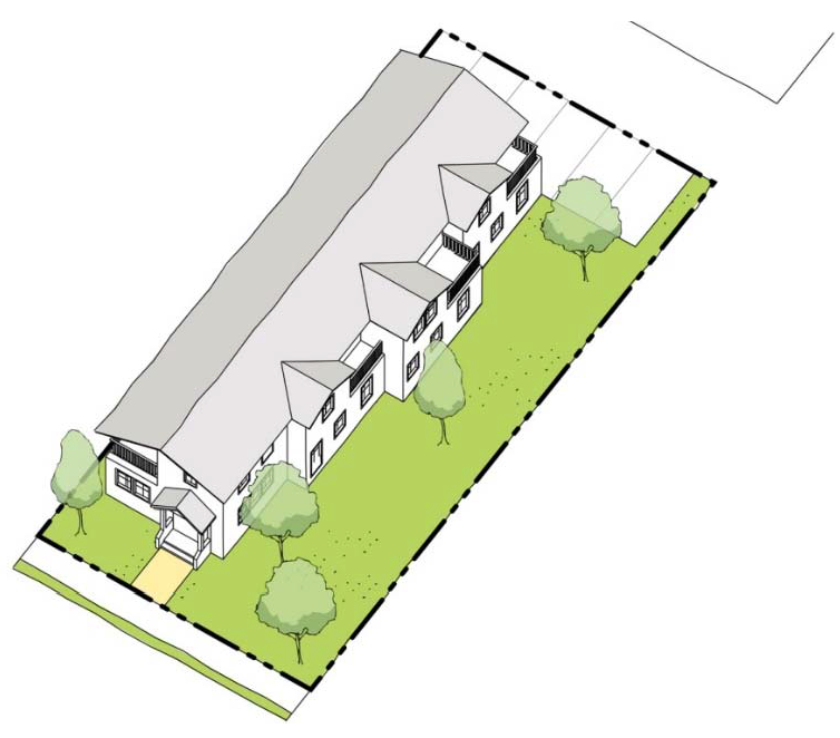
(2)
Standards. Side court apartments shall comply with the development standards shown in Table 20.22-9, unless otherwise approved through the minor use permit or site plan review permit process.
a.
The side courtyard shall be a shared space accessible to all building residents.
b.
Pathways shall be provided from each unit to the side courtyard and from the side courtyard to a public sidewalk adjacent to the site.
Notes: [1] The minimum rear setback shall be five (5) feet when abutting an alley.
i.
Courtyard Apartments.
(1)
Definition. A grouping of attached dwelling units arranged to share one (1) or more central courtyard.
Figure 20.22-10 Courtyard Apartments Example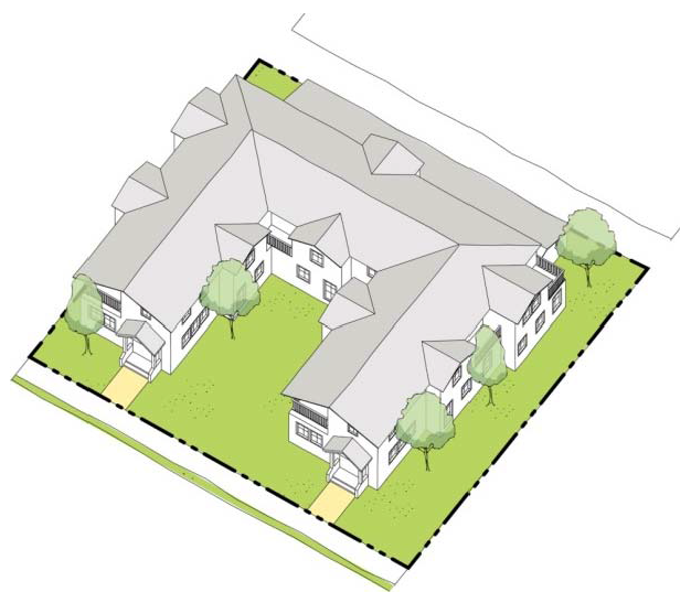
(2)
Standards. Courtyard apartments shall comply with the development standards shown in Table 20.22-10, unless otherwise approved through the minor use permit or site plan review permit process.
Notes: [1] The minimum rear setback shall be five (5) feet when abutting an alley.
(3)
Pedestrian Access. The primary entry to individual units or the interior lobby of a courtyard apartment building shall be through the central courtyard.
(4)
Central Courtyard.
a)
The central courtyard shall be a shared space accessible to all building residents.
b)
Pathways shall be provided from each unit to the central courtyard and from the central courtyard to a public sidewalk adjacent to the site.
c)
The central courtyard shall be visible from the primary street frontage.
d)
The amount of impervious surface in central courtyard shall not exceed fifty (50) percent of the total courtyard area.
e)
The central courtyard shall be at least thirty (30) feet in width.
(5)
Frontage. The active side yard shall front the street on a corner lot.
j.
Live/Work.
(1)
Definitions. Attached dwelling units that are used jointly for commercial and residential purposes.
Figure 20.22-11 Live/Work Example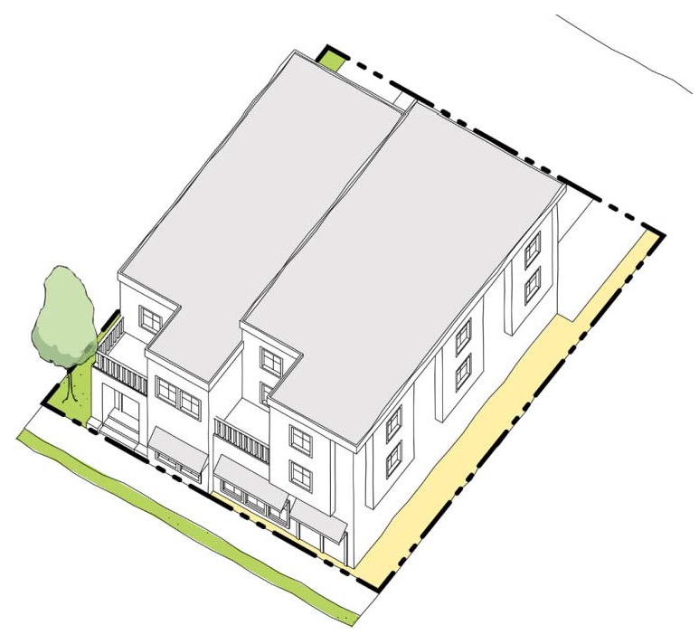
(2)
Standards. Live/work shall comply with the development standards shown in Table 20.22-11, unless otherwise approved through the minor use permit or site plan review permit process.
Notes: [1] The minimum rear setback shall be five (5) feet when abutting an alley.
(3)
Pedestrian Access.
a)
The main entrance to the ground floor work space shall be accessed directly from and face a public street.
b)
Dwelling unit shall be located above the work space, and accessed from a separate entrance.
(Ord. No. 2465, § 2(Exhs. A., B.), 9-19-2016)