
Monticello City Zoning Code
ARTICLE III
ZONING DISTRICT REGULATIONS
Sec. 54-121. - Districts established.
For the purposes of protecting, promoting, and improving the public health, safety, comfort, order, appearance, convenience, morals, and general welfare of the community, the incorporated area of the city is hereby divided into the following zoning districts in the manner shown on the official zoning map:
(Ord. No. 90-13, § 03.01, 8-7-1990; Ord. No. 2001-06, § 2(03.01), 11-6-2001)
Sec. 54-122. - Official map.
(a)
Generally. The official zoning map shall be entrusted to the custody of the city clerk and shall be located in city hall. It shall be identified by the signature of the mayor, attested by the city clerk, and shall bear the city seal under the following words: "This is to certify that this is the Official Zoning Map referenced in Article III of the City of Monticello Land Development Regulations, Ordinance No. _______ adopted on ________."
(b)
Amendments. Approved amendments to the official zoning map shall be promptly noted on a true copy of the official zoning map by inserting the case number and date of approval on or near the affected parcel.
(c)
Retention of earlier zoning maps. All zoning maps and regulations or remaining portions thereof which have had official force and effect in the city prior to the effective date of these zoning regulations shall be retained as public records.
(d)
Replacement of official zoning map. If the official zoning map is damaged, destroyed, lost, or difficult to interpret because of the nature or number of changes and additions, the city council may adopt, after due public notice, an updated official zoning map which will supersede the prior official zoning map. The updated official zoning map may correct drafting or other errors or omissions in the prior official zoning map, but no such corrections shall have the effect of amending the original official zoning map or any subsequent amendment thereof. The updated official zoning map shall be identified in the same manner as the original official zoning map, except that the certificate shall state "This is to certify that this Official Zoning Map supersedes and replaces the Official Zoning Map adopted on ________ as part of Ordinance No. _______ of the City of Monticello." (Insert date map was replaced.) Unless the prior official zoning map has been lost or has been totally destroyed, the prior map or any significant parts thereof remaining shall be preserved, together with all available records pertaining to its adoption or amendment.
(Ord. No. 90-13, § 03.02, 8-7-1990; Ord. No. 2001-06, § 2(03.02), 11-6-2001)
Sec. 54-123. - Interpretation of district boundaries.
The following rules of interpretation shall be used to locate the district boundaries shown on the official zoning map:
(1)
Boundaries following streets. Boundaries following, or approximately following, the centerlines of streets shall be construed to follow those centerlines. If a street is vacated, the district boundary shall be construed to remain in its location, except when ownership of the vacated street is divided other than at the center, in which case the boundary shall be construed to move with the ownership.
(2)
Boundaries following lot lines. Boundaries following, or approximately following, lot lines shall be construed to follow those lot lines.
(3)
Boundaries following county and city limits. Those boundaries following, or approximately following, city limits shall be construed to follow those county and city limits.
(4)
Boundaries following railroad lines. Those boundaries following, or approximately following, railroad lines shall be construed to follow the centerline of the railroad right-of-way. If a railroad right-of-way is vacated, the district boundary shall be construed to remain in its location, except when ownership of the vacated railroad right-of-way is divided other than at the center; in which case, the boundary shall be construed to move with the ownership.
(5)
Boundaries following water bodies. Those boundaries following, or approximately following, the shorelines of water bodies shall be construed to follow and move with those shorelines. Boundaries following, or approximately following, the centerlines of streams, rivers, canals, lakes, or other bodies of water, shall be construed to follow and move with those centerlines.
(6)
Boundaries entering any body of water. Boundaries entering any body of water, but not continuing to intersect with other zoning boundaries, shall be construed to extend in the same direction in which they entered the body of water, until they intersect with other zoning boundaries.
(7)
Boundaries parallel to or extensions of above features. Boundaries parallel to or extensions of the features indicated in subsections (1) through (6) above shall be construed to be parallel to, or extensions of, those features as the case may be.
(8)
Other cases. Boundaries splitting existing lots in subdivisions and any other boundaries not determined by the above rules shall be determined by reference to the expressed distances on, or the scale of, the official zoning map. If the existing lot will not accommodate any of the uses permitted in the multiple districts indicated thereon, a rezoning to an appropriate district shall be required.
(9)
Determination of boundaries. In cases where the rules set forth in this article cannot with certainty determine the true location of a district boundary, the city council shall render a determination. No boundary shall be changed except by the amendment process.
(Ord. No. 90-13, § 03.03, 8-7-1990; Ord. No. 2001-06, § 2(03.03), 11-6-2001)
Sec. 54-124. - Scope; applicability.
(a)
Minimum requirements. In interpreting and applying the provisions of this article, they shall be held to be the minimum requirements for achieving the purposes of the article. It is not intended that this article interfere with, abrogate, or annul any easements, covenants, or other agreements between parties; however, where this article imposes a greater restriction, the provisions of this article shall control.
(b)
Zoning affects all premises. No premises shall hereafter be used or occupied, and no building or structure shall hereafter be erected, constructed, moved, or altered, except in conformity with these regulations. If, because of an error or omission on the official zoning map, any property within the city is not shown as being included within a zoning district, the classification of such property shall be R-1 residence, single-family, unless changed by an amendment to this article.
(c)
Yard, lot coverage, floor areas and building height requirements. Every building or accessory structure to be erected upon a lot shall meet all yard, lot coverage, floor area, and building height requirements of its district unless specifically exempted elsewhere in this article.
(d)
Multiple use of required space prohibited. No part of a required yard, or other required open space, or of the off-street parking or loading spaces for one structure, shall be included as part of the yard, open space, off-street parking or loading space requirements for any other structure.
(e)
Reduction of lot area prohibited. Except for any approved planned residential, planned commercial, or planned industrial development, no yard or lot existing at the time of passage of the ordinance from which this article is derived shall be reduced in dimension or area below the minimum requirements of its district. With the same exception, yards or lots designed after the effective date of such ordinance shall meet the requirements established by this article.
(Ord. No. 90-13, § 03.04, 8-7-1990; Ord. No. 97-1, 1-7-1997; Ord. No. 2001-06, § 2(03.04), 11-6-2001)
Sec. 54-125. - Penalty.
Any person who violates or fails to comply with any of the provisions of this article shall, upon conviction, be subject to punishment in accordance with section 1-4. Each day's violation shall constitute a separate offense and shall be punishable under the terms of this article. Nothing herein shall prevent the city from taking such other lawful action as is necessary to prevent or remedy any violation.
(Ord. No. 90-13, § 03.07.03(A), 8-7-1990; Ord. No. 2001-06, § 2(03.07.03(A)), 11-6-2001)
Sec. 54-126. - Amendments.
(a)
Amendment procedure.
(1)
Initiation of amendment. The city council may, from time to time, amend, supplement, or repeal the regulations and provisions of this article after public notice and hearings as provided by law consistent with the provisions of the Charter and applicable state statute and upon initiation by one of the following ways:
a.
On its own motion.
b.
On petition from the owners of 51 percent or more of the area involved in the proposed change. Whenever the fee simple owners of 51 percent or more of any property owners desire a change in zoning classification or any owner desires change of the conditions or regulations of any district or any other provision of this article, he or she shall make written application to the development administrator on a form and in a manner as set forth by the city, together with evidence of payment of the appropriate fee. Such written application shall be signed by the owner or his or her designated agent and shall include a list all owners of real property, as listed in the current year ad valorem tax rolls, which are within 500 feet of the property proposed for amendment.
(2)
Planning agency review. Upon acceptance of a complete application for zoning amendment, the designated city development administrator shall, within 30 working days, prepare a report for the local planning agency for review at a public hearing.
a.
Notice requirements prior to planning agency review.
1.
At least ten days prior to the planning agency review of the re-zoning amendment, the meeting must be advertised.
2.
A notice shall be sent by U.S. Mail to property owners within 500 feet of the subject property. This notice shall identify the property subject to the rezoning application, the nature of the proposed change, and the date when the local planning agency will review the proposed change. Where a condominium or cooperative building is involved, only the association through its duly registered agent or officer, need be notified.
3.
At least ten days prior to the planning agency review, the owner of the property involved in a proposed zoning change shall conspicuously display a placard on the property with the following verbiage:
NOTICE OF PROPOSED REZONING
A Petition for Rezoning of this property from (current zoning designation) to (proposed zoning designation) will be considered by the Monticello Local Planning Agency at public hearing on (date) at (time and a.m. or p.m.) at City Hall, 245 S. Mulberry Street, Monticello, Florida 32344.
Complete information on the re-zoning process is available at City Hall.
The placard shall be placed on the real property proposed to be rezoned, at a location facing each public roadway which borders the property, and the verbiage shall be legible from the nearest roadway travel lane. The signs shall be yellow with black lettering, at least 48 inches by 48 inches in size. The signs shall be installed by secure posts and supports to prevent bending or tilting.
b.
The local planning agency shall, within 60 days of completion of the public hearing, take action either recommending approval of the application; recommending approval with suggested modifications; or recommending denial of the application.
(3)
City council action. Following the receipt of a request for a zoning amendment, the council shall hold a public first reading of the title of the proposed ordinance of rezoning, followed by an advertised public hearing on the zoning amendment request, as required by F.S. [Florida Statutes] and the Charter.
(4)
Failure to give the notice prescribed shall not invalidate the action of the city council.
(5)
Successive applications. No application for a zoning change shall be made within 12 months from the date of the scheduled public hearing before the city council of a previous application for substantially the same request, unless there has been a substantial change of conditions or character of the surrounding land area or the land in question.
(Ord. No. 90-13, §§ 03.07.01, 03.07.02, 8-7-1990; Ord. No. 2001-06, § 2(03.07.01, 03.07.02), 11-6-2001; Ord. No. 2010-13, § 1, 12-7-2010; Ord. No. 2012-03, § 1, 7-3-2012)
Sec. 54-127. - Limited use district.
(a)
Intent. The provisions of the limited use district are intended as an alternative elective process which would allow further limitation of the permitted use of any property. The general purpose is to permit certain land uses within a zoning district to the exclusion of other uses, which will allow land use to be directed to the circumstances surrounding the property and the individual application for zoning reclassification. Further, it is the intent, through the use of optional site-planning criteria, for a proposed development to be more sensitive to a neighborhood or the neighborhood community environment by offering protection from potential adverse influences. An applicant may seek to restrict the use of the land to one or more uses permitted within a specific zoning district proposed for rezoning, or may elect to file a site plan which would become part of the development standards on the property, upon approval of the city council.
(b)
Definition. A limited use zone is an alternative elective zoning district which accommodates either or both of the following:
(1)
A certain use or uses are permitted to the exclusion of all other uses authorized within the zoning district.
(2)
A site plan is permitted to become part of the development standards upon approval by the city council.
(c)
Eligibility. Minimum requirements shall be the same as those set forth in development standards under the zoning district sought. Any rezoning application may be amended to conform to the requirements of this district at any stage of the rezoning process.
(d)
Site plan. When an applicant elects to submit a site plan, that site plan shall become part of said application and be binding upon the property in the event the same application is granted. A site plan shall be drawn to an appropriate engineer's scale to include the location and boundary of the site and in addition must include one or more of the following optional elements:
(1)
The approximate size, location, height, or setbacks of all proposed buildings or other structures. The specified use of buildings and structures may be included.
(2)
Off-street parking and loading plans, including circulation plans for vehicular movement, number and approximate limitation controls.
(3)
Approximate location and size of open spaces and landscaped areas or buffering elements.
(4)
Total acreage of the site and the calculated intensity for the project, either by density for residential uses, or square footage of gross floor area for nonresidential uses.
(5)
Drawings indicating the general architectural themes, appearance and representative building types.
(6)
Definitive covenants, grants, easements, dedications and restrictions to be imposed on the land, buildings and structures.
(7)
Any other commitments of development specifications, limitations, constraints, standards, or proposed physical features not specifically included within subsections (1) through (6) above.
(e)
Subsequent rezoning. Any property so zoned under these provisions may not be re-zoned for a period of five years from the date of LUD zoning.
(Ord. No. 90-13, § 03.06, 8-7-1990; Ord. No. 2001-06, § 2(03.06), 11-6-2001)
Sec. 54-151. - Generally.
District regulations shall be as set forth in the following schedule of district regulations.
(Ord. No. 90-13, § 03.05, 8-7-1990; Ord. No. 2001-06, § 2(03.05), 11-6-2001)
Sec. 54-152. - R-1 residential, single-family district.
(a)
Purpose and intent. The purpose of the R-1 district is to delineate those areas defined by the Future Land Use Element of the city's comprehensive plan as suitable for low density development consisting of single-family units.
(b)
Permitted uses. The following uses shall be permitted principal uses in the R-1 district:
(1)
Single-family dwelling.
(2)
Public park.
(3)
Church.
(4)
Library.
(5)
Museum.
(6)
Schools, nurseries, day cares, elementary and training schools, schools for the developmentally disabled.
(7)
Essential services.
(8)
Fish ponds.
(c)
Special exception uses.
(1)
Bed and breakfast home, subject to the following requirements:
a.
On premises parking for guests;
b.
No more than six guestrooms or 18 guests at one time;
c.
Owner/operator must reside on premises of the bed and breakfast home;
d.
Applicant must meet the requirements for licensing by the state department of business and professional regulation as per F.S. § 509.013.
e.
For a bed and breakfast inn otherwise permitted, such inn may operate a restaurant for use by the general public, and may advertise the same, if all of the following criteria are met; provided, however, that such use shall have the approval and appropriate licensing of the state and/or other governmental agencies:
1.
Restaurant scale/size. The restaurant dining area does not exceed eight seats per guest room.
2.
Days and hours of operation. Days and hours of operation for dining are Monday through Saturday between 11:00 a.m. and 5:30 p.m., except as provided below.
3.
Extended hours of operation. A bed and breakfast may serve meals to the general public after 5:30 p.m., provided the last seating is no later than 10:00 p.m. and the following standards are met:
i.
Such inn shall have main access via an arterial roadway, or collector roadway where such inn fronts on a nonresidential use.
ii.
Such inn shall maintain enough on-site parking spaces to accommodate the general public, based on the city parking standards.
(2)
Professional offices and limited, residentially-compatible businesses, subject to the following requirements in the R-1 zoning district:
a.
Purpose and intent. Limited to professional offices and limited, residentially-compatible businesses, fronting on U.S. Highway 19 and U.S. Highway 90 in areas designated as mixed-use office/residential on the future land use map of the comprehensive plan. Types of professional offices and limited, residentially-compatible businesses and sizes of buildings permitted within this residential zone must be sensitive to the adjacent residential environment and, thus, exclude those uses and building sizes which can negatively impact the surrounding residential area with traffic generation, parking, deliveries, noise, noxious odors, and aesthetic incompatibility. All business uses and activities shall be conducted exclusively and wholly within an enclosed building, except that activities associated with a business, excluding vending machines, may be permitted outside the enclosed building to the extent that such activities are residentially-compatible and do not otherwise constitute or create a nuisance to adjoining residential properties.
b.
Permitted uses.
1.
Professional and government offices.
2.
Retail businesses involving the sale of merchandise on the premises within the enclosed buildings, but excluding pawn shops, sweepstakes or gaming parlors, liquor package stores, bars, taverns, cocktail lounges, drive-through facilities, food establishments with commercial kitchens, pet shops and boarding kennels, and other business activities similar to the foregoing.
3.
Establishments involved in the rendering of a personal service, such as beauty salon, or business service, copying center, bicycle repair shop, recreational sporting equipment rentals, but excluding automobile or motor service/repair facilities, day cares, schools, tattoo, body art or fortune-telling businesses.
c.
On premises parking for clients/customers, in accordance with parking regulations outlined in section 54-502.
d.
Utilization of existing driveways for ingress and egress, or prior written approval from the city manager for a new driveway accessing the property from a city street.
e.
No commercial dumpsters are allowed.
f.
Allowable hours of operation: From 7:00 a.m. to 8:00 p.m., Monday through Saturday, and 12:00 noon to 5:00 p.m. on Sundays.
g.
The operation of the business may not generate excessive vehicular traffic to the premises, generate noxious odors, or create noise from machinery or equipment audible from any adjacent property.
h.
Screening or buffering must be provided pursuant to the provisions of section 54-194 for all uncomplementary land uses.
i.
Except as provided in subsection k. below, professional and business offices may utilize only structures in existence on March 3, 1998.
j.
Such nonresidential uses shall be compatible with the historic resources in the neighborhood.
k.
New structures intended specifically for the nonresidential uses authorized herein shall be no larger than 5,000 square feet, and may not be placed on the site of a residential structure which existed on March 3, 1998.
l.
New structures intended specifically for such nonresidential uses shall be limited to an impervious surface ratio of 0.50.
m.
Site plan review, local planning agency review and city council approval is not required for new special exception uses under this section, provided that no new structures are being constructed or placed on the property and no expansion of existing structures is proposed, and the owner or lessee completes and submits to the city clerk or designee the appropriate application certifying that the intended use of the property is a permitted use under this section and that it will comply with all applicable city ordinances.
(d)
Accessory uses.
(1)
Accessory dwelling units as defined in section 54-4 and developed in accordance with section 54-198.
(2)
Accessory structures and uses incidental to a principal use in accordance with section 54-192.
(e)
Property development requirements. The property development regulations addressing minimum lot requirements, minimum floor area, required yards, maximum lot coverage, and maximum height are presented in tabular form in section 54-160.
(f)
Other development requirements. Other applicable lot and use regulations, and architectural design and aesthetic standards, are set forth in article IV of this chapter, supplementary regulations.
(Ord. No. 90-13, § 03.05.01, 8-7-1990; Ord. No. 95-7, 10-9-1995; Ord. No. 2000-07, § 1, 9-5-2000; Ord. No. 2001-06, § 2(03.05.01), 11-6-2001; Ord. No. 2014-02, § 1, 6-3-2014; Ord. No. 2019-03, § 3, 6-4-2019; Ord. No. 2020-01, § 1, 5-12-2020; Ord. No. 2023-03, § 1, 1-3-2023)
Sec. 54-153. - R-1A residential, single-family/mobile home district.
(a)
Purpose and intent. The purpose of the R-1A district is to delineate those areas defined by the Future Land Use Element of the comprehensive plan as suitable for low density development and to provide for a recognized need for low cost housing. Individual lots may be utilized for either single-family dwellings or mobile homes within this district.
(b)
Permitted uses. The following uses shall be permitted principal uses in the R-1A district:
(1)
Single-family dwelling.
(2)
Mobile home dwelling.
(3)
Public park.
(4)
Church.
(5)
Library.
(6)
Museum.
(7)
Schools, nurseries, day care, elementary and training schools, schools for the developmentally disabled.
(8)
Essential services.
(c)
Special exception uses. None.
(d)
Accessory uses.
(1)
Accessory dwelling units as defined in section 54-4 and developed in accordance with section 54-198.
(2)
Accessory structures and uses incidental to a principal use in accordance with section 54-192.
(e)
Property development requirements. The property development regulations addressing minimum lot requirements, minimum floor area, required yards, maximum lot coverage, and maximum height are presented in tabular form in section 54-160.
(f)
Other development requirements. Other applicable lot and use regulations are set forth in article IV of this chapter, Supplementary Regulations.
(g)
Lot size for mobile homes. Whenever any applicant for a mobile home permit shall own or have possession of or the right to occupy a lot in the city, in a platted subdivision, or any lot or portion of lot located therein, such mobile home usage, placement and occupancy shall be permitted, without the necessity of a variance, if the total lot or lots provide 5,000 square feet of usable land, regardless of frontage, width or depth of said lot. However, nothing herein shall be construed to omit the requirement of appropriate setbacks as they may apply to any R-1A residential lot.
(Ord. No. 90-13, § 03.05.02, 8-7-1990; Ord. No. 96-02, 2-4-1996; Ord. No. 98-02, § 1, 7-7-1998; Ord. No. 2001-06, § 2(03.05.02), 11-6-2001; Ord. No. 2023-03, § 2, 1-3-2023)
Sec. 54-154. - R-2 residential, multifamily district.
(a)
Purpose and intent. The purpose of the R-2 district is to provide for the development of multifamily and mobile home housing as defined and limited by the Future Land Use Element of the comprehensive plan. Properties designated R-2 shall not exceed 15 percent of the total acreage of any single planning area nor shall they exceed ten percent of the total land area in the city. The R-2 zone shall not be applied within the established neighborhoods as specified in the comprehensive plan.
(b)
Permitted uses. The following uses shall be permitted principal uses in the R-2 district:
(1)
Multifamily dwellings.
(2)
Single-family dwellings.
(3)
Adult congregate living facilities.
(4)
Mobile home parks.
(5)
Public park.
(6)
Church.
(7)
Library.
(8)
Museum.
(9)
Schools, nurseries, day care, elementary and training schools, schools for the developmentally disabled.
(10)
Essential services.
(c)
Special exception uses. None.
(d)
Accessory uses. Permitted accessory uses shall include those uses customarily incidental to a permitted use.
(e)
Property development requirements. The property development regulations addressing minimum lot requirements, minimum floor area, required yards, maximum lot coverage, and maximum height are presented in tabular form in section 54-160.
(f)
Building groups and spacing. The maximum length of any group of attached structures shall not exceed 150 feet. The minimum distance between building groups shall be 25 feet.
(g)
Other development requirements. Other applicable lot and use regulations are set forth in article IV of this chapter, Supplementary Regulations.
(Ord. No. 90-13, § 03.05.03, 8-7-1990; Ord. No. 98-02, § 2, 7-7-1998; Ord. No. 2001-06, § 2(03.05.03), 11-6-2001; Ord. No. 2003-04, § 1, 5-6-2003)
Sec. 54-155. - B-1 business, central district.
(a)
Purpose and intent. The B-1 district is intended to serve as the center of retail trade, financial and professional activity for the city and its service area. Its primary purpose is to group these specialized uses together in a compact area designed for pedestrian movement supported by limited off-street parking. It is intended to be applied in the area surrounding the junction of U.S. 90 and U.S. 19.
(b)
Permitted uses. The following uses shall be permitted principal uses in the B-1 district:
(1)
Office, business and professional.
(2)
Store, convenience.
(3)
Store, retail.
(4)
Store, personal service.
(5)
Financial institutions.
(6)
Restaurants.
(7)
Commercial parking facilities.
(8)
Library.
(9)
Museum.
(10)
Fire station.
(11)
Police station.
(12)
Office, government.
(13)
Church, schools and day care.
(14)
Essential services.
(15)
Single-family residences in pre-1960 structures originally constructed as dwellings.
(c)
Special exceptions uses.
(1)
Town homes, subject to the following requirements:
a.
Structures must consist of at least two, attached single-family units with firewall(s) separating the units. Structures shall be either:
1.
Two story;
2.
Single story, with an eave height of 16 feet; or
3.
Single story, with an eave height of at least 12 feet and a roof pitch of at least 8/12.
b.
The design of each town home must be reflective of the surrounding styles in the traditional downtown area.
c.
All proposed town home designs shall be submitted for review by the city's historical design review board, which shall make a recommendation regarding approval to the city council.
d.
All town homes proposed for construction in any designated historic district must comply with the requirements in article VII of this chapter.
e.
No town home will be approved as a special exception use until there has been an appropriate review, and a finding by the city that the proposed special exception complies with the requirements in section 54-191 and section 54-502 of this chapter.
(d)
Accessory uses. The following uses shall be permitted accessory uses in the B-1 district:
(1)
Multiple-family dwellings provided the residential floor area is less than 50 percent of the total floor area on the lot and that the minimum floor area per dwelling unit as specified in the R-2 district is met.
(2)
A single-family dwelling unit as an accessory to a principal use provided that tenant separation requirements are met.
(3)
Other accessory uses customarily incidental to a principal use.
(e)
Property development requirements. In addition to site plan review and other development requirements governing B-1 properties located in the City Historic District, the following development requirements are applicable to the B-1 Downtown Business District:
(1)
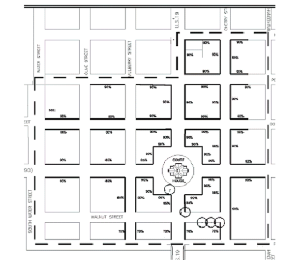
Build-to line. Building facades must be located within ten feet of the right-of-way line. Space between right-of-way and façade must be landscaped and/or paved with non-concrete pedestrian pavers which meet accessibility standards of the Americans with Disabilities Act. Building frontages must meet the minimum percentage requirements of frontage as depicted in Section 54-160(b).
(2)
Subdivision. Lots can be subdivided by owner to create conforming build-to line frontages.
(3)
Corner lots. On corner lots, new buildings are considered primary facades and shall be oriented to both streets. These primary facades shall be considered opportunities for distinctive architecture. Entrances of new buildings on corner lots within the four corners of the courthouse circle shall be oriented to face the courthouse.
(4)
Parking spaces. No new parking spaces shall be constructed within 25 feet of the build-to line.
(5)
Garbage collection facilities. Applications for site plan approval for new construction or building additions comprising 1,750 square feet or more of interior floor space must contain a plan for garbage collection facilities and be approved by the city manager. The plan shall include estimates of garbage based on the most intensive use all units within the structure jointly. The garbage collection facility plan for structures containing commercial kitchen site plans shall include a plan for on-site storage of wet garbage.
(6)
Single-family character structures. Structures located within the B-1 zoning district originally constructed before 1960 as single-family residences are a complement to the identity and function of the downtown business district. Therefore, lots containing existing single-family character structures are exempt from build-to frontage requirements so long as any proposed addition and/or new construction on those lots is situated behind the front façade of the structure, and no more than 50 percent of the original building is removed.
(7)
Church lots and structures. Lots containing church structures and accessory church buildings in existence as of January 1, 2009 are a complement to the identity and historic urban character of the city and therefore, these lots are exempt from build-to frontage requirements for new construction so long as the building permit for the new construction is issued to a tax-exempt, Chapter 501(c)(3) church organization in existence as of January 1, 2009, and intended use for any church lot or structure addition is for church programs and function.
(f)
Other development requirements. Other applicable lot and use regulations are set forth in article IV of this chapter, Supplementary Regulations.
(Ord. No. 90-13, § 03.05.04, 8-7-1990; Ord. No. 2001-06, § 2(03.05.04), 11-6-2001; Ord. No. 2005-07, § 1, 10-4-2005; Ord. No. 2009-01, § 1, 3-3-2009; Ord. No. 2022-04, § 1, 2-1-2022)
Sec. 54-156. - B-2 business, highway district.
(a)
Purpose and intent. The purpose of this district is to delineate those areas defined by the Future Land Use Element of the comprehensive plan for commercial development, suitable for those commercial activities which function relatively independently from pedestrian traffic. These activities typically require direct automobile access, and this district will normally be applied along traffic arteries.
(b)
Permitted uses. The following uses shall be permitted principal uses in the B-2 district:
(1)
Automobile repair garage.
(2)
Automobile service facility.
(3)
Church.
(4)
Financial institution.
(5)
Hotel, motel and other short-term rentals.
(6)
Office, business and professional.
(7)
Restaurant.
(8)
Store, convenience.
(9)
Store, retail.
(10)
Store, personal service.
(11)
Self-storage facilities (mini-storage) (north of Pearl Street and south of Cherokee Street, only).
(12)
Veterinarian.
(13)
Day care and schools.
(14)
Private clubs.
(15)
Arcades and game rooms.
(16)
Commercial parking facilities (north of Pearl Street and south of Cherokee Street, only).
(17)
Fitness center and/or swimming facility.
(18)
Library.
(19)
Museum.
(20)
Office, government.
(21)
Fire station.
(22)
Police station.
(23)
Essential services.
(c)
Special exception uses:
(1)
Single-family residential dwelling units, subject to the following requirements:
a.
All single-family residential dwelling units proposed for the B-2 zoning district shall be submitted for review to the city's local planning agency, which shall make a recommendation regarding approval to the city council.
b.
In addition to local planning agency review, all proposed single-family dwelling units in the B-2 zoning district which lie in the designated historic district must comply with the provisions and review requirements in chapter 54, article VII of the Monticello City Code.
c.
Proposed residential single-family units must meet the dimensional regulation requirements of single-family residential lots contained in section 54-160 of the Monticello City Code.
d.
Proposed residential lots subject to approval under this section shall comply with the buffer standards found in section 54-194(b) of the Monticello Code.
(d)
Accessory uses. The following uses shall be permitted accessory uses in the B-2 district:
(1)
A single-family dwelling unit as accessory to a principal use provided that tenant separation requirements are met.
(2)
Other accessory uses customarily incidental to a permitted use.
(e)
Property development requirements. The property development regulations addressing minimum lot requirements, minimum floor area, required yards, maximum lot coverage and maximum height are presented in tabular form in section 54-160.
(f)
Other development requirements. Other applicable lot and use regulations are set forth in article IV of this chapter, Supplementary Regulations.
(Ord. No. 90-13, § 03.05.05, 8-7-1990; Ord. No. 95-02, 2-7-1995; Ord. No. 2001-06, § 2(03.05.05), 11-6-2001; Ord. No. 2002-01, § 1, 7-2-2002; Ord. No. 2004-07, § 1(03.05), 11-2-2004; Ord. No. 2007-06, § 1, 6-5-2007)
Sec. 54-157. - I, industrial district.
(a)
Purpose and intent. The purpose of the I district is to delineate those areas identified by the Future Land Use Element of the comprehensive plan as suitable for industrial development.
(b)
Permitted uses. The following uses shall be permitted principal use in the I district:
(1)
Building supply.
(2)
Manufacturing, assembly and processing operations.
(3)
Printing.
(4)
Trade shops.
(5)
Warehousing.
(6)
Wholesale packaging, supply and distribution.
(7)
Schools.
(8)
Essential services.
(c)
Special exception uses. None.
(d)
Accessory uses. The following uses shall be permitted accessory uses in the I district:
(1)
Retail sales associated with and incidental to the principal use.
(2)
Offices associated with and incidental to the principal use.
(3)
Outside storage provided the screening requirements of section 54-194 are met.
(4)
Other uses customarily incidental to a principal use.
(e)
Manufacturing limitations. All manufacturing and business activities shall be done in a completely enclosed building. No bulk storage of flammable materials and no storage of explosives except as provided through Florida Statutes.
(f)
Property development requirements. The property development regulations addressing minimum lot requirements, minimum floor area, required yards, maximum lot coverage and maximum height are presented in tabular form in section 54-160.
(g)
Transitional setbacks. Where an industrial use abuts a residential district, a setback of 40 feet shall be required in addition to any screening requirements.
(h)
Other development requirements. Other applicable lot and use regulations are set forth in article IV of this chapter, Supplementary Regulations.
(Ord. No. 90-13, § 03.05.06, 8-7-1990; Ord. No. 2001-06, § 2(03.05.06), 11-6-2001)
Sec. 54-158. - A, agriculture district.
(a)
Purpose and intent. The purpose of this district is to provide for low intensity agricultural and residential activities in the areas designated as Agricultural by the Future Land Use Element of the comprehensive plan.
(b)
Permitted uses. The following uses shall be permitted principal uses in the A district:
(1)
Field and tree crops.
(2)
Grazing.
(3)
Orchards.
(4)
Dwelling, single-family.
(5)
Plant nurseries.
(6)
Schools.
(7)
Essential services.
(c)
Special exception uses. None.
(d)
Accessory uses.
(1)
Accessory dwelling units as defined in section 54-4 and developed in accordance with section 54-198.
(2)
Accessory structures and uses incidental to a principal use in accordance with section 54-192.
(e)
Property development requirements. The property development regulations addressing minimum lot requirements, maximum floor area, required yards, maximum lot coverage and maximum height are presented in section 54-160.
(f)
Other development requirements. Other applicable lot and use regulations are set forth in article IV of this chapter.
(g)
Mobile homes. A mobile home may be permitted as a single-family residence on property zoned "agricultural" only in the event the owner resides thereon and the acreage zoned exceeds five acres. This regulation shall not permit an owner to re-zone from R-1 to agricultural for the sole purpose of establishing and locating a mobile home thereon. Agricultural land available for placement of mobile homes shall be restricted to those areas designated "agricultural" as of July 31, 1990.
(Ord. No. 90-13, § 03.05.07, 8-7-1990; Ord. No. 94-05, 12-6-1994; Ord. No. 97-2, 1-7-1997; Ord. No. 2001-06, § 2(03.05.07), 11-6-2001; Ord. No. 2023-03, § 3, 1-3-2023)
Sec. 54-159. - BR, mixed-use business/residential district.
(a)
Purpose and intent. The purpose of the BR district is to delineate those areas defined by the future land use element of the comprehensive plan, which by reference is made a part hereof, as suitable for residential and residentially-compatible uses.
(b)
Permitted uses. The following uses shall be permitted principal uses in the BR district:
(1)
Single-family dwellings.
(2)
Multifamily dwellings.
(3)
Business and professional offices, excluding veterinarian offices.
(4)
Restaurants, excluding fast food restaurants, restaurants with fast food counters, and restaurants providing take-out or drive-through services.
(5)
Financial institutions.
(6)
Retail stores, excluding convenience stores.
(7)
Personal service establishments, excluding laundry and dry cleaning facilities, and excluding automobile fueling and service establishments.
(8)
Hotels and motels.
(9)
Churches.
(10)
Libraries.
(11)
Day cares.
(12)
Museums.
(13)
Government offices.
(14)
Essential services.
(c)
Special exception uses. None.
(d)
Accessory uses. Permitted accessory uses shall include those uses customarily incidental to a permitted use.
(e)
Property development requirements. The minimum lot area for single-family dwellings shall be 7,500 square feet, with a minimum lot width of 75 feet. The minimum lot area for multifamily dwellings shall be 8,500 square feet, with a minimum lot width of 100 feet. The minimum lot area for nonresidential uses shall be 10,000 square feet, with a minimum lot width of 100 feet. New structures intended specifically for nonresidential uses shall be no larger that 7,500 square feet. Nonresidential uses shall be limited to an impervious surface ratio of 0.75. Minimum yard requirements shall be those applicable to R-1 single-family in section 54-160. The minimum floor area of single-family dwellings shall be 900 square feet. The maximum height of any structure shall be 30 feet.
(f)
Other development requirements. Nonresidential uses require site plan review, pursuant to article II, division 2 of this chapter. The distribution of the mix of uses shall be within the range of 40 to 60 percent residential/40 to 60 percent nonresidential. For undeveloped parcels greater than 25 acres in size not currently included in this category on the June 1999 comprehensive plan future land use map, the nonresidential use component shall include a mix of commercial and recreational uses. Other applicable lot and use regulations are set forth in article IV of this chapter, Supplementary Regulations.
(Ord. No. 2001-03, 7-3-2001; Ord. No. 2001-06, § 2(03.05.08), 11-6-2001)
Sec. 54-160. - Schedule of dimensional regulations.
(a)
Table A: Minimum lot area and minimum yard requirements.
*Note 1: Minimum floor area for single-family: 900 square feet. Minimum floor area for mobile homes: 400 square feet.
*Note 2: One acre for residential use. Setbacks and floor area must conform to R-1.
(b)
Table B: B-1 Downtown Business District build-to minimum frontage requirements. The following table establishes build-to frontage lines and minimum percentages for B-1 Downtown Business District Lots:
(Ord. No. 90-13, § 03.05.08, 8-7-1990; Ord. No. 2001-06, § 2(03.05.09), 11-6-2001; Ord. No. 2009-01, § 2, 3-3-2009; Ord. No. 2023-09, § 1, 4-4-23)
Sec. 54-161. - Minimum floor areas for multiple-family units.
Minimum floor areas for multiple-family units are as follows:
(Ord. No. 90-13, § 03.05.09, 8-7-1990; Ord. No. 2001-06, § 2(03.05.10), 11-6-2001)
Sec. 54-162. - Single-family dwellings on lots in two zoning districts.
A single-family dwelling may be constructed on a lot split by a zoning district boundary where it is a permitted use, or where it may be approved as a special exception or accessory use, in one of the districts in which the lot is located, and the construction of the dwelling is otherwise authorized under sections 54-152 through 54-160.
(Ord. No. 2019-05, § 1, 10-1-2019)