
Morro Bay City Zoning Code
Division I
INTRODUCTORY PROVISIONS IP
Chapter 17.01 - PURPOSE AND EFFECT
Sections:
Chapter 17.02 - INTERPRETATION
Sections:
Chapter 17.03 - ZONING DISTRICTS AND ZONING MAP
Sections:
17.01.010 - Title.
A.
Title 17 of the Morro Bay Municipal Code shall be known and cited as the "Morro Bay Zoning Code," "Zoning Code of the city of Morro Bay," "Zoning Code," or "Code."
B.
Portions of Title 17 identified in Section 17.01.050, Local Coastal Program Coastal Implementation Plan (IP), shall be known as the "City of Morro Bay Coastal Implementation Plan" and hereafter referred to as the "Implementation Plan" or "IP." These sections are denoted with an "(IP)" next to the section number.
(Ord. No. 662, § 2, 12-13-23)
17.01.020 - Authority.
The Morro Bay Zoning Code is adopted pursuant to the authority contained in Section 65850 of the California Government Code, as well as the coastal act for implementation plan purposes.
(Ord. No. 662, § 2, 12-13-23)
17.01.030 - Purpose.
The purpose of this code is to implement the city's general plan and to protect and promote the public health, safety, peace, comfort, convenience, prosperity, and general welfare. More specifically, the Code is adopted to achieve the following objectives:
A.
Provide standards for the orderly growth and development of the city, and guide and control the use of land to provide a safe, harmonious, attractive, and sustainable community.
B.
Achieve the arrangement of land uses depicted in the Morro Bay General Plan, consistent with the goals and policies of the general plan/coastal zone land use plan.
C.
Enhance the appearance of the city and promote high quality design.
D.
Preserve and enhance the quality of life and character of residential neighborhoods.
E.
Promote economic growth and the creation of jobs.
F.
Facilitate the appropriate location of community facilities, institutions, transportation, and parks and recreational areas.
G.
Allow for public participation in government decision-making regarding land use and development in a manner consistent with state law.
H.
Define duties and powers of administrative bodies and officers responsible for implementation of the Code.
(Ord. No. 662, § 2, 12-13-23)
17.01.040 - Relationship to the general plan.
This code implements the goals and policies of the Morro Bay General Plan by regulating the use of land and structures within the city. This code and the general plan shall be consistent with one another. Any permit, license, or approval issued pursuant to this code must be consistent with the general plan and all applicable specific plans. In any case where there is a conflict between this code and the general plan, the general plan shall control.
(Ord. No. 662, § 2, 12-13-23)
17.01.050 - Local coastal program coastal implementation plan (IP).
A.
The City of Morro Bay Coastal Implementation Plan. The following portions of Title 17 shall be known as the "City of Morro Bay Coastal Implementation Plan" and hereafter referred to as the "Implementation Plan" or "IP." These components are also denoted with an "(IP)" in the table of contents at the beginning of Title 17. The implementation plan is a component of the city of Morro Bay local coastal program (LCP), which is made up of its land use plan (LUP) and this IP, serving to carry out the policies of the LUP, including providing the requirements for issuance of coastal development permits (CDPs).
1.
Division I: Introductory Provisions (all chapters).
2.
Division II: District Regulations (all chapters except supplemental regulations Sections 17.07.040 and 17.08.040).
3.
Section 17.23.010: Purpose and Applicability.
4.
Section 17.23.020: Accessory Structures.
5.
Section 17.23.040: Development on Substandard Lots.
6.
Section 17.23.050: Encroachments into Required Setbacks.
7.
Section 17.23.070: Heights and Height Exceptions.
8.
Section 17.23.100: Open Space.
9.
Section 17.23.140: Sloping Lots.
10.
Chapter 17.26: Nonconforming Uses, Structures, and Lots (all sections).
11.
Chapter 17.27: Parking and Loading (all sections).
12.
Section 17.30.220: Short-Term Vacation Rentals.
13.
Chapter 17.39: Coastal Development Permits (all sections).
14.
Chapter 17.42: Modifications (all sections).
15.
Chapter 17.43: Reasonable Accommodation (all sections).
16.
Chapter 17.44: Variances (all sections).
17.
Chapter 17.53: Use Classifications (all sections).
18.
Chapter 17.54: List of Terms and Definitions (only terms/definitions denoted 'IP').
B.
Authority. The implementation plan is adopted pursuant to the authority contained in Section 65850 et seq. of the California Government Code, Division 20 of the Public Resources Code (California Coastal Act), and Title 14, Division 5.5 of the California Code of Regulations (California Coastal Commission Regulations).
C.
Purpose. The purpose of this IP is to implement the city of Morro Bay Local Coastal Program (LCP) Land Use Plan (LUP), in accordance with the requirements of the California Coastal Act of 1976.
D.
Applicability. The regulations found in this IP shall apply to all areas of the city of Morro Bay located within the coastal zone as established by the state legislature.
E.
Conflicting Regulations and Policies. In case of conflict with any other applicable non-LCP city policies or regulations, the IP and LUP shall take precedence, with the LUP taking precedence if there are conflicts between the LUP and the IP. Where the IP and LUP are silent, other city policies and regulations shall be in force, but in no case shall such policies and regulations be used as a standard of review for CDPs.
F.
Agency Coordination. The city will work with other agencies as appropriate to implement the LCP.
G.
LCP Violations. The city is the primary enforcement entity for development within its jurisdiction and will investigate and prosecute development activity that occurs within the coastal zone without a coastal development permit pursuant to the requirements of the LCP and other violations of the Coastal Act. The city will work to resolve violations of the LCP in a timely manner, including through the use of appropriate enforcement actions. The city may request that the coastal commission assist with, or assume primary responsibility for, resolving violations of the LCP. The commission may request that the city act to resolve violations of the LCP. However, if the city declines to act or does not act in a timely manner, the coastal commission may enforce the requirements of the LCP through its own enforcement actions pursuant to Coastal Act Sections 30809 and 30810.
H.
Severability. If any section, subsection, paragraph, sentence, clause, phrase, or other portion of this IP is for any reason held to be invalid or unenforceable by a court, such decision shall not affect the validity of the remaining portions of the IP.
I.
Jurisdiction. The city's jurisdiction over CDPs does not include tidelands, submerged lands, and public trust lands as described in Public Resources Code Section 30519(b) and described as areas of California Coastal Commission CDP jurisdiction, including as illustrated on the local coastal program post-certification permit and jurisdiction map, as may from time to time be amended.
J.
Coastal Commission CDPs. The coastal commission retains authority over CDPs approved and/or issued by the coastal commission (either prior to certification of the LCP or post-certification on appeal), including with respect to condition compliance and amendments. Where either new development or a modification to existing development is proposed on a site where development was authorized in a coastal commission-issued CDP, the applicant shall apply to the coastal commission for a CDP amendment, unless the commission's executive director determines that such development or modification is not inconsistent with and will not change the relevant terms and conditions underlying the CDP, in which case the application can be processed by the city.
K.
Coastal Resource Protection. The LCP shall be interpreted to accomplish the purposes of and carry out the objectives of the California Coastal Act, including in terms of best protecting coastal resources. Site specific biological resources, archaeological, visual, geologic, water quality, coastal hazards, and other coastal resource protection constraints may limit development to less than the maximum development potential listed for the LCP's zoning districts.
(Ord. No. 662, § 2, 12-13-23)
17.01.060 - Applicability.
A.
Applicability to Property. This code shall apply, to the extent permitted by law, to all property within the corporate limits of the city of Morro Bay and to property for which applications for annexation and/or subdivisions have been submitted to the city of Morro Bay, including all uses, structures, and land owned by any private person, firm, corporation or organization, or the city of Morro Bay or other local, state, or federal agencies. Any governmental agency shall be exempt from the provisions of this code only to the extent that such property may not be lawfully regulated by the city of Morro Bay.
B.
Minimum Requirements. The provisions of this zoning code shall be minimum requirements for the promotion of the public health, safety, and general welfare. Where this zoning code provides for more discretion on the part of a city official or body, that discretion may be exercised to impose more stringent requirements than set forth in this zoning code as may be necessary to promote orderly land use development and the purposes of this zoning code.
C.
Compliance with Regulations. No land shall be used, and no structure shall be constructed, occupied, enlarged, altered, demolished or moved in any zoning district, except in accordance with the provisions of this code, including the development and performance standards herein, and any permit issued pursuant hereto. The temporary or transitory nature of a use does not exempt it from this requirement.
D.
Conflicting Regulations. The regulations of this code and requirements or conditions imposed pursuant to this code shall not supersede any other regulations or requirements adopted or imposed by the Morro Bay city council, the State of California, or any federal agency that has jurisdiction by law over uses and development authorized by this code. All uses and development authorized by this code shall comply with all other such regulations and requirements. Where conflict occurs between the provisions of this code and any other city ordinance, chapter, resolution, guideline, or regulation, the more restrictive provisions shall control, unless otherwise specified.
E.
Private Agreements. This code shall not interfere with or annul any recorded easement, covenant, or other agreement now in effect, provided that where this code imposes greater restriction than imposed by an easement, covenant, or agreement, this code shall control. The city of Morro Bay shall not be responsible for monitoring or enforcing private agreements.
F.
Prior Code. The provisions of this code supersede all prior zoning codes codified in Title 17 of the Morro Bay Municipal Code and any amendments. No provision of this code shall validate any land use or structure established, constructed, or maintained in violation of the prior zoning code, unless such validation is specifically authorized by this code and is in conformance with all other regulations.
G.
Effect on Previously Approved Projects and Projects in Progress.
1.
Building Permit. Any building or structure for which a building permit has been issued may be completed and used in accordance with the plans, specifications, and permits on which said building permit was granted, provided at least one inspection has been requested and posted for the primary structure on the site where the permit is issued and provided construction is diligently pursued and completed within six months of permit issuance. No extensions of time except as provided for in the building code shall be granted for commencement of construction, unless the applicant has secured an allowed permit extension from the planning division.
2.
Previously Approved Land Use Authorization. This zoning code shall not interfere with, repeal, abrogate, or annul any previously granted land use authorization. All allowances, requirements, and conditions of approval of previous land use authorizations shall apply until the applicable review authority specifically repeals the allowance, requirement, or condition.
3.
Land Use Authorization in Process. An application for a discretionary land use authorization that has been accepted by the planning division as complete for processing prior to the adoption of this code or any applicable amendment shall be processed according to the requirements of this zoning code or the prior code upon written request from the project applicant. The written request shall be made no later than thirty days after the effective date of this zoning code and at least one action must be taken by the review authority within two hundred ten days of the effective date of this code.
H.
Application During Local Emergency. The city council may authorize a deviation from a provision of this code during a local emergency declared and ratified under the Morro Bay Municipal Code. The city council may authorize a deviation by resolution without notice or public hearing.
(Ord. No. 662, § 2, 12-13-23)
17.01.070 - Responsibility for administration.
The zoning code shall be administered by the Morro Bay City Council, planning commission, and community development department as established in Chapter 17.35, Planning Authorities. The IP shall also be administered by the coastal commission pursuant to the Coastal Act.
(Ord. No. 662, § 2, 12-13-23)
17.01.080 - Severability.
If any section, subsection, paragraph, sentence, clause, or phrase of this code is for any reason held to be invalid or unconstitutional by the decision of any court of competent jurisdiction, such decision shall not affect the validity of the remaining portions of this code. The Morro Bay City Council hereby declares that it would have passed this code, and each section, subsection, sentence, clause, and phrase thereof, regardless of the fact that any or one or more sections, subsections, sentences, clauses, or phrases be declared invalid or unconstitutional.
(Ord. No. 662, § 2, 12-13-23)
17.01.090 - Fees.
The city council shall establish by resolution, and may amend and revise from time to time, fees for processing the discretionary entitlement applications and other permits authorized or required by this code. All fees shall be paid at the time an application is filed, and no processing shall commence until the fees are paid in full.
(Ord. No. 662, § 2, 12-13-23)
17.02.010 - Purpose.
The purpose of this chapter is to provide precision in the interpretation of the zoning regulations. The meaning and construction of words and phrases defined in this chapter apply throughout the zoning code, except where the context indicates a different meaning.
(Ord. No. 662, § 2, 12-13-23)
17.02.020 - Rules of interpretation.
In interpreting the various provisions of this title, the following rules of interpretation shall apply.
A.
General Rules. The following general rules apply to the interpretation and application of the zoning code.
1.
The specific controls the general.
2.
In case of conflict between the text and a figure, illustration, heading, caption, diagram or graphic, the text controls.
3.
Sections and section headings contained herein shall not be deemed to govern, limit, modify, or in any manner affect the scope, meaning, or intent of any section.
4.
Unless the context clearly indicates the contrary, the following conjunctions shall be interpreted as follows:
a.
"And" indicates that all connected words or provisions shall apply.
b.
"And/or" indicates that the connected words or provisions may apply singularly or in any combination.
c.
"Or" indicates that the connected words or provisions may apply singularly or in any combination.
d.
"Either . . . or" indicates that the connected words or provisions shall apply singularly but not in combination.
5.
The words "shall," "will," "must" and "is to" are always mandatory and not discretionary. "Should" is a regulation that is not mandatory, but must be either fulfilled or the applicant must demonstrate an alternative that fulfills the intent of the regulation. "May" is permissive. For purposes of the IP, "shall," "will," "must" and "is to" are always mandatory; "should" and "may" are mandatory, unless there is a compelling reason to do otherwise; and "including" means "including but not limited to."
6.
The present tense includes the past and future tense, and the future tense includes the past.
7.
The singular number includes the plural, and the plural, the singular.
8.
All references to departments, committees, commissions, boards, or other public agencies are to those of the city of Morro Bay, unless otherwise indicated.
9.
All references to public officials are to those of the city of Morro Bay, and include designated deputies of such officials, unless otherwise indicated.
B.
Calendar Days. All references to days are to calendar days, unless otherwise indicated. If a deadline falls on a weekend or holiday, or a day when the city offices are closed, it shall be extended to the next working day. The end of a time period shall be the close of business on the last day of the period.
C.
Definitions. The director shall make the interpretation for any definition not expressly identified in this title.
D.
Uncertainty of Boundaries. If an uncertainty exists as to the boundaries of any district shown on the official zoning map, the following rules shall apply:
1.
Boundaries indicated as approximately following the centerlines of alleys, lanes, streets, highways, streams or railroads shall be construed to follow such centerlines.
2.
Boundaries indicated as approximately following lot lines, city limits, or extraterritorial boundary lines shall be construed as following such lines, limits or boundaries.
3.
Where a zone district or area boundary approximately follows the shoreline of the Pacific Ocean, the boundary shall be construed to follow the mean high tide line.
E.
Parcels Containing Two or More Zoning Districts.
1.
For parcels containing two or more zoning districts, the location of the zoning district boundary shall be determined by the director.
2.
For parcels containing two or more zoning districts, the applicable regulations for each district shall apply.
(Ord. No. 662, § 2, 12-13-23)
17.02.030 - Rules of measurement.
For all calculations, the applicant shall be responsible for supplying drawings illustrating the measurements that apply to a project. These drawings shall be drawn to scale and of sufficient detail to allow easy verification upon inspection by the director.
A.
Fractions. Whenever this title requires consideration of distances, parking spaces, dwelling units or other aspects of development or the physical environment expressed in numerical quantities, and the result of a calculation contains a fraction of a whole number, the results will be rounded as follows:
1.
General Rounding. Fractions of one-half or greater shall be rounded up to the nearest whole number and fractions of less than one-half shall be rounded down to the nearest whole number, except as otherwise provided.
2.
Density Rounding. For purposes of computing the maximum number of residential units allowed on a lot, any fractions equal to nine-tenths or larger shall be rounded up to the next whole number and any fraction less than nine-tenths shall be rounded down to the next whole number except as provided below.
a.
Exception for State Affordable Housing Density Bonus. Each component of any density calculation related to projects eligible for bonus density pursuant to Government Code Section 65915 or any successor statute, including base density and bonus density, resulting in fractional units shall be separately rounded up to the next whole number.
B.
Measuring Distances.
1.
Measurements are Shortest Distance. When measuring a required distance, such as the minimum distance between a structure and a lot line, the measurement is made at the closest or shortest distance between the two objects.
2.
Distances are Measured Horizontally. When determining distances for setbacks and structure dimensions, all distances are measured along a horizontal plane from the appropriate line, edge of building, structure, storage area, parking area, or other object. These distances are not measured by following the topography or slope of the land.
3.
Measurements Involving a Structure. Measurements involving a structure are made to the closest point of an exterior wall or support element of the structure. Structures or portions of structures that are entirely underground are not included in measuring required distances.
4.
Measurement of Vehicle Stacking or Travel Areas. Measurement of a minimum travel distance for vehicles, such as garage entrance setbacks and stacking lane distances, are measured down the center of the vehicle travel area. For example, curving driveways and travel lanes are measured along the center arc of the driveway or traffic lane.
5.
Measuring Radius. When a specified land use is required to be located a minimum distance from another land use, the minimum distance is measured in a straight line from all points along the lot line of the subject project, in all directions.
6.
Measuring Setbacks. See Subsection 17.02.030 J, Determining Setbacks (Yards).
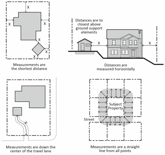
FIGURE 17.02.030(B): MEASURING DISTANCES
C.
Measuring Height. Height is measured as the vertical distance from a point on the ground below a structure to a point directly above.
1.
Measuring Building Height. Building height is measured from the average level of the highest and lowest point of that portion of the lot covered by the building, as measured to the topmost point of the roof or the top rail of a roof deck.
a.
When measuring the various levels on a lot to calculate the height, the grades in existence on the effective date of this title (1/12/2024) shall be used; any fill added to the site since that date shall be deducted from present grade elevations and any areas cut since that date may be added to the present grade elevations when measuring building height.
b.
When measuring height along the waterfront, height is determined by average grades of the land portion of the site, not including the bank.
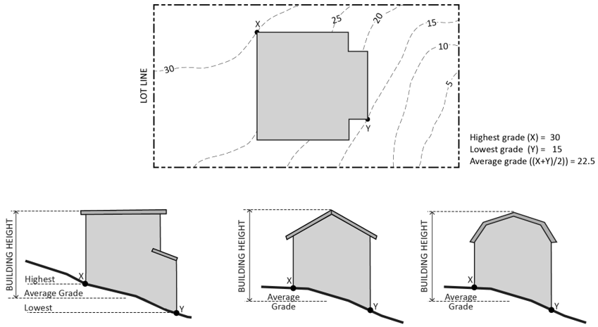
FIGURE 17.02.030(C)(1): MEASURING BUILDING HEIGHT
2.
Measuring the Number of Stories. In measuring the number of stories in a building, the following rules shall apply:
a.
An interior balcony or mezzanine shall be counted as a full story if its floor area exceeds one-third of the total area of the nearest full floor directly below it or if it is enclosed on more than two sides.
b.
A basement shall be counted as a full story if the vertical distance between finished grade and the finished surface of the floor above the basement is more than six feet at any point.
c.
A story shall not exceed twenty feet in height from the upper surface of the floor to the ceiling above.
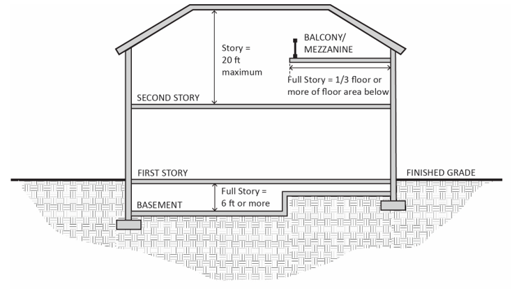
FIGURE 17.02.030(C)(2): MEASURING THE NUMBER OF STORIES
3.
Measuring Height of Fences or Walls. The height of a fence or wall is measured as the vertical distance from the ground level on the lowest external side of the fence or wall to the highest point of such fence or wall.

FIGURE 17.02.030(C)(3): MEASURING HEIGHT OF FENCES OR WALLS
4.
Measuring the Height of Decks. Deck height is determined by measuring from the ground to the top of the floor of the deck directly above the ground below. The top rail of any deck shall not exceed the height limitations of the district in which the deck is located.

FIGURE 17.02.030(C)(4): MEASURING HEIGHT OF DECKS
D.
Measuring Lot Width and Depth.
1.
Lot Width. Lot width is the horizontal distance between the side lot lines, measured at right angles to the lot depth at the required front setback line.
2.
Lot Depth. Lot depth is measured along a straight line drawn from the midpoint of the front property line of the lot to the midpoint of the rear property line or to the most distant point on any other lot line where there is no rear lot line.
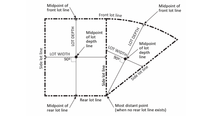
FIGURE 17.02.030(D): MEASURING LOT WIDTH AND DEPTH
E.
Determining Average Slope. The average slope of a parcel is calculated using the following formula: S = 100(I)(L)/A, where:
1.
S = Average slope (in percent).
2.
I = Contour interval (in feet).
3.
L = Total length of all contour lines on the parcel (in feet).
4.
A = Area of subject parcel (in square feet).
F.
Determining Floor Area. The floor area of a building is the sum of the gross horizontal areas of all floors of a building or other enclosed structure, measured from the outside perimeter of the exterior walls and/or the centerline of interior walls.
1.
Included in Floor Area. Floor area includes, but is not limited to, all habitable space (as defined in the building code) that is below the roof and within the outer surface of the main walls of primary or accessory buildings or the centerlines of party walls separating such buildings or portions thereof or within lines drawn parallel to and two feet within the roof line of any building without walls. In the case of a multi-story building that has covered or enclosed stairways, stairwells or elevator shafts, the horizontal area of such features shall be counted only once at the floor level of their greatest area of horizontal extent.
2.
Excluded from Floor Area. Floor area does not include the following:
a.
Mechanical, electrical, and communication equipment rooms that do not exceed two percent of the building's total floor area;
b.
Bay windows or other architectural projections where the vertical distance between the lowest surface of the projection and the finished floor is thirty inches or greater;
c.
Areas that qualify as usable open space;
d.
Covered porticoes, paseos, corridors, and courtyards designed for use by and accessible to the general public; and
e.
In non-residential buildings, areas used for off-street parking spaces or loading spaces, driveways, ramps between floors of a multi-level parking garage, and maneuvering aisles that are located below the finish grade of the property.
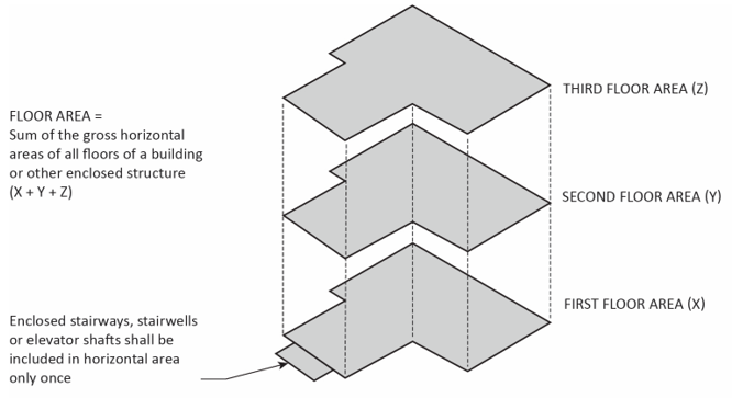
FIGURE 17.02.030(F): DETERMINING FLOOR AREA
G.
Determining Floor Area Ratio. The floor area ratio (FAR) is the ratio of the floor area, excluding the areas described below, of all primary and accessory buildings on a site to the site area. To calculate the FAR, floor area is divided by site area, and typically expressed as a decimal. For example, if the floor area of all buildings on a site totals twenty thousand square feet, and the site area is ten thousand feet square feet, the FAR is expressed as 2.0.
1.
Excluded from Floor Area in Calculating FAR.
a.
Underground Areas. Floor area located below finished grade.
b.
Parking. Parking areas located below finished grade or finished floor of habitable space where the vertical distance between finished grade and finished floor is less than six feet.
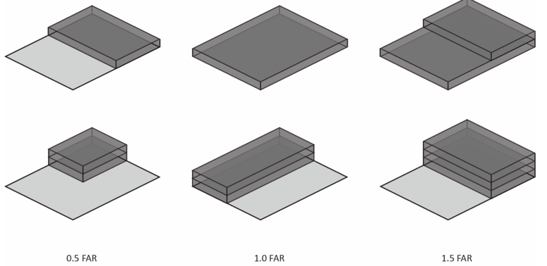
FIGURE 17.02.030(G): DETERMINING FLOOR AREA RATIO
H.
Determining Lot Coverage. Lot coverage is the ratio of the total footprint area of all structures on a lot to the net lot area, typically expressed as a percentage. The footprints of all primary and accessory structures, including garages, carports, covered patios, roofed porches, and uncovered patios, decks, and landings more than thirty inches in height, shall be summed in order to calculate lot coverage. The following structures shall be excluded from the calculation:
1.
Unenclosed and unroofed decks, uncovered patio slab, porches, landings, balconies and stairways less than thirty inches in height;
2.
Eaves and roof overhangs projecting up to three feet from a wall;
3.
Trellises, pergolas, and similar structures that have roofs or coverings that are at least fifty percent open to the sky with uniformly distributed openings;
4.
Swimming pools and hot tubs that are not enclosed in roofed structures or decks; and
5.
One small, non-habitable accessory structure under one hundred twenty square feet in size and less than eight feet in height. Structures above quantity of one shall be included in lot coverage.
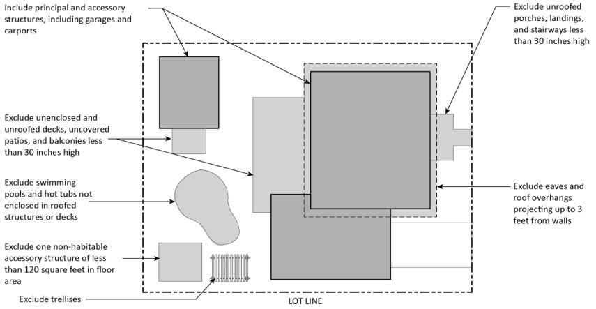
FIGURE 17.02.030(H): DETERMINING LOT COVERAGE
I.
Determining Lot Frontage.
1.
Corner Lot. The front of a lot is the narrowest dimension of the lot with street frontage unless otherwise determined by the director based on historic use, topography, neighborhood character, and other factors.
2.
Through Lot. The front of a through lot abuts the street that neighboring lots use to provide primary access.
a.
RS District. Where the majority of lots in a block are street-to-street lots in the RS district, the following rules apply:
i.
East-West Orientation. On east-west oriented lots, the western frontage shall be considered the front and the eastern frontage shall be considered the rear unless otherwise determined by the director.
ii.
North-South Orientation. The front and rear of north-south oriented lots shall be determined by the director based on the prevailing development pattern of the block.
J.
Determining Setbacks (Yards). A setback line defining a required yard is parallel to and at the specified distance from the corresponding front, side, or rear property line. The following special regulations for determining setbacks apply in certain circumstances.
1.
Setbacks Measurement from Plan Lines. Whenever an official plan line has been established for any street or proposed street, setbacks required by this title shall be measured from such plan line and in no case shall the provisions of this title be construed as permitting any encroachment upon any official plan line. For the purpose of determining setbacks, the property lines shall be interpreted to be the official lot lines except in cases where a street or public area is offered for dedication but not yet been accepted, in which case the line established by the offer for dedication shall be interpreted to be the property line.
2.
Building Lines.
a.
Where there is no public area or street dedication or offers for dedication, setbacks shall be required when any land borders on a future street as designated within the adopted circulation element of the general plan, or any future local street right-of-way or a future public area designated by the city's plans and ordinances.
b.
In any district where rights-of-way are not dedicated or offered for dedication, building line setbacks on major or collector highways shall be determined by the city engineer. Dedication of land required for development of a major or secondary street shall be required at time of the subdivision of any land, or where no subdivision is involved, at time of development. Improvement shall be required as a condition of any use permit or variance and preceding any change of land use.
3.
Alleys. If a side lot line abuts an alley, the yard shall be considered an interior side yard rather than a corner side yard.
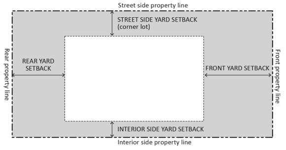
FIGURE 17.02.030(J): DETERMINING SETBACKS (YARDS)
K.
Measuring Signs. The calculations of measurements related to signs are described in Chapter 17.29, Signs.
(Ord. No. 662, § 2, 12-13-23)
17.03.010 - Base zoning districts and overlay zoning districts.
The city shall be classified into districts or zones, the designation and regulation of which are set forth in this title and as follows:
A.
Base Zoning Districts. Base zoning districts into which the city is divided are established as shown in Table 17.03.010, Base and Overlay Zoning Districts.
B.
Overlay Zoning Districts. Overlay zoning districts, one or more of which may be combined with a base district, are established as shown in Table 17.03.010, Base and Overlay Zoning Districts.
(Ord. No. 662, § 2, 12-13-23)
17.03.020 - Official zoning map and district boundaries.
The boundaries of the zoning districts established by this code are not included in this code but are shown on the official zoning map maintained by the city clerk. The official zoning map, together with all legends, symbols, notations, references, zoning district boundaries, map symbols, and other information on the maps, have been adopted by the council and are hereby incorporated into this code by reference, together with any amendments previously or hereafter adopted, as though they were fully included here.
(Ord. No. 662, § 2, 12-13-23)
17.03.030 - IP provisions.
For the purposes of the zoning and use charts below, only the provisions of the IP as specified in 17.01.050(a) shall govern CDP review. In addition, in the coastal zone, public recreational access facilities and uses, such as trails, accessways, and public parks, shall be permissible uses in all zoning districts.
(Ord. No. 662, § 2, 12-13-23)