
Morro Bay City Zoning Code
Division II
DISTRICT REGULATIONS
Chapter 17.06 - AGRICULTURE DISTRICT (IP)
Sections:
Chapter 17.07 - RESIDENTIAL DISTRICTS
Sections:
Chapter 17.08 - COMMERCIAL AND MIXED USE DISTRICTS
Sections:
Chapter 17.09 - INDUSTRIAL DISTRICTS (IP)
Sections:
Chapter 17.10 - PUBLIC AND SEMI-PUBLIC DISTRICTS (IP)
Sections:
Chapter 17.11 - WATERFRONT AND HARBOR AREA DISTRICTS (IP)
Sections:
Chapter 17.14 - COASTAL RESOURCE PROTECTION (CRP) OVERLAY DISTRICT (IP)
Sections:
Chapter 17.15 - CLOISTERS (-CL) OVERLAY DISTRICT (IP)
Sections:
Chapter 17.16 - MIXED USE RESIDENTIAL (-MUR) OVERLAY DISTRICT (IP)
Sections:
Chapter 17.17 - WATERFRONT MASTER PLAN (-WMP) OVERLAY DISTRICT (IP)
Sections:
Chapter 17.18 - PLANNED DEVELOPMENT (-PD) OVERLAY DISTRICT (IP)
Sections:
17.06.010 - Purpose and applicability.
The purpose of the agriculture (AG) district is to provide for the continuation of agricultural uses in suitable areas and for limited nonagricultural uses which may be necessary to support such continued agricultural activities. New development in this district shall also be sited and designed to protect and enhance scenic resources associated with the rural character of agricultural lands. This district implements the agriculture general plan/LCP land use plan land use designation.
(Ord. No. 662, § 2, 12-13-23)
17.06.020 - Land use regulations.
Table 17.06.020, Land Use Regulations—Agriculture District, sets the land use regulations for the agriculture district. The regulations for the district are established by letter designation as follows:
"P" designates permitted uses.
"M" designates use classifications that are permitted after review and approval of a minor use permit pursuant to Chapter 17.40, Use Permits.
"C" designates use classifications that are permitted after review and approval of a conditional use permit pursuant to Chapter 17.40, Use Permits.
"(#)" numbers in parentheses refer to specific limitations listed at the end of the table.
"-" designates uses that are not permitted.
For all uses, approval of a coastal development permit pursuant to Chapter 17.39, Coastal Development Permits (IP), may be required.
Land uses are defined in Chapter 17.53, Land Use Classifications. In cases where a specific land use or activity is not defined, the director shall assign the land use or activity to a classification that is substantially similar in character. Land uses not listed in the table or not found to be substantially similar to the uses below are prohibited. Section numbers in the right hand column refer to specific regulations applicable to the particular use classification located in other sections of this code.
(Ord. No. 662, § 2, 12-13-23)
17.06.030 - Development standards.
Table 17.06.030, Development Standards—Agriculture District, prescribes the development standards for the agriculture district. Additional regulations are denoted in the right hand column. Section numbers in this column refer to other sections of this code, while individual letters refer to subsections that directly follow the table.
A.
Reduced Lot Size. Minimum lot sizes may be reduced only if a covenant, restriction or similar document is recorded which limit future uses of the lots to open space, agriculture or uses of the lots to open space, agriculture or uses or structures accessory to agriculture provided, however, that the minimum lot area shall in no case be less than twenty thousand square feet and the lots are clustered to maintain agricultural feasibility or provide a coordinated open space area.
(Ord. No. 662, § 2, 12-13-23)
17.07.010 - Purpose and applicability (IP).
The purposes of the residential districts are to:
A.
Provide for a full range of housing types consistent with the general plan/LCP land use plan.
B.
Preserve, protect, and enhance the character of the city's different residential neighborhoods and the quality of life of city residents.
C.
Ensure adequate light, air, privacy, and open space for each dwelling.
D.
Ensure that the scale and design of new development and alterations to existing structures are compatible with surrounding homes and appropriate to the physical characteristics of the site and the area where the project is proposed.
E.
Provide sites for public and semi-public land uses such as parks, schools, day care, and other uses that will serve city residents and will complement surrounding residential development.
Additional purposes of each residential district:
Residential Low Density (RL). The RL district is intended to provide areas for detached single-unit dwellings and accessory uses compatible with the residential use of the district. In addition to single-unit dwellings, this district provides for other compatible uses, such as schools and parks that may be appropriate in a single-unit residential neighborhood. The overall density limit for these areas is four units per acre. This district implements the low density residential general plan/LCP land use plan land use designation.
Residential Single-Unit (RS). The RS district is intended to provide areas for detached and attached single-unit housing at densities between four and one-tenth and seven. Overall densities for these areas are up to seven units per net acre. In addition, this district provides for uses such as schools and parks that may be appropriate in a low- or moderate-density residential environment. This district implements the moderate density residential general plan/LCP land use plan land use designation.
Residential Medium Density (RM). The RM district is intended to provide areas for a variety of housing types at densities between seven and one-tenth and fifteen units per acre. Types of dwelling units include attached and detached single-unit dwellings, townhomes, condominiums, two-unit dwellings, multi-unit developments, and apartments. This district also provides for uses such as schools, daycare centers, parks, and community facilities that may be appropriate in a medium density residential environment. This district implements the medium density residential general plan/LCP land use plan land use designation.
Residential High Density (RH). The RH district is intended to provide areas for a variety of medium to high-density residential development. Housing types include single-unit attached, townhouses, condominiums, and apartment buildings at densities between fifteen and one-tenth and twenty-seven dwelling units per acre. Detached single-unit dwellings are allowed where site characteristics such as size or topography, preclude multi-unit development. This district also provides for uses such as schools, daycare centers, parks, and community facilities that may be appropriate in a higher-density residential environment. This district implements the high density residential general plan/LCP land use plan land use designation.
(Ord. No. 662, § 2, 12-13-23)
17.07.020 - Land use regulations (IP).
Table 17.07.020, Land Use Regulations—Residential Districts, sets the land use regulations for residential districts. The regulations for each district are established by letter designation as follows:
"P" designates permitted uses.
"M" designates use classifications that are permitted after review and approval of a minor use permit pursuant to Chapter 17.40, Use Permits.
"C" designates use classifications that are permitted after review and approval of a conditional use permit pursuant to Chapter 17.40, Use Permits.
"(#)" numbers in parentheses refer to specific limitations listed at the end of the table.
"-" designates uses that are not permitted.
For all uses, approval of a coastal development permit pursuant to Chapter 17.39, Coastal Development Permits (IP), may be required.
Land uses are defined in Chapter 17.53, Land Use Classifications. In cases where a specific land use or activity is not defined, the director shall assign the land use or activity to a classification that is substantially similar in character. Land uses not listed in the table or not found to be substantially similar to the uses below are prohibited. Section numbers in the right hand column refer to specific regulations applicable to the particular use classification located in other sections of this code.
(Ord. No. 662, § 2, 12-13-23)
17.07.030 - Development standards (IP).
Table 17.07.030 A, Development Standards—RS districts, and Table 17.07.030 B, Development Standards—RL, RM, and RH districts, prescribe the development standards for residential districts. Additional regulations are denoted in the right hand column. Section numbers in this column refer to other sections of this code. Additional development standards are specified following the tables below.
Additional Development Standards.
A.
Senate Bill (SB) 9 Related Development. In the RS and RL districts, two dwelling units are allowed per lot if the following standards are met:
1.
The proposed development shall not be located in any of the following areas:
a.
Prime farmland or farmland of statewide importance.
b.
Wetlands.
c.
High or very high fire hazard severity zone.
d.
Hazardous waste site.
e.
Within a delineated earthquake fault zone.
f.
Within a special flood hazard area/subject to a letter of map revision.
g.
Within regulatory floodway.
h.
Lands identified for conservation in an adopted natural community conservation plan.
i.
Habitat for protected species.
j.
Lands under conservation easement.
k.
Within a historic district or property included on the state historic resources inventory, as defined in Section 5020.1 of the Public Resources Code, or within a site that is designated or listed as a city or county landmark or historic property or district pursuant to a city or county ordinance.
2.
The proposed development shall not require demolition or alteration of any of the following types of housing:
a.
Housing that is subject to a recorded covenant, ordinance, or law that restricts rents to levels affordable to persons and families of moderate, low, or very low income.
b.
Housing that is subject to any form of rent or price control through a public entity's valid exercise of its police power.
c.
Housing that has been occupied by a tenant in the last three years.
3.
The proposed development shall not be located on a lot on which an owner of residential real property has exercised the owner's rights under Chapter 12.75 (commencing with Section 7060) of Division 7 of Title 1 to withdraw accommodations from rent or lease within fifteen years before the date that the development proponent submits an application.
4.
The proposed development shall not involve the demolition of more than twenty-five percent of the existing exterior structural walls.
5.
A maximum of two residential units are allowed per lot, inclusive of accessory dwelling units and junior accessory dwelling units.
6.
Each unit constructed pursuant to this subsection shall comply with all provisions of the base, overlay, or specific plan district, except as modified by this section.
a.
Interior Side and Rear Setbacks. A minimum four foot side and rear setback is required; however no setback is required for an existing structure or a structure constructed in the same location and to the same dimensions as an existing structure.
b.
Parking. A minimum of one space per unit shall be provided unless:
i.
The lot is located within one-half mile walking distance of either a high-quality transit corridor, as defined in subdivision (b) of Section 21155 of the Public Resources Code, or a major transit stop, as defined in Section 21064.3 of the Public Resources Code.
ii.
There is a car share vehicle located within one block of the lot.
c.
Rental Limitations. Rental terms shall be a minimum of thirty consecutive days.
7.
If located in the coastal zone, the project must also be found consistent with all applicable provisions of the LCP, including those specified in Section 17.14.040 B.
(Ord. No. 662, § 2, 12-13-23)
17.07.040 - Supplemental regulations.
A.
Paving. The maximum amount of paved area in street-facing yards is fifty percent of the required yard.
B.
Residential Development.
1.
All Residential Development, Window Placement. Windows shall be offset to avoid direct sight lines into and from neighboring properties.
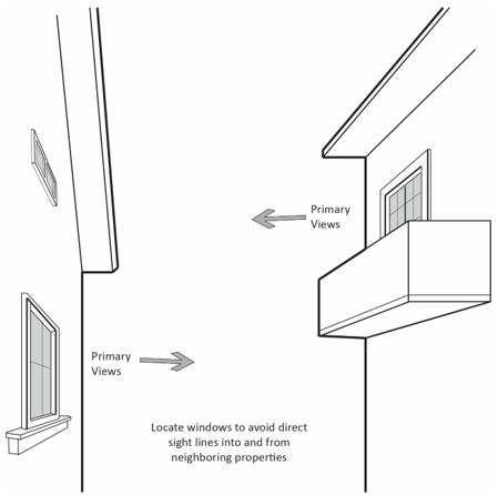
FIGURE 17.07.040(B.1): WINDOW PLACEMENT
2.
Single-Unit, Detached, Development. All detached single-unit development on lots five thousand square feet or more in size shall meet the following development standards.
a.
Front Elevation Second Story Stepback. A minimum of sixty percent of the second story front elevation shall be setback a minimum of three feet from the first floor wall.
b.
Building Massing. Two-story structures shall meet one of the following conditions:
i.
The floor area of the second level shall not exceed seventy-five percent of the first level and the front and side elevation shall not be single solid planes; or
ii.
A minimum of twenty-five percent of each building elevation shall be setback at least three feet from the remaining area of the elevational plane.
3.
Single-Unit, Attached, and Multi-Unit Development. All attached single-unit and multi-unit residential development shall meet the following development standards.
a.
Building Design. Exceptions to the following building design requirements may be granted through design review approval where the review authority finds that adequate design features have been included to create visual variety and avoid a large-scale and bulky appearance.
i.
Entrance Orientation. All units located along public rights-of-way shall have the primary entrance facing the right-of-way.
ii.
Entrance Projection or Recess. Building entrances must have a roofed projection (such as a porch) or recess with a minimum depth of at least five feet and a minimum area of thirty square feet.
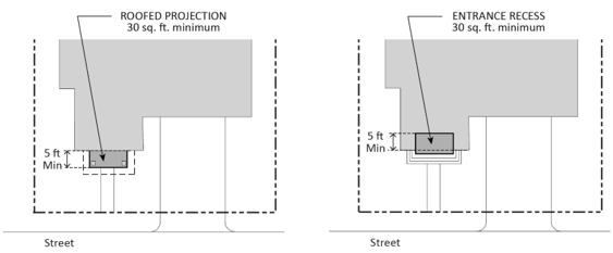
FIGURE 17.07.040(B.3.II): ENTRANCE PROJECTION OR RECESS ATTACHED SINGLE-UNIT AND
MULTI-UNIT DEVELOPMENT
iii.
Maximum Building Length. The maximum building length is one hundred feet.
iv.
Window Trim or Recess. Trim at least two inches in width shall be provided around all windows, or window must be recessed at least two inches from the plane of the surrounding exterior wall.
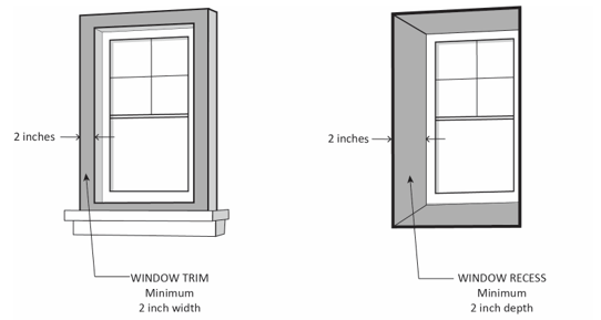
FIGURE 17.07.040(B.3.IV): WINDOW TRIM OR
RECESS ATTACHED SINGLE-UNIT AND MULTI-UNIT DEVELOPMENT
v.
Façade Articulation. All street-facing façades shall have at least one horizontal or vertical projection or recess at least two feet in depth for every twenty-five horizontal feet of wall. If located on a building with two or more stories, the articulated elements must be greater than one story in height, and may be grouped rather than evenly spaced in twenty-five-foot modules. Building entrances and front porches and projections into required yards such as stoops, bays, overhangs, fireplaces, and trellises may count towards meeting this requirement.
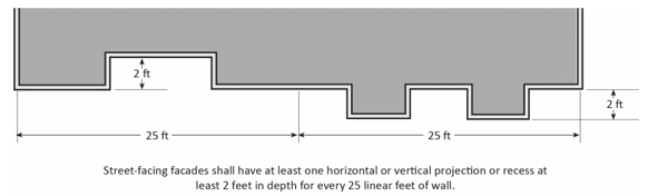
FIGURE 17.07.040(B.3.V): FAÇADE ARTICULATION ATTACHED SINGLE-UNIT AND
MULTI-UNIT DEVELOPMENT
vi.
Building Colors. Every building shall have at least two complementary colors.
b.
Private Storage Space. Each unit shall have at least two hundred cubic feet of enclosed, weather-proofed, and lockable private storage space with a minimum horizontal dimension of four feet. The required private storage shall be accessible from the exterior of the structure and may be used for bicycle parking.
c.
Pedestrian Access. On-site pedestrian circulation and access shall be provided according to the following standards.
i.
Internal Connections. A system of pedestrian walkways shall connect all buildings on a site to each other, to on-site automobile and bicycle parking areas, and to any on-site open space areas or pedestrian amenities.
ii.
To Circulation Network. Regular connections between on-site walkways and the public sidewalk and other planned or existing pedestrian routes shall be provided. An on-site walkway shall connect the primary building entry or entries to a public sidewalk on each street frontage.
iii.
To Neighbors. Direct and convenient access shall be provided to adjoining residential and commercial areas to the maximum extent feasible while still providing for safety and security.
iv.
To Transit. Safe and convenient pedestrian connections shall be provided from transit stops to building entrances.
v.
Pedestrian Walkway Design.
(1)
Walkways shall be a minimum of five feet wide, shall be hard-surfaced, and paved with concrete, stone, tile, brick, or comparable material.
(2)
Where a required walkway crosses parking areas or loading areas, it must be clearly identifiable through the use of a raised crosswalk, a different paving material, or similar method.
(3)
Where a required walkway is parallel and adjacent to an auto travel lane, it must be raised or separated from the auto travel lane by a raised curb at least four inches high, bollards, or other physical barrier.
C.
Small Lot Single-Unit Development. Single-unit development located on lots less than the minimum lot size established for residential districts may be approved with a conditional use permit subject to the following standards.
1.
Development Standards. Small lot single-unit development is subject to the development standards and supplemental regulations of the base zone district except as specified below.
a.
Maximum Density. Density shall be determined by the base zone district; however, density shall mean the average density of the entire site.
b.
Setbacks.
i.
Perimeter Setbacks. The minimum setback from the property lines on the perimeter of the small lot single-unit development shall be the required setbacks of the underlying base zone.
ii.
Interior Street Setbacks. The minimum setback from the back of sidewalk of any interior street or edge of pavement where there is no sidewalk shall be eighteen feet to the garage door and ten feet to any living area or covered porch.
iii.
Side Setbacks. The minimum setback shall be three feet from a side property line. For attached units, a minimum side setback of ten feet shall be provided at the end of the row of the attached units.
iv.
Rear Setbacks. The minimum setback shall be ten feet from the rear property line.
c.
Entrances.
i.
Dwelling units that abut a public right-of-way or private street shall orient the primary entryway toward the street.
ii.
Dwelling units located in the interior of the development shall orient the primary entryway toward and visible from a pedestrian pathway that is connected to a public right-of-way or private street.
iii.
There shall be a minimum eight-foot separation between the primary entryway of a unit and the adjacent building wall of a neighboring unit.
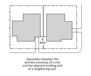
FIGURE 17.07.040(D.1.C.III): ENTRANCE SEPARATION SMALL LOT SINGLE-UNIT DEVELOPMENT
d.
Open Space. Open space shall be provided pursuant to the open space requirements of the underlying base zone. In the RS and RL districts, open space shall be provided pursuant to the open space requirements of the RM district.
e.
Parking. Parking shall be provided in accordance with Chapter 17.27, Parking and Loading, except that small lot single-unit development of attached dwelling units shall be subject to the parking requirements for multi-unit residential.
2.
Required Findings. A conditional use permit for a small lot single-unit development shall only be approved if the following findings are made in addition to any other findings required by this code:
a.
The development will result in a density that is no higher than otherwise permitted in the zoning district and open space standards that are no less than required for a similar development within the zoning district;
b.
The design of the development provides for a comprehensive and harmonious arrangement of buildings, open spaces, circulation ways, parking, and development amenities; and
c.
The project relates to the existing and planned land use and circulation plans of the community, and does not constitute a disrupting element in the development pattern of the neighborhood.
(Ord. No. 662, § 2, 12-13-23)
17.07.050 - SB 9 urban lot splits, RS and RL districts (IP).
In the RS and RL districts, urban lot splits consistent with California Government Code Section 66411.7 and Title 16, Subdivisions, of the Morro Bay Municipal Code, are allowed consistent with the following:
A.
No more than two new lots shall be created.
B.
Each new lot shall be at least one thousand two hundred square feet in size and at least forty percent of the area of the original lot.
C.
The urban lot split shall not involve a lot that has been established through prior exercise of an urban lot split.
D.
Neither the owner of the lot being subdivided nor any person acting in concert with the owner may have previously subdivided an adjacent parcel using an urban lot split.
E.
The urban lot split shall not be located in any of the following areas:
1.
Prime farmland or farmland of statewide importance.
2.
Wetlands.
3.
High or very high fire hazard severity zone.
4.
Hazardous waste site.
5.
Within a delineated earthquake fault zone.
6.
Within a special flood hazard area/subject to a letter of map revision.
7.
Within regulatory floodway.
8.
Lands identified for conservation in an adopted natural community conservation plan.
9.
Habitat for protected species.
10.
Lands under conservation easement.
11.
Within a historic district or property included on the State Historic Resources Inventory, as defined in Section 5020.1 of the Public Resources Code, or within a site that is designated or listed as a city or county landmark or historic property or district pursuant to a city or county ordinance
F.
The urban lot split shall not require demolition or alteration of any of the following types of housing:
1.
Housing that is subject to a recorded covenant, ordinance, or law that restricts rents to levels affordable to persons and families of moderate, low, or very low income.
2.
Housing that is subject to any form of rent or price control through a public entity's valid exercise of its police power.
3.
A lot on which an owner of residential real property has exercised the owner's rights under Chapter 12.75 (commencing with Section 7060) of Division 7 of Title 1 to withdraw accommodations from rent or lease within fifteen years before the date that the development proponent submits an application.
4.
Housing that has been occupied by a tenant in the last three years.
G.
Applicant Occupancy Required. The applicant for an urban lot split shall sign an affidavit stating that the applicant intends to occupy one of the housing units as their principal residence for a minimum of three years from the date of the approved urban lot split.
1.
Exception. This requirement does not apply to an applicant that is a community land trust or qualified nonprofit corporation.
H.
Maximum Number of Units. A maximum of two residential units are allowed per lot, inclusive of accessory dwelling units and junior accessory dwelling units.
I.
Development Standards. Development on lots created by urban lots splits shall comply with all provisions of the base, overlay, or specific plan district in which it is located, except as modified by this section.
1.
Interior Side and Rear Setbacks. A minimum four foot side and rear setback is required; however, no setback is required for an existing structure or a structure constructed in the same location and to the same dimensions as an existing structure.
2.
Parking. A minimum of one space per unit shall be required unless:
a.
The lot is located within one-half mile walking distance of either a high-quality transit corridor, as defined in subdivision (b) of Section 21155 of the Public Resources Code, or a major transit stop, as defined in Section 21064.3 of the Public Resources Code.
b.
There is a car share vehicle located within one block of the lot.
3.
Rental Limitations. Rental terms shall be a minimum of thirty consecutive days.
J.
Review Procedures. A parcel map for an urban lot split consistent with California Government Code Section 66411.7 and Title 16, Subdivisions, of the Morro Bay Municipal Code shall be ministerially approved.
1.
In the coastal resource protection (CRP) overlay district, a coastal development permit pursuant to Chapter 17.39, Coastal Development Permits (IP) may be required.
K.
If located in the coastal zone, the project must also be found consistent with all applicable provisions of the LCP, including those specified in Section 17.14.040 B.
(Ord. No. 662, § 2, 12-13-23)
17.08.010 - Purpose and applicability (IP).
The specific purposes of the commercial and mixed use districts are to:
A.
Provide for the orderly, well-planned, and balanced development of commercial and mixed-use districts;
B.
Designate adequate land for a full range of local- and regional-serving retail and commercial services consistent with the general plan/LCP land use plan to maintain and strengthen the city's economic resources;
C.
Provide appropriately located areas for a range of commercial uses that provide for a variety of good and services for residents, employees, and visitors;
D.
Provide opportunities for a mix of complementary uses that may combine residential and non-residential uses or combine a variety of non-residential uses on the same site; and
E.
Promote pedestrian-oriented, mixed-use commercial centers at appropriate locations.
Additional purposes of each commercial and mixed use district are as follows:
Neighborhood Commercial (NC). This district is intended to provide areas for smaller-scale neighborhood commercial areas which provide goods, services, and businesses to meet the day-to-day needs of nearby residents. Residential uses are allowed above and behind commercial uses and as stand-alone development in certain areas. This district implements the neighborhood commercial general plan/LCP land use plan land use designation.
Community Commercial (CC). This district is intended to create, maintain and enhance walkable community commercial areas that provide a mix of community-oriented uses including retail stores, restaurants, professional and medical offices, and personal services. Residential uses are allowed above and behind commercial uses and as stand-alone development in certain areas. This district implements the community commercial and the mixed use general plan/LCP land use plan land use designation.
District Commercial (DC). This district provides locations for retail, commercial, and service uses that meet local and regional demand. It is intended for larger-scale development that is appropriate in an auto-oriented environment. This district implements the district commercial general plan/LCP land use plan land use designation.
Visitor Serving Commercial VSC. This district is intended to provide areas for visitor-oriented services and uses located at easily accessible locations and tourist destinations. A range of visitor-serving uses are allowed, including hotels and motels, restaurants, retail, recreation, and other uses that accommodate visitor needs and activities. Residential uses are allowed in certain areas. This district implements the visitor-serving commercial general plan/LCP land use plan land use designation.
Transitional Mixed Use (TMU). This district is intended as a flexible district providing appropriate transitions from the commercial mixed-use character of the downtown to adjacent residential neighborhoods. A wide range of uses are allowed, including service, commercial, office, residential, public, and visitor serving uses. This district implements the mixed use general plan/LCP land use plan land use designation.
(Ord. No. 662, § 2, 12-13-23)
17.08.020 - Land use regulations (IP).
Table 17.08.020, Land Use Regulations—Commercial and Mixed Use Districts, sets the land use regulations for commercial and mixed use districts. The regulations for each district are established by letter designation as follows:
"P" designates permitted uses.
"M" designates use classifications that are permitted after review and approval of a minor use permit pursuant to Chapter 17.40, Use Permits.
"C" designates use classifications that are permitted after review and approval of a conditional use permit pursuant to Chapter 17.40, Use Permits.
"(#)" numbers in parentheses refer to specific limitations listed at the end of the table.
"-" designates uses that are not permitted.
For all uses, approval of a coastal development permit pursuant to Chapter 17.39, Coastal Development Permits (IP), may be required.
Land uses are defined in Chapter 17.53, Land Use Classifications. In cases where a specific land use or activity is not defined, the director shall assign the land use or activity to a classification that is substantially similar in character. Land uses not listed in the table or not found to be substantially similar to the uses below are prohibited. Section numbers in the right hand column refer to specific regulations applicable to the particular use classification located in other sections of this code.
(Ord. No. 662, § 2, 12-13-23)
17.08.030 - Development standards (IP).
Table 17.08.030, Development Standards—Commercial and Mixed Use Districts, prescribes the development standards for commercial and mixed use districts. Additional regulations are denoted in the right hand column. Section numbers in this column refer to other sections of this code.
A.
Additional Height Allowance, NC District. The planning commission may allow up to thirty feet to encourage roofline variations and sloping roof treatments provided that the additional height is necessary for such roof treatment and that corridors protecting significant views are provided. Furthermore, to prevent long, unvarying rooflines, the planning commission shall consider the following guidelines when allowing a project to exceed twenty-five feet in height.
1.
For buildings fronting on Main Street, not more than one-third of the west elevation of the building roofline and, if different, not more than one-third of the elevation of the longest building roofline should exceed twenty-five feet in height. This standard is intended as a guideline, not a strict requirement, and the planning commission may vary from this guideline as deemed necessary and useful to meet the intent of this section.
2.
To the extent practical, significant view opportunities shall be preserved and protected through the use of view corridors and air space easements.
B.
Required Building Location, CC District. The following building location requirements apply in the CC district.
1.
Build-to Line. Buildings shall be located within ten feet of street-facing property lines for at least sixty percent of the linear street frontage.
2.
Corner Build Area. Buildings shall be located within ten feet of the property line within thirty feet of the street corner.
3.
Frontage Improvements. The area between buildings and the property line shall be improved as part of a wider sidewalk, outdoor dining/seating area, or with landscaping.
4.
Exceptions. These requirements may be modified or waived through design review upon finding that:
a.
Entry courtyards, plazas, entries, or outdoor eating areas are located adjacent to the property line and buildings are built to the edge of the courtyard, plaza, or dining area; or
b.
The building incorporates an alternative entrance design that creates a welcoming entry feature facing the street.
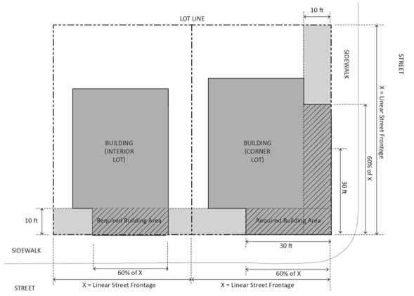
FIGURE 17.08.030(C): REQUIRED BUILDING
LOCATION, CC DISTRICT
C.
Front Setback, TMU District. Where twenty-five percent or more of the lots on the same block face have been improved with buildings, the minimum front setback requirement shall be the average of the actual front setback of all improved lots on such block face or fifteen feet, whichever is less.
(Ord. No. 662, § 2, 12-13-23)
17.08.040 - Supplemental regulations.
A.
Building Transparency/Required Openings, Non-Residential Uses. Exterior walls of buildings or portions of buildings containing non-residential uses facing and within twenty feet of a front or street side lot line shall include windows, doors, or other openings for at least fifty percent of the building wall area located between two and one-half and seven feet above the level of the sidewalk. Such walls may run in a continuous plane for no more than thirty feet without an opening.
1.
Design of Required Openings. Openings fulfilling this requirement shall have transparent glazing and provide views into work areas, display areas, sales areas, lobbies, or similar active spaces, or into window displays that are at least three feet deep.
2.
Reductions through Design Review. The building transparency requirement may be reduced or waived through design review upon finding that:
a.
The proposed use has unique operational characteristics with which providing the required windows and openings is incompatible, such as in the case of a cinema or theater; and
b.
Street-facing building walls will exhibit architectural relief and detail, and will be enhanced with landscaping in such a way as to create visual interest at the pedestrian level.
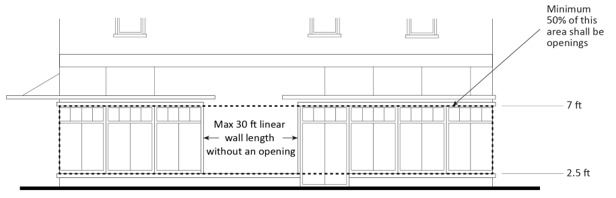
FIGURE 17.08.040(A): BUILDING TRANSPARENCY/REQUIRED OPENINGS
B.
Exterior Building Materials and Colors.
1.
A unified palette of quality materials shall be used on all sides of buildings.
2.
Exterior building materials shall be stone, brick, stucco, concrete block, painted wood clapboard, painted metal clapboard or other quality, durable materials approved through design review.
C.
Pedestrian Access. On-site pedestrian circulation and access shall be provided according to the following standards.
1.
Internal Connections. A system of pedestrian walkways shall connect all buildings on a site to each other, to on-site automobile and bicycle parking areas, and to any on-site open space areas or pedestrian amenities.
2.
To Circulation Network. Regular connections between on-site walkways and the public sidewalk shall be provided. An on-site walkway shall connect the primary building entry or entries to a public sidewalk on each street frontage. Such walkway shall be the shortest practical distance between the main entry and sidewalk, generally no more than one hundred twenty-five percent of the straight line distance.
3.
To Neighbors. Direct and convenient access shall be provided from commercial and mixed-use projects to adjoining residential and commercial areas to the maximum extent feasible while still providing for safety and security.
4.
To Transit. Safe and convenient pedestrian connections shall be provided from transit stops to building entrances.
5.
Interior Pedestrian Walkway Design.
a.
Walkways shall have a minimum clear unobstructed width of six feet, shall be hard-surfaced, and paved with permeable materials.
b.
Where a required walkway crosses driveways, parking areas, or loading areas, it must be clearly identifiable through the use of a raised crosswalk, a different paving material, or similar method.
c.
Where a required walkway is parallel and adjacent to an auto travel lane, it must be raised or separated from the auto travel lane by a raised curb at least four inches high, bollards, or other physical barrier.
D.
Additional Supplemental Regulations, CC, TMU, NC, and VSC Districts. The following additional supplemental regulations apply in the CC, TMU, NC, and VSC districts.
1.
Building Orientation.
a.
Buildings shall be oriented to face public streets.
b.
Building frontages shall be generally parallel to streets.
c.
Buildings shall be designed and oriented to minimize the visual intrusion into adjoining residential properties. Window, balcony, and deck locations shall be directed away from window areas of adjoining residences (on-site or off-site).
2.
Building Entrances, Nonresidential Uses.
a.
The primary building entrance shall face a public sidewalk.
b.
Entrances located at corners shall generally be located at a forty-five-degree angle to the corner and shall have a distinct architectural treatment to animate the intersection and facilitate pedestrian flow around the corner. Different treatments may include angled or rounded corners, arches, and other architectural elements.
c.
All building and dwelling units located in the interior of a site shall have entrances from a sidewalk that is designed as an extension of the public sidewalk and connect to a public sidewalk.
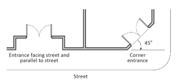
FIGURE 17.08.040(D.2): BUILDING ENTRANCES, CC, TMU, NC, AND VSC DISTRICTS
3.
Limitations on Location of Parking. Off-street parking spaces shall be located to the rear of principal buildings whenever possible. Above ground parking may not be located within forty feet of a street facing property line. Exceptions may be granted through design review upon finding that:
a.
The design incorporates habitable space built close to the public sidewalk to the maximum extent feasible; and
b.
The site is small and constrained such that underground parking or surface parking located more than forty feet from the street frontage is not feasible.
E.
Rooftop View Decks, VSC District between Beach Street and Surf Street. In the VSC district between Beach Street and Surf Street, the use of a rooftop for decks for viewing or similar uses may be permitted subject to conditional use permit approval if the planning commission finds that by its location, screening, hours of operation, or other features, the use will not significantly adversely affect residences on the blufftop, especially during night time hours.
(Ord. No. 662, § 2, 12-13-23)
17.09.010 - Purpose and applicability.
The purposes of the industrial districts are to:
A.
Designate adequate land for businesses, professional offices, and industrial growth consistent with the general plan/LCP land use plan to maintain and strengthen the city's economic resources;
B.
Provide a range of employment opportunities to meet the needs of current and future residents;
C.
Provide areas for a wide range of manufacturing, industrial processing, and service commercial uses and protect areas where such uses now exist; and
D.
Preserve appropriately sited land for uses which must be located near the coast to function.
Industrial-General (IG). The IG district is intended to provide areas for a variety of industrial and service uses. Retail, service, and other supporting uses serving employees and businesses are also allowed. This district implements the general (light) industrial general plan/LCP land use plan land use designation.
Industrial-Coastal-Dependent (ICD). The ICD district is intended to provide areas for coastal dependent industrial land uses that are given priority by the California Coastal Act for location adjacent to the coastline. This district implements the coastal-dependent industrial general plan/LCP land use plan land use designation.
(Ord. No. 662, § 2, 12-13-23)
17.09.020 - Land use regulations.
Table 17.09.020, Land Use Regulations—Industrial Districts, sets the land use regulations for industrial districts. The regulations for each district are established by letter designation as follows:
"P" designates permitted uses.
"M" designates use classifications that are permitted after review and approval of a minor use permit pursuant to Chapter 17.40, Use Permits.
"C" designates use classifications that are permitted after review and approval of a conditional use permit pursuant to Chapter 17.40, Use Permits.
"(#)" numbers in parentheses refer to specific limitations listed at the end of the table.
"-" designates uses that are not permitted.
For all uses, approval of a coastal development permit pursuant to Chapter 17.39, Coastal Development Permits (IP), may be required.
Land uses are defined in Chapter 17.53, Land Use Classifications. In cases where a specific land use or activity is not defined, the director shall assign the land use or activity to a classification that is substantially similar in character. Land uses not listed in the table or not found to be substantially similar to the uses below are prohibited. Section numbers in the right hand column refer to specific regulations applicable to the particular use classification located in other sections of this code.
(Ord. No. 662, § 2, 12-13-23)
17.09.030 - Development standards.
Table 17.09.030, Development Standards—Industrial Districts, prescribes the development standards for industrial districts. Additional regulations are denoted in the right hand column. Section numbers in this column refer to other sections of this code.
(Ord. No. 662, § 2, 12-13-23)
17.10.010 - Purpose and applicability.
The purposes of public and semi-public districts are to:
A.
Provide land for development of public, quasi-public, and open space uses that provide services to the community and support existing and new residential, commercial, and industrial land uses.
B.
Provide areas for educational facilities, cultural and institutional uses, health services, parks and recreation, general government operations, utility and public service needs, and other similar and related supporting uses.
C.
Provide opportunities for outdoor recreation, and meet the recreational needs of Morro Bay residents.
D.
Reserve areas for passive recreation and habitat protection.
Additional purposes of each public and semi-public district:
Public Facility (PF). The PF district is intended for facilities that serve the public, such as government buildings and service facilities, schools, hospitals, cultural centers, and other public and quasi-public uses. The public facility district implements the public/institutional general plan/LCP land use plan land use designation.
Park and Recreation (PR). The PR district is intended to identify and maintain areas for active recreation, including city parks and other areas that support recreational activities. Uses include parks, playgrounds, campgrounds, picnic areas, sports fields, golf courses, recreational clubs, and other appropriate recreational uses. This district implements the open space/recreation general plan/LCP land use plan land use designations.
Open Space (OS). The OS district is intended for open space, undeveloped parkland, habitat and natural resource areas, and other areas that provide open space, habitat protection and enhancement, or support passive recreation such as beach areas, linear parks, trails. This district implements the open space/recreation general plan/LCP land use plan land use designation.
(Ord. No. 662, § 2, 12-13-23)
17.10.020 - Land use regulations.
Table 17.10.020, Land Use Regulations—Public and Semi-Public Districts, sets the land use regulations for public and semi-public districts. The regulations for each district are established by letter designation as follows:
"P" designates permitted uses.
"M" designates use classifications that are permitted after review and approval of a minor use permit pursuant to Chapter 17.40, Use Permits.
"C" designates use classifications that are permitted after review and approval of a conditional use Permit pursuant to Chapter 17.40, Use Permits.
"(#)" numbers in parentheses refer to specific limitations listed at the end of the table.
"-" designates uses that are not permitted.
For all uses, approval of a coastal development permit pursuant to Chapter 17.39, Coastal Development Permits (IP), may be required.
Land uses are defined in Chapter 17.53, Land Use Classifications. In cases where a specific land use or activity is not defined, the director shall assign the land use or activity to a classification that is substantially similar in character. Land uses not listed in the table or not found to be substantially similar to the uses below are prohibited. Section numbers in the right hand column refer to specific regulations applicable to the particular use classification located in other sections of this code.
(Ord. No. 662, § 2, 12-13-23)
17.10.030 - Development standards.
Table 17.10.030, Development Standards—Public and Semi-Public Districts, prescribes the development standards for public and semi-public districts. Additional regulations are denoted in the right hand column. Section numbers in this column refer to other sections of this code.
(Ord. No. 662, § 2, 12-13-23)
17.11.010 - Purpose.
The city of Morro Bay is uniquely located and situated to capitalize on the waters of Morro Bay and the adjacent Pacific Ocean. As such, the city of Morro Bay is dedicated to ensuring a vibrant working waterfront for the purposes of providing, promoting and supporting land uses and access in support of water-dependent commercial activities, water-dependent recreational activities, waterfront enhanced commercial activities, water-enhanced recreational activities, and for purposes related to providing public access to the Tidelands Trust Lands. The specific purposes of the waterfront and harbor area districts are to:
A.
Ensure that waterfront development is attractive and pedestrian-friendly through greater pedestrian-oriented development, street furniture, and a more efficient solution to traffic circulation and automobile parking.
B.
Achieve an architectural character for the Embarcadero area that is in keeping with a working fishing community.
C.
Preserve the attraction of the city as a tourist destination with visitor-serving facilities, shopping and amusement areas, recreational amenities, and public parks and beaches, but still retain the city's small-town "fishing port" character.
Additional purposes of each waterfront and harbor area district are as follows:
Commercial Fishing (CF). This district is intended to preserve areas that serve or facilitate licensed fishing activities or commercial fishing and incidental uses supportive of fishing activities in the fisheries sector (measure D zone) shown on Figure LU-5 of Plan Morro Bay pursuant to Measure "D" of the June 2, 1981 city ballot. The CF district is intended to retain the city's small-town fishing image and to ensure that development does not conflict with the fishing industry. Land uses are limited to coastal dependent uses including boating and fishing facilities, marine sales and services, and incidental parking and utility uses that are supportive of fishing activities. This district implements the commercial/recreational fishing general plan/LCP land use plan land use designation.
Harbor (H). This district designates areas within city limits covered by water, excluding sensitive habitat areas, for those uses which must be located on the water in order to function, or as an accessory use to a land based/shore facility or structure. This district implements the harbor/navigational general plan/LCP land use plan land use designations.
Waterfront (WF). This district is intended to provide for the continued mixture of visitor-serving commercial and recreational and harbor-dependent land uses in appropriate waterfront areas. This district implements the waterfront commercial/industrial general plan/LCP land use plan land use designations.
(Ord. No. 662, § 2, 12-13-23)
17.11.020 - Applicability.
Development shall conform to all applicable land use plan (LUP) policies, including, but not limited to coastal priority uses policies and Embarcadero policies; the provisions of this chapter; and all other applicable provisions of this code.
(Ord. No. 662, § 2, 12-13-23)
17.11.030 - Land use regulations.
Table 17.11.030, Land Use Regulations—Waterfront and Harbor Area Districts, sets the land use regulations for waterfront and harbor area districts. The regulations for each district are established by letter designation as follows:
"P" designates permitted uses.
"M" designates use classifications that are permitted after review and approval of a minor use permit pursuant to Chapter 17.40, Use Permits.
"C" designates use classifications that are permitted after review and approval of a conditional use permit pursuant to Chapter 17.40, Use Permits.
"(#)" numbers in parentheses refer to specific limitations listed at the end of the table.
"-" designates uses that are not permitted.
For all uses, approval of a coastal development permit pursuant to Chapter 17.39, Coastal Development Permits (IP), may be required.
Land uses not listed in the table or not found to be substantially similar to the uses below are prohibited.
A.
Additional Use Allowances and Limitations.
1.
CF District.
a.
Expressly Prohibited Uses. The city shall not grant any permit, authorization or other approval of any state-owned tidelands subject to city lease between Beach Street and Target Rock, unless such development or use is primarily for the purpose of serving or facilitating licensed commercial fishing activities or noncommercial recreational fishing activities, or if clearly incidental thereto. For purposes of illustration, and not by way of limitation, no approval shall be granted for any new passenger-for-hire boats or supporting facilities, or for any new restaurant, cafe, gift shop, or other retail establishment servicing the general public and any existing such uses shall hereafter be considered nonconforming and shall not be expanded or enlarged.
b.
Existing Uses. Existing uses may remain and be redeveloped provided the use is not expanded, enlarged, or moved.
2.
WF District.
a.
Existing Residential Uses. Residential uses existing in the WF district at the time of adoption of the ordinance codified in this chapter shall be permitted to remain, be reconstructed, or relocated. No new residential uses are allowed.
b.
Development Priority. Development priority shall be given to coastal-dependent uses which are consistent with traffic, circulation, and parking constraints.
(Ord. No. 662, § 2, 12-13-23)
17.11.040 - Development standards.
Table 17.11.040, Development Standards—Waterfront and Harbor Area Districts, prescribes the development standards for waterfront and harbor area districts. Additional regulations are denoted in the right hand column. Section numbers in this column refer to other sections of this code. Additional development standards applicable to the CF and WF districts are established in the waterfront master plan. All development in the CF and WF districts are subject to the standards and requirements of the waterfront master plan.
(Ord. No. 662, § 2, 12-13-23)
17.11.050 - Supplemental regulations.
A.
Architectural Treatment. Exterior treatment of structures in new development and redevelopment shall be considered though the development review process. The following criteria will be used in the review of applications:
1.
The architectural and landscape design of a project, including materials, shall be consistent with the character of a working fishing village.
2.
The design shall protect aesthetic environmental qualities.
3.
The design shall enhance the desirability and/or enjoyment of the immediate area.
4.
The design shall improve community appearances by preventing extremes of dissimilarity or monotony in new construction or redevelopments.
B.
Public Access Requirements. Public access from the nearest public roadway to the shoreline and along the bay front shall be provided in new development projects, subject to the provisions set forth in Section 17.14.110, Coastal Access.
C.
Harbor District. In the Harbor District, no use shall be permitted unless the following performance standards are met, as applicable:
1.
No Pollutant Discharge. Pollutants such as chemicals, fuels, lubricants, raw sewage and other harmful wastes generated during commercial or recreational boating activities shall be prohibited from being discharged into the bay;
2.
Adequate Safety and Navigational Standards. New development shall contain adequate safety and navigational standards to ensure compatibility with existing uses within the bay and harbor areas;
3.
Maintenance Dredging Mitigation Measures. Maintenance dredging of the channels shall include mitigation measures to prevent potential damage to benthic organisms including mollusks and eel grass beds;
4.
Preservation of Right-of-Way. Any permitted use of the tidelands, harbor or bay, as defined and regulated by this chapter shall be prohibited from excluding the right-of-way to such water whenever it is required for any public purpose, and from destroying or obstructing the free navigation of such water; and
5.
Placement of Floating Docks. The placement of floating docks shall be in water areas that do not encroach into wetland or buffer areas surrounding defined wetlands in the bay.
(Ord. No. 662, § 2, 12-13-23)
17.14.010 - Purpose and applicability.
The coastal resource protection (CRP) overlay district applies to the "coastal zone" as defined by the Coastal Act (and denoted as the area within the "coastal zone-CZ" overlay district on the zoning map) and is established for the purpose of implementing the Coastal Act of 1976 (Division 20 of the California Public Resources Code) and to ensure that all development in the Coastal Zone of the city of Morro Bay is consistent with the city's certified local coastal program and the Coastal Act.
A.
Development within the CRP overlay district shall conform to all applicable LUP policies, the requirements of this chapter, and all other sections of the IP.
B.
Protection of coastal resources shall be a priority in all city actions and decisions, and development must conform to all applicable LCP policies related to hazards, water and marine resources, scenic resources, biological resources and environmentally sensitive habitat areas, cultural resources, and public access and recreation.
(Ord. No. 662, § 2, 12-13-23)
17.14.020 - Definitions.
The following terms are used in the implementation plan. See also the definitions listed in land use plan Section 6, glossary and acronyms.
A.
Best Available Science. Current, generally accepted, data-driven information, as refined to be most applicable to the local circumstances and conditions, and considering a range of plausible impacts based on multiple time scales, emissions scenarios, or other factors developed to inform further decision-making regarding the range of impacts and vulnerabilities.
B.
Coastal Access.
1.
Lateral. An area of land providing public access along the shoreline and coastal bluffs.
2.
Vertical. An area of land providing a connection between the first public road or use area nearest the sea and the publicly-owned tidelands or established lateral access way.
C.
Coastal-Dependent Development or Use. Any development or use which requires a site on, or adjacent to, the sea to be able to function at all.
D.
Coastal-Related Development or Use. Any development or use which is dependent on a coastal-dependent development or use.
E.
Coastal Beach (or Beach). The sandy area between the low tide and the first line of terrestrial vegetation or development or the toe of an adjacent coastal bluff or seawall, whichever is the most landward.
F.
Environmental Justice Communities. Low-income communities, communities of color, and other populations with higher exposure and/or sensitivity to adverse project impacts due to historical marginalization, discriminatory land use practices, and/or less capacity to mitigate adverse impacts.
G.
First Public Road Paralleling the Sea. That road nearest to the sea, as defined in Section 30115 of the Public Resources Code, which:
1.
Is lawfully open to uninterrupted public use and is suitable for such use;
2.
Is publicly maintained;
3.
Is an improved, all-weather road open to motor vehicle traffic in at least one direction;
4.
Is not subject to any restrictions on use by the public except when closed due to an emergency or when closed temporarily for military purposes; and
5.
Does in fact connect with other public roads providing a continuous access system, and generally parallels and follows the shoreline of the sea so as to include all portions of the sea where the physical features such as bays, lagoons, estuaries, and wetlands cause the waters of the sea to extend landward of the generally continuous coastline.
H.
Flood (or Flooding). Normally dry land becoming temporarily covered in water, either periodically (e.g., tidal flooding) or episodically (e.g., storm or tsunami flooding), including in relation to sea level rise.
I.
Low-Income Household, Area, or Community. Means those with household incomes at or below eighty percent of the statewide median income or with household incomes at or below the threshold designated as low-income by the Department of Housing and Community Development. A) "low-income area" means an area with household incomes at or below eighty percent of the statewide median income or with household incomes at or below the threshold designated as low income by the Department of Housing and Community Development's list of state income limits adopted pursuant to Section 50093 (Section 39713 of the Health and Safety Code)
J.
Revetment. A type of shoreline protective device typically consisting of a sloped retaining wall; a facing of stone, concrete, blocks, rip-rap, etc. built to protect an embankment, bluff or development against erosion by wave action and currents.
K.
Riprap. A type of shoreline protective device consisting of a protective layer or facing of rock, concrete blocks or quarry stone, placed to prevent erosion, scour, or sloughing of an embankment or bluff or to protect development.
L.
Sea. The Pacific Ocean and all harbors, bays, channels, estuaries, salt marshes, sloughs, and other areas subject to tidal action through any connection with the Pacific Ocean, excluding nonestuarine rivers, streams, tributaries, creeks, and flood control and drainage channels.
M.
Submerged Lands. Lands which lie below the line of mean low tide.
N.
Visitor-Serving Development or Use. Stores, shops, businesses, temporary lodging and recreational facilities (both public and private) which provide accommodations, food and services for the traveling public, including, but not limited to, hotels, motels, campgrounds, parks, nature preserves, restaurants, specialty shops, art galleries and commercial recreational development such as shopping, eating and amusement areas.
(Ord. No. 662, § 2, 12-13-23)
17.14.030 - Coastal development permit required.
In addition to any other required permits or approvals, all development, as defined in Coastal Act Section 30106, within the coastal resource protection (CRP) overlay district requires a coastal development permit (CDP) pursuant to Chapter 17.39, Coastal Development Permits (IP), except as specified in Section 17.39.020, CDP Exemptions, and Section 17.39.030, Waivers for Deminimis Development.
(Ord. No. 662, § 2, 12-13-23)
17.14.040 - Land uses.
In order to protect priority land uses as defined by the Coastal Act, including recreation and visitor-serving and coastal-dependent uses for both residents and visitors, development shall conform with all applicable land use plan (LUP) land use designations and land use policies and standards, including, but not limited to, coastal priority uses policies and standards. Development shall only be authorized when the proposed use is allowed per the applicable land use designation, and when it meets all applicable LCP policies and standards.
A.
Visitor-serving uses shall have priority over private residential, general industrial, or general commercial development, but not over agriculture or coastal-dependent industry. Public recreational access facilities and uses, such as trails, accessways, and public parks, shall be permissible uses in all zoning districts.
B.
In addition to all other applicable regulations, accessory dwelling units, SB 9 related development, and affordable housing density bonus development shall meet the following additional standards:
1.
Accessory dwelling units, SB 9 related development, and affordable housing density bonus development are allowed provided they are sited and designed to avoid adverse impacts to coastal resources.
2.
For ADUs and SB 9, such proposed development shall be consistent with all applicable LCP provisions, including those governing sensitive habitats and their buffers (i.e., wetlands, streams, and ESHA), coastal hazards and corresponding buffers (e.g., meeting necessary beach and bluff setbacks without armoring), public views, and public coastal access.
For all ADUs and SB 9 development within the area shown in Figure 17.14.040(B)(2), the parking reductions specified in Section 17.07.030 A(6) shall not apply, and one off-street parking space per unit shall be required. If enclosed or covered parking for the primary dwelling is converted or demolished in conjunction with the construction of an ADU or SB 9 unit, off-street replacement parking is required.
For all ADUs and SB 9 development, all CDP processing requirements specified in Chapter 17.39 shall be met, including in terms of public noticing and opportunities for appeal to the coastal commission for appealable development, with the exception that no local public hearing shall be required.
3.
For affordable housing density bonuses, an analysis of coastal resource impacts associated with the density bonus project (and any alternatives) shall be provided. Such analysis shall identify the Coastal Act and LCP-consistent project for the site, defined as the maximum size, scale, density, and intensity of development (including the number of market-rate and affordable residential units) that can be accommodated on a proposed project site consistent with all Coastal Act and LCP requirements, and without applying any state density bonus law incentives/waivers/concessions. The LCP-consistent project shall be compared against a density bonus project, including clearly identifying any LCP deviations proposed to be sought, the coastal resource impacts associated with such deviations, and the affordable housing benefit being provided. Such analysis shall quantitively and qualitatively identify, compare, and contrast expected coastal resource impacts between the LCP-consistent project and the density bonus project. Such analysis shall also include an analysis of measures that could be applied to the density bonus project(s) to ensure that they do not result in any significant adverse coastal resource impacts (e.g., measures necessary to ensure consistency with all applicable Coastal Act and LCP provisions addressing wetlands, streams, environmentally sensitive habitats, coastal hazards, public recreational access, etc.)
In order to approve a project that deviates from the LCP standards for the site, the approving authority must conclude, based on substantial evidence, that: (a) the approved project encourages housing opportunities for persons of low and moderate income with the least amount of Coastal Act and LCP deviation; and (b) there will be no significant adverse coastal resource impacts due to the approved project.
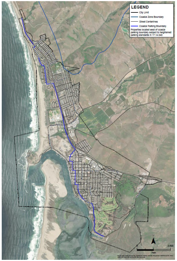
FIGURE 17.14.040(B)(2): ADU/SB 9 COASTAL
PARKING STANDARDS
C.
Low Cost Visitor Accommodation, Protection of Low Cost Visitor Accommodations.
1.
Applicability. The provisions of this section apply to the expansion, reduction, redevelopment, demolition, conversion, closure, cessation, or new development of any project involving visitor overnight accommodations, with the exception of short-term rental lodging that is within residential units.
2.
Low, Moderate, and High Cost Visitor Accommodations Defined. For purposes of this section, visitor accommodations shall be defined as low, moderate, or high cost as follows:
a.
Low Cost. The average daily room rate of all economy hotel and motel rooms in the city of Morro Bay based on the best available information (e.g., as defined in the city's lower-cost visitor-serving accommodations technical memorandum, Smith Travel Research data, etc.), or not to exceed seventy-five percent of the prior year's statewide average daily rate.
b.
Moderate Cost. Between low cost and high cost.
c.
High Cost. The average daily room rate of all upscale hotel and motel rooms in the city of Morro Bay based on the best available information (e.g., as defined in the city's lower-cost visitor-serving accommodations technical memorandum, Smith Travel Research data, etc.), and must be greater than or equal to is one hundred twenty-five percent of the prior year's statewide average daily rate.
3.
Required Low Cost Accommodations. Each development shall provide at least the number of low cost visitor overnight accommodations stated in subsection a below unless a reduction is approved pursuant to subsection b.
a.
Number of Accommodations.
i.
All removed low cost visitor overnight accommodations shall be replaced on at least a one-to-one ratio; and
ii.
New low cost visitor overnight accommodations shall be provided on at least a rate of one new low cost accommodation for every four new high cost accommodations.
b.
Reductions. The number of low cost accommodations to be provided may be waived or reduced taking into consideration the feasibility of the project and any additional amenities that would be provided to serve as a lower cost option for families. A request for a reduction in the number of low cost accommodations to be provided shall be accompanied by a feasibility study that explains why providing lower cost accommodations as part of the project is not feasible, whether the proposed project includes amenities that would serve as a lower/moderate cost option for families (e.g., additional beds per unit, suite facilities, kitchen facilities, etc. that should be understood as making the project a lower or moderate cost option), or has other specific factors that make the accommodations more accessible to the general population and serves to increase coastal public access. A request for reduction may also be granted based on other project factors as well, including distance from the shoreline and other visitor-serving amenities, and the amount of lower-cost accommodations in the city (e.g., if the number of low cost visitor overnight accommodations in the city is above the city's goal of fifty percent [i.e., when fifty percent or more of all visitor overnight accommodations in the city are low cost]). This explanation shall address the land value; development costs; a breakdown of the estimated annual revenues (including average daily rate and occupancy rates); operating costs; and any other information necessary to address the feasibility of providing lower cost accommodations on site. The feasibility study shall be prepared at the applicant's expense. A request for a reduction in the number of low cost accommodations is not allowed on state tidelands (e.g. the waterfront master plan overlay), nor is it allowed for any replacement accommodations specified in Section 17.14.040(C)(3)(a)(i).
4.
Location. All required low cost accommodations shall be provided on the same lot as the associated visitor serving development except where it is not feasible to provide all lower cost accommodations as required on site and an equivalent combination of on site, off site, and payment of an in-lieu fee, in order of preference, is provided.
a.
Off-Site Accommodations. Off-site accommodations shall be located within the city of Morro Bay and shall be completed and ready for use prior to occupancy of the new development.
b.
In-Lieu Fee Program. Specific detailed information regarding calculation and use of any fees to be paid in lieu of providing lower cost visitor accommodations within the city shall be included as a condition of approval of the coastal development permit for the visitor accommodations. Fees shall be adequate to cover the cost of providing the equivalent number of required new low cost accommodations for which the CDP is issued (i.e., construction costs). Based on the Turner Construction Cost Index, construction cost per low cost unit in the first quarter of 2022 is one hundred thirty-three thousand dollars, not including land costs. All in-lieu fee payments shall be deposited into a fund established by the city which shall be in an interest-bearing account and shall only be used for the provision of new low cost overnight accommodations, within the city. Funds shall be used for activities that will result in additional low cost visitor accommodations, including, but not limited to, construction, renovation, and permitting costs. The specific low cost requirements for any project funded by the in-lieu fee program shall be determined through the CDP process of the in-lieu fee funded project.
5.
Rate Control and Income Eligibility Requirements Prohibited. In no event shall required low cost accommodations be required to:
a.
Provide overnight accommodation rental be fixed at an amount certain; or
b.
Establish any method for the identification of low or moderate income persons for the purpose of determining eligibility for overnight accommodation rentals in any such facilities.
6.
Monitoring of Low Cost Accommodations. The city shall monitor the number of low cost accommodations and report the status of the current number of low cost accommodations within the coastal zone within all staff reports containing visitor serving accommodations. This information shall be forwarded to the coastal commission prior to issuance of the coastal permit.
7.
Restrictions to Protect Lower Cost Accommodations. Any project that is required to provide low cost accommodations shall be required to submit annual reporting to the city verifying retention of low cost accommodation.
8.
Protection of Short-Term Vacation Rentals (Short-Term Lodging). Most short-term lodging units meet the low cost definition when maximum occupancy is taken into account. Short-term lodgings can accommodate more people than a typical hotel room. They also provide full-sized, equipped kitchens allowing families or larger groups to reduce the overall cost of a visit by allowing them to prepare meals as an alternative to dining out. The city shall continue to allow short-term lodgings in residential units as a means of providing lower cost overnight visitor accommodations while continuing to prevent conditions leading to increased demand for city services and adverse impacts in residential areas and coastal resources. Short-term rentals shall be subject to the standards in Section 17.30.220, Short-Term Vacation Rentals (IP).
(Ord. No. 662, § 2, 12-13-23)
17.14.050 - Community design.
In order to protect and maintain the city's unique natural setting and character, to promote orderly development, and to maintain consistency with the LCP's land use plan (LUP), development shall conform to all applicable LUP community design and visual resources and viewsheds policies. All standards within the LCP (including with respect to height, setbacks, density, coverage, etc.) shall be interpreted as maximums (or minimums) that shall be reduced (or increased as applicable) to protect and enhance such resources and meet LCP objectives to the maximum extent feasible. Development is subject to the development standards in the applicable zoning district and the following:
A.
Design and Siting. Development shall be sited and designed to maintain public views and community character, including through quality design, architectural articulation (including varied offsets and projections), and quality exterior materials and landscaping that respect and emphasize the natural setting and surrounding built environment.
B.
Coverage. Building and other site coverage shall be limited to the degree necessary to protect and maintain existing public views, maintain adequate open space to preserve small-scale visual landscapes, protect water quality (including by limiting impervious surfaces), and maintain community character, including thorough requirements for compact design, pervious materials, and maximized landscaping and open space. Utility and related infrastructure shall be sited underground if possible, and shall be screened from view and otherwise camouflaged if unavoidably sited above-ground.
C.
Heights. Building and other structure heights shall be limited and upper-story step backs shall be provided to the degree necessary to maintain existing public views, pedestrian scale, and community character. All heights shall be reduced as necessary to ensure that existing blue water views from public vantage points are maintained.
D.
Setbacks. Setbacks from streets and property lines shall be applied in a manner designed to maintain public views, maintain adequate open space to preserve small-scale visual landscapes and pedestrian scale, and maintain community character.
E.
Off-Street Parking. Off-street parking spaces shall be required in the number necessary to ensure that residential, customer, and employee parking needs are provided on-site and do not conflict with public parking needs, including for public coastal access. Factors to consider when determining off-street parking requirements include the size of the lot, proximity to the shoreline, and adequacy of public parking opportunities for public coastal access in the vicinity.
(Ord. No. 662, § 2, 12-13-23)
17.14.060 - Agricultural land preservation.
In order to protect and maintain agricultural land and to maintain consistency with the LCP's land use plan (LUP), development shall conform to LUP policies for agricultural uses and the following standards.
A.
Prime Agricultural Land. It is the intent of the city that it shall maintain the maximum amount of prime agricultural land in agricultural production to assure the protection of the area's agricultural economy.
1.
Special Restrictions on Nonagricultural Use of Prime Agricultural Land. The following special restrictions on uses shall apply to prime agricultural land:
a.
Commercial Uses. Commercial recreation, visitor-serving commercial and general commercial uses shall be prohibited on prime agricultural lands.
b.
Other Uses. All other uses which are conditionally permitted in the AG district may be permitted on prime agricultural lands only if the following findings are made:
i.
No Alternative Building Site. That no alternative building site exists except on prime agricultural lands;
ii.
Amount of Conversion Minimized. That the least amount of prime agricultural land possible will be converted to these conditionally permitted uses; and
iii.
No Use Conflicts. That the conditionally permitted uses will further the continuance of agricultural production on site and will not conflict with surrounding agricultural land and uses.
B.
Nonprime Agricultural Land. In addition, it is the city's intent that all nonprime agricultural land within the city suitable for agricultural use shall not be converted to nonagricultural uses unless:
1.
Continued or renewed agricultural use is not feasible; or
2.
Such conversion would preserve prime agricultural land or concentrate development consistent with Public Resources Code, Section 30250.
(Ord. No. 662, § 2, 12-13-23)
17.14.070 - Cultural resource protection.
In order to protect the city's archaeological and historic resources, and to maintain consistency with the LCP's land use plan (LUP), development shall conform to all applicable LUP cultural and historic resources policies and the following requirements.
A.
Applicability. The provisions of this section apply to development within areas known to contain or suspected to contain cultural resources, including any parcel located within the coastal resource protection-cultural resource (CRP-CR) overlay district on the zoning map and any other parcel containing a known archaeological site recorded by the archaeological site survey office.
B.
Requirements.
1.
New Development. New development shall be sited and designed to avoid adverse impacts to cultural, archaeological, and paleontological resources to the maximum extent feasible. If there is no feasible alternative that can eliminate all impacts to cultural, archaeological, and paleontological resources, then the alternative that would result in the fewest or least significant impacts shall be selected. Reasonable mitigation measures shall be required for proposed developments where impacts to cultural, archaeological, and paleontological resources cannot be avoided through siting and design alternatives.
2.
Preliminary Site Survey Required. Before issuance of a land use or construction permit for development within the coastal resource protection-cultural resource (CRP-CR) overlay district, a preliminary site survey shall be required. The survey shall be conducted by a qualified archaeologist knowledgeable in local Native American culture, paleontologist, or other qualified expert subject to the approval of the director. Any affected Native American tribes with cultural affiliation to the project site should be consulted during the preliminary site survey.
3.
Mitigation Plan. If the preliminary site survey determines that proposed development may have an adverse impact on existing, known or suspected cultural resources and avoidance is infeasible, a plan for mitigation shall be prepared by a qualified archaeologist, paleontologist, or other qualified expert subject to the approval of the director. The purpose of the plan is to protect the resource through construction activities, project redesign, or other actions to avoid (or mitigate if avoidance is not feasible) the impacts on the resource. Highest priority shall be given to avoiding disturbance of sensitive resources. Lower priority mitigation measures may include use of fill to cap the sensitive resources. As a last resort, the review authority may permit excavation and recovery of those resources. The mitigation plan shall be submitted to and approved by the director, and considered in the evaluation of the development request by the review authority. Any affected Native American tribes associated with cultural affiliation to the project site shall be consulted in the development of the mitigation plan and during its implementation.
4.
Archaeological Resources Discovery. In the event archaeological resources are unearthed or discovered during any construction activities, the following standards shall apply.
a.
Construction activities shall cease, and the community development department shall be notified so that the extent and location of discovered materials may be recorded by a qualified archeologist, and disposition of artifacts may be accomplished in accordance with state and federal law.
b.
In the event archeological resources are found to include human remains, or in any other case when human remains are discovered during construction, the county coroner is to be notified in addition to the community development department so that proper disposition may be accomplished.
c.
Construction activities shall not commence until a mitigation plan, prepared by a qualified professional archaeologist reviewed and approved by the director, is completed and implemented. if applicable, the director shall provide pertinent project information to the affected Native American tribe(s) and consider comments prior to approval of the mitigation plan and continue consulting with affected Native American tribes during plan implementation. The mitigation plan shall include measures to avoid the resources to the maximum degree feasible and shall provide mitigation for unavoidable impacts. A report verifying that the approved mitigation plan has been completed shall be submitted to the director prior to occupancy or final inspection, whichever occurs first.
(Ord. No. 662, § 2, 12-13-23)
17.14.080 - Environmentally sensitive habitat.
In order to protect biological resources in the city's coastal zone, and to maintain consistency with the LCP's land use plan (LUP), development shall conform to all applicable land use plan biological communities and/or environmentally sensitive habitat area (ESHA) policies and standards and the following requirements.
A.
Purpose. The coastal resource protection-environmentally sensitive habitat (CRP-ESH) overlay district is intended to:
1.
Protect environmentally sensitive habitat areas against any significant disruption of habitat values.
2.
Maintain and, where feasible, restore the biological productivity and the overall quality of coastal waters, streams, wetlands, estuaries, and lakes.
3.
Protect wetlands for their water quality and habitat value.
B.
Applicability. The provisions of this section apply to development within areas known to contain or are suspected of containing sensitive habitat, including:
1.
Areas located within or within one hundred feet of an environmentally sensitive habitat area (ESHA) indicated in Figure C-2, environmentally sensitive habitat areas, of the land use plan, or in the city of Morro Bay ESHA review and current conditions mapping report; or
2.
Areas containing or located within one hundred feet of a habitat area where there is evidence of the presence of an ESHA, wetland, or other sensitive habitat.
C.
Initial Site Resource Survey.
1.
An initial site resource survey, prepared within one year of permit application, is required for all coastal development permit applications.
2.
The initial site resource survey shall identify the presence or potential for wetlands or sensitive habitat, vegetation, or wildlife species on the site. If the site contains the potential for monarch overwintering or rookeries due to the presence of appropriately sized trees and groves, a seasonally timed survey appropriate for detecting the target species shall be included in the study.
D.
Biological Site Assessment.
1.
Biological Site Assessment Required. If the initial site resources survey indicates the presence or potential for sensitive habitat vegetation or wildlife species on the site, a biological site assessment report shall be prepared with recommendations as to whether a habitat area constitutes an ESHA.
a.
Evaluation. The report shall include a site-specific survey, prepared within one year of completion of the report, and shall evaluate the following attributes when recommending whether a habitat area constitutes an ESHA:
i.
The presence of natural communities that have been identified as rare by the California Department of Fish and Wildlife.
ii.
The recorded or potential presence of plant or animal species designated as rare, threatened, or endangered under state or federal law.
iii.
The presence or potential presence of plant or animal species that are not listed under state or federal law, but for which there is other compelling evidence of rarity, such as designation as a 1B or 2 species by the California Native Plant Society.
iv.
The presence of coastal streams.
v.
The degree of habitat integrity and connectivity to other natural areas.
b.
Contents. The assessment shall be prepared by a qualified biologist approved by the city and shall, at minimum:
i.
Identify and confirm the extent of the ESHA;
ii.
Document any site constraints and the presence of sensitive plant or animal species;
iii.
Recommend buffers and development setbacks and standards to protect the ESHA;
iv.
Recommend mitigation measures to address any allowable impacts; and
v.
Include any other information and analyses necessary to understand potential ESHA impacts as well as measures necessary to protect the resource as required by the local coastal program.
vi.
Dune ESHA. For all new development within dune ESHA that could impact dune ESHA, and in addition to the biological assessment described above, a qualified, city-approved biologist shall prepare a dune stabilization and/or restoration plan. The dune stabilization/restoration plan shall include, at minimum:
(1)
The removal of all nonnative and invasive plants species;
(2)
Revegetation with native plant species, including rare and/or endangered species;
(3)
Maintenance and monitoring requirements;
(4)
Methods for directing public access; and
(5)
A schedule for plant establishment including targets for plant variation and density, contingency measures, and reporting.
(6)
The dune stabilization/restoration plan shall prohibit the use of any nonnative plant species and shall require that all nonnative species be removed and not allowed to persist. Initiation of restoration activities shall be required prior to occupancy/use of any allowable new development.
E.
Environmentally Sensitive Habitat Areas.
1.
ESHA Designation. Any area in which plant or animal life or their habitats are either rare or especially valuable because of their special nature or role in an ecosystem and which could be easily disturbed or degraded by human activities and developments shall be designated as an ESHA except existing developed areas.
2.
Protection Required. ESHAs shall be protected against any significant disruption of habitat values, and only uses dependent on those resources shall be allowed. Development in areas adjacent to ESHAs shall be sited and designed to prevent impacts which would significantly degrade such areas, and shall be compatible with the continuance of the ESHA.
3.
ESHA Buffers. A protective open space buffer shall be required to horizontally separate ESHA from development areas and provide distance and physical barriers to human and domestic pet intrusion.
a.
Size. ESHA buffers shall be of a sufficient size to ensure the biological integrity and preservation of the habitat they are designed to protect. Wetlands shall have a minimum buffer width of one hundred feet, measured from the outer edge of the wetland. For rivers, streams, and riparian areas, the required buffer shall extend at least fifty feet from the outer edge of the riparian vegetation on both sides of the river, stream, and/or riparian area or fifty feet itself (measured perpendicularly from the top of the river, stream, or measure from riparian area bank for areas without riparian direction of the vegetation). All other ESHA shall have a minimum buffer width of fifty feet, measured from the outer edge of the ESHA.
i.
Exceptions: Smaller buffers may be allowed pursuant to LUP policies C-1.5 and C-1.6 and only where it can be demonstrated that:
(1)
The required minimum buffer is not possible due to site-specific constraints, the site is unusable for the principal purpose if the buffer is not reduced, and the reduction is the minimum necessary that allows the use after all practical design modifications are evaluated;
(2)
The proposed narrower buffer would be protective of the biological integrity of the ESHA given the site-specific characteristics of the resource and of the type and intensity of disturbance; and
(3)
For wetland buffers, the project is separated from the wetland by topography.
ii.
Additional Requirements. Where smaller buffers are allowed, the following additional requirements apply:
(1)
Site drainage shall be evaluated to ensure development does not cut off hydrology.
(2)
Stormwater from the development shall be managed such that it does not contribute sediment or pollutants into the ESHA.
(3)
Native vegetation shall be planted between the ESHA and the development.
b.
Vegetation.
i.
ESHA buffers shall be maintained exclusively with native vegetation to serve as transitional habitat.
ii.
Fuel modification zones shall be maintained outside of ESHA buffers.
iii.
Invasive plant species shall be prohibited.
4.
Design and Siting. Development outside, but within one hundred feet of, an ESHA shall incorporate the following design and site characteristics:
a.
Development adjacent to an ESHA shall be designed and sited to protect ESHA resources against any significant disruption of habitat values.
b.
Development adjacent to an ESHA shall be compatible with the continuance of ESHA habitat areas.
c.
Development adjacent to an ESHA shall be limited to low-impact land uses, such as open space and passive recreation whenever feasible.
d.
Development shall not necessitate fuel modification in an ESHA or ESHA buffer.
e.
Development lighting adjacent to an ESHA shall minimize impacts to wildlife.
i.
All outdoor lighting fixtures shall be designed, shielded, aimed, located, and maintained to direct lighting away from environmentally sensitive habitat areas (ESHA) and ESHA buffers and to minimize glare, sky glow, and light trespass.
ii.
Buildings shall be designed to minimize light trespass from interior lighting.
iii.
All lighting shall utilize the best available "dark sky" practices, including the use of lights with the lowest intensity possible for safety purposes and that utilize wavelengths that are the most environmentally protective of organisms active at night and dawn and dusk.
f.
Unauthorized structures that impact, or encroach into, ESHA or ESHA buffer shall be removed.
5.
Limits on Land Uses. ESHA shall be protected against any significant disruption of habitat values. Uses within ESHA shall be limited to only those uses that are dependent on those resources. Limited public access improvements (e.g., hiking and educational trails and low-impact camping), minor educational, interpretative and research activities and development, and habitat restoration projects may be considered resource-dependent uses. Measures, including, but not limited to, trail creation, signage, placement of boardwalks, and fencing, shall be implemented as necessary to protect ESHA.
6.
Required Findings. No development shall be allowed in an ESHA or ESHA buffer area unless the following findings are made:
a.
The resource as identified will not be significantly degraded or disrupted by the proposed development and the development will be compatible with the continuance of the resource.
b.
There is no feasible less environmentally damaging alternative.
c.
All feasible mitigation measures capable of reducing or eliminating project-related impacts have been adopted.
F.
Wetlands, Deepwater Areas, and Other Water Areas.
1.
Protection Required.
a.
The biological productivity and the quality of coastal waters, streams, wetlands, estuaries, and lakes shall be protected, maintained and, where feasible, restored.
b.
All uses of the marine environment shall be carried out in a manner that will sustain the biological productivity of coastal waters and that will maintain healthy populations of all species of marine organisms adequate for long-term commercial, recreational, scientific, and educational purposes.
c.
Marine resources shall be maintained, enhanced, and, where feasible, restored.
d.
Special protection shall be provided to marine resource areas and species of special biological or economic significance.
2.
Channelizations. Channelizations, dams, or other substantial alterations of rivers and streams shall incorporate the best mitigation measures feasible, and be limited to:
a.
Necessary water supply projects.
b.
Flood control projects where no other method for protecting existing structures in the floodplain is feasible and where such protection is necessary for public safety or to protect existing development.
c.
Developments where the primary function is the improvement of fish and wildlife habitat.
3.
Removal of Unauthorized Structures. All unauthorized structures that impact, or encroach into, wetlands, deepwater areas, or other water areas shall be removed.
4.
Diking, Filling, and Dredging Projects.
a.
Limits on Development. Development involving the diking, filling, or dredging of open coastal waters, wetlands, or estuaries shall only be permitted consistent with Section 30233 of the Coastal Act and under the following circumstances:
i.
Only if there is no feasible, less environmentally damaging alternative.
ii.
If there is no feasible, less environmentally damaging alternative, mitigation measures shall be provided to minimize adverse environmental effects.
iii.
Diking, filling, or dredging projects shall sustain the functional capacity of the wetland, or estuary. In order to establish that the functional capacity is being maintained, the applicant must demonstrate all of the following:
(1)
That the project does not alter presently occurring plant and animal populations in the ecosystem in a manner that would impair the long-term stability of the ecosystem; i.e., natural species diversity, abundance, and composition are essentially unchanged as a result of the project.
(2)
That the project does not harm or destroy a species or habitat that is rare or endangered.
(3)
That the project does not harm a species or habitat that is essential to the natural biological functioning of the wetland or estuary.
(4)
That the project does not significantly reduce consumptive (e.g., fishing, aquaculture and hunting) or nonconsumptive (e.g., water quality and research opportunity) values of the wetland or estuarine ecosystem.
b.
Limits on Uses. Development involving diking, filling, or dredging of open coastal waters, wetlands, and estuaries shall be limited to the following:
i.
Construction or expansion of port/marine facilities.
ii.
Construction or expansion of coastal-dependent industrial facilities, including commercial fishing facilities, and commercial ferry facilities.
iii.
In open coastal waters, including estuaries and streams, new or expanded boating facilities, including docks, slips, access ramps, piers, marinas, recreational boating, launching ramps, and pleasure ferries, and the placement of structural pilings for public recreational piers that provide public access and recreational opportunities.
iv.
Maintenance of existing and restoration of previously dredged depths in navigational channels, turning basins, vessel berthing, anchorage, and mooring areas, and boat launching ramps.
v.
Incidental public service purposes which temporarily impact the resources of the area, such as burying cables and pipes, inspection of piers, and maintenance of existing intake and outfall lines.
vi.
Sand extraction for restoring beaches, except in environmentally sensitive areas.
vii.
Restoration purposes.
viii.
Nature study, aquaculture, or similar resource-dependent activities.
c.
Dredged Material Disposal.
i.
Dredged material disposal shall be planned and carried out to limit turbidity and to avoid significant disruption to marine and wildlife habitats and water circulation.
ii.
Dredged material suitable for beneficial reuse shall be transported for such purposes to appropriate areas and placed in a manner that minimizes adverse effects on the environment.
iii.
Dredged material suitable for beach replenishment should be transported for such purposes to appropriate beaches or into suitable longshore current systems.
G.
Coastal Dunes.
1.
Purpose. This section provides requirements for development in areas with or adjacent to coastal dunes. The intent of this section is to protect coastal dunes as natural habitats and for shoreline protection.
2.
Applicability. The requirements of this section shall apply to development in areas with coastal dune habitats.
3.
Earthmoving. Earthmoving of beach sand in dune habitat areas shall be limited to dune restoration projects necessary for the protection of coastal resources and existing development.
4.
Public Access and Recreation. Public beach access improvements shall be designed, sited, and maintained in a manner to avoid impacts to dune habitats through the use of well-defined footpaths, boardwalks, protective fencing, signage, and similar methods. Recreation improvements shall be designed and sited to avoid dune habitat areas.
5.
Restoration of Native Vegetation. Plant materials in coastal dune habitat areas shall be restricted to native plant species appropriate to the habitat type.
H.
Mitigation and Monitoring.
1.
When Required. Mitigation and monitoring programs, including restoration plans and management programs, are required to minimize adverse impacts to sensitive habitat.
a.
ESHA. Mitigation shall be required for allowable impacts to ESHA and other sensitive resources that cannot be avoided through the implementation of siting and design alternatives. Mitigation shall not substitute for implementation of the project alternative that would avoid impacts to ESHA.
b.
Wetlands. Feasible mitigation measures shall be required to minimize adverse environmental effects of diking, filling, or dredging of open coastal waters, wetlands, estuaries, and lakes where the proposed use is consistent with Section 30233 of the Coastal Act and there is no feasible less environmentally damaging alternative.
2.
Mitigation Programs. Mitigation programs shall include the following components:
a.
Specific mitigation objectives and performance standards designed to measure the success of the restoration and/or enhancement.
b.
Provisions for acquiring title or other property interest to the mitigation site.
c.
Provisions for the dedication of the restored or created habitat or wetland and associated buffer areas to a public agency or nonprofit entity acceptable to the reviewing authority, or permanent restriction of their use to open space purposes.
d.
A monitoring and management program with mitigation objectives and performance standards.
e.
Additional Components for Open Coastal Waters, Wetlands, Estuaries, and Streams.
i.
Wildlife Contingency Plan. A marine wildlife contingency plan (Plan) shall be developed and approved by the community development director prior to the initiation of any pile driving activities. That plan shall describe specific methods that will be used to reduce pile-driving noise and comply with the standards of this section. Power to the pile driver shall be ramped up to allow marine wildlife to detect a lower sound level and depart the area before full-power noise levels are produced. The plan shall identify a US Fish & Wildlife Service (USFWS)-approved biologist to monitor noise-generating construction within the water-lease area who shall be retained by the applicant. The plan shall describe on-site marine wildlife monitoring and reporting requirements, as well as identify specific conditions when the biological monitor shall be allowed to stop work, such as observance of a marine mammal within one hundred feet of the project area. The biologist shall be responsible to monitor for compliance with all environmental mitigation measures, and regulatory permit conditions (as applicable). The approved biological monitor shall be present onsite during construction and shall have the authority to stop construction if any individuals of southern sea otter are seen within one hundred feet of the project area. Construction will be allowed to resume after sighted otters have left the one hundred-foot radius of the project area or are deemed not in distress by the project biologist on a case by case basis. The species shall not be disturbed or forced from the project site by equipment, noise, or other disruptive activity. The monitor will have discretionary authority to temporarily halt the project if it is determined any otter, or other marine mammal, could be affected by the project, even if the animal is beyond the one hundred-foot boundary. All construction crew employees shall be informed on the requirements of this condition.
ii.
Oil Spill Response and Recovery Plan. A project-specific oil spill response and recovery plan that includes specifics on reporting and response procedures, available on-site equipment and contracted services, and responsibilities shall be completed and approved prior to the initiation of construction activities. Specifically, the project shall include the following best management practices (BMPs) and shall be included on building plans submitted for approval:
(1)
No refueling of equipment without adequate containment and spill response equipment. The barge shall have only double contained fuel storage below decks, with the spill containment and clean up kits on-site and easily accessible. Spill containment and clean up kits shall include the following:
(a)
One hundred fifty feet absorbent boom two hundred square feet absorbent tarp (for use during pile driving operations).
(b)
Barrel absorbent pads.
(c)
Container absorbent granules.
(2)
Rainwater runoff pollution from equipment stored on deck shall be prevented through ongoing equipment maintenance and appropriate double containment.
(3)
The work area shall be contained within a boom to prevent debris from falling into the water.
(4)
All equipment fueling shall take place on the barge, with containment in-place. No refueling between vessels shall occur.
(5)
An absorption tarp shall be placed underneath any portable equipment while in use.
(6)
No equipment shall be permitted to enter the water with any petroleum products.
(7)
All equipment used during pile driving operations shall be in good condition without fuel or oil leakage.
(8)
Should any equipment begin to leak, that equipment shall be removed immediately from the barge and repaired or replaced.
(9)
All vessels shall have portable, regularly serviced sanitation equipment. No overboard discharge is permitted.
iii.
Pre- and Post-construction Surveys. Applicants shall be subject to the California Eelgrass Mitigation Policy (CEMP) which requires a pre-construction survey shall be completed within thirty—sixty days prior to issuance of a building permit unless otherwise waived under the Army Corps permitting requirements. Post-construction survey, if required by the CEMP, shall be completed within thirty days of construction completion or as otherwise determined by the National Marine Fisheries Service (NMFS) in order to determine amount of impact if any and CEMP-required annual reporting and mitigations. Any change in eelgrass extent shall be documented and reported to the community development director. If the report identifies a reduction in eelgrass coverage then a plan shall be prepared to identify the appropriate mitigations necessary and in line with the specifications for mitigation of eelgrass habitat as provided for in the California Eelgrass Mitigation Policy, dated October 2014, or successor document.
iv.
Noise Mitigation Plan. Vibratory hammers shall be used for pile driving activities where feasible. In the instance anything other than a vibratory hammer is to be used for pile driving activities, a pile driving plan and hydro-acoustical noise mitigation plan shall be submitted to the community development director prior to issuance of a building permit to ensure that underwater noise generated by pile driving activities is minimized to the maximum extent feasible and does not exceed: (i) an accumulated one hundred eighty seven dB SEL as measured five meters from the source; and (ii) peak dB above two hundred eight dB as measured ten meters from the source as determined by the Fisheries Hydroacoustic Working Group. The plan shall provide for a hydro-acoustical monitor to ensure that underwater noise generated by pile driving activities does not exceed such limits. The plan shall identify the type of method used to install pilings. A bubble curtain shall be employed to contain both noise and sediment. The plan shall also provide for additional acoustical BMPs to be applied if monitoring shows underwater noise above such limits (including, but not limited to, alternative pile driving methods (press-in pile placement, drilling, dewatered isolation casings, etc.) and additional noise dampening measures (sound shielding and other noise attenuation devices).
v.
Netting or fencing around and underneath the project site shall be installed to catch and remove debris released during and after construction.
vi.
To reduce potential turbidity-associated impacts, silt screens should be used when and where they will be effective. The relatively high tidal currents within Morro Bay could reduce the effectiveness of silt screens and should be considered prior to placing of these screens.
3.
Habitat Creation/Restoration.
a.
ESHA. Mitigation for impacts to ESHA and other sensitive resources shall be in the form of habitat creation or substantial restoration. The mitigation shall occur on site wherever possible. Off-site mitigation measures shall only be approved when it is not feasible to fully mitigate impacts on site.
b.
Wetlands. Mitigation shall occur in the same watershed and in the form of in-kind wetland restoration or creation whenever possible. Where out-of-kind mitigation is necessary, restoration or creation of wetlands shall be of equal or greater biological productivity to the wetland that was filled or dredged. Mitigation may also be permitted in the form of restoration that includes opening equivalent areas to tidal action or providing other sources of surface water.
4.
Mitigation Ratios. Adverse impacts shall be mitigated at a ratio necessary to achieve the specific mitigation objectives and performance standards identified in the mitigation and monitoring program and approved by the review authority.
5.
Restoration Plans. A restoration and management plan shall be submitted. Restoration plans shall be reviewed and approved by a qualified professional prior to accepting sites for mitigation.
6.
Timing. Restoration/mitigation shall occur before or simultaneously with construction of the approved development.
a.
Any off-site mitigation site shall be purchased and legally restricted and/or dedicated before impacts to the development site can proceed.
7.
In-Lieu Fee for Wetland and/or Eelgrass Impacts. An in-lieu fee may be paid to an appropriate public agency to mitigate wetland and/or eelgrass impacts, if no appropriate mitigation site can be acquired. Payment of an in-lieu fee would only be an option if an applicant is unable to find a potential restoration site. The fee shall be based on the following factors:
a.
The habitat type.
b.
The costs of acquisition.
c.
The cost per acre to restore or create a comparable wetland within the region where the impact occurred.
d.
The acreage of the habitat affected, based on the final approved project.
8.
Monitoring. Monitoring of mitigation measures shall be for a period of sufficient time to determine if mitigation objectives and performance standards are being met. Midcourse corrections shall be implemented if necessary to meet the objectives or performance standards.
a.
Period. Monitoring shall be conducted a period of not less than five years following completion, unless the director determines that a longer mitigation monitoring schedule is appropriate. If performance standards are not met by the specified monitoring period, the monitoring period shall be extended until the standards are met or the applicant shall submit an amendment application proposing alternative mitigation measures and implement the approved changes.
b.
Reports. Monitoring reports that document the success or failure of the mitigation shall be provided to the department annually and at the conclusion of the monitoring period.
c.
Completion. The restoration shall be considered successful after the success criteria have been met for a period of at least three years with no remediation or maintenance activities other than weeding.
9.
Easements and Dedications. Where on-site or off-site preservation of an ESHA, wetland, stream, or mitigation area and buffers to each are required as a condition of approval of a coastal development permit or other authorization, a guarantee of protection through direct dedication, offer to dedicate, or conservation easement shall be required. The protection guarantee shall identify the precise location and area to be set aside for preservation along with evidence of the legal ability over that area to restrict that area and/or convey a property interest in that area.
a.
Timing. Prior to the approval of a coastal development permit, the method and form of the protection guarantee shall be approved by city attorney. The protection guarantee shall be recorded in the office of the county recorder prior to the issuance of a building permit.
b.
Management and Funding. A management plan and funding plan shall be required to ensure appropriate management of the habitat area in perpetuity.
c.
Method of Protection Guarantee. A method of access guarantee shall be chosen according to the following criteria:
i.
Deed Restriction. A deed restriction shall be used only where an owner, association or corporation agrees to assume responsibility for maintenance of and liability for the habitat area, subject to approval by the reviewing authority.
ii.
Grant of Fee Interest or Easement. A grant of fee interest or easement shall be used when a public agency or private organization approved by the reviewing authority is willing to assume ownership, maintenance and liability for the habitat.
iii.
Offer of Dedication. An offer of dedication shall be used when no public agency, private organization or individual is willing to accept fee interest or easement for habitat maintenance and liability. These offers shall not be accepted until maintenance responsibility and liability is established.
(Ord. No. 662, § 2, 12-13-23)
17.14.090 - Visual resource protection.
In order to enhance public views and the scenic qualities of the city's coastal zone, and to maintain consistency with the LCP's land use plan (LUP), development shall conform to all applicable land use plan visual resources and viewsheds policies and the following requirements.
A.
Site-Specific Visual Analysis. The following documentation and requirements shall be provided for all CDP applications within scenic areas, including those described in Figures C-6 and C-7 of the LUP and any other development that may adversely impact public views:
1.
A site plan that identifies all public view corridors and pictures of existing public views of and including the project site from public viewing areas, including all before and after public views of and towards the ocean.
2.
Project plans that confirm height is within the requirements of the zoning district in which it is located. Exceptions are allowed only for chimneys, vents, and similar vertical extensions, not to exceed an additional four feet, and not to comprise more than five percent of a building's roof area. In all cases, heights may be further limited in order to meet LCP scenic resource protection requirements.
3.
When trees defined as major vegetation are proposed for removal, ribbons, or other method of identification showing the location of trees proposed for removal, must be installed.
4.
Illustration showing the colors, textures, and architectural styles to show the exterior façades are compatible with development on adjacent blocks and the city's overall architectural character and do not cause the project to stand out from surrounding built and natural features.
5.
Any other information deemed necessary to determine the visual impact of the proposed project, including but not limited to analysis of the heights of existing buildings within one hundred fifty feet of the proposed structure; story poles and netting showing proposed ridgelines; and visual simulations to help identify potential visual impacts.
B.
Exterior Lighting. Where exterior lighting is proposed, a plan showing the location, types, and intensity of the proposed lights is required. At a minimum, the exterior lighting plan must include the following:
1.
Lighting that is designed to minimize light spill into natural areas by using cut-off fixtures, directing light to the ground, and not flooding the site with light.
2.
Lighting that is minimally visible from coastal beaches and bluffs, and off-shore locations.
3.
Lighting that uses cut-off, shielded, or downward fixtures (i.e., the bulb is not directly visible) and is between 2600 and 3500 Kelvin and has a CRI of eighty-five or greater.
4.
Lighting that does not blink or flash unless required for navigation, safety, or similar purposes.
5.
Unless shielded from the coast by buildings or vegetation, trail lighting that is mounted on bollards no greater than 4 feet tall and with the lighting shielded from the coast.
6.
Anti-reflective window glazing, awnings, or other anti-glare methods on south- and west-facing elevations and those elevations visible from public view points.
C.
Landscaping. Development shall minimize the removal of existing native vegetation, and shall provide for landscaping improvements that include removal of non-native and/or invasive species, and plantings of noninvasive native plants in a manner sited and designed to enhance coastal habitats and public views.
1.
Landscaping Plan. For projects that include landscaping that may impact public views, a plan showing the type, location, and mature height of all trees and shrubs shall be required. At a minimum, the landscaping plan must include vegetation types and maintenance provisions that ensure, during both the growing stage and at maturity, plantings will not significantly encroach into a public view corridor or significantly obstruct public views to and of the ocean and shoreline areas.
D.
Ancillary and other Structures. Ancillary and other structures shall be sited and designed to protect views to and along the ocean and scenic coastal areas, to minimize the alteration of natural land forms, to be visually compatible with the character of surrounding areas, and, where feasible, to restore and enhance visual quality in visually degraded areas.
1.
Fencing and Hedges. Fencing and hedges shall be minimized to avoid negative impacts to public views (particularly blue water views) from roads, sidewalks, and other public viewing areas.
2.
Public Utilities. Public utilities shall be placed underground whenever feasible. When underground installation is infeasible, utilities shall be placed outside of public view and/or appropriately screened with landscaping when feasible.
3.
Telecommunication Facilities. Telecommunication facilities shall be sited and designed to avoid adverse impact coastal views, and alternatives shall be considered and required where such impacts can be avoided. Unless inconsistent with federal telecommunications law, such facilities shall not be allowed in agricultural lands, in EHSA/wetlands and other sensitive habitats, or in the waterfront district. Undergrounding of such facilities shall be required whenever feasible. If undergrounding of such facilities is not feasible, co-location of such facilities shall be encouraged and screening shall be required when feasible.
(Ord. No. 662, § 2, 12-13-23)
17.14.100 - Hazards and shoreline protection.
In order to protect life, property, and coastal resources from coastal hazards, and to maintain consistency with the LCP's land use Plan (LUP), development shall conform to all applicable land use plan coastal hazards policies and the following requirements.
A.
Hazards Evaluation Report.
1.
Initial Site Assessment. The director shall conduct an initial site assessment screening of all permit applications to determine whether the site is or will be subject to geologic or other hazards over a timeframe of a minimum of one hundred years. Geological or other hazards are defined to include:
a.
Earthquake hazard zones;
b.
Areas subject to tsunami runup or episodic and long-term shoreline retreat (including beach or bluff erosion) including as related to sea level rise;
c.
Unstable slopes and areas with moderate or greater landslide or liquefaction potential; and
d.
Flood hazard areas, including those areas potentially inundated by future sea level rise.
e.
The screening shall include a review of reports, resource maps, aerial photographs, site inspection, and the city's hazards maps. Absence of mapping shall not alone be considered absence of hazard, and local site conditions shall be examined at the time of permit application using the best available science.
2.
Hazards Report. Where the initial site assessment reveals that the proposed development is located in potential coastal hazards areas mapped in Figures PS-7 and PS-8 of the LUP, within the coastal resource protection-sea level rise (CRP-SLR) overlay district, or in or within one hundred feet of an area potentially subject to geologic or other hazards over the one hundred-year assessment time frame, a hazards report consistent with LUP coastal hazards policies shall be prepared. The hazards report shall at a minimum provide for:
a.
Purpose. The report shall be prepared by a qualified geologist/engineer and shall identify the potential impacts of erosion, episodic and long-term shoreline retreat, flooding, inundation, storm waves, high seas, tidal scour, and tsunamis, including in relation to sea level rise, over the life of the development. The report shall recommend any mitigation measures or modifications to the project that are needed to ensure that the project is consistent with all applicable land use plan coastal hazards policies.
b.
Content. The report shall, at a minimum, contain the following sections:
i.
Summary.
ii.
Geology of the project area.
iii.
Wave, tide, and current trends.
iv.
Erosion trends and episodes in project area.
v.
Seasonal beach profiles and trends.
vi.
Impacts from coastal hazards on the proposed project.
vii.
Description of project alternatives to avoid/minimize coastal hazard impacts.
viii.
Mitigation of coastal hazard impacts.
ix.
Conclusions and recommendations
x.
Coordination with other agencies, groups, or consultants.
xi.
Report preparer's qualifications.
xii.
References.
c.
Coastal Hazards Analysis. The report shall at a minimum document the following:
i.
Regional and local geologic setting, including topography, natural landforms, soil/rock types, thickness of soil or depth to bedrock, and other relevant properties such as erosion potential.
ii.
Information about potential coastal hazards at the site, including normal and maximum tidal surges, wave conditions (including maximum expected wave height and frequency/magnitude of wave/tidal surge), storm conditions (including storm waves from a one hundred-year event or a storm that compares to the 1982/83 El Niño event).
iii.
Long-term average annual erosion rates, based on photogrammetric analysis, LiDAR data, and peer reviewed studies and reports, etc., quantified in distance per year (e.g., six" per year). The long-term average annual erosion rate should be broken down separately for any differing geologic units (e.g., erosion for the upper bluff terrace deposits may differ from erosion for a harder lower bluff substrate) to the extent that these long-term rates differ.
iv.
Episodic or rapid erosion, based on recent observations from the project site or nearby areas of comparable geology.
v.
Ground and surface water conditions and variations, including hydrologic changes caused by the development (e.g., introduction of sewage effluent and irrigation water to the groundwater system, and alterations in surface drainage).
vi.
For coastal bluffs, quantitative slope stability analyses (including a description of the factors of safety for the site and structures on it, and a breakdowns, as appropriate, for the factors of safety applying to the full bluff profile.
vii.
Expectations for the near-term (three to five years) changes to the site, considering current erosion and related conditions (including wave and storm conditions).
viii.
Expectations for longer term changes, including the effects of sea level rise.
ix.
Effect of the proposed development (including siting and design of structures, septic system, landscaping, drainage, and grading) and impacts of construction activity on the stability of the site and the adjacent area.
d.
Mitigation of Coastal Hazards Analysis. The report shall include a detailed analysis of alternative options to avoid identified erosion/site stability hazards, including non-armoring alternatives. At a minimum the analysis shall include:
i.
Evaluation of alternatives including avoiding proposed development; relocation of any threatened structures, including an analysis of any technical feasibility questions and an estimate of expected costs to be borne by the property owner to relocate; partial removal of threatened elements, again with a clear analysis and estimate of how this would be accomplished; and site drainage controls and native plant revegetation.
ii.
Expectations on the degree of protection for each alternative must be provided, including an estimate of the number of years of stability provided to the structure or development being protected (absent additional armoring or other measures) associated with each option.
iii.
A combination of different alternatives should be considered when appropriate, such as for example, vegetation, surface water controls and periodic nourishment; or the use of incremental responses tied to identified triggers.
B.
Coastal Hazard Risks Acknowledged. Coastal hazard risks shall be acknowledged by deed restriction for all development that at some point during its lifetime may be subject to coastal hazards consistent with LUP coastal hazards policies (e.g., Policy PS-3.6).
C.
Shoreline Development.
1.
Purpose. This section provides standards for development proposed on lots that border the ocean or bay, where careful design and development practices are necessary to preserve significant coastline features, implement applicable provisions of the general plan and local coastal program, and comply with the Coastal Act.
2.
Applicability. This section applies to all development, including expansion of existing uses, proposed to be located on or adjacent to a beach or coastal bluff, except in the Embarcadero as provided in paragraph b. Embarcadero, below.
a.
Coastal Bluff. A landform that includes a scarp or steep face of rock adjacent to the bay or ocean and meeting one of two parameters:
i.
The toe is now or was historically (generally within the last two hundred years) subject to marine erosion.
ii.
The toe of which lies within an area otherwise identified in Public Resources Code Section 30603(a)(1) or (a)(2).
b.
Embarcadero. The provisions of this subsection 17.14.100 C. shoreline development, do not apply to development in the Embarcadero as specified in LUP Policy LU-8.7.
3.
Geologic Report. Permit applications for development or expansion of existing uses proposed to be developed on or adjacent to a beach or coastal bluff shall include a geologic report prepared by a licensed engineering geologist or a professional civil engineer with expertise in soils and foundation engineering, or a registered geologist with a background in engineering applications. Such report shall include a scaled map showing location of the bluff edge, the toe of the bluff, and other significant geologic features by distance from readily identified fixed monuments such as the property line, centerline of the road nearest the bluff, or inside of curb face. The report shall include an analysis of beach erosion, wave run-up, inundation and flood hazards, including those due to sea-level rise; and consider, describe, and analyze the following:
a.
The impact of construction activity on the stability of the site and adjacent area;
b.
Bluff geometry and site topography, extending the surveying work beyond the site as needed to depict unusual geomorphic conditions that might affect the site;
c.
Historic, current, and foreseeable bluff and shoreline erosion and possible changes in shore configuration and sand transport;
d.
Geologic conditions, including soil, sediment, and rock types and characteristics, in addition to structural features such as bedding, joints and faults;
e.
Evidence of past or potential landslide conditions, the implications of such condition for the proposed development, and the potential effects of the development on landslide activity;
f.
Ground and surface water conditions and variations, including hydrologic changes caused by the development;
g.
Potential erosion of the site and mitigation measures to be used to ensure minimized erosion problems before and after construction (i.e., landscape and drainage design);
h.
Effects of marine erosion on coastal bluffs;
i.
Potential effects of seismic forces resulting from a maximum credible earthquake;
j.
Any other factor that might affect slope or bluff stability;
k.
A tsunami hazard assessment, including sea-level rise and tsunami wave runup calculations;
l.
Evaluation of off-site impacts of development (e.g., development contributing to geological instability) and the additional impacts that might occur due to the proposed development (e.g., increased erosion along a footpath).
m.
An evaluation of whether the development, as proposed or modified, could be safely established on the property for a one hundred-year period without a shoreline protective device and without taking into account the effect of any existing shoreline protective device;
n.
Measures to mitigate potential impacts; and
o.
Other matters as determined relevant to the property by the report preparer or city engineer.
4.
Coastal Bluff Face Development. No development shall be permitted on a coastal bluff face, except for engineered staircases or accessways to provide public beach access and pipelines for scientific research or coastal-dependent industry. Drainpipes shall only be allowed where no other less environmentally damaging drain system is feasible and the drainpipes are designed and placed to minimize impacts to the coastal bluff face, toe, and beach. Drainage devices extending over the coastal bluff face shall not be permitted if the property can be drained away from the coastal bluff face.
5.
Structures on the Beach. No permanent structure shall be permitted on a dry, sandy beach except a facility necessary for public health and safety, such as lifeguard towers, and recreation facilities, such as beach volleyball courts.
6.
Setbacks. Proposed development must be set back from the top of the coastal bluff, as provided by this subsection. Additional setbacks may be required to accommodate public access in compliance with Section 17.14.110, Coastal Access.
a.
Coastal Bluff Setback Requirements. New development must be set back equal to a sufficient setback to maintain a minimum factor of safety of at least one and one-half for a minimum of one hundred years based on a site-specific geological or geotechnical engineering study. In no case shall the minimum setback be less than twenty feet from the coastal bluff edge.
i.
No development, except pathways, stairways, fencing, signage, and other features associated with a public accessway or a necessary pipeline associated with a public facility, will be permitted within the bluff retreat setback identified in site-specific geologic reports.
b.
Non-Bluff Coastline Setbacks. Structures proposed within five hundred feet of the mean high tide line in areas that lack coastal bluffs, shall be set back equal to a sufficient setback so the proposed structure would not be expected to be subject to shoreline erosion or other hazards for the structure's lifetime or for fifty years, whichever is greater, based on a site-specific shoreline erosion rate and shoreline hazards study. In no case shall the minimum setback be less than twenty feet from the coastline or property line adjacent to the ocean or bay, whichever results in a greater setback.
c.
Landscaping. Drought-tolerant landscaping shall be installed and maintained in the required setback.
7.
Erosion Control. Proposed development must be designed and constructed to incorporate appropriate erosion-control measures, consistent with the city's grading standards.
8.
Shoreline Protection Restrictions. Development shall be sited and developed to be safe from coastal bluff retreat, waves, or flood hazards without the use of any shoreline protective device. Existing and new shoreline protection devices shall be consistent with LUP coastal hazards policies.
a.
All permits for development on coastal blufftop or shoreline lots that do not have a legally established shoreline protection structure shall have conditions of approval requiring that prior to issuance of any grading or construction permits, the property owner record a deed restriction against the property to ensure that no shoreline protection structure will be proposed or constructed to protect the development, and expressly waiving any future right to construct such devices.
b.
Proposed development shall not be approved where the review authority determines that shoreline protective structures will be necessary to protect it at any point in the development's lifetime.
c.
A shoreline protective structure may be allowed where consistent with LUP policies with conditional use permit and coastal development permit approval, only when the approval body makes the following findings:
i.
The shoreline protective structure is consistent with all applicable LUP policies;
ii.
Non-structured alternatives to the protective devices have failed;
iii.
The shoreline protective structure is located to avoid significant rocky points and intertidal areas;
iv.
The shoreline protective structure proposed is the least environmentally damaging, feasible alternative;
v.
The shoreline protection structure is designed to maintain lateral beach access, where feasible; and
vi.
The shoreline protection structure is designed to respect natural land forms and minimize visual impact to the extent possible, through means including the use of visually compatible colors and materials.
vii.
New shoreline protective devices shall be sited and designed to avoid coastal resource impacts to the maximum extent feasible through: eliminating or mitigating all adverse impacts on local shoreline sand supply (including sand and beach area that are lost through the shoreline protective device's physical encroachment on a beach, fixing of the back beach, and prevention of new beach formation in areas where the bluff/shoreline would have otherwise naturally migrated, and the loss of sand-generating bluff/shoreline materials that would have entered the sand supply system absent the device); protecting and enhancing public recreational access; protecting and enhancing public views; minimizing alteration of, and being visually subordinate to, the natural character of the shoreline; avoiding impacts to archeological resources; and protecting other coastal resources as much as possible. Shoreline protective devices shall be required to mitigate impacts to shoreline sand supply, public access and recreation, and any other relevant coastal resource impacts in twenty-year increments, starting with the building permit completion certification date. Permittees shall apply for a coastal permit amendment prior to expiration of each twenty-year mitigation period, proposing mitigation for coastal resource impacts associated with retention of the shoreline protective device beyond the preceding twenty-year mitigation period, and such application shall include consideration of alternative feasible mitigation measures in which the permittee can modify the shoreline protective device to lessen its impacts on coastal resources. Shoreline protective devices shall only be authorized until the time when the qualifying development that is protected by such a device is no longer present, constitutes redevelopment, and/or no longer requires armoring, at which time the shoreline protective device shall be removed and the site restored.
9.
Liability. For any development on a beach or shoreline subject to wave action, erosion, flooding, landsides, sea-level rise, or other hazards associated with development on a beach or coastal bluff, the property owner shall execute and record a deed restriction that acknowledges and assumes these risks and waives any future claims of damage or liability against the city and agrees to indemnify the city against any liability, claims, damages, or expenses arising from any injury or damage due to such hazards.
D.
Flood Hazards. Habitable space is prohibited at elevations subject to wave and/or flood risk, including risk due to sea level rise.
E.
Geologic, Slope, and Stability Hazards. The following standards apply to all development within areas of geologic hazards; very high, high, and moderate landslide potential; high or moderate liquefaction potential; and areas with other soil or slope stability issues.
1.
Subdivisions. Land divisions, including lot line adjustments and SB 9 development, are prohibited in areas subject to geologic, seismic, and other hazards unless it is demonstrated by the subdivider that all lots in the new subdivision will have sufficient buildable land area that is situated outside the hazardous portions of the property and outside of any hazard setback areas.
2.
Geotechnical, Soil, and Engineering Studies. Site-specific geotechnical, geologic, soil, and/or structural engineering studies that assess the degree of hazard on the proposed site and recommend any appropriate site design modifications or considerations as well as any other mitigation measures shall be prepared.
(Ord. No. 662, § 2, 12-13-23)
17.14.110 - Coastal access.
In order to protect the public's access to the coast, and to maintain consistency with the LCP's land use plan (LUP), development shall conform to all applicable land use plan coastal access and Embarcadero policies and the following requirements.
A.
Purpose. This section provides procedures and standards for the preservation, dedication, and improvement of public access to and along the shoreline and coastal bluff tops, in conjunction with development in the coastal zone. The intent is to:
1.
Ensure that public rights of access to the shoreline are protected as guaranteed by the California constitution and achieve the basic state goals of maximizing public access to the coast, as set forth in the Coastal Act (Sections 30000 through 30900).
2.
Implement the public access and recreation policies of Chapter 3 of the Coastal Act (Sections 30210 through 30255) and the applicable policies of the coastal land use plan.
3.
Ensure public access to coastal bluff tops, where feasible.
B.
Applicability. The public access procedures and standards of this section shall be carried out in a reasonable manner as to the rights of the individual property owner with the public constitutional right of access pursuant to Section 4 of Article X of the California Constitution.
1.
Protection of Existing Coastal Access. Development shall not interfere with public rights of access to the sea where the rights were acquired through use or legislative authorization. Public access rights may include the use of dry sand and rocky beaches to the bluff or first line of terrestrial vegetation.
2.
Access Requirements. Public access from the nearest public roadway to the shoreline and along the coast shall be provided in new development projects, except where:
a.
It would be inconsistent with public safety or the protection of fragile coastal resources;
b.
Adequate access exists nearby;
c.
Agriculture would be adversely affected;
d.
Access at the site would be inconsistent with policies of the local coastal program, other than those requiring access;
e.
Requiring or providing the access would be inconsistent with federal or state law; or
f.
The activity is not considered "new development." New development does not include:
i.
Replacement of any structure pursuant to the provisions of subdivision (g) of Section 30610.
ii.
The demolition and reconstruction of a single-family residence; provided, that the reconstructed residence shall not exceed either the floor area, height or bulk of the former structure by more than ten percent, and that the reconstructed residence shall be sited in the same location on the affected property as the former structure.
iii.
Improvements to any structure which do not change the intensity of its use, which do not increase either the floor area, height, or bulk of the structure by more than ten percent, which do not block or impede public access, and which do not result in a seaward encroachment by the structure.
iv.
The reconstruction or repair of any seawall; provided, however, that the reconstructed or repaired seawall is not seaward of the location of the former structure.
v.
Any repair or maintenance activity for which the commission has determined, pursuant to Section 30610, that a coastal development permit will be required unless the commission determines that the activity will have an adverse impact on lateral public access along the beach.
For purposes of this section, "bulk" means total interior cubic volume as measured from the exterior surface of the structure.
C.
Standards for Public Access.
1.
Lateral Access. Lateral access pursuant to Coastal Access Policies LU-7.1, LU-7.2, and LU-7.3 of the LUP shall be provided and shall consist of an offer to dedicate an easement or a grant of easement for open and unobstructed public accessways along the waterfront revetment (or shoreline, if no revetment exists, between the mean high-tide line to the first line of vegetation or an appropriate landward feature on sites along the Embarcadero and similarly developed areas).
2.
Vertical Public Access. Vertical access pursuant to Coastal Access Policy LU-7.4 of the LUP shall be provided and consist of an offer to dedicate an easement or a grant of easement for open and unobstructed vertical access to the shoreline.
3.
Public Accessways. All public accessways shall be properly signed and conform to coastal conservancy/coastal commission access standards and guidelines.
D.
Prescriptive Rights. In areas where it is established that the public acquired a right of access through use, custom, or legislative authorization, development shall not interfere with or diminish such access. This requirement will be interpreted to allow flexibility in accommodating both new development and continuation of historic public parking and access.
E.
Access Title and Guarantee. Where public coastal accessways are required by this chapter, approval of a coastal development permit will require guarantee of the access through deed restriction or dedication of right-of-way or easement. Before approval of a coastal development permit, the method and form of the access guarantee will be approved by the city attorney and recorded in the office of the county recorder, identifying the precise location and area to be set aside for public access. The method of access guarantee will be chosen according to the following criteria:
1.
Deed Restriction. To be used only where an owner, association, or corporation agrees to assume responsibility for maintenance of and liability for the public access area, subject to approval by the director.
2.
Grant of Fee Interest or Easement. To be used when a public agency or private organization approved by the director is willing to assume ownership, maintenance and liability for the access.
3.
Offer of Dedication. To be used when no public agency, private organization, or individual is willing to accept fee interest or easement for accessway maintenance and liability. These offers will not be accepted until maintenance responsibility and liability are established.
4.
Maintenance. A dedicated public accessway shall not be required to be opened to public use until a public agency or private association approved by the city council agrees to accept responsibility for maintenance and liability of the access, except in cases where immediate public access is approved through a deed restriction.
F.
Timing of Access Implementation. The type and extent of access to be dedicated and/or constructed and maintained, as well as the method by which its continuing availability for public use is to be guaranteed, shall be established as provided by this chapter at the time of planning permit approval (e.g., conditional use permit and/or coastal development permit approval).
1.
Dedication. Shall occur before issuance of construction permits or the start of any construction activity not requiring a permit.
2.
Construction of Improvements. Shall occur at the same time as construction of the approved development, unless another time is established through conditions of planning permit approval.
(Ord. No. 662, § 2, 12-13-23)
17.15.010 - Purpose.
The cloisters (-CL) overlay district is intended to establish standards for clustered residential development and public open space within the cloisters subdivision, also known as the tract 1996 subdivision.
(Ord. No. 662, § 2, 12-13-23)
17.15.020 - Applicability.
The cloisters (-CL) overlay district applies to all areas within the boundaries of the CL overlay district shown on the official zoning map, and as shown on the final map for tract 1996.
(Ord. No. 662, § 2, 12-13-23)
17.15.030 - Land use regulations.
Land use regulations in all areas within the boundaries of the cloisters (-CL) overlay district shall comply with the land use regulations of the base zone district.
(Ord. No. 662, § 2, 12-13-23)
17.15.040 - Development standards.
The following standards shall apply for all residential development in the cloisters (-CL) overlay district. In any case where there is a conflict between the development standards of the base zone district and this chapter, this chapter shall control.
A.
Maximum Height. Height limits shall be measured from finished grade, provided that finished grade shall only exceed existing natural grade where necessary to meet floodplain elevation requirements, tract drainage, engineering, and utility design criteria. Grading plans shall be reviewed to ensure that the following criteria are met as determined by the city engineer. If the final map for tract 1996 should expire, maximum height shall comply with the height limits established by the local coastal program land use plan and the general plan
1.
Lots 1 through 45. Structures shall be limited to a single story, not to exceed fourteen feet in height.
2.
Lots 46 through 48, and 59 through 88. Structures shall be limited to a single story, not to exceed fourteen feet in height.
3.
Lots 91, 92, 94, 96 through 100, 102, 103, 105 through 107, 109, 111, 114, and 117. Structures shall not exceed seventeen feet in height.
4.
Lots 49 through 58, 89, 90, 93, 95, 101, 104, 108, 110, 112, 113, 115, 116, 118 through 120. Structures shall not exceed twenty-five feet in height.
B.
Maximum Second Story Floor Area. For two-story structures, the maximum second story floor area shall be limited to fifty percent of the structure's total floor area.
C.
Minimum Lot Size.
1.
Interior Lots. Six thousand square feet.
2.
Corner Lots. Seven thousand square feet.
D.
Maximum Lot Coverage. Forty-five percent, unless otherwise allowed pursuant to the local coastal program land use plan standards.
E.
Minimum Lot Width. Fifty-five feet, or thirty-five feet on a cul-de-sac measured at the property line.
(Ord. No. 662, § 2, 12-13-23)
17.16.010 - Purpose.
The mixed use residential (-MUR) overlay district is intended to allow additional opportunities for residential development within certain zoning districts.
(Ord. No. 662, § 2, 12-13-23)
17.16.020 - Applicability.
The mixed use residential (-MUR) overlay district applies to all areas within the boundaries of the MUR overlay district shown on the official zoning map.
(Ord. No. 662, § 2, 12-13-23)
17.16.030 - Allowed residential development.
In addition to the uses and development configuration allowed pursuant to base district regulations, residential development is allowed as follows.
A.
VSC District. In the VSC district, attached single-unit dwellings and multi-unit residential development up to twenty-seven units per acre are allowed with conditional use permit approval when provided as part of a visitor-serving, mixed-use development.
B.
NC District. In the NC district, residential housing types on the ground floor or developed as stand-alone residential development are allowed subject to minor use permit approval. Stand-alone residential development shall be subject to the development standards of the RM district.
(Ord. No. 662, § 2, 12-13-23)
17.17.010 - Purpose.
The purpose of this chapter is to identify the applicability of the waterfront master plan.
(Ord. No. 662, § 2, 12-13-23)
17.17.020 - Applicability.
The waterfront master plan applies to all use and development of properties within the boundaries of the waterfront master plan (-WMP) overlay district boundaries on the official zoning map.
(Ord. No. 662, § 2, 12-13-23)
17.17.030 - Waterfront master plan.
All development within the waterfront master plan (-WMP) overlay district shall be in accordance with the waterfront master plan.
(Ord. No. 662, § 2, 12-13-23)
17.18.010 - Purpose.
The purpose of this chapter is to establish a planned development (-PD) overlay district that provides for one or more properties to be developed under a plan that provides for better coordinated development and incorporates development standards crafted to respond to site conditions in order to:
A.
Provide for greater flexibility in the design of the development than is otherwise possible through the strict application of zoning district regulations;
B.
Ensure compliance with the general plan/local coastal land use plan and provide various types of land use which can be combined in compatible relationship with each other as a part of a totally planned development; and
C.
Allow for creative development projects that incorporate design features that are more sensitive to site conditions and provide greater amenities than would likely result from conventionally planned development.
(Ord. No. 662, § 2, 12-13-23)
17.18.020 - Zoning map designation.
A -PD overlay district shall be noted on the zoning map by the designation "-PD," followed by the number of the planned development based on order of adoption.
(Ord. No. 662, § 2, 12-13-23)
17.18.030 - Land use regulations.
No use other than an existing use is permitted in a -PD overlay district except in accordance with a valid PD plan. Any permitted or conditional use authorized by this code may be included in an approved PD plan consistent with the general plan/local coastal land use plan land use designation(s) for the property.
(Ord. No. 662, § 2, 12-13-23)
17.18.040 - Development standards.
A.
Minimum Area.
1.
Waterfront Master Plan Area. There is no minimum area of a -PD overlay district for areas within the waterfront master plan area.
2.
Other Areas. In areas outside of the waterfront master plan boundary, the minimum area of a -PD overlay district shall be one-half acre; however, the city council may approve a district smaller than one-half acre if it finds that a planned development would provide greater benefits to the general welfare of Morro Bay's residents and property owners than development under conventional zoning because of unique characteristics of the site or the proposed use.
B.
Residential Unit Density. Except where a density bonus is granted in compliance with Chapter 17.24, Affordable Housing, Density Bonuses, and Other Incentives, the total number of dwelling units in a -PD overlay district shall not exceed the maximum number permitted by the general plan/LCP land use plan density for the total area of the planned development designated for residential use, excluding areas devoted to public and private streets.
C.
Performance Standards. The performance standards prescribed by Chapter 17.28, Performance Standards, apply.
D.
Other Development Standards. Other development standards shall be as prescribed by the PD plan.
(Ord. No. 662, § 2, 12-13-23)
17.18.050 - Procedures.
A.
Review Procedures.
1.
Zoning/LCP Amendment. An application for a -PD overlay district shall be processed as a zoning amendment, according to the procedures of Chapter 17.46, Amendments to the General Plan, Zoning Code, and Zoning Map; may require an amendment to the local coastal program; and shall include a PD plan.
2.
PD Plan. The PD plan shall be accepted and processed concurrently, in the same manner as a conditional use permit application, pursuant to Chapter 17.40, Use Permits.
3.
Tentative Subdivision Map. When a PD requires the submission of a tentative subdivision map, this map and all supporting documents shall be prepared and submitted concurrently with the application of the PD.
B.
Initiation. An application for a -PD overlay district may be initiated by any qualified applicant identified in Section 17.36.020, Application Forms and Fees, or a motion of the city council. If the property is not under a single ownership, all owners must join the application, and a map showing the extent of ownership shall be submitted with the application.
C.
Application Content. A qualified applicant shall submit an application for a -PD overlay district on a form prescribed by the planning division accompanied by the required fee. The planning division may require an applicant to submit such additional information and supporting data as considered necessary to process the application.
D.
Coastal Resources. The project shall include an evaluation of whether coastal resources are negatively impacted. If coastal resources are impacted, then coastal resources are required to be restored, protected, and/or enhanced to the greatest extent feasible as a result of the PD above and beyond that which the LCP would otherwise require.
(Ord. No. 662, § 2, 12-13-23)
17.18.060 - Required findings.
A -PD overlay district and PD plan shall only be approved if all of the following findings are made:
A.
The proposed development is consistent with the general plan/local coastal land use plan and any applicable specific plan, including the density and intensity limitations that apply;
B.
The subject site is physically suitable for the type and intensity of the land use being proposed;
C.
Adequate transportation facilities and public services exist or will be provided in accord with the conditions of development plan approval, to serve the proposed development; and the approval of the proposed development will not result in a reduction of traffic levels of service or public services so as to be a detriment to public health, safety, or welfare;
D.
The proposed development will not have a substantial adverse effect on surrounding land uses and will be compatible with the existing and planned land use character of the surrounding area;
E.
The development generally complies with applicable design guidelines; and
F.
The proposed development is demonstratively superior to the development that could occur under the standards applicable to the underlying base zoning district, and will achieve superior community design, resource protection, and/or substantial public benefit.
(Ord. No. 662, § 2, 12-13-23)
17.18.070 - Conditions.
In approving a -PD overlay district and PD plan, the city council may impose reasonable conditions deemed necessary to:
A.
Ensure that the proposal conforms in all significant respects with the general plan, local coastal land use plan, and with any other applicable plans or policies that the city has adopted;
B.
Achieve the general purposes of this code or the specific purpose of the zoning district in which the project is located;
C.
Achieve the findings listed above; or
D.
Mitigate any potentially significant impacts identified as a result of review conducted in compliance with the requirements of the California Environmental Quality Act.
(Ord. No. 662, § 2, 12-13-23)
17.18.080 - Expiration and renewal.
A.
Expiration.
1.
PD Plan. A PD plan shall be effective on the same date as the ordinance creating the -PD overlay district for which it was approved and shall expire two years after the effective date unless actions specified in the conditions of approval have been taken, or a building permit has been issued and construction diligently pursued. An approved PD plan may specify a development staging program exceeding two years.
2.
Tentative Map. Where a tentative map has been approved in conjunction with a PD plan, the PD plan shall expire upon the expiration of the tentative map.
3.
Phased Development. In the event that the applicant intends to develop the project in phases, and the city council approves phased development, the PD plan shall remain in effect so long as not more than one-year lapses between the end of one phase and the beginning of the next phase.
B.
Renewal. An approved PD plan that has not been inaugurated may be renewed for a two-year period approved by the city council after a duly-noticed public hearing. Application for renewal shall be made in writing between thirty and one hundred twenty days prior to expiration of the original approval. The city council may renew a PD plan if it finds the renewal consistent with the purposes of this chapter.
(Ord. No. 662, § 2, 12-13-23)
17.18.090 - Amendments of approved plans.
A.
Changed Plans. Amendments to a -PD overlay district or PD plan may be requested by the applicant or its successors. Amendments to the approved plan shall be classified as major or minor amendments. Upon receipt of an amendment application, the director shall determine if the proposed amendment constitutes a major or minor amendment.
B.
Major Amendments. Major amendments to an approved -PD overlay district or PD plan shall be considered by the city council at a duly noticed public hearing. An amendment will be deemed major if it involves one or more of the following changes:
1.
A change in the boundary of the -PD overlay district;
2.
An increase or decrease in the number of dwelling units for the -PD overlay district that is greater than the maximum or less than the minimum stated in the PD plan;
3.
An increase or decrease in the floor area for any non-residential land use that results in the floor area exceeding the minimum or maximum stated in the PD plan;
4.
Any change in land use or density that is likely to negatively impact or burden public facilities and utilities infrastructure as determined by the public works director;
5.
Any change in land use or density that is likely to negatively impact or burden circulation adjacent to the -PD overlay district or to the overall major street system, as determined by the public works director; or
6.
Any other proposed change to the PD plan or the conditions of approval that substantively alters one or more of its components as determined by the director.
C.
Minor Amendments. Amendments not meeting one or more of the criteria listed in subsection B above shall be considered minor if they are consistent with and would not change any original condition of approval. Minor amendments may be approved by the director.
(Ord. No. 662, § 2, 12-13-23)
17.18.100 - Project review.
Plans for a project in a -PD overlay district shall be accepted for planning and building permits or subdivisions only if they are consistent with an approved PD plan and any conditions of approval. No project may be approved and no building permit issued unless the project, alteration or use is consistent with an approved PD plan.
(Ord. No. 662, § 2, 12-13-23)