
Mountain Brook City Zoning Code
ARTICLE XVI
PLANNED UNIT DEVELOPMENT DISTRICT
Sec. 129-261.- Purpose and applicability.
(a)
General Purposes. The Planned Unit Development ("PUD") District is designed to permit flexible development of projects which are comprehensively planned as a single development with a functional master development plan which fully considers the entire site as an integrated project and gives broad consideration to impacts and relationships to surrounding areas. The PUD District permits flexibility in locating buildings, mixtures of building types and land uses, and open spaces. In permitting such flexibility, the city council should consider policies or goals in the city master plan and any village master plan approved by the planning commission, and other broad public benefits demonstrated in a master development plan. The planning commission or city council may attach conditions to a master development plan proposed for a PUD to safeguard the public health, safety, morals and general welfare.
(b)
Specific purposes. Each master development plan for a proposed PUD District shall advance the following specific planning purposes:
(1)
The plan should take into consideration policy statements identified in association with use of the PUD District as a future land use policy in an officially approved village master plan; and
(2)
The plan shall encourage more efficient development and use of land which results in one or more of the following benefits to the general public that could not be gained under standard zoning districts, such as:
a.
Reduced negative aesthetic and environmental impacts from buildings and site development facilities, including better management of or reduction in the environmental impacts of development on the surrounding community;
b.
A better relationship between buildings, streetscapes, and public or common open spaces, resulting in an integrated community character that considers extensions and transitions to adjacent areas, as well as relationships to the particular characteristics of the site;
c.
Less burden of traffic on streets, roads, and highways, including better pedestrian accommodations and connections; or
d.
Exemplary design of buildings and civic spaces which reinforces and complements the existing character of surrounding areas.
(c)
General applicability. The PUD District is generally applicable for master development plans that involve arrangements of two or more types of building types, lot types, or uses which could otherwise not be developed under a single zoning district, or where developments that may be allowed under a single zoning district represent exemplary design with public benefits that could not be achieved under the zoning district standards. In each case a master development plan shall be used to create a better arrangement of the buildings, lots, or uses than would otherwise be allowed under the base zoning district standards. However, each element of the site shall be based on a zoning district most closely associated with the building types and uses, and the master development plan shall demonstrate and identify where deviations from the standards of that district are necessary to achieve the goals of the master development plan and provide broader public benefits.
(d)
Minimum acreage. The minimum contiguous acreage for a master development plan and application of the PUD zoning district shall be:
(1)
Four acres for areas covered by an approved village master plan of the city and specifically identified for use of the PUD District as a future land use policy; or
(2)
Twelve acres for areas not covered by an approved village master plan or a plan including areas not identified for use of the PUD as a future land use policy in such plan; or
(3)
Two acres for areas designated as Highway 280 gateways.
(e)
Highway 280 gateways. Properties eligible for a master development plan and application of PUD zoning district shall be:
(1)
Property, located in whole or in part, in a primary or secondary gateway as designated on the Highway 280 gateway maps;
(2)
Property for which the current use, as of the effective date of this amendment is non-residential.
The boundaries officially approved for the Highway 280 gateways, as specified above, are adopted herein by reference, and shall become a part of official zoning map of Mountain Brook as defined in section 129-17 of the zoning ordinance.
The gateway maps for Highway 280 are attached hereto, and are included within, and made a part of these planned unit development standards.
(Ord. No. 1224, 2-26-96; Ord. No. 1766, § 1(19-16-1), 2-25-2008; Ord. No. 1975, § 1, 3-27-2017)
Sec. 129-262. - Definitions.
As used in this article, the following words and terms shall have the following meaning:
(1)
Applicant means the owner of the land proposed for a PUD or a designated representative of the owner.
(2)
Common area means an area within a PUD designated and intended for the use and enjoyment of all residents of the PUD and under the common ownership and control of the owners of the property within the PUD.
(3)
Developer means the owner of the parcel proposed to be developed as a PUD or a designated representative of the owner.
(Ord. No. 1224, 2-26-96)
Sec. 129-263. - Permitted uses.
The PUD District shall be assembled using any of the base zoning districts provided in this chapter and approved by the city council. The permitted uses in the PUD District shall include any of the permitted uses of such base zoning district(s) used to assemble the master development plan. Final approval of any of the uses in the PUD District shall be contingent on submittal of the required master development plan and other materials, proper review of the same by the planning commission, and subsequent determination by the city council that the uses being proposed are appropriate and acceptable due to the arrangement, planning and design demonstrated in the master development plan.
(Ord. No. 1224, 2-26-96; Ord. No. 1766, § 1(19-16-3), 2-25-2008)
Sec. 129-264. - Area and dimensional requirements.
(a)
Spacing and setbacks of buildings and structures. The spacing, height and setback of buildings and structures, and the required parking and parking design requirements associated therewith, shall generally meet the standards of the applicable base zoning district(s) included in the master site plan. Modification from these requirements may be made through the proposed master development plan. The planning commission may recommend and the city council may approve arrangements that better meet the purposes of this district, the city master plan, or any applicable village master plan. Required parking for master development plans for property located in the Highway 280 gateways may utilize the provisions under subsection 129-555(b)(3).
(b)
Density. The permitted number of dwelling units and building intensity in a PUD may not exceed the number which would otherwise be allowed in the base zoning district(s) which are used as a basis for the master development plan, though the city council may approve other densities that better meet the purposes of this district and any specific policies and goals of the city master plan and any applicable village master plan. In this regard, the PUD application shall be considered similar to a rezoning request to all of the districts that make up the basis of the master development plan. The burden of proof shall be on the developer to show that existing or proposed facilities and utilities can handle the requested intensity of development.
(c)
Property development standards. Property development standards for a PUD shall be determined by the city council after receiving recommendations from the planning commission. The development of the PUD must be compatible with the topography of the parcel and must preserve any unusual topographic or natural features of the parcel. The development shall not adversely affect the developed or undeveloped property in the vicinity of the PUD, and the development must be compatible with such other property with regard to density, size of buildings, architectural style and type of use. The city council's determination as to whether the proposed development of the PUD is compatible with the neighboring properties with regard to the forgoing criteria shall be presumptively correct. Adequate water, sewer, streets, open spaces and other facilities and utilities must be available for the proposed PUD or there must be a definite proposal for making them available at the expense of a party other than the city. Depending upon the density of the proposed PUD and the type of uses proposed for the PUD, the city council may require such building setbacks for any front yards, side yards, or back yards, along with such buffers, walls, hedges, shrubs, trees, and other designed transitions as the city council deems necessary and appropriate for the preservation of the character of the other property in the vicinity of the PUD. The city council may impose such reasonable conditions, terms or limitations which it finds necessary or helpful for the protection and promotion of the public health, safety, morals and welfare of the city.
(d)
Other regulations. All applicable regulations provided for elsewhere in this chapter, including minimum parking requirements and density standards, shall be in force except where the matters covered by such regulations are specifically addressed in this article.
(e)
Master development plan. The proposed master development plan ("proposed plan") shall include the following information:
(1)
The location and size of the parcel to be developed as a PUD, including its legal description and a current perimeter survey prepared and certified by a surveyor who is licensed as a surveyor by the state. The survey must show all streets which are adjacent to the parcel, all easements and rights-of-way on the parcel and the location of any existing buildings or other structures which shall be a part of the PUD.
(2)
A vicinity map showing the parcel in relation to surrounding property and a general description of the surrounding area, including the current zoning and land uses of the surrounding area.
(3)
A statement of the planning objectives to be achieved by the PUD. The statement should include a description of the proposed development and the rationale behind the assumptions and projections made by the applicant.
(4)
The density of land use to be allocated to all parts of the PUD site, together with tabulations by acreage and percentage of the parcel to be occupied by each proposed use.
(5)
The location, size, and character of all buildings, including identification of the base zoning district related thereto and contemplated use(s) of the building. If any proposed building does not meet the standards of the base zoning district associated with it, a description of the specific standards which are not met by the proposed building, a description of the deviations from those standards and the reasons why the deviations are necessary must be provided.
(6)
The location, size and character of any common open space or any commonly owned facilities and the type or organization which will own and maintain any commonly owned open space or facilities.
(7)
The number, location and layout of parking spaces and attendant driveways and other areas necessary for the maneuvering of motor vehicles.
(8)
Means of access to and from the PUD site.
(9)
Location and dimensions of any service yards.
(10)
A landscaping plan.
(11)
The outside appearance of any proposed buildings.
(12)
Any signs for any proposed buildings.
(13)
Materials with which parking areas, driveways and sidewalks will be covered.
(14)
Storm drainage facilities.
(15)
Plans for providing utilities.
(16)
A computerized or physical three-dimensional scale model of the proposed site and all buildings showing the scale, massing, and relationship of the buildings to the site and topography, to streetscapes, to open spaces, and to adjacent properties from all relevant perspectives and showing all relevant dimensions. The applicant may submit the model in electronic format if the most recent version of Sketch-Up is used, otherwise, the application shall provide perspectives from all relevant angles and at least one for each side of the buildings. Where applications include multiple similar buildings, one scale model for each similar building type may be submitted, provided all occurrences of the building type have a similar relationship to the site and topography, streetscapes, open spaces, and adjacent sites as depicted in the model.
(17)
The substance of covenants, easements or other restrictions which will be imposed upon the use of the parcel, the buildings and other structures.
(18)
All plans shall be prepared at the scale of one inch equals 40 feet.
(19)
Any additional data, plans or specifications which the applicant or the city council believes is pertinent and will assist in clarifying the application.
(Ord. No. 1224, 2-26-96; Ord. No. 1766, § 1(19-16-1), 2-25-2008; Ord. No. 1975, § 1, 3-27-2017)
Sec. 129-265. - Procedure of application for a Planned Unit Development District.
(a)
Preapplication conference. Before filing an application for a Planned Unit Development District, the prospective applicant shall schedule a preapplication conference with the zoning officer. At the preapplication conference the prospective applicant shall present to the zoning officer a proposed plan for review. At the preapplication conference the zoning officer and the applicant shall discuss pertinent development matters including, but not limited to, the following:
(1)
The relationship between the proposed development and the property which is adjacent to the proposed development;
(2)
The effect of the proposed development on development and planning objectives of the city;
(3)
The adequacy of existing and proposed streets, utilities and other public facilities to serve the development;
(4)
The nature, design and appropriateness of the proposed land use arrangement for the parcel involved;
(5)
The adequacy of open space areas for the proposed PUD;
(6)
The ability of the subject parcel and surrounding areas to accommodate future expansion, if needed;
(7)
Net acreage devoted to all land uses;
(8)
Building coverage and floor area to be devoted to each type of use in the proposed PUD;
(9)
The number of dwelling units per acre for residential areas; and
(10)
Other information which, in the opinion of the zoning officer, would assist him, the planning commission and the city council in understanding the nature of the proposed PUD.
The proposed plan and information about the matters referred to in the foregoing items (1) through (10) must be submitted to the zoning officer at least ten days prior to the date scheduled for the preapplication conference to allow the zoning officer adequate time to review them.
(b)
Application. After the preapplication conference has been held, the applicant may file with the zoning officer an application for the rezoning of the parcel. The application shall be accompanied by a preliminary master development plan ("preliminary plan"), which shall include any changes in the proposed plan requested by the zoning officer at, or as a result of, the preapplication conference, and the following documents, materials and information:
(1)
Written documentation including:
a.
A legal description of the parcel upon which the PUD is to be built;
b.
The name of the present owner and, if different, the person who will be the owner of the parcel during the development of the PUD;
c.
A statement of development objectives, including a description of the character of the proposed development and its relationship to surrounding areas;
d.
A development schedule indicating the approximate date when construction of the PUD is expected to begin and to be completed, and any applicable phasing of construction;
e.
A statement of the applicant's intentions with regard to future selling or leasing of all or portions of the PUD, including land areas and dwelling units;
f.
Estimated percentages of the parcel to be devoted to each type of land use, including any subcategories of residential, commercial and institutional uses, open space and recreational areas;
g.
A plan for the intended manner of permanent care and maintenance of open spaces, recreational areas, and private street rights-of-way.
(2)
A site plan, which shall include the following items, either on the site plan or on an accompanying document:
a.
The name of the development;
b.
The legal description of the parcel on which the PUD is to be developed;
c.
Scale;
d.
North arrow;
e.
Boundary survey and dimensions of property;
f.
Delineation of proposed land use districts or areas;
g.
Proposed lot lines and dimensions;
h.
The number of all existing and proposed residential buildings and structures, including:
1.
Distribution of housing types;
2.
Location, grouping and orientation;
3.
Numbers of units, stories and maximum heights; and
4.
Proposed floor areas of all units;
i.
The number of all existing and proposed nonresidential buildings and structures, including:
1.
Types of uses proposed;
2.
Location, grouping and orientation; and
3.
Number of stories, maximum heights and all floor areas;
j.
The location and size of all areas to be conveyed, dedicated or reserved as commonly owned open spaces, public parks, recreational areas and similar public or semi-public uses;
k.
The location of utility easements;
l.
The existing and proposed circulation system of arterial, collector and local streets, both public and private, including:
1.
Location and dimensions of streets, alleys, driveways and points of access to public rights-of-way;
2.
Notations of proposed ownership;
3.
Location, dimensions and capacities of parking areas;
4.
Service and loading zones; and
5.
Pedestrian circulation;
m.
A general landscape plan indicating treatment of materials used for private and common open spaces, and the proposed treatment of the perimeter of the PUD including materials and techniques to be used; and
n.
A vicinity map.
(3)
Any additional information determined by the zoning officer to be reasonable and necessary for evaluating the character of the proposed PUD and its potential impact on the surrounding areas.
The materials submitted with the proposed plan shall be reviewed by the zoning officer, and any other appropriate employees or representatives of the city, and may be reviewed by the members of the planning commission, prior to the planning commission meeting at which the proposal for such rezoning is to be heard.
(c)
Additional time for submission of documents, materials and information. Exceptions may be made regarding the time when the documents, materials and information required as part of an application for Planned Unit Development District zoning must be submitted in cases in which the subject parcel exceeds ten acres, or in cases in which the zoning officer determines, as a result of the preapplication conference, that there are special, unusual or unique circumstances which warrant such exceptions. In those cases the applicant may be allowed to submit such documents, materials and information in phases as the PUD's planning and development progresses. Such allowance will in no way exempt the applicant from submitting all of such documents, materials and information for review and approval prior to beginning construction of the PUD, or any portion thereof.
(d)
Preparation of preliminary master development plan. In the preparation of the preliminary plan, the applicant shall comply with amendments or revisions requested by the zoning officer during, or as a result of, the preapplication conference with the zoning officer and with the requirements of this chapter and the city's subdivision regulations. In addition to meeting requirements of subsection 129-264(g) of this article, the preliminary plan shall be prepared at a scale of one inch equals 40 feet and shall include the following:
(1)
A dimensioned layout of any buildings, open space, recreational areas and other matters which shall be a part of the proposed use, including the number of square feet in each proposed use, with the total number of units and/or habitable improvements to be placed within each delineated area or space;
(2)
The locations, amounts and types of nonresidential uses within the parcel proposed to be developed;
(3)
The size and location of all vehicular and pedestrian access points to the PUD; the number, overall dimensions and location of all parking spaces; the pattern, estimated traffic volumes, width and type of paving proposed for all vehicular movement areas; all proposed screening and/or lighting of parking and other areas;
(4)
Contours and elevations, which shall be shown on a separate topographical survey; and
(5)
Instruments to be used in conveying title (including beneficial ownership) of common areas to a corporation, association or other legal entity, including provisions for guaranteeing:
a.
The continued use of such land for the intended purposes;
b.
The continuity of proper maintenance for those portions of the common area requiring maintenance;
c.
When appropriate, the availability of funds required for such maintenance;
d.
Adequate insurance protection;
e.
Recovery for losses sustained by casualty or by condemnation; and
f.
Proof of the financial responsibility of the established entity to maintain the common area.
(e)
Platting. If necessary to do so, the parcel proposed for a PUD shall be resurveyed or subdivided in accordance with the city's subdivision regulations and with the provisions of this article. If there is an irreconcilable conflict between the requirements of the subdivision regulations and the requirements of this article, the requirements of this article shall be controlling. The master development plan must be approved prior to, or simultaneously with, the preliminary approval of the resurvey or subdivision plat. If the parcel has been resurveyed or subdivided prior to the approval of the master development plan, the parcel may have to be resurveyed to ensure the compatibility of the plat with the master development plan.
(f)
Action on petition. Upon its consideration of the preliminary plan for a PUD at a public hearing, the planning commission may take action immediately; may, with the consent of the applicant, postpone taking action for no longer than 60 days to allow time for further review of materials; and/or may request changes or other modifications to the proposed PUD. If any such proposed PUD is determined by the planning commission to be unacceptable in terms of conforming with the purpose and intent of this article, as well as in consideration of the best interest of the area affected and the city as a whole, the reasons for such determination shall be set forth in the planning commission's recommendation to the city council for denial of the petition. Upon the planning commission's recommendation that a proposed PUD be approved by the city council, all materials, including the preliminary plan and any changes or modifications made thereto in the review and hearing processes, shall be considered binding on the subsequent development of the affected parcel while zoned as a Planned Unit Development District, unless any changes therein are approved in writing by the city council.
(g)
Process for consideration of approval of PUD. For a PUD, the approval process shall comply with procedures set forth in article XXV of this chapter for a zoning amendment, except to the extent that the provisions of this article are inconsistent therewith, in which case such provisions of this article shall be controlling. Promptly after submission of a preliminary plan by the applicant, the city shall initiate the approval process by placing the proposed PUD on an agenda of the planning commission. After holding a public hearing on the application for such PUD rezoning, the planning commission shall prepare a report on the PUD and forward it to the city council, along with copies of the preliminary plan and related documents. Upon receipt of the planning commission's report, the preliminary plan and related documents, the city council shall schedule a public hearing as required by article XXV of this chapter and take appropriate action to approve, amend and approve, or disapprove the preliminary plan.
(Ord. No. 1224, 2-26-96; Ord. No. 1770, 4(19-16-5), 5-12-2008)
Sec. 129-266. - Additional requirements and provisions.
(a)
Deviation from the development plan. To facilitate minor adjustments to the approved master development plan as may be required by engineering or other circumstances unforeseen at the time of its approval by the city council, the zoning officer is authorized to approve alterations to the final master development plan which, in his opinion, are incidental or minor in scope.
The following changes, which shall be considered major in scope and which may not be approved by the zoning officer, shall be subject to the review of the planning commission, and may be authorized by the planning commission, but only after their review thereof:
(1)
Changes in density, open space, amount of land used for a certain purpose, or change in the size of a lot within the PUD by not more than five percent;
(2)
Changes in the size of any building or structure by not more than five percent;
(3)
Changes in the location of any building or structure by not more than five feet in any direction; provided that no such change referred to in the foregoing subparagraphs (a), (b) and (c) may permit: a. Greater density than, or a structure larger than, that which could have been permitted by the city council in its consideration of the preliminary plan, or b. A use which was not approved by the city council in its consideration of the preliminary plan.
(4)
All other changes in the PUD or the master development plan must be made in accordance with the procedures applicable to the initial approval of the PUD. The planning commission shall have the right to require further review, an additional public hearing or complete reapplication regarding any changes, including those listed above, which may, in the opinion of the planning commission, substantially alter the concept of the PUD as originally approved.
(b)
Violation of plan. Any deviation from the master development plan which is not approved in accordance with subsection (a) above shall constitute a violation of the ordinance establishing that Planned Unit Development District and will subject the developer to the procedures and penalties set forth in this chapter.
(c)
Failure to begin construction. Construction of the approved development must begin within two years from the date of the approval of the master development plan by the city council unless a different period is established by the city council as part of its approval of the application. Any approved changes in the plan shall not extend the time at which said two-year period begins to run unless otherwise specified by the city council as part of approval of such changes. The city council may, no sooner than 60 days prior to the end of said two-year period, upon the written request of the applicant, extend such two-year period for a period to be determined by the city council if, in the judgment of the city council, such additional time is warranted. In any event, the construction of the PUD must be started within two years or for other such time as is otherwise specified by the city council, of the approval of the master development plan by the city council and must be completed within the period of time determined by the city council for each PUD (the "completion period"), subject to extension by the city council, as provided hereinafter. If the city council extends the date by which construction of the PUD must be started, it may, but it shall not be obligated to, extend the completion period for the PUD by a period of time which may be less, but may not be greater, than the length of time by which the commencement date was extended. Failure to begin the development of the PUD within said two-year period, or the period as extended, or to complete the development within the completion period, or the extended completion period, shall automatically void the master development plan, and the zoning classification shall automatically revert to the zoning classification in effect for such parcel prior to its being rezoned a planned unit development district. For purposes of this subsection, construction of the approved development shall be considered to have begun on the date that construction work has commenced after the issuance of and pursuant to relevant permits.
No building permit shall then be issued (except a permit for a building which would be in compliance with such prior zoning classification) until a new master development plan has been resubmitted and approved in accordance with the procedures set forth in this article for an initial submission and approval. The development of a PUD shall be considered to be complete when the land has been resurveyed or subdivided in accordance with the subdivision regulations of the city (if such resurvey or subdivision is required), the subdivision plat has been recorded in the office of the Judge of Probate of Jefferson County, Alabama, the installation of all utilities which are to be used in the PUD has been completed (except for service lines to individual dwelling units), all required streets (public or private), curbs, gutters and sidewalks have been installed in the PUD and the final coat of paving has been placed on all streets in the PUD.
(d)
Development in phases. If a PUD is to be constructed in stages, the construction of the first stage must begin within two years from the date of the approval of the master development plan by the city council, and each additional stage must begin no later than the construction commencement date for each such stage as provided for in the development schedule approved by the city council. In all cases, progress towards completion of the development should proceed in accordance with said development schedule. Failure to comply with this provision shall constitute a deviation from the master development plan, and the provisions and procedures of this section shall apply accordingly. For purposes of this subsection, construction of the first stage shall be considered to have begun on the date that construction work has commenced after the issuance of and pursuant to relevant permits.
(e)
When the PUD application is filed, a processing fee, as provided for in section 19-471(c), must be paid to the zoning officer, and the applicant shall provide the city with a digital copy of the preliminary plan and attendant documents and information. During the time the preliminary plan is under consideration by the planning commission, the applicant shall furnish the zoning officer with a digital copy of any revisions of the preliminary plan. During the time the preliminary plan or the master development plan is under consideration by the city council, the applicant shall furnish the zoning officer with a digital copy of any revisions of the preliminary plan or the master development plan.
(Ord. No. 1224, 2-26-96; Ord. No. 1770, 5(19-16-6), 5-12-2008; Ord. No. 2157, § 1, 3-25-2024)
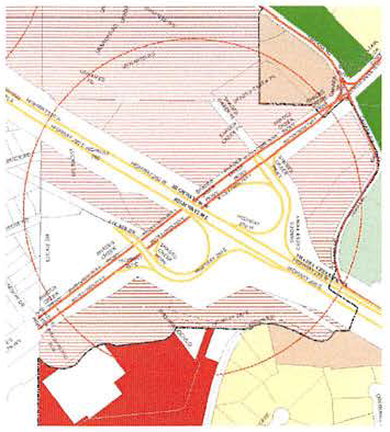
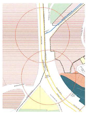
Sec. 129-267. - Highway 280 gateway maps.
(a)
Primary gateways—One thousand-foot radius from intersection of Highway 280.
(1)
Office Park Gateway.
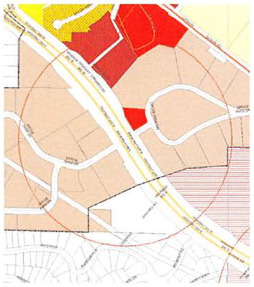
(2)
Shades Creek Parkway/Mountain Brook Parkway Gateway.
(b)
Secondary gateways—Five hundred-foot radius from intersection of Highway 280.
(1)
Hollywood Boulevard Gateway.
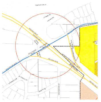
(2)
Cherokee Road Gateway.
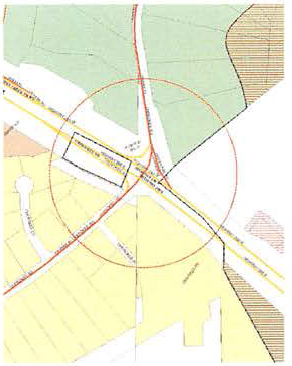
(3)
Overton Road/Rocky Ridge Road.
(4)
Green Valley Road.
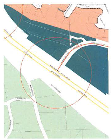
(5)
Pump House Road.
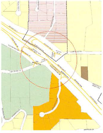
(6)
Cahaba River Road.
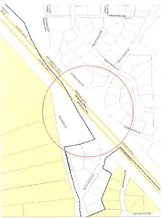
(Ord. No. 1975, § 1, 3-27-2017)