
Natchez City Zoning Code
CHAPTER 11
- ZONING USE DISTRICTS, STANDARDS AND USES
PART 1. - ESTABLISHMENT OF DISTRICTS
11.1.1 The City of Natchez shall be divided into the zoning districts shown in Table 11.1.1, Zoning Districts Established. These districts allow a variety of uses in each district which are appropriate to the character of the individual district.
TABLE 11.1.1
11.2.1 - Purpose and Scope.
The designation of "permitted uses" is established to provide for the location of particular uses which are considered appropriate within a given zoning district.
11.2.2 - Classification of Principal Uses.
The Permitted Use Table organizes allowable principal uses by use classifications, use categories, and use types. This classification scheme provides a systematic basis for identifying and consolidating uses, for distinguishing unidentified uses to determine whether a particular use is allowable in a particular zoning district. The use classifications identify broad general classifications of land use and include residential, institutional, business and office, public and civic, and industrial uses. Use classifications are further broken down into specific "use types." The specific use types are included in the respective use category. They identify the specific principal uses that are considered to fall within characteristics identified in the use category. For example, single-family detached dwellings, townhouse dwellings, multifamily dwellings, and manufactured homes are use types in the Residential Classification. See Table 11.2.2 in Appendix B.
11.2.3 - Designation of Principal Uses as Permitted, Special, or Prohibited.
A "P" in a cell of the Permitted Use Table indicates that the corresponding use type is appropriate and allowed as a principal use by right within the corresponding base zoning district. Permitted principal uses are subject to all other applicable standards of this Ordinance, such as dimensional standards and development standards.
An "SE" in a cell of the Permitted Table indicates that the corresponding use type is allowed as a principal use in the corresponding base zoning district only upon approval of a Special Exception and any conditions placed on approval of the Special Exception.
All Special Exceptions are subject to all other applicable regulations of this Ordinance, including, but not limited to, dimensional standards and development standards.
A blank cell in the Principal Use Table indicates that the corresponding use type is a prohibited use in the corresponding base zoning district. See Table 11.2.2 in Appendix B.
11.2.4 - Standards for Uses.
A particular use type allowable as a permitted use in a zoning district may be subject to additional standards (i.e. development standards, signs, historic preservation) that are specific to the particular use. These standards shall apply to the particular permitted use regardless of the base zoning district where it is proposed, unless otherwise specified.
The Planning Director may interpret an unlisted principal use as an allowed permitted use or special use in a particular zoning district only after determining that the nature, function, and duration of the use and the impact of allowing it in the zoning district are so similar to those of a use that is allowed in the zoning district that the unlisted use should be deemed allowed in the same manner (i.e., as a permitted use or as a special exception use) as the similar use type or use category and subject to the same use-specific standards.
11.2.5 - Required Permits and Approvals.
No use designated as a permitted use shall be established until after the person proposing such use has applied for and received all building permits and certificates of occupancy required within this ordinance.
11.2.6 - Action on Permit Applications.
(a)
When an application is made for a building permit for a permitted use, the Planning Director shall review the application to determine whether the proposed use complies with the applicable terms of this Ordinance.
(b)
No building permit or certificate of occupancy shall be issued for a use which does not comply with the terms of this Ordinance applying to that use and the zoning district in which the use is to be located.
11.2.7 - Objectives and Dimensional Standards of Zoning Districts.
The objectives and dimensional standards applicable to each zoning district are shown in Part 3 through Part 19 of this Chapter.
11.3.1 - Objectives.
The purpose of this district is to conserve land for agricultural use, to prevent the premature development of land and to prevent urban and agricultural land use conflicts. The intent is to preserve areas suitable for eventual urbanization when the need and the availability of community facilities warrant its development. The types of uses, area and intensity of development permitted in this district are designed to protect agricultural and open space uses until urbanization is warranted and appropriate changes in district classification can be made. Permitted Uses
11.3.2 - Dimensional Standards of General Applicability.
All uses and structures in the A-1 District shall meet the following dimensional standards, except as otherwise provided by this Ordinance:
Minimum Lot Area - Ten (10) acres
Minimum Lot Width - 300 feet
Minimum Front Yard - 75 feet
Minimum Side Yards - 100 feet
Minimum Rear Yard - 100 feet
Maximum Building Height - 35 feet
Maximum Lot Coverage - 20%
Note: Any agriculturally developed lot shall have no more than two (2) large animals, i.e., horses and/or cattle or four (4) small animals, i.e., sheep, goats, and/or chickens per acre.
11.4.1 - Objectives.
The purpose of this district is to recognize the historical value of historic properties inside this district and to protect their integrity. This district generally includes residences erected during ante bellum times on large tracts of land, many of which are listed on the National Register of Historic Places. The intent is to protect the integrity of these structures and therefore the subdivision of any land so classified to create lots of less than three (3) acres is prohibited.
11.4.2 - Dimensional Standards of General Applicability.
All uses and structures in the VR Villa Residential District shall meet the following dimensional standards, except as otherwise provided by this Ordinance:
Minimum Lot Area - Three (3) acres
Minimum Lot Width - 100 feet
Minimum Front Yard - 50 feet
Minimum Side Yards - 25 feet
Minimum Rear Yard - 25 feet
Maximum Building Height - 45 feet
Maximum Lot Coverage - 35%
11.5.1 - Objectives.
The purpose of this district is to provide for the protection of areas presently developed on large tracts of land and to provide for future development in such areas by permitting development on lots not less than one (1) acre.
11.5.2 - Dimensional Standards of General Applicability.
All uses and structures in the RE Estate Residential District shall meet the following dimensional standards, except as otherwise provided by this Ordinance:
Minimum Lot Area - One (1) acre
Minimum Lot Width - 100 feet
Minimum Front Yard - 40 feet
Minimum Side Yards - 20 feet
Minimum Rear Yard - 20 feet
Maximum Building Height - 35 feet
Maximum Lot Coverage - 35%
11.6.1 - Objectives.
The purpose of this district is to provide areas for the development of moderate density, single-family detached dwellings and related compatible uses in relatively spacious surroundings, which provide ample usable yard areas for leisure time activities.
11.6.2 - Dimensional Standards of General Applicability.
All uses and structures in the R-1 Single Family Residential District shall meet the following dimensional standards, except as otherwise provided by this Ordinance:
Minimum Lot Area - 7,200 sq. ft.
Minimum Lot Width - 60 feet
Minimum Front Yard - 25 feet
Minimum Side Yards - 8 feet-except the sum of the side yard shall not be less than 20 ft.
Minimum Rear Yard - 20 feet
Maximum Building Height - 35 feet
Maximum Lot Coverage - 35%
11.7.1 - Objectives.
The purpose of this district is to provide for areas containing a mixture of single-family and two-family dwellings and area where similar residential development seems likely to occur. The district regulations are designed to protect the residential integrity of the district.
11.7.2 - Dimensional Standards of General Applicability.
All uses and structures in the R-2 Two Family Residential District shall meet the following dimensional standards, except as otherwise provided by this Ordinance:
Minimum Lot Area - 7,200 sq. ft. (two family - 8,000 sq. ft, other uses - 10,000 sq ft.)
Minimum Lot Width - 60 feet
Minimum Front Yard - 25 feet
Minimum Side Yards - 8 feet-except the sum of the side yard shall not be less than 20 ft.
Minimum Rear Yard - 20 feet
Maximum Building Height - 35 feet
Maximum Lot Coverage - 35%
11.8.1 - Objectives.
The purpose of this district is to provide for a mixture of single-family and two family dwellings on smaller lots with a variety of setbacks as well as the location of higher density dwellings such as zero lot line homes and townhouse developments. It is the intent of this district to recognize areas where such a variety of densities and housing types are compatible with the surrounding business and institutional uses, while protecting the residential integrity of the district.
11.8.2 - Dimensional Standards of General Applicability.
All uses and structures in the R-3 Mixed Density Residential District shall meet the following development standards, except as otherwise provided by this Ordinance for townhouses and zero lot line dwellings:
Outside the Historic District
Minimum Lot Area - 5,000 sq. ft. (two family - 8,000 sq. ft., other uses - 10,000 sq. ft.)
Minimum Lot Width - 50 feet
Minimum Front Yard - 25 feet
Minimum Side Yards - 10 feet
Minimum Rear Yard - 20 feet
Maximum Building Height - 35 feet
Maximum Lot Coverage - 50%
Historic District
Minimum Lot Area - None
Minimum Lot Width - 40 feet
Minimum Front Yard - within 10% of the setback lines of adjacent structures and should not extend into the front yard more than adjacent structures
Minimum Side Yards - 10 feet
Minimum Rear Yard - 20 feet
Maximum Building Height - 35 feet or within 10% of the height of adjacent structures
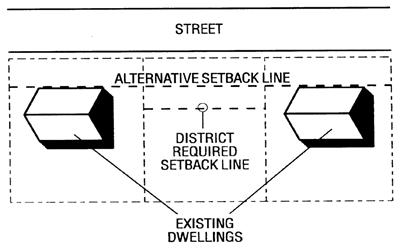
Figure 11.8.2: Alternative Setback Line
11.9.1 - Objectives.
The purpose of this district is to provide areas for the development of higher density multifamily buildings with adequate, usable open space to prevent overcrowding. The R-4 District is appropriate for the development of multifamily housing on land near office and commercial uses or large tracts of land near lower density housing. It is the intent of this Ordinance that these districts be carefully located only in areas where the infrastructure of the City (i.e. the street/highway system, storm drainage and water and sanitary sewer systems) is adequate to serve such higher density housing and where the multifamily housing will not intrude on lower density residential areas.
11.9.2 - Dimensional Standards of General Applicability.
All uses and structures in the R-4 Multi-Family Residential District shall meet the following dimensional standards, except as otherwise provided by this Ordinance:
Multi-Family
Minimum Lot Width - 20 feet per unit
Minimum Front Yard - 20 feet
Minimum Side Yards - 5 feet
Minimum Rear Yard - 20 feet
Single Family Dwelling on Individual Lot
Minimum Lot Area - 5000 sq. ft.
Minimum Lot Width - 50 feet
Minimum Front Yard - 20 feet
Minimum Side Yards - 10 feet
Minimum Rear Yard - 20 feet
Maximum Building Height - 45 feet
Maximum Lot Coverage - 50%
11.10.1 - Objectives.
The R-5 Manufactured Home Park District is established to provide for needed and properly planned Manufactured Home Parks at a density higher than the R-6 district for such housing. It is the intent of this Ordinance that these districts may be located only in such areas as to not adversely affect the established residential subdivisions and residential densities in the City. Such location, however, should have necessary public services, a healthful living environment and normal amenities associated with residential areas.
11.10.2 - Dimensional Standards of General Applicability.
All uses and structures in the R-5 Manufactured Home Park Residential District shall meet the following dimensional standards, except as otherwise provided by this Ordinance:
Manufactured Home Park
Minimum Property/Site Area - five (5) acres for
Minimum Lot Area - 3,200 sq. ft. per unit
Minimum Lot Width - 40 feet per unit
Manufactured Home on Individual Lot (not part of a park)
Minimum lot area - 5000 sq. ft.
Dimensional Standards Applicable to Both Park and Individual Lots
Minimum Front Yard - 25 feet
Minimum Side Yards - 5 feet
Minimum Rear Yard - 20 feet
Maximum Building Height - 35 feet
Maximum Lot Coverage - 50%
11.11.1 - Objectives.
The R-6 Manufactured Home Subdivision District is established to provide for needed and properly planned subdivisions for manufactured homes in which lots are offered for sale, and in which the purchaser receives fee simple title to the lot. Manufactured homes may also be placed on individual lots is this district. It is the intent of this Ordinance that these districts may be located in such areas as to not adversely affect the established residential subdivisions and residential densities of the City. Such location, however, should have necessary public services, a healthful living environment and normal amenities associated with residential districts of the City.
11.11.2 - Dimensional Standards of General Applicability.
All uses and structures in the R-6 Manufactured Home Subdivision Residential District shall meet the following dimensional standards, except as otherwise provided by this Ordinance:
Minimum Site Area - Ten (10) acres (Subdivision)
Minimum Lot Width - 50 feet per unit
Minimum Front Yard - 25 feet per unit
Minimum Side Yards - 8 feet per unit-except the sum of the side yard shall not be less than 20 ft. per unit
Minimum Rear Yard - 20 feet per unit
Maximum Building Height - 35 feet
Maximum Lot Coverage - 35%
Minimum Lot Area - 7,200 sq. ft. per unit (Individual lot not part of a subdivision)
Minimum Lot Width - 60 feet
Minimum Front Yard - 25 feet
Minimum Side Yards - 8 feet-except the sum of the side yard shall not be less than 20 ft.
Minimum Rear Yard - 20 feet
Maximum Building Height - 35 feet
Maximum Lot Coverage - 35%
11.12.1 - Objectives.
The purpose of the B-1 Neighborhood Business District is to provide offices, retail, and personal services for the convenience of the people in adjacent residential neighborhoods. These districts are normally located at key street intersections and along the frontage lots of arterial and collector streets.
11.12.1 - Dimensional Standards of General Applicability.
All uses and structures in the B-1 Neighborhood Business District shall meet the following dimensional standards, except as otherwise provided by this Ordinance.
Minimum Lot Area - None
Minimum Lot Width - 50 feet
Minimum Front Yard - 25 feet
Minimum Side Yards - None
Minimum Rear Yard - 20 feet
Maximum Building Height - 35 feet
Maximum Lot Coverage - 35%
11.13.1 - Objectives.
The purpose of the B-2 General Business District is to provide for business a variety of uses that are located on major thoroughfares and provide goods and services to residents of the community. Because these commercial uses are subject to the public view, which is a matter of important concern to the whole community, they should provide an appropriate appearance, ample parking, controlled traffic movement, and suitable landscaping, and protect abutting residential areas from the traffic and visual impacts associated with commercial activity.
11.13.2 - Dimensional Standards of General Applicability.
All uses and structures in the B-2 General Business District shall meet the following development standards, except as otherwise provided by this Ordinance:
Historic District
Minimum Lot Area - None
Minimum Lot Width - 30 feet
Minimum Front Yard - within 10% of the setback lines of adjacent structures and should not extend into the front yard more than adjacent structures. See Figure 11.8.2 (page 41).
Minimum Side Yards - None
Minimum Rear Yard - None
Maximum Building Height - 35 feet
Maximum Lot Coverage - 90%
Outside of the Local Historic District
Minimum Lot Width - 100 feet
Minimum Front Yard - 25 feet
Minimum Side Yards - 10 feet
Minimum Rear Yard - 20 feet
Maximum Building Height - 35 feet
Maximum Lot Coverage - 40%
11.14.1 - Objectives.
The purpose of this District is to preserve and perpetuate an intensive and cohesive downtown urban core characterized as the center for employment and as the focus of commercial, governmental and cultural activities. The intent of this District is to develop a strong sense of place by extending the duration of downtown's activities by improving the pedestrian environment and creating mutually supportive land uses such as cultural arts, education, entertainment, housing, business other commerce and government.
11.14.2 - Dimensional Standards of General Applicability.
All uses and structures in the B-3 Central Business District shall meet the following dimensional standards, except as otherwise provided by this Ordinance or the Historic Preservation Ordinance:
Minimum Lot Area - None
Minimum Lot Width - 30 feet
Minimum Front Yard - within 10% of the setback lines of adjacent structures and should not extend into the front yard more than adjacent structures. See Figure 11.8.2 (page 41).
Minimum Side Yards - None
Minimum Rear Yard - None
Maximum Building Height - 95 feet*
Maximum Lot Coverage - 90%
*The maximum height within the B-3 District bounded by Wall, Main, Broadway and Franklin Streets is seventy-five (75) feet
11.15.1 - Objectives.
The purpose of the B-4 Highway Business District is to provide areas for intensive, high impact, commercial and small scale light industrial establishments, some of which generate large volumes of heavy truck traffic. Consequently, these districts are found along highways and in pockets of back lots off of arterial streets. Most retail office and personal service establishments are incompatible, and, therefore, are not to be mixed in these heavy commercial and light industrial areas.
11.15.2 - Dimensional Standards of General Applicability.
All uses and structures in the B-4 Highway Business District shall meet the following dimensional standards, except as otherwise provided by this Ordinance:
Minimum Lot Area - None
Minimum Lot Width - 70 feet
Minimum Front Yard - 25 feet
Minimum Side Yards - None
Minimum Rear Yard - 20 feet
Maximum Building Height - 35 feet
Maximum Lot Coverage - 40%
11.16.1 - Objectives.
The I-1 General Industrial District is established as a district in which the principal use of land is for industries which can be operated in a relatively clean and quiet manner and which will not be obnoxious to adjacent residential or business districts and for warehousing and wholesaling activities with limited contact with the general public. The regulations are designed to prohibit the use of land for heavy industry, which should be properly segregated, and to prohibit any other use which would substantially interfere with the development of industrial establishments in the district.
11.16.2 - Dimensional Standards of General Applicability.
All uses and structures in the I-1 Industrial District shall meet the following dimensional standards, except as otherwise provided by this Ordinance:
Minimum Lot Area - 10,000 sq. ft.
Minimum Lot Width - 100 feet
Minimum Front Yard - 25 feet
Minimum Side Yards - 10 feet
Minimum Rear Yard - 20 feet
Maximum Building Height - 95 feet
Maximum Lot Coverage - 40%
11.17.1 - Objectives.
This District is comprised of land located along the Mississippi River and only within locally designated historic districts. It is intended that such lands be reserved for active uses which animate the waterfront and take advantage of their proximity to the waterfront. Such uses should be oriented toward the enjoyment of tourists and citizens of the City. Primary objectives include visual and limited physical access to the water, a pedestrian friendly environment, limited automobile access and parking, and the preservation and enhancement of the distinct character of the historic waterfront. Furthermore, this district is intended to preserve the open and undeveloped character of those publicly owned lands located above the bluff, including those lands which once constituted the City's original Spanish parade ground.
11.17.2 - Dimensional Standards of General Applicability.
All uses and structures in the W-1 Waterfront District shall meet the following dimensional standards, except as otherwise provided by this Ordinance or the Historic Preservation Ordinance:
Minimum Lot Area - None
Minimum Lot Width - None
Minimum Front Yard - None
Minimum Side Yards - None
Minimum Rear Yard - None
Maximum Building Height - 75 feet
Maximum Lot Coverage - None
11.18.1 - Objectives.
This District is comprised of land located along the Mississippi River. It is intended that such lands be reserved for active uses which animate the waterfront and take advantage of their proximity to the waterfront. Such uses should be oriented toward the enjoyment of tourists and citizens of the City. Primary objectives include visual and limited physical access to the water, a pedestrian friendly environment, limited automobile access and parking, and the preservation an enhancement of the distinct character of the historic waterfront. Furthermore, this district is intended to preserve the open and undeveloped character of those publicly owned lands located above the bluff.
11.18.2 - Dimensional Standards of General Applicability.
All uses and structures in the W2 Waterfront District shall meet the following dimensional standards, except as otherwise provided by this Ordinance:
Minimum Lot Area - None
Minimum Lot Width - None
Minimum Front Yard - None
Minimum Side Yards - None
Minimum Rear Yard - None
Maximum Building Height - 75 feet
Maximum Lot Coverage - None
11.19.1 - Objectives.
The purpose and intent of the Special Use District zoning classification is to permit the Board of Aldermen the right to establish needed zoning districts for a number of specific types of land use developments which do not fit compatibly into the other zoning districts because of their size, unique characteristics, or institutional nature.
11.19.2 - Dimensional Standards of General Applicability.
All uses and structures in the SUD Special Use District shall meet the following dimensional standards, except as otherwise provided by this Ordinance.
Minimum Lot Area - None
Minimum Lot Width - None
Minimum Front Yard Requirements - 25 feet
Minimum Side Yard Requirements - 25 feet
Minimum Rear Yard Requirements - 25 feet
Maximum Building Height - 35 feet
Maximum Lot Coverage - 65%