
New Castle County Unincorporated
City Zoning Code
City Zoning Code
ARTICLE 26
- MODIFICATION OF STANDARDS
Division 40.26.000.- Purpose.
This Code uses hard standards in many places because a completely flexible performance standard would be too lengthy or complicated to administer. In other cases, uncommon, yet logical exceptions to a standard have been anticipated. Specific standards are identified in this Article that may be modified pursuant to the standards below.
(Ord. No. 97-172, § 3(ch. 13, div. 26.000), 12-31-1997)
Sec. 40.26.110. - Review and approval.
The Department shall review all requests for modification of standards against this Article and the standards in Division 40.31.400. A note indicating the modification approval shall be placed on file and indicated by a note on the record plan or building permit.
(Ord. No. 97-172, § 3(ch. 13, § 26.110), 12-31-1997; Ord. No. 01-112, § 1(Exh. A), 3-12-2002)
Division 40.26.200. - Zoning modification.
The following sections address specific zoning standards that can be modified by the Department without the necessity of seeking a variance.
(Ord. No. 97-172, § 3(ch. 13, div. 26.200), 12-31-1997)
Sec. 40.26.210. - Construction envelopes.
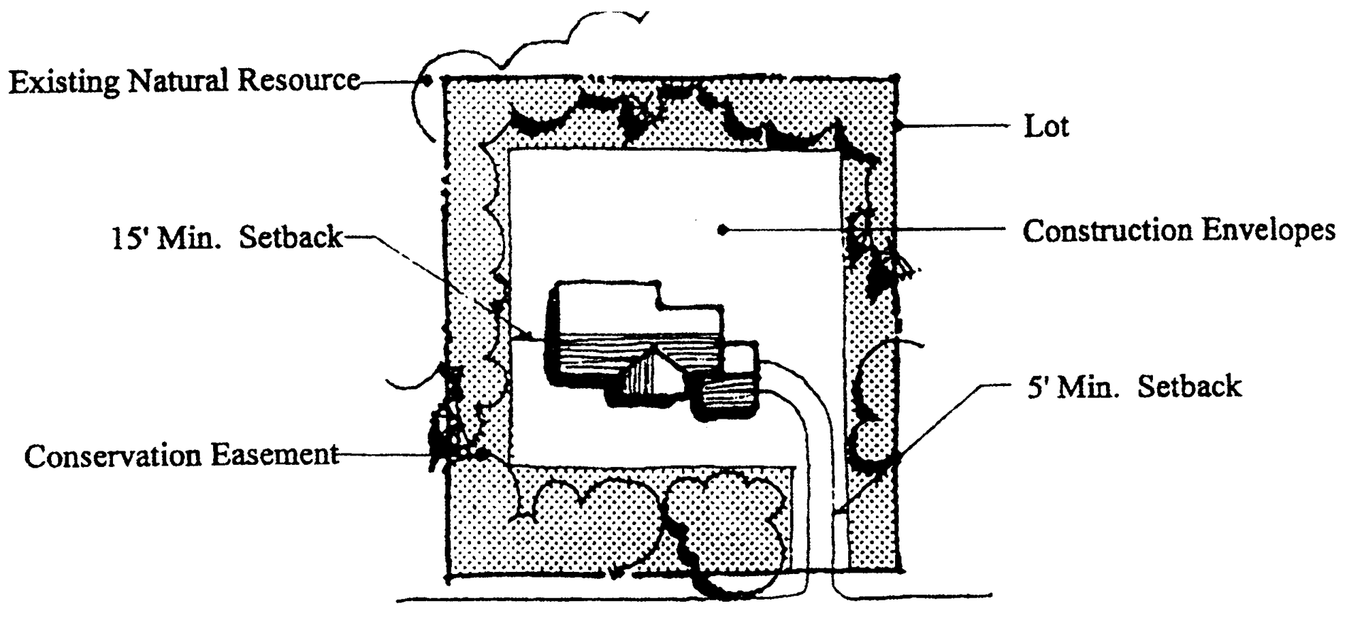
The site capacity calculations and net densities in Article 4 and Article 5 assume all of a residential lot will be disturbed during development. This Section provides the rules by which resource protection is permitted to occur on a lot. It is permitted only when the minimum lot size (Table 40.04.110) with sewer exceeds twenty thousand (20,000) square feet or where lots with tile fields exceed two (2) acres. All eligible lots shall place a conservation easement over the resource area in question, restricting the use of that land to open space uses and prohibiting fencing and the clearing, cutting, or disturbing of vegetation. All construction envelope developments shall follow this Section's standards.
A.
The net density in Table 40.26.120 shall be substituted for that in Table 40.04.110 based on the size of the maximum area of the construction envelope used in the development.
B.
The construction envelope may occupy no more than seventy-five (75) percent of the total area of the lot.
C.
All lot construction and clearing shall be confined to the construction envelope including buildings, decks or patios, driveways, lawns, pools, tennis courts, septic tanks and tile fields, and utility access. The construction envelope shall be extended fifteen (15) feet from the foundation and five (5) feet from any other area to be developed or disturbed to provide for machinery and earth movement. The construction envelope shall be temporarily fenced prior to construction or grading to prevent equipment from intruding into the conservation areas. Figure 40.26.120 shows the relationship between the lot, construction envelope, and conservation areas on a lot.
D.
The Department shall require that a mitigation bond be posted for one thousand dollars ($1,000.00). The Department shall inspect for damaged trees in the conservation easement before occupancy and shall require mitigation for those trees damaged. The mitigation rate shall conform to Section 40.23.220.
Table 40.26.120
CONSTRUCTION ENVELOPE NET DENSITIES
Figure 40.26.120
LOT WITH CONSTRUCTION ENVELOPE
(Ord. No. 97-172, § 3(ch. 13, § 26.210), 12-31-1997)
Sec. 40.26.220. - Bufferyards.
A.
Bufferyard model. The standards in Table 40.23.140 have been tested to ensure they meet the opacity standard. Numerous other mixes can meet the standard. The bufferyard calculation (or the Bufferyard Model) provided in Section 40.23.141 can be used to design an individualized buffer that meets the required opacity standard.
B.
Bufferyard reduction for buildings at setback. In the event a non-residential use is proposed at the minimum street yard setback in any zoning district where the bufferyard opacity standards of Table 40.04.111 requires an opacity standard with a wider minimum width than the street yard setback width, the bufferyard opacity may be reduced to a one-tenth (0.1) opacity.
(Ord. No. 97-172, § 3(ch. 13, § 26.220), 12-31-1997; Ord. No. 99-075, § 1, 12-14-1999; Ord. No. 10-113, § 1(Exh. A), 1-18-2011)
Sec. 40.26.230. - Street yard setbacks.
The street yard is normally intended to ensure a safe setback from roads, but often results in all buildings being lined up in a row; however, landscaping that screens the buildings from the street or variations in setback can, in some conditions, reduce the need for the rigid setback. In other cases, building form may dictate a different type of setback.
A.
Single-family and lot line. A combination of landscaping and facades that are articulated or staggered to give the sense that setbacks are varied can provide an environment equal to that in which all houses sit exactly on the setback line. The setback may be reduced where the following are met:
1.
When individual building construction envelopes, with varying setbacks, are described for each lot on the record plan to provide a streetscape with varied building locations.
2.
Where the setback in Table 40.04.110 is greater than thirty-five (35) feet, the average setback may be reduced by up to ten (10) percent on any block face. No single lot setback reduction shall be greater than thirty (30) percent.
3.
Where the setbacks in Table 40.04.110 are thirty-five (35) feet or less, the development's setbacks shall average the setback listed in Table 40.04.110. No single lot setback reduction shall be greater than twenty (20) percent.
4.
In addition to the street tree requirements (Table 40.04.111), the Department may require up to one (1) plant unit per two hundred (200) feet of street frontage be placed in the right-of-way or first ten (10) feet of the lot.
5.
All front-loading garages shall be set back the minimum distance to provide for adequate off-street parking.
6.
This provision shall only be used along the development's internal streets, not where single-family homes face homes in another subdivision across a street.
B.
Adjoining lots are nonconforming. In older parts of the County, setbacks may not conform or may vary from lot to lot. In these areas, the Department may approve unique setbacks under the following conditions:
1.
Where forty (40) percent of the lots on a block face are nonconforming, the unit may be set back so as to blend in with the average distance of existing nearby structures.
2.
Where existing block faces are all nonconforming, the Department, upon determining the local conditions, shall determine a setback.
C.
Side-loading garages. Side-loading attached garages located in front of the house shall be permitted on single-family detached house lots listed as fifteen thousand (15,000) square feet in Table 40.04.110. The setback for such garages may be reduced, provided the following are met:
1.
Side-load garage setbacks shall be a minimum of fifteen (15) feet.
2.
One (1) plant unit shall be installed for each side-load garage in the area between the garage and the right-of-way.
3.
Within a development, no more than forty (40) percent of the total lots may be side-load garages. No more than three (3) adjacent lots may contain side-load garages. The orientation shall be broken up so that garages do not all face the same direction.
(Ord. No. 97-172, § 3(ch. 13, § 26.230), 12-31-1997)
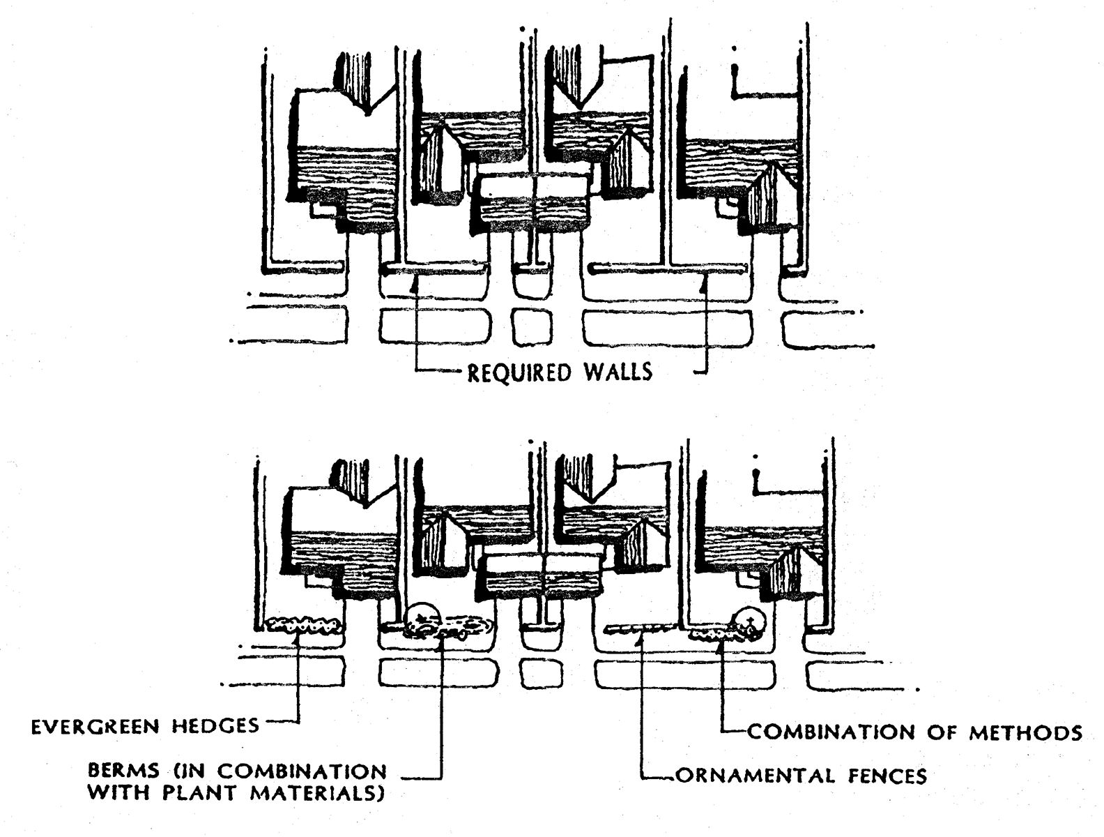
Sec. 40.26.231. - Patio and atrium dwelling units.
The wall enclosing these lots may be eliminated or reduced in height or opacity where the unit faces open space. The street yard should be varied to avoid monotony. The following rules govern wall modulation:
A.
Where the wall abuts open space within the development, it may be reduced in height, length, or opacity in accordance with Table 40.26.231.
B.
A patio or atrium dwelling unit's street face (where applicable) may be articulated to avoid monotony. The wall requirement shall be eliminated in favor of some combination of the wall and one (1) or more of the techniques shown in Figure 40.26.231.
Table 40.26.231
PERCENT REDUCTION IN TOTAL AREA OF WALL
Figure 40.26.231
TECHNIQUES FOR ARTICULATING PATIO AND ATRIUM STREET FACE WALLS
(Ord. No. 97-172, § 3(ch. 13, § 26.231), 12-31-1997; Ord. No. 21-009, § 9, 12-14-2021)
Sec. 40.26.232. - Windowless wall.
In lot-line, atrium, and patio units, windows are prohibited from looking into the neighboring yards. Windows shall be permitted in walls designated as windowless provided that one of the following conditions are met:
A.
The adjoining land is a public right-of-way.
B.
The adjoining land is open space having a minimum width of fifteen (15) feet, where the unit on the opposite side of the open space is walled.
C.
The adjoining land is open space having a minimum width of thirty (30) feet.
D.
The windows face a closed courtyard, or the windows are located at a height that prevents a view into the adjoining property.
(Ord. No. 97-172, § 3(ch. 13, § 26.232), 12-31-1997; Ord. No. 01-112, § 1(Exh. A), 3-12-2002)
Sec. 40.26.233. - Building separation.
This Section sets forth the residential building spacing regulations and standards. Various attached dwelling unit types have no side yard lines, since the individual dwelling units are attached. However, blocks of attached units are regulated by building spacing. A variety of situations can modify the basic standards. The normal separation assumes the building walls are generally parallel, but that need not be the case; this circumstance also changes the separation requirements needed to provide light, air and fire access. The following standards permit modification of building spacing under the specified conditions.
A.
Irregular facing walls. Where facing building planes are not a straight line, the average distance between the adjoining walls shall be used, provided no portion of the building is closer than eighty (80) percent of the minimum building spacing.
B.
Nonparallel building alignment. Where building walls are not parallel, the minimum building separation may be reduced. The average separation must be equal to the requirement of Table 40.04.112 and the minimum shall be no less than eighty (80) percent of that requirement.
C.
Building Code.Chapter 6 may establish increased requirements for fire-rated construction where building setbacks are reduced, thus increasing costs, or require stricter standards.
(Ord. No. 97-172, § 3(ch. 13, § 26.233), 12-31-1997; Ord. No. 04-059, § 1(Exh. A), 7-13-2004; Ord. No. 10-113, § 1(Exh. A), 1-18-2011)
Sec. 40.26.240. - Modification of housing type.
This Code provides a variety of building types to insure diversity. Market or design constraints may be such that modification of building types may be permitted in order to achieve the desired character or meet market demands. The following modifications are expressly permitted:
A.
Lot line and village units. These lots have different sizes, provided the size and mix requirements are retained. Either design motif may be used as follows:
1.
The lot line house may be designed in the village mode, using the same front yard setback and retaining its build to line. The side yards should be a minimum of six (6) feet and a total of fourteen (14) feet.
2.
The village house may be designed in the lot line mode with a twenty (20) foot front yard setback and single side yard or building separation of fifteen (15) feet.
B.
Build-to and setback lines. The standards are designed to be used in small scale subdivisions where each subdivision in the district has common standards. In the Traditional Neighborhood, developments having over three hundred (300) dwelling units the Department may change these standards according to the following:
1.
Where design guidelines for the entire community in the Traditional Neighborhood suggest a different setback or build-to line, and this is done to achieve a specific look, it may be permitted, provided:
a.
The setback does not result in greater exposure of the automobile to the streetscape.
b.
The change does not result in a loss of landscaping to soften the street facades.
c.
The change does not alter the urban character of the Traditional Neighborhood, an alternative may be used throughout the development.
(Ord. No. 98-080, § 1(ch. 13, § 26.240), 9-22-1998; Ord. No. 09-037, § 1, 10-13-2009)
Sec. 40.26.250. - Additional dwelling unit types.
The Department shall review proposed additional dwelling unit types. The new types may be approved provided:
A.
They represent a significantly different housing style, not just a small lot;
B.
That the housing type address issues of privacy, usable yard space, and adequate light and air;
C.
That the parking be such that the unit does not create a situation where garages and drives dominate the front facades; and
D.
That there be a valid reason for the unit type such as, but not limited to, the following:
1.
The unit is designed for specific topographic conditions.
2.
The unit works to increase single-family attached densities near transit.
3.
The unit is particularly suited to increasing affordable housing and can be mixed into the overall fabric of the community without either creating an obvious unit type. For example, a unit type that makes a single-family home a two (2) unit building either with a granny flat or a second unit in a townhouse of village house situation.
4.
The design caters to a specific market segment such as elderly that have difficulty with one (1) of the normal housing types.
5.
The housing type fulfills a specific design function that enhances the design of the community and creates greater sense of place in the development.
(Ord. No. 98-080, § 1(ch. 13, § 26.250), 9-22-1998)
Sec. 40.26.260. - Large industrial structures.
For land development plan applications, the maximum size of a proposed industrial building or addition is two hundred thousand (200,000) square feet of GFA to prevent too large a building or structure from altering the general character of the community. Industrial buildings or additions larger than two hundred thousand (200,000) square feet of GFA may be approved dependent on compliance with this Chapter and the following standards:
A.
The design of the development incorporates the following techniques to minimize visual impact:
1.
The development has a common architectural design, including the use of common facade materials, window treatment, and roof lines.
2.
Proposed industrial buildings or additions must be designed to reduce their apparent mass by including site and building design improvements such as building wings, articulated facade, a reduced height by setting the ground floor partially below grade, or locating the building topographically so that proposed industrial buildings or additions are better screened by surrounding buildings, where appropriate.
3.
The massing of buildings on the periphery of the development to screen the larger buildings.
4.
Except for along lot lines internal to an existing office or industrial park or adjacent to existing industrial uses the bufferyards, street trees, berming, and on-lot landscaping must be upgraded, where appropriate, to mask the development.
5.
The site plan must be designed so that the actual view of the larger building located down the street is such that the scale of the larger building is not apparent.
B.
Where large industrial structures are proposed to be adjacent to an existing residential use or residential zoning district, lighting must be designed so that there is zero (0) footcandle at the property line of the residential area.
C.
The site must be designed to minimize noise impact on neighboring properties. A noise study must be submitted to evaluate this impact and to verify consistency with Chapter 22 of the New Castle County Code.
D.
The site must be designed so that parking, loading, and circulation minimize the glare from vehicular lights visible to neighboring residential properties.
E.
The plan must include elements of building design, site design and amenities identified in the applicable Character Area set forth in Appendix 7. The Department may require specific improvements to the development where they are most needed, are appropriate, and can be physically accommodated.
F.
Upon a finding by the Department that the exploratory plan is in general compliance with this Chapter, and receipt of a narrative identifying how the proposal addresses the conditions of this section, the plan shall be scheduled for a Planning Board public hearing on the next available hearing date. The Planning Board will review the proposal and consider the effects of the proposed structure on adjoining properties. Planning Board review of the exploratory sketch plan is required prior to submission of a record plan to the Department.
(Ord. No. 97-172, § 3(ch. 13, § 26.260), 12-31-1997; Ord. No. 23-104, § 7, 1-9-2024)
Editor's note— Ord. No. 23-104, § 7, adopted January 9, 2024, changed the title of Section 40.26.260 from "Very large light industrial structures" to "Large industrial structures." The historical notation has been preserved for reference purposes.
Sec. 40.26.310. - No road frontage.
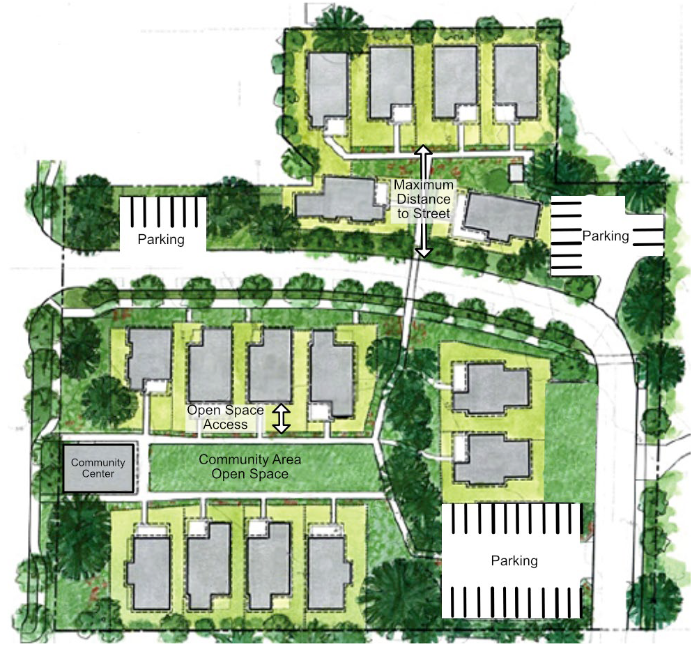
In pocket neighborhoods, the Department may allow dwelling units to have no street frontage. All such units shall front an open space that meets the standards in Table 40.26.310. The maximum distance such a unit may be away from a street depends on whether the lot has direct access to both the open space and an alley that provides the lots with on-site parking and emergency access, or whether access is solely via the open space. The distance in Table 40.26.310 is doubled if a road or emergency access alley is available at both ends of the open space. Figure 40.26.310 illustrates the various conditions.
Table 40.26.310
STANDARDS FOR SPECIFIC RESIDENTIAL UNITS WITH NO ROAD FRONTAGE
Figure 40.26.310
RESIDENTIAL UNITS WITH NO ROAD FRONTAGE
(Ord. No. 97-172, § 3(ch. 13, § 26.310), 12-31-1997; Ord. No. 24-137, §§ 7, 8, 12-10-2024)
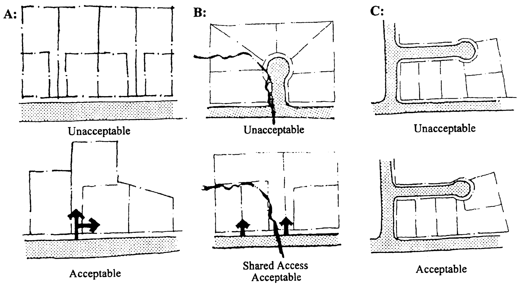
Sec. 40.26.320. - Flag lots.
Flag lots are generally prohibited because they have often been used to avoid building a street to serve a subdivision, and their use increases the number of curb cuts on arterial or collector roads. However, conditions exist where flag lots are reasonable and can even enhance the community's character. These conditions are set forth below and illustrated in Figure 40.26.320.
A.
If the property to be subdivided has very irregular boundaries and a narrow street and cul-de-sac are not feasible, a flag lot may be used to serve a single lot where lots are one (1) acre or larger.
B.
In a resource protection area a flag lot may be used to reduce resource destruction which would have occurred by extending the cul-de-sac further into the sensitive area where lots are one (1) acre or larger.
C.
A flag lot shall be used to avoid lots taking access to arterial or collector streets as long as the flag lot does not take access from the arterial or collector.
D.
A combined curb cut for the flag lot and one (1) or more lots may be required where the Department believes such design will improve safety.
Figure 40.26.320
FLAG LOT CONDITIONS
(Ord. No. 97-172, § 3(ch. 13, § 26.320), 12-31-1997)
Sec. 40.26.321. - Lot shapes.
Normally, lot shapes are rectangular or pie-shaped. This pattern works well in some cases; rectangular lots are important when lots are rather small since they provide a maximum buildable area. Pie-shaped lots can be very inefficient. The most important element is that the lot contains a building construction envelope adequate for conventional house design. Lot shapes may be irregular under the following circumstances (see Figure 40.26.321):
A.
Where lots are surrounded by open space, lots of approximately trapezoidal shape may be used to maximize the benefits of the open space and reduce road length.
B.
Where the property has a shape that makes it difficult to lot efficiently, the developer should be able to use irregular lot shapes rather than waste land.
C.
Where lots exceeding three (3) acres are provided, the lot shape that provides efficient use of the land and minimum lot size may be used.
D.
Portions of lots in a conservation easement may have irregular shapes since they cannot be used for construction.
E.
All lot sizes and shapes shall be reviewed to determine if houses similar to those normally built in the district can be constructed with normal patios or decks within the building envelope.
Figure 40.26.321
IRREGULAR SHAPED LOTS
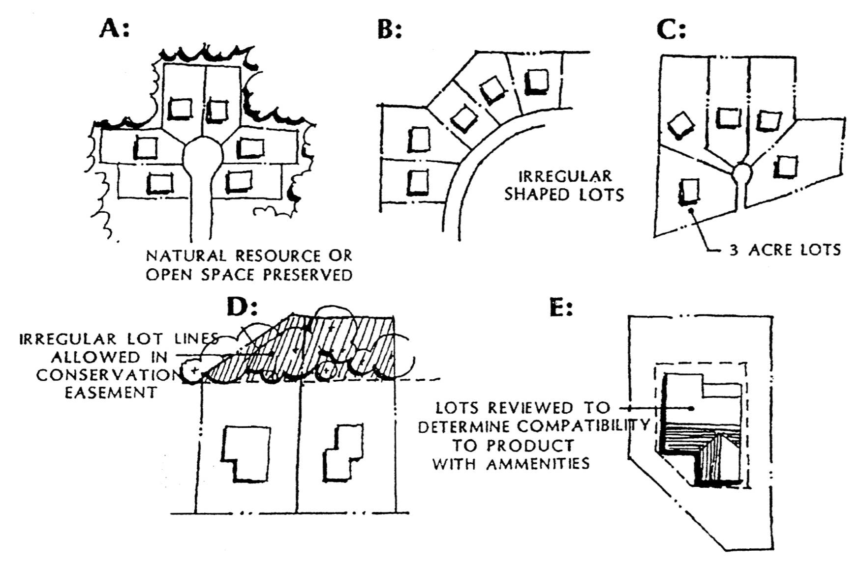
(Ord. No. 97-172, § 3(ch. 13, § 26.321), 12-31-1997)
Sec. 40.26.330. - Cul-de-sac or block length.
Cul-de-sac length is generally set to avoid unduly long roads where only one (1) means of access exists. Maximum block lengths provide for good circulation. However, a longer block length or cul-de-sac length may be permitted.
A.
A cul-de-sac's maximum length may be extended to serve twenty-four (24) lots provided:
1.
No stub street is possible; and
2.
The average number of lots served by culs-de-sac in the development is sixteen (16) or less; and
3.
The cul-de-sac layout and design minimizes natural resource disturbance; and
4.
The cul-de-sac layout and design are in accordance with the standards of the DelDOT Development Coordination Manual.
B.
A block's longest dimension may be extended by twenty-five (25) percent (with proportionate expansion to the maximum block perimeter) where:
1.
Unique topography, shape, or physical features make it difficult to connect to another street without building structures that are well above normal improvement costs; or
2.
The connection would result in undesirable intrusions into natural resources; and
3.
Adjoining developments provided no connections, which if linked to the subject property would reduce the need for the modulation; or no stubs are possible to adjoining vacant land.
(Ord. No. 97-172, § 3(ch. 13, § 26.330), 12-31-1997; Ord. No. 21-009, § 10, 12-14-2021)
Sec. 40.26.331. - Intersections.
Intersections may be permitted closer than the three hundred (300) foot centerline distances where:
A.
The depth of a block is less than these distances. An exception shall be granted unless a reasonable alternative street configuration exists which will provide the needed separation; or
B.
Topographic, natural resource, or ownership problems make providing the separation impractical or undesirable; or
C.
A narrower distance may be permitted where the Department determines the shorter distance results in safer conditions based on site distances.
(Ord. No. 97-172, § 3(ch. 13, § 26.331), 12-31-1997)
Sec. 40.26.410. - Purpose.
The purpose of the Hometown Overlay District is to perpetuate and enhance the character of communities built before the creation of zoning and land development codes. The creation of the overlay districts is intended to foster investment and redevelopment in these communities by preventing the need for variances in order to maintain existing patterns and characteristics, and to prevent the lack of harmony that results from strict adherence to existing zoning standards. Nearly three (3) centuries of development were already in place when the first zoning code was established in 1954. The zoning code, and amendments, created standards for new development, but failed to recognize the unique qualities of existing communities and how they would evolve. The diversity of our older communities include settlements that grew around mill seats, ports, railroad stations, crossroads, agricultural trading centers, trolley lines, and adjoining cities. Many are designed with street systems, lot sizes, dimensional relationships, and patterns of use that do not conform to existing zoning districts, yet are viable, attractive communities that offer an alternative to modern development. The urban style density, setbacks, and mixed uses in some older communities are not permitted in the standard zoning districts. A community redevelopment plan for each overlay district will define unique characteristics that infill projects, redevelopment, and zoning patterns will perpetuate.
(Ord. No. 03-107, § 1(Exh. A), 3-23-2004)
Sec. 40.26.420. - Designation.
A.
County Council may establish Hometown (HT) Overlay Zoning Districts, pursuant to process and standards for a zoning map amendment set forth in Article 31 of this Chapter.
B.
The Hometown (HT) Overlay Zoning District encompasses the boundaries of communities and neighborhoods that will be subject to a modification of dimensional standards as set forth herein and by an approved Community Redevelopment Plan.
C.
When the establishment of a Hometown Overlay District requires an amendment to the Comprehensive Development Plan, the County must amend the Comprehensive Plan consistent with State Code.
D.
The description and identification of these communities shall be through civic initiative and public input to determine the unique qualities, landscapes, land use, development patterns, amenities, road network and transit facilities, community uses, public spaces and other assets that define and characterize that community. The delineation of a community shall not be comprised of only one (1) land use type. Communities are composed of a variety of uses that include residential, commercial, employment, recreational and institutional uses. While not all communities have each of these categories, all communities do exhibit a variety of land uses that together contribute to the identity and function of the community.
E.
All proposed land use applications reviewed by the Department shall comply with a Community Redevelopment Plan and/or Design Guidelines adopted for a community.
(Ord. No. 03-107, § 1(Exh. A), 3-23-2004; Ord. No. 06-031, § 1, 7-11-2006; Ord. No. 10-113, § 1(Exh. A), 1-18-2011; Ord. No. 24-112, § 1, 1-14-2025)
Sec. 40.26.430. - Community redevelopment plan.
A.
With adoption of the Hometown Overlay Zoning District Ordinance, County Council shall at the same time, by ordinance, approve a Community Redevelopment Plan with design guidelines.
1.
At a minimum, the Plan shall include a purpose, goals, and description of the land uses, community character, architectural or design themes, streetscape and landscape concepts, transportation objectives, considerations for building envelope, mixed use opportunities, parking/loading, and accessory uses.
2.
The Community Redevelopment Plan must describe how development is intended to be compatible with the community character or in harmony with the existing community fabric. It should encourage maintaining the rhythm of the existing developed community by recognizing streetscape contexts involving building, scale, mass, door and window openings and spacing, building height, setbacks, materials, texture, and relief of facades. However, the Plan should not merely act to replicate architectural styles that would result in an unintended monotony and blandness or a contrived, artificial appearance.
3.
The Community Redevelopment Plan shall identify those properties that warrant a different zoning designation and County Council shall consider these rezonings concurrently with the adoption of the overlay zone.
4.
An illustrative plan and narrative report shall address proposed dimensional, character, design and other standards to supplant or supplement other provisions in County Code. These standards and criteria may be incorporated in the Community Redevelopment Plan or within a separate "Design Guidelines" manual.
B.
The Community Redevelopment Plan with guidelines shall result from no less than two (2) public meetings scheduled by the Department to determine community goals and objectives, sometimes referred to as a visioning process. It is imperative that these public meetings, held pursuant to the public notification process of Section 40.31.340, comprise broad-based support with representation by diverse community interests and bona fide community groups.
Subsequent to the public meetings, an application supporting the proposed Plan with design guidelines shall be submitted to the Department and scheduled to be heard by the Planning Board and, if historic resources are potentially involved, the Historic Review Board. Following the hearing(s), the Planning Board and the Department shall issue a joint recommendation regarding the application. Where applicable, the Historic Review Board shall issue a separate recommendation.
C.
Amendment or revision to the Community Redevelopment Plan and/or the guidelines, may be initiated by the community, the Design Review Advisory Committee (DRAC), the District Council Member, or by the Department, and approved through an ordinance pursuant to the standards and process for a text amendment set forth in Article 31 of this Chapter with the addition of a review and recommendation by the Design Review Advisory Committee (DRAC) if one exists.
D.
An applicant seeking a variance from the dimensional standards and/or design guidelines identified in the Community Redevelopment Plan or Design Guidelines manual shall apply to the Board of Adjustment. A recommendation from the DRAC and the Department (or the Department alone, if no DRAC exists) shall be submitted to the Board of Adjustment prior to consideration of the application by the Board.
(Ord. No. 03-107, § 1(Exh. A), 3-23-2004; Ord. No. 10-113, § 1(Exh. A), 1-18-2011; Ord. No. 24-112, § 1, 1-14-2025)
Sec. 40.26.440. - Design Review Advisory Committee (DRAC).
A Design Review Advisory Committee shall be established pursuant to Section 40.30.450 for each Hometown Zoning Overlay District created.
(Ord. No. 03-107, § 1(Exh. A), 3-23-2004)
Sec. 40.26.450. - Variation from UDC standards.
A.
All standards in this Chapter shall remain in effect within the designated community including zoning districts as depicted on the Zoning Map. The standards established by the Community Redevelopment Plan/Design Guidelines manual that may conflict or contradict those of this Chapter shall supersede those of this Chapter as identified and determined by the Department during plan review.
B.
The requirements of this Chapter may be modified to adjust density, landscaping, buffers or open space areas, parking, building and paving setbacks, building heights, and sign standards to insure that the proposed development will conform to the goals and objectives of the Community Redevelopment Plan and/or Design Guidelines manual.
C.
Exceptions:
1.
All protected resources as identified in Article 10 shall be preserved.
2.
The Community Redevelopment Plan/Design Guidelines manual shall not replace historic preservation measures found in Article 15.
D.
The Department may initiate proactive rezoning of land within the overlay zone to facilitate proposed development that conforms to the Community Redevelopment Plan and/or Design Guidelines Manual.
(Ord. No. 03-107, § 1(Exh. A), 3-23-2004; Ord. No. 10-113, § 1(Exh. A), 1-18-2011)
Sec. 40.26.460. - Land development reviews.
A.
Any proposed land development application within a Hometown Overlay zone shall follow the procedures of Article 31 with the addition of a review by the Design Review Advisory Committee (DRAC). If no DRAC exists, the Planning Board will consider the application for consistency with the Community Redevelopment Plan at the public hearing for Major Land Development Plans by this Chapter.
B.
The Department shall review all other land use applications located within any Hometown Overlay for consistency with the Community Redevelopment Plan and Design Guidelines. The Department may refer an application to the local DRAC for their recommendation if the Department determines that the proposed activity is not consistent with the Community Redevelopment Plan and/or Design Guidelines Manual.
C.
Upon submission of an application, the Department shall notify the appropriate DRAC of the application and schedule a public meeting for the next regularly scheduled monthly meeting in compliance with legal notice requirements. Both the applicant and the Department shall be responsible for public notification in accordance with Section 40.31.340.
D.
The Department shall prepare a preliminary report for the DRAC prior to the public meeting. The Department's preliminary report shall include a discussion of the appropriateness of the application in relation to the Community Redevelopment Plan and/or Design Guidelines manual and this Chapter.
E.
A public meeting for review of the application shall be held by the DRAC and the Department. The applicant shall be present to provide a brief description of the project and answer questions by the Committee and those in attendance. Based upon its public review, the DRAC shall provide a written recommendation to the Department within ten (10) days of the public meeting. If the DRAC fails to submit a recommendation within those ten (10) days, the Department shall proceed with its review of the application.
F.
The DRAC's written recommendation shall advise the Department of the project's conformance with the goals, objectives and standards of the Community Redevelopment Plan and/or Design Guidelines manual. The Committee may make suggestions or recommendations for desired revisions to further enhance the project or to correct deficiencies.
G.
Upon receipt of the DRAC recommendation, the Department shall issue a final report to the applicant. In doing so, the Department shall give due consideration to the public meeting comments and DRAC recommendation in determining conformance with the Community Redevelopment Plan and/or Design Guidelines manual. A revised exploratory plan or land development application may be required to incorporate the proposed changes identified in the final report. Architectural details, elevations and other design-related elements shall be shown on a landscape plan or on a separate plan. The Department will subsequently respond to the applicant as part of its review in accordance with this Code. Dimensional standards varied by this process and other Community Redevelopment Plan and/or Design Guideline manual elements shall be noted and depicted on all subsequent plan and/or application submissions.
H.
The Department may refuse acceptance of plans that are in substantial noncompliance with this Chapter or Community Redevelopment Plan and/or Design Guidelines manual and may require subsequent reviews by the DRAC upon submission of revised plans.
I.
In the event that an applicant submits supplemental materials to the Department to contradict a recommendation from the DRAC, an additional DRAC meeting, following the notification process outlined in Subsection 40.26.460 B., shall be required to provide an opportunity for the DRAC to revisit its prior recommendation in light of any new materials including, but not limited to, all supplemental materials received by the Department from the applicant and the Department's official position. The DRAC shall then have ten (10) days from the date of the public meeting to provide a supplemental recommendation to the Department. If the DRAC fails to submit a supplemental recommendation within those ten (10) days, the Department shall proceed with its review of the application.
(Ord. No. 03-107, § 1(Exh. A), 3-23-2004; Ord. No. 06-031, § 2, 7-11-2006; Ord. No. 08-032, § 1, 7-8-2008; Ord. No. 10-113, § 1(Exh. A), 1-18-2011; Ord. No. 24-112, § 1, 1-14-2025)