
New Castle County Unincorporated
City Zoning Code
City Zoning Code
ARTICLE 33
- DEFINITIONS
Division 40.33.000.- Purpose.
This Article defines words, terms and phrases found in this Chapter. Words not defined in this Article shall have the meaning given in other Code Chapters or Webster's Unabridged Dictionary.
(Ord. No. 97-172, § 3(ch. 13, div. 33.000), 12-31-1997; Ord. No. 04-059, § 1(Exh. A), 7-13-2004; Ord. No. 10-113, § 1(Exh. A), 1-18-2011)
Division 40.33.100. - Word usage.
This Article's provisions and rules shall be observed and applied when interpreting this Chapter, except when the context clearly requires otherwise:
A.
Words used or defined in one (1) tense or form shall include other tenses or forms.
B.
Words in the singular number shall include the plural number. Words in the plural number shall include the singular number.
C.
The masculine gender shall include the feminine. The feminine gender shall include the masculine.
D.
Reserved.
E.
The word "may" is permissive.
F.
The word "person" includes individuals, partnerships, firms, corporations, associations, trusts or any employees, assistants, agents and any other similar entities or combination of individuals.
G.
The word "shall" is mandatory.
(Ord. No. 97-172, § 3(ch. 13, div. 33.100), 12-31-1997; Ord. No. 04-059, § 1(Exh. A), 7-13-2004)
Sec. 40.33.110. - County terms.
A.
The word "Council" shall mean the New Castle County Council.
B.
The phrase "Board of Adjustment" shall mean the New Castle County Board of Adjustment.
C.
The words "this Chapter" shall mean the "New Castle County Unified Development Code" Chapter 40 of the New Castle County Code.
D.
"Code Enforcement Officer" means any sworn New Castle County Code Enforcement Constable, County Building Inspector or County Inspector.
E.
The word "County" shall mean New Castle County, Delaware.
F.
The words "County Engineer" shall mean an engineer employed by New Castle County.
G.
The words "Comprehensive Development Plan" shall mean the Comprehensive Plan of New Castle County. It means all maps, charts and exploratory materials adopted by Substitute No. 2 to Ordinance 22-024 on July 26, 2022, and any subsequent amendments thereto.
H.
The word "Department" shall mean the New Castle County Department of Land Use.
I.
The words "Department of Public Works" shall mean the New Castle County Department of Public Works.
J.
Reserved.
K.
The words "Planning Board" shall mean the New Castle County Planning Board.
L.
The words "Recorder of Deeds" shall mean the New Castle County Office of Recorder of Deeds.
M.
The words "Guiding Principles" shall mean the Guiding Principles for Development (Appendix 7) of the UDC.
(Ord. No. 97-172, § 3(ch. 13, § 33.110), 12-31-1997; Ord. No. 01-092, § 2, 3-25-2002; Ord. No. 04-059, § 1(Exh. A), 7-13-2004; Ord. No. 06-140, § 2, 7-24-2007; Ord. No. 10-113, § 1(Exh. A), 1-18-2011; Ord. No. 11-109, § 2, 4-24-2012; Ord. No. 18-031, § 78, 4-24-2018; Ord. No. 18-021, § 54, 7-10-2018; Ord. No. 22-024, § 4, 7-26-2022)
Sec. 40.33.120. - State agencies and terms.
A.
The word "DelDOT" means the State of Delaware, Department of Transportation.
B.
The word "State" shall mean the State of Delaware.
C.
The term "State Fire Marshal" means the State Fire Marshal of the State of Delaware.
D.
The term "State Public Health Division" means the Division of Public Health of the State of Delaware Department of Health and Social Services.
E.
The term "Department of Natural Resources and Environmental Control (DNREC)" means the Department of Natural Resources and Environmental Control of the State of Delaware.
F.
The term "State Big Tree" indicates a tree which has been accepted into the Delaware State Big Trees Program, by virtue of its representation of indigenous species, or possessing outstanding size, height, or spread.
G.
The term "WILMAPCO" means the Wilmington Area Planning Council.
(Ord. No. 97-172, § 3(ch. 13, § 33.120), 12-31-1997; Ord. No. 01-112, § 1(Exh. A), 3-12-2002)
Sec. 40.33.130. - Abbreviations.
The following abbreviations are used in this Chapter:
(Ord. No. 97-172, § 3(ch. 13, § 33.130), 12-31-1997; Ord. No. 99-075, § 1, 12-14-1999; Ord. No. 00-102, § 6, 11-28-2000; Ord. No. 01-112, § 1(Exh. A), 3-12-2002; Ord. No. 04-059, § 1(Exh. A), 7-13-2004; Ord. No. 04-058, § 2, 10-5-2004; Ord. No. 17-044, § 10, 10-10-2017)
Division 40.33.200. - Use definitions.
The uses found in Table 40.03.110 are defined in this Division. Specific uses may be further defined in Division 40.33.300. If a use is not enumerated in either of these Divisions, see Section 40.31.520 for interpretations. Any use not specifically listed in Table 40.03.110 and defined in this Article is expressly prohibited, unless the interpretation is that the use is similar to a permitted use. The 2007 North American Industrial Classification System (NAICS), as published by the Federal government and as may be amended from time to time, shall be used as a guide to define uses.
(Ord. No. 97-172, § 3(ch. 13, div. 33.200), 12-31-1997; Ord. No. 98-080, § 1(ch. 13, div. 33.200), 9-22-1998; Ord. No. 02-075, § 1(Exh. A), 10-22-2002; Ord. No. 09-068, § 1(Exh. A), 11-10-2009)
Sec. 40.33.210. - Agricultural uses.
A.
Agriculture. These uses include crop production and animal production (NAICS 111 and 112). These uses also include any other agricultural use recognized by Delaware law.
B.
Clearing. This use includes:
1.
Forestry (NAICS 113) involving the management, harvesting and use of a forest or woodland, or the clearing of an area so that eighty (80) percent of the land shall at all times be in forest or woodland cover. It requires a management plan for the regrowth of the harvested areas; or
2.
The clearing, destruction and cutting in excess of twenty (20) percent of forested areas for agricultural or purposes other than forestry. Clear cutting, burning or other methods of eliminating the vegetative cover are included; or
3.
Any other types of clearing recognized by Delaware law as an agricultural use.
C.
Farmstead. This is a residential-agricultural unit in which the land is used for agriculture and residential purposes by the owner/operator of the agricultural operation.
D.
Commercial stables. The stabling, training, and feeding of horses, or the provision of riding facilities for other than the use of the resident of the property; this also includes riding academies. This is any structure or place where horses, mules, donkeys, or ponies are kept for riding, driving, or stabling for compensation or incidental to the operation of any club, association, ranch or similar establishment.
E.
Farm market. This is a temporary or permanent use, structure or vehicle for the sale of agricultural products at least fifty (50) percent of which are grown on the subject farm. More than one (1) farm may sell at a single stand.
(Ord. No. 97-172, § 3(ch. 13, § 33.210), 12-31-1997; Ord. No. 98-080, § 1(ch. 13, § 33.210), 9-22-1998)
Sec. 40.33.220. - Residential uses.
A.
Single-family detached. These are detached dwelling units intended for only one (1) family. This term shall include any dwelling unit which complies with Chapter 6.
B.
Open space subdivision. These are single-family detached residential uses in a subdivision that include, as part of the subdivision design, significant common open space that meets the standards in Section 40.04.110.
C.
Single-family attached. These are attached dwelling units including semi-detached, twin, atrium, weak-link and townhouse types and quadraplex. The unit type permitted and open space standards are specified in Section 40.04.110.
D.
Open space planned. This describes a development that consists of one (1) or more of the following housing types: single-family, single-family lot line, village houses, twin, duplexes, patio houses, atrium houses, townhouses of several types, quadraplex and apartments. Such developments shall be planned as a unit and shall meet all the open space standards in Section 40.04.110.
E.
Multi-family. This use permits apartments only.
F.
Apartment conversion. This use involves the conversion of a large, single-family structure into multiple dwelling units.
G.
Commercial apartment. This is from one (1) to four (4) dwelling units located above, alongside, or to the rear of a nonresidential structure on the same lot.
H.
Hamlet. This is a special type of planned development that permits an extreme cluster with very extensive open space that is a freestanding community with residential, and a central place where commercial uses are permitted pursuant to the regulations of this Chapter.
I.
Village. This type of development is similar to a hamlet, permitting a cluster-style development with a community commercial district providing employment opportunities, pursuant to the regulations of this Chapter.
J.
Group home. A group home is a building that would otherwise be categorized as a single-family home, except for the fact that the number of unrelated individuals living in the unit does not qualify under the definition of family. The operation of a group home shall be a family living environment, not an institutional environment, where staff manages the living, and controls activities. If the unit would otherwise qualify as other types of dwelling units defined in this Chapter, such as apartment or attached housing, then the use shall be treated as such. Co-ops, nursing homes, other institutional residential and boardinghouse type of operations are expressly excluded since these are institutional or commercial lodging uses.
K.
Manufactured home park. A development designed to accommodate the sale or lease of sites for the placement of manufactured or mobile homes.
L.
Small single-family. The small single-family house is an affordable unit specially designed and built to serve the needs of individuals or small households who need small, compact, affordable housing. It is not intended to meet the needs of large families. Two (2) types of housing are provided: single-family detached one (1) story and single-family detached two (2) story. The small scale of these units permits them to fit into existing neighborhoods without threatening the neighborhood character.
M.
Accessory dwelling unit (ADU). This is a second, subordinate dwelling unit added to or created within a single-family detached dwelling, which provides independent living, sleeping, eating, cooking and sanitation facilities.
N.
Pocket neighborhood. This describes a development that consists of one (1) or more of the following housing types: village houses on village lots and small single-family detached dwellings on small single family detached dwelling lots.
(Ord. No. 97-172, § 3(ch. 13, § 33.220), 12-31-1997; Ord. No. 98-080, § 1(ch. 13, § 33.220), 9-22-1998; Ord. No. 04-059, § 1(Exh. A), 7-13-2004; Ord. No. 07-001, § 2, 4-10-2007; Ord. No. 09-037, § 1, 10-13-2009; Ord. No. 10-113, § 1(Exh. A), 1-18-2011; Ord. No. 24-087, § 4, 9-24-2024; Ord. No. 24-137, § 9, 12-10-2024)
Sec. 40.33.221. - Home uses.
A.
Day care, family and large family. A facility in a private home or nonresidential setting that is operated by one (1) or more persons duly licensed or qualified to be licensed by the State for the purpose of providing child day care for one (1) to not more than twelve (12) children at any one (1) time, who are not relatives of the day care provider (NAICS 62441). The terms "family day care home" and "large family day care" are further defined and limited by the State of Delaware, Department of Services for Children, Youth and Their Families, Office of Child Care Licensing regulations.
B.
Home occupation. Home occupation means any service, profession, occupation or trade which is conducted within a residential dwelling and which does not change the essential character of the residential use.
1.
Exception: In Arden, Ardentown, and Ardencroft ("the Ardens") the home occupation may occur in the dwelling and any accessory structure on the same lot. Therefore, for the purposes of this Section and Section 40.03.420, the term "dwelling" shall be synonymous with the term "structure" when applying home occupation regulations in the Ardens.
C.
Home business. This is a business operated out of a home that permits the employment of up to two (2) unrelated individuals in the home. Uses shall be limited to office or service businesses and sales; wholesale or retail is prohibited. Farm workers are not included.
D.
Cottage industry.
1.
An industrial or intensive use(s) conducted on a lot with a residential dwelling unit. Up to six (6) employees may be employed in addition to family members. Farm workers are not included.
2.
This use includes, but is not limited to, businesses related to agriculture, trucking operations, small automotive repair shops, septic system service, well service, carpentry, upholstery, woodworking, potteries, glassworks and other similar uses. It includes screened outdoor storage areas.
(Ord. No. 97-172, § 3(ch. 13, § 33.221), 12-31-1997; Ord. No. 98-080, § 1(ch. 13, § 33.221), 9-22-1998; Ord. No. 99-134, § 2, 2-8-2000; Ord. No. 00-057, § 2, 7-25-2000; Ord. No. 01-112, § 1(Exh. A), 3-12-2002; Ord. No. 10-113, § 1(Exh. A), 1-18-2011)
Sec. 40.33.230. - Institutional uses.
A.
Assembly and worship. This use includes churches and other places of worship (NAICS 8131).
B.
Schools. This use includes private and public, elementary and secondary, including public vocational high schools and places of worship with schools. These uses may include student housing facilities on-site. (NAICS 6111)
C.
Colleges. This includes colleges, universities, and professional schools (NAICS 6112, 6113). These uses may include student housing facilities on site.
D.
Institutional, regional. Libraries, museums, aquariums, cultural or arts centers, civic and social organizations, community recreation centers, cemeteries and all other public or private indoor institutional uses which are not otherwise defined in this Section. (NAICS 8134, 81222, 712) Conference centers with no lodging. Conference centers with accessory lodging, comprising less than twenty (20) percent of the GFA and available only to conference participants.
E.
Institutional, neighborhood. These uses include libraries, community recreation centers, cemeteries (NAICS 81222), day care centers for all ages, preschools (NAICS 6244) and all other public or private indoor institutional uses serving the neighborhood.
F.
Institutional, residential. Type I facilities accommodating more than four (4) and not more than ten (10) persons, and Type II facilities accommodating more than ten (10) persons. These uses include:
1.
Convents or monasteries (NAICS 813110), and nursing homes
2.
Sheltered care facilities or group living facilities where the residents live in an institutional environment and are generally under the care or control of staff. All sheltered care and group care facilities, except emergency shelters and residential substance abuse facilities where total occupancy is more than eight (8), are considered an institutional residential use. The residents would be members of an institution, or would have institutional care, or would be treated by staff in an institutional setting rather than living independently (NAICS 623, 624221).
3.
Institutional housing where there is commercial rental or condominium ownership combined with any of the following: common food service, nursing, or health care (NAICS 623, 624221).
4.
Dormitories, fraternities, or sororities (NAICS 721310).
G.
Protective care. This is housing where the residents are assigned to the facility and are under the protective care of the City, County, State or federal government. This use includes jails, prisons, work release, other similar facilities (NAICS 92214).
H.
Public service. These uses include public service facilities e.g., ambulance, fire, police, rescue, national security (NAICS 62191, 92212, 92216, 92811). (See Office uses under Section 40.33.240.)
I.
Hospitals. Hospitals (NAICS 622).
(Ord. No. 97-172, § 3(ch. 13, § 33.230), 12-31-1997; Ord. No. 98-080, § 1(ch. 13, § 33.230), 9-22-1998; Ord. No. 99-075, § 1, 12-14-1999; Ord. No. 01-112, § 1(Exh. A), 3-12-2002; Ord. No. 10-113, § 1(Exh. A), 1-18-2011; Ord. No. 24-137, § 9, 12-10-2024)
Sec. 40.33.240. - Commercial uses.
A.
Adult uses. This includes:
1.
Adult bookstore. Means an establishment having, as a substantial or significant portion of its stock in trade, books, magazines or other periodicals which are distinguished or characterized by their emphasis on matter depicting, describing or relating to specified sexual activities or specified anatomical areas, as defined in this Subsection A.2.a and A.2.b, or an establishment with a segment or section devoted to the sale or display of such material.
2.
Adult entertainment establishment means an enclosed building used for presenting material and/or conduct distinguished or characterized by an emphasis on matter depicting, describing or relating to specified sexual activities or specified anatomical areas, as defined in this Section, for observation by patrons therein. This includes bars, restaurants, movie theaters, theaters, peep shows, strip halls, special cabarets, physical culture establishments, photographic studios, or any other normally permitted use where "specified sexual activities" are displayed, or where "specified anatomical areas" are exposed to customers.
a.
For the purpose of this definition, the term "specified sexual activities" is defined as:
i.
Human genitals in a state of sexual stimulation or arousal;
ii.
Acts of human masturbation, sexual intercourse or sodomy;
iii.
Fondling or other erotic touching of human genitals, pubic region, buttock or female breast.
b.
For purposes of this definition, the term "specified anatomical areas" is defined as:
i.
Less than completely and opaquely covered:
(a)
Human genitals, pubic region;
(b)
Buttocks; and
(c)
Female breast below a point immediately above the top of the areola; and
ii.
Human male genitals in a discernibly turgid state, even if completely and opaquely covered.
3.
Massage parlors. These are establishments offering massage, manipulation, rubbing, vibration, stroking, or tapping of the human body with the hand or an instrument, staffed by one (1) or more persons who do not belong to any nationally recognized massage therapy association, or by persons who are not graduates of any recognized training school in massage therapy.
B.
Agricultural support and other rural services. This use includes farm supply services, equipment dealers, grain storage, farm product warehousing and storage, fishing, hunting and trapping industries, veterinary services, kennels, taxidermist, commercial greenhouse, nursery and garden center, mulch operations, and cemeteries (NAICS 114, 115, 49313, 4245, 444220, 54194, 81291, 81222).
C.
Bed and breakfast. (NAICS 721191) This is any place of lodging in which there are no more than eight (8) guestrooms, or suites of rooms, available for temporary occupancy for varying lengths of time, with compensation to the owner, by the general public, and in which meals may be prepared for them, provided that no meals may be sold to persons other than such guests, and that the owner resides therein as his or her principal place of residence.
D.
Commercial lodging. (NAICS 7211, 7213) These uses include hotels, motels, boarding and rooming houses, or a building or group of buildings offering transient lodging accommodations on a daily rate to the general public. Additional services to be provided may include a restaurant, meeting rooms, and recreational facilities.
E.
Commercial retail and service. These uses include the following:
Wholesale trade, with a maximum gross floor area of twenty-five thousand (25,000) square feet (NAICS 42)
Automotive parts and accessory stores (NAICS 4413)
Furniture and home furnishing stores (NAICS 442)
Electronics and appliance stores (NAICS 443)
Paint and wallpaper stores (NAICS 44412)
Hardware stores (NAICS 44413)
Lawn and garden equipment and supply stores (NAICS 4442) plus unlimited outdoor plant storage
Food and beverage stores (NAICS 445)
Health and personal care stores (NAICS 446)
Clothing and accessory stores (NAICS 448)
Sporting goods, hobbies, books and music stores (NAICS 451)
General merchandise stores (NAICS 452)
Miscellaneous store retailers (NAICS 453, except 45393)
Postal service, local office only (NAICS 491)
Couriers and messengers, local office only (NAICS 492)
Consumer rental goods (NAICS 5322)
General rental centers (NAICS 5323)
Services to buildings and dwellings (NAICS 5617)
Electronic and precision equipment repair (NAICS 8112)
Personal and household goods repair (NAICS 8114)
Personal and laundry services (NAICS 812)
Commercial copy centers (NAICS 323114)
Gasoline station with convenience store, where more than one thousand (1,000) square feet of GFA is for convenience store retail sales (NAICS 447110)
Miniwarehouses and self storage units (NAICS 53113) with less than fifty thousand (50,000) GFA.
Retail uses with accessory wholesale sales of no more than twenty-five thousand (25,000) square feet of GFA.
Retail bakeries not exceeding twenty thousand (20,000) GFA (NAICS 311811)
Taxidermist
Special trade contractors (NAICS 238, except NAICS 238110 and 238110)
F.
Corporate guest house. This use is composed of one (1) or more buildings owned by a business entity in which there are no more than ten (10) guestrooms, or suites of rooms, available for temporary occupancy for varying lengths of time, without compensation to the owner, by employees, customers, and other persons whose presence in the building is due principally to their relationship with the business entity.
G.
Drive-in facility. These uses include all drive-in and drive-through establishments providing service to customers in vehicles.
H.
Heavy retail and service. These are retail and/or service activities that have exterior service or storage areas as listed below.
Special trade contractors (NAICS 238)
Truck, recreational vehicles, boats and other vehicle sales (NAICS 44121, 441222, 441229)
Building materials and home centers (NAICS 44411)
Other building materials dealers (NAICS 44419)
Manufactured home dealers (NAICS 45393)
Fuel dealers (NAICS 45431)
Miniwarehouses and self-storage units (NAICS 53113)
Truck, utility, trailer, RV rental (NAICS 53212)
Commercial industrial machinery and equipment rental (NAICS 5324)
Services to buildings and dwellings (NAICS 5617)
Automotive paint, body and interior repair and maintenance (NAICS 811121)
Commercial and industrial machinery and equipment repair (NAICS 8113)
Vehicle repair services, towing, parking, storage; motor vehicle auction
Taxi and limousine service (NAICS 4853)
Construction of buildings (NAICS 236)
Truck stop, including other associated uses such as restaurant, laundry, showers (NAICS 447190)
Marina and associated uses (NAICS 71393)
Outdoor display and sale of prefabricated garden sheds and other similar outdoor structures, including picnic tables and play equipment.
Warehousing storage facilities (NAICS 493) with a maximum GFA of fifty thousand (50,000) square feet
I.
Light automobile service. Automotive service and repair within buildings, fuel sales, car wash. (NAICS 447, 4413, 8111 except 811121 paint and body shop). There is no storage of towed vehicles except those vehicles that may be on-site for repairs/service. Automobile service stations with more than one thousand (1,000) square feet of convenience store retail sales are classified as Commercial retail and service.
J.
Mixed use. One or more buildings on a lot planned, designed and managed as an integrated development comprised of residential and nonresidential uses oriented to a pedestrian precinct and intended to provide convenient shopping, employment and residential opportunities while reducing vehicular trip generation.
K.
Restaurants. (NAICS 722, 722320, 531120). See Subsection 40.33.240.G. for restaurants with drive-in facilities.
L.
Retail marijuana store. This use includes entities licensed by the State of Delaware to purchase marijuana from marijuana cultivation facilities; to purchase marijuana and marijuana products from marijuana product manufacturing facilities; and to sell marijuana and marijuana products to consumers. (NAICS 459991)
M.
Office. Office uses include:
Agricultural support and services (offices only) (NAICS 115)
Information services and data processing (NAICS 516, 518, 519)
Finance and insurance (NAICS 52)
Real estate (NAICS 531, except 53113)
Owner nonfinancial assets (NAICS 533)
Professional, scientific and technical services (NAICS 54)
Management of companies (NAICS 55)
Administrative and support services (NAICS 561, except 5617)
Business schools and computer and management training (NAICS 6114)
Technical and trade schools (NAICS 6115)
Other schools and instruction (NAICS 6116, except NAICS 61162)
Educational support services (NAICS 6117)
Ambulatory health care services (NAICS 621)
Social assistance (NAICS 624, except 624221, 6244)
Funeral homes (NAICS 81221)
Religious, grant making, civic, and professional and similar organizations (NAICS 813)
Public administration (NAICS 92, except 92214)
Miscellaneous administrative and business offices
Research and development facilities, where the facility generally resembles an office development and no finished product is manufactured.
N.
Craft alcohol production establishment ("CAPE"). A farm winery, craft distillery or microbrewery, as defined by Title 4 of the Delaware Code, and licensed and regulated by the Office of Alcoholic Beverage Control Commissioner for the State of Delaware.
O.
Brewery-pub. A restaurant in which beer is manufactured on the premises, as defined by Title 4 of the Delaware Code, and licensed and regulated by the Office of Alcoholic Beverage Control Commissioner for the State of Delaware.
P.
Shopping center. A group of at least three (3) retail, personal, or professional service establishments planned, developed and managed as a unit, with shared off-street parking, signage, utilities, landscaping, pedestrian and vehicular access provided on the site. Other uses permitted in the zoning district may also locate in a shopping center if the above three (3) uses are established.
Q.
Vehicular sales, rental and service. Automobile, light truck, boat, motorcycle, auto rental, but no other truck sales or rental (NAICS 4411, 441221, 441222, 53211).
R.
Firearm retail business. Any establishment or portion of an establishment which engages in selling or purchasing guns, firearms, or ammunition.
(Ord. No. 97-172, § 3(ch. 13, § 33.240), 12-31-1997; Ord. No. 98-062, § 1(ch. 13, § 33.240), 9-22-1998; Ord. No. 98-080, § 1(ch. 13, § 33.240), 9-22-1998; Ord. No. 99-075, § 1, 12-14-1999; Ord. No. 01-112, § 1(Exh. A), 3-12-2002; Ord. No. 02-075, § 1(Exh. A), 10-22-2002; Ord. No. 04-059, § 1(Exh. A), 7-13-2004; Ord. No. 06-060, § 1(Exh. A), 9-26-2006; Ord. No. 07-124, § 5, 12-11-2007; Ord. No. 10-113, § 1(Exh. A), 1-18-2011; Ord. No. 17-108, § 5, 5-8-2018; Ord. No. 18-020, § 36, 7-10-2018; Ord. No. 24-084, § 4, 9-17-2024; Ord. No. 24-138, § 3, 12-10-2024)
Sec. 40.33.250. - Amusement and resort uses.
A.
Campgrounds. A parcel of land where campsites are established as temporary living quarters for recreation, education or vacation purposes. (NAICS 7212)
B.
Recreation, high intensity. Theses uses are characterized by one (1) or more of the following: building or site development intensive, regional in nature, spectator oriented, fee required, community impacts; e.g., lighting, trash, noise, traffic. Indoor uses include, but are not limited to: casinos, bowling alleys, dancehall, health and exercise clubs, dance studios, indoor sports arenas, martial arts, gymnastics, indoor swimming pools, tennis, racquetball, or handball courts, movie theaters, performing arts facilities, dinner theater, indoor skating rinks (ice or roller), amusement game machine complex, pool halls, and shooting ranges. Outdoor uses include, but are not limited to, fairgrounds, outdoor stadiums, marinas, racing facilities, performing arts, theme parks, amusement parks, miniature golf, water parks, batting cages, chip and putt, driving range.
C.
Recreation, low-intensity. Theses uses are characterized by one (1) or more of the following: low FAR, open area emphasis, minimal site impact, community compatible, low spectator emphasis, club membership. The uses include, but are not limited to: zoos, botanical gardens, game preserves, passive recreational uses including, but not limited to: arboretums, wildlife sanctuaries, areas for hiking, equestrian facilities, nature areas, and other passive recreation-oriented park. Other recreational activities and supporting services including, but not limited to: jogging, cycling, tot-lots, playing fields, paint ball, parks, playgrounds. Clubs and associations, such as outdoor swimming pools and tennis courts, golf courses, country club, and shooting, archery, sportsman, rod and gun.
D.
Resorts. A lodging facility for transient guests where the primary attraction is recreational features or activities.
(Ord. No. 97-172, § 3(ch. 13, § 33.250), 12-31-1997; Ord. No. 98-080, § 1(ch. 13, § 33.250), 9-22-1998)
Sec. 40.33.260. - Reserved.
(Ord. No. 97-172, § 3(ch. 13, § 33.260), 12-31-1997)
Sec. 40.33.270. - Industrial uses.
A.
Compost operations (NAICS 325314). A process that results from the controlled biological decomposition and stabilization of organic substrates, under conditions that allow development of thermophilic temperatures as a result of biologically produced heat, to produce a final product that is stable, free of pathogens and plant seeds, and can be beneficially applied to land.
B.
Extraction. This category includes extraction uses such as mining and quarrying, and any other extraction use (NAICS 21).
C.
Heavy industry. This category includes construction, mining, manufacturing, transportation, and public utilities due to the land use intensity impacts typically associated with large industrial uses, their accessory outdoor storage uses, and large building areas. The following uses are permitted:
Animal food, meat product, seafood product manufacturing (NAICS 3111, 3116, 3117)
Tobacco manufacturing (NAICS 3122)
Breweries, wineries, distilleries other than brewery-pubs and craft alcohol production establishments (NAICS 31212, 31213, 31214)
Sawmills (NAICS 3211)
Manufactured home manufacturing (NAICS 321991)
Pulp, paper and paperboard mills (NAICS 3221)
Petroleum refining and related industries (NAICS 324)
Chemical manufacturing, including compost operations (NAICS 325)
Cement manufacturing (NAICS 32731)
Ready-mix concrete manufacturing (NAICS 32732)
Other nonmetallic mineral product manufacturing (NAICS 3279)
Primary metal manufacturing (NAICS 331)
Ammunition (except small arms) manufacturing (NAICS 332993)
Transportation equipment manufacturing (NAICS 336, except 3363, 336991)
Rail and water freight facilities (NAICS 482, 483)
Solid waste landfills (NAICS 562212)
D.
Light industry. This category is designed to accommodate limited intensity levels of manufacturing and assembly activities, storage, warehousing, services, associated offices and similar uses. This includes the following uses:
Construction of buildings (NAICS 236)
Heavy and civil engineering construction (NAICS 237)
Special trade contractors (NAICS 238)
Food manufacturing (NAICS 311, except 3111, 3116, 3117)
Beverage and tobacco product manufacturing (NAICS 312, except 31212, 31213, 31214, 3122)
Textile mills, textile product mills and apparel manufacturing (NAICS 313, 314, 315)
Leather and allied product manufacturing (NAICS 316)
Wood product manufacturing (NAICS 321, except 3211, 321991)
Paper manufacturing (NAICS 322, except 3221)
Printing and related support services (NAICS 323)
Carbon black manufacturing (NAICS 325182)
Pharmaceutical and medicine manufacturing (NAICS 3254)
Soap cleaning compound and toilet preparation manufacturing (NAICS 3256)
Printing ink manufacturing (NAICS 32591)
Plastics and rubber product manufacturing (NAICS 326)
Nonmetallic mineral product manufacturing (NAICS 327, except 32731, 32732, 3279)
Fabricated metal product manufacturing (NAICS 332, except 332993)
Machinery manufacturing (NAICS 333)
Computer and electronic product manufacturing (NAICS 334)
Electrical equipment, appliance and component manufacturing (NAICS 335)
Motor vehicle parts manufacturing (NAICS 3363)
Motorcycle, bicycle and parts manufacturing (NAICS 336991)
Furniture and related product manufacturing (NAICS 337)
Miscellaneous manufacturing (NAICS 339)
Wholesale trade (NAICS 42)
Nonstore retailers (NAICS 454, except 45431)
Trucking transportation (NAICS 484)
Transit and ground passenger transportation maintenance, service, storage facilities (NAICS 485, 487)
Support activities for transportation (NAICS 488)
Postal service, regional (NAICS 491)
Couriers and messengers, regional (NAICS 492)
Warehousing and storage facilities, including logistics services related to the distribution of goods (NAICS 493)
Information industries (NAICS 51)
Miniwarehousing and self-storage units (NAICS 53113)
Rental and leasing services (NAICS 532)
Architectural, engineering, and related services (NAICS 5413)
Scientific research and development services (NAICS 5417)
Services to buildings and dwellings (NAICS 5617)
Medical and diagnostic laboratories (NAICS 6215)
Special food services (NAICS 7223)
Automotive paint, body, interior repair and maintenance (NAICS 811121)
Commercial and industrial machinery and equipment repair (NAICS 8113)
Heavy industry, where the business is less than twenty thousand (20,000) square feet
Marina and associated uses (NAICS 71393)
Research and development facility, where the facility generally resembles an industrial or manufacturing facility or where such facility manufactures a finished product.
Crematories (NAICS 812220).
E.
Recycling or storage. This use includes any land or structure used for salvaging, recycling, resource recovery, junkyards, or storing of wastepaper, rags, scrap metal, and discarded materials, and the collection, dismantlement, storage, and salvage of two (2) or more inoperative vehicles, automobiles, boats, trucks, farm vehicles or equipment, or other types of machinery. This includes the aggregate storage of manmade equipment, machinery, scrap, or other used materials having a total cubic volume of seven hundred (700) cubic feet. Where there is no exterior storage, and all the material is stored inside buildings with impervious floors, the use shall be considered light industry.
F.
Solar energy system, large scale. Any SES that is engineered and designed to be the principle use of a lot or that is designed to generate more than one hundred ten (110) percent of the expected aggregate electrical consumption of all uses located on the lot.
G.
Utility, major. Any new facility or structure for the regional generation, transmission, distribution, treatment, disposal, regulation, or storage of power, natural gas, water, sanitary sewer, or waste management. Any new underground, surface or overhead facility or structure or an area of land used to generate, store, transmit, distribute or regulate electricity in excess of two hundred thirty (230) kilovolts (kV). This use shall exclude:
1.
Any type of SES regardless of size;
2.
Poles and wires associated with transmission or distribution of electricity; and
3.
Disposal of hazardous or radioactive waste materials (NAICS 562211), which are prohibited.
H.
Utility, minor. Any facility or structure for the local generation, transmission, distribution, treatment, disposal, regulation, or storage of power, natural gas, water, sanitary sewer, or waste management that provides service solely within the boundaries of New Castle County. Any underground, surface or overhead structure or facility or an area of land used to generate, store, transmit, distribute, or regulate electricity of no more than two hundred thirty (230) kilovolts (kV). The alteration of the footprint of an existing major or minor utility. This use shall exclude:
1.
Any type of SES regardless of size, and
2.
Poles and wires associated with transmission or distribution of electricity.
I.
Utilities, maintenance facilities. A building or outdoor yard for vehicle or equipment storage, repair, maintenance and service, which may include offices (administrative or business).
(Ord. No. 97-172, § 3(ch. 13, § 33.270), 12-31-1997; Ord. No. 98-080, § 1(ch. 13, § 33.270), 9-22-1998; Ord. No. 99-075, § 1, 12-14-1999; Ord. No. 01-112, § 1(Exh. A), 3-12-2002; Ord. No. 02-075, § 1(Exh. A), 10-22-2002; Ord. No. 06-060, § 1(Exh. A), 9-26-2006; Ord. No. 07-124, § 6, 12-11-2007; Ord. No. 10-113, § 1(Exh. A), 1-18-2011; Ord. No. 17-044, § 11, 10-10-2017; Ord. No. 17-108, § 6, 5-8-2018; Ord. No. 19-046, § 3, 8-27-2019; Ord. No. 23-104, § 9, 1-9-2024)
Sec. 40.33.280. - Other uses.
A.
Airports. This use includes all airports (NAICS 481) and flight training schools (NAICS 611512), not including those for the private use of an individual. This term shall include Commercial Service Category Airport as defined as a publicly owned airport classified as a Commercial Service Category Airport pursuant to the National Plan of Integrated Airport Systems (NPIAS) and also having a Part 139 Certification pursuant to 14 CFR Part 139.
B.
Commercial communication towers. This category includes radio or television broadcasting towers, telecommunications towers, and antenna arrays (NAICS 515, 517), except residential and retail receiving satellite dishes.
(Ord. No. 97-172, § 3(ch. 13, § 33.280), 12-31-1997; Ord. No. 98-080, § 1(ch. 13, § 33.280), 9-22-1998; Ord. No. 02-075, § 1(Exh. A), 10-22-2002)
Sec. 40.33.290. - Temporary uses.
A.
Concrete/asphalt batch plant. A concrete or asphalt batch plant assembled on a site for the construction of a particular road improvement. This facility shall be disassembled and removed within six (6) months of project completion.
B.
Contractor's office. This includes watchman's trailers, construction equipment sheds, contractor's trailers and similar uses incidental to a construction project. Sleeping and/or cooking facilities may also be permitted.
C.
Reserved.
D.
Model homes/sales office. A dwelling unit in a subdivision used as a sales office, or a modular unit used as a sales office for a subdivision.
E.
Commercial temporary outdoor sales. Outdoor sales of merchandise, by either a store owner or occupant, outside the store in question. These sales are of a limited duration and are conducted on an occasional basis. This use excludes sales associated with a public interest or special event as defined in this Section.
F.
Public interest. Outdoor gatherings, auctions, art sales, flower/plant and holiday tree sales, bake sales and sales of similar items for the benefit of the community, or community service or non-profit organization.
G.
Special event. These events may include, but are not limited to, outdoor concerts, auctions, carnivals, circuses, outdoor religious meetings, and special entertainment at commercial properties. Such uses often travel to various communities, or involve noisy events regardless of purpose.
H.
Temporary miscellaneous sales. This use includes those activities which bring goods to a retail use in trucks, and sell that merchandise from the trucks or a temporary outdoor or tented sales area. Examples include, but are not limited to, holiday tree sales, flower and plant sales, furniture and other similar goods and products.
(Ord. No. 97-172, § 3(ch. 13, § 33.290), 12-31-1997; Ord. No. 98-080, § 1(ch. 13, § 33.290), 9-22-1998; Ord. No. 99-075, § 1, 12-14-1999; Ord. No. 08-115, § 3, 1-13-2009)
Division 40.33.300. - General definitions.
This Division contains the definition of words used in this Chapter.
Abandonment. That the use, structure, or sign is not used, occupied, or otherwise operating for the intended nonconforming activity for the period specified in Section 40.08.120. Periods of active remodeling during which the use is closed for repairs should not be considered in determining abandonment, provided the remodeling is completed within a reasonable time period as indicated on the zoning permit issued for remodeling nonconforming use. Abandonment of signs shall mean having electricity disconnected for lighted signs, no message, or the failure to repair damaged signs.
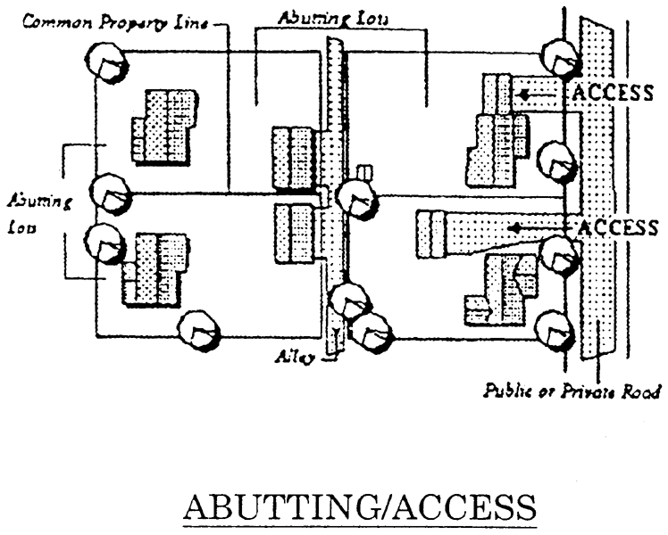
Abutting. Two (2) lots sharing the same or common property lines, including lots separated by an alley. See Figure 40.33.301.
Figure 40.33.301
Access. An area designated as a way for vehicles to enter or leave a property or lot to a public or private street or alley. Access is intended to permit residents to bring their vehicles onto the property, customers or tenants to park, and to provide for public access in emergencies. See Figure 40.33.301.
Access easement. That portion of a lot used for ingress/egress to an abutting lot and shown on a record plan by a recorded easement declaration. In no case shall a street right-of-way be construed to mean an easement.
Accessory building or structure. A building or structure detached from a principal building located on the same lot, and which is customarily incidental and subordinate to the principal use or building.
Accessory use. A use of land or a building, or portion thereof, customarily incidental and subordinate to the principal use or building, and located on the same lot with such principal use or building.
Active recreation. Recreational uses, areas, and activities oriented toward potential competition and involving special equipment. Playgrounds, sports fields and courts, swimming pools, picnic areas and golf courses are examples of active recreation uses. Also see Passive recreation.
Active stormwater infiltration practices. Designed, constructed and maintained stormwater practices that manages stormwater runoff by promoting infiltration into the ground.
Addition. Any construction which adds or enlarges the size of an existing building. Additions also include any extension or increase in floor area, or height of a building or structure. Examples of an addition are: a porch, carport, new room, roof configuration, etc. Also see Conversion, Building or Use and Structural alteration.
Afforestation. The establishment of forest cover on areas that are not presently forested, or where forest cover is below the afforestation threshold for the use.
Agricultural land management practices. Those methods and procedures generally accepted by the conservation districts and used in the cultivation of land in order to further crop and livestock production and conservation of related soil and water resources.
Alley. See Street, service.
Alter or alteration. A change in the appearance of a building, structure, site, or object, which is not otherwise covered by the definition of demolition, or any other change for which a permit is required pursuant to this Chapter.
Alternative development options. Residential developments that were permitted under the former Code, including lot averaging, comprehensive residential developments (CRD), cluster developments, and patio-type options.
Ancillary uses. Uses subordinate to the principal use being conducted on a lot located either on the same lot as the proposed use(s) or on a separate lot, but which provide services convenient to the operation of the principal use.
Apartment. A dwelling unit located in a building containing at least one (1) other dwelling unit or a commercial use permitted in the zoning district. See Figure 40.04.111.
Appeal. A way to obtain review of a decision, determination, order, or act of an administrative agency pursuant to the terms of this Chapter.
Applicant. A person, firm or governmental agency who executes the necessary forms to obtain approval or a permit for any zoning, subdivision, land development, building, land disturbance, or other activity regulated by this Chapter.
Approval. Approval shall mean final approval given by a department, or when County Council action is required for final approval, approval shall mean the adoption of all necessary ordinances, resolutions or the signature of the President of County Council when no ordinance or resolution is required.
Approved segment. A portion of a subdivision street for which a developer has posted a bond, letter of credit, or other surety with DelDOT or the County to ensure completion of specified public or private street improvements.
Aquifer. A body of rock (crystalline, sand or gravel) that contains sufficient saturated permeable material to conduct groundwater springs or to yield economically significant quantities of groundwater to wells.
Arborist. A person possessing a bachelors degree in arboriculture from a college or university who is certified through the International Society of Arboriculture with documented experience in mid-Atlantic states.
Arterial street. See Street, arterial.
As-built plans or record documents. A set of engineering or site drawings that delineate the lot lines, roads, water, sewer, other utilities, and stormwater management facility as actually constructed.
Atrium house. An attached, one (1) story dwelling unit with private individual access for a single family. Each unit shall have a private yard called an atrium. The entire lot area of atrium and house shall be enclosed by a wall. All living spaces (that is, living rooms, dens or bedrooms) shall face an atrium. An atrium house is permitted only in planned developments as provided in Articles 3 and 4. See Figure 40.04.111.
Attic. The area between roof framing and the ceiling of the rooms below, and that is not habitable, but may be reached by ladder and used for storage or mechanical equipment. Improvement to habitable status shall make it a story.
Average gross residential density (DPUD's only). The number of dwelling units per acre in a DPUD, computed by dividing the number of dwelling units which the developer proposes to construct by the number of acres in the development which are not planned to be devoted to commercial or industrial use.
Awning. A structure partially attached or entirely supported by a wall, and which is covered by canvas, cloth, plastic, other similar material, used as a protective cover for a door, entrance, window, walkway, or service area.
Base flood. The flood having a one percent chance of being equaled or exceeded in any given year; the base flood is also referred to as the one hundred (100) year flood or the one percent annual chance flood).
Base flood discharge. The volume of water resulting from a Base Flood as it passes a given location within a given time, usually expressed in cubic feet per second (cfs).
Base flood elevation. The elevation of the base flood, including wave height, relative to the National Geodetic Vertical Datum (NGVD), North American Vertical Datum (NAVD) or other datum specified on the community's flood insurance rate map.
Basement. Any area of the building having its floor subgrade (below ground level) on all sides. This also includes crawlspace areas.
Base site area. A calculated area obtained by subtracting various land areas from the gross site area. See Table 40.05.420.
Benchmark. A definite point of known elevation and location, and of more or less permanent character. The identity and elevation shall be based on NAD 1927/NGVD 1929 or NAD 1983/NGVD 1988.
Best management practices. That combination of conservation measures, structures, vegetation or management practices, that reduces or avoids adverse impacts of development on adjoining site's land, water, or waterways and water bodies.
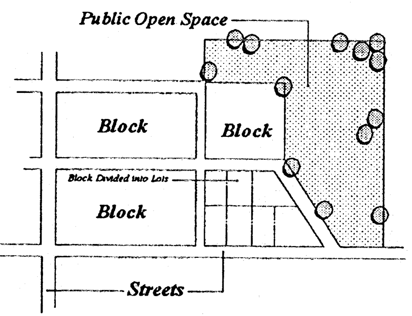
Block. A piece of land surrounded on all sides by streets or other transportation rights-of-way, or by physical barriers such as water bodies or public open spaces. Blocks are normally divided into lots. See Figure 40.33.302.
Figure 40.33.302
Brownfield. Any vacant, abandoned or underutilized real property the development or redevelopment of which may be hindered by the reasonably held belief that the real property may be environmentally contaminated and as defined under 7 Del. C. Ch. 91 (Hazardous Substance Cleanup Act). An applicant shall submit documentation from DNREC identifying and confirming the Brownfield site prior to any review.
Buffer. A designated area between two (2) uses deemed incompatible with each other, or along the perimeter of a natural feature to be protected from an incompatible use, or along the perimeter of that use, which will absorb or otherwise preclude such incompatibility by some combination of construction design, vegetative plantings, fences and/or maintenance practices which shall be permanently maintained.
Buffer, riparian. See Riparian buffer area.
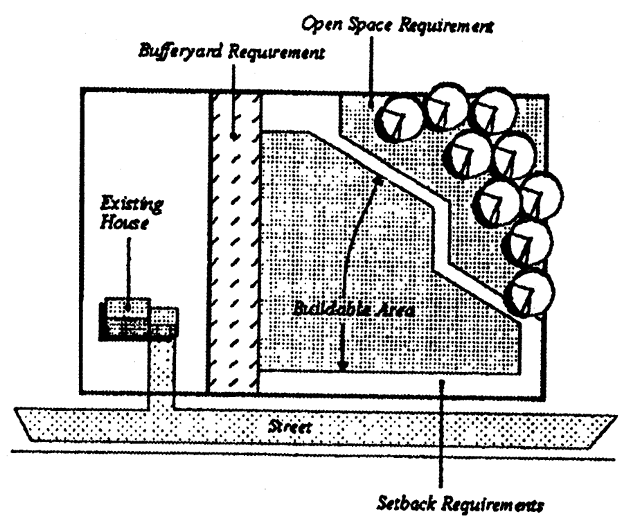
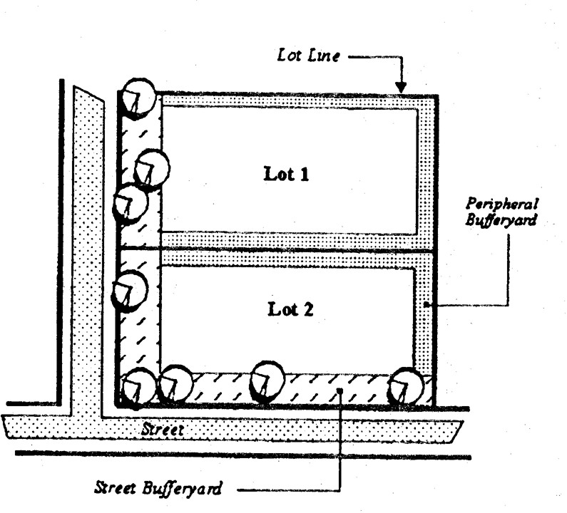
Bufferyard. A strip of land on the periphery of a property created to separate one (1) type of land use or zoning district from another when they are incompatible or in conflict. Bufferyards include street bufferyards that protect the use from road related nuisances or screen undesirable uses. See Figure 40.33.303.
Buildable area. The space remaining on a lot after the minimum open space or landscape surface requirements, bufferyards and setbacks have been met. See Figure 40.33.304 and Net buildable site area.
Figure 40.33.304
Building. A structure built on a lot, having a roof, and intended to shelter people, animals, property or business activity. Any structure used or intended to be used for supporting or sheltering any use or occupancy. The word "building" shall be construed as if followed by the words "or part or parts thereof and all equipment therein."
Building code. The family of International Codes published by the International Code Council as amended and adopted by New Castle County. The building code that applies to one- and two-family dwellings and their accessory structures is referred to as the "residential code". The building code that applies to all other buildings and their accessory structures is referred to as the "building code."
Building front. That exterior wall of a building which faces the front lot line.
Building height. See Height, building.
Building line. That line formed by the rear, side, and street setbacks. Also see Buildable area.
Building Official. General Manager of the Land Use Department or his or her designee.
Build-to line. The building setback where the structure is required to be constructed.
Figure 40.33.303
Bulk regulations. Controls which establish the maximum size, height, and setback of a building on its lot. See Table 40.04.110.
Bulletin board. See Sign, bulletin board.
C&D Canal. Shall mean the Chesapeake and Delaware Canal.
Caliper. The diameter of new landscape plantings measured six (6) inches above ground.
Canopy. The uppermost layer in a forest, formed from a crown of trees.
Canopy tree. See Tree, canopy.
Capital improvements program (CIP). The capital improvements program approved by the New Castle County Council or DelDOT, the first year of which is termed the capital budget.
Capital Transportation Program (CTP). The statewide program for transportation programs and projects prepared in accordance with 29 Del. C. § 8419, as may be amended from time to time.
Certificate of adequate community facilities. A statement signed by the person designated in Article 5.
Certificate of occupancy. A statement signed by the Department setting forth that a building, structure or use legally complies with this Chapter and Chapter 6 and that the building, structure or use may be used for the purposes stated herein.
Certification of ownership. A statement bearing the signature of the owner of the subdivision or land development stating that all dedications are offered to the County, State, or private utilities.
Certified construction reviewer. Those individuals, having passed a DNREC sponsored or approved training course, who provide on-site inspection for sediment control and stormwater management in accordance with these regulations.
Clean fill. A nondecomposable, environmentally inert solid, such as rock, soil, gravel.
Clearcutting. The practice of wholesale, complete removal of all trees, disturbing shrubs, or other vegetation in the process. This definition does not include the selective removal of trees on a building pad or normal maintenance of vegetation.
Closed channel. A conveyance system not open to the atmosphere (usually, but not always, pipe).
Coastal high hazard area or special flood hazard area subject to high velocity wave action. An area of special flood hazard extending from offshore to the inland limit of a primary frontal dune along an open coast and any other area subject to high velocity wave action from storms. Coastal high hazard areas also are referred to as "Zone V" or "V Zones" and are designated on FIRM's as flood insurance risk Zone VE.
Cockeysville Formation. The Cockeysville Formation water resource protection area shall be those areas which are directly underlain by the Cockeysville Formation as depicted on the Three Map series "Water Resource Protection Areas for the City of Newark, City of Wilmington, New Castle County, Delaware," prepared by the Water Resources Agency for the County that is dated 1993, or as amended.
The locations of the Cockeysville Formation were obtained from plate 1 of a report prepared by the Delaware Geological Survey in 1991 titled "Summary Report, Geology and Hydrology of the Cockeysville Formation, New Castle County, Delaware."
Cockeysville Formation drainage area. The Cockeysville Formation drainage area shall be those land surface areas which drain to the areas underlain by the Cockeysville Formation as depicted on the Three Map series "Water Resource Protection Areas for the City of Newark, City of Wilmington, New Castle County, Delaware," prepared by the Water Resources Agency for the County that is dated 1993, or as amended. Areas draining to and across the Cockeysville Formation were derived from the U.S. Geological Survey 7.5 minute topographic quadrangle maps.
Collector street. See Street, collector.
Collector, residential. See Street, residential collector.
Commencement of construction. Commencement of construction means that a building permit or other written permit required to be issued by the Department has been issued and work commenced under such permit which is recognizable upon an inspection of the property and which work is of a nature and character that reflects a good faith intention to continue the work until completion, such as the clearing of rights-of-way, rough-grading of the roadway, the installation of a drainage system or stormwater management facilities, and the placement and active maintenance of erosion and sediment control measures.
Common facilities. Common facilities shall mean and refer to any area on a record plan dedicated as private open space, stormwater management area, recharge or infiltration system, park, active recreation facility, common parking area, sidewalk not located in a DelDOT right-of-way, street not dedicated for public use, and landscaping, easement, fence or any other item if specifically defined as a common facility on the record plan or in the maintenance declaration.
Common land. That land set aside for open space, including stormwater retention lakes, ponds or recreational use areas for the owners of lots in a subdivision, which land is conveyed in trust for the benefit, use and enjoyment of the lot owners.
Community facilities. Facilities and services required to serve new development, including but not limited to:
A.
Roads, streets, highways, bridges and public transportation facilities;
B.
Water supply production, treatment and distribution facilities;
C.
Sewage collection, treatment and disposal facilities;
D.
Drainage facilities;
E.
Parks, open space and recreation facilities;
F.
Public primary and secondary schools;
G.
Police protection services;
H.
Fire and paramedic services;
I.
Libraries.
Comprehensive amendment. Any map amendment affecting all land in a district, or any change in a map affecting more than one hundred (100) property units.
Comprehensive rezoning. A County-initiated rezoning intended to guide and control future growth consistent with the spirit and intent of the Comprehensive Development Plan as provided by State law.
Condominium. A multi-family dwelling, or single-family detached or attached dwelling, governed by the Unit Property Act, 25 Del. C. § 22.
Conservation. The planned management of a natural feature to prevent its exploitation, destruction, or neglect.
Conservation design. A series of holistic land development design goals that maximize protection of key land and environmental resources, preserve significant concentrations of open space and greenways, evaluate and maintain site hydrology, and ensure flexibility in development design to meet community needs for complimentary and aesthetically pleasing development. Conservation design encompasses the following objectives: conservation/enhancement of natural resources, wildlife habitat, biodiversity corridors, and greenways (interconnected open space); minimization of environmental impact resulting from a change in land use (minimum disturbance, minimum maintenance); maintenance of a balanced water budget by making use of site characteristics and infiltration; incorporation of unique natural, scenic and historic site features into the configuration of the development; preservation of the integral characteristics of the site as viewed from adjoining roads; and reduction in maintenance required for stormwater management practices. Such objectives can be met on a site through an integrated development process that respects natural site conditions and attempts, to the maximum extent possible, to replicate or improve the natural hydrology of a site.
Conservation easement. A portion of a lot that is covered by an easement, running in favor of the County, or a nonprofit agency providing that such land shall be left in a natural state or open space access easement. The area of the lot, exclusive of the easement, shall meet the minimum lot area requirements of Article 4.
Construct or construction. The erection of a new building, structure, or object upon a site.
Constructed wetland. A low-lying, basin-like structure, artificially created by dredging, damming, or leveeing of earth for the retention of water, and the establishment of a hydrophytic vegetative community.
Construction buffer. A specific separation distance that serves to absorb the impact of land disturbing activities and protect a designated resource area.
Contiguous. Land that abuts other land, or lands that are separated only by streets, ways, pipelines, electric power lines, conduits or rights-of-way, owned in fee or less than fee, by third parties.
Contributing building, structure, site or object. A building, structure, site, or object within a historic district that reflects the historical or architectural character of the district.
Conversion, building or use. The process by which the original use of a building or land is changed to a different use. See also Addition and Structural alteration.
Cooperative. Multi-family dwellings or single-family group dwellings in which there is sold or offered for sale:
A.
An interest in the entity owning the building; and
B.
A lease to occupy a particular dwelling unit within the building.
Corridor. The road or highway right-of-way and the adjacent area that is visible from and extending along the road or highway. The distance the corridor extends from the road or highway could vary with the different intrinsic qualities as evaluated by the Department.
Corridor Management Plan (CMP). A document that specifies the practices and strategies to maintain the archaeological, cultural, historic, natural, recreational and scenic qualities that support a byway's designation. A CMP is developed with community involvement, provides for the conservation and enhancement of the byway's intrinsic qualities as well as the promotion of tourism and other economic development, and provides an effective management strategy to balance these concerns while providing for the users' enjoyment of the byway. The document should be generally consistent with the State of Delaware standards for such plans.
Critical natural area (CNA). Any site listed in the State natural areas inventory, as administered by the State Office of Nature Preserves, Division of Parks and Recreation, of the DNREC.
Critical natural areas report. A report analyzing the impact of a development or subdivision proposal on a CNA located on the site which shall include the following elements:
A.
A statement that the entire lot or parcel is included in the critical natural areas investigation or, with the approval of the Department, a description of a smaller area which is subject to the critical natural areas investigation;
B.
A scaled plan of the site accurately depicting critical natural area boundaries. The CNA boundary lines shall be identified with a metes and bounds description prepared by and bearing the seal of a professional land surveyor registered in the State, or a professional engineer with a background in civil engineering registered in the State. Where many survey traverses are necessary to accurately describe the CNA boundary, the developer may have the surveyor or engineer identify and prepare a metes and bounds description for the smallest polygon that contains all the critical natural areas identified on the site. In such instances, however, the limits of the polygon will be considered the CNA boundaries for plan review purposes;
C.
A narrative description of the extent to which the applicant proposes land disturbing activities within any critical natural areas which are shown on the scaled plan; and
D.
Any measures that will be taken to minimize or mitigate the disturbance of critical natural areas.
Critical Root Zone (CRZ). The protected area around the base of a tree.
A.
The CRZ is the zone in which the majority of a tree's roots are found that supply nutrients and water to the tree. In ideal growing conditions, a tree's roots are often concentrated in the upper twelve (12) to eighteen (18) inches of soil.
B.
To determine the CRZ utilize one (1) of two (2) methods: The CRZ is delineated by the greater of either:
1.
The outer drip line of the tree canopy; or
2.
The tree diameter at breast height (DBH), then multiply the diameter by a standard factor of one and one-half (1.5) feet. For example, an 18-inch diameter tree would have a CRZ of twenty-seven (27) feet (eighteen (18) inches x one and one-half (1.5) feet) measured radially from the center of the tree trunk.
Cutoff. The point at which all light rays emitted by a lamp, light source, or luminaire are intercepted by a shield preventing their continuation. For signs, the term "cutoff" simply refers to the use of shields to direct the light so light rays shine exclusively on the sign.
Cutoff angle of a luminaire. The angle of an outdoor light fixture or luminaire, measured up from the nadir (i.e., straight down), between the vertical axis and the first line of sight at which the bare source (the bulb or lamp) is not visible.
Cutoff fixture. An outdoor lighting fixture or luminaire with intensity at or above ninety (90) degrees (horizontal), where no more than two and one-half (2.5) percent of the luminaire's light intensity is emitted at or above horizontal, and no more than ten (10) percent of the luminaire's light intensity is emitted at or above eighty (80) degrees. See Figure 40.22.720.
Day-night level (DNL). A measure of noise that is an outdoor, day-night average A-weighted sound level.
Days. Working days.
Dedication. The transfer of private property to public or common ownership for a public purpose. The transfer may be in fee simple interest, or less than fee simple interest, including easements. Dedication requires the acceptance of the interest to be complete.
Demolish. Demolition or demolish means the razing or destruction, whether entirely or in significant part, of a building, structure, site, or object. Demolition includes the removal of a building, structure, or object from its site, the removal or destruction of the facade or surface, or the alteration to such an extent that repair is not feasible or is so costly so as to be prohibitive, rendering the property unfit for use. Demolition shall also include demolition by neglect as defined in this Chapter.
Demolition by neglect. The failure to provide ordinary and necessary maintenance and repair to a building, structure or object located in a historic district or meeting the criteria to be included in a historic district. Whether by ordinary negligence or willful neglect, purpose or design, by owner or any party in possession thereof, which results in any of the following conditions:
A.
The deterioration of the exterior features so as to create or permit a hazardous or unsafe condition to exist.
B.
The deterioration of exterior walls, roofs, chimney, windows, the lack of adequate waterproofing, or deterioration of interior features or foundations which will or could result in permanent damage or loss of exterior features.
Density. The number of dwelling units per unit of land. Figure 40.33.305.
Figure 40.33.305
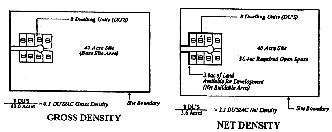
Density, gross, (GD). The number of dwelling units per unit of base site area, Figure 40.33.306.
Density, net, (ND). The number of dwelling units per unit of net buildable area of the site, Figure 40.33.306.
Figure 40.33.306
_____
Design storm frequencies. Time interval in years at which a storm occurrence has a chance to exceed or equal the storm of specific duration and intensity used in design of drainage facilities.
Designated byway. A right-of-way having special scenic, historic, recreational, cultural, archeological, or natural qualities that is recognized as a byway by the Federal Government, State of Delaware, or County. The designated byways are:
1.
The Brandywine Valley National Scenic Byway;
2.
The Red Clay Valley Scenic Byway;
3.
Harriet Tubman Underground Railroad Byway; and
4.
Delaware Bayshore Byway.
Designated watershed. A watershed for which a comprehensive stormwater management plan has been approved, the requirements of which any proposed development within that watershed must conform to.
Detention/retention basin. A natural or manmade structure designed as a temporary holding basin for water. Water may be detained to minimize flooding downstream, or retained to increase aquifer recharge.
Developable land. All land within the boundaries of any tract proposed for development except for land which is located within the existing rights-of-way of any public or private road or any overhead utility line, floodplains, including land continuously covered with water, wetlands and prohibitive steep slopes.
Developed areas. Areas delineated on the Comprehensive Development Plan concept map or overlay maps amending the concept map.
Developer. A person seeking to build or develop as defined in this Chapter.
Development. Any manmade change to improved or unimproved real estate, including but not limited to buildings or other structures, placement of manufactured homes, mining, dredging, filling, grading, paving, excavation or drilling operations or storage of equipment or materials. Also includes any action covered by Section 40.01.110.
Development Coordination Manual. The DelDOT regulations for the planning, design, construction, and acceptance of subdivision streets and access to State-maintained roadways, codified at 2 DE Admin. Code 2309, as amended.
Diameter at breast height (DBH). A measurement of the size of tree equal to the diameter of its trunk measured four and one-half (4.5) feet above the adjacent natural grade. See also Caliper.
Disposal field. A system of open jointed or perforated pipes laid in the upper strata of the soil to distribute sewage effluent into the soil for absorption and vaporization.
Diversified planned unit development (DPUD). A planned development which contains open space and which may contain one (1) or more types of residential, commercial, industrial, and institutional uses approved by County Council.
Domestic animals. An animal that is tame or domesticated and that is not normally found in the wild state. Hybrids of animals normally found in the wild state are not included within the meaning of domestic animal.
Dormitory. A building with many rooms providing sleeping and living accommodations for a number of usually unrelated persons; usually associated with an educational institution. See Section 40.33.230F.
Drainage. The process by which surface water (usually from rainfall) moves across the land surface. See Stormwater management.
Drainage areas. The delineated areas that currently contribute or are proposed to contribute runoff to a specific location or point.
Drainage facility. Any system of artificially constructed drains, including open channels and separate stormwater sewers, used to convey stormwater, surface water, or groundwater, either continuously or intermittently, to natural watercourses.
Drainageway. A minor watercourse (not in an RBA), seasonally or continually available for the passage of water, of which functions include, but are not limited to: flood control, groundwater recharge, drainage, and sedimentation and erosion control. The presence of a drainageway is determined by one (1) or more of the following two (2) conditions: (i) the presence of certain specific soil types, (such as Codorus silt loam (Co), Comus silt loam (Cu), Hatboro silt loam (Ha), Johnston loam (Jo), or Mixed alluvial land (Mv)); (ii) the land on either side of and within twenty-five (25) feet of the centerline of any swale, intermittent or perennial stream shown on the National Hydrographic Dataset (NHD) utilized by the United States Geological Survey as having an upstream drainage area of five (5) or more acres.
Drip line. A generally circular line, the circumference of which is determined by the outer reaches of a tree's widest branching points.
Driveway. A private accessway, primarily for vehicles, leading from a street to a parking or loading area.
Dry floodproofing. A combination of measures which results in structures including attendant utilities and equipment, being watertight with all elements substantially impermeable and with structural components having capacity to resist flood loads.
Dry waste. Includes clean fill, plastics, lumber, trees, stumps, vegetative matter, asphalt pavement, asphaltic products incidental to construction/demolition debris, or other materials which have reduced potential for environmental degradation and leachate production.
Duplex. A single-family detached dwelling with no more than two (2) units per structure, located one over the other. This includes two (2) family dwellings.
Dwelling. A building, or portion thereof, used as a place of residence, containing sleeping, cooking, and sanitary facilities, excluding commercial lodging facilities.
Dwelling, attached. A single-family dwelling that is attached to or shares a common vertical wall with one (1) or more other dwellings.
Dwelling, multiple-family. A building containing three (3) or more dwelling units typically located one over the other and including garden and high rise apartment buildings.
Dwelling, quadraplex. Four (4) attached dwellings in which each unit has at least two (2) open space exposures and shares one (1) or two (2) vertical walls with adjoining units and where no more that two (2) units may lack street frontage.
Dwelling, semi-detached (see Twin house).
Dwelling, single-family detached. A dwelling unit, including a manufactured home, designed for and occupied by not more than one (1) family and having no roof, wall or floor in common with any other dwelling unit.
A.
It has a minimum of seven hundred fifty (750) square feet of gross floor area.
B.
It has a minimum width along any exterior front, side and rear elevation of twenty (20) feet, exclusive of any garage area. If applicable, it must be multiple transportation sections at least ten (10) feet wide unless transportable in three (3) or more sections, in which case only one (1) section need be ten (10) feet wide.
C.
It is permanently mounted on a solid foundation or pier foundation system and anchored in accordance with Chapter 6.
D.
All wheels, axles, transportation lights and removable towing apparatus, if any, shall be removed from the dwelling when it is placed on the foundation in accordance with Subsection C.
E.
All utilities shall be permanently connected in accordance with the County plumbing and mechanical codes.
F.
It has a storage area either in a basement located beneath the living area, in an attic area, in a closet area, in an attached or detached garage or an enclosed structure constructed on a permanent foundation and having an area of at least one hundred sixty (160) square feet or any combination thereof. The total storage area must not be less than fifteen (15) percent of the gross floor area of the dwelling unit.
G.
It shall have a weather-resistant exterior covering material comparable in appearance, quality and durability to the materials used on the dwelling, such as brick, stone facing, treated lumber, masonry or masonry veneer, which shall extend to the ground.
H.
The siding of all dwellings shall be continuous so as to enclose any joining of two (2) or more sections.
I.
It complies with all other pertinent sections of the building and housing codes of the County, and the fire and health codes of the State.
Dwelling, small single-family detached. A one (1) or two (2) story dwelling unit, designed for and occupied by not more than one (1) family and having no roof, wall or floor in common with any other dwelling unit. The following applies:
A.
It has a minimum of four hundred (400) square feet of gross floor area and less than seven hundred fifty (750) square feet of gross floor area.
B.
It is of light-frame or masonry construction and permanently mounted on a solid foundation or pier foundation system in accordance with Chapter 6.
C.
All utilities must be permanently connected in accordance with the County plumbing and mechanical codes.
D.
The dwelling must have a weather-resistant exterior covering material comparable in appearance, quality and durability to brick, stone, treated lumber, masonry, or masonry veneer, which shall extend to the foundation.
E.
The siding of all dwellings must be continuous so as to enclose any joining of two (2) or more sections.
F.
It complies with all other pertinent sections of the building and housing codes of the County, and the fire and health codes of the State.
Dwelling unit. One (1) or more rooms physically arranged so as to create an independent housekeeping establishment for occupancy by one (1) family with separate facilities for all of the following: sanitation, living, sleeping, cooking and eating.
Easements. Any portion of a parcel subject to an agreement between the property owner and another party which grants the other party the right to make limited use of that portion of the property for a specified purpose. See Conservation easement.
Elderly. A person who meets the criteria set forth in the Federal Older Americans Act of 1965, as amended.
Elevation certificate. The National Flood Insurance Program, Elevation Certificate (FEMA Form 086-0-33), used to document building elevations and other information about buildings. When required to be certified, the form shall be completed by a licensed professional land surveyor.
Enclosure below the lowest floor. An unfinished or flood resistant enclosure usable solely for parking of vehicles, building access, or storage, in an area other than a basement.
Endorsement. The signature of the General Manager of the Department, and, where applicable, that of the President of the County Council, appended to the record plan to signify approval thereof.
Engineer. An individual technically and legally qualified to practice the profession of civil engineering and who is registered to do so in the State.
Environmental Impact Assessment Report. Any study, report or application required by this Chapter, such as critical natural areas, floodplains, riparian buffers, steep slopes, water resource protection areas and wetlands.
Erosion. The wearing away of soil or rock fragments by water, rain, wind or earth gravity.
Erosion-prone slopes. Slopes that consist of land with soils of United States Department of Agriculture Soil Conservation Service capability classifications IVe, VIe, VIs and VIIe as mapped by the soil survey of the County dated October 1970 or as later revised.
Essential access. An access that must cross a protected resource area, such as a wetland, floodplain or steep slope, to reach an area of the site that is otherwise buildable, and would result in damage to the protected resource.
Expire. When used in reference to a Subdivision/Land Development Plan, "expire" shall mean that a plan was not timely processed according to former Code provisions (e.g., Sections 32-95(a), 32-96(h)(2), 32-97, 32-152(c),(f)(2), and (g), as amended), or current Code provisions (e.g., Sections 40.01.120 and 40.31.390). Once a plan has expired, it is void and has no legal effect. Any subsequent submission must comply with the rules and regulations as they exist on the day of such submission.
Expressway. A limited access highway designed to carry regional traffic. All intersections shall be grade separated.
Exterior features. The architectural style, design and general arrangement of the exterior of a building, structure or object, including the color, nature and texture of building materials, and the type of style of all windows, doors, light fixtures, signs or other similar items found on or related to the exterior of a building, structure or object.
Exterior storage. Outdoor storage of fuel, raw materials, products, equipment and other materials accessory to the permitted nonresidential use. Exterior storage includes all building materials or waste or scrap materials stored outdoors. Truck trailers held on the site for more than one (1) night storing materials or awaiting pickup shall be considered exterior storage. In the case of truck terminals, exterior storage includes all trucks, truck beds and truck trailers that are not involved in active loading.
Facade. One (1) exterior side of a building.
Family. Any number of individuals legally related through blood, marriage, adoption or guardianship, including individuals placed for foster care by an authorized agency, or up to four (4) unrelated individuals living and cooking together and functioning as a single housekeeping unit using certain rooms and housekeeping facilities in common.
Farm. The land, buildings, structures and machinery which are primarily adapted and used for agricultural purposes.
Fascia. A band located at the top edge of a building but below the actual roofline and above the building wall. Fascia material is often of a different type than either the actual roof or the building wall.
Federal Emergency Management Agency (FEMA). The federal agency with the overall responsibility for administering the National Flood Insurance Program.
FEMA Technical Bulletin. A series of guidance documents published by FEMA to provide guidance concerning building performance standards of the National Flood Insurance Program. See sections where specific technical bulletin are identified.
Fence. Constructed barrier erected to enclose, screen, or separate areas and may include masonry walls designed and constructed for these purposes.
Filling. Inclusive of structures in Section 40.10.312, the depositing on land, whether submerged or not, of sand, gravel, earth or other materials. Biodegradable materials and other materials subject to decomposition or significant settling (such as garbage and other organic matter) shall not be considered filling.
Flag lot. A tract of land having insufficient lot width along a road or at the minimum setback line to meet Article 4 requirements but with sufficient area to meet all lot requirements further back on the lot. See Figure 40.33.307.
Figure 40.33.307
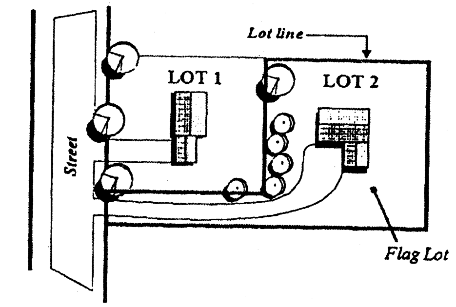
Flood or flooding. A general and temporary condition of partial or complete inundation of normally dry land areas from:
A.
The overflow of inland or tidal waters, and/or
B.
The unusual and rapid accumulation or runoff of surface waters from any source.
Flood damage-resistant materials. Any construction material capable of withstanding direct and prolonged contact with floodwaters without sustaining any damage that requires more than cosmetic repair. See FEMA Technical Bulletin #2 - Flood Damage Resistant Materials Requirements and FEMA Technical Bulletin #8 - Corrosion Protection for Metal Connectors in Coastal Areas.
Flood fringe. Those portions of the Zone AE floodplain, outside the floodway, subject to inundation by the one hundred (100) year recurrence interval flood or base flood and generally associated with standing or slowly moving water, rather than rapidly flowing water.
Flood insurance rate maps (FIRM). An official map on which the Federal Emergency Management Agency has delineated special flood hazard areas to indicate the magnitude and nature of flood hazards, and to designate applicable flood zones.
Zone A: Special flood hazard areas inundated by the one percent annual chance flood; base flood elevations are not determined.
Zone AE: Special flood hazard areas subject to inundation by the one percent annual chance flood; base flood elevations are determined; floodways may or may not be determined.
Zone AO: Areas of shallow flooding, with or without a designated average flood depth.
Zone X (shaded): Areas subject to inundation by the five hundred (500) year flood (two-tenths (0.2) percent annual chance); areas subject to the one percent annual chance flood with average depths of less than one foot or with contributing drainage area less than one square mile; and areas protected by levees from the base flood.
Zone X (unshaded): Areas determined to be outside the one percent annual chance flood and outside the five hundred (500) year floodplain.
Zone VE: Special flood hazard areas subject to inundation by the one percent annual chance flood and subject to high velocity wave action (also referred to as coastal high hazard areas).
Limit of moderate wave action (LiMWA): The inland limit of the area affected by waves greater than one and one-half (1.5) feet during the base flood. Base flood conditions between the Zone VE and the LiMWA will be similar to, but less severe than, those in the Zone VE.
Flood insurance study. The official report provided by Federal Emergency Management Agency (FEMA) containing the flood insurance rate map (FIRM), the flood boundary and floodway map (FBFM), the water surface elevations of the base flood and supporting technical data.
Floodplain. Any land area susceptible to being inundated by water from any source (see "Flood" or "Flooding". Also referred to as special flood hazard area.
Floodproofing certificate. The National Flood Insurance Program, Floodproofing Certificate for Non-Residential Structure's (FEMA Form 86-0-34), used by registered professional engineers and architects to certify dry floodproofing designs.
Floodway. The channel of a river or other watercourse and the adjacent land areas that must be reserved in order to pass the base flood discharge such that the cumulative increase in the water surface elevation of the base flood discharge is not more than a designated height.
Floor area, gross. See Gross floor area.
Floor area ratio (FAR). A measure of the allowable size of floor area on a lot compared to the size of the lot. FAR gives developers flexibility in deciding whether to construct a low building covering most of the lot or a tall building covering only a small part of the lot, as long as the total allowable floor area coverage is not exceeded. See Figure 40.33.308.
Figure 40.33.308
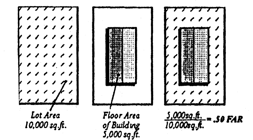
Floor area ratio, gross (GFAR). The total floor area of a building or structure divided by the base site area.
Floor area ratio, net (NFAR). The total floor area (FA) of a building or structure divided by the net buildable site area (BSA). See Figure 40.33.309.
Figure 40.33.309
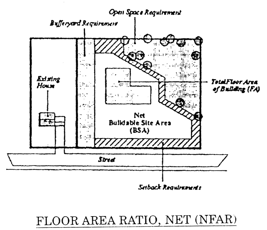
Footcandle. A unit measuring the amount of illumination produced on a surface. One (1) footcandle is the amount of illumination falling on all points which are one (1) foot from a uniform point source of one (1) candle.
Forest. An area covered by a canopy of trees, covering a contiguous land area of at least one (1.0) acre or greater in size. Forests do not include trees planted and grown for commercial purposes, and do not include canopy cover over existing structures.
Forest cover. Is the total area of a site under the cover of an existing stand of trees or new stand of trees (reforestation or afforestation), meeting the minimum requirement of forest to be preserved and maintained.
Forest habitat value assessment. A method or process for determining the area or areas within a forest that contain high habitat value.
Forest interior. Habitat of high ecological value within the core of the forest located at least three hundred (300) feet from the forest edge.
Forest management practices. That combination of generally accepted methods for preserving, promoting and protecting silviculture, which may include selective cutting, burning and removal of trees.
Forest protection level.
Tier 1: A forested area or areas with the highest habitat value based on the forest habitat value assessment and a numerical point system. A Tier 1 protection level has fifty-two (52) or greater habitat value points.
Tier 2: A forested area or areas that has between twenty-six (26) and fifty-one (51) habitat value points.
Tier 3: A forested area or areas that has between one (1) and twenty-five (25) habitat value points.
Forester. A person possessing a bachelors degree in forestry from a college or university accredited by the Society of American Foresters or licensed in mid-Atlantic states maintaining licensing programs.
Former Code. The New Castle County Code and Comprehensive Development Plan Update in existence as of December 31, 1997, prior to the adoption of this Chapter and prior to any Comprehensive Development Plan Update amendments adopted by County Council on December 31, 1997.
Former zoning district. All New Castle County zoning districts (zoning designations) in existence as of December 31, 1997, prior to the adoption of this Chapter.
Freeboard. A factor of safety usually expressed in feet above a flood elevation for the purposes of floodplain management. Freeboard tends to compensate for the many unknown factors that could contribute to flood heights greater than the height calculated for a selected size flood and floodway conditions. Such as wave action, obstructed bridge openings, debris and ice jams, and the hydrologic effect of urbanization in a watershed.
Front lot line. See Lot line.
Functional classification of streets. See Street functional classification.
Functionally dependent use. A use which cannot perform its intended purpose unless it is located or carried out in close proximity to water; the term includes only docking facilities, port facilities that are necessary for the loading and unloading of cargo or passengers, and ship building and ship repair facilities, but does not include long-term storage or related manufacturing facilities.
Garage, private. A garage accessory to a principal building and in which no business, service or industry is conducted.
Garage, public. A garage available to the public for free or fee.
Garden apartments. See Apartment.
Geologist. An individual technically and legally qualified to practice the profession of geology and who is registered to do so in the State of Delaware.
Governmental body. Any federal, State or local government including the departments, agencies, commissions and instrumentalities thereof.
Governmental parkland. Land that is owned, developed, or controlled by Municipal, County, State, and Federal governments for outdoor passive or active recreational uses excluding open space recorded on a plan as a development's open space.
Grade. The natural level of the ground adjoining the object whose height is to be measured. Where grade refers to a street or road, it is the existing grade at that point.
Grading. The excavating, filling (including hydraulic fill) or stockpiling of earth materials, or any combination thereof, including the land in its excavated or filled condition.
Green technology stormwater best management practices (GTBMP's). GTBMP's achieve stormwater management objectives by applying the principles of filtration, infiltration and storage most often associated with natural vegetation and undisturbed soils. Green technologies stormwater GTBMP's may also be constructed using an imported soil medium and planted vegetation designed to promote the natural hydrologic process. These GTBMP's include vegetative filtration, riparian buffer plantings, bio-retention areas, vegetative flow conveyance, as well as recharge and surface storage in undisturbed natural areas.
Greenway. A linked system of open spaces, parklands, historic and cultural sites, wildlife management areas and natural preserves. Connecting corridors between such resources generally will be linear in nature and can include such features as natural areas, hiking trails, bike paths, city sidewalks, stream corridors, rivers, abandoned railroad rights-of-way, or scenic roads.
Gross area. The total land and water surface area contained within the boundaries of a lot or tract.
Gross floor area (GFA). The sum of the total horizontal areas of every floor of every building on a lot. The measurement of gross floor area shall be computed by applying the following criteria:
A.
The horizontal square footage is measured from the outside face of all exterior walls.
B.
Cellars, basements, penthouses, attics, enclosed storage or mechanical areas, mezzanines and similar structures shall be included as GFA wherever at least five (5) feet are provided between the finished floor and the ceiling.
C.
Except for upper floor spaces in open atriums, no deduction shall apply for horizontal areas void of actual floor space, for example, elevator shafts and stairwells.
D.
Parking structures and parking areas shall not count toward GFA except for the purpose of calculating the processing fee for such structure as delineated in Appendix 2 of this Chapter.
E.
Unheated structures or buildings, not fully enclosed whether temporary or permanent and exposed to the elements through the absence of walls on at least twenty-five (25) percent of its perimeter shall not be counted as GFA.
Groundwater. A portion of the subsurface water that occurs beneath the water table in soils and geologic formations that are fully saturated.
Hazardous substance. Any substance as found in 40 CFR 116, Designation of Hazardous Substances.
Height, building. The maximum height of a building permitted on a lot. Building height is determined from the vertical distance as measured from the average level of the finished grade adjacent to each exterior wall of the building to the highest point of the building, excluding chimneys and antenna. See Section 40.04.110.
Highest adjacent grade. The highest natural elevation of the ground surface prior to construction next to the proposed walls of a structure.
Highway. Any road thoroughfare, street, boulevard, lane, court, trailway, right-of-way or easement used for, or laid out and intended for, public passage of vehicles or persons.
Historic district. A district possessing a significant concentration, linkage, or continuity of sites, buildings, structures, or objects united historically or aesthetically by plan or physical development.
Historic object. The term "object" is used to identify those resources that are primarily artistic in nature or are relatively small in scale and simply constructed. Although it may be, by nature or design, movable, an object is associated with a specific setting or environment.
Historic renovation. The treatment of an historic resource through rehabilitation, restoration, or reconstruction as defined by the Secretary of the Interior's Standards for the Treatment of Historic Properties.
Historic resource. Any building, structure, object, site or historic district that is important historically, architecturally or archaeologically in the history of the County, the State or the nation. These may be determined by the following criteria:
A.
Listed in or determined to be eligible for the National Register of Historic Places as provided in the National Historic Preservation Act of 1966, 16 U.S.C. 470. Historic resources may be listed individually or as part of a district.
B.
Designated or determined to be eligible for designation as an Historic overlay zoning district according to the provisions of this Chapter.
Historic site. The location of a significant event, a prehistoric or historic occupation or activity, of a building or structure, whether standing, ruined or vanished, where the location itself maintains historical, cultural or archaeological value regardless of the value of any existing structure. Four (4) types of sites are regulated. See Section 40.15.111.
Historic structure. The term "structure" is used to identify buildings and other man-made features designed and constructed for purposes other than human habitation, such as silos, water towers, gazebos, bandstands, grain elevators, kilns, stone walls, and windmills. Man-made alterations to the landscape such as canals, dams, earthworks, water control systems, irrigation systems, drainage ditches, marsh dikes and breakwaters may also be considered historic structures.
Home buyer. Home buyer shall mean and refer to any person whose intent is to accept a deed to a lot or dwelling unit.
Home occupation. See Section 40.33.221B.
Homeowner. Homeowner shall mean and refer to those individuals who accept a deed to a lot or dwelling unit.
Hotel. See Section 40.33.240D.
Housing trust fund. A fund into which contributions collected pursuant to this Chapter shall be deposited and from which monies shall be expended to construct, purchase and maintain permanently affordable units and to administer programs consistent with the purposes of this Chapter.
Hydraulically critical areas. Locations where the design high water level may exceed the top of bank, or overtop a catch basin or facility, causing flooding conditions.
Hydric soils. Soils which in their natural, undrained state are wet frequently enough at or near the surface to periodically produce anaerobic conditions, thereby influencing plant species composition and/or growth.
Hydrophytic vegetation. Those plants which are adapted to life in saturated soil conditions.
Impervious surface ratio (ISR). The proportion of a development that is impervious surface. It is determined by dividing the area in impervious surface by the base site area.
Impervious surfaces. Areas that do not allow significant amounts of water to penetrate.
Infiltration. The passage or movement of water through the soil profile.
Intensity. The degree to which land is allowed to be used for development. See Density and Floor area ratio.
Intermittent stream. A channel with banks and a bed within which concentrated water flows some of the time.
Intrinsic quality. Scenic, natural, historic, cultural, recreational, or archeological features that are considered representative, unique, irreplaceable, or distinctly characteristic of an area.
Invasive plant species. Trees, woody plants, or herbaceous plants, alien to the Mid-Atlantic region, which have a tendency to spread, encroach, or infringe on other plant species, often displacing less hardy plant species. The list of invasive plant species is maintained by the Delaware Invasive Species Council (DISC).
Land development, major. See Major land development.
Land development, minor. See Minor land development.
Land disturbance. Changing the composition or character of the land or vegetation on the site. This includes cutting trees, clearing and grading operations, grading, excavation, removal or destruction of the ground cover. Disturbance includes the act of preparing a site for a building. The act of construction of a building or any portion of a building is not covered by the term "land disturbance" and would be regulated by the land uses category.
Land grading. See Grading.
Land, improved. Vacant land which has been provided with power, water, sewage, streets and sidewalks, and other infrastructure.
Landowner. Any person, firm, partnership, corporation, or other legal entity who possesses a legal interest in property.
Landscape architect. An individual registered by the State to practice the profession of landscape architecture.
Landscape plan. A plan indicating the placement of trees, shrubs, ground cover and affiliated structures and improvements, including specifications, species, quantities and installation as prepared by a Delaware-registered landscape architect.
Landscape surface area. Surface area of land not covered by any buildings, storage areas, or impervious surface. These areas shall be maintained as lawn or a natural area and may be left undisturbed. See Figure 40.33.311.
Figure 40.33.311
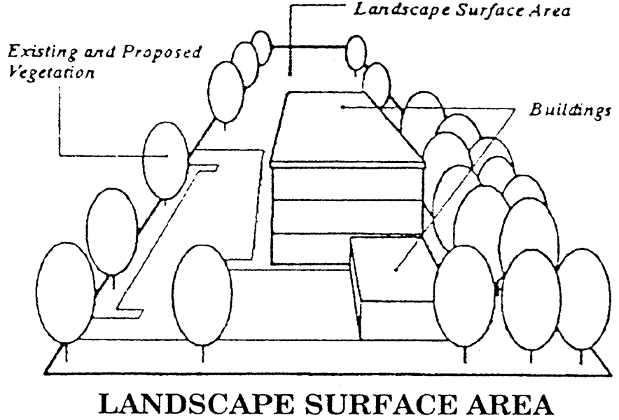
Landscape surface ratio (LSR). The area of landscaped surface divided by the base site area.
Landscaping. The design and installation of plant material such as lawns, groundcover, trees, bushes, etc., in formal, informal, or natural arrangements.
Land use application. Any building permit application, zoning permit application, subdivision or land development plan application, rezoning application, limited use application, special use application, variance application, appeals, or any other application made to the County which, if granted, would have the effect of permitting the development or use of land. A land use application shall also include an approved DNREC site evaluation.
Leachable wastes. Waste materials including, without limitation, solids, sewage sludge and agricultural residue which may release waterborne contaminants to the surrounding environment.
Leachate. Liquid that has passed through, contacted or emerged from dry waste and contains dissolved, suspended or miscible materials, chemicals and microbial waste products removed from the dry waste.
Lessee. Any person who leases all or a portion of a premises on a day-to-day, week-to-week or month-to-month basis.
Letter of map change. A letter of map change is an official FEMA determination, by letter, to amend or revise an effective flood insurance rate map, flood boundary and floodway map, and flood insurance study. letters of map change include:
Letter of Map Amendment (LOMA): An amendment based on technical data showing that a property was inadvertently included in a designated special flood hazard areas. A LOMA amends the current effective flood insurance rate map and establishes that a specific property is not located in a special flood hazard area.
Letter of Map Revision (LOMR): A revision based on technical data that may show changes to flood zones, flood elevation, floodplain and floodway delineation, and planimetric features. One common type of LOMR, a letter of map revision based on fill (LOMR-F), is a determination that a structure or parcel of land has been elevated by fill above the base flood elevation and is, therefore, no longer exposed to flooding associated with the base flood; in order to qualify for this determination, the fill must have been permitted and placed in accordance with these regulations.
Conditional Letter of Map Revision (CLOMR): A formal review and comment as to whether a proposed flood protection project complies with the minimum National Flood Insurance Program requirements for such projects with respect to delineation of special food hazard areas. A CLOMR does not amend or revise effective flood insurance rate maps, flood boundary and floodway maps, or flood insurance studies; upon submission to and approval of certified as-built documentation, a letter of map revision may be issued.
Level of service (LOS). A measure of traffic on a roadway segment or intersection being used during peak hours, as determined by the most current version of report 209, the Highway Capacity Manual, prepared by the National Research Council's Transportation Research Board. Level of service is expressed on a scale of "A" to "F" with "A" indicating the best level of service and "F" indicating the worst. The definitions of levels of service "A" through "F" shall be those contained in the references cited in this definition.
Limit of moderate wave action (LiMWA). An area of special flood hazard subject to moderate wave action of between one and one-half (1.5) to three (3) feet.
Loading space. A durably paved, properly designed for drainage, off-street space used for the loading and unloading of vehicles, except passenger vehicles in connection with the use of the property on which such space is located.
Local residential access street. See Street, local residential access.
Local street. See Street, local.
Lot. A parcel of land whose boundaries have been established by a legal instrument such as a recorded deed, court order or a recorded plot which is recognized as a separate legal unit for purposes of transfer of title.
Lot area. The area of a lot taken at its perimeter exclusive of any portion within a public or private street right-of-way.
Lot coverage. That portion of the lot area that is covered by buildings.
Lot, flag. See Flag lot.
Lot line. A property line dividing one (1) lot from another or from a street or other public place. A lease line shall not be interpreted to be a lot line. There are basically four (4) types of lot lines—front, rear, side, and street. See Figure 40.33.312.
A.
Front lot line. The street lot line from which the unit takes access. Where more than one (1) street yard could safely provide access, the street serving the smallest traffic volume unless otherwise determined by the Department. For parcels with no street frontage the front lot line must be determined by the Department.
B.
Rear lot line. The lot line opposite or nearly opposite the front lot line. In the case of a lot without a clearly identified rear lot line, that line shall be construed to be a ten (10) foot long line drawn parallel with the front street line.
C.
Side lot line. The lot line that runs generally perpendicular or at angles to the street or any line that is not a front, street or rear lot line.
D.
Street lot line. Any lot line that is also a street right-of-way line.
Figure 40.33.312
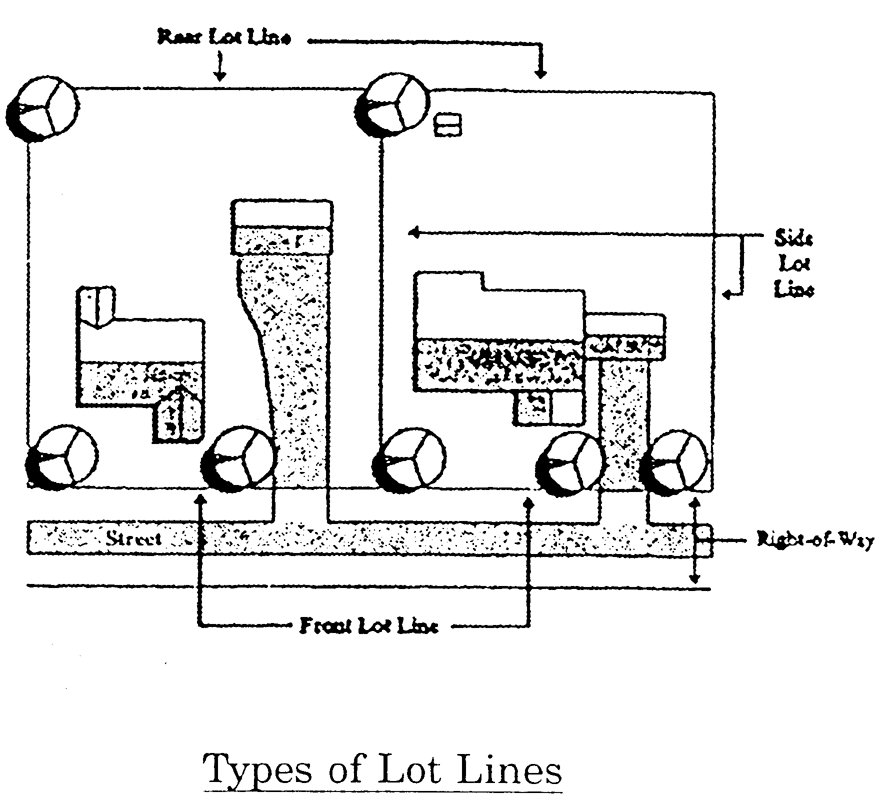
Lot-line house. A dwelling type consisting of a single-family, fully detached residence located on an individual lot with only one (1) side yard. No windows are permitted on the zero (0) lot line wall of the house. The zero (0) lot line may be achieved by placing the house on a side lot line and providing a maintenance easement six (6) feet wide on the adjoining lot.
Lot width. The distance across the lot (side lot line to side lot line) at the minimum front setback line.
Lowest floor. The lowest floor of the lowest enclosed area, including basement, but excluding any unfinished or flood-resistant enclosure, useable solely for vehicle parking, building access or limited storage provided that such enclosure is not built so as to render the structure in violation of the non-elevation requirements specified in the building code for enclosures below the lowest floor.
Luminaire. A complete lighting unit consisting of a light source and all necessary mechanical, electrical, and decorative parts ready to be mounted on pole or other location.
Maintenance corporation. A nonstock corporation consisting of lot or unit owners of a subdivision created for the purpose of owning and maintaining private open space and common facilities located within a residential subdivision.
Maintenance guarantee. A guarantee of facilities or work to ensure the correction of any failures of any improvements required by this Code, or to maintain same.
Maintenance organization. An organization approved by the County that is legally responsible for owning, maintaining, and/or managing open space. A maintenance organization may be a condominium association, a third party conservancy, or a maintenance corporation.
Major change. A change to the plan that increases density or floor area, decreases open space, bufferyards, or parking, or which alters the alignment or layout of streets by more than five (5) feet. For conditional approvals granted prior to the adoption of this Chapter, any use proposed not contained in the original advertisement shall be considered a major change.
Major land development. A plan that proposes one (1) or more of the following:
A.
A new public or private street.
B.
Buildings or expansions that exceed the limits of the minor land development definition outlined in Subsection B.
C.
A subdivision of land resulting in more than five (5) lots.
D.
Apartment or multi-family development of ten (10) or more dwelling units.
E.
An electric power generating facility.
Manufactured home. A one (1) family dwelling unit fabricated in an off-site manufacturing facility for installation or assembly at the building site, bearing a seal certifying that it was built in compliance with Chapter 6 of the New Castle County Code or the Federal Manufactured Housing Construction and Safety Code.
Marijuana cultivation facility. Entities licensed by the State of Delaware to cultivate, prepare, and package marijuana and sell marijuana to retail marijuana stores, to marijuana product manufacturing facilities, and to other marijuana cultivation facilities, but not to consumers. A marijuana cultivation facility may not produce marijuana concentrates, tinctures, extracts, or other marijuana products.
Marina. A facility for storing, servicing, fueling, berthing, securing and launching boats. It may include supporting facilities and services.
Marquee. A hood or permanent roof-type construction which projects from the wall of a building above an entrance for movie theaters and similar uses.
Mass(ing). The arrangement of a building's bulk, including relative openness and solidity.
Maximum permitted illumination. The most illumination, measured in footcandles, that is allowed at the interior lot line or bufferyard line, if a bufferyard is required, at ground level.
Meadow. A grassland condition either planted or a result of natural succession that has been established for at least five (5) years. Areas with shorter establishment periods shall be considered disturbed land.
Mean surface water elevation. The observed limit of dry weather flow elevation in a watercourse or mean high water level in tidal areas.
Minimize. To reduce to the smallest amount possible using best management practices. "Minimize" shall not mean complete elimination, but shall require that the most substantial efforts possible under the circumstances have been taken to reduce the adverse effect of the action required to be minimized. With respect to activities, the conduct of which is adverse to the conservation of the natural features of land, the requirement to "minimize" shall include but not be limited to the requirement that the placement of dwellings and other structures and the locations of roads, sedimentation and erosion control devices, and earthmoving activities shall be planned and designed so as to permit the adverse effect of the activity in question to be reduced to the smallest amount possible under the circumstances consistent with the otherwise permitted development.
Minor change. A change to the plan that does not increase density or floor area, does not decrease open space, bufferyards or parking, or alter the alignment or layout of streets by more than five (5) feet.
Minor land development. A plan that proposes one (1) or more of the following:
A.
A subdivision of land resulting in five (5) lots or less and not creating new street rights-of-way.
B.
Except for single-family dwellings and residential accessory structures on fee simple lots, land development proposing new buildings or additions one thousand (1,000) square feet GFA or greater, or five thousand (5,000) square feet GFA or greater in the P, OR, BP, I, and HI zoning districts and meeting one (1) or more of the following criteria:
1.
Proposed buildings less than twenty thousand (20,000) square feet GFA. One (1) or more buildings may be constructed; however, once the cumulative total of approved square footage on the site exceeds twenty thousand (20,000) square feet GFA, the plan shall be reviewed as a major plan.
2.
For lots containing at least twenty thousand (20,000) square feet GFA of existing development, any number of expansions are permitted (including expansions in excess of twenty thousand (20,000) square feet GFA), provided the cumulative total of all the expansions does not exceed fifty thousand (50,000) square feet GFA. Any subsequent plan submission proposing a new building or expansion exceeding fifty thousand (50,000) square feet shall be reviewed as a major plan.
3.
In any OR, BP, I or HI zoning district on lots containing at least fifty thousand (50,000) square feet GFA of existing development, any size expansion of an existing industrial or manufacturing use provided no TIS is required by DelDOT.
4.
Apartment or multi-family development of less than ten (10) dwelling units.
5.
Development that would be considered a major land development in industrial or office parks for which a previous record major plan has been recorded to establish lots and otherwise depict the overall limits of development provided that no special studies are required for approval; e.g., TIS, CNA, environmental impact assessment report, floodplain application, WRPA, subsidence. The project must be such that any issues or concerns are minor in nature and can be evaluated without the necessity of a PLUS review.
6.
Expansions of existing institutional facilities or the replacement of existing public schools provided that no special studies are required for approval e.g. TIS, CNA, environmental impact assessment report, floodplain application, WRPA, subsidence. The project must be such that any issues or concerns are minor in nature and can be evaluated without the necessity of a PLUS review.
7.
Any land development plan subject to, and in compliance with, an approved Economic Empowerment District.
C.
Any major utility except electric power generating facilities.
D.
A minor utility that is:
1.
A new utility substation that is used to transmit or distribute more than one hundred thirty-nine (139) kV of electricity; or
2.
An elevated storage tank or standpipe.
E.
Large scale solar energy systems.
Mitigation. Any action taken to lessen the specified undesirable impacts of a proposed land use or land disturbance activity, including those which would adversely affect the health or longevity of a natural feature, pose a visual intrusion or conflict, or otherwise be deemed incompatible with surrounding properties.
Mixed use. See Section 40.33.240J.
Mobile home or mobile dwelling unit. A transportable one (1) family dwelling larger than three hundred twenty (320) square feet, designed to be used as a year-round residence. This definition shall not include motor homes or recreational vehicles.
Moderate-income household. A household earning more than eighty (80) percent, but not to exceed one hundred twenty (120) percent of the New Castle County area median income, as published and annually updated by the United States Department of Housing and Urban Development.
Monument. A stone or concrete boundary marker, as required by this Chapter, intended to fix the physical location of property lines.
Motel. See Section 40.33.240D.
Motor vehicle. For purposes of Section 40.03.440, the term "motor vehicle" shall include an automobile, light truck, boat, boat trailer, recreational vehicle, motorcycle and the like.
Mulch operations. A process that results in a product from the physical breakdown of yard trimmings and other approved materials into smaller pieces. Mulch is a protective cover placed over surface soil to modify the effects of the local climate. Mulch material may include the following: grass, leaves, bush and tree prunings, brush, shrubs, Christmas trees, tree limbs, hay, sawdust, and wood chips.
Multifamily conversion. The conversion of office or commercial GFA to apartments or residential condominium units.
Multi-modal transportation. The availability or use of more than one form of transportation, such as automobiles, walking, cycling, transit, ride share, car-pool, or commuter rail.
National Geodetic Vertical Datum (NGVD). Elevations referenced to mean sea level datum of the 1929 or 1988 U.S. Geological Survey.
Native ground cover plants. See Appendix 3 to this Chapter - Native plants.
Native plant. A plant or tree species native and indigenous to the State of Delaware is one that has, over time, evolved and adapted to the environmental conditions of the area and is understood to have occurred in Delaware prior to the time of human settlement, or has established itself within the state independent of direct human activity.
Natural resource management plan. A supplemental plan associated with residential major subdivision plans, applicable to the natural resource area open space, which shall be referenced on the record plan as being an integral part of the record plan detailing the disposition, use and maintenance for all natural resource area open spaces. The plan shall include:
A.
Executive summary. A brief description of the contents of the plan and the natural resource area open space to be managed. The ownership of natural resource area open space shall also be identified.
B.
Description of existing conditions. Narrative description of protected resources on-site, including natural and scenic resources. The discussion of natural resources shall include a list of species found on the site and the overall condition and health of the natural systems. Other resources shall be similarly discussed, including their health and condition or significance.
C.
Goals and objectives. Overall goals and objectives for managing natural resource area open space shall be established along with methods of measuring the implementation of such objectives to help in determining that the goals are met.
D.
Management measures. A description of proposed activities, budget and schedule for managing and restoring natural resource area open space pursuant to the goals and objectives identified in Subsection C.
E.
Maintenance and operation plan. Identification of any annual or periodic maintenance and operation of natural resource area open space necessary to implement the management plan.
Net buildable site area. Calculations specified in Article 5.
New construction. Buildings and structures for which the "start of construction" commenced on or after December 3, 1971 including any subsequent improvements to such structures.
Nonconforming building. A building, structure or parts thereof lawfully existing at the time this Chapter or a subsequent amendment to this Chapter became effective which does not conform to the dimensional requirements of the district in which it is located.
Nonconforming lot. A lot, legally established prior to the adoption of this Chapter or a subsequent amendment to this Chapter, which does not meet the standards of the district in which it is located. This can involve minimum area, buildable area, or dimensional requirements of the lot.
Nonconforming sign. Any sign, legally established prior to the adoption of this Chapter or a subsequent amendment to this Chapter, which does not fully comply with the standards of this Chapter.
Nonconforming situation. A building/structure or the use of a lot or building/structure lawfully existing at the time this Chapter or a subsequent amendment to this Chapter became effective which does not conform to the dimensional and/or use requirements of the district in which it is located.
Nonconforming use. A use of land or use of a building/structure lawfully existing at the time this Chapter or a subsequent amendment to this Chapter became effective which does not conform to the use requirements of the district in which it is located.
Nondelineated floodplain. An area subject to a 100-year flood, for which FEMA has not delineated a floodplain, adjacent to a watercourse that is also identified by a blue line on the National Hydrographic Dataset (NHD) utilized by the United States Geological Survey or adjacent to a watercourse that is identified as a "stream" in the detailed maps of the N.C.C. Soil Survey.
Non-native plants. A species that is not native to North America (north of Mexico). Non-native species are thought to have been introduced by humans, primarily through agricultural or horticultural practices.
Notice of disturbance. This shall indicate that the Department (limited uses) or County Council has approved a disturbance of a certain acreage of natural resources. Each shall be listed along with the acres involved. The notice shall contain an indication of resources that may be further disturbed or any areas where resources will have to be restored if the site is developed.
Office park. A development on a tract of land that contains a number of separate office buildings, accessory and supporting uses, and open space designed, planned, constructed, and managed on an integrated and coordinated basis.
Old field. Lands formerly cultivated, timbered or grazed but later abandoned. The dominant plants include grasses and herbaceous plants, with encroaching woody vegetation, which evidences secondary succession; in particular, areas covered by woody plants eight (8) or more feet in height which either cover forty (40) percent or more of a property or cover eighty (80) percent of a contiguous area one (1) acre or greater in size.
Opacity. The measurement of the screening effectiveness of a bufferyard or fence expressed as the percent of vision that the screen blocks.
Open space. Parcels of land within a residential subdivision, exclusive of streets and lots, generally preserved in a natural state or improved to provide common amenities for the residents of the subdivision. Open space shall be categorized as either natural resource area open space or community area open space. Open space is intended to preserve environmentally sensitive areas and protected resources, provide active and passive recreation facilities, establish greenways, provide wildlife habitats, facilitate stormwater management functions, and landscaped bufferyards. Both natural resource area open space and community area open space can be public or private and would be annotated as such on the development record plan and/or deed.
Open space, community area. One (1) of the two (2) types of open space in a residential subdivision is community area open space. In residential subdivisions with fewer than fifty (50) acres, all open space shall be considered community area open space. In subdivisions of fifty (50) acres or greater, community area open space shall be relatively smaller, isolated, and typically internal pockets of open space not necessarily contiguous with the natural resource area open space. Such open space parcels normally will provide a function benefiting the residents of the subdivision. The homeowners organization, comprised of the residents of the subdivision, will own and be responsible for community area open space. Approved improvements, conservation and long-term maintenance will be shown on the landscape plan approved for the open space.
Open space, natural resource area. One (1) of the two (2) types of open space in a residential subdivision of fifty (50) acres or greater. Natural resource area open space are those areas comprised of protected resources including but not limited to wetlands, floodplains, riparian buffer areas, forests, steep slopes, critical natural areas, and water resource protection areas, as well as other relatively large, contiguous open spaces.
Open space ratio (OSR). The proportion of a development required to be left in open space. It is determined by dividing the area in open space by the base site area. When applied to resource protection, the open space ratio shall mean that percentage of the resource feature to be protected and/or preserved in the total land area in that resource.
Open space subdivision. A development pattern or design technique in which lots are grouped together rather than spread evenly throughout a parcel as in conventional subdivision development. Clustering development allows the remaining land to be used for recreation, open space and the preservation of natural resources. See Figure 40.33.315.
Figure 40.33.315
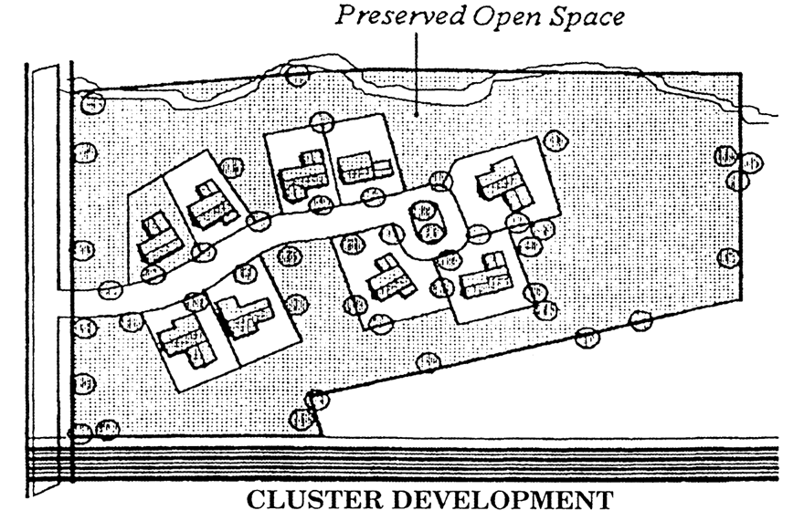
Outflow hydrograph. Graphical representation of the runoff rate versus time for flow exiting a stormwater management facility.
Outfall point. A specific location, as defined by local topography, where stormwater runoff exits a specific land area.
Overlay district. A district that is applied over other zoning districts and which may modify the permitted uses or intensity of use.
Owner. See Landowner.
Parcel. See Lot.
Park. An area open to the general public and reserved for recreational, educational or scenic purposes.
Park and ride facility. A public parking lot designed for drivers to leave their cars and use mass transit facilities beginning, terminating, or stopping at the park and ride facility.
Parking space. An area of land designated for the parking of motor vehicles. See Section 40.22.610.
Parking structure. An above-ground structure designed to accommodate vehicular parking spaces which are fully or partially enclosed or located on the deck surface of a building. A parking area located under a building that is entirely at or below-grade, and single-story garages accessory to a residential use shall not be considered a parking structure.
Passive recreation. Recreational uses, areas or activities oriented to noncompetitive activities which either require no special equipment or are natural areas. Bicycle riding, hiking and bird watching are examples of passive recreation activities.
Passive stormwater infiltration practices. Utilizes existing and restored natural areas with good hydrologic soils and dense vegetative attributes for stormwater management.
Patio house. A single-family dwelling type that is a detached or semi-detached unit (i.e., attached by a common wall to another dwelling unit), with one (1) dwelling unit from ground to roof. Each dwelling unit's lot shall be fully enclosed by a wall located at the lot line, thus creating a private yard, referred to as a patio, between the house and the wall. A "minimum patio area" rather than setbacks is used to determine minimum yard area. All living spaces, such as living rooms, dens and bedrooms, shall face into the yard or patio. A patio house is permitted only in planned developments as provided in Articles 3 and 4. See Figure 40.04.110.
Paved area. See Impervious surfaces.
Peak hours or peak periods. In general, periods from 7:00 a.m. to 9:00 a.m. and from 4:00 p.m. to 6:00 p.m. on weekdays. A peak hour is a sixty (60) minute period occurring within a peak period. Different peak hours may be established by the Department, based on type of development or traffic counts on a street.
Pedestrian precinct. A paved or largely paved area such as a plaza or courtyard set aside for pedestrian use that provides amenities, including but not limited to seating areas and other street furniture, lighting, landscaping, fountains, water features, art or other appropriate elements.
Pedestrian way. A publicly or privately owned right-of-way or easement for pedestrian or bicycle use.
Percolation tests. See Soil borings and percolation tests.
Perennial stream. A channel with banks and a bed within which concentrated water flows all of the time.
Performance guarantee. See Surety.
Period of significance. The length of time when a property was associated with important events, activities, or persons, or attained the characteristics which qualify it for Historic overlay zoning. These associations may include important contributions to the history, architecture, archaeology, engineering, or culture of the County, State or the nation.
Person. An individual or group of individuals, corporation, partnership, association, or any other entity, including state and local governments and agencies.
Pervious. A description of a surface that presents an opportunity for precipitation to infiltrate into the ground.
Plan, exploratory sketch. An informal plan indicating salient existing features of a tract and its surroundings, including the general layout of a proposed subdivision or land development.
Plan, major land development. A plan depicting a major land development which may include the subdivision of land.
Plan, minor land development. A plan depicting a minor land development which may include the subdivision of land.
Plan, record. A complete subdivision or land development plan, including all required supplementary data, which defines property lines, proposed streets and other improvements, and easements; or a plan of private streets to be dedicated to public use.
Plan, record conversion. A plan and supporting documentation describing the proposed conversion of a multi-family dwelling or single-family group dwellings from rental dwelling units to condominium or cooperative dwelling units.
Plan, record street. A minor land development plan the sole purpose of which is to dedicate private streets to public use.
Plans, site construction. All applicable plans or information on all applicable plans required during the land use application review process that will be reviewed by the Department regarding the engineering and design of a site, including but not limited to, the Stormwater Management Plan, Erosion and Sediment Control Plan, General Grading Plan, Pre-Bulk Grading Plan, Post-Bulk Grading Plan, Lines and Grades Plan, Landscape Plan, Natural Resource Management Plan, and Open Space Management Plan.
Planned development. A form of cluster development and residential use type. See Section 40.33.220.
Plot. See Parcel.
Preservation plan. A document describing the measures to be taken in the historic restoration or rehabilitation and preservation of an historic resource. See Section 40.15.310.
Principal building or use. The main use on a property in terms of size, area, and function. See Accessory building or Accessory use.
Property line. See Lot line.
Public improvement. Any improvement, facility or service, together with customary improvements and appurtenances thereto, necessary to provide for public needs such as: streets, alleys, pedestrian walks or paths, storm sewers, flood control improvements, water supply and distribution facilities, sanitary sewage disposal and treatment, public utility and energy services.
Public utilities. See Utility, public.
Public water supply well. A well from which the water is used to serve a public water system as defined in the State of Delaware Regulations Governing Public Drinking Water Systems. All classes of public water supply wells are covered by this definition, including Community, Non-transient Non-community, and Transient Non-community as defined and mapped by the State of Delaware Regulations Governing Public Drinking Water Systems.
Rare species. A plant or animal defined as endangered or threatened by the State under 7 Del. C.Ch. 6 (Endangered Species).
Rational method. An engineering method of predicting peak runoff rates.
Receiving streams. Those streams which are downstream from a development area which may be affected by changes in course, volume, quality or velocity of flow, due to construction or development activity.
Recharge areas. The recharge water resource protection areas are designated as having the best potential for groundwater recharge. They were delineated using methodology described in a report prepared by the Delaware Geological Survey entitled "Delineation of Ground-Water Recharge Resource Protection Areas in the Coastal Plain of New Castle County, Delaware," dated January 1993 ("recharge resource area").
Recreation, active. See Active recreation.
Recreation, passive. See Passive recreation.
Recreational vehicle. A vehicle designed or used as living quarters for recreational, camping, vacation, or travel use, such as house trailers, travel trailers, trucks, trailers, pickup trucks and vans. For the purposes of this definition, a recreational vehicle shall not include trailers in excess of twenty-eight (28) feet in length or in excess of four thousand five hundred (4,500) pounds gross weight.
Redevelopment. A process used to identify previously developed land that is now vacant, abandoned or underutilized real property where older structures if they exist are rehabilitated or replaced.
Reforestation. Replanting or planting of forest plant materials. Also includes planting in areas not originally forested for mitigation purposes.
Renaming, existing public or private streets or recorded land development or subdivision plan. An administrative process by which a name is extinguished and another established for an existing public or private street, road or lane serving three (3) or more parcels; or recorded land development or subdivision plan.
Reserve strip. A parcel of ground in separate ownership separating a street from other adjacent properties or from another street.
Residential collector street. See Street, residential collector.
Responsible person. An agent, tenant, individual, corporation, firm, partnership, or any other legal entity having a legal or equitable interest in property or owing a legal duty to same.
Restoration. The reasonable rehabilitation of the affected land for useful purposes and the protection of the natural resources of the surrounding area, including surface water and groundwater.
Resubdivision. See Section 40.31.711.
Retaining wall. A structure which holds an earthen embankment in place.
Reverse frontage lot. A lot extending between and having frontage on two (2) generally parallel streets. Also referred to as "double frontage lot."
Rezoning. An amendment to the zoning map.
Right-of-way. An area of land dedicated for public or private use to accommodate a transportation system, except that with some older lots in New Castle County property lines may extend into the right-of-way. In no case shall a right-of-way be construed to mean an easement.
Riparian buffer area (RBA). An RBA consists of land which forms a transition zone between aquatic and terrestrial environments. RBA's include:
A.
One hundred (100) feet on either side of perennial and intermittent streams, lakes and tidal wetlands;
B.
All of the floodplain, plus an additional fifty (50) feet of adjacent land;
C.
All of a nontidal wetland greater than twenty thousand (20,000) square feet in area, plus an additional fifty (50) feet of adjacent land;
D.
All of any size nontidal wetland classified as a Piedmont Stream Valley Wetland, as defined in the 1997 New Castle County Comprehensive Plan Update and designated by the Delaware Natural Heritage Program, a Division of DNREC, plus an additional fifty (50) feet of adjacent land.
The riparian buffer area shall consist of two (2) zones.
A.
Zone 1 is the land within twenty-five (25) feet of the water body or wetland. It shall also include any contiguous area of slopes in excess of fifteen (15) percent and erosion-prone slopes contiguous to and draining toward a floodplain or watercourse upstream of an existing public water supply intake.
B.
Zone 2 is the remainder of the riparian buffer.
C.
Identification and calculation.
1.
Reserved.
2.
Initial identification of the watercourses/water bodies shall be made using the National Hydrographic Dataset (NHD) utilized by the United States Geological Survey or more accurate information, as available. Field verification to determine evidence and location of channelized flow is required for a specific determination.
3.
Measurements for the Zone 1 boundary are to be made horizontally, perpendicular from the following reference points: top of bank of perennial streams, centerline of intermittent streams, and mean water level of lakes, ponds, and tidal wetlands. Measurements for the Zone 2 boundary are to be made horizontally, perpendicular from the boundary of the environmentally sensitive lands.
4.
Measurements shall be made at appropriate intervals perpendicular to these reference points so as to accurately reflect the character of the adjacent land.
5.
The width of existing impervious area such as roadways, parking lots, structures, sidewalks, etc. shall not count towards the RBA measurements.
6.
Final determination of the boundaries of the RBA shall be made by the Department.
D.
Exceptions. An RBA shall not be designated along industrial ponds, sewage lagoons, manmade irrigation ditches, stormwater management basins and other artificial features with a similar water quality or storage function.
Road, arterial. See Street, arterial.
Road, collector. See Street, collector.
Road, local. See Street, local.
Roadway. The portion of a highway including the cartway and shoulders within a right-of-way.
Roof line. The top of a roof or building parapet, excluding any cupolas, pylons, chimneys, or other minor projections.
Runoff. That portion of precipitation or snow melt that has not evaporated or infiltrated into the soil, but flows on the land surface.
Sanitary sewage. Any liquid discharge from a structure or animal containment area, except roof drains.
Sanitary sewage disposal, community. A sanitary sewage collection system in which sewage is carried from individual lots, by a system of pipes, to a temporary central treatment and disposal plant, generally serving a neighborhood area.
Sanitary sewage disposal, on-lot. A system in which sanitary sewage and wastewater is collected from a single use or dwelling unit, by a system of pipes, and carried to a septic tank and tile disposal field located within the boundaries of an individual lot.
Sanitary sewage disposal, public. A system in which sanitary sewage and wastewater is collected from multiple uses or dwelling units, by a system of pipes, and carried to a central disposal facility, generally serving a region.
Sanitary sewer line. A sanitary sewer collection system in which sewage is carried from individual lots, by a system of pipes, to a central treatment and disposal plant, or to other pipes, that run to a central treatment and disposal plant.
Sanitary sewer system. A central treatment and disposal plant and related systems and pipes, including, but not limited to, sanitary sewer lines.
Scenic resource.
A.
A general term of reference for viewsheds and intrinsic qualities of a road or corridor that provide scenic beauty or character.
B.
A scenic resource has a high degree of natural beauty and historic or cultural value, characterized by one or more of the following:
1.
Size and dimension of landscape;
2.
Characteristics of roadway (e.g., runs with topography, winds through landscape, changes with terrain);
3.
Visual accents or scenic vistas along roads;
4.
Historic characteristics of the landscape, of a road, or along roads (e.g., historic bridges, houses, barns, mills, springhouses, stone walls, or other structures);
5.
Natural resources or ecosystems near, or visible from, roads (e.g., watercourses, wetlands, rock outcrops, or other geologic formations, woodlands, wildlife habitat); and
6.
Parkland or recreation along or adjacent to roadways.
Scenic viewshed. The land area generally along and visible from a byway or road. A scenic viewshed is identified using a motorist's line of sight, as measured from multiple observation points along the roadway, with a point of view approximately six (6) feet above the roadway pavement. The scenic viewshed includes all land area visible from the observation points in a winter, or leaf-off, condition.
Scenic vista. A broad or expansive view of a landscape, the scenic boundary of which is primarily defined by forest cover or other buffering features within the public viewshed.
Screen, visual. A physical device and/or landscaping, such as berms, walls or hedges, used to hide or conceal a use or structure from sight.
SCS Method. A method of estimating runoff and peak discharges in a watershed, including Technical Release 20 and Technical Release 55, promulgated by the U.S. Department of Agriculture.
Secondary containment. A system installed to prevent any volume of a substance released from the primary containment tank from reaching the soils and/or water outside the system for the anticipated period of time necessary to detect and recover the released substance.
Sediment. Soils or other surface materials transported and/or deposited by the action of wind, water, ice or gravity as a product of erosion.
Sediment and stormwater management plan. A plan for the control of soil erosion, sedimentation, stormwater quantity and water quality impacts resulting from any land disturbing activity.
Selective cutting. The felling of certain, but not all, trees in an area for the purpose of:
A.
Removing dead, diseased, damaged, mature or marketable timber;
B.
Improving the quality of a tree stand or species; or
C.
Meeting personal domestic needs.
Semi cut-off. An outdoor lighting fixture or luminaire with intensity at or above ninety (90) degrees (horizontal), where no more than five (5) percent of the luminaire's light intensity is emitted at or above horizontal, and no more than twenty (20) percent of the luminaire's light intensity is emitted at or above eighty (80) degrees. See Figure 40.22.720.
Septic tank. A multiple compartment, watertight receptacle which receives sewage from a building and is designed and constructed so as to permit settling of solids from the sewage, digestion of the organic matter and discharge of the liquid portion into a disposal area.
Septic system, individual. See Sanitary sewage disposal, on-lot.
Setback. A stated minimum distance on a lot as measured perpendicular from a lot line, a right-of-way line or the required bufferyard if Section 40.04.302, whichever is closest to the proposed structure.
Shared-use pathway. A transportation facility, serving non-motorized users, including pedestrians, cyclists and equestrians, typically located within an easement or right-of-way for public access and physically separated from motor vehicle traffic.
Sheltered care. See Section 40.33.230 F.
Sidewalk. A pedestrian way extending along, parallel to and within an easement or the right-of-way of a public or private street.
Siltation control. The installation of such devices as sediment ponds, bales of straw, fencing, siltation webbing, sodding, seeding and mulching, or other devices to prevent silting of abutting properties and roadways during the period of construction, up to and including, such times as permanent ground cover is attained.
Single lot development. A development consisting of one (1) or more buildings to be erected on a platted parcel of land or a single lot which is part of a subdivision, intended to be separately owned, developed and otherwise used as a unit.
Sinkhole. A topographic feature defining a depression in the ground's surface, typically formed by the collapse of underlying strata, which surface water drains. A sinkhole shall be considered as encompassing the entire area lying within the depression, plus an additional area one hundred (100) feet wide around the edge of the depression. See Figure 40.33.318.
Figure 40.33.318
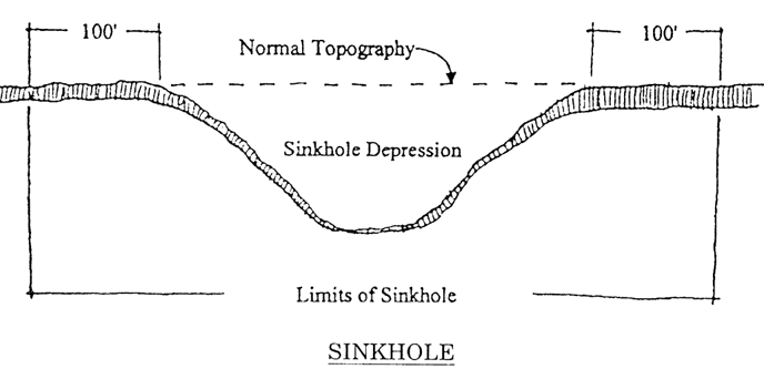
Site analysis plan. For all minor and major land development applications, the applicant shall be required to submit a site analysis plan as the first phase of the pre-application sketch or exploratory plan review process. The Department may also require a site analysis plan for any other application type. The site analysis plan shall serve as a basis for the planning process and shall be used to determine the best areas of the site for open space and natural resource preservation, land conservation and development. The site analysis plan allows both the applicant and the Department the opportunity to utilize the natural site conditions to determine how the development of each parcel or tract can be designed to minimize environmental degradation while achieving highest possible community character design standards.
Site development agreement. A properly executed and legally binding contract between the developer of a parcel of land and the County to proceed with development as noted therein.
Site disturbance. See Grading, Filling, and Section 40.01.110B.
Site plan. A plan or drawing showing the location of buildings, parking, or other elements that is used for the issuing of approvals other than subdivision plans or land developments. The drawings shall show sufficient detail to enable the Department to determine whether the standard requiring a site plan has been met.
Slope, steep. The term "slope" is defined as the vertical change in elevation divided by the horizontal distance over which that vertical change occurs. The steep slope area consists of two (2) areas which are delineated and defined as follows:
A.
Prohibitive slope. Prohibitive slopes are those of greater than twenty-five (25) percent slope as based on a site survey, where such slope exists in any continuous horizontal increment of fifty (50) feet or more.
B.
Precautionary slope. Precautionary slopes are those of fifteen (15) to twenty-five (25) percent slope as based on a site survey, where such slope exists in any continuous horizontal increment of fifty (50) feet or more.
These definitions do not include manmade steep slopes resulting from the implementation of an approved plan.
Soil borings and percolation tests. Field tests conducted and used in judging the suitability of soil for on-site, subsurface sewerage and seepage systems. The borings indicate the soil formations penetrated and groundwater conditions. The percolation tests give an indication of the absorptive capacity of the soil and provide a basis for the design of seepage facilities.
Soil stabilizing function. A plant or structure which encourages resistance of soil to erosion, soil creep or other movement which results in net loss of soil from an area.
Solar energy system (SES). Any structure for the conversion of sunlight into electricity either directly using photovoltaics or indirectly using concentrated solar thermal power including all components thereof such as photovoltaic modules, collectors, panels, controls, energy storage devices, heat pumps, heat exchangers, mounting systems, cables, solar inverters, electrical accessories, and other materials and hardware necessary for the collection, storage, conversion, dissipation and distribution of energy. Installation and operation of any SES shall be approved as required by applicable state and federal law.
Solar energy system, accessory. Any SES that is designed to provide no more than one hundred ten (110) percent of the expected aggregate electrical consumption of all uses located on the lot on which the SES is located.
Solar energy system, community ("CSES"). Any large-scale SES meeting the definition of a "Community-owned energy generating facility" as set forth in § 1001, Title 26 of the Delaware Code.
Solar energy system, ground-mounted. Any SES that has its electricity-generating solar panels mounted or resting on the ground.
Solar energy system, rooftop. Any SES that has its electricity-generating solar panels mounted or resting on the rooftop of a building or structure.
Special flood hazard area (SFHA). The land in the floodplain subject to flood hazards and shown on a flood insurance rate map as Zones A, AE, AO, and Zone VE. The term also includes non-delineated floodplains as described in Article 10.
Specimen tree. Any tree or arborescent plant (i.e., a perennial woody plant with a treelike habit that resembles a tree in growth or appearance) in good health that is not in a forest and having a single trunk diameter in accordance with Table 40.23.320 and Appendix 3, or having seventy-five (75) percent or more of the trunk diameter of the current state champion tree as identified by the Delaware Forest Service. Non-native tree species considered invasive shall not be designated as specimen trees.
Spray irrigation system (or other approved large scale treatment system). Spray irrigation systems discharge treated effluent so as to recharge the groundwater table after providing final treatment by the plants and soil. The effluent may be discharged directly or indirectly to the land or a water body, or may be recycled or otherwise reused. Other approved large scale treatment systems include any sewage treatment system approved by the Department of Public Works and DNREC.
Stabilization. The prevention of soil erosion by surface runoff or wind through the establishment of vegetative or structural soil coverage measures. Examples include, but are not limited to, straw mulch with temporary or permanent vegetation, wood chips and stone or gravel ground cover.
Start of construction. See Commencement of construction.
Stormwater management. The management of stormwater runoff including quantity and quality control due to changes in land use through engineered practices that incorporates existing and/or modified land features.
A.
For water quantity control, a system of vegetative, structural, and other measures that control the volume and rate of stormwater runoff caused by land disturbing activities or activities upon the land; and
B.
For water quality control, a system of vegetative, structural, and other measures that control adverse effects on water quality that may be caused by land disturbing activities or activities upon the land.
C.
Can utilize green technology stormwater best management practices (GTBMP's).
Stormwater mitigation area corridor. An expanse of land secured for the express purpose of managing urban stormwater runoff exclusive of conventional structural stormwater management practices. These areas shall attempt to support and protect all natural resources from the detrimental effects of unmanaged urban stormwater runoff. This may be accomplished through preserving natural drainage patterns and filtering contaminants from stormwater runoff by encouraging infiltration and filtration. Open space may be used for the creation of these areas.
Stormwater utility. An administrative organization that has been established for the purposes of funding sediment control, stormwater management or flood control planning, design, construction, maintenance and overall resource needs by authorized and imposed charges.
Story, first. The ground floor story of a building, provided its floor level is not more than four (4) feet below the mean lot level adjacent to the foundation.
Story, half. A story under a sloping roof at the top of the building, the floor of which is not more than two (2) feet below the wall plate.
Street. A strip of land, comprising the entire area within the right-of-way, intended for use as a means of vehicular and pedestrian circulation to provide access to more than one (1) lot. However, the establishment of a common driveway for access purposes for no more than four (4) separate parcels contiguous to one another shall not be considered a street as this term is defined.
Street, arterial. Streets that generally carry high traffic volumes over longer distances. Arterial streets generally connect other arterials and/or collectors. Although arterial streets sometimes connect local streets, they rarely provide direct access to individual lots. Streets classified as arterial on the most recent version of the New Castle County Functional Classification Map (published by DelDOT) are considered arterial streets in this Chapter.
Street, collector. Streets that generally carry medium traffic volumes over shorter distances. Although collector streets connect all types of streets, they rarely provide direct access to individual lots. Streets classified as collector on the most recent version of the New Castle County Functional Classification Map (published by DelDOT) are considered collector streets in the UDC. Subdivision streets classified by DelDOT regulations as major collector or type III are considered collector streets in this Chapter.
Street, cul-de-sac. A short, independent, minor street having only one (1) point of ingress and egress, terminating in a circular turnaround or other approved termination.
Street frontage. The linear measurement of a parcel along a street line, private road or right-of-way to which the parcel abuts.
Street functional classification. The ranking of streets in a hierarchy, based on the type of service they provide. Streets comprise a network, with individual streets carrying traffic within the network. As links in a network, streets provide two types of service-mobility for through traffic and access to adjacent lands. Streets are ranked according to the proportion of each type of service they perform. Arterial streets, which emphasize mobility, are at the highest level of the street hierarchy. Collector streets, which provide both mobility and access, are in the middle of the hierarchy. Local streets, which emphasize access, are at the lowest level of the street hierarchy. The UDC recognizes the functional classification of individual streets on the most recent New Castle County Functional Classification Map (published by DelDOT).
Street, half (partial). A street, generally parallel and adjacent to a property line, having a lesser right-of-way width than normally required for improvement and use of the street.
Street line. A property line of a lot which coincides with a line indicating the limits of an existing or proposed right-of-way.
Street, local. Streets that generally carry low traffic volumes over short distances. Local streets generally provide access to adjacent lots and connect to other local and/or collector streets. Local streets rarely provide direct access to arterial streets. Streets classified as local on the most recent version of the New Castle County Functional Classification Map (published by DelDOT) are considered local streets in this Chapter. Streets classified as minor collector or minor streets in DelDOT Rules and Regulations for Subdivision Streets are considered local streets in this Chapter.
Street, local residential access. A street that provides access to individual residential lots and abutting properties.
Street, marginal access. A local street, parallel and adjacent to an arterial street, but separated from it by a long strip, which provides access to abutting properties and control of intersections with the major street.
Street, minor. See Street, local.
Street, private. Any street right-of-way not dedicated to public use.
Street, private estate. A local residential street having a limited length and serving a limited number of lots such that the streets will not be accepted for maintenance by DelDOT.
Street, public. Any street right-of-way dedicated to public use or maintained by the DelDOT Division of Highway Operations.
Street, residential collector. A street intended to gather traffic from local residential access streets and convey it to higher level streets. Note this street does not serve individual residential lots. Located in residential areas or developments, this street type collects and moves the traffic from local residential access streets whose total dwelling unit count exceeds two hundred forty (240).
Street right-of-way. See Street and Right-of-way.
Street, service. A minor right-of-way providing secondary vehicular access to the side or rear of two (2) or more properties.
Structural alterations. Any change in the supporting members of a building such as bearing walls, columns, beams or girders and floor joists, ceiling joists, roof rafters or stairways.
Structure. Any manmade object having an ascertainable stationary location on land or in water, whether or not affixed to the land.
Structure, permanent. A structure placed on or in the ground, or attached to another structure in a fixed position.
Structure, temporary. A structure that is designed to be repeatedly erected or inflated, tents and inflatable structures, or buildings that are picked up and moved.
Subdivision.
A.
The division or redivision of a lot, tract, or parcel of land, by any means, including by means of a plan or a description by metes and bounds, into two (2) or more lots, tracts, parcels or other divisions of land, for the purpose, whether immediate or future, of the transfer of ownership or of building development, exempting, however, the division of land for agricultural purposes into parcels of more than ten (10) acres not involving any new streets or easements of access, divisions of property by testamentary or intestate provision, or divisions of property upon court order;
B.
The division or allocation of land for the opening, widening or extension of any street or streets, or the division or allocation of land as open spaces for common use by owners, occupants or leaseholders, or as easements for the extension and maintenance of public sewer, water supply, storm drainage or other public facilities.
C.
The elimination of one (1) or more lot lines through the recordation of a deed that eliminates common property lines between lots that have not been previously depicted on an approved land development plan or between lots within an approved land development plan shall not be considered subdivision for purposes of this Chapter, provided the resulting lot(s) is in conformance with this Chapter. The deed shall indicate that the purpose of this deed is to comply with the definition of subdivision in Section 40.33.300, exempting subdivision review to eliminate one (1) or more interior division lines affecting the herein described property.
Subdivision, major. See Major land development.
Subdivision, minor. See Minor land development.
Subdivision regulations. Articles 1, 18, 20—27 and 30—33 of this Chapter.
Substantial construction.
A.
Subdivisions: Payment of surety, the clearing and grading of the site, installation of roads and utilities and placing of initial foundations.
B.
Land developments: Installation of parking, circulation, stormwater facilities and installation of foundations.
Substantial damage. Damage of any origin sustained by a structure whereby the cost of restoring the structure to its before-damaged condition would equal or exceed fifty (50) percent of the market value of the structure before the damage occurred.
Substantial improvement. Any repair, alteration, reconstruction, rehabilitation, addition, or other improvement of a structure, the cost of which equals or exceeds fifty (50) percent of the market value of the structure before improvement or repair is started. If the structure has sustained substantial damage, any repairs are considered substantial improvement regardless of the actual repair work performed. The term does not, however, include any project for improvement of a building required to correct existing health, sanitary, or safety code violations identified by the building official and that are the minimum necessary to assure safe living conditions.
Substantial rehabilitation. The reconstruction, enlargement, installation, repair, alteration, improvement or renovation of a building, structure, or portion thereof.
Substantial repair. See Substantial improvement.
Sumps. A point of comparatively low elevation which cannot be drained by means of surface flow.
Superblock. An area bounded by arterial or collector streets or cut off by a body of water.
Surety. A form of financial guarantee that required improvements will be made by providing the County with the resources to install the improvements should the developer fail to do so. These include, bonds, cash, letters of credit, or other financial instruments approved by the County Attorney.
Surface water. Natural or artificial bodies of water greater than one (1) acre in extent at the normal annual water level, as depicted on the National Hydrographic Dataset (NHD) utilized by the United States Geological Survey and/or as determined by on-site surveys by a registered surveyor, landscape architect or engineer. Excluded from this definition are retention basins or other stormwater management facilities, farm ponds or other facilities associated with agricultural operations, sewage lagoons and other facilities for which normal maintenance and repair is necessary.
Surveyor. A land surveyor registered by and licensed to practice in the State of Delaware.
Swale. A linear depression in the land's surface in which sheet runoff would collect and form a temporary watercourse. See Figure 40.33.319.
Figure 40.33.319
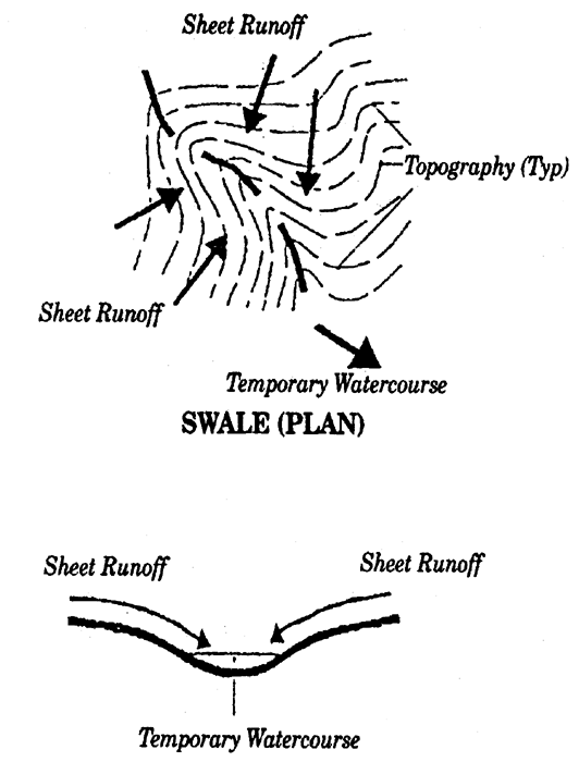
Tidewater. Water inland from Delaware Bay which is affected by tidal influence.
Top of bank. A point above the mean water surface of a watercourse which defines the maximum depth of channel flow in the watercourse. It is either determined visually or computed as an elevation using the peak rate of runoff from a two (2) year storm event.
Topography. The characteristics of a parcel of land with respect to elevation.
Townhouse. A single-family dwelling in a row of three (3) or more other dwellings that share common vertical walls. See Figure 40.04.111.
Townhouse, weak-link. A townhouse having both a one (1) and two (2) story section. See Figure 40.04.111.
Travel demand management program. A program initiated by the employer that provides some combination of the following: business supplied car/van pooling, subsidy of transit passes, flex hours, staggered work hours, home work programs, subsidy of rents for living within walking commuting distance, company vehicles for daytime use or company run pickups from nearby transit stations.
Travel trailer. See Recreational vehicle.
Tree. A living perennial woody plant with single or multiple stems that branch into a well-formed crown of foliage and reaching a height of at least fifteen (15) feet under ideal growing conditions.
Tree, canopy. A tree whose foliage would occupy the upper level of a forest. These trees are also called shade trees, and typically reach heights of fifty (50) feet or greater at maturity under ideal growing conditions.
Tree cover. Applies to a stand of trees not meeting the minimum requirements of a forest and is the area of existing CRZ or an assumed CRZ after twenty (20) years of growth for newly planted trees. Tree Cover is an optional substitute for forest cover in order to meet minimum afforestation ratio standards.
Tree, small canopy/understory. A tree whose foliage would occupy the intermediate level of a forest.
Twin house (dwelling, semi-detached). A single-family dwelling that is attached by one (1) common vertical wall to one (1) other dwelling unit. See Figure 40.04.111.
Unbuildable. For purposes of Article 1, an approved record plan for a subdivision or land development shall be deemed unbuildable if, immediately prior to December 31, 1997, such plan did not comply with all applicable laws, including zoning and subdivision regulations, and no longer fell within any period of protection under former Code provisions, so that a valid building permit could not have been issued for construction of development or improvements.
Underground petroleum storage. Any underground storage vessel, including the underground pipes connected thereto, which is used to contain petroleum products including heating oil and diesel fuel, and the volume of which, including the volume of the underground pipes connected thereto, is buried ten (10) percent or more beneath the surface of the ground.
Underground storage tank system. Any one (1) or a combination of tanks including underground pipes connected thereto, which is used to contain an accumulation of regulated substances, and the volume of which, including the volume of underground pipes connected thereto, is ten (10) percent or more beneath the surface of the ground. See 7 Del. C. Ch. 74 (Underground Storage Tank Act).
Understory tree. See Tree, understory.
Unlawful acts. The violation of any note, regulation, order, permit condition or provision of the Chapter.
Utility. Publicly or investor owned or regulated entity which provides services to the general public utilities, e.g., water, sewer, communications, waste management, cable, gas and electric.
Variance. Relief from the standards of this Chapter.
Village house. A single-family dwelling which is detached from neighboring structures. A village house has very small front yards with special landscape requirements. Homes shall be built to the build-to line. A village house is permitted only in planned developments as provided in Articles 3 and 4. See Figure 40.04.111.
Vista points. Locations or vantage points along byways and roadways from which scenic vistas are viewed. Vista points are further depicted in Corridor Management Plans and other County studies related to designated byways as set forth in Appendix 8.
Visual accents. Elements or improvements that are compatible with the character and nature of a scenic area and add to the protection or enhancement of a scenic area's character-defining features or intrinsic qualities. Visual accents may be natural or man-made features which contribute to the landscape (e.g., rock outcroppings, historic structures, stone walls, farm complexes, historic stone bridges, streams or other water bodies).
Visual amenity. Any type of visible feature which the observer finds attractive or pleasing to the eye.
Visual intrusions. Elements or improvements that are not compatible with the character and nature of a scenic area and do not add to the protection or enhancement of a scenic area's character-defining features or intrinsic qualities. Visual intrusions may be identified in applicable studies or may be comprised of new improvements and structures that affect the byway (e.g., transmission lines, new structures proposed in a scenic viewshed, opaque fences).
Water body. Any watercourse, tidal wetland or lake defined by a bank or shore in which water can be found.
Watercourse. A stream channel (perennial, intermittent, mapped or unmapped) with banks and a bed within which concentrated water flows.
Water distribution system.
A.
Community: A system for supplying and distributing water from a common source to two (2) or more dwellings or other buildings within a single neighborhood.
B.
On-site: A system for supplying and distributing water to a single dwelling or other building from a source located on the same lot.
C.
Public: A system for supplying and distributing water from a common source to dwellings and other buildings, but generally not confined to one neighborhood.
Water quality. Those characteristics of stormwater runoff, usually from a land disturbing activity that relate to the chemical, physical, biological or radiological integrity of water.
Water resource protection area. Water resource protection areas (WRPA) are the Cockeysville Formation, Cockeysville Formation Drainage Area. Wellheads and recharge areas. All such areas are as depicted on the three-map series "Water Resource Protections Areas for the City of Newark, City of Wilmington, New Castle County, Delaware," prepared by the Water Resources Agency for the County that is dated 1993, or as amended. Any Class A Wellhead WRPA not depicted on the WRPA maps shall also be considered a Wellhead Water Resource Protection Area.
Watershed. The total or partial drainage area contributing stormwater runoff to a single point.
Water table. The level below the surface at which the ground is saturated by water.
Wellhead. The wellhead water resource protection areas are surface and subsurface areas surrounding public water supply wells or wellfields where the quantity or quality of groundwater moving toward such wells or wellfields may be adversely affected by land use activity. Such activity may result in a reduction of recharge or may lead to introduction of contaminants to groundwater used for public supply ("wellhead"). Three (3) classes of wellhead water resource protection areas exist in accordance with the following:
A.
Class A. The area within a three hundred (300) foot radius circle around all public water supply wells which are classified as public water systems, as defined in the State of Delaware Regulations Governing Public Drinking Water Systems.
B.
Class B. The Glendale and eastern states wellfields. These wellhead water resource protection areas have been delineated through the use of hydrogeologic mapping, analytical methods, and application of United States Environmental Protection Agency modular semi-analytical models using a five (5) year time-of-travel by the Delaware Geological Survey entitled "Application of the EPA WHPA Models for Delineation of Wellhead Protection Areas in the Glendale and Eastern States Wellfields," dated January 1993.
C.
Class C. Wellhead water resource protection areas delineated by the Delaware Geological Survey and DNREC through the interpretation of geologic and hydrologic reports and maps, water table maps and professional judgment. Such areas are considered preliminary designations.
Wetland. Those areas inundated or saturated by surface or groundwater at a frequency and duration sufficient to support, and that under normal circumstances do support, a prevalence of vegetation typically adapted for life in saturated soil conditions; or areas that are defined and delineated in accordance with the U.S. Army Corps of Engineers guidelines as may be amended from time to time, the U.S. Environmental Protection Agency, or the DNREC.
Wetland delineation and report. An on-site method or process for identifying wetlands as described by the U.S. Army Corps of Engineers guidelines as may be amended from time to time. The wetland delineation report shall be prepared by a person with professional experience and knowledge in wetlands identification and shall analyze a site for the existence and extent of wetlands. When such a delineation and report is required as part of a land use application, such report and delineation may be required to be updated and revised if the original report was prepared more than three (3) years prior to the date of submission of the land use application.
Whips. Young trees having one (1) season's growth from the time of budding or grafting and usually forming a simple unbranched shoot.
Wildlife habitat. A community of plants that provide food, water, cover, nesting, and foraging or feeding conditions necessary to maintain populations of animals.
Woodland. See Forest.
Woodland management plan. A description, by means of text and maps, of proposed actions involving the removal of trees from a tract of land. Such a plan shall be prepared by a person with demonstrable expertise in forest management and shall document the measures intended to be taken to:
A.
Protect water quality;
B.
Minimize impacts from skid trails and logging roads, landing areas and the tree removal process; and
C.
Ensure site restoration.
Yard. An unoccupied space open to the sky on the same lot with a building or structure.
Yard, front. A yard extending the full width of the lot between the front lot line and the parts of the principal building erected thereon.
Yard, rear. A yard extending the full width of the lot between the rear lot line and the parts of the principal building erected thereon. For a corner lot, the rear yard shall not extend beyond the building setback line on the side street.
Yard, side. A yard between the parts of the principal building and the adjacent side lot line and extending from the front yard to the rear yard.
Yard, street. A yard extending the full width of the lot between the street lot line and the parts of the principal building erected thereon setting back from and nearest such street line.
Zero (0) lot line. See Lot-line house.
Zoning district. A designation shown on the zoning map as being in a district enumerated in Article 2 in which a specific set of zoning standards apply. The term may refer to the standards or an area so mapped. The term is also analogous with zoning classification or designation.
Zoning map. The map(s) showing the location and boundaries of the zoning districts established by this Chapter. These maps are entitled, "Official Zoning Map of New Castle County."
Zoning permit. A written permit issued by the Department that certifies that the proposed use of the land will be in compliance with this Chapter.
Zoning regulations. Articles 1—17, and 30—33 of this Chapter.
(Ord. No. 97-172, § 3(ch. 13, div. 33.300), 12-31-1997; Ord. No. 98-062, § 1(ch. 13, div. 33.300), 9-22-1998; Ord. No. 98-080, § 1(ch. 13, div. 33.300), 9-22-1998; Ord. No. 99-075, § 1, 12-14-1999; Ord. No. 99-084, § 4, 4-11-2000; Ord. No. 01-050, § 2, 7-24-2001; Ord. No. 01-085, § 3, 11-13-2001; Ord. No. 01-112, § 1(Exh. A), 3-12-2002; Ord. No. 02-075, § 1(Exh. A), 10-22-2002; Ord. No. 03-045, § 1(Exh. A), 7-8-2003; Ord. No. 04-059, § 1(Exh. A), 7-13-2004; Ord. No. 04-058, § 2, 10-5-2004; Ord. No. 06-007, § 7, 3-28-2006; Ord. No. 06-060, § 1(Exh. A), 9-26-2006; Ord. No. 07-124, § 7, 12-11-2007; Ord. No. 07-150, § 1, 2-26-2008; Ord. No. 08-121, § 2, 2-24-2009; Ord. No. 09-066, § 21, 10-13-2009; Ord. No. 09-068, § 1(Exh. A), 11-10-2009; Ord. No. 10-113, § 1(Exh. A), 1-18-2011; Ord. No. 14-108, § 2, 2-3-2015; Ord. No. 14-126, § 13, 1-13-2015; Ord. No. 15-053, § 5, 7-28-2015; Ord. No. 16-066, § 5, 1-10-2017; Ord. No. 17-044, § 12, 10-10-2017; Ord. No. 18-031, § 79, 4-24-2018; Ord. No. 18-020, § 37, 7-10-2018; Ord. No. 18-021, § 55, 7-10-2018; Ord. No. 19-005, § 6, 5-28-2019; Ord. No. 20-071, § 13, 10-27-2020; Ord. No. 21-009, § 12, 12-14-2021; Ord. No. 22-072, § 13, 10-11-2022; Ord. No. 23-104, § 9, 1-9-2024; Ord. No. 23-122, § 4, 5-14-2024; Ord. No. 24-057, § 8, 9-24-2024; Ord. No. 24-087, § 5, 9-24-2024; Ord. No. 24-138, § 3, 12-10-2024; Ord. No. 24-130, § 8, 3-25-2025)
APPENDIX OUTLINE
Appendix 1. Application and Plan Requirements
1.
Land Development Application Submission Requirements
A.
Pre-Application Sketch Plan (Planning and Engineering)
B.
Exploratory Plan
C.
Site Construction Plans
D.
Record Plans (Planning)
2.
Land Development Plan Requirements
A.
Plan Requirements
B.
Engineering Requirements
3.
Other Reports and Applications
A.
Floodplain Permit Application
B.
Parking Plan
C.
Site Plan
D.
Wetland Report
E.
Critical Natural Area Report
F.
Landscape Plan
G.
Deed Restriction Change Application (Maintenance Declaration)
H.
Subdivision Appeal/Variance Application
I.
Extractive Use Application
J.
Level of Service (LOS) Waiver Application
K.
Site Analysis Plan
L.
Natural Resources Area Management Plan
Appendix 2. Fees
1.
Land Development and Rezoning Processing
2.
Engineering Section
3.
Board of Adjustment
4.
Other
Appendix 3. Plant Lists and Planting Guidance
1.
Recommended Plant List
2.
Plants to Avoid
3.
Native Plant Species of Special Interest
4.
Street Tree Selection
5.
Reforestation Planting
6.
Tree Replacement Calculation
Appendix 4. New Castle County Historic Sites
Appendix 5. Documents
1.
Maintenance Corporation Agreement
2.
Bylaws of Maintenance Corporation
3.
Articles of Incorporation of Maintenance Corporation
Appendix 6. Miscellaneous Items
1.
Technical Advisory Committee
2.
Resource Protection Area Technical Advisory Committee
3.
Department of Land Use Distribution of Approved Plans
4.
Source of Data for Establishing Resource Protection Levels (supplement to Table 40.05.420)
Appendix 7. Guiding Principles For Development
1.
Purpose and Applicability
2.
Character Areas
3.
Guiding Principles and Character Areas
4.
Residential Neighborhood
5.
Suburban Community Development
6.
Corridor
7.
Center
8.
Traditional Community Development
9.
General Concepts
10.
Amenities
Appendix 8. Byway Area Resources