


Nibley City Zoning Code
Appendices
16-05
16-03
Nibley City General Plan
23-04
23-04 MIHP
20-12
21-04
25-05
25-12
25-14
25-14 DA
25-16
25-17
25-28
25-29
24-02
24-03
24-03 DA
24-09
24-10 DA
24-10
24-11 DA
24-11
24-13
23-01
23-03
Notice of Boundary Action - Malouf
23-07
Notice of Boundary Action
23-09
23-20
23-23
23-26
23-31
23-31 - DA
23-32
23-36
23-36 DA
22-07
22-08
22-13
21-07
21-09
20-04
20-05
21-10
23-08
20-18
19-01
19-07
18-04
15-09
20-08
20-10
22-12
O22-12
22-06
25-09
Petition to Vacate - O25-09
25-09 LAA
25-06
Logan Wastewater IFFP - O25-06
25-32
Ordinance 14-03: Transportation Master Plan
AN ORDINANCE AMENDING A PORTION OF THE NIBLEY CITY
TRANSPORTATION MASTER PLAN
WHEREAS, Nibley City has a transportation master Plan ("Plan") which outlines anticipated future development of its transportation infrastructure; and
WHEREAS, although Nibley City tries to make transportation decisions in light of the Plan, from time to time, it becomes necessary to amend the Plan; and
WHEREAS, Nibley City desires to amend the Plan at this time to clarify its transportation goals in a certain part of Nibley City.
NOW THEREFORE, BE IT ORDAINED BY THE NIBLEY CITY COUNCIL LOCATED AT NIBLEY, UTAH, THAT:
- The attached map, entitled "Nibley City Master Road Plan" is hereby adopted, by fact and by reference.
- All other portions of the previously adopted Plan remain in full force and effect.
- All ordinances, resolutions and policies of the City, or parts thereof inconsistent herewith are hereby repealed, but only to the extent of such inconsistency. This repealer shall not be construed as reviving any law, order, resolution or ordinance or part thereof.
- Should any provision, clause or paragraph of this ordinance or the application thereof to any person or circumstance be declared by a court of competent jurisdiction to be invalid, in while or in part, such invalidity shall not affect the other provisions or applications of this ordinance or the Nibley City Municipal Code to which these amendments apply. The valid part of any provision, clause or paragraph of this ordinance shall be given independence from the invalid provisions or applications and to this end the parts, section and subsections of this ordinance, together with the regulations contained herein, are hereby declared to be severable.
- This ordinance shall become effective upon posting as required by law.
PASSED BY THE NIBLEY CITY COUNCIL THIS 3rd DAY OF JULY, 2014.
J. Shaun Dustin, Mayor
ATTEST: David Zook, City Recorder
Adopted by Ord. 14-03 on 7/3/2014
Ordinance 16-05: Transportation Master Plan
An Ordinance Amending the Nibley City Transportation Master Plan
WHEREAS, Nibley City has a Multi-Modal Transportation Master Plan which guides the development of a variety of transportation modes; and
WHEREAS, the purpose of the Nibley City Multi-Modal Transportation Master Plan is to plan for current and future transportation needs of the municipality; and
WHEREAS, from time to time, it is necessary to amend the plan to reflect changes that have occurred within the city; and
WHEREAS, the attached document reflects needed changes to the Multi-Modal Transportation Master Plan, specifically regarding the Master Road Plan.
NOW THEREFORE, BE IT ORDAINED BY THE NIBLEY CITY COUNCIL LOCATED AT NIBLEY, UTAH, THAT:
The attached document, entitled "Nibley City Master Roadway Plan" is adopted and
- All ordinances, resolutions and policies of the City, or parts thereof, inconsistent herwith, are hereby repealed, but only to the extent of such inconsistency. This repealer shall not be construed as reviving any law, order, resolution or ordinance or part thereof.
- Should any provision, clause or paragraph of this ordinance or the application thereof to any person or circumstance be declared by a court of competent jurisdiction to be invalid, in whole are in part, such invalidity shall not affect the other provisions or applications of this ordinance or the Nibley City Municipal Code to which these amendments apply. The valid part of any provision, clause or paragraph of this ordinance shall be given independence from the invalid provisions or applications and to this end the parts, sections and subsections of this ordinance, together with the regulations contained therein, are hereby declared to be severable.
- This ordinance shall become effective upon posting as required by law.
Passed by the Nibley City Council this 1st day of September, 2016.
Shaun Dustin, Mayor
ATTEST: David Zook, City Recorder
Amended by Ord. 16-05 on 9/1/2016
Ordinance 16-03: General Plan
An Ordinance Adopting Un Updated General Plan for Nibley City
WHEREAS, Utah Code Annotated section 10-9a-401 requires that all municipalities located within the State of Utah adopt a General Plan; and
WHEREAS, the purpose of the Nibley City General Plan is to plan for current and futures needs of the municipality in regards to growth and development; and
WHEREAS, from time to time, it is necessary for cities to amend their general plan to reflect the changes and growth that have occurred within the city and to reflect the current value and vision of that city; and
WHEREAS, Nibley City has undertaken to revise its general plan to reflect such changes and growth that have occurred; and
WHEREAS, the attached document reflects the vision of Nibley City and will serve as a guide for growth and development for the near future.
NOW THEREFORE, BE IT ORDAINED BY THE NIBLEY CITY COUNCIL LOCATED AT NIBLEY, UTAH, THAT:
The attached document, entitled "Nibley City General Plan" is adopted and
- All ordinances, resolutions and policies of the City or parts thereof, inconsistent herewith, are hereby repealed, but only to the extent of such inconsistency. This repealer shall not be construed as reviving any law, order resolution or ordinance or part thereof.
- Should any provision, clause or paragraph of this ordinance or the application thereof to any person or circumstance be declared by a court of competent jurisdiction to invalid, in whole or in part, such invalidity shall not affect the other provisions or applications of this ordinance or the Nibley City Municipal Code to which these amendments apply. The valid part of any provision, clause or paragraph of this ordinance shall be given independence from the invalid provisions or applications and to this end the parts, sections and subsections of this ordinance, together with the regulations contained therein, are hereby declared to be severable.
- The ordinance shall become effective upon posting as required by law.
Passed by the Nibley City Council this 2nd day of June, 2016
Shaun Dustin, Mayor
ATTEST: David Zook, City Recorder
Adopted by Ord. 16-03 on 6/2/2016
Adopted by Other Nibley City General Plan on 6/2/2016
Ordinance 17-03: Transportation Master Plan
AN ORDINANCE AMENDING A PORTION OF THE NIBLEY CITY TRANSPORTATION MASTER PLAN
WEREAS, Nibley City has a transportation master plan ("Plan") which outlines anticipated future development of its transportation infrastructure; and
Ordinance 23-04 Amending The NCGP; Including Moderate Income Housing Plan
AMENDING THE NIBLEY CITY GENERAL PLAN; INCLUDING MODERATE INCOME HOUSING PLAN
WHEREAS, Utah law allows municipalities to create land use laws within their boundaries to benefit their residents; and
WHEREAS, Nibley City has established zoning, land use laws, standards, and requirements to help enhance the lives and property of Nibley residents; and
WHEREAS, Nibley City’s zoning codes and land use policy can help contribute to affordable housing within the area; and
WHEREAS, per HB 462, the State of Utah has adopted new standards for a Moderate-Income Housing Plan that require Nibley City to update the plan.
NOW, THEREFORE, BE IT RESOLVED BY THE CITY COUNCIL OF NIBLEY CITY, STATE OF UTAH, AS FOLLOWS:
- That the attached Moderate Income Housing Plan is accepted and adopted by the Nibley City Council.
- The attached Plan is added to the Nibley City General Plan
Dated this 26 day of January, 2023
Larry Jacobsen, Mayor
ATTEST: Cheryl Bodily, City Recorder
Adopted by Ord. 23-04 on 1/26/2023
Adopted by Other 23-04 MIHP on 1/26/2023
Ordinance 20-12 Electric Utility Franchise And General Utility Easement For Rocky Mountain Power
AN ORDINANCE GRANTING AN ELECTRIC UTILITY FRANCHISE AND GENERAL UTILITY EASEMENT TO ROCKY MOUNTAIN POWER
WHEREAS, in 1995, by Ordinance 004-95, the City of Nibley, Utah approved the current Power Franchise Agreement with Pacificorp; and WHEREAS, the Franchise is due to expire on August 17, 2020: and WHEREAS, Rocky Mountain Power, is a regulated public utility that provides electric power and energy to the citizens of Nibley City (the “City”) and other surrounding areas; WHEREAS, providing electrical power and energy requires the installation, operation and maintenance of power poles and other related facilities to be located within the public ways of the City; WHEREAS, the City, pursuant to the provisions of Utah Code Ann. § 10-8-21 has the authority to regulate power line facilities within public ways and to grant to Rocky Mountain Power a general utility easement for the use thereof; WHEREAS, the City desires to set forth the terms and conditions by which Rocky Mountain Power shall use the public ways of the City; NOW, THEREFORE, be it ordained by Nibley City that: SECTION 1. Grant of Franchise and General Utility Easement. The City hereby grants to Rocky Mountain Power the right, privilege and authority to construct, maintain, operate, upgrade, and relocate its electrical distribution and transmission lines and related appurtenances, including underground conduits and structures, poles, towers, wires, guy anchors, vaults, transformers, transmission lines, and communication lines (collectively referred to herein as “Electric Facilities”) in, under, along, over and across the present and future streets, alleys, and rights-of-way, not including City parks, buildings or other spaces not associated with City-owned rights-of-way (collectively referred to herein as “Public Ways”) within the City, for the purpose of supplying and transmitting electric power and energy to the inhabitants of the City and persons and corporations beyond the limits thereof. SECTION 2. Term. The term of this Franchise and General Utility Easement is for Twenty (20) years commencing on the date of acceptance by the Company as set forth in Section 3 below. SECTION 3. Acceptance by Company. Within sixty (60) days after the passage of this ordinance by the City, Rocky Mountain Power shall file an unqualified written acceptance thereof, with the City Recorder otherwise the ordinance and the rights granted herein shall be null and void. SECTION 4. Non-Exclusive Franchise. The right to use and occupy the Public Ways of the City shall be nonexclusive and the City reserves the right to use the Public Ways for itself or any other entity that provides service to City residences; provided, however, that such use shall not unreasonably interfere with Rocky Mountain Power’s Electric Facilities or Rocky Mountain Power’s rights as granted herein. SECTION 5. City Regulatory Authority. In addition to the provision herein contained, the City reserves the right to adopt such additional ordinances and regulations as may be deemed necessary in the exercise of its police power for the protection of the health, safety and welfare of its citizens and their properties or exercise any other rights, powers, or duties required or authorized, under the Constitution of the State of Utah, the laws of Utah or City Ordinance. SECTION 6. Indemnification. The City shall in no way be liable or responsible for any loss or damage to property or any injury to, or death, of any person that may occur in the construction, operation or maintenance by Rocky Mountain Power of its Electric Facilities. Rocky Mountain Power shall indemnify, defend and hold the City harmless from and against claims, demands, liens and all liability or damage of whatsoever kind on account of Rocky Mountain Power’s use of the Public Ways within the City, and shall pay the costs of defense plus reasonable attorneys' fees for any claim, demand or lien brought thereunder. The City shall: (a) give prompt written notice to Rocky Mountain Power of any claim, demand or lien with respect to which the City seeks indemnification hereunder; and (b) permit Rocky Mountain Power to assume the defense of such claim, demand, or lien. If such defense is not assumed by Rocky Mountain Power, Rocky Mountain Power shall not be subject to liability for any settlement made without its consent. Notwithstanding any provision hereof to the contrary, Rocky Mountain Power shall not be obligated to indemnify, defend or hold the City harmless to the extent any claim, demand or lien arises out of or in connection with any negligent or willful act or failure to act of the City or any of its officers or employees. SECTION 7. Annexation.7.1 Extension of City Limits. Upon the annexation of any territory to the City, the rights granted herein shall extend to the annexed territory to the extent the City has such authority. All Electrical Facilities owned, maintained, or operated by Rocky Mountain Power located within any public ways of the annexed territory shall thereafter be subject to all of the terms hereof. 7.2 Notice of Annexation. When any territory is approved for annexation to the City, the City shall, not later than ten (10) working days after passage of an ordinance approving the proposed annexation, provide by certified mail to Rocky Mountain Power: (a) each site address to be annexed as recorded on county assessment and tax rolls; (b) a legal description of the proposed boundary change; and (c) a copy of the City’s ordinance approving the proposed annexation. The notice shall be mailed to:
Rocky Mountain Power Customer Contact Center
Attn: Annexations
P.O. Box 400
Portland, Oregon 97207-0400
With a copy to:
Rocky Mountain Power
Attn: Office of the General Counsel
1407 West North Temple, Room 320
Salt Lake City, UT 84116
SECTION 8. Plan, Design, Construction and Installation of Company Facilities. 8.1 All Electrical Facilities installed or used under authority of this Franchise shall be used, constructed and maintained in accordance with applicable federal, state and city laws, codes and regulations. 8.2 Except in the case of an emergency, Rocky Mountain Power shall, prior to commencing new construction or major reconstruction work in the Public Ways, apply for any permit from the City as may be required by the City’s ordinances, which permit shall not be unreasonably withheld, conditioned, or delayed. Rocky Mountain Power will abide by all applicable ordinances and all reasonable rules, regulations and requirements of the City, and the City may inspect the manner of such work and require remedies as may be reasonably necessary to assure compliance. Notwithstanding the foregoing, Rocky Mountain Power shall not be obligated to obtain a permit to perform emergency repairs. 8.3 All Electric Facilities shall be located so as to cause minimum interference with the Public Ways of the City and shall be constructed, installed, maintained, cleared of vegetation, renovated or replaced in accordance with applicable rules, ordinances and regulations of the City. 8.4 If, during the course of work on its Electrical Facilities, Rocky Mountain Power causes damage to or alters the Public Way or public property, Rocky Mountain Power shall at its own cost and expense replace and restore it in as good a condition as existed before the work commenced. The City shall have the right to inspect all such work to ensure compliance with this Section 8.4. 8.5 In addition to the installation of underground electric distribution lines as provided by applicable state law and regulations, Rocky Mountain Power shall, upon payment of all charges provided in its tariffs or their equivalent, place newly constructed electric distribution lines underground as may be required by City ordinance. 8.6 The City shall have the right without cost to use all poles and suitable overhead structures owned by Rocky Mountain Power within Public Ways for City wires used in connection with its fire alarms, police signal systems, or other public safety communication lines used for governmental purposes; provided, however, any such uses shall be for activities owned, operated or used by the City for a public purpose and shall not include the provision of CATV, internet, or similar services to the public. Provided further, that Rocky Mountain Power shall assume no liability nor shall it incur, directly or indirectly, any additional expense in connection therewith, and the use of said poles and structures by the City shall be in such a manner as to prevent safety hazards or interferences with Rocky Mountain Power’s use of same. Nothing herein shall be construed to require Rocky Mountain Power to increase pole size, or alter the manner in which Rocky Mountain Power attaches its equipment to poles, or alter the manner in which it operates and maintains its Electric Facilities. City attachments shall be installed and maintained in accordance with the reasonable requirements of Rocky Mountain Power and the current edition of the National Electrical Safety Code pertaining to such construction. Further, City attachments shall be attached or installed only after written approval by Rocky Mountain Power in conjunction with Rocky Mountain Power’s standard pole attachment application process. Rocky Mountain Power shall have the right to inspect, at the City’s expense, such attachments to ensure compliance with this Section 8.6 and to require the City to remedy any defective attachments. 8.7 Rocky Mountain Power shall have the right to excavate the Public Rights of Ways subject to reasonable conditions and requirements of the City. Before installing new underground conduits or replacing existing underground conduits, Rocky Mountain Power shall first notify the City of such work by written notice and shall allow the City, at its own expense, (to include a pro rata share of the trenching costs), to share the trench of Rocky Mountain Power to lay its own conduit therein, provided that such action by the City will not unreasonably interfere with Rocky Mountain Power’s Electrical Facilities or delay project completion. 8.8 Before commencing any street improvements or other work within a Public Way that may affect Rocky Mountain Power’s Electric Facilities, the City shall give written notice to Rocky Mountain Power. SECTION 9. Relocations of Electric Facilities.9.1 The City reserves the right to require Rocky Mountain Power to relocate its Electric Facilities within the Public Ways in the interest of public convenience, necessity, health, safety or welfare at no cost to the City. Within a reasonable period of time after written notice, Rocky Mountain Power shall promptly commence the relocation of its Electrical Facilities. Before requiring a relocation of Electric Facilities, the City shall, with the assistance and consent of Rocky Mountain Power, identify a reasonable alignment for the relocated Electric Facilities within the Public Ways of the City. The City shall assign or otherwise transfer to Company all right it may have to recover the cost for the relocation work and shall support the efforts of Rocky Mountain Power to obtain reimbursement. 9.2 Rocky Mountain Power shall not be obligated to pay the cost of any relocation that is required or made a condition of a private development. If the removal or relocation of facilities is caused directly or otherwise by an identifiable development of property in the area, or is made for the convenience of a customer, Rocky Mountain Power may charge the expense of removal or relocation to the developer or customer. For example, Rocky Mountain Power shall not be required to pay relocation costs in connection with a road widening or realignment where the road project is made a condition of or caused by a private development. SECTION 10. Subdivision Plat Notification. Before the City approves any new subdivision and before recordation of the plat, the City shall obtain Rocky Mountain Power’s approval of Electrical Facilities, including underground facilities to be installed by the developer, and associated rights of way depicted on the plat. A copy of the plat shall be mailed for approval to Rocky Mountain Power. SECTION 11. Vegetation Management. Rocky Mountain Power or its contractor may prune all trees and vegetation which overhang the Public Ways, whether such trees or vegetation originate within or outside the Public Ways to prevent the branches or limbs or other part of such trees or vegetation from interfering with Rocky Mountain Power’s Electrical Facilities. Such pruning shall comply with the American National Standard for Tree Care Operation (ANSI A300) and be conducted under the direction of an arborist certified with the International Society of Arboriculture. A growth inhibitor treatment may be used for trees and vegetation species that are fast-growing and problematic. Nothing contained in this Section shall prevent Rocky Mountain Power, when necessary and with the approval of the owner of the property on which they may be located, from cutting down and removing any trees which overhang streets. SECTION 12. Renewal. At least 120 days prior to the expiration of this Franchise, Rocky Mountain Power and the City either shall agree to extend the term of this Franchise for a mutually acceptable period of time or the parties shall use best faith efforts to renegotiate a replacement Franchise. Rocky Mountain Power shall have the continued right to use the Public Ways of the City as set forth herein in the event an extension or replacement Franchise is not entered into upon expiration of this Franchise. SECTION 13. No Waiver. Neither the City nor Rocky Mountain Power shall be excused from complying with any of the terms and conditions of this Franchise by any failure of the other, or any of its officers, employees, or agents, upon any one or more occasions to insist upon or to seek compliance with any such terms and conditions. SECTION 14. Transfer of Franchise. Rocky Mountain Power shall not transfer or assign any rights under this Franchise to another entity, except transfers and assignments by operation of law, or to affiliates, parents or subsidiaries of Rocky Mountain Power which assume all of Rocky Mountain Power’s obligations hereunder, unless the City shall first give its approval in writing, which approval shall not be unreasonably withheld, conditioned or delayed; provided, however, Rocky Mountain Power may assign, mortgage. pledge, hypothecate or otherwise transfer without consent its interest in this Franchise to any financing entity, or agent on behalf of any financing entity to whom Rocky Mountain Power (1) has obligations for borrowed money or in respect of guaranties thereof, (ii) has obligations evidenced by bonds, debentures, notes or similar instruments, or (iii) has obligations under or with respect to letters of credit, bankers acceptances and similar facilities or in respect of guaranties thereof. SECTION 15. Amendment. At any time during the term of this Franchise, the City through its City Council, or Rocky Mountain Power may propose amendments to this Franchise by giving thirty (30) days written notice to the other party of the proposed amendment(s) desired, and both parties thereafter, through their designated representatives, will, within a reasonable time, negotiate in good faith in an effort to agree upon mutually satisfactory amendment(s). No amendment or amendments to this Franchise shall be effective until mutually agreed upon by the City and Rocky Mountain Power and formally adopted as an ordinance amendment, which is accepted in writing by Rocky Mountain Power. SECTION 16. Notices. Unless otherwise specified herein, all notices from Rocky Mountain Power to the City pursuant to or concerning this Franchise shall be delivered to the City Recorder's Office. Unless otherwise specified herein, all notices from the City to Rocky Mountain Power pursuant to or concerning this Franchise shall be delivered to the Regional Business Management Director, Rocky Mountain Power, 70 North 200 East, Room 122, American Fork, Utah, 84003, and such other office as Rocky Mountain Power may advise the City of by written notice. SECTION 17. Severability. If any section, sentence, paragraph, term or provision hereof is for any reason determined to be illegal, invalid, or superseded by other lawful authority including any state or federal regulatory authority having jurisdiction thereof or unconstitutional, illegal or invalid by any court of common jurisdiction, such portion shall be deemed a separate, distinct, and independent provision and such determination shall have no effect on the validity of any other section, sentence, paragraph, term or provision hereof, all of which will remain in full force and effect for the term of the Franchise or any renewal or renewals thereof. SECTION 18. Waiver of Jury Trial. To the fullest extent permitted by law, each of the parties hereto waives any right it may have to a trial by jury in respect of litigation directly or indirectly arising out of, under or in connection with this agreement. Each party further waives any right to consoli¬date any action in which a jury trial has been waived with any oth¬er action in which a jury trial cannot be or has not been waived. PASSED by the City Council of the City of Nibley, Utah this 11 day of June, 2020.
Shaun Dustin, Mayor
ATTEST:
David Zook, City Recorder
Adopted by Ord. 20-12 on 6/11/2020
Ordinance 21-04 Electric Utility Franchise And General Utility Easement To First Digital Telecom LLC
THIS FRANCHISE AGREEMENT (“Agreement”) is entered into by and between the Nibley City, Utah, a municipal corporation and political subdivision of the State of Utah (“CITY”), with its principal offices at 455 West 3200 South, Nibley City, Utah 84321, and FirstDigital Telecom, LLC, a Utah Limited Liability Company (“PROVIDER”), with its principal offices at 90 South 400 West Suite M100, Salt Lake City, Utah 84101
W I T N E S S E T H:
WHEREAS, PROVIDER desires to provide telecommunications transmission services within CITY and in connection therewith to establish a telecommunications network in, under, along, over and across present and future rights-of-way of CITY: and
WHEREAS, the City, pursuant to Utah Code Ann. §10-8-11, as amended, the City’s inherent authority, Title 13, Chapter 10 of the Nibley City Code, and other statutory authority, regulates the use of City Right-of-Way for the benefit of its residents; and
WHEREAS, CITY, in exercise of its management of public rights-of-way, believes that it is in the best interest of the public for PROVIDER to have a nonexclusive franchise to operate a telecommunications network in CITY.
NOW, THEREFORE, in consideration of the mutual covenants and agreements of the parties contained herein, and for other good and valuable consideration, CITY and PROVIDER agree as follows:
ARTICLE 1. FRANCHISE AGREEMENT AND ORDINANCE
1.1 Agreement. Upon execution by the parties, this Agreement shall be deemed to constitute a contract by and between CITY and PROVIDER.
1.2 Ordinance. CITY has adopted the Telecommunications System Franchises Ordinance, Title 13, Chapter 10 of the Nibley City Code, incorporated herein by reference. PROVIDER acknowledges that it has had an opportunity to read and become familiar with the Telecommunication System Franchises Ordinance. The parties agree that the terms of this Agreement are intended to, and that each party hereby agrees to be contractually bound to, comply with the terms of the Telecommunication System Franchises Ordinance. The definitions in the Telecommunication System Franchises Ordinance shall apply herein unless a different meaning is specifically indicated herein. Nothing in this Section shall be deemed to require PROVIDER to comply with any provision of the Telecommunication System Franchises Ordinance which is determined to be unlawful or beyond CITY’s authority.
1.3 Ordinance Amendments. CITY reserves the right to amend Telecommunication System Franchises Ordinance at any time. CITY shall give PROVIDER notice and an opportunity to be heard concerning any proposed amendments. If there is any inconsistency between PROVIDER’s rights and obligations under the Telecommunication System Franchises Ordinance as amended and this Agreement, the provisions of this Agreement shall govern during its term. Otherwise, PROVIDER agrees to comply with any such amendments.
1.4 Franchise Description. The franchise provided hereby shall confer upon PROVIDER the nonexclusive right, privilege, and franchise to own, construct, maintain, lease, use, and operate a telecommunications network in, under, above, and across the present and future public rights-of-way in CITY. The franchise does not grant to PROVIDER the right, privilege or authority to engage in community antenna (or Cable) television business; although, nothing contained herein shall preclude PROVIDER from: (1) permitting those with a cable franchise who are lawfully engaged in such business to utilize PROVIDER’s system within CITY for such purposes; or (2) from providing such service in the future if an appropriate franchise is obtained and all other legal requirements have been satisfied.
1.5 Licenses. PROVIDER acknowledges that it has obtained the necessary approvals, licenses, or permits required by federal and state law to fulfill its obligations consistent with the provisions of this Agreement and with the Telecommunication System Franchises Ordinance.
1.6 Relationship. Nothing herein shall be deemed to create a joint venture or principal-agent relationship between the parties, and neither party is authorized to, nor shall either party act toward third persons or the public in a manner that would indicate any such relationship with each other.
ARTICLE 2. FRANCHISE TAX
2.1 Municipal Telecommunications License Tax. For the Franchise granted herein, PROVIDER shall pay to CITY a municipal telecommunications license tax pursuant to the Municipal Telecommunications License Tax Act adopted by the State. UCA § 10-1-401 et seq. and CITY’S Municipal Telecommunications License Tax Ordinance, Nibley City Code 5.06.030. PROVIDER shall make payments to the Utah State Tax Commission and comply with all rules, requests, and auditing requirements imposed by the Utah State Tax Commission and governing law regarding this tax.
2.2 Equal Treatment. CITY agrees that if any service forming part of the base for calculating the franchise fee under this Agreement is, or becomes, subject to competition from a third party, CITY will either impose and collect from such third party a fee or tax on gross revenues from such competing service in the same percentage specified herein, plus the percentage specified as a utility revenue tax or license fee in the then current ordinances of CITY, or waive collection of the fees provided for herein that are subject to such competition.
ARTICLE 3. TERM AND RENEWAL
3.1 Term and Renewal. The franchise granted to PROVIDER shall be for a period of ten (10) years commencing on the first day of the month following this Agreement, unless this Franchise be sooner terminated as herein provided. At the end of the initial ten (10) year term of this Agreement, the franchise granted herein may be renewed by PROVIDER upon the same terms and conditions as contained in this Agreement for an additional five (5) year term, by providing to CITY’s representative designated herein written notice of PROVIDER’s intent to renew not less than ninety (90) calendar days before the expiration of the initial franchise term.
3.2 Rights of PROVIDER upon Expiration or Revocation. Upon expiration of the franchise granted herein, whether by lapse of time, by agreement between PROVIDER and CITY, or by revocation or forfeiture, PROVIDER shall have the right to remove from CITY’s rights-of-way any and all of its system, but in such event, it shall be the duty of PROVIDER, immediately upon such occurrence, to restore the rights-of-way from which such system is removed to as good a condition as the same was before the removal was effected.
ARTICLE 4. PUBLIC USE RIGHTS
4.1 CITY Uses of Poles and Overhead Structures. CITY shall have the right, without cost, to use all poles owned by PROVIDER within CITY for fire alarms, police signal systems, or any lawful public use; provided, however, any said uses by CITY shall be for activities owned, operated, or used by CITY for any public purposes and shall not include the provision of telecommunications service to third parties.
4.2 Limitations on Use Rights. Nothing in this Agreement shall be construed to require PROVIDER to alter the manner in which PROVIDER operates and maintains its equipment. Such CITY attachments, if any, shall be installed and maintained in accordance with the reasonable requirements of PROVIDER and the current National Electrical Safety Code. CITY attachments shall be attached or installed only after written approval by PROVIDER, which approval will be processed in a timely manner and will not be unreasonably withheld.
4.3 Maintenance of CITY Facilities. CITY’s use rights shall also be subject to the parties reaching an agreement regarding CITY’s maintenance of CITY attachments.
ARTICLE 5. POLICE POWERS
CITY expressly reserves, and PROVIDER expressly recognizes, CITY’s right and duty to adopt, from time to time, in addition to provisions herein contained, such ordinances and rules and regulations as CITY may deem necessary in the exercise of its police power for the protection of the health, safety and welfare of its citizens and their properties.
ARTICLE 6. CHANGING CONDITIONS, SEVERABILITY, AND ASSIGNMENT
6.1 Meet to Confer. PROVIDER and CITY recognize that many aspects of PROVIDER’s business are currently the subject of discussion, examination and inquiry by different segments of the industry and affected regulatory authorities and that these activities may ultimately result in fundamental changes in the way PROVIDER conducts its business and the way CITY regulates the business. In recognition of the present state of uncertainty respecting these matters, PROVIDER and CITY each agree, upon request of the other during the term of this Agreement, to meet with the other and discuss in good faith whether it would be appropriate, in view of developments of the kind referred to above during the term of this Agreement, to amend this Agreement or enter into separate, mutually satisfactory arrangements to effect a proper accommodation of any such developments.\
6.2 Severability. If any section, sentence, paragraph, term or provision of this Agreement or the Telecommunications System Franchise Ordinance is for any reason determined to be or rendered illegal, invalid or superseded by other lawful authority, including any state or federal, legislative, regulatory, or administrative authority having jurisdiction thereof, or is determined to be unconstitutional, illegal, or invalid by any court of competent jurisdiction, such portion shall be deemed a separate, distinct, and independent provision and such determination shall have no effect on the validity of any other section, sentence, paragraph, term, or provision, all of which shall remain in full force and effect for the term of this Agreement or any renewal or renewals thereof. Provided that if the invalidated portion is considered a material consideration for entering into this Agreement, the parties will negotiate, in good faith, an amendment to this Agreement. As used herein, “material consideration” for CITY is its ability to collect a municipal telecommunications license tax during the term of this Agreement and its ability to manage its affairs in a manner similar to that provided in this Agreement, the Telecommunications System Franchise Ordinance, and CITY’S Excavation Permit Ordinance. For PROVIDER, “material consideration” is its ability to use the City rights-of-way for telecommunication purposes in a manner similar to that provided in this Agreement, and CITY’S Ordinance regulating CITY’s rights-of-way.
6.3 Assignment. If PROVIDER is the subject of a sale, merger, transfer or assignment, or is disposed of in whole or in part by ordinary sales, consolidation, or otherwise such that its successor entity is obligated to inform or seek the approval of the Public Service Commission of Utah, PROVIDER or its successor shall notify CITY of the nature of the transaction. The notification shall include the successor entity’s certification that it unequivocally agrees to all of the terms of this Agreement. Upon receipt of a notification in accordance with this section CITY shall send notice affirming the transfer/assignment of the Agreement to the successor entity. If CITY has good cause to believe that the successor entity may not comply with this Agreement, it may require an application for the transfer/assignment.
ARTICLE 7. EARLY TERMINATION, REVOCATION OF FRANCHISE, AND OTHER REMEDIES
7.1 Grounds for Termination. CITY may terminate or revoke this Agreement and all rights and privileges herein provided for any of the following reasons:
7.1.1 PROVIDER fails to make timely payments of the franchise tax required under Article 2 of this Agreement and does not correct such failure within sixty (60) calendar days after written notice by CITY of such failure;
7.1.2 PROVIDER, by act or omission, materially violates a material duty herein set forth in any particular within PROVIDER’s control, and with respect to which redress is not otherwise herein provided. In such event, CITY, acting by or through its city council, may determine, after hearing, that such failure is of a material nature, and thereupon, after written notice giving PROVIDER notice of such determination, PROVIDER, within sixty (60) calendar days of such notice, shall commence efforts to remedy the conditions identified in the notice and shall have ninety (90) calendar days from the date it receives notice to remedy the conditions. After the expiration of such 90-day period and failure to correct such conditions, CITY may declare the franchise forfeited and this Agreement terminated, and thereupon, PROVIDER shall have no further rights or authority hereunder; provided, however, that any such declaration of forfeiture and termination shall be subject to judicial review as provided by law, and provided further, that in the event such failure is of such nature that it cannot be reasonably corrected within the 90-day period provided above, CITY shall provide additional time for the reasonable correction of such alleged failure if the reason for the noncompliance was not the intentional or negligent act or omission of PROVIDER; or
7.1.3 PROVIDER becomes insolvent, unable or unwilling to pay its debts; is adjudged bankrupt; or all or part of its facilities installed along the public rights-of-way within CITY should be sold under an instrument to secure a debt and is not redeemed by PROVIDER within sixty (60) days.
7.2 Reserved Rights. Nothing contained herein shall be deemed to preclude PROVIDER from pursuing any legal or equitable rights or remedies it may have to challenge the action of CITY.
7.3 Remedies at Law. In the event PROVIDER or CITY fails to fulfill any of its respective obligations under this Agreement, CITY or PROVIDER, whichever the case may be, shall have a breach of contract claim and remedy against the other, in addition to any other remedy provided herein or by law; provided, however, that no remedy that would have the effect of amending the specific provisions of this Agreement shall become effective without such action that would be necessary to formally amend the Agreement.
7.4 Third Party Beneficiaries. The benefits and protection provided by this Agreement shall inure solely to the benefit of CITY and PROVIDER. This Agreement shall not be deemed to create any right in any person who is not a party and shall not be construed in any respect to be a contract in whole or in part for the benefit of any third party (other than the permitted successors and assigns of a party hereto).
ARTICLE 8. PARTIES’ DESIGNEES
8.1 CITY Designee and Address. City Manager or his or her designee(s) shall serve as CITY’s representative regarding administration of this Agreement. Unless otherwise specified herein or elsewhere required by statute or ordinance, all notices from PROVIDER or CITY pursuant to or concerning this Agreement, shall be addressed and delivered to CITY’s representative at Nibley City Manager, 455 West 3200 South, Nibley City, Utah 84321, or such other officer and address as CITY may designate by written notice to PROVIDER.
8.2 PROVIDER Designee and Address. PROVIDER’s designee(s) shall serve as PROVIDER’s representative regarding administration of this Agreement. Unless otherwise specified herein or subsequently changed by written notice to CITY, all notices from CITY to PROVIDER, pursuant to or concerning this Agreement, shall be delivered to Brandon Balmforth, 90 South, 400 West, Suite M100 Salt Lake City, Utah 84101, or such other officer and address as PROVIDER may designate by written notice to CITY.
8.3 Failure of Designee. The failure or omission of CITY’s or PROVIDER’s representative to act shall not constitute any waiver or estoppels by CITY or PROVIDER.
ARTICLE 9. INSURANCE AND INDEMNIFICATION
9.1 Insurance. Prior to commencing operations in CITY pursuant to this Agreement, PROVIDER shall obtain and furnish to CITY evidence that it has adequate general liability and property damage insurance, in such form, amount and scope of coverage acceptable to the CITY. PROVIDER agrees to provide evidence of insurance upon reasonable request by CITY during the term of this Agreement.
9.2 Indemnification. PROVIDER agrees to indemnify, defend and hold CITY harmless from and against any and all claims, demands, liens, and all liability or damage of whatsoever kind on account of or arising from PROVIDER’s acts or omissions pursuant to or related to this Agreement, and to pay any and all costs, including reasonable attorneys’ fees, incurred by CITY in defense of such claims. CITY shall promptly give written notice to PROVIDER of any claim, demand, lien, liability, or damage, with respect to which CITY seeks indemnification and, unless in CITY’s judgment a conflict of interest may exist between the parties with respect to the claim, demand, lien, liability, or damage, CITY shall permit PROVIDER to assume the defense of such with counsel of PROVIDER’s choosing, unless CITY reasonably objects to such counsel. Notwithstanding any provision of this Section to the contrary, PROVIDER shall not be obligated to indemnify, defend or hold CITY harmless to the extent any claim, demand, lien, damage, or liability arises out of or in connection with negligent acts or omissions of CITY.
ARTICLE 10. INSTALLATION AND MAINTENANCE
10.1 Permits and General Obligations. PROVIDER shall be responsible for obtaining, at its own cost and expense, all generally applicable permits, licenses, or other forms of approval or authorization necessary to construct, operate, maintain or repair its telecommunication facilities and services, or any part thereof, prior to the commencement of any such activity. Construction, installation, and maintenance of the telecommunication facilities by PROVIDER shall be performed in a safe, thorough and reliable manner using materials of good and durable quality in accordance with federal, state, and CITY regulations. All transmission and distribution structures, poles, other lines, and equipment installed by PROVIDER shall be located so as to minimize the interference with the proper use of the CITY Rights-of-Ways and the rights and reasonable convenience of property owners who own property that adjoins any such Right-of-Way.
10.2 Coordinated Installation. In order to prevent and/or minimize the number of cuts to and excavations within CITY’s rights-of-way, PROVIDER shall coordinate with CITY and other providers or users of CITY’s rights-of-way, when such cuts and excavations will be made. When possible, installation, repairs or maintenance of lines and facilities within CITY’s rights-of-way shall be made in the same trench and at the time other installations, repairs, or maintenance of facilities are conducted within CITY’s rights-of-way. CITY will give PROVIDER a schedule of street repairs in advance of CITY work which schedule may be subject to change based upon funding. In addition, CITY will hold regular meetings with PROVIDER to provide updates to road projects and opportunities to share costs on burying lines.
10.3 Underground Installation. Unless otherwise provided, all of PROVIDER’s facilities within CITY shall be constructed underground. PROVIDER may be permitted to install facilities overhead if: (1) it is infeasible to go underground at the time; (2) lines can be placed on already existing poles; and (3) PROVIDER agrees to move its facilities underground at PROVIDER’s own expense when CITY directs and so long as CITY, at the same time, directs other franchisees with overhead facilities in the same location to move their facilities underground.
10.4 Restoration of Rights-of-Way. If in connection with the construction, operation, maintenance, or repair of PROVIDER’s telecommunication facilities, PROVIDER disturbs, alters, or damages any CITY Right-of-Way, PROVIDER agrees that it shall at its own cost and expense replace and restore any such Right-of-Way to a condition reasonably comparable to the condition of the Right-of-Way existing immediately prior to the disturbance.
10.5 Relocation of Facilities. PROVIDER agrees to relocate its facilities or lines as follows:
10.5.1 CITY Requests. If the grades or lines of any CITY Right-of-Way are lawfully changed at any time during the term of this Agreement, PROVIDER is given not less than sixty (60) calendar days advance written notice to arrange for such temporary relocation and no less than one hundred twenty (120) business days for a permanent relocation. PROVIDER shall at its own cost and expense, protect or promptly alter or relocate its telecommunication network, facilities, lines, and any part thereof, so as to conform with the changed CITY Right-of-Way or such alternate CITY Right-of-Way that is reasonably acceptable to CITY and PROVIDER. In the event that CITY requests relocation efforts from PROVIDER solely for aesthetic reasons, then CITY agrees to pay all costs associated with relocation.
10.5.2 Other Requests. Upon reasonable prior written request of any other person holding a permit issued by the CITY, PROVIDER shall move any line or facility provided (i) PROVIDER may impose a reasonable charge on the person for the movement of any such line or facility and may require such charge to be paid in advance of the movement of the line or facility; and (ii) PROVIDER is given not less than sixty (60) calendar business days advance written notice to arrange for such temporary relocation and no less than one hundred twenty (120) business days for a permanent relocation.
ARTICLE 11. MISCELLANEOUS PROVISIONS
11.1 Binding Agreement. The parties represent that: (a) when executed by their respective parties, this Agreement shall constitute legal and binding obligations of the parties; and (b) each party has complied with all relevant statutes, ordinances, resolutions, by-laws and other legal requirements applicable to their operation in entering into this Agreement.
11.2 Utah Law. This Agreement shall be interpreted pursuant to Utah law.
11.3 Time of Essence. Time shall be of the essence of this Agreement.
11.4 Interpretation of Agreement. The invalidity of any portion of this Agreement shall not prevent the remainder from being carried into effect. Whenever the context of any provision shall require it, the singular number shall be held to include the plural number, and vice versa, and the use of any gender shall include any other and all genders. The paragraphs and section headings in this Agreement are for convenience only and do not constitute a part of the provisions hereof.
11.5 No Presumption. All parties have participated in preparing this Agreement. Therefore, the parties stipulate that any court interpreting or construing the Agreement shall not apply the rule of construction that the Agreement should be more strictly construed against the drafting party.
11.6 Amendments. This Agreement may be modified or amended by written agreement only. No oral modifications or amendments shall be effective.
11.7 Binding Agreement. This Agreement shall be binding upon the heirs, successors, administrators and assigns of each of the parties. [SIGNATURE PAGE FOLLOWS] SIGNED AND ENTERED INTO THIS 25 day of February, 2021.
Adopted by Ord. 21-04 on 2/25/2021
Ordinance 15-09
An Ordinance Establishing Temporary Land Use Regulations Prohibiting the Receipt, Processing and Approval of All Applications for Zoning, Re-Zoning, Subdivision Approvals and Annexations in Nibley City
WHEREAS, Nibley City ("City") is a municipal corporation duly organized and existing under the laws of Utah; and
WHEREAS, the City Council finds that in conformance with Utah Code ("UC") §10-3-717, and UC §10-3-701, the governing body of the city may exercise all administrative and legislative powers by resolution or ordinance; and
WHEREAS, the City finds that UC §10-9a-101 et. seq. and related sections provide that the CityCouncil may enact zoning and subdivision ordinances establishing regulations for land use and development within the City; and
WHEREAS, the City finds that the management and administration of the applications for zoning, re-zoning, subdivision approval and annexation are an integral part of the function of both the Nibley City Planning Commission and Nibley City Council; and
WHEREAS, Nibley City, by virtue of having entered into a contract with Logan Simpson Design, is in the process of updating its general plan, which, upon adoption, will provide the frame work for, among other things, zoning, re-zoning, subdivision and annexation in Nibley City in the future; and
WHEREAS, the City finds that the continued receipt of applications for zoning, re-zoning, subdivision of property, preliminary or final, or annexation, each as defined in the ordinances of Nibley City, or approval of such is not in the best interest of the City nor its residents and would be harmful to the public interest until the City’s updated general plan has been adopted; and
WHEREAS the City finds that a certain amount of time will be required to complete the review, design, and amendment of said general plan; and
WHEREAS the City finds that UC §10-9a-504 provides, in part, that the City Council may, without prior consideration of or recommendation from the planning commission, enact an ordinance establishing a temporary land use regulation for any part or all of the area within the municipality.
WHEREAS, Utah State Law provides as follows:
UCA 10-9a-504 Temporary Land Use Regulations.
(1) (a) The legislative body may, without prior consideration of or recommendation from the planning commission, enact an ordinance establishing a temporary land use regulation for any part or all of the area in a municipality if:
(i) the legislative body makes a finding of compelling, countervailing public interest; or
(ii) the area is unregulated.
and;
WHEREAS, the Nibley City Council finds that there is compelling, countervailing public interest to have the City's Master Plan undated and adopted prior to the receipt, processing and approval of additional application for zoning, rezoning, subdivision approval, both preliminary and final, and/or annexations into the municipal boundaries of Nibley City, in order that such future applications will be processed in compliance with the City's updated and current General Plan.
NOW THEREFORE, BE IT ORDAINED BY THE NIBLEY CITY COUNCIL LOCATED AT NIBLEY, UTAH, THAT:
- The Nibley City Land Use Ordinances are hereby temporarily amended to include, in all zones within the City, the imposition of immediate, temporary land use regulations which prohibit the receipt, processing and approval of applications for zoning, rezoning, subdivision approval, both preliminary and final, and/or annexation into the municipal boundaries of Nibley City.
- These temporary land use regulations shall be effective for a period of time not exceeding six (6) months, starting on the date this Ordinance is posted as required by law.
- These temporary land use regulations my be rescinded prior to the end of said six (6) month period, upon a finding by the Nibley City Council that it would be in the best interest of the City so to do.
- All ordinances, resolutions and policies of the City, or parts thereof, inconsistent herewith, are hereby repealed, but only to the extent of such inconsistency and only for the period of time this Ordinance remains effective. This repealer shall not be construed as reviving any law, order, resolution or ordinance or part thereof.
- Should any provision, clause or paragraph of this ordinance or the application thereof to any person or circumstance be declared by a court of competent jurisdiction to be invalid, in whole or in part, such invalidity shall not affect the other provisions or applications of this ordinance or the Nibley City Municipal Code to which these amendments apply. The valid part of any provision, clause or prargraph of this ordinance shall be given independence from the invalid provisions or applications and to this end the parts, sections and subsections of this ordinance, together with the regulations contained therein, are hereby declared to be severable.
- This ordinance shall become effective upon posting as required by law.
Passed by the Nibley City Council this 19th day of November, 2015.
Shaun Dustin, Mayor
David Zook, City Recorder
Posting Date: 11/20/15
Adopted by Ord. 15-09 Temporary Land Use Reulations on 11/20/2015
Ordinance 20-08 R-PUD Moratorium
AN ORDINANCE ESTABLISHING TEMPORARY LAND USE REGULATIONS PROHIBITING THE RECEIPT, PROCESSING AND APPROVAL OF ALL APPLICATIONS FOR RESIDENTIAL PLANNED UNIT DEVELOPMENTS
WHEREAS, Nibley City ("City") is a municipal corporation duly organized and existing under the laws of Utah; and
WHEREAS, the City Council finds that in conformance with Utah Code ("UC") § 10-3-717, and § UC 10-3-701, the governing body of the city may exercise all administrative and legislative powers by resolution or ordinance; and
WHEREAS, the City finds that § UC 10-9a-101 et. seq. and related sections provide that the City Council may enact zoning and subdivision ordinances establishing regulations for land use and development within the City; and
WHEREAS, the City finds that the management and administration of the applications for zoning, re-zoning, subdivision approval and annexation are an integral part of the function of both the Nibley City Planning Commission and Nibley City Council; and
WHEREAS, Nibley City, in in the process of updating its Residential Planned Unit Development; and
WHEREAS, Nibley City Ordinances governing Residential Planned Unit Developments require legislative approval of any such development, so no property that has not already received legislative approval of a Residential Planning Unit Development has any entitlement to receive the terms and conditions of the Residential Planned Unit Development ordinance; and
WHEREAS, the City finds that the continued receipt of applications or approval of such is not in the best interest of the City nor its residents and would be harmful to the public interest until the City's updates and adopts the amendments to the code; and
WHEREAS the City finds that a certain amount of time will be required to complete the review, design, and amendment of said ordinance; and
WHEREAS the City finds that UC § 10-9a-504 provides, in part, that the City Council may, without prior consideration of or recommendation from the planning commission, enact an ordinance establishing a temporary land use regulation for any part or all of the area within the municipality.
WHEREAS, Utah State Law provides as follows:
UCA 10-9a-504 Temporary Land Use Regulations
(1)(a) A municipal legislative body may, without prior consideration of or recommendation from the planning commission, enact an ordinance establishing a temporary land use regulations for any part or all of the area within the municipality if:
(i) the legislative body makes a finding of compelling, countervailing public interest; or
(ii) the area is unregulated.
(b) A temporary land use regulation under Subsection (1)(a) may prohibit or regulate the erection, construction, reconstruction, or alteration of any building or structure or any subdivision approval.
(c) A temporary land use regulation under Subsection (1)(a) may not impose an impact fee or other financial requirement on building or development.
and;
WHEREAS, the Nibley City Council finds that there is compelling, countervailing public interest to have the Nibley City code 19.32 Residential Planned Unit Development put on a temporary land use regulation prohibiting the receipt, processing and approval of all new application fo Residential Planned Unit Developments in order to ensure that such developments are carried in the best interests of the City and its citizens.
NOW THEREFORE, BE IT ORDAINED BY THE NIBLEY CITY COUNCIL LOCATED AT NIBLEY, UTAH, THAT:
- There is hereby adopted an immediate, temporary land use regulations pursuant to Utah Code § 10-9a-504 regarding Nibley Code 19.32 and Residential Planned Unit Developments, as detailed below.
- The Nibley Code 19.32 Residential Planned Unit Development is hereby temporarily amended and suspended to prohibit the receipt, processing, and approval of applications for the Residential Planned Unit Development.
- These temporary land use regulations shall be effective for a period of time not exceeding six (6) months, starting on the date this Ordinance is posted as required by law.
- These temporary land use regulations may be rescinded prior to the end of said six (6) month period, upon a finding by the Nibley City Council adopted by ordinance or resolution that it would be in the best interest of the City so to do.
- All ordinances, resolutions and policies of the City, or parts thereof, inconsistent herewith, are hereby repealed, but only to the extent of such inconsistency and only for the period of time this Ordinance remains effective. This repealer shall not be construed as reviving any law, order, resolution or ordinance or part thereof.
- Should any provision, clause or paragraph of this ordinance or the application thereof to any person or circumstance be declared by a court of competent jurisdiction to be invalid, in while or in part, such invalidity shall not affect the other provisions or applications of this ordinance or the Nibley City Municipal Code to which these amendments apply. The valid part of any provision, clause or paragraph of this ordinance shall be given independence from the invalid provisions or applications and to this end the parts, sections and subsections of this ordinance, together with the regulations contained therein, are hereby declared to be severable.
- This ordinance shall become effective upon posting as required by law.
Passed by the Nibley City Council this 26 day of March, 2020.
Shaun Dustin, Mayor
David Zook, City Manager
Adopted by Ord. 20-08 on 3/26/2020
Ordinance 20-10 Community Reinvestment Agency
AN ORDINANCE OF THE NIBLEY CITY COUNCIL CREATING A COMMUNITY REINVESTMENT AGENCY
WHEREAS under the "Limited Purpose Local Government Entities - Community Reinvestment Agency Act" found in Title 17C of the Utah Code Ann. (2019) (the "Act"), a community legislative body has authority to create a community reinvestment agency for all the purposes set forth in the Act; and
WHEREAS the Nibley City Council (the "Legislative Body") of Nibley (the "City) desires to create a community reinvestment agency as provided in Section 17C-1-201.5 of the Act, for the benefit of Nibley and its residents;
NOW, THEREFORE, BE IT ORDAINED BY THE LEGISLATIVE BODY OF NIBLEY AS FOLLOWS:
- There is hereby created a community reinvestment agency, as defined the Act, to be known as the Nibley Community Reinvestment Agency (the "Agency"). The Agency is given all powers, rights, authorities, and privileges provided under the Act with no limitations.
- Unless otherwise provided in the Act: (a) the Executive Director fo the Agency will be the same person who contemporaneously serves at any time, from time to time, as the City Manager of Nibley, (b) the governing board of the Agency will be comprised of the same persons who contemporaneously serve at any time, from time to time, on the Legislative Body, and (c) the boundaries of the Agency will at al times be coterminous with the boundaries of Nibley, and any change to the boundaries of Nibley at any time will automatically constitute a similar change to the borders of the Agency.
- Nibley staff and consultants are directed to provide notice to the lieutenant governor, and to record with the County Recorder a certificate of creation, and to take all other steps as are necessary to carry out the creation and operation of the Agency under the Act.
- This ordinance will take effect immediately upon publication or posting in compliance with applicable law.
APPROVED AND ADOPTED THIS 28 day of May, 2020.
Shaun Dustin, Mayor
ATTEST:
David Zook, City Recorder
Adopted by Ord. 20-10 on 5/28/2020
Ordinance 22-12 Project Area Plan For The Malouf Community Reinvestment Project Area
ORDINANCE OF THE CITY COUNCIL OF NIBLEY CITY, UTAH ADOPTING AN OFFICIAL PROJECT AREA PLAN FOR THE MALOUF COMMUNITY REINVESTMENT PROJECT AREA
WHEREAS, the Board of the Nibley City Community Reinvestment Agency the “Agency”), having prepared a Project Area Plan (the “Plan”) for the Malouf Community Reinvestment Project Area, the legal description attached hereto as Exhibit A, pursuant to Utah Code Annotated (“UCA”) § 17C-5-105, and having held the required public hearing on the plan on May 26, 2022, pursuant to UCA § 17C-5-104, adopted the Plan as the Official Community Reinvestment Plan for the Project Area attached hereto as Exhibit B; and
WHEREAS, the Limited Purpose Government Entities – Community Reinvestment Agency Act (the “Act”) mandates that, before the community reinvestment project area plan approved by an agency under UCA § 17C-5-104 may take effect, it must be adopted by ordinance of the legislative body of the community that created the agency in accordance with UCA § 17C-5-109; and
WHEREAS, the Act also requires that notice, attached herein as Exhibit C, is to be given by the community legislative body upon its adoption of the Plan under UCA § 17C-5-110.
NOW, THEREFORE, BE IT ORDAINED BY THE CITY COUNCIL OF NIBLEY CITY, UTAH AS FOLLOWS:
- City Council of Nibley City, Utah hereby adopts and designates the Plan, as approved by the Agency Board, as the Official Community Reinvestment Area Plan for the Project Area (the “Official Plan”).
- City staff and consultants are hereby authorized and directed to publish or cause to be published the notice, attached herein as Exhibit C, as required by UCA § 17C-5-110, whereupon the Official Plan shall become effective pursuant to UCA § 17C-5-110(2).
- Pursuant to UCA § 17C-5-109, the Agency may proceed to carry out the Official Plan upon its adoption.
- This ordinance shall take effect upon publication.
APPROVED AND ADOPTED this 9 day of June, 2022. Larry Jacobsen, Mayor ATTEST: Cheryl Bodily, City Recorder
Exhibit C: Notice of Plan Adoption
NOTICE OF ADOPTION OF A PROJECT AREA PLAN FOR THE MALOUF COMMUNITY REINVESTMENT PROJECT AREA BY THE NIBLEY CITY COUNCIL
On June 9, 2022, the Nibley City Council, by Ordinance No. 22-13, adopted an official project area plan (the “Plan”) for the Malouf Community Reinvestment Project Area. In summary, Ordinance No. 22-13 adopted the Plan in the form approved by the Nibley City Community Reinvestment Agency. The Plan outlines the anticipated reinvestment activities anticipated within the boundaries of the Project Area, with potential public investment through the use of, among other things, Tax Increment revenues. The Boundaries of the Project Area include approximately 143.81 acres located at an area just east of Highway 89 and north of 3200 South at the Nibley and Logan boundary line. Copies of the Plan are and will be available for public inspection at the Agency’s offices located at 455 West 3200 South in Nibley City between the hours of 9:00 am and 5:00 pm Monday through Friday, for a period of at least 30 days following the date of publication of this notice. During that 30-day period, any person in interest may contest the Plan or the procedures used to adopt the Plan if the Plan or the procedure fails to comply with applicable statutory requirements. After that 30-day period, no person may contest the Plan, or the procedure used to adopt the Plan, for any cause.
Adopted by Ord. 22-12 on 6/9/2022
Adopted by Other O22-12 on 6/9/2022
Ordinance 22-06 Granting A Petition To Vacate Some Of 1200 West Street
GRANTING A PETITION TO VACATE SOME OF 1200 WEST STREET
WHEREAS, UCA 10-9a-609.5 (7) (a) provides a legislative body to vacate a public street; and
WHEREAS, all public noticing requirements have been met; and
WHEREAS, a public hearing was held during an open City Council meeting; and
WHEREAS, The City Council has found that good cause exists to vacate the street; and
WHEREAS, The City Council has found that neither the public interest or any person will be materially injured by the proposed vacation; and
WHEREAS, No property owner will lose public access to their property; and
WHEREAS, No utilities currently exist in the area, no existing utility easements will be impaired, and new public utility easements have been created that will provide for the installation of future utilities if needed.
WHEREAS, the City has previously entered into agreements with Robert and Cari Stott, in lue of Eminent Domaine, for the construction of the new roundabout and 1200 West alignment.
NOW, THEREFORE, BE IT ORDAINED BY THE CITY COUNCIL OF NIBLEY, UTAH THAT:
- The petition to vacate a portion of the public street located along 1200 West, with the following property description is hereby granted.
A PART OF THE SOUTH ½ OF SECTION 20, TOWNSHIP 11 NORTH, RANGE 1 EAST OF THE SALT LAKE BASE AND MERIDIAN. BIGINNING AT THE NORTHWEST CORNER OF PARCEL 03-018-0015 WHICH POINT IS ALSO AT THE INTERSECTION OF THE SOUTH RIGHT OF WAY LINE OF 3200 SOUTH STREET AND THE EXISTING EAST RIGHT OF WAY LINE OF 1200 WEST STREET LOCATED AT S89 51’19” E, 2,909.22 FEET ALONG THE CENER SECTION LINE, AND S 00 00’00”, 1,227.74 FEET FROM THE WEST ¼ CORNER OF SAID SECTION 20; THENCE S00D55’46” W, 174.91 FEET ALONG SAID EAST RIGHT OF WAY LINE; THENCE N 87D19’48”W, 98.98 FEET, THENCE N00D55’46”E, 174.91 FEET, THENCE S87D19’48”E, 98.98 FEET TO THE POINT OF BEGINNING. - City Council authorizes the City Manager to complete the agreement previously made with Robert and Cari Stott, by completing a boundary line adjustment to their parcel of land.
- This ordinance will be effective when the roundabout is open to public use.
PASSED BY THE NIBLEY CITY COUNCIL THIS 10 DAY OF March 2022.
Larry Jacobsen, Mayor
ATTEST: Cheryl Bodily, City Recorder
Adopted by Ord. 22-06 on 3/10/2022
Ordinance 25-09 Vacating Public Right Of Way 1200 West Between 3230 S To 3300 S
AN ORDINANCE VACATING PUBLIC RIGHT OF WAY 1200 WEST BETWEEN APPROXIMATELY 3230 SOUTH TO 3300 SOUTH
WHEREAS, the City has received a request submitted by the property owner(s) adjacent to the subject Public Right of Way, requesting that portions of the Public Right of Way be vacated,
WHEREAS, the City has authority by State Law to vacate streets, rights of way, and public utility easements, from use by the public;
WHEREAS, the City realigned 1200 West and constructed a roundabout intersection approximately 250 feet west of an existing intersection at 3200 South;
WHEREAS, the portions of Public Right of Way along the old 1200 West roadway alignment will not be used as Public Right of Way in future plans for the proposed Hawk Hollow residential development;
WHEREAS, the Nibley City Council finds there is good cause for vacating the Public Right of Way and finds such action shall not materially injure the public or any person; and,
WHEREAS, the proposed vacation of Public Right of Way, as shown in EXHIBIT A and described in EXHIBIT B has been reviewed by the City and the City Council, and all appropriate hearings, postings, and notifications have been performed in accordance with Utah law to obtain public comment regarding the proposed determination.
NOW, THEREFORE, BE IT ORDAINED BY THE NIBLEY CITY COUNCIL OF NIBLEY, UTAH THAT:
SECTION 1: Pursuant to Section 10-9a-609.5, Utah Code Annotated, 1953 the Public Right of Way shown in EXHIBIT A and described in EXHIBIT B are hereby abandoned and vacated.\
SECTION 2: Effective Date. This ordinance shall become effective upon publication.
PASSED BY THE NIBLEY CITY COUNCIL THIS 20 DAY OF February, 2025.
Larry Jacobsen, Mayor
ATTEST: Cheryl Bodily, City Recorder
EXHIBIT A
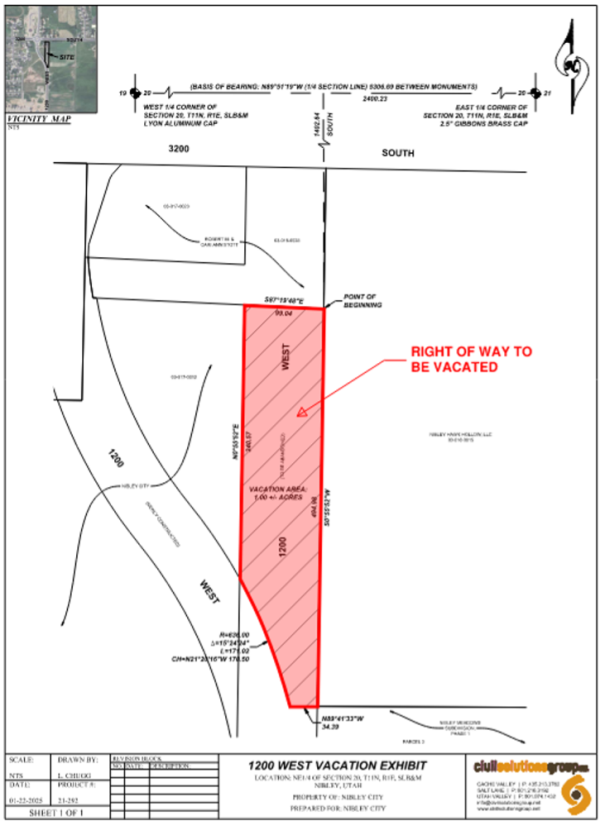
EXHIBIT B
LEGAL DESCRIPTION PREPARED FOR 1200 WEST ROADWAY VACATION NIBLEY CITY NIBLEY, UTAH (January 29, 2025) Project No. 21-292
1200 WEST VACATION
All of 1200 West Street as previously monumented and constructed located south of Parcel 03-018-0035 and north of the newly constructed 1200 West Street, located in the NE1/4 of Section 20, Township 11 North, Range 1 East, Salt Lake Base & Meridian, Nibley, Utah, more particularly described as follows:
Beginning at the southeast corner of Parcel 03-018-0035, located N89°51’19”W along the 1/4 Section Line between the West 1/4 Corner and East 1/4 Corner of Section 20, T11N, R1E, SLB&M 2,400.23 feet and South 1,402.64 feet from the East 1/4 Corner of said Section 20; thence S0°55’52”W along the existing east right-of-way line of 1200 West Street and the west line of Parcel 03-018-0015 494.98 feet to the northwest corner of NIBLEY MEADOWS Subdivision, Phase 1, according to the Official Plat thereof on file in the Office of the Cache County Recorder and the north right-of-way line of the newly constructed 1200 West Street; thence along said north right-of-way line the following 2 (two) bearings and distances: (1) N89°41’33”W 34.39 feet; (2) thence northwesterly along the arc of a 636.00 foot radius non-tangent curve (radius bears: S76°21’56”W) to the left 171.02 feet through a central angle of 15°24’24” (chord: N21°20’16”W 170.50 feet) to a point on the east line of Parcel 03-017-0012 and the existing west right-of-way line of 1200 West Street; thence N0°55’52”E along the east line of said parcel and the existing west right-of-way line of said Street 340.57 feet to a point on the south line of Parcel 03-018-0035; thence S87°19’48”E along south line of said Parcel 99.04 feet to the point of beginning.
Contains: 1.00+/- acres
Adopted by Ord. 25-09 on 2/20/2025
Adopted by Other Petition to Vacate - O25-09 on 2/20/2025
Approved by Other 25-09 LAA on 2/20/2025
Ordinance 25-06 Notice Of Intent To Adopt An Impact Fee Facilities Plan
NOTICE OF INTENT TO ADOPT AN IMPACT FEE FACILITIES PLAN, LOGAN CITY WASTEWATER IMPACT FEES
WHEREAS, Nibley City is a municipal corporation duly organized and existing under the laws of the State of Utah; and WHEREAS, Nibley City finds that in conformance with the provision of UCA 11-36a et seq., the City has in the past enacted and promulgated certain impact fees within Nibley City; and WHEREAS, Nibley City finds that it is in the public welfare and for the benefit of the City and its residents to adopt an impact fee to provide for the future Water, Sewer, Wastewater Treatment and Parks needs of Nibley City; and WHEREAS, in conformance with the provisions of UCA 11-36a-303, Logan City has prepared an Amended Impact Fee Facilities Plan; and WHEREAS, Nibley City Council has reviewed the Impact Fee Facilities Plan, and finds and concludes that the analysis provides a reasonable plan on which to impose and base a decrease of impact fees. NOW, THEREFORE, BE IT ORDAINED BY THE NIBLEY CITY COUNCIL OF NIBLEY, UTAH THAT:
- Nibley City accepts the Amended Wastewater Impact Fee Facilities Plan and Impact Fee Analysis Amendment prepared by LRB Public Finance Advisors dated November 2024.
PASSED BY THE NIBLEY CITY COUNCIL THIS 20 DAY OF February, 2025. Larry Jacobsen, Mayor ATTEST: Cheryl Bodily, City Recorder
Adopted by Ord. 25-06 on 2/20/2025
Adopted by Other Logan Wastewater IFFP - O25-06 on 2/20/2025
Ordinance 25-31 Providing For The Compensation Of Elected And Statutory Officers And Department Heads Of Nibley City
WHEREAS, elected and statutory officers are required to devote a significant amount of time and talent to the effective administration of Nibley City; and WHEREAS, elected and statutory officers should be fairly compensated for their time and expenses; and WHEREAS, the Nibley City Council finds that enacting the proposed compensation increases as set forth in this Ordinance will comply with Utah Code requirements and will promote the public health, safety, and welfare of the residents of the City of Nibley, Utah; and NOW, THEREFORE, BE IT ORDAINED BY THE NIBLEY CITY COUNCIL OF NIBLEY, UTAH THAT:
- All previous salary or compensation ordinances regarding the elected and statutory officers and department managers listed below are hereby repealed.
- The maximum compensation of the elected and statutory officers and department managers of Nibley City shall be as follows:
Office/Title: 2024-25
Annual Salary:Proposed Maximum
FY 25-26
Annual SalaryChristmas
BonusAnnual Increase: Recreation Director $90,804 $102,000 $300 $11,196 - Elected and statutory officers shall be paid on the same schedule as other municipal employees.
- The compensation listed above is not inclusive of per diem, mileage, phone allowance or other expenses, which may be incurred in the course of conducting Nibley City business.
- This ordinance shall become effective 16 Oct, 2025.
PASSED BY THE NIBLEY CITY COUNCIL THIS 16 DAY OF October, 2025. Larry Jacobsen, Mayor ATTEST: Cheryl Bodily, City Recorder
Adopted by Ord. 25-32 on 10/16/2025
Ordinance 25-05 Development And Land Adj Agreement With Hawk Hollow Btwn City And Developer Parcels
DEVELOPMENT AND LAND ADJUSTMENT AGREEMENT WITH NIBLEY HAWK HOLLOW, LLC FOR THE HAWK HOLLOW SUBDIVISION FOR THE ADJUSTMENT OF BOUNDARIES BETWEEN CITY PARCELS AND THE DEVELOPER PARCEL, LOCATED AT APPROXIMATELY 1050 W 3200 S, SETTING FORTH TERMS AND CONDITIONS, INCLUDING AN EXCEPTION TO NCC 21.12.060(F)(3) REGARDING PEDESTRIAN CONNECTIVITY
WHEREAS, UCA 10-9-532(2)(a)(iii) provides that the City may enter into a development agreement which includes provisions which the City Code would otherwise prohibit provided that the agreement is approved in accordance with the same procedures for enacting a land use regulation under UCA 10-9a-502 ; and
WHEREAS, the proposed land exchange will benefit the health and wellness of the community with additional usable park space.
WHEREAS, The proposed location of a trail adjacent to the proposed park space provides a greater community benefit than the limits of NCC 21.12.060(F)(3) provide.
WHEREAS, The setback and size limitations of the proposed casita are within constraints of Nibley City’s standards for accessory dwelling units.
NOW, THEREFORE, BE IT ORDAINED BY THE CITY COUNCIL OF NIBLEY, UTAH THAT:
- The attached LAND ADJUSTMENT AGREEMENT be approved.
- The Agreement shall not take place until the Developer and City have signed the attached Agreement.
- All ordinances, resolutions and polices of the City, or parts thereof, inconsistent herewith, are hereby repealed, but only to the extent of such inconsistency. This repealer shall not be construed as reviving and law, order, resolution or ordinance or part thereof.
PASSED BY THE NIBLEY CITY COUNCIL THIS 13 DAY OF March, 2025.
Larry Jacobsen, Mayor
ATTEST: Cheryl Bodily, City Recorder
Adopted by Ord. 25-05 on 3/13/2025
Ordinance 25-12 Rezone Parcel 03-227-0004 From Residential (R-2) To Agricultural (A)
REZONE PARCEL 03-227-0004, LOCATED AT 1500 W 2600 S FROM
RESIDENTIAL (R-2) TO AGGRICULTURAL (A)
BE IT ORDAINED BY THE NIBLEY CITY COUNCIL LOCATED AT NIBLEY, UTAH, THAT:
Parcel 03-227-0004, more particularly described below, is hereby rezoned from Residential (R-2) to Agricultural (A).
Parcel 03-227-0004:
ALL OF LOT 4 WESLEY NELSON FARMS SUBDIVISION
CONT 7.83 AC
PASSED BY THE NIBLEY CITY COUNCIL THIS 12 day of June, 2025.
Larry Jacobsen, Mayor
Attest: Cheryl Bodily, City Recorder
Adopted by Ord. 25-12 on 6/12/2025
Ordinance 25-14 2nd Amd Of The Nibley Meadows Subdivision DA
SECOND AMENDMENT OF THE NIBLEY MEADOWS SUBDIVISION DEVELOPMENT AGREEMENT, INCLUDING MODIFICATIONS TO DEVELOPMENT PLANS, AREA DENSITY, AND STORMWATER AND PARK AMENITY REQUIREMENTS
WHEREAS, Nibley Meadows, hereinafter referred to as “the Development,” was previously approved as a Resi-dential Planned Unit Development (“R-PUD”) under Nibley City Code Title 19, Chapter 32 (“R-PUD Ordi-nance”) pursuant to the Development Agreement and other approvals issued by Nibley City; and;
WHEREAS, according to the terms of the Development Agreement, the parties have entered into the Park Agree-ment which governs the development of a 4.5 acre City park space (the “Park Space”);
WHEREAS, in order to accommodate regional stormwater infrastructure, changes to the design of the Develop-ment are necessary as well as deviations to applicable code; and
WHEREAS, Developer has agreed to dedicate additional land for public use, and to fund additional public infra-structure improvements, as depicted on Exhibit A;
WHEREAS, this First Amendment was passed pursuant to Ordinance No. 23-08;
WHEREAS, the parties desire to amend the Development Agreement and Park Agreement as set forth in this Sec-ond Amendment.
NOW, THEREFORE, BE IT ORDAINED BY THE CITY COUNCIL OF NIBLEY, UTAH THAT:
- The attached Development Agreement- Second Amendment be approved
- The Agreement shall not take place until the Developer and City have signed the attached Agreement and said Agreement has been properly recorded as required by Nibley City Code.
- All ordinances, resolutions and polices of the City, or parts thereof, inconsistent herewith, are hereby re-pealed, but only to the extent of such inconsistency. This repealer shall not be construed as reviving and law, order, resolution or ordinance or part thereof.
PASSED BY THE NIBLEY CITY COUNCIL THIS 22 DAY OF May 2025.
Larry Jacobsen, Mayor
ATTEST: Cheryl Bodily, City Recorder
Adopted by Ord. 25-14 on 5/22/2025
Amended by Other 25-14 DA on 5/22/2025
Ordinance 25-16 Adjusting The Municipal Boundaries Of The City Of Nibley Adding Parcels 03-012-0026, 03-012-0027 And 03-012-0028
ADJUSTING THE MUNICIPAL BOUNDARIES OF THE CITY OF NIBLEY, ADDING PARCELS 03-012-0026, 03-012-0027 AND 03-012-0028, LOCATED AT 2244-2298 SOUTH & U.S. HIGHWAY 89/91, TO NIBLEY CITY AND ASSIGNING ZONING TO SUBJECT PROPERTIES
WHEREAS, the Nibley City Council finds that it is in the best interest of Nibley City to adjust the boundary between the City of Logan and the City of Nibley; and
WHEREAS, the boundary adjustment as set forth below will not materially injure the public in general or any person.
WHEREAS, the area described in this ordinance is included in the Nibley City Annexation Declaration Area and is contiguous to existing municipal boundaries.
WHEREAS, The Future Land Use Map of the Nibley City General Plan designates the area described in this ordinance as Commercial.
NOW, THEREFORE, BE IT ORDAINED BY THE CITY COUNCIL OF NIBLEY, UTAH THAT:
1. Pursuant to section 10-2-419, Utah Code Annotated, the following boundary line adjustment is declared:
Property identified as parcels, or portions thereof, 03-012-0026, 03-012-0027 and 03-012-0028, in the parcel records of Cache County, State of Utah, located at approximately 2944, 2966 and 2988 South U.S. Highway 89/91 in Logan, Utah and comprising approximately 5.998 acres, and legally described as:
An Adjusted Corporate Limit Line located in the East Half of Section 19, Township 11 North, Range 1 East, Salt Lake Meridian, situated in Cache County, Utah as described below:
Beginning at the Southeast Corner of Racoon Ridge Subdivision, Entry Number 686022, being Common to the Southwest Corner of Heritage Business Park Phase 1, Entry Number 894573, and RUNNING THENCE Along the Perimeter of said Racoon Ridge the Following Four (4) Courses: (1) North 89°27'17" West 330.52 Feet (North 89°54'48" West 330.58 Feet by Record); (2) South 89°44'44" West 189.42 Feet (South 89°06'17" West by Record); (3) South 53°04'58" West 220.34 Feet (South 52°26'31" West by Record); (4) North 20°01'01" West 381.06 Feet (North 20°39'28" West 386.60 Feet by Record) to the Intersection with the South Right-of-Way Line of Highway 89-91; Thence North 52°36'16" West 52.50 Feet to the Center of said Highway; Thence North 37°23'44" East 362.66 Feet Along said Highway Center; Thence South 52°36'16" East 52.50 Feet to the Intersection with the West Line of said Heritage Business Park Phase 1; Thence South 49°35'33" East 796.21 Feet (South 49°48'47" East 798.47 feet by Record) Along said West Line to the Point of Beginning.
Shall be relinquished from City of Logan jurisdiction and shall be transferred to the jurisdictional authority of the City of Nibley.
2. The Zoning for the area that is jurisdictionally transferred to Nibley City is to be Commercial (C).
3. Effective Date. This ordinance shall take effect immediately upon publication and passage of a similar appropriate ordinance by the City of Logan.
PASSED BY THE NIBLEY CITY COUNCIL THIS 1 DAY OF May 2025
Larry Jacobsen, Mayor
ATTEST: Cheryl Bodily, City Recorder
Adopted by Ord. 25-16 on 5/1/2025
Adopted by Map 25-16 on 5/1/2025
Ordinance 25-17 Annexation And Zoning Assignment Of Parcel 03-049-0011 Located At Approximately 3601 S 1200 W, Containing 9 Acres And Assigning Zoning Of R-2A (Residential)
BE IT ORDAINED BY THE NIBLEY CITY COUNCIL LOCATED AT NIBLEY, UTAH, THAT: The attached Annexation Petition, with the following legal description, be approved to annex into the City: Part of Lot 14, Block 15 and adjoining streets, Millville West Field Survey located in the North Half of Section 29, Township 11 North, Range 1 East of the Salt Lake Baseline and Meridian described as follows: Commencing at the West Quarter Corner of Section 20, Township 1 East of the Salt Lake Baseline and Meridian monumented with an Aluminum Cap (East Quarter Corner of said Section 20 monumented with a Brass Cap bears N 89º55'25” E 5306.65 feet) thence N 89º55'25” E 2183.73 feet E 5306.65 feet) thence N 89º55'25” E 2183.73 feet E 2183.73 feet along the Quarter Section line; thence South 3852.35 feet to the Southwest Corner of Nibley Farms, Phase 6 recorded in the Cache County Recorder's Office under Entry No. 1322379 on June 21, 2022 and the POINT OF BEGINNING and running thence S 88°55'24" E 701.51 feet along the south line of said Nibley Farms, Phase 6 and its projection thereof to the east right of way line of 1200 East Street; thence along said east right of way line the next two courses: 1) thence S 00°32'23" W 18.15 feet; thence S 00°32'23" W 18.15 feet; 2) thence 650.59 feet along a curve to the left, with a thence 650.59 feet along a curve to the left, with a central angle of 01°20'01", a radius of 27950.50 feet, and a chord that bears S 00°07'38" E 650.59 feet; thence N 88°52'50" W 701.58 feet along the south line of Lot 14, Block 15, Millville West Field Survey and its projection thereof; thence N 00°06'14" W 668.20 along west line of Lot 14, Block 15, Millville West Field Survey to the point of beginning, containing 10.74 acres, more or less. Parcel 03-049-0011 shall be assigned the zone as R-2A (Residential). PASSED BY THE NIBLEY CITY COUNCIL THIS 25 DAY OF September, 2025.
Larry Jacobsen, Mayor
ATTEST: Cheryl Bodily, City Recorder
Adopted by Ord. 25-17 on 9/25/2025
Adopted by Map 25-17 on 9/25/2025
Adopted by Other 25-17 on 9/25/2025
Ordinance 25-28 Adj Municipal Boundaries Of The City Of Nibley
ADJUSTING THE MUNICIPAL BOUNDARIES OF THE CITY OF NIBLEY, ADDING PARCELS, OR PORTIONS THEREOF, 03-007-0023, 03-007-0011, 03-007-0010, 03-007-0022, 03-007-0009, 03-007-0013, 03-007-0027, LOCATED AT APPROXIMATELY 2200 SOUTH & U.S. HIGHWAY 89/91, TO NIBLEY CITY AND ASSIGNING ZONING TO SUBJECT PROPERTIES
WHEREAS, the Nibley City Council finds that it is in the best interest of the City to adjust the boundary between the City of Logan and the City of Nibley; and
WHEREAS, the boundary adjustment as set forth below will not materially injure the public in general or any person.
WHEREAS, on July 27, 2023, the City Council approved Ordinance 23-31: annexation agreement with Watermark, LLC, setting forth zoning and development obligations for parcels 03-007-0010, 03-007-0011, and 03-007-0023, located at approximately 1250 w 2200 s, assigning a zone of R-M mixed residential with modifications, in advance of a future annexation application.
WHEREAS, the Nibley City Planning Commission have recommended a zone designation for Parcels 03-007-0013, 03-007-0009, and 03-007-0022, located at 2230, 2240 and 2250 S Hwy 89/91, to Residential (R-2) and a portion of Parcel 03-007-0027, located at 1275 W 2350 S, to Park/School (P/S) in conjunction with a Logan City – Nibley City Boundary Adjustment, in support of the Nibley City General Plan.
WHEREAS, parcels 03-007-0023, 03-007-0011, 03-007-0010, 03-007-0022, 03-007-0009, 03-007-0013, 03-007-0027 are within Nibley City’s Future Annexation Declaration Area.
NOW, THEREFORE, BE IT ORDAINED BY THE CITY COUNCIL OF NIBLEY, UTAH THAT:
- Pursuant to section 10-2-419, Utah Code Annotated, the following boundary line adjustment is declared:
Property identified as parcels, or portions thereof, 03-007-0023, 03-007-0011, 03-007-0010, 03-007-0022, 03-007-0009, 03-007-0013, 03-007-0027, in the parcel records of Cache County, State of Utah, located at approximately 2200 South, U.S. Highway 89/91 and 1200 West in Logan, Utah and comprising approximately 14.75 acres, and legally described as:
A portion of the SW1/4 of Section 17, Township 11 North, Range 1 East, Salt Lake Base & Meridian, more particularly described as follows:
Beginning on the northerly line of the ANNEXATION TO THE CITY OF NIBLEY described in Book 2002 Page 1586 of the Official Records of Cache County and the calculated position of the Center 1/4 Corner of Section 17, T11N, R1E, SLB&M (Basis of Bearing: N89°44'10”W between the West 1/4 Corner and the Center 1/4 Corner of Section 17, T11N, R1E, SLB&M); thence along said Annexation the following 10 (ten) courses and distances: (1) S0°29'32”E along the 1/4 Section line 735.91 feet; (2) thence N70°13'47”W 314.74 feet; (3) thence N69°48'07”W 184.69 feet; (4) thence S55°22'22”W 233.69 feet; (5) thence N78°46'42”W 24.89 feet; (6) thence N66°12'42”W 14.69 feet; (7) thence N47°04'08”W 45.23 feet; (8) thence N40°06'34”W 19.26 feet; (9) thence N29°34'24”W 60.21 feet; (10) thence N66°22'17”W 467.69 feet to the easterly right-of-way line of US Highway 89/91; thence N40°10'19”E along said right-of-way line 521.32 feet to the centerline of 2200 South Street also being the 1/4 Section line of Section 17; thence N89°44'10”W along said centerline and 1/4 Section line 860.79 feet to the point of beginning.
Shall be relinquished from City of Logan jurisdiction and shall be transferred to the jurisdictional authority of the City of Nibley. - Effective Date. This ordinance shall take effect immediately upon publication and passage of a similar appropriate ordinance by the City of Logan.
- Parcels 03-007-0013, 03-007-0009, and 03-007-0022, are assigned the zone of Residential (R-2). The portion of Parcel 03-007-0027, located at 1275 W 2350 S, is assigned the zone of Park/School (P/S). Parcels 03-007-0010, 03-007-0011, and 03-007-0023 are assigned the zone of Mixed Residential (R-M).
PASSED BY THE NIBLEY CITY COUNCIL THIS 24 DAY OF October, 2024.
Larry Jacobsen, Mayor
ATTEST: Cheryl Bodily, City Recorder
Adopted by Ord. 25-28 on 7/31/2025
Ordinance 25-29 Amending The DA For Apple Creek Subdivision Phase 1
DEVELOPMENT AGREEMENT FOR THE APPLE CREEK SUBDIVISION PHASE 1 FIRST AMENDMENT, AMENDING LOT 35, CREATING AN ADDITIONAL BUILDING LOT AND AMENDING THE CONSERVATION AREA, INCLUDING MODIFICATIONS TO DEVELOPMENT AND ZONING STANDARDS
WHEREAS, The Apple Creek Subdivision Phase 1 First Amendment, was conditionally approved as a Open Space Subdivision on August 7, 2025 under Nibley City Code 21.10.020 (“Open Space Subdivision Ordinance”) pursuant to the Development Agreement and other approvals issued by Nibley City; and
WHEREAS, The dedication of additional Open Space will be of beneficial use to the City and its residents.
NOW, THEREFORE, BE IT ORDAINED BY THE CITY COUNCIL OF NIBLEY, UTAH THAT:
- The attached Development Agreement be approved
- The Agreement shall not take place until the Developer and City have signed the attached Agreement and said Agreement has been properly recorded as required by Nibley City Code.
- All ordinances, resolutions and policies of the City, or parts thereof, inconsistent herewith, are hereby repealed, but only to the extent of such inconsistency. This repealer shall not be construed as reviving and law, order, resolution or ordinance or part thereof.
PASSED BY THE NIBLEY CITY COUNCIL THIS 25 DAY OF September, 2025
Larry Jacobsen, Mayor
ATTEST: Cheryl Bodily, City Recorder
Amended by Ord. 25-29 on 9/25/2025
Ordinance 24-02 Rezone Parcel 03-018-0015 And A Portion Of Parcel 03-017-0012 Located At 1150 W 3200 S From R-2 To R-2A
REZONE PARCEL 03-018-0015 & A PORTION OF PARCEL 03-017-0012. LOCATED AT 1150 W 3200 S FROM RESIDENTIAL (R-2) TO RESIDENTIAL (R-2A)
BE IT ORDAINED BY THE NIBLEY CITY COUNCIL LOCATED AT NIBLEY, UTAH, THAT:
Parcel 03-018-0015 & a portion of parcel 03-017-0012, the area of which is described below, is hereby rezoned from Residential (R-2) to Residential (R-2A).

The Rezone is conditional upon the following:
- Nibley City and the applicant will exchange land in an agreement to be determined later with the city’s intention to increase the size of the planned Nibley Meadows Park.
- The property is legally subdivided in accordance with Nibley City Code Chapter 21.
- This Rezone does not constitute approval of the proposed concept plan submitted with the Rezone application.
- The zoning on the property will revert back to Residential (R-2) if the land exchange and subdivision required in Items 1 & 2 are not finalized within 2 years of adoption of this ordinance.
PASSED BY THE NIBLEY CITY COUNCIL THIS 14 day of March, 2024.
Larry Jacobsen, Mayor
ATTEST: Cheryl Bodily, City Recorder
Adopted by Ord. 24-02 on 3/14/2024
Ordinance 24-04 DA With RW Enterprises Inc And Project Valor For Parcel 03-020-0018
DEVELOPMENT AGREEMENT WITH R & W ENTERPRISES INC, TOGETHER WITH PROJECT VALOR TO ALLOW CONSTRUCTION OF ONE (1) CASITA ON PARCEL 03-020-0018, LOCATED AT 110 W 2600 S, TO HOUSE TRANSITIONING AND/OR HOMELESS VETERANS WITHIN A LEGALLY NON-CONFORMING MOBILE HOME PARK, SETTING FORTH CONDITIONS AND STANDARDS FOR ITS CONSTRUCTION
WHEREAS, UCA 10-9-532(2)(a)(iii) provides that the City may enter into a development agreement which includes provisions which the City Code would otherwise prohibit provided that the agreement is approved in accordance with the same procedures for enacting a land use regulation under UCA 10-9a-502 ; and
WHEREAS, Allowing for the Casita, as presented, is in support of Nibley City General Plan Residential Development and Housing Goal 3 and Moderate-Income Housing Plan Strategy 7.
WHEREAS, The Casita is expected to have minimal impact on surrounding properties and be compatible with surrounding land uses.
WHEREAS, The setback and size limitations of the proposed casita are within constraints of Nibley City’s standards for accessory dwelling units.
NOW, THEREFORE, BE IT ORDAINED BY THE CITY COUNCIL OF NIBLEY, UTAH THAT:
- The attached NIBLEY CITY DEVELOPMENT AGREEMENT be approved.
- The Agreement shall not take place until the Developer and City have signed the attached Agreement.
- All ordinances, resolutions and polices of the City, or parts thereof, inconsistent herewith, are hereby repealed, but only to the extent of such inconsistency. This repealer shall not be construed as reviving and law, order, resolution or ordinance or part thereof.
PASSED BY THE NIBLEY CITY COUNCIL THIS 14 DAY OF March, 2024.
Larry Jacobsen, Mayor
ATTEST: Cheryl Bodily, City Recorder
Adopted by Ord. 24-03 on 3/14/2024
Adopted by Other 24-03 DA on 3/14/2024
Ordinance 24-09 Rezone Parcel 03-227-0003 From R-2 To R-M
REZONE PARCEL 03-227-0003, LOCATED AT 1301 W 2600 S, FROM RESIDENTIAL (R-2) TO MIXED RESIDENTIAL (R-M)
BE IT ORDAINED BY THE NIBLEY CITY COUNCIL LOCATED AT NIBLEY, UTAH, THAT: Parcel 03-227-0003, more particularly described below, is hereby rezoned from Residential (R-2) to Mixed Residential (R-M). Parcel 03-227-0003: ALL OF LOT 3 WESLEY NELSON FARMS SUBDIVISION CONT 18.94 AC PASSED BY THE NIBLEY CITY COUNCIL THIS 22 day of August, 2024.
Larry Jacobsen, Mayor ATTEST: Cheryl Bodily, City Recorder
Adopted by Ord. 24-09 on 8/22/2024
Ordinance 24-10 DA With Stokes Nature Center For Learning Center And Nature Park
DEVELOPMENT AGREEMENT WITH STOKES NATURE CENTER FOR THE CONSTRUCTION OF AN OUTDOOR LEARNING SPACE AND NATURE PARK ON PARCEL 03-004-0011, LOCATED AT 99 W 2600 S, SETTING FORTH CONDITIONS AND STANDARDS FOR ITS CONSTRUCTION, INCLUDING EXCEPTIONS TO REQUIREMENTS FOR THE INCLUSION OF PUBLIC TRAILS AND THE DEDICATION OF WATER SHARES OR RIGHTS
WHEREAS, UCA 10-9-532(2)(a)(iii) provides that the City may enter into a development agreement which includes provisions which the City Code would otherwise prohibit provided that the agreement is approved in accordance with the same procedures for enacting a land use regulation under UCA 10-9a-502 ; and
WHEREAS, The Planning Commission has conditionally approved a Site Plan for the construction of an outdoor learning space and nature park; and
WHEREAS, Stokes Nature Center has indicated that the provision of a public trail would be a violation of the conservation easement held by the Utah Division of Wildlife Resources; and
WHEREAS, Stokes Nature Center has demonstrated the ability to irrigate the property’s intended outdoor use without culinary water use.
NOW, THEREFORE, BE IT ORDAINED BY THE CITY COUNCIL OF NIBLEY, UTAH THAT:
- The attached NIBLEY CITY DEVELOPMENT AGREEMENT be approved.
- The Agreement shall not take place until the Developer and City have signed the attached Agreement.
- All ordinances, resolutions and polices of the City, or parts thereof, inconsistent herewith, are hereby repealed, but only to the extent of such inconsistency. This repealer shall not be construed as reviving and law, order, resolution or ordinance or part thereof.
PASSED BY THE NIBLEY CITY COUNCIL THIS 22 DAY OF August, 2024.
Larry Jacobsen, Mayor
ATTEST: Cheryl Bodily, City Recorder
Adopted by Other 24-10 DA on 8/22/2024
Adopted by Ord. 24-10 on 10/22/2024
Ordinance 24-11 Amendment 2 Of The Ridgeline Park Subdivision DA-Allowing For Payment In-Lieu Of 2900 South Access Road
ORDINANCE 24-11
AMENDMENT 2 OF THE RIDGELINE PARK SUBDIVISION DEVELOPMENT AGREEMENT, ALLOWING FOR A PAYMENT IN-LIEU OF REQUIRED IMPROVEMENTS FOR THE 2900 SOUTH ACCESS ROAD
WHEREAS, Visionary Homes, hereinafter referred to as “the Development” has obtained approval for a Residential Planned Unit Development (“R-PUD”) overlay zone under Nibley City Code Title 19, Chapter 32 (“R-PUD Ordinance”) for the Ridgeline Park Subdivision; and
WHEREAS, In light of continuing negotiations between the Utah Department of Transportation (UDOT) and the City regarding a new Highway 165 corridor agreement, the parties agree that the previously contemplated construction of 2900 S (together with ancillary improvements) in conjunction with the development of Ridgeline Park phases 7 through 9, may be modified or eliminated by the plans resulting from such negotiations. Accordingly, the parties agree that rather than constructing 2900 S, Developer shall pay to the City a Non-Project-Specific fee in lieu; and
WHEREAS, the Parties intend to establish the specific terms, conditions, and requirements for the allowance of the payment in-lieu of improvements.
NOW, THEREFORE, BE IT ORDAINED BY THE CITY COUNCIL OF NIBLEY, UTAH THAT:
- The attached Development Agreement- Second Amendment be approved
- The Agreement shall not take place until the Developer and City have signed the attached Agreement and said Agreement has been properly recorded as required by Nibley City Code.
- All ordinances, resolutions and polices of the City, or parts thereof, inconsistent herewith, are hereby repealed, but only to the extent of such inconsistency. This repealer shall not be construed as reviving and law, order, resolution or ordinance or part thereof.
PASSED BY THE NIBLEY CITY COUNCIL THIS 14 DAY OF November, 2024.
Larry Jacobsen, Mayor
ATTEST: Cheryl Bodily, City Recorder
Adopted by Other 24-11 DA on 11/14/2024
Adopted by Ord. 24-11 on 11/14/2025
Ordinance 24-13 Adjusting The Municipal Boundaries Of The City Of Nibley
ORDINANCE 24-13
ADJUSTING THE MUNICIPAL BOUNDARIES OF THE CITY OF NIBLEY, ADDING PARCELS, OR PORTIONS THEREOF, 03-007-0023, 03-007-0011, 03-007-0010, 03-007-0022, 03-007-0009, 03-007-0013, 03-007-0027, LOCATED AT APPROXIMATELY 2200 SOUTH & U.S. HIGHWAY 89/91, TO NIBLEY CITY AND ASSIGNING ZONING TO SUBJECT PROPERTIES
WHEREAS, the Nibley City Council finds that it is in the best interest of the City to adjust the boundary between the City of Logan and the City of Nibley; and WHEREAS, the boundary adjustment as set forth below will not materially injure the public in general or any person.
WHEREAS, on July 27, 2023, the City Council approved Ordinance 23-31: annexation agreement with Watermark, LLC, setting forth zoning and development obligations for parcels 03-007-0010, 03-007-0011, and 03-007-0023, located at approximately 1250 w 2200 s, assigning a zone of R-M mixed residential with modifications, in advance of a future annexation application.
WHEREAS, the Nibley City Planning Commission have recommended a zone designation for Parcels 03-007-0013, 03-007-0009, and 03-007-0022, located at 2230, 2240 and 2250 S Hwy 89/91, to Residential (R-2) and a portion of Parcel 03-007-0027, located at 1275 W 2350 S, to Park/School (P/S) in conjunction with a Logan City – Nibley City Boundary Adjustment, in support of the Nibley City General Plan.
WHEREAS, parcels 03-007-0023, 03-007-0011, 03-007-0010, 03-007-0022, 03-007-0009, 03-007-0013, 03-007-0027 are within Nibley City’s Future Annexation Declaration Area.
NOW, THEREFORE, BE IT ORDAINED BY THE CITY COUNCIL OF NIBLEY, UTAH THAT:
- Pursuant to section 10-2-419, Utah Code Annotated, the following boundary line adjustment is declared:
Property identified as parcels, or portions thereof, 03-007-0023, 03-007-0011, 03-007-0010, 03-007-0022, 03-007-0009, 03-007-0013, 03-007-0027, in the parcel records of Cache County, State of Utah, located at approximately 2200 South, U.S. Highway 89/91 and 1200 West in Logan, Utah and comprising approximately 14.75 acres, and legally described as:
A portion of the SW1/4 of Section 17, Township 11 North, Range 1 East, Salt Lake Base & Meridian, more particularly described as follows:
Beginning on the northerly line of the ANNEXATION TO THE CITY OF NIBLEY described in Book 2002 Page 1586 of the Official Records of Cache County and the calculated position of the Center 1/4 Corner of Section 17, T11N, R1E, SLB&M (Basis of Bearing: N89°44'10”W between the West 1/4 Corner and the Center 1/4 Corner of Section 17, T11N, R1E, SLB&M); thence along said Annexation the following 10 (ten) courses and distances: (1) S0°29'32”E along the 1/4 Section line 735.91 feet; (2) thence N70°13'47”W 314.74 feet; (3) thence N69°48'07”W 184.69 feet; (4) thence S55°22'22”W 233.69 feet; (5) thence N78°46'42”W 24.89 feet; (6) thence N66°12'42”W 14.69 feet; (7) thence N47°04'08”W 45.23 feet; (8) thence N40°06'34”W 19.26 feet; (9) thence N29°34'24”W 60.21 feet; (10) thence N66°22'17”W 467.69 feet to the easterly right-of-way line of US Highway 89/91; thence N40°10'19”E along said right-of-way line 521.32 feet to the centerline of 2200 South Street also being the 1/4 Section line of Section 17; thence N89°44'10”W along said centerline and 1/4 Section line 860.79 feet to the point of beginning.
Shall be relinquished from City of Logan jurisdiction and shall be transferred to the jurisdictional authority of the City of Nibley. - Effective Date. This ordinance shall take effect immediately upon publication and passage of a similar appropriate ordinance by the City of Logan.
- Parcels 03-007-0013, 03-007-0009, and 03-007-0022, are assigned the zone of Residential (R-2). The portion of Parcel 03-007-0027, located at 1275 W 2350 S, is assigned the zone of Park/School (P/S). Parcels 03-007-0010, 03-007-0011, and 03-007-0023 are assigned the zone of Mixed Residential (R-M).
PASSED BY THE NIBLEY CITY COUNCIL THIS 24 DAY OF October, 2024. Larry Jacobsen, Mayor ATTEST: Cheryl Bodily, City Recorder
Adopted by Ord. 24-13 on 10/24/2024
Ordinance 24-15 Rezone Parcel 03-018-0005 From R-2 To C-N
REZONE PARCEL 03-018-0005, LOCATED AT APPROXIMATELY 1101 W 3200 S, FROM RESIDENTIAL (R-2) TO NEIGHBORHOOD COMMERCIAL (C-N)
BE IT ORDAINED BY THE NIBLEY CITY COUNCIL LOCATED AT NIBLEY, UTAH, THAT: Parcel 03-018-0005, more particularly described below, is hereby rezoned from R-2 (Residential) to Neighborhood Commercial (C-N).
Parcel 03-018-0005: BEG 7.1 CHS E & 12.25 CHS S OF NW COR OF SE/4 SEC 20 T 11N R 1E, S 5 CHS TO N LINE CO ROAD E 7.1 CHS N 5 CHS W 7.1 CHS TO BEG CONT 3.55 AC
PASSED BY THE NIBLEY CITY COUNCIL THIS 5 day of December, 2024. Larry Jacobsen, Mayor ATTEST: Cheryl Bodily, City Recorder
Ordinance 23-01 Rezone Of A Portion Of Parcel 03-004-0011 (Stokes Nature Center) To Parks/School (PS)
REZONE OF A PORTION OF PARCEL 03-004-0011, LOCATED AT APPROXIMATELY 101 WEST 2600 SOUTH, CONTAINING 4.19 ACRES,
FROM RESIDENTIAL (R-2) TO PARK/SCHOOL (P/S)
BE IT ORDAINED BY THE NIBLEY CITY COUNCIL LOCATED AT NIBLEY, UTAH, THAT:
The southern 4.19 acre portion of Parcel 03-004-0011 which includes the entirety of the property currently incorporated in Nibley City, more particularly described below, is hereby rezoned from Residential (R-2) to Park/School (P/S).
BEG 20 RDS N & 16 RDS E OF SW COR OF SE/4 OF SE/4 SEC 16 T 11N R 1E, TH N 3 RDS W 13 RDS N 13 RDS W 3 RDS N 89 FT E 670 FT SE'LY TO PT E OF BEG W TO BEG CONT 4.95 AC SUBJ TO PIPELINE EASEMENT 453/515 ALSO: BEG 683 FT N & 679 FT W FROM SE COR SEC 16 T 11N R 1E, TH E 132.5 FT SE'LY TO W LINE OF STATE ROAD, S'LY ALG SD W LINE TO ITS INTERSECT WITH S LINE OF SE/4 SD SEC 16 W 744 FT N 20 RDS E IN NIBLEY CORP LIMITS TO ITS CHANGE IN DIRECTION RUNNING NW'LY TH NW'LY TO BEG CONT 6.42 AC LESS 0.06 AC TO UDOT 485/881 LESS: BEG AT S/4 COR SEC 16 T 11N R 1E & TH S 89*56'07" E 2198.5 FT ALG SEC LN TH N 0*03'53" E 16.5 FT TO N LN OF 2600 S ST & TRUE POB TH S 89*56'07" E 122.02 FT ALG SD ST TO W LN OF HWY 165 TH ALG HWY IN 3 COURSES: N 34*54'26" E 14.95 FT TH N 1*17'40" W 402.77 FT TH N 2*55'10" W 62.39 FT TH LEAVING HWY N 40*46'48" W 33.75 FT TH S 37*16'04" W 251.25 FT TH S 10*27'39" E 307.83 FT TO TRUE POB CONT 1.54 AC M/B (0027) NET 4.82 AC CONT 9.77 AC M/L IN ALL A R/W OVER 1 RD IN WIDTH ON BOTH SIDES & RUNNING FULL LENGTH OF ALL QUARTER SEC LINES WITHIN SD SEC WHICH IS RESERVED & FOREVER DEDICATED TO THE PUBLIC USE AS HIGHWAYS
PASSED BY THE NIBLEY CITY COUNCIL THIS 9 day of February, 2023.
Larry Jacobsen, Mayor
ATTEST: Cheryl Bodily, City Recorder
Adopted by Ord. 23-01 on 2/9/2023
Ordinance 23-03 Proposed Zoning And Annexation - Malouf
APPROVING PROPOSED ZONING AND THE ANNEXATION OF PARCEL 03-015-0004, LOCATED AT 1525 W 2960 S, CONTAINING 11.62 ACRES
BE IT ORDAINED BY THE NIBLEY CITY COUNCIL LOCATED AT NIBLEY, UTAH, THAT:
- The attached Annexation Petition, with the following legal description, be approved to annex into the City:?
A portion of the NW1/4 of Section 20, Township 11 North, Range 1 East, Salt Lake Base & Meridian, more particularly described as follows:
Beginning at the Northwest Corner of the SW1/4 of the NW1/4 of Section 20, T11N, R1E, S.L.B.& M., located S0°32'00”E along the Section line 1,324.10 feet from the Northwest Corner of said Section 20; thence S89°56'29”E 1,326.92 feet along the north line of said SW1/4 of the NW1/4 to the northeast corner of said SW1/4 of the NW1/4; thence S0°31'44”E 385.30 feet along the east line of said SW1/4 of the NW1/4; thence N89°36'08”W (plat: N89°35'23”W) along the extension of, and along the north line of MALOUF SUBDIVISION, according to the Official Plat thereof on file in the Office of the Cache County Recorder 1,327.00 feet to the northwest corner of said Subdivision and the west line of said Section 20; thence N0°32'00”W along the Section line 377.45 feet to the point of beginning. - The area above shall be assigned the zone as Industrial.
PASSED BY THE NIBLEY CITY COUNCIL THIS 9 DAY OF February, 2023.
Larry Jacobsen, Mayor
ATTEST: Cheryl Bodily, City Recorder
Adopted by Ord. 23-03 on 2/9/2023
Recorded by Other Notice of Boundary Action - Malouf on 3/9/2023
Ordinance 23-07 Annexation And Zoning Assignment; Stokes Nature Center
APPROVING ANNEXATION AND ZONING ASSIGNMENT OF PARCEL 03-004-0011, LOCATED AT APPROXIMATELY 101 WEST 2600 SOUTH, CONTAINING 5.06 ACRES
AND PROPOSED ZONING OF PARK/SCHOOL
BE IT ORDAINED BY THE NIBLEY CITY COUNCIL LOCATED AT NIBLEY, UTAH, THAT:
- The attached Annexation Petition, with the following legal description, be approved to annex into the City:
A Part of the Southeast Quarter of Section 16, Township 11 North, Range 1 East of the Salt Lake Base and Meridian. The Basis of Bearings is the Utah Coordinate System 1983 North Zone.
Beginning on the Existing Nibley City Corporate Boundary Line at a Point Located 1588.40 Feet South 89°42'49" East (East by Record) Along the South Line of said Southeast Quarter and 330.00 Feet North 00°17'11" East (North by Record) from the the Southwest Corner of said Southeast Quarter and RUNNING THENCE North 00°17'11" East (North by Record) 49.50 Feet; Thence North 89°42'49" West (West by Record) 214.50 Feet; Thence North 00°17'11" East (North by Record) 214.50 Feet; Thence North 89°42'49" West (West by Record) 49.50 Feet; Thence North 00°17'11" East (North by Record) 89.00 Feet; Thence South 89°43'39" East (East by Record) 673.46 Feet to the Intersection with said Nibley City Corporate Boundary Line; Thence Along said Corporate Boundary Line the Following Two (2) Courses: (1) South 05°32'27" East 355.00 Feet; (2) North 89°42'49" West (West by Record) 445.50 Feet to the Point of Beginning. Containing 5.061 Acres. - The area above shall be assigned the zone as Park/School.
PASSED BY THE NIBLEY CITY COUNCIL THIS 9 DAY OF February, 2023.
Larry Jacobsen, Mayor
ATTEST:
Cheryl Bodily, City Recorder
Adopted by Ord. 23-07 on 2/9/2023
Recorded by Other Notice of Boundary Action on 3/9/2023
Ordinance 23-09 Park Development Agreement Between Nibley City And 7 Point Royal, LLC Regarding The City Park
PARK DEVELOPMENT AGREEMENT BETWEEN NIBLEY CITY AND 7 POINT ROYAL, LLC REGARDING CITY PARK AT NIBLEY MEADOWS
WHEREAS, Nibley Meadows, hereinafter referred to as “the Development” has obtained approval for a Residential Planned Unit Development (“R-PUD”) overlay zone under Nibley City Code Title 19, Chapter 32 (“R-PUD Ordinance”); and
WHEREAS, the Development Agreement for Nibley Meadows (“Development Agreement”) provides that The City and Developer shall enter into a separate Park Development Agreement for improvement of an 4.5 acre City park space (“Park Space”); and
WHEREAS, the Parties intend to establish the specific terms, conditions, plans, phasing, and requirements that will govern the improvement of the Park Space.
NOW, THEREFORE, BE IT ORDAINED BY THE CITY COUNCIL OF NIBLEY, UTAH THAT:
- The attached Park Development Agreement be approved
- The Agreement shall not take place until the Developer and City have signed the attached Agreement and said Agreement has been properly recorded as required by Nibley City Code.
- All ordinances, resolutions and polices of the City, or parts thereof, inconsistent herewith, are hereby repealed, but only to the extent of such inconsistency. This repealer shall not be construed as reviving and law, order, resolution or ordinance or part thereof.
PASSED BY THE NIBLEY CITY COUNCIL THIS 9 DAY OF March, 2023. Larry Jacobsen, Mayor ATTEST: Cheryl Bodily, City Recorder
Adopted by Ord. 23-09 on 3/9/2023
Ordinance 23-20 Rezone Of Parcel 03-026-0014 And 03-026-0016 From R-2 To C
AN ORDINANCE REZONING PARCEL 03-026-0014 & 03-026-0016, LOCATED AT APPROXIMATELY 35 WEST 3200 SOUTH, FROM R-2 (RESIDENTIAL) TO C (COMMERCIAL)
BE IT ORDAINED BY THE NIBLEY CITY COUNCIL LOCATED AT NIBLEY, UTAH, THAT:
Parcel 03-026-0014 and Parcel 03-026-0016, as described below, are hereby rezoned from FROM R-2 (RESIDENTIAL) TO C (COMMERCIAL). This Rezone does not take effect until both parcels are combined and assigned a single Parcel Tax ID number.
Parcel 03-026-0014 & Parcel 03-026-0016:
BEGINNING 432.83 FEET SOUTH AND 1157.0 FEET EAST OF THE NORTHWEST CORNER OF SOUTHWEST QUARTER OF SECTION 21 TOWNSHIP 11 NORTH RANGE 1 EAST AND THENCE SOUTH 89°02' EAST 727.10 FEET TO THE TRUE POINT OF BEGINNING THENCE SOUTH 10°45'34" WEST 45.0 FEET THENCE SOUTH 30°54'52" WEST 193.55 FEET THENCE SOUTHEASTERLY ALONG FENCE IN 5 COURSES: SOUTH 17°3'41" EAST 68.99 FEET SOUTH 25°04'55" EAST 42.82 SOUTH 32°36'34" EAST 97.91 FEET SOUTH 29°08'22" EAST 44.17 FEET SOUTH 23°16'26" EAST 171.57 FEET THENCE NORTH 29.69 FEET TO THE NORTHWEST CORNER OF PARCEL 0005, THENCE EAST 10 RODS 4 FEET, THENCE SOUTH 186.00 FEET TO THE NORTHWEST CORNER OF PARCEL 03-026-0015, THENCE SOUTH 89°02'00" EAST 75.00 FEET ALONG THE NORTH LINE OF SAID PARCEL, THENCE SOUTH 00°58'00" WEST ALONG THE EAST LINE OF SAID PARCEL TO THE NORTH LINE OF 3200 SOUTH, THENCE SOUTH 89°02'00" EAST 72.5 FEET ALONG THE NORTH LINE OF 3200 SOUTH TO THE POINT NORTH 89°02' WEST 199 FEET OF THE WEST LINE OF STATE HIGHWAY [ THENCE N 1° 50' EAST 65 FEET; THENCE S 89°02' EAST59 FEET] THENCE NORTH 1°50' EAST 55 FEET THENCE SOUTH 89°02' EAST 10 FEET THENCE NORTH 1°07'49" EAST 199.30 FEET THENCE EAST 32 FEET NORTH 1°50' EAST 101.5 FEET THENCE NORTH 89°21 ' WEST 25 FEET NORTH 1°50' EAST 99 FEET SOUTH 89°02' EAST 123 FEET NORTH 1°50' EAST 110.2 FEET NORTH 2°30' WEST 4 RODS NORTH 89°02' WEST 9 RODS NORTH 2°30' WEST 8 RODS NORTH 89°02' WEST 455.5 FEET TO TRUE POINT OF BEGINNING.
ALSO: BEGINNING 18.78 CHAINS SOUTH AND 31.61 CHAINS SOUTH 89°02' EAST AND NORTH 89°02' EAST AND NORTH 89°02' WEST 100 FEET OF NORTHWEST CORNER OF THE SOUTHEAST QUARTER OF SECTION 21 TOWNSHIP 11 NORTH RANGE 1 EAST AND THENCE NORTH 100 FEET THENCE NORTH 89°02' WEST 7.12 FEET, THENCE SOUTH 100 FEET THENCE SOUTH 89°02' EAST 7.12 FEET TO BEGINNING.
LESS PARCEL 03-026-0009 AS FOLLOWS: BEGINNING NORTH 88° WEST 225.1 FEET FROM A POINT NORTH 1°50' EAST 99 FEET OF A POINT BEARING SOUTH 859.46 FEET AND EAST 2433.02 FEET FROM THE NORTHWEST CORNER OF THE SOUTHEAST CORNER OF SECTION 21 TOWNSHIP 11 NORTH RANGE 1 EAST AND THENCE NORTH 1°23' EAST 148.2 FEET THENCE SOUTH 69°16' WEST 80.7 FEET, THENCE SOUTH 41°04'WEST 75.2 FEET THENCE NORTH 86°44' WEST 28.3 FEET THENCE SOUTH 3°19' WEST 59.35 FEET THENCE SOUTH 88°EAST 153.05 FEET TO BEGINNING. CONT 0.36 AC
SUBJECT TO 12 FOOT RIGHT OF WAY OVER THE SOUTH 12 FEET OF PARCEL WITH A 12 FOOT RIGHT OF WAY BEGINNING AT THE SOUTHEAST CORNER OF SAID PARCEL AND THENCE EAST 219.37 FEET TO THE WEST RIGHT OF WAY STATE HIGHWAY THENCE NORTHERLY 12 FEET ALONG RIGHT OF WAY THENCE WESTERLY 219.32 FEET IN LINE PARALLEL TO AND NORTH 12 FEET FROM THE SOUTH LINE OF RIGHT OF WAY THENCE SOUTH 1°23' WEST 12 FEET TO BEGINNING.
LESS PARCEL 03-026-0013 AS FOLLOWS: BEGINNING 783.43 FEET SOUTH AND 2118.21 FEET EAST OF THE NORTHWEST CORNER OF THE SOUTHEAST QUARTER OF SECTION 21 TOWNSHIP 11 NORTH RANGE 1 EAST AND THENCE SOUTH 1°07'49" WEST 135 FEET, THENCE NORTH 89°02' WEST 135 FEET TO CENTER OF SPRING CREEK, THENCE NORTHWESTERLY ALONG CREEK 146 FEET TO A POINT WEST OF BEGINNING, THENCE SOUTH 89°02' EAST 190 FEET TO BEGINNING WITH RIGHT OF WAY.
CONT 0.50 AC
LESS LAND DEEDED TO UDOT FOR HIGHWAY 165 (0011) CONT 7.27 AC (CCR) LESS AND EXCEPTING THE FOLLOWING DESCRIBED PARCEL BEGINNING ON THE WEST RIGHT OF WAY LINE OF STATE HIGHWAY 165 AT ENGINEER`S STATION 1051+12.58 55.00 FEET LEFT, SAID POINT OF BEGINNING IS LOCATED BY RECORD THE FOLLOWING SEVEN COURSES FROM THE NORTHWEST CORNER OF SAID SOUTHEAST QUARTER: (1) 1135.20 FEET SOUTH 89°02' EAST; (2) 1206.48 FEET SOUTH; (3) 184.80 FEET SOUTH 89°02 EAST; (4) 33.00 FEET SOUTH; (5) 1138.50 FEET SOUTH 89°02' EAST TO THE WEST BOUNDARY LINE OF A COUNTY ROAD; (6) 630.30 FEET NORTH 01°50' EAST ALONG SAID WEST BOUNDARY LINE; (7) 132.00 FEET NORTH 02°30` WEST ALONG SAID WEST BOUNDARY LINE, SAID POINT ALSO DESCRIBED AS BEING LOCATED 3170.82 FEET SOUTH 02°58'58" WEST FROM THE NORTHEAST CORNER OF SAID SECTION 21, AND BEING THE EASTERLY CORNER COMMON TO THE HEREIN DESCRIBED PARCEL AND THE ADJOINING PARCEL TO THE NORTH (PINEDA PARCEL), AND RUNNING THENCE SOUTHERLY ALONG THE ARC OF A 5674.58 FOOT RADIUS CURVE TO THE RIGHT AN ARC LENGTH OF 137.42 FEET, LONG CHORD BEARS SOUTH 00°57'55" EAST 137.42 FEET. ALONG SAID WEST RIGHT OF WAY LINE; THENCE NORTH 88°30'48" WEST 142.97 FEET; THENCE NORTH 01°01'17" WEST 136.01 FEET; THENCE SOUTH 89°04'43" EAST (SOUTH 89°02' EAST BY RECORD) 143.05 FEET TO THE POINT OF BEGINNING. CONT 0.22 AC (CCR).
NET 7.05 AC
PASSED BY THE NIBLEY CITY COUNCIL THIS 11 day of May, 2022. Larry Jacobsen, Mayor ATTEST: Cheryl Bodily, City Recorder
Adopted by Ord. 23-20 on 5/11/2023
Ordinance 23-23 Rezone Of Parcel 03-125-0014 Morgan Farm To Agriculture (A)
REZONE OF PARCEL 03-125-0014, LOCATED AT 2700 SOUTH 800 WEST FROM P/S (PARK/SCHOOL) TO A (AGRICULTURAL)
BE IT ORDAINED BY THE NIBLEY CITY COUNCIL LOCATED AT NIBLEY, UTAH, THAT:
The Parcel 03-125-0014, more particularly described below, is hereby rezoned from Park/School (P/S) to Agricultural (A).
BEG 724.79 FT S 0*27'37" E & 24.49 FT N 89*33'37" E FROM NW COR SEC 21 T 11N R 1E & ON E R/W LN OF 800 W ST TH N 89*33'37" E 75.0 FT TH N 37*02'11" E 189.01 FT TO S LN OF ELKHORN DR (2680 SOUTH) TH ALG SD DR IN 3 COURSES: SE'LY 90.63 FT, 4.59 FT ALG CURVE, S 62*03'08" E 137.41 FT TH S 0*26'23" E 240.76 FT TH N 89*30'12" E 163.68 FT TH S 55*29'38" E 122.03 FT TH S 0*26'23" E 360.0 FT TH S 89*30'07" W 402.21 FT TH N 0*26'23" W 149.86 FT TH S 89*30'07" W 264.5 FT TO E LN OF 800 W ST TH N 0*26'23" W 457.4 FT TO BEG CONT 7.95 AC M/B
PASSED BY THE NIBLEY CITY COUNCIL THIS 25 day of May, 2023.
Larry Jacobsen, Mayor
ATTEST: Cheryl Bodily, City Recorder
Adopted by Ord. 23-23 on 5/25/2023
Adopted by Other 23-23 on 5/25/2023
Ordinance 23-26 Rezone Of Parcel 03-007-0019, 2352 S HWY 89 25.6 Acres From Residential (R-2) To Commercial (C)
REZONE OF PART OF PARCEL #03-007-0019, LOCATED AT 2352 S HWY 89/91 AND CONTAINING APPROXIMATELY 25.6 ACRES, FROM RESIDENTIAL (R-2) TO COMMERCIAL(C)
BE IT ORDAINED BY THE NIBLEY CITY COUNCIL LOCATED AT NIBLEY, UTAH, THAT:
Part of Parcel 03-007-0019, more particularly described below, is hereby rezoned from Residential (R-2) To Commercial(C).
Beginning at a point on the Northerly right of way line of the future 2600 South right of way, said point being North 89°47’28” West 1818.81 feet and North 00°12’32” East 229.16 feet from the South Quarter corner of said Section 17; and running thence along said Northerly right of way line the following three (3) courses and distances: 1) North 53°19’30” West 473.25 feet; 2) North 47°36’52” West 120.60 feet; 3) North 53°19’30” West 150.96 feet to the Easterly and Southerly right of way line of US Highway 89/91; thence North 36°37’09” East 1201.07 feet along said highway right of way; thence South 74°36’12” East 252.95 feet; thence South 36°40’30” West 274.87 feet; thence Southerly 15.71 feet along the arc of a 10.00 foot radius tangent curve to the left (center bears South 53°19’30” East and the long chord bears South 08°19’30” East 14.14 feet with a central angle of 90°00’00”); thence South 53°19’30” East 74.51 feet; thence Southeasterly 96.55 feet along the arc of a 300.00 foot radius tangent curve to the left (center bears North 36°40’30” East and the long chord bears South 62°32’40” East 96.13 feet with a central angle of 18°26’21”); thence South 71°45’51” East 87.06 feet; thence South 00°15’51” East 31.63 feet; thence North 71°45’51” West 97.10 feet; thence Westerly 7.03 feet along the arc of a 330.00 foot radius tangent curve to the right (center bears North 18°14’09” East and the long chord bears North 71°09’14” West 7.03 feet with a central angle of 01°13’13”); thence Southwesterly 15.92 feet along the arc of a 10.00 foot radius curve to the left (center bears South 19°27’22” West and the long chord bears South 63°50’46” West 14.29 feet with a central angle of 91°13’13”); thence South 18°14’09” West 171.95 feet; thence Southwesterly 106.20 feet along the arc of a 330.00 foot radius tangent curve to the right (center bears North 71°45’51” West and the long chord bears South 27°27’20” West 105.74 feet with a central angle of 18°26’21”); thence South 36°40’30” West 95.58 feet; thence Southerly 9.42 feet along the arc of a 6.00 foot radius tangent curve to the left (center bears South 53°19’30” East and the long chord bears South 08°19’30” East 8.49 feet with a central angle of 90°00’00”); thence South 53°19’30” East 1.83 feet; thence Easterly 4.71 feet along the arc of a 3.00 foot radius tangent curve to the left (center bears North 36°40’30” East and the long chord bears North 81°40’30” East 4.24 feet with a central angle of 90°00’00”); thence North 36°40”30” East 13.50 feet; thence South 53°19’30” East 211.00 feet; thence South 36°40’30” West 13.50 feet; thence Southerly 4.71 feet along the arc of a 3.00 foot radius tangent curve to the left (center bears South 53°19’30” East and the long chord bears South 08°19’30” East 4.24 feet with a central angle of 90°00’00”); thence South 53°19’30” East 4.83 feet; thence Easterly 4.71 feet along the arc of a 3.00 foot radius tangent curve to the left (center bears North 36°40’30” East and the long chord bears North 81°40’30” East 4.24 feet with a central angle of 90°00’00”); thence North 36°40’30” East 29.90 feet; thence Northeasterly 74.09 feet along the arc of an 80.00 foot radius tangent curve to the right (center bears South 53°19’30” East and the long chord bears North 63°12’20” East 71.47 feet with a central angle of 53°03’39”); thence North 89°44’09” East 6.70 feet; thence South 00°15’51” East 30.00 feet; thence South 89°44’09” West 6.70 feet; thence Southwesterly 46.30 feet along the arc of a 50.00 foot radius tangent curve to the left (center bears South 00°15’51” East and the long chord bears South 63°12’20” West 44.67 feet with a central angle of 53°03’39”); thence South 36°40’30” West 655.90 feet to the point of beginning.
Inclusive of the future Lot 1, Wesley Nelson Farms Subdivision.
Part of Parcel No.: 03-007-0019
PASSED BY THE NIBLEY CITY COUNCIL THIS 8 day of June, 2023.
Larry Jacobsen, Mayor
ATTEST: Cheryl Bodily, City Recorder
Adopted by Ord. 23-26 on 6/8/2023
Ordinance 23-31 Annexation Agreement With Watermark, LLC
ANNEXATION AGREEMENT WITH WATERMARK, LLC, SETTING FORTH ZONING AND DEVELOPMENT OBLIGATIONS FOR PARCELS 03-007-0010, 03-007-0011, AND 03-007-0023, LOCATED AT APPROXIMATELY 1250 W 2200 S, ASSIGNING A ZONE OF R-M MIXED RESIDENTIAL WITH MODIFICATIONS, IN ADVANCE OF A FUTURE ANNEXATION APPLICATION
WHEREAS, The subject property is within Nibley City’s Annexation Declaration Area and can be efficiently serviced by Nibley City Utilities; and
WHEREAS, The City, through the City Planning Commission and City Council, have reviewed the proposed Annexation and the proposed waivers or modifications of City Code requirements requested by Petitioner, and find that the Annexation and Development of the Property, as generally depicted in the Development Plan, will be beneficial to the City and its residents and will comply with the goals and objectives of the City’s general plan.\
NOW, THEREFORE, BE IT ORDAINED BY THE CITY COUNCIL OF NIBLEY, UTAH THAT:
- The attached Annexation Agreement be approved.
- The Agreement shall not take place until the Developer and City have signed the attached Agreement.
- All ordinances, resolutions and polices of the City, or parts thereof, inconsistent herewith, are hereby repealed, but only to the extent of such inconsistency. This repealer shall not be construed as reviving and law, order, resolution or ordinance or part thereof.
PASSED BY THE NIBLEY CITY COUNCIL THIS 27 DAY OF July, 2023.
Larry Jacobsen, Mayor
ATTEST: Cheryl Bodily, City Recorder
Approved by Ord. 23-31 on 7/27/2023
Adopted by Other 23-31 - DA on 7/27/2023
Ordinance 23-32 Rezone Parcel 03-0017-0019 And 03-0017-0020, Located At 1405 W 3200 S From Agricultural (A) To Residential (R-2)
REZONE PARCEL 03-0017-0019 & 03-0017-0020, LOCATED AT 1405 W 3200 S FROM AGRICULTURAL (A) TO RESIDENTIAL (R-2)
BE IT ORDAINED BY THE NIBLEY CITY COUNCIL LOCATED AT NIBLEY, UTAH, THAT:
Parcel 03-0017-0019 & 03-0017-0020, more particularly described below, is hereby rezoned from Agricultural (A) to Residential (R-2).
Parcel 03-0017-0019:
REMAINDER 12-23-85; REM 8/08 1350 WEST ST;
Legal Description BEG S 523.18 FT (518.76 FT BR) TO PT 599.28 FT N OF N LN 3200 S ST & N 89*02' W 300 FT TO TRUE POB FROM NE COR SW/4 SEC 20 T 11N R 1E TH N 89*02' W 116.5 FT TH S 99.28 FT TH N 89*02' W 437.68 FT TO E LN 60 FT R/W TH S 300 FT TO SW COR LT 7 HIDEAWAY ESTATES SUBD & TH S 88*42'07" E 108.91 FT TO W LN OF 1350 W ST TH S 0*15'24" E 199.73 FT TO N LN OF 3200 S ST TH W'LY ALG N LN OF ST TO W LN 60 FT R/W BEING S OF PT 621.18 FT W OF BEG TH N 1095.6 FT TO N LN OF SW/4 SD SEC 20 TH E 621.18 FT TO PT DUE N OF BEG TH S 518.76 FT TO BEG SUBJ TO 1 RD R/W ON NORTH (322/133) CONT 9.46 AC M/L
Parcel 03-017-0020:
BEG NE COR SW/4 SEC 20 T 11N R 1E & TH S 1118.04 FT BR 1122.46 FT MEAS TO N LN OF 3200 S ST TH N 89*02' W 1313 FT ALG ST TO SW COR NIELSEN PROP & TRUE POB TH N 382.28 FT BR N 0*22' W MEAS TH E 398.82 FT TO W LN OF 60 FT R/W TH S 382.28 FT TO N LN OF CO ROAD TH N 89*02' W 398.82 FT TO TRUE POB 3.5 AC ALSO BEG IN W LN OF 60 FT R/W AT PT N 382.28 FT OF PT 914.1 FT N 89*02' W ALG N LN OF 3200 S ST OF PT S 1118.04 FT BR 1122.46 FT MEAS FROM NE COR SD SW/4 SEC 20 & TH W 398.82 FT TH N 0*22'W 713.32 FT TH E 398.82 FT TH S ALG W LN OF SD 60 FT R/W TO BEG 6.53 AC SUBJ TO 1 RD R/W ON THE NORTH TOGETHER WITH 60 FT R/W SEE RECORD CONT 10.03 AC IN ALL
PASSED BY THE NIBLEY CITY COUNCIL THIS 14th day of September, 2023.
Larry Jacobsen, Mayor
ATTEST: Cheryl Bodily, City Recorder
Adopted by Ord. 23-32 on 9/14/2023
Ordinance 23-36 Development Agreement With Wesley Nelson Farms Allowing For A 4-Lot Subdivision Subdivision Improvements
DEVELOPMENT AGREEMENT WITH WESLEY NELSON FARMS INC, ALLOWING FOR A FOUR LOT SUBDIVISION OF PARCEL #03-007-0019, 03-007-0030, AND 03-007-0031, LOCATED AT 2600 S HWY 89/91, SETTING FORTH CONDITIONS AND STANDARDS THAT WILL APPLY TO THE SUBDIVISION AND FUTURE COMPLETION OF SUBDIVISION IMPROVEMENTS
WHEREAS, UCA 10-9-532(2)(a)(iii) provides that the City may enter into a development agreement which includes provisions which the City Code would otherwise prohibit provided that the agreement is approved in accordance with the same procedures for enacting a land use regulation under UCA 10-9a-502 ; and
WHEREAS, The Development Agreement provides appropriate provisions to ensure that required public improvements which are provided in connection with development or future subdivision of the subject property.
NOW, THEREFORE, BE IT ORDAINED BY THE CITY COUNCIL OF NIBLEY, UTAH THAT:
- The attached NIBLEY CITY DEVELOPMENT AGREEMENT – FOUR LOT PLAT be approved.
- The Agreement shall not take place until the Developer and City have signed the attached Agreement.
- All ordinances, resolutions and polices of the City, or parts thereof, inconsistent herewith, are hereby repealed, but only to the extent of such inconsistency. This repealer shall not be construed as reviving and law, order, resolution or ordinance or part thereof.
PASSED BY THE NIBLEY CITY COUNCIL THIS 9 DAY OF November, 2023. Larry Jacobsen, Mayor
ATTEST:Cheryl Bodily, City Recorder
Adopted by Ord. 23-36 on 11/9/2023
Adopted by Other 23-36 DA on 11/9/2023
Ordinance 22-07 Rezoning Parcel 03-041-003 And 03-041-0001 From R-1 To R-1A
AN ORDINANCE REZONING OF PARCEL 03-041-0003 AND A PORTION OF PARCEL 03-041-0001 FROM R-1 TO R-1A
BE IT ORDAINED BY THE NIBLEY CITY COUNCIL LOCATED AT NIBLEY, UTAH, THAT:
All portions of Parcels 03-041-0003 and 03-041-0001, and more particularly described below, is hereby rezoned from Residential R-1 to Residential R-1A.
Parcel 03-041-0001: Commencing at the northwest corner of said Section 27; Thence N1°19'12"E 90.42 feet to the north line of said Lot 6; Thence N88°54'24"W 104.29 feet to the northwest corner of said Lot; Thence S88°54'24"E 149.00 feet along the north line of said Lot to the Point of Beginning; Thence S88°54'24"E 1285.88 feet, more or less, along the north line of said Lot and its extension to the west sixteenth line of said Section 22; Thence S0°04'11"W 56.39 feet to the west sixteenth corner common to said Sections 22 and 27; Thence S0°08'39"E 83.64 feet along the west sixteenth line of said Section 27; Thence N88°54'24"W 320.90 feet; Thence S1°05'36"W 192.20 feet; Thence N88°56'46"W 850.61 feet; Thence N1°19'12"E 124.79 feet; Thence N88°54'24"W 262.00 feet to the east line of State Road 165; Thence N1°19'12"E 95.00 feet along said east line; Thence S88°54'24"E 143.50 feet; Thence N1°19'12"E 113.00 feet to the Point of Beginning. CONT 8.39 AC Parcel 03-041-0003: BEG AT NW COR SEC 27 T 11N R 1E & TH N1*19'12"E 90.42 FT TO N LN LT 6 BLK 19 MILLVILLE WEST FIELD SVY TH N88*54'24"W 104.29 FT TO NW COR LT 6 TH S88*54'24"E 5.50 FT TO E LN OF ST HWY 165 TH S1*19'12"W 208.00 FT TO TRUE POB TH S88*54'24"E 262.00 FT TH S1*19'12"W 124.79 FT TH N88*56'46"W 262.00 FT TO E LN OF ST HWY TH N1*19'12"E 124.97 FT TO TRUE POB CONT 0.75 AC M/B
PASSED BY THE NIBLEY CITY COUNCIL THIS 28 day of April, 2022.
Larry Jacobsen, Mayor
ATTEST: Cheryl Bodily, City Recorder
Adopted by Ord. 22-07 on 4/28/2022
Ordinance 22-08 Rezoning A Portion Of Parcel 03-019-003 From Industrial (I) To Commercial (C)
AN ORDINANCE REZONING OF A PORTION OF PARCEL 03-019-0003 FROM INDUSTRIAL (I) TO COMMERCIAL (C)
BE IT ORDAINED BY THE NIBLEY CITY COUNCIL LOCATED AT NIBLEY, UTAH, THAT:
The northern 9.7 acre portion of Parcel 03-019-0003, more particularly described below, is hereby rezoned from Industrial I & Commercial C. This Rezone will be approved in conjunction with a concurrent process of subdivision in accordance with Nibley Code.
The North portion of Cache County Parcel No. 03-019-0003 located in Nibley City, Utah and in the Northwest Quarter of Section 21, Township 11 North, Range 1 East, of the Salt Lake Base & Meridian, more particularly described as follows:
Beginning at a point located S 89°45’39” E along the north section line a distance of 24.75 feet and S 0°26’23” E along the easterly right of way line of 800 West (a county road) a distance of 1,331.76 feet from the Northwest Corner of Section 21, T. 11 N., R. 1 E., of the S.L.B.& M. to the TRUE POINT OF BEGINNING: thence N 89°30’12” E a distance of 1,098.29 feet to the westerly railroad right of way; thence along said right of way S 1°01’07” W a distance of 387.01 feet; thence S 89°33’37” W a distance of 1,088.42 feet to the easterly right of way line of 800 West (a county road); thence along said right of way N 0°26’23” W a distance of 385.83 feet to the TRUE POINT OF BEGINNING.
Parcel is subject to all existing easements (not shown here).
Said parcel containing: 9.70 acres more or less.
PASSED BY THE NIBLEY CITY COUNCIL THIS 12 day of May, 2022.
Larry Jacobsen, Mayor
ATTEST: Cheryl Bodily, City Recorder
Adopted by Ord. 22-08 on 5/12/2022
Ordinance 22-13 Rezoning A Portion Of Parcel 03-026-0014 And The Remainder Of Parcel 03-026-0006
AN ORDINANCE Rezoning a Portion of Parcel 03-026-0014 and the Remainder of 03-026-0006,
Located at 35 West 3200 South from R-2 (Residential) to C (Commercial)
BE IT ORDAINED BY THE NIBLEY CITY COUNCIL LOCATED AT NIBLEY, UTAH, THAT:
The southern approximately 1 acre portion of Parcel 03-026-0014 and the remaining portion of Parcel 03-026-0006 which is not currently zoned Commercial, as shown in the exhibit below, is hereby rezoned from Residential- R-2 to Commercial- C. The Rezone of the portion of Parcel 03-026-0014 described below will revert back to R-2 zoning, as currently designated if the area is not subdivided and assigned a separate Tax ID.
PASSED BY THE NIBLEY CITY COUNCIL THIS 14 day of July, 2022.
Larry Jacobsen, Mayor
ATTEST: Cheryl Bodily, City Recorder
Adopted by Ord. 22-13 on 7/14/2022
Ordinance 21-07 Changing The Zone Of Approximately 1.97 Acres From Residential R-2 To Commercial C
ORDINANCE 21-07
AN ORDINANCE CHANGING THE ZONE OF APPROXIMATELY 1.97 ACRES FROM RESIDENTIAL R-2 TO COMMERCIAL C
BE IT ORDAINED BY THE NIBLEY CITY COUNCIL LOCATED AT NIBLEY, UTAH, THAT: Parcel 03-067-0004, bearing the following legal description, as shown in the office of the Cache County Recorder, is hereby rezoned from Residential R-2 To Commercial C:
Beginning 12.25 chains North and 45 feet East of the West Quarter corner of Section 34, Township 11 North, Range 1 East of the Salt Lake Base and Meridian; and running thence North 00'48'00" East 530 feet; thence East 4.9 chains; thence South 13'45' West 8 chains; thence West 2.75 chains to the point of beginning. Less the following: a part of the Northwest Quarter of Section 34, Township 11 North, Range 1 East of the Salt Lake Base and Meridian, described as follows: Beginning at a point located South 89"12'00'' East 4 7. 80 feet and running along the East right of way line of State Highway, 165 feet thence the following three courses: South 00'48'00" West 951.1 feel to an existing right of way monument; North 89'12'00" West 5.00 fee thence South 00'48'00" West 657.2 feet from the Northwest corner of said Section 34, and running !hence South 00' 48'00" West 226.02 feet to a point described of record as being 12.25 chains North end 45 feet East of the West Quarter corner of said Section; thence North 90'00'00" East 156.82 feet (2.75 chains by record) to a point on the West right of way line of a county road; thence North 19"02'30" East along said West line 14.62 feel; thence North 14'14'09" East along said West line 92.12 feet; thence South 90'00'00" West 223.50 feet to the point of beginning. Less and excepting to Utah Department of Transportation the following: A parcel of land in fee for the widening of an existing highway State Route 165 known as Project No. STP-0166 (1) 4, being part of an entire tract of property, situate in the Northwest one quarter of Section 34, Township 11 North, Range 1 East of the Salt Lake Base and Meridian. The boundaries of said parcel of land are described as follows: Beginning at the intersection of the Southerly boundary line of said entire tract and the Easterly existing right of way line of said State Route 165, at a point 15.240 meter (50,00 feet) perpendicularly distant Easterly from the center line of said project; which point is 246.431 meter (808.50 feet) North and 13. 716 meter (45.00 feet) East and 68.891 meter (226.02 feet) North 00'48'00" East from !he West Quarter comer of said Section 34; and running thence North 00'48'00" East 92.653 meter (303.98 feet) to the Northerly boundary line of said entire tract; hence East 1.524 meter (5.00 feet) to a point 16. 764 meter (55.00 feet) perpendicularly distance Easterly from said center line; thence South 00'48'00" West 92.653 meter (303.98 feet) to said Southerly boundary line; thence West 1.524 meter (5.00 feet) to the point of beginning as shown on The official map of said project on file in the office of the Utah Department of Transportation.
Passed by the Nibley City Council this 13 day of May, 2021.
Shaun Dustin, Mayor
ATTEST:
Cheryl Bodily, Deputy City Recorder
Adopted by Ord. 21-07 on 5/13/2021
Ordinance 21-09 Rezoning Parcel 03-021-0003, Located At 3105 W From I-Industrial To R-2A-Residential
ORDINANCE 21-09
- S88°44'59"E 11.50 FEET;
Passed by the Nibley City Council this 10 day of June, 2021.
Shaun Dustin, Mayor
ATTEST:
Cheryl Bodily, Deputy City Recorder
Adopted by Ord. 21-09 on 6/10/2021
Ordinance 20-04 Residential Planned Unit Development Overlay Zone Application And Development Agreement For The Proposed Firefly Estates Development
RESIDENTIAL PLANNED UNIT DEVELOPMENT OVERLAY ZONE APPLICATION AND DEVELOPMENT AGREEMENT FOR THE PROPOSED FIREFLY ESTATES DEVELOPMENT, LOCATED AT APPROXIMATELY 2200 SOUTH AND 1200 WEST
WHEREAS, Nibley City's Moderate Income Housing Plan encourages development of higher diversity of housing types; and
WHEREAS, the City Council created the, Residential Planned Unit Overlay Zone to allow a higher diversity of housing types and developments; and
WHEREAS, the City Council and Planning Commission finds the proposed Firefly Estates meets the criteria listed in Nibley City Code and is a desirable place for a Residential Planned Unit Development Overlay Zone.
NOW, THEREFORE, BE IT ORDAINED BY THE CITY COUNCIL OF NIBLEY, UTAH THAT:
- The attached Residential Planned Unit Development Overlay Zone Application be approved.
- The attached Development Agreement be approved
- The Overlay Zone shall not take place until the Developer and City have signed the attached Development Agreement and said Development Agreement has been properly recorded as required by Nibley City Code.
PASSED BY THE NIBLEY CITY COUNCIL THIS 27 DAY OF FEBRUARY 2020.
Shaun Dustin, Mayor
ATTEST: David Zook, City Recorder
Adopted by Ord. 20-04 on 2/27/2020
Ordinance 20-05 Approving Zoning And Annexation Of Wesley Nelson Farms Inc Parcel ID 03-007-0019
AN ORDINANCE APPROVING ZONING AND ANNEXATION OF WESLEY NELSON FARMS INC. 57.734 ACRES PARCEL 03-007-0019.
BE IT ORDAINED BY THE NIBLEY CITY COUNCIL LOCATED AT NIBLEY, UTAH, THAT:
- The attached Annexation Petition, with the following legal descrition, be approved to annex into the City.
WESLEY NELSON FARMS PROPERTY - AS-SURVEYED LEGAL DESCRIPTION A PARCEL OF LAND, SITUATE IN THE SOUTHWEST QUARTER OF SECTION 17, TOWNSHIP 11 NORTH, RANGE 1 EAST, SALT LAKE BASE AND MERIDIAN, SAID PARCEL ALSO LOCATED IN LOGAN, UT AH, MORE PARTICULARLY DESCRIBED AS FOLLOWS:
BEGINNING AT THE SOUTH QUARTER CORNER OF SAID SECTION 17, TOWNSHIP 11 NORTH, RANGE 1 EAST, SALT LAKE BASE AND MERIDIAN, AND RUNNING; THENCE NORTH 89°47'28" WEST 2654.13 FEET ALONG THE SOUTH LINE AND TO THE SOUTHWEST CORNER OF SECTION 17.
THENCE NORTH 00°29'19" WEST 425.58 FEET ALONG THE WEST LINE OF SAID SECTION 17, MORE OR LESS TO THE CENTERLINE OF US HIGHWAY 89-91;
THENCE NORTH 36°40'30" EAST 1536.26 FEET ALONG SAID CENTERLINE OF US HIGHWAY 89-91;
THENCE SOUTH 74°36'16" EAST 438.74 FEET TO A POINT ON THE WEST LINE OF SIERRA COMMERCIAL PARK;
THENCE SOUTH 00°15'51" EAST 879.23 FEET ALONG THE WEST LINE AND TO THE SOUTHWEST CORNER OF SAID SIERRA COMMERCIAL PARK;
THENCE SOUTH 89°54'07" EAST 1307.74 FEET ALONG THE SOUTH LINE OF SIERRA COMMERCIAL PARK, TO AND ALONG THE SOUTH LINE AND TO THE SOUTHEAST CORNER OF SPRING CREEK CROSSING PHASE 2, SAID SOUTHEAST CORNER OF SPRING CREEK CROSSING PHASE 2 BEING THE CENTER-SOUTH-SOUTH 1/64 CORNER SAID SECTION 17;
THENCE SOUTH 00°27'41" EAST 669.46 FEET ALONG THE QUARTER SECTION LINE OF SAID SECTION 17, TO THE POINT OF BEGINNING. - The area above shall be assigned the zone as Residential R-2.
PASSED BY THE NIBLEY CITY COUNCIL THIS 27 DAY OF FEBRUARY 2020.
Shaun Dustin, Mayor
ATTEST: David Zook, Nibley City Recorder
Adopted by Ord. 20-05 on 2/27/2020
Ordinance 20-18 Approving Zoning And The Annexation Petition For 1 Parcel On 25.86 Acres - Malouf
AN ORDINANCE APPROVING ZONING AND THE ANNEXATION PETITION FOR 1 PARCEL ON 25.86 ACRES, CONTAINED, WITHIN PARCEL TAX ID: 03-014-0025, LOCATED NORHT OF 3200 SOUTH, AND WEST OF 1600 WEST, AND EAST OF THE HYRUM SLOUGH
BE IT ORDAINED BY THE NIBLEY CITY COUNCIL LOCATED AT NIBLEY, UTAH, THAT:
- The attached Annexation Petition, with the following legal descrition, be approved to annex into the City: A portion of the SE1/4 of Section 19, Township 11 North, Range 1 East, Salt Lake Base & Meridian, located in Nibley, Utah, more particularly described as follows: Beginning at the East 1/4 Corner of Section 19, T11N, R1E, S.L.B.& M. (Basis Bearing: N0°32'00”W along the Section line between the East 1/4 Corner and the Northeast Corner of said Section 19), said Corner being the southeast corner of HERITAGE BUSINESS PARK, PHASE 1 Subdivision, and the northwest corner of MEADOW VIEW P.U.D. Subdivision, according to the Official Plats thereof on file in the Office of the Cache County Recorder, and a point on the current Corporate Limits of Nibley City; thence along said Corporate Limits the following 3 (three) courses and distances: S0°29'11”E 1,076.59 feet; thence N89°14'46”W 228.25 feet; thence S0°12'46”E 99.01 feet to the southerly line of 3200 South Street as described and monumented as part of ZOLLINGERS' MINOR SUBDIVISION, according to the Official Plat thereof on file in the Office of the Cache County Recorder; thence N89°14'46”W (plat: N89°02'W) along the southerly line of 3200 South Street 594.68 feet; thence N0°45'14”E 99.00 feet; thence along the extension of, and along an existing fence line the following 8 (eight) courses and distances: N4°44'30”E 69.05 feet; thence N5°15'00”E 341.30 feet; thence N16°51'00”W 30.00 feet; thence N20°13'30”W 76.00 feet; thence N22°02'00”W 36.50 feet; thence N32°09'00”W 14.00 feet; thence N48°14'00”W 86.00 feet; thence N50°59'00”W 76.15 feet; thence S39°21'00”W 61.50 feet to the centerline of an existing slough; thence along the centerline of said slough the following 19 (nineteen) courses and distances: N46°07'00”W 26.00 feet; thence N72°30'00”W 54.00 feet; thence N53°53'00”W 98.00 feet; thence N23°57'00”W 70.00 feet; thence N59°56'00”W 54.00 feet; thence S45°18'00”W 26.00 feet; thence S67°39'00”W 43.00 feet; thence S57°19'00”W 29.00 feet; thence N72°00'00”W 45.00 feet; thence N19°00'00”W 158.00 feet; thence N51°41'00”W 78.00 feet; thence N66°29'00”W 58.00 feet; thence S67°17'00”W 79.00 feet; thence S56°07'00”W 38.00 feet; thence S76°58'00”W 29.00 feet; thence S53°26'00”W 21.00 feet; thence N56°45'00”W 47.00 feet; thence N40°33'00”W 82.00 feet; thence N69°29'00”W along the centerline of said slough and the extension thereof 91.10 feet to the southerly line of RACOON RIDGE MINOR Subdivision, according to the Official Plat thereof on file in the Office of the Cache County Recorder and a point on the current Corporate Limits of Logan City; thence along said plat and Corporate Limits of Logan City the following 3 (three) courses and distances: N52°51'46”E (plat: N52°26'31”E) 59.22 feet; thence N89°31'32”E (plat: N89°06'17”E) 189.42 feet; thence S89°39'57”E (plat: N89°54'48”E) 330.58 feet to the southwest corner of said HERITAGE BUSINESS PARK, PHASE 1 Subdivision and a common point with said Corporate Limits of Nibley City; thence N89°56'00”E along said Plat and Corporate Limits of Nibley City 1,269.63 feet to the point of beginning.
- The area above shall be assigned the zone as Commercial
PASSED BY THE NIBLEY CITY COUNCIL THIS 12 DAY OF November, 2020.
Shaun Dustin, Mayor
ATTEST:
David Zook, City Recorder
Adopted by Ord. 20-18 on 11/12/2020
Ordinance 19-01 Assigning The Zones Of Approximately 113 Acres Contained In Annexation Petition 18-01
CONTAINED IN ANNEXATION PETITION 18-01.
Adopted by Ord. 19-01 on 1/3/2019
Ordinance 19-07 Zoning And Annexation Of Firefly Park Parcel 03-008-0004
AN ORDINANCE APPROVING ZONING AND ANNEXATION OF FIREFLY PARK NIBLEY CITY ANNEXATION, PARCEL 03-008-0004.
BE IT ORDAINED BY THE NIBLEY CITY COUNCIL LOCATED AT NIBLEY, UTAH, THAT:
- All proper procedures and processes were followed, and this is a adoption of Ordinance 18-11.
- The attached Annexation Petition, with the following legal descrition, be approved to annex
into the City.
PART OF THE NORTHEAST QUARTER OF THE SOUTHEAST QUARTER OF SECTION 17, T.11N., R.1E., S.L.B.&M,
BEGINNING AT A POINT ON THE SOUTH BOUNDARY OF LOGAN CITY LIMITS SAID POINT BEING WEST 660.00 FEET FROM THE EAST QUARTER CORNER OF SAID SECTION 17, THENCE ALONG THE SOUTH BOUNDARY OF LOGAN CITY WEST 660,00 FEET TO A POINT ON THE EXISTING NORTHERN BOUNDARY OF NIBLEY CITY, THENCE ALONG THE EXISTING BOUNDARY OF NIBLEY CITY THE FOLLOWING THREE (3) COURSES: (1) SOUTH 1320.00 FEET, (2) EAST 660.00 FEET, (3) NORTH 660.00 FEET; THENCE NORTH 660.00 FEET TO THE POINT OF BEGINNING.
THE ABOVE DESCRIBED PARCEL OF LAND CONTAINS 20.00 ACRES IN AREA, MORE OR LESS. - The area above shall be assigned the zone as Park/School
Passed by the Nibley City Council this 23 day of May, 2019.
Shaun Dustin, Mayor
ATTEST: David Zook, City Recorder
Adopted by Ord. 19-07 on 5/23/2019
Ordinance 18-04 Changing The Zone Of Approximately 21.1 Acres From Agricultural Residential R-2A To Residential R-2
An Ordinance Changing the Zone of Approximately 21.1 Acres From Agricultural Residential R-2A to Residential R-2
BE IT ORDAINED BY THE NIBLEY CITY COUNCIL, LOCATED AT NIBLEY, UTAH, THAT:
Parcel 03-008-0001, bearing the following legal description, as shown in the office of the Cache County Recorder, is hereby rezoned from Agricultural and Residential R-2A to Residential R-2:
A PARCEL OF LAND LOCATED IN SECTION 17, TOWNSHIP 11 NORTH, RANGE 1 EAST, SALT LAKE BASE AND MERIDIAN, NIBLEY CITY, CACHE COUNTY, UTAH AND MORE PARTICULARLY DESCRIBED AS FOLLOWS: BEGINNING AT THE CENTER OF SAID SECTION 17, FROM WHICH THE EAST QUARTER CORNER OF SECTION 17 BEARS NORTH 89 (DEGREES) 46' 23" EAST 2649.62 FEET; THENCE SOUTH 00 (DEGREES) 27' 36" EAST 589.43 FEET ALONG THE MERIDIONAL CENTERLINE OF SAID SECTION 17 TO POINT ON THE PROPERTY LINE OF THE PARCEL SHOWN ON THE SURVEY RECORDED AS SURVEY #2000-91 IN THE OFFICE OF THE CACHE COUNTY SURVEYOR; THENCE ALONG SAID PROPERTY LINE THE FOLLOWING 3 COURSES: THENCE NORTH 89 (DEGREES) 36' 32" EAST 814.04 FEET; THENCE SOUTH 02 (DEGREES) 44' 49" EAST 281.04 FEET; THENCE NORTH 88 (DEGREES) 37' 48" EAST 500.74 FEET TO THE EAST LINE OF THE NORTHWEST QUARTER OF THE SOUTHEAST QUARTER OF SAID SECTION 17; THENCE NORTH 00 (DEGREES) 32' 07" WEST 857.88 FEET ALONG SAID EAST LINE TO A POINT ON THE LATITUDINAL CENTERLINE OF SAID SECTION 17; THENCE SOUTH 89 (DEGREES) 46' 23" WEST 1324.81 FEET ALONG SAID CENTERLINE TO THE POINT OF BEGINNING.
CONTAINING 21.1 ACRES OF LAND.
Passed by the Nibley City Council this 15 day of March, 2018.
Shaun Dustin, Mayor
ATTEST: David Zook, City Recorder
Adopted by Ord. 18-04 on 3/15/2018
Ordinance 21-10 Addendum To The Development Agreement For Ridgeline Park Subdivision Regarding Water Assessment Requirements
ORDINANCE 21-10
ADDENDUM TO THE DEVELOPMENT AGREEMENT FOR RIDGELINE PARK SUBDIVISION REGARDING WATER ASSESSMENT REQUIREMENTS
WHEREAS, Proposed water supply requirements for the Ridgeline Park subdivision are sufficient to meet the needs of Ridgeline Park Subdivision according to its size, units, and development type; and
WHEREAS, The methods used to determine water supply requirements are more consistent with the Nibley City Water Master Plan and are an appropriately applied method given the circumstances, terms, and conditions of the Development and R-PUD; and
WHEREAS, UCA 10-9a-502, the Legislative Body of the City may contain terms within a development agreement which conflict with an existing land use regulation if the legislative body approved the development agreement in accordance with the same procedures for enacting a land use regulation under UCA 10-9a-530;
NOW, THEREFORE, BE IT ORDAINED BY THE CITY COUNCIL OF NIBLEY, UTAH THAT:
- The attached Addendum to the Development Agreement for Ridgeline Park be approved.
- The Addendum shall be properly recorded as required by Nibley City Code.
- All ordinances, resolutions and polices of the City, or parts thereof, inconsistent herewith, are hereby repealed, but only to the extent of such inconsistency. This repealer shall not be construed as reviving and law, order, resolution or ordinance or part thereof.
PASSED BY THE NIBLEY CITY COUNCIL THIS 10 DAY OF June, 2021.
Shaun Dustin, Mayor ATTEST:
Cheryl Bodily, Deputy City Recorder
Adopted by Ord. 21-10 on 6/10/2021
Ordinance 23-08 Amendment To R-PUD Development Agreement Between Nibley City And 7 Point Royal, LLC Regarding Nibley Meadows
AMENDMENT TO NIBLEY CITY R-PUD DEVELOPMENT AGREEMENT BETWEEN NIBLEY CITY AND 7 POINT ROYAL, LLC REGARDING NIBLEY MEADOWS
WHEREAS, Nibley Meadows is an approved R-PUD Subdivision; and
WHEREAS, the City Council created the Residential Planned Unit Overlay Zone to allow a greater diversity of housing types and developments; and
WHEREAS, it is in the interest of Nibley City to protect and, if necessary, mitigate impacts to wetlands and other sensitive lands; and
WHEREAS, certain potential wetlands exist on the property that potentially impact the development of proposed residential lots.
NOW, THEREFORE, BE IT ORDAINED BY THE CITY COUNCIL OF NIBLEY, UTAH THAT:
- The attached Amendment to the Development Agreement be approved.
- The Amendment shall not take place until the Developer and City have signed the attached Agreement and said Agreement has been properly recorded as required by Nibley City Code.
- All ordinances, resolutions and polices of the City, or parts thereof, inconsistent herewith, are hereby repealed, but only to the extent of such inconsistency. This repealer shall not be construed as reviving and law, order, resolution or ordinance or part thereof.
PASSED BY THE NIBLEY CITY COUNCIL THIS 9 DAY OF March, 2023. Larry Jacobsen, Mayor ATTEST: Cheryl Bodily, City Recorder
Amended by Ord. 23-08 on 3/9/2023