
Niceville City Zoning Code
ARTICLE 7
- LAND USE, ZONING DIMENSIONAL STANDARDS, OVERLAYS
7.00.00 - General.
This article implements the goals, objectives and policies set forth in the comprehensive plan relating to land use in the City of Niceville. Provisions set forth as to type of land use, density and intensity permitted are correlated with the districts shown on the future land use map.
(Ord. No. 22-09-01, § 4, 9-13-22)
7.01.00 - Protection and preservation of archaeological and historic resources.
The Florida Department of State, Division of Historic Resources has identified ten (10) sites within Niceville of historic significance. Such sites have been identified and documented as being significant in American history, architecture, archaeology, engineering or culture. They reflect the prehistoric occupation and historical development of the nation, state and local community. Their protection and preservation, therefore, is essential. Any time a proposed development may impact an historic or archeological site within the city, the following regulations shall apply.
(a)
Historic structures shall be exempted from the provisions of the Florida Building Code, if any modification, repair or restoration activity would jeopardize their historical integrity, except in the case of a safety hazard.
(b)
Land alteration or development of land where such would contribute to the destruction of historic resources shall be prohibited.
(c)
A project classified as a development of regional impact (DRI) shall contain a description of historical or archaeological sites within the proposed development and suggested mitigation measures for such resources if present. DRIs shall be submitted to the compliance and review section in the Florida Department of State's Bureau of Historic Preservation.
(d)
Where a proposed development is located on a protected historical or archaeological site, a survey shall be conducted by a State of Florida qualified archaeologist or similar expert. The survey shall contain recommendations on methods of preservation, protection, or mitigation of resources on the site. Where previously unidentified historical or archaeological resources are unearthed during site preparation, excavation, construction, or development activity on a site, development shall be suspended and the city shall be notified. The city shall determine if a survey is required.
(Ord. No. 16-02-01, § 3, 2-9-15; Ord. No. 22-09-01, § 4, 9-13-22)
7.02.00 - Restoration of Boggy Bayou.
7.02.01 Purpose.
Land use also has impact on surface waters and therefore requires the implementation of regulatory controls. Boggy Bayou in Niceville represents the economic heritage of the City of Niceville and as such requires protection to guard against future degradation. Docks, marinas and boating activity in the bayou tend to increase proportionately with Niceville's growing population. Measures to ameliorate the impact of high intensity use of the bayou are essential to protect this valuable resource.
7.02.02 Regulations and policies.
This section sets forth regulations and policies pertinent to land use and the permitting process that are designed to protect Boggy Bayou and to comply with state law:
(a)
The direct discharge of sewage from boats in the bayou is prohibited by federal, state and local law.
(b)
All commercial marinas shall show proof of the required federal and state permits prior to annual issue or reissue of business/local business tax.
(c)
Commercial marinas are subject to annual fire inspection.
(d)
Proof of any required permits for alteration or reconstruction will also be submitted at business/local business tax renewal.
(e)
The licensee shall be responsible for the condition and repair of all docks and facilities.
(Ord. No. 16-02-01, § 3, 2-9-15; Ord. No. 22-09-01, § 4, 9-13-22)
7.03.00 - Establishment of districts and official maps.
7.03.01 Intent and purpose.
(a)
For the purposes of this Code the city is divided into future land use and zoning districts in the manner provided for elsewhere in this Code. Each future land use district shall contain a set of zoning districts that may be permitted within its boundaries and are consistent with its allowable uses.
(b)
The rezoning of land to any of the zoning districts established in this Code shall be consistent with the comprehensive plan directives, shall discourage non-residential strip development along transportation corridors, shall not adversely impact the facilities and services of the city, and shall not set a precedent for the introduction of inappropriate uses into an area.
(c)
All development and redevelopment activities shall be consistent with the comprehensive plan regarding permitted uses and densities and intensities of uses, as well as applicable performance criteria, best management practices and standards set forth in the comprehensive plan and this Code.
7.03.02 Official maps.
The boundaries of the zoning districts are hereby established and shall be delineated on an official map for the city entitled "The Official Zoning Map of the City of Niceville" which, with all explanatory matter set forth thereon are incorporated in and hereby made a part of this Code. The official zoning map shall be identified by the signature of the mayor, attested by the city clerk, and bearing the seal of the city under the following words: "This is to certify that this is the Official Zoning Map referred to in Section 7.03.02 of the City of Niceville Land Development Code," together with the date of the adoption of this Code.
7.03.03 Changes to district boundaries.
If changes are made in district boundaries or other matter portrayed on the official zoning map, such changes shall be made on the official map promptly after the amendments have been approved by the city council. An ordinance number shall be given to each change and a file of such changes kept by the city clerk.
7.03.04 Interpretation of district boundaries.
Where uncertainty exists as to the boundaries of districts as shown on the zoning map, the following rules shall apply.
(a)
Where district boundaries appear to follow centerlines of streets, alleys, easements, railroads and the like, they shall be construed as following centerlines.
(b)
Where district boundaries appear to follow lot, property or similar lines, they shall be construed as following such lines.
(c)
In subdivided property or where a district boundary divides a lot, the location of such boundary, unless the same is indicated by dimensions, shall be determined by use of the scale appearing on the map.
(d)
Where a district boundary line divides a lot or parcel of land the uses permitted in the zoning district on either portion of the lot may be extended a distance not to exceed fifty (50) feet beyond the district line into the remaining portion of the lot.
(e)
Where any street or alley is hereafter officially vacated or abandoned, the regulations applicable to each parcel of abutting property shall apply to that portion of such street or alley added thereto by virtue of such vacation or abandonment.
(f)
Boundaries indicated as approximately following the centerlines of streams, rivers, canals, lakes or other bodies of water shall be construed to follow such centerlines.
7.03.05 Relationship of future land use categories and zoning districts.
In the establishment, by this article, of the respective zoning districts, the city council has given due and careful consideration to the peculiar suitability of each zoning district for the particular regulations applied thereto, and the necessary, proper and comprehensive groupings and arrangements of the various uses and densities of population in accordance with the comprehensive plan for the development of the city. In order to regulate and limit the height and size of buildings, to regulate and limit the intensity of the use of lot areas, to regulate and determine the areas of open spaces surrounding buildings, to classify, and to regulate the location of buildings designed for specified industrial, business, residential, and other uses, the city is hereby divided into the following future land use categories and zoning districts:
(Ord. No. 16-02-01, § 3, 2-9-15; Ord. No. 22-09-01, § 4, 9-13-22)
7.04.00 - Zoning districts established.
7.04.01 Intent and general requirements.
The following zoning districts are established for the purpose of regulating the location and development of residential and non-residential uses. The rezoning of land to any of the zoning districts established in this Code shall be consistent with the comprehensive plan directives, shall discourage non-residential strip development along transportation corridors, shall not adversely impact the facilities and services of the city, and shall not set a precedent for the introduction of inappropriate uses into an area. All development and redevelopment activities shall be consistent with the comprehensive plan regarding permitted uses and densities and intensities of uses, as well as applicable performance criteria, best management practices and standards set forth in the comprehensive plan and this Code.
7.04.02 CON: Conservation zoning district.
The conservation zoning district is intended to preserve and protect distinct areas of open space, vegetative habitat, natural drainage systems, aquifer recharge areas, soils, and wildlife habitats located on public property or on privately-held lands as desired by the property owner. Conservation lands are intended primarily for the purpose of preserving natural resources and while allowing minimal opportunities for passive activities such as hiking, fishing, non-motorized boating, and similar uses.
7.04.03 S-1: Outdoor recreational zoning district.
The outdoor recreational zoning district is established to provide sufficient space for public parks for active and passive recreational uses, and forestry activities. This zoning district is intended to accommodate existing public parks and recreation areas as well as committed public and semi-public open spaces.
7.04.04 PCI: Public, civic and institutional zoning district.
The public, civic and institutional zoning district is established to accommodate public and semi-public services including government administration buildings; public schools and not-for-profit educational institutions; public hospital facilities and health care units; arts, cultural or civic facilities; essential public services and facilities; cemeteries; fire and emergency operation facilities; utilities; and other similar uses.
7.04.05 R-1A, R-1: Low-density residential zoning districts.
The purpose of the residential zoning districts is to provide for predominantly suburban residential uses ranging from low to medium densities, to accommodate and support non-residential uses, and to protect these areas from the encroachment of incompatible uses. The R-1A and R-1 single-family residential districts are established for the purpose of providing and preserving areas of single-family, low intensity development at a maximum density of five (5) dwelling units per acre in areas deemed suitable because of compatibility with existing development and/or the environmental character of the areas.
7.04.06 R-1B, R-2, R-3: Medium-density residential zoning districts.
The R-1B, R-2, and R-3 single-family and multi-family residential districts are established for the purpose of providing a mixture of single-family, duplex, and low-intensity multi-family dwellings with a maximum density of fifteen (15) dwelling units per acre. The zoning regulations and performance standards are intended to promote design which is in character with the density, intensity and scale of the existing surrounding or adjacent neighborhoods.
7.04.07 R-NC, R-C: Mixed-use zoning districts.
The mixed-use districts are established for the purpose of providing for a mixture of residential housing types and densities and a range of commercial uses. Residential and nonresidential uses shall be allowed on the same parcel and within the same structure. When the mixed-use district is located in older, developed areas of the city, the zoning regulations are intended to provide for infill development at a density, character and scale compatible with the surrounding area. In some cases, the mixed-use districts are intended as a transition area between residential uses and higher intensity commercial uses.
(a)
R-NC: Residential/neighborhood commercial zoning district. The residential/neighborhood commercial zoning district is intended to provide for a mixture of offices, low-intensity businesses, and residential uses at a maximum density of fifteen (15) units per acre. Design standards and guidelines ensure development is designed in a way to be compatible with and enhance the existing character of the neighborhood in which it is located or adjacent to.
(b)
R-C: Residential/commercial zoning district. The residential/commercial zoning district is intended to provide for a mixture of predominantly offices, businesses, and residential uses at a maximum density of twenty-five (25) units per acre. Design standards and guidelines ensure development is designed in a way to be compatible with and enhance the existing character of the neighborhood in which it is located or adjacent to.
7.04.08 C-1, C-2: Commercial zoning districts.
The commercial zoning districts are established for the purpose of providing areas of primarily business and commercial development ranging from stand-alone retail businesses to compact shopping areas to high intensity commercial centers. The commercial zoning districts are not intended for low density residential development, nor or they intended for mixed residential and commercial uses on the same parcel. Any existing low-density residential development will be permitted to remain and shall not be considered a non-conforming use; however, only medium- to high-density new residential uses are permitted.
(a)
C-1: Limited commercial zoning district. The C-1 zoning district is intended to provide for a mixture of predominantly offices and low-intensity retail commercial uses, along with limited medium-density residential use at a maximum fifteen (15) units per acre. Design standards and guidelines shall ensure development is designed in a way to ensure transportation connectivity with adjacent development along arterial and major collector roadways, pedestrian accessibility to the surrounding neighborhoods, and parking lot design compatible with the lower intensity character of the district and the surrounding neighborhoods.
(b)
C-2: General commercial zoning district. The C-2 zoning district is intended to provide for a mixture of predominantly offices and high-intensity retail commercial uses, along with limited medium- to high-density residential use at a maximum twenty-five (25) units per acre. Because this zoning district is generally assigned to land along arterial and major collector roadways, design standards and guidelines shall ensure development is designed in a way to ensure transportation and pedestrian connectivity with adjacent development.
7.04.09 M-1: Industrial zoning district.
The industrial zoning district is established for the purpose of facilitating the manufacturing, warehousing, distribution, wholesaling and other industrial functions of the city and the region. Residential uses are prohibited in the industrial zoning district, except for a caretaker/security manager's residence. The industrial district regulations are designed to:
(a)
Encourage the formation and continuance of a compatible environment for industries, especially those which require large tracts of land and/or employ large numbers of workers;
(b)
Protect and reserve undeveloped areas which are suitable for industries; and
(c)
Discourage development of new residential or other uses capable of adversely affecting or being affected by the industrial character of this district.
7.04.10 PUD: Planned unit developments zoning district.
(a)
Planned unit developments (PUDs). Townhouses, patio homes, atriums, cluster developments, multifamily dwellings, rental apartments, motels, hotels, and condominiums are considered to be PUDs. Also considered as PUDs are clustered developments as defined in article 3, Definitions, of this Code.
(b)
Procedures.
(1)
Advertising for public hearing by the planning commission/city council is required. Submit documents to the city manager or his designee for processing.
(2)
Drawings and other documents shall be complete to the extent necessary to indicate all requirements of this Code have been met prior to advertising for a public hearing. Complete construction drawings for buildings are not required prior to public hearings; however, complete construction drawings are required prior to issuing of building permits.
(3)
Submit five (5) copies of plot plans showing property and street lines, common open space, buildings and other structures, parking, setback dimensions, drives and stormwater management for zoning and the city engineer's approval. In the case of proposed city dedicated public streets construction drawings are required.
(4)
Platting procedure shall be in accordance with City of Niceville Code of Ordinances.
(5)
Refer to the subdivision chapter for requirements for dedicated public streets. Private streets are allowed in PUDs.
(6)
Approval by the governing body is required prior to obtaining building permits. Approvals the city engineer and DEP are required. Approvals by other concerned agencies may be required.
(7)
The owner or his authorized representative must be present at all hearings regarding his project.
(8)
Building permits shall not be issued for PUD projects where the applicant has failed to obtain a building permit for all or a portion of the proposed dwelling units within a period of one (1) year from the date of approval of the governing body. In such cases, in order to obtain a building permit the applicant is required to resubmit the project as stated herein for approval and comply with all ordinances, rules and regulations in force and effect at the time of reconsideration.
(c)
Condominiums. The procedures for processing condominium projects shall be as stated hereinabove except the platting procedure shall be in accordance with Florida Statues.
(d)
Conversions. The converting of existing rental apartments, motels, etc., constructed or structurally altered to increase the number of dwelling units subsequent to October 1, 1990, shall be in accordance with Florida State Statues and in accordance with this Code.
7.04.11 C-PUD: Community planned unit development zoning district.
(a)
Purpose and intent of district. The community planned unit development (C-PUD) zoning district is intended to provide a method by which proposals for a unique zoning district which are not provided for or allowed in the zoning districts otherwise established by this chapter may be evaluated. The C-PUD district may be located in any future land use category established by the comprehensive plan. The district is intended for projects that require multiple phases and will develop over time. Detailed buildings and site layout may not be available at the time the zoning district is established. The standards and procedures of this district are intended to promote flexibility of design and permit planned diversification and integration of uses and structures, while at the same time retaining in the city council the absolute authority to establish such limitations and regulations as it deems necessary to protect the public health, safety, and general welfare.
(b)
Eligibility. The C-PUD development district is designed to allow an applicant to submit a proposal for consideration, for any uses or any mixture of uses that are consistent with the comprehensive plan, and to allow the city council to approve any proposal which it determines to be in the best interest of the public health, safety, and welfare, along with any conditions or requirements or limitations thereon which the city council deems advisable. The approval of C-PUD rezoning requests rests with the city council. However, no rezoning to this zoning district shall be eligible for approval unless the following minimum conditions are met:
(1)
Minimum area for a C-PUD zoning district. The minimum area required for an application to a C-PUD development district is five (5) acres unless a special exception is approved by the city council.
(2)
Unified control/ownership. All land included for the purpose of development within a C-PUD development district shall be owned by or be under the complete control of the applicant for such zoning designation at the time the C-PUD zoning district is established, whether the applicant be an individual, partnership, corporation, other entity, group, or agency. No application shall be considered until the requirements of this section have been fully complied with. Amendments to the C-PUD zoning district must demonstrate unified/control ownership for the portion of the zoning district that is being amended. At the time a concept plan is filed, the applicant shall provide the city all of the necessary documents and information that may be required by the city attorney to assure the city that the development project may be lawfully completed according to the plans sought to be approved.
(c)
Review process. An application for a C-PUD zoning district shall consist of a map delineating the boundary of the proposed zoning district. Any development within the zoning district must be consistent with the city's comprehensive plan and no new development may occur until a concept plan and a final development plan have been approved; however interim land use activities such as agricultural, silvicultural and recreational activities may occur as well as expansion of existing uses may occur as long as those uses are consistent with the comprehensive plan.
(1)
C-PUD concept plan. A concept plan is a generalized plan which shows the proposed use and maximum density or intensity of all lands within the zoning district in accordance with the information set forth in subsection d of this section.
a.
Pre-application conference. All C-PUD projects are considered "major" projects as defined in this Code, section 2.05.00. A pre-application meeting with the technical review committee is required prior to filing a concept plan application.
b.
Concept plan application. A concept plan application shall be submitted in accordance with the submittal requirements set forth in subsection (d) of this section.
c.
Public notification. Public notice of the public hearings shall be consistent with the notice procedures in article 4, section 4.02.00.
d.
Technical review committee review. The technical review committee shall review a concept plan application to determine if the application complies with the comprehensive plan and other applicable land development codes adopted by the city. The technical review committee shall prepare an itemized list of written findings of fact which supports a recommendation of approval, approval with conditions, or denial of a concept plan. The written findings of the technical review committee shall be forwarded to the planning commission. Meetings of the technical review committee shall be conducted in accordance with established policies and procedures.
e.
Planning commission review. The planning commission shall review the concept plan and the written findings of fact of the technical review committee, and conduct a public hearing in order to formulate a recommendation to the city council on approving, approving with conditions, or denying a concept plan. The recommendation of the planning commission shall be supported by written findings of fact. Meetings of the planning commission shall be conducted in accordance with established policies and procedures.
f.
City council review. The city council shall review the concept plan, the recommendation and written findings of the technical review committee and the planning commission, and conduct a public hearing. The city council will then approve, approve with conditions, or deny the concept plan. The decisions of the city council shall be final and shall be supported by written findings. Meetings of the city council shall be conducted in accordance with established policies and procedures.
g.
Revisions to the concept plan. The applicant shall have ninety (90) days from the date of the city council meeting when final action is taken to submit a revised concept plan to include any conditions of approval for the concept plan imposed by the city council. Any such changes shall be reviewed for acceptance by the technical review committee members or their designees within ten (10) days of receipt and shall bear the signature of the technical review committee members or their designees before the concept plan can be accepted as the approved concept plan. Upon written request from the applicant, one (1) ninety-day extension may be granted to the applicant by the city manager for submittal of the revised concept plan. Failure by the applicant to submit a revised concept plan within the time frames specified in this section shall deem the plan null and void.
h.
Amendments to concept plan. The building official may approve amendments to the concept plan during the review of a final development plan if the building official determines that such amendments do not affect the overall character of the concept plan. If the amendments affect the overall character of the concept plan, then the amendments to the concept plan shall be reviewed as a new concept plan.
(2)
Final development plan. A final development plan is a detailed development plan which is prepared to scale showing accurately and with complete dimensioning the boundaries of a site and the location of all buildings, structures, land uses, and principal site development features proposed. The submittal requirements, review process, and minimum standards that apply to a final development plan are set forth in the site plan review procedures of article 2 of this Code. At the option of the applicant, a concept plan may be reviewed simultaneously with a planned unit development final development plan. The submittal requirements of such a review may be determined at a pre-application conference.
(3)
Consolidated planned unit development concept/final development plan. A unified planned unit development concept/final development plan consists of an application which includes all submittal requirements for a C-PUD concept plan and final development plan outlined in subsection (d) of this section and section 2.12.00, of this Code, submitted for review as a single entity. The unified C-PUD concept/final development plan is subject to the review process outlined in this subsection (d).
(d)
Submittal requirements.
(1)
Concept plan. A concept plan shall consist of the graphic or textual information itemized in subsections (d)(1)a. through c. of this section. Adjustments to this information may be made at the pre-application conference. Individual submittal requirements may be waived by the building official based upon the project's size, character, location and composition.
a.
A general plan for the use of all lands indicating the general location of residential areas (including density and unit types), open space, parks, passive or scenic areas, and nonresidential areas (including building square footage and height) and connection points to utility systems.
b.
A plan of vehicular and pedestrian circulation showing the general locations and right-of-way widths of roads, sidewalks, transit facilities (if any), the capacity of the system and access points to the external and internal thoroughfare network.
c.
Quantitative summary of land uses (maximum acres, maximum nonresidential building square feet, and maximum number of residential dwelling units). A report shall be submitted to the city that includes a statement indicating how the proposed development complies with the comprehensive plan and a general description of the proposed development including:
i.
The total acreage of the project.
ii.
The number of acres proposed to be developed in the various categories of land shown on the concept plan; the percentage of total acreage represented by each category of use and each component of development; and an itemized list of uses proposed for each of the components which shall be the range of uses permitted for that section of the planned unit development.
iii.
The number and type of dwelling units proposed for the overall site and for its components, including dwelling unit per acre calculations or for nonresidential projects, gross square footage devoted for each land use.
iv.
The establishment of minimum development standards which shall govern the site and development such as lot shape and size, internal streets and pedestrian ways, open space provisions, off-street parking, buffers and landscape areas.
v.
A binding commitment to develop the property in accordance with the approved concept plan and conditions of approval. The commitment shall bind all subsequent owners.
vi.
A site conditions map which includes:
• Legal description and boundary survey signed and sealed by a registered state land surveyor.
• Name of the planned unit development; owner; subdivider/lessee/optionee (if applicable), and address and phone number of each; surveyor and engineer of record; and date of drawing.
• Scale, date, north arrow, and general location map showing relationship of the site to external uses, structures, and features.
• Boundaries of the subject property, all existing streets, buildings, water courses, easements, section lines, and other important physical features.
• Existing topography (latest United States Department of the Interior Geological Survey).
• The location and size of all existing drainage facilities and utility lines.
• Information about the existing vegetative cover and general soil types, and their appropriateness for the proposed project.
• The location and function of all other existing public facilities which would serve the residents of the site including, but not limited to, schools, parks, and fire stations. The requirements to provide this information may be waived for small projects. If required, notation of this information on a scaled map is acceptable.
vii.
An environmental analysis accepted by the building official, in accordance with the applicable provisions of this Code.
viii.
A completed school impact analysis form for projects proposing residential land use or projects located adjacent to residential development.
ix.
A letter from the Florida Division of Historical Resources indicating if any significant historical or archaeological resources reported on the master site file are located on the site.
(2)
Final development plan. For information on the submittal requirements for planned unit development final development plans, refer to section 2.12.02 of this Code.
(e)
Review criteria. In evaluating a proposed C-PUD district and concept plan, the city shall consider the criteria established in this subsection. The consideration of each criteria by the city shall be documented by written findings.
(1)
Consistency with the comprehensive plan. The proposed C-PUD district and any concept plan(s) shall be consistent with the comprehensive plan.
(2)
Consistency with other ordinances. The proposed C-PUD district and any concept plan(s) shall be consistent with all other ordinances adopted by the city, including, but not limited to, the applicable environmental and concurrency management ordinances.
(3)
Consistency with purpose and intent of C-PUD district. Any concept plan(s) for the planned unit development district shall indicate how the concept plan meets the purpose and intent of the planned unit development district, as set forth in subsection (e)(1) of this section. The narrative shall address the statements itemized in subsection (a) of this section.
(Ord. No. 16-02-01, § 3, 2-9-15; Ord. No. 22-09-01, § 4, 9-13-22)
7.05.00 - General provisions and exceptions.
7.05.01 Land use certificate.
Before a building shall be added to, erected, reconstructed, structurally altered, moved, removed or demolished, a land use certificate (zoning permit) shall be obtained from the building inspector. The certificate shall be on a form provided by the building inspector, and no fee shall be charged. Said certificate shall be obtained prior to issuance of any building permit.
7.05.02 Effect of established setback lines for street planning.
Where setback lines have been established on streets, roads or highways, the front yard and side yard of corner lots shall be measured from said setback lines.
7.05.03 Substandard lots of record.
(a)
When a lot or parcel of land has an area or frontage which does not conform with the requirements of the district in which it is located, the use of the lot for a single-family dwelling may be granted by means of a variance as defined in article 3 of this Code.
(b)
When a subdivision of land or portion thereof contains lots or parcels of land that do not conform to the lot area of lot provisions specified under the various zoning classifications, it shall be incumbent upon the owner of the said tract to replat same to conform to the minimum area and frontage provisions of the applicable zoning district.
7.05.04 Temporary buildings.
No temporary buildings will be permitted in any district, except temporary buildings used in conjunction with construction work only may be permitted in any district.
(Ord. No. 16-02-01, § 3, 2-9-15; Ord. No. 22-09-01, § 4, 9-13-22)
7.06.00 - Schedule of uses by zoning district.
7.06.01 Applicability.
Except as specifically provided in this Code, regulations governing the use of land and structures within the various zoning districts in the corporate limits of the City of Niceville shall be as shown in Table 7-1, Schedule of Permitted Uses by Zoning District, and no development shall be undertaken without approval and issuance of a development order pursuant to the provisions of this Code.
7.06.02 Interpretation of uses.
Whenever a particular use of land or structure is not expressly listed in the schedule of permitted uses, or whenever there is any uncertainty as to the classification of a use, the city manager or designee shall determine the classification, if any, within which the use falls, based on its characteristics and similarity to other uses in the district. If a use has characteristics similar to more than one (1) classification, the use shall be construed as the classification having the most similar characteristics. In the event that a particular use is determined not to be within an allowed defined use, then the particular use shall be prohibited.
7.06.03 Home occupations.
(a)
Home-based business.
(1)
It is the purpose of this section to provide for the orderly conduct of a limited commercial activity on property otherwise zoned for residential purposes.
(2)
Unless otherwise expressly permitted by applicable statutes or residential zoning regulations, including, but not limited to, mixed-used development plans and agreements for planned unit development, only commercial activity meeting the definition of home-based businesses, as defined in F.S. § 559.955, is permitted on property zoned for residential use.
(3)
All home-based businesses located on property zoned for residential purposes must operate subject to the following provisions, conditions and restrictions:
A.
The employees of the business who work at the residential dwelling must also reside in the residential dwelling, except that up to a total of two (2) employees or independent contractors who do not reside at the residential dwelling may work at the business. The business may have additional remote employees that do not work at the residential dwelling.
B.
Parking related to the business activities of the home-based business must comply with zoning requirements applicable to other residential properties within the same zoning classification, and the need for parking generated by the business may not be greater in volume than would normally be expected at a similar residence where no business is conducted. Home-based businesses must comply with any regulations pertaining to the operation or parking of vehicles and trailers to residences where no home business is conducted. Any vehicles and trailers used in connection with the home-based business must be parked in legal parking spaces that are not located within the right-of-way, on or over a sidewalk, or on any unimproved surfaces at the residence.
C.
As viewed from the street, the use of the residential property must be consistent with the uses of the residential areas that surround the property. External modifications made to a residential dwelling to accommodate a home-based business must conform to the residential character and architectural aesthetics of the neighborhood.
D.
No heavy equipment, defined herein as commercial, industrial, or agricultural vehicles, equipment, or machinery, may be parked or stored such that it is visible from the street or a neighboring residential property.
E.
The home-based business may not conduct retail transactions at a structure other than the residential dwelling; however, incidental business uses and activities may be conducted at the residential property.
F.
The activities of the home-based business must be secondary to the property's use as a residential dwelling.
G.
The business activities conducted at the residence must comply with any relevant local or state regulations with respect to signage and equipment or processes that create noise, vibration, heat, smoke, dust, glare, fumes, or noxious odors as such regulations apply to other residences where no business is conducted.
H.
All business activities conducted at the residence must comply with any relevant local, state, and federal regulations with respect to the use, storage, or disposal of any corrosive, combustible, or other hazardous or flammable materials or liquids as such regulations would apply to a residence where no business is conducted.
(4)
Violations and enforcement. Anyone or any entity operating a home-based business in a manner inconsistent with this section is in violation of this Code, and the city may enforce these provisions by any legal means available or as otherwise directed by general law, including, but not limited to, code enforcement proceedings or an action to enjoin any violations of this section. Nothing herein may be deemed to excuse or exempt the owner or operator of a home-based business from paying any taxes, including business tax receipts, that may be due and owing in connection with the operation or establishment of any such business or complying with any federal or state occupational or licensure requirements.
(5)
Intent. It is the intent of this Code provision to be interpreted in harmony with general law pertaining to home-based businesses, and in the event of any conflict with such general law, general law will govern and control the interpretation and application of this section 7.06.03.
7.06.04 Child care centers, nursery schools and kindergartens.
(a)
Child care centers, nursery schools and kindergartens in which more than five (5) children are present at any given time shall have a minimum floor space (apart from administrative or residential use) of thirty-five (35) square feet per child.
(b)
Each child must also have a minimum of one hundred (100) square feet of outside play area enclosed by a minimum six-foot-high chain link fence.
(c)
All licensed child care facilities must provide a separate kitchen and separate bathrooms apart from the normal living quarters in accordance with Chapter 10M-12, "Child Care Standards," Department of Health and Rehabilitative Services.
(d)
Requirements of Chapter 4A-36 of the Fire Marshal's Code, shall also apply in determining construction and safety standards.
7.06.05 Automobile service stations.
(a)
All pumps shall be set back at least fifteen (15) feet from the right-of-way lines, or where a future widening setback line has been established, this setback shall be measured from such line.
(b)
The number of curb breaks for an establishment shall not exceed two (2) for each one hundred (100) feet of street frontage each having a width of not more than thirty (30) feet or less than twenty-five (25) feet and located not closer than fifteen (15) feet to a street intersection. Two (2) or more curb breaks on the same street shall be separated by an area of not less than ten (10) feet.
(c)
When the station abuts a residential district, it shall be separated therefrom by a solid wall or equivalent planting screen at least six (6) feet high.
7.06.06 Guest homes.
Residential properties that are to be used for guest homes, short-term rentals, vacation homes, tourist homes, etc. will only be allowed in zoning district R-3 Multiple Family Residential. This type of use requires the acquisition of a city business tax receipt, registration with the State with appropriate licensing, inclusion in the Okaloosa Tourism Tax and collection of State sales tax at a minimum.
7.06.07 Special exception uses.
A particular land or use of structure listed as a special exception use within a zoning district requires additional special review by the planning commission and approval by the city council before obtaining a development order. The review shall consider the character of the neighborhood in which the proposed use is to be located, with reference to the effect of the proposed development on surrounding properties and the public benefit and need for such use in the neighborhood; and further, a consideration of site area, open spaces, buffer strips, and off-street parking facilities as defined in the minimum requirements of this article.
Table 7-1: Schedule of Permitted and Special Exception Uses by Zoning Districts
Table notes:
;note; 1. ;hg;All office, business and commercial uses permitted in the R-NC zoning district are limited to a maximum ten thousand (10,000) square feet in gross floor area, and in the R-C zoning district are limited to a maximum fifteen thousand (15,000) square feet in gross floor area.
;note; 2. ;hg;Existing single-family and duplex residential dwelling units are considered a permitted use within the C-1 and C-2 zoning districts and are exempt from non-conforming structure or use of structure provisions as established in section 1.07 of this Code. However, no new single-family, duplex, or townhome residential dwelling units are permitted in the C-1 and C-2 zoning districts.
;note; 3. ;hg;Existing single-family detached homes are permitted and are considered a conforming use; new single-family detached homes are not permitted.
(Ord. No. 16-02-01, § 3, 2-9-15; Ord. No. 22-09-01, § 4, 9-13-22; Ord. No. 24-09-01, § 4, 9-10-24)
7.07.00 - Bulk and dimensional regulations.
In order to carry out the purposes, intent and provisions of this Code, bulk and dimensional regulations for particular zoning districts are hereby established. Except as may be qualified by the provisions of this Code, no structure or part thereof, shall hereafter be built or moved on a lot which does not meet all of the minimum bulk and dimensional regulations for the zoning district in which the structure is located; and except as may be qualified by the provisions of this Code, no structure shall hereafter be used, occupied or arranged for use on a lot which does not meet all of the minimum bulk and dimensional regulations for the zoning district in which such structure is located.
7.07.01 Schedule of area, height, bulk and placement regulations.
Except as specifically provided in this Code, regulations governing the minimum lot area, width, area per dwelling unit, required front, side and rear yards, maximum permitted floor area ratio, maximum permitted height of structures, maximum permitted lot coverage, and related matters for the standard districts shall be as shown in Table 7-2, Schedule of Area, Height, Bulk and Placement Regulations.
Requests for administrative deviations or variances shall be considered based on situations resulting from peculiar shapes of land, the necessity of extending streets, or other unusual circumstances but shall not be permitted simply because the existing lots, setbacks, etc., do not meet these standards.
7.07.02 Maximum density.
In no instance shall the maximum density specified for a given zoning district be exceeded in the approval of any application for development approved. For residential zones, maximum density shall be expressed in number of dwelling units per gross residential acre. In the determination of the maximum number of units to be allowed on a lot, the permitted number shall be made proportional to any fraction of the acreage that is part of the lot.
Table 7-2: Schedule of Area, Height, Bulk and Placement Regulations.
Notes for Table 7-2
;note; 1. ;hg;For parcels zoned R-C and C-2 that are located within the Accident Potential Zones (APZ-1 and APZ-II) in the MIPA Zoning Overlay, the maximum residential density is fifteen (15) units per acre.
;note; 2. ;hg;Notwithstanding the maximum building heights shown in Table 7-2, measured above ground level (agl), any structure that exceeds a height of one hundred (100) feet above mean sea level (msl) shall be reviewed by Eglin AFB for comment as to its compatibility with the mission of the military installation.
;note; 3. ;hg;Maximum lot coverage means the total area of the lot or parcel that may be covered by principal and accessory buildings. Swimming pools are excepted from this provision.
;note; 4. ;hg;Townhomes have no minimum lot area requirement; however, they shall be built in units as determined by lot size and density criteria (i.e.: eight (8) dwelling units per acre × acres or fraction of acre = number of dwelling units). Multiple units on any size parcel must meet setback requirements. Townhouses must have a minimum nine hundred (900) square feet per dwelling unit.
;note; 5. ;hg;Townhomes have a minimum lot width requirement of twenty (20) feet.
;note; 6. ;hg;For duplex, townhouse, condominiums or apartments in a R-NC or R-C zoning district having no front-loaded driveways (all parking from alleys or parking lots) the front yard setback may be a minimum ten (10) feet.
;note; 7. ;hg;For permitted non-residential uses, or uses approved as special exceptions in residential districts, side yard setback requirements range from five (5) feet to twenty-five (25). A minimum one-foot setback shall be maintained for utility structures. For churches, libraries, educational, recreational and community buildings a twenty-five-foot setback shall be maintained.
;note; 8. ;hg;Side yard and rear yard setbacks for non-residential uses:
;note; • ;hg;For setbacks shown with two (2) numerals separated by a slash mark (i.e., 5/10) the first numeral indicates the setback required when the non-residential use is to be developed adjacent to an existing non-residential use; the second numeral indicates the setback required when the non-residential use is to be developed adjacent to an existing residential use or to a residential zoning district boundary line (regardless of the existing use).
;note; • ;hg;If the two uses are separated by a public street, alley, body of water, or similar man-made or natural buffer, the additional setback requirement shall not apply.
;note; 9. ;hg;Rear yard setbacks for C-1, C-2 Zoning Districts: The setback shown is the minimum required, except, where the rear of the property is bounded by a public alley or street the rear yard may be decreased by one-half (½) the width of such alley or street up to ten (10) feet, but in such event there shall be provided a rear yard of not less than ten (10) feet exclusive of the alley.
;note; 10. ;hg;Maximum non-residential intensity (FAR) within the Accident Potential Zones (APZ-1 and APZ-II) shall be reviewed based on compatibility with military operations as shown on Figure 10-4 of the June 2009 Eglin Air Force Base JLUS Final Report.
7.07.03 Lot requirements.
(a)
Generally. Except as may be qualified by the provisions of the code, including section 1.06, Nonconforming uses and structures, no structure or part thereof shall hereafter be used, occupied or arranged for use on a lot which does not meet all the minimum lot size requirements presented for the zoning district in which such structure or land is located. No dwelling shall be erected on a lot or portion of a lot that does not abut upon a public street, or on an approved private street, with a minimum frontage of at least twenty-five (25) feet.
(b)
Educational and recreational buildings, churches and their accessory uses, and community buildings shall have a minimum site of two (2) acres and said lot shall have a minimum width of one hundred fifty (150) feet.
(c)
Reduction of lot size or yards; subdivision. No lot or yard existing on the effective date of this Code shall thereafter be reduced in size, dimension, or area below the minimum requirements set out herein, except by reason of a portion being acquired for public use in any manner, including dedication, condemnation and purchase.
(1)
Lots or yards created after the effective date of this Code shall meet the minimum requirements established herein.
(2)
Only a lot that meets or exceeds the minimum provisions of this Code may be subdivided, to create more lots, and only then where the resultant lots shall themselves meet such minimum provisions; however, this limitation shall not bar the re-subdivision of lots for the alteration of dimensions or boundary locations where each lot conforms to the zoning requirements and the total number of lots is not increased.
(d)
Minimum front lot line. Every lot shall have a front lot line which is at least eighty (80) percent of the minimum required lot width, except flag lots and lots with curvilinear street lines or which front on a cul-de-sac or a curve in a street, where the radius of the arc of such street line, cul-de-sac, or curve is seventy (70) feet or less, may have a front lot line not less than sixty (60) percent of the minimum lot width, or twenty-five (25) feet, whichever is less.
7.07.04 Maximum building height.
(a)
Generally. Maximum building height, where specified, shall apply to all structures located in the zoning district, except those structures and appurtenances excluded below.
(b)
General height exclusions. Except for the purpose of military compatibility height restrictions (see paragraph (d), below) the height limitations of this Code shall not apply to chimneys, spires, cupolas, gables, scenery lofts, domes, birdhouses, monuments, water towers, water tanks, smokestacks, or other similar roof structures and mechanical appurtenances; or any similar structure approved by the city manager or designee provided, however:
(1)
No such structure, when located on a building roof, shall occupy an area greater than ten (10) percent of the total roof area.
(2)
No such structure shall be used for any purpose other than a use incidental to the main use of any principal building.
(3)
No such structure over thirty-five (35) feet in height, excluding signs, shall be located nearer to a lot line less than a distance equal to its height, except for public or private utility facilities/use. Structures which are self-collapsing within the lot lines, without impacting overhead utility lines, are exempt from this requirement. All structures shall maintain appropriate clearance from overhead electrical conductors in accordance with applicable codes and regulations.
(4)
A parapet wall, cornice, or similar projection may exceed the height limit established for a given zoning district by not more than four (4) feet, but such projection shall not extend more than four (4) feet above the roof level of the building of which it is a part.
(c)
When located within or adjacent to a low or medium-density residential zoning district, multi-family, townhome, and condominium buildings, churches, libraries, community center buildings, country clubs, educational and recreational buildings and utility structures may not exceed thirty-five (35) feet in height, except by increasing the minimum side yards one (1) foot for each additional foot of height in excess of thirty-five (35) feet, up to the maximum allowed within the zoning district in which the building is located.
(d)
Military compatibility height restrictions.
(1)
Notwithstanding building heights allowed within each zoning district pursuant to Table 7-2, or approved within a C-PUD, any structure that exceeds a height of one hundred (100) feet above mean sea level (msl) shall be reviewed by Eglin AFB for comment as to its compatibility with the mission of the military installation.
(2)
Structures and appurtenances excluded in section 7.07.04(b) are included in the height measurements for the purposes of military compatibility height restrictions.
7.07.05 Required yards.
(a)
Generally. Except as otherwise specified herein, every lot shall have a front yard, side yards, and a rear yard with minimum depths not less than those specified for the respective zoning districts.
(1)
Where setback lines are established on streets, roads or highways, the front yard of all lots and the side yard of corner lots shall be measured from said setback lines.
(2)
Side yard requirements for dwellings shall be waived where dwellings are erected above stores or shops; however, such dwellings shall meet the same yard requirements established for the ground floor commercial structure.
(b)
Exemptions.
(1)
The following structures shall be exempt from the minimum yard requirements set forth in this Code, provided however that these exemptions shall not permit encroachment into the visibility triangle:
a.
Underground and overhead utility equipment;
b.
U.S. Post Office authorized mail boxes;
c.
Bus shelters and bus benches;
d.
Public bicycle shelters;
e.
Backflow preventers;
f.
Any similar structure or device as determined by the city manager or designee.
(2)
Individual lots within any office, commercial or industrial project may share a common wall when approved under a master site plan for the entire project. Side yard setbacks shall not be required for contiguous units within shopping centers if a common wall agreement is included within the recorded deeds. Projects approved under this section shall be considered as one (1) premises, regardless of ownership.
(c)
Corner lots. On lots having frontage on more than one (1) street at an intersection, a required front yard shall only be required on one (1) street frontage; the required side yard fronting the other street shall be reduced by fifty (50) percent of the required front yard for the district, but shall not be less than fifteen (15) feet.
(d)
Double frontage or through lots. On lots having frontage on more than one street, but not located on a corner, a minimum front yard shall be provided for each street in accordance with the provisions of this section, unless a non-access easement is established on one frontage of such lot.
(e)
Wetland buffer. When a wetland buffer is required or designated pursuant to this Code, a ten-foot setback shall be required between the upland edge of the buffer and adjacent structures. Yard encroachments that are otherwise allowed by this Code shall be allowed to encroach in the same manner into this setback. The city manager or designee may approve a reduction of this setback if the applicant can demonstrate that the proposed reduction will not impact the adjacent wetland buffer.
7.07.06 Yard encroachments.
(a)
Generally. Every part of a required yard shall be open and unobstructed from its lowest point to the sky, unobstructed, except for that portion occupied by permitted accessory structures, trees and shrubs, except as hereinafter provided or as otherwise permitted in this Code.
(b)
Cornices and similar features. Cornices, awnings, eaves, gutters or other similar features shall be at least eight (8) feet above finish grade and may extend two (2) feet into any required yard or yard setback, but not nearer to any lot line than a distance of five (5) feet.
(c)
Sills, leaders, and belt courses. Sills, leaders, belt courses and similar ornamental features may extend twelve (12) inches into any required yard.
(d)
Fences and hedges. Fences and hedges are permitted in required yards, subject to the provisions of subsection 9.06.05 of this Code.
(e)
Balconies, chimneys, bay windows, etc. Bay windows, oriels, balconies and chimneys may extend three and one-half (3½) feet into any required front, side, or rear yard; but not nearer to any side lot line than a distance of five (5) feet nor to any rear lot line than a distance of fifteen (15) feet.
(f)
Outside stairways. An outside stairway, open or enclosed, may extend three and one-half (3½) feet into any required side or rear yard, but not nearer to any side lot line than a distance of five (5) feet.
7.07.07 Specific requirements for public and institutional uses and certain accessory uses.
(a)
Boat shelters, lifts and docks. Boat shelters, lifts and docks are permitted as accessory uses provided the roof or top of the structure does not exceed ten (10) feet above the mean sea level. Enclosed shelters, except those constructed prior to the adoption of this Code, are not permitted in residential districts. All such structures must conform to U.S. Corps of Engineers, and Florida Department of Environmental Protection permitting and construction standards.
(b)
Child care centers, nursery schools and kindergartens.
(1)
Child care centers, nursery schools and kindergartens in which more than five (5) children are present at any given time shall have a minimum floor space (apart from administrative or residential use) of thirty-five (35) square feet per child.
(2)
Each child must also have a minimum of one hundred (100) square feet of outside play area enclosed by a minimum six-foot high chain link fence.
(3)
All licensed child care facilities must provide a separate kitchen and separate bathrooms apart from the normal living quarters in accordance with Chapter 10M-12, "Child Care Standards," Department of Health and Rehabilitative Services.
(4)
Requirements of Chapter 4A-36 of the Fire Marshal's Code, shall also apply in determining construction and safety standards.
7.07.08 Siting of manufactured homes in residential land use districts.
(a)
Any person desiring to site a manufactured home in a residential land use district shall comply with the following standards:
(1)
The unit shall comply with the U.S. Department of Housing and Urban Development Manufactured Home Construction and Safety Standards and the Florida Manufactured Building Act.
(2)
The manufactured home must have an assessed tax value (including improvements) comparable to other dwelling units in the area proposed for siting the manufactured home.
(3)
The minimum horizontal dimension of the main body, as assembled on the site, shall not be less than twenty (20) feet, as measured across the narrowest portion.
(4)
The pitch of the main roof shall not be less than one (1) foot of rise for each four (4) feet of horizontal run and minimum distance from eave to ridge is one-half (½) the minimum horizontal dimension.
(5)
The roofing material used shall be similar in texture, color, and appearance to that of detached single-family dwelling units in the district in which it is to be located.
(6)
The materials used for the exterior finish and skirting shall be similar in texture, color, and materials to detached single-family dwelling units in the district in which it is to be located, and applied in such a manner as to make the manufactured home similar in appearance with surrounding detached single-family dwelling units. Reflection from the exterior shall not be greater than from siding coated with clear, white, gloss exterior enamel.
(7)
All transportation equipment must be removed and the manufactured home must be placed on a permanent foundation and properly anchored.
(b)
Manufactured homes located within a mobile home park designed exclusively for manufactured housing are exempt from the requirements of this section.
(c)
Any person proposing to site a manufactured home in other than a mobile home park shall submit the following application information to the city manager or his designee:
(1)
The applicant's name and address.
(2)
Legal description, street address, lot number and subdivision name, if any, of the property upon which the manufactured home is to be located.
(3)
Statement of ownership.
(4)
Size of subject property in square feet and acres.
(5)
Proof that the manufactured home has met the requirements of the U.S. Department of Housing and Urban Development Manufactured Home Construction and Safety Standards and the Florida Manufactured Building Act.
(6)
Proof that the manufactured home has an assessed tax value (including improvements) comparable to other dwelling units in the area proposed for siting the manufactured home.
(7)
Statement describing the type and dimensions of the manufactured home proposed to be located on the property.
(8)
Elevations and photographs of all sides of the manufactured home proposed to be located on the property.
(9)
A statement describing the exterior dimensions and roof slope of the manufactured home proposed to be located on the property.
(10)
A description of the exterior finish of the manufactured home, including exterior walls and roof.
(11)
A schematic design of the manufactured home showing the roof, skirtings, and other improvements.
(d)
Procedure for review of applications:
(1)
After an application has been submitted, the city manager or his designee shall determine whether the application is complete. If the city manager or his designee determines the application is not complete, he shall send a written statement specifying the application's deficiencies to the applicant by mail. The city manager or his designee shall take no further action on the application unless the deficiencies are remedied.
(2)
When the city manager or his designee determines the application is complete, he shall review the application, and shall decide whether the proposal complies with the standards for manufactured homes sited in residential districts. Notification of the decision shall be filed with the planning department and shall be mailed to the applicant.
(e)
If any individually owned mobile home is removed from a private lot for a period in excess of six (6) months, any subsequent use of such land shall conform to the regulations specified by this ordinance for the district in which such property is located.
(f)
The temporary use of mobile homes shall be permitted for a period not to exceed one hundred twenty (120) days within any district in the City of Niceville following the occurrence of a disastrous event which renders permanent homes or buildings unsuitable or unsafe for human occupancy. Thirty-day extensions may be authorized at the discretion of the city council.
7.07.09 Accessory structures in general.
(a)
Accessory structures. Accessory structures shall not be placed in the front yard. They may be placed in side yards, provide no structures are closer to the lot lines than five (5) feet, and provided further, that on a corner lot accessory structures are closer to the rear lot line than five (5) feet except when the rear property line abuts a public right-of-way. When the rear property line abuts a public right-of-way, accessory structures may be no closer than seven and one-half (7½) feet from the property line.
(b)
Waterfront lots or lots of such "depth" as to allow a structure to be set back from a public right-of-way by a minimum of twenty-five (25) feet and a minimum of ten (10) feet from a principal dwelling are exempted from this provision.
(c)
A detached accessory structure defined as a building, shall not be located closer than ten (10) feet to the principal building, nor closer than five (5) feet to the side and rear lot lines, nor closer than ten (10) feet to any other accessory building on the same lot.
(d)
Accessory structures defined as buildings shall not be larger in size than sixty (60) percent of the square feet of living space contained in the principal structure, nor shall an accessory building may not exceed the height of the principle structure. No accessory building shall occupy more than thirty-five (35) percent of a required yard space.
(e)
Nonconforming accessory uses and structures: If a principle nonconforming use or structure ceases to exist, neither shall any of its accessory uses or structures continue, unless such accessory use or structure shall thereafter conform to all the regulations of the zoning district in which it is located.
(f)
No accessory structure in residential zoning districts shall be utilized for commercial uses.
7.08.00 - Accessory structures.
7.08.01 General standards and requirements. Any number of different accessory structures may be located on a parcel, provided that the following requirements are met:
(a)
Construction and occupancy. Permits for accessory structures shall not be issued until a permit has been issued for the principal structure. Seawalls are not considered accessory structures and building permits for these facilities may be issued in advance of the principal structure in accordance with city regulations. All accessory structures shall comply with standards pertaining to the principal use, unless exempted or superseded elsewhere in this Code.
(b)
Location and design standards of accessory buildings and structures in residential areas.
(1)
No detached accessory building shall be located between the principal dwelling and the front property line of the lot or parcel. Waterfront lots or lots of such depth as to allow a structure to be set back from a public right-of-way by a minimum of twenty-five (25) feet and a minimum of ten (10) feet from a principal dwelling are exempted from this provision.
(2)
When an accessory building is attached to a principal dwelling by a roofed passage, it shall be considered as part of the principal dwelling and must meet setback requirements of the applicable zoning district.
(3)
Detached garage apartments shall not be located closer than ten (10) feet to the principal building, nor closer than five (5) feet to the side lot line and ten (10) feet to the rear lot line, nor closer than ten (10) feet to any other accessory building on the same lot. A detached garage may have an accessory dwelling unit above the garage as a second story only.
(4)
The total square footage of all non-habitable accessory buildings on a lot shall not be larger in size than sixty (60) percent of the square feet of the heated and cooled living space contained in the principal structure. No single, non-habitable accessory building may exceed twelve (12) feet in height, nor may it occupy more than thirty-five (35) percent of a required rear yard.
(5)
Detached accessory dwelling units (ADUs) shall not be considered residential units for the purposes of density calculations and shall not exceed nine hundred (900) square feet of heated and cooled living space, except that lots or parcels at or above one (1) acre in size may be allowed to construct one (1) accessory dwelling unit up to one thousand two hundred (1,200) square feet of heated and cooled living space.
a.
All ADUs shall be subordinate to the principal dwelling unit and shall not be larger than or equal to in size to the principal dwelling unit. ADUs shall not exceed seventy-five (75) percent of the square feet of the heated and cooled living space contained in the principal structure.
b.
Detached ADUs shall not exceed the primary dwelling unit's height.
c.
Recreational vehicles cannot be utilized as an ADU.
d.
ADUs shall meet the requirements of subsection 7.08.00(b)(1) above.
e.
An application for a building permit to construct an ADU must include an affidavit from the applicant which attests that the unit will be rented at an affordable rate to an extremely-low-income, very-low-income, lo-income, or moderate-income person or persons.
(c)
Accessory structures shall be included in all calculations of impervious surface and stormwater runoff.
(d)
Accessory structures shall be shown on any development plan submitted for review as required in section 2.06.00.
7.08.02 Fences and walls.
(a)
Setbacks, orientation, and placement.
(1)
Fences or hedges may be located in side and rear yard setback areas only with the most forward fence line being the same as the front of the principal dwelling. Each fence located in the side and rear yard setbacks shall not exceed the height of eight (8) feet.
(2)
In areas where the property faces two (2) roadways or is located in any other area construed to be a corner lot, no fence shall be located in the clear vision triangle (defined in article 3).
(3)
Any fence located adjacent to a public right-of-way or private road shall be placed with the finished side facing that right-of-way.
(4)
A fence for safety and protection of hazard by another public agency may not be subject to height limitations above. Approval to exceed minimum height standards may be given by the building inspector upon receipt of satisfactory evidence of the need to exceed height standards.
(5)
Fences and walls may be located within an easement as long as they do not interfere with utilities; provided, however, such structures are subject to removal and replacement at the property owner's expense by the requesting utility agency.
(6)
No fence or hedge shall be constructed or installed in such a manner as to interfere with drainage on the site.
(7)
For the purposes of this Code, split rails without gates are decorative and not considered fences when installed to a maximum height of three (3) feet measured from ground level to the top of the uppermost rail.
(8)
Gates are considered parts of fences and walls and are regulated accordingly. Gates shall not open or swing onto neighboring properties.
(b)
Height.
(1)
Measurement of height. The maximum height shall be measured from finished grade to the top of the fence or wall. The finished grade shall not be altered to increase fence height and where a berm is constructed, the height of the berm over the finished grade shall be included in determining fence height. Decorative wall columns and occasional architectural embellishments to fences may extend up to twelve (12) inches above the maximum height permitted.
a.
All fences require permitting. All retaining walls twenty-four (24) inches or greater require engineering and permitting.
(2)
Height based on zoning district.
a.
Residential and mixed-use districts.
1.
Rear yard fences. The maximum height of fences or walls in the residential and mixed use districts (R-1A, R-1, R-1B, R-2, R-3, R-NC and R-C) is six (6) feet; however, when a residential use in an R-NC or R-C district abuts a commercial use or commercial or industrial zoning district the maximum height may be increased to eight (8) feet.
2.
Front or street side yard fences. Fences in front of the principal building located in the required front yard or in a street side yard are allowed at a maximum height of four (4) feet provided the fence is of an open, picket style, constructed of wood, wrought iron, or aluminum materials in combination with wood, brick, or finished masonry columns.
b.
Commercial and industrial districts. The maximum height of fences in the commercial and industrial districts (C-1, C-2 and M-1) is eight (8) feet.
c.
Outdoor recreation and public, civic and institutional districts. The maximum height of fences in the recreation and public, civic and institutional districts shall be six (6) feet, unless otherwise specified in this Code or as approved by the planning department for health, safety, or environmental protection purposes.
(3)
A fence or wall on a residential lot located to the rear of the principal structure and outside of the five (5) foot shoreline protection zone of a waterway is limited to a height of four (4) feet, except in the following situations:
a.
An open fence is allowed to a height of six (6) feet.
b.
A privacy fence or wall enclosing a pool deck is allowed to a height of six (6) feet.
(4)
Fences immediately surrounding civic or public recreational sports playing fields located on lots over one (1) acre in size may be constructed to a maximum height of twelve (12) feet and hooded backstops for diamond sports may be increased to a maximum height of twenty-eight (28) feet, with approval of the planning department.
(c)
Design and Materials.
(1)
Fences.
a.
Fences shall be constructed utilizing rot-resistant material for any part of the fence coming in contact with the ground. All fences shall be constructed of customary fencing materials and finishes.
b.
Chain link, aluminum (except for decorative aluminum fences), or similar metal fences shall be prohibited in yards fronting along arterial and collector roadways. Chain link fences shall not have slats, fabric or similar types of screening materials attached to them.
(2)
Walls shall be made of the following materials:
a.
Brick, Norwegian brick, jumbo brick or stone.
b.
Split-faced block or finished masonry walls where block seams are not visible.
c.
Wrought iron or aluminum fence in combination with brick, jumbo brick, or finished masonry columns.
d.
Pre-cast concrete having a simulated wood stone or brick pattern.
e.
Other materials as approved by the planning department.
(3)
Walls shall have columns spaced as follows:
a.
Twenty-(20) foot maximum spacing on walls one hundred (100) linear feet, or less.
b.
Thirty-(30) foot maximum spacing on walls one hundred and one (101)—two hundred (200) linear feet.
c.
Forty-(40) foot maximum spacing on walls over two hundred (200) linear feet
(4)
No barbed wire, razor wire, or electrically charged fence shall be erected, unless approved by the planning department for safety reasons or per paragraph D below. Broken glass, steel spikes, or other sharp objects intended to restrict access along the top edge of a fence or wall are prohibited.
(5)
Chicken wire, field fences, and other similar fence types are prohibited.
(d)
Special provisions for subdivision entrance features.
(1)
Fences and walls used as decorative features at subdivision entrances may exceed maximum permitted heights by up to four (4) feet upon approval by the planning department. This measurement shall exclude decorative wall columns, which may extend a maximum of twelve (12) inches beyond the top of the wall or eighteen (18) inches above the height of a wall framing an identification sign. Light fixtures may extend up to forty-two (42) inches above the height of the wall.
(2)
Entrance walls and landscaping shall be located within a designated easement, tract, or common area.
(3)
Wall jogs and spanned footer intervals shall be used, where possible, to avoid existing trees. Buffer width requirements may be waived to the extent necessary to protect protected trees.
(e)
Special provisions for fences and walls for agricultural uses. Fences used to contain farm animals or to separate crops relative to bona fide agricultural uses are exempt from this section. The planning department must review plans for the fence or wall before approving an application for a building permit.
7.08.03 Garages, detached.
(a)
Detached garages and carports are permitted in all zoning districts.
(b)
Detached garages shall not be converted into any other use, without application for a development order or permit in compliance with this Code.
(c)
A detached garage shall not exceed fifty (50) percent of the total living area of the principal dwelling unit
(d)
A detached garage shall not exceed twenty-five (25) feet in height unless:
(1)
The garage is located completely within all of the building setbacks for the property; and
(2)
The second story of the garage is going to be developed as habitable structure.
7.08.04 Generators, permanently installed.
The following standards shall apply to all permanently installed generators:
(a)
Generators are prohibited in the required front and street side yard and prohibited in front of the front building line of the principal structure.
(b)
Generators may be operated for testing purposes one (1) time per week, excluding Sundays, for a period not exceeding thirty (30) minutes between the hours of 10:00 a.m. and 6:00 p.m.
(c)
A maximum of one (1) generator is allowed per single-family, duplex, or townhouse residential dwelling unit and one (1) generator is allowed per multiple family building.
(d)
Generators shall be set back a minimum of ten (10) feet from the rear property line in all zoning districts.
(e)
Generators shall be set back a minimum of three (3) feet from the side interior property line(s) in all zoning districts, but shall not be located within an easement.
7.08.05 Boat shelters, lifts and dock facilities.
(a)
Purpose. This subsection establishes regulations, procedures and standards by which the city shall control and regulate development, construction and activities on, within and contiguous to its bayous, including Boggy Bayou, Rocky Bayou and Shirks Bayou.
(b)
Applicability. No person shall construct, or add to an existing dock, seawall, bulkhead, mooring piling, modify an existing submerged land lease, or conditions thereto, or conduct dredge or fill operations in, or contiguous to the city's navigable bayous without first obtaining the proper authorization from the appropriate federal and state agencies. The city shall review all dock construction notifications received from federal and state agencies and make the appropriate comments. All docks require permitting from local jurisdiction.
(c)
Prohibitions.
(1)
No dock shall be constructed such that it constitutes a hazard to navigation.
(2)
Enclosed shelters, except those constructed prior to the adoption of this Code, are not permitted in residential districts.
(3)
No person who maintains or operates a dock shall allow or permit the disposal of fish carcasses, litter, waste, petroleum products or other pollutants into the harbor. Trash disposal receptacles shall be anchored to each dock to ensure compliance with the provisions of this article.
(4)
No fuel or oil shall be willfully or knowingly discharged in the bayous. No dock which sells or receives fuel or oil shall be constructed, operated or maintained in the bayous unless an oil abatement plan, in accordance with Coast Guard guidelines, is available at each dock. The city will review oil abatement plans for these types of facilities at the time of receipt of federal or state notification.
(5)
No piling(s) shall be added to the waterward end of any pier which piling(s) would make the total length of the dock more than two hundred (200) feet.
(6)
No vessel shall be moored or docked on the waterward end of any pier of the maximum legal length as determined pursuant to subsection (5) above, for more than seventy-two (72) hours.
(7)
No dock shall unreasonably interfere with the riparian rights of others.
(8)
No dock shall be constructed which permits the commercial docking of boats with on-board toilets unless such dock is equipped with a sewage pump out or adequate sewage control plan as determined by the city.
(9)
No dock shall be constructed which permits the docking of a liveaboard unless such vessel has an operable holding tank.
(10)
No dock shall be constructed or modified such that slip density exceeds one (1) slip per eight (8) linear feet of waterfront footage except that on canals, no lot may have more than one (1) slip per forty-five (45) linear feet of waterfront. However, all lots riparian to a canal shall be entitled to at least two (2) slips on the canal.
(11)
No boat or vessel, entering into, exiting or operating within the bayou shall operate at such speed that would create a wake that endangers other boats or vessels, swimmers or other persons within the harbor, or would contribute to any adjacent land erosion.
(12)
No heated or cooled water may be emitted into the harbor or the harbor canals other than from a boat.
(13)
No pier shall extend more than six (6) feet into a canal waterway.
(14)
No discharge of water shall contain phosphorous or any other substance likely to cause a violation of the water quality standards specified in Section 62, F.A.C.
(d)
General standards.
(1)
All dock structures must conform to U.S. Corps of Engineers, and Florida Department of Environmental Protection permitting and construction standards. All docks require permitting from the City of Niceville building department.
(2)
Drainage rights-of-way.
a.
Any groundcovers disturbed in the drainage rights-of-way during construction or maintenance activities shall be promptly replaced and properly maintained by the abutting property owner to prevent erosion.
b.
Drainage rights-of-way shall not be filled in such a way as to reduce the cross-sectional area used for flow of stormwater.
(3)
No dock or vessel shall be placed within the twenty-five (25) foot setback of a property line without providing prior written notification to the adjoining land owners and requesting their response. Any objections received from the adjoining property owners will be considered by the local planning agency in their recommendations to the city council.
(4)
Safety.
a.
All structures and associated facilities shall be properly constructed and secured to prevent potential hazards from floating into the waterbody.
b.
To eliminate potential waterbody contamination, all structures shall be constructed with materials that do not result in contamination.
c.
The city shall require removal of derelict vessels and lifts consistent with city standards.
d.
No commercially operated boat docking facilities shall be permitted or operated unless equipped with fire-fighting facilities as specified by the city.
e.
No electrical or water service upon any dock shall be installed unless a permit is obtained from the City of Niceville Planning and Inspections Department for that service.
(e)
Residential or commercial docking facilities.
(1)
Placement of docking facilities. The location of docks, lifts, and boathouses within the navigable waters of the city shall be determined on an individual basis.
(2)
Setbacks and size.
a.
No lot, or multi-contiguous lots, with less than fifty (50) feet of waterfront footage shall be allowed individual docks. Except as otherwise prohibited, docks may be allowed under the provisions of subsection (d) (2).
b.
The minimum setbacks from a projection of the side property line to the structure shall be a minimum of ten (10) feet. Other setbacks may be considered by the planning department based upon lot size, location, easements, existing structures, and navigation.
c.
No new or existing dock shall be constructed or modified such that the length of any pier as completed is greater than twenty (20) percent of the width of the bayou at the place where the pier is located, or out two hundred (200) feet, whichever is less.
d.
No dock shall be longer than the width, at the mean high-water line, of the lot to which the dock is attached.
1.
For those docks connected to uplands zoned commercial, a dock may be constructed to a length of one and five-tenths (1.5) times the width of the property at the mean high-water line.
2.
For the purpose of this article, lots may be combined with neighboring lots. However, no dock may exceed the limitations specified in subsection (b) above.
e.
Other than cantilevered safety walks, all dock walkways shall be no less than three (3) feet or greater than six (6) feet.
f.
Boat shelters, lifts and docks are permitted as accessory uses provided the roof or top of the structure does not exceed ten (10) feet above the mean sea level.
(4)
Floating docks.
a.
Floating docks shall not exceed a length of twenty (20) feet as measured parallel to the waterway frontage.
b.
Floating docks may be used in conjunction with permanent docking structures, but must meet the criteria established herein.
(5)
Boatlifts.
a.
All boatlifts, inclusive of all components, shall be mounted or installed within the dimensions allowed for structures in the waterbody.
b.
Boatlifts on waterfront lots with dimensions less than fifty (50) feet of water frontage or lots with unusual conditions are not allowed unless granted an administrative waiver by the planning department. The location of easements, culvert pipes, and navigability are unusual conditions that may be considered.
(6)
Cantilever safety walk extensions. Cantilever safety walk extensions may be approved by the planning department based upon the following criteria:
a.
The length of a cantilever safety walk extension shall be the minimum necessary to access the watercraft.
b.
Cantilever safety walk extensions shall not extend more than twelve (12) inches beyond a twelve (12)-foot boat slip or lift and pilings.
(e)
Landscape. Any groundcover disturbed in the drainage right-of-way during construction or maintenance activities shall be promptly replaced and properly maintained by the abutting property owner to stabilize the soil and prevent erosion.
(f)
Safety. All structures and associated facilities shall be properly constructed and secured to prevent potential hazards from floating into the waterbody.
7.08.06 Satellite dish antenna.
(a)
Standards.
(1)
All satellite dish antenna installations beginning with the enactment of this Code shall meet the following requirements:
a.
The satellite dish antenna shall be considered a structure requiring a building permit to be issued prior to installation. Subsequent to installation, the antenna shall be maintained in compliance with all applicable building and electrical codes.
b.
The satellite dish antenna installation and any part thereof shall maintain vertical and horizontal clearances from any electrical lines and shall conform to the National Electrical Safety Code.
c.
The satellite dish antenna installation shall meet all FCC and manufacturer specifications, rules and requirements.
d.
The satellite dish antenna shall be of a nonreflective surface material and shall be made, to the maximum extent possible, to conform and blend into the surrounding area and structures. Color and location of the dish shall be considerations.
e.
The satellite dish antenna shall contain no advertising or signage of any type.
f.
The installer of any satellite dish antenna, prior to installation, shall submit detailed blueprints/drawings of the proposed satellite dish antenna installation and foundation which shall be certified by the manufacturer or a professional engineer.
g.
The satellite dish antenna installation shall be permitted to be placed in side and rear areas of the main dwelling or commercial structure only.
(2)
The following standards are for installation in developments:
a.
A satellite dish antenna shall be considered an accessory structure to the main dwelling structure and shall not constitute the principal use of the property.
b.
The satellite dish antenna installed pursuant to this subsection shall not be used for any commercial purposes. It shall only provide service to the main dwelling structure.
c.
Satellite dish antenna installations shall be limited to one (1) installation per residential lot.
d.
The maximum size of the satellite dish antenna, whether ground or pole-mounted, shall be limited to twelve (12) feet in diameter.
e.
The maximum height of a ground-mounted satellite dish antenna installation shall be fifteen (15) feet.
f.
The maximum height of a pole-mounted satellite dish antenna installation shall be thirteen and one-half (13½) feet above the eaves of the roof.
g.
A satellite dish antenna shall not be permitted to be installed on the roof of any main dwelling structure.
h.
The satellite dish antenna installation, whether ground or pole, shall be mounted at a fixed point and shall not be portable.
(b)
Nonconforming antenna. Any satellite dish antenna lawfully installed prior to the enactment of this Code shall be allowed to remain, until such time as it is replaced or moved. At the time of replacement or relocation, the provisions of this Code shall be met.
7.08.07 Sheds, storage buildings, utility buildings, greenhouses.
(a)
Sheds, storage buildings, utility buildings, greenhouses and the like are considered non-habitable accessory buildings for the purposes of this section.
(b)
Permitted locations and size for non-habitable accessory buildings.
(1)
More than one (1) non-habitable accessory building may be permitted on a lot within the building setbacks or within the required rear or side yard setbacks; however, in no case shall the non-habitable accessory building be located in front of the building line of the principal structure.
(2)
The total square feet of all habitable and non-habitable accessory buildings on a lot shall not be larger in size than sixty (60) percent of the square feet of living space contained in the principal structure and no single, non-habitable accessory building may occupy more than thirty-five (35) percent of a required rear yard.
(3)
Non-habitable accessory buildings may be located as close as five (5) feet from the abutting interior side or rear property lines, with approval from the building official after review of the location of structures or buildings on abutting properties, if any, and may be located no closer than five (5) feet to a street corner side property line.
(4)
Non-habitable accessory buildings shall comply with fire safety and other applicable standards, as may be required by the building official, for distance between the principal building and other accessory buildings located on the property.
(5)
In no event shall a non-habitable accessory structure or any part thereof, be permitted within an easement.
(6)
No accessory buildings used for industrial storage of hazardous, incendiary, noxious or dangerous materials shall be located nearer than one hundred (100) feet from any property line.
(7)
Vehicles, including manufactured housing and mobile homes, shall not be used as storage buildings, utility buildings or other such uses.
(c)
Height. The maximum building height for any non-habitable building shall be twelve (12) feet.
7.08.08 Swimming pools.
(a)
Purpose.
(1)
The purpose of this subsection is to regulate the location of swimming pools as to minimum distances from buildings or structures and from side or rear property lines for human safety, construction integrity and to abate noise, as well as protect the health, safety and welfare of the citizens of the city. Safety barriers in the form of pool enclosures, fences or walls are necessary to prevent accidental injury or drownings.
(b)
Location.
(1)
No portion of a swimming pool outside a building shall be located at a distance less than six (6) feet from a building measured from the building to the water's edge.
(2)
No portion of a swimming pool outside a building shall be located at a distance less than four (4) feet from any side or rear property line, or building line measured from the property line to the water's edge.
(c)
Fencing.
(1)
Any person who owns, possesses, manages, operates, maintains or controls any real property where any swimming pool is situated shall erect a fence around the perimeter of any such pool which shall be no less than four (4) feet in height and such a fence may be built, constructed or erected either around the immediate proximity of such pool or around or within the boundary of the real property where such pool is located, whichever method shall provide an obstacle barrier and security for any such pool. The term "immediate proximity of such pool," as used in this subsection, shall be construed as that area which includes the pool, the surrounding patio, or the play or lounge area associated therewith; provided, however, that when any such pool is located within an area of real property where such real property is bounded by a lake, Choctawhatchee Bay and bayous thereof, Niceville Harbor or the Gulf of Mexico, such person shall not be required to erect a fence along the shore of any of those water bodies, provided that the remaining boundaries of such property, wherein the pool is located, shall be required to be fenced as provided by this section.
(2)
All such fences shall be constructed of sound material erected in accordance with good trade practice with no space between adjacent fence components of greater than four (4) inches including those types of fences commonly known as chain link, wood picket, stockade, woven wire or woven wood. All gates providing ingress or egress into the pool area shall have an effective self-closing, self-latching mechanism incorporated therein and the owner and the person who owns, occupies or possesses the real property where any such pool is located shall keep any such gate in a latched condition when such pool is not actually being used or supervised by any such person or by any person having the permission to use or supervise any such pool. A solid wall of brick, stone or masonry material of at least four (4) feet in height shall be sufficient to provide an enclosure for any such pool. The purpose of this section is to provide a barrier which shall be comprised of any or a combination of all of the above and foregoing types of fences or walls which are intended to prevent the unrestricted entry of persons or animals into such a pool area. The side of a building may also be considered to be part of any such barrier. Such pools which are wholly enclosed by screen enclosures or other similar enclosure devices shall be exempt from the provisions of this section.
(e)
Roof. Any solid roof covering for a swimming pool, hot tub, or spa shall adhere to the setbacks of the principal structure.
(f)
Lights. Lights used to illuminate any swimming pool shall be arranged and shaded to reflect light away from adjoining properties.
(Ord. No. 22-09-01, § 4, 9-13-22; Ord. No. 24-11-04, § 5, 11-12-24)
7.09.00 - Community Redevelopment Area (CRA) zoning overlay.
7.09.01 Purpose.
The purpose of the community redevelopment area (CRA) zoning overlay to the official zoning map is to establish the parameters that will enable the promotion of redevelopment activities that will provide consistent performance standards compatible with the adopted community redevelopment area plan. The intent of the CRA overlay zone is to provide flexibility in location and design requirements to support and encourage economic development in the CRA district.
7.09.02 Description of boundaries.
The CRA overlay is shown on the map below and is the same CRA boundary adopted within the most recent version of the community redevelopment area plan.
City of Niceville Community Redevelopment Agency Boundary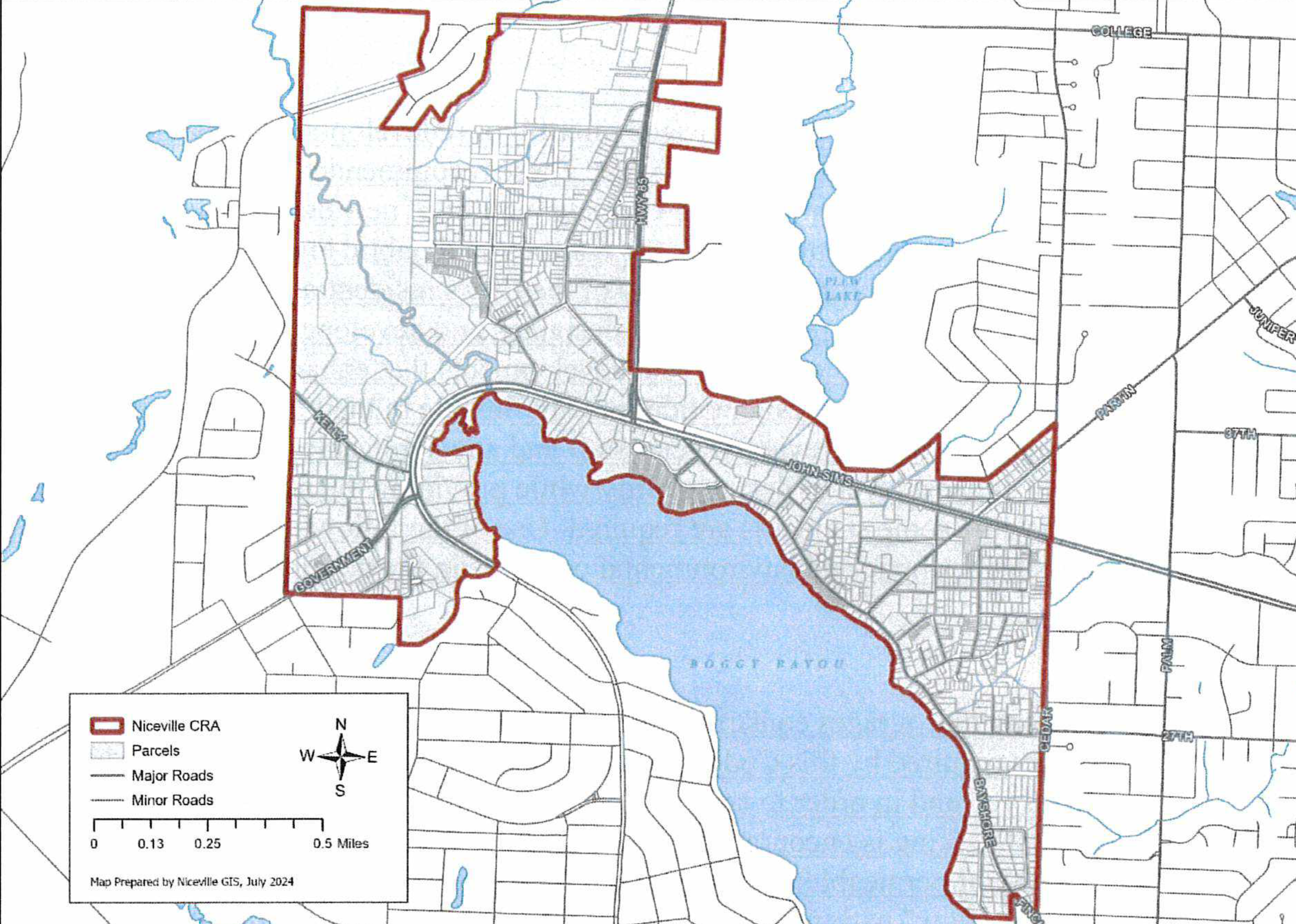
7.09.03 Applicability.
This section shall be applicable to all new construction, additions to existing structures, or additional structures on a developed site. For the purposes of this section, the term "shall" indicate a regulatory requirement or standard, and the term "should" indicate a suggested guideline that is not considered a regulatory requirement. All development standards included within this section shall apply in addition to or instead of the development standards found elsewhere in the land development code. Whenever a specific or conflicting standard is included within this section, the overlay standard shall supersede similar standards found elsewhere in the land development code.
7.09.04 Design guidelines.
Most development in the CRA overlay is located on infill or redevelopment sites; therefore, projects should take their surroundings into account. These recommended design guidelines are intended as suggested methods to improve the character and fit of new development and to encourage respect for how architecture, landscape features, and public improvements help establish context, and steadily improve the quality of the city's residential and commercial neighborhoods. These guidelines are intended for designers and developers to look closely at the area surrounding their specific project and create developments that enhance and complement the built and natural environment. The design guidelines are flexible in their application and maybe applied to specific projects during review by city staff and any applicable review board(s). The intent is to create the highest level of design quality while providing the needed flexibility for creative site design while some standards are required. Use of the following design guidelines is a means for addressing aesthetic and environmental concerns in the development process.
(a)
Site planning.
(1)
Parking.
a.
The city discourages construction of more than the minimum number of parking spaces required by this Code, in order that more natural vegetation may be preserved and in order to control stormwater runoff in a more natural manner.
b.
Shared parking is encouraged where feasible.
c.
The use of permeable paving materials is encouraged in parking lots, especially for "overflow" parking or parking spaces in excess of the requirements of this title.
d.
Site design should minimize the impact of automobile parking and driveways on the pedestrian environment, adjacent properties, and pedestrian safety. The following are some examples of techniques used to minimize the impacts of driveways and parking lots:
i.
Break large parking lots into multiple smaller ones.
ii.
Minimize the number and width of driveways and curb cuts.
iii.
Share driveways with abutting lots.
iv.
Locate parking in less visible areas of the site, specifically to the rear or side of the site.
v.
Locate driveways so they are visually less dominant.
vi.
Provide special pavers or other surface treatments to enhance and separate pedestrian areas from vehicle maneuvering and parking areas.
(2)
Innovative stormwater management design encouraged.
a.
The construction of roads across regulated wetlands shall be limited, and any roads that are built should be constructed utilizing piers or pilings or with adequate culverts to allow the passage of floodwaters.
b.
The use of onsite wetlands and stormwater management facilities as open space, recreation, and conservation areas is encouraged.
(3)
Site characteristics to consider in building design include, but are not limited to, the following:
a.
Site buildings to avoid or lessen the impact of development on environmentally sensitive and critical areas such as wetlands, stream corridors, fragile vegetation and wildlife areas, etc.
b.
The placement of buildings and other development features should enable the preservation of significant or important native trees. Within the CRA overlay the city manager or designee may authorize parking reductions, building setback modifications, or other bulk and dimensional regulations found elsewhere in this Code in order to preserve heritage trees.
(4)
Utilities and service areas. Building sites should locate service elements like trash dumpsters, loading docks and mechanical equipment away from the street front wherever possible. When elements such as dumpsters, utility meters, mechanical units and service areas cannot be located away from the street front, they should be situated and screened from view and should not be located near pedestrian routes.
(5)
All vending machines, or any facilities dispensing merchandise, or a service on private property, shall be confined to a space built into the building or buildings or enclosed in a separate structure compatible with the main building(s). All exterior forms, attached or not to buildings should be in conformity to and secondary to the building. They should be an asset to the aesthetics of the site and to the neighborhood.
(6)
Mechanical equipment for multifamily residential, nonresidential, office, commercial or industrial developments shall not be allowed any closer than ten (10) feet to either the property line or zoning district boundary line of a single-family or duplex residential development or zoning district; and shall be screened from adjoining property and from public view.
(b)
Architectural standards and considerations.
(1)
Building entrances should be clearly visible from the street. Using entries that are visible from the street makes a project more approachable and creates a sense of association with neighboring structures.
(2)
Exterior metal facade wall cladding shall be limited to a maximum of thirty (30) percent per elevation of a building located in the CRA. The remaining percentage of each facade elevation shall have a finish treatment other than metal. The planning commission may grant requests to exceed this maximum standard on a case-by-case basis with consideration being given to developments that incorporate design guidelines suggested in this section and exhibit superior site design.
(3)
Development projects that are adjacent to a less-intensive use, may create substantial adverse impacts that result from inappropriate height, bulk, and scale relative to their neighbors. Where a new structure is constructed or a major addition to an existing structure is proposed adjacent to an existing structure, the new structure should be designed to be compatible with the original structure. This is particularly important if the existing structure has historical or architectural merit to the community.
Careful siting and design treatments can help mitigate some height, bulk, and scale impacts; in other cases, actual reduction in the height, bulk, and scale of a project are necessary to adequately mitigate adverse effects. Some techniques for achieving compatibility are:
a.
Use of architectural style, details (such as rooflines or fenestration), exterior colors or materials that derive from the less intensive adjacent uses or neighborhood.
b.
Creative use of landscaping or other screening.
c.
Location of features on-site to facilitate transition, such as locating required open space on edges so the building is located farther from the lesser intensity use.
d.
In a mixed-use project, siting the more compatible use(s) near the project edge.
e.
Stepping back building height to lessen the impact of building height differentials.
f.
Utilizing greater building setbacks between more intense and less intense uses.
(4)
Architectural elements for new development in established neighborhoods should complement neighboring buildings and consider how design gives a neighborhood its identity. This does not mean that new buildings must excessively mimic older existing buildings. Rather, the guidelines suggest that new buildings use some traditional building concepts or elements.
a.
Components that define the appearance of a building, such as roofs, windows, porches, modulations, entries, materials, balconies and details can successfully relate to older buildings while still looking contemporary.
b.
Architectural features. Taking note of the architectural characteristics of surrounding buildings can help new buildings be compatible with their neighbors when a consistent pattern is already established by similar building articulation; building scale and proportions; architectural style(s); roof forms, building details and fenestration patterns; or materials. Even when there is no consistent architectural pattern, building design and massing can be used to complement and enhance certain physical conditions of existing surrounding development.
c.
In cases where an existing context is either not well defined, or may be undesirable, a well-designed new project has the opportunity to establish a pattern or identity that future redevelopment can build on.
(5)
The design of new buildings should incorporate architectural features, elements and details that achieve a desirable human scale through the use of human-proportioned architectural features and site design elements clearly oriented to human activity. Building elements that may be used to achieve human scale are as follows:
a.
Pedestrian-oriented storefront windows and doors directly facing the street or publicly accessible open space such as courtyards, gardens, patios, or other unified landscaped areas.
b.
Window patterns, building articulation, and other exterior treatments that help identify individual units in a multi-family building or mixed-use building.
c.
Stepping back upper stories (generally above the third or fourth floor).
d.
Porches or covered entries that offer pedestrian weather protection such as canopies, awnings, arcades, or other similar elements wide enough to protect at least one (1) person.
(6)
Structured parking garages.
a.
The presence and appearance of structured parking garages and their entrances should be minimized so they do not dominate the street frontage.
b.
Ramps should be visually screened from streets and adjacent residential zoning districts and oriented towards the interior of the lot within a project where possible.
c.
Ramps profiles should be hidden on the exterior elevations.
d.
Roof top parking should be visually screened with articulated parapet walls or other architectural treatment.
e.
Parking levels above the ground floor should maintain the same vertical and horizontal articulation or rhythm and incremental appearance established on the ground floor.
f.
The openings of the garage should be designed in a manner that obscures parked vehicles.
g.
Decorative architectural elements on the ground floor level should be designed to accommodate the pedestrian scale.
(7)
Exterior lighting shall utilize fixtures provided with cut off shielding in order to eliminate glare and spillage onto adjacent properties and roadways.
(8)
Blank walls. Buildings should avoid large blank walls facing the street, especially near sidewalks. Where blank walls are unavoidable, due to the requirements of a particular land use or structural needs, they shall not exceed a length of fifty (50) feet, or twenty (20) percent of the length of the building facing the street, whichever is less, and should receive design treatment to increase pedestrian comfort and interest.
(9)
Roof-mounted electrical, mechanical, air conditioning and communications equipment shall be completely screened from adjacent properties and public view from the public right-of-way. The equipment screening shall be such that the equipment is not visible within a two hundred-foot radius. The radius shall be measured from the exterior side of the screen to a point ten (10) feet above finished grade. All mechanical equipment must be equipped with the manufacturer's recommended sound attenuation.
7.09.05 Mixed use development authorization.
Properties designated mixed use on the future land use map as adopted within the City of Niceville Comprehensive Plan and located within the CRA overlay may be developed utilizing the adopted allowable uses, maximum density (twenty-five [25] du per acre maximum), and a maximum intensity of 0.85 impervious surface area ratio found within Policy 7A.11.1 of the Comprehensive Plan regardless of zoning. However, section 7.10.00 pertaining to the Military Planning Area (MIPA) zoning overlay shall apply. The following bulk and dimensional standards are the only bulk and dimensional standards in addition to the maximum impervious surface area ratio of 0.85 (eighty-five [85] percent) from section 7.07.01 of this Code that apply to these properties:
(a)
The maximum allowable building height or the applicable underlying zoning district shall apply; and
(b)
The minimum yard setbacks for the applicable underlying zoning district shall apply; except that minimum setbacks do not apply internally within a master planned mixed use development.
(Ord. No. 16-02-01, § 3, 2-9-15; Ord. No. 22-09-01, § 4, 9-13-22; Ord. No. 24-10-04, § 4, 11-12-24)
7.10.00 - Military influence planning area (MIPA) zoning overlay.
7.10.01 Purpose.
It is the purpose of this section to promote the public health, safety and general welfare, and to ensure the compatibility between existing or future airports, and the surrounding land uses, by minimizing adverse impacts to interior noise levels for surrounding habitable land uses, and by placing restrictions on certain types of outdoor lighting that may negatively affect military aircraft operations. The regulations in this section are meant to implement the recommendations from Section 10 of the June 2009 Eglin Air Force Base Joint Land Use Study (JLUS) Final Report and the 2013 BRAC Supplemental Environmental Impact Statement (SEIS).
7.10.02 Description of geographic boundary.
The entire land area located within the Accident Potential Zones (APZ-I and APZ-II) depicted on Figure 10-2 of the JLUS, as well as the remaining portions of all parcels through which the APZ lines fall, and all land located within the 65 dB DNL noise contour line within the city depicted on Figure 3-3 of the Record of Decision, Final SEIS, as well as the remaining portions of all parcels through which the 65 dB DNL noise contour line falls, are hereby designated as the boundary of the MIPA zoning overlay.
(a)
The MIPA boundary is depicted as the "MIPA Overlay Zone" on the adopted Future Land Use Map.
(b)
The MIPA boundary is depicted as the "MIPA Zoning Overlay" on the "City of Niceville Official Zoning Map" and shall be applied and operated in conjunction with any other zoning district in which such lands are located. Such lands may be used as permitted by such other zoning districts except as limited or qualified by the requirements of the MIPA zoning overlay regulations set forth in this section.
7.10.03 Military review; minor or major development review required.
All new development within the MIPA zoning overlay requiring special consideration according to this section shall be reviewed as a minor or major development pursuant to section 2.05 of this Code, unless exempted by this section. All new development shall be reviewed by Eglin AFB for comment as to its compatibility with the mission of the military installation and those comments forwarded to the planning commission prior to any public hearing pertaining to the development.
7.10.04 Land use compatibility.
For development located within an Accident Potential Zone (APZ-I or APZ-II), as identified in Figure 10-2 of the 2009 Eglin AFB JLUS:
(a)
Future land use or zoning amendments that result in higher than the existing adopted residential densities shall not be approved.
(b)
Changes in non-residential land use and intensity shall be reviewed based on their compatibility with military operations as identified in Figure 10-4 of the 2009 Eglin AFB JLUS.
7.10.05 Outdoor lighting standards to reduce potential for aircraft accidents.
(a)
Purpose and intent. The purpose and intent of the provisions for the regulations of outdoor lighting within military airport environs is to reduce the potential for aircraft accidents related to pilot vision impairment or pilot confusion created by outdoor lighting. Accordingly, it is the intent of this Code to require outdoor lighting practices and systems that will minimize light pollution, glare, and flash illumination that may interfere with a pilot's or navigator's ability to control or navigate aircraft. The intent is also to promote optimum conditions for effective night-time military flight operations and ground training.
(b)
The standards in this subsection apply to outdoor lighting for all development within the MIPA zoning overlay, including installation of new lighting and repair or replacement of existing lighting (whether for aesthetic purposes or because lighting was damaged or destroyed).
(c)
Lighting prohibited within the MIPA zoning overlay. The following lighting or glare that can cause distraction, flash blindness, vision impairment, or visual interference while piloting or navigating an aircraft are prohibited within the MIPA zoning overlay:
(1)
Series, lines, rows, or patterns of lights, whether supported by cables or other physical means, or laid upon a ground or building, that may resemble navigational or flight safety aids, landing pads, or lighting common to general or military aviation.
(2)
Lighting designed for the creation of sky glow to attract attention, in excess of the lighting used to provide safety, security, and utility.
(3)
Outdoor floodlighting by flood light projection above the horizontal plane.
(4)
External illumination for signs.
(d)
Lighting standards within the MIPA zoning overlay.
(1)
Outdoor lighting limitation. Outdoor lighting shall only be used to accommodate minimum illumination for general safety, security and utility within a MIPA zoning overlay.
(2)
Parking lot lighting standards. For all parking lots, outdoor lighting shall be full cutoff or properly shielded.
(3)
Landscape, decorative, and architectural lighting.
a.
Luminaries used to illuminate flags, statues, steeples, monuments, and other tall narrow objects shall be illuminated with the type of luminary that directs the narrowest beam capable of illuminating the object.
b.
Lighting on buildings for aesthetic purposes shall be directed downward from the top.
(4)
Fixed lights, including street lights, must be full cutoff or properly shielded. All light fixtures that are required to be shielded shall be installed in such a manner that all light emitted by the fixtures, either directly from the lamp or indirectly from the fixture, is projected below a horizontal plane extending from the bottom of the fixture.
(5)
Automobile canopies. All luminaries mounted on the under surface of automobile canopies for service stations, drive-in restaurants, or other commercial or industrial uses shall be fully shielded.
(e)
Outdoor lighting plan. Within the MIPA zoning overlay, as well as anywhere else in the city, an outdoor lighting plan shall be submitted with a site plan or subdivision application for any non-residential use to determine compliance with the requirements of this article. Prior to final approval of a site plan or subdivision plan for which an outdoor lighting plan is required, the plan is subject to review and comment by the military.
(f)
Exemptions. The following outdoor lighting is exempt from this section:
(1)
Search lights, laser source lights, or any similar high-intensity lighting used in emergencies by police and fire personnel or at their direction; or for meteorological data gathering purposes undertaken with approval by the city.
(2)
Airport lighting which is required for the safe and efficient movement of aircraft during flight, takeoff, landing, and taxiing is exempt from the provisions of this section. All other outdoor lighting at airport facilities shall comply with the provisions of this article.
(3)
Holiday or decorative lights illuminated November 20 through January 15 each year, so long as such lights placed on property or buildings within a MIPA zoning overlay are not determined to adversely affect pilot vision or comprehension.
(g)
Nonconforming outdoor lighting.
(1)
Following application of this section, the installation of new lighting or the replacement of lighting shall be made in strict compliance with this Code. Routine maintenance, including changing the lamp, ballast, starter, photo control, fixture housing, lens and other required components, is permitted for all existing fixtures not subject to subparagraph (2) below.
(2)
All outdoor lighting that fails to conform to this section that is damaged in excess of fifty (50) percent of its market value shall be discontinued, removed, made to conform to this section, or replaced with lighting that conforms to this section.
(3)
Any fixture that, due to excessive glare, produces prohibited glare as prohibited in subsection 3.06.03.C, shall be required to either discontinue use of the fixture in question or replace the fixture with one (1) that conforms to the requirements of this section.
(h)
Temporary lighting permits. Outdoor lighting which is inconsistent with this section may be allowed on a temporary basis for special events, construction activities, or temporary outdoor lighting needs for public assembly or public safety so long as the outdoor lighting does not create a potential distraction, flash blindness, vision impairment, or visual interference for aircraft pilots or navigators and would not cause a potential unreasonable risk for flight safety or interfere with any military airport operation or with ground activities at military installations.
7.10.06 Noise level reduction.
Noise level contours are incrementally measured from the highest typical decibel (dB) generated within a military installation to sixty-five (65) dB within non-military property. The noise level reduction (NLR) regulations in this section apply to the noise level contours delineated in Figure 3-3 of the Record of Decision, Final SEIS F-35 Beddown (June 26,2014). The Department of Defense (DoD) and other federal agencies have determined that noise exposure below sixty-five (65) dB is generally compatible with non-military development. The Environmental Protection Agency (EPA) and the Federal Aviation Administration (FAA) have established an interior Day Night Average Sound Level (or DNL) goal of forty-five (45) dB.
(a)
Purpose and intent. The purpose of this subsection is to establish standards for reducing interior noise levels through construction techniques that result in an interior DNL of approximately forty-five (45) dB. This means that techniques must be used that provide interior NLR of twenty-five (25) dB within the sixty-five (65) to seventy (70) dB DNL noise contours, and an interior NLR of thirty (30) dB within the seventy (70) to seventy-five (75) DNL noise contours (Note: there are no portions of the city that are located within a noise contour greater than seventy-five (75) dB).
(b)
Applicability.
(1)
The provisions of this article shall apply to the construction of any building or structure or portion of a building or a structure located within the sixty-five (65) dB or greater noise contours, except work located primarily in a public right-of-way, public utility towers and poles, and mechanical equipment not specifically regulated in this article.
(2)
Buildings or structures moved onto or within the MIPA zoning overlay shall comply with applicable provisions of this article.
(3)
The regulations prescribed by this subsection shall not be construed to require the sound conditioning or other changes or alteration of any preexisting structure not conforming to this article as of the effective date of this article or otherwise interfere with the continuance of any such preexisting nonconforming use. Nothing herein contained shall require any such change in the construction or alteration of a structure which was begun prior to the effective date of this article, and is diligently pursued.
(c)
Approval of methods of construction.
(1)
Noise level reduction construction standards shall be consistent with the 2010 Florida Residential Building Code, Section R324, Airport Noise, as amended.
(2)
When required by this subsection to provide noise attenuation the applicant must provide either:
a.
A testing certificate from an accredited noise testing lab that a new structure or addition to existing structure built to the submitted engineering plans will achieve an average minimum NLR dB equal to or greater than the reduction required;
b.
An engineering judgment signed and sealed by an engineer licensed in the State of Florida that the structure or addition built to the submitted engineering plans will achieve an average minimum equal to or greater than the reduction required; or
c.
Plans using the standards contained in "Guidelines for Sound Insulation of Residences Exposed to Aircraft Operations" prepared for the Department of the Navy by Wyle Research and Consulting, Arlington, Virginia, April 2005 on file with the Florida Building Commission.
(d)
General design requirements. The NLR requirements may be achieved by any suitable combination of building design, choice of building materials and execution of construction details in accordance with established architectural and acoustical principles. The NLR requirements shall apply to all occupied rooms having one (1) or more exterior walls or ceilings, when furnished in accordance with the intended final usage of the room.
(e)
Failure to comply with allowable interior noise levels. A property owner may be granted a waiver of the allowable interior noise levels by the building official and a certificate of occupancy may be issued if:
(1)
The property owner has made a documented good faith effort to achieve the interior noise level standard, but the field test required by paragraph C reveals non-compliance; and
(2)
The property owner can demonstrate that a substantial and unreasonable additional expense would be involved to achieve the required interior noise level.
7.10.07 Disclosure.
No person shall sell, lease, nor offer for sale or lease any property within a MIPA zoning overlay unless the prospective buyer or lessee has been duly notified through one (1) or more of the following requirements.
(a)
Disclosure with sale or lease contract.
(1)
Sale of residential property. Any contract for the sale of residential property that is located in whole or part within a MIPA zoning overlay, shall include, as an attachment to the contract of sale, a military airport disclosure notice, in a form approved by the city. The military airport disclosure notice shall be dated and signed by the purchaser(s) and the seller(s). If the seller is represented by a real estate agent, the agent shall witness the signature(s) of the seller(s). The seller is responsible for providing a copy of the signed disclosure notice to the Eglin AFB Planning Office. A disclosure notice form will be made available by the planning and zoning department.
(2)
Lease of residential property. Any contract for the lease of a residential dwelling for more than seven (7) months shall be subject to the notification requirements set forth in subsection (a)(1).
(3)
Consumer protection. The failure of a sales contract to comply with the requirements of subsection (a)(1) shall enable a party to the contract who is aggrieved by such failure to rescind the contract any time prior to settlement. The failure of a lease contract to comply with the requirements of subsection (a)(2) shall enable a party who is aggrieved by such failure to rescind the contract any time prior to the contract termination date. The right of rescission provided by this subsection is not an exclusive remedy, and any other right or cause of action available to a party to the sales or lease contract shall remain.
(b)
Realty sales offices and marketing. Sales offices used to market or sell new residential homes or mobile homes, including pre-construction sales, which will be constructed on lots located in a MIPA zoning overlay, must display a map illustrating military installation property boundaries, accident potential zones, clear zones, runway protection zones, and noise level contour zones over sixty-five (65) dB. This display requirement also applies to temporary reality sales offices. Pamphlets illustrating the same information appearing the on paper not less than eight and one-half (8½) inches by eleven (11) inches shall also be made available and placed in public view.
(1)
Display requirements. The display map shall be no smaller than twenty-four (24) inches by thirty-six (36) inches and must be prominently displayed in a public area of the office and copies of such map must be available on paper which is eight and one-half (8½) [inches] by eleven (11) inches or larger in dimension. The display map and pamphlet must include a statement that additional information regarding the MIPA zoning overlay and zoning is available at the Niceville Building Department and include its most current telephone number. The location of the residential development shall be denoted on the map or pamphlet.
(2)
Temporary permits. A temporary permit shall not be issued for a realty sales office located in the City of Niceville unless it contains a requirement for compliance with subsections (b)(1) and (b)(4).
(3)
Site plan permits. A site plan approval for any commercial or office use within the city shall include a statement that any reality sales office use shall comply with the display requirements of this section.
(4)
Marketing brochures. Any real estate office or business within Okaloosa County that produces a marketing brochure for residential home sales or rental units located on property wholly or partially within a MIPA zoning overlay shall include in said brochure the following statement: "Some or all of the property within this residential development lies within a MIPA zoning overlay. Information regarding such zoning overlays, including airport noise impacts, can be obtained from the City of Niceville, Florida."
(c)
Covenants and restrictions. Residential plats proposed within a MIPA zoning overlay shall incorporate disclosure requirements within covenants and restrictions.
(Ord. No. 16-02-01, § 3, 2-9-15; Ord. No. 22-09-01, § 4, 9-13-22)