
Nisswa City Zoning Code
ARTICLE III
PERFORMANCE STANDARDS
Sec. 20-98. - Statutory authorization.
This floodplain ordinance is adopted pursuant to the authorization and policies contained in M.S.A., chapter 103F; Minnesota Rules, parts 6120.5000—6120.6200; the rules and regulations of the National Flood Insurance Program (NFIP) in 44 CFR § 59 to 78; and the planning and zoning enabling legislation in M.S.A., chapter 462.
(Ord. No. 24 (Fourth Series), § 1, 2-18-2025)
Sec. 20-99. - Purpose.
(a)
This article regulates development in the flood hazard areas of the City of Nisswa. These flood hazard areas are subject to periodic inundation, which may result in loss of life and property, health and safety hazards, disruption of commerce and governmental services, extraordinary public expenditures for flood protection and relief, and impairment of the tax base. It is the purpose of this article to promote public health, safety, and general welfare by minimizing these losses and disruptions.
(b)
This article is adopted in the public interest to promote sound land use practices, and floodplains are a land resource to be developed in a manner which will result in minimum loss of life and threat to health, and reduction of private and public economic loss caused by flooding.
(c)
This article is adopted to maintain eligibility in the national flood insurance program.
(d)
This article is also intended to preserve the natural characteristics and functions of watercourses and floodplains in order to moderate flood and stormwater impacts, improve water quality, reduce soil erosion, protect aquatic and riparian habitat, provide recreational opportunities, provide aesthetic benefits and enhance community and economic development.
(Ord. No. 24 (Fourth Series), § 1, 2-18-2025)
Sec. 20-100. - Abrogation and greater restrictions.
It is not intended by this article to repeal, abrogate, or impair any existing easements, covenants, or other private agreements. The standards in this ordinance take precedence over any less restrictive, conflicting local laws, ordinances, or codes. All other ordinances inconsistent with this article are hereby repealed to the extent of the inconsistency only.
(Ord. No. 24 (Fourth Series), § 1, 2-18-2025)
Sec. 20-101. - Warning and disclaimer of liability.
This division does not imply that areas outside the floodplain districts or land uses permitted within such districts will be free from flooding or flood damages. Not all flood risk is mapped. Larger floods do occur, and the flood height may be increased by man-made or natural causes, such as ice jams or bridge openings restricted by debris. This ordinance does not create liability on the part of the City of Nisswa or its officers or employees for any flood damages that result from reliance on this ordinance, or any administrative decision lawfully made hereunder.
(Ord. No. 24 (Fourth Series), § 1, 2-18-2025)
Sec. 20-102. - Severability.
If any section, clause, provision, or portion of this ordinance is adjudged unconstitutional or invalid by a court of law, the remainder of this ordinance shall not be affected and shall remain in full force.
(Ord. No. 24 (Fourth Series), § 1, 2-18-2025)
Sec. 20-103. - Land to which ordinance applies.
This ordinance applies to all lands within the jurisdiction of the City of Nisswa within the special flood hazard areas (SFHAs) identified on the Flood insurance Rate maps identified in section 20-104. Areas within the SFHA are within one of three districts: the floodway, flood fringe, or general floodplain.
(1)
The floodway, flood fringe or general floodplain districts are overlay districts. The standards imposed in the overlay districts are in addition to any other requirements. In case of a conflict, the more restrictive standards will apply.
(2)
These regulations apply to all areas within the SFHA. If areas below the base flood elevation (BFE) extend beyond the mapped SFHA based on actual field conditions, the base flood elevation (BFE) shall be the governing factor in locating the outer boundaries of the one-percent annual chance floodplain and these regulations apply to the outer boundary of the one-percent annual chance floodplain.
(3)
Persons contesting the location of the district boundaries will be given a reasonable opportunity to present their case to the planning and zoning committee to submit technical evidence.
(Ord. No. 24 (Fourth Series), § 1, 2-18-2025)
Sec. 20-104. - Incorporation of maps by reference.
The following maps together with all attached material are hereby adopted by reference and declared to be a part of the official zoning map and this ordinance. The attached material includes the flood insurance study for Crow Wing County, Minnesota, and Incorporated Areas, dated August 15, 2017, and the flood insurance rate map panel numbers 27035C0275C; 27035C0400C, all dated August 15, 2017, all prepared by the federal emergency management agency. These materials are on file in the Nisswa City Hall.
(Ord. No. 24 (Fourth Series), § 1, 2-18-2025)
Sec. 20-105. - Districts.
(a)
Floodway district. Those areas within zone A as shown on the flood insurance rate maps referenced in section 20-104 determined to be located in the floodway based on the delineation methods in section 20-116(e).
(b)
Flood fringe district. Those areas within zone A shown on the flood insurance rate maps referenced in section 20-104 determined to be located in the flood fringe based on the delineation methods in section 20-116(e).
(c)
General floodplain district. Those areas within zone A that do not have a floodway delineated as shown on the flood insurance rate Maps referenced in section 20-104.
(Ord. No. 24 (Fourth Series), § 1, 2-18-2025)
Sec. 20-106. - Annexations.
The flood insurance rate map panels referenced in section 20-104 may include floodplain areas that lie outside of the corporate boundaries of the City of Nisswa at the time of adoption of this ordinance. If any of these floodplain land areas are annexed into the City of Nisswa after the date of adoption of this ordinance, the newly annexed floodplain lands will be subject to the provisions of this ordinance immediately upon the date of annexation. Annexations into panels not referenced in section 20-104 require an ordinance amendment in accordance with section 20-123.
(Ord. No. 24 (Fourth Series), § 1, 2-18-2025)
Sec. 20-107. - Municipal boundary adjustments.
The flood insurance rate map panels referenced in section 20-104 apply countywide. If at any point any land comes under the jurisdiction of another local government, the following shall apply:
(1)
City adjustments of corporate boundaries, including but not limited to annexations and detachments, shall shift floodplain administrative authority of all affected lands immediately upon the date of the boundary adjustment occurring. The city retains jurisdiction for all incorporated lands, and the county retains jurisdiction under this ordinance on all unincorporated lands
(Ord. No. 24 (Fourth Series), § 1, 2-18-2025)
Sec. 20-108. - Requirements for all floodplain districts—permits required.
A permit must be obtained from the planner to verify compliance with all applicable standards outlined in this ordinance prior to the following uses or activities:
(1)
The erection, addition, modification, maintenance, rehabilitation, repair, or alteration of any building, structure, or portion thereof. Normal maintenance requires a permit to determine if such work, either separately or in conjunction with other planned work, constitutes a substantial improvement, as specified in section 20-121(a)(3)
(2)
The construction of a fence, pool, deck, or placement of anything that may cause a potential obstruction.
(3)
The change or expansion of a nonconforming use.
(4)
The repair of a structure that has been damaged by flood, fire, tornado, or any other source.
(5)
The placement of fill, excavation, utilities, on-site sewage treatment systems, or other service facilities.
(6)
The storage of materials or equipment, in conformance with section 20-109(a)(4).
(7)
Relocation or alteration of a watercourse (including stabilization projects or the construction of new or replacement dams, culverts and bridges). A local permit is not required if public waters work permit has been obtained from the department of natural resources, unless a significant area above the ordinary high-water level is also to be disturbed.
(8)
Any other type of "development," as defined in this ordinance.
(Ord. No. 24 (Fourth Series), § 1, 2-18-2025)
Sec. 20-109. - Minimum development standards.
(a)
All development must:
(1)
Be designed (or modified) and adequately anchored to prevent flotation, collapse, or lateral movement resulting from hydrodynamic and hydrostatic loads, including the effects of buoyancy;
(2)
Be constructed with materials and equipment resistant to flood damage;
(3)
Be constructed by methods and practices that minimize flood damage;
(4)
Be constructed with heating, ventilation, duct work, and air conditioning equipment and other service facilities elevated at least up to the regulatory flood protection elevation (RFPE). Water, sewage, electrical, and other utility lines below the RFPE shall be constructed so as to prevent water from entering or accumulating within them during conditions of flooding;
(5)
Be reasonably safe from flooding and consistent with the need to minimize flood damage;
(6)
Be assured to provide adequate drainage to reduce exposure to flood hazards;
(7)
Not be detrimental to uses in adjoining areas; and
(8)
Not adversely affect the efficiency or restrict the flood carrying capacity of the channel and adjoining floodplain of any tributary watercourse or drainage system.
(9)
Ensure that any fill or other materials are protected from erosion, discharge, and sediment entering surface waters by the use of vegetative cover or other methods as soon as possible.
(b)
Materials that, in time of flooding, are buoyant, flammable, explosive, or could be injurious to human, animal, or plant life shall be stored at or above the regulatory flood protection elevation (RFPE), floodproofed, or protected by other measures as approved by the Planner. Storage of materials likely to cause pollution of the waters, such as sewage; sand; rock; wrecked and discarded equipment; dredged spoil; municipal, agricultural or industrial waste; and other wastes as further defined in M.S.A., section 115.01, are prohibited unless adequate safeguards approved by the Minnesota Pollution Control Agency are provided. For projects not requiring approvals by the Minnesota Pollution Control Agency, adequate safeguards must be approved by the Planner prior to issuance of a permit.
(Ord. No. 24 (Fourth Series), § 1, 2-18-2025)
Sec. 20-110. - Permitted uses in floodway district.
Development allowed in the floodway district is limited to that which has low flood damage potential and will not obstruct flood flows, increase velocities, or increase the water surface elevations of the one-percent annual chance flood. The following uses and activities may be allowed with a permit, subject to the standards in section 20-111:
(1)
Agricultural uses, recreational uses, parking lots, loading areas, airport landing strips, water control structures, navigational facilities, as well as public open space uses.
(2)
Roads, driveways, railroads, trails, bridges, and culverts.
(3)
Public utility facilities and water-oriented industries which must be in or adjacent to watercourses.
(4)
Grading, filling, land alterations, and shoreline stabilization projects.
(5)
No other structures are allowed in the floodway district.
(Ord. No. 24 (Fourth Series), § 1, 2-18-2025)
Sec. 20-111. - Standards for permitted uses in floodway district.
In addition to the applicable standards detailed in section 20-108:
(1)
The applicant must demonstrate that the development will not result in any of the following during the one-percent annual chance flood: cause a stage increase of 0.00 feet or greater, obstruct flood flows, or increase velocities. This shall be demonstrated through hydrologic and hydraulic analysis performed by a professional engineer or using other standard engineering practices (e.g. projects that restore the site to the previous cross-sectional area). This is commonly documented through a "no-rise certification."
(2)
Any development that would result in a stage increase greater than 0.00 feet may only be allowed with a permit if the applicant has applied for a conditional letter of map revision (CLOMR) in accordance with 44 CFR § 65.12, and FEMA has issued the CLOMR. Map revisions must follow the procedures in sections section 20-120(g) and section 20-123.
(3)
Any development resulting in decreases to the water surface elevation of the base flood identified in the flood insurance study requires a letter of map revision (LOMR) following the procedures in section 20-120(f) and section 20-123.
(4)
Any development in the beds of public waters that will change the course, current or cross section is required to obtain a public waters work permit in accordance with M.S.A., section 103G.245 or a utility crossing license in accordance with M.S.A., section 84.415, from the department of natural resources, or demonstrate that no permit is required, before applying for a local permit.
(5)
Fill and other land alteration activities must offer minimal obstruction to the flow of flood waters.
(Ord. No. 24 (Fourth Series), § 1, 2-18-2025)
Sec. 20-112. - Standards for permitted uses in flood fringe district.
Any uses or activities allowed in any applicable underlying zoning districts may be allowed with a permit, subject to the standards set forth in section 20-113.
(Ord. No. 24 (Fourth Series), § 1, 2-18-2025)
Sec. 20-113. - Standards for permitted uses in flood fringe district.
(a)
Residential structures.
(1)
Elevation on fill. Structures erected, constructed, reconstructed, altered, or moved on fill within the flood fringe district shall be placed so that the lowest floor, as defined in this ordinance, is elevated at or above the regulatory flood protection elevation (RFPE). The finished fill elevation shall be at or above the elevation associated with the base flood plus any stage increases that result from designation of a floodway. Fill must extend at the same elevation at least 15 feet beyond the outside limits of the structure. Elevations must be certified by a registered professional engineer, land surveyor or other qualified person designated by the planner. Elevation methods alternative to these fill standards are subject to a conditional use permit, as provided in section 20-114 of this ordinance.
Figure 1: Overview of fill standards for residential structures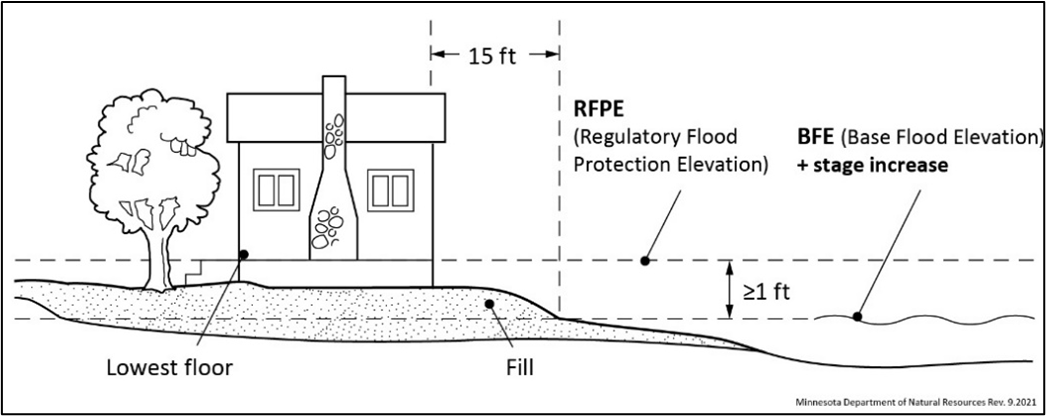
(b)
Nonresidential structures. Nonresidential structures must meet one of the following construction methods:
(1)
Elevation on fill. Structures may be elevated on fill, meeting the standards in section 20-113 of this ordinance. Fill for nonresidential structures is not required to be extended 15 feet beyond the outside limits of the structure
(2)
Alternative elevation methods. Structures may be elevated using methods alternative to the fill standards in section 20-113 of this ordinance. Such methods include the use of blocks, pilings (figure 2), filled stem walls (figure 3), or internally flooded enclosed areas (figure 4) such as crawl spaces, attached garages, or tuck under garages.
Figure 2: Blocks or Pilings; Figure 3: Filled Stem Walls; Figure 4: Internally Flooded
Enclose Area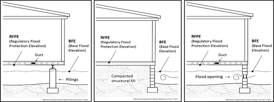
(3)
Designs accommodating for internally flooded enclosed areas must be certified by a registered professional engineer or architect, or meet or exceed the standards detailed in FEMA technical bulletin 1, as amended, as well as the following standards:
a.
The lowest floor, as defined in this ordinance, shall be elevated at or above the regulatory flood protection elevation (RFPE).
b.
The floor of the enclosed area must be at or above the exterior grade on at least one side of the structure.
c.
To allow for the equalization of hydrostatic pressure, there shall be a minimum of two openings below the base flood elevation on at least two sides of the structure. The bottom of all openings shall be no higher than one foot above grade. The openings shall have a minimum net area of not less than one square inch for every square foot of enclosed area subject to flooding, have a net area of not less than one square inch for every square foot of enclosed area subject to flooding, and shall allow automatic entry and exit of floodwaters without human intervention.
d.
Internally flooded enclosed areas shall only be used for the parking of vehicles, building access, or storage. Bathrooms and toilet rooms shall not be allowed.
(c)
Dry floodproofing. Structures having watertight enclosed basements or spaces below the regulatory flood protection elevation (RFPE) must meet the following standards:
(1)
Walls must be substantially impermeable to the passage of water, with structural having the capacity of resisting hydrostatic and hydrodynamic loads and effects of buoyancy, at least up to the regulatory flood protection elevation (RFPE);
(2)
Must meet the standards of FEMA technical bulletin 3, as amended; and
(3)
A registered professional engineer or architect shall be required to certify that the design and methods of construction meet the standards detailed in this section.
(d)
Accessory structures. All accessory structures must meet the following standards:
(1)
Structures shall not be designed or used for human habitation.
(2)
Structures will have a low flood damage potential.
(3)
Structures shall constitute a minimal investment not to exceed 576 square feet in size, one-story in height, and shall only be used for parking and storage, except as provided under section 20-113 and be designed and constructed in accordance with floodplain management requirements based on whether the structure is residential or non-residential. Residential structures must meet the requirements of section 20-113, and non-residential structures must meet the requirements of section 20-113.
(4)
Structures with two or more rigid walls must meet one of the following construction methods:
a.
Wet floodproofing. Structures may be floodproofed in a way to accommodate internal flooding. To allow for the equalization of hydrostatic pressure, there shall be a minimum of two openings on at least two sides of the structure and the bottom of all openings shall be no higher than one foot above grade. The openings shall have a minimum net area of not less than one square inch for every square foot of enclosed area subject to flooding, and shall allow automatic entry and exit of floodwaters without human intervention. Portions of structures below the RFPE must be constructed of flood damage-resistant materials. Utilities must be elevated above the RFPE and any utility lines below the RFPE shall be constructed so as to prevent floodwaters from entering or accumulating within them. Wet floodproofed structures must be anchored to resist flotation, collapse, and lateral movement.
b.
Elevation on fill. Structures may be elevated on fill, meeting the standards in section 20-113 of this ordinance. Fill is not required to be extended 15 feet beyond the outside limits of the structure.
c.
Alternative elevation methods. Structures may have their lowest floor elevated above the regulatory flood protection elevation (RFPE) through methods alternative to the fill standards in section 20-113 of this ordinance.
d.
Dry floodproofing. Structures may be dry-floodproofed, or watertight, meeting the standards in section 20-113 of this ordinance.
(5)
Structures with fewer than two rigid walls, such as carports, gazebos, and picnic pavilions, meeting the standards in section 20-109(a)(4) of this ordinance may be located at an elevation below the regulatory flood protection elevation, exceed 576 square feet in size, and may include uses as provided under section 20-113.
(Ord. No. 24 (Fourth Series), § 1, 2-18-2025)
Sec. 20-114. - Conditional uses in flood fringe.
The following uses and activities may be permitted as conditional uses, subject to the standards in section 20-114:
(1)
Alternative elevation methods—Residential structures. Residential structures with their lowest floor elevated above the regulatory flood protection elevation (RFPE) using methods alternative to the fill requirements in section 20-113.
(Ord. No. 24 (Fourth Series), § 1, 2-18-2025)
Sec. 20-115. - Standards for conditional uses in flood fringe.
In addition to the applicable standards detailed in sections 20-116, 20-108 and 20-120(g):
(1)
All residential structures with lowest floors elevated through alternative elevation methods must meet the standards in section 20-113.
(Ord. No. 24 (Fourth Series), § 1, 2-18-2025)
Sec. 20-116. - General floodplain district—Permitted uses in general floodplain district.
(a)
Until the floodway is delineated, allowable uses will be restricted to those listed in the floodway district, section 20-110.
(b)
All other uses are subject to a floodway/flood fringe determination as provided in section 20-116(e), in addition to the standards provided in sections 20-116(c) and (d). Permitted uses shall be determined as follows:
(1)
Any development determined to be in the floodway district is prohibited.
(2)
If the development is determined to be in the flood fringe district, section 20-113 applies.
(c)
Determining flood elevations.
(1)
All development requires a determination of the base flood elevation (BFE). Proposed developments of more than 50 lots or five acres, whichever is lesser, must use detailed methods for determining the BFE. This may include use of supporting A zone modeling and the "shoreland method," when eligible, on lakes. Exceptions to this requirement include projects that restore the site to the previous cross-sectional area, such as shore stabilization or culvert replacement projects. Base flood elevations (BFE) may be found using best available data from any federal, state, or other source (including MNDNR's Lake & Flood Elevations Online (LFEO) Viewer).
(2)
The regulatory flood protection elevation (RFPE) can be determined by assuming a one-half foot stage increase to accommodate for future cumulative impacts. A stage increase does not need to be assumed along lakes, wetlands, and other basins that are not affected by velocities.
(d)
Encroachment analysis.
(1)
Encroachments due to development may not allow stage increases more than one-half foot at any point, unless through a map revision following the procedures in section 20-120(f) and 20-123. This evaluation must include the cumulative effects of previous encroachments and must be documented with hydrologic and hydraulic analysis performed by a professional engineer or using other standard engineering practices. A lesser water surface elevation increase than one-half foot is required if, due to the water surface level increase, increased flood damages would potentially result.
(2)
Alterations or changes that result in stage decreases are allowed and encouraged.
(e)
Standards for the analysis of floodway boundaries.
(1)
Requirements for detailed studies. Any development, as requested by the planner, shall be subject to a detailed study to determine the regulatory flood protection elevation (RFPE) and the limits of the floodway district. This determination must be consistent with the minimum standards for hydrologic and hydraulic mapping standards and techniques, as detailed in Minnesota Rules, part 6120.5600, Subp. 4 and FEMA guidelines and standards for flood risk analysis and mapping, as revised. Additionally:
a.
A regulatory floodway necessary to carry the discharge of the one-percent annual chance flood must be selected without increasing the water surface elevation more than one-half foot at any point. This determination should include the cumulative effects of previous encroachments. A lesser water surface elevation increase than one-half foot is required if, due to the water surface level increase, increased flood damages would potentially result; and
b.
An equal degree of encroachment on both sides of the stream within the reach must be assumed in computing floodway boundaries, unless topography, existing development patterns, and comprehensive land use plans justify a modified approach, as approved by the department of natural resources.
(f)
Other acceptable methods. For areas where a detailed study is not available or required:
(1)
Development prohibited in floodways (e.g. most buildings) requires a floodway/flood fringe determination to verify the development is within the flood fringe. This determination must be done by a professional engineer or utilize other accepted engineering practices. The Department of Natural Resources may also provide technical assistance and must approve any alternative methods used to determine floodway boundaries.
(Ord. No. 24 (Fourth Series), § 1, 2-18-2025)
Sec. 20-117. - Subdivision standards.
Subdivisions. All subdivided land must meet the following requirements. Manufactured home parks and recreational vehicle parks or campgrounds are considered subdivisions under this division.
(1)
All lots within floodplain districts must be suitable for a building site outside of the floodway district.
(2)
Subdivision of lands within the floodplain districts may not be approved if the cost of providing governmental services would impose an unreasonable economic burden on the City of Nisswa.
(3)
All subdivisions must have vehicular access both to the subdivision and to the individual building sites no lower than two feet below the regulatory flood protection elevation (RFPE), unless a flood warning/emergency evacuation plan has been approved by the City of Nisswa.
(4)
The floodway and flood fringe district boundaries, the regulatory flood protection elevation (RFPE) and the required elevation of all access roads must be clearly identified on all required subdivision drawings and platting documents.
(Ord. No. 24 (Fourth Series), § 1, 2-18-2025)
Sec. 20-118. - Public and private utilities, service facilities, roads, bridges and railroads.
(a)
Public transportation facilities. Railroad tracks, roads, and bridges must be elevated to the regulatory flood protection Elevation (RFPE) where such facilities are essential to the orderly functioning of the area, or where failure or interruption would result in danger to public health or safety. Minor or auxiliary roads or railroads may be constructed at a lower elevation where failure or interruption of transportation services would not endanger the public health or safety. All public transportation facilities should be designed to minimize increases in flood elevations.
(b)
Public utilities. All utilities such as gas, electrical, sewer, and water supply systems to be located in the floodplain must be elevated and/or floodproofed to the regulatory flood protection elevation (RFPE), be located and constructed to minimize or eliminate flood damage and be designed to eliminate infiltration of flood waters into the systems and discharges from the systems into flood waters. All public utilities should be designed to minimize increases in flood elevations. New solid waste management facilities, as defined in Minnesota Rules, part 7035.0300, are prohibited in the one-percent annual chance floodplain. Water supply systems are subject to the provisions in Minnesota Rules, part 4725.4350.
(c)
Private on-site water supply, individual sewage treatment systems, and other service facilities. Private facilities shall be subject to applicable provisions detailed in section 20-118(b) In addition, new or replacement on-site sewage treatment systems are to be located to avoid impairment to them or contamination from them during times of flooding, shall not be located in a designated floodway, and are subject to the provisions in Minnesota Rules, parts 7080.2270.
(Ord. No. 24 (Fourth Series), § 1, 2-18-2025)
Sec. 20-119. - Manufactured homes and recreational vehicles.
(a)
Manufactured homes and manufactured home parks are subject to applicable standards for each floodplain district. In addition:
(1)
New and replacement manufactured homes must be placed and elevated in compliance with section 20-113 and must be securely anchored to a system that resists flotation, collapse and lateral movement. Methods of anchoring may include, but are not limited to, the use of over-the-top or frame ties to ground anchors.
(2)
New manufactured home parks and expansions to existing manufactured home parks must meet the appropriate standards for subdivisions in section 20-117.
(b)
New recreational vehicle parks or campgrounds and expansions to existing recreational vehicle parks or campgrounds are prohibited in any floodplain district. Recreational vehicles placed in existing recreational vehicle parks, campgrounds or lots of record in the floodplain must either:
(1)
Meet the requirements for manufactured homes in section 20-119 (a); or
(2)
Be travel ready, meeting the following criteria:
a.
The vehicle must be fully licensed.
b.
The vehicle must be ready for highway use, meaning on wheels or the internal jacking system, attached to the site only by quick disconnect type utilities.
c.
No permanent structural type additions may be attached to the vehicle.
d.
Accessory structures may be permitted in the flood fringe district, provided they do not hinder the removal of the vehicle should flooding occur, and meet the standards outlined in sections 20-108 and 20-113(d).
(Ord. No. 24 (Fourth Series), § 1, 2-18-2025)
Sec. 20-120. - Administration.
(a)
Duties. The Planner or other official must administer and enforce this ordinance.
(b)
Permit application requirements. Permit applications must be submitted to the planner. The permit application must include the following, as applicable:
(1)
A site plan showing all existing or proposed buildings, structures, service facilities, potential obstructions, and pertinent design features having an influence on the permit.
(2)
Location and detail of grading, fill, or storage of materials.
(3)
Copies of any required local, state or federal permits or approvals.
(4)
Other relevant information requested by the Planner as necessary to properly evaluate the permit application.
(c)
Recordkeeping. The planner must maintain applicable records in perpetuity documenting:
(1)
All certifications for dry floodproofing and alternative elevation methods where applicable.
(2)
Analysis of no-rise in the floodway district, as detailed in section 20-118(a), and encroachment analysis ensuring no more than one-half foot of rise in the general floodplain district, as detailed in sections 20-116(c) and (d).
(3)
Final elevations, as applicable, detailing the elevation to which structures and improvements to structures are constructed or floodproofed. Elevations shall be determined by an engineer, architect, surveyor or other qualified individual, as approved by the planner.
(4)
Substantial damage and substantial improvement determinations, as detailed in section 20-121(b) including the cost of improvements, repairs, and market value.
(5)
All variance actions, including justification for their issuance, must report such variances as requested by the federal emergency management agency.
(d)
Certificate of zoning compliance for a new, altered, or nonconforming use. No building, land or structure may be occupied or used in any manner until a certificate of zoning compliance has been issued by the planner stating that the finished fill and building floor elevations or other flood protection measures are in compliance with the requirements of this ordinance.
(e)
Notifications for watercourse alterations. Before authorizing any alteration or relocation of a river or stream, the planner must notify adjacent communities. If the applicant has applied for a permit to work in public waters in accordance with M.S.A., section 103G.245, this will suffice as adequate notice. A copy of the notification must also be submitted to FEMA.
(f)
Notification to FEMA when physical changes increase or decrease base flood elevations. Where physical changes affecting flooding conditions may increase or decrease the water surface elevation of the base flood, the City of Nisswa must notify FEMA of the changes in order to obtain a letter of map revision (LOMR), by submitting a copy of the relevant technical or scientific data as soon as practicable, but no later than six months after the date such supporting information becomes available. Within the general floodplain district, a map revision is only required if development results in stage increases greater than 0.5 feet.
(g)
Conditional uses and variances.
(1)
An application for a conditional use permit will be processed and reviewed in accordance with the provisions of this ordinance.
(2)
An application for a variance to the provisions of this ordinance will be processed and reviewed in accordance with M.S.A., section 462.357, subd. 6(2) and this ordinance.
(h)
Additional variance criteria. The following additional variance criteria must be satisfied:
(1)
Variances must not be issued within any designated regulatory floodway if any increase in flood levels during the base flood discharge would result.
(2)
Variances from the provisions of this ordinance may only be issued by a community upon:
a.
A showing of good and sufficient cause;
b.
A determination that failure to grant the variance would result in exceptional hardship to the applicant; and
c.
A determination that the granting of a variance will not result in increased flood heights, additional threats to public safety, extraordinary public expense, create nuisances, cause fraud on or victimization of the public, or conflict with existing local laws or ordinances.
(3)
Variances from the provisions in this ordinance may only be issued upon a determination that the variance is the minimum necessary, considering the flood hazard, to afford relief.
(4)
Variances may be used to modify permissible methods of flood protection, but no variance shall permit a lesser degree of flood protection than the regulatory flood protection elevation (RFPE).
(5)
The planner must notify the applicant for a variance in writing that:
a.
The issuance of a variance to construct a structure below the base flood level will result in increased premium rates for flood insurance up to amounts as high as $25.00 for $100.00 of insurance coverage; and
b.
Such construction below the base flood level increases risks to life and property. Notification must be maintained with a record of all variance actions.
(6)
Considerations for approval. The City of Nisswa must consider all relevant factors specified in other sections of this ordinance in granting variances and conditional use permits.
(7)
Conditions of approval. The City of Nisswa may attach such conditions to the granting of variances and conditional use permits as it deems necessary to fulfill the purposes of this ordinance.
(i)
Notifications to the department of natural resources.
(1)
All notices of public hearings to consider variances or conditional uses under this ordinance must be sent via electronic mail to the department of natural resources respective area hydrologist at least ten days before the hearings. Notices of hearings to consider subdivisions/plats must include copies of the subdivision/plat.
(2)
A copy of all decisions granting variances and conditional uses under this ordinance must be sent via electronic mail to the department of natural resources respective area hydrologist within ten days of final action.
(Ord. No. 24 (Fourth Series), § 1, 2-18-2025)
Sec. 20-121. - Nonconformities.
(a)
Continuance of nonconformities. A use, structure, or occupancy of land which was lawful before the passage or amendment of this ordinance, but which is not in conformity with the provisions of this ordinance, may be continued subject to the following conditions:
(1)
Within the floodway and general floodplain districts (when a site has been determined to be located in the floodway following the procedures in section 20-116(d) or when the floodway has not been delineated), any expansion or enlargement of uses or structures is prohibited.
(2)
Within all districts, any addition, modification, rehabilitation, repair, or alteration shall be in conformance with the provisions of this ordinance, shall not increase the flood damage potential or increase the degree of obstruction to flood flows, and where applicable, must be protected to the regulatory flood protection elevation (RFPE).
(3)
If any nonconforming structure is determined to be substantially damaged or substantially improved based on the procedures in section 20-121(a) it may not be reconstructed except in conformity with the provisions of this ordinance.
(4)
If any nonconforming use, or any use of a nonconforming structure, is discontinued for more than one year, any future use of the premises must conform to this ordinance.
(b)
Substantial improvement and substantial damage determinations. Prior to issuing any permits for additions, modifications, rehabilitations, repairs, alterations, or maintenance to nonconforming structures, the planner is required to determine if such work constitutes substantial improvement or repair of a substantially damaged structure. A determination must be made in accordance with the following procedures:
(1)
Estimate the market value of the structure. In the case of repairs, the market value of the structure shall be the market value before the damage occurred and before any restoration or repairs are made.
(2)
Estimate the cost of the project. The property owner shall accommodate for inspection, and furnish other documentation needed by the zoning administrator to evaluate costs.
a.
Improvement costs shall be comprised of the market rate of all materials and labor, as well as the costs of all ordinary maintenance and upkeep carried out over the past one year.
b.
Costs to repair damages shall be comprised of the market rate of all materials and labor required to restore a building to its pre-damaged condition regardless of the work proposed, as well as associated improvement costs if structure is being restored beyond its pre-damaged condition.
(c)
Compare the cost of the improvement, repairs, or combination thereof to the estimated market value of the structure and determine whether the proposed work constitutes substantial improvement or repair of a substantially damaged structure, as defined in this ordinance.
(d)
Based on this determination, the planner shall prepare a determination letter and notify the property owner accordingly. Structures determined to be substantially damaged or substantially improved may not be reconstructed except in conformity with the provisions of this ordinance.
(Ord. No. 24 (Fourth Series), § 1, 2-18-2025)
Sec. 20-122. - Violations and penalties.
(a)
Uses in violation of the ordinance. Every structure, fill, deposit, or other use placed or maintained in the floodplain in violation of this ordinance shall be considered a public nuisance.
(b)
Civil remedies. The creation of a public nuisance may be enjoined and the maintenance of a public nuisance under this ordinance may be abated by an action brought by the City of Nisswa or the department of natural Resources.
(c)
Enforcement. Violations of the provisions of this ordinance constitutes a misdemeanor and is punishable as defined by law. The Planner may utilize the full array of enforcement actions available to it including but not limited to prosecution and fines, injunctions, after-the-fact permits, orders for corrective measures or a request to the national flood insurance program for denial of flood insurance. The City of Nisswa must act in good faith to enforce these official controls and to correct ordinance violations to the extent possible so as not to jeopardize its eligibility in the national flood insurance program.
(Ord. No. 24 (Fourth Series), § 1, 2-18-2025)
Sec. 20-123. - Amendments.
(a)
Ordinance amendments. Any revisions to the floodplain maps by the federal emergency management agency or annexations of new map panels require an ordinance amendment to update the map references in section 20-104.
(b)
Required approval. All amendments to this ordinance must be submitted to the department of natural resources for review and approval prior to adoption, for compliance with state and federal rules and requirements. The floodplain ordinance shall not be considered valid until approved.
(Ord. No. 24 (Fourth Series), § 1, 2-18-2025)
Sec. 20-131. - Stormwater management standards.
(a)
The purpose of this part is to protect surface waters and private property from damage resulting from storm water runoff and erosion, ensure the annual storm water runoff rates and volumes from post development site conditions mimic the annual runoff rates and volumes from predevelopment site conditions, ensure site development minimizes the generation of storm water and maximizes storm water treatment and infiltration, and protect water quality from nutrients, pathogens, toxins, debris, and thermal stress.
(b)
The department shall evaluate the storm water management needs of each lot in doing all reviews, approvals, and permit issuances.
(c)
Treated storm water runoff shall use existing natural drainage ways and vegetated soil surfaces to convey, store, further filter, and retain storm water runoff before discharge to public waters. Preference shall be given to designs using surface drainage, vegetation, and infiltration rather than buried pipes and man-made materials and facilities.
(d)
Shoreland Residential District—Shoreland Protection Zone. Impervious surface coverage shall not exceed the limits in section 20-97.
(1)
On lots with total impervious surface coverage that does not exceed 15 percent, a stormwater management plan shall not be required for permit approval provided that the department shall consider proper stormwater management and recommend to the applicant best management practices as set forth in the Minnesota Stormwater Manual.
(2)
On lots with total impervious surface coverage that exceeds 15 percent but does not exceed 20 percent, a stormwater management plan shall be prepared by the applicant or their designated agent pursuant to this section of the ordinance, the stormwater management plan design guide and worksheet provided by the department and be submitted to the department for approval prior to issuance of a permit and shall be effectively implemented, subject the following:
a.
Permit holders or their designated agent shall notify the department within 24 hours after implementation of the approved stormwater management plan.
b.
The department shall conduct an on-site inspection of stormwater management system to ensure compliance with the approved stormwater management plan.
c.
The planner shall have the discretion to determine whether an engineered stormwater plan is required. A determination by the planner that an engineered stormwater plan is necessary shall be made in writing on a form approved by the city council for this purpose. The form shall specifically set forth the facts upon which the determination was made, and a copy of said form, signed by the planner, shall be forwarded to the planning and zoning commission.
(3)
On lots with total impervious surface coverage that exceeds 20 percent a stormwater management plan shall be prepared by the applicant or their designated agent pursuant to the stormwater management plan design guide and worksheet provided by the department and be submitted to the department for approval prior to issuance of a permit and shall be effectively implemented, subject to the following:
a.
A no maintenance shoreline buffer shall be created on riparian lots pursuant to section 20-55 (3) of this chapter.
b.
A permitted path not exceeding 15 feet and a new shoreline recreation use area shall be allowed pursuant to this section of the ordinance.
c.
Permit holders or their designated agent shall notify the department within 24 hours after implementation of the approved stormwater management plan.
d.
The department shall conduct an on-site inspection of stormwater management systems to ensure compliance with the approved stormwater management plan.
e.
The planner shall have the discretion to determine whether an engineered stormwater plan is required. A determination by the planner that an engineered stormwater plan is necessary shall be made in writing on a form approved by the city council for this purpose. The form shall specifically set forth the facts upon which the determination was made, and a copy of said form, signed by the planner, shall be forwarded to the planning and zoning commission.
(4)
Maximum impervious surface coverage in the Shoreland Protection Zone shall not exceed the standards in Section 20-97 of this chapter.
(e)
Shoreland Residential District—Shoreland Buffer Zone. Impervious surface coverage shall not exceed the limits in section 20-97 of this chapter.
(1)
The department shall consider proper stormwater management for all permits in the shoreland buffer zone and recommend to the applicant best management practices as set forth in the Minnesota Stormwater Manual.
(f)
Non-shoreland districts. Impervious surface coverage outside the Shoreland District shall not exceed the limits in section 20-97 in this chapter.
(g)
Stormwater management general standards.
(1)
All stormwater plans shall be designed for permanent on-site treatment of one inch of stormwater runoff on all impervious surface coverage on the lot. This means that a volume of water equal to one inch multiplied by the area of impervious surface must be treated. Preference should be given to volume reduction techniques that include infiltration basins, rain gardens, enhanced infiltration swales, filter strips, disconnected impervious areas, soil amendments, bioretention, and other approved volume reduction techniques. The plan shall be approved by the department and effectively implemented.
(2)
For approved permits that create over 10,000 square feet of new impervious surface on a lot in the Shoreland Residential District and for all plats, the department shall require the applicant to submit a plan for permanent on-site treatment of one inch of stormwater runoff designed by a Minnesota-licensed professional engineer.
(3)
All stormwater management systems shall be capable of safely passing a 100-year 24-hour storm event, including grassed swales, grit chambers, vegetated filter strips, bioretention areas, off-line retention areas, and natural depressions for infiltration, is required before the runoff leaves the project site or enters surface waters. Constructed storm water outfalls to public waters and non-incidental wetlands must provide for filtering or settling of suspended solids and skimming of surface debris before discharge into said waterbody or basin.
(4)
All management technologies must be consistent with the most current version of the Minnesota Stormwater Manual, which is incorporated herein by reference.
(5)
For engineered designs, certification that installation meets the design standards must be received from the design engineer after the stormwater plan is effectively implemented.
(6)
A minimum 12-foot wide driveway from the nearest road right-of-way to the principal structure must be included in the impervious surface coverage calculation. The department shall use actual on-site driveway dimensions if such data is provided by the applicant.
(7)
The department may give credit for up to 100 percent of the area covered by a permeable surface system as a pervious surface if it is designed and inspected by a Minnesota-licensed professional engineer and is certified annually to the department that it is functioning as a pervious surface. Best management practices shall be followed in design, installation, and maintenance as found in the latest Minnesota Stormwater Manual, subject to the following standards:
a.
No credit may be given for a permeable pavement system in the shore impact zone 1, 2, or a bluff impact zone, except as otherwise allowed for watercraft access ramps;
b.
The base of the installed permeable surface system must have a minimum of three feet separation from the seasonally saturated soils or from the bedrock; and
c.
The design of a permeable pavement system must allow the infiltration of one inch of stormwater on the permeable surface.
d.
Permeable surface systems for projects 400 square feet in size or smaller shall not require an engineered design provided that the manufacturer's specifications, industry standards, the Minnesota stormwater manual and all other aspects of this chapter are followed.
(h)
Management of stormwater facilities.
(1)
All storm water management facilities shall be designed to minimize the need for maintenance, to provide access for maintenance purposes and to be structurally sound. All storm water management facilities shall have a plan of operation and maintenance that assures effective removal of pollutants carried in storm water runoff. It shall be the responsibility of the applicant to obtain any necessary easements or other property interests to allow access to the storm water management facilities for inspection and maintenance purposes. The planning and zoning commission may require a developer to enter into a contract providing for access to perform maintenance and inspection to public or private storm water management facilities.
(2)
Newly installed and rehabilitated catch basins shall be provided with a sump area for the collection of coarse grained material as specified by the department. Such basins shall be cleaned when sediment or other material has accumulated to occupy 25 percent of the basin's original volume.
(i)
Minnesota pollution control agency permit.
(1)
Construction activity that results in the disturbance of one or more acres will require a stormwater permit from the Minnesota Pollution Control Agency (MPCA). Construction activity that results in the disturbance of less than one acre may also require a MPCA permit depending on the nature of the activity. Permit applicants are responsible to contact MPCA to determine if a permit is required.
(Ord. No. 8 (Fourth Series), § 2, 3-21-2023)
Sec. 20-132. - Shoreline buffer management standards and vegetative mitigation.
(a)
To protect water quality and safeguard sensitive areas, on-site vegetative mitigation shall be required for:
(1)
A variance granted to the standards of this chapter;
(2)
Issuance of any conditional use permit where evaluation and assessment by the planning and zoning commission determines the need for additional environmental protection;
(3)
A no maintenance shoreline buffer shall be required for the issuance of a permit on riparian lots that exceeds 20 percent total lot impervious coverage subject to the shoreline rapid assessment model as defined by this chapter;
(4)
Mitigation shall be proportional to the impact of the proposed project;
(5)
Required mitigation shall be determined by the department according to the City of Nisswa Shoreline Rapid Assessment Model approved by the city council.
(Ord. No. 8 (Fourth Series), § 2, 3-21-2023)
Sec. 20-133. - Shoreline vegetation standards.
(a)
Removal or alterations of vegetation is allowed according to the following standards:
(1)
Intensive vegetation clearing within shore impact zone 1 is not allowed except as provided under section 20-135 of this chapter with an approved shoreland alteration permit.
(2)
To accommodate a permitted path not to exceed a cleared width of 15 feet to access a shoreline recreation use area.
(3)
Limited clearing of trees and shrubs and cutting, pruning, and trimming of trees to accommodate the placement of stairways and landings, picnic areas, access paths, beach, and watercraft access areas, and permitted water oriented structures or facilities, as well providing a view to the water from the principal dwelling site, in shore impact zone 1 is allowed provided that:
a.
The screening of structures, vehicles, or other facilities as viewed from the water, assuming summer, leaf on conditions, is not substantially reduced;
b.
Along rivers, existing shading of water surface is preserved; and
c.
The above provisions are not applicable to the removal of trees, limbs, or branches that are dead, diseased or pose a safety hazard.
(Ord. No. 8 (Fourth Series), § 2, 3-21-2023)
Sec. 20-134. - Bluff and steep slope vegetation standards.
(a)
A vegetation buffer consisting of trees, shrubs, and ground cover plants and understory in a natural state is required in bluff impact zones and on areas with steep slopes. Vegetation clearing and removal of ground cover is not allowed, except as follows:
(1)
Only removal of vegetation necessary to accommodate the placement of a stairway and associated landing, lift, and access path is allowed. Trees, shrubs, and a low ground cover consisting of plants and understory must be maintained in a natural state within these areas. An access path within this area requires a shoreland alteration permit and shall not exceed a cleared width of eight feet; and
(2)
Removal of trees or branches that pose a safety hazard or are diseased is allowed.
(3)
The department shall evaluate possible soil erosion impacts and development visibility from public waters before issuing a permit for construction of roads, driveways, structures, or other alterations on steep slopes. When determined necessary, conditions shall be attached to issued permits to prevent erosion, preserve vegetation or restore vegetation to a natural state, and screen structures, vehicles, and other facilities as viewed from the surface of public waters, assuming summer, leaf on vegetation.
(4)
Shoreline vegetation buffers in areas of forestry use. The harvesting of timber and associated reforestation must be conducted consistent with the provisions of the Minnesota Nonpoint Source Pollution Assessment—Forestry and the provisions of Water Quality in Forest Management "Best Management Practices in Minnesota."
(Ord. No. 8 (Fourth Series), § 2, 3-21-2023)
Sec. 20-135. - Dirt moving/grading/filling standards.
(a)
The standards in this section shall apply to all dirt moving activities within Shoreland. For the purpose of this chapter, dirt moving activities include dirt movement, grading and filling and shall be totaled cumulatively for the purpose of permit requirements. Except as specified in 20-135 (b) below, dirt moving, grading, and filling activities shall require shoreland alteration permits and shall require a site plan, scope of work, and additional supporting documents including, but not limited to, surveys, wetland delineation reports, engineered grading plans with profile view, engineered drainage plans including erosion and sediment control and stormwater management plans according to section 20-131 of this chapter.
(b)
The following activities shall not require a shoreland alteration permit but must meet the provisions of this section.
(1)
Grading, filling, or excavations necessary for construction of structures or septic systems, if part of an approved permit, shall not require a separate shoreland alteration permit.
(2)
Placement of up to 10 cubic yards of soil for the creation of a lawn or yard as long as the fill or dirt moving is not located within a bluff impact zone or shore impact zone 1.
(3)
Private roads or driveways. The construction of a driveway, access road, or parking area provided that they:
a.
Meet the structure setback from the ordinary high-water level from public waters;
b.
Are properly screened from public waters; and
c.
Are not located in a bluff impact zone or shore impact zone 1 or 2.
(4)
Wetland Replacement Plan. A shoreland alteration permit is not required if a wetland replacement plan, exemption, or no-loss has been approved pursuant to Minnesota Rules Chapter 8420.
(5)
Existing sand blankets/beaches. A shoreland alteration permit shall not be required to place ten cubic yards of sand annually on an existing sand blanket/beach on residential parcels located in the shoreland district. A shoreland alteration permit shall be required for new sand blankets or expansions to existing sand blankets and shall be subject to section 20-135 (c)(2) of this chapter.
(c)
Activities in the Shore Impact Zone (SIZ1).
(1)
Dirt moving, grading and fill activities in shore impact zone 1 shall require shoreland alteration permits and meet the following standards unless the activity is exempt according to this section.
(2)
Sand blanket.
a.
The maximum dimensions shall not exceed 30 percent of the total lot width by 25 feet landward from the OHWL and shall be located within the shoreline recreation use area. The maximum width of a sand blanket created under this section shall not exceed 200 feet. A sand blanket may also be located in shore impact zone 2 and the rear lot zone.
b.
The slope of the area to be covered by the sand blanket shall be less than ten percent. The sand shall be clean with minimal amounts of organic materials.
c.
Sand blankets shall be limited to ten cubic yards annually.
(3)
Shoreline recreation use areas.
a.
Intensive vegetation clearing for the purpose of creating a new shoreline recreation use area within shore impact zone 1 is allowed with an approved shoreland alteration permit.
b.
Only one shoreline recreation use area is allowed on each lot and the recreation use area must not exceed 30 percent of the total lot width and 25 feet landward from the ordinary high-water level in depth. The maximum width of a shoreline recreation use area created under this article shall not exceed 200 feet.
c.
Sand blankets pursuant to section 20-135 (c)(2) shall be located in the shoreline recreation use area;
d.
Stairways, lifts, landings, and walkways pursuant to section 20-141 of this chapter shall terminate or be adjacent to the shoreline recreation use area;
(4)
Upland fill.
a.
A maximum of 30 cubic yards of dirt moving may be permitted, including that placed as a sand blanket, if applicable. Applications to move larger quantities shall be processed as conditional uses.
(5)
Wetland fill.
a.
No wetland fill shall be allowed in SIZ 1 except as allowed under MN Rules Chapter 8420.0420 Subpart 8 A (1) d.
(6)
Annual ice ridges. Annual ice ridges may be regraded to their original shoreline contour without a shoreland alteration permit provided that the work is completed in the year in which the annual ice ridge occurred. Any such regrading shall meet the following standards:
a.
There shall be no topsoil or vegetative matter deposited in the lake.
b.
Any dirt moving from re-grading the annual ice ridge that is used on the remainder of the property shall require a shoreland alteration permit.
c.
Depositing any sand below the OHWL is subject to DNR public waters permit rules.
d.
Temporary erosion and sediment control best management practices shall be implemented.
(7)
Historic ice ridges. On those ice ridges with well-established vegetative cover, alterations for lake access shall require a shoreland alteration permit and comply with the following standards:
a.
One alteration site is allowed per conforming residential lot, single nonconforming lot of record, or per group of contiguous nonconforming lots in the same ownership.
b.
On residential lots, the bottom width shall not exceed 15 feet, with side slopes no steeper than 2:1 at each end.
c.
On waterfront commercial lots, the maximum bottom width shall be 25 feet with 2:1 side slopes at each end.
d.
Berms of not less than 12 inches above grade level or diversions not less than 12 inches below grade level shall be placed landward of all ice ridge alterations to prevent erosion from upland runoff.
e.
A stormwater management plan meeting the standards of section 20-131 of this chapter must be approved by the department prior to any dirt moving.
f.
All disturbed material shall be graded landward or removed from the site.
g.
Any alteration below the OHWL may require approval from the Department of Natural Resources and/or U.S. Army Corps of Engineers.
(d)
Activities in Shore Impact Zone 2 (SIZ2).
(1)
Dirt moving, grading and fill activities in shore impact zone 2 shall require shoreland alteration permits and meet the following standards unless the activity is exempt according to this section.
(2)
Upland fill.
a.
A maximum of 50 cubic yards of dirt moving may be permitted. Applications to move larger quantities shall be processed as conditional uses.
(3)
Wetland fill.
a.
No wetland fill shall be allowed in SIZ 2 except as allowed under MN Rules Chapter 8420.0420 Subpart 8 A (1) d.
(e)
Activities in the Rear Lot Zone (RLZ).
(1)
Dirt moving activities in the rear lot zone shall require shoreland alteration permits and meet the following standards unless the activity is exempt according to this section.
(2)
Upland fill.
a.
A maximum 100 cubic yards of dirt moving may be permitted per calendar year. Applications to move larger quantities shall be processed as conditional uses.
(3)
Wetland fill.
a.
No wetland fill shall be allowed in RLZ except as allowed under MN Rules Chapter 8420.0420 Subpart 8 A (1) d.
(f)
General standards.
(1)
Not more than one shoreland alteration permit for dirt moving, grading or fill activities shall be allowed on the same property in any three-year period. This limitation shall apply to each of the SIZ1, SIZ2 and RLZ areas separately.
(2)
Soil used as fill shall be free of state-regulated contaminates.
(3)
Exposure of bare ground.
a.
Dirt moving must be designed to ensure that the smallest amount of bare ground is exposed for the shortest period of time.
b.
Erosion and sediment control best management practices as required by the department shall be used during and immediately after construction.
c.
Permanent vegetative coverage shall be established within 21 days of the completion of construction, or when vegetation establishment is not possible, other protective measures such as erosion control fabric or mulch blankets shall be installed until permanent vegetation can be established.
d.
Dirt moving, grading or fill activities in a bluff impact zone is prohibited, except for the placement of stairways, lifts, or landings permitted under section 20-141 of this chapter.
e.
Steep slope stabilization. Dirt moving on steep slope may be permitted with a stormwater and erosion control plan approved by the department.
f.
Lake access across wetlands in the shore impact zone shall be by boardwalk according to section 20-138 of this chapter.
(Ord. No. 8 (Fourth Series), § 2, 3-21-2023)
Sec. 20-136. - Retaining wall standards.
(a)
Retaining walls may be installed with a shoreland alteration permit in shore impact zones 1 or 2 provided the following standards are met:
(1)
The department determines that there is no other alternative to control erosion.
(2)
No tier of the retaining wall shall exceed four feet in height without a plan signed by a Minnesota licensed professional engineer.
(3)
Construction complies with all provisions of sections 20-131 and section 20-135 of this chapter.
(b)
Retaining walls may be installed without a permit behind the structure setback provided that:
(1)
It does not significantly alter the character of the property or does not create runoff or erosion problems.
(2)
Construction complies with all provisions of section 20-131 and 20-135 of this chapter.
(Ord. No. 8 (Fourth Series), § 2, 3-21-2023)
Sec. 20-137. - Rip rap standards.
(a)
Placement of natural riprap, including associated grading of the shoreline requires a shoreland alteration permit and shall be done according to the following:
(1)
Riprap will only be allowed in situations where active erosion problems exist and are documented by the department or Crow Wing Soil and Water Conservation District.
(2)
Riprap may be used to correct an existing established erosion problem that cannot be controlled using suitable vegetation or slope stabilization approved by the department.
(3)
The use of riprap must be no more than 200 linear feet of shoreline along lakes and wetlands or along shoreline of streams, must be less than five times the average width of the affected watercourse unless a permit is obtained from the DNR. If a DNR permit is required, a permit from the city is not required according to this chapter.
(4)
A vegetative buffer is required landward of the riprap and will be subject to and size determined by the shoreline rapid assessment model according to section 20-132 of this chapter.
(5)
The placement of natural riprap where approved shall comply with MN Statutes 103G.245.
(6)
Natural rock must be used as riprap and cannot average less than six inches or more than 30 inches in diameter and shall be free of debris that may cause pollution or siltation.
(7)
A filter of crushed rock, gravel, or filter fabric material may be placed under the riprap.
(8)
The minimum finished slope waterward of the riprap shall be no steeper than three to one (horizontal to vertical).
(Ord. No. 8 (Fourth Series), § 2, 3-21-2023)
Sec. 20-138. - Boardwalks standards.
(a)
Boardwalks shall be the preferred method to accessing public waters across riparian wetlands and;
(b)
Boardwalks shall not be considered fill pursuant to MN Rules 8420.0111 Subpart 26 and;
(c)
Boardwalks shall be constructed to be perpendicular to the shoreline to the greatest extent possible and;
(d)
Boardwalks shall not extend into adjoining riparian use areas and;
(e)
Boardwalks shall meet property line setbacks and;
(f)
The maximum width of a boardwalk shall be six feet and;
(g)
Boardwalk supports shall be constructed above the wetland surface and decking shall be constructed a minimum of 12 inches above the wetland surface and;
(h)
Boardwalks may be placed on temporary or permanent pilings and;
(i)
Boardwalks may incorporate railings and;
(j)
Boardwalk construction activity below the OHWL is not regulated by this chapter.
(Ord. No. 8 (Fourth Series), § 2, 3-21-2023)
Sec. 20-139. - Private water access ramp standards.
(a)
Watercraft access ramps, approach roads, and access related parking areas require shoreland alteration permits and shall comply with the following standards:
(1)
Are permitted for private residential lots only on lakes without public accesses;
(2)
May be permitted for conservation design development lake access, if authorized, or water-oriented commercial uses on any lake classified general development or recreational development. Private water access ramps are not allowed on natural environment lakes;
(3)
Shall not include asphalt in shore impact zone 1;
(4)
Shall not exceed 15 feet in width from the lake to the structure setback line;
(5)
Construction complies with all provisions of sections 20-131 and 20-135 of this chapter; and
(6)
The maximum impervious surface limits for the lot are not exceeded.
(Ord. No. 8 (Fourth Series), § 2, 3-21-2023)
Sec. 20-140. - Controlled and alternative access lot standards.
(a)
Controlled access lots, or any lot, tract, or parcel of land, however designated or described, intended to be used to provide accesses to public waters for owners of non-riparian lots within new subdivisions or plats, are prohibited.
(b)
Alternative access lots, or parcels of land that provide access to public waters for owners of riparian lots within subdivisions, shall be used where the planning and zoning commission determines that direct riparian access for each individual is not feasible due to the presence of protected vegetation, wetlands, or other critical fish or wildlife habitat and shall be processed as a conditional use permit. The lot that provides the alternative access shall meet all lot size and width requirements of this chapter.
(Ord. No. 8 (Fourth Series), § 2, 3-21-2023)
Sec. 20-141. - Stairways, walkways, lifts and landings standards.
(a)
Stairways, walkways, lifts, and landings for public water access shall require shoreland alteration permits and comply with the following standards:
(b)
Stairways, walkways, and lifts are the preferred alternative to major topographic alterations for achieving access up and down bluffs and steep slopes to shoreline areas.
(c)
Only one stairway or walkway shall be allowed within a shore or bluff impact zone. The combination of stairways and walkways to traverse a shore or bluff impact zone shall be allowed, provided they are constructed in a continuous manner without diverting in different directions. A parcel may contain one lift in addition to any allowed stairway/walkway. The lift and the walkway/stairway must be located within the allowable cleared vegetation standards in section 20-134 and be adjacent to each other.
(d)
Stairways and lifts shall not exceed four feet in width on residential lots. Up to eight foot wide stairways may be permitted on water-oriented commercial lots.
(e)
Construction complies with all provisions of section 20-131 and 20-135 of this chapter.
(f)
The maximum impervious surface limits for the lot shall not be exceeded.
(g)
Landings for stairways and lifts on residential lots must not exceed 32 square feet in area and be integral to the function of the stairway and not constitute a deck. Landings for stairways and lifts on water-oriented commercial lots must not exceed 64 square feet in area and be integral to the function of the stairway and not constitute a deck.
(h)
Canopies or roofs are not allowed on stairways, lifts, or landings.
(i)
Stairways, lifts, and landings may be either constructed above the ground on posts or pilings or placed into the ground, provided they are designed and built in a manner that ensures control of soil erosion.
(j)
Stairways, lifts, and landings must be located in the most visually inconspicuous portions of lots, as viewed from the surface of the public water assuming summer, leaf-on conditions.
(k)
Facilities such as ramps or mobility paths for handicapped access to shoreline areas may be allowed, provided that:
(1)
The department determines that there is no other reasonable way to achieve access;
(2)
The dimensional and performance standards of this section are met; and
(3)
The requirements of Minnesota Rules, Chapters 1307 and 134 are met.
(Ord. No. 8 (Fourth Series), § 2, 3-21-2023)
Sec. 20-142. - Water oriented accessory structures standards.
(a)
One water oriented accessory structure on riparian residential lots not meeting the structure setbacks in section 20-89 of this chapter may be placed with a shoreland alteration permit provided the following standards are met:
(1)
The structure or facility must not exceed ten feet in height and cannot occupy a combined area greater than 120 contiguous square feet (e.g., a patio and storage structure may both be constructed but must be located contiguously and cannot exceed 120 combined square feet);
(2)
The setback of the structure or facility from the OHWL must be at least 20 feet;
(3)
The structure must be treated to reduce visibility as viewed from public waters and adjacent shorelands by vegetation, topography, increased setbacks, color, or other means acceptable to the department, assuming summer, leaf-on conditions;
(4)
Construction complies with all other provisions of this chapter;
(5)
The maximum impervious surface limits for the lot are not exceeded;
(6)
The structure shall not be located within a bluff impact zone;
(7)
The structure shall not be used for human habitation; and
(8)
The structure shall not include bathroom facilities.
(9)
The roof shall have a minimum 4/12 pitch.
(b)
One water oriented accessory structure on waterfront commercial lots not meeting the structure setbacks in section 20-89 of this chapter may be placed with a shoreland alteration permit provided the following standards are met:
(1)
The structure or facility shall not exceed 15 feet in height and cannot occupy an area greater than 250 square feet (e.g., a patio and storage structure may both be constructed but must be located contiguously and cannot exceed 250 combined square feet);
(2)
The minimum setback of the structure acility from the OHWL level shall be 20 feet;
(3)
The structure is treated to reduce visibility as viewed from public waters and adjacent shorelands by vegetation, topography, increased setbacks, or color, assuming summer, leaf-on conditions;
(4)
The structure shall not be used for human habitation;
(5)
The structure shall not be located within a bluff impact zone;
(6)
Construction complies with all other provisions of this chapter; and
(7)
The maximum impervious surface limits for the lot are not exceeded;
(8)
The roof shall have a minimum of a 4/12 pitch. Flat roofs are prohibited.
(Ord. No. 8 (Fourth Series), § 2, 3-21-2023)
Sec. 20-143. - Boathouses.
(a)
New boathouses and boat storage structures that do not meet the setback requirements in section 20-89 of this chapter are prohibited.
(b)
Existing boathouses and boat storage structures may be repaired or replaced pursuant to M.S.A. § 462.357. A flat roof may be replaced provided it does not exceed a 4/12 pitch.
(Ord. No. 8 (Fourth Series), § 2, 3-21-2023)
Sec. 20-144. - Patios.
(a)
Patios placed within the lake, river or stream structure setback shall require a shoreland alteration permit.
(b)
Patios within the lake, river or stream structure setback shall comply with the following standards:
(1)
Shall not be located in shore impact zone 1 except as a water-oriented accessory structure according to section 20.66 of this chapter;
(2)
Be free standing;
(3)
Have no railings;
(4)
Be a maximum of 250 square feet in size. Up to 400 square feet in size is allowed with an approved and implemented stormwater management plan according to section 20-131 of this chapter;
(5)
Not be more than one foot below or above natural ground level;
(6)
Construction complies with all other provisions of this chapter; and
(7)
The maximum impervious surface limits for the lot shall not be exceeded.
(8)
Patios are allowed behind the structure setback without a permit provided that all setbacks are met, and the property does not exceed the maximum allowable impervious surface standards.
(Ord. No. 8 (Fourth Series), § 2, 3-21-2023)
Sec. 20-145. - Swimming pool standards.
(a)
Swimming pools located above or below the ground and below-ground hot tubs shall require a shoreline alteration permit and must meet all applicable setbacks in section 20-89 of this chapter. Above ground hot tubs shall not require a permit but shall meet setbacks applicable to accessory structures.
(Ord. No. 8 (Fourth Series), § 2, 3-21-2023)
Sec. 20-146. - Guest cabin/guest quarter standards.
(a)
A guest cabin in the Shoreland Residential District shall comply with the following standards:
(1)
All required setbacks shall be met;
(2)
The maximum impervious surface limits for the lot shall not be exceeded;
(3)
The maximum building footprint and livable area for a guest cabin does not exceed 700 square feet;
(4)
A guest cabin shall not exceed 15 feet in building height; and
(5)
A guest cabin or guest quarter shall be located or designed to reduce visibility as viewed from public waters and adjacent shorelands by vegetation, topography, increased setbacks, or color, assuming summer leaf-on conditions.
(b)
A guest quarters in the Shoreland Residential District shall comply with the following standards:
(1)
All required setbacks shall be met;
(2)
The maximum impervious surface limits for the lot shall not be exceeded;
(3)
The maximum livable area for a guest quarter does not exceed 700 square feet;
(4)
A guest quarter shall not exceed 30 feet in building height; and
(5)
A guest cabin or guest quarter shall be located or designed to reduce visibility as viewed from public waters and adjacent shorelands by vegetation, topography, increased setbacks, or color, assuming summer leaf-on conditions.
(c)
There shall be an analysis of existing shoreland vegetation according to the shoreline rapid assessment model and development of a shoreland vegetation restoration plan, if applicable, as set forth in section 20-132 of this chapter.
(d)
Lots which contain a duplex(s), triplex(s), quad(s) or other multi-family dwellings shall not be allowed a guest cabin or guest quarter.
(Ord. No. 8 (Fourth Series), § 2, 3-21-2023)
Sec. 20-147. - Decks.
(a)
Construction of new decks or replacement of existing decks shall require a land use permit and comply with the following standards:
(1)
Decks adjacent to dwellings shall meet structure setbacks in section 20-89 except as provided under this section;
(2)
A four-foot walkway located beyond the minimum required setback required for dwellings, or within said setback when attached or immediately adjacent to a building, constructed for the purpose of providing access to an entrance door on a dwelling, may be added without a permit and without regard to its setback to the ordinary high water level; and
(3)
Deck construction shall comply with all provisions of this chapter.
(b)
Decks should be constructed as to be pervious, allowing water to reach a pervious surface below the deck. Decks not meeting this requirement shall be considered impervious surfaces.
(c)
Decks that do not meet required setbacks from public waters may be allowed without a variance to structures in existence prior to July 17, 1970, if the following criteria are met:
(1)
An evaluation of the property and structure reveals no reasonable location for a deck meeting the OHWL setback;
(2)
The deck encroachment toward the OHWL does not exceed 15 percent of the existing public water setback and does not encroach any closer than 30 feet, whichever is more restrictive;
(3)
The deck is constructed as a pervious surface and is not roofed or screened; and
(4)
Maximum size of the deck is 250 square feet.
(Ord. No. 8 (Fourth Series), § 2, 3-21-2023)
Sec. 20-148. - Temporary structures.
(a)
Temporary structures for residential uses, including the use of construction trailers or travel trailers, shall be allowed for a period not to exceed seven consecutive days without a permit. A permit shall be required and may be issued by the city planner when the temporary structure is on the parcel for more than seven consecutive days and all other provisions of this chapter are met including but not limited to setbacks and impervious coverage limitations.
(b)
Minimum facilities for temporary structures shall include provisions for wastewater, water supply and solid waste.
(c)
Permits for temporary structures will only be allowed when a principal dwelling is located on the lot.
(d)
Travel trailers that are stored on the property and not used as a dwelling are exempt from this section.
(e)
A permit may be issued for the use of a temporary travel trailer in conjunction with a valid permit for a dwelling.
(Ord. No. 8 (Fourth Series), § 2, 3-21-2023)
Sec. 20-149. - Use of fertilizer.
(a)
The use of fertilizer, pesticides, or animal wastes in shoreland districts must conform to M.S.A., chapters 18B, 18C, 18D, and 103H, and be consistent with the latest best management practices developed for such use by the Minnesota Department of Agriculture and Minnesota Pollution Control Agency.
(Ord. No. 8 (Fourth Series), § 2, 3-21-2023)
Sec. 20-150. - Agricultural uses and animal husbandry in the OSR district.
(a)
The keeping of horses, cattle or other large domestic animals shall be allowed in the OSR district. The maximum animal density shall be a fenced area containing one acre per animal unit.
(b)
Adequate provisions for disposal of manure, control of flies, and an adequate buffer to adjoining properties left natural or screened shall be provided by the owner.
(c)
The fenced area shall be enclosed with wire, pipe fencing, board fencing, or other decorative or non-obtrusive material and shall be no closer than 150 feet to any stream, lake or well.
(Ord. No. 8 (Fourth Series), § 2, 3-21-2023)
Sec. 20-151. - Multifamily dwellings to comply with building codes; visual screening required.
Buildings with four or more units shall be designed by a licensed architect, who shall certify that the building complies with the city's building and construction codes. Visual screening shall be provided in the side yard setback area if adjacent to any other residential district.
(Ord. No. 8 (Fourth Series), § 2, 3-21-2023)
Sec. 20-152. - Manufactured housing developments.
(a)
Development of this type creates a heavy demand and reliance on municipal type facilities including roads, sewer, water, and fire protection. In addition, these developments are often the densest in a community requiring heavier streets, more public recreational facilities and nearby shopping.
(b)
Manufactured housing developments are generally considered compatible with the UR district only and requires public sewer. A state department of health permit is also required. All new manufactured housing developments shall be processed as a planned unit development.
(c)
The minimum standards for manufactured housing developments are set forth in the chart below. The city may further restrict the developments in order to comply with the criteria for the issuance of a conditional use permit.
* Density to be determined by lake classification found in this chapter.
(Ord. No. 8 (Fourth Series), § 2, 3-21-2023)
Sec. 20-153. - Reserved.
Editor's note— Ord. No. 18, Fourth Series, § 2, adopted April 16, 2024, repealed § 20-153, which pertained to open space development (OSD) and derived from Ord. No. 8 (Fourth Series), § 2, adopted March 21, 2023.
Sec. 20-154. - Standards for linden lakeshore residential district (LR).
(a)
History; purpose and intent. The linden lakeshore residential district (LR) was created to address specific concerns over the redevelopment of properties adjacent to Grand View Lodge on the East and West Linden Avenue Neighborhood. This area was developed early in the history of the city and the riparian lots do not meet the current development standards for shoreland residential neighborhoods. This neighborhood is unique since it was platted early in the history of the city and most of the riparian lots are very near 20,000 square feet in area and the properties are connected to the municipal sewer system. As such specific development standards for the district are established.
(b)
Additions to nonconforming principal structure. On one occasion, an addition to nonconforming principal structures without the need for a variance is allowed if the following conditions are met:
(1)
The addition shall not allow the ground covered by principal structure to increase by more than 50 percent of the existing ground cover, inclusive of decks and patios.
(2)
The addition is one-story or 15 feet in height, whichever is less.
(3)
The total impervious coverage on the property does not exceed 25 percent for all structures and 30 percent including sidewalks, driveways and patios.
(4)
The addition does not encroach closer to the OHW than the existing principal structure.
(5)
The principal structure and the proposed addition are entirely outside of the shore impact zone.
(6)
The applicant shall provide adequate provisions for stormwater management and drainage on their property and shall provide improved vegetative screening.
(c)
Additions to nonconforming accessory structure. No addition to a nonconforming accessory structure is permitted.
(Ord. No. 8 (Fourth Series), § 2, 3-21-2023; Ord. No. 24 (Fourth Series), § 1, 2-18-2025)
Sec. 20-155. - Reserved.
Editor's note— Ord. No. 18, Fourth Series, § 2, adopted April 16, 2024, repealed § 20-155, which pertained to Urban residential planned unit development (PUD) and derived from Ord. No. 8 (Fourth Series), § 2, adopted March 21, 2023.
Sec. 20-156. - Sale of motor vehicles.
The sale or display for sale of motor vehicles, motorcycles or recreational vehicles or equipment that is owned by the property owner shall be allowed within all residential districts. The sale of such vehicles shall not be allowed if the vehicles are not owned by the property owner. At no time shall any property owner display for sale more than two motor vehicles, motorcycles, recreational vehicles or equipment.
(Ord. No. 8 (Fourth Series), § 2, 3-21-2023)
Subdivision I. - In General[2]
Editor's note—Ord. No. 18, Fourth Series, § 2, adopted April 16, 2024, repealed the former Subd. I., §§ 20-171—20-249, and enacted a new Subd. I as set out herein. The former Subd. I pertained to similar subject matter and derived from Ord. No. 8 (Fourth Series), § 2, adopted March 21, 2023; and Ord. No. 16, Fourth Series, § 2, adopted Nov. 21, 2023.
Subdivision II. - Reserved[3]
Editor's note—Ord. No. 18, Fourth Series, § 2, adopted April 16, 2024, repealed Subd. II., §§ 20-213—20-217, which pertained to resorts and derived from Ord. No. 8 (Fourth Series), § 2, adopted March 21, 2023.
Sec. 20-171. - Commercial land use districts.
(a)
Commercial Waterfront District (CW). The CW district provides for the development of commercial resorts, golf courses and associated uses. The use and associated development shall recognize and address the sensitive relationship that the family resort has had with surrounding residential uses and the impact on water quality. As such all uses shall require a conditional use permit for expansion of the development. The district should encourage unique tourism businesses. Properties developed under this designation shall be used primarily as transient lodging spaces and related commercial uses. Uses shall not include privately owned residences.
(b)
Central Business District (CB). The CB district allows and encourages building design and layout for pedestrian access associated with the traditional downtown area, including zero-lot line setbacks, sidewalks, awnings, and other architectural design features. The city should encourage tourism-related businesses, offices, medical facilities, and public uses to locate within this district.
(c)
Highway Business District (HB). The HB district allows and encourages commercial development that provides services and shopping facilities adjacent to Trunk Highway 371. The city should encourage open space design principles for commercial projects within this district.
(Ord. No. 18, Fourth Series, § 2, 4-16-2024)
Sec. 20-172. - Intent.
(a)
The purpose and intent of this article is to support the development of commercial and commercial/industrial districts that will accommodate a wide range of commercial goods and services and maintain the up-north character of the area without degrading the natural resources and to:
(1)
Promote business property by enhancing the appeal and attraction of the commercial and commercial/industrial districts to residents, visitors and tourists with uniform lot width and area, and setbacks;
(2)
Promote the improvement of appearance through good landscaping emphasizing natural occurring trees for screening;
(3)
Encourage lighting that provides safety, utility, and security without glare onto public roads, private residences, and atmospheric light pollution;
(4)
Manage storm water runoff and its associated effects and to provide for the protection of natural and artificial water storage and retention areas, and public waters;
(5)
Alleviate potential traffic congestion on local streets and adjacent highways by the provision of adequate off-street parking, traffic circulation patterns and arrangement of uses;
(6)
Treat wastewater to protect public health and safety, and to protect ground and surface water; and
(7)
Establish reasonable regulation for design, construction, installation, and maintenance of all exterior signs.
(Ord. No. 18, Fourth Series, § 2, 4-16-2024)
Sec. 20-173. - Plan submission requirements.
(a)
No site development, structure construction, or vehicular use area modifications are allowed, unless the information requirements of this Ordinance are met. The property owner or developer shall provide:
(1)
Development plan according to format and standards established by the Department;
(2)
A landscaping/grading plan with elevations (proposed and final) including building locations, setbacks, impervious coverage and wetlands are identified;
(3)
A screening plan meeting the standards in section 20-189 of this ordinance;
(4)
A lighting plan meeting the standards in section 20-177 of this ordinance;
(5)
An off-street loading and parking plan meeting the standards in section 20-188 of this ordinance;
(6)
A sign plan meeting the standards in section 20-177 of this ordinance;
(7)
A stormwater management plan meeting the requirements in section 20-131 of this ordinance.
(8)
A wastewater treatment plan to properly dispose of all wastewater generated according to section 20-xxx of this ordinance.
(9)
A solid waste disposal plan consistent with local, state, and federal requirements including section 20-176 of this ordinance;
(10)
Evidence that plans comply with the Americans with Disabilities Act Accessibility Code (MN Statute 326B.16) as certified by an Accessibility Specialist licensed by the State of Minnesota. The project must also be certified following completion of construction such that the "as-built" project conforms to the Accessibility Code as well; and
(11)
Where bleachers are being constructed, evidence of plans that comply with all applicable state and federal regulations.
(Ord. No. 18, Fourth Series, § 2, 4-16-2024)
Sec. 20-174. - Exterior building finish.
(a)
Generally. All exterior wall finishes on any principal or accessory building shall be one of or a combination of the following:
(1)
Face brick.
(2)
Natural or cut stone, wood or log.
(3)
Specially designed, precast concrete units, if the surfaces have been integrally treated with an applied decorative material or texture (excluding raw concrete block painted or unpainted).
(4)
Glass, fiberglass or similar non-metal materials.
(5)
Stucco and other cementation coating applied in a manner so as to create a harmonious design in conjunction with the materials.
(b)
New materials. The planning and zoning commission may approve other new materials that are equal to or better than the materials listed in subsection (a) of this section.
(c)
Neighboring structures. All structures shall be compatible with neighboring structures in mass, color and exterior materials.
(d)
Formula restaurants. All formula restaurants shall meet the requirements set forth below:
(1)
Outdoor storage areas, mechanical equipment, and utility vaults shall not be visible from adjacent streets and pedestrian walkways.
(2)
Site services should be located on the least visible side of the structure or site or within interior building spaces.
(3)
All signs shall use natural materials such as wood, metal masonry or stone.
(4)
There shall be no exterior vending machines such as soft drink dispensers, ice cube freezers and the like.
(5)
Trash receptacles shall be placed at the entrances to any building containing formula restaurants and shall be maintained by those businesses. Exterior receptacles shall not exhibit logos or advertising.
(6)
The planning and zoning commission may restrict formula restaurants or revise design standards to ensure the preservation of the unique, small-town character of the city.
(e)
Site development requirements along Highway 371. In addition to the general site requirements for all construction projects, commercial developments within 500 feet of State Trunk Highway 371 shall utilize the following site design requirements:
(1)
When feasible, the development shall design backage roads as part of the internal road network.
(2)
Developers shall provide for safe pedestrian movement between buildings and between adjacent uses.
(3)
No permanent new access points shall be allowed on to Highway 371. When no frontage or backage road is available, a temporary access point may be allowed providing future alternate access is planned. The removal of the temporary access shall be regulated by the conditional use permit.
(4)
Driveways shall be located outside of the functional area of intersections or turn lanes.
(5)
Adequate vehicle stacking at the driveway shall be provided.
(6)
If an existing use is intensified or changed, the city may require the elimination of access points on to Highway 371. If removal is not possible, the city, in consultation with the state department of transportation may work with the property owner to move the access to a safer location.
(7)
No backing movements of patrons or service vehicles shall be allowed on to or off the public road system.
(f)
Site development requirements for commercial structures in the CB district. All new or reconstructed structures shall be placed within 15 feet of the right-of-way. Adequate provisions for pedestrian movement (sidewalks) between properties shall be included in all site plans.
(g)
Subsequent additions, exterior alterations and accessory buildings constructed after the erection of an original building or buildings shall be of the same materials or better than those used in the original building and shall be designed in a manner conforming to the original architectural concept and general appearance. These provisions shall not prevent the upgrading of the quality of materials used in a remodeling or expansion program involving all structures on the property.
(Ord. No. 18, Fourth Series, § 2, 4-16-2024)
Sec. 20-175. - Rooftop equipment.
(a)
Screening required. Rooftop equipment, including rooftop structures related to elevators, shall be completely screened from eye level view from contiguous properties and adjacent streets. Such equipment shall be screened with parapets or other materials similar to and compatible with exterior materials and architectural treatment on the structure being served. Horizontal or vertical slats of wood material shall not be utilized for this purpose.
(b)
Exception for solar energy equipment. Equipment for the capture and transfer of solar energy shall be exempted from subsection (a) of this section, provided that the equipment is designed and located to blend with the overall design of the structure.
(Ord. No. 18, Fourth Series, § 2, 4-16-2024)
Sec. 20-176. - Trash handling equipment.
All waste materials, debris, refuse or garbage shall be kept in an enclosed building or enclosed within a container. The container shall be completely screened by a wall or equivalent visual screen. The screen or enclosed building shall be architecturally compatible with the principal building it serves.
(Ord. No. 18, Fourth Series, § 2, 4-16-2024)
Sec. 20-177. - Exterior lighting.
(a)
Lighting fixtures. Fixtures shall be of a downcast, cutoff type, concealing the light source from view and preventing glare and spilling into residential areas. Lighting levels at contiguous residential property lines shall not exceed one-half footcandle.
(b)
Parking lot and security lighting. All parking lot and security lighting shall be directed away from adjoining residential uses.
(c)
Energy efficient system required; minimum lighting levels. Energy efficient lighting systems shall be employed for all exterior lighting. Lighting levels for covered and open parking facilities shall be installed at a height of five feet minimum and shall have a minimum lighting level of nine-footcandle in general parking and pedestrian areas (high pedestrian activity), and one footcandle in vehicle use areas (low pedestrian activity).
(d)
Maximum lighting levels. Any light or combination of lights used for exterior illumination on a commercial or industrial property that cast light on a public street shall not exceed one footcandle (meter reading) as measured from the centerline of the street. Any light or combination of lights that cast light on residential property shall not exceed one-half footcandles (meter reading) as measured from the property.
(e)
Height restrictions. Lighting fixtures mounted on poles or structures shall have a maximum height of 25 feet when the commercial property is adjacent to a residentially zoned property, except that no lighting shall be placed higher than 12 feet within 50 feet of a residentially zoned property. Exceptions to these height requirements may be granted when the lighting is located in an area otherwise screened or blocked from view from the residential property, such as lighting on the side of a commercial building opposite the residential property.
(Ord. No. 18, Fourth Series, § 2, 4-16-2024)
Sec. 20-178. - Temporary structures.
(a)
Temporary construction trailer structures shall be allowed for a period not to exceed 90 days, unless extended in writing by the city planner. A land use permit shall be required and issued by the city planner with conditions to ensure the health safety and welfare of the public. Minimum facilities for temporary structures shall include provisions for water supply and wastewater.
(b)
Temporary commercial structures and uses within the CB and HB districts may be allowed by an interim use permit with appropriate conditions to ensure the health safety and welfare of the public. The following requirements will apply to all temporary commercial structures and uses within the CB and HB districts:
(1)
Temporary commercial structures and uses shall not be permitted in the public realm, including, but not limited to, public sidewalks, public streets, parks, right-of-way and parking spaces.
(2)
An interim use permit may be granted with appropriate conditions for temporary commercial structures on private property.
(3)
Adequate measures to control power, noise and waste shall be provided. A copy of an electrical inspection stating the power source is state electric code compliant shall be provided to the city.
(4)
Temporary commercial structures and uses that include food handling shall provide the city with a copy of all required permits, inspections and or licenses from the state health department and or other applicable state agencies.
(5)
Temporary commercial structures must comply with city sign regulations including off-site advertising signs.
(6)
The planning and zoning commission may restrict temporary commercial structures and uses to ensure the preservation of the unique, small-town character of the city.
(7)
All temporary commercial structures shall be removed from the property once the interim use permit expires.
(Ord. No. 18, Fourth Series, § 2, 4-16-2024)
Sec. 20-179. - Developer agreements and bonds.
(a)
As part of any permitting or review process, the planning and zoning commission may require the developer of any commercial property to enter into a developer agreement. The agreement shall be in a format that is acceptable to the city attorney and shall be recorded. The terms of the developer agreement may include the conditions approved by the city, bonding requirements and other items deemed necessary by the city.
(b)
Prior to construction of any public utility or roadway, the developer shall post a bond or other security satisfactory to the city attorney, in the amount of between 125 percent and 200 percent of the cost of off-site and on-site sewer, water, storm sewer, other utilities and street improvements required for the project as estimated by the engineer. The actual percentage will be determined by the city engineer and be based on the reasonable anticipated costs for the city to complete the required improvements if the developer would fail to complete them.
(c)
The city shall hold the bond as security to ensure the timely and satisfactory installation of the improvements listed in subsection (a) of this section and the timely completion of any building and shall use the proceeds, if the developer defaults on his or her plans for any reason, to remove or complete the construction. The city may, at its discretion, allow construction and approval of the utilities and street after preliminary approval, but before final approval of a plat or condominium plat in lieu of the bond.
(d)
Such financial guarantees as may be required may be reduced in increments as construction or installation is completed to the satisfaction of the city engineer and city administrator.
(Ord. No. 18, Fourth Series, § 2, 4-16-2024)
Sec. 20-180. - Bed and breakfast inns.
(a)
Because of changes in the character of the community and tourism trends across the region, the city recognizes the need to allow bed and breakfast developments within the city within certain districts and with performance standards that protect the integrity of the surrounding district and the health, safety and welfare of the general public. The following minimum standards shall apply to all bed and breakfast uses within the city:
(1)
The bed and breakfast must be operated in the principal residence on the subject property and not in an accessory structure.
(2)
The bed and breakfast must be owner occupied and must be operated by the owner, his or her family and up to two additional employees.
(3)
The bed and breakfast shall not provide more than six guest rooms to the traveling public for compensation.
(4)
No cooking facilities shall be provided in any guest room and the bed and breakfast shall only provide meals and food service to registered overnight guests.
(5)
Prior to opening, the structure shall be inspected by the city planner for compliance with any and all conditions established by the planning and zoning commission in granting a conditional use permit.
(6)
Off-street parking shall be provided and shall include a minimum of one-off street parking space per guest room, one for each non-family employee and two for the principal residence. Parking shall be effectively screened from adjoining residences by wood fencing or plantings and shall not be located any closer than five feet from any property line. All off-street parking areas shall be paved or hard surfaced.
(7)
One on-premises advertising sign per street frontage shall be allowed not exceeding two square feet per sign. The sign shall be placed on the principal structure and shall not be lighted.
(8)
No other commercial enterprises shall be operated in the facility during the term of the conditional use permit.
(9)
The interim use permit shall be reviewed by the planning and zoning commission upon sale or transfer of the property from the owner or operator.
(Ord. No. 18, Fourth Series, § 2, 4-16-2024)
Sec. 20-181. - Accessory structures in the HB and CB districts.
(a)
Size limitation. In the HB district, accessory structures with a cumulative square footage not exceeding 200 square feet shall be allowed by issuance of a land use permit from the city planner. In the HB district, a conditional use permit is required for any structures with a cumulative size exceeding 200 square feet. In the CB districts, the cumulative square footage for all accessory structures shall not exceed 200 square feet.
(b)
Exterior finish. All accessory structures shall have an exterior finish that matches the finishing materials on the principal structure.
(Ord. No. 18, Fourth Series, § 2, 4-16-2024)
Sec. 20-182. - Additions to residential structures in commercial districts.
In all commercial districts, an addition may be placed to the side and rear of an existing nonconforming residential structure, provided the structures and any additions meet all other setback requirements.
(Ord. No. 18, Fourth Series, § 2, 4-16-2024)
Sec. 20-183. - Commercial structure size requirements.
(a)
Except public buildings (such as city hall, community center, schools or churches), no structure within the CB district shall exceed 10,000 square feet in ground cover. Any structure or combination of structures located on a single parcel of land within the CB district that exceeds 10,000 square feet in ground cover shall require a conditional use permit and be subject to the following additional design requirements:
(1)
All uses shall be required to provide a pedestrian walkway to any adjacent property.
(2)
At least 35 percent of any building face that fronts a public road shall consist of windows.
(3)
Building façades should be organized vertically and shall have a clearly defined base, middle and top.
(4)
A building more than 50 feet in width should be divided into increments of no more than 40 feet through articulation of the façade. This could be achieved through the combinations of the following techniques:
a.
Divisions or breaks in materials;
b.
Window bays;
c.
Separate entrances and entry treatments;
d.
Use of architectural details such as parapets.
(5)
The color of buildings should complement the adjacent buildings' colors and include a complementary mix of colors.
(6)
Parking areas shall be located on the side or rear of the principal structure.
(7)
No merchandise shall be stored within any required yard area.
(b)
Any structure or combination of structures located on a single parcel of land within the HB district that exceeds 10,000 square feet in ground cover shall be subject to the following additional design requirements:
(1)
All retail or office uses shall be required to provide a pedestrian walkway to any adjacent property.
(2)
At least 35 percent of any building face that fronts a public road shall consist of windows.
(3)
No merchandise shall be stored within any required yard area.
(Ord. No. 18, Fourth Series, § 2, 4-16-2024)
Sec. 20-184. - Change in character of business.
If a previously permitted or legally existing commercial use changes character to a degree where the performance standards are no longer met, a new conditional use permit shall be required.
(Ord. No. 18, Fourth Series, § 2, 4-16-2024)
Sec. 20-187. - Commercial storage units.
Commercial storage units shall comply with the following standards:
(1)
Commercial storage units shall not exceed 50 percent of the parcel area.
(2)
Approved commercial storage parking areas must be paved with an all-weather surface. Class 5 pavement is not permitted.
(3)
Commercial storage unit parcels shall maintain a setback of 50 feet on all sides.
(4)
Commercial storage unit structures shall not be located in designated parking areas or areas striped for parking.
(5)
Commercial storage units are to be screened on all sides, and 20 feet linear footage facing the road may be visible for placement of a driveway.
(6)
Screening may consist of double or triple deep staggered dense evergreen and coniferous plantings eight feet or more in height to be approved by the city planner prior to the issuance of a land use permit.
(7)
All lighting is to be in compliance with section 20-176 regarding exterior lighting.
(8)
No commercial storage unit business may be placed on a parcel located within 1,000 feet of a dwelling, house of worship, or school parcel.
(9)
No commercial storage unit business may have more than five buildings or 100 rental units, whichever is less.
(10)
Commercial storage units are limited in use to that of storage of materials. No workshop activities, social gatherings, habitation or the like is allowed. No living accommodation is permitted.
(11)
Water is permitted for irrigation only.
(12)
Storage pods, boats, recreational vehicles, fish houses and similar storage items (in the sole discretion of the planning and zoning commission and city council) not permitted outside of the enclosed storage unit.
(13)
Commercial storage units located in the OSR zone are to be on parcels no less than 20 acres.
(14)
Commercial storage units are permissible in the OSR zones and HB districts with a conditional use permit.
(Ord. No. 18, Fourth Series, § 2, 4-16-2024)
Sec. 20-188. - Parking and loading.
(a)
Generally. To reduce impervious coverage, the minimum number of parking stalls required to meet the needs of the development, while still complying with the ordinance, are encouraged.
(b)
On-site parking. On-site parking or garage space shall be provided in all in all districts, except as exempted by the planning and zoning commission, including the following:
(1)
For lots fronting a highway or collector street, on-site parking lots and driveways shall be designed in manner which will allow vehicles to enter the street in a forward-facing direction. On-site parking spaces shall not be used for storage.
(2)
In the Central Business District (CB), on-site parking is required. Exceptions shall be granted at the discretion of the planning and zoning commission.
(c)
Parking location and design. On-site parking shall meet the setback requirements of this chapter and the additional requirements:
(1)
All parking shall be paved with an all-weather surface and be adequately drained to a pervious surface designed to allow entrapment of silts and nutrients prior to discharge into public waters.
(2)
Commercial or industrial parking lots shall be located in the side or rear yard area of the development as seen from Highway 371, or the collector and or backage road system. When no frontage road exists parallel to Highway 371, parking will be allowed up to 40 feet wide in front of the building if a landscaping plan which completely screens the parking lot from the highway is provided and approved by the planning and zoning commission. Screening shall consist of trees, bushes or similar native vegetation, including non-deciduous vegetation to provide screening during leaf-off seasons.
(d)
Parking stall size. Parking stalls shall be a minimum of 20 feet long and nine feet wide except in commercial districts, where 9.5 feet is required, and as required by other state or federal regulations.
(e)
Landscaping in parking lots. The following landscaping requirements shall apply:
(1)
Parking lots with more than ten parking stalls shall have five percent of the surface area of the parking lot landscaped with grass, shrubbery, trees and/or other approved ground cover. The owner shall be responsible for maintaining any landscaped areas within the parking lot.
(2)
More than five parking stalls contiguously located and any commercial or business/industrial parking adjacent to residential zoning shall be landscaped according to a plan approved by the planning and zoning commission.
(f)
Shared parking facilities. The planning and zoning commission may recommend that a shared parking facility is in the best interest of the district in which the proposed use is located. A shared parking facility shall be allowed by a conditional use permit.
(g)
Loading berths. All required loading berths shall be off street and shall be located on the same lot or adjoining lot as the principal use served. Loading shall not occupy the front yard space. Berths shall not be used for storage in excess of eight hours. Loading berths shall be no less than 15 feet in width and 50 feet long with 14 feet of vertical clearance. Berths shall have all weather surfaces and be well drained.
(h)
Lighting. Parking lot lighting must comply with section 20-177.
(Ord. No. 18, Fourth Series, § 2, 4-16-2024)
Sec. 20-189. - Screening.
(a)
Residential areas. Commercial and industrial uses shall be screened from residential areas and shall screen the business activity on a commercial property from adjacent residential areas. Screening shall be provided where a business or industry is across the street from a residential use, but not on any side of a business or industry considered to be the frontage as determined by the Planner, unless specifically required as part of a conditional use permit or as otherwise required by this ordinance. Screening shall be equally effective in the winter and summer and may be accomplished by the use of one or more of the following:
(1)
The placement of the building on the lot or the placement of a building on an adjacent lot.
(2)
The use of berms and landscaping.
(3)
Planting of vegetative screens.
(4)
Construction of walls or fences.
(5)
Screening Design Standards:
a.
Vegetative screens shall consist of healthy, hardy plant materials that provide effective visual screening year-round.
b.
A minimum of a six-foot wall or fence may be utilized as an alternative to vegetative screening.
c.
Screening and fences shall be maintained and repaired.
(6)
Screening between adjacent commercial uses.
a.
No screening is required between adjacent commercial uses, unless specifically required as part of a conditional use permit or as otherwise required by this ordinance.
(Ord. No. 18, Fourth Series, § 2, 4-16-2024)