
Nisswa City Zoning Code
ARTICLE VIII
ADMINISTRATION AND ENFORCEMENT
Sec. 20-592. - City planner.
The city planner shall be appointed by the city council. The duties of the city planner shall be as provided in the city planner job description on file in the office of the city clerk.
(Ord. No. 8 (Fourth Series), § 2, 3-21-2023)
Sec. 20-593. - Planning and zoning commission and board of adjustment.
The planning and zoning commission and the board of adjustment established in chapter 2 of this Code shall have the duties prescribed in chapter 2 of this Code, and by state law.
(Ord. No. 8 (Fourth Series), § 2, 3-21-2023)
Sec. 20-594. - City council's role in administering and enforcing chapter.
In the administration and enforcement of this chapter, the city council shall:
(a)
Decide to accept, modify, or reject within the allowable time recommendations from the planning and zoning commission for changes in district boundaries or amendments to this article and acceptance of final plats, condominium plats, or other recommendations.
(b)
Initiate an appeal proceeding upon review of the planning and zoning commission or board of adjustment actions if it finds the actions to deviate from the ordinance. The instigation shall be started at the next normal council meeting, following the planning and zoning commission or board of adjustment action. All original parties shall be notified by mail of the appeal hearing.
(c)
Hear appeals from the actions of the board of adjustment or the planning and zoning commission where the planning and zoning commission has the authority for final decision.
(Ord. No. 8 (Fourth Series), § 2, 3-21-2023)
Sec. 20-595. - Fees, costs, violations, penalties and other remedies.
(a)
Violation of any provision of this chapter shall be considered either an administrative offense subject to an administrative fine; a criminal offense; or a civil offense subject to enforcement through civil remedies. Each act of violation in every calendar day upon which the violation occurs or continues may be considered a separate offense. The owner of the subject property and any contractor involved may be considered jointly liable in appropriate circumstances.
(b)
The council shall adopt a schedule of fees for all permits. No permit shall be issued, or request brought before the board of adjustment or planning and zoning commission until the fees are paid. All late applications or after the fact applications shall require an additional fee whether the permit is issued or not.
(c)
In all cases where the city reviewing, investigating, or administering a land use application for purposes of enforcing compliance with this chapter, the offending party, real estate owner, or permit holder shall be required jointly and severally to reimburse the city for the city's fees and costs associated with enforcing compliance with this chapter. Fees and costs include, but are not limited to, attorney's fees, engineering fees, consultant fees, and other professional services deemed necessary by the city. The city also reserves the right to record a lien against real estate that is the subject of a land use enforcement action pursuant to M.S.A. § 514.67 for any unpaid fees and services.
(d)
The city shall not accept applications where the applicant has past due fees or charges due to the city or the county until the account is made current.
(e)
No applications shall be accepted by the city planner from a contractor or property owner having outstanding violations. Permits can only be issued to contractors or property owners with outstanding violations by majority vote of the planning and zoning commission after the violation has been addressed to the satisfaction of the planning and zoning commission.
(f)
In the event of a violation or threatened violation of any provision of this article or the conditions of any permit issued pursuant to the ordinance, the city in addition to other remedies, may act or institute civil action to prevent, restrain, correct, or abate such violation or threatened violation.
(Ord. No. 8 (Fourth Series), § 2, 3-21-2023)
Sec. 20-596. - Liability of city officials.
The failure of any officer of the city or board or committee or commission or employees of the city to act pursuant to this article, except as an individual acting in his or her own behalf, shall not be an offense and shall not subject the officer, board or employee to any penalty except that provided for under performance of city personnel under the city personnel policies. The city shall not be liable for problems arising from reliance on lot corners, legal description or other information provided by the property owner.
(Ord. No. 8 (Fourth Series), § 2, 3-21-2023)
Sec. 20-626. - Procedure.
(a)
Authority of planning and zoning commission. Pursuant to M.S.A. ch. 462, the planning and zoning commission shall issue conditional use permits to the property for structures or other specified uses upon approval after a public hearing where it makes findings of fact that the proposal is consistent with the terms of this section.
(b)
Application for permit; fees. All applications for a conditional use permit shall be submitted to the city planner by the application deadline published on the annual planning and zoning commission meeting schedule, accompanied by the required submission, along with the appropriate fee. The fee or contract owner of the property shall sign the application.
(c)
Notice to adjacent property owners and the DNR. The city planner shall notify all property owners within 350 feet by regular mail and shall advertise the sharing once in the legal section of the official newspaper at least ten days ahead of the public hearing. If the proposed use is in shoreland, the city planner shall send the same notice postmarked at least ten days in advance of the hearing to the DNR.
(d)
Sketch plan review. At his or her option, the proposer may request a sketch plan review with no action by the planning and zoning commission and with no fee by giving at least ten days' notice thereof to the city planner if meeting time permits.
(e)
Access to property for inspection. In applying for a conditional use permit the owner of the property is agreeing to allow representatives of the city to access their property to confirm conditions are being followed through with until such time that all conditions have been met.
(f)
Submissions required. As a minimum, the following items shall be submitted along with the appropriate application fees:
(1)
Legal description of site;
(2)
A survey reflecting the current conditions, completed by a registered land surveyor, indicating impervious surface coverage, setbacks and all improvements. Survey must show parcel and existing building dimensions and two-foot contours for all commercial projects and surface water features and any wetlands that are on the national wetland inventory or are greater than 400 square feet in its entirety;
(3)
Location of all existing and proposed buildings and their square footage. All proposed buildings shall be staked on-site;
(4)
Existing and proposed curb cuts, driveway, access roads, parking, off street loading and sidewalks;
(5)
Proposed landscaping and screening plans;
(6)
Proposed stormwater management plan;
(7)
Proposed and existing sanitary sewer and water supply plans with estimated usages on peak day;
(8)
Soil data;
(9)
Proposed signing and lighting;
(10)
Current survey showing existing iron pipe boundary monuments marked with proof of survey with stakes visible on-site;
(11)
Floor plans indicating dimension of all proposed rooms and areas identifying the proposed uses;
(12)
Elevations of the proposed buildings identifying exterior treatments and materials to be used and color;
(13)
For all commercial buildings exceeding 1,500 square feet in area, plans signed by an architect, licensed in the state, indicating conformance with applicable regulations and codes; and
(14)
Other information where it is determined by the city planner or the planning and zoning commission to be necessary to determine whether or not the application meets the criteria for issuance of a conditional use permit.
(g)
Additional information. In evaluating all conditional use requests, the planning and zoning commission shall require the property owner to address, when appropriate, stormwater runoff management, reducing impervious surfaces, increasing setback, restoration of wetlands, vegetative buffers, sewage treatment and water supply capabilities, and other conservation-designed actions.
(h)
Waiver of submittal requirements. The city planner shall have the authority to waive submittal requirements on a case-by-case basis, subject to the approval of the planning and zoning commission and board of adjustment, where the information submitted is, in the judgment of the city planner, not required to make an informed decision on the application. If an item waived by the city planner is required by the planning and zoning commission upon the commission's first review, the application shall be deemed incomplete until the information is provided.
(i)
Findings and determination to be provided to the DNR. The findings and determinations shall be provided to the DNR postmarked within ten days, if in shorelands.
(j)
Filing with county recorder. The conditional use permit shall be filed with the county recorder within 15 days of approval with the filing fee paid by the applicant.
(Ord. No. 8 (Fourth Series), § 2, 3-21-2023)
Sec. 20-627. - Applicant to bear professional review costs.
The applicant shall be responsible for all the city's professional costs in reviewing the proposal, including, but not limited to, legal, engineering, planning, and financing assistance.
(Ord. No. 8 (Fourth Series), § 2, 3-21-2023)
Sec. 20-628. - Evaluation criteria.
(a)
The following criteria shall be used in reviewing a proposed conditional use permit application. The use with conditions will:
(1)
Ensure that the use and enjoyment of other property in the immediate vicinity for the purposes already permitted is not impaired.
(2)
Not impede the normal and orderly development and improvement of surrounding vacant property for predominant uses in the area.
(3)
Ensure that adequate utilities, access roads, drainage and other necessary facilities have been or are being provided.
(4)
Provide adequate measures sufficient off-street parking and loading spaces to serve the proposed use.
(5)
Ensure that adequate measures have been or will be taken to prevent or control offensive odor, fumes, dust, noise, and vibration, so that none of these will constitute a nuisance, and to control lighted signs and other lights in such a manner that no disturbance to neighboring properties will result.
(6)
Not depreciate property values within the immediate vicinity.
(7)
Not cause the local, county or state road systems to exceed their safe carrying capacity.
(b)
For projects within the shoreland district additional review criteria shall be considered and a thorough evaluation of the proposal, the water body, and the topographic, vegetation and soils condition on the site must be made to ensure:
(1)
The prevention of soil erosion or other possible pollution of public waters both during and after construction.
(2)
The visibility of structures and other facilities as viewed from public waters is limited.
(3)
The site is adequate for water supply and on-site sewage treatment if necessary.
(4)
The types, uses and numbers of watercrafts that the project will attract are compatible in relation to the suitability of public waters to safely accommodate those watercrafts.
(5)
The use or development is an appropriate conditional use in the land use district.
(6)
The use or development with conditions, conforms to the comprehensive plan for land use.
(7)
The use with conditions is compatible with the existing neighborhood.
(8)
The use with conditions would not be injurious to public health, safety, decency, order, comfort, convenience, appearance, or prosperity.
(Ord. No. 8 (Fourth Series), § 2, 3-21-2023)
Sec. 20-629. - Conditions may be imposed.
In permitting a new conditional use or alteration of an existing conditional use, the planning and zoning commission may impose, in addition to the standards and requirements expressly specified by this division, additional conditions which the planning and zoning commission considers necessary to protect the best interest of the surrounding area or the city as a whole. These conditions may include, but are not limited to, the following:
(a)
Increasing the required lot size or yard dimension;
(b)
Limiting the height, size or location of buildings;
(c)
Controlling the location and number of vehicle access points;
(d)
Increasing the street width;
(e)
Increasing the number, size, location, or lighting of signs;
(f)
Limiting the number, size, location, or lighting of signs;
(g)
Requiring diking, fencing, screening, landscaping, or other steps to protect adjacent or nearby property;
(h)
Designating sites for open space;
(i)
Restricting the number of access points on to the county road system or Highway 371;
(j)
Increasing setbacks from wetlands to ensure protection of the resource; and
(k)
Restricting formula restaurant or revising design standards to ensure the preservation of the unique small-town character of the city.
(Ord. No. 8 (Fourth Series), § 2, 3-21-2023; Ord. No. 18, Fourth Series, § 2, 4-16-2024)
Sec. 20-630. - Lapse of permit; extensions.
Failure by the owner to act in reliance on a conditional use permit within 12 months or failure to complete the work under a conditional use permit within three-years, unless extended by the planning and zoning commission, shall void the permit. Extension requests to the planning commission shall be made prior to the expiration of the conditional use permit. A second extension shall require a new public hearing. This provision shall apply to any conditional use permit outstanding at the time of the adoption of the ordinance from which this division is derived. Conditional use permits for planned unit developments are exempt from this provision.
(Ord. No. 8 (Fourth Series), § 2, 3-21-2023; Ord. No. 10 (Fourth Series), § 2, 5-16-2023)
Sec. 20-631. - Appeal to city council.
Appeals from the action of the planning and zoning commission shall be filed with the city clerk within 30 days after planning and zoning commission or board of adjustment action, or at the next regular meeting of the city council, whichever is later. The city council shall hear the appeal.
(Ord. No. 8 (Fourth Series), § 2, 3-21-2023)
Sec. 20-632. - Permits may be transferred to new property owners.
Conditional use permits shall be transferable to new property owners.
(Ord. No. 8 (Fourth Series), § 2, 3-21-2023)
Sec. 20-633. - Reserved.
Editor's note— Ord. No. 18, Fourth Series, § 2, adopted April 16, 2024, repealed § 20-633, which pertained to alternate procedure for planned unit developments (PUDs) and derived from Ord. No. 8 (Fourth Series), § 2, adopted March 21, 2023.
Sec. 20-655. - Interim uses.
(a)
Defined. An interim use, as defined in M.S.A. § 462.3597, is a use that for a brief period will be compatible with existing or anticipated uses, or a use that is presently judged acceptable for an area until such time it will not be acceptable given anticipate growth patterns.
(b)
Review by planning and zoning commission; procedure. Interim uses are allowed by the city after appropriate review by the planning and zoning commission. An interim use will be reviewed in the same manner as a conditional use permit. All submittal requirements in division 2 of this article shall be required for interim use permits.
(c)
Review criteria. In addition to the review criteria for conditional use permits, the following criteria shall be used for interim use permits. The findings of fact shall include that:
(1)
The use conforms to zoning regulations;
(2)
The date or event that will terminate the use;
(3)
The permission of the use will not impose additional costs on the public if it is necessary for the public to take the property in the future; and
(4)
The user agrees to any conditions deemed appropriate by the city for the permission of the use.
(d)
Termination by change in district. Any interim use may be terminated by a change in the district.
(Ord. No. 8 (Fourth Series), § 2, 3-21-2023)
Sec. 20-656. - Variances.
(a)
Authority of board of adjustment. When the literal interpretation of the terms of this division causes hardship to a property owner, the board of adjustment may grant a variance from a standard or dimensional requirement as set forth in the procedures outlined below.
(b)
Application. Variances shall be issued for structures or uses as approved by the board of adjustment after a public hearing. All applications for a variance shall be submitted to the city planner by the application deadline published on the annual planning and zoning commission meeting schedule, accompanied by a professionally prepared survey, unless waived by the city planner, along with the appropriate fee. The application shall be judged as a complete application if it contains the information required in this section. The fee or contract owner or his or her authorized agent shall sign the application.
(c)
Notice to adjacent property owners. The city planner shall notify all property owners within 350 feet of the property that is the subject of the variance application by regular mail and shall advertise the hearing once in the legal section of the official newspaper at least ten days ahead of the public hearing.
(d)
Notice to the DNR for shoreland property variances. If the proposed use is in shorelands, the city planner shall send the same notice to the DNR, postmarked at least ten days prior to the date of the hearing. The city planner shall provide the findings and determination to the DNR postmarked within ten days, if in shoreland.
(e)
Sketch plan review. At his or her option, the proposer may request a sketch plan review with no action taken by the board of adjustment and with no fee by giving ten days' notice thereof to the city planner if meeting time permits.
(f)
Additional information required. In evaluating all variance requests, the zoning authority shall require the property owner to address, when appropriate, stormwater runoff management, reducing impervious surfaces, increasing setback, restoration of wetlands, vegetative buffers, sewage treatment and water supply capabilities, and other conservation designed actions.
(g)
Criteria for approval. Variance shall be granted if the board of adjustment finds that the application meets the following criteria:
(1)
Has the applicant established that there are practical difficulties, as defined in this article, in complying with the official control?
(2)
Will the deviation from this article still be in harmony with the general purposes and intent of this article and comprehensive plan?
(3)
Is the plight of the property owner due to circumstances unique to the property and not caused by the property owner?
(4)
Do the terms and conditions of the variance protect the essential character of the neighborhood?
(5)
Is the variance based on findings of fact other than economic considerations?
(6)
Is the variance for a land use that is allowed under the terms of this chapter?
(h)
Decision to be rendered within 60 days of application; exception. Variances shall be decided within 60 days of the receipt of a completed application as determined by the city planner, unless extended pursuant to M.S.A. § 15.99.
(i)
Lapse of variance; extensions. Failure by the owner to act in reliance on the variance within six months or failure to complete the work under a variance within one year unless extended by the board of adjustment shall void the variance. A second extension shall require a new public hearing. This subsection shall apply to any variance outstanding at the time of adoption of the ordinance from which this article is derived.
(j)
Appeal of decision to city council. Appeals from the action of the board of adjustment shall be filed with the city clerk within 30 days after planning and zoning commission or board of adjustment action, or at the next regular meeting of the city council, whichever is later. The city council shall hear the appeal.
(k)
Copy of variances to be filed with county recorder. The city planner shall file a copy of all approved variances with the county recorder within 15 days of approval at the expense of the applicant.
(l)
Conditions of variance. Variances shall not allow or create a use not provided for in a district. Variances shall run with the land and are transferable with the real estate to a new owner. Violation of the conditions on a variance shall void the variance.
(Ord. No. 8 (Fourth Series), § 2, 3-21-2023)
Sec. 20-657. - Land use permits.
(a)
When required. No person shall assemble, install, remove, or construct any structure prior to applying for and receiving a land use permit. Land use permits shall be issued for all new structures, driveways, patios, any change in structure exterior dimensions, and any construction or repair of sewage systems, and any grading and filling in shorelands not exempted by this article.
(b)
Sewage system update and certificate of compliance required. In order to obtain a permit for any improvement of any type it shall be necessary to upgrade or replace any nonconforming sewage treatment to meet the standards for conforming systems. No land use permit shall be issued without a valid certificate of compliance.
(c)
Prerequisite reviews and approvals. When a proposed use requires action of the board of adjustment, planning and zoning commission or council, or posting of financial security, or filing restriction with the county recorder, the action shall occur and the conditional use permit, variance, district change, final plat plan approval, or approval of metes and bounds division shall be issued or security posted or restriction filed before the land use permit is issued.
(d)
Permit application; survey. The land use permit application shall contain the legal description of the property and the signature of the fee or contract owner of the property or his or her authorized agent. Lot corners shall be visible on the lot. The city planner may require a new survey when stakes are not visible or have been removed through erosion, construction, or other action, and a new certificate with existing and record dimensions.
(e)
Additional information may be required. In evaluating all land use permit applications, the zoning authority shall require the property owner to address, when appropriate, stormwater runoff management, reducing impervious surfaces, increasing setback, restoration of wetlands, vegetative buffers, sewage treatment and water supply capabilities, and other conservation-designed actions.
(f)
Proof of restriction recordation. When a restriction is required by this article, the city shall provide evidence that such a restriction has been recorded to the city planner prior to issuance of the permit.
(g)
Lapse; extensions. Unless extended by the city planner, where a land use permit has been issued but no action in reliance on it has occurred within 24 months, the land use permit shall be null and void. The city planner may extend the time limits for good cause. A second extension shall require a new fee.
(h)
Time for completion of work authorized by permit. Once action on a permit has commenced, all work on the project, including the exterior finish, shall be completed within 24 months, unless otherwise approved by the planning and zoning commission.
(i)
Reservations. Granting of a land use permit shall not be considered a statement of compliance with regional, state or federal codes, statutes, or laws, or approval of the design of the structure or accessories, or description or survey of the property. Subsequent actions of the city planner shall not be considered acceptance of structural components or workmanship, but rather shall be for the purpose of determining general compliance with this article.
(j)
Violations terminate permit; appeal. If the city planner determines, in writing that any violation of the permit or any section of the ordinance has occurred, the permit shall immediately become null and void. Such a determination shall be appealable to the board of adjustments, which shall consider the matter at its next meeting.
(Ord. No. 8 (Fourth Series), § 2, 3-21-2023)
Sec. 20-688. - When appropriate; procedure.
(a)
Generally. The city council may adopt amendments by majority of the full council to either city zoning regulations or zoning map in relation to the land uses within a district or the boundaries of the districts. Such amendments shall not be issued indiscriminately but shall only be used as a means to reflect changes in the goals of the community or changes in the conditions of the city.
(b)
Initiation. An amendment may be initiated by the council, the planning and zoning commission or by the property owner. The city planner shall review the proposed amendment and make a recommendation to the planning and zoning commission.
(c)
Notice to adjacent property owners and the DNR. The planning and zoning commission shall cause all property owners within 350 feet of the proposed district change to be notified by regular mail and shall publish a hearing notice for either a change in city zoning regulations in the legal section of the official newspaper and if the proposed change is in shorelands, shall provide notice to the DNR postmarked at least ten days ahead of the public hearing.
(d)
Hearing before planning and zoning commission; exception for map amendments. The planning and zoning commission shall hold the hearing and make a recommendation to the city council within 60 days of the date of application. Adoption of a new zoning map shall require published notice only.
(e)
Review of recommendation by city council. The city council shall review the recommendations and shall make a timely decision. An amendment requires a majority vote of the full council to be enacted.
(f)
Review criteria. The planning and zoning commission and city council shall consider the following criteria prior to deciding on any rezoning of land.
(1)
Preservation of natural sensitive areas;
(2)
Present ownership and development;
(3)
Shoreland soil types and their engineering capabilities;
(4)
Topographic characteristic;
(5)
Vegetative cover;
(6)
In-water physical characteristics;
(7)
Recreational use of surface water;
(8)
Road and service center accessibility;
(9)
Socio-economic development needs of the public;
(10)
Availability of public sewer;
(11)
The necessity to preserve and restore certain areas having significant historical or ecological value;
(12)
Conflicts between land uses and impacts of commercial uses or higher densities on adjacent properties;
(13)
Alternatives available for desired land use;
(14)
Prevention of spot zoning; and
(15)
Conformity to the city land use plan.
(g)
Publication of amendment; copy to the DNR. The city clerk shall publish a summary of the text of the change or description of boundary change or a new zoning map whichever is appropriate in the official newspaper within one week after action by the council and shall send a copy to the DNR if the change affects shorelands.
(Ord. No. 8 (Fourth Series), § 2, 3-21-2023)
Sec. 20-689. - Lake classification amendments.
The city council may adopt multiple shoreland classifications to a single body of water by resolution. Such resolution shall not be passed indiscriminately but shall only be adopted upon a determination that such action is necessary to address a unique situation. The procedure for making a determination on the necessity of a multiple lake classification is as follows:
(a)
Study of water body; notice. A study of the water body shall be initiated by the city council. The planning and zoning commission or any property owners may petition the council for such a study. A petition shall not compel the council to proceed. Prior to commencing a study of the water body, the commission shall be notified of the city's intent to commence the study.
(b)
Study oversight; features examined. The study shall be prepared by the city planner and overseen by the planning and zoning commission. The study shall determine whether the lake has an irregular natural shoreline configuration, possesses two or more bays, arms, islands, peninsulas or points, or the lake has been artificially segmented by roadways, railways, bridges or levees. If none of these conditions exist, multiple shoreland classification shall not be applied to the lake.
(c)
Recommendation; references. If the conditions listed in subsection (b) of this section exist, a recommendation shall be made as to the appropriate lake classification for each segment identified. The recommendation shall be based on references to the following:
(1)
The records and files of the DNR, including maps, lists, and other products of the protected waters inventory;
(2)
Data and publications of the DNR Shoreland Update Project, DNR Bulletin No. 25 (1968);
(3)
Supplementary Report No. 1, Shoreland Management Classification System for Public Waters (1976), by the DNR Division of Waters;
(4)
Minnesota's Lakeshore, Part 2, Statistical Summary, Department of Geography, University of Minnesota; and
(5)
Any additional supporting data supplied by the DNR.
(d)
Notice of hearing to adjacent property owners and the DNR. Upon receipt of the study, the planning and zoning commission shall cause all property owners within a minimum of 500 feet of the shoreline proposed to be reclassified to be notified by regular mail and shall publish a hearing notice for in the legal section of the official newspaper and shall provide notice and proposed reclassification to the DNR at least ten days ahead of the public hearing.
(e)
Commission hearing and recommendation. The planning and zoning commission shall hold the hearing and make a recommendation to the city council.
(f)
Reviewing and determination by city council. The city council shall review the recommendation and shall make a decision within 60 days of receiving the recommendation from the planning and zoning commission. A majority vote to reclassify shall be done by resolution.
(g)
Review by the DNR; copy of resolution to be provided to the DNR. When a resolution to reclassify is adopted, the city clerk shall forward the resolution to the DNR for review and approval.
(h)
Publication or reclassification. When approved by the DNR, the city clerk shall publish a description of reclassified area or a map showing the change, whichever is appropriate, in the official newspaper within 30 days of a response from the DNR.
(i)
Notice of denial by the DNR. When a reclassification is denied, the city clerk shall notify property owners of the DNR's decision.
(Ord. No. 8 (Fourth Series), § 2, 3-21-2023)
Sec. 20-690. - Form of notices; effect of failure to receive notice.
Notices for all public hearings required, as part of this notices shall include the legal description for the subject property, the description of the proposed action under consideration, the location, time and date for the public hearing. All notices shall be given in accordance with the requirements set forth in state law. Failure to receive notice called for by this article shall not invalidate any action taken by the city so long as the city acted reasonably in its attempt to provide such notice.
(Ord. No. 8 (Fourth Series), § 2, 3-21-2023)
Sec. 20-700. - Definitions.
The following words and phrases, when used in this chapter, shall have the meanings respectively ascribed to them in this section, except where the context otherwise requires:
Abandoned building means a building on public or private property which no longer serves a practical use and is considered a safety hazard in the opinion of the city planner due to its location or structural condition.
Abandoned motor vehicle means a motor vehicle, as defined in M.S.A. § 168B.011, that:
(1)
Has remained on public property in an inoperable condition for more than 48 hours;
(2)
Has remained illegally on private property, for a period of time as determined under M.S.A. § 168B.04(2), without the permission of the owner; or
(3)
Lacks vital component parts or is in an inoperable condition such that it has no substantial potential for further use consistent with its usual functions unless it is kept in an enclosed garage or storage building.
Accessory use or accessory structure means a use or structure on the same lot with, and of a nature customarily incidental and subordinate to, the principal use or structure, including tower antennas, dish antennas exceeding 36 inches in diameter, swimming pools, wind generators, garages, sheds, boathouses, and similar structures. The terms "accessory use" or "accessory structure" does not include a guest cabin or guest quarters.
Agricultural use means the use of land for the growing or production of crops, or livestock products for the production of income, including incidental retail sales of produce and animal products.
Air puppet means a dynamic inflated device or sign intended to advertise or draw attention, and made of lightweight material supported by helium, hot or pressurized air, and greater than 11 inches in diameter.


Allowable dwelling unit means a dwelling unit that would be allowed as per a planned unit development density analysis.
Alternative access lots are parcels of land that provide access to public waters for owners of riparian lots within subdivisions where direct riparian access is likely to result in significant damage to protected vegetation, wetlands, or other critical fish or wildlife habitat.
Animal husbandry means the care and breeding of domestic animals such as cattle, hogs, sheep, horses, and poultry.
Animal unit means a unit of measure based on the approximate production of wastes, as follows:
Antenna means a device used to transmit or receive telecommunication, television or radio signals, or electromagnetic waves between terrestrially or orbit ally-based structures directly or indirectly related to wireless personal communication services and cellular services.
Assisted living facility means a housing facility for people with disabilities or for adults who cannot or who choose to not live independently.
Auto salvage yard means an area where used waste, discarded or salvaged materials are bought, sold, exchanged, stored, baled, cleared, parked, disassembled, or handled, including, but not limited to, scrap iron and other metals, paper, rags, rubber products, bottles, and used building materials. Storage of materials in conjunction with the construction or a manufacturing process are not included. Three or more automobiles without current licenses constitute a junkyard. The term "junkyard" shall not include accumulations of putrescent wastes such as garbage.
Banner means a rectangular sign made of vinyl, canvas, or similar flexible material that is not intended to be permanently mounted to a pole or a building.

Base flood means the flood having a one-percent chance of being equaled or exceeded in any given year. "Base flood" is synonymous with the term "regional flood" used in Minnesota Rules, part 6120.5000.
Base flood elevation (BFE) means the elevation of the base flood, regional flood, or one-percent annual chance flood. The term "base flood elevation" is used in the flood insurance study.
Basement means any area of a structure, including crawl spaces, having its floor subgrade (below ground level) on all sides, regardless of the depth of excavation below ground level.
Bed and breakfast inn means a dwelling other than a resort or hotel where nightly accommodations, including food services, are provided for compensation, containing up to six separate rental rooms.
Block means an area of land bounded by streets, exterior boundary lines or bodies of water.
Bluff means a topographic feature such as a hill, cliff, or embankment having all the following characteristics:
(1)
Part or all of the feature is located in shoreland area;
(2)
A slope rises at least 25 feet above the ordinary highwater level of the water body;
(3)
The grade of the slope from the toe of the bluff to a point 25 feet or more above the ordinary highwater level averages 30 percent or greater; and
(4)
The slope drains toward the water body.
An area with an average slope of less than 18 percent over a distance for 50 feet or more shall not be considered part of the bluff.
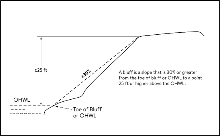
Bluff impact zone means the area of a bluff between the toe of the bluff and the top of the bluff and land located within 30 feet from the top of a bluff.
Bluff, toe means, for the purpose of measuring setbacks, the point at the bottom of a bluff that is the lower end of a 50 foot segment with an average slope exceeding 18 percent or is the OHWL, whichever is higher
Bluff, top means, for the purpose of measuring setbacks, the point at the upper end of a bluff that is the higher end of a 50 foot segment with an average slope exceeding 18 percent
Buffer, shoreline means riparian land that is used to protect adjacent lands and waters from development and more intensive land uses. The land is kept in a natural state of trees, shrubs, and low ground cover and understory of plants and functions to filter runoff, control sediment and nutrient movement, and protect fish and wildlife habitat.
Boathouse means a structure designed and used solely for the storage of boats or boating equipment.
Boardwalk means an elevated walkway used to access public waters over riparian wetlands. For the purpose of this chapter, this definition applies to land above the OHWL of a public water.
Board of adjustment means the planning and zoning commission, appointed by the city council, to hear appeals from actions of the city planner or zoning inspector and variance requests.
Brewery/taproom means a facility on the premises of and accessory to a licensed brewery intended for the on-sale consumption and limited off-sale of beer produced on site by the brewer as authorized by M.S.A. section 340A.
Buildable area means the minimum required area remaining on a newly created parcel of land or platted lot after all public road rights-of-way, road easements, setbacks, and wetlands are subtracted. In the shoreland, all land below the ordinary high water level (OHWL) of public waters, and bluffs, and wetlands shall also be subtracted.
Buildable lot means a preexisting lot for which a deed, recorded contract for deed or other legal conveyance or plat has been recorded prior to the effective date of the city zoning regulations or a lot legally created under the provisions of this Code.
Building. See structure.
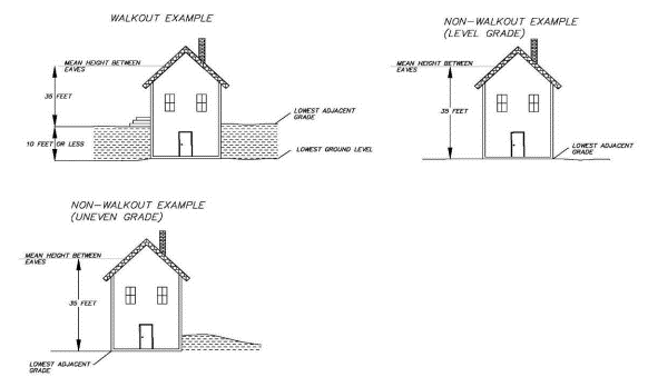
Building height means the vertical distance between the lowest adjacent grade at the structure or ten feet above the lowest ground level whichever is lower, and the highest point of a flat roof or mean height between the eaves and the ridge for gable, hip, mansard, gambrel, or other pitched or hipped roofs.
Building line means a line parallel to a lot line or the ordinary highwater level at the required setback beyond which a structure may not extend.
Building official means the person authorized by the state building code to administer building permits and appointed by the city council (who may be the same person as the city planner).
Building width means the smallest dimension of the major portion of the building.
Business, commercial retail means any establishment, employment, or enterprise wherein merchandise is manufactured, exhibited, stored, or sold, or where services are offered for compensation.
Campground means a land use consisting of designated campsites with appropriate facilities designed for temporary occupation by tents or recreational vehicles with single ownership, management services and with site rentals.
Campsite means a parcel or site within a resort or campground designated for the occupancy of one family on a periodic basis in a tent or recreational vehicle.
Cannabis business (All defined by OCM—excluding low potency retail) see Chapter VIII of Nisswa's Code of Ordinances and MN Chapter 342—Cannabis.
Cannabis business—low-potency retail see Chapter VIII of Nisswa's Code of Ordinances and MN Chapter 342—Cannabis.
Channel means a natural or artificial depression of perceptible extent, with definite bed and banks to confine and conduct flowing water either continuously or periodically.
CIC plat means a final common interest community plat.
City sewer or water systems means a system of municipally maintained utilities approved by the state and serving more than one building or property.
Clinic, hospital means a building designed and used for the diagnosis and treatment of human patients that may include overnight care facilities.
Clustering or clustered means a development pattern and technique whereby structures or building sites are arranged in close proximity to one another in non-linear groups, adjacent to permanently preserved common open space, so as to make efficient and visually aesthetic use of the natural features of the landscape and maximize visualization of permanently preserved open space.
Commercial storage facility means a use of land for storage buildings including racking that may be leased or sold individually. Said buildings cannot be used as dwellings or contain livable area.
Commercial use means the principal use of land or buildings for the sale, lease, rental, trade of products, goods, or services.
Commissioner is the commissioner of the department of natural resources or his/her authorized representative.
Comprehensive plan means a compilation of goals, policy statements, standards, programs, and maps for guiding the physical, social, and economic development of the city.
Conditional use means a land use or development as defined by ordinance that would not be appropriate without restriction, but may specifically be allowed with appropriate restrictions or conditions as determined by the planning and zoning commission upon a finding that:
(1)
The use or development is an appropriate conditional use in the land use district;
(2)
The use or development with conditions conforms to the comprehensive plan;
(3)
The use with conditions is compatible with the existing neighborhood; and
(4)
The use with conditions would not be injurious to public health, safety, decency, order, comfort, convenience, appearance, or prosperity.
Condominium ownership means a form of ownership within a multi-owner building or complex wherein the boundaries are defined by a condominium plat in accordance with the Uniform Condominium Act, M.S.A. ch. 515A.
Controlled access lot means a privately owned riparian lot meeting the standards for a buildable lot, owned by more than one owner in undivided interest, provided with facilities and used for access, and not containing a dwelling.
Cul-de-sac means the circular turn around at the end of a street with only one outlet.
Daycare facility means any facility, public or private, which, for gain or otherwise, regularly provides one or more persons with care, training, supervision, rehabilitation or developmental guidance on a regular basis, for periods of less than 24 hours per day in a place other than the person's own home, including, but not limited to, family daycare homes, group family daycare homes, daycare centers, day nurseries, nursery schools, preschool programs, daytime activity centers, day treatment programs and day services. Daycare facilities are pursuant to M.S.A. chapter 245A as amended.
Deck means a horizontal, unenclosed platform with or without attached railings, seats or trellises or other attached features, attached or functionally related to a principal use or site and at any point extending above ground level.
Development means any man-made change to improved or unimproved real estate, including, but not limited to buildings or other structures, mining, dredging, filling, grading, paving, excavation or drilling operations, or storage of equipment or materials.
Dirt moving/grading/excavation means any movement, excavation, grading, or filling of dirt on a lot.
DNR means the Minnesota Department of Natural Resources.
Driveway means a private or public roadway providing access for vehicles to a street or highway from a structure.
Duplex, triplex, or quad means a dwelling structure on a single lot having two, three, or four dwelling units respectively attached by common walls with each unit being equipped with separate sleeping, cooking, eating, living, and interior sanitation facilities.
Dwelling, guest cabin, means a free-standing structure, not for sale or lease, that contains sleeping spaces and functioning bathroom facilities in addition to those provided in the primary dwelling on the lot. A guest cabin shall not be permitted if guest quarters exist on the lot.
Dwelling, guest quarters, means the second story of a detached accessory structure, not for sale or lease, that contains sleeping spaces and bathroom facilities in addition to those provided in the primary dwelling on the lot. Guest quarters shall not be permitted if a guest cabin exists on the lot.
Dwelling, multifamily, means two or more dwelling units attached together by any point including duplexes, triplexes, townhouses, and multi-level units regardless of type of ownership.
Dwelling, single-family, a detached residence designed for or occupied by one family only.
Dwelling site means a designated location for residential use by one or more persons using temporary or movable shelter including camping and recreational vehicle sites. The term "dwelling site" includes campsites.
Dwelling unit means a structure or portion of a structure or other shelter designed as short- or long-term living quarters for one or more persons including rental or time share accommodations such as motel, hotel, resort rooms, and resort cabins, including accommodations for one family.
Dwelling unit above commercial use means a dwelling unit or units that are located above an established commercial use.
Easement means a grant by a property owner for the use of a strip of land for the purpose of construction and maintenance of utilities including, but not limited to, sewers, water mains, electric lines, telephone lines, storm sewer, or drainageways and gas lines.
EAW means environmental assessment worksheet.
EIS means environmental impact statement.
Engineer means the engineer duly appointed by the council to perform technical services for the city.
Equal degree of encroachment means a method of determining the location of floodway boundaries so that floodplain lands on both sides of a stream are capable of conveying a proportionate share of flood flows.
Essential services means underground, on ground or overhead gas, electrical, phone, cable, steam or water transmission or distribution systems; collection, communication, supply or disposal systems including poles, wires, mains, drains, sewers, pipes, conduits, cables, fire alarm boxes, police call boxes, traffic signals, hydrants or other similar equipment and accessories in conjunction therewith; but not including buildings
Expansion means any increase in a dimension such as number of units, size, area, volume, or height, or increase in the area of use, or placement of a structure.
Exterior finish means the final exterior covering of a structure including, but not limited to, brick, natural stone, glass, specialty concrete block such as textured, burnished block or rock faced block, architecturally pre-cast textured concrete panels, masonry stucco, vinyl, steel siding, exterior finish installation system (EFIS), ceramic, glass block or wood (exterior finished grade).
Exterior storage means storage of goods, materials, equipment, manufactured products outside of a fully enclosed building.
Extractive use means the use of land for surface or subsurface removal of sand, gravel, rock, industrial minerals, metallic or nonmetallic minerals or peat.
Family means an individual, or two or more persons related by blood, marriage or adoption, living together in a dwelling unit or a group of not more than six persons, not so related, maintaining a common household.
Farm fence means an open type of fence of posts and horizontally run wire, further specified in M.S.A., section 344.02, Subd. 1(a—d).
Feather flag means a portable sign that contains a harpoon-style pole or staff driven into the ground for support, supported by means of an individual stand, or attached to a building.

FEMA means Federal Emergency Management Agency.
Fence means a partition, wall, or gate erected as a divider, marker, barrier, or enclosure on a property boundary, or a barrier, screed, or enclosure within the property.
Final common interest community plat means a drawing prepared by a registered professional land surveyor or registered professional architect as to the parts of a plat prepared by each, depicting the condominium subdivision of real estate and related information conforming to the requirements of the Minnesota Common Interest Ownership Act, M.S.A. ch. 515B.
Final condominium plat means a drawing prepared by a registered architect, registered engineer, or registered land surveyor depicting the condominium subdivision of real estate and related information conforming to the requirements of M.S.A. § 515.A.2-110.
Final plat means a drawing prepared by a registered land surveyor depicting the subdivision of real estate and related information conforming to the requirements of M.S.A. ch. 505 (plats, coordinates and surveys) or the Minnesota Condominium Act, M.S.A. ch. 515.
Flag means any fabric or similar lightweight material attached at no more than two corners of the material, usually to a staff or pole, so as to allow movement of the material by atmospheric changes and which contains distinctive colors, patterns, symbols, emblems, insignia, or other symbolic devices or text. Flags more than three times as long as any other dimension are considered banners and specifically excluded from this definition. In addition, the term "flag" includes only flags attached to a building and not flags attached to a pole anchored in the ground.


Flood means a temporary rise in the stream flow or water surface elevation from any source that results in the inundation of normally dry land areas.
Flood fringe means the portion of the one-percent annual chance floodplain located outside of the floodway.
Flood insurance rate map (FIRM) means an official map on which the federal insurance administrator has delineated both the special flood hazard areas and the risk premium zones applicable to the community. A FIRM that has been made available digitally is called a digital flood insurance rate map (DFIRM).
Flood insurance study (FIS) means the study referenced in section 3.2, which is an examination, evaluation and determination of flood hazards, and if appropriate, corresponding surface elevations, or an examination, evaluation, and determination of mudslide (i.e. mudflow) and/or flood-related erosion hazards.
Floodplain means the beds, channel and the areas adjoining a wetland, lake or watercourse, or other source which have been or hereafter may be inundated by the base flood.
Floodproofing means a combination of structural and non-structural additions, changes, or adjustments to properties and structures subject to flooding, primarily for the reduction or elimination of flood damages.
Floodway means bed of a wetland or lake and the channel of a watercourse and those portions of the adjoining floodplain which must be reserved to carry or store the base flood discharge without cumulatively increasing the water surface elevation more than one-half foot.
Floor area means the sum of the gross horizontal areas to the several interior floors of a building excluding basements not used for occupancy.
Forest land conversion means the clear cutting of forested lands to prepare for a new land use other than the re-establishment of a subsequent forest stands.
Foundation means a concrete, concrete and block, or treated wood portion of a structure which totally encloses the perimeter of the structure, supports the bearing loads of the super structure and penetrates the ground to provide frost protection.
General floodplain means those floodplains designated on the flood insurance rate maps referenced in section 20-112 but that do not have a delineated floodway.
Half street means a street containing half of the required right-of-way, with the intention of adding the additional right-of-way at a future date from an adjacent property.
Home business means a use of a commercial nature conducted by occupants of a single family dwelling and/or employees that do not reside in the dwelling which may be conducted inside as well as outside the dwelling or accessory buildings, where the use is clearly incidental and secondary to the use of the dwelling for residential purposes. This includes but is not limited to people coming to the property for the purposes of conducting business activities, day care activities, salons, retail sales and any space open to the public for commercial use.
Home occupation means a use of commercial nature conducted by occupants of a single family dwelling entirely within the dwelling or accessory structures, of which the use is clearly incidental and secondary to the use of the dwelling or accessory structures for residential purposes. For the purposes of this chapter, on-site retail services are not allowed as well as use of any space open to the public for commercial use.
House of worship means a building, together with its accessory buildings and uses, where persons regularly assemble for religious activities or worship and related activities.
Ice ridge, annual means a linear mound of lakebed materials pushed up onto the lakeshore by the action of ice within a calendar year.
Ice ridge, historic means a linear mound of lakebed materials pushed up onto the lakeshore by the action of ice over a period of two or more years upon which well-established herbaceous and woody vegetation is growing.
Impervious surface means a constructed hard surface that prevents or retards entry of water into the soil and causes water to run off the surface in greater quantities and at an increased rate of flow than prior to development, including rooftops; sidewalks; patios; parking lots; storage areas; concrete, asphalt, or gravel driveways; and other similar surfaces.
Industrial uses means the use of land or buildings for the production, manufacture, warehousing, storage, or transfer of goods, products, commodities or other wholesale items that may produce impacts such as noise, odor, or vibration.
Inflatable means a static inflated device or sign intended to advertise or draw attention, and made of lightweight material supported by helium, hot or pressurized air, and greater than 11 inches in diameter.


Intensive vegetation clearing means the complete removal of trees or shrubs in a continuous path, strip, row, or block.
Interim uses means a temporary use of a property until a particular date, until the occurrence of a particular event or until zoning regulations no longer permit it. Interim uses may be granted in accordance with M.S.A. § 462.3597 and are processed in the same manner as conditional uses.
Interval ownership means a form of ownership of real property, condominium land or space further defined by time interval reoccurring each year, resulting in more than one owner of the same property, also known as timeshare.
Lake classification means the formal classification by the DNR of each body of public waters within the city.
Landscaping means the placement of trees, shrubs, grass, and walls and earth mounds or the utilization of existing natural vegetative cover equal thereto.
Land use permit means a permit issued by the city planner to allow the construction of a structure or to allow a land use when the provisions of this chapter have been met, when approval of any conditional use permits or variances has been granted and when the fees are paid. A land use permit may have administrative conditions specific to the subject site when provided by the ordinance.
Large portable sign means a portable sign, made of rigid material, larger than eight square feet which is manifestly designed to be transported, including by trailer or on its own wheels, even though the wheels of such sign may be removed and the remaining chassis or support converted to another sign or attached temporarily or permanently to the ground since this characteristic is based on the design of such sign.


Leaseback by owner means an arrangement between an owner of property and a leasing agent or resort, to promote and operate the property for rental purposes.
LEED means the leadership in energy and environmental design rating system promulgate by the United States Green Building Council.
Litter means waste materials including, but not limited to, cans, bottles, plastic, and paper wrappings or containers.
Lot means a parcel of land designated by plat, metes and bounds, registered land survey, auditor's plat or other accepted means and separated from other parcels or portions by the description for the purpose of use, occupancy, sale, lease, mortgage, building, or separation.
Lot area means square footage or acreage included within the boundaries of a parcel or platted lot. For riparian lots, land above the ordinary high water level.
Lot, corner, means a lot situated at the junction of and abutting on two or more intersecting streets or a lot at the point deflection in alignment of one street with the internal angle less than 135 degrees.
Lot, front, means the boundary of a lot which abuts on a public right-of-way, or if a corner lot, the shortest of the two boundaries. If the lot abuts public water, the lakeside shall be considered the lot front.
Lot, preexisting, means a lot which is one unit of a subdivision plat heretofore duly approved and filed or one unit of an auditor's subdivision, or registered land survey, or a lot created by metes and bounds, any of which has been recorded in the office of the county recorder prior to the effective date of the ordinance from which this chapter is derived.
Lot line means the property lines bounding a lot except that where the description extends into a public right-of-way, the right-of-way line shall be considered the lot line.
Lot, riparian means a lot that abuts a public waters.
Lot, non-riparian means a lot that does not abut public waters.
Lot tier depth means the lot depth of a normal lot conforming to the shoreland requirements:
(1)
General development lake, first tier, 200 feet;
(2)
Second and additional tiers, 267 feet;
(3)
Recreational development lake, all tiers, 267 feet; and
(4)
Natural environment lake, all tiers, 400 feet.
Lot tiers means successive strips of land parallel with the ordinary highwater line, each one-tier depth wide, and extending across the parcel.
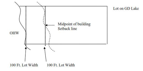
Lot width means the shortest distance between lot lines measured and at the midpoint of the building line and at the OHW for all riparian lots.
Lowest floor means the lowest floor of the lowest enclosed area (including basement). An unfinished or flood resistant enclosure, used solely for parking of vehicles, building access, or storage in an area other than a basement area, is not considered a building's lowest floor; provided that such enclosure is not built so as to render the structure in violation of the applicable non-elevation design requirements of 44 CFR § 60.3.
Manufactured home means a structure, transportable in one or more sections, which in the traveling mode, is eight body feet or more in width or 40 body feet or more in length, or, when erected on site, is 320 or more square feet, and which is built on a permanent chassis and designed to be used as a dwelling with or without a permanent foundation when connected to the required utilities, and includes the plumbing, heating, air conditioning, and electrical systems contained therein; except that the term "manufactured home" includes any structure which meets all the requirements and with respect to which the manufacturer voluntarily files a certification required by state law and complies with the standards established under the state Manufactured Home Building Code, M.S.A. ch. 327. The term "manufactured home" does not include the term "recreational vehicle."
Manufactured housing development means a form of planned unit development designed for manufactured homes and including two possible types of ownership: single ownership with site rentals or individual site ownership with a homeowner's association owning common property.
Metes and bounds means descriptions of property and descriptions of lots other than lots in recorded subdivision plats.
Motel or hotel means a commercial business with a central management to provide lodging which may provide related facilities such as restaurants, bars, and other recreational amenities but not including bed and breakfast inns.
Motor fuel station means a retail place of business engaged primarily in the sale of motor fuels, but also may be engaged in supplying goods and services generally associated with the operation and maintenance of motor vehicles. These may include sale of petroleum products, sale and servicing of tires, batteries, automotive accessories, and replacement items, washing and lubrication services, and the performance of minor automotive maintenance and repair.
Motor vehicle sales means any person, firm, or corporation who engages in the business of selling or offering for sale a vehicle, boat or recreational vehicle and receives or expects to receive money, profit, or any other item of value.
New construction means structures for which the start of construction commenced on or after the effective date of an adopted floodplain management regulation and includes any subsequent improvements to such structures.
Nonconformity or nonconforming means any legal use, structure or parcel of land already in existence, recorded or authorized before the adoption of official controls or amendments thereto that would not have been permitted to become established under the terms of the official controls now written, if the official controls had been in effect prior to the date it was established, recorded or authorized.
Nuisance means anything that interferes with the use or enjoyment of property, endangers personal health or safety, or is offensive to the senses, such as excessive smoke, odor, noise, heat, vibration, glare, traffic generation, visual impact, and other similar interferences or offenses.
Nursing home means a place of residence for people who suffer from physical or mental disabilities, and who require constant nursing care to perform their daily living activities. Nursing home services include the services of nurses, nursing aides and assistants; physical, occupational and speech therapists; and service of social workers and recreational assistants.
NWI means national wetland inventory.
Official signs and notices means signs and notices erected and maintained by public officers or public agencies within their territorial jurisdiction and pursuant to and in accordance with direction or authorization contained in federal, state or local law for the purposes of carrying out an official duty or responsibility.
Office, business and professional means a room, set of rooms, or building where the business of a commercial or industrial organization or of a professional person is conducted.
Open space means privately owned property permanently dedicated by covenant to vegetative ground coverage with allowance for recreational facilities, tree coverage or watercourses, water supply, sewage disposal and drives or public property dedicated to park, vegetative buffer, tree coverage, or similar uses.
Ordinary highwater level (OHWL) means the boundary of public waters and wetlands consisting of an elevation delineating the highest water level which has been maintained for sufficient period of time to leave evidence on the landscape, commonly that point where the natural vegetation changes from predominantly aquatic to predominately terrestrial. The ordinary highwater level of a watercourse is the level determined by the DNR or, in the absence of a DNR determination, the elevation of the top of the bank of the channel or, for reservoir and flowages, the operating elevation of a normal summer pool.
OSND means an open space neighborhood design.
Outdoor storage of products for sale/rent means the storage of goods, materials, equipment, manufactured products and similar items not fully enclosed by a building.
Outlot means a lot remnant or any parcel of land included in a plat, which may be used as open space. An outlot may be a large tract that could be subdivided in the future or a tract too small to comply with the minimum size requirements of zoning and subdivision regulations or otherwise unsuitable for development and, therefore, not usable as a building site as it currently exists.
Parking space means a site off public right-of-way, maintained and sized to be occupied by one automobile.
Party wall or floor means the structural divider between dwelling units vertically or horizontally, respectively.
Passive recreation means outdoor activities that include walking, hiking, cross-country skiing, horseback riding, and other non-motorized recreational activities that do not materially alter the landscape, degrade environmental quality, or involve commercial recreational use.
Patio means an uncovered, unscreened platform that is adjacent to a dwelling, or free standing, that is covered with a pervious or an impervious surface such as asphalt, paving stones, wood, or other approved material with ground level being its highest point.
Pennant means a series of typically polygonal shaped flexible material attached along a canvas or rope line, hung at either end, to attract attention.


Permitted use means a land use conforming to the character of a district, which is permitted by ordinance requiring only a land use permit or shoreland alteration permit issued by the city planner.
Personal wireless services means commercial mobile services, unlicensed wireless services, and common carrier wireless exchange access services.
Personal wireless service facilities means facilities for the provision of personal wireless services.
Pet means an animal, bird, reptile or fish commonly associated with human habitation, not considered under the category of animal husbandry and not raised for production of income.
Planned unit development (PUD) means a land use or development pattern characterized by a unified site design for a number of dwelling units or dwelling sites on a parcel, whether for sale, rent, or lease, and also involving clustering of these units or sites to provide areas of common open space, density increase, and mix of structure types and land uses. These developments may be organized and operated as condominiums, time share condominiums, cooperatives, full free ownership, commercial enterprises, or any combination of these, or cluster subdivisions of dwelling units, residential, condominiums, townhouses, apartment buildings, campgrounds, recreational vehicle parks, resorts, hotels, motels, and conversions of structures and land uses to these uses. An OSND pattern is a planned unit development.
Planner means the duly appointed person responsible for the enforcement and administration of this chapter of city code.
Pool means any in ground structure, chamber, or tank containing an artificial body of water for swimming, diving, relaxation, or recreational use including special purpose pools.
Practical difficulties, pursuant to M.S.A. 462.357 subd. 6(2) when used in connection with the granting of a variance, means that the property owner proposes to use the property in a reasonable manner not permitted by an official control; the plight of the property owner is due to circumstances unique to the property not created by the property owner; and the variance, if granted, will not alter the essential character of the locality. Economic considerations alone do not constitute practical difficulties.
Preliminary plan and preliminary condominium plat mean plans prepared in accordance with the city's subdivision regulations depicting the proposed subdivision of property by final plat or condominium plat.
Principal structure or use means the single primary structure or use on a lot, as distinguished from accessory uses or accessory structures.
Principal structure or use means the single primary structure or use on a lot, as distinguished from accessory uses or accessory structures.
Protective covenants mean restrictions placed on the property by the owner and duly filed with the county recorder. Protective covenants may also be used in planned unit developments to establish homeowners' associations, restrict shoreline development and provide for common facilities.
Public utility means persons, corporations or governments supplying gas, electric, transportation, water, sewer, or landline telephone service to the general public. Commercial wireless telecommunication services are defined separately and shall not be considered public utility uses under this definition.
Public waters. Lakes, rivers, streams and wetlands as designated under M.S.A. § 103G.005 (15 and 15a) including any lakes or wetlands listed in the DNR public waters inventory as well as any lake, river or stream listed in this chapter. However, that no lake, pond, or flowage of less than ten acres in size within the city need be regulated for the purposes of the shoreland management rules and regulations.
Reach means a hydraulic engineering term to describe a longitudinal segment of a stream or river influenced by a natural or man-made obstruction. In an urban area, the segment of a stream or river between two consecutive bridge crossings would most typically constitute a reach.
Recreational vehicle means a vehicle that is built on a single chassis, is 320 square feet or less when measured at the largest horizontal projection, is designed to be self-propelled or permanently towable by a light duty truck, and is designed primarily not for use as a permanent dwelling but as temporary living quarters for recreational, camping, travel, or seasonal use. Those vehicles not meeting this definition shall be considered a structure for the purposes of this ordinance. For the purposes of this ordinance, the term recreational vehicle is synonymous with the term "travel trailer/travel vehicle."
Regulatory flood protection elevation (RFPE) means an elevation that is one foot above the elevation of the base flood plus any increases in the water surface elevation caused by encroachments on the floodplain that result from designation of a floodway. These increases in water surface elevations are typically identified in the floodway data tables, found in the flood insurance study.
Replacement tree means a tree (independent of species) that has a trunk diameter of two inches or more, measured three feet from the ground and has a height of eight feet or more. The species selected shall be capable of growing to a height of at least 15 feet.
Residential real estate means a new or existing building constructed for habitation by one to four families and includes detached garages.
Resort means a commercial establishment, regardless of ownership arrangement, that includes buildings, campgrounds, lodges, structures, dwelling units or sites, enclosures or any part thereof that are kept, used, maintained or advertised as or held out to the public to be a place where sleeping accommodations are furnished to the public and primarily to those seeking recreation, for periods of one day, one week, or longer, and having for rent three or more cabins, rooms, campsites, or enclosures. These establishments must be primarily service-oriented for transient lodging of guests. All cabins, rooms, dwelling units/sites, or enclosures must be included in the resort rental business. In order to qualify as a resort pursuant to this definition, a resort shall also be fully licensed and permitted under appropriate state and local regulations. The entire parcel of land must be controlled and managed by the licensee.
Resort, fractional ownership, means a resort where the ownership is divided amongst multiple property owners, typically through the direct sale of individual resort units or a share of an individual resort unit.
Restaurant means an establishment having facilities for serving meals at tables to the general public, in consideration of payment therefor, and which employs adequate staff to provide the usual, customary and suitable service to guests.
Restaurant, formula, means a restaurant or establishment that is contractually required to offer standardized menus and ingredients and where the exterior or interior design and which serves or delivers food or beverages in disposable containers.
Retaining wall means a structure designed to contain, support or prevent the movement of soil in order to allow ground levels of different elevations to exist adjacent to one another.
Right-of-way means a parcel of property dedicated to the public, connecting to other public rights-of-way, which afford primary access by pedestrians and vehicles to abutting properties.
Riparian property means land that abuts the edge of a lake, river, stream or wetland adjacent to the edge of a lake, river or stream.
Riparian rights mean the rights of access for navigation, withdrawal of a reasonable amount of water and similar activities, which belong to the owner of land adjacent to a lake or stream.
Riparian use area means the surface water including the bottom of a lake, river or stream adjacent to riparian property that is determined by extending the property lines over the surface water at the same angle on land.
Sand blanket means a layer of sand placed on land that is considered non-wetland for the purpose of creating a recreational use area. This definition applied to riparian and non-riparian parcels of land.
School means a building or space that is principally used as a place where persons receive educational instruction.
Semi-public use means the use of land by a private, nonprofit organization to provide a public service that is ordinarily open to some persons outside the regular constituency of the organization.
Sensitive resource management means the preservation and management of areas unsuitable for development in their natural state due to constraints such as shallow soils over groundwater or bedrock, highly erosive or expansive soils, steep slopes, susceptibility to flooding or occurrence of flora or fauna in need of special protection.
Setback means the minimum horizontal distance between a structure, sewage treatment system, well or other facility and an ordinary highwater level, sewage treatment system, well, top of bluff, road, highway, property line or other facility. Three feet of roof overhang, stoops not exceeding 30 square feet and steps from stoop to ground not over four feet wide may protrude into the setback.
Setback, interior lot, in a PUD, means the closest horizontal distance between the lot line and the foundation or wall of a structure when the lot line is not the exterior boundary of the development. Three feet of roof overhand, stoops not exceeding 30 square feet and steps from stoop to ground not over four feet wide may protrude into the setback.
Setback, road, means the closest horizontal distance between the road right-of-way line and the foundation or wall of a structure. Three feet of roof overhang, stoops not exceeding 30 square feet and steps from stoop to ground not over four feet wide may protrude into the setback.
Setback, side, exterior, means the closest horizontal distance between the exterior boundary side lot line and foundation or wall of a structure. This setback takes precedence over setback, interior lot, where any conflict exists. Three feet of roof overhang, stoops not exceeding 30 square feet and steps from stoop to ground not over four feet wide may protrude into the setback.
Setback, waterfront, means the closest horizontal distance between the ordinary highwater mark and the foundation or wall or edge of a structure. Three feet of roof overhang, stoops not exceeding 30 square feet and steps from stoop to ground not over four feet wide may protrude into the setback.
Sewer system (public) means pipelines or conduits, pumping stations and force mains and all other constructions, devices, appliances or appurtenances used for conducting sewage or industrial waste or other waste to a point of ultimate disposal.
Shore impact zone 1 means land located between the ordinary highwater level of a public water and a line parallel to it at a setback of 50 percent of the normal structure setback.
Shore impact zone 2 means land located between shore impact zone 1 and the structure setback line.
Shoreland means land located within the following distances from public water: 1,000 feet from the ordinary high-water level of a lake, pond, or flowage; and 300 feet from a river or stream, or the landward extent of a flood plain designated by ordinance on a? river or stream, whichever is greater.
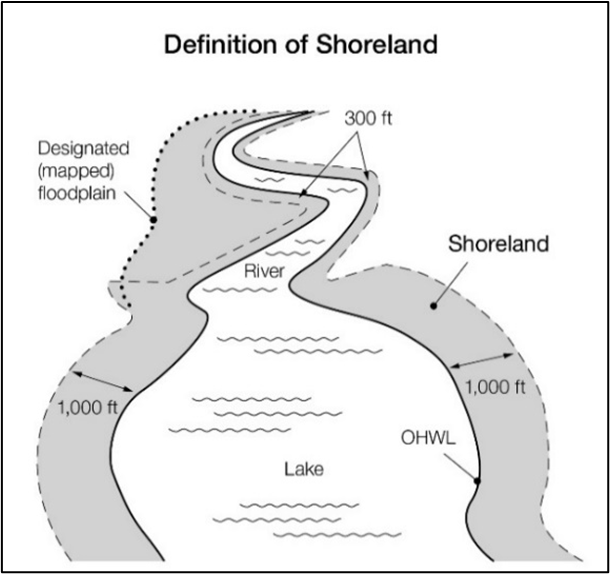
Shoreland alteration permit means a permit approved by the planner that is required for dirt moving activities and amounts and the construction of certain structures such as but not limited to water oriented accessory structures, stairways, walkways, lifts, landings, retaining walls, ria rap, shoreline use areas including sand blankets, at grade patios, boardwalks, watercraft access ramps in the shoreland zoning district with the primary area being shore impact zone 1 and 2.
Shoreland buffer zone (SBZ) means the area between the shoreland protection zone and the 1,000 foot end of the shoreland residential district for lakes and the 300 foot end of the shoreland residential district for streams and rivers.
Shoreland protection zone (SPZ) means the area between the ordinary high water level (OHWL) of a public water and a line parallel to the OHWL at:
(1)
500 feet from a lake or pond, or;
(2)
150 feet of a river or stream
Shoreline property means a lot directly abutting a public water, generally located in the first lot tier adjoining the public water.
Shoreline rapid assessment model (SRAM) means a process and criteria incorporated herein by reference and used by the department to determine the extent of natural vegetation present on a lot, the degree of natural protection that a shoreline has, and options for property owners to bring their shoreline into compliance in conjunction with permit or variance applications.
Sidewalk sign means a portable sign, made of rigid material, no larger than eight square feet on one side that is capable of standing without support or attachment, such as sandwich boards and A-frame signs.


Sign means a name, identification, description, display, illustration, advertisement, or device which is displayed for the purpose of attracting attention to a person, product, place, activity, institution, or business. Signs also include, but are not limited to:
(1)
Banners: a canvas, fabric, cloth, plastic or other flexible material hung to display a message;
(2)
Streamers: a canvas, fabric, cloth, plastic or other flexible material typically attached to a vertical pole to attract attention and display a message;
(3)
Pendants: a series of typically triangular shaped flexible material attached along a canvas or rope line, hung at either end, to attract attention; and
(4)
Temporary signs: typically consisting of plastic, metal, aluminum or wood materials on wheels or supports that is intended to be set in place for a temporary period of time.
Sign, area identification, means any sign identifying the name of a neighborhood, residential subdivision, PUD or similar area.
Sign, business, means sign which directs attention to a business, commodity, service, activity or entertainment sold or offered upon the premises where such sign is located.
Sign, construction, means a temporary sign erected during construction on the premises of the site where the construction is taking place indicating the names the architects, engineers, landscape architects, contractors or similar artisans, or the owners, financial supporters, sponsors and similar individuals for firms having a role or interest with respect to the structure or project.
Sign, dynamic display, means any sign capable of displaying words, symbols, figures or images that can be electronically or mechanically moved or changed by remote, automatic, or electronic means but not including merely the ability to turn the sign on and off.
Sign, freestanding, means any permanent sign and its supporting framework that is anchored in the ground, and which is independent from any building or other structure but not including large portable signs.
Sign, home occupation, means any sign designating a home occupation when such sign is located on the premises of the residential property where the business is being conducted.
Sign, internal directional, means a sign which serves solely to designate the direction of any place or area located on the same lot as the place or area necessary for the orderly movement of traffic or providing necessary direction to users of the site. Examples include parking lot entrance and exit signs, directional signs to holes within a golf course, and similar signs.
Sign, internal identification, means a sign that has a purpose secondary to the use of the lot on which it is located, such as "telephone," "drive-up window," "cash machine," "air" and similar directives.
Sign, multifamily building identification, means a sign indicating information related to the name, address, ownership, and other incidental property information for a multifamily dwelling complex located on the premises of the complex.
Sign, obsolete, means a sign which identifies or advertises an activity, business, product, service or special event no longer produced, conducted, performed or sold on the premises upon which sign is located, except signs of historical character.
Sign, off-site, means any sign not located on the contiguously owned property with the use which is advertised.
Sign, on-site, means any sign located on the contiguously owned property with the use which is advertised.
Sign, nameplate, means any sign indicating the name, address and other noncommercial messages on a residential property.
Sign, political, means a temporary sign advertising election issues or the candidacy of a person running for office.
Sign, portable, means any sign which is manifestly designed to be transported, including by trailer or on its own wheels, even though the wheels of such sign may be removed, and the remaining chassis or support converted to another sign or attached temporarily or permanently to the ground since this characteristic is based on the design of such sign.
Sign, protruding, means any sign which is affixed to a building or wall in such a manner that its leading edge extends more than six inches beyond the surface or such building wall or face.
Sign, real estate, means any sign which announces the sale, rental or lease of property by the owner of the property or real estate company when such sign is located on the site of property being advertised.
Sign, semi-public directional, means a sign displaying directional information for churches, schools, hospitals, nursing homes, clubs, libraries or similar uses (excluding office of commercial establishments) not necessarily located on the site of the use being advertised.
Sign, semi-public identification, means a sign displaying identification information for churches, schools, hospitals, nursing homes, clubs, offices, libraries or similar uses when located on the site of the use for which the sign is intended.
Sign, temporary, means a sign affixed, erected or maintained on a premise or lot for a limited amount of time, including, but not limited to, banners, pennants, streamers, feather flags, flags, sidewalk signs, large portable signs, inflatables, yard signs, or similar displays.
Sign, wall, means a sign attached parallel to, painted on the surface of, or erected within the limits of an outside wall of any building or structure, which is supported by such wall or structure and projects six inches or less from the surface, and which displays only one sign surface.
Sign, waterfront business entrance, means a sign located at the principal entrance for a resort, golf course or other recreational facility within the CW district.
Sign, waterfront business identification, means a sign placed within the shore impact zone conveying only information relating to the location of, general types of goods and services available at, and name of an establishment in the CW district that depends on patrons arriving by boat. Other detailed information such as product brands and prices are prohibited on a waterfront business sign.
Significant historical site means any archeological site, standing structure, or other property that meets the criteria for eligibility to the national register of historical Places, or is listed in the state register of historical sites or is determined to be an unplatted cemetery that falls under the provisions of M.S.A. § 307.08. A historical site meets these criteria if it is presently listed on either register or if it is determined to meet the qualifications for listing after review by the state archeologist or the director of the state historical society. All unplatted cemeteries are automatically considered to be significant historical sites.
Sketch plan review means a preliminary discussion and review of a proposal in sketch plan form between the proposer and the planning and zoning commission to educate the commission as to the intent of the proposer, and to provide the proposer with feedback regarding concerns of the commission.
Special flood hazard area (SFHA) means an area having special flood, mudslide (i.e., mudflow), or flood-related erosion hazards, and shown on an FHBM or FIRM as Zone A, AO, A1-30, AE, AR, AR/A1-30, AR/AE, AR/AO, AR/AH, AR/A, A99, AH, VO, V1-30, VE, V, M, or E.
Stage increase means any increase in the water surface elevation during the one-percent annual chance flood caused by encroachments on the floodplain.
Start of construction includes substantial improvement, and means the date the permit was issued, provided the actual start of construction, repair, reconstruction, rehabilitation, addition placement, or other improvement was within 180 days of the permit date. The actual start means either the first placement of permanent construction of a structure on a site, such as the pouring of slab or footings, the installation of piles, the construction of columns, or any work beyond the stage of excavation; or the placement of a manufactured home on a foundation. Permanent construction does not include land preparation, such as clearing, grading and filling; nor does it include the installation of streets and/or walkways; nor does it include excavation for a basement, footings, piers, foundations, or the erection of temporary forms; nor does it include the installation on the property of accessory buildings, such as garages or sheds not occupied as dwelling units or not part of the main structure. For a substantial improvement, the actual start of construction means the first alteration of any wall, ceiling, floor, or other structural part of a building, whether or not that alteration affects the external dimensions of the building.
State-licensed residential facility means any facility, public or private, which for gain or otherwise regularly provides one or more persons with a 24 hours per day substitute for care, food, lodging, training, education, supervision, habilitation, rehabilitation, and treatment they need, but which for any reason cannot be furnished in the person's own home. Such facilities include, but are not limited to, state institutions under the control of the state department of human services, foster homes, residential treatment centers, maternity shelters, group homes, residential programs, supportive living residences for functionally impaired adults, or schools for disabled children.
Steep slope means land located in the Shoreland District having average slopes over 12 percent, as measured over horizontal distances of 50 feet or more that is not a bluff and drains to a public water.
Stoop means an entrance or exit of a building with steps.
Streamer means a long relatively narrow strip of any type material that is free hanging.

Street means a public right-of-way which affords primary vehicular access to abutting property including avenues, roads, or highways, boulevards, drives and similar public ways.
Structure means anything constructed, placed, or erected on the ground or to the ground by humans, with or without a roof including but not limited to homes, cabins, buildings, factories, sheds, detached garages, accessory buildings, manufactured housing, recreational vehicles left on a site for 14 consecutive days, signs, storage buildings, decks, fences, pergolas, ground-mounted solar energy systems, fish houses, gas or liquid storage tanks and other similar items except the following:
(1)
Aerial or underground utility lines such as sewer, electric, telephone, telegraph, gas lines;
(2)
Walks or steps on grade not more than four feet wide;
(3)
Stoops not exceeding 30 square feet; and
(4)
Fences, temporary furniture, planters.
Subdivider means the owner, agent, person, corporation, partnership, or legal entity proposing to subdivide property under his or her control.
Subdivision means the division of real estate into two or more parcels for the purpose of sale, rent, or lease, or mortgage, including planned unit development, and includes the following:
(1)
Subdivision by plat. The subdivision into two or more parcels of any size by the authority of M.S.A. ch. 505 (plats, coordinates and surveys), with documents prepared by a registered land surveyor and duly approved by the planning and zoning commission and council.
(2)
Subdivision by condominium plat. The subdivision of a building or the subdivision of real estate into two or more spaces or parcels of any size by the authority of the Uniform Condominium Act, M.S.A. ch. 515A with documents prepared by a registered land surveyor and duly approved by the planning and zoning commission and council.
(3)
Subdivision by metes and bounds. Any division of real estate resulting in two or more parcels which are not platted but divided by description prepared and signed by a registered land surveyor. All subdivision by metes and bounds resulting in residential parcels less than 20 acres or 500 feet in width and commercial parcels less than five acres or 300 feet in width shall be considered for approval by the planning and zoning commission. Subdivision by metes and bounds shall be limited to no more than one split of a parcel into two parcels, including the remnant parcel, in a three-year period.
(4)
Subdivision as a result of the expansion or extension of a road right-of-way. Any division of real estate resulting in two or more parcels which are not platted or divided by metes and bounds description but are divided as a result of the expansion or extension of a road right-of-way as a result of city council or county board action. The resulting parcels of land may be considered buildable if all minimum design standards can be met and the resulting lots are at least 100 feet or 80 percent of the required lot width, whichever is less.
(5)
Subdivision by common interest community. The subdivision of a building or the subdivision of real estate into two or more spaces or parcels of any size by the authority of the Minnesota Common Interest Ownership Act, M.S.A. ch. 515B, with documents prepared by a registered land surveyor and duly approved by the planning and zoning commission and city council.
Substantial damage means damage of any origin sustained by a structure where the cost of restoring the structure to its before damaged condition would equal or exceed 50 percent of the market value of the structure before the damage occurred.
Substantial improvement means any reconstruction, rehabilitation, addition, or other improvement of a structure, the cost of which equals or exceeds 50 percent of the market value of the structure before the "start of construction" of the improvement. This term includes structures that have incurred "substantial damage," regardless of the actual repair work performed. The term does not, however, include either:
(1)
Any project for improvement of a structure to correct existing violations of state or local health, sanitary, or safety code specifications which have been identified by the local code enforcement official and which are the minimum necessary to assure safe living conditions; or
(2)
Any alteration of a "historic structure," provided that the alteration will not preclude the structure's continued designation as a "historic structure." For the purpose of this ordinance, "historic structure" is defined in 44 CFR § 59.1.
Subsurface sewage treatment system (SSTS) means a sewage treatment system, or part thereof, serving a dwelling, or group thereof, and using sewage tanks followed by soil treatment and disposal or using advanced treatment devices that discharge below final grade. Subsurface sewage treatment system includes holding tanks and privies.
Surface water oriented commercial use means the use of land for commercial purposes where access to and use of a surface water feature is an integral part of the normal operation of business. Marinas, resorts, and restaurants with transient docking facilities are examples.
Swimming pool means any structure intended for swimming or recreational bathing that contains water over 18 inches deep and includes inground and above ground structures.
Temporary commercial structure or use means a structure of a temporary character, including, but not limited to, sell food, services, or retail.
Temporary structure means a structure placed on a lot that is limited to seven consecutive days in a calendar year and that complies with setbacks and other regulations of the land use district in which the lot is located.
Tower means any pole, spire, or structure or combination thereof, to which an antenna is attached, or which is designated for an antenna, meteorological device or similar apparatus to be attached, and all supporting lines, cables, wires and braces, which is intended to be used for commercial purposes.
Trailer, travel means a recreational vehicle built on a single chassis with a rigid walled shelter, mounted on wheels and have a gross trailer area not exceeding 400 square feet. For the purposes of this chapter, the term travel trailer is synonymous with the term "recreational vehicle."
Variance means a legally permitted deviation as provided in M.S.A. § 462.357(6)(2) and 44 CFR § 59.1 from the requirements of this chapter, including restrictions placed on nonconformities, as determined by the planning and zoning commission.
Vegetation removal, clear cutting, means the removal of more than 75 percent and up to 100 percent of a stand of trees and brush on a lot or parcel of land up to 40 acres.
Vegetation removal, open cutting, means the removal of more than 25 percent and up to 75 percent of a stand of trees and brush on a lot or parcel of land up to 40 acres including the removal of more than 50 percent of the under-story trees and brush from the property.
Vegetation removal, select cutting, means removal of dead, diseased or damaged trees or shrubs, or removal of trees for placement of structures and drives, and further removal of only individual trees to uniformly thin up to 25 percent of a stand on a lot or parcel of land up to 40 acres. Up to 50 percent of the under-story and brush may be removed.
Vehicle body repair means any person, firm, or corporation who engages in the business of repairing the body (physical exterior) of a vehicle, boat or recreational vehicle and receives or expects to receive money, profit, or any other item of value.
Violation means the failure of a structure or other development to be fully compliant with the community's flood plain management regulations. A structure or other development without the elevation certificate, other certifications, or other evidence of compliance required in this ordinance is presumed to be in violation of until such time as that documentation is provided.
Walkway means a continuous path no wider than four feet created of a material other than natural groundcover vegetation at grade level.
Warehousing means the principal use is storage of materials or equipment within an enclosed building.
Watercourse means a channel in which a flow of water occurs either continuously or intermittently in a definitive direction. The term applies to either natural or artificially constructed channels.
Water-oriented accessory structure means a small above ground building which because of the relationship of its use to a surface water feature is located closer to public waters than the normal structure setback. Examples of such structures and facilities include equipment storage buildings, gazebos, screen houses, free-standing pergolas, fish houses, pump houses, patios, and detached decks.
Wetland means lands transitional between terrestrial and aquatic systems where the water table is usually at or near the surface or the land is covered by shallow water. In addition, a wetland has distinct hydrologic feature with characteristics of wetlands surrounded by non-wetland and including all contiguous wetland types, except those connected solely by riverine wetlands. Wetland area means a portion of a wetland or the entire wetland. Wetlands do not include public water wetlands and public waters that are designated on the public water inventory maps prepared under M.S.A. § 103G.201. Wetlands must:
(1)
Have a predominance of hydric soils;
(2)
Be inundated or saturated by surface or groundwater at a frequency and duration to support a prevalence of hydrophytic vegetation typically adapted for life in saturated soil conditions; and
(3)
Under normal circumstances, support a prevalence of hydrophytic vegetation.
Wireless telecommunications services mean licensed commercial wireless telecommunication services including cellular, personal communication services (PCS), special mobilized radio (SMR), enhanced specialized mobilized radio (ESMR), paging and similar services that are marketed to businesses and the general public.
Yard sign means a temporary sign supported by one or more uprights, posts, or bases placed upon or affixed in the ground and not attached to any part of a building that is no larger than six square feet.
(Ord. No. 8 (Fourth Series), § 2, 3-21-2023; Ord. No. 18, Fourth Series, § 2, 4-16-2024; Ord. No. 24 (Fourth Series), § 1, 2-18-2025)