North Miami City Zoning Code
ARTICLE 3
- DEVELOPMENT REVIEW
DIVISION 4. - CONDITIONAL USES
DIVISION 5. - SPECIAL EXCEPTIONS
DIVISION 6. - VARIANCES HEARD BY BOARD OF ADJUSTMENT
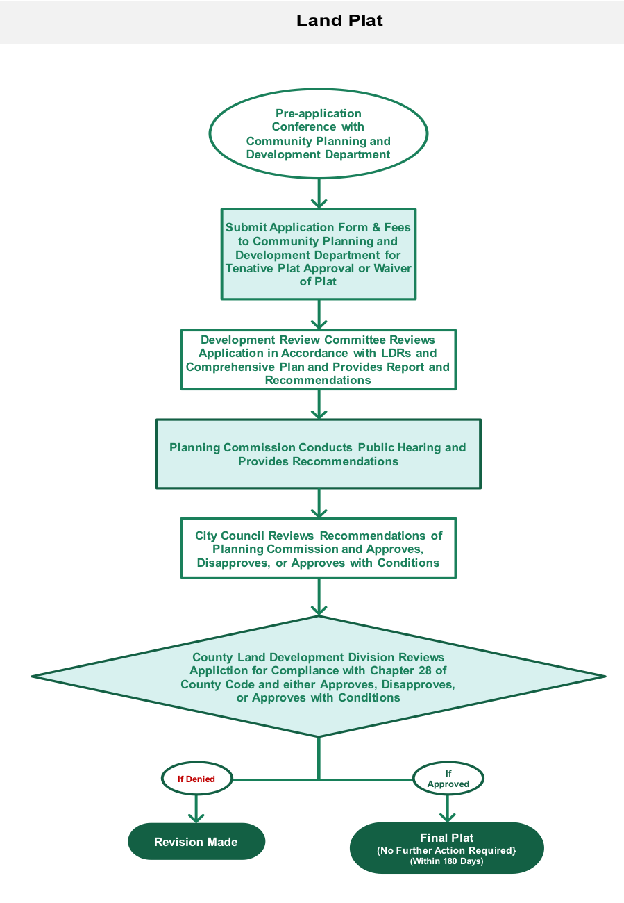
DIVISION 8. - PLATS, SUBDIVISIONS, ADDRESS ASSIGNMENT
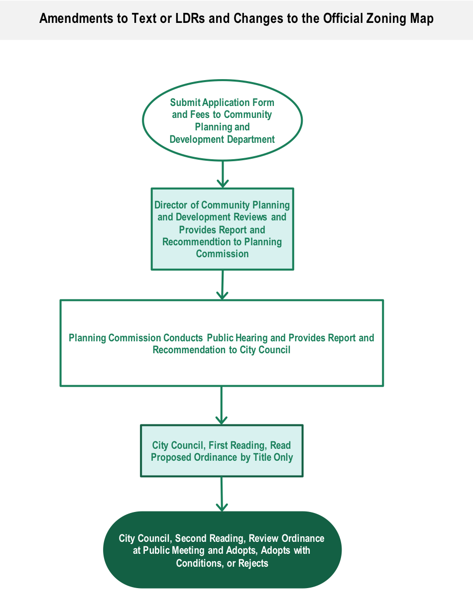
DIVISION 10. - AMENDMENTS TO TEXT OF LDRS AND CHANGES TO THE OFFICIAL ZONING MAP
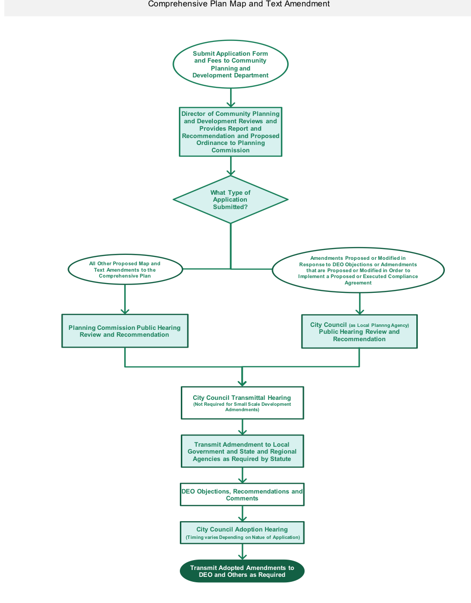
DIVISION 11. - COMPREHENSIVE PLAN MAP AND TEXT AMENDMENTS
Sec. 3-101. - Purpose and applicability.
The purpose of this article is to establish and describe the types of procedures involved in obtaining development approval. This article establishes the requirements for each type of development approval, beginning with general procedures, which are applicable to all levels of approval and followed by specific procedures that are applicable to each process. This article is applicable to all applications for development approval that are initiated subsequent to the effective date of these LDRs.
(Ord. No. 1278, § 1(exh. 1), 4-28-09)
Sec. 3-201. – Pre-application conference.
A. For all development applications, which may or may not require a public hearing, a preapplication conference shall be scheduled with the community planning and development department to discuss the nature of the application, application format requirements, and the timing of review and approval.
B. At the preapplication conference, the community planning and development department shall determine whether the proposed application contains developable property, provide the applicant with all required application forms, including all pertinent information and submittal requirements, in order to review the application for compliance with these LDRs, and without undue delay.
(Ord. No. 1278, § 1(exh. 1), 4-28-09)
Sec. 3-202. - Application.
A. Form of application. All applications for development approval shall be submitted on forms approved and provided by the community planning and development department.
B. Payment of application fee. All applications shall be accompanied by the applicable fees established via resolution by the city council, as may be amended from time to time, and/or cost recovery amount(s) for peer review.
C. Proof of ownership or agency/authorization. All applications shall include sworn proof of ownership of the subject property or sworn proof that the applicant is authorized by the owner to act on the owner's behalf on a form approved by the community planning and development department and the city attorney.
D. Development plans submittal. All applications shall be accompanied by detailed development plans, which shall be prepared by a registered architect, landscape architect or registered engineer, qualified under the laws of the State of Florida to prepare such plans and specifications. Traffic studies shall be prepared by registered transportation engineers.
E. Boundary Survey Requirement. A boundary survey is required when filing for any development application, as well as for a building permit or zoning improvement permit. The boundary survey submitted shall have been updated within one (1) year from the date of an application being filed.
F. Simultaneous applications. If more than one (1) approval is requested or will be required for a particular development proposal, with the exception of an application for a building permit or certificate of completion/occupancy, an applicant is required to submit all applications for development review at the same time.
G. Withdrawal of applications. If an application for development approval has been filed but no approval has been received within nine (9) months of receipt of a complete application, the application will be deemed withdrawn. If another application is submitted for the same project, new fees will be required, unless the application has been to hearing before a board and is under a continuance granted by the board.
H. Priority given. Priority shall be given to the review of all applications for development approval which involve green building principles and affordable housing.
(Ord. No. 1278, § 1(exh. 1), 4-28-09)
Sec. 3-203. - Determination of completeness.
- Upon receipt of an application for development review, the community planning and development department shall review the application to determine whether submittal requirements have been met:
- All required information is provided in an acceptable format;
- The required fee(s) is paid; and
- Whether the information is technically competent.
- If any required information is not provided, the applicable fee not paid and/or if the application or any part of the application is determined not technically competent, then:
- City staff shall notify the applicant in writing of the specific deficiency in the application and shall not process the application further; and
- The applicant shall either:
- Submit the specifically identified information in a technically competent form; or
- Withdraw the application.
(Ord. No. 1278, § 1(exh. 1), 4-28-09)
Sec. 3-204. - Review by development review committee.
After an application for development approval is determined to be complete and technically competent, if a site plan is required under the provisions of subsection 3-206A, the development review committee (DRC) shall review the application in accordance with the procedures adopted by the DRC and any procedures applicable to the application for development approval. The zoning administrator will coordinate the DRC review, assist in the resolution of conflicts and inform the applicant of any changes that need to be made to the applications to allow further review of the application to proceed. The following shall be required to be submitted with an application for site plan approval:
A. Letter of intent. The applicant shall submit a detailed letter of intent with a statement of objectives indicating:
1. The general purpose of the development;
2. The density, number and type of dwelling units to be constructed, and/or the type and square footage of nonresidential development, pervious and impervious surface areas, and other standards as may be required;
3. The method and time schedule of development and improvements to be made as part of the project;
4. For any site plan for residential units, the applicant shall include a statement indicating whether the residential units are intended to be owner occupied or rental units.
B. Survey. A boundary survey drawn to an appropriate engineering scale sufficient to show and to depict the location of existing property lines for both private and public property, existing contours shown at a contour interval of no greater than two feet, streets, buildings, watercourses, transmission lines, sewers, bridges, culverts and drain pipes, water mains, public utility easements, wooded areas, streams, lakes, marshes, and any other physical improvements and conditions on the site.
C. Site plan. A site plan shall be drawn to an appropriate engineer's scale showing:
1. The proposed grading plan;
2. The width, location, typical section, and names of proposed streets;
3. The width, location and names of surrounding streets including all rights-of-way and easements;
4. The zoning district(s) and existing land use(s) on properties adjacent to the proposed development;
5. The use, size, location and height of all proposed buildings and other structures;
6. The location of phase lines indicating all applicable construction phases;
7. The off-street parking and loading plan;
8. A circulation diagram showing vehicular and pedestrian movements including any special engineering features and traffic regulation devices;
9. The location and size of common open spaces and public or quasi-public areas; and
10. Statistical information, including:
a. Total acreage of the site;
b. Maximum building coverage expressed as a percentage of the total site area;
c. The area of land devoted to open space expressed as a percentage of the total site area;
d. The calculated density in dwelling units/acre or intensity in square footage for the project;
e. Parking calculations for required parking and provided parking categorized by uses; and
f. The area of land devoted to rights-of-way, transportation easements, parking and other transportation facilities expressed as a percentage of the total site area.
D. Engineering plan. Civil engineering plans drawn to an appropriate engineer's scale depicting:
1. Existing drainage and sewer lines;
2. The disposition and/or retention of sanitary waste and storm water;
3. The source of potable water;
4. The location and width of all utility easements and rights-of-way;
5. All roadways, alleyways, driveways, improved and proposed; and
6. All easements, reservations of easements of record and proposed.
E. Landscape plan. Landscaping plan drawn to an appropriate engineer’s scale depicting:
1. All landscape areas, including swale and abutting properties to be landscaped;
2. All specimen trees or groups of specimen trees, indicating those to be retained, removed, or relocated;
3. The location, height, and material for walks, fences, walkways, and other manmade landscape features; and
4. Any special landscape features including but not limited to, manmade lakes, hardscape materials, land sculpture, and waterfalls.
F. Development phasing plan. Development phasing plan with schedule showing order of construction, consistent with phase lines shown on the site plan, proposed date for the beginning of construction and completion of the project as a whole and any phases thereof, and construction staging areas.
G. Covenants, grants, easements, dedications and restrictions. Submittal of any covenants, grants, easements, dedications and restrictions to be imposed on the land, buildings, and structures, including proposed easements for public utilities and instruments relating to the use and maintenance of common open spaces and private streets. Such instruments shall give consideration to access requirements of public vehicles for maintenance purposes.
H. School concurrency. All residential development applications shall be reviewed for compliance with Public School Concurrency, pursuant to Chapters 163 and 1013, Florida Statutes. All such applications shall be submitted through the City to the Miami-Dade County Public Schools for Public School Concurrency review.
I. Design standards. Plans of the design standards for the development depicting the following:
1.Elevations of front and sides of buildings, and rear if facing a public right of way, with indications of materials, openings, design and dimensions;
2.Elevations of accessory buildings, if proposed, with indications of materials and dimensions;
3.Paving materials;
4.Palette of exterior materials and their colors; and
5.Color rendering in perspective.
J. Application and fee. Completed application on form approved by the city, accompanied with the required fee, as established via resolution by the city council, as may be amended from time to time, and/or cost recovery amount(s) for peer review.
K. Additional information. Additional and relevant information, which is deemed to be appropriate by the city to ensure consideration of all relevant issues.
L. Waiver of submittal requirements. The administrative official shall have the discretion to waive, if deemed appropriate, any of the required submittal items.
M. Determination of completeness.
1. Within five (5) working days after receipt of an application for site plan approval, the city shall determine whether the application contains all required information at the required level of detail. In the event it is determined that the application is not complete, the city shall notify the applicant in writing of the areas of insufficiency and shall specify the additional information and level of detail required in order to declare the application complete.
2. In the event that an applicant fails to submit the required additional information within thirty (30) days of notification of insufficiency, the city may consider the application to be withdrawn.
3. At the written request of an applicant, an extension may be granted by the community planning and development, provided that the applicant demonstrates just cause. Such extension shall be for a time certain.
N. Design review criteria. The zoning administrator may approve, approve with conditions, defer, or deny the application, or if acting in an advisory capacity, make a recommendation therefore, after consideration and review of the following:
1. The development, as proposed, conforms to the city’s comprehensive plan, and is consistent with the recommendations of any applicable neighborhood or area studies or master plans that have been approved by action of the city council, and is otherwise compatible with the existing area or neighborhood development;
2. The proposed development site plans, landscape plans, engineering plans and other required plans conform or will conform with all applicable city codes; including design standards as set forth in this chapter;
3. The development, as proposed, will efficiently use or not unduly burden water, sewer, solid waste disposal, education, recreation or other necessary public facilities that have been constructed or planned and budgeted for construction in the area;
4. The development, as proposed, will efficiently use or not unduly burden or affect public transportation facilities, including mass transit, public streets, roads and highways that have been planned and/or budgeted for construction in the area, and if the development is or will be accessible by private or public roads, streets, or highways; and
5. The development provides necessary and adequate vehicular circulation, pedestrian access, ingress/egress, and is configured in a manner to minimize hazards and impacts on abutting and adjacent properties and abutting and adjacent rights-of-way.
O. Imposition of conditions. Upon approval with conditions, or recommendation therefore, the zoning administrator may impose conditions as deemed necessary to ensure compliance with code requirements or minimize or mitigate the impacts of the application on public facilities, adjacent properties and the surrounding neighborhood, including but not limited to the following:
1. Require city council approval as applicable for compliance with code requirements.
2. Require the property be platted, or waiver of plat filed and obtained, prior to issuance of building permit or issuance of certificate of occupancy.
3. Require submittal of revised and completed plans to the city meeting the conditions imposed by the DRC prior to issuance of building permit or prior to issuance of certificate of occupancy.
4. Require applicant to proffer, execute and record a declaration of restrictive covenants, subject to the review and approval of the city attorney, inclusive of conditions of approval and other proffered restrictions on the development as required, or recommended as the case may be, by the administrative official.
5. Require applicant to dedicate, reserve, or grant easements for future improvements as may be deemed necessary by the city, as permitted by applicable law.
6. Require applicant to proffer a unity of title or covenant in lieu of unity of title, pursuant to this division for lands subject to the development as deemed necessary prior to issuance of building permit.
7. Require applicant to submit planning studies, traffic impact analysis, parking analysis, cost estimate studies, drainage studies, or other studies as deemed necessary by the city as requiring further review.
8. Require the applicant to post a bond or other form of surety to ensure and if appropriate fund construction of any improvements as deemed necessary prior to issuance of building permit or issuance of certificate of occupancy.
9. Require that all applicable fees, contributions, or proffered contributions be paid prior to issuance of building permit.
10. Require that large scale developments with residential uses provide park and/or recreation areas within the developments.
11. Impose any other condition that is deemed necessary in protecting the public health, safety and welfare, inclusive of mitigating, or minimizing impacts as result of the proposed development.
P. Appeals. An applicant may appeal any order, requirement, decision or determination by filing such petition with the zoning appeals board in accordance with Sec. 3-701, et seq.
Q. Modifications, deletions, revisions. Any modification, deletion, or revision to approved plans or conditions shall only be made upon a request being submitted to the zoning administrator, on a form approved by the city zoning administrator, requesting the modification, deletion, or revision. The zoning administrator shall determine if the requested modifications, deletions, or revisions represent a substantial change to the approval. If it is determined that the requested modifications, deletions, or revisions are in substantial compliance with the approval, the zoning administrator shall issue a substantial compliance statement to the applicant. In the event it is determined the requested modifications, deletions, or revisions are not substantially in compliance with the approval the zoning administrator may require the application to be resubmitted and reviewed in the manner set forth in this section.
(Ord. No. 1278, § 1(exh. 1), 4-28-09)
Sec. 3-205. - Permitted uses.
Any use listed as a permitted use in a zoning district may be permitted subject to obtaining a building permit and site plan approval, business tax receipt and certificate of use, as may be required by these LDRs.
(Ord. No. 1278, § 1(exh. 1), 4-28-09)
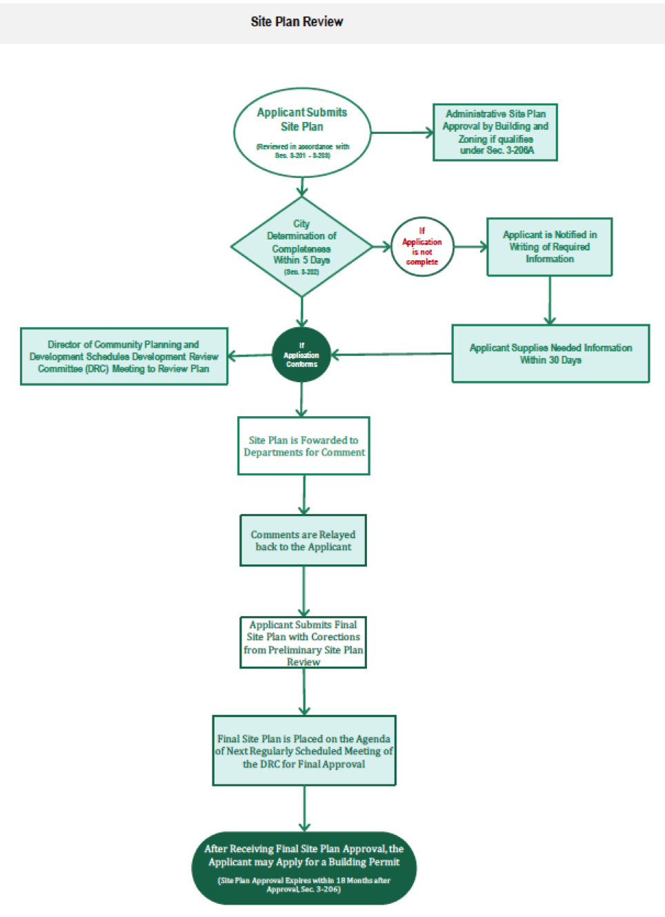
Sec. 3-206. – Site plan review.
A. Administrative site plan review by the community planning and development department shall be required for minor development/redevelopment as depicted on the use chart in article 4, division 2, section 4-202.
B. Site plan review shall be required by the DRC of any proposed development that:
1. Increases the gross impervious area of any property by more than five thousand (5,000) square feet;
2. Involves development of ten (10) percent or more of the site area; or
3. Reconstructs a structure following substantial destruction by fire or other calamity.
C. The community planning and development department may determine that a site plan is required for development not covered by subsection 3-206A or B. and the director shall consult such other city departments as may be determined to be necessary in the review of the application.
D. Upon receipt of a preliminary site plan application under the provisions of subsection 3-206B., the zoning administrator shall schedule a DRC meeting to present the proposed plan.
1. Public works shall review the site plan for:
a. Water and sewer;
b. Stormwater;
c. Sanitation;
d. Public right-of-way, including sidewalks;
e. Public facilitiesconcurrency;
f. Traffic circulation and impacts.
2. Parks and recreation department shall review the site plan for:
a. Consistency with the park master plan;
b. Landscape design and energy conservation;
c. Park concurrency;
d. Florida friendly plant list.
3. Police shall review the site plan for:
a.Crime Prevention Through Environmental Design (CPTED);
b.Defensible space design approaches.
4. Community planning and development department shall review the site plan for:
a. Consistency with comprehensive plan's goals, policies and objectives;
b. Compliance with these LDRs;
c. Concurrency requirements;
d. Transportation mitigation strategies; and
e. Sustainable building program.
5. Community redevelopment agency shall review the site plan for:
a. Consistency with the CRA plan.
E. At the DRC meeting where a new site plan is being presented, members of the committee will receive copies of the proposed site plan. Within five (5) business days of the DRC meeting, members of the committee shall provide the community planning and development department with comments. Notice of the application shall be given to the mayor and city council, who, in turn, may issue comments on the site plan to the community planning and development director.
F. Upon receipt of all preliminary review comments, the community planning and development department shall compile each of the comments into a comprehensive development review report and submit such report to the applicant.
G. Once corrections are made as requested by the DRC, the applicant shall submit copies of a final site plan. The community planning and development department shall transmit the final site plan to the members of the DRC for final approval and signatures, if all outstanding comments have been addressed.
H. After receiving final site plan approval, the applicant may apply for a building permit. If another approval is required, such as a conditional use or a variance, simultaneous applications may be considered in accordance with applicable procedures in this article.
I. If a building permit is not applied for pursuant to an approved site plan within eighteen (18) months of approval, then the site plan approval shall expire, unless the director of community planning and development grants an extension of time not to exceed an additional six (6) months.
J. Applicability, substantial compliance. Where there has been a final development order issued an applicant may request a substantial compliance determination of any modification, deletion, amendment or revision to the development order as it impacts the approved plans, declaration of restrictive covenants, or any other condition of approval, which, if granted shall not require the modification, deletion, amendment, or revision to be reviewed as otherwise required in these LDRs.
K. Application substantial compliance determination. Prior to the implementation of any modification, deletion, amendment or revision to the final development order as it impacts the approved plans, declaration of restrictive covenants, or any other conditions of approval, an applicant may file an application in a form approved by the zoning administrator for a substantial compliance determination. The application shall be accompanied by a fee, and contain a statement as to the basis upon which the substantial compliance determination is asserted together with documentation required by the city and other documentary evidence supporting the claim. The administrative official shall review the application and based upon the evidence submitted and the review criteria set forth in this section shall make a determination within thirty (30) days as to whether the request is substantially in compliance with the original approval.
L. Criteria for review of substantial compliance determination request. Upon direct application in specific cases for a substantial compliance determination the zoning administrator may grant approval, approval with conditions, or deny the request after consideration of the following:
1. The request is consistent with the basic intent and purpose of the land development, subdivision and other regulations set forth in this chapter, which are to protect the general welfare of the public, particularly as it affects the stability and appearance of the community. The request will not be detrimental to the community;
2. The request will have a significant adverse effect upon the value of properties in the immediate vicinity;
3. The request changes the community design, architecture, or layout and orientation of buildings, open space, or amenities that is inconsistent with and deleterious to the aesthetic character of the immediate vicinity;
4. The requested increases the density, massing, intensity, or height, or decreases the dimensional requirements or numerical requirements, or changes the use of the subject property that it represents an obvious and significant departure from the original approval and/or the established development pattern of the immediate vicinity which will have a deleterious effect on its community character;
5. The request may result in a substantial degradation of localized traffic patterns or a substantial adverse impact on the roadway network;
6. The request may result in unmitigated demands on potable water, sanitary sewer, or stormwater treatment systems, which exceed the capacity of those systems;
7. The request creates a new or continued and substantial risk to human life or safety or to the environment, or a nuisance.
M. Appeals. The administrative official's decision shall be subject to appeal, by only the applicant for substantial compliance determination, to the zoning appeals board as an appeal of an administrative interpretation. Such notice of appeal filed shall be filed with the zoning administrator within thirty (30) days after the zoning administrator’s written decision, subject to the provisions of Sec. 3-702.
Sec. 3-207. - Building permit.
Permit required.
A. No person shall construct, enlarge, alter, repair, move, demolish, or change the occupancy of a building or structure, or any outside area being used as part of the building's designated occupancy or to erect, install, enlarge, alter, repair, remove, convert or replace any electrical, gas, mechanical or plumbing system, the installation of which is regulated by the Florida Building Code, or to cause any such work to be done, without first making application to the building services department and obtain the required permit for the work.
B. All building permits and sign permits shall be in conformity with these LDRs and any applicable development approval related to the parcel proposed for development.
(Ord. No. 1278, § 1(exh. 1), 4-28-09)
Sec. 3-208. – Zoning Improvement Permits.
Certain buildings, structures, improvements and installations are exempted by the Florida Building Code from building permit issuance, but must otherwise comply with the minimum requirements of this chapter. Therefore, such buildings, structures, improvements and installations shall be subject to review under the Zoning Improvement Permit (ZIP) standards contained in this section, as well as the regulations of the underlying zoning district and other applicable provisions of these LDRs.
The following buildings, structures, improvements and installations shall require a ZIP from the community planning and development department:
1. Chickee huts constructed by Miccosukee or Seminole Indians (Florida Statutes);
2. Decorative reflective pools and fishponds that contain water less than 24 inches deep, that contain less than 250 square feet in area, and contain less than 2,250 gallons in volume;
3. Decorative garden-type water fountains.
The community planning and development director shall have the authority to require ZIP review for other buildings, structures, improvements and installations that are newly created or come about by changes in the state or local building codes.
In the event any portion of the subject property is contiguous to or across the street from a municipal boundary, applicant shall submit a boundary survey performed in accordance with section 5J-17.051, Florida Administration Code.
The submittal of plans shall be necessary to fully advise and acquaint the issuing department with the location and use of the buildings, structures, improvements and installations, and such plans must accompany the application for a ZIP. The Miami-Dade County’s environmental resources management and fire rescue departments shall review the submitted plans only to the extent of their respective jurisdiction under the Code of Miami-Dade County. In the event there is a question as to the legality of a use, the community planning and development director may require affidavits and such other information as may be deemed appropriate or necessary to establish the legality of the use, before a ZIP permit is issued.
Sec. 3-209. - Permit to move building; bond.
A. No building or structure shall be moved from one (1) lot or premises to another, unless such building or structure shall thereupon be made to conform with all the provisions of this chapter relative to building or structures hereafter erected upon the lot or premises to which such buildings or structures shall have been moved.
B. The community planning and development director is hereby authorized to require any person applying to obtain a permit to move a building or structure from one (1) lot or premises to another, to post a bond, either in cash or surety company bond, meeting with the approval of the Director in a sum not to exceed two thousand five hundred dollars ($2,500.00), deposited with the city clerk, if a cash bond, or if a surety bond, payable to the city, conditioned upon the applicant’s compliance in all respects with the building and zoning codes pertaining to the area on which such a building shall have been moved.
C. A building shall not be moved on, across or along a public highway without a permit being obtained from the city. A building to be moved shall be routed over highways and bridges as directed by the public works director.
Sec. 3-210. - Buildings on through lots.
Where a lot extends through from one (1) street to another, the setback requirement for each such street shall be complied with and any building shall have dual facing. Lots which have a decorative wall as defined in section 5-1209 along the rear property line as required by plat shall not be considered through lots.
Sec. 3-211. - Certificate of occupancy.
A certificate of occupancy (CO) is required for all new construction. A CO can be issued by the building official after all applicable final inspections are approved, all required documents are filed with the building official and all applicable fees are paid.
(Ord. No. 1278, § 1(exh. 1), 4-28-09)
Sec. 3-212. - Certificate of completion.
A certificate of completion (CC) is required for all substantial remodeling, renovations and rehabilitations without any change in use. A CC can be issued after all applicable final inspections are approved, all required documents are filed with the building services department and all applicable fees, and code enforcement fines are paid.
(Ord. No. 1278, § 1(exh. 1), 4-28-09)
Sec. 3-213. - Certificate of re-occupancy.
A. Purpose. The purpose of this section is to ensure that prior to residential property being conveyed to new ownership, the city is able to confirm that the property meets the current city zoning requirements; that the premises are being used solely for residential purposes; and that there are no previously existing and cited uncorrected life safety code violations on the property.
B. Single-family, duplex, triplex and condominium units. It shall be unlawful for any person, entity or corporation to buy, sell, convey or transfer a single-family, duplex, triplex or condominium dwelling unit, unless a certificate of re-occupancy has been issued by the building official or his or her designee. The certificate of re-occupancy, if issued, shall state that the building official or his or her designee has inspected the dwelling and has determined that the dwelling meets the provisions of the land development regulations of the city pertaining solely to the requirement that each individual unit is used, designed or intended to be used as a single-family, duplex, triplex or condominium dwelling unit and that the dwelling unit has not been altered and conforms to its zoning designation. A certificate of re-occupancy shall not be required for the original transfer or conveyance of a newly constructed single-family, duplex, triplex or condominium dwelling unit.
C. Apartment complex. It shall be unlawful for any person, entity or corporation to buy, sell, convey or transfer an apartment or building complex consisting of four (4) or more units unless a certificate of re-occupancy has been issued by the building official or his or her designee. The certificate of re-occupancy, if issued, shall state that the building official or his or her designee has inspected the dwelling and has determined that the dwelling meets the provisions of the LDRs pertaining solely to the requirement that each individual unit is used designed or intended to be used as an apartment or building unit and that the unit has not been altered and conforms to its zoning designation. A certificate of re-occupancy shall not be required for the original transfer or conveyance of a newly constructed apartment or building complex.
D. Certificate of re-occupancy application.
1. Applications for a certificate of re-occupancy shall be made by the seller, owner or the designated agent, upon a form provided by the city along with the payment of an inspection fee.
2. Upon receipt of the application and fee, a city inspector shall inspect the dwelling within ten (10) days and, if such dwelling is found to be in conformity with the provisions of subsection A. or B. above, a certificate of re-occupancy shall be issued. If the dwelling is not in conformity with such provisions, the building official or his or her designee shall indicate by itemized list, corrective action and the certificate of re-occupancy shall be withheld unless and until such provisions are complied with, to the reasonable satisfaction of the building official.
3. The fee for re-inspection, to be paid by the applicant, shall be promulgated by the city. An expedited inspection or re-inspection fee shall be paid by the applicant, if the applicant requests for an inspection or re-inspection to be completed within five (5) business days of receipt of the application.
E. Restriction on inspection. Inspections under this section shall be limited to ensuring compliance with zoning requirements and dwelling use. Information gained or conditions observed, including life safety violations, other than as to the dwelling use or zoning designations addressed in subsections A or B of this section, during the course of any inspection under this section, shall not be utilized as the basis for denying a certificate of re-occupancy. This shall not preclude the bringing of code enforcement actions against the property for violations observed during the inspection.
F. Conditional certificate of re-occupancy. A certificate of re-occupancy may not be issued should there be previously existing and cited uncorrected life safety code violations on the dwelling. In the event that there are previously existing and cited uncorrected life safety code violations, a conditional certificate of re-occupancy may be issued subject to terms set by the building official. The city manager shall have authority to enter into settlement agreements and issue the conditional certificates of re-occupancy, which shall be executed by the buyer and seller. The fee for a conditional certificate of re-occupancy shall be promulgated by the city. Prior to the issuance of the conditional certificate of re-occupancy, all code enforcement fines must be satisfied.
G. Penalties. Any property for which an approved re-occupancy or conditional re-occupancy certificate is not obtained prior to the transfer of title shall be subject to a fine equivalent to the expedited application fee, payable at the time the late application is filed plus any fines assessed by the code enforcement special magistrate under code enforcement violation proceedings.
(Ord. No. 1278, § 1(exh. 1), 4-28-09; Ord. No. 1324, § 1, 12-3-11; Ord. No. 1381, § 1, 10-14-14)
Sec. 3-214. - Resubmission of application affecting same property.
If an application for conditional use permit, special exceptions, variances, appeals, text amendments to the LDRs and/or zoning map amendments, comprehensive plan text and/or map amendments, and abandonment and vacation of right-of-ways and easements, is denied by the city council or the board of adjustment, another similar request on the same property or portions thereof shall not be accepted within a one (1) year period, unless the city council or the board of adjustment specifies that the denial of the application is made without prejudice, or if the city council or the board of adjustment makes a determination that significant new material or facts are present, which justify reconsideration of the application and thereby grants specific approval for refiling of the application, then said one (1) year waiting period may be waived.
(Ord. No. 1278, § 1(exh. 1), 4-28-09)
Sec. 3-215. - Certificate of use.
A. Certificate of use required.
1. No building, other than a single-family residence or duplex, shall be used or enlarged, or any new use made or enlarged of any land, body of water, or structure, without first obtaining a certificate of use (CU) from the .community planning and development department Notwithstanding the foregoing, home occupational and community residential uses to be conducted within a single-family residence or duplex shall obtain a CU. Said CU shall be required for each individual business and each multi-family building located within the city. No person shall use or permit the use of any structure and/or property hereafter created, erected, changed, converted, enlarged or moved, wholly or partly, until a CU reflecting the use, extent, location, transfer of ownership and other matters related to this section shall have been issued to the property owner. Where a building permit is involved, the provision of a certificate of use shall be part of the building permit application review and approval process. Otherwise, an application shall be made to the zoning administrator on forms provided by the city.
2. When granted, a CU, together with any conditions or safeguards attached, shall apply to the land, building, or use for which it was issued, and shall be binding upon heirs and assigns, unless abrogated or altered in the manner set forth in this chapter.
B. Application.
1. Applications for CU are to be completed only by the property owner, its formally designated agent, or a lessee with formal and legally sufficient consent of the property owner. Such applications shall be made on forms provided by the community planning and development department and shall be accompanied by such plans, reports, or other information, exhibits, or documents as may be reasonably required to make the necessary findings that the applicant is in compliance with zoning requirements. If the application is not in full accord with zoning regulations, the application shall be denied and the applicant notified in writing of the reasons for such denial.
2. The property owner may also be subject to the following disclosure requirements:
a. A statement describing in detail the character and intended use of structure and/or property;
b. Boundaries of the property, any existing streets, buildings, watercourses, easements, and section lines;
c. Exact location of the structure and/or property;
d. Access to utilities and points of hookups;
e. Storm drainage and sanitary sewerage plans;
f. Such additional data, maps, plans, or statements as may be required for the particular use involved.
3. Completed applications with the appropriate fee shall be filed with the community planning and development department. No application shall be deemed to have been filed unless and until the application is completed with all plans, reports, or other information, exhibits, or documents required hereto shall have been provided, and all fees due at time of filing shall have been paid.
4. During the processing of an application, if it is determined by the director that additional information is required, failure to supply such information may be used as grounds for denial of CU. In the event the director denies an application pursuant to this section, the applicant may appeal the decision of the director in accordance with subsection I.2. below.
C. Certificate of use renewal.
1. Except for CUs required by code or zoning regulation to be renewed annually, and except for CUs issued on a temporary basis, certificates of use shall remain valid for one (1) year commencing October 1 through September 30, unless otherwise revoked for cause. The CU is only valid for the specific address, business name, corporate name and type of business for which it was issued. A new CU shall be required for any changes in use, name or ownership interest, expansion of square footage occupied, the inclusion of additional uses, or when changes to the structure have been approved by final building inspection.
2. No CU shall be issued to any person, firm, or corporation for the sale of alcoholic beverages to be consumed on or off the premises where the proposed place of business does not conform to the distance requirements of article 5, division 9 of these LDRs, unless a variance is first obtained.
D. Conformity with laws.
1. The certificate of use shall show that the use of a structure and/or property is in conformity with applicable city and Miami-Dade County (county) codes, as amended from time to time. It shall be the duty of the community planning and development director or his/her designee to issue a CU if the director finds that all applicable city and county requirements have been complied with as of the date of issuance, or to withhold a CU until such time the director finds that all applicable city and county requirements are satisfied, including abatement/satisfaction of open code violations and payment of any code enforcement fines.
2. In the event there is a question as to the legality of a use, the director may require inspections, affidavits and such other information deemed appropriate or necessary to establish the legality of the use. Additionally, the city shall have the right to periodically inspect premises at any reasonable time to ensure the existence of a current and valid CU and to ensure compliance with applicable city and county laws, under which the CU was issued.
E. Certificate issued in error.
1. A certificate of use issued in error shall not confer any rights to the person or entity in possession of the certificate, and upon a finding by the community planning and development director that a certificate has been so issued, it shall be considered null and void.
2. No certificate of use shall be deemed or construed to authorize a violation of any provision of these LDRs, and such certificates of use shall be deemed or construed to be valid only to the extent that the use, location, or other matters related to these LDRs are lawful.
3. Issuance of a CU, in reliance upon the information presented during the application process, shall not prevent the director from taking any of the following actions:
a. Require necessary corrections on the application documents;
b. Require the abatement of any violation of use of structure and/or property; and
c. Revoke, or otherwise withhold the certificate of use.
F. Certificate of use fee.
1. The community planning and development department shall charge a certificate of use application fee in the amount prescribed from time to time by resolution of the city council. The fee is to be paid by all applicants at the time of application submittal.
2. The certificate of use fee may be adjusted annually by an amount equal to the rate of increase in the Consumer Price Index (CPI) or from time to time by resolution of city council.
3. Unless otherwise provided, for each new certificate of use obtained between October 1st and March 31st, the full fee amount shall be paid, and for new certificate of use obtained from April first to September 30th, one-half (½) of the full fee amount for one (1) year shall be paid.
G. Administration.
1. The city manager or designee shall be responsible for the administration and enforcement of this section, prevent violations or detect and secure their correction, and investigate promptly complaints of City Code violations, with such assistance as the city manager may direct.
2. It shall be the duty of all employees of the city, and especially of all officers and inspectors of the department of community planning and development, the code enforcement division, and the police department, to report to the director any apparent violation.
3. If any structure is erected, constructed, reconstructed, altered, repaired, or maintained, or any structure, land, or waterway is used in violation of any regulation herein contained, enforcement procedures shall be initiated before a special magistrate as provided in chapter 2, divisions 5.2 and 5.3 of the City Code.
H. Violations and enforcement.
1. If the city manager or designee shall find that any of the provisions of these LDRs or City Code are being violated, notification shall be made in writing to the owner of the property where the violation is occurring, indicating the nature of the violation and ordering action necessary to correct it.
2. If the violation continues, the city manager or designee may initiate enforcement procedures pursuant to chapter 2, divisions 5.2 and 5.3 of the City Code. The city manager or designee, in addition to other remedies, may also institute any appropriate civil action or proceedings in the circuit court for Miami-Dade County, to prevent any unlawful erection, construction, reconstruction, alteration, repair, conversion, maintenance or use, and to restrain, correct, or abate such violation, to prevent the occupancy of said structure, land or waterway, and to prevent any illegal act, conduct of business, or use in or about such premises.
3. Any person, firm or corporation violating or failing to comply with the requirements of this section may be deemed guilty of a misdemeanor and, upon conviction thereof, shall be punished by a fine not exceeding five hundred dollars ($500.00) or imprisonment for a term not exceeding sixty (60) days, or both such fine and imprisonment at the discretion of the court.
I. Nonrenewal and revocation of certificate of use.
1. The city manager or designee is authorized to deny or revoke a CU for cause. The following constitute adequate grounds to deny or revoke a CU:
a. The use or activity on the property is conducted without a business tax receipt or with an unpaid balance of business tax for the previous year.
b. The applicant has obtained a CU by misleading, and or deceptive information or by making false statements that were relied upon by the city in issuing the CU.
c. Unless the violation is cured subsequent to being issued a CU, the property owner was convicted of, or has pled guilty to, a state or federal law violation, or to a city or county ordinance violation, which violation occurred as a part of the main business use.
d. The property owner, lessee or sub-lessee is conducting a business which is not in compliance with a city or county code, state or federal law or regulation.
e. There is a pending judgment, order, injunction or decree entered by a court or tribunal of competent jurisdiction against the property owner, which is prohibiting the property owner from engaging in the use or activity for which property owner seeks a CU.
f. The property owner currently has existing liens on property or unpaid code enforcement fines and or penalties.
2. The property owner may appeal the decision denying or revoking the CU, by a written petition requesting a hearing before the zoning appeals board as required under the City Code. The request for such a hearing must be made pursuant to chapter 29, article 3, section 3-701 of the City Code.
3. The property owner may appeal an order of the zoning appeals board by filing a petition with a court of competent jurisdiction. Such appeal shall be filed within thirty (30) days of the date of filing of the order by the board with the clerk.
4. If a CU is denied or revoked under this section, the city shall be entitled to recover its reasonable attorneys’ fees and any costs of the hearing such as court reporters and transcription charges expended by the city.
J. Records. The director shall maintain records of all official administrative actions and of all violations discovered by whatever means, including all complaints and responses made in regard thereto, with remedial action taken and disposition of cases.
K. Exemption from fees. The city, Miami-Dade County, the state, and the United States of America shall be exempted from the payment of any fee for a certificate of use where the work is done wholly by personnel of any such agency.
(Ord. No. 1284, § 1, 10-27-09; Ord. No. 1323, § 1, 11-8-11; Ord. No. 1332, § 1, 4-24-12)
Sec. 3-216. - Unity of title; covenant in lieu thereof.
A. The term “unified development site” shall be defined as a site where a development is proposed and consists of multiple lots. All applications for building permits where buildings and/or improvements are proposed for a single lot, or where building(s) are proposed for a unified development site, shall be accompanied by one of the following documents:
1. Unity of Title. A unity of title shall be utilized when there is solely one owner of the entire unified development site. The unity of title, approved for legal form and sufficiency by the city attorney, shall run with the land and be binding upon the owner’s heirs, successors, personal representatives and assigns, and upon all mortgagees or lessees and others presently or in the future having any interest in the property; or
2. Covenant in Lieu of Unity of Title. A covenant in lieu of unity of title or a declaration of restrictive covenants, shall be utilized when the unified development site is owned, or is proposed for multiple ownership, including, but not limited to, a condominium form of ownership, or the unified development site is separated by a public right of way. The covenant in lieu of unity of title shall be approved for legal form and sufficiency by the city attorney. The covenant in lieu of unity of title shall run with the land and be binding upon the owner’s heirs, successors, personal representatives and assigns, and upon all mortgagees and lessees and others presently or in the future having any interest in the property. The covenant shall contain the following necessary elements:
a. The unified development site shall be developed in substantial accordance with the approved site plan.
b. No modification to the site plan shall be effectuated without the written consent of the then owner(s) of the unified development site for which modification is sought.
B. Standards for reviewing a modification to the site plan.
1. A modification may be requested, provided all owners within the original unified development site, or their successors, whose consent shall not be unreasonably withheld, execute or consent to the application for modification.
2. The director of the city’s community planning and development department shall review the application and determine whether the request is for a minor or substantial modification. If the request is a minor modification, the modification may be approved administratively by the director. If the modification is substantial, the request will be reviewed by the DRC, after public hearing. This application shall be in addition to all other required approvals necessary for the modification sought. A minor modification would not generate excessive noise or traffic; tend to create a fire or other equally or greater dangerous; provoke excessive overcrowding of people; tend to provide a nuisance; nor be incompatible with the area concerned when considering the necessity and reasonableness of the modification in relation to the present and future development of the area concerned. A substantial modification may also include a request to modify the uses on the unified development site, the operation, physical condition or site plan. Substantial modifications shall be required to return to the appropriate development review board or boards for consideration of the effect on prior approvals and the affirmation, modification or release of previously issued approvals or imposed conditions.
C. That if the unified development site is to be developed in phases, that each phase will be developed in substantial accordance with the approved site plan.
D. In the event of multiple ownerships, subsequent to site plan approval that each of the subsequent owners shall be bound by the terms, provisions and conditions of the covenant in lieu of unity of title. The owner shall further agree that he or she will not convey portions of the subject property to such other parties unless and until the owner and such other party or parties shall have executed and mutually delivered, in recordable form, an instrument to be known as an “easement and operating agreement” which shall include, but not be limited to:
1. Easements for the common area(s) of each parcel for ingress to and egress from the other parcels;
2. Easements in the common area(s) of each parcel for the passage and parking of vehicles;
3. Easements in the common area(s) of each parcel for the passage and accommodation of pedestrians;
4. Easements for access roads across the common areas(s) of the unified development site to public and private roadways;
5. Easements for the installation, use, operation, maintenance, repair, replacement, relocation and removal of utility facilities in appropriate areas in the unified development site;
6. Easements on each parcel within the unified development site for construction of buildings and improvements in favor of each such other parcel;
7. Easements upon each such parcel within the unified development site in favor of each adjoining parcel for the installation, use, maintenance, repair, replacement and removal of common construction improvements such as footings, supports and foundations;
8. Easements on each parcel within the unified development site for attachment of buildings;
9. Easements on each parcel within the unified development site for building overhangs and other overhangs and projections encroaching upon such parcel from the adjoining parcels such as, by way of example, marquees, canopies, lights, lighting devices, awning, wing walls and the like;
10. Appropriate reservation of rights to grant easements to utility companies;
11. Appropriate reservation of rights to road right-of-ways and curb cuts;
12. Easements in favor of each such parcel within the unified development site for pedestrian and vehicular traffic over dedicated private ring roads and access roads; and
13. Appropriate agreements between the owners of the unified development site as to the obligation to maintain and repair all private roadways, parking facilities, common areas and common facilities and the like.
14. Such easement and operating agreement shall contain such other provisions with respect to the operation, maintenance and development of the property as to which the parties thereto may agree, or the community planning and development director may require, all to the end that although the property may have several owners, it will be constructed, conveyed, maintained and operated in accordance with the approved site plan. The community planning and development department shall treat the unified site as one site under these land development regulations, regardless of separate ownerships. These provisions or portions thereof may be waived by the director if they are not applicable to the subject property (such as for conveyances to purchases of individual condominium units). These provisions of the easement and operating agreement shall not be amended without prior written approval of the city attorney.
E. The declaration of restrictive covenants shall be in effect for a period of 30 years from the date the documents are recorded in the public records of Miami-Dade County, Florida, after which time they shall be extended automatically for successive periods of ten years unless released in writing by the then owners and the community planning and development director, acting for and on behalf of North Miami, Florida, upon the demonstration and affirmative finding that the same is no longer necessary to preserve and protect the property for the purposes herein intended.
F. Enforcement of the declaration of restrictive covenants shall be by action at law or in equity with costs and reasonable attorneys’ fees to the prevailing party.
(Ord. No. 1495, § 1(exh. 1), 10-25-22)
Sec. 3-301. - Intent and purpose.
The intent of this section is to establish procedures to ensure procedural due process and maintain citizen access to the local government decision-making process relating to the approval of applications requiring quasi-judicial and legislative hearings. This policy shall be applied and interpreted in a manner recognizing both the legislative and judicial aspects of the local government decision-making process relating to site-specific parcels. The procedures set out in this division shall be applicable to all public hearings required by any provision of these LDRs.(Ord. No. 1278, § 1(exh. 1), 4-28-09)
Sec. 3-302. - Notice.
In every case where a public hearing is required pursuant to these LDRs, city staff shall provide a notice of public hearing in the manner set out in this section.
A. Publication. The requirements for this type of notice shall be as follows:
1. Notice shall be published at least one (1) time in the non-legal section (unless specified otherwise) of a newspaper of general circulation published in the City of North Miami, or in Miami-Dade County, Florida, at least ten (10) days prior to the date of any required public hearing.
2. The notice of hearing shall state the date, time and place of the meeting; the titles of the proposed ordinances or resolution or a description of the substance of the matter being considered; and the place within the city where the proposed ordinances or other materials may be inspected by the public. The notice shall also state that interested parties may appear at the meeting and be heard with respect to the matter.
3. A copy of the notice shall be available for public inspection at city hall during the regular business hours of the city.
4. Notice for ordinances that change the actual list of permitted, conditional or prohibited uses, within a zoning category/district, or ordinances initiated by the city that change the actual zoning map designation of a parcel or parcels of land involving ten (10) contiguous acres or more, shall be published at least ten (10) days prior to the planning commission public hearing, again at least seven (7) days prior to the first city council public hearing and again at least five (5) days prior to the second city council adoption hearing. Public notice shall be provided as described in the following subsections:
a.The required advertisements shall be no less than two (2) columns wide by ten (10) inches long in a standard size tabloid size newspaper and the headline in the advertisement shall be in a type no smaller than eighteen (18) point. The advertisement shall not be placed in that portion of the newspaper where legal notices and classified advertisements appear. The advertisement shall be placed in a newspaper of general paid circulation in the municipality, not one of limited subject matter, pursuant to F.S. Ch. 50. Whenever possible, the advertisement shall appear in a newspaper that is published at least five (5) days a week unless the only newspaper in the City is published less than five (5) days a week.
b.The advertisement shall be in substantially the following form:
Notice of (Type) Change The City of North Miami proposes to adopt the following ordinance or approve the following application: (title of ordinance or description of application). A public hearing on the ordinance or application will be held on (date) at (time) at (location). The proposed ordinance or application materials are available for inspection at the office of community planning and development department during normal business hours. Interested parties may appear at the meeting and will be given the opportunity to be heard on the matter. |
c. Except for amendments which change the actual list of permitted, conditional or prohibited uses within a zoning category, the advertisement shall also contain a geographic location map which clearly indicates the area covered by the proposed ordinance or application. The map shall include major street names as a means of identification of the general area.
d. In lieu of publishing the advertisement set out in this section, the city may mail a notice to each person owning real property within five hundred (500) feet of the property covered by the ordinance or application. Such notice shall clearly explain the proposed ordinance or application and shall notify the persons of the date, time and location of any public hearing on the proposed ordinance or application. The notice shall also inform the persons that the materials are available for inspection and of their opportunity to attend the meeting and be heard.
5. Ordinances initiated by other than the city that would change the actual zoning map designation of a parcel of land or parcels of land shall be read by title, in full, at two (2) separate city council hearings and shall be published at least ten (10) days before the planning commission meeting and again at least ten (10) days before the city council adoption hearing.
6. Notice of small-scale development amendments to the comprehensive land use plan, initiated by someone other than the city, shall be published at least ten (10) days before the planning commission public hearing and again at least five (5) days before the city council adoption hearing.
7. All comprehensive land use plan amendments, other than small-scale amendments, shall be published at least ten (10) days before the planning commission public hearing, and again at least seven (7) days before the first city council meeting, and again at least five (5) days before the city council adoption hearing.
8. Failure to provide advertised notice as set forth in the foregoing notice requirements shall not affect any action or proceedings taken under this section unless such notice is required by Florida Statutes.
B. Posting property.
1. Except as provided in subsection B.2., all specific property being considered at a public hearing shall be posted at least ten (10) days in advance of the public hearing, provided however that the posting of specific property shall not be required when the property subject to change constitutes more than ten (10) contiguous acres. Such posting shall consist of a sign, the face surface of which shall not be larger than five hundred seventy-six (576) square inches in area, with black lettering and shall contain the following language:
[NAME OF DECISION-MAKING BODY] NOTICE OF PUBLIC HEARING PHONE: _____ HEARING DATE: _____ HEARING TIME: _____ HEARING NO.: _____ ACTION REQUESTED: _____ ADDRESS: _____ |
2. No posting shall be required for meetings of the downtown action plan advisory committee.
3. The sign shall be erected in full view of the public on each street side of the subject property. Where large parcels of property are involved with street frontages extending over considerable distances, as many signs shall be erected on the street frontage as may be deemed adequate by the City staff to inform the public.
4. The sign shall be located within the boundaries of the subject property and visible from the street.
5. The height of such sign shall be erected to project not more than seven (7) feet above the surface of the ground.
6. Failure to post specific property shall not affect any action or proceeding taken under the provisions of these LDRs.
C. Mailed notices.
1. Except for meetings before the downtown action plan advisory committee, a notice of public hearing affecting specific properties containing general information as to the date, time, place of the hearing, property location and general nature of the application may be mailed to the property owners whose addresses are known by reference to the latest ad valorem tax record, within a five hundred-foot radius. This notification requirement is measured in feet from the perimeter boundaries of the subject property. The expense of mailing notice shall be borne by the applicant.
The community planning and development department may require that an additional area receive a courtesy notice on any application. The community planning and development department may also require courtesy notices on applications that are not typically required to be so noticed if it is determined that such notice is desirable.
2. Courtesy notices shall be mailed at least ten (10) days prior to the date of the public hearing.
3. When a proposed ordinance is initiated by the City that changes the actual zoning map designation for a parcel or parcels of land less than ten (10) acres, the community planning and development department shall notify, by mail, each real property owner whose land the City will redesignate by enactment of the ordinance and whose address is known by reference to the latest ad valorem tax records. In addition, the notice will be mailed to all owners of property within a five hundred (500)-foot radius of the subject property. The notice shall state the substance of the proposed ordinance as it affects that property owner and shall set a place and time for the public hearing on such ordinance. Such notice shall be given at least ten (10) days prior to the date of the planning commission meeting and again at least thirty (30) days prior to the date of the city council public hearing.
4. Notice of small-scale development amendments to the future land use map, initiated by the city, shall be mailed to each owner of record of the property subject to the amendment in the current tax rolls. The notice shall state the substance of the proposed ordinance as it affects that property owner and shall set a time and place for the public hearing on such ordinance. Such notice shall be given at least ten (10) days prior to the date of the planning commission public hearing and again at least thirty (30) days prior to the date of the city council public hearing.
5. Notice for ordinances that change the actual list of permitted, conditional or prohibited uses or special exceptions within a zoning category/use district, or ordinances initiated by the city that change the actual zoning map designation of a parcel or parcels of land involving ten (10) contiguous acres or more, shall be mailed at least ten (10) days prior to the planning commission public hearing, again at least seven (7) days prior to the first city council public hearing and again at least five (5) days prior to the second city council adoption hearing.
6. A copy of mailed notice shall be available for public inspection during the regular business hours of the city.
7. Failure to mail where required by these LDRs, or receive notice shall not affect any action or proceeding taken under these LDRs. Except for courtesy notices, the applicant shall be required to provide a mailing list and labels of the area within the radius prescribed above to the city. The mailing list shall be accompanied by a map certified by a registered surveyor or engineer or sworn to by a person regularly in the business of providing such lists, indicating the property within a five hundred (500)-foot radius of the subject property.
(Ord. No. 1278, § 1(exh. 1), 4-28-09)
Sec. 3-303. - Quasi-judicial procedures.
A. Order of presentation. Quasi-judicial hearings shall be conducted generally in accordance with the following order of presentation:
1. Disclosure of ex parte communications and personal investigations pursuant to subsection C., below.
2. Presentation by city staff.
3. Presentation by the applicant.
4. Public comment.
5. Cross-examination by city staff.
6. Cross-examination by the applicant.
7. Cross-examination by the decision-making body.
8. Rebuttal by the applicant.
9. Closing of public hearing.
10. Discussion among members of the decision-making body.
11.Motion by decision-making body with explanation of position.
12. Action by decision-making body, including amendments to the motion if desired, and entry of specific findings. Action may include a continuance if additional information is needed for a decision, however, no more than two continuances shall be permitted. In the event the board fails to make a decision or recommendation, the matter shall proceed to the city council for decision without a board decision or recommendation.
B. Ex parte communications.
1. Any person not otherwise prohibited by statute, charter provision or ordinance may discuss the merits of any matter on which action may be taken by any decision-making body with any member of the decision-making body.
2. Members of the decision-making body shall disclose ex parte communications and personal investigations regarding pending quasi-judicial decisions in accordance with applicable Florida law; see F.S. sec. 286.0115.
C. Continuances and deferrals. A continuance of a quasi-judicial proceeding may be requested by any party at any time prior to a decision on the merits of the matter. Such request may be granted by the board in the interests of justice and fairness. A continuance may also be granted where, in the opinion of the board, any testimony or documentary evidence or information presented at the hearing justifies allowing additional research or review in order to properly determine the issue presented. The board shall continue the hearing to a time and date certain, unless the time needed for continuance is indeterminate, and in such event the board may continue the hearing to a future date to be determined, if the matter is readvertised at the expense of the applicant.
D. Judicial notice. The board shall take judicial notice of all state and local laws, ordinances and regulations and may take judicial notice of such other matters as are generally recognized by the courts of the state.
E. Supplementing the record. Supplementing the record after the quasi-judicial hearing is prohibited, unless specifically authorized by an affirmative vote of the board under the following conditions:
1. After a quasi-judicial hearing is continued but prior to final action being taken.
2. A question is raised by the board at the hearing to which an answer is not available at the hearing, the party to whom the question is directed may submit the requested information in writing to the board after the quasi-judicial hearing, provided the hearing has been continued or another hearing has been scheduled for a future date and no final action has been taken by the board. The information requested will be presented to the board at the time of the continued hearing. All parties and participants shall have the same right with respect to the additional information as they had for evidence presented at the hearing.
F. The record. All evidence in the form of documents, photographs, maps and other written materials admitted at the hearing shall be maintained by the community planning and development department or shall be placed in the official file as directed by the council or board. The official file shall be kept in the custody of the appropriate staff at all times during the pendency of the application. The official record of the quasi-judicial hearing may be preserved by tape recording or similar device by the office of the city clerk, and maintained with the official file for the quasi-judicial hearing as a public record of the city. Resumes of staff members who testify during a quasi-judicial proceeding will be automatically be entered into the record of the proceeding.
(Ord. No. 1278, § 1(exh. 1), 4-28-09)
Sec. 3-401. - Purpose and applicability.
A. Purpose. The purpose of providing for conditional uses is to recognize that there are uses which may have beneficial effects and serve important public interests, but which may, but not necessarily, have adverse effects on the environment, overburden public services or change the desired character of an area. Conditional uses are permitted uses in a particular zoning district that require individualized review due to the potential individual or cumulative impacts that they may have on the surrounding area or neighborhood. The review process allows the imposition of conditions to mitigate identified concerns or to deny the use if concerns cannot be resolved.
B. Applicability. With the exception of applications in the PCUD, conditional use approval is the mechanism for approval of all planned development district applications, for allocating units in the NRO district, for approval of PU applications, and approval of density and height bonuses in article 4, division 4, section 4-404.
(Ord. No. 1278, § 1(exh. 1), 4-28-09; Ord. No. 1440, § 1, 6-25-19)
Sec. 3-402. - General requirements.
In addition to the application for a conditional use permit, the following items shall be submitted for review and approval:
A. Phasing plans. A progress plan delineating the various development phases, if more than one (1), and specifying a reasonable time allocation for each phase.
B. Landscape and irrigation plan. A detailed landscaping plan indicating type and size of trees, shrubs, ground cover and other horticulture.
C. Site plan. A detailed site plan of the proposed development, in accordance with administrative regulations.
D. Impact analysis. The form and content of impact analyses shall be as set forth in administrative regulations or as required by the community planning and development director.
(Ord. No. 1278, § 1(exh. 1), 4-28-09)
Sec. 3-403. - Application.
An application for conditional use approval shall be made in writing upon an application form approved by city staff, and shall be accompanied by applicable fees.
(Ord. No. 1278, § 1(exh. 1), 4-28-09)
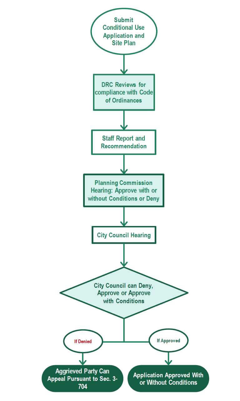
Sec. 3-404. - Staff review, report and recommendation.
A. City staff shall review the application in accordance with the procedural provisions of this division and article 3, division 2 of these LDRs.
B. Upon completion of review of an application, city staff shall:
1. Provide a report that summarizes the application, including whether the application complies with each of the standards for granting conditional use approval in section 3-405.
2. Provide written recommended findings of fact regarding the standards for granting conditional use approval.
3. Provide a recommendation as to whether the application should be approved, approved with conditions or denied.
4. Provide the report and recommendation, with a copy to the applicant, to the planning commission for review.
5. Provide notice of the hearing before the planning commission in accordance with the provisions of article 3, division 3 of these LDRs.
6. After the planning commission hearing and recommendation, compile the planning commission recommendation together with the staff recommendation and report for the hearing before the city council.
7. Provide notice of the hearing before the city council in accordance with the provisions of article 3, division 3 of these LDRs.
(Ord. No. 1278, § 1(exh. 1), 4-28-09)
Sec. 3-405. - Standards for approval of conditional uses.
A. Applications for conditional use shall demonstrate compliance with the following standards:
1. The application is consistent with the comprehensive land use plan;
2.The application is in compliance with the district regulations applicable to the proposed development, including the bonus provisions in section 4-404, if applicable;
3.The application is consistent with the applicable development standards in these LDRs;
4.The site for the proposed use relates to streets and highways adequate in width and pavement type to carry the quantity and kind of traffic generated by the proposed use or adequate mitigation is provided;
5.The proposed use is compatible with the nature, condition and development of adjacent uses, buildings and structures and will not adversely affect the adjacent uses, buildings or structures;
6.The parcel proposed for development is adequate in size and shape to accommodate all development features;
7.The proposed use will not have an adverse impact on use, livability, value and development of adjacent properties;
8.The nature of the proposed development is not detrimental to the public health, safety and general welfare of the community;
9.The design of the use creates a form and function which enhances the community character of the immediate vicinity of the parcel proposed for development; and
10.Flexibility in regard to development standards is justified by the benefits to community character and the immediate vicinity of the parcel proposed for development.
11. No open code violations or unpaid code enforcement fines exist.
B. Conditional uses may be granted some flexibility in the application of the development standards in articles 4 and 5; provided however, that:
1. The limitations in height and density in article 4 may not be exceeded for the zoning district in which the property is located; and
2. No deviations from the transitional standards in the NRO district may be granted.
(Ord. No. 1278, § 1(exh. 1), 4-28-09)
Sec. 3-406. - Planning commission recommendation.
The planning commission shall review the application for conditional use, the recommendation and report of city staff and the standards for conditional uses in section 3-405. The planning commission may attach such conditions to the approval of the conditional use that are necessary to ensure compliance with the standards in section 3-405 in furtherance of protecting the public health, safety and general welfare. The planning commission, after reviewing the reports and application as well as hearing testimony at the public hearing, shall make a recommendation for approval, approval with conditions or denial. If the planning commission determines that additional information is needed in order to make a decision, it may continue the item for receipt of such information and further review.
(Ord. No. 1278, § 1(exh. 1), 4-28-09)
Sec. 3-407. - City council decision.
The city council shall review the application, the recommendation of the planning commission and city staff and shall conduct a quasi-judicial public hearing on the proposed conditional use request. The city council, at the conclusion of the public hearing, shall render a decision on the conditional use to either approve, approve with conditions or deny the proposed conditional use. If the city council determines that additional information is needed in order to make a decision, it may continue the item for receipt of such information and further review. The city council shall set forth its findings in writing.
(Ord. No. 1278, § 1(exh. 1), 4-28-09)
Sec. 3-408. - Effect of decision.
Approval of a conditional use shall be deemed to authorize only the particular use(s) for which it is issued and shall entitle the recipient to apply for a building permit or any other approval that may be required by these LDRs, the city or regional, state or federal agencies. Within one (1) year after approval of a planned development conditional use approval, a precise plan shall be filed denoting overall development as approved by the city council and all permits which are issued for the conditional use shall be in accordance with the provisions of the precise plan. If a precise plan is not filed within one (1) year, the conditional use approval shall be null and void.
(Ord. No. 1278, § 1(exh. 1), 4-28-09)
Sec. 3-409. - Changes to conditional use approvals.
A. Minor revisions. The community planning and development director is authorized to allow minor revisions to an approved conditional use permit after receipt of comments from the development review committee. A minor revision is one which:
1. Does not affect the conditional use criteria applicable to the conditional use.
2. Does not alter the location of any major road or walkway by more than ten (10) feet.
3. Does not change the use.
4. Does not change a condition of approval.
5. Does not increase the density or intensity of the development.
6. Does not result in a reduction of setback or previously required landscaping.
7. Does not result in a substantial change to the location of a structure within a previously approved use by the development review committee or by a previously issued and approved conditional use permit.
8. Does not add property to the parcel proposed for development.
9. Does not increase the height of the buildings.
10. Does not include any modifications not reflected in a previously approved conditional use permit.
B. Substantial revisions. Any proposed change that does not meet the above criteria is not minor and must be reviewed in accordance with the procedures for an original approval, including new application materials and payment of fees.
C. Applicability. Notwithstanding any provision to the contrary in this section 3-410, a previously approved and issued conditional use permit, as may be amended from time to time, shall clearly define within its terms what constitutes a minor or substantial revision under subsections A and B.
D. Appeal. An appeal from any decision of the of community planning and development director or the development review committee, shall be taken by an aggrieved party to the zoning appeals board as provided for in section 3-701 of these LDRs.
(Ord. No. 1278, § 1(exh. 1), 4-28-09; Ord. No. 1382, § 1, 1-27-15)
Sec. 3-410. - Expiration of approval.
Unless otherwise specified in the approval, an application for a building permit shall be made within one (1) year of the date of the conditional use approval. An extension of time may be granted by the community planning and development director for a period not to exceed six (6) months and only within the original period of validity.
(Ord. No. 1278, § 1(exh. 1), 4-28-09)
Sec. 3-501. - Purpose and applicability.
A. Purpose. The purpose of providing for special exceptions is to recognize that there are uses which may have beneficial effects and serve important public interests, but which may, but not necessarily, have adverse effects on the environment, overburden public services or change the desired character of an area. Special exceptions are permitted uses in their respective zoning districts that require individualized review due to the potential individual or cumulative impacts that they may have on the surrounding area or neighborhood. The review process allows the imposition of conditions to mitigate identified concerns or to deny the use if concerns cannot be resolved.
B. Applicability. Special exception approval is required for all uses listed as requiring special exception approval in the zoning districts in article 4.
(Ord. No. 1278, § 1(exh. 1), 4-28-09)
Sec. 3-502. - Application.
An application for special exception approval shall be made in writing upon an application form approved by the city, accompanied by a site plan and other information required and applicable fees.
(Ord. No. 1278, § 1(exh. 1), 4-28-09)
Sec. 3-503. - Staff review, report and recommendation.
A. City staff shall review the application in accordance with the applicable provisions of these LDRs.
B. Upon completion of review of an application, city staff shall:
1. Provide a report summarizing the application, including whether the application complies with each of the standards for granting special exception approval in section 3-504.
2. Provide written recommended findings of fact regarding the standards for granting special exception approval.
3. Provide a recommendation as to whether the application should be approved, approved with conditions or denied.
4. Provide the report and recommendation, with a copy to the applicant, to the board of adjustment for review.
5. Provide notice of the hearing before the board of adjustment as per the public noticing requirements set forth in these LDRs.
6. Once a decision has been rendered by the board of adjustment at a public hearing, prepare and provide the applicant with a copy of the board order; said order to be signed by the appropriate parties before being recorded with the Miami-Dade County Clerk of Courts.
(Ord. No. 1278, § 1(exh. 1), 4-28-09; Ord. No. 1321, § 1, 9-27-11)
Sec. 3-504. - Standards for approval.
Applications for special exceptions shall demonstrate compliance with the following standards:
A. The use is a listed special exception in the district where the property is located.
B. There is appropriate provision for access facilities adequate for the estimated traffic from public streets and sidewalks so as to assure the public safety and to avoid traffic congestion.
C. There are adequate parking areas and off street truck loading spaces (if applicable) for the anticipated number of occupants, employees, patrons, and the layout of the parking is convenient and conducive to safe operation.
D. There is suitable landscaping or fencing along side lot and rear lot lines adjacent to residential uses or residential zoning districts.
E. The proposed special exception is reasonable in terms of logical, efficient and economical extension of public services and facilities, such as public water, sewers, police and fire protection, and transportation.
F. The proposed special exception will constitute an appropriate use in the area and will not substantially injure or detract from the use of the surrounding property or from the character of the neighborhood.
G. No open code violations or unpaid code enforcement fines exist.
(Ord. No. 1278, § 1(exh. 1), 4-28-09)
Sec. 3-505. - Board of adjustment decision.
The board of adjustment shall review the application for special exception, the recommendation and report of city staff and the standards for special exception in section 3-504. The board of adjustment shall conduct a quasi-judicial public hearing on the application and may attach such conditions to the approval of the special exception that are necessary to ensure compliance with the standards in section 3-504 in furtherance of protecting the public health, safety and general welfare. The board of adjustment, after reviewing the reports and application as well as hearing testimony at the public hearing, shall approve, approve with conditions or deny the application. If the board determines that additional information is needed in order to make a decision, it may continue the item for receipt of such information and further review.
(Ord. No. 1278, § 1(exh. 1), 4-28-09; Ord. No. 1321, § 1, 9-27-11)
Editor's note— Ord. No. 1321, § 1, adopted September 27, 2011, repealed the former section 3-506 in its entirety, which pertained to appeal to city council and derived from Ord. No. 1278, § 1(exh. 1), adopted April 28, 2009. Subsequently, Ord. No. 1321 redesignated the former sections 3-507—3-510 as sections 3-506—3-509. The historical notation has been preserved for reference purposes.
Sec. 3-506. - Effect of decision.
Approval of a special exception shall be deemed to authorize only the particular use for which it is issued and shall entitle the recipient to apply for a building permit or any other approval that may be required by these LDRs, the city or regional, state or federal agencies.
(Ord. No. 1278, § 1(exh. 1), 4-28-09; Ord. No. 1321, § 1, 9-27-11)
Note— See editor's note at section 3-505.
Sec. 3-507. - Changes to special exception approvals.
A. Minor revisions. The community planning and development department is authorized to review and approve minor revisions to an approved special exception. A minor revision is one which:
1. Does not affect the special exception standards applicable to the special exception.
2. Does not alter the location of any road or walkway by more than five (5) feet.
3. Does not change the use.
4. Does not change a condition of approval.
5. Does not increase the density or intensity of the development.
6. Does not result in a reduction of setback or previously required landscaping.
7. Does not result in a substantial change to the location of a structure previously approved.
8. Does not add property to the parcel proposed for development.
9. Does not increase the height of the buildings.
B. Substantial revisions. Any proposed change that does not meet the above criteria is not minor and must be reviewed in accordance with the procedures for an original approval.
(Ord. No. 1278, § 1(exh. 1), 4-28-09; Ord. No. 1321, § 1, 9-27-11)
Note— See editor’s note at section 3-506.
Sec. 3-508. - Expiration of approval.
Unless otherwise specified in the approval, an application for a business tax receipt or building permit necessary to establish such use shall be made within one (1) year of the date of the special exception approval. An extension of time may be granted by the community planning and development department for a period not to exceed six (6) months, and only if requested within the original period of validity.
(Ord. No. 1278, § 1(exh. 1), 4-28-09; Ord. No. 1321, § 1, 9-27-11)
Note— See editor’s note at section 3-505.
Sec. 3-601. - Purpose and applicability.
The purpose of this division is to establish a procedure for reviewing and granting variances from the literal terms of these LDRs where there are practical difficulties or unnecessary and undue hardships so that the spirit of these regulations shall be observed, public safety and welfare secured, and substantial justice done. No variances may be granted to permit a use not listed as a permitted use in the applicable zoning district and/or to permit a prohibited use.
(Ord. No. 1278, § 1(exh. 1), 4-28-09)
Sec. 3-602. - Application.
An application for a variance shall be made in writing upon an application form approved by the city staff, accompanied by such other information as required by the city and by applicable fees.
(Ord. No. 1278, § 1(exh. 1), 4-28-09)
Sec. 3-603. - Staff review, report and recommendation.
A. City staff shall review the application in accordance with the provisions of this division.
B. Upon completion of review of an application, city staff shall:
1.Provide a report summarizing the application and the effect of the proposed variance, including whether the variance complies with each of the standards for granting administrative variances in section 3-604 or the standards for other variances in section 3-606 of this article.
2.Provide written recommended findings of fact regarding the standards for granting nonadministrative variances as provided for in section 3-606 of this article.
3.Provide a recommendation as to whether the application should be approved, approved with conditions or denied.
4.Schedule the application for hearing before the board of adjustment.
5.Provide notice of the hearing before the board of adjustment as per the public noticing requirements set forth in the.
(Ord. No. 1278, § 1(exh. 1), 4-28-09)
Sec. 3-604. - Administrative variances.
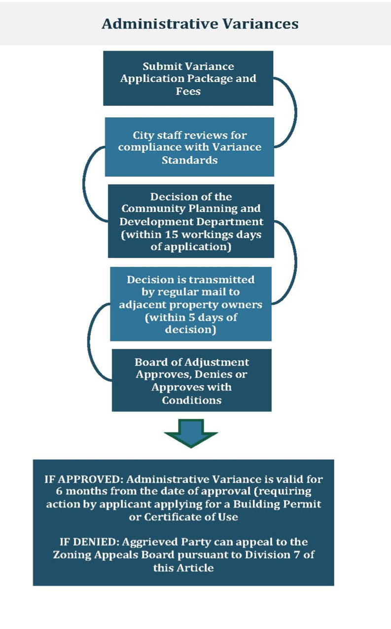
A. Nonuse administrative variances may be granted by the community planning and development department for applications under the following circumstances:
1. For single-family, duplex, triplex or townhouse project a variance to setback requirements where the setback is not decreased by more than twenty (20) percent of what is required in the applicable zoning district.
2. A variance for setbacks for docks not to exceed ten (10) percent of the required setback.
3. A parking variance for the first restaurant in a shopping center which existed on the date of adoption of these LDRs. If a parking variance is required for the second restaurant in an existing center, the board of adjustment shall consider the variance in accordance with the provisions of section 3-701 of this article.
4. For single-family, duplex, triplex, or townhouse lot, a variance to allow a driveway to maintain a side yard setback between two and one-half (2 ½) feet and five (5) feet, provided that the driveway is composed of pervious or permeable materials.
5. A variance for the parking or storage of recreational vehicles pursuant to section 5-1405.
6. A variance for any carport structure within the required front and side setbacks pursuant to the requirements of article 5, division 1, section 5-103 and all other applicable standards of these LDRs.
7. A variance shall not be granted if the property has any open code violations or unpaid code enforcement fines, except that the granting of a variance whose purpose is to cure or assist in curing a code violation shall be permitted.
B. The granting of an administrative variance shall be based on the following:
1. The variance is in harmony with the character of the immediate neighborhood and is in keeping with community goals as they relate to quality of life; and
2. The variance will not adversely affect or be injurious to the adjacent uses, immediate neighborhood and the community as a whole.
C. Applications, and signed consent of neighboring property owners; mailed notices.
1. The applicant must file a request to the community planning and development department, in a form approved by staff, containing all the information necessary for staff to make an administrative decision, which shall include, but is not limited to, identification of the specific provisions of these LDRs from which an administrative variance is sought; the nature and extent of the variance; and the grounds relied upon to justify the approval of the variance, pursuant to subsection B, above.
2. Such application shall be accompanied by the required submittal documents and fee as determined by staff, which shall include the following:
a. The signed consent of all contiguous property owners, including those located across the street from the subject site, shall be submitted by the applicant on a form prescribed by the administrative official, and on the site plan submitted for consideration.
b. Said consent shall not be required from an abutting property when a separating public right-of-way measures seventy (70) feet or greater, nor shall consent be required when a body of water completely separates the subject parcel from another parcel.
c. If the applicant for an administrative variance is unable to obtain either the signed consent or objection of a neighboring property owner, the signature of that owner shall not be required if the applicant demonstrates a good faith effort to comply with the requirements stated herein, or a hearing before the board of adjustment shall be required to review the application for a variance.
3. Mailed notices. Once an administrative decision has been rendered, the city shall provide written mailed notice to the abutting property owners. Such notices shall be deemed sufficient if it accurately describes the administrative variance granted and informs the abutting property owners of the thirty (30) day appeal process as outlined in division 7 below.
D. A property owner receiving approval of an administrative variance shall not commence any of the improvements allowed by the administrative variance until after the expiration of time allowed for an appeal, in accordance with the provision of section 3-701.
E. An administrative variance granted under these procedures shall be valid for six (6) months from the final date of approval, after which it shall become null and void unless a building permit is issued or a recreational vehicle (in the front yard) permit is granted or an extension is granted. The community planning and development department is authorized to grant one (1) six-month extension. Any further extension shall require the application to be resubmitted as an entirely new application.
F. Appeals of decisions on an application for an administrative variance may be taken to the zoning appeals board by an aggrieved party in accordance with the applicable provisions of these LDRs.
(Ord. No. 1278, § 1(exh. 1), 4-28-09)
Sec. 3-605. - Review, hearing and decision by board of adjustment.
The board of adjustment shall review an application for all variances which are not administrative, the report, recommendation and proposed findings prepared by city staff, and conduct a quasi-judicial public hearing on the application in accordance with the requirements of section 3-303 and render a decision. The decision shall be based upon written findings of fact and the board of adjustment shall either grant, grant with conditions or deny the variance.
(Ord. No. 1278, § 1(exh. 1), 4-28-09)
Sec. 3-606. - Standards for variances.
A. In order to authorize any variance from the terms of these LDRs, the board of adjustment shall find that the applicant has demonstrated compliance with four (4) of the following six (6) standards:
1. Special conditions and circumstances exist which are peculiar to the land, structure or building involved and which are not applicable to other lands, structures or buildings in the same zoning district.
2. The unusual circumstances or conditions necessitating the variance request are present in the neighborhood and are not unique to the property.
3. That the requested variance maintains the basic intent and purpose of the subject regulations, particularly as it affects the stability and appearance of the city.
4. The literal interpretation of the provisions of these LDRs would deprive the applicant of rights commonly enjoyed by other properties in the same zoning district under the terms of these LDRs.
5. The variance requested is the minimum variance that will make possible the reasonable use of the land, structure or building.
6. The granting of the variance will be in harmony with the general intent and purpose of these LDRs and such variance will not be injurious to the area involved.
B. No variance may be granted if the property has any open code violations or unpaid code enforcement fines, except that the granting of a variance whose purpose is to cure or assist in curing a code violation shall be permitted.
(Ord. No. 1278, § 1(exh. 1), 4-28-09)
Sec. 3-607. - Time limit for variances.
Any variance granted under the provisions of this division shall become null and void and of no effect twelve (12) months from and after the date of approval, unless within such period of twelve (12) months a building permit is issued if required; or if no permit is required, unless the requested action permitted by the variance shall have taken place within the twelve (12)-month period. An extension of six (6) months may be granted by the community planning and development director for good cause.
(Ord. No. 1278, § 1(exh. 1), 4-28-09)
Sec. 3-608. - Effect of decision.
Approval of a variance shall be deemed to authorize only the particular use for which it is issued and shall entitle the recipient to apply for a building permit or any other approval that may be required by these LDRs, the city or regional, state or federal agencies.
(Ord. No. 1278, § 1(exh. 1), 4-28-09; Ord. No. 1321, § 1, 9-27-11)
Editor's note— Ord. No. 1321, § 1, adopted September 27, 2011, changed the title of section 3-609 from “Appeals of board of adjustment decision to city council” to “Appeals from board of adjustment.” The historical notation has been preserved for reference purposes.
Sec. 3-701. – Purpose and applicability.
The purpose of this division is to set forth procedures for appealing the decisions of city staff and other boards, where it is alleged that there is an error in any order, requirement, decision or interpretation made in the enforcement or interpretation of these LDRs. An action by any administrative official, development review committee, or any board made pursuant to the provisions the LDRs may be appealed to the zoning appeals board in accordance with the provisions of this article.
Sec. 3-702. – Appeal period.
An appeal of the decision of the administrative official, development review committee, or any board within the scope of these LDRs may be made within 30 days from the date such decision is filed with the clerk of that official or board. If filed, an appeal stays any further action on the permit until final resolution of the appeal, unless the administrative official, development review committee, or any board whose action is the subject of the appeal, certifies in writing that the stay poses an imminent peril to life or property, except that staff may review plans filed in furtherance of such approval appealed as long as no final action is taken to issue the permit allowed by the decision on appeal.
Sec. 3-703. - Applicability.
Any appealable decision may be appealed by an applicant, the city, or any aggrieved party, including affected neighborhood, community and civic associations, whose name appears in the record of the official or board from which the appeal is made, by filing with the community planning and development department a petition in a form prescribed by the city.
Appealable decisions include the following, but are not limited to:
1. Variances and waivers.
2. Special exception use approvals.
3. Conditional use permit approvals.
4. Plat approvals.
5. Amendments to conditions, or release of conditions, or release of a declaration of restrictive covenants accepted by resolution or ordinance.
6. Development agreement approvals.
7. Vested rights determination approvals.
8. Large scale development review.
9. Appeals of administrative decisions and interpretations as provided in Sec. 3-303.
10. Applications for extension of time of commencement or completion.
Sec. 3-704.- Application and contents of appeal.
An application for appeal must be filed with the city manager or designee and the body, office or department whose action is the basis for appeal, along with a fee for the processing of the appeal. The application shall be on a form provided by the city and include a written statement specifying in brief, concise language the grounds and reasons for requesting a reversal of the ruling made by the lower official or board. Such reasons for the appeal shall be based upon the evidence presented prior to the original decision. Failure of the appellant to present such reasons shall be deemed cause for denial of the appeal.
Sec. 3-705. - Time period of hearing.
Within forty-five (45) working days of receipt of a complete appeal application, the city manager or designee shall schedule a public hearing before the zoning appeals board.
Sec. 3-706. - Notice of hearing.
The public hearing on the appeal shall be noticed as required by Sec. 3-302. The notice shall state that an appeal has been filed; describe the order being appealed; describe the lot, parcel, property or areas that are the subject of the appeal; describe the final decision on the original request; and note other pertinent information, as may be determined by the director of community planning and development.
Sec. 3-707. - Action by the zoning appeals board.
A. Upon the timely filing of an application for appeal, the community planning and development director shall transmit to the Zoning Appeals Board the petition for appeal, any associated documents which may be submitted on appeal, the original application and the decision and record of the lower official or board.
B. At a quasi-judicial public hearing, the Zoning Appeals Board shall consider whether the decision of the administrative officer, development review committee, or any board, as the case may be, should or should not be sustained or modified. By resolution, the appellate body shall affirm, modify or reverse the lower decision and such action shall be by a majority vote of all members present. Such hearing shall be limited to the record below and shall not be de novo. No new testimony or evidence shall be permitted. Arguments on appeal shall be limited to those on behalf of the appellant, appellee and the City staff, or attorneys on their behalf.
C. In order to reverse, amend, modify, or remand for amendment, modification, or rehearing the decision of the lower board or authority, the Zoning Appeals Board shall find that the board or official below did not comply with any of the following:
1. Provide procedural due process;
2. Observe essential requirements of law; or
3. Base its decision upon substantial competent evidence.
D. The decision on the appeal shall be set forth in writing, and shall be promptly mailed to all parties to the appeal.
Sec. 3-708. - Effective Date.
The decision of the zoning appeals board on an appeal shall be effective immediately.
Sec. 3-709. - Appeals from the decisions of the zoning appeals board.
Any persons aggrieved by a decision of the zoning appeals board may appeal by petition for writ of certiorari to a court of competent jurisdiction for judicial relief within thirty (30) days after a decision by the zoning appeals board is filed with the clerk of that board. The election of remedies shall lie with the appellant.
(Ord. No. 1278, § 1(exh. 1), 4-28-09; Ord. No. 1321, § 1, 9-27-11)
Editor’s note— Ord. No. 1321, § 1, adopted September 27, 2011, repealed the former section 3-703 in its entirety, which pertained to appeals from decisions of the board of adjustment, and derived from Ord. No. 1278, § 1(exh. 1), adopted April 28, 2009. Subsequently, Ord. No. 1321 redesignated the former section 3-704 as section 3-703. The historical notation has been preserved for reference purposes.
Sec. 3-801. - Purpose and applicability.
The purpose of this division is to provide application and review procedures for the subdivision of land within the city. This division shall be applicable to any subdivision or re-subdivision of land that creates one (1) or more parcels. No building permit shall be issued for construction of any improvements on a parcel that was not legally created in compliance with these LDRs.
(Ord. No. 1278, § 1(exh. 1), 4-28-09)
Sec. 3-802. - Plats and platting, recording; exceptions.
Whenever land is subdivided a plat must be recorded, except that the recording of a plat will not be required if:
A. The subdivision involved consists only of the dedication of a road, highway, street, alley or easement, and due to unusual conditions and circumstances, the community planning and development director finds that it is not necessary that a plat be recorded. In lieu of the recording of a plat, the dedication may be required by deed, and may be subject to compliance with such conditions the community planning and development director deems appropriate under the particular circumstances, such as improvements of sidewalks, streets, or drainage facilities and the acceptance of the dedication by the governing body. Posting of bond or other surety acceptable to the city may be required.
B. The land to be subdivided is to be divided into no more than six lots, and because of:
1. Unusual conditions created by ownership or development of adjacent lands;
2. The isolation or remoteness of the land concerned in relation to other platted or improved lands; or
3. Improvements and dedications existing on the land substantially in accordance with the requirements of this chapter, the community planning and development director determines that waiving the requirement for platting would not conflict with the purpose and intent of this article.
C. In lieu of platting, the community planning and development director may require any dedications, reservations, or improvements required in connection with platting under this article, including the posting of a performance and maintenance bond, as may be necessary to carry out the intent and purpose of this chapter.
D. The community planning and development director determines that resubdivision of land heretofore platted is of such unusual size or shape, or is surrounded by such development or unusual conditions to justify the waiving of the requirement for recording a plat. In lieu of the recording of a plat, such conditions may be imposed as may be deemed necessary and appropriate to preserve the public interest.
Sec. 3-803. - Waiver of plat.
A. Procedure.
1. Preapplication conference. Prior to filing an application for waiver of plat approval, the applicant shall have a preapplication conference with the community planning and development department.
2. Application. An applicant for subdivision approval shall submit an application for review of waiver of plat upon an application form approved by city staff and shall include all applicable fees. The waiver of plat survey shall be prepared by a professional surveyor and mapper licensed in the state, and shall bear the embossed seal of the surveyor and mapper. The application for waiver of plat survey shall include the following items, unless waived by the community planning and development director:
a. Legal description of the parent tract.
b. Legal description of each lot to be created.
c. Location of property lines, existing easements, buildings, watercourses and other essential features.
d. The location of any existing sewers and water mains, or any underground or overhead utilities, culverts and drains on the property to be subdivided.
e. Location, names and present widths of existing and proposed streets, highways, easements, building lines, alleys, parks and other open public spaces and similar facts regarding property immediately adjacent.
f. Date of field survey, north point and graphic scale.
g. The width and location of all streets or other public ways proposed by the developer.
h. The proposed lot lines with dimensions.
i. Existing ground elevations of the property and extending not less than 25 feet beyond the boundaries of property.
j. Existing easements or restrictions shown on underlying plat shall be shown.
k. The location of all buildings, swimming pools, slabs, fences and other permanent structures on the adjacent properties that would be nonconforming with the creation of this division of land.
B. Development review committee report and recommendation.
1. The development review committee shall review the application in accordance with the provisions of article 3, division 2 of these LDRs and the comprehensive plan. Any such review by the development review committee shall, at a minimum, include a review and comment by the public works department.
2. Upon completion of review of an application the city planner shall:
a. Prepare a report that summarizes the application, including whether the application complies with these LDRs and the comprehensive plan;
b. Provide written recommendations as to whether the application should be recommended for approval, approval with conditions or denial;
c. Provide the report and recommendation, with a copy to the applicant and to the planning commission at least one (1) week prior to the next scheduled meeting of the planning commission;
d. Schedule the application for hearing before the planning commission;
e. Provide notice of the hearing before the planning commission in accordance with the provisions of article 3, division 3 of these LDRs.
C. Planning commission review. Upon receipt of the recommendations of the development review committee, the planning commission shall conduct a public hearing on the waiver of plat and shall review to ensure that it conforms to the requirements of these LDRs and the comprehensive plan.
D. Planning commission recommendation. Upon completion of its review, the planning commission shall either recommend the waiver of plat for approval, approval with conditions or disapprove, unless a continuance for more information is required.
E. City council. The city council shall review the recommendation of the planning commission and then approve, approve with conditions, or disapprove the waiver of plat. If the city council approves the waiver of plat, the mayor signs the plat document and it is transmitted to the Miami-Dade County Platting & Traffic Review. The city council may continue the matter if it decides more information is needed.
F. Miami-Dade County Platting & Traffic Review. After the city council hearing, the applicant shall deliver the signed plat or waiver, along with a signed copy of the approving resolution, with necessary copies, to Miami-Dade County Platting & Traffic Review for its review. The county reviews the application for compliance with chapter 28 of the Code of Miami-Dade County and either approves, approves with conditions or disapproves the tentative plat. The county then notifies the city and the applicant of its decision. If the waiver of plat is granted by the county no further action is required.
(Ord. No. 1278, § 1(exh. 1), 4-28-09)
Sec. 3-804. – Tentative plat.
A. Preliminary conference. The subdivider or his engineer, or land surveyor, prior to the preparation of the tentative plat, may informally seek the advice of the plat division of the appropriate authority in order that he may become familiar with the subdivision requirements and with the provisions of the master plan affecting the territory in which the proposed subdivision is located.
B. Tentative plat. The tentative plat shall show on a map all of the facts and data required by the various departments to determine whether the proposed layout of the land in the subdivision is satisfactory from the standpoint of public interest.
1. The following information shall be part of the tentative plat unless waived by the plat Division of the appropriate authority.
a. Proposed subdivision name and identifying title and the name of the City, if any, in which the subdivision is located, and the section, township and range.
b. Location of property lines, existing easements, buildings, watercourses, elevations, permits and other essential features.
c. The names of all subdivisions immediately adjacent.
d. The location of any existing sewers and water mains, or any underground or overhead utilities, culverts and drains on the property to be subdivided.
e. Location, names and present widths of existing and proposed streets, highways, alleys, parks and other open public spaces and similar facts regarding property immediately adjacent.
f. The width and location of any street or other public ways or places shown upon the official map or the master plan, within the area to be subdivided, and the width and locations of all streets or other public ways proposed by the developer.
g. Date of field survey, north point and graphic scale.
h. Legal description and plan of proposed layout made and certified by a Florida-licensed land surveyor.
i. The proposed lot lines with approximate dimensions and in the case of odd or irregularly shaped lots, suggested location of building setback lines.
j. Where the tentative plat submitted covers only a part of the subdivider’s entire holding, a master tentative plat of the prospective future street system of the unsubdivided part will be required, and the street system of the unsubmitted part will be considered in the light of adjustments and connection with the street system of the plat submitted.
k. A plat application signed by the owner and notarized on the form prescribed by the City.
l. The numbering of all lots, blocks and the lettering of all tracts shall be shown on the tentative plat. All lots or tracts shall be numbered or lettered progressively. All blocks shall be progressively numbered except that blocks in numbered additions bearing the same name shall be numbered consecutively throughout the several additions.
m. A location map at the scale of one (1) inch equals three hundred (300) feet showing existing and proposed rights-of-way.
2. The following information shall be submitted in addition to the tentative plat if requested by the plat division of the appropriate authority.
a. The names of owners of record of immediately adjacent property.
b. Any changes in the use, height, area and density districts or other regulations under these LDRs, applicable to the area to be subdivided, and any boundaries of such districts, affecting the tracts; all parcels of land proposed to be dedicated to public use and the conditions of such dedications.
c. Typical cross-section of the proposed grading and roadways or sidewalks and topographic conditions.
d. Location of closest available subdivision or public water supply system.
e. Location of closest available subdivision or public sewage disposal system.
f. Provisions for collecting and discharging surface drainage.
g. Preliminary designs of any bridges or culverts which may be required.
h. A boundary survey.
i. If required by these regulations or if proposed by the subdivider, the proposed location of any type of sidewalks, street lighting standards and species of street trees, the location of curbs, gutters, water mains, sanitary sewers and storm drains and the sizes and types thereof, the character, width and depth of pavement and sub-base, and the location of manholes and basins and underground conduits.
j. The boundaries of proposed permanent utility easements over or under private property. Such easements shall provide satisfactory access to an existing public highway or other public open space shown upon the layout. Permanent drainage easements shall also be shown.
k. All dimensions affecting public rights-of-way and proposed dedication of the public rights-of-way shall be established by a registered surveyor and shown on the grading and drainage plan accompanying approved and valid tentative plats when said plan is submitted for approval, with the same degree of accuracy as, and identical to, the corresponding dimensions shown on the final plat.
l. A copy of owners’ deed or a current opinion of title from any attorney authorized to practice law in the State.
C. Filing copies of tentative plat and plat application. The subdivider shall file such copies as may be required by the City, together with the plat application.
D. Checking and investigating. The subdivider shall pay such fees as may be prescribed by ordinance for checking the tentative plat and investigating such matters concerning it as may be required by law and these LDRs.
E. Approval of tentative plat. Tentative approval shall confer upon the subdivider the right for a nine (9) months period from the date of approval that the terms and conditions under which the tentative approval was granted will not be changed if the final plat is in accordance with the tentative approval.
F. Appeal of the city’s plat decision. Decisions of the city council may be appealed by common law writ of certiorari to a court of competent jurisdiction for judicial relief in accordance with the Florida Rules of Appellate Procedure within fourteen (14) days of rendering the decision. The 14-day appeal period provided herein shall commence on the day after notification that the city has taken action on the particular matter, such notification to be given by the city through the posting of a short, concise statement of the action taken on a conspicuous bulletin board that may be seen by the public at reasonable times and hours in the office of the community planning and development department and/or the city website. Where the fourteenth day falls on a weekend or legal holiday, the appeal period shall be deemed to extend through the next business day.
G. Expiration of tentative plat. The tentative plat shall expire and be of no further force and effect if a completed application for a final plat is not filed as set forth in section 3-806 below within one hundred eighty (180) days of approval by Miami-Dade County Platting & Traffic Review. After expiration of one hundred eighty (180) days, the applicant will be required to resubmit the tentative plat for staff and planning commission review as set forth in this section.
Sec. 3-805. - Vested rights.
A. Any property owner claiming a vested right to obtain action upon or approval of a tentative plat or waiver of plat contrary to this section may submit an application for a vested rights determination in accordance with article 3, division 12 of these LDRs.
B. The application shall have attached an affidavit setting forth the facts upon which the applicant bases his/her claim for vested rights. The applicant shall also attach copies of any contracts, letters and other documents upon which a claim of vested rights is based. The mere existence of zoning shall not vest rights.
C. The city, in addition to all review criteria set forth in section 3-1203, shall review the application and determine whether the applicant has demonstrated an act of development approval by an agency of Miami-Dade County or the City of North Miami upon which the applicant has in good faith relied to his detriment, such that it would be highly inequitable to deny the landowner the right to obtain action on or approval of a tentative plat or waiver of plat.
D. Any appeal of the city’s determination shall be made following the procedures outlined in division 7 of this article.
E. The provisions of this section shall not prohibit the zoning appeals board from considering the issue of vested rights during other hearings where such rights are in issue, provided that a decision upon a claim of such rights shall be a final determination thereof and further administrative hearings thereon shall be neither required nor permitted.
Sec. 3-806. - Final plat.
A. Application. The application for final plat review shall be accompanied by all applicable fees including any associated cost recovery fees for external consultant review for checking and investigating the final plat and prepared on a form approved by city staff.
B. Incorporation of changes. The final plat shall have incorporated all of the changes or modifications recommended by the planning commission, the city council, and any changes or conditions imposed by Miami-Dade County Platting & Traffic Review to make the tentative plat conform to the requirements of this article. To the extent that any such modifications have not been made, the applicant shall indicate in writing as part of the application the grounds for any departure.
C. Preparation. The final plat shall be prepared by a professional surveyor and mapper licensed in the state. The final plat shall be clearly and legibly drawn, to a sheet size of thirty (30) inches by thirty-six (36) inches and to a scale of sufficient size to be legible, with letters and numbers to be no smaller than one-eighth of an inch in height. The final plat, insofar as preparation is concerned, shall comply with all applicable regulations and state laws dealing with the preparation of plats.
D. Contents.
1. Name of the subdivision. The plat shall have a title or name. The title of the plat shall identify the location of the plat as being within the city, and the applicable section, township and range. The community planning and development director shall disapprove any name or title upon a finding that it is sufficiently similar to the name of any previously approved plat in the city which may cause confusion as to the location of any platted property.
2. Deed description; description written on map or plat. There shall be written or printed upon the plat a full and detailed description of the land embraced in the map or plat showing the township and range in which such lands are situated and the section and part of sections platted and a location sketch showing the plat’s location in reference to the closest centers of each section embraced within the plat. The description must be so complete that from it, without reference to the plat, the starting point can be determined and the outlines run. If a subdivision of a part of a previously recorded plat is made, the previous lots and blocks to be resubdivided shall be given. If the plat be a resubdivision of the whole of a previously recorded plat, the fact shall be so stated. Vacation of previously platted lands must be accomplished in the manner provided by law.
3. Names of adjacent subdivisions.
4. Names or numbers and width of streets immediately adjoining plat.
5. All plat boundaries.
6. Bearings and distances to the nearest established street lines, section corners or other recognized permanent monuments which shall be accurately described on the plat.
7. Section lines or other boundaries accurately tied to the lines of the subdivision by distance and bearing, as provided by state law.
8. Accurate location of all monuments.
9. Length of all arcs, radii, internal angles, points of curvature and tangent bearings.
10. Where lots are located on a curve or when side lot lines are at angles less than 87 degrees or more than 93 degrees, the width of the lot at the front building setback line shall be shown.
11. The name or numbering and right-of-way width of each street or other right-of-way shown on plat.
12. The numbering of all lots and blocks shown on the plat. All lots shall be numbered either by progressive numbers, or in blocks progressively numbered, except that blocks in numbered additions bearing the same name shall be numbered consecutively throughout the several additions. Excepted parcels must be marked “not part of this plat.”
13. Plat restrictions to restrict type and use of water supply; type and use of sanitary facilities; use and benefits of water areas and other open spaces and odd-shaped and substandard parcels; resubdivision of parcels as “platted,” and restrictions of similar nature.
14. All areas reserved or dedicated for public purposes. No strip or parcel of land shall be reserved by the owner, unless the same is sufficient in size and area to be of some practical use or service.
15. The dimensions of all lots and angles or bearings.
16. Minimum building setback lines.
17. Location, dimension and purpose of any easements.
18. Certification by a professional surveyor and mapper licensed to practice in the state as to the accuracy of the monuments shown thereon, and their location.
19. An acknowledgment by the owner of the land being platted, and a dedication statement identifying the dedication of streets and other public areas and the designated purposes therefore, and the consent of any mortgage holders to such adoption and dedication. If existing right-of-way is to be closed, the purpose of closing must be stated on the plat.
20. The signature and seal of the city. Where property is being replatted, the signatures of the city council shall be affixed or denied pursuant to the procedures established in F.S. § 177.101 (1971), unless the vacation of prior plats has previously been validly accomplished.
E. Other data required with plat.
1. Restrictive covenants desired by the developer so long as they do not violate existing ordinances. Restrictive covenants shall be required covering the same restrictions controlling building lines, establishment and maintenance of buffer strips and walls, and restrictions of similar nature.
2. The face of the plat (or certification from a professional surveyor and mapper licensed in the state, on a separate sheet, not to be recorded in the public records) shall show the Florida State Plane Coordinates (current readjustment) of at least two of the permanent reference monuments shown on the plat. This requirement may be waived by the community planning and development director if:
a. Any portion of the land encompassed by the plat is more than one mile from the nearest station shown on the list on file in the Miami-Dade County Public Works Department survey office, as updated; or
b. All stations within one mile of the plat have been lost.
A copy of the certified corner record (as defined in F.S. 177.503 (1993), for the corners used shall be provided with the final plat.
3. Current opinion of title from any attorney authorized to practice law in the state.
4. Certification from the city and county that all taxes and assessments have been paid on the land within the proposed subdivision or receipted tax bills.
5. Fees for plats. The city shall charge and collect fees for subdivision platting at the rates established by city council.
6. The city shall submit a statement to the Miami-Dade County Land Development Division, certifying that all required improvements within the public right-of-way have been completed or that the city is holding sufficient bond or other surety for the completion of the improvements. The certification shall also state that the plat appears to conform to all of the requirements of the Miami-Dade County‘s subdivision regulations. Failure of the county to act on said plats within forty-five (45) days of the acknowledged receipt of the plat shall be deemed an approval of the plat.
7. No plat shall be recorded in the clerk‘s office until the plat is signed by the Miami-Dade County Public Works Director, certifying that the plat appears to conform to all of the subdivision requirements of the county. A certification of the County Public Works Director need not appear if the plat division of the appropriate authority submits an affidavit to the clerk stating that the county has not acted on said plat within forty-five (45) days of the acknowledged receipt of the subject plat.
F.Community planning and development department. Upon completion of its review, the city planner shall:
1. Prepare a report that summarizes the application, including whether the applicant has complied with the recommendations of the planning commission, where applicable, the city council and Miami-Dade County .
2. Provide written recommendations as to whether the final plat should be approved, approved with conditions or denied.
3. Provide the report, recommendation and a copy of all prior recommendations to the city council with a copy to the applicant, at least one (1) week prior to the next scheduled meeting of the city council. The city planner shall also prepare a resolution accepting the plat.
4. Schedule the application for hearing before the city council.
5. Provide notice of the hearing before the city council in accordance with the provisions of article 3, division 3 of these LDRs.
G. Preliminary approval on final plat. Preliminary approval of a final plat may be given by the city council where bonds, engineering plans or specifications have not been completed by the applicant where conditions make it desirable for the applicant to obtain an expression from the city council before proceeding further. Preliminary approval vests the applicant for a period of six (6) months with the right to obtain final approval upon the terms and conditions under which said preliminary approval is given. At a quasi-judicial public hearing, the city council shall reserve discretion to disapprove the final plat in the event that missing items, such as the bonds, engineering plans or other specifications, do not comply with these LDRs. Except as otherwise provided herein, no building permits shall be issued until the final plat is approved and recorded.
H. Final action on final plat. At a quasi-judicial public hearing, the city council shall review the final plat for conformity to these LDRs and the comprehensive plan as well as the requirements from Miami-Dade County Platting & Traffic Review Division. The city council shall either approve, approve with conditions or disapprove the final plat by resolution. Said resolution shall include any acceptance of dedications made on the plat. When approved, the mayor, city clerk and community planning and development director shall affix their signatures to the plat together with the city seal and resolution number. If approval is granted, the final plat and a copy of the resolution are returned to the applicant for submission to Miami-Dade County Land Development Division, together with four (4) copies for final review by the board of county commissioners. When disapproved, the city clerk shall attach to the plat a statement setting forth the reasons for such action and return it to the applicant.
I. Final approval; rejection, for plats. After approval has been given as provided in this division, the community planning and development director shall inform the subdivider, or agent, as the case may be, that the plat has been given final approval and is ready for recording. In the event the plat has been rejected, the director of community planning and development will so notify the subdivider or agent in writing with all reasons for such rejection.
J. Revisions after city council approval and prior to recordation.
1. Any changes, erasures, modifications or revisions to an approved plat prior to recordation may only be made by the director of community planning and development to correct scrivener's errors. Reflect accurate legal descriptions and locate right-of-way dedications, drainage ways and easements. However, no such request shall be considered unless the application is made by the preparer of the final plat.
2. No other changes, erasures, modifications or revisions to an approved plat shall be made prior to recordation unless resubmitted for new approval, provided however, the city council may after a quasi-judicial public hearing and based only on the recommendation of the community planning and development department, change, modify or revise dedicated road rights-of-way or drainage easements. No such change, modification or revision of the dedication of road rights-of-way or drainage easements shall be reviewed unless the application is made by the preparer of the final plat.
K. Recording. Following approval of the final plat by the county, or if forty-five (45) days pass from receipt of the plat by the county without any action taken, the final plat shall be recorded, by the applicant, in the public records of Miami-Dade County at the expense of the applicant. A recorded copy of the plat should be filed with the city no later than thirty (30) days from recording.
L. Building permits.
1.Except as provided in this subsection, no building permits shall be issued until all subdivision improvements required in connection with the approval of the plat (e.g., monuments, streets, sidewalks, etc.) have either been completed or sufficiently bonded in a form approved by the city attorney. Proper indemnification must also be reviewed and approved by the city attorney prior to any building permit issuance.
2.No building permit shall be issued for construction of any improvements on a parcel that was not legally created in compliance with these regulations except permits for a construction trailer or sales office trailer, single-family homes and townhouses to be used as models. Permits for entrance features, perimeter walls, lift stations and commercial and industrial buildings, may be issued if the developer complies with the following requirements:
a. For construction trailer or trailer used as sales office: No permits will be approved until at least a tentative plat or waiver of plat has been approved and the paving and drainage plans have been approved. In addition, no permit shall be issued unless the trailer complies with requirements for providing potable water and sanitary facilities.
b. For permanent buildings to be used as single-family or townhouse models: Permits for models will be approved when:
(1) The tentative plat or waiver of plat has been approved by the city council.
(2) Paving and drainage plans have been approved.
(3) All plans for public facilities required for the permanent buildings have been reviewed and approved.
(4) A letter signed by the property owner has been submitted to the city, requesting the construction of models prior to final platrecording. The letter shall include the number of models being requested (only one (1) of each model will be allowed, or only one (1) townhome building) together with the lot and block numbers for each model. The letter shall state that the owner understands and agrees that the model home shall not be occupied until the plat is recorded in the public records and that the penalty for violation of this occupancy prohibition shall be the demolition of the model. The letter shall also state that the owner agrees and shall hold the city and Miami-Dade County, its employees and agents, harmless from any and all liability and causes of action of whatsoever nature and kind for and as a result of the issuance of building permits and any construction prior to final plat approval and recordation.
(5) No certificate of completion shall be issued for any model until after the final plat is recorded except that a temporary certificate of completion may be issued by the community planning and development department.
c. Entrance features, perimeter wall and lift station permits may be issued after tentative plat approval and receipt of a letter signed by the owner requesting the permit prior to final platrecording and releasing and holding the city and Miami-Dade County, its employees and agents, harmless from any and all liability and causes of action of whatsoever nature or kind for and as a result of the issuance of building permits and any construction prior to final plat approval and recordation.
d. For commercial and industrial buildings:
(1) The tentative plat has been approved by the city council.
(2) Only one (1) building permit may be issued, on a site, and only one (1) such permit may be issued within a subdivision.
(3) Paving and drainage plans (if required) shall have been approved by the public works department.
(4) At the time of request, there must be an active set of building plans pertaining to the site, with an active process number under the county's permitting system. The plans must have approvals from the following disciplines or an indication that such approval(s) are nonapplicable: building, department of environmental resources management, electrical, energy, impact fees, mechanical, planning, plumbing, public works and structural.
(5) A letter, signed by the property owner, has been submitted to the city requesting the permit prior to final platrecording. The letter shall state the proposed lot and block or tract for such permit, and the owner's acknowledgment and agreement that no certificate of occupancy will be sought or allowed until after the final plat is recorded. The letter shall also state that the owner agrees and shall release and hold the city and Miami-Dade County, its employees and agents, harmless from any and all liability and causes of action of whatsoever nature or kind for and as a result of the issuance of building permits and any construction prior to final plat approval and recordation.
(6) No certificate of occupancy for the subject structure will be issued until the plat is recorded.
(7) The issuance of the building permit shall not modify or affect the concurrency capacity of the underlying tentative plat in any way.
e. For permanent buildings to be used as single- family or townhouse production homes: Permits for single-family or townhouse production homes will be approved when:
(1) The tentative plat has been approved by the city.
(2) Paving and drainage plans have been approved.
(3) All Miami-Dade County Environmental Resources Management requirements, including the approval of water and sewer extension plans are complied with.
(4) The proposed final plat for the subdivision in which the production homes are to be located has been listed on an agenda for approval by the city council.
(5) A letter, signed by the property owner, has been submitted to the city requesting approval of production homes prior to final platrecording. The letter shall state that the owner understands and agrees that the production home shall not be occupied until the plat is recorded in the public records and that the penalty for violation of this occupancy prohibition shall be the demolition of the production home. The letter shall also state that the owner agrees and shall hold the City and Miami-Dade County, its employees and agents, harmless from any and all liability and causes of action of whatsoever nature and kind for and as a result of the issuance of building permits and any construction prior to final plat approval and recordation.
(6) No certificate of completion shall be issued for any production home until after the final plat is recorded except that a temporary of certificate of completion may be issued by the building services department.
M. Right-of-way dedication.
a. No permit shall be issued for a building or use on a lot, plot, tract, or parcel in any district until that portion of the applicant's lot, plot, tract, or parcel lying within the required official zoned right-of-way has been dedicated to the public for road purposes, and standard pavement improvements have been made, bonded for or an improvement agreement signed prior to building permit issuances except as otherwise provided by these LDRs. Any deviation from this section shall require an administrative variance or waiver pursuant to the provisions of these LDRs.
b. Where a site plan for a multiple-family housing development, apartment development, or apartment hotel development containing frontage on a public or dedicated road and containing interior private streets or roads within the development has been submitted to and approved by the department, it shall be exempt from the provisions of this section, except that if full right-of-way dedications or improvements as required by the public works department are lacking, the same shall be provided or a non-use variance obtained.
Sec. 3-807. - Public improvements and maintenance, withholding from subdivision not approved or accepted.
The city shall withhold all public improvement of whatsoever nature, including the maintenance of streets and the furnishing of sewage facilities and water service from all subdivisions which have not been approved, and from all areas dedicated to the public which have not been accepted, in the manner prescribed herein.
Sec. 3-808. - Drainage.
A. Master plan and manual of public works construction. The developer shall plan all drainage for the subdivision in accordance with the master plan entitled “County Water-Control Plan,” recorded in Plat Book 64, page 114 and in accordance with the flood criteria map, recorded in Plat Book 53, pages 68, 69, and 70, or as such plan and map may be changed or modified. The drainage plans shall be subject to approval of the public works department for compliance with such plan.
B. Permit to construct or alter drainage ways. No individual, partnership, or corporation shall construct, deepen, widen, fill, reroute, or alter any existing drainage way, ditch, drain, or canal without first obtaining a written permit from the city's public works department, county's department of public works and/or the county’s department of environmental resources management. Plans for all such work shall comply with the manual of county‘s Public Works Department, and all such work shall be done under the supervision and subject to the approval of the city's public work’s department and county’s department of public works and/or the county's department of environmental resources management. Rights-of-way for all such drainage works and maintenance thereof as prescribed by the manual of public works and construction and the county water control plan, must be dedicated to the use of the public, such dedication to be made prior to any such construction or alteration if so required by the city‘s public works department, and county‘s public works department and/or the county’s department of environmental resources management.
C. Rights-of-way and easements. Whenever any drainage way, stream, or surface drainage course is located or planned in any area that is being subdivided, the subdivider shall dedicate such stream or drainage course and an adequate right-of-way necessary for maintenance, future expansion and other purposes along each side of such stream or drainage course as is determined by uniform standards prescribed by the manual of public works construction.
D. Stormwater. Adequate provision shall be made for the disposal of stormwater subject to standards prescribed in the manual of public works construction.
E. Contour map and drainage of adjacent areas. A contour map shall be prepared for the area comprising the subdivision and such additional areas as may be required by the city’s public work department and/or county‘s public works department and/or the county’s department of environmental resources management, necessary to include all watersheds which drain into or through the property to be developed, provided that this map of the adjacent areas may be prepared from existing maps or other data available to and acceptable by the appropriate reviewing departments and agencies. The design for drainage of the subdivision must be adequate to provide for drainage of adjacent water shed areas, and design of drainage structures must provide for drainage of adjacent water sheds after complete development of the total area. Where ditches and canals are required, rights-of-way shall be provided for future needs in accordance with uniform standards proscribed in the city’s and county’s manual of public works construction. Provided, however, that the developers may be permitted by the city’s public work department and/or county’s department of public works and/or the county’s department of environmental resources management to excavate or open, or construct necessary drainage ways and structures only of sufficient capacity to provide for existing drainage needs whenever the developed or undeveloped status of adjacent water sheds may so warrant as determined by the city’s public works department and/or county’s department of public works, and/or the county’s department of environmental resources management.
F. Off-site drainage. Off-site drainage shall be mutually coordinated by and between the sub-divider, and the city’s public works department. While the city’s floodplain management ordinance prohibits offsite drainage, Miami-Dade County Environmental Resources Management may nonetheless allow off-site drainage when necessary through a Miami-Dade County Environmental Resources Management Class II permit.
Sec. 3-809. - Design standards.
A. Conformity with master site plan. If a master site plan has been adopted for such area, the proposed subdivision shall conform in principle with such master site plan.
B. Streets.
1. Conformance. The arrangement, extent, width, grade and location of all streets shall conform to the master plan, if one has been adopted for the area, and shall be considered in their relation to existing and planned streets, topographical conditions, to public conveniences, safety, and in their appropriate relation to the proposed uses of the land to be served by such streets. Where not shown on the master plan, the arrangement and the other design standards of streets shall conform to the provisions found herein.
2. Relation to adjoining street system. The arrangement of streets in new subdivisions shall make provisions for the continuation of existing streets in adjoining areas.
3. Projection of street. Where adjoining areas are not subdivided, the arrangement of streets in new subdivisions shall make provisions for the proper projection of streets.
4. Streets to be carried to property lines. When a new subdivision adjoins unsubdivided land then the new streets shall be carried to the boundaries of the tract proposed to be subdivided where required to promote reasonable development of the adjacent lands or provide continuity of road systems.
5. Street jogs prohibited. Street jogs with center line offsets of less than one hundred twenty-five (125) feet shall be prohibited unless because of unusual conditions the city and/or –Miami-Dade County Land Development Division determine(s) that a lesser center line offset is justified.
6. Dead-end streets or cul-de-sacs. Dead-end streets or cul-de-sacs designated to be so permanently, shall not be longer than six hundred (600) feet, and at the closed end, a turnaround having an outside roadway diameter of at least eighty-four (84) feet, and a street property line diameter of at least one hundred (100) feet, may be required. If a dead-end street is of a temporary nature a similar turnaround may be required, and provision made for future extension of street into adjoining property, as may be required by the Miami-Dade County Land Development Division.
7. Marginal access streets. Where a subdivision butts on or contains an existing limited access highway, freeway, parkway or arterial street, marginal access streets or other such treatment as may be necessary for adequate protection of residential property and to afford separation of through and local traffic may be required.
8. Minor streets. Minor streets shall be so laid out that their use by through traffic shall be discouraged.
9. Railroad on or abutting subdivision. Where a subdivision borders on or contains a railroad right-of-way or limited access highway right-of-way, a street approximately parallel to and on each side of such right-of-way may be required, at a distance suitable for the appropriate use of the intervening land for park purposes in residential districts or for commercial or for industrial purposes in appropriate districts. Such distances shall be determined with due regard for the requirements of approach grade and future grade separation in accordance with uniform standards prescribed by the manual of public works construction.
10. A tangent of at least one hundred (100) feet long shall be introduced between reversed curves on arterial and collector streets.
11. When connecting street lines deflect from each other at any one point by more than ten degrees, they shall be connected by a curve with a radius adequate to ensure a sight distance and safe turning movement in accordance with uniform standards prescribed by the Miami-Dade County public works construction manual.
12. Streets shall be laid out so as to intersect as nearly as possible at right angles.
13. Property lines at street intersections shall be rounded with a radius of twenty-five (25) feet. A greater radius may be prescribed by the city and/or Miami-Dade County Land Development Division in special cases in accordance with uniform standards prescribed by the city’s or Miami-Dade County Public Works construction manual. The Miami-Dade County Land Development Division may permit comparable cutoffs or chords in place of rounded corners.
14. Street rights-of-way widths shall be as shown on the master plan or where not so shown shall be not less than as follows:
a. Arterial: 100 feet right-of-way;
b. Collector: 70 feet right-of-way;
c. Minor, for apartments and residences: 50 to 60 feet right-of-way as may be determined in uniform standards prescribed by the Miami-Dade County Public Works construction manual;
d. Marginal access: 45 feet where required in residential areas; 50 feet where access is limited by a limited access highway, a railroad or canal; 70 feet in industrial subdivision;
e. Minor for industrial areas: 70 feet right-of-way; unless because of unusual conditions the Miami-Dade County Land Development Division determines that a lesser right-of-way width is justified.
f. Half streets shall be prohibited, except where essential to the reasonable development of the subdivision in conformity with other requirements of these regulations, and where the community planning and development director finds it will be practical to require the dedication of the other half when adjoining property is subdivided. Whenever a half street is adjacent to a tract to be subdivided, the other half of the street shall be platted within such tracts.
g. No street names or numbers shall be used which will be confused with or duplicate the names of existing streets. Street names shall be subject to the approval of the community planning and development department as set forth in these LDRs.
C. Alleys.
1. Alleys may be dedicated in commercial and industrial districts, except that the community planning and development director may waive this requirement where other definite and assured provision is made for service access, such as off-street loading, unloading, and parking consistent and adequate for the uses proposed.
2. The width of any alley shall not be less than twenty (20) feet.
3. Vacation and abandonment of rights-of-way, alleys, and/or platted easements, and nonplatted easements.
a. Procedure. The vacation and abandonment of any rights-of-way, alleys and/or platted easements, and the reversion thereof to abutting property owners shall be accomplished only through the platting procedure as set forth in these LDRs.
b. Nonplatted easements. Vacation and abandonment of nonplatted easements shall only be required to comply with requirements set forth in subsection (c)(5) below and subject to the review criteria set forth in subsection (4) below. Approval of such vacation and abandonment of non-platted easements shall be by resolution of the city council.
c. Requirements. All tentative plats involving vacation and abandonment shall be reviewed for compliance with all technical requirements of this section, and including the following criteria:
(1) No tentative plat will be considered which includes only rights-of-way or easements to be vacated and closed. The properties on each side of the rights-of-way or easements to be vacated and closed shall be included in the plat, and all abutting property owners shall join in the plat and the disposition of the rights-of-way or easements shown.
(2) Where the subdivider requests the vacation and abandonment of a portion of the right-of-way connecting two streets, the subdivider shall provide a cul-de-sac as per the design standards of section 3-809. The cul-de-sac shall be located fully within the property being platted. All property owners abutting the right-of-way between the two streets shall join in the abandonment of the plat and shall disclaim all right, title and interest in the portion of the right-of-way being abandoned.
(3) Where the subdivider requests the vacation and abandonment of a portion of an alley, the subdivider shall provide on his/her property, suitable access from the closed end of the alley to the nearest public street, or streets, as may be required. All property owners abutting the alley shall join in the plat.
(4) Written consent to vacate and close the platted private easement(s): (i) platted public easement(s) and/or platted emergency access easement(s) of the holder(s) of the easement(s), and for non-platted easements; (ii) written releases from all benefited specified individuals or public or private entities, or a certification that no such benefited individuals or public or private entities exist within the easement(s); and (iii) recommendations of approval from the city’s police, public works, community planning and development departments, as well as Miami-Dade Fire Rescue Department. The written consent that must be obtained from the holders of the easements, must specify that the holders of the easements consents to the vacation of the easements, must specify whether the holders of the easements have granted any type of interest in the easements to a third party, and must specify the third party’s identity. In the event that a third party does have an interest in the easements, the applicant must also obtain the third party’s written approval to vacate and close the easements. In addition, the applicant must submit an ownership and encumbrance search report prepared by a title company of the area encompassed by the easements that is to be vacated.
d. Criteria for review. Further consideration for vacations and abandonment. In addition to review for technical compliance, the Development Review Committee (DRC) shall also consider the request for vacation and abandonment with respect to the following:
(1) Whether it is in the public interest to vacate or abandon the right-of-way or easement?
(2) Whether, the right-of-way or easement is being used including use by public service vehicles such as trash and garbage trucks, police, fire and/or other emergency vehicles?
(3) The adverse effect on the ability to provide police, fire or emergency services.
(4) Whether the vacation or abandonment negatively affects pedestrian and vehicular circulation in the area?
4. Easements.
a. Easements across lots (not including drainage) and, where possible, centered along lot lines shall be provided for utilities where necessary.
b. Where a subdivision is traversed by a watercourse, drainageway, or canal, there shall be provided a stormwater easement or drainage right-of-way conforming substantially to the lines of such watercourse, and such further width or construction, or both, as will be adequate for the purpose. Parallel streets or parkways may be required in connection therewith in accordance with uniform standards prescribed by the manual of public works construction.
5. Blocks.
a. The length, width and shape of blocks shall be determined with due regard to:
(1) Provision of adequate building sites suitable to the special need of the type of use contemplated.
(2) Land development requirements as to lot size and dimensions.
(3) Need for convenient access, circulation, control and safety of street traffic.
(4) Limitations and opportunities of topography.
b. Block length shall not exceed one thousand five hundred (1,500) feet, or be less than four hundred (400) feet, unless a lesser or greater length is requested by the subdivider and is deemed advisable because of unusual conditions by the community planning and development director.
c. In blocks nine hundred (900) feet in length or greater, pedestrian crosswalks not less than ten feet wide may be required to provide circulation or access to school, playground, shopping center, transportation, and other facilities.
6. Lots.
a. The lot depth, shape and orientation, and the minimum building setback lines shall be appropriate for the location of the subdivision and on the type of development and use contemplated.
b. Lot dimensions shall conform to the requirements of these LDRs.
c. Each lot shall be provided, by means of a public street, with satisfactory access to an existing public street or in the case of units within a townhouse site, or cluster development, each lot shall be provided perpetual right of access by private street or roadway to an existing public street in accordance with the provisions of these LDRs.
d. Double frontage or through lots shall be avoided except where essential to provide separation of residential development from traffic arteries or to overcome specific disadvantages of topography or orientation. An appropriate buffer as set forth in these LDRs shall be required along the rear property line, across which there shall be no right of vehicular access. This portion of the block line shall be shown as a limited access line on the final plat.
e. Side lot lines shall, where possible, be substantially at right angles or radial to street lines.
7. Sidewalks. Sidewalks shall be designed and constructed in accordance with the manual of public works construction which shall require, but not be limited to the following:
a. Minimum width of sidewalks shall be five (5) feet, except that along the following roads, sidewalks shall be a minimum six (6) feet wide, and shall be of material and design approved by the public works department, which may include stamped concrete, pavers, or other acceptable materials.
b. The minimum six-foot width requirement shall apply to properties on intersections along said rights-of-way for a distance extending one hundred (100) feet along the intersecting right-of-way, or the distance of which the property extends along such intersecting right-of-way, whichever is greater.
c. Contribution of funds in lieu of sidewalk requirements. Where a sidewalk requirement set forth in this section cannot be complied with an administrative waiver to contribute funds in lieu of complying with the requirement may be applied for, subject to the approval of the city’s public works and community planning and development departments. If a contribution of funds in lieu of the sidewalk requirement is granted, such requirement shall be required prior the recordation of the plat, or prior to the issuance of building permit for any development on the property.
d. Exceptions. Except as may be granted by an administrative variance or waiver as set forth above, and in accordance to this section, sidewalks may not be required on roads that are not city maintained.
e. Acceptance of dedication. The offer of dedication of public spaces shall not constitute an acceptance of the dedication by the city and/or county. The acceptance of the dedication shall be indicated by a resolution of the applicable governing body, and by an indication on the plat.
f. Waiver of standards. Those design standards enumerated within subsections (a), and (b) of this section may be waived by the community planning and development director as an administrative variance.
Sec. 3-810. - Required improvements.
Prior to the granting of the final plat approval, the subdivider shall have installed or shall have furnished adequate bond, as provided for herein this article, the amount equal to 110 percent of the cost of improvements for the ultimate installation of the following:
A. Permanent reference monuments. Monuments shall be constructed and placed in accordance with F.S. ch. 177.
B. Streets.
1. Construction; inspection; approval. All streets shall be constructed and surfaced in accordance with applicable standards specifications of the county entitled, "“Specifications for Second Road Construction and Residential Streets,” or in accordance with requirements indicated in the city's and county’s public works construction manuals. Such construction shall be subject to the inspection by the governing body or their designated representatives, and subjected to issuance of permits. Where street construction complies in specifications, such installation shall be approved. No other permits of any kind for construction of streets shall be required.
2. Curbs, gutters and drainage. Curbs, gutters, drainage and drainage structures which are required by ordinance shall be provided in accordance with standard specifications or in accordance with the county’s public works construction manual. Such construction shall be subject to the inspection of the governing body or their designated representatives, and subjected to issuance of permits therefore.
3. Sidewalks. Sidewalks shall be required for all developments along all rights-of-way within the city.
4. Street signs. Street name signs shall be placed at all street intersections within or abutting the subdivision. Such signs shall be of a type approved by the city and county and shall be placed in accordance with the standards of the city and county and the manual of public works construction. The type of street signs and their locations shall meet with the approval and inspection of the Traffic Signals and Signs Division of the Miami-Dade Transportation and Public Works Department.
5. Guardrails. On any street adjacent to or abutting a canal, a lake or other body of water a guardrail or other form of traffic barrier must be installed to protect any vehicle from entering the canal, lake or other body of water.
C. Water supply system.
1. Water supply system. Where a water supply system is required, each lot within the subdivision area shall be provided with a connection thereto. All systems and extensions shall be subject to the approval of the governing bodies, and shall be in accordance with all state and county regulations and standards governing their installation.
2. Individual wells. Where a water supply system is not required, individual wells may be permitted by the Florida department of health, division of environmental health and engineering and/or the environmental resources management division, if all county and state regulations and standards governing their installations and uses are adequately met.
3. Fire hydrants. Where required by the fire department chief, fire hydrants or fire wells shall be installed in all subdivisions in accordance with the uniform standards established by the public works manual.
D. Sewage disposal system.
1. Sewer systems. Where a sewer system is required by the Miami-Dade County Environmental Management Resource Division, each lot in the subdivision shall be provided with a connection thereto. All systems, extensions, and connections shall be subject to the approval of the director of environmental resources management and shall be in accordance with all city, county and state regulations and standards governing their installation.
2. Septic tanks. Septic tanks may be permitted upon approval by the director of environmental resources management in accordance with the provisions of chapter 24 of the Miami-Dade County Code. Septic tanks shall be installed in compliance with all of the requirements, specifications and standards of the city, county and state governing their use.
E. Underground electric and communication lines.
1. Except as expressly provided hereinafter, all utility lines, including but not limited to those required for electrical power distribution, telephone and telegraph communication, street lighting and television signal service shall be installed underground. This section shall apply to all cables, conduits or wires forming part of an electrical distribution system including service lines to individual properties and main distribution feeder electric lines delivering power to local distribution systems; provided that it shall not apply to wires, conductors or associated apparatus and supporting structures whose exclusive function is in transmission of electrical energy between generating stations, substations and transmission lines of other utility systems. Appurtenances such as transformer boxes, pedestal-mounted terminal boxes, and meter cabinets may be placed aboveground but shall be located in conformance with the requirements of the manual of public works construction. In areas zoned for industrial use, all electrical and communication distribution systems may be installed overhead, but the service conductors from the utility pole to the building (structure) shall be an underground service lateral.
2. Easements shall be provided for the installation of utilities or relocating existing facilities in conformance with the respective utility company’s rules and regulations.
3. Exception. In subdivisions of less than 21 lots, the community planning and development director may waive the requirements for underground installations if the service to the adjacent area is overhead and it does not appear that further development will occur, as set forth in these LDRs.
4. Any new service which is allowed by the provisions herein to be supplied by overhead utilities shall be connected to a service panel that is convertible for underground utility service at a future date.
5. The subdivider or developer shall make the necessary costs and other arrangements for such underground installation with each of the persons, firms or corporations furnishing utility services involved.
F. Street and alley lighting. Street lighting as required per the public works manual shall be installed. Street and alley lighting may be provided for through the establishment of a special taxing district.
Sec. 3-811. - Construction plans required.
A. Preparation. The subdivider, shall confer with the appropriate agencies to determine the standards and specifications which will govern the proposed improvements. The subdivider shall submit complete construction plans prepared by an engineer and/or professional surveyor and mapper, as the case may be, licensed in the state, for the entire development of the area for which application to plat has been submitted, together with the complete and accurate contour map using U.S.C. and G.S. datum, to the appropriate agencies for their review and approval. The construction plans shall include the complete design of required sanitary sewer system, water supply system, storm drainage system and the street system for the entire area to be subdivided. Due consideration shall be given to the problems that may be created by the subdivision of adjacent lands, especially as pertains to drainage in order that conformance with the overall drainage plan will be obtained. The subdivider shall do no construction work until his completed construction plans have been approved by the appropriate agencies. Reasonable time must be allotted for the proper study of the plans submitted.
B. Construction of improvements; employing engineer. After approved construction plans have been filed and approved, the subdivider may construct the required improvements, subject to obtaining the required permits from the appropriate agencies.
C. Notification. On plats, the director of the department of public works, and if sewerage and water systems are involved, Florida department of health, division of environmental health and engineering, shall be notified in advance of the date that such construction shall be commenced. Construction shall be performed under the supervision of the appropriate agencies and shall at all times be subject to inspection by these agencies. However, this in no way shall relieve the subdivider of close field supervision and final compliance with the approved plans and specifications.
D. Employment of registered engineer; progress reports. Where deemed necessary, in accordance with the city's and county’s public works construction manuals, the appropriate agencies may require the subdivider to employ a registered engineer for complete supervision of the construction or installation of the improvements involved, and may require progress reports and final certificate of the construction or installation from such engineer. The appropriate agencies shall establish detailed regulations governing the inspections to be furnished by the developer or his engineer and may refuse to accept work, which has been done without proper inspection. No construction work shall be undertaken prior to obtaining the required permits.
E. Acceptance of improvements. When construction is complete in accordance with the approved plan and specifications and complies with the provisions of these regulations, the subdivider shall obtain written final approval and acceptance from the appropriate agencies.
Sec. 3-812. - Bond in lieu of immediate construction.
In lieu of immediate construction of improvements, the subdivider may file with the city a cash bond or letter of credit for 110 percent of the work with the required fees in an amount approved by the city’s department of public works, a company approved by the city to insure the city the actual satisfactory completion of construction of proposed improvements within a period of not more than one year from the date of such bond. The bond for the installation of sidewalks may be a separate bond. Provisions shall be made for extension of all such bonds, such extension to be commensurate with the progress of the development. Provisions shall also be made for reduction of such bonds, such reduction to be commensurate with the percentage of improvements constructed in the subdivision concerned. This bond shall also include a maintenance provision for two years covering drainage and for one year covering all other improvements by the subdivider. The amount to be included for maintenance shall be outlined in the county’s public works construction manual. Bonds shall be subject to cancellation, reduction or renewal only by the city upon written certification of the city’s public works department.
Sec. 3-813. - Subdivision of portion of tract.
The owner or developer of a tract may prepare a master plan for that entire tract and then may submit a tentative and final plat for only a portion of the tract. No construction of subdivision improvements shall be started until construction plans for the entire area covered by the final plat have been approved. Except as otherwise provided in these LDRs, improvements must be installed for all of that area for which a final plat is submitted before building permits will be issued. In such cases of partial subdivision of a tract, the street system, drainage systems, trunk sewers and sewage treatment plants and water plants shall be designed and built to serve the entire area, or designed and built in such a manner as to be easily expanded or extended to service the entire area.
Sec. 3-814. - Encroachment on or in streets.
A. No building or any other type of structure shall be permitted on or in, a mapped street, except required and approved underground installations, and further excepting that pump houses for drip irrigation may be permitted to encroach into public rights-of-way subject to the granting of an administrative variance pursuant to the provisions of these LDRs, after a recommendation is made by the public works director, and further providing that a building permit is subsequently secured for such pump house placement. In addition to the criteria for administrative variance, the community planning and development director shall determine whether the request will be contrary to the public interest based upon the following criteria:
1. Safe and sufficient passing distance for motorists and pedestrians;
2. Location of existing pavement, if any;
3. Safe sight distance for motorists;
4. The effect on adjacent land uses; and
5. Access to land in the area.
B. Upon the community planning and development director determination that the pump house encroachment will not be contrary to the public interest, the property owner shall execute and deliver a written covenant running with the land in favor of the city committing that within 60 days after notice from the public works director that the pump house has become contrary to the public interest based on the above-mentioned criteria, the property owner shall remove the pump house at the owner's expense and terminate the encroachment. Said covenant shall be in a form approved by the city attorney, and shall be executed so as to be entitled to recording in the public records of the county. The property owner shall establish that there is no lien or encumbrance prior in right to such covenant except for non-delinquent ad valorem property taxes, failing which a removal bond satisfactory to the public works director shall additionally be posted. Upon the owner’s compliance with the provisions of these LDRs, the public works director shall issue written approval.
C. For the purpose of this section, the term “drip irrigation” shall mean low volume irrigation, intended and designed to deliver water and nutrients to the root area of a plant in quantities matching evapotranspiration requirements as closely as possible, and at a rate close to what the soil will absorb.
D. Wire fences without barbed wire may be permitted to be constructed within the rights-of-way providing written approval is obtained from the public works director, and further providing that a building permit is secured for such fence placement.
1. An applicant for the public works director’s approval of a wire fence shall submit the written consents of all the owners of all parcels abutting the subject property, and of all the owners of all parcels immediately across the street from the subject site.
2. In the event the applicant is unable to submit such consents, approval of an application for an administrative variance and waiver as set forth in these LDRs is required.
3. The public works director shall send a notice to all property owners within 1,500 feet of the proposed site. The notice shall state that any interested party may respond in writing within 30 days and that no permit will be granted until after the 30-day period has expired.
4. After considering the application and all statements of interested parties, the public works director shall determine whether the requested fence will be contrary to the public interest based upon the following criteria, and make a recommendation to the community planning and development director:
a. Location of existing pavement, if any;
b. Safe sight distance for motorists;
c. Effect on adjacent land uses;
d. Access to land in the area; and
e. Safe recovery zone for vehicles.
5. Under no circumstances shall any fence or wall be placed within the public right-of-way less than ten (10) feet from the edge of any existing roadway pavement.
6. Upon the recommendation of the public works director, and the community planning and development director’s determination that the fence will not be contrary to the public interest, the property owner shall execute and deliver a written covenant running with the land in favor of the city, committing. Such covenant shall commit the property owner to remove the fence at his/her expense within sixty (60) days after notice from the public works department director should it be found that the fence does not comply with the above-mentioned criteria and has become contrary to the public interest. Said covenant shall be in a form approved by the city attorney, and shall be executed so as to be entitled to recording in the public records of the county. The property owner shall establish that there is no lien or encumbrance prior in right to such covenant except for nondelinquent ad valorem property taxes, failing which a removal bond satisfactory to the public works director shall additionally be posted.
7. The public works director shall publish notice of his determination regarding fence placement or removal in a newspaper of general circulation and shall provide mail notice to the same property owners who were entitled to be mailed notice in advance of the director’s determination, as provided in this section. Appeal of the director’s determination or decision may be made pursuant to the applicable provisions of these LDRs. The public interest criteria contained in this section shall apply to any appeal regarding the placement in or removal from the right-of-way of any wire fence.
8. No masonry wall or wood fence shall be permitted to be constructed on or in a right-of-way unless approved as an administrative variance and waiver as set forth in these LDRs. The public interest criteria contained in this section shall be considered in granting the approval regarding the placement in or removal from the right-of-way of any masonry wall or wood fence.
E. Appeals. Appeals of the public works director‘s decision regarding pump house or fence placement or removal may shall be made in as set forth in these LDRs.
Sec. 3-815. - Variances and waivers.
Variances from the provisions of this article are subject to the rules and procedures for the granting of variances as set forth in these LDRs.
Sec. 3-816. - City’s regulations, effect.
In the event the city's regulations provide, or are of a higher standards of subdivision regulations than those provided by the county, as have been adopted in accordance with law, the city's standards shall be noticed to the county public works department, and those higher standards shall be enforced as a supplement to chapter 28 of the Miami-Dade Code and by the county departments concerned.
Sec. 3-817. - Excavations.
A. Special exception use approval required for certain excavations. No excavations below the level of any street, highway or right-of-way shall be made except upon special exception use approval as set forth in these LDRs.
B. Exceptions. No special exception use approval shall be required for excavations for the following purposes:
1. The foundation of a building or any structure to be constructed immediately after such excavations. All excavations shall be refilled after construction of such foundation in a manner which will prevent accumulation of stagnant water or other hazard.
2. Swimming pools.
3. Water hazard in a bona fide golf course.
4. Canals, which are part of the county or South Florida Water Management District canal system.
5. Reflecting ponds and water features with a maximum depth of six (6) feet of water so long as said amenities are completely lined with impervious material, a horizontal five-foot safety shelf is provided around the perimeter of the reflecting pond or water feature at an elevation where not more than 18 inches of water is provided on the shelf area and so long as backsloping or a perimeter berm is provided to prevent overland stormwater runoff from entering the water body.
6. Retention drainage areas subject to first obtaining site plan approval from the planning and zoning department.
C. All other excavations. All other excavations shall be subject to all applicable regulations as set forth in the Miami-Dade County Code, and as amended.
Sec. 3-818. - Street signs.
A. Incorrect street signs. No person shall put up or cause to be put up any sign designating a street, avenue or other public place by a different name than that by which it is generally and legally known, or refuse to move the same from his property when requested to do so by any officer of the city.
B. Injuring, defacing, etc., street signs. No person shall willfully and maliciously injure, deface or remove any of the street signs posted in the city.
Sec. 8-819. - Proposed street names on plats and plans.
A. The approval process for new street names shall be administered during the tentative plat, or plan review. Street names are required to be submitted for each new street, whether the street is to be dedicated to public use, a private street, or an ingress/egress easement that meets the criteria stated below. Plats or plans submitted without street names, or with generic names, such as “Street A,” are to be rejected and returned to the developer/design engineer until compliance with the requirements for labeling street names is achieved. The approved street names will appear on all subsequent submissions of plats or plans for review by the city.
B. The following streets or traveled ways require city approved street names:
1. Federal and primary state highways.
2. Street proposed for acceptance into the secondary state highway system - dedicated to public use.
3. Private streets to be maintained by homeowners’ association or other private firm or organization.
4. Ingress/egress easements that serve more than one address.
C. New street names may be required when an insufficient number of addresses remain on an existing street for addressing new townhouse, condominium, apartment, or retail developments. In such cases, the access entrance to the development from the existing street is to be named, with addresses assigned to the named entrance and traveled way.
D. Tentative reservation of street names.
1. Tentative approval. Developers and engineers may receive tentative approval of street names by reserving the names with the community planning and development department. By reserving a proposed street name, the city has not formally approved the street name for use, but has given conditional approval, subject to formal review during the tentative plat or plan review process. The community planning and development department reserves the right to disallow use of tentatively approved street names upon formal plat or plan review.
2. Two-year reservation. Proposed street names may be tentatively reserved for two (2) years only. After expiration of the two-year reservation, if plats or plans showing such reserved names have not been submitted to the city by the developer reserving the name, the name may be used by any other developer in the city.
E. Duplication of existing street names. No duplication of existing street names is to occur within the city. Street names with the same name, but different street type designations will be considered duplicate street names and will not receive approval with the exception of cul-de-sacs that intersect directly with a street of the same name. To ensure that street names are not duplicated, proposed street names will be reviewed against the city address system as the primary source for existing street names.
F. Near spelling duplications, confusing spellings, phonetically similar names. Near duplications in spelling, confusing spellings, or names that are phonetically similar to existing names are not to be approved. Near duplications of spelling are to be identified by reviewing the city address system. Confusing spellings include those names that are difficult to spell, obscure names, or twists on conventional spelling of familiar names. Proper names are not to be approved, except for special recognition as approved by the city council, nor will the names of commercial establishments be utilized.
G. Length of street names. New street names will not contain more than 16 characters, not including the type designation. Names shall not contain hyphens, apostrophes, nor any other non-letter characters. Street names will not consist of more than two words, exclusive of street type.
H. Continuation of street names. Streets continuing through an intersection will keep the same name. Exceptions may be granted if the street crosses a major arterial road. Commercial, multifamily, or townhouse developments having an entrance or access through a publicly maintained cul-de-sac are to have a separate street name for the entrance or access road in the event that it serves or is intended to serve more than one (1) address.
1. Cul-de-sacs directly opposite each other, intersecting with a common street are to have different names.
2. Street names will not change due to a change in direction of the street, nor will a new prefix be used for those streets that meet the criteria for using compass points in the street name.
I. Use of compass points in street names. Compass points, such as north or west, shall not be used as a part of a street name, including as a prefix or suffix except as follows:
1. Where streets cross the east/west or north/south zero baseline for address assignment, with no change in base name and type, compass points shall be used to ensure that the correct portion of such streets is correctly identified. For those streets that meet the criterion for this exception, the compass point direction is to made part of the official name of that street.
2. Where a street is constructed in stages from two ends and does not connect, compass points may be used until the street is physically connected. At that time, any such prefixes will be removed from the official street names. This process is to be automatic and is the responsibility of the planning and zoning department.
Sec. 3-820. - Street type designations.
Street type designations will be approved or assigned by the community planning and development department. Street names submitted for review must include street type designations and must be evaluated. If meeting the criteria for street types, they will be approved. Street types appearing on tentative, final check subdivision plats, site plans, or the subdivision record plats, which do not meet criteria shall be noted for change by the developer/design engineer and approvals will be withheld until such changes are implemented. The following are the criteria for street type designation assignment or approval:
A. Major roadways such as an interstate, multi-lane federal highway - normally four (4) or more lanes, limited access, and divided:
1. Highway.
2. Pike.
3. Freeway.
4. Expressway.
5. Throughway.
6. Turnpike.
B. Major roadways - multi-lane, non-limited access, usually the main arterial roadways carrying high volumes of traffic:
1. Highway.
2. Avenue.
3. Road.
4. Boulevard.
5. Parkway.
a. Local connector roads, usually two lanes:
(1) Avenue.
(2) Street.
(3) Road.
(4) Drive.
(5) Extension.
b. Local roadway providing access to individual lots within a subdivision or commercial area:
(1) Lane.
(2) Drive.
(3) Way.
(4) Circle.
(5) Trail.
(6) Loop.
(7) Bend.
(8) Heights.
(9) Hill.
(10) Knoll.
(11) Ridge.
(12) Run.
(13) Crossing.
c. Local street which have only one way in and out, such as cul-de-sacs:
(1) Court.
(2) Place.
(3) Terrace.
(4) Mews.
(5) Common.
(6) Commons.
(7) Crescent.
(8) Green.
(9) Landing.
(10) Manor.
(11) Point.
(12) Pointe.
(13) Summit.
(14) Trace.
(15) View.
(16) Vista.
Sec. 3-821. - Alternatives to renaming streets.
A. The city council shall consider three alternatives to renaming or codesignating streets as follows:
1. Marker, by which a plaque or sign bearing a designation shall be mounted separately on a stone or post in the right-of-way.
2. Plaza, by which only the intersection of two streets shall be designated. The designation shall be mounted on the post under the street signs at the intersection.
3. Codesignation, by which a numbered street shall receive an additional designation over the numbered street designation on the street signs. The police department, the Miami-Dade County Fire Rescue Department and the United States Postal Service shall be notified of any codesignation.
B. Procedure to rename or codesignate streets. The city council may, by resolution adopted after a public hearing, name, rename or codesignate any city road, street or public way. The following criteria shall be considered for street codesignation:
1. Named or numbered streets shall not be so renamed or codesignated in a manner that will be confused with or duplicate the names of existing streets.
2. Named streets shall not be codesignated because of the resulting confusion.
3. Numbered streets shall not be codesignated for merely commercial purposes.
4. Numbered streets shall only be codesignated if there is significant historical, neighborhood or community benefit to the codesignation.
5. Numbered street codesignations shall not exceed five (5) blocks in length.
6. There shall be a hiatus at least five (5) blocks in length between consecutive codesignations in numbered streets.
7. In order for a resolution renaming or codesignating a street with a person’s name to be approved, the unanimous vote of the city council shall be required.
8. Persons whose names are considered for the renaming or codesignation of a street shall meet the following criteria:
a.Such persons must have demonstrated extraordinary service to the city and its residents; or
b.Such persons shall have brought exceptional credit or recognition to the city and its residents; or
c.Such persons shall be of significant prominence nationally or internationally.
9. Only the mayor and members of the city council may sponsor a resolution for the renaming or codesignation of a street.
Block numbers shall be added to any new street signs that reflect codesignations, markers or plazas.
10. The city council must approve a resolution for renaming or codesignation of streets. This resolution must be submitted to the Miami-Dade County Transportation and Public Works Division for final approval and sent to the county’s public works department for fabrication and installation. The Board of County Commissioners will need to approve the sign prior to installation. A County fee will be charged to provide and install the signs.
C. The criteria outlined above shall also apply when the city council considers whether to recommend the renaming or codesignation of county, state or federal streets.
D. Upon adoption of a resolution naming, renaming or codesignating any city road, street or public way, the city clerk shall provide a certified copy of the adopted resolution to the city’s community planning and development department, building services department, public works department, the police department, and the United States Postal Service. Additionally, the city clerk shall publish notice of any street name change in a newspaper of general circulation within the city in substantially the following form:
NOTICE OF STREET NAME CHANGE Public notice is hereby given that the City Council of the City of North Miami, Florida has enacted a resolution changing the name of ____________/____________/____________ to ____________/____________/____________. This name change is effective immediately and has been duly recorded with the United States Postal Service. |
E. Expenses.
1. All expenses on the part of the city or any other governmental agency resulting from requests for street codesignations, markers or plazas shall be borne by the applicant.
2. Initial expenses include, but are not limited to, newspaper advertising, posting of notification placards, and postal correspondence to the applicant. Upon approval by the city council of a request for street codesignation or a marker or a plaza, the applicant shall pay all additional expenses related to the permits, manufacture and installation of the appropriate signs and related appurtenances. A nonrefundable deposit in the amount determined by the public works department director toward the initial expenses outlined in this section shall accompany any request for a street codesignation or for a designation of a marker or a plaza.
F. Schedule of fees. Any request for a street codesignation or for a designation of a marker or a plaza shall also be accompanied by an application fee in the amount set forth in the City’s fee schedule.
Sec. 3-822. - Uniform building numbering system.
A. The public health, safety, comfort, and welfare require a uniform system for the numbering of buildings within the city. In furtherance of this purpose, the numbering of all buildings within the corporate limits of the city shall be in conformity with the following system:
B. Address grid system. Each new subdivision, parcel, commercial unit, apartment or condominium, or townhouse will be assigned and address based on the street providing access to the property. Vehicular parcel access will determine street name and address number assignment as opposed to the direction the building may be facing. Addresses will be assigned based on the county-wide grid system, which is a quadrant grid extended from the City of North Miami.
C. The centerline of N.W. 119th Street shall be taken as the basis of numbering from the south to the north on a unit basis of 25 feet per address number; and the buildings on the north and south avenues and thoroughfares, which intersect that street shall begin to be numbered at that street and run north to the city limits.
D. The centerline of Miami Avenue shall be taken as the basis of numbering from the east to the west and from the west to the east on a unit basis of 25 feet per address number; and the buildings on the east and west streets and other thoroughfares which intersect Miami Avenue shall begin to be numbered at that avenue and run east to the city limits and west to the city limits.
E. All numbering of number units shall begin from the base thoroughfares, the north and east sides of the streets having the odd numbers and the south and west sides having the even numbers.
F. Address number units in a square shall increase in an arithmetical progression of two as the address number units recede from the base thoroughfare.
G. The address numbers in the first squares adjoining a base thoroughfare shall begin with one on the north and east sides and two on the south and west sides, and progress arithmetically by two (2) for each successive address number unit space from the base thoroughfare, to the next street or avenue.
H. The numbering of address number units in each square shall begin with that hundred number indicating the number of squares it may be removed from the base thoroughfare, and numbers shall advance by hundreds only by squares.
I. In case of diagonal streets, avenues or places, or in case of streets, avenues or places which do not lend themselves to the designation or description of north and south or east and west, the community planning and development department is hereby authorized and empowered to assign numbers which will be in keeping with the general plan set forth herein as applied to and contrasted with the numbers assigned in the vicinity.
J. All buildings, houses, portions of land and lots adjacent to or abutting (joining end to end) upon streets, avenues, places, terraces, courts, lanes and roads of the city shall be known and designated by the numbers indicated on the appropriate plats as retained by the city clerk’s office.
K. Buildings on streets with similar names, such as cul-de-sacs with the same base name, but different type designations, shall not have identical numbering sequences.
Sec. 3-823. - Building numbering for specific uses.
A. Addressing of single-family homes. Addresses for single lots within subdivisions are to be assigned consecutively, as appropriate, on the odd and even sides of the street. A separate street address is to be assigned for each single-family lot, to include open space parcels. This information is to be entered and stored, with ancillary data, in the automated city address system.
B. Addressing of duplexes/two-family homes. Addresses for duplex lots are to be assigned consecutively, as appropriate, on the odd and even sides of the street. Two (2) separate street addresses are to be assigned for each duplex lot, to include open space parcels. This information is to be entered and stored, with ancillary data, in the automated city address system.
C. Addressing of townhouse developments. Addresses for townhouse lots are to be assigned consecutively, as appropriate, on the odd and even sides of the street. A separate street address is to be assigned for each townhouse lot, to include open space parcels. This information is to be entered and stored, with ancillary data, in the automated city address system. No unit numbers, such as apartment numbers, are to be assigned in townhouse developments.
D. Addressing of vacant parcels. Each vacant parcel outside of a subdivision shall have an address assigned using the lowest number available across the road frontage of the parcel. If, at a later date, a building permit is applied for on that parcel, the actual location of the driveway entrance will be shown the time of permit application and the building number adjusted to correspond to the location of the driveway. This information is to be entered and stored, with ancillary data, in the automated city address system.
E. Addressing land-locked parcels. Land-locked pieces of property shall be addressed from the nearest road unless there is a major creek or stream between the nearest road and the property and the property lies in its entirety on the far side of the creek or stream from the road. In such cases, the next adjacent road to the property will be used to assign an address. The street address number shall be derived from the appropriate address on the grid system closest to the center of the property. If, at a later date, a building permit is applied for on that land-locked parcel and a proper legal right of ingress/egress has been obtained, the actual location of the ingress/egress will be shown the time of permit application and the building number adjusted to correspond to the location of the driveway. This information is to be entered and stored, with ancillary data, in the automated city address system.
F. Addressing commercial, office, and warehouse developments. Assignment of addresses for shopping centers will vary depending on whether it is a strip center or mall. Commercial developments with variable retail space are to be evaluated for addressing based upon the minimum frontage and the maximum potential number of units. The requirements for addressing office and variable warehouse are the same as for strip shopping centers. Finalized assigned address information is to be entered and stored, with ancillary data, in the automated city address system.
1. Strip shopping centers, variable office and warehouse spaces. Strip shopping centers are to have an individual address for the center itself and each unit shall be addressed in the manner prescribed for townhouses. Strict adherence to the 25-foot frontage dimension shall be followed. Site development plans for all strip shopping centers shall be required to include the maximum number of potential units within the center in order that allowances can be made for proper addressing. The location of the door providing primary public access is the determining factor in address assignment. In the event that a strip shopping center may require more street addresses than are available within the segment of street, the community planning and development department may assign one (1) street address to the strip shopping center as a whole and assign unit numbers for each of the potential units within the center. Unit numbers shall run as consecutive whole numbers in the same direction as the addresses on the street. Unit numbers shall begin with 101 and progress higher. The same procedures and information are to be used in assigning addresses and unit numbers to variable office and warehouse spaces.
2. Enclosed shopping malls. Enclosed shopping malls are to be addressed with one street address number assigned to the street intersecting with the main entrance. Separate address numbers are not to be assigned to each entrance of enclosed shopping malls. The maximum number of retail units is to be included on the site development plans as well as the minimum retail unit frontage. Unit numbers are to be assigned using an odd and even numbers distribution on either side of the mall corridor. Unit numbers will begin with 1001 on the odd side and 1002 on the even side. In malls having multiple corridors and/or levels, each corridor is to be assigned numbers in higher hundreds of divisions within a range of 1001 to 1999. Additional levels shall be numbered similarly within the next highest thousands range. For example, retail spaces in one corridor may run from 1001 to 1028, retail spaces in an adjoining corridor would resume the sequence and run from 1029 to 1046, and stores on the next level up would be numbered 2001 to 2028 and 2029 to 2046, respectively.
3. Office parks. Office park address assignment shall be in accordance with the established address grid system. Each building will be numbered as with townhouses with each exterior entrance receiving a separate address.
G. Addressing multifamily dwellings and multi-unit office building types. These requirements include residential and office buildings of the same type construction design as apartment buildings.
1. Multifamily housing units, such as apartments and condominiums, are to have a separate street address for each entry providing primary access to units within the building, as defined by the development plans. Street addresses are to be assigned based on the established criteria for assignment in accordance with the grid system and using an appropriate odd and even scheme for building entrance. Finalized assigned address information is to be entered and stored, with ancillary data, in the automated city address system.
2. Plans for multifamily dwellings, such as apartments and condominiums, to include conversions, and multi-unit office building types shall have unit numbers assigned by the community planning and development department in conjunction with the grid based street address. Plans submitted for review and address assignment must clearly identify the location of all entrances to each building and each unit therein and depict the physical relationships between these entrances.
3. Within vertical, multi-level structures, a consecutive whole unit number shall be assigned for each separate unit. Numbers shall be assigned from left to right as viewed from the common primary entrance. The lowest floor shall begin with 101 and progress in increments of one (102, 103, 104, etc.), until all units on that level have been assigned unit numbers. Unit numbers on successively higher floors are to be incremented by 100, such as 201, 202, 203, for the second level, 301, 302, 303, for the third floor and so on. The official complete street address for each unit will consist of the building number, street name, street type, and unit number in accordance with United States Postal Service regulations.
4. The submitted site development plans, or condominium plats, must include a top view schematic of the buildings in their proper relationship to the streets providing access, as well as an elevation view or perspective diagram showing the relationship of unit entrances to the entry providing primary access from the exterior of the building. Final approval of plans will not be granted until the developer/design engineer has provided the community planning and development department with information suitable for assigning addresses for these types of structures.
Sec. 3-824. - Building numbers specifications.
Numbers on buildings shall conform to the following specifications.
A. Address numbers for single-family, townhouses, and multifamily dwellings.
1. Size. The numbers shall have a minimum height of four (4) inches. It is recommended that the height of the numbers exceed four inches.
2. Location. All numbers shall be securely mounted on the building front, or any fixed accessory located in front of the building within five (5) feet of the main entry way or main path of travel which leads to the main entrance of the said building from a public or private road. Such numbers shall otherwise be separately mounted in the same manner upon the face of a wall or fence or upon a post in the front yard of the property. Whenever a building is more than 50 feet from the street, or when the primary access doorway is not clearly visible from the street, the number is to be placed on appropriate signage at the street end of the driveway or other street access point and will be visible from both directions of street approach. Placement of numbers on a roadside mailbox, conforming to size requirements, in such cases, will be acceptable.
B. Address numbers for commercial, office, and warehouse facilities.
1. Size. Numbers will be not less than ten (10) inches in height.
2. Location. Numbering shall be placed above the exterior primary access entrance. In the event that a strip shopping center, variable office structure, or warehouse structure has had unit numbers assigned, unit numbers shall be posted in a like manner as well and will, also, be not less than ten (10) inches in height.
3. Numbering on signage. Commercial properties such as, but not limited to, strip shopping centers, shopping malls, and office parks, displaying approved identifying signage will display an address number on that signage. In the case of shopping malls, the number shall be the actual number of the mall’s address. In the case of strip shopping centers, shall be the lowest number of all numbers assigned to the facility. Numbers displayed on signage shall not be less than ten inches in height and may be placed above or below the signage and attached to that signage. Numbers must be clearly visible from the street.
C. Addressing of vacant parcels. Each vacant parcel outside of a subdivision shall have an address assigned using the lowest number available across the road frontage of the parcel. If, at a later date, a building permit is applied for on that parcel, the actual location of the driveway entrance shall be shown the time of permit application and the building number adjusted to correspond to the location of the driveway. This information is to be entered and stored, with ancillary data, in the automated city address system.
D. Addressing land locked parcels. Land-locked pieces of property shall be addressed from the nearest road unless there is a major creek or stream between the nearest road and the property and the property lies in its entirety on the far side of the creek or stream from the road. In such cases, the next adjacent road to the property shall be used to assign an address. The street address number shall be derived from the appropriate address on the grid system closest to the center of the property. If, at a later date, a building permit is applied for on that land locked parcel and a proper legal right of ingress/egress has been obtained, the actual location of the ingress/egress shall be shown the time of permit application and the building number adjusted to correspond to the location of the driveway. This information is to be entered and stored, with ancillary data, in the automated city address system.
E. Additional requirements.
1. Legibility. Numbers shall be sufficiently legible as to contrasting background, arrangement, size, spacing, and uniformity of numerals, so that the numbers may be read with ease during daylight hours by a person possessing at least 20/40 vision upon viewing said numbers from the center line of the adjacent road. The numbers shall be placed such that trees, shrubs, and other obstructions do not block the line of sight of the numbers from the centerline of the adjacent road.
2. Proximity to light source. Wherever practicable and in accordance with these LDRs, the building numbers shall be placed as close as possible to a light source, in order to make them more visible at night. If no light source is in proximity, the numbers shall be made of a reflective material.
3. Adjusting and specifying numbers. Such numbers shall not be changed without the consent of the community planning and development department director; and it shall be the duty of the community planning and development department director to adjust such numbers, or to number such streets from time to time, if such numbering may be required.
4. Plats on file. For the purpose of facilitating a correct enumeration, plats of all streets, avenues, courts, terraces and highways within the city, showing the proper number of all lots or houses fronting upon all thoroughfares (except alleys) shall be prepared and kept on file in the office of the city clerk, which plats shall be available during regular office hours, for public inspection.
5. Placement by owner or occupant. It shall be a violation of these LDRs for any owner or occupant of any building to fail to number or renumber such building in conformity with the provisions set forth herein, and with the plan for numbering buildings, within thirty (30) days after receipt of written notice from the community planning and development department director of the proper number of such building. Such violation shall be subject to the imposition of a monetary fine that may be collected in the same manner and with the same penalties as violations for failure to pay city taxes.
Sec. 3-825. - Authority for changing building numbers.
The community planning and development department director shall have the authority to change the numbering of any existing or new address upon determining that such change is a necessity based on health, safety, and welfare of the citizenry. The community planning and development department director shall determine appropriate new address numbers to supplant those to be changed. The community planning and development director shall notify the owners of the property by mail as to the impending change. In all cases, changes shall become effective not less than 60 days subsequent to the notification letter mailing date. The community planning and development director shall coordinate notification of changes with appropriate county agencies and the United States Postal Service.
Sec. 3-826. - Duty of building owners relative to building numbering.
It shall be the duty of the owner of any dwelling unit, building or place of business to which a number has been assigned, to display such number in numeral form in accordance with the following standards:
A. All buildings constructed, erected or removed shall, upon completion of their construction, erection or removal, be numbered in accordance with the plat referred in the preceding section.
B. All street numbers assigned pursuant to this section shall be clearly legible and shall be visible from any distance up to 100 feet from the centerline of the street, roadway, or alley fronting the property. Such numbering shall be done by the owner and the numbers thereof shall conform to and be in accordance with the plat referred to in the preceding section.
C. Numerals shall be placed on a sharply contrasting background if placed on a freestanding address display stand or shall be of a sharply contrasting color if placed on the building wall or other structure.
D. Street numbers shall be placed in such a location mounted on a permanent structure or freestanding address display stand so as to be visible from the centerline of the street, roadway or alley facing the numerals.
E. The maximum setback for street numbers mounted on a building or other permanent structure shall be 100 feet from the centerline of the street or roadway fronting the property.
F. Street numbers mounted on a fence, wall or freestanding address display stand shall be placed within 25 feet of the driveway, walkway or other obvious entry onto the premises from the fronting street or roadway.
G. All building numbers as herein provided shall be maintained in good condition.
H. Failure by any owner of a building to number, renumber, maintain such building address numbers, or use any number other than that assigned by the community planning and development department constitutes a violation of this chapter, which may result in the imposition of a monetary fine that may be collected in the same manner and with the same penalties as violations for failure to pay city taxes. The city shall not issue any building permit until the official building number has been issued, nor shall the city issue any certificate of occupancy until permanent and proper address numbers have been affixed to the structure in accordance with this article.
I. It shall be unlawful for any person to tamper with, deface or take down numbers placed on any property in accordance with this article, except for repairs or replacement of such numbers.
J. The word “owner” as used in this section shall include owners of the fee, lessee and agent in charge.
K. All costs for the address numbering or renumbering materials shall be borne by the property owner, whether or not the address change was initiated by the city.
L. It shall be unlawful for any person to use any number other than that designated or assigned by the community planning and development department.
Sec. 3-901. - Purpose and applicability.
The purpose of this division is to establish a uniform procedure for the abandonment of real property interests of the city. This division applies to city streets, alleys, sidewalks, easements and other fee or non-fee property interests of similar character.
(Ord. No. 1278, § 1(exh. 1), 4-28-09; Ord. No. 1329, § 1, 4-10-12)
Sec. 3-902. - Application and fees.
A property owner whose property abuts a public right-of-way or alleyway may apply to the city for the abandonment, in whole or in part, of the abutting right-of-way or alleyway. The fee simple right-of-way or alleyway to be abandoned shall be appraised by an independent appraiser to determine the fair market value.
The applicant is required to pay a cost recovery fee for the independent appraisal. Once appraised the applicant will have the option to purchase the property for no less than ninety (90) percent of the appraised value of said lands in accordance with article 1, section 3 of the City Charter. All requests for abandonment of city streets, alleys, sidewalks, easements and other fee or non-fee interests which the city may have in real property shall be made in writing upon an application form approved by city staff and shall be accompanied by applicable fees, and shall be filed with the community planning and development department.
(Ord. No. 1278, § 1(exh. 1), 4-28-09; Ord. No. 1329, § 1, 4-10-12)
Editor’s note— Ord. No. 1329, § 1, adopted April 10, 2012, changed the title of section 3-902 from “Application” to “Application and fees.” The historical notation has been preserved for reference purposes.
Sec. 3-903. - Standards.
Applications for vacation or abandonment of city streets, alleys, sidewalks, easements and other fee or non-fee interests which the city may have in real property shall be approved provided that it is demonstrated that:
A. The fee or non-fee property interest sought to be vacated or abandoned:
1. Does not provide a benefit to the public health, safety, welfare or convenience, in that:
a.It is not being used by the city for any of its intended purposes; and
b. No comprehensive plan, special purpose plan or capital improvement program anticipates its use; or
2. Provides some benefit to the public health, safety, welfare or convenience, but the overall benefit anticipated to result from the vacation or abandonment outweighs the specific benefit derived from the nonfee property interest, in that:
a. The purpose of the interest sought to be vacated or abandoned will be adequately and appropriately served in an alternative manner when the interest is vacated or abandoned;
b. The vacation or abandonment will not compromise the delivery of emergency services;
c. The vacation or abandonment will not compromise pedestrian or vehicular safety;
d. The vacation or abandonment will not interfere with solid waste removal services;
e. The vacation or abandonment will not frustrate any comprehensive plan, special purpose plan or capital improvement program of the city;
f. The vacation or abandonment will not interfere with any planning effort of the city that is underway at the time of the application but is not yet completed; and
g. The vacation or abandonment will provide a material public benefit in terms of promoting development or redevelopment of abutting property, removing blighting influences or improving the city’s long-term fiscal position.
B. The proposed vacation or abandonment will be accomplished in accordance with all applicable standards of local, state and federal authorities.
C. The proposed vacation or abandonment will promote development or redevelopment that will maintain or enhance the character of the surrounding area.
D. The proposed vacation or abandonment will not have a negative fiscal impact on the city or result in development that will have a negative fiscal impact on the city.
(Ord. No. 1278, § 1(exh. 1), 4-28-09; Ord. No. 1329, § 1, 4-10-12)
Sec. 3-904. - Staff review, report and recommendation.
A. Upon receipt of an application pursuant to this division, the community planning and development director shall review the application to determine whether it is complete.
B. The application package shall be distributed either by regular mail or by hand, to all public utility companies and city-operated utilities that have facilities within the area of the interest sought to be vacated or abandoned. The notice shall request their review and comment within twenty (20) days, and shall be delivered to:
1. City manager;
2. Community planning and development department;
3. Public works department;
4. Police department;
5. Parks and recreation department;
6. City clerk;
7. City attorney; and
8. Such other agencies as determined by the director of community planning and development.
C.Within forty-five (45) days of distribution of the application to public utility companies and city-operated utilities, the director of community planning and development shall:
1. Review the application for compliance with the standards set out in section 3-903;
2. Provide a report which addresses the application's compliance with the standards set out in section 3-903 and summarizes all comments submitted with regard to the application;
3. Provide a proposed resolution granting approval or approval with conditions;
4. Forward the entire record of the application, including all application materials, the report, the proposed resolution and all correspondence related to the application to the planning commission;
5. Schedule the application for hearing before the planning commission; and
6. Provide notice of the planning commission hearing pursuant to article 3, division 3.
D. After the public hearing of the planning commission, the director of community planning and development shall:
1. Schedule the application for hearing before the city council;
2. Forward the entire record of the application, including all application materials, the staff report and recommendation, the proposed resolution, all correspondence related to the application, the findings and recommendation of the planning commission, and the transcript of the planning commission proceeding to the city council; and
3. Provide notice of the city council hearing pursuant to article 3, division 3.
(Ord. No. 1278, § 1(exh. 1), 4-28-09)
Sec. 3-905. - Planning commission review and recommendation.
The planning commission shall:
A. Review the application at a public hearing;
B. Make written findings with respect to whether the application complies with the standards set out in section 3-903; and
C. Make a written recommendation to the city council with regard to whether the application should be approved, approved with conditions or denied.
(Ord. No. 1278, § 1(exh. 1), 4-28-09)
Sec. 3-906. - City council review and decision.
The city council shall review the application at one (1) public hearing. At the public hearing, the city council shall:
A. Decide whether the application should be approved, approved with conditions, denied or deferred;
B. If the application is not deferred, make written findings of whether the application complies with the standards set out in section 3-903;
C. If the application is approved or approved with conditions, cause notice of the approval to be published in accordance with these LDRs.
(Ord. No. 1278, § 1(exh. 1), 4-28-09)
Sec. 3-907. - Effect of vacation or abandonment.
A. The effective date of any resolution pursuant to this division shall be the date of adoption of any resolution or in the event the resolution is subject to conditions, the effective date will be compliance with those conditions.
B. A vacation or abandonment pursuant to this division shall renounce and disclaim any rights in any land delineated on any recorded map, and shall abrogate the easement theretofore owned, held, claimed or used by or on behalf of the public. The title of fee owners shall be freed and released therefrom, and if the fee of road space has been vested in the city, it is surrendered and will vest in the abutting fee owners to the extent and in the same manner as in case of termination of an easement for road purposes.
C. Whenever any street, alley or other public way is vacated or abandoned, the zoning regulations governing the property abutting upon each side of such street, alley or public way shall be automatically extended to the center of the former street, alley or public way.
D. Whenever land that is the subject of a vacation or abandonment has been built-up by fill of formerly submerged lands, the zoning regulations applying to the land immediately adjoining such built-up land shall be automatically extended thereto.
(Ord. No. 1278, § 1(exh. 1), 4-28-09)
Sec. 3-1001. - Purpose and applicability.
The purpose of this division is to establish a uniform procedure for zoning map changes and for text amendments to these LDRs. This division applies to all such changes and amendments, whether initiated by the city or by one (1) or more private property owners.
(Ord. No. 1278, § 1(exh. 1), 4-28-09)
Sec. 3-1002. - Application.
All applications for district boundary changes or text amendments to these LDRs shall be made in writing upon an application form approved by the city, and shall be accompanied by applicable fees.
(Ord. No. 1278, § 1(exh. 1), 4-28-09)
Sec. 3-1003. - Standards for zoning map changes.
A.Consideration of zoning map changes shall include consideration of the following factors:
1.Consistency with the comprehensive land use plan.
2.Whether the application contributes to the following factors:
a.Improve mobility by reducing vehicle miles traveled for residents within a one-half (½) mile radius by:
(1) Balancing land uses in a manner that reduces vehicle miles traveled;
(2) Creating a mix of uses that creates an internal capture rate of greater than twenty (20) percent; or
3) Increasing the share of trips that use alternative modes of transportation, such as public transit ridership, walking or bicycle riding.
b. Promote high-quality development or redevelopment in an area that is experiencing declining or flat property values;
c. Create affordable-workforce housing opportunities for people who work in the City of North Miami;
d. Implement specific objectives and policies of the comprehensive land use plan;
e. Promote development patterns that will not interfere with hurricane evacuation;
f. Promote high quality environmental safety design techniques or promotes crime prevention through environmental design (CPTED) approaches;. and
g. Improve environmental quality by adopting green building and sustainability initiatives.
3. Will not cause a diminution of the market value of adjacent property or materially diminish the suitability of adjacent property for its existing or approved use.
B.An applicant may propose limitations regarding the use, density or intensity, which will be permitted on the parcel proposed for development in order to achieve compliance with the standards of this section. Such limitations shall be offered by a restrictive covenant or declaration of use that is provided to the city in recordable form acceptable to the city attorney. It is within the discretion of the city council to accept or reject the proffered covenant or declaration of use or restrictions.
(Ord. No. 1278, § 1(exh. 1), 4-28-09)
Sec. 3-1004. - Standards for text amendments to these LDRs
Consideration of text amendments to these LDRs shall include consideration of the following factors:
A. Whether the amendment promotes the public health, safety and welfare;
B. Whether the amendment permits uses the comprehensive land use plan prohibits in the area affected by the zoning map change or text amendment;
C. Whether the amendment allows densities or intensities in excess of the densities and intensities which are permitted by the future land use categories of the affected property;
D. Whether the amendment causes a decline in the level of service for public infrastructure which is the subject of a concurrency requirement to a level of service which is less than the minimum requirements of the comprehensive land use plan;
E. Whether the amendment directly conflicts with a goal, objective or policy of the comprehensive land use plan; and
F. Whether the amendment furthers the orderly development of the City of North Miami.
(Ord. No. 1278, § 1(exh. 1), 4-28-09)
Sec. 3-1005. - City staff review, report and recommendation.
A. Upon receipt of an application pursuant to this division, the director of community planning and development shall review the application in accordance with the provisions of this division.
B. Upon completion of review of an application, the director of community planning and development shall:
1.Review the application for compliance with the standards of this division.
2.Provide a report with regard to the application's compliance with the standards of this division.
3.Provide a recommendation as to whether the application should be approved, approved with conditions, or denied.
4.Schedule the application for hearing before the planning commission.
5.Provide notice of the planning commission hearing pursuant to article 3, division 3.
C. Upon receipt of the recommendation of the planning commission, the director of community planning and development shall:
1.Schedule the application for hearing before the city council.
2.Forward the staff report and recommendation and the findings and recommendation of the planning commission to the city council.
3.Provide notice of the city council hearing pursuant to article 3, division 3.
D. If a second public hearing of the city council is required, the director of community planning and development shall provide timely notice of the public hearing pursuant to these LDRs.
(Ord. No. 1278, § 1(exh. 1), 4-28-09)
Sec. 3-1006. - Planning commission review and recommendation.
The planning commission shall:
A. Review the application at a public hearing;
B. Make written findings with respect to whether the proposed zoning map change or text amendment to these LDRs is consistent with the comprehensive land use plan; and
C. Make a written recommendation to the city council with regard to whether the application should be approved, approved with conditions or denied. The planning commission may continue the item if more information is needed for a decision.
(Ord. No. 1278, § 1(exh. 1), 4-28-09)
Sec. 3-1007. - City council review and decision.
A. For zoning map changes and text amendments to these LDRs, the city council shall hold two (2) advertised public hearings as follows:
1. At the first public hearing, which shall be held at least seven (7) days after the day that the first advertisement is published, the city council shall read the proposed ordinance by title only.
2. At the second hearing, which shall be held at least ten (10) days after the first hearing and advertised at least five (5) days prior to the public hearing, the city council shall review the application for compliance with the standards set out in these LDRs and decide whether to adopt, adopt with conditions or deny the proposed ordinance.
3. If the proposed amendment is a zoning map change, changes the list of permitted, conditional or prohibited uses in a district, then one (1) of the public hearings shall be held after 5:00 p.m. on a weekday, unless the city council, by a majority plus one (1) vote, elects to conduct that hearing at another time of day.
B. Approval of a zoning map change shall require an affirmative vote of four (4) members of the city council. The city council may continue a hearing if it determines it needs additional information for a decision.
C. Where there has been a denial of a zoning map change or text amendment, no subsequent application for a district boundary change or text amendment affecting the same parcel of property shall be permitted for the period of one (1) year from the date of the denial by the city council, unless the denial was without prejudice. If the denial was without prejudice, reapplication may be made at any time. At the time of denial, the city council may state that it is with prejudice but reduce the one-year period to another specified period.
(Ord. No. 1278, § 1(exh. 1), 4-28-09)
Sec. 3-1101. - Purpose and applicability.
The purpose of this division is to establish a uniform procedure for amending the text and maps of the comprehensive land use plan. This division does not supersede the requirements of F.S. Ch. 163, Part II. If any part of this division conflicts with F.S. Ch. 163, Part II, the statutory requirement shall control. This division applies to all text and map amendments to the comprehensive land use plan, whether initiated by the city or by one (1) or more private property owners.
(Ord. No. 1278, § 1(exh. 1), 4-28-09)
Sec. 3-1102. - Plan and map amendment processing.
A. Expedited state review process. The city shall accept comprehensive plan amendment applications at any time. With the exceptions noted herein, all plan and map amendment applications shall follow the expedited state review process as prescribed in F.S. §163.3184(3).
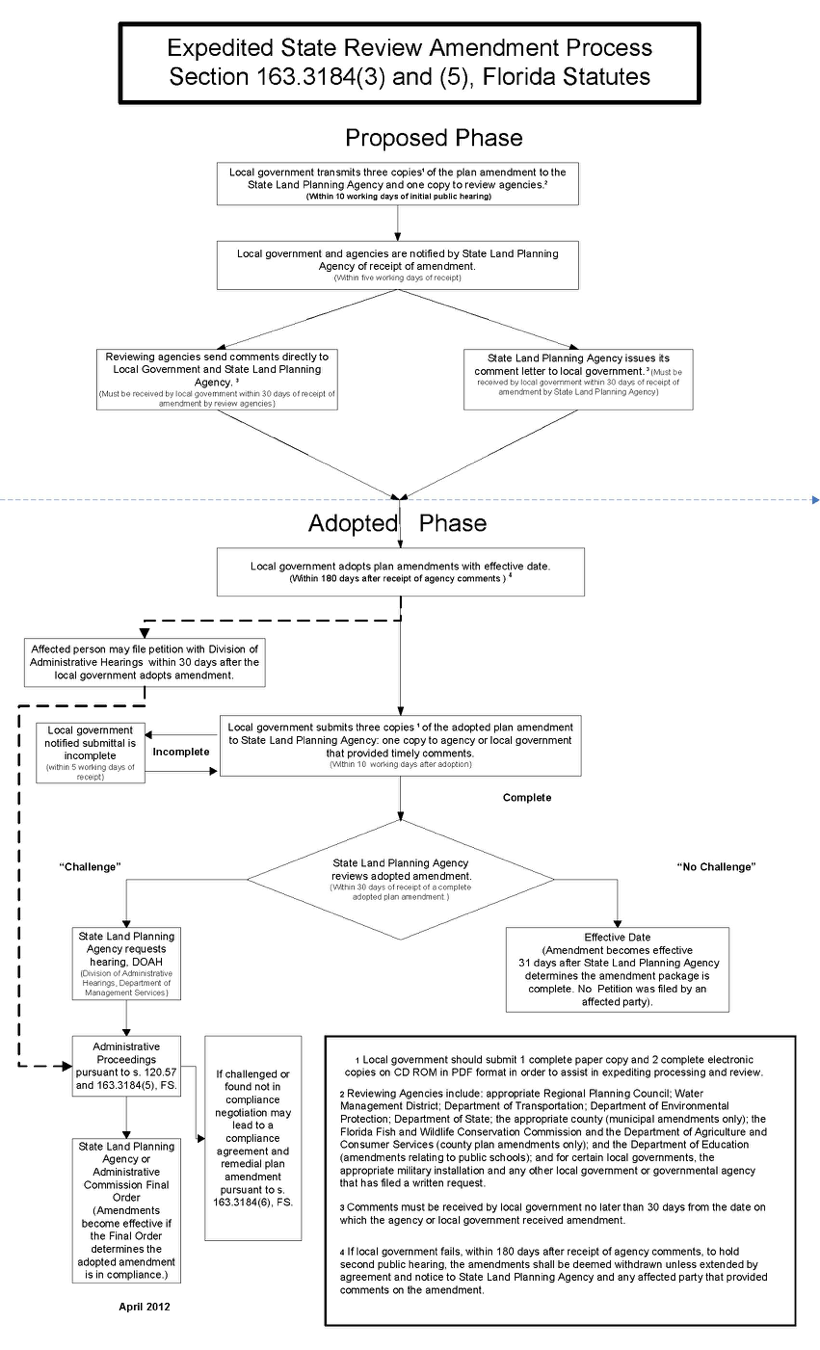
B. State coordinated review process. The following plan amendments must follow the state coordinated review process established in F.S. §163.3184 (4):
1. Those based on an evaluation and appraisal pursuant to F.S. §163.3191.
2. Propose development subject to the requirements of F.S. §380.06.
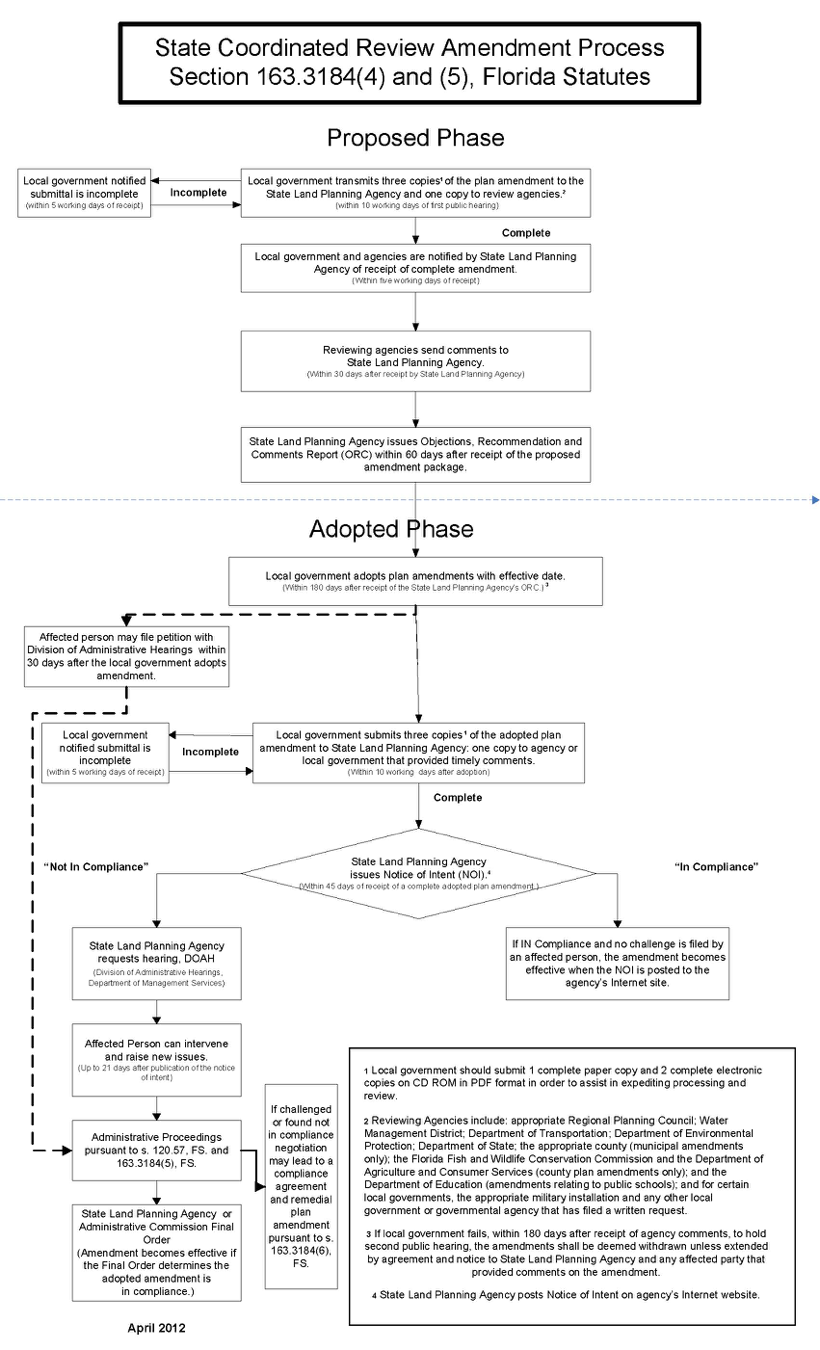
C.Small-scale amendment review process. Plan amendments that qualify as small-scale development amendments are subject to the small-scale review process established in F.S. §163.3187 A small scale development amendment may be adopted if the proposed amendment:
1. Involves a use of ten (10) acres or less;
2. Does not involve a text change to the goals, policies and objectives of the comprehensive land use plan, but only proposes a land use change to the future land use map for a site-specific small scale development activity; however, text changes that relate directly to, and are adopted simultaneously with, the small scale future land use map amendment shall be permissible; and
3. The cumulative annual effect of acreage for all small scale amendments does not exceed one hundred twenty (120) acres.
(Ord. No. 1278, § 1(exh. 1), 4-28-09)
Sec. 3-1103. - Application.
All applications for amendments to the text or maps of the comprehensive land use plan shall be made in writing upon an application form approved by city staff and shall be accompanied by applicable fees.
(Ord. No. 1278, § 1(exh. 1), 4-28-09)
Sec. 3-1104. - Conditions of approval.
A. An applicant may propose additional limitations regarding the use, density or intensity which will be permitted on a parcel proposed for development. Such limitation shall be offered by executed restrictive covenant or declaration of use that is provided to the city in a recordable form that is acceptable to the city attorney, and if the amendment is approved with the restrictive covenant or declaration of use, the recording information shall be set out on the comprehensive land use map.
B. The city council may condition the grant of a zoning map amendment upon the timely development of the parcel proposed for development, and may include provisions that the district boundary change does not become effective until a complete application for development approval is accepted by city staff.
(Ord. No. 1278, § 1(exh. 1), 4-28-09)
Sec. 3-1105. - City staff review, report and recommendation.
A. Upon receipt of an application pursuant to this division, the city staff shall review the application in accordance with the applicable provisions of these LDRs.
B. Upon completion of review of an application, the director of community planning and development shall:
1. Provide a report that summarizes the application and the effect of the proposed amendment, including:
a. Whether it specifically advances any goal, objective or policy of the comprehensive plan;
b. Its effect on the level of service of public infrastructure;
c. Its effect on environmental resources;
d. Its effect on hurricane evacuation;
e. Its effect on the availability of housing that is affordable to people who work in the city; and
f. Any other effect that city staff determines is relevant to the city council's decision on the application;
2. Provide a recommendation as to whether the application should be approved, approved with conditions or modifications, or denied;
3. Provide a proposed ordinance that could be used to adopt the proposed amendment;
4. Schedule the application for a hearing before the planning commission; and
5. Provide notice of the planning commission hearing pursuant to the applicable provisions of these LDRs.
C. Upon receipt of the planning commission recommendation, the city staff shall:
1. Schedule the application for hearing before the city council;
2. Forward its report and recommendation, as well as the planning commission recommendation, as applicable, to the city council; and
3. Provide notice of the city council hearing in accordance with the applicable provisions of these LDRs.
D. Notwithstanding the requirements of division 11, sections 3-1105 through 3-1107, if the proposed amendment is a small scale amendment, the information shall include:
1. A statement indicating that the city is submitting the adopted amendment as a small-scale amendment under section 163.3187(1), Florida Statutes.
2. A statement identifying the number of acres of the small-scale amendment.
3. A statement identifying the cumulative total number of acres for small-scale amendments the city has approved for the calendar year.
4. A statement identifying whether the amendment is within an area of critical state concern. If the amendment is within an area of critical state concern, certify that the amendment involves the construction of affordable housing units meeting the criteria of section 420.0004(3), Florida Statutes.
5. A statement indicating that the amendment has been submitted to the DEO Bureau of Economic Development (if the amendment is being adopted pursuant to section 163.3187(3), Florida Statutes)
6. The name, title, address, telephone and fax number of the local contact.
E. Small scale development amendments require only one (1) public hearing before city council, which shall be scheduled in accordance with the applicable provisions of these LDRs.
F. Small scale amendments shall become effective thirty-one (31) days after adoption unless an appeal is filed in accordance with F.S. § 163.3187(5).
(Ord. No. 1278, § 1(exh. 1), 4-28-09)
Sec. 3-1106. - Local planning agency review and recommendation.
A. The planning commission shall:
1. Review the application at a public hearing that is held before the transmittal hearing, or if no transmittal hearing is required, before the adoption hearing; and
2. Make a written recommendation to the city council with regard to whether the proposed amendments should be adopted, adopted with conditions, or rejected;
3. Whenever the planning commission votes to recommend approval of a proposed amendment to the comprehensive plan, or when the city sends a copy of the notice and plan amendment to the DEO if the amendment is a small scale amendment, the city manager shall issue an administrative order setting forth the proposed amendment and establishing a moratorium during which any city employee, board or department is prohibited from granting an approval or permit which would be prohibited, or prohibited without variances, in the event that the proposed amendment is enacted by the city council. The administrative order shall be effective until the proposed amendment is enacted or rejected by the city council. Any administrative order shall be deemed expired in the event the city council fails or declines to:
a. Adopt a small scale amendment;
b. Transmit a proposed amendment to DEO; or
c. Reject an amendment within ninety (90) days after a favorable recommendation by the planning commission; or
d. Fails to enact or reject an amendment within one hundred eighty (180) days after receiving comments on the proposed amendment from DEO.
4. Notwithstanding subsection 3. above, no administrative order shall affect any project which has a validly issued building permit, zoning approval, or has completed an application meeting all submission requirements for city approval, board of adjustment approval, or building permit approval prior to a vote by the planning commission in favor of the proposed amendment.
B. The city council shall serve as the local planning agency with respect to:
1. Amendments that are proposed or modified in response to DEO objections, comments or recommendations;
2. Amendments that are proposed or modified in order to implement a proposed or executed compliance agreement.
(Ord. No. 1278, § 1(exh. 1), 4-28-09)
Sec. 3-1107. - Transmittal hearing.
A. A transmittal hearing by the city council shall be held on each proposed comprehensive plan amendment.
B. All transmittal hearings shall be on weekdays.
C. If the city council approves the plan amendment at the transmittal hearing, within ten (10) working days the city shall transmit the amendment to those local governments, and state and regional agencies to which transmittal is required by state statute or administrative rule.
(Ord. No. 1278, § 1(exh. 1), 4-28-09)
Sec. 3-1108. - DEO objections, recommendations and comments.
A. If DEO comments on and/or formally objects to a privately initiated amendment, the city shall promptly notify the applicant in writing which shall include a copy of the objections, recommendations and comments report.
B. The applicant may submit a draft response to the city within fifteen (15) days. If city staff determines that the draft response is appropriate and responsive to the objection, city staff shall forward the response to DEO.
C. The city may respond to DEO objections on behalf of an applicant who does not provide an appropriate and responsive objection, but shall not be obligated to do so.
(Ord. No. 1278, § 1(exh. 1), 4-28-09)
Sec. 3-1109. - Adoption hearing.
A. The adoption hearing by the city council shall be scheduled within one hundred eighty (180) days of:
a.Receipt of DEO‘s objections, recommendations and comments report if DEO provides said report; or
b.The date the DEO review period ends if the amendment:
(1) Was transmitted to DEO; and
(2) DEO did not object; and
(3) No affected person requested review within thirty (30) days of the date the amendment was adopted.
B. At the adoption hearing, the city council shall adopt the proposed amendment, adopt the proposed amendment with amendments that respond to DEO objections, recommendations or comments, or reject the proposed amendment. Adoption shall require the affirmative vote of a super-majority of the members of city council.
(Ord. No. 1278, § 1(exh. 1), 4-28-09)
Sec. 3-1110. - Transmittal of adopted amendments.
The city shall submit all adopted comprehensive plan and future land use map amendments to DEO, and any other unit of local government or governmental agency that provided timely comments within ten (10) working days after the adoption hearing pursuant to the requirements established in F.S. §163.3184. If the amendment is a small-scale development amendment, the transmittal requirements established herein shall apply.
(Ord. No. 1278, § 1(exh. 1), 4-28-09)
Sec. 3-1111. - Compliance agreements.
The city council may enter into a compliance agreement with DEO with regard to any proposed or adopted comprehensive plan amendment, as follows:
A. If the city elects to commence negotiation of a compliance agreement with DEO, it shall mail notice to all parties that have intervener status in proceedings before DEO at least seven (7) days before substantive negotiations commence. Parties that have intervener status in proceedings before DEO shall be afforded a reasonable opportunity to participate in the negotiation process.
B. All negotiation meetings with the city and/or the parties with intervener status in proceedings before DEO shall be open to the public.
C. No compliance agreement shall be executed by the city unless such execution is considered at a public hearing of the city council.
(Ord. No. 1278, § 1(exh. 1), 4-28-09)
Sec. 3-1201. - Purpose and applicability.
It is the purpose of this division to provide an administrative remedy for applicants who allege that their vested rights have been abrogated in the event of destruction and/or redevelopment or by a final action of the city. This division sets out a process for obtaining an official and binding determination of vested rights to use or develop property in a particular manner.
(Ord. No. 1278, § 1(exh. 1), 4-28-09)
Sec. 3-1202. - Application.
A. All applications for a determination of vested rights pursuant to this division shall be made in writing upon an application form approved by the community planning and development department, and shall be accompanied by applicable fees.
B. Applications pursuant to this division shall be filed no later than thirty (30) days from the date a final action is taken that allegedly abrogates rights the applicant claims to be vested pursuant to the standards in these LDRs.
(Ord. No. 1278, § 1(exh. 1), 4-28-09)
Sec. 3-1203. - Standards.
The city council may grant an application for a determination of vested rights if it is demonstrated that:
A. A valid, unexpired government act of the city authorizes the specific development for which the determination is sought;
B. Expenditures or obligations were made or incurred in reliance upon the authorizing act that are not reasonably usable in a development that is permitted by these LDRs;
C. It would be highly inequitable to deny the applicant the opportunity to complete the previously approved development, in that:
1. Actual construction has commenced;
2. The injury suffered by the applicant outweighs the public cost of allowing the applicant's development to proceed;
3. The development was economically viable at the time it was approved;
4. The expenses or obligations incurred in good faith and without notice of a pending change in regulations that would prohibit the development for which vested rights are sought; and
5. The applicant cannot make a reasonable return on its previous expenditures on the project by developing according to the requirements of the current LDRs.
D. The relief granted is the minimum relief necessary to provide the applicant with a reasonable rate of return on his investment made before the effective date of the regulations that the applicant alleges have abrogated its vested rights.
(Ord. No. 1278, § 1(exh. 1), 4-28-09)
Sec. 3-1204. - Staff review, report and recommendation.
Staff review of the application for vested rights shall be conducted pursuant to this division.
(Ord. No. 1278, § 1(exh. 1), 4-28-09)
Sec. 3-1205. - City council review and decision.
The city council shall review the application at a quasi-judicial public hearing, and shall decide whether the application should be approved, approved with conditions or denied. The city council may continue the matter if it determines it needs more information.
(Ord. No. 1278, § 1(exh. 1), 4-28-09)
Sec. 3-1206. - Effect of vested rights determination.
A. A vested rights determination shall be set out in writing and specifically set forth the rights that have been recognized as vested.
B. Vested rights shall be utilized within two (2) years of the date the determination is rendered. If substantial development pursuant to the vested rights determination has not begun within said time period, the vested rights shall be extinguished without further notice or hearing.
(Ord. No. 1278, § 1(exh. 1), 4-28-09)
Sec. 3-1301. - Purpose and applicability.
The city council may enter into development agreements in accordance with the provisions of this division and applicable Florida law to encourage a stronger commitment to comprehensive and capital facilities planning, ensure the provision of adequate public facilities for development, encourage the efficient use of resources, and reduce the economic cost of development. Development agreements shall be required for all developments within the Planned Community Urban Design (PCUD) Overlay District. Development agreements for university campus master plans shall also be subject to the requirements of F.S. §1013.30.
(Ord. No. 1278, § 1(exh. 1), 4-28-09; Ord. No. 1440, § 1, 6-25-19)
Sec. 3-1302. - Application.
All applications for a determination of a development agreement pursuant to this division shall be made in writing upon an application form approved by the director of community planning and development, and shall be accompanied by applicable fees.
(Ord. No. 1278, § 1(exh. 1), 4-28-09)
Sec. 3-1303. - Staff review and report.
The shall review the application for a development agreement with the development review committee in accordance with the applicable provisions of these LDRs, and shall prepare a written recommendation to the planning commission.
(Ord. No. 1278, § 1(exh. 1), 4-28-09)
Sec. 3-1304. - Planning commission review.
The planning commission shall conduct a quasi-judicial public hearing and review the proposed development agreement, the recommendation of staff, and the testimony at the public hearing, the standards for review herein these LDRs and shall issue a recommendation to the city council for approval or denial of the development agreement.
(Ord. No. 1278, § 1(exh. 1), 4-28-09)
Sec. 3-1305. - City council review.
The city council shall conduct a quasi-judicial public hearing on the proposed development agreement. Upon conclusion of the public hearing, the council shall review the proposed development agreement, the recommendation of the planning commission, the recommendation of staff and the testimony at the public hearing. The council shall approve, approve with modifications, or deny the proposed development agreement. The council may continue the matter if it determines it needs more information.
(Ord. No. 1278, § 1(exh. 1), 4-28-09)
Sec. 3-1306. - Standards of review.
In reaching a decision as to whether or not the development agreement should be approved, approved with modifications, approved with conditions, or denied, the city council shall determine whether the development agreement is consistent with and furthers the goals, policies and objectives of the comprehensive land use plan.
(Ord. No. 1278, § 1(exh. 1), 4-28-09)
Sec. 3-1307. - Contents of development agreement.
The approved development agreement shall contain, at a minimum, the following:
A. A legal description of the land subject to the development agreement.
B. The names of all persons having legal or equitable ownership of the land.
C. The duration of the development agreement, which shall not exceed thirty (30) years.
D. The development uses proposed for the land, including population densities, building intensities and building height.
E. A description of the public facilities and services that will serve the development, including who shall provide such public facilities and services; the date any new public facilities and services, if needed, will be constructed; who shall bear the cost of construction of any new public facilities and services; and a schedule to assure that the public facilities and services are available concurrent with the impacts of the development. The development agreement shall provide for a cashier's check, a payment and performance bond or letter of credit in the amount of one hundred fifteen (115) percent of the estimated cost of the public facilities and services, to be deposited with the city to secure and fund construction of any new public facilities and services required to be constructed by the development agreement, to the extent permitted by applicable law. The development agreement shall provide that such construction shall be completed prior to the issuance of any certificate of occupancy.
F. A description of any reservation or dedication of land for public purposes.
G. A description of all local development approvals approved or needed to be approved for the development.
H. A finding that the development approvals as proposed is consistent with the comprehensive land use plan and these LDRs.
I. A description of any conditions, terms, restrictions or other requirements determined to be necessary by the city council for the public health, safety or welfare of the citizens of the city. Such conditions, terms, restrictions or other requirements may be supplemental to requirements in these LDRs or other ordinances of the city.
J. A statement indicating that the failure of the development agreement to address a particular permit, condition, term or restriction shall not relieve the developer of the necessity of complying with the law governing said permitting requirements, conditions, terms or restrictions.
K. The development agreement may provide, in the discretion of the city council, that the entire development or any phase thereof be commenced or be completed within a specific period of time. The development agreement may provide for liquidated damages, the denial of future development approvals, the termination of the development agreement, or the withholding of certificates of occupancy for the failure of the developer to comply with any such deadline.
L. A statement that the burdens of the development agreement shall be binding upon, and the benefits of the development agreement shall inure to, all successors in interest to the parties to the development agreement.
M. All development agreements shall specifically state that subsequently adopted ordinances and codes of the city which are of general application not governing the development of land shall be applicable to the lands subject to the development agreement, and that such modifications are specifically anticipated in the development agreement.
(Ord. No. 1278, § 1(exh. 1), 4-28-09)
Sec. 3-1308. - Recording of development agreement.
No later than fourteen (14) days after the execution of a development agreement by all parties thereto, the city shall record the development agreement with the Clerk of the Circuit Court in Miami-Dade County. The applicant for a development agreement shall bear the expense of recording the development agreement.
(Ord. No. 1278, § 1(exh. 1), 4-28-09)
Sec. 3-1309. - Effect of decision.
A. The codes and ordinances of the city governing the development of land subject to a development agreement in existence at the time of the execution of the development agreement shall govern the development of the land for the duration of the development agreement. Upon the expiration or termination of a development agreement, all codes and ordinances of the city in existence upon the date of expiration or termination shall become applicable to the development regardless of the terms of the development agreement.
B. The city may apply codes and ordinances adopted subsequent to the execution of a development agreement to the subject property and development only if the city council, upon holding a public hearing, has determined that such subsequent codes and ordinances are:
1. Not in conflict with the laws and policies governing the development agreement and do not prevent development of the land uses, intensities or densities in the development agreement.
2. Are essential to the public health, safety or welfare, and expressly state that they shall apply to a development that is subject to a development agreement.
3. Of general application not governing the development of land they are by general reference specifically anticipated and provided for in the development agreement as provided herein.
4. The city demonstrates that substantial changes have occurred in pertinent conditions existing at the time of approval of the development agreement.
5. The development agreement is based on substantially inaccurate information supplied by the developer.
(Ord. No. 1278, § 1(exh. 1), 4-28-09)
Sec. 3-1310. - Changes to development agreements.
A development agreement may be amended by mutual consent of the parties, provided the notice and public hearing requirements of these LDRs are followed. A party to a development agreement may request one (1) extension of the duration of the development agreement, not to exceed one (1) year from the date of expiration of the initial term of the development agreement, by submitting an application to the community planning and development department at least sixty (60) days prior to the expiration of the initial term of the agreement. The application shall address the necessity for the extension and shall demonstrate that the extension is warranted under the circumstances. The community planning and development director shall schedule the requested extension as a proposed amendment to the development agreement for public hearing before the planning commission in accordance with division 3 of this article.
(Ord. No. 1278, § 1(exh. 1), 4-28-09)
Sec. 3-1311. - Termination or revocation of approval.
The city manager shall review all lands within the city subject to a development agreement at least once every twelve (12) months to determine if there has been demonstrated good-faith compliance with the terms of the development agreement. The city manager shall make an annual report to the city council as to the results of this review. In the event the city council finds, on the basis of substantial competent evidence, that there has been a failure to comply with the terms of the development agreement, the development agreement may be revoked or modified by the city council upon giving a minimum of a 15-day written notice to the parties named in the development agreement. Such termination of a development agreement shall occur only after compliance with the public hearing and notice requirements of division 3 of this article.
(Ord. No. 1278, § 1(exh. 1), 4-28-09)
Sec. 3-1401. - Short title.
This chapter shall be known and may be cited to as the “City of North Miami Impact Fees Ordinance.”
(Ord. No. 1302, § 2, 9-15-10; Ord. No 1531, § 4, 11-26-24)
Sec. 3-1402. - Findings.
A. The city council hereby finds and declares that:
1. New development generates increased demands upon city public facilities and services and requires additional facility capacity and capital equipment in order to accommodate those demands.
2. The potential for development of properties is a direct result of city policy as expressed in the city comprehensive plan and as implemented via the city zoning ordinances and map.
3. It is the policy of the city that new development should bear its fair share of the costs of providing public facilities, facility capacity, increased services and capital equipment needed to accommodate the demand generated by new development.
4. The amount of the "impact fee" to be imposed shall be based upon the average amount of the public facility capacity demand attributable to new development and the average cost of additional capital facilities, capital improvements, services and capital equipment needed to provide additional capacity.
5. The impact fees established in this division are applicable to development submitting building permit applications accepted as complete by the city on or after April 14, 2025 and are based on the methodology and data presented in the Impact Fees Study prepared by Duncan Associates, dated August 25, 2024, (hereinafter referred to as “impact fees study”). The city council hereby adopts and incorporates by reference the impact fees study. A copy of the impact fees study was submitted as a part of the record of the public hearings on the ordinance, and a copy of the impact fees study shall be maintained on file in the office of the city clerk.
B. The city council hereby finds and declares that the impact fees imposed herein upon new development in order to finance public facilities and capital equipment needed to accommodate the demand created by new development are in the best interest of the city and its residents, are equitable, and do not impose an unfair burden on such development. The city council hereby finds and declares that new development, as defined herein, within the city limits generates an increased demand for system improvements for parks and recreation (including library) facilities, general government (including police) facilities, and stormwater facilities, and that new development within the city's water and sewer service areas generates an increased demand for water and sewer facilities, respectively. The city council hereby finds and declares that the system improvements to be funded by the impact fees imposed herein will provide benefit to new development in the areas where the city provides those services.
(Ord. No. 1302, § 3, 9-15-10; Ord. No 1531, § 4, 11-26-24)
Sec. 3-1403. - Intent.
This division is intended to impose impact fees, payable at the time of building permit issuance, in order to fund capital improvements, capital facility capacity, and capital equipment needed to address demand for public facilities attributable to new development. This division is not intended to authorize imposition of fees related to capital facility or equipment needs attributable to existing development. This division is intended to allow new development in compliance with the comprehensive plan and to provide a mechanism for new development to help address the burdens created by new development.
(Ord. No. 1302, § 4, 9-15-10; Ord. No 1531, § 4, 11-26-24)
Sec. 3-1404. - Authority.
The city council is authorized to establish and adopt an impact fees ordinance pursuant to the authority granted by the Florida Impact Fee Act, F.S. section 163.31801, the Florida Constitution, article VII, sections 1(f), 1(g) and 2(b), the Municipal Home Rule Powers Act, F.S. Ch. 166, as amended, the City of North Miami Charter, and the Community Planning Act, as amended. In addition, the Community Planning Act, as amended, encourages the use of innovative land development regulations, including impact fees. The provisions of this division shall not be construed to limit the power of the city to adopt such ordinance pursuant to any other source of local authority nor to utilize any other methods or powers otherwise available for accomplishing the purposes set forth herein, either in substitution of or in conjunction with these Land Development Regulations ("LDRs").
(Ord. No. 1302, § 5, 9-15-10; Ord. No 1531, § 4, 11-26-24)
Sec. 3-1405. - Definitions.
For the purpose of this division, the following definitions shall apply unless the context clearly indicates or requires a different meaning:
Applicant shall mean the property owner, or duly designated agent of the property owner, of land on which an application for a building permit is submitted and impact fees are due pursuant to this division, or shall mean the property owner or duly designated agent of the property owner of land identified in a credit agreement pursuant to section 3-1410(D) where such property owner or agent is responsible for the provision of system improvements.
Appropriation shall mean, for purposes of this division, funds identified in the capital budget related to a system improvement.
Capital budget shall mean the city current fiscal year capital budget which is the first year of the five-year capital improvements plan and which identifies capital projects that are proposed to be initiated in that fiscal year or to receive any changes in funding in that fiscal year.
Capital improvement plan (CIP) shall mean the city current five-year program of proposed capital improvements which identifies all capital projects that are proposed to be initiated during the five-year period.
General government facilities shall mean administrative office space, maintenance facilities, and associated land for all city functions except parks and recreation facilities as herein defined, and capital equipment, parking garage space and vehicle fleet for all the departments of the city.
Impact fee shall mean a fee imposed at building permit issuance and calculated based upon a new development’s proportionate share of the average cost of system improvements required to accommodate new development.
Impervious cover shall mean surface areas of a parcel of real property that has been compacted or covered with a layer of material so that it is highly resistant to infiltration by water, excluding such areas within public rights-of-way.
Industrial/warehouseshall mean any of the following:
- Industrial - a facility primarily intended for the production or assembly of goods, processing of foods, mining of raw materials, or similar activities. Typical uses include factories, welding shops, wholesale bakeries, and utility plants.
- Warehouse - an establishment primarily engaged in the display, storage and sale of goods to other firms for resale, as well as activities involving significant movement and storage of products or equipment. Typical uses include wholesale distributors, storage warehouses, moving and storage firms, trucking and shipping operations and major mail processing centers.
- Mini-warehouse - an enclosed storage facility containing independent, fully enclosed bays that are typically leased to persons for storage of their household goods or personal property.
Multifamily shall mean a building containing two or more dwelling units, excluding single-family attached (townhome) units. It includes duplexes, apartments, and residential condominiums.
New development shall mean the carrying out of any building activity, the making of any material change in the use of a structure or land, the installation of a water meeter, or the making of a connection to the sewer system that generates demand for capital facilities and equipment over and above the previously existing documented use of the development site, but excluding government owned and operated facilities.
Office shall mean a building exclusively containing establishments providing executive, management, administrative, financial, medical or professional services, and which may include ancillary services for office workers, such as a restaurant, coffee shop, newspaper or candy stand, or childcare facilities. It may be the upper floors of a multi-story office building, excluding ground floor retail uses. Typical uses include real estate, insurance, property management, investment, employment, travel, advertising, secretarial, data processing, telephone answering, and telephone marketing offices; medical offices and hospitals, emergency care centers, and veterinary clinics; institutions of higher education; technical or trade schools; music, radio and television recording and broadcasting studios; professional or consulting services in the fields of law, architecture, design, engineering, accounting and similar professions; interior decorating consulting services; and business offices of private companies, utility companies, trade associations, unions and nonprofit organizations. This category does not include an office use within a shopping center or an administrative office that is ancillary to a different primary use of the site.
Parks and recreation facilities shall mean parks and library facilities, related administrative space and maintenance and storage facilities, community centers, swimming pools, gymnasiums, tennis courts, ballfields, and similar recreational improvements and associated land.
Retail/commercial shall mean a shopping center or a free-standing retail or commercial use. A shopping center shall mean an integrated group of commercial establishments planned, developed, owned or managed as a unit. A retail or commercial use shall mean the use of a building or structure primarily for the sale to the public of services, goods, or foods that have not been made, assembled or otherwise changed in ways generally associated with manufacturing or basic food processing in the same building or structure. This category includes, but is not limited to, all uses located in shopping centers and the following typical types of free-standing uses: amusement park, bank, bar, camera shop, car wash, convenience store, department store, discount store, florist shop, golf course or driving range, health or fitness club, hobby, toy and game shop, hotel or motel, laundromat, laundry or dry cleaning, lawn and garden supply store, marina, massage establishment, movie theater, music store, newsstand, racetrack, recreation facility, restaurant, service station, specialty retail shop, used merchandise store, variety store, and vehicle and equipment rental.
Sewer facilities shall mean the city’s sewer collection and conveyance system and associated improvement and land, but excluding gravity lines and force mains less than 16 inches in diameter and associated improvements and land.
Single-family detached/attached shall mean a building containing only one dwelling, or one of multiple units attached on one or both sides to other units and separated by a wall that separates the units from the ground through the roof, also referred to as a townhome.
Stormwater facilities shall mean the city system of flood prevention and mitigation and associated land and improvements, including but not limited to pumps, storm drains, auger wells, catch basins, and french drains.
System improvements shall mean improvements that expand the capacity of a set of improvements for a particular public facility type, if such capacity can be quantified, or otherwise enhance the ability of such systems to provide the same level of service to new development as is currently provided to existing development. System improvements do not include the replacement, repair, rehabilitation, or maintenance of existing facilities.
Water facilities shall mean the city’s water supply, treatment and distribution system, including associated improvements and land, but exculding water lines less than 16 inches in diameter and associated improvements and land.
(Ord. No. 1302, § 6, 9-15-10; Ord. No 1531, § 4, 11-26-24)
Sec. 3-1406. - Applicability of impact fees.
This article shall be uniformly applicable to all new development, and the appropriate impact fees shall be collected prior to issuance of a building permit except where a building permit is issued for:
A. Additions, remodels, rehabilitation or other improvements to an existing structure and reconstruction of a demolished structure which results in no net increase in the number of residential dwelling units for residential structures.
B. Any development which is government-owned and operated facility.
(Ord. No. 1302, § 7, 9-15-10; Ord. No 1531, § 4, 11-26-24)
Sec. 3-1407. - Imposition of impact fee.
Impact fees are hereby levied on all new development imposed pursuant to this division, as set forth in the following fee schedules.
A. Parks and recreation impact fee schedule.
| Land Use Type | Unit | Year 1 | Year 2 | Year 3 | Year 4 |
| Single Family Det./Att. | Dwelling | $2,937 | $4,112 | $4,993 | $5,874 |
| Multi-Family | Dwelling | $1,986 | $2,780 | $3,375 | $3,971 |
B. General government impact fee schedule.
Land Use Type | Unit | Year 1 | Year 2 | Year 3 | Year 4 |
Single Family Det./Att. | Dwelling | $1,329 | $1,860 | $2,258 | $2,657 |
Multi-Family | Dwelling | $919 | $1,287 | $1,562 | $1,838 |
Retail/Commercial | 1,000 sq. ft. | $2,214 | $3,100 | $3,764 | $4,428 |
Office | 1,000 sq. ft. | $1,279 | $1,790 | $2,173 | $2,557 |
Industrial/Warehouse | 1,000 sq. ft. | $201 | $281 | $341 | $401 |
Public/Institutional | 1,000 sq. ft. | $677 | $948 | $1,151 | $1,354 |
C. Water impact fee schedule.
Water Meter Size | Meter Type | Year 1 | Year 2 | Year 3 | Year 4 |
3/4" | Disc | $4,532 | $6,344 | $7,704 | $9,063 |
1" | Disc | $7,568 | $10,595 | $12,865 | $15,135 |
1.5" | Disc | $15,090 | $21,125 | $25,652 | $30,179 |
2" | Disc | $24,153 | $33,814 | $41,059 | $48,305 |
1.5" | Turbine | $48,350 | $67,690 | $82,195 | $96,700 |
2" | Turbine | $60,404 | $84,565 | $102,686 | $120,807 |
3" | Turbine | $135,942 | $190,319 | $231,101 | $271,884 |
4" | Turbine | $302,109 | $422,952 | $513,584 | $604,217 |
5" | Turbine | $422,916 | $592,082 | $718,956 | $845,831 |
6" | Turbine | $604,172 | $845,840 | $1,027,092 | $1,208,343 |
8" | Turbine | $1,057,312 | $1,480,236 | $1,797,430 | $2,114,623 |
D. Sewer impact fee schedule.
Water Meter Size | Meter Type | Fee Per Meter |
3/4" | Disc | $1,768 |
1" | Disc | $2,953 |
1.5" | Disc | $5,887 |
2" | Disc | $9,423 |
1.5" | Turbine | $18,865 |
2" | Turbine | $23,567 |
3" | Turbine | $53,040 |
4" | Turbine | $117,873 |
5" | Turbine | $165,007 |
6" | Turbine | $235,727 |
8" | Turbine | $412,527 |
E. Stormwater impact fee schedule.
Fee per square foot of impervious cover: $0.78
(Ord. No. 1302, § 8, 9-15-10; Res. No. R-2010-103, § 1, 9-28-10; Ord. No. 1409, § 1, 12-13-16; Ord. No 1531, § 4, 11-26-24)
Sec. 3-1408. - Administration of impact and mobility fees.
A. Collection of impact fee and mobility fees. Impact fees due pursuant to this division and mobility fees due pursuant to division 15 shall be collected by the building department prior to issuance of a building permit.
1. Upon receipt and acceptance of a complete application for a building permit for a new development, the building department shall determine the amount of the impact fee or mobility fee due.
2. The building department shall determine whether or not the development is exempted for the levying of impact fees or mobility fees.
3. The city manager shall determine whether or not the development is entitled to any credits for the impact fees or mobility fees.
4. In the case of development activity involving a change from an existing development or use or previously existing development or use on the site, the impact or mobility fee shall be the difference between the computed fee for the proposed development activity and the computed fee for the existing development activity as defined above. No refunds will be given for proposed development activity resulting in a negative fee calculation.
B. Transfer of funds to finance department. Upon receipt of impact and mobility fees, the building department shall transfer such funds to the city finance department which shall be responsible for placement of such funds into the appropriate separate accounts by facility type. All such funds shall be deposited in interest-bearing accounts in a bank authorized to receive deposits of city funds. Interest earned by each account shall be credited to that account and shall be used solely for the purposes specified for funds of such account. The funds of these accounts shall not be commingled with other funds or revenues of the city.
C. Establishment and maintenance of accounts. The city finance department shall establish separate accounts and maintain records for each such account, whereby impact fees and mobility fees collected are segregated by type of fee. A separate account shall be maintained for each type of impact fee and the mobility fee.
D. Maintenance of records. The city finance department shall maintain and keep adequate financial records for each such account which shall show the source and disbursement of all revenues, which shall account or all moneys received, including revenue by building permit, and which shall document and ensure that the disbursement of funds from each account shall be used solely and exclusively in accordance with provisions of this section. For purposes of petitions for refunds under section 3-1410 (C) of this division, the expenditure and appropriation of impact fees or mobility fees shall be deemed to occur in the same sequential order as the collection of impact fees or mobility fees, in other words, the first fee in shall be the first fee out.
E. Impact or mobility fee expenditures. Impact fees or mobility fees collected shall be expended only for the type of system improvements for which the impact or mobility fee was imposed.
(Ord. No. 1302, § 9, 9-15-10; Ord. No 1531, § 4, 11-26-24)
Sec. 3-1409. - Administrative fees.
Expenses to be incurred by the city in connection with the administration of the development impact fee ordinance and the mobility fee ordinance in division 15 of this article have been estimated and budgeted and have been determined to be of benefit to the properties therein and shall be assessed through the imposition of a service charge in the amount of three (3) percent of the impact or mobility fee due. The nonrefundable service charges are in addition to and shall be paid separately from the impact or mobility fees but shall be payable at the time of application for the building permit and shall be for the sole purpose of defraying expenses as provided herein.
(Ord. No. 1302, § 10, 9-15-10; Ord. No 1531, § 4, 11-26-24)
Sec. 3-1410. - Administrative procedures for petitions for impact and mobility fees.
A. Petition process.
1. Petitions for an impact or mobility fee determination, refund, credit against impact or mobility fees, deferral of fee payment, or independent fee study shall be submitted using the petition process, requirements and time limits provided herein. All petition requests except petitions for refunds under subsection (C) below, shall be accompanied by a fee of two hundred fifty dollars ($250.00). Any officer, department, board, commission or agency of the city (collectively referred to as city “entities”) submitting a petition shall not be required to pay said fee.
2. All petitions shall be submitted to the city manager's office for processing and preparation of a staff report and recommendation on the petition, and the final determination on the petition shall be issued at the reasonable discretion of the city manager. The city manager's office may obtain an analysis of the petition request from any and all appropriate city departments and staff in order to provide a complete and detailed review of and recommendation on the petition request to the city manager. The staff report and recommendations shall be forwarded to the city manager no later than sixty (60) days after filing of a completed petition. The city manager shall, no later than ninety (90) days of filing of the complete petition issue a written determination on the petition, with the reasoning for the determination based upon the petition data, the provisions of this division and applicable law, and, if needed, direct the appropriate city staff to take the actions necessary to implement the determination.
3. Upon written agreement by the city manager's office and the petitioner the time limits in this section may be waived for any reason, including, but not limited to, the submittal of additional data and supporting statements by the petitioner. The city manager's designee is authorized to determine whether a petition is complete and whether additional data or supporting statements by appropriate professionals are needed. If the city manager's designee determines that the petition is not complete, a written statement detailing the insufficiencies of the petition shall be provided to the petitioner within thirty (30) days of initial filing of the petition. The date of such written determination of insufficiency shall toll the time limits established in the section until submittal of a complete petition. Any insufficiency not corrected during such time will cause the petition to not be considered, and it will be returned without the necessity of further action.
4. The filing of a petition shall stay action by the city on the application for building permit and any other city action related to the development. No building permit shall be issued for development for which a petition has been filed and is pending unless the total impact fees due have been paid in full or a sufficient bond or letter of credit satisfactory to the city attorney has been filed with the city.
B. Petitions for impact or mobility fee determination. Any applicant, prior to or in conjunction with the submission of an application for a building permit, or within thirty (30) days of the date of payment of impact or mobility fees, may petition the city manager for a determination that the amount of the impact or mobility fees imposed on the new development is inappropriate based on the specific land use category or water meter size and type applied to the development. The petition shall specify in detail the basis on which the applicant asserts that the amount of the impact or mobility fees is inappropriate. The petition shall be on a form provided by the city and shall, at a minimum, include identification of the disputed factor(s), a detailed statement by a qualified professional engineer, planner or other appropriate professional, and, if filed after payment of impact or mobility fees, a dated receipt for payment of the impact fees issued by the city's building department. Failure to timely file a petition for impact or mobility fee determination shall waive any right to review or recalculation to decrease the impact or mobility fee payment.
C. Petitions for refund of impact or mobility fees.
1. The current owner of property on which an impact or mobility fee has been paid may apply for a refund of such fees if the city has failed to appropriate or spend the collected fees by the end of the calendar quarter immediately following ten (10) years of the date of payment of the impact or mobility fee, or if the building permit for which the impact or mobility fee has been paid has lapsed for non-commencement of construction, or if the project for which a building permit has been issued has been altered resulting in a decrease in the amount of the impact or mobility fee due.
2. Only the current owner of property may petition for a refund. A petition for refund must be filed within ninety (90) days of any of the above-specific events giving rise to the right to claim a refund. Failure to timely file a petition for refund shall waive any right to an impact or mobility fee refund.
3. The petition for refund shall be submitted to the city manager's office on a form provided by the city for such purpose. The petition shall contain a notarized affidavit that petitioner is the current owner of the property, a certified copy of the latest tax records of Miami-Dade County showing the owner of the subject property, a copy of the dated receipt for payment of the impact or mobility fee issued by the city's building department and a statement of the basis upon which the refund is sought.
4. Any money refunded pursuant to this subsection shall be returned with interest in an amount of at least seventy-five (75) percent of the annualized average interest rate payable on such account or interest at the rate of three (3) percent per year simple interest, whichever the city elects.
D. Petition for credits against impact or mobility fees.
1. Any applicant as defined in this divisionwho elects to construct or dedicated all or a portion of a system improvement as defined in this division, or who escrows money with the city for the construction of a system improvement shall, if all criteria in this article and this subsection D are fulfilled, be granted a credit for such contribution against the impact or mobility fees otherwise due for the same type of system improvement. The applicant must, prior to the applicant's construction, dedication or escrow of the system improvement, submit a petition on a form provided by the city, obtain a determination of credit eligibility and the amount of any credit, and enter into a credit agreement with the city. The petition for credit shall contain, at a minimum, the following; a certified copy of the most recently recorded deed for the subject property, preliminary engineering plans and certified costs estimates by an architect, engineer or other appropriate professional, the proposed schedule for completion of any construction/dedication identified in the current adopted CIP, identification in detail of the development against which the credits are to apply including but not limited to the land use type(s), number of units/gross floor area, anticipated development schedule, and legal descriptions of the subject property. Any and all system improvements required to be conveyed to the city pursuant to a Development Agreement, Conditional Use Permit, or other binding agreement or requirement with or by the city shall be considered included as part of the city’s CIP, for purposes of this subsection D. Any appeal of petition determinations on credits must be filed, heard, and determined prior to the applicant’s construction, dedication or escrow for which the credit is requested. Failure to timely file a petition for impact or mobility fee credits shall waive any right to such credits.
2. A credit shall be granted and the amount of the credit shall be determined by the city manager, in his reasonable discretion, if it is determined that the system improvement is in the adopted, current capital improvement plan and is funded in whole or in part with impact fee revenue or is considered to be part of the adopted CIP as noted in paragraph 1, above. The amount of the credit shall be based on actual costs certified by a professional engineer or architect submitted by the applicant and reviewed and approved by the appropriate city department. If the impact fees or mobility fees exceed the amount of credit granted, at the time of issuance of the building permit, the applicant shall pay the difference between the amount of the impact or mobility fees and the credit.
3. If a credit petition is approved, the applicant and the city shall enter into a credit agreement which shall provide for the process to be used to verify actual costs of improvements and the value of any dedicated land. The agreement shall describe the obligations and responsibilities of the applicant and the city, including but not limited to
- Public bidding or solicitation requirements or engineering estimate;
- Engineering, design and construction standards and requirements to be complied with;
- Insurance bonding and indemnification requirements;
- Project inspection standards and responsibilities;
- Timing of the actions to be taken by the applicant;
- Transfer of title to land and improvements;
- Process for submittal of requests for use of credits; and
- Timing of actions by the city.
4. No impact or mobility fee credit shall be provided until any land has been dedicated and conveyed to the city and/or the facilities have been constructed and accepted or alternatively until a bond has been posted to ensure the conveyance and/or construction. Any bond shall be issued by a state surety and in a form acceptable to the city attorney and risk manager. The city’s obligation to allow the use of impact or mobility fee credits instead of fee payment shall be limited to a period not to exceed ten (10) years from the date of approval of the agreement. The credit agreement shall provide for forfeiture of any impact or mobility fee credit remaining at the end of such ten-year period. The credit applicant shall agree to provide recorded notice to subsequent purchasers/owners of the property receiving the credit, if any, that may be available to such purchasers and shall agree to indemnify the city for any and all costs and liabilities arising from any claims by others related to the credit.
5. Any excess approved credit beyond the current impact or mobility fees that would be required for the proposed development may be transferred to other developments that benefit from the dedications or improvements for which the credit was provided. Any such transfer of credits must be registered with and approved by the development services department.
6. In the event that the impact fees are increased after the date of the credit agreement, the amount of the remaining credits shall be increased as necessary to ensure that the credit holder receives the full benefit of the intensity or density repaid by the credit when it was first established. To implement this requirement of the Florida impact fee act, the city shall use the following procedures.
a. For credit agreements established after the effective date of this ordinance, the city shall compute weighted average percentage increases based on the mix of remaining land use types for the parks and recreation impact fees, general government impact fees, and mobility fees and apply those percentages to any outstanding credit balances for these three facility types. Outstanding credit balances for water and sewer impact fees shall be increased by the weighted average increases derived from the mix of remaining water meter sizes/types for the original proposed development, and outstanding credit balances for stormwater impact fees shall be increased by the percentage increase in the fee per square foot of impervious cover.
b. For credit agreements established before the effective date of this ordinance, a comparable procedure shall be used for parks and recreation and general government impact fee credits. A comparable procedure shall also be used for water and sewer impact fee credits where a weighted average percentage increase can be determined, but this will generally only be possible where the remaining mix of land uses consists exclusively of individually-metered housing types or land uses that will all require the smallest meter size.
c. Any adjustments to the amount of outstanding credit balances shall be made within thirty (30) days of the effective date of any fee increases.
E. Deferral of impact or mobility fees for affordable and workforce housing.
1. In order to encourage the provision and retention of affordable housing and workforce housing for owner-occupancy and for rental, there shall be a deferral of impact or mobility fees due on affordable housing and workforce housing dwelling units developed within the City. The city shall require, under the program, a covenant running with the land covering the assignment of affordable and workforce housing, annual reporting due prior to September 30th, and any other requirements deemed necessary or appropriate for participation in the affordable housing and workforce housing impact or mobility fee deferral program. An applicant shall submit a petition for affordable housing and workforce housing determination with any development review application. If the petition for affordable housing and workforce housing deferral determination is submitted incomplete and/or too close in time to allow determination prior to issuance of the building permit, then the total impact or mobility fees due shall be paid prior to issuance of the building permit, and a petition for refund may be submitted if the development is approved for the deferral program.
2. Affordable housing or workforce housing impact or mobility fee deferral shall apply to the following:
- Such development shall consist of 100 percent affordable housing units for families and/or individuals.
- If the project is providing affordable rental housing, then such development shall have secured its necessary low-income housing tax credits from Florida Housing Finance Corporation and shall submit proof of such to the city manager or his designee; and
- If the project is providing affordable home ownership, then, prior to the issuance of building permits, the applicant shall provide the city with a covenant and deed restrictions, in forms acceptable to the city attorney, which assure that such units remain affordable for a period of at least thirty (30) years and the home owner(s) be responsible for submitting proof of such to the city manager, or his designee, on an annual basis, the required covenants shall include enforcement and penalty language to address non- compliance.
3. At such time that the property is sold or transferred the impact or mobility fees will be due to the city in their entirety.
C. Independent fee study.
1. The feepayer may elect, prior to paying the impact or mobility fees from the fee schedules, to utilize an independent fee study prepared by a qualified professional for one or more of the applicable fees. The feepayer shall provide the city manager notice of intent to utilize an independent fee computation study prior to the issuance of any building permit on the property for which the fee is due. Nothing in this section shall allow a building permit for development activity to be issued without the payment of the applicable impact or mobility fees.
2. If the feepayer elects to utilize an independent fee study, the feepayer shall, at his or her own expense, prepare and present to the city manager, a study that documents the basis upon which the value of each of the components of the fee formula were determined. The burden shall be upon the feepayer to provide the data, analysis, and reports necessary for the city manager or his or her designee to make a determination. The analysis and report must be based on the same methodology set forth in the impact fee or mobility fee study.
3. The city manager shall determine whether the independent fee computation study accomplishes the following:
(a) Adheres to the impact or mobility fee methodology used in the impact or mobility fee study;
(b) Ensures the inputs to the calculation reasonably reflect the long-term impacts (20 years or more) of the development, rather than unique characteristics of the proposed initial occupant or use;
(c) Provides complete, thorough, and accurate information; and
(d) Is prepared by a qualified professional.
4. Upon approval of the independent fee computation study by the city manager based upon a determination that the conditions described above have been fully met, the feepayer shall pay the amount of the fee so computed and be entitled to a refund of any amount previously paid in excess thereof.
Sec. 3-1411. - Appeal to zoning appeals board.
A. A petition determination by the city manager shall be final unless a written notice of appeal to the zoning appeals board is filed with the community planning and development services director within thirty (30) days of the date the written determination by the city manager is filed with the city clerk, together with payment of a five hundred dollar ($500.00) fee. Such appeal may be filed by the applicant, the petitioner, or by any officer, department, board, commission, or agency of the city. The above-specified city entities shall not be required to pay said fee. Failure to timely file a request for review of a petition determination shall waive any right to any further review of the petition determination.
B. The community planning and development director shall then certify such appeals through the office of the city manager.
C. Appeals shall be filed on a form provided by the city and accompanied by five (5) copies of all documents for consideration by the zoning appeals board including but not limited to the petition submittal and all accompanying documents, the petition determination and any additional documents, exhibits, technical reports, or other written evidence the appellant wants the zoning appeals board to consider. Should the appellant want to submit additional written material after the initial filing of notice of appeal, five (5) complete copies of such material shall be submitted to the building official no later than thirty (30) days prior to the hearing date. If any material is submitted after that date, the zoning appeals board shall reschedule the hearing to a later date to provide adequate time for review of the material by city staff and the city manager notwithstanding the ninety-day period established under subsection D.
D. The zoning appeals board on review shall have full power to affirm, reverse, or modify the action of the city manager so long as such council action is based on applicable law and the provisions of this division. The appeal shall be heard by the zoning appeals board not more than ninety (90) days after the appeal is filed by the appellant. The hearing before the zoning appeals board shall be de novo.
Sec. 3-1412. - Judicial review.
Sec. 3-1413. - Effect of impact fee on planning, zoning, subdivision, and other regulations.
This division shall not affect, in any manner, the permissible use of property, density of development, design and improvement standards and requirements or any other aspect of the development of land or provision of public improvements subject to the city comprehensive plan, zoning regulations, subdivisions regulations, or other regulations of the city, all of which shall be operative and remain in full force and effect without limitation with respect to all such development.
Sec. 3-1414. - Impact fees as additional and supplemental requirement.
The payment of impact fees imposed pursuant to this division is additional and supplemental, and not in substitution, to any other requirements imposed by the city on the development of land or the issuance of building permits. It is intended to be consistent with and to further the objectives and policies of the comprehensive plan, the land development regulations, and to be coordinated with the city’s capital improvement program, and other city policies, ordinances and resolutions by which the city seeks to ensure the provision of public facility improvements in conjunction with the development of land. In no event shall a property owner be required to pay impact fees for the same improvements in an amount in excess of the amount calculated pursuant to this division, provided, however, that a property owner may berequired to provide or pay, pursuant to Miami-Dade County, state and/or city ordinances, policies or regulations, for public facility improvements in addition to payment of impact fees pursuant to this division. Nothing in this division shall be construed as a guarantee of adequate public facilities at the time of development of any particular property.
Sec. 3-1415. - Alternative collection method.
In the event that the appropriate amount of impact fees due pursuant to this division are not paid prior to the issuance of a building permit, the city may elect to collect the impact fees due by any other method, which is authorized by law.
(Ord. No. 1302, § 16, 9-15-10)
Sec. 3-1501. - Short title.
This division shall be known and may be cited to as the “City of North Miami Mobility Fee Ordinance."
Sec. 3-1502. Findings.
A. The city council hereby finds and declares that:
1. Development activity generates increased person travel demands upon city public facilities and services and requires additional person capacity and mobility projects in order to accommodate those demands.
2. The potential for development activity on properties is a direct result of city policy as expressed in the city comprehensive plan and as implemented via the city zoning ordinances and map.
3. It is the policy of the city that development activity should bear its attributable and assignable share of the costs of providing mobility projects and person capacity needed to accommodate the person travel demand generated by development activity.
4. The amount of the "mobility fee" to be imposed shall be based upon the person travel demand attributable and assignable to development activity and the person miles of capacity rate to provide mobility projects to provide the needed person miles of capacity to meet the travel demands from development activity.
5. The mobility fees established in this division are applicable to development activity submitting building permit applications accepted as complete by the city on or after April 14, 2024 and are based on the methodology and data presented in the 2045 Mobility Action Plan and Mobility Fee Technical Report prepared by NUE Urban Concepts, LLC, dated October 2024 (hereinafter referred to as “technical report”). The city council hereby adopts and incorporates by references the technical report. A copy of the technical report was submitted as a part of the record of the public hearings on the ordinance, and a copy of the technical report shall be maintained on file in the office of the city clerk.
B. The city council hereby finds and declares that the mobility fees imposed herein upon development activity, in order to fund mobility projects needed to accommodate the person travel demand created by development activity are in the best interest of the city and its residents, are equitable, and do not impose an unfair burden on such development activity. The city council hereby finds and declares that development activity, as defined herein, within the city limits generates an increased person travel demand for mobility projects. The city council hereby finds and declares that the mobility projects to be funded by the mobility fees imposed herein will provide benefit to development activity within the city.
Sec. 3-1503. Intent.
This division is intended to impose mobility fees, payable at the time of building permit issuance, in order to fund mobility projects needed to address person travel demand for mobility projects attributable to development activity. This division is not intended to authorize imposition of fees related to mobility project needs attributable to existing development. This division is intended to allow development activity in compliance with the comprehensive plan and to provide a mechanism for development activity to help address the burdens created by development activity.
Sec. 3-1504. Authority.
The city council is authorized to establish and adopt a mobility fee ordinance pursuant to the authority granted by F.S. section 163.3180, the Florida Constitution, article VII, sections 1(f), 1(g) and 2(b), the Municipal Home Rule Powers Act, F.S. Ch. 166, as amended, the City of North Miami Charter, and the Community Planning Act, as amended. In addition, the Community Planning Act, as amended, encourages the use of innovative land development regulations, including mobility fees. The provisions of this division shall not be construed to limit the power of the city to adopt such ordinance pursuant to any other source of local authority nor to utilize any other methods or powers otherwise available for accomplishing the purposes set forth herein, either in substitution of or in conjunction with these Land Development Regulations.
Sec. 3-1505. Definitions.
The Technical Report includes definitions related to the mobility action plan and mobility fee. For the purpose of this division, the following definitions shall supersede any other mobility related definitions:
Development Activity shall mean new residential and non-residential construction, any new land development or site preparation activity, any new construction of buildings or structures, any modification, reconstruction, redevelopment, or upgrade of buildings or structures, any change of use of a building, land, or structure, and any special exception approval, variance, or special use permit that results in an increase in person travel demand (aka impact) above the demand generated by the existing use of property. Property includes submerged lands.
Mobility shall mean the ability to move people and goods from an origin to a destination by multiple modes of travel in a timely manner based on the speed of travel.
Mobility fee shall mean a monetary exaction imposed on development activity at building permit issuance pursuant to division 15 of this article 3 to fund mobility projects identified in the most recently adopted mobility action plan.
Mobility action plan shall mean the Streets Plan, Multimodal Plan, Transit Plan, Mobility Action Plan Programs included in the City of North Miami 2045 Mobility Action Plan and Mobility Fee Technical report dated October 2024 and prepared by NUE Urban Concepts, LLC that identifies mobility projects within the City to meet future person travel demand between 2024 and 2045 and serves as the basis for the city’s mobility fee. Future updates of the mobility action plan may be referenced as a mobility plan.
Mobility action plan program shall mean mobility programs identified in the mobility action plan in recognition that the mobility action plan is the first part of a multi-part plan to develop and construct mobility projects and implement mobility programs. These mobility programs include a variety of mobility initiatives, plans, services, and studies that the city will undertake as part of implementation of the mobility action plan and expenditure of the mobility fee.
Mobility fee expenses shallmean expenditures for: (a) the repayment of principal and interest or any redemption premium for loans, advances, bonds, bond anticipation notes, and any other form of indebtedness then outstanding consistent with statutory allowances and used to advance mobility projects identified in the Mobility Plan; (b) reasonable administrative and overhead expenses necessary or incidental to expanding and improving mobility projects; (c) crosswalks, traffic control and crossing warning devices, landscape, trees, multimodal way finding, irrigation, hardscape, and lighting related to projects; (d) micromobility devices, microtransit vehicles, programs and services, (e) mobility hubs, transit circulators, water taxis, docks, facilities, programs, shuttles, services, vehicles and vessels; (f) reasonable expenses for engineering studies, stormwater reports, soil borings, tests, surveys, construction plans, and legal and other professional advice or financial analysis relating to projects; (g) the acquisition of right-of-way and easements for the improvements, including the costs incurred in connection with the exercise of eminent domain; (h) the clearance and preparation of any site, including the demolition of structures on the site and relocation of utilities; (i) floodplain compensation, wetland mitigation and stormwater management facilities; (j) all expenses incidental to or connected with the issuance, sale, redemption, retirement, or purchase of bonds, bond anticipation notes, or other forms of indebtedness, including funding of any reserve, redemption, or other fund or account provided for in the ordinance or resolution authorizing such bonds, notes, or other form of indebtedness consistent with statutory allowances and used to advance mobility projects identified in the Mobility Plan; (k) reasonable costs of planning, design, engineering, and construction, including mobilization, maintenance of traffic during construction and CEI (construction engineering and inspection) services of mobility projects, (l) city administration, implementation updates to the mobility plan and mobility fee, including any analysis, assessments, counts, data collection, plans, programs or studies needed for mobility projects, (m), local match for federal, state and county funded projects.
Mobility fee technical report shall mean the City of North Miami 2045 Mobility Action Plan and Mobility Fee Technical Report dated October 2024 and prepared by NUE Urban Concepts, LLC that documents the analysis, data and methodology used to develop a mobility fee and is adopted pursuant to an implementing ordinance which authorizes imposition of the mobility fee.
Mobility project shall mean corridor and intersection improvements such as bike lanes, buffered bike lanes, protected bike lanes, intersections, interchanges, landscape, shared-use paths, trails, greenways, boardwalks, pedestrian overpasses or underpasses, roads, roundabouts, sidewalks, streets, curbless shared streets, green streets, traffic calming, and streetscape. Mobility projects also include policies, programs and services, wayfinding, micromobility devices, and transit vehicles and vessels, lanes, stops, docks, and facilities, along with mobility hubs. Projects can include new or additional road travel lanes and turn lanes, upgrade of roads that results in a change in functionally classification of the road, complete and green streets, curbless shared streets, new or upgraded traffic signals, traffic synchronization, mobilization, maintenance of traffic, survey, geotechnical and engineering, utilities, construction, PD&E, planning, engineering and inspection, utility relocation, right-of-way, easements, land acquisition, stormwater management facilities.
Multimodal shall mean multiple modes of travel including, but not limited to walking, bicycling, jogging, rollerblading, skating, scootering, riding transit, driving a golf cart, low speed electric vehicle or motor vehicle.
Transportation system shall mean the arterial, collector, local, and residential roads and streets within the city and includes city, county, and state facilities, as well as bicycle lanes, boardwalks, buffers, intersections, landscape, lighting, mobility hubs, on-street parking, paths, railways, sidewalks, streetscape, swales, trails, and transit facilities, stops, and stations.
Sec. 3-1506. Applicability of mobility fees.
This division shall be uniformly applicable to development activity within the city limits for mobility projects identified in the Mobility Action Plan or Capital Improvements Program. It shall not be applicable to any government-owned and operated facility or other uses exempt from impact fees or mobility fees by Florida Statute.
Sec. 3-1507. Imposition of mobility fees.
A. Mobility fee schedule. Mobilityfees are hereby levied on all development activity imposed pursuant to this division, as set forth in the following mobility fee schedule:
Use Categories, Use Classifications, and Representative Uses | Unit of Measure | Mobility Fee |
Residential Uses | ||
Residential (Single-Family, Multifamily, Active Adult) | sq. ft. | $2.46 |
Institutional Uses | ||
Community Serving (Assembly, Centers, Lodges, Museum, Performance Venues, Religious Institution, Studios) | sq. ft. | $1.62 |
Long Term Care (Adult Day Care, Assisted Living, Continuum of Care Facility, Skilled Nursing Facility) | sq. ft. | $2.02 |
Private Education (Afterschool, Child Care or Day Care, K-12, Pre-K, Trade School, Tutor) | sq. ft. | $1.67 |
Commercial Recreational Uses | ||
Marina (wet berths, dry slips, ancillary repair, any publicly accessible land uses pay applicable fee per use) | berth, plus per 10 dry slips | $1,462 |
Recreation / Entertainment, Outdoor (Golf, Multi-Purpose, Sports, Tennis) | acre | $14,082 |
Recreation / Entertainment, Indoor (Exercise Studio, Fitness, Gym, Health, Indoor Sports, Recreation) | sq. ft. | $7.38 |
Industrial Uses | ||
Industrial (Assembly, Development and Testing, Distribution and Processing, Microbrewing, Trades, Utilities) | sq. ft. | $2.29 |
Commercial Storage (Junk /Salvage Yard, Mini-Warehouse, Outdoor Storage, Recycling / Waste Management, Warehouse) | sq. ft. | $0.92 |
Office Uses | ||
Office (Administrative, Business, Professional, Professional School, Higher Education, Hospital) | sq. ft. | $4.57 |
Medical Office (Clinic, Dental, Health Service, Laboratory, Professional Care, Emergency Care, Rehab, Veterinary) | sq. ft. | $8.31 |
Retail Uses | ||
Local Retail (Café, Restaurant, Retail, Sales and Services, Personal Services) | sq. ft. | $3.43 |
Retail (Discount, Large Scale Retail, Superstore, Sales & Services, Variety Store, Vehicle Sales) | sq. ft. | $7.94 |
High Impact Retail (Banks, Financial Services, Pharmacy, Sit-Down Restaurants, Supermarket, Wine & Spirits) | sq. ft. | $13.89 |
Convenience Retail (Convenience Store, Fast Food Restaurant, Motor Vehicle Charging / Fueling) | sq. ft. | $32.56 |
Non-Residential Uses Per Unit of Measure (All uses are Additive Mobility Fees except overnight lodging) | ||
Fast Food Drive Thru | $21,181 | |
Financial Service Drive-Thru Lane or Free-Standing ATM | lane / ATM | $16,402 |
room | $2,868 | |
Vehicle Cleaning (Detailing, Wash, Wax) | lane or stall plus per five (5) stations | $28,818 |
Vehicle Charging or Fueling (Commercial Facility which requires Payment) | per charging or fueling position | $14,495 |
Vehicle Repair or Service (Accessories, Brakes, Maintenance, Major, Minor, Quick Lube, Repair, Tires) | bay or stall | $9,978 |
B. Mobility fee calculation. The mobility fee shall be calculated based on the effective mobility fee rate and the unit of measure for each use established in the mobility fee in accordance with the following:
1. The mobility fee for any residential land use, regardless of type of residential use is based on the total livable, habitable, and temperature controlled enclosed (by doors, windows, or walls) square footage per dwelling unit. Residential square feet are the sum of the area (in square feet) of each dwelling unit measured from the exterior surface of the exterior walls or walls adjoining public spaces such as multifamily or dormitory hallways, or the centerline of common walls shared with other dwelling units. This square footage does not include unconditioned garages or unenclosed areas under roof. For condominiums, multifamily and dormitory uses, common hallways, lobbies, leasing offices, and residential amenities not accessible to the public are not included in the square feet calculation. The square footage of areas leased to a third-party use, or a use that provides drinks, food, goods, or services to the public or paid memberships available to persons that do not reside in a dwelling unit would be assessed the applicable mobility fee rate per square foot for the use.
2. For commercial recreation uses that feature both indoor facilities and outdoor recreation, the indoor shall be based on the indoor mobility fee rate, the outdoor shall be made on the outdoor rate. Any square footage that is leased to a third-party use, or a use that provides drinks, food, goods, or services to the public, shall be required to pay the applicable mobility fee per the individual uses identified in the mobility fee schedule.
3. For commercial storage uses, acreage for any unenclosed material and vehicle storage, including but not limited to boats, commercial vehicles, recreational vehicles (RV), and trailers, sales and display shall be converted to square footage by multiplying the total acreage by 43,560.
4. The city may elect to establish a program that establishes criteria to qualify as a local retail business. A lower mobility fee rate has been calculated as permitted per Florida Statute (Fla. Sta.) 163.3180 (5) (f) 6. Until the city establishes a program for designation as a small retail business, and an applicant receives formal approval as a local retail business, the local retail business mobility fee rate would not be applicable.
5. Retail includes all commercial or retail land uses that do not fall under high impact or convenience retail and generate less than 75 daily trips per 1,000 sq. ft. per the latest ITE Generation Manual or alternative trip generation study.
6. High impact retail uses include banks, marijuana dispensaries, pharmacies, sit down restaurants (non-fast food), grocery stores, supermarkets, beer, liquor, package, wine and spirits stores, bars, nightclubs, and lounges. These uses generate between 75 and 250 daily trips per 1,000 sq. ft. per the latest ITE Generation Manual or alternative trip generation study.
7. Convenience retail uses include convenience stores, gas stations, service stations, coffee, donut, sandwich, food and beverage that would be considered fast food or quick service restaurants. These uses generate between more than 250 daily trips per 1,000 sq. ft. per the latest ITE Generation Manual or alternative trip generation study.
8. Additive mobility fees are assessed per applicable unit of measure and are mobility fees in addition to the mobility fee assessed for the square footage of buildings on the same property or unified development.
9. Fast food drive-thru includes fast casual, fast food, ghost kitchens, or other restaurants primarily fulfilling online delivery orders are considered fast food. Any drive-thru associated with a fast-food service restaurant will be an additive fee in addition to the applicable retail mobility fee per square foot of the building. The number of drive-thru lanes will be based on the number of lanes present when an individual places an order or picks up an order, whichever is greater.
10. Financial services drive-thru or freestanding ATM include banks, credit unions, and financial institutions with a drive-thru shall pay the high impact retail rate for the square footage of the building under the retail use category. Drive-thru lanes, free standing ATM's and drive-thru lanes with ATM's are assessed a separate fee per lane or per ATM and are added to any mobility fee associated with the building. The free-standing ATM is for an ATM only and not an ATM within or part of another non-financial building, such as an ATM within a grocery store or a convenience store.
11. Overnight lodging is based on the number of rooms available for guest. Any square footage that is leased to a third-party use, or a use that provides drinks, food, goods, or services to the public, shall be required to pay the applicable mobility fee per the individual uses identified in the mobility fee schedule. This does not apply to conference spaces, markets, or food and beverage service provided by the overnight lodging for its guest.
12. Vehicle or boat cleaning shall mean any car wash, wax, or detail where a third party or automatic system performs the cleaning service. Mobility fees are assessed per bay, lane, stall, or tunnel. For automated car washes, mobility fees are also assessed per five (5) finishing stations for waxing, drying, detailing, or vacuuming the vehicle. The high impact retail rate shall be used to calculate the mobility fee for any additional building square footage.
13. Mobility fees are charged per charging or fueling position. The number of charging or fueling positions is based on the maximum number of vehicles that could be charged or fueled at one time. The mobility fee rates per vehicle charging or fueling position apply to a convenience store, gas station, general store, grocery store, supermarket, superstore, variety store, wholesale club or service stations with fuel pumps. In addition, there shall be a separate mobility fee for the square footage of any retail building per the applicable mobility fee rate under commercial and retail uses. Non-commercial vehicle charging stations associated with residential or non-residential uses that are required by the city or are provided by the owner as an amenity and not a commercial purpose shall not be assessed a mobility fee.
14. Vehicle service includes maintenance, repair, and servicing of motor vehicles. Mobility fees are assessed per bay or stall, plus a retail rate associated with any additional building square footage under retail uses for waiting areas, parts, supplies, and transactions.
Sec. 3-1508. Administration of mobility fees.
A. Collection of mobility fees. Mobility fees due pursuant to division 15 shall be collected by the office of building services prior to issuance of a building permit or a development order approval that would allow development activity to commence where a building permit is not required.
1. Upon receipt and acceptance of a complete application for a building permit, or development order approval where a building permit is not required, for development activity, the building services office shall determine the amount of the mobility fee due.
2. The building services office shall determine whether or not the development is exempted for the levying of mobility fees. The City may elect to adopt administrative procedures or an administrative manual to establish additional exemptions.
3. The city manager shall determine whether or not development activity is entitled to any off-set for mobility fees.
4. In the case of development activity involving a change from an existing development or use or previously existing development or use on the site, the mobility fee shall be the difference between the computed fee for the proposed development activity and the computed fee for the existing development activity. No refunds will be provided for mobility fees where proposed development activity results in a lower fee than existing development.
5. The city may establish administrative procedures or an administrative manual that further defines to what extent existing development is eligible for an off-set and establish time frames where existing development or demolished buildings and structures are no longer eligible for off-set as there is no longer any impact associated with a building, structure, or use that is no longer in operation, has been abandoned, or demolished. The city may also elect to develop a traffic count program or inventory of existing uses that identifies parcels that are no longer in operation, abandoned, or demolished and no longer have an impact for which an off-set would be provided for proposed development activity.
B. Mobility fee expenditures. Mobility fees collectedshall be expended only for mobility projects identified in the Mobility Action Plan, the most recently adopted Mobility Plan, or the Capital Improvements Program for which the mobility fee was imposed.
C. Administrative procedures. The city may elect to adopt administrative procedures or an administrative manual for administration and implementation of the mobility fee. These procedures may address assessments, credits, determinations, exemptions, expenditures, imposition, off-sets, payments, agreements, alternative studies, reporting, and updates.
D. City manager determination. The city manager may make determinations and take subsequent actions to ensure that mobility fees are consistent with case law and statutory requirements. These determinations and actions would include, but not be limited to, assessments, credits, determinations, exemptions, expenditures, imposition, off-sets, payments, agreements, alternative studies, reporting, and updates, and unique circumstances. Determination by the city manager that are not clearly addressed through this division, division 14, or administrative procedures, shall be reviewed by, and if found acceptable, signed-off by the city attorney, prior to the city manager making a final determination.
Sec. 3-1509. Updating, indexing, annual reporting, and audits.
A. Update. At least once every five years, the city shall update the technical report and the mobility plan which provides the basis for the mobility fees imposed under this chapter.
B. Inflation adjustment. During years when no update occurs, as required above, and beginning in October 2025, the mobility fee schedule set forth in this division shall be adjusted annually to account for inflationary increases in the costs to the city of providing mobility projects to development activity. These annual adjustments shall be consistent with the methodology set forth in the technical report and shall be based on either the National Highway Construction Cost Index, inflation reports prepared by the Florida Department of Transportation, or localized data from Miam Dade County and the city’s public works department. If those entities do not provide inflation reports, the then inflation shall be adjusted by the Consumer Price Index.
C. Annual report. On an annual basis, the city manager, or designee, shall report to the city council as to the following:
1. The amount of mobility fee revenues currently on account for mobility fees and each public facility for which impact fees are collected;
2. The amount and nature of any expenditure or encumbrance of mobility fees since the prior annual report; and
3. The amount and nature of any planned expenditures or encumbrances of mobility fees prior to the next annual report.
D. State audit requirements. Audits of the city's financial statements, which are performed by a certified public accountant pursuant to F.S. § 218.39, and submitted to the auditor general, must include an affidavit signed by the finance director, stating that the city has complied with the requirements of F.S. § 163.31801.
E. Notice. All updates and annual adjustments to this division shall comply with statutory requirements for notice and publication
Sec. 3-1510. Effect of mobility fee on planning, zoning, subdivision, and other regulations.
This division shall not affect, in any manner, the permissible use of property, density of development, design and improvement standards and requirements or any other aspect of the development of land or provision of public improvements subject to the city comprehensive plan, zoning regulations, subdivisions regulations, or other regulations of the city, all of which shall be operative and remain in full force and effect without limitation with respect to all such development.
Sec. 3-1511. Mobility fees as additional and supplemental requirement.
The payment of mobility fees imposed pursuant to this division is additional and supplemental, and not in substitution, to any other requirements imposed by the city on the development of land or the issuance of building permits. It is intended to be consistent with and to further the objectives and policies of the comprehensive plan, the land development regulations, and to be coordinated with the city’s capital improvement program, and other city policies, ordinances and resolutions by which the city seeks to ensure the provision of public facility improvements in conjunction with the development of land. In no event shall a property owner be required to pay impact fees for the same improvements in an amount in excess of the amount calculated pursuant to this division, provided, however, that a property owner may be required to provide or pay, pursuant to Miami-Dade County, state and/or city ordinances, policies or regulations, for mobility projects in addition to payment of mobility fees pursuant to this division. Nothing in this division shall be construed as a guarantee of adequate public facilities at the time of development of any particular property.
Sec. 3-1512. Alternative collection method.
In the event that the appropriate amount of mobility fees due pursuant to this division are not paid prior to the issuance of a building permit or equivalent development order approval, the city may elect to collect the mobility fees due by any other method, which is authorized by law.
(Ord. No. 1530, § 1 (exh.1), 11-26-24)
Site Plan Review Process