
Norway City Zoning Code
ARTICLE VI
OPEN SPACE PRESERVATION2
Note— A landowner's (residential clustering) option: Required under Michigan Zoning Enabling Act, Act 110 of 2006, Section 506 (MCL 125.3506).
Sec. 601.- Statement of purpose.
The purpose of this section is to provide an optional mechanism for development of single-family residences, where permitted, which assists in meeting the following goals: Maintain the character of the area, maintain an image of open space, permanently preserve open space and natural resources, protect a portion of lands for forest, agriculture and farming, and achieve a balance between woodland uses, farming, open space and residential growth. Specifically, the city recognizes:
A.
That the preservation of wetlands, woodlands, open space and agricultural land in the city is necessary to the conservation of local, state, and national economic resources and is necessary, not only to the maintenance of the economy of the state, but also for the assurance of desirable living conditions for present and future residents of the city;
B.
That the discouragement of unnecessary conversion of open space, forest and agricultural land to urban uses is a matter of public interest and will be of benefit to the city residents overall in that it will discourage noncontiguous urban development patterns, which unnecessarily increase the costs of services to community residents;
C.
That development under the open space preservation development option provisions of this section is a primary goal of the city. Development under the provisions of this option is intended to provide the preferred alternative to lot splitting or conventional subdivision or site condominium development in many areas of the city;
D.
That single-family residential developments approved through this development method shall:
1.
Maintain the city's open space and rural or semi-rural settings;
2.
Allow greater flexibility and encourage a more creative approach to residential development;
3.
Preserve the city's natural resources, including woodlands, wetlands, floodplains, prime agricultural land, and similar natural assets;
4.
Create a more desirable living environment through the preservation and conservation of the natural character of open fields, woodlands, stands of trees, wetlands, brooks and streams, farmland and other similar assets;
5.
Provide open space that directly benefits the residents of the development and the city; and
6.
Protect the rural character of the district, retain rural vistas by requiring optimum setbacks of residential development from rural highways and improve traffic safety by prohibiting direct access from individual home sites to such highways.
Sec. 602. - Eligibility under the Michigan Zoning Enabling Act (MCL 125.3506 et seq.).
To utilize this development option, a site without public sewer service shall be located within a zoning district that has a one-half acre (21,280 sq. ft.) or larger minimum lot size or a site with public sewer service shall be located within a zoning district that has a one-third acre (14,420 sq. ft.) or larger minimum lot size. The open space preservation development (residential clustering) option shall be a principal use permitted in the RR-Rural Residential, and RP-Resource Production districts.
Sec. 603. - Unified control.
The proposed development shall be under single ownership or control, such that there is a single person or entity having proprietary responsibility for the full completion of the project. The applicant shall provide sufficient documentation of ownership or control in the form of agreements, contracts, covenants, and/or deed restrictions that indicate that the development will be completed in its entirety as proposed.
Sec. 604. - Method of land division.
Home sites may be developed under this option as a subdivision, a site condominium, or land division.
Sec. 605. - Open space retained.
To the greatest extent possible, all the natural features of the property such as large trees, natural forest groves, wetlands, floodplains, watercourses, natural drains and stream channels and similar assets that will add attractiveness and value to the property and will promote the health and welfare of the community shall be preserved. Retained open space and other protected resource areas shall be reasonably contiguous (not fragmented).
A.
Primary conservation areas. This category consists of:
1.
Wetlands, lands that are generally inundated (under ponds, lakes, creeks, etc.), land within the 100-year floodplain, slopes exceeding 25 percent, and soils subject to slumping. These sensitive lands are deducted from the total parcel acreage to produce the "adjusted tract acreage," on which density shall be based (for both conventional and conservation subdivisions). (These areas are deducted because as a rule they would not be buildable lands under traditional development.)
2.
Land that would be required for street rights-of-way (a minimum ten percent of the net tract area) and land under permanent easement prohibiting future development (county drain easements, existing and planned public road ROWs, utility easements, etc.) shall also be deducted.
B.
Secondary conservation areas. In addition to the primary conservation areas, at least 50 percent of the remaining land shall be designated and permanently protected. Full density credit shall be allowed for land in this category that would otherwise be buildable under local, state, and federal regulations, so that their development potential is not reduced by this designation. Such density credit may be applied to other unconstrained parts of the site. This category typically includes all or part of the following kinds of resources: mature woodlands and forest, significant wildlife habitat areas, prime farmland, historic sites, archaeological sites, scenic views into the site from public roads, and other scenic views within or looking outward from the subject land. At least 25 percent of the total of the minimum required secondary conservation areas may be suitable for active recreation purposes, but no more than 50 percent shall be utilized for that purpose, in order to preserve a reasonable proportion of natural areas on the site. The purposes for which open space areas are proposed shall be documented by the applicant.
C.
Lots. Protected areas shall be outside the boundaries of the proposed lots.
Sec. 606. - Method of preservation.
The areas in open space, recreation, woodlands, agriculture, or commons shall be perpetually protected from development. The open space shall be preserved using one or a combination of the following methods, subject to the review and approval of the city attorney and the planning commission:
A.
Home owners association (HOA). Title to the open space lands and other protected resource areas may be held by a homeowner's association with required participation of all residents within the development. If a HOA is to hold title, a recognized independent conservation organization shall be granted a conservation easement covering all land areas to be protected.
B.
Protective covenants. The covenants of the subdivision may include the preservation of lands within them. The exact locations of the open space and other protected resource areas shall be defined within this document. These covenants shall also state the types of uses that would be allowed in such open spaces and other protected areas. Covenants may be used with a home owners association but a recognized independent conservation organization shall be granted a conservation easement covering all land areas to be protected.
C.
Condominium association. All elements that are reserved for open space and other protected resource areas shall be preserved as common elements as shown on the site plan, except those areas that may be dedicated to a unit of government. Any alteration to the open space and other protected areas under common element status shall require the submittal of a new site plan and approval by the appropriate bodies. If a condominium association is to hold title to any open space and/or other protected areas, a recognized independent conservation organization shall be granted a conservation easement covering all land areas to be protected.
D.
Fee simple dedication to a unit of government. The open space lands are dedicated to a unit of government (township, village, city, school district, county, state, or federal, etc.). This dedication may have provisions within it that state that in no way shall the unit of government be obligated to any cost due to the acquisition, and that the municipality has ample access to all areas of the open space for adequate maintenance purposes should they ever be needed. There shall also be deed restrictions preventing the unit of government from selling the property or using it for development purposes. If dedication to the city or another governmental body is to be used, a recognized independent conservation organization shall be granted a conservation easement covering all land areas to be protected.
E.
Conservation easements. The easement over the open space lands and other protected resource areas shall be held by a legal owner/holder, such as a conservation agency, and that owner shall have the right to enforce any aspect of the easement. The easement shall state the uses that are allowed within the open space areas and other protected resource areas and which uses are disallowed. The agreement shall be as specific as possible as to what is allowed and where it is allowed to take place. If the easement is granted to any party other than a recognized independent conservation organization, the easement shall be co-signed by a recognized independent conservation organization to ensure a checks and balance system. Whichever organization holds the legal rights to the easement, they shall visit the site a minimum of once per year to inspect and record any violations that may be occurring within the open space areas and other protected resource areas and create and file a report of what is observed.
F.
Public trust. The open space lands and other protected resource areas may be dedicated to a public trust. This shall include the accompaniment of money with it to provide funds for the trust to conduct annual surveys on the land to turn into state agencies which may require these reports. The two entities shall enter into an agreement which states that the trust, whose only purpose is to protect open lands and other protected resource areas, shall protect these spaces within the development.
G.
Conveyance of any unused development rights. Any unused development rights of the subject property may be conveyed to a unit of government or a conservation agency while allowing present and future owners of the open space lands to continue to maintain farming activities or open lands for their own use but permanently giving up the right to ever develop it.
Sec. 607. - Density limit (yield plan).
The number of dwellings permitted to be constructed shall not exceed the number that would be permitted under conventional zoning regulations as determined by calculating the gross parcel area, less primary conservation areas as defined in the paragraphs under section 605.A. above, with the balance divided by the minimum lot area set forth in the schedule of regulations for the district involved. The permitted density may be modified, if a density bonus is approved by the planning commission.
Sec. 608. - Density bonus.
A.
Generally. To encourage developers to utilize this development option where a large amount of open space is permanently preserved instead of conventional forms of land division where little or no usable open space remains, the planning commission may permit the number of dwelling units to be increased by up to 30 percent depending upon the physical characteristics of the site and upon a determination by the commission that the plan is well designed and that proposed development complies in all respects with the intent and purpose of this section, provided all other requirements of this section are met. Proceeds from the sale of bonus lots are to be used to provide a conservation endowment (50%) and to provide an incentive (50%) to the developer. Spending from this conservation endowment fund shall be restricted to interest from such fund and shall be used to offset continuing open space monitoring and maintenance costs.
B.
Public access. To encourage appropriate and desirable lands to be set aside for public access to a portion of the site, a bonus of one additional potential lot may be granted to the developer in exchange for a written and recorded easement to a unit of government for each five acres of public access land provided. (Note: Land for connecting public paths or trails and adjoining buffer areas are one type of public access that may be desired. Public access to or along water bodies may be desired. Historic, archaeological, or cultural features, rare or unusual plants, or habitats are examples of other potential candidate resources for public access.) Fifty percent of the proceeds from the sale of the bonus lot(s) shall be set aside for a public access endowment. The interest from the endowment shall be used to cover the additional public liability insurance requirements and cover other protection, maintenance, and inspection costs.
Sec. 609. - Minimum lot size.
The conventional minimum lot area and width requirements set forth in the schedule of regulations shall not apply. The minimum lot area and width shall be large enough for anticipated rural or very low density suburban household activities and shall also be determined by land area and distances required to comply with yard and setback requirements and county or district health department on-site sewage disposal and well requirements (including isolation distances and sufficient land area for replacement septic fields).
Sec. 610. - Frontage on internal road.
All lots shall front only upon a road which is internal to the development. No lots may be created which front upon existing public roads.
Sec. 611. - Road standards.
All internal public roads shall be designed and constructed to meet all requirements of the City of Norway, and as may be set forth in the city subdivision regulations or the city site condominium requirements. All internal public roads shall be dedicated to the City of Norway, be accepted, and be incorporated into the city ACT 51 Road system.
Sec. 612. - Clustered home sites.
A.
General evaluation criteria.
1.
Protects and preserves all floodplains, wetlands, and steep slopes.
2.
Preserves and maintains mature woodlands and forest, existing fields, pastures, meadows, orchards, and creates sufficient buffer areas.
3.
If development must be located on open fields or pastures because of greater constraints in all other parts of the site, dwellings should be sited on the least prime agricultural soils, or in locations at the far edge(s) of a field, as seen from existing public roads.
4.
Maintains or creates an upland buffer of natural native species vegetation adjacent to wetlands and surface waters.
5.
Designs around existing tree lines and hedgerows between fields or meadows, and minimizes impacts on large woodlands (greater than five acres).
6.
Leaves scenic views and vistas unblocked or uninterrupted, particularly as seen from public thoroughfares.
7.
Avoids siting new construction on prominent hilltops or ridges, by taking advantage of lower topographic features.
8.
Protects wildlife habitat areas of species listed as endangered, threatened, or of special concern.
9.
Designs around and preserves sites of historic, archaeological, or cultural value, their environs, and their related features (e.g. stone walls, earth-works, and burial grounds).
10.
Protects rural roadside character.
11.
Landscapes common areas (such as community greens), cul-de-sac islands, and both sides of new streets with native species of shade trees and flowering shrubs with high wildlife conservation value.
12.
Provides active recreational areas in suitable locations that offer convenient access by residents and adequate screening from nearby house lots.
13.
Includes a safe internal pedestrian circulation system, ideally connected to a community pedestrian/bicycle system. The system must be integrated with open space, recreation, preservation areas, and provide convenient access from home sites.
14.
Provides open space that is reasonably contiguous. (Design and Management Handbook for Preservation Areas, by the Natural Land Trust is a good reference resource.)
B.
Specific criteria.
1.
Location of house sites. House sites should generally be located not closer than 100 feet from primary conservation areas, but may be situated within 50 feet of secondary conservation areas to provide buffering distances and afford enjoyable views. The building "footprint" of proposed residences may be changed in any direction by less than 50 feet without planning commission approval. Changes involving 50 feet or more may be changed with approval from the planning commission.
2.
Street and lot layout. When lots and access streets are laid out, they shall be located in a way that avoids or at least minimizes adverse impacts on both the primary and secondary conservation areas. To the greatest extent practicable, wetland crossings and streets traversing existing slopes over 15 percent shall be strongly discouraged. Street connections shall generally be encouraged to minimize the number of new culs-de-sac to be maintained by the city and to facilitate easy access throughout the development. Single-loaded residential access streets may maximize the number of homes with enjoyment of open space views, but may require more land to be disturbed by the development.
3.
Lot lines. These are generally drawn midway between adjacent house locations. Lots may be irregularly shaped, including L-shaped "flag-lots".
Sec. 613. - Setbacks.
Dwellings shall be located in compliance with all yard and setback requirements of the district in which they are located. Dwelling units and structures shall be set back a minimum of 50 feet from any perimeter lot line of the parent parcel, except that they shall be set back at least 250 feet from any existing public road right-of-way which borders the perimeter of the project site. Dwelling unit clusters shall be spaced an appropriate distance apart from another cluster, as determined by the planning commission, compatible with the surrounding community character and to discourage a suburban subdivision appearance.
Sec. 614. - Landscaping.
To maintain the rural or very low density suburban character of the district, the frontage along the perimeter public road shall be heavily landscaped to screen clustered home sites from view of the public to the greatest extent feasible. Scenic vistas from the perimeter public road shall be maintained (and perhaps enhanced) to the greatest extent feasible. A landscape plan for such areas shall be reviewed and approved by the planning commission. Existing natural screens, or new screens may be used. The planning commission may require the installation of a landscaped berm where necessary to meet the intent of this section.
Sec. 615. - Sewage disposal and water supply.
Use of on-site wells and septic systems are frequently anticipated in the rural areas of the city. However, community septic systems or package treatment plants and community wells in lieu of individual wells and septic fields may be permitted if approved by the city, county, district and/or state health department. Public water and sewage disposal systems shall not be extended to serve projects developed under this section if the site lies beyond an urban services area boundary, as may be set forth within the City of Norway Master Plan, except in such instances where such utilities already are located at the perimeter of the site. Portions of the open space may be used, if approved by the planning commission and the county or district health department for individual or community wells, for underground drainage fields for individual or community septic systems and for "spray fields" for spray irrigation purposes in a "land treatment" sewage disposal system. However, "mound" systems protruding above grade and aerated sewage treatment ponds shall be limited to no more than ten percent of the required minimum open space.
Sec. 616. - Pedestrian linkages to open space.
To the greatest extent feasible, the open spaces should be located and interwoven with the dwelling unit clusters so as to be easily accessible to residents of the development, except in cases where the open space to be preserved is not intended for the use of the residents (as in the case of active farming or protection of endangered species). Linking pedestrian trails shall be provided within the open space.
Sec. 617. - Site plan.
Approval under this section requires that a site plan meeting the requirements of article XI be reviewed and approved by the zoning administrator or planning commission. In addition to a site plan, the planning commission may require the submittal of additional documents as specified or called for herein.
Sec. 618. - Site condominium, subdivision approval, or land division.
A project approved under this section shall also comply with all requirements of the city, county, and state for a site condominium, subdivision, or land division as may be applicable, and shall follow all such steps and procedures for approval required therein. If clustering under land division is intended, documentation of the potential number of new parcels out of the parent parcel must be submitted. Notwithstanding other provisions of this section, if developed under the land division method, the number of parcels or lots to be created shall not exceed the maximum number permitted under the state Land Division Act (MCL 560.101 et seq.).
Sec. 619. - Application and approval process.
A.
The applicant shall prepare and present the following exhibits to the planning commission for review and approval. The planning commission shall submit the applicant's exhibits to the city planner for a recommendation. As may be necessary or advisable, a recommendation from the city engineer may also be sought during the preliminary approval process.
1.
Applicant prepares and presents a "yield plan" for review and approval of the planning commission. The "yield plan" shall identify all primary conservation areas as defined in the paragraphs under section 605.A., and shall accurately demonstrate the maximum number of lots or parcels which could be created if the property was developed conventionally.
2.
Applicant submits conceptual preliminary plan with all basic existing and proposed land features and structures shown separately. Aerial photos and simple transparencies may be used.
3.
Applicant submits conceptual landscape plan with all basic existing and proposed topography and vegetation features shown separately. Photos and simple transparencies may be used.
4.
A site walkabout may be scheduled for the applicant, planning commissioners, and the city's staff and/or consultants.
B.
Site plan review procedures (see article XI) are required in all eligible districts (RR-Rural Residential, and RP-Resource Production districts) for this principal permitted use. All required steps shall be scheduled with a determination of approval, approval with conditions, or disapproval to follow accordingly.
C.
Any legal instruments (easements, covenants, etc.) pertinent to the effectuating of the proposed open space preservation development must be reviewed and approved by the city attorney. Any approved easements, covenants, or other legal instruments which run with the land are to be recorded with the county register of deeds. No zoning compliance permit shall be issued until this has been accomplished.
Sec. 620. - Examples of open space cluster developments.
A.
An example calculation (assuming a 2.5 acre min. lot size):
1.
Parcel size: 40 acres (A site like this with various natural limitations can be made more buildable under this development option.)
Normal Zoning—(RR) Rural Residential District: 2.5 acre minimum lot size
Calculation of allowable number of lots:
40 acres = gross area
Less 15 percent for internal roadways (6.0 acres).
Less one (1.0) acres for planned county road ROW (parcel legal description running to the center of the road).
Less 1.5 acres for a county drain easement.
Less 6.5 acres of regulated wetland, also 100-year floodplain, adjacent to county drain (a primary conservation area).
40 - 6.0 acres - 1.0 acres - 1.5 acres - 6.5 acres = 25 acres [adjusted tract acreage]
25 net acres/2.5 acre minimum lot size = 10.0.
Therefore, 10 lots allowed [result of lot "yield plan"].
2.
Adjusted tract acreage eligible for development minus 50 percent preservation = Net amount of land to be developed.
12.5 acres = net developable area less 10% for roadway (reduced need)
12.5 × 0.90 = 11.25 net acres
Area per buildable home site:
11.25 net acres/10 allowable units.
Typical home site = 1.125 acre.*
3.
Potential bonus lots [section 608.A. Density Bonus, above].
Allowable units × (maximum 30% bonus) = Potential Bonus Lots
10 × 0.30 = + 3.0 (fractions 1.5 and over rounded up) Potential Total: 10 + 3 = 13 Lots*
4.
Potential bonus lots [section 608.B. Public Access Bonus, above]
5 Acres Public Access = 1 Additional Bonus Lot(s)
5.
Potential total 10 + 3 + 1 = 14 lots*
12.5 net acres/14 allowable units
Typical home site = 0.89 acre*
*Note: Actual typical home site size may vary due to on-site conditions affecting well and septic placement as well as health department requirements. See section 615 for potential well and/or septic field placement options.
B.
An example conservation subdivision (residential clustering) illustrated:
Comparison images of a conservation subdivision (top) vs. a conventional subdivision (bottom) with the SAME number of home sites (55) on the same 130 acre property.
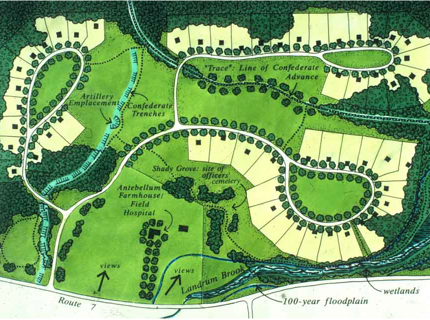
Conservation subdivision (above) with just under ¾ of an acre, 30,000 sq. ft., house lots with the SAME number of home sites (55) as the conventional subdivision below on the same 130 acre site. The conservation subdivision preserves almost two-thirds of the site, 62 percent, 81 acres.
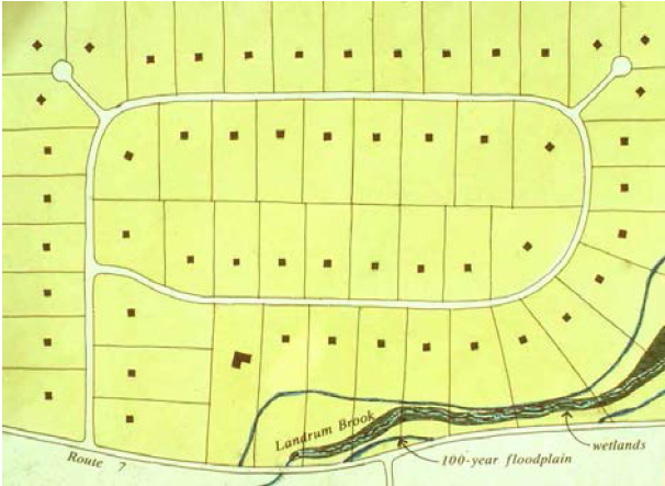
Conventional subdivision (above) with two acre house lots with the SAME number of home sites (55) on the same 130 acre site as the conservation subdivision at the top of the page.

