
Norwich City Zoning Code
CHAPTER 3
SPECIAL DISTRICTS
3.1 - Types of Special Districts.
Norwich has developed several overlay districts to refine how development can occur in accordance with the recommendations in the City's Plan of Conservation and Development. There are two ways in which the overlay tool is being utilized in these regulations: restrictive or permissive.
3.2 - Coastal Area Management Overlay District.
3.2.1
Depiction of coastal boundary; exemptions from coastal management act. The Norwich coastal boundary as defined in CGS § 22a-94 and depicted on the official Norwich coastal boundary map is reproduced for informational purposes on the Norwich zoning map.
3.2.2
All buildings, uses, and structures fully or partially within the coastal boundary as defined by CGS § 22a-94 entitled "An Act Concerning Coastal Management" shall be subject to the coastal site plan review requirements and procedures in CGS §§ 22a-105—22a-109 with the exception of the following activities which are hereby exempted from coastal site plan review requirements under the authority of CGS § 22a-109(b):
.1
Gardening, grazing and the harvesting of crops;
.2
Minor additions to or modifications of existing buildings or detached accessory buildings, such as garages and utility sheds;
.3
Construction of new or modification of existing structures incidental to the enjoyment and maintenance of residential property including but not limited to walks, terraces, driveways, swimming pools, tennis courts, docks and detached accessory buildings;
.4
Construction of new or modification of existing on premise fences, walls, pedestrian walks and terraces, underground utility connections, essential electric, gas, telephone, water and sewer service lines, signs and such other minor structures as will not substantially alter the natural character of coastal resources as defined by CGS § 22a-93(7) or restrict access along the public beach;
.5
Construction of an individual conforming single-family residential structure except in or within 100 feet of the following coastal resource areas as defined by CGS § 22a-93(7): tidal wetlands, coastal bluffs and escarpments, beaches and dunes;
.6
Activities conducted for the specific purpose of conserving or preserving soil, vegetation, water, fish, shellfish, wildlife and other coastal land and water resources;
.7
Interior modifications to building;
.8
Minor changes in use of building, structure or property except those changes occurring on property adjacent to or abutting coastal waters.
3.2.3
The foregoing exemptions from coastal site plan review requirements shall apply to the following site plans, plans and applications:
.1
Site plans submitted to the Commission in accordance with CGS § 22a-109;
.2
Applications for special permit submitted to the Commission on the City Plan in accordance with CGS § 8-2 and section 7.7 of these regulations;
.3
Applications for a variance submitted to the zoning board of appeals in accordance with CGS § 8-6(3) and section 7.8 of these regulations;
.4
A referral of a proposed municipal project to the Commission in accordance with CGS § 8-24.
3.2.4
In the cases where approval by any department of the state or city is required, said approval must be acquired prior to submission of the coastal site plan.
3.3 - Mill Reuse Overlay District.
3.3.1
Purpose. It is the intent of these regulations to encourage new development opportunities that will contribute to the economic stability of the city, encourage tourism and improve the quality of life for the residents of Norwich through the adaptive reuse, rehabilitation and preservation of the historic and/or architecturally unique resources that reflect Norwich's rich cultural past.
3.3.2
Designation, determination of eligibility; zoning requirements. The mill reuse overlay district shall be designated as those sites listed on the national or state register of historic places or local historic districts as either an individual building or site or as a contributing building or site in a registered district. Where eligibility has not been determined by the state historic preservation officer or the director of the Connecticut historical commission, the Commission on the City Plan may determine eligibility based on the recommendation of a qualified historic preservation expert, as provided by the applicant. The zone shall also include structures that are architecturally or historically notable, as determined by the Commission.
3.3.3
All zoning requirements applying to the underlying zone shall continue to govern the mill reuse overlay district unless as otherwise specified in this chapter.
3.3.4
Permitted uses. The following uses shall be permitted in the historic design overlay zone: The conversion of historic mill buildings located in any district to any use permitted in multi-family, neighborhood commercial, Chelsea Central district, general commercial, planned commercial, and business park.
3.3.5
Requirements. The following criteria must be met:
.1
The Commission shall determine if the conversion meets the intent of these regulations and the "mill enhancement program" ordinance. In making such determination, the Commission shall consider impact on the historic character of the subject property and on the adjacent neighborhood. If in the opinion of the Commission said proposal does not meet the intent of these regulations, the Commission shall deny said application. The city council has adopted an ordinance entitled the "Mill Enhancement Program" (MEP). It is the intent of the MEP to acknowledge the value of the historic mills as a resource, to encourage adaptive reuse of these mill buildings so as to promote economic stability and ensure the preservation of the city's heritage, to increase property values, to preserve the historic integrity of the mills and the associated villages, to improve the quality of life for the residents of the city and to encourage business investment in the community.
.2
An application for site plan approval shall be submitted in accordance with section 7.5 of these regulations.
.3
Parking shall be provided in accordance with section 5.1 of these regulations.
.4
The Commission on the City Plan may refer the application to the historic district commission, the city historian or a qualified historic architect for advisory review and comment. The Commission may consider the impact of the proposal on the architectural integrity of the mill as part of its review and, if in the opinion of the Commission said conversion will adversely impact the historic integrity of the mill and the potential adaptive reuse, the Commission may reject said request.
.5
Upon approval of the site plan application, the applicant shall obtain a conversion permit in accordance with section 1.1 of these regulations. Any other review or approval required by other city agencies shall be obtained by the applicant prior to submission of the conversion permit.
3.4 - Floodplain/Floodway Overlay.
3.4.1
Statement of purpose. The areas of special flood hazard and the floodway of the City of Norwich are subject to periodic inundation that may result in loss of life, property, health and safety hazards, the disruption of commerce and governmental services, extraordinary public expenditures for flood protection and relief, and the impairment of the tax base, all of which adversely affects the general welfare of the city and its residents.
3.4.2
It is the purpose of this chapter to promote the public health, safety and general welfare and to minimize public and private losses in flood prone areas by:
.1
Promoting the use of floodplains and floodways on public lands for open space and passive recreation and to encourage the acquisition of such vacant open space land located within the floodway and floodplain for public lands.
.2
Restricting and prohibiting uses which are dangerous to health, safety or property in times of flood or which cause increased flood heights or velocities.
.3
Requiring that uses vulnerable to floods, including public facilities which serve such uses, be provided with flood protection at the time of initial construction.
3.4.3
Lands to be regulated by these regulations. This chapter shall apply to all areas of special flood hazard and floodways identified by the Federal Emergency Management Agency (FEMA) in its Flood Insurance Study (FIS) for New London County, Connecticut, dated July 18, 2011, and accompanying Flood Insurance Rate Maps (FIRM), dated July 18, 2011, and other supporting data applicable to the City of Norwich, and any subsequent revisions thereto, are adopted by reference and declared to be a part of these regulations. Since mapping is legally adopted by reference into this regulation it must take precedence when more restrictive until such time as a map amendment or map revision is obtained from FEMA. The area of special flood hazard includes any area shown on the FIRM as Zones A and AE, including areas designated as a floodway on a FIRM. Areas of special flood hazard are determined utilizing the base flood elevations (BFE) provided on the flood profiles in the Flood Insurance Study (FIS) for a community. BFEs provided on a Flood Insurance Rate Map (FIRM) are only approximate (rounded up or down) and should be verified with the BFEs published in the FIS for a specific location.
.1
The requirements of these regulations shall be supplementary to the basic requirements of various zoning districts within Norwich in which a parcel or lot may lie and section 8.8.6 of these regulations.
.2
Violation. A structure or other development without required permits, lowest floor elevation documentation, flood-proofing certificates or required floodway encroachment calculations is presumed to be in violation of this chapter until such time as all required documentation is provided to the zoning enforcement officer.
.3
If any portion of a structure lies within the Special Flood Hazard Area (SFHA), the entire structure is considered to be in the SFHA. The entire structure must meet the construction requirements of the flood zone. The structure includes any attached additions, garages, decks, sunrooms, or any other structure attached to the main structure. Decks or porches that extend into a more restrictive flood zone will require the entire structure to meet the standards of the more restrictive zone.
.1
If a structure lies within two or more flood zones, the construction standards of the most restrictive zone apply to the entire structure (i.e., V zone is more restrictive than A zone; structure must be built to the highest BFE). The structure includes any attached additions, garages, decks, sunrooms, or any other structure attached to the main structure. (Decks or porches that extend into a more restrictive zone will require the entire structure to meet the requirements of the more restrictive zone.)
3.4.4
Interpretation of boundaries within the floodplain and floodway.
.1
The zoning enforcement officer shall determine initially upon request whether a lot or parcel of land lies wholly or partially within the floodplain and/or floodway as shown on the "flood insurance rate map" and any amendments thereto. The zoning enforcement officer may require that verification of elevations be provided by the applicant and/or owner of the property. Such verification shall be determined by a land surveyor licensed in the State of Connecticut and shall be based on the North American Vertical Datum (NAVD) of 1988.
.2
In floodplain and floodway areas, where there is no base flood elevation provided, the zoning enforcement officer shall obtain, review and reasonably utilize any base flood elevation and floodway data available from a federal, state or other sources, including data developed for applications submitted in accordance with section 3.4.6 and section 3.4.7 of these regulations.
.1
In AE zones where base flood elevations have been determined, but before a floodway is designated, the floodway location shall be determined by assuming that no new construction or substantial improvements or other development (including fill) will be permitted that will increase flood heights more than one foot at any point along the watercourse when all anticipated development is considered cumulatively (cumulative is the reasonable assumption that there will be total encroachment extending on both sides of the watercourse within the floodway fringe).
.2
The zoning enforcement officer may request floodway data of an applicant for watercourses without FEMA-published floodways. When such data is provided by an applicant or whenever such data is available from any other source (whether in response to the zoning enforcement officer's request or not), the zoning enforcement officer shall propose the adoption of a regulatory floodway overlay zone based on the principle that the floodway must be able to convey the waters of the base flood without increasing the water surface elevation more than 1.0 foot at any point within the community.
3.4.5
Floodways.
Located within Special Flood Hazard Areas (SFHA) are areas designated as floodways on the community's Flood Insurance Rate Maps (FIRM). Since the floodway is an extremely hazardous area due to the velocity of flood waters which carry debris, potential projectiles and has erosion potential, no encroachments, including fill, new construction, substantial improvements, repairs to substantially damaged structures and other developments shall be permitted unless certification, with supporting technical data, by a registered professional engineer is provided demonstrating, through hydrologic and hydraulic analyses performed in accordance with standard engineering practice, that encroachments shall not result in any (0.00 feet) increase in flood levels during occurrence of the base flood discharge. Fences in the floodway must be aligned with the flow and be of an open design. A permit may be given which allows encroachments resulting in increases in base flood elevations provided the community first obtains a conditional floodway revision by meeting the requirements of C.F.R. 44, Chapter 1, Subsection 65.12.
3.4.6
Permitted uses. The following uses shall be permitted within the floodplain upon the issuance of a zoning permit by the zoning enforcement officer, provided they are not prohibited by other ordinances, and they do not require structures (unless specifically listed) or changes in grades.
.1
Agricultural and silvicultural uses according to recognized soil and water conservation practices, including the building of fences. However, no solid design fences, such as stockade, shall be allowed to be placed within the floodway portion of the floodplain unless it is oriented parallel to the flow of floodwaters.
.2
Public and private open space uses such as golf courses, tennis courts, driving ranges, archery areas, parks, wildlife and nature preserves, game farms, fish hatcheries, hunting and fishing areas, hiking and horseback riding trails, provided that no such use shall pose a pollution threat to adjacent waterways. Such uses do not include any necessary associated paved parking lots, structures, dredging or filling.
.3
Residential uses such as lawns, gardens, paved or dust free stone driveways, installation of in-ground pools and associated flood proofed pump houses (not to exceed five feet by five feet and must be properly anchored to prevent flotation) and play areas. The filling in of an in-ground pool may occur provided the filling matches the surrounding topography.
.4
Unpaved parking (including any required paved driveway apron) areas, provided they do not allow materials to collect in such a way that they might be washed into the adjacent waterway and provided no change in elevation is proposed.
.5
Emergency replacement of existing on-site sewage disposal system, provided immediate action is necessary as determined by the zoning enforcement officer based on recommendation from the health district, municipal, state and regional departments.
.6
Removal and replacement of existing fuel storage tanks and associated regrading, provided existing grading is restored after the tank is removed and/or replaced. Such tanks shall be anchored to prevent buoyancy in flood conditions.
.7
Required public water supply property maintenance work.
.8
Building demolition.
.9
Required minor maintenance of city roads, such as repaving of existing roads, cleaning of culverts and minor drainage improvements to existing systems.
.10
Installation of public utilities, provided they are designed to minimize or eliminate infiltration of floodwaters into the system and discharge from the system into floodwaters.
.11
Public safety signs and other sign supports, provided they are properly anchored to prevent flotation.
.12
The zoning enforcement officer may require submission of an erosion and sediment control plan, and any other information necessary to ensure compliance with these regulations, and the review of the proposed improvements by the city engineer, the technical advisor to the inland wetlands, watercourses and conservation commission, the Connecticut department of environmental protection, the New London County Soil and Water Conservation District and the U.S. Army Corps of Engineers.
3.4.7
Special permit uses within the floodplain.
.1
Uses enumerated. The following uses which involve structures (temporary or permanent), fill, excavation of land, storage of materials or equipment may be permitted only by the granting of a special permit by the Commission on the City Plan; however, not including those uses permitted under section 3.4.6 and those uses prohibited under section 3.4.5 of these regulations; and provided the additional provisions of section 3.4.7.6 are addressed.
.2
Dams, culverts, bridges, dikes and flood-control projects, provided that such use has been approved by appropriate authorities at the regional, state and/or federal level, unless regional, state and/or federal regulations require local approval first.
.3
Paved roads, paved driveways and paved parking areas.
.4
Excavation of and the grading and regrading of lands including the deposition of topsoil and the grading thereof and the construction of retaining walls.
.5
Structures otherwise permitted in the zoning district in which the floodplain is located, provided that:
.1
All new construction and substantial improvements of residential structures, including manufactured or mobile homes, shall have the lowest floor (including the basement) elevated to one foot above the base flood elevation (BFE). All residential structures, including manufactured or mobile homes, to be repaired as a result of substantial damage, shall be elevated so that the bottom of the lowest floor is at least one foot above the base flood elevation (BFE).
.2
Manufactured (Mobile Homes and Recreational Vehicles (RV's) in accordance with Chapter 12 of the City of Norwich Ordinances:
In all Special Flood Hazard Areas (SFHA), any manufactured (mobile) homes to be newly placed, undergoing a substantial improvement or repaired as a result of substantial damage, shall be elevated so that the bottom of the frame is one foot above the base flood elevation (BFE). The manufactured home must also meet all the construction standards per Section 3.4.7.6. This includes SFHAs outside a manufactured home park or subdivision, or in an existing manufactured home park or subdivision, or on a site in an existing park which a manufactured home has incurred substantial damage as a result of a flood:
All manufactured (mobile) homes within a SFHA shall be placed on a permanent foundation which itself is securely anchored and to which the structure is securely anchored so that it will resist flotation, lateral movement and hydrostatic pressures. Anchoring may include, but not be limited to, the use of over-the-top or frame ties to ground anchors.
All manufactured (mobile) homes within a SFHA shall be installed using methods and practices which minimize flood damage. Adequate access and drainage should be provided.
Elevation construction standards include piling foundations placed no more than ten (10) feet apart, and reinforcement is provided for piers more than six (6) feet above ground level.
Recreational vehicles placed on sites within a SFHA shall either (i) be on the site for fewer than 180 consecutive days, and (ii) be fully licensed and ready for highway use, OR (iii) meet all the general standards of Section 5.1 and the elevation and anchoring requirement of Section 3.4.7.6.4. A recreational vehicle is ready for highway use if it is on its wheels or jacking system, is attached to the site only by quick disconnect type utilities and security devices, and has no permanently attached additions.
.3
All new construction and substantial improvements of nonresidential structures, including mixed use structures, shall:
(i)
Have the lowest floor (including the basement) elevated to one foot above the base flood elevation (BFE); or
(ii)
Together with attendant utilities and sanitary facilities, be designed so that the structure is flood proofed to one foot above the base flood level elevation (BFE), with walls substantially impermeable to the passage of water and with structural components having the capability of resisting hydrostatic and hydrodynamic loads and effects of buoyancy. A professional engineer or architect licensed in the State of Connecticut shall certify to the Commission on the City Plan and the building inspector that the construction of the building will comply with this section and other requirements outlined in the building code for the construction of buildings in a floodplain.
.6
Additional requirements for special permits. In addition to the requirements of the particular zoning district and the requirements of section 7.7, the following are additional requirements for improvements within the floodplain district:
.1
The water holding capacity of the floodplain, except those areas which are tidally influenced, shall not be reduced. Any reduction caused by filling, excavation, deposition, new construction, substantial improvements involving an increase in the footprint to the structure, storage of materials or equipment, whether permanent or temporary, shall be compensated for by deepening and/or widening of the floodplain. Storage shall be provided on-site, unless easements have been gained from adjacent property owners; it shall be provided within the same hydraulic reach and a volume not previously used for flood storage; it shall be provided within the same hydraulic reach and a volume not previously used for flood storage, it shall be hydraulically comparable and incrementally equal to the theoretical volume of flood water at each elevation, up to and including the 100-year flood elevation, which would be displaced by the proposed project. Such compensatory volume shall have an unrestricted hydraulic connection to the same waterway or water body. This standard shall be demonstrated by technical data, prepared by a professional engineer licensed in the State of Connecticut. Compensatory storage can be provided off-site if approved by the municipality.
Within the floodplain, except those areas which are tidally influenced, as designated on the Flood Insurance Rate Map (FIRM) for the community, encroachments resulting from filling, new construction or substantial improvements involving an increase in footprint of the structure, are prohibited unless the applicant provides certification by a registered professional engineer demonstrating, with supporting hydrologic and hydraulic analyses performed in accordance with standard engineering practice, that such encroachments shall not result in any (0.00 feet) increase in flood levels (base flood elevation). Work within the floodplain and the land adjacent to the floodplain, including work to provide compensatory storage shall not be constructed in such a way so as to cause an increase in flood stage or flood velocity.
.2
The Commission on the City Plan may permit development with varying levels of compensatory flood storage or without compensatory flood storage if the Commission on the City Plan determines it is not technically feasible to equally counterbalance the encroachment or it is not reasonable to provide such storage due to the existence of one or more of the following conditions:
(i)
The provision of such storage would require significant blasting due to geological conditions.
(ii)
The provision of such storage will adversely impact the historical integrity of existing structures on the site.
(iii)
The provision of such storage will adversely impact important natural and archaeological resources on the site.
(iv)
Such compensation will prevent the reuse of existing structures and improvements.
Technical data prepared by a qualified professional engineer licensed in the State of Connecticut shall be provided to enable the Commission on the City Plan to determine compliance with this section and sections 3.4.7.6.1 and 3.4.7.6.2. The Commission on the City Plan (or the inland wetlands, watercourses and conservation commission to assist in making a recommendation) may require additional information prepared by other qualified professionals to determine if compensatory storage should be required or waived in accordance with items 1—4 of this subsection. All applicants requesting a waiver in accordance with [items] 1—4 above shall submit a request for a waiver with the application for the special permit and shall outline specific reasons substantiating the request for the waiver. If the applicant does not provide such information as part of the application, the Commission on the City Plan shall deny the waiver and the special permit application.
.3
New construction and substantial improvements shall have the bottom of all in-structure mechanicals, such as electrical, heating, ventilation, plumbing, air conditioning equipment, and other service facilities, elevated to one foot above the base flood elevation to prevent water from entering or accumulating within the components during conditions of flooding. This includes, but is not limited to, furnaces, oil or propane tanks, air conditioners, heilt pumps, hot water heaters, ventilation ductwork, washer and dryer hook-ups, electrical junction boxes, and circuit breaker boxes.
.4
New construction and substantial improvements shall be anchored to prevent flotation, collapse or lateral movement, and shall be developed using methods and practices that minimize flood damage and shall be constructed with materials resistant to flood damages. A professional engineer and/or architect licensed in the State of Connecticut shall certify that such building construction complies with the provisions of this section.
.5
New sanitary sewage systems shall be designed to minimize or eliminate infiltration of floodwaters into the system and discharge from the system into floodwaters. New and replacement water supply systems shall be designed to minimize or eliminate infiltration of flood waters into the system. On-site waste disposal systems shall be located and constructed to avoid impairment to them or contamination from them during flooding.
.6
Fully Enclosed Areas Below the Base Flood Elevation of Elevated Buildings. All structures and substantial improvements, or repair to structures that have sustained substantial damage, whether residential or non-residential, that include fully enclosed areas formed by a foundation and other exterior walls shall have the lowest floor elevated to one foot above the base flood elevation. The elevated building shall be designed to preclude finished living space below the lowest floor and be designed to allow for the entry and exit of flood waters to automatically equalize hydrostatic flood forces on exterior walls (wet flood-proofing). Designs for complying with this requirement must either be certified by a registered professional engineer or architect, or meet the following minimum criteria listed in sections (a)—(g) below:
(a)
Provide a minimum of two openings (hydraulic flood vents) having a total net area of not less than one square inch for every one square foot of enclosed area subject to flooding. These hydraulic openings must be located on at least two different walls. Only the area (square footage) that lies below the BFE can be used in the calculation of net area of vents required. If the structure has more than one enclosed area, openings must be installed in the exterior walls of each enclosed area so that flood waters can enter directly from the outside;
(b)
The bottom of all openings shall be no higher than one foot above grade. At least one side of the structure's fully enclosed area must be at or above grade. Fill placed around the foundation walls must be graded so that the elevation inside the enclosed area is equal to or higher than the adjacent outside elevation on at least one side of the building. The finished floor of the enclosed area shall be no lower than the bottom of the foundation openings. The foundation slab of a residential structure, including the slab of a crawlspace, must be set equal to the outside finished grade on at least one side of the building;
(c)
The openings may be equipped with screens, louvers, valves or other coverings or devices provided they permit the automatic entry and exit of flood waters in both directions without any external influence or control such as human intervention, including the use of electrical and other non-automatic mechanical means. Other coverings may be designed and certified by a registered professional engineer or approved by the zoning enforcement officer;
(d)
The area cannot be used as finished living space. Use of the enclosed area shall be the minimum necessary and shall only be used for the parking of vehicles, building access or limited storage. Access to the enclosed area shall be the minimum necessary to allow for the parking of vehicles (garage door) or limited storage of maintenance equipment used in connection with the premises (standard exterior door) or entry to the living area (stairway or elevator). The enclosed area shall not be used for human habitation or partitioned into separate rooms;
(e)
All interior walls, floor, and ceiling materials located below the BFE plus one foot shall be unfinished and resistant to flood damage.
(f)
Electrical, plumbing, HVAC ductwork, machinery or other utility equipment and connections that service the structure (including, but not limited to, furnaces, oil or propane tanks, air conditioners, heat pumps, hot water heaters, ventilation, washers, dryers, electrical junction boxes, circuit breaker boxes and food freezers) are prohibited in the fully enclosed area below the BFE plus one foot. Utilities or service equipment located in this enclosed area, even if elevated one foot above the BFE in the space, will subject the structure to increased flood insurance rates.
(g)
A residential building with a structurally attached garage having the floor slab below the BFE is considered an enclosed area below the BFE and must meet the standards of Sections 3.4:7.6.6(a)—(f). A garage attached to a residential structure, constructed with the garage floor slab below the BFE, must be designed to allow for the automatic entry and exit of floodwaters n both directions. Flood openings or vents are required in the exterior walls of the garage or in the garage doors. The human intervention necessary to open garage doors when flooding occurs is not an acceptable means of meeting the openings requirements. In addition to the automatic entry of floodwaters, the areas of the garage below BFE plus one foot must be constructed with the flood resistant materials. Garages attached to non-residential structures must also meet the aforementioned requirements or be dry flood proofed as per the requirements of Section 3.4.7.5.2.
.7
The project shall not tend to reduce the value or usefulness of other properties in the floodplain or near the floodplain due to increase in flood heights.
.8
The project shall not present a potential pollution hazard to soil, ground or surface waters.
.9
The project will protect human life and health and limit property damage.
.10
The project shall not endanger public facilities such as flood-control projects, water, sewer, gas, and electrical lines, streets and bridges.
.11
Structures shall be constructed and placed on the building site so as to offer the minimum obstruction to the flow of floodwater and to objects and debris carried by the floodwaters.
.7
Application procedures for special permits. Applications for approval of any special permits for improvements within the floodplain and floodway shall be submitted to the Commission on the City Plan in accordance with the specifications of section 7.4 of these regulations and this chapter, and on an application form furnished by the Commission on the City Plan. Such application shall be accompanied by the following information:
.1
Five sets of plans drawn to scale, showing the nature, location, dimensions and elevation of the lot, existing and/or proposed structure (indicating lowest floor elevation, including basement), fill, storage of and type of materials, location of the foregoing in relation to the floodway, floodplain, wetland areas, watercourses and any other natural resources. Such plan shall be prepared by a land surveyor and/or professional engineer licensed in the State of Connecticut, whichever is applicable.
.2
Flood impact studies, certified by a professional engineer licensed in the State of Connecticut, indicating the effects of the proposed use on the drainage systems upstream and downstream, the watercourse, the floodplain and any associated wetland areas. Such studies shall also indicate how the application will comply with sections 3.4.7.5 and .3.4.7.6.1 through 3.4.7.6.11 of these regulations. The Commission on the City Plan may waive the requirement of the preparation of the flood study or impact statement by a professional engineer if in the Commission's opinion the proposed activity is insignificant and provided the city engineer and the inland wetlands, watercourses and conservation commission recommend that the preparation of such statement or study by a professional engineer is not necessary.
.3
A copy of any necessary federal and state permit applications. Prior to construction, the applicant shall provide documentation to the zoning enforcement officer to assure that all necessary permits have been received. Copies of such permits shall be maintained on file with the application submitted under this section.
.8
Review by other regulatory bodies. Upon receipt of the application, the Commission on the City Plan shall refer the application to the inland wetlands, watercourses and conservation commission (IWWCC) for review and comment.
.1
The Commission on the City Plan may also refer the application to the city engineer, the New London County Soil Conservation (Service) District, Connecticut Department of Energy and Environmental Protection, the U.S. Army Corps of Engineers and/or a competent professional consultant for review and comment.
.2
The Commission on the City Plan shall request that comments be provided within 30 days of the Commission's request.
.9
Notification of other municipalities and agencies. The Commission on the City Plan shall notify any municipality within 500 feet of the proposed development, the department of environmental protection, inland water resources division, and the Federal Emergency Management Agency prior to any alteration or relocation of a watercourse and shall submit evidence that maintenance is provided within the altered or relocated portion of said watercourse so that the flood-carrying capacity is not diminished.
.10
Public hearings. The Commission on the City Plan shall conduct a public hearing on all requests for special permit applications for improvements within the floodplain and floodway. Such hearing shall be conducted in accordance with section 7.7.3 of these regulations.
.11
Fees. Each application for a special permit under this section, in addition to the required fee under section 1.1, shall be accompanied by a fee of one-tenth of one percent of the estimated cost of construction of the project, provided that municipal agencies shall not be required to pay a fee. The proceeds of such fees may be used by the Commission to pay for professional consultation concerning the project.
.12
Provision of flood proofing. Prior to the issuance of a zoning compliance certificate, the zoning enforcement officer shall require the applicant to provide an as-built plan prepared by a land surveyor licensed in the State of Connecticut showing the elevation of the lowest floor including the basement, the level to which any nonresidential structure has been waterproofed, and/or grades for those areas re-graded.
.13
The zoning enforcement officer or city planner shall maintain a record of certification for flood proofing as required by section 3.4.7.5.1 and 3.4.7.5.2, and any other design or plan certifications as may be required under these regulations.
3.4.8
Variances. Variances of the provisions of this chapter may be granted by the zoning board of appeals in accordance with the provisions of section 8.8.4 and the following:
.1
No variance shall be granted that will result in increased flood heights more than one foot at any point along the length of the watercourse, as required by the provisions of the Flood Insurance Program.
.2
No variance shall be granted that will result in additional threats to public safety, extraordinary public expense, nuisances or victimization of the public.
.3
Upon the granting of the variance, the zoning board of appeals shall notify the applicant in writing that:
.1
The granting of the variance to construct a structure below the base flood level will result in increased premium rates for flood insurance up to amounts as high as $25.00 for $100.00 of insurance coverage.
.2
Such construction below the flood level increases risks to life and property.
.4
The notification information outlined in this section shall appear in the variance form filed with the city clerk's office.
.5
The zoning board of appeals shall maintain a record of all variances granted, including justification for their issuance and report any variance to the Federal Emergency Management Agency (FEMA) in its biennial report.
3.4.9
Municipal liability. The granting of a special permit, variance or zoning permit shall not constitute a representation, guarantee or warranty of any kind by the city, its officials, agents or employees of the practicability or safety of the proposed use or structure and shall create no liability upon the city, its agents or its employees.
(Ord. No. 1743, Exh. B, 4-17-17; Ord. No. 1792, 12-7-20)
3.5 - Adaptive Reuse Overlay District.
3.5.1
Purpose.
.1
The purpose of this overlay district is to encourage restoration and preservation of existing buildings of historic value and to promote harmony of surrounding land uses. There are some uses, both residential and commercial, which would enhance historic structures and would not disrupt the neighborhood if properly conducted.
.2
Therefore, by special permit, the following uses may be allowed in a historic structure located within the adaptive reuse overlay district subject to the conditions listed below. Each use will be considered on a case-by-case basis, and further reasonable conditions may be imposed by the Commission. The list of uses is not all-inclusive; applicants with proposed uses not listed are encouraged to apply for a historic conversion permit if their proposed use is in harmony with the intent of this regulation.
3.5.2
Special Permit Uses. In addition to the uses allowed in the underlying zone, the following uses may be authorized through the issuance of the Special Permit by the Commission, in accordance with section 7.7:
.1
Antiques shops.
.2
Bed and breakfast inn.
.3
Bookstores.
.4
Galleries.
.5
Gift shops.
.6
Hotels/inns in accordance with section 6.13.
.7
Multi-family residence (within the existing building footprint).
.8
Museums.
.9
Professional offices.
.10
Restaurants.
.11
Tourist homes.
.12
Winery.
3.5.3
Standards. For properties located in the adaptive reuse district.
.1
Structure must be designated as historically significant by:
.1
Registry in the National Register of Historic Places or the State Register of Historic Places, or
.2
By the Commission on the City Plan upon presentation by the applicant of adequate evidence of historic significance such as the City of Norwich Historic Resources Survey.
.2
Where applicable, a site plan, and floor plans/sketches will be submitted with application. Commission may waive site plan requirement if the scope of the project does not warrant a site plan.
.3
Architectural integrity of the structure must be preserved, and the proposed use must be in harmony with surrounding uses.
.4
The proposed use must meet all health and safety requirements such as: adequate water supply for drinking and fire-fighting, adequate sewage disposal, safe traffic flow and control, drainage, off-street parking; wetlands approval where needed, etc., as well as building code requirements.
.5
Off-street parking shall be provided, except when the Commission finds that sufficient public parking is available within 500 feet of the site. Off-street parking spaces shall not be located in a front yard.
.6
There is no lot size requirement; however, an existing lot cannot be split if the split creates any nonconforming lot (including the lot containing the historic structure).
.7
No evidence of the nonresidential use shall be visible from the public right-of-way, except for a business sign not to exceed 25 square feet.
3.6 - Agriculture Business Overlay District.
3.6.1
Purpose. The agriculture business district is intended to retain land in agricultural and other compatible low intensity development, in areas where utilities are suitable for these uses, to enable this area to conduct additional business operations related to the agricultural heritage of eastern Connecticut.
3.6.2
Special Permit Uses. In addition to the uses allowed in the underlying zone, the following uses may be authorized through the issuance of the Special Permit by the Commission, in accordance with section 7.7:
.1
Breweries and distilleries.
.2
Commercial riding stables.
.3
The manufacturing, compounding, processing and/or packing of food products, except for the rendering or refining of fats and oils.
.4
Veterinary hospitals.
.5
Vocation schools focusing on agriculture.
.6
Wineries.
3.6.3
The following uses may be permitted as accessory uses. Accessory uses do not need to be located in the same building as the principal use.
.1
Event and conference space.
.2
Office.
.3
Retail store.
.4
Tasting room.
.5
Visitor center/Information center.
.6
Warehouse.
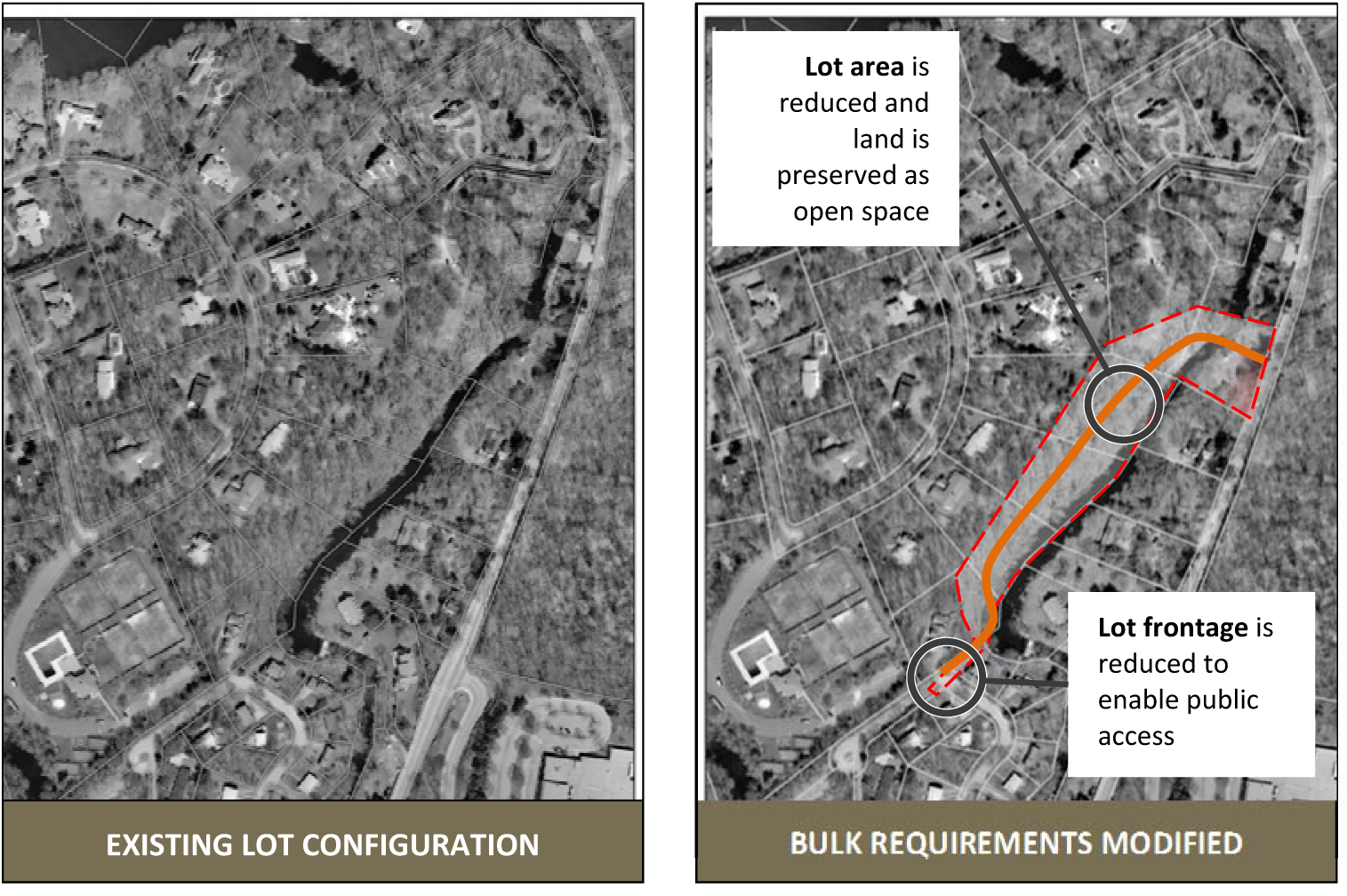
3.7 - Greenway Open Space District.
3.7.1
Purpose.
3.7.2
The Greenway open space district is an overlay district. It has been developed to provide bulk requirement flexibility in the underlying zoning district, in order to:
.1
Protect, conserve, enhance, and maintain the natural, scenic, historical, economic, and recreational qualities of lands in the city.
.2
Establish criteria, standards, and procedures for the development of land, change of uses, and the intensification of uses within the greenway.
.3
Increase public access to and along the Shetucket, Thames and Yantic rivers for the purpose of increasing recreational opportunities, providing emergency vehicle access, assisting in flood protection and control, providing connections to other transportation systems.
3.7.3
Eligible Areas. Areas designated as "potential corridors," or "potential open space connections" in the Plan of Conservation and Development, or officially designated by the Connecticut Greenways Council, and depicted on the Zoning Map of the City of Norwich.
3.7.4
Bulk Modifications.
The Commission may reduce the minimum yard (i.e., front, side, rear), minimum lot size and minimum frontage requirements in sections 1.1 and 2.1 for properties location with the Greenway Open Space district through the special permit process (section 7.7), provided the portion of the lot for which the reductions were needed is deed as open space to the City of Norwich, or a nonprofit land trust operating within the City.
ILLUSTRATION
3.7.5
Uses in the greenway open space district. All uses allowed in the underlying zoning district shall be allowed in the greenway open space district except when land has been dedicated to open space purposes in accordance with this section.
3.7.6
The modified bulk requirements shall be recorded on the Land Records of the City of Norwich.
3.8 - Neighborhood Redevelopment District (NRD).
3.8.1
General. The City of Norwich recognized that there exists under-utilized commercial properties located in close proximity to the village cores which create a unique opportunity for neighborhood redevelopment as acknowledged in and described as essential for, implementation in the Plan of Conservation and Development (POCD). The redevelopment of these sites are a sensitive matter to the City and the neighborhoods being impacted, as such any decisions and determinations made with respect to these properties would require assurances for the City and its residents that its existence and future plans will enhance, and not disrupt, the surrounding residential neighborhood. Accordingly the City does hereby create a special neighborhood redevelopment district (NRD).
3.8.2
Purpose. The NRD is intended to: encourage the reclamation of underutilized commercial parcels and permit new construction, renovation and/or adaptive re-use at these sites; promote diversified housing opportunities, including, but not limited to, mixed-use development uses; and preserve and enhance the City's historic character and these neighborhoods in the structure nodes. This zone is intended to allow for the establishment, continuation and expansion of such uses and activities in ways that will maintain and enhance compatibility with surrounding neighborhoods. Factors to be considered by the Commission in approving the NRD include:
.1
The proposed uses and layout are in conformity with and in furtherance of the goals and objective contained in the POCD.
.2
Harmony and compatibility with surrounding residential neighborhoods, land uses and the nodes, including adequate buffers that are consistent with the existing condition on the site, neighborhood and/or structure node, promotion of pedestrian safety, provision for adequate parking, minimized impact of motor vehicles, and prevention of glare to adjacent properties from lighting on-site. To the extent practical, commercial and tourist traffic shall be directed to major thoroughfares and away from residential streets.
.3
Furtherance of the policies of the Coastal Area Management Act.
3.8.3
Master Plan. A Master Plan shall be prepared by an applicant. The purpose of the Master Plan submission is to determine whether the proposed uses and layout conform to the NRD requirements and to the POCD. The Master Plan shall include:
.1
Plan showing site conditions and structures, including wetlands and watercourses, which, along with other surveys and plans listed below, shall be at a scale of 1" = 40 feet or larger by a Connecticut-licensed architect, surveyor or engineer.
.2
A description of the existing uses of the property and their present location prepared by the applicant or its consultant(s).
.3
Plan indicating structures to be retained, substantially rehabilitated, or demolished; new structures to be built on the property; parking areas; vehicular and pedestrian circulation; and any areas to be landscaped or dedicated to public use. This plan shall be prepared by a licensed architect and/or engineer, as applicable, and provide sufficient information to determine proposed uses and size of buildings, including heights, floor area ratios, and lot coverage and the amount of off-street parking to be provided, if any. For purposes of this provision, the Commission shall take into account commercial properties located within a one-half mile radius of the proposed site in determining whether the height, floor area ratio and lot coverage are consistent with those neighboring properties.
.4
A description of any proposed new uses or change in uses and their proposed location on the site by the applicant or its consultant(s).
.5
Narrative report prepared by the applicant or its consultant(s) describing the proposed new uses and changes in uses and the proposed structures to house said uses, including style and method of building construction and the cumulative amount of square feet intended for each type of proposed new use.
.6
Preliminary traffic impact report prepared by a professional engineer for any proposed new use.
.7
Information on the location, availability, and capacity of public utilities capable of serving the development for any proposed new use.
.8
An impact statement prepared by the applicant or its consultant(s) regarding the effect, if any, of the proposed new uses or change in uses on surrounding residential properties and a description of what, if any, changes are proposed in flow of traffic or pedestrians, as well as buffering to minimize the impact.
3.8.4
Site Plan. After Master Plan approval and establishment of the zone by the Commission, an application for a site plan must be submitted for approval, following the provisions contained in Article VIII of these Regulations. The Commission shall schedule a public hearing for the site plan application.
3.8.5
Specific Design Standards. The following design standards shall apply to the NRD:
.1
Area and Bulk Requirements. Existing structures located within the NRD are deemed to be conforming in terms of any encroachments on maximum height, maximum lot coverage and floor area ratio.
.1
Minimum district size: 100,000 square feet
.2
Minimum front yard: 0 feet
.3
Minimum side yard: 0 feet
.4
Minimum rear yard: 0 feet
.5
Maximum height: 7 stories
.2
Signs. A sign plan, indicating the general position, content, and appearance of signs visible from the public right-of-way. No detached sign within the NRD shall exceed the height of the highest building on the parcel upon which that sign is located, except that where a detached sign is located upon a parcel that is used solely for parking, no sign shall exceed 20 feet in height.
.3
Buffers.
.1
Performance Buffers. The Commission will carefully analyze any buffers between the NRD and surrounding residential neighborhoods and may tailor buffers to include greater setbacks, landscaping, fences, walls, and berms, considering the relative heights of the uses on each side of the buffer. The Commission may allow for buffering on adjacent property with consent of the affected property owner (e.g., landscaping, fence, or wall).
.2
Standard Buffers. Unless otherwise approved in the Master Plan, buffers for non-residential uses shall be established and maintained as 25 feet with 10 feet of screening from adjoining residential zone and/or any additional buffer requirements as determined by the Commission. The Commission may require additional buffers of such size, type and material as it deems reasonably necessary to protect adjacent properties or important natural resources. When reduction of buffers is allowed, the Commission shall require, where appropriate, performance buffers.
3.8.6
Prohibited Uses. Uses prohibited in the NRD shall include: Gasoline filling stations; Motor vehicle and trailer coach sales, leasing and renting; Tire sales establishments; Auto repair shops and paint shops; Car washes, and Drive-through windows.
3.9 - Incentive Housing Overlay District (IH).
3.9.1
Purpose.
.1
The Incentive Housing Overlay (IH) is adopted pursuant to the authority of CGS Chapter 124b. Its purpose is to encourage housing affordability in both residential and business districts that have the transportation connections, nearby access to amenities and services, and infrastructure necessary to support concentrations of development.
.2
The IH seeks to avoid sprawl and traffic congestion by encouraging a more vibrant residential component to business or mixed use areas to sustain a lifestyle in which residents can walk or use public transportation to reach jobs, services, and recreational or cultural opportunities.
.3
It is a further purpose that the IH enable development and reuse of existing, historic or underutilized buildings or properties in Norwich that may otherwise be lost to progress.
3.9.2
General Requirements.
.1
Any such zone shall be in compliance with the locational requirements of CGS Chapter 1245b. The Commission may designate subzones within an overall IH in which different types of uses may be permitted, as in the case of a mixed-use incentive housing development.
.2
Each IH may consist of one or more subzones, which may overlay each other as well as the underlying district. Within any IH, there may be any or all of 3 subzones, designated as:
.1
Townhouse TH Subzone,
.2
Multi-family MF Subzone, or
.3
Mixed-use MU Subzone.
3.9.3
Bulk Requirements. The following Bulk Requirements shall apply when an IHZ project is proposed. The requirements in the Underlying Zone (UZ) remain in effect when noted UZ.
TABLE NOTES
A.
1 See 2013 Plan of Conservation and Development, Community Structure Map.
B.
UZ = Underlying zone; see multifamily dwellings bulk requirements in Section 6.4.
3.
9.4 Density. Density is calculated by the number of units allowed per area.
.1
Where an incentive housing development contains a mix of the above dwelling types, the land occupied by non-residential uses will be included in the residential density calculation. The residential densities will be calculated by apportioning the total acreage of the incentive housing development in the same proportion that each type of housing bears to the total number of dwelling units.
.2
For any incentive housing development to be developed in phases each phase will comply with the minimum residential densities and the incentive housing restrictions set forth in this section.
3.9.5
Public Applicant. In the case of an incentive housing development proposed by a public applicant, the residential densities will be in accordance with a waiver as may be granted by the Secretary of the Office of Policy and Management in accordance with CGS § 8-13n(b)(3).
3.9.6
Buffers.
.1
From Rear Property Line.
.1
Where the underlying district is a residential district, no less than 10 feet.
.2
Where the underlying district is business or industrial district, in accordance with the underlying district.
.3
For non-residential uses, in accordance with the underlying district.
.2
From Other Property Line.
.1
Where the underlying district is a residential district, no less than 10 feet.
.2
Where the underlying district is a business or industrial district, in accordance with the underlying district.
.3
For non-resident uses, in accordance with the underlying district.
3.9.7
Minor Accessory Buildings or Structures.
.1
For residential uses, same as for principal buildings or structures, above.
.2
For non-residential uses, in accordance with the underlying district.
3.9.8
Principal Uses and Activities.
.1
Prior to the approval of any application for Certificate of Zoning Compliance for any Incentive Housing Development that includes any principal or accessory use permitted under this Section; a Site Plan will be submitted to and approved by the Commission in accordance with Section 7.5. In considering an incentive housing development, the Commission will find that any application for an incentive housing development will comply with the provisions of this Section, as well as the Site Plan Objectives and, for uses requiring a Special Permits, the General Standards for Special Permit Uses in section 7.7.
.2
Any principal use as permitted in the underlying district and subject to the requirements and approval procedures as may be applicable to the uses. When proposed in conjunction with an Incentive Housing Overlay Zone use.
3.9.9
Mixed Uses.
.1
For any incentive housing development in a mixed-use subzone, the Commission may allow by Special Permit the inclusion of uses otherwise permitted by Site Plan or Special Permit in the underlying district provided that the minimum residential densities are met for the total incentive housing development.
.2
In any mixed-use incentive housing development, at least 50 percent of the gross floor area of the first story will be non-residential uses. Bulk requirements for stand-alone non-residential uses in an incentive housing development will be in accordance with the requirements of the underlying district.
3.9.10
Special Permits. Prior to the approval of any application for Certificate of Zoning Compliance for any incentive housing development that includes any principal or accessory use permitted by Special Permit under this section, an application for Special Permit use, including a Site Plan, will be submitted to and approved by the Commission.
3.9.11
Accessory Uses. Any accessory use as permitted in the underlying district and subject to the requirements and approval procedures as may be applicable to the uses.
3.9.12
Incentive Housing Restriction. For an incentive housing development proposed by a private applicant at least 20 percent of the dwelling units will be rented or conveyed subject to an incentive housing restriction requiring that, for at least 30 years after the initial occupancy of the development, the dwelling units will be sold or rented at, or below, prices that will preserve the units as housing for which persons pay 30 percent or less of their annual income, where the income is less than or equal to 80 percent or less of the median income. In determining compliance with this paragraph, the Commission will utilize regulations or guidelines published by the Connecticut Office of Policy and Management, or any other successor agency designated in accordance with CGS §§ 8-13m to 8-13x.
3.9.13
Public Applicant for Incentive Housing Development. For an incentive housing development proposed by a public applicant, 100 percent of the dwelling units will be rented or conveyed subject to an incentive housing restriction requiring that for at least 30 years after the initial occupancy of the development, the dwelling units may be sold or rented at, or below, prices that will preserve the units as housing for which persons pay 30 percent or less of their annual income, where the income is less than or equal to 80 percent or less of the median income. In determining compliance with this paragraph, the Commission will utilize regulations or guidelines published by the Connecticut Office of Policy and Management or any other successor agency designated in accordance with CGS §§ 8-13m to 8-13x.
3.9.14
Submission of Affordability Plan. Each applicant for an incentive housing development will provide an affordability plan that will detail the administration, monitoring and enforcement of the dwelling units to be sold or rented at below-market rates as described above. The plan will include proposed deed restrictions or covenants, lease agreements, common interest ownership documents, bylaws, rules and regulations, sample income calculations, and any other information as the Commission may require to establish compliance with this Section and CGS §§ 8-13m to 8-13x.
3.9.15
Designation of Administering Agency. The applicant will indicate the name, address and other contact information for the agency that will administer the sale or rental of dwelling unit: that are subject to the below-market sale or rental in accordance with this Section.
3.9.16
Approval of IH Zone or Subzones.
.1
In considering each subzone, or any IH Zone as a whole, the Commission will find that any application for an Incentive Housing Overlay Zone or subzone will comply with the provisions of this Section and the CGS Chapter 124b.
.2
In establishing a subzone, the Commission will have the discretion to exclude one (1) or more uses that would otherwise be permitted in an incentive housing development in that subzone, including uses permitted in the underlying district, which exclusions, if any, will be stated in the resolution creating or amending the subzone and will become part of the text describing the Incentive Housing Overlay Zone.
3.9.17
Application Processing For Incentive Housing Developments. Incentive Housing Development Proposed within an Existing Incentive Housing Overlay Zone. For incentive housing developments involving land already designated as an Incentive Housing Overlay Zone on the Norwich Zoning Map, applicants shall submit a site plan application in accordance with section 7.5 of these regulations.
3.10 - Village District Overlay (VDO)
3.10.1
Purpose.
.1
The Village District Overlay (VDO) is adopted pursuant to the authority of G.S. § 8-2j with the purpose to establish Village Districts in areas of distinctive character, landscape or historic value that have been specifically identified in the Norwich Plan of Conservation and Development (POCD).
.2
Village Districts are identified in the 2013 Plan of Conservation and Development as a strategy for enhancing Norwich's physical character (p.38). The POCD recognizes several community nodes as focal points where compatible development may reinforce a sense of place for residents and enhance community character. These include, but are not limited, to Norwichtown, Occum, Thamesville, Greeneville, Bean Hill, Downtown and Taftville.
.3
Establishment of village districts will encourage the conversion, conservation and preservation of existing buildings and sites in a manner that maintains the historic or distinctive character of the specific district.
3.10.2
Objectives. To protect the distinctive character, landscape and historic structures, the Commission on the City Plan shall regulate, on and after the effective date of these regulations, new construction, substantial reconstruction and rehabilitation of properties within an established village district and in view from public roadways, including, but not limited to, (1) the design and placement of buildings, (2) the maintenance of public views, (3) the design, paving materials and placement of public roadways, and (4) other elements that the commission deems appropriate to maintain and protect the character of the village district. These regulations shall not apply to existing structures used solely for residential purposes. To accomplish these objectives:
.1
Buildings, the layout of buildings, and included site improvements shall reinforce existing buildings and streetscape patterns and the placement of buildings and included site improvements shall assure there is no adverse visual effect on the district;
.2
The maintenance of historic buildings, monuments, and landscaping shall be encouraged;
.3
Proposed streets and walkways shall be connected to the existing district road network, wherever possible;
.4
Open spaces within the proposed development shall reinforce open space patterns of the district, in form and siting;
.5
Locally significant features of the site such as distinctive buildings, sight lines or vistas from within the district, shall be integrated into the site design;
.6
Landscape design shall complement the district's landscape patterns;
.7
Exterior signs, site lighting and accessory structures shall support a uniform architectural theme if such a theme exists and be compatible with their surroundings; and
.8
The scale, proportions, massing and detailing of any proposed building shall be in proportion to the scale, proportion, massing and detailing in the district.
3.10.3
Village District Design Guidelines. The Council of the City of Norwich shall adopt Village District Design Guidelines following review by the Commission on the City Plan, which may be updated from time to time, by the Council of the City of Norwich to include specific criteria to encourage compatibility for each particular village district. The guidelines shall include design criteria to achieve the compatibility objectives stated in Section 3.10.2. The regulation concerning the exterior structures or sites shall be consistent with the (A) "Connecticut Historical Commission - The Secretary of the Interior's Standards for Rehabilitation and Guidelines for Rehabilitating Historic Buildings", revised through 1990, as amended; or (B) the distinctive characteristics of the district identified in the municipal Plan of Conservation and Development. The regulations shall establish criteria from which a property owner and the commission may make a reasonable determination of what is permitted or encouraged within such district.
3.10.4
General Requirements. Utilizing the Village District Design Guidelines, the following shall be considered in all development proposals:
.1
Proposed buildings or modifications to existing buildings shall be harmoniously related to their surroundings, and the terrain in the district and to the use, scale and architectural style of existing buildings in the district that have a functional or visual relationship to a proposed building or modification,
.2
All spaces, structures and related site improvements visible from public roadways shall be designed to be compatible with the elements of the area of the village district in and around the proposed building or modification,
.3
The color, size, height, location, proportion of openings, roof treatments, building materials and landscaping of commercial or residential property and any proposed signs and lighting shall be evaluated for compatibility with the local architectural motifs and the maintenance of views, historic buildings, monuments and landscaping, and
.4
The removal or disruption of historic traditional or significant structures or architectural elements shall be minimized.
3.10.5
Village District Uses:
Norwichtown:
Bed and breakfasts, as well as current uses within the underlying zones, are allowed in the Norwichtown Village District. The following uses are not permitted in the Norwichtown Village District:
.1
Excavation and Earth Removal Operations
.2
Large public utility facilities
.3
Solar equipment, 1 megawatt (mW) and greater
.4
Commercial kennels
.5
Boat sales (i.e., display and repair, including sale of marine equipment or products) or Docks, slips, piers, Marina/yacht clubs
.6
Motor vehicle fueling stations (NOTE: Repair is a storage occupancy)
.7
Motor vehicle retail (e.g., passenger cars, recreation vehicles and mobile homes)
.8
Motor Vehicle Repair Garages
.9
Car Wash Facility
.10
Storage Rental Facility
.11
Any exterior storage not shielded from public view
3.10.6.
Regulated Activities. All applications for new construction and substantial reconstruction within the district and in view from public roadways shall be subject to review and recommendation by an architect or architectural firm, landscape architect, or planner who is a member of the American Institute of Certified Planners contracted by the City of Norwich and selected by the Commission on the City Plan and designated as the village district consultant for such application. Alternatively, the Council of the City of Norwich may adopt an ordinance to designate an architectural review board as the village district consultant whose members shall include at least one architect, landscape architect or planner who is a member of the American Institute of Certified Planners. Should the commission hire an outside consultant for review of village district proposals, such services shall be paid by the applicant.
3.10.7
Application Process. The City has established a tiered approach to review development proposals based on their complexity. It is at the discretion of the Zoning Enforcement Officer to determine the appropriate tier:
Tier 1 Activities:
.1
Sign, awning, lighting, public art/historical markers, solid waste, and recycling storage, fire exits, and handicapped access or fence.
Tier 2 Activities:
.1
Replacement of stairs, accessory buildings, landscaping, minor additions of 200 square feet or less, sidewalks, siding and facades, or window and door replacement.
Tier 3 Activities:
.1
New structures, major additions of over 200 square feet, new paved parking lots, scale roof-mounted solar systems, and any application or site plan that requires approval from the Commission on the City Plan.
.2
All proposals that don't adhere to Tier 1 or 2
.3
All municipal improvements are automatically Tier 3.
3.10.8
Submission Materials. To demonstrate that proposals meet the requirements of the Village District, the following items must be submitted:
.1
Tier 1 and 2: submit material specs, spec sheet, simple assessor's map plot plan, and any other information required to ensure the proposal meets the requirements of the Village District as listed in these regulation Guidelines.
.2
Tier 3: submit stamped architectural/ engineering site plans, survey, drawings, models, renderings, and/or perspectives that illustrate the 3-dimensional massing and architectural character of proposed new buildings and/or substantial renovation of existing buildings, including adjacent buildings that are adequate to properly assess the application.
.3
The village district consultant or the Zoning Enforcement Officer may request additional materials for permitting.
3.10.9
Review Process.
.1
The village district consultant shall review all applications and report its suitability findings at the next regular meeting of the Commission on the City Plan or within thirty-five (35) days of receipt of the application. Such report and recommendation shall be considered to render a decision on the village district compatibility. Failure of the village district consultant to report within the specified time shall not alter or delay any other time limit imposed by the regulations.
.2
In reviewing village district proposals, recommendations may be sought from any City agency or regional council or outside specialist with which it consults, including, but not limited to, the regional council of governments, the municipality's historical society, Historic District Commission, the Connecticut Trust for Historic Preservation and the University of Connecticut College of Agriculture and Natural Resources. Any reports or recommendations from such councils or organizations shall be entered into the public hearing record.
.3
In determining an application for its compatibility, the Commission on the City Plan shall state upon the record the reasons for its decision. If a commission denies an application, the reason for the denial shall cite the specific regulations under which the application was denied. Notice of the decision for Village District applications shall be published in a newspaper having a substantial circulation in the municipality. An approval shall become effective in accordance with G.S. § 8-3c(b). The fee for the legal notice shall be paid by the applicant.
.4
No approval under this section shall be effective until a copy thereof, certified by the commission after rendering a decision regarding compatibility, containing the name of the owner of record, a description of the premises to which it relates and specifying the reasons for its decision, is recorded in the Norwich Land Records.
.5
The city clerk shall index the same in the grantor's index under the name of the then record owner and the record owner shall pay for such recording.
(Ord. No. 1769, 7-2-18)
3.11 - Business Master Plan District (BMPD).
3.11.1
Statement of Purpose.
3.11.1.1
The City of Norwich recognizes that there exist properties located proximate to Interstate 395 and the Taftville-Occum area of the City which represent important opportunities for economic growth and community development. There may also be other areas in the City which may be identified from time to time which present such opportunities.
3.11.1.2
The City Council may establish a site specific BMPD for those properties suitable for the development of uses as permitted in a BMPD as set forth in these regulations. The BMPD is a floating zone governed by a Master Plan. The Master Plan will be subject to review and approval by the City Council, acting as the City's zoning authority, as a zone change, subject to a public hearing and the terms and conditions of these regulations. The Master Plan requires certain fluidity in order to accommodate market changes during the complete development of the property or properties comprising the BMPD, and as such may change over time. Any substantial and material changes shall be subject to the City Council's sole discretion and shall be subject to the same procedural and public hearing requirements as the original zone change adopting the BMPD. Any development on the zoned property will be subject to the specific BMPD requirements as set forth herein.
3.11.1.3
The BMPD is intended to encourage development of commercial parcels and permit new construction, renovation and/or adaptive re-use at these sites. The proposed uses and objectives are in conformity with and in furtherance of the goals and objectives contained in the Norwich Plan of Conservation and Development (POCD), and may include locations for advanced technology industries, research and development facilities, data centers, laboratories, or manufacturing, which will generate employment opportunities for the City. Factors to be considered by the City Council in approving a BMPD include:
.1
That the location, uses and layout of the BMPD are in conformance with the general intent and the goals and objectives of the POCD.
.2
That there will exist compatibility between the various uses that are proposed within the BMPD and also compatibility with neighboring land uses, taking into consideration the requirement and standards of these regulations.
.3
That there will be a positive economic impact of the proposed BMPD to the City, including anticipated tax revenue, utility revenue and employment opportunities.
3.11.2
Establishment of District.
3.11.2.1
The City Council shall establish the BMPD by approving a Master Plan, which while not intended to be a substitute for detailed requirements associated with a site plan, provides sufficient information to determine whether the proposal is in conformance with Section 3.11.1. Such adoption shall constitute a zoning map amendment in accordance with Section 8.4 of these Regulations.
3.11.2.2
Additions and Alterations. Any substantial and material alterations to the Master Plan, including, but not limited to changes which are beyond the authority of the Commission on the City Plan under Chapter 7 of these Regulation, must comply with the criteria established in Section 3.11.1, and must be approved by the City Council in its sole discretion.
3.11.2.3
District Expiration. Approval of the zone change under this BMPD shall be void, without any further action of the City Council and the property shall automatically return to its prior zoning designation, unless a site plan for one or more sites in the BMPD is approved within 5 years of the zone change approval, and all work in connection with the site plan is completed within the 5 year period. The City Council may grant one or more extensions of this period prior to expiration upon written request of the applicant, but in no event will the extensions exceed the extension of any site plan approval to complete the required work (but excluding an extension under Section 7.5.10). It being the intension of this provision that should the site work not be completed within site plan extension, that this zone change under this BMPD be null and void and the property revert to its prior zoning designation.
3.11.3
Master Plan. The purpose of the submission of a Master Plan is to determine whether the proposed uses and layout conform to Section 3.11.1, 3.11.5 and the POCD. The Master Plan, once adopted for a particular property or properties (the "Site") shall establish the dimensional characteristics of the BMPD and its uses. All elements of the Master Plan shall be prepared to provide a conceptual plan for the overall development of the BMPD. The Master Plan shall include:
3.11.3.1
Master Plan narrative demonstrating the Master Plan's consistency with the purpose of the BMPD, and the policies, goals and objectives of the POCD.
3.11.3.2
Existing Conditions Plan, showing site conditions and structures, including wetlands, watercourses, special flood hazard areas, existing topography with 5-foot contours showing the general gradient of the site, existing roads and rights of way, easements, boundary survey and location map, which, along with other surveys and plans listed below, shall be at a scale of 1 inch = 100 feet or larger prepared by a Connecticut licensed architect, landscape architect, surveyor or engineer (collectively the "Consultants").
3.11.3.3
A description of the existing uses of the Properties and their present location prepared by the applicant and its Consultants.
3.11.3.4
Conceptual plan indicating structures to be retained, substantially rehabilitated or demolished; general location of new structures to be built on the Properties; proposed roadways; parking areas; vehicular and pedestrian circulation; and any areas to be landscaped or dedicated to public use or open space. This plan shall be prepared by one or more of the applicant's Consultants, as applicable, and provide sufficient information to review the proposal.
3.11.3.5
A description of any proposed new uses or change in uses and their proposed location on the site by the applicant and/or its Consultants.
3.11.3.6
A preliminary traffic analysis detailing the impact of the proposed development taking into account the most intensive uses permitted in the BMPD; and including in the conceptual plan and the measures necessary to mitigate those impacts, if necessary.
3.11.4
Site Plan.
3.11.4.1
After Master Plan approval and establishment of the zone by the City Council, each development site must apply for site plan approval to the Commission on the City Plan ("Commission"), following the requirements of Chapter 7 of these Regulations. The implementation of the Master Plan may be phased by the filing of multiple site plan applications.
3.11.5
Design Standards. The following design standards shall apply to the BMPD:
3.11.5.1
Area and Bulk Requirements. Existing structures located within the BMPD are deemed to be conforming in terms of any encroachments on maximum height, maximum lot coverage, etc.
(i)
Minimum district size: A minimum of 100 acres of contiguous land in one or more parcels under common ownership or other ownership arrangement satisfactory to the City Council acting as the zoning authority in its discretion; and
(ii)
Road frontage along any arterial road or direct access to and from an arterial road via a public road and/or private right-of-way;
(iii)
Serviced by adequate underground public utilities or be capable of being serviced by the same or by the provision of sufficient on site facilities to be constructed.
(iv)
Minimum front, side and rear yards: such yards as approved on the Master Plan.
(v)
Maximum building height: such height as approved on the Master Plan.
3.11.5.2
Architectural Design. All new construction shall be designed to provide a high quality appearance consistent with contemporary standards and all selected materials shall be durable with subtle colors and uniform treatment. The Commission on the City Plan shall approve architecture during the site plan process.
3.11.5.3
Signage. A sign plan evidencing unified signage for the BMPD, including the general position, size and appearance of signs visible from any public right of way shall be included in the Master Plan application and shall be approved by the City Council.
3.11.5.4
Parking. On-site parking areas shall be adequate for the uses proposed. The Master Plan shall establish parking which adheres to industry standards as determined acceptable to the Zoning Commission, with parking located on site to the extent feasible, without excessive impervious coverage. Parking area design should maximize landscaping. Stormwater management shall be designed to handle anticipated run-off without creating negative impacts on adjacent properties or natural resources.
3.11.5.5
Lighting. All site lighting shall be designed with full cut-off fixtures and facing in a general downward direction to shield and reduce glare.
3.11.5.6
Permitted Uses. Permitted uses shall be established by the Master Plan.
.1
Professional and contractor offices.
.2
Research and development facilities.
.3
Computer software and hardware development.
.4
Data Centers.
.5
Logistic Centers.
.6
Laboratories.
.7
Manufacturing.
.8
Power generation facilities and utilities.
.9
Truck Stop with associated retail sales, subject to approval of location within the BMPD.
.10
Other uses as permitted in the underlying zone in which the BMPD is located when specifically identified at the time of the BMPD application.
3.11.5.7
Prohibited uses. The following uses are prohibited in the BMPD:
.1
Outdoor storage of raw or finished materials as a principal use (more than 50% of the building footprint).
.2
Junk or salvage yards.
.3
Gasoline filling stations, except the permitted use Truck Stop.
.4
Vehicle sales, leasing and renting.
.5
Auto repair, storage, maintenance and paint shops.
.6
Residential uses.
.7
Landscaping and construction laydown area.
.8
Self-Storage facilities.
3.11.5.8
Buffers. The purpose of buffer areas is to provide privacy from noise, light glare and visual intrusion to residential dwellings in all locations where uses within the BMPD abut a residential district exterior to the BMPD. The city council will carefully analyze any buffers between the BMPD and surrounding residential neighborhoods and may tailor standard buffers to include enhanced landscaping, fences, walls and earthen landscaped berms, with due consideration for the relative heights of the uses on each side of the buffer.
.1
Standard Buffers. Unless otherwise approved in the Master Plan, buffers for uses within the BMPD shall be established and maintained as 25 feet with 10 feet of screening from the adjoining residential zone and/or any additional buffer requirements as determined by the City Council.
.2
Buffers may only be reduced from those established under Section 3.11.5.8.1 in the event such reduction is compatible with the objectives of Section 3.11.1. When reduction of buffers under Section 3.11.5.8.1 is allowed, the City Council shall require buffers meeting the standards of Section 3.11.5.8. The City Council, in the exercise of its discretion may require buffers of such size, type and material as it deems reasonably necessary to protect adjacent properties or important natural resources.
.3
The following accessory uses may be allowed within buffer areas, provided they are adequately screened from residential properties: access roads, pedestrian sidewalks, utilities, mailboxes and approved signs.
3.11.6
Consultant Review: In the event that the Zoning Commission needs to hire a consultant to review any aspect of the Master Plan proposal, the applicant shall pay for the City's consultant expense.
(Ord. No. 1794, 4-19-21)