
Ocean Ridge City Zoning Code
CHAPTER 64
ZONING
ARTICLE I. - DISTRICT REGULATIONS[1]
Cross reference— Parking of commercial vehicles, boats, motorbuses, trailers and trucks restricted, § 64-47; height and yard requirements and exceptions, § 64-52.
ARTICLE III. - SUPPLEMENTAL REGULATIONS[2]
Cross reference— Garage sales regulations, § 2-256 et seq.; noise regulations, § 34-31 et seq.
ARTICLE IV. - MARINAS, DOCKS AND BULKHEADS[3]
Cross reference— Licenses and business regulations, ch. 30; nuisances, ch. 34; utilities, ch. 58; waterways and parks, ch. 62; restrictions on docking houseboats, yachts and other vessels, § 62-51; buildings and building regulations, ch. 67.
ARTICLE V. - SUBDIVISIONS[4]
Cross reference— Construction noise limitations, § 34-83; streets and sidewalks, ch. 46; requirements for street, sidewalk or right-of-way resurfacing, § 46-3; traffic and vehicles, ch. 54; utilities, ch. 58; waterways and parks, ch. 62; driveway access requirements, § 64-45; flood damage prevention and protection standards for subdivisions, § 66-20; buildings and building regulations, ch. 67; required improvements for issuance of building permits, etc., for occupancy and uses exempt from the subdivision regulations, § 67-71 et seq.
State Law reference— Platting, F.S. ch. 177.
Sec. 64-1. - RSF and RSE single-family residential districts.
(a)
Purpose and intent. It is the intent of the town commission to introduce and maintain certain elements of "human scale" to the proportion of single-family residential dwellings within the town. As used in this land development code, human scale refers to architectural elements of construction, such as windows, doors, entryways, ceiling heights, roofs, building envelope and overall height, and the keeping of such elements in an approximate 1:1 relationship with the scale of the human body. This is being done in the best interest of the health, safety and welfare of the community, and to provide adequate light, air, and separation between buildings. In addition, the town commission is seeking to harmonize the building character within the community by restricting the use of large and overstated, or overbearing building elements.
(b)
Permitted uses. Permitted uses in the single-family residential districts are as follows:
(1)
Single-family dwelling and its customary private accessory uses, including garage, swimming pool and tennis court.
(2)
Community residential home.
(c)
Prohibited uses. The following uses are specifically prohibited in the single-family residential districts:
(1)
Commercial uses.
(2)
Transient housing units.
(3)
Vacation rentals or units.
(4)
Any other use not specifically provided for in this Code.
(d)
Special exceptions subject to town commission approval. Special exceptions permitted subject to town commission approval are as follows:
(1)
Public and private utility uses.
(2)
Reserved.
(3)
Private recreation facilities and clubs.
(4)
Houses of worship, and accessory buildings (see also section 64-53)
(5)
Planned residential development.
(e)
Land development criteria, and designation of building "front." The following land development criteria, and the examples set forth in figure 64-1 and 64-2, shall apply to all elevations of single-family dwelling units and their accessory buildings in the town. For the purposes of this section, except setbacks (which are treated elsewhere), "front" shall mean only one side of a dwelling or building, and shall be the one facing the street or right-of-way, whether public or private, or for double street frontages or corner lots, the one designated by the owner. Utility sheds/storage buildings that do not exceed 100 square feet are exempt from the following land development criteria.
(1)
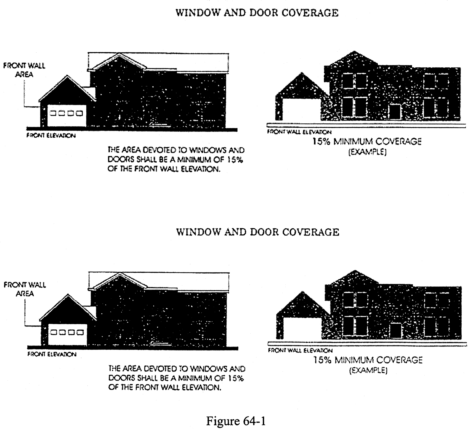
Window and door coverage. All elevations of a single-family residential dwelling and of an accessory building including without limitation, front, side, and rear elevations, shall devote a minimum of 15 percent of their wall coverage to window and door coverage. Figure 64-1 shows an example of this for a front elevation.
(2)
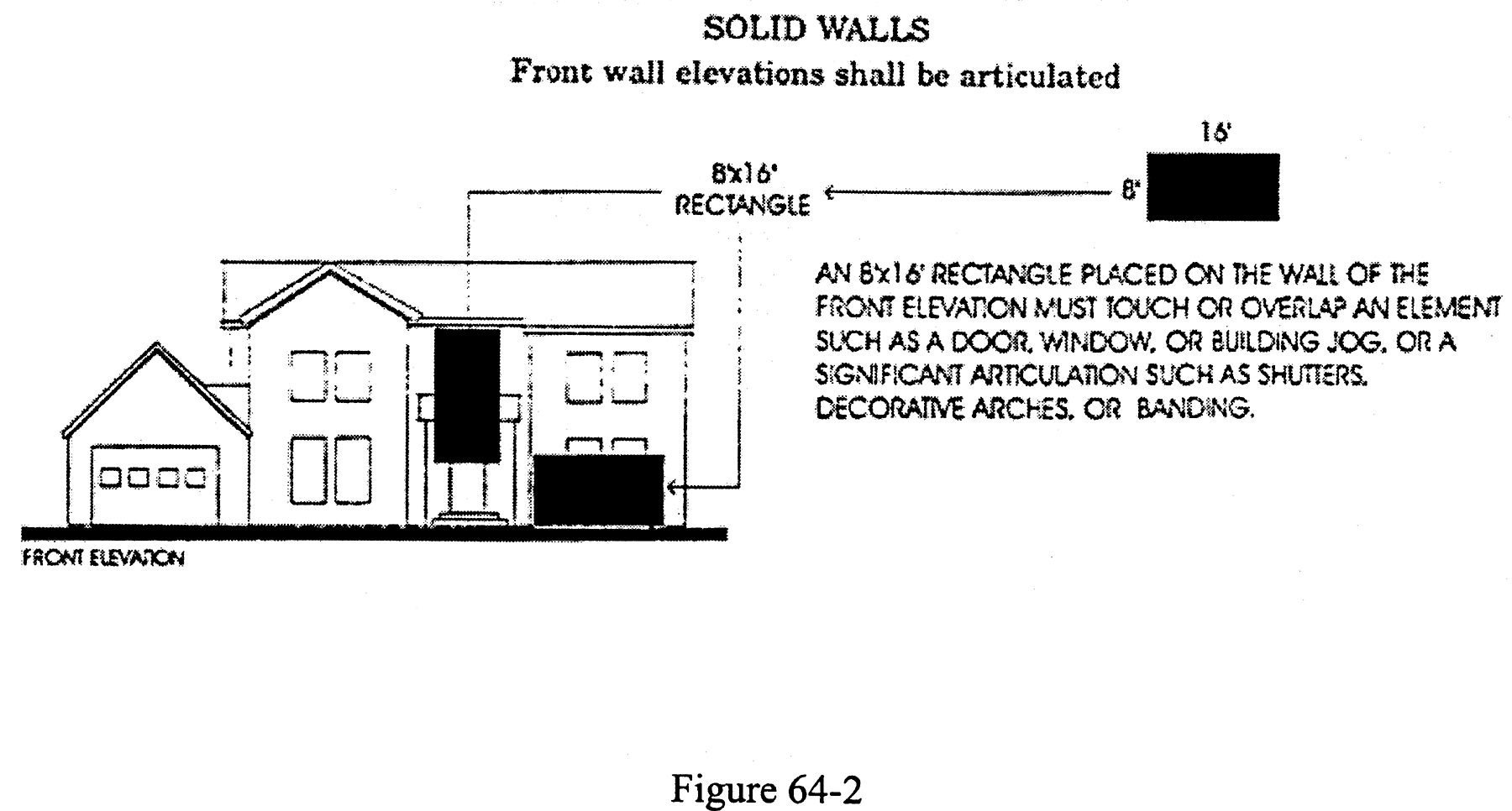
Substantial articulation. In addition to the 15 percent window and door coverage on all elevations of a single-family residential dwelling and an accessory building including without limitation, front, side, and rear elevations, there shall be other signification articulation on all elevations such that the placement of an eight foot by 16 foot rectangle on the wall of the elevation must touch or overlap an element such as a window or door, or a significant articulation such as shutters, decorative arches, building jog, or banding. Figure 64-2 shows an example of this for a front elevation.
(f)
Roofs and flat roof usable areas.
(1)
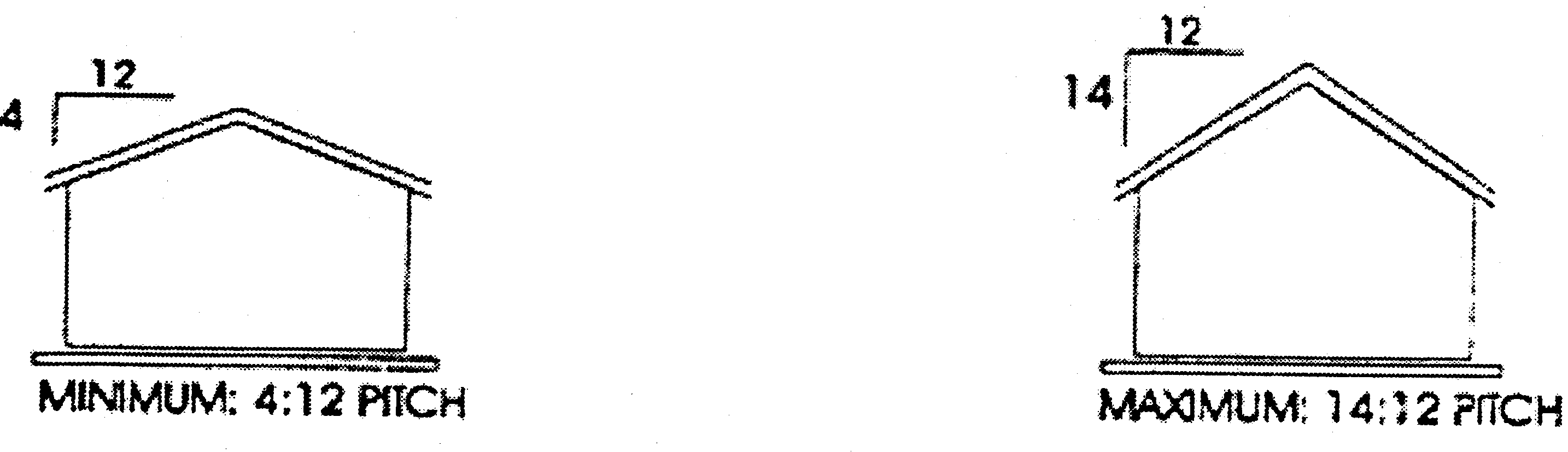
For single-family residential dwellings and accessory buildings in the single-family residential districts, the minimum permit ed pitch for a pitched roof is 4:12 (rise to run) and the maximum permit ed pitch is 14:12 (rise to run). The planning and zoning commission may approve a pitched roof minimum of 3:12 as a special design exception subject to the development plan review criteria in section 63-56(1) including, but not limited to, sections 63-56(1)(a)(2), 63-56(1)(b), and 63-56(1)(c)(1), (2), (5), (6), and (7). Except for a flat roof usable area (defined below), it shall be unlawful to construct or maintain a pitched roof system consisting of tar paper or felt without approved exterior shingles, tiles or metal covering. Parapets shall not to be utilized with pitched roofs except in conjunction with a flat roof usable area (defined below).
(2)
Flat roofs, which are less than 4:12 pitch (rise to run) (excluding roofs receiving special design exception for a minimum pitch of 3:12), are permitted on single-family residential dwellings and accessory buildings in the single-family residential districts, provided the flat roof complies with all requirements and restrictions set forth in section 67-37.
(3)
A flat roof usable area is an area provided with a pitched roof or flat roof system which may be utilized as a deck, porch, or other outdoor usable space on single-family residential dwellings and accessory buildings in the single-family residential districts. A flat roof usable area shall not exceed 15 percent of the total floor area. A flat roof usable area shall be limited to a maximum height of 14 feet from the finished floor. No balconies shall be at ached to, connected to, or adjoin a flat roof usable area. Except for temporary external access necessary for maintenance, repairs, and emergencies, access to the flat roof usable area must be internal to the dwelling or building. The construction and/or installation of any non-temporary external access to the flat roof usable area is prohibited.
(g)
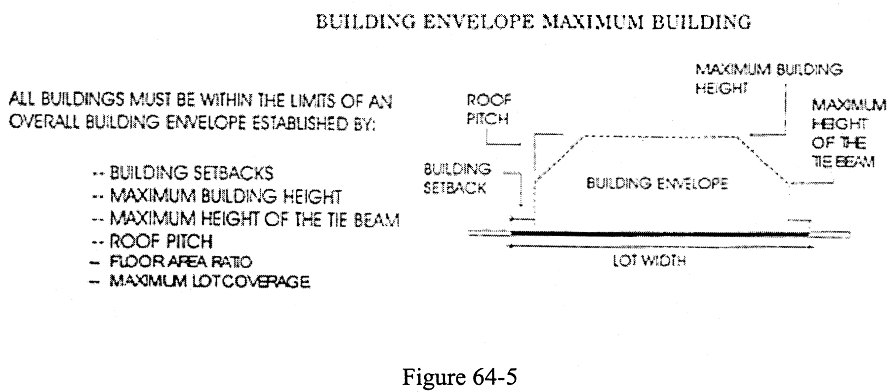
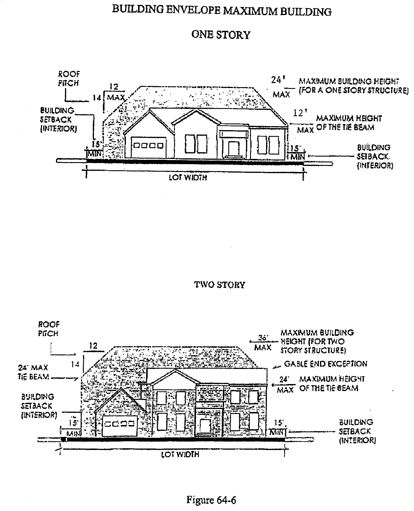
Building envelope. All single-family residential buildings must be within the limits of an overall building envelope established by yard setbacks, maximum building height, maximum height of the tie beam, maximum lot coverage, floor area ratio, and roof pitch. The building envelope permitted within the town is shown graphically as follows:
(h)
Building envelope exceptions. Notwithstanding the building envelope requirements set forth above, the construction of a flat roof usable area shall be permitted up to the building setback requirements. Further, the construction of dormers and gabled ends on single-family dwellings with pitched roofs shall be permitted, notwithstanding the building envelope requirements above, it being the intent of the town commission to permit colonial, federal, Dutch colonial, and other similar styles of architecture.
(i)
Floor area calculations.
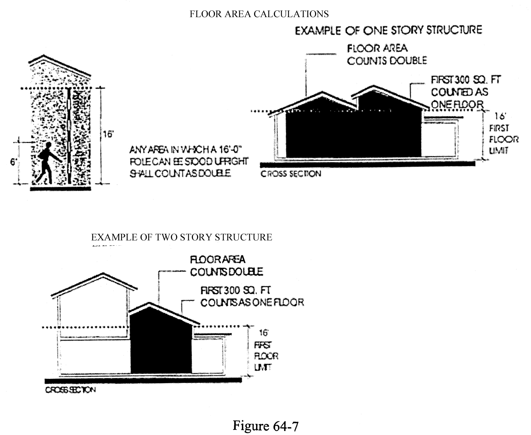
(1)
When calculating total floor area, the first floor area under ceilings which are 16 feet or higher shall count as double. The first 300 square feet thereof, however, shall be counted as one floor to allow for limited vaulted spaces. The second floor area shall not exceed 75 percent of the first floor.
(2)
For purposes of calculating the 75 percent requirement of this section, the first floor area will include those portions of a structure utilized in establishing the maximum finished floor elevation described in section 67-32(a)(3) including roofed porches, but excluding bay windows, and which share at least one wall with the remainder of the habitable structure.
(3)
For purposes of calculating the second floor for the 75 percent requirement of this section, the second floor area will include all enclosed areas of the second floor and roofed porches and balconies, but will exclude bay windows whose sills are no lower than 12 inches from the floor, and provided the bay windows comprise 20 percent or less of any one facade and do not extend out beyond the overhang.
(j)
RSF — Single-family residential property development regulations. Property development regulations for the RSF district are as follows:
(1)
Minimum lot area and dimensions. Minimum lot area and dimensions are as follows:
a.
Area: 10,000 square feet.
b.
Width (interior): 80 feet.
c.
Width (corner): 90 feet.
d.
Depth: 100 feet.
(2)
Minimum yard setback requirements. Minimum yard setback requirements are as follows:
a.
Front: 25 feet.
b.
Side (interior): 15 feet.
c.
Side (corner): 20 feet.
d.
Rear: 15 feet.
e.
Waterway: 25 feet.
f.
Atlantic Ocean: 1979 coastal construction setback line.
Exterior balconies, bay windows, exterior chimneys, or other architectural features which do not measure more than 25 square feet in the horizontal plane, and eaves which do not extend more than three feet from the vertical wall of the building shall not be considered as encroachments in the setback.
(3)
Maximum building height shall be no more than 24 feet for single-story buildings and the maximum two-story building height shall be no more than 36 feet. Height shall be measured to the ridge or highest point of the structure, including all non-habitable architectural features, but excluding chimneys, as measured from the top of the lowest finished floor elevation of the first floor, as described in section 67-32. No building with more than two stories is permitted. No chimneys, including caps, shall exceed four feet in height from the ridge of the roof. For pitched roof systems, wherever a base flood elevation (BFE) is dictated by the FEMA National Flood Insurance Program (NFIP) maps requiring the finished floor elevation to be above seven feet NAVD, for every foot above seven feet NAVD there shall be a corresponding decrease of one foot in the maximum building height.
(4)
Minimum floor area. Minimum floor area is 1,800 square feet.
(5)
Maximum lot coverage. Maximum lot coverage shall be 35 percent of the total lot area.
(6)
Maximum floor area. The maximum floor area of all finished floors under roof shall be 36 percent of the total lot area. For any RSF lot existing or created after the date of adoption of this ordinance in excess of 20,000 square feet, the maximum floor area of all finished floors under roof shall be 32 percent of the total lot area. For purposes of this subsection, if a lot is separated by a street or right-of-way from that portion of the lot containing the principal structure or use, the calculation of the "total lot area" shall include the first 1,000 square feet of the separated portion of the lot, provided that the maximum floor area does not exceed 36 percent of the total lot area. Prior to allowing the use of the separated portion square footage, a unity of title, approved by the town, must be executed by the property owner. The floor area occupied by bay windows, chimneys, or other non-habitable architectural features shall be included and shall be subject to this provision. The floor area occupied by roofed porches and balconies shall be exempt from this provision.
(k)
RSE — Single-family residential estate property development regulations. Property development regulations for the RSE district are as follows:
(1)
Minimum lot area and dimensions. Minimum lot area and dimensions are as follows:
a.
Area: 20,000 square feet.
b.
Width (interior): 100 feet.
c.
Width (corner): 100 feet.
d.
Depth: 100 feet.
(2)
Minimum yard setback requirements. Minimum yard setback requirements are as follows:
a.
Front: 25 feet.
b.
Side (interior): 15 feet.
c.
Side (corner): 20 feet.
d.
Rear: 15 feet.
e.
Atlantic Ocean: 1979 coastal construction setback line.
Exterior balconies, bay windows, exterior chimneys, or other architectural features which do not measure more than 25 square feet in the horizontal plane, and eaves which do not extend more than three feet from the vertical wall of the building shall not be considered as encroachments in the setback.
(3)
Maximum building height shall be no more than 24 feet for single-story buildings and the maximum two-story building height shall be no more than 36 feet. Height shall be measured to the ridge or highest point of the structure, including all non-habitable architectural features, but excluding chimneys, as measured from the top of the lowest finished floor elevation of the first floor, as described in section 67-32. No building with more than two stories is permitted. No chimneys, including caps, shall exceed four feet in height from the ridge of the roof. Wherever a base flood elevation (BFE) is dictated by the FEMA National Flood Insurance Program maps requiring the finished floor elevation to be above seven feet NAVD, for every foot above seven feet NAVD there shall be a corresponding decrease of one foot in the maximum building height.
(4)
Minimum floor area. Minimum floor area is 1,800 square feet.
(5)
Maximum lot coverage. Maximum lot coverage shall be 32 percent of the total lot area.
(6)
Maximum floor area. The maximum floor area of all finished floors under roof shall be 36 percent of the total lot area. For purposes of this subsection, if a lot is separated by a street or right-of-way from that portion of the lot containing the principal structure or use, the calculation of the "total lot area" shall include the first 1,000 square feet of the separated portion of the lot provided that the maximum floor area does not exceed 36 percent of the total lot area. Prior to allowing the use of the separated portion square footage, a unity of title, approved by the town, must be executed by the property owner. The floor area occupied by bay windows, chimneys, or other non-habitable architectural features shall be included and shall be subject to this provision. The floor area occupied by roofed porches and balconies shall be exempt from this provision.
(7)
Maximum lot coverage. Maximum lot coverage shall be 32 percent of the total lot area.
(8)
Maximum floor area. The maximum floor area of all finished floors under roof shall be 36 percent of the total lot area. For purposes of this subsection, if a lot is separated by a street or right-of-way from that portion of the lot containing the principal structure or use, the calculation of the "total lot area" shall include the first 1,000 square feet of the separated portion of the lot provided that the maximum floor area does not exceed 36 percent of the total lot area. Prior to allowing the use of the separated portion square footage, a unity of title, approved by the town, must be executed by the property owner. The floor area occupied by bay windows, chimneys, or other non-habitable architectural features shall be included and shall be subject to this provision. The floor area occupied by roofed porches and balconies shall be exempt from this provision.
(9)
Old Ocean Blvd. Lots. The following 14 parcels of land which border Old Ocean Boulevard between Anna Street and Corrine Street-shall be considered legal, conforming lots of record as of the date of the adoption of this Ordinance for lot size, lot width, and/or lot depth in the RSE district for purposes of development:
If any of the aforementioned lots are subdivided without documented town zoning approval which causes any reduction in total lot size, lot width, or lot depth, the foregoing grant of conforming status shall be voided and the lot will be rendered a non-legal lot of record and no development will be permitted.
(10)
Lots East of Old Ocean Blvd. For the above identified lots which are located on the east side of Old Ocean Blvd, between Anna Street and Corrine Street and deemed conforming as specified in paragraph (9) above, the following requirements shall apply for all new development, substantial improvement of an existing structure(s), or expansion of an existing structure(s) (beyond the existing footprint with regards to setbacks, height, lot coverage, and maximum floor area ratio):
1.
The lot must have or maintain armoring seaward of the 1979 coastal construction control line, which armoring complies with all requirements of section 161.053, Florida Statutes (as amended from time to time).
2.
The minimum front setback shall be 15 feet; provided that no structures with any vertical feature or pools shall be located within ten feet of the front setback (in whole or in part).
3.
The minimum side (interior) setback shall be ten feet for first floor area of the structure and 15 feet for second floor portion of the structure.
4.
The minimum side comer setback shall be 15 feet.
5.
The minimum rear setback shall be the coastal construction setback line (CCSL) as defined and set forth in section 67-18. Exterior balconies, bay windows, eaves, and other architectural features which do not extend more than three feet from the vertical wall of the building and/or which do not measure more than 25 square feet in the horizontal plane may extend past the CCSL. In addition, new non-habitable structures are permitted seaward of the CCSL by CCSL administrative permit. All permitted development seaward of the CCSL shall be a sufficient distance landward of the existing armoring to allow for maintenance of the armoring and located up to or landward of such established line of approved construction.
6.
The maximum lot coverage shall not exceed 28 percent of the total lot area.
7.
The maximum floor area of all finished floors under roof shall be 32 percent of the total lot area. The floor area occupied by bay windows, chimneys, or other non-habitable architectural features shall be included and shall be subject to this provision. The floor area occupied by roofed porches and balconies shall be exempt from this provision.
All such new development, substantial improvement of an existing structure(s), or expansion of an existing structure(s) (beyond the existing footprint with regards to setbacks, height, lot coverage, and maximum floor area ratio) shall also be subject to the development plan review criteria set forth in section 63-56 and reasonable conditions established by the planning and zoning commission for the protection of the health, safety, and general welfare of the adjacent property owners, the town, and its residents. The issuance of town building permits based on the planning and zoning commission's approval or approval with conditions shall be subject to approval by all other regulatory agencies with jurisdiction over such development and construction including, but not limited to, the Florida Department of Environmental Protection.
(l)
Special regulations. See article III of this chapter for regulations on access, parking, landscape and fences, and chapter 70 of this land development code for regulations on signs.
(Ord. No. 540, 3-13-2003; Ord. No. 560, § 2, 11-7-2005; Ord. No. 586, §§ 2, 3, 6-7-2010; Ord. No. 2019-08, § 3, 6-3-2019; Ord. No. 2020-05, § 2, 9-8-2020; Ord. No. 2021-02, § 2, 4-5-2021; Ord. No. 2022-09, § 2—6, 8-1-2022; Ord. No. 2023-05, § 2, 11-6-2023; Ord. No. 2024-01, § 2, 3-4-2024)
Sec. 64-2. - RMM medium density multiple-family residential district.
(a)
Purpose and intent. The purpose and intent of the RMM district is intended to include land developed or found by the comprehensive plan to be suitable for single-family attached, semidetached, detached and duplex residences and other multifamily residential types not to exceed a density of five dwelling units per gross acre.
(b)
Permitted uses. In an RMM medium density multiple-family residential district, no building, structure or land or water use shall be permitted except for one or more of the following uses:
(1)
Single-family dwelling and its customary accessory uses.
(2)
Multiple-family development and accessory uses and buildings. Accessory uses may include a private garage, swimming pool or tennis court.
(c)
Prohibited uses. The following uses are specifically prohibited in the medium-density multiple-family residential district:
(1)
Commercial uses.
(2)
Transient housing units.
(3)
Vacation rentals or units.
(4)
Any other use not specifically provided for in this Code.
(d)
Special exceptions. Special exceptions are subject to town commission approval. Special exceptions permitted subject to town commission approval are as follows in the RMM district:
(1)
Public and private utility uses and structures.
(2)
Reserved.
(3)
Private recreation facilities and clubs.
(4)
Churches and accessory buildings.
(5)
Planned residential development.
(6)
Marina facilities.
(e)
Property development regulations. Property development regulations for the RMM district are as follows:
(1)
Minimum lot area and dimensions.
a.
Minimum lot area for a single-family dwelling is 7,500 square feet.
b.
Minimum lot area for a two-family duplex is 12,500 square feet.
c.
Minimum lot area for a multiple-family dwelling is 12,500 square feet for the first dwelling unit and 6,500 square feet for each additional unit thereafter.
d.
Minimum lot dimensions for single-family dwellings are as follows:
1.
Depth: 100 feet.
2.
Width (interior): 50 feet.
3.
Width (corner): 60 feet.
e.
Minimum lot dimensions for duplex and multiple-family dwellings are as follows:
1.
Depth: 100 feet.
2.
Width (interior): 100 feet.
3.
Width (corner): 100 feet.
(2)
Minimum building setbacks. The minimum building setbacks shall apply both to the proximity of one building to another as well as to the proximity to the property line. Minimum building setbacks are as follows:
a.
Front: 25 feet.
b.
Side (interior): 15 feet.
c.
Side (corner): 25 feet.
d.
Rear: 15 feet.
e.
Waterway: 25 feet.
(3)
Maximum building height. Maximum building height is 36 feet, subject to the additional provisions of section 64-1 as applicable to single-family dwellings and of section 64- 41(b)(2) as applicable to accessory uses, buildings or structures. Any flat roof areas, excluding decks and porches, shall be screened entirely by a parapet, which shall not extend above the top of the tie beam by more than three feet. This parapet shall extend around the flat roof area and shall screen all flat roof elements. Where a parapet is used to conceal a pitched roof, the top of the parapet shall not extend above the top of the tie beam by more than three feet.
(4)
Maximum lot coverage. Maximum lot coverage is 40 percent of the total lot area.
(5)
Minimum floor area requirements. Minimum floor area requirements are as follows:
a.
Efficiency: 850 square feet.
b.
One bedroom: 1,000 square feet.
c.
Two bedrooms: 1,200 square feet.
d.
Three bedrooms: 1,400 square feet.
e.
More than three bedrooms: 1,600 square feet.
(6)
Allowable building square footage computation. Notwithstanding other provisions of the Code, allowable building square footage for all residential lots with less than 7,500 square feet total area within the town may be computed using a floor area ratio of 0.45; provided, however, the maximum floor area of a building structure on any lot less than 7,500 square feet in total area may not exceed 2,700 square feet.
(7)
Single-family development regulations. Except as otherwise provided in this section, each single-family dwelling and its customary private accessory uses, including garage, swimming pool and tennis court constructed in the RMM district shall be subject to the property development regulations set forth in sections 64-1(b) through 64-1(i) herein, except the minimum floor area shall be 1,600 square feet. In addition, for two-story buildings, wherever a base flood elevation (BFE) is dictated by the FEMA National Flood Insurance Program maps requiring the finished floor elevation to be above seven feet NAVD, for every foot above seven feet NAVD there shall be a corresponding decrease of one foot in the maximum building height.
(f)
Special regulations. See article III of this chapter for regulations relative to access, parking, landscaping and fences and chapter 70 of this land development code for regulations relative to signs.
(g)
Site plan review. A site plan review shall be required prior to the issuance of a building permit for the construction or alteration of any multiple-family development within this RMM medium density multiple-family district.
(Ord. No. 540, 3-13-2003; Ord. No. 547, § 1, 8-2-2004; Ord. No. 560, § 3, 11-7-2005; Ord. No. 2019-08, § 4, 6-3-2019; Ord. No. 2021-02, § 3, 4-5-2021; Ord. No. 2025-02, § 2, 5-5-2025)
Sec. 64-3. - Ocean View Special Area.
(a)
Scope. Notwithstanding other provisions of the land development code, including this article, relating to minimum lot size, lot depth, setbacks, floor area ratio or minimum floor area for building structures, this section shall apply to all existing residential lots within the area as of October 4, 1999, and shall supersede any land development code requirements to the contrary. Except as specifically provided in this section, all other land development code requirements remain applicable to the residential lots in the area, including without limitation, sections 64-1(e), 64-1(f), and 67-37 for single-family residential dwellings and single-family residential accessory buildings in the area.
(b)
Minimum lot size. Minimum lot size within the area shall be 3,250 total square feet.
(c)
Minimum lot depth. Minimum lot depth within the area shall be 65 feet.
(d)
Minimum setbacks. The following minimum setbacks shall apply to all residential lots within the area:
(1)
Front setback - 20 feet.
(2)
Side setback - ten feet.
(3)
Side corner setback - 15 feet.
(4)
Rear setback - ten feet.
(e)
Floor area ratio. The maximum floor area ratio for residential lots within the area of 5,000 square feet total area or less shall be 0.52. For lots within the area greater than 5,000 square feet, but less than 7,500 square feet, the floor area ratio for the town floor area ratio overlay for residential lots as set forth in section 64-7 of the land development code shall apply.
(f)
Minimum residential floor area. Notwithstanding the current land development code requirement for a minimum floor area of 1,600 square feet, no minimum floor area shall be required for residential lots within the Ocean View Special Area.
(g)
The following table identifies residential lots that are located within the area:
OCEAN VIEW SPECIAL AREA
*Note:
0.36 FAR applies to lots 7,500 SF or more under the current land development code.
0.45 FAR applies to lots under 7,500 SF under the town FAR overlay. Maximum floor area not to exceed 2,700 SF.
0.52 FAR applies only to lots under 5,000 SF in the Ocean View Area. Maximum floor area not to exceed 2,700 SF.
(Ord. No. 540, 3-13-2003; Ord. No. 2022-09, § 7, 8-1-2022)
Sec. 64-4. - RHM high density multiple-family residential district.
(a)
Purpose and intent. The purpose and intent of the RHM district is to include land found by the comprehensive plan to be suitable for single-family attached, semidetached, detached and duplex residences and other multifamily residential types not to exceed a density of ten dwelling units per gross acre.
(b)
Permitted uses. Permitted uses in the RHM district are as follows:
(1)
Single-family dwelling and its customary accessory uses.
(2)
Multiple-family development and accessory uses and buildings.
(3)
Private garage accessory to a principal residence.
(4)
Private swimming pool accessory to a principal residence.
(5)
Private tennis court accessory to a principal residence.
(6)
Residential accessory use.
(c)
Prohibited uses. The following uses are specifically prohibited in the high-density multiple-family residential district:
(1)
Commercial uses.
(2)
Transient-housing units.
(3)
Vacation rentals or units.
(4)
Any other use not specifically provided for in this Code.
(d)
Special exceptions subject to town commission approval. Special exceptions permitted subject to town commission approval are as follows in the RHM district:
(1)
Public and private utility uses.
(2)
Reserved.
(3)
Private recreation facilities and clubs.
(4)
Churches and accessory buildings and structures.
(5)
Planned residential development.
(6)
Marina facilities.
(e)
Property development regulations. Property development regulations for the RHM district are as follows:
(1)
Minimum lot area and dimensions.
a.
Minimum lot area for a single-family dwelling is 5,000 square feet.
b.
Minimum lot area for a two-family duplex is 10,000 square feet.
c.
Minimum lot area for a multiple-family dwelling is 10,000 square feet for the first dwelling unit and 2,500 square feet for each additional unit thereafter.
d.
Minimum lot dimensions for single-family dwellings are as follows:
1.
Depth: 100 feet.
2.
Width (interior): 50 feet.
3.
Width (corner): 60 feet.
e.
Minimum lot dimensions for duplex and multiple-family dwellings are as follows:
1.
Depth: 100 feet.
2.
Width (interior): 100 feet.
3.
Width (corner): 100 feet.
(2)
Minimum building setbacks. The minimum building setbacks shall apply both to the proximity of one building to another as well as to the proximity to the property line. Minimum building setbacks are as follows:
(3)
Maximum building height. Maximum building height is 44 feet and no more than four stories. Any flat roof areas, excluding decks and porches, shall be screened entirely by a parapet, which shall not extend above the top of the tie beam by more than three feet. This parapet shall extend around the flat roof area and shall screen all flat roof elements. Where a parapet is used to conceal a pitched roof, the top of the parapet shall not extend above the top of the tie beam by more than three feet.
(4)
Maximum lot coverage. Maximum lot coverage is 40 percent of the total lot area.
(5)
Minimum floor area. Minimum floor area is as follows:
a.
Efficiency: 850 square feet.
b.
One bedroom: 1,000 square feet.
c.
Two bedrooms: 1,200 square feet.
d.
Three bedrooms: 1,400 square feet.
e.
More than three bedrooms: 1,600 square feet.
(6)
Single-family development regulations. Except as otherwise provided in this section, each single-family dwelling and its customary private accessory uses, including garage, swimming pool and tennis court constructed in the RHM district shall be subject to the property development regulations set forth in section 64-1(b) through 64-1(i) herein. In addition, for two-story buildings, wherever a base flood elevation (BFE) is dictated by the FEMA National Flood Insurance Program maps requiring the finished floor elevation to be above seven feet NAVD, for every foot above seven feet NAVD there shall be a corresponding decrease of one foot in the maximum building height.
(f)
Special regulations. See article III of this chapter for regulations relative to access, parking, landscaping and fences and chapter 70 of this land development code for regulations relative to signs.
(g)
Type of master site development plan review. All development in the RHM district shall be required to undergo review pursuant to the planned residential development requirements of this land development code. A master site development plan review shall be required prior to the issuance of a building permit for the construction or alteration of any multiple-family development within this RHM high density multiple-family district.
(Ord. No. 540, 3-13-2003; Ord. No. 560, § 4, 11-7-2005; Ord. No. 2019-08, § 5, 6-3-2019; Ord. No. 2021-02, § 4, 4-5-2021)
Sec. 64-5. - PO public ownership district.
(a)
Permitted uses. There are no permitted uses in the PO district.
(b)
Special exceptions subject to town commission approval. Special exceptions permitted subject to town commission approval are as follows in the PO district:
(1)
Public and private utility services and accessory buildings and structures including, but not limited to, the following:
a.
Electric power and light substation.
b.
Gas and water regulation station.
c.
Sewage treatment plant.
d.
Tower, storage tank or reservoir.
(2)
Government services and accessory buildings and structures including, but not limited to, the following:
a.
Fire and police stations.
b.
Libraries.
c.
Town hall.
d.
Parks and recreation areas operated by the town or by any other governmental entity approved by the town. Marina facilities incidental and accessory to the park and recreation area referenced in this subsection may also be included if operated by the governmental entity. A food concession, or vending facility within a structure, incidental and accessory to a park and recreation area as referenced in this subsection, may be included. Such use shall not exceed 1,000 square feet in exterior dimension, and drive-in service, table service, telephone orders, inside seating and delivery are hereby prohibited. Alcoholic beverages shall be consumed only in designated areas.
(c)
Special regulations. See article III of this chapter for regulations relative to parking and fences and chapter 70 of this land development code for regulations relative to signs.
(Ord. No. 540, 3-13-2003)
Sec. 64-6. - Preservation/conservation (PC) district.
(a)
Purpose and intent. The purpose and intent of the PC district is to establish and protect certain areas which are composed of the habitats of endangered species of wildlife, fish or flora, or which are important habitats for the production of fish and wildlife.
(b)
Permitted uses. In a PC district, no building, structure or land and water use shall be permitted except for one or more of the following uses upon approval by the town commission:
(1)
Pedestrian or canoe trails.
(2)
Boating limited to motors of less than ten horsepower.
(3)
Wildlife management performed by the game and fish commission of the state.
(4)
Fishing under policies and regulations prescribed by the game and fish commission of the state.
(5)
Archaeological exploration, observation and excavation by recognized authorities.
(c)
Special exceptions subject to town commission approval. Special exceptions permitted subject to town commission approval are as follows in the PC district: park areas operated by the town.
(d)
Prohibited uses and activities. Any use which has an adverse impact upon any environmental habitat or archaeological site causing the deterioration of the habitat or physically altering an archaeologically significant environment is prohibited. Intense activity levels of the uses permitted in this section without consideration of the compatibility of the activity with the natural resource is also prohibited. Any alteration of the soils, vegetation or water levels beyond the minimum required to accommodate the uses permitted is prohibited. Further, wheeled vehicles, tracked vehicles and airboats are prohibited.
(Ord. No. 540, 3-13-2003; Ord. No. 2022-07, § 2, 5-2-2022)
Editor's note— Ord. No. 2022-07, § 2, adopted May 2, 2022, changed the title of § 64-6 from "C conservation district" to read as herein set out.
Sec. 64-7. - Town floor area ratio overlay.
(a)
Scope. These land development code provisions shall apply to all existing residential lots within the town that are less than 7,500 square feet in total area as of October 4, 1999, other than those lots subject to the provisions of the Ocean View Special Area criteria. Except as specifically provided in this section, all other land development code requirements remain applicable to all residential lots which are subject to the town floor area ratio overlay.
(b)
Floor area ratio. Notwithstanding other provisions of the land development code, allowable building square footage for all residential lots with less than 7,500 square feet total area within the town other than lots subject to the provisions of section 64-3 of the land development code, may be computed using a floor area ratio of 0.45; provided, however, the maximum floor area of a building structure on any lot less than 7,500 square feet in total area may not exceed 2,700 square feet.
(Ord. No. 540, 3-13-2003)
Sec. 64-8. - Zoning map.
The boundaries of the districts described in this article are designated on the official zoning map of the town. Such map is adopted as a part of this land development code. The board of adjustment is hereby empowered to resolve any uncertainties created by the zoning district lines as shown on the zoning map.
(Ord. No. 540, 3-13-2003)
Sec. 64-21. - Purpose and definition.
The purpose of a planned residential development is to achieve land development under unified control, designed and planned to be developed in a single operation or by a series of prescheduled development phases, according to an officially approved final master site development plan which does not necessarily correspond to the property development and use regulations of the zoning district in which the development is located.
(Code 1993, § 26-190)
Sec. 64-22. - General regulations.
The following regulations shall apply to all planned residential developments:
(1)
Minimum area. Except for the required RHM district review, no site shall qualify for a planned residential development unless the development consists of a contiguous area of at least ten acres.
(2)
Unified control. All land included for the purpose of development within a planned residential development shall be owned or under the control of the petitioner for such zoning designation, whether that petitioner is an individual, partnership or corporation, or a group of individuals, partnerships or corporations. The petitioner shall present firm evidence of the unified control of the entire area within the proposed planned residential development and shall state agreement that if he proceeds with the proposed development he will:
a.
Do so in accord with the officially approved final master site development plan of the development, and such other conditions or modifications as may be attached to the special exception.
b.
Provide agreements, covenants, contracts, deed restrictions or sureties acceptable to the town for completion of the undertaking in accordance with the adopted final master site development plan as well as for the continuing operation and maintenance of such areas, functions and facilities as are not to be provided, operated or maintained at general public expense.
c.
Bind his development successors in title to any commitments made under subsections (2)a. and b. of this section.
d.
Secure written consents and agreements from all property owners of record within the planned residential development boundaries who have not joined in the planned residential development application that there is no objection to including their property in the overall land planning process of the planned residential development.
(3)
Configuration of site. Any tract of land for which a planned residential development application is made shall contain sufficient width, depth and frontage on a publicly dedicated arterial or major street or appropriate access thereto as shown on the town thoroughfare plan to adequately accommodate its proposed use and design.
(4)
Authorized uses. Authorized uses are as follows:
a.
Any residential structure of a type and arrangement compatible with the purpose and intent of this special exception.
b.
Residential accessory uses (see section 64-1).
c.
Public and private utility services and accessory buildings and structures.
d.
Government services and accessory buildings and structures.
e.
Private recreation facilities and clubs (see section 64-43).
(5)
Prohibited uses. The following uses are specifically prohibited in planned residential developments:
a.
Commercial uses.
b.
Transient housing units.
c.
Vacation rentals or units.
d.
Any other use not specifically provided for in this Code.
(Code 1993, § 64-43; Ord. No. 560, § 5, 11-7-2005)
Sec. 64-23. - Procedural requirements.
(a)
Required plans. All planned residential development applications shall be accompanied by a proposed master site development plan meeting the requirements of section 63-53 and of this article. This proposed master site development plan will serve as a basis for a more refined preliminary site development plan and a final master site development plan.
(b)
Copies of plans.
(1)
The applicant shall provide the town with the following copies:
a.
Proposed master site development plan and attendant documents and information: six copies.
b.
Preliminary master site development plan and attendant documents and information: six copies.
c.
Final master site development plan and attendant documents and information: six copies.
(2)
The town commission may amend the required number of plan copies from time to time as may be deemed necessary.
(c)
Use of professional services. Any master site development plan submitted as part of a petition for a planned residential development shall certify that the services of three or more of the following professionals were utilized in the design or planning process:
(1)
A planner who possesses the education and experience to qualify for full membership in the American Institute of Certified Planners; and/or
(2)
A landscape architect registered by the state; and/or
(3)
An architect licensed by the state; together with
(4)
A professional engineer registered by the state and trained in the field of civil engineering; and/or
(5)
A land surveyor registered by the state.
(d)
Review and approval.
(1)
Preapplication conference. Prior to the submission of a formal planned residential development application, the prospective petitioner is required to schedule a preapplication conference with the administrative official and to discuss a tentative proposed master site development plan for the subject property. The preapplication conference should also address itself to pertinent development matters including, but not limited to:
a.
The proper relation between the anticipated project and surrounding uses, and the effect of the proposed development on the comprehensive land use plan and stated planning and development objectives of the town or adjacent municipalities.
b.
The adequacy of existing and proposed streets, utilities and other public facilities to serve the development.
c.
The nature, design and appropriateness of the proposed land use arrangement for the size and configuration of property involved.
d.
The adequacy of open space areas in existence and as proposed to serve the development.
e.
The ability of the subject property and of surrounding areas to accommodate future expansion, if needed.
(2)
Formal application. After completion of the preapplication conference, the petitioner shall submit an application for a special exception, accompanied by a proposed master site development plan and attendant documents and information.
(3)
Prehearing conference.
a.
The purpose of a prehearing conference prior to the presentation of the planned residential development to the town planning and zoning commission is to assist the applicant in bringing the planned residential application and proposed master site development plan into conformity with the intent of this land development code and other applicable town regulations and to define those areas where justifiable deviation from application of this land development code is suggested by the development's proposed master site development plan.
b.
All recommendations and requests for change from the proposed master site development plan by either the administrative official or the applicant shall be committed to writing and shall be made a part of the official town file for the subject planned residential development.
c.
Upon completion of the required amendments or revisions to the proposed master site development plan as requested by the administrative official to meet the requirements and regulations of this land development code, the planned residential development application shall be certified for inclusion on the next official agenda of the planning and zoning commission.
(4)
Planning and zoning commission hearing. Pursuant to article II of this chapter, a duly noticed public hearing on the planned residential development application shall be held within 30 days of the date of the administrative official's certification for inclusion on an official planning and zoning commission agenda.
(5)
Town commission hearing. Pursuant to article II of this chapter, a duly noticed public hearing on the planned residential development application shall be held within 30 days of the date of the rendering of the planning and zoning commission advisory recommendation on the application.
(6)
Final master site development plan review. The administrative official shall, within 30 days of the receipt of the official decision of the town commission, conduct a final review, if any is required, of the preliminary master site development plan and planned residential development application and shall notify the applicant in writing that the preliminary master site development plan has been approved with or without modifications and has been certified as the planned residential development's final master site development plan, or the administrative official will advise the applicant of any further changes which should be made to bring the preliminary master site development plan into full compliance with this land development code and other applicable town land use regulations.
(7)
Final master site development plan certification and platting.
a.
Certification. Upon certification of the preliminary master site development plan as the final master site development plan, the final plat must be filed in the office of the town clerk within six months of the date of town commission approval of the planned residential development special exception.
b.
Phasing controls. If the final master site development plan is to be developed in phases or stages requiring more than one final plat, successive plats must be filed so that construction and development activity shall be of a reasonably continuous nature; but in no event shall more than one year, plus one additional one-year extension period, elapse between the filing of successive plats. Should a planned residential development be constructed in phases requiring more than one plat, the following sequence must be adhered to:
1.
A major recreation facility planned to serve the entire development shall be platted prior to the platting of more than 40 percent of the total permitted dwelling units.
2.
The gross density of an individual plat shall not exceed the maximum density permitted for the entire development unless the instant plat considered in conjunction with all previously recorded plats of record produces an average density less than or equal to the approved maximum density for the entire planned residential development.
c.
Platting. Each plat shall be in compliance with the provisions of F.S. ch. 177, and the town subdivision and platting regulations as set out in article V of this chapter, as both may be amended from time to time.
d.
Site plan. The density, the location of buildings and other improvements and the location of areas to be set aside as open space shall be shown on a site plan for the area to be platted and shall be approved by the administrative official prior to or in conjunction with the submission of each plat in final form. The site plan shall be a timetable reproducible made from the applicable final plat with the following information indicated in India ink:
1.
Building pad corners and corner ties shall be indicated.
2.
The parking layout and typical dimensions shall be indicated.
3.
Open space area calculations and building pad area, and calculations on attachments, shall be indicated.
4.
Density calculations for each development lot, and calculations on attachments, shall be indicated.
5.
A statement from the town attorney approving the substance of the property owners' agreement, condominium documents, covenants, grants and easements or other restrictions proposed to be imposed upon the use of land, buildings and structures shall be provided within a reasonable time, not to exceed 30 days from the time of the submission of the documents.
6.
A key map of the approved master site development plan for the development shall appear on the site plan, showing the location of the site plan.
e.
Final plat approval. When a plat is submitted to the town commission, it shall be in conformance with the requirements for filing plats contained in the town subdivision and platting regulations as set out in article V of this chapter and this article.
(Ord. No. 540, 3-13-2003)
Sec. 64-24. - Development standards.
(a)
Density by applicable zoning district. The gross residential density for a planned residential development shall not exceed the maximum permitted as prescribed by the following:
(1)
RSF single-family residential district: three units per acre.
(2)
RSE single-family residential district: two units per acre.
(3)
RMM medium density multiple-family residential district: five units per acre.
(4)
RHM high density multiple-family residential district: ten units per acre.
(b)
Maximum area limitations. Pursuant to more specific requirements and regulations as prescribed in this section, the following percentages express the maximum land area of the planned residential development the specific land uses may occupy: residential, 60 percent of gross area.
(c)
Minimum area limitations. Planned residential developments shall contain areas at least equal to the following minimums: open space, 40 percent of gross area.
(d)
Total residential dwelling unit computation. For purposes of this section, the total number of dwelling units permitted in the planned residential development shall be computed as follows:
(1)
List the gross area of the planned residential development in acres: _____ acres
(2)
Less the area included in public and private streets and uncovered parking areas in excess of 25 percent of the gross area of the planned residential development, 65 excluding that area contained in town arterials and collectors required by the administrative official: _____ acres
(3)
Equals the effective base residential area _____ acres
(4)
Multiplied by the applicable density factor _______
(5)
Equals the total number of residential dwelling units permitted _______
(e)
Open space requirement and computation. Planned residential developments shall exhibit and maintain a total open space requirement at least equal to 40 percent of the gross area of the planned residential development. The following areas qualify wholly or partially as open space:
(1)
If the major recreation facility is concentrated in a localized section of the planned residential development with less than 30 percent of the residential dwelling units abutting it, only 50 percent of the area contained in the facility may count toward the open space requirement.
(2)
If, however, the major recreation facility is dispersed throughout the planned residential development with between 30 and 60 percent of the residential dwelling units abutting it, 75 percent of the area contained therein may count toward the open space requirement.
(3)
If more than 60 percent of the residential dwelling units abut the major recreation facility, 100 percent of the area contained therein may count toward the open space requirement.
a.
Fifty percent of the area contained in manmade water bodies and canals with average water widths less than 60 feet, or 100 percent of the area if the canal or water body has an average water width wider than 60 feet, may count toward the open space requirements.
(4)
If the water body is natural and the shoreline vegetation will not be disturbed by the development, the total area contained therein may be counted as open space.
(5)
If natural habitats of unique and significant value are determined to exist, the administrative official shall require the area so defined to be left in an undisturbed state and adequately protected or incorporated into the design of the planned residential development as a passive recreation area with a minimum of improvements permitted. In either case, the total area contained therein may be counted as open space.
(6)
The area contained in a continuous open space pedestrian system, consisting of permanently maintained walks and trails not less than eight feet wide leading to a natural amenity, recreation facility or commercial use, offering intradevelopment communication that is divorced from roads and streets, may be counted as open space.
(7)
The area contained in miniparks which may or may not be a part of the open space system but contain at least one acre and have a minimum dimension of 100 feet together with, but not limited to, benches, playground apparatus, barbecue pits and fire rings may be counted as open space.
(8)
The area occupied by a multiple-use recreation building and its attendant outdoor recreation facilities, excluding a golf course, may be counted as open space.
(9)
Any privately maintained or owned exterior open space adjacent to and for the exclusive use by the residents of the individual dwelling unit, enclosed or partially enclosed by walls, hedges, buildings or structures, including but not limited to balconies, terraces, porches, decks, patios and atriums, may be counted toward the total open space requirement, provided the total area contained therein does not exceed five percent of the gross area of the planned residential development, nor decrease the amount of ground level open space below that acreage equal to 30 percent of the gross area of the planned residential development. All pervious land areas between the property or lot lines and the buildings thereon shall count as open space, except as otherwise provided in this section.
(10)
The area contained in public and private streets is not considered as open space and receives no credit toward the open space requirement.
(f)
Property development regulations for residential uses.
(1)
Minimum yard setback requirements. All buildings and structures shall observe the following regulations governing setbacks and yard areas. The distances stated in this subsection apply both to the proximity of one building to another as well as to the proximity to the property line. All developments shall be required to have a buffer area at least 50 feet wide adjacent to and completely around the boundary of the site. However, a buffer of 25 feet will be allowed if the remaining 25 feet is added to the interior of the project as open space. If the boundary of the proposed planned residential development abuts an existing canal right-of-way or other water body equal to or greater than 50 feet in width, the required buffer area may be omitted. In areas where the planned residential development is located contiguous to a local or collector street whereby the existing land use abutting the street is consistent with the subject design proposal, the perimeter buffer may be reduced by approval of the administrative official.
(2)
Maximum permitted lot coverage. The total ground floor building area of all buildings and structures shall not exceed 30 percent of the total area of the planned residential development or development phase.
(3)
Minimum floor area requirements. Minimum floor area requirements are as follows:
(4)
Maximum building height. Maximum building height is 44 feet and no more than four stories.
(5)
Single-family dwelling design.
a.
Detached design. If a portion of the planned residential development is proposed as a standard single-family development, the minimum lot area and dimensions shall be as follows:
1.
Area: 7,500 square feet.
2.
Width (interior): 65 feet.
3.
Width (corner): 75 feet.
4.
Depth: 100 feet.
5.
Frontage: 65 feet.
The single-family detached dwelling unit shall meet the setback requirements of the RSF single-family residential district.
b.
Attached design (zero lot line). Residential structures may be placed on any two or more lots contiguous to the interior property line common to their ownership. Each lot size shall be no less than 100 percent of the total ground floor building area of the residential structure on such lot. No other minimum lot area or dimensions shall be required for such structures. No openings of any kind shall be permitted on the interior property line wall. In any planned residential development containing structures on lots permitted by this subsection (f), ownership of the common areas, which includes open space, shall be held by either:
1.
The lot owners, in which event each lot owner shall have an undivided interest in the common areas which shall be appurtenant to his lot; the undivided interest in the common area shall not be conveyed separately from the ownership of the lot;
2.
A property owners' association; or
3.
A combination of the ownership described in subsections (f)(5)b.1. and 2. of this section.
In any planned residential development containing structures on lots permitted by this subsection, the developer shall agree to provide agreements, covenants or deed restrictions running with the land. The agreements, covenants or deed restrictions shall provide for the maintenance of the common areas. They shall also provide that the portion of the plat containing open space may not be vacated in whole or in part unless the entire plat is vacated. If any residential unit built under this subsection is destroyed or removed by or for any cause, if replaced, the unit shall be replaced with a unit of at least similar size and type, however, not exceeding the dimensions of the previous unit. A townhouse cluster shall be constructed as a whole, and no certificate of occupancy for a townhouse unit shall be issued until completion of that whole.
c.
Single-family structures shall conform to the height requirements of the RSF district.
(6)
Special regulations.
a.
Access. For regulations pertaining to access, see section 64-45.
b.
Fences and walls. For regulations pertaining to fences and walls, see section 64-44.
c.
Landscaping. For regulations pertaining to landscaping, see article IV of chapter 66.
d.
Off-street loading. For regulations pertaining to off-street loading, see section 64-48.
e.
Parking, storing or keeping of commercial and recreational vehicles. For regulations pertaining to parking of commercial and recreational vehicles, see section 64-47.
f.
Signs. For regulations pertaining to signs, see chapter 70 of this land development code.
g.
Off-street parking.
1.
A minimum of two parking spaces per dwelling unit shall be required. Parking areas shall be located for convenient access to the living units without impairing the views from the living rooms, obstructing entrances to the dwellings or excessively consuming front yard space.
2.
Parking of vehicles on arterials or collectors is prohibited. Parking areas shall be screened as required by article IV of chapter 66.
3.
Parked vehicles may not back out into any arterial or collector street. Turning movements for vehicle orientation purposes must be accomplished prior to entering any street of high traffic volume.
4.
Parking bay design shall be governed by section 64-46.
(g)
General design criteria. All planned residential developments shall observe and accommodate in the design solution the following objectives and requirements:
(1)
General objectives. General objectives are as follows:
a.
To provide a suitable residential environment by utilizing the potential advantages of the site, including suitable placement of the buildings and facilities in relation to the site and surrounding influences.
b.
To provide adequate open space related to buildings and other land improvements.
c.
To conveniently locate adequate car storage space within a reasonable distance from the dwelling unit.
d.
To preserve existing trees and other natural features of the site.
e.
To enhance the appearance of the buildings and grounds with supplemental plantings to screen objectionable features and to control noise from areas or activities beyond the control of the planned residential development.
All of the elements of the site plan shall be harmoniously and efficiently organized in relation to topography, the size and shape of the tract, the character of adjoining property, and the type and size of the buildings, in order to produce a livable, economical land use pattern. Arrangements of buildings shall be in favorable relation to the natural topography, existing desirable trees, views within and beyond the site, and exposure to the sun and other buildings on the site.
(2)
Access and circulation.
a.
Principal vehicular access points shall be designed to encourage smooth traffic flow and minimize hazards to vehicular or pedestrian traffic. Merging and turning lanes and traffic medians shall be required where existing or anticipated heavy traffic flows indicate needed controls. Minor streets within the planned residential development shall not connect with minor streets in adjacent developments in such a way as to encourage through traffic. In addition, visibility triangles shall be maintained at all intersections.
b.
Access to the dwellings and circulation between buildings and other important project facilities for vehicular and pedestrian traffic shall be comfortable and convenient for the residents.
c.
Access and circulation for firefighting equipment, furniture moving vans, garbage collection, deliveries and other large utility vehicles shall be planned with the appropriate design criteria as determined by the administrative official.
d.
Streets shall not occupy more land than is required to provide access as indicated, nor create unnecessary fragmentation of the development into small blocks, nor shall streets be so laid out or constructed as to interfere with desirable drainage in or adjacent to the development.
e.
All major streets shown on the master site development plan as arterials or collectors shall be controlled access facilities, and the only vehicular access thereto shall be by public or private streets.
f.
Arterial and collector streets, whether public or private, shall connect with similarly classified streets in adjacent development. If no streets exist, the administrative official shall determine whether future connections are likely and desirable and shall have the authority to alter the design of the planned residential development to accommodate his judgment.
(3)
Garbage and refuse collection.
a.
Outdoor collection stations shall be provided for garbage and trash removal when individual collection is not made and indoor storage is not provided.
b.
Outdoor collection stations shall not be offensive and shall be enclosed by a fence or wall at least as high as the containers and in no case less than four feet in height.
c.
Access to indoor or outdoor collection stations shall be such that the removal vehicle need not make several unnecessary turning or backing movements.
d.
Provision shall be made for on-site solid waste separation into at least five categories to facilitate recycling.
(4)
Roof design. Any flat roof areas, excluding decks and porches, shall be screened entirely by a parapet, which shall not extend above the top of the tie beam by more than three feet. This parapet shall extend around the flat roof area and shall screen all flat roof elements. Where a parapet is used to conceal a pitched roof, the top of the parapet shall not extend above the top of the tie beam by more than three feet.
(h)
Permanent and temporary structures and facilities.
(1)
Permanent structures and facilities. No residential permits shall be issued unless the final master site development plan has been approved by the administrative official and the final plat for the entire development or phase of development has been recorded as a plat of record. However, permits for permanent structures and facilities may be issued prior to recording a final plat but not before final master site development plan approval, provided a site plan for the structure is approved by the administrative official, under the following conditions for the following uses:
a.
Real estate sales office, if in an area designated for residential use on the final master site development plan and subject to the property development and special regulations for that area of the planned residential development.
b.
Sales models erected on the site pursuant to all applicable codes and ordinances. The number of sales models shall not exceed four, and the sales models shall not be connected to water and sewer facilities until a plat of record has been recorded for the master plan area in which the models are located. One of the sales models may be used for a temporary real estate sales office if sanitary facilities are approved by the appropriate government agencies.
c.
Gatehouses for internal project security if not in conflict with right-of-way and setback requirements of this land development code, the town subdivision and platting regulations as set out in article 5 of this chapter, and the town thoroughfare plan.
d.
Public utilities or private services and accessory buildings and structures if in compliance with all applicable rules and regulations governing such facilities.
e.
Accessory recreation facilities and clubs in conjunction with the open space or recreation land use system of the planned residential development.
(2)
Temporary structures and facilities. Permits for temporary structures may be issued prior to recording a final plat but not before final master site development plan approval by the administrative official under the following conditions for the following uses:
a.
Construction trailer. Use of this facility shall be limited to storage and onsite office work. The facility is not to be inhabited overnight.
b.
Watchman mobile home. Use of this facility allows overnight habitation if:
1.
The mobility of the vehicle used as a mobile home or house trailer must be maintained.
2.
Sanitary facilities must have approval of all governmental agencies having appropriate jurisdiction, and permits and inspections for necessary electric and water supply and sewage disposal facilities must be obtained from the administrative official.
3.
The temporary permit shall be valid for a period of six months.
4.
Requests for extensions of time beyond the initial six-month approval shall be made to the administrative official on forms prescribed by the town. In no case shall the total time exceed a maximum of one year for the initial approval and subsequent extension.
5.
No additions or adjuncts shall be permitted to the mobile home except town-approved awnings and demountable screen panels.
(Ord. No. 540, 3-13-2003; Ord. No. 2019-08, § 6, 6-3-2019; Ord. No. 2021-02, § 5, 4-5-2021)
Sec. 64-41. - Accessory uses, buildings and structures generally.
(a)
Scope. This section includes those accessory uses, buildings and structures customarily incidental and subordinate to the main use or building and located on the same lot.
(b)
Development regulations.
(1)
Location. All accessory uses, buildings and structures shall be located on the same lot as the principal or main use and not within any required yard setbacks, except as provided in this land development code. Where lots, located east of the 1997 coastal construction control line and divided by a street or right-of-way, a dune crossover may be located on that portion of the lot separated by the street or right-of-way from that portion of the lot on which the main use or building is located, as set forth in subsection (d). If a property with a single family dwelling unit and a parcel located adjacent to the ocean are owned by the same entity as of October 5, 2020, then a dune crossover may be located on the parcel adjacent to the ocean, provided a unity of title, as approved by the town, is provided as well as all other requirements as set forth in subsection (d) are met.
(2)
Height. No accessory use, building or structure shall exceed the height permitted for a one story structure.
(3)
Use. Such accessory building shall not be rented or otherwise used as a separate dwelling unit.
(4)
In the event a dune crossover is allowed on a lot divided by a right-of-way, a unity of title shall be required, in a form acceptable to the town, prior to the issuance of any permits for the construction of the dune crossover.
(c)
Utility shed/storage building.
(1)
Only one utility shed/storage building shall be allowed per lot.
(2)
A permit shall be required for a utility shed/storage building unless the shed meets the requirements set forth in paragraph (3) below. No utility sheds/storage building shall be allowed in any setbacks, drainage detention areas, easement areas or front yard area, unless as set forth below.
(3)
The following shall apply to prefabricated utility sheds/storage buildings that do not exceed 100 square feet in size or seven feet in height and which is only used for the storage of household items and supplies and domestic equipment (no vehicles) and does not have any plumbing or electrical service:
a.
No shed shall be allowed in a front yard.
b.
If the shed is predominately screened from view from adjoining properties and abutting rights-of-way and waterways by vegetation, fencing or other obstructions, as determined by the building official, then the minimum side interior setback shall be three feet and minimum rear setback shall be five feet, unless the rear or side yard abuts a waterway then the normal easement would apply. If a greater easement width exists, the width of the easement shall be the minimum setback.
c.
The roof drainage shall be retained on the property and shall not adversely impact adjoining properties.
d.
No building permit shall be required, however, an administrative review and/or inspections by the building official shall occur to document that the above requirements are met. However, the building must be anchored according to the manufacturer's specifications regarding anchoring. An administrative fee may be charged as set forth on the fee schedule as adopted by the town commission.
e.
An administrative special exception may be granted by the town building official for lots that are under 10,000 square feet in size that establish a hardship in their ability to meet the setback requirements set forth in subsection (c)(3)b above. Such administrative special exception may allow encroachment up to the property line provided that all other requirements of subsection (c) are satisfied.
(4)
Utility sheds/storage buildings shall be maintained in good condition, free from evidence of deterioration, rust, holes, or breaks.
(d)
Dune crossover. Dune crossover (private) shall be subject to the following:
(1)
A private dune crossover is only allowed for the specific use of the primary residential dwelling unit, unless as otherwise set forth in this paragraph. Only one dune crossover shall be allowed per parcel and a unity of title shall be required.
(2)
A dune crossover used and installed by a multi-family complex, greater than four dwelling units, located in the town may not be required to own property directly adjacent and across from the beach side parcel, separated by a public street, provided that the crossover may only be used by the residents of the multi-family complex.
(3)
Other dwelling units, located in the town, may be allowed a dune crossover if there is an existing written instrument, in existence at the time of adoption of this ordinance, providing for the allowed use. Such use shall be allowed to continue in accordance with the terms of the written instrument.
(4)
Decks, walkways, and steps shall not extend beyond the seaward toe of the dune.
(5)
Dune crossovers shall be located, designed and constructed to minimize damage to the beach and dune system, including native vegetation systems, and shall extend seaward only as far as necessary to protect the dune and vegetation.
(6)
Plans submitted for approval under this provision shall include proposed dune, beach or vegetation restoration.
(7)
Dune crossovers, existing at the time of adoption of this ordinance, shall be allowed to remain and be repaired and replaced, however such crossovers shall not be expanded or modified in any manner to exceed the original footprint.
(8)
A dune crossover shall be subject to the same setback requirements as set forth in the zoning district where the crossover is located. Notwithstanding the foregoing or section 67-18(b) requiring a variance for all development seaward of the 1979 coastal construction control line, a dune crossover (inclusive of the deck, walkway, and steps) may be constructed subject to approval of a building permit if all other requirements of this Code and local and state law for the dune crossover have been satisfied.
(9)
The town building official shall have the authority to require the use of building materials and practices that are deemed more environmentally and dune friendly construction, as determined by the building official.
(Ord. No. 540, 3-13-2003; Ord. No. 2020-06, § 3, 10-5-2020; Ord. No. 2021-03, § 2, 7-6-2021)
Sec. 64-42. - Swimming pools.
(a)
Swimming pool as accessory use. Any swimming pool operated by a residential homeowners' association or condominium association, or by the resident of a single-family dwelling, shall be considered as an accessory use to a principal use and shall exist on the same lot.
(b)
Setbacks. If the swimming pool is located at or below finished grade, it is permitted in any front yard, interior and corner side yard and rear yard, provided that in no case shall it be closer than five feet from any side, rear or front property line, provided it is not enclosed and provided that it is not closer than five feet to the primary building.
(c)
Lot coverage. Swimming pools located at finished grade shall not be considered as lot coverage.
(d)
Drainage. If a patio is provided adjacent to or surrounding the swimming pool, it shall be designed so as to be self-draining away from the pool.
(e)
Lighting. Artificial lighting used to illuminate the premises shall be directed away from adjacent properties and streets, shining only on the subject pool site.
(f)
Performance standards. The operation of these facilities shall conform to all rules and regulations of all governmental agencies having appropriate jurisdiction over swimming pools.
(g)
Swimming pool as principal use. A swimming pool shall be considered as part of a principal use only in conjunction with the operation of a private club, pursuant to section 64-43.
(h)
Permitted screen enclosure. A screen structure utilized to completely enclose an outdoor living space for the primary purpose of excluding insects shall be allowed. The structure shall consist of a rigid frame with walls and roof covered by a material allowing for a minimum of 50 percent light and 50 percent air circulation. The area enclosed by a permitted screen enclosure shall not be considered as lot coverage.
(i)
Screen enclosure setbacks. Screen enclosures shall comply with the following setbacks:
(1)
Front: 25 feet.
(2)
Side (interior): 15 feet.
(3)
Side (corner): 15 feet.
(4)
Rear: 15 feet.
(5)
Waterway: 25 feet.
(Ord. No. 540, 3-13-2003)
Cross reference— Buildings and building regulations, ch. 67.
Sec. 64-43. - Private clubs.
(a)
Scope. Private clubs are allowed as special exceptions in all residential districts subject to the property development regulations of the specific zoning district and the special regulations provided for in this section, and provided they are accessory to and part of a principal residential development.
(b)
Minimum area. The lot on which a private club is to be located shall contain not less than four acres.
(c)
Access. There shall be direct access to the lot on which the private club is to be located from State Road A-1-A (Ocean Boulevard) without passing through minor streets in neighborhoods which are or may be developed for residential purposes.
(d)
Uses. Private clubs shall be restricted to social and recreational activities and facilities with eating and drinking establishments. Small shop facilities for the sale or rental of recreational equipment and apparel are allowed but are limited to use by club members and their authorized guests.
(e)
Signs. No signs shall be erected in connection with such private clubs except those necessary to direct traffic circulation and except for one identification sign which shall not exceed five square feet in total surface area.
(f)
Yards. Front, side and rear yards with minimum dimensions of 25 feet shall be provided for all private clubs unless the zoning district in which the private club is to be located requires greater yard setbacks. Adequate buffering, screening, hedging and the like shall be provided to protect adjacent parcels. No active recreational use or activities shall be allowed or located at any required side or rear yard.
(g)
Parking. For each three seats offered to club membership in the restaurant, lounge or clubroom, there shall be at least one parking space, in addition to one space per club employee at the shift of greatest employment.
(h)
Special regulations. Detailed site plans showing physical location of all proposed facilities and activities shall be submitted with the special exception application. The planning and zoning commission shall attach conditions and safeguards to the special exception application based upon such plans to provide for necessary limitations on lighting, buffers, hours of operation, location of principal entrances or other requirements necessary to protect adjoining property owners and to provide for traffic safety.
(Code 1993, § 26-32)
Sec. 64-44. - Fences, walls and hedges.
(a)
In all residential districts, fences, walls and hedges may be erected or maintained along or adjacent to a lot line.
(b)
All tennis courts shall be fenced, and, should such fence be greater than six feet in height, it shall be constructed of material allowing no less than 50 percent light and 50 percent air circulation, shall not be roofed and shall be placed subject to all building setback requirements.
(c)
The height of a wall or fence located in the front yard shall be measured on the street side of the wall or fence from the top of the wall or fence. The height of walls and fences located in the front yard setback shall not exceed four feet in height. The height of a wall or fence located in a side or rear yard setback shall be measured on either side of the wall or fence from the top of the wall or fence. Walls and fences located in a side or rear yard setback shall not exceed six feet in height from the lowest grade opposite such point of measurement. Where the grade elevation is different on either side of the wall or fence, and the wall or fence is within five feet of the property line, the wall or fence height may be increased, as measured from the lowest grade, by one-half of the difference in elevations, provided that such increase is constructed of lattice, open bars, or other type of nonsolid material which will permit no less than 50 percent light and 50 percent air circulation. Except as may otherwise be provided for in this Code, there shall be no maximum height for hedges.
(d)
Additional landscaping requirements: In any location where a fence or a wall is placed along or parallel to an improved public right-of-way (roadway or waterway), the following additional landscaping requirements shall apply:
(1)
Not more than 50 percent of any wall, fence, hedge, or other plant material (measured linearly) shall be within 18 inches from the public right-of-way; and
(2)
At least 50 percent of the linear distance of any such wall or fence facing the public right-of-way shall be landscaped using plant materials and standards as provided in article IV, landscaping, of chapter 66 of this land development code. Notwithstanding any other requirement of this land development code, such landscaping shall be shown on the site plan furnished to the town for permitting and maintained in accordance with the requirements of this Code.
If at any time, a hedge or other plant material(s) authorized by this section appears to hinder the safe and convenient vehicular or pedestrian movement in the public right-of-way, the town reserves the right to require all such hedge or other plant material(s) to be trimmed to allow for the safe and convenient flow of vehicular and pedestrian movement in the public right-of-way.
(e)
Chain link fences; where permitted and prohibited. No chain link fence shall be permitted to be erected in or across any yard within the town which abuts an improved street or waterway. Where chain link fences are permitted, they may extend only up to and no further than the setback line of any adjacent yard or portion of the lot which abuts an improved street or waterway. All chain link fences shall be made of or covered in their entirety by vinyl.
(f)
Block walls: No concrete block, or cinder block wall, but not including split face, or other decorative block, shall be erected within the town unless the same shall be finished with stucco with integral color or finished with stucco and painted, or finished with other decorative opaque material so the seams of the blocks are obscured.
(g)
A wall or fence may include lighting or decorative elements which exceed the height limitation herein provided such do not cause off-site lighting or shading effects and do not constitute more than five percent of the cumulative area of the fence.
(Ord. No. 540, 3-13-2003; Ord. No. 558, § 1, 10-3-2005; Ord. No. 2024-02, § 2, 12-9-2024)
Cross reference— Streets and sidewalks, ch. 46; landscaping requirements, § 66-116 et seq.; buildings and building regulations, ch. 67.
Sec. 64-45. - Driveway access.
All access driveways shall be constructed in accordance with the town construction standards for private and public facilities, and such driveways are permitted at the following locations:
(1)
Corner lots. Access to corner lots shall be located a minimum of 30 feet from intersecting right-of-way lines on local streets, and a minimum of 180 feet from intersecting right-of-way lines on all other streets of higher classifications.
(2)
Local street, intermittent locations. Intermittent locations are permitted between corner lot access points not closer than 25 feet apart, and not closer than ten feet to a property line.
(3)
Double-fronted lots. Where double-fronted lots are created adjacent to collector or arterial streets, they shall front on a local street and the rear of the lot shall be the side which abuts the collector or arterial street. In such cases, the lot shall be screened from the abutting collector or arterial street with landscaping or a decorative masonry wall in a nonaccess reservation along the rear lot line and in compliance with all the town subdivision and platting regulations, as set out in article V of this chapter, and other applicable land use regulations.
(4)
Setbacks from property lines. Driveway access to lots shall not be located closer than ten feet from the adjacent lot property line, except that in a cul-de-sac the driveway access may be permitted closer than ten feet from the adjacent property line if necessary.
(Code 1993, § 26-34)
Cross reference— Streets and sidewalks, ch. 46; subdivisions, § 64-96 et seq; buildings and building regulations, ch. 67; change in street grade in construction of driveways, § 67-33.
Sec. 64-46. - Off-street parking.
(a)
Single-family and two-family dwellings. All single-family and two-family dwellings shall require one off-street parking space per bedroom or per room that may qualify as a bedroom, in accordance with the Florida Building Code, except as set forth below. Parking shall occur on driveways and parking areas otherwise permitted by code. Parking areas which are not contiguous to a street or right of way shall be connected to such by a driveway. Driveways shall be considered as constituting off-street parking spaces for single-family and two-family duplex dwellings in all appropriate residential districts, provided that sufficient spaces are available on such driveways to meet the requirements of this section. Driveways shall be constructed in a manner that is clearly delineated and engineered and consistent with section 67-174(a)(3). Each single-family and two-family dwellings shall include an accessory attached and/or detached, fully-enclosed garage to accommodate two full-size vehicles. For every two bedrooms above four bedrooms, an additional garage parking space shall be provided. For single/two-family dwellings on existing lots less than 10,000 square feet in area, that are located in zoning districts other than RSF and RSE, only one off-street parking space shall be required. Each interior parking space shall be a minimum of ten feet by 20 feet. Each exterior parking space shall be a minimum of nine feet by 18 feet. Parking spaces shall be located on the same property as the primary structure and vertically stacked spaces shall not be counted as a parking space.
(b)
Multiple-family and other special exception uses.
(1)
Location of on-site parking spaces. Parking spaces shall be located so that no spaces are a greater distance than 600 feet from the building or use to which they are assigned.
(2)
Landscaping. All off-street parking areas for all uses except single-family and two-family residential dwellings shall be landscaped as outlined in article IV of chapter 66. The administrative official shall determine from the site plans submitted whether the requirements of the town landscape code have been met.
(3)
Drainage and maintenance. The proposed grading and drainage for the off-street parking facilities shall be approved by the administrative official. All parking areas shall be paved with a minimum of a six-inch shellrock or limerock base and a one-inch hot plant-mix asphaltic concrete or other acceptable base for durable weatherproof surface pavement. The parking lot shall be maintained in a manner so as to not create a hazard or nuisance.
(4)
Parking geometrics, signing and marking requirements. Parking spaces and lots shall be designed to meet the minimum geometric requirements defined in this section, as follows:
a.
The minimum stall dimensions for parking spaces shall be nine feet in width and 18 feet in length. However, "compact vehicle" parking spaces measuring not less than eight feet in width and 16 feet in length shall be permitted for not more than ten percent of all required parking spaces. Wherever "compact vehicle" parking spaces are used, the net area saved by use of the smaller parking space(s) shall be used for additional landscape, as provided in this land development code.
b.
"Handicapped" parking spaces shall be dimensioned as required by law.
c.
All parking spaces shall be delineated by painted lines, curbs or other means to indicate individual spaces; except this provision may be waived when parking spaces are placed on stabilized sod.
d.
Concrete wheel stops or continuous concrete or asphalt curb or similar material shall be provided for all parking areas, and shall be so located as to provide a minimum of two feet of clear area from the front edge of the parking space to the edge of the wheel stop.
e.
"Dead-end" parking spaces are discouraged, but when unavoidable due to site conditions, shall be designed to provide for a minimum maneuvering area of 24 feet in width and six feet in depth, immediately adjacent to such parking space.
f.
Traffic control signs and other pavement markings shall be used as necessary to ensure safe and efficient traffic operation on the lots. Such signing and marking shall be subject to the approval of the town traffic engineer and by the administrative official.
Minimum Parking Bay Dimensions by Parking Angle and Parking Bay Illustrations
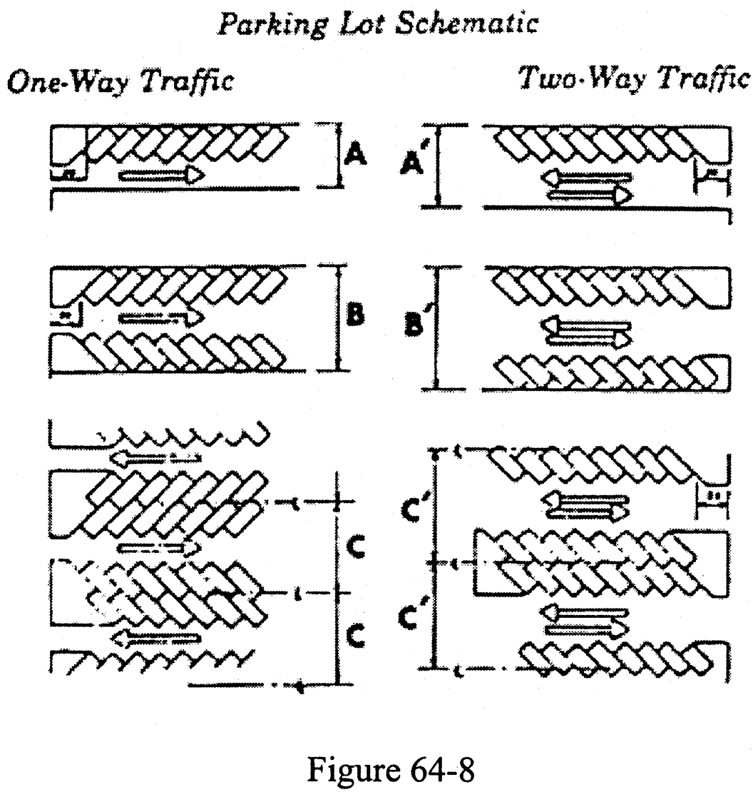
Parking Lot Schematic Figure 64-8
Notes:
(1)
All examples show 45-degree angle parking.
(2)
Wheel stops or curbs are required when the parking spaces face the property line.
(3)
A minimum backup distance of 20 feet is required between the property line and the first stall as shown in examples above.
(4)
Within the area formed by the right-of-way lines of intersecting streets, a straight line connecting points on such right-of-way lines at a distance equal to the required setback for the applicable zoning district from their point of intersection, such connecting line extending beyond the points to the edge of the pavement, there shall be a clear space with no obstruction to vision. Fences, walls, or plantings shall be restricted to a height of three feet or less above the average grade of each street as measured at the centerlines thereof.
(4.1)
Minimum parking bay dimensions by parking angle and parking bay illustration. See Figure 64-8.
(5)
Parking access and driveways: Each parking stall shall have appropriate access to a street or alley, and maneuvering and access aisle areas shall be sufficient to permit vehicles to enter and leave the parking area in a forward motion, with the exception of single-family and duplex areas. Driveways shall be paved and meet the requirements outlined in subsection (b)(6) of this section unless very high volumes or other special circumstances warrant variation by the zoning administrator.
(6)
Access dimension guidelines: The dimension at the street shall be as follows:
* Measured along right-of-way line at inner limit of curbed radius sweep or between radius and near edge of curbed island at least 50 square feet in area. The minimum width applies principally to one-way driveways.
** On side of driveway exposed to entry or exit by right-turning vehicles.
(7)
Site plan requirements: At the time of the application for any minor development (site plan required or major development) for which parking spaces are required to be constructed, a site plan for such parking facilities shall be submitted to the zoning administrator. The site plan shall include the following:
a.
Landscaping and screening shall be provided as outlined in article IV of chapter 66 of this land development code.
b.
Channelization and division of parking areas within the interior of the parking lot for pedestrian and vehicular traffic shall be accomplished by the use of landscaped areas with trees, other natural growth or artificial features or raised curbs. Traffic channelization and other traffic controls, including signing, pavement marking, and ingress and egress to public roads, shall be approved by the zoning administrator.
c.
When the parking facilities are housed in an underground garage or a multistoried structure or on the roofs of buildings, a site plan shall be submitted under this land development code for approval of interior traffic circulation, slope of ramp, ease of access and utilization of ramps, for approval of parking stall and aisle dimensions, proper traffic control signing and pavement marking for safe and efficient vehicular and pedestrian operation, for approval of location of entrances and exits on public roads, for approval of sight distances at such entrances and exits and at corners of intersecting public roads, and for approval of the effective screening of the cars located in or on the parking structures from adjoining properties and from public roads.
d.
The site plan shall be prepared with careful regard to the location of the parking facilities with relation to adjoining land uses, and the parking facilities shall be devised to have the least adverse effect on such adjoining or neighboring properties. The site plan submitted shall show:
1.
The location and design of entrances from and exits to public roads.
2.
The location and size of all buildings and structures.
3.
The location and dimensions of parking spaces and aisles, and directional markings and traffic control devices and signs, and the location of future parking areas as required by subsection (8) of this section.
4.
The location and design of walls, fences, landscaped areas, banks, berms, changes of grades and planting materials, including the type and names of materials proposed to be planted.
5.
Such other information that may be required by the administrative official to meet the rules and regulations of this and other applicable ordinances of the town.
(8)
Off-street parking spaces required:
a.
Residential uses: Two spaces per dwelling unit are required for residential uses.
b.
Government services: Required spaces for governmental services are as follows:
1.
One space per employee on the shift of greatest employment.
2.
One space for each three seats provided in the government service facility if public meeting rooms or areas are provided. This parking requirement shall be in addition to the employee parking requirement in subsection (b)(8)b.1. of this section.
(9)
Special parking prohibition:
a.
There shall be no overnight parking in any front, side or rear yard, except on driveways and parking areas otherwise permitted by code.
b.
There shall be no parking on any vacant parcel of land within the town. Vacant parcels of land are those upon which no structure exists to which the parking may be determined to be an accessory use.
(Ord. No. 540, 3-13-2003; Ord. No. 638, § 2, 11-5-2018)
Cross reference— Licenses and business regulations, ch. 30; nuisances, ch. 34; streets and sidewalks, ch. 46; parking regulations, § 54-76 et seq.; buildings and building regulations, ch. 67.
Sec. 64-47. - Parking of commercial vehicles.
(a)
Residential districts.
(1)
It shall be unlawful for any owner, agent, operator or person in charge of any bus, pole trailer, semitrailer, trailer, mobile home, motor home or other recreational vehicle, truck or truck tractor, as defined by the statutes of the state, to park or store such motor vehicle on any public street or right-of-way within any residential district in the town for a period exceeding one hour in any 24-hour period, each period commencing at the time of first stopping or parking, except as may be otherwise provided in this land development code.
(2)
It shall be unlawful for any owner of property in any residential district in the town to park on or allow to be parked on his residential property any bus, pole trailer, semitrailer, trailer, mobile home, truck or truck tractor for a period exceeding one hour in any 24-hour period, each period commencing at the time of first stopping or parking, except as may be otherwise provided in this land development code.
(b)
Delivery and construction vehicles; emergency repairs.
(1)
The restrictions of subsection (a)(1) of this section shall not apply to the temporary parking of such vehicles or private property in residential districts whereon construction is underway, for which a current and valid building permit has been issued by the town, when such permit is properly displayed on the premises.
(2)
The restrictions of subsection (a)(2) of this section of one hour in residential districts shall not apply to routine deliveries by tradesmen, or the use of trucks in making service calls, providing that such time in excess of one hour is actually in the course of business deliveries or servicing, as the case may be.
(3)
The restrictions of subsection (a) of this section shall not apply to a situation where such vehicle becomes disabled and, as a result of such emergency, is required to be parked within a residential district. However, such vehicle must be used by a resident of the premises and no more than one such truck is permitted on each plot.
(c)
Permitted parking in single-family districts.
(1)
Automobiles, sport utility vehicles, window vans, and mini-vans not exceeding ¾ ton rated capacity, all without commercial markings or exposed commercial or industrial equipment, are exempt from this section.
(2)
One panel, pickup, van or similar type truck of not over ¾ ton in rated capacity, and without commercial markings or exposed commercial or industrial equipment may be parked by a resident or guest at a single-family residence. However, such vehicle must be used by a resident or guest of the premises and no more than one such truck is permitted. Any vehicle parked within a completely enclosed garage (not including a three-sided carport), shall be exempt from this section.
(3)
Boats, or trailers or recreational mobile vehicles as defined in this land development code, may be parked by a resident or guest at a single-family residence, subject to the following restrictions and conditions:
a.
One boat or one trailer with or without a boat thereon, and one recreational mobile vehicle, may be parked at a single-family residence, but not more than one of each shall be so parked.
b.
One boat or one of the vehicles described in subsection (c)(2)a. of this section may be parked in a garage or carport which is effectively screened on three sides; provided, however, that no portion of the boat, motor or vehicle shall extend beyond the roofline. Subject to these requirements, a boat, trailer or recreational mobile vehicle may be parked only if it is currently registered as required by state or federal law and if the transportation of the vehicle would be in compliance with F.S. ch. 316.
c.
Such boat or vehicle must be owned by and used by a resident of the premises.
d.
No boat or vehicle described in subsection (c)(2)a. of this section may be parked in the area between the street and the structure.
e.
One boat or one vehicle described in subsection (c)(2)a. of this section may be parked on a plot occupied by a permitted structure in the side yard or rear yard, providing that it is effectively screened against direct view from abutting properties and adjoining streets by a masonry wall, ornamental fence or dense hedge planting six feet high.
f.
One boat or one of the vehicles described in subsection (c)(2)a. of this section may be parked in the front yard driveway for 12 hours in a 24-hour period, but not to exceed two times in any consecutive seven-day period, and only for the purpose of loading or unloading.
g.
The term "plot," as used in this section, shall include both the lot on which a residence is located and any abutting lot which is in the control of the occupant of such residence by virtue of ownership or lease of such abutting lot. Parking on vacant lots is otherwise prohibited.
h.
No boat or vehicle described in subsection (c)(2)a. of this section parked in a residential district may be occupied or used for living, sleeping or housekeeping purposes.
(d)
Permitted parking in multifamily districts.
(1)
Automobiles, sport utility trucks, window vans, and mini-vans not exceeding ¾ ton rated capacity, all without commercial markings or exposed commercial or industrial equipment, are exempt from this section.
(2)
One panel, pickup, van or similar type truck of not over ¾ ton in rated capacity, and without commercial markings or exposed commercial or industrial equipment may be parked by a resident or guest at a multifamily residence. However, such vehicle must be used by a resident or guest of the premises and no more than one such truck is permitted for each single apartment unit. Any vehicle parked within a completely enclosed garage (not including a three-sided carport), shall be exempt from this section.
(e)
Conflicting parking regulations. In the event of a conflict in the local regulation of parking as provided for in this section and chapter 54, the most restrictive provisions shall apply.
(Ord. No. 540, 3-13-2003)
Cross reference— Licenses and business regulations, ch. 30; nuisances, ch. 34; streets and sidewalks, ch. 46; traffic and vehicles, ch. 54; zoning district regulations, § 64-1 et seq.; buildings and building regulations, ch. 67.
Sec. 64-48. - Off-street loading regulations.
(a)
Scope. At the time of the erection of any principal or accessory use or at the time any principal or accessory use is altered, enlarged or increased in capacity or size by the addition of floor area, off-street loading space for the accommodation of trucks and service vehicles servicing the specific use shall be provided in accordance with this section.
(b)
Minimum dimensions of loading space. For the purposes of this section, a loading space means a space within a main building or on the same lot designed for the standing, loading or unloading of trucks or other service vehicles having minimum dimensions of loading bays as follows:
(1)
Width: 12 feet.
(2)
Length: 30 feet.
(3)
Maneuvering apron: 30 feet.
(c)
Drainage and maintenance. The proposed grading and drainage for the off-street loading facilities shall be approved by the administrative official. All loading areas shall be paved with a minimum of a six-inch shellrock or limerock base and a one-inch hot plant-mix asphaltic, concrete or other acceptable base or durable weatherproof surface pavement. The loading area shall be maintained in a manner so as not to create a hazard or nuisance.
(d)
Landscaping. All off-street loading areas for all uses shall be landscaped as outlined in article IV of chapter 66. The administrative official will determine from the site plans submitted whether the requirements of article IV of chapter 66 have been met.
(Code 1993, § 26-37)
Cross reference— Licenses and business regulations, ch. 30; streets and sidewalks, ch. 46; traffic and vehicles, ch. 54; parking regulations, § 54-76 et seq.; buildings and building regulations, ch. 67.
Sec. 64-49. - Temporary structures.
Temporary structures in connection with building construction or land development projects within the town may be erected for occupancy by personnel involved in the construction or land development project, in accordance with section 67-9 of this Code. No temporary structure, other than as permitted herein in connection with building construction or land development projects, may be constructed, placed or maintained on any lot without a temporary structure permit issued by the administrative officer for a period not to exceed two weeks.
(Code 1993, § 26-38; Ord. No. 621, § 2, 5-1-2017)
Sec. 64-50. - Location of exterior residential equipment and accessories.
(a)
No part of an air conditioning unit, swimming pool maintenance unit and the like, or any equipment or apparatus related thereto, shall be exposed or visible from the front of the primary building structure or be placed within the front yard setback. For purposes of this section, front yard shall be defined as in section 64-1(d), and shall not include canal frontages. No part of an air conditioning unit, swimming pool maintenance unit and the like, or any equipment or apparatus related thereto, may be placed within ten feet of the side or rear lot line of any lot. Customary yard accessories and ornaments and furniture shall be an exception to this section. Any rooftop mechanical equipment shall be screened on all sides from view from off-site properties. The screening of the rooftop equipment shall, at a minimum, equal the height of the proposed equipment. Mechanical equipment shall not be placed on a flat roof permitted for a residential single-family dwelling or an accessory building to a single-family residential dwelling unless specifically authorized in section 67-37. Existing permitted rooftop equipment shall not extend more than 30 inches above the flat roof surface, however, exact change out equipment permit applications are exempt from this provision as determined by the building official.
(b)
No laundry or wearing apparel or any other item to be dried shall be hung from balconies, windows, porches, stairs or clotheslines unless suitably screened so as not to be visible from the street or adjoining properties, and such items shall be concealed by a hedge, fence or similar approved screening device.
(c)
Permanent generators shall not be placed in the required front, street side or street rear yard setbacks. Permanent generators shall meet or exceed the setbacks required for accessory structures as set forth in the town's Land Development Code. In cases where the accessory setback cannot be reasonably achieved, one permanent generator shall be allowed in a required side or rear yard provided it is set back a minimum of five feet from the property line. Additionally, permanent generators shall be placed a minimum of five feet from all windows and doors, and from any neighboring houses. The following criteria will apply to the location of all permanent generators:
(1)
These distances are to be measured from the actual generator and exclude the generator's enclosure.
(2)
Permanent generators are to be installed in a fashion where they are completely screened from the street and abutting neighbors.
(3)
Screening methods to be employed include, but are not limited to, the use of a concrete wall and a hedge around the perimeter of the permanent generator.
(Code 1993, § 26-39; Ord. No. 568, § 3, 7-10-2006; Ord. No. 2019-08, § 7, 6-3-2019; Ord. No. 2022-09, § 8, 8-1-2022)
Sec. 64-51. - Satellite dish antennas.
(a)
Intent. It is the intent of this section to provide for the reasonable, safe and aesthetic installation of satellite dish antennas.
(b)
Permit.
(1)
No person shall construct or cause to be constructed a satellite dish antenna which does not fit within a one-meter cube without first obtaining a minor development permit therefor.
(2)
Application for a permit under this section shall be made to the administrative official and shall be accompanied by payment of a fee as set forth in the schedule of fees in section 63-131 and by plans and specifications and other data, sufficiently detailed, prepared by a competent engineer or architect duly registered and licensed in the state. The engineer or architect must include a statement to accompany the plans and specifications to the effect that the satellite dish antenna, when constructed in accordance with the plans and specifications, can be safely maintained under wind forces to which it can be subjected in the location where placed.
(3)
The plans, specifications and other data submitted under this section shall be in duplicate and shall provide the detail required of structures by the administrative official.
(c)
Location and dimensions.
(1)
Satellite dish antennas which do not fit within a one-meter cube shall be restricted to rear yards only and shall not be installed on the roofs of single-family dwellings. All setback requirements shall be complied with in the plot location of any satellite dish antenna. No such satellite dish may be installed in a front yard.
(2)
The antenna and supporting structure shall be screened from view by the use of shrubbery, trees, foliage or other screening material.
(3)
Satellite dish antennas shall be freestanding, except for a satellite dish antenna which will fit within a one-meter cube, which may be mounted on a structure, and the highest point of the antenna shall not exceed the height of the horizontal eave line of the building or 15 feet above ground level, whichever is less.
(4)
The dish of the antenna shall not exceed 12 feet in diameter, if circular, or 12 feet in its greatest dimension if not circular.
(Code 1993, § 26-40)
Cross reference— Licenses and business regulations, ch. 30; buildings and building regulations, ch. 67.
Sec. 64-52. - Height and yard exceptions.
(a)
Height. The height limitations stipulated in the zoning districts described in this land development code apply to all structures and appurtenances thereto. The following may be considered by application as special exceptions to the height requirements:
(1)
Church spires.
(2)
Church belfries.
(3)
Monuments.
(4)
Water towers.
(5)
Air conditioning cooling towers.
(6)
Elevator bulkheads.
(7)
Flagpoles.
(8)
Antennas, when attached to the primary structure.
(b)
Yards.
(1)
Projections. The roof overhang may project onto the required yard area (setback area) no more than three feet. This provision shall not apply to any other projection or overhang into the required yard area.
(2)
Reduced lot frontage. On curving streets or culs-de-sac, the required lot frontages for lots contiguous to and between the points of curvature (P.C.) of such streets may be reduced by 40 percent, provided that the centerline radius of the contiguous street is 100 feet or less.
(Ord. No. 540, 3-13-2003)
Cross reference— Streets and sidewalks, ch. 46; zoning district regulations, § 64-1 et seq.; buildings and building regulations, ch. 67.
Sec. 64-53. - Churches.
The following requirements and regulations shall be met for churches:
(1)
Minimum lot area. Minimum lot area is 100,000 square feet.
(2)
Minimum lot width. Minimum lot width is 200 feet.
(3)
Minimum lot depth. Minimum lot depth is 200 feet.
(4)
Minimum side yard (interior). Minimum interior side yard is 25 feet.
(5)
Minimum side yard (corner). Minimum corner side yard is 50 feet.
(6)
Minimum rear yard. Minimum rear yard is 25 feet.
(7)
Maximum building height. Maximum building height is 22 feet or not more than two stories.
(8)
Maximum lot coverage. Maximum lot coverage is 25 percent of the total lot area.
(Code 1993, § 26-43)
Sec. 64-54. - Prohibited housing types.
(a)
Generally. Time-sharing uses and mobile homes are hereby prohibited within all zoning districts of the town.
(b)
Exception for manufactured housing. However, manufactured housing is permitted in residential districts if it meets the following standards:
(1)
The unit is certified under the U.S. Department of Housing and Urban Development's Manufactured Housing and Safety Code.
(2)
The units are trucked in for attachment to a permanent foundation.
(3)
The exterior design is acceptable as determined at site plan review, including no flat roofs and no metal facades.
(Code 1993, § 26-44)
Cross reference— Buildings and building regulations, ch. 67.
Sec. 64-55. - Existing housing.
(a)
Housing maintenance.Section 67-31 and thus the Standard Housing Code are hereby adopted by reference to ensure adequate maintenance of all existing housing units.
(b)
Historic housing. Any proposed exterior renovation to a dwelling listed on the state master site file of historic places shall be subject to town commission approval prior to issuance of a building permit. The town commission shall utilize the county standards and professional advisor to assist it in reviewing the renovation to ensure that the historical and architectural integrity of the houses are preserved.
(1)
Variance required. In the event a property owner seeks a development permit, other than a building permit as described in subsection (b) above, no such permit shall be granted without a variance first having been granted by the board of adjustment.
(2)
Variance procedure. This procedure is supplementary to the variance procedures found elsewhere within this land development code. An applicant seeking to:
a.
Renovate (without restoring);
b.
Construct an addition to; or
c.
Demolish (in whole or in part);
a historic property as provided herein, shall apply for same to the board of adjustment, on forms provided for that purpose by the town clerk. At least five days prior to the public hearing on the application, the town manager shall file a written recommendation with the town clerk, with copies provided to the applicant, and to the members of the board of adjustment concerning the recommended approval, approval with conditions, or the denial of the application. The town manager shall specify the reasons for the recommendation, and may consult with any knowledgeable persons including the applicant, the town staff, the applicant's architect, engineer, other design professional or historian. At the conclusion of the public hearing, the board of adjustment shall make formal findings, by motion, using the criteria below, prior to considering a motion to approve, approve with conditions or deny the application.
(3)
Variance criteria. In reviewing a request for a variance herein, the board of adjustment, in addition to the other standards required for variances from this land development code, must find the:
a.
Structure does not have a "significant historic value" to the town. The standards for review shall be the age, structural condition, architecture, celebrity of the former occupants, former uses, and the educational value of the structure.
b.
Cost and practical feasibility of repair or restoration is not reasonable when compared to the cost of replacement (significantly lower), or compared to the economic value of the property without the structure (significantly higher).
(Ord. No. 540, 3-13-2003)
Sec. 64-56. - Antennas, masts, etc.
(a)
Permits shall be obtained for the installation of outlets, equipment, antennas and radio masts. The permit fee for installation of each antenna or mast shall be as set forth by resolution of the town commission, except that reinspections caused by installation found faulty upon first examination, or when corrections have not been made when reinspection is requested, shall each be subject to a further inspection fee as set forth by resolution of the town commission.
(b)
Masts and towers for all televisions and radio installations shall be of corrosion-resistant materials and of an approved type. When a mast or antenna is installed on a roof, it shall be supported on its own platform and securely anchored with guy wires.
(c)
No mast for the support of antennas shall be erected within the distance of its height plus six feet of any wires operating in excess of 600 volts, unless the antenna is lower than the wires operating in excess of 600 volts or by written consent of the electrical department.
(d)
No person shall install or allow to be operated on his premises within the town any apparatus which may cause objectionable radio or television interference, unless such apparatus is effectively guarded by proper interference eliminating or mitigating equipment.
(Code 1993, § 26-46; Ord. No. 633, § 6, 9-6-2018)
Sec. 64-57. - Balconies not to extend into required yard setbacks.
Except as provided in section 64-1, all balconies above the first floor level shall be constructed so that the exterior edge of the balcony does not protrude or extend into the required front yard setback, side yard setback or rear yard setback.
(Code 1993, § 26-48)
Sec. 64-58. - Underground locations of utility service lines.
At the time that any new buildings and/or structures are being constructed or located on any privately owned property, or at the time that any existing buildings and/or structures are on privately owned property are being reconstructed or substantially improved (as defined in section 1-3 of the code), such buildings and/or structures shall have an entirely underground location for all utility service lines, electrical distribution systems, wires and cables, which connect to and service such buildings and/or structures.
(Code 1993, § 26-49)
Sec. 64-59. - Guest cottages.
Guest cottages shall comply with the property development regulations for the district in which it is located. Such quarters shall have no cooking facilities.
Sec. 64-60. - Decks, patios, driveways, parking areas, steps, stoops, and terraces (unenclosed and uncovered).
Unenclosed and uncovered decks, patios, driveways, parking areas, steps, stoops, and terraces shall be setback at least five feet from any property line or right-of-way line, whichever is closer. These improvements shall be maintained and drained so as to prevent nuisance conditions, which include, but is not limited to, nuisances as described in this Code, to the public and/or abutting property owners. In those instances where that portion of the property containing the deck, patio, steps, stoops or terraces abuts a sea wall, the setback requirement for the primary area where the deck, patio, steps, stoops or terraces abuts the sea wall shall be waived. Flat roof usable areas as defined in section 64-1(f)(3) shall comply with all applicable building setbacks.
(Ord. No. 620, § 2, 5-1-2017; Ord. No. 638, § 3, 11-5-2018; Ord. No. 2022-09, § 9, 8-1-2022)
Editor's note— Ord. No. 638, § 3, adopted Nov. 5, 2018, changed the title of § 64-60 from "Decks, patios, steps, stoops, and terraces (unenclosed and uncovered)" to read as herein set out.
Sec. 64-76. - Marina facilities.
(a)
Generally. Marina facilities are allowed as special exceptions in all residential districts subject to the property development regulations of the specific zoning district and the special regulations provided for in this article and provided they are accessory to and part of a principal residential development.
(b)
Permitted facilities. Marina facilities shall include facilities for wet storage and the docking of pleasure craft for residential purposes. Marina facilities may include a marina, boat dock and yacht club. The yacht club may provide a restaurant, lounge, ship's chandler and other club facilities as an accessory use to the marina, boat dock or yacht club facility.
(c)
Property development regulations. The property development regulations and requirements of section 64-43, pertaining to private clubs, shall apply where appropriate in addition to the regulations provided for in this article.
(d)
Parking. For each boat accommodated at the facility, there shall be provided one parking space. In addition, for such accessory facilities as yacht clubs and the like, five spaces per 1,000 square feet of total floor area shall be provided.
(e)
Dock length. No dock, building or other structure shall extend further than 200 feet from the established shoreline, and structures shall be subject to all applicable regulations for dock construction of the town, the county and the state.
(f)
On-site sewer and water facilities. All marine facilities shall provide, at each boat slip, an individual sewer and water connection, an approved on-shore sewage system and a potable water system. A central dumping station may be provided upon approval of all governmental agencies having appropriate jurisdiction over water and sewer facilities.
(g)
Restrictions on activities and use. In no event shall dry storage, fuel or repair facilities be permitted. All facilities permitted in this article are restricted to use by residents of the principal residential use or club members only and their guests, who shall be subject to regulations stipulated in chapter 62.
(Code 1993, § 26-92)
Sec. 64-77. - Location, type and height of docks, floating docks and pilings.
(a)
Dockage space and facilities for the mooring of pleasure boats, yachts and noncommercial watercraft shall be permitted in any waterway within the town as an accessory use to the residential occupancy of a lot. No occupancy shall be permitted on any adjacent vacant lot unless there is unity of title. Docks permitted hereunder shall conform to the requirements of the county department of environmental resource management, and the state department of environmental protection, if any.
(b)
No dock shall project more than five feet into any waterway line or established bulkhead line, or extend closer than ten feet to the lot line of any adjacent lot or closer than ten feet to the lot line extended beyond said property line on a line perpendicular to the seawall or bulkhead. Measurements shall be made to the edge of the flat (walking) surface of the dock, without regard to pilings. Pilings shall not be considered in the dimensional measurements so long as no more than a pile width extends beyond the flat (walking) surface of the dock.
(c)
Dolphin pilings, being defined as those kinds or types which are self-supporting and unattached to the dock proper, shall be allowed; provided that they shall not project more than 20 feet into any waterway or extend closer than ten feet to the lot line of any other property, or closer than ten feet to the lot line extended beyond said property line on a line perpendicular to the seawall or bulkhead, and that they shall not interfere with navigation on waters within the town.
(d)
In the case of any dock, wherever located, the height of the dock shall not exceed five feet above the mean low water or the cap of the seawall or bulkhead to which such dock abuts, if any, whichever is higher, and no superstructure shall be constructed thereon, except a railing not to exceed four feet in height.
(e)
Floating platforms or docks for the storage or use of personal watercraft or boats shall be allowed immediately adjacent to the seawall or bulkhead of a lot with a single-family residence. Such platforms shall be moored between the seawall or bulkhead and dolphin pilings, and shall conform to the setback requirements established in paragraphs (b) and (c) above. The installation of such a platform which does not require the installation of pilings does not require a permit from the town. Floating platforms for multifamily developments shall require a permit and shall be allowed only as special exception uses.
(f)
Davits and boat lifts shall be permitted to be attached to the seawall, bulkhead cap, dolphin piling and dock, and the base shall conform to the setback requirements otherwise required herein; the boom or lift shall not extend beyond the area permitted for dolphin pilings.
(g)
Seawalls, bulkheads, docks, dolphin pilings, floating docks, and davits, or boat lifts appurtenant to a seawall or bulkhead, shall require a building permit.
(Ord. No. 540, 3-13-2003)
Sec. 64-78. - Bulkhead line.
There is hereby established a bulkhead line for all sovereign tidal waters and submerged lands lying within the town and subject to the jurisdiction of the town, such bulkhead line being more particularly described as follows:
Beginning at the point of intersection of the easterly right-of-way line of the Intracoastal Waterway, according to the plat thereof recorded in Plat Book 17, page 13A, public records of Palm Beach County, Florida, and the centerline of Cherokee Avenue, plat of Briny Breezes, Addition No. 2, according to the plat thereof, recorded in Plat Book 14, page 62, public records of Palm Beach County, Florida, such centerline being the south corporate limits of the town; thence north 7° 07′ 04″ east along such easterly right-of-way line and such bulkhead line a distance of 547.14 feet; thence north 16° 30′ 02″ east along such easterly right-of-way line and such bulkhead line a distance of 610.92 feet; thence north 7° 31′ 42″ east along such easterly right-of-way line and such bulkhead line a distance of 6,547.98 feet to a point; thence south 89° 31′ 12″ east along such bulkhead line a distance of 100.76 feet; thence north 7° 31′ 42″ east along the westerly boundary of Inlet Cay, according to the plat thereof, recorded in Plat Book 24, page 222, public records of Palm Beach County, Florida, and such bulkhead line, a distance of 1,303.73 feet; thence north 32° 21′ 42″ east along the boundary of such Inlet Cay and such bulkhead line a distance of 240.42 feet; thence south 89° 22 ′ 59″ east along the north boundary of such Inlet Cay and such bulkhead line a distance of 516.19 feet; thence north 13° 28′ 53″ east along such bulkhead line a distance of 348.61 feet to a point in the westerly boundary of McCormick Mile, according to the plat thereof, recorded in Plat Book 24, page 191, public records of Palm Beach County, Florida; thence north 9° 25′ 47″ east along the westerly boundary of McCormick Mile and such bulkhead line a distance of 473.38 feet; thence north 12° 57′ 41″ west along such bulkhead line a distance of 358.10 feet to a point in the westerly boundary of McCormick Mile, Addition No. 1, according to the plat thereof recorded in Plat Book 25, page 181, public records of Palm Beach County, Florida; thence north 5° 22′ 25″ east along such westerly boundary of McCormick Mile, Addition No. 1, and such bulkhead line, a distance of 1,287.66 feet to a point in the north line of Section 22, Township 45 South, Range 43 East, Palm Beach County, Florida; thence south 89° 39′ 15″ east along such north line of Section 22 and such bulkhead line a distance of 988.77 feet; thence north 0° 45′ 45″ east along such bulkhead line a distance of 165 feet; thence south 89° 39 ′ 15″ east along such bulkhead line a distance of 45 feet; thence north 16° 14′ 55″ east along such bulkhead line a distance of 348.24 feet, to the southwest corner of existing pier of the Boynton Inlet Docks; thence north 12°14′ 155″ east along such bulkhead line a distance of 639.58 feet to a point in the north property line of the South Lake Worth Inlet District and the end of such bulkhead line, such line being also the north corporate limits of the town, such point being also located at a distance of 605.67 feet north 80° 31′ 25″ west from the centerline of State Road No. A-1-A.
(Code 1993, § 26-94)
Cross reference— Waterways and parks, ch. 62; buildings and building regulations, ch.67.
Sec. 64-79. - Filling.
No fill or filling or other creation or extension of land shall be made or maintained on the channel side of the bulkhead line and no filling or dredging or similar activity shall be made on the landward side of such line without formal written approval from the necessary authorities.
(Code 1993, § 26-95)
Sec. 64-80. - Permit.
(a)
Any person desiring to construct islands or to add to or extend existing lands within the landward side of the bulkhead line established by this article, by pumping, dredging or dumping sand, rock or earth or by any other means, shall first make application to the town commission for a permit to do so in accordance with article IV of chapter 63 of this land development code. Such written application shall be accompanied by a plan or drawing showing the proposed construction and shall also show the area from which any fill material is to be dredged if the proposed construction is intended to be created from dredged material. If such application is found by the town commission not to be violative of any statute, zoning law, ordinance or other restriction which may be applicable thereto, or that no harmful obstruction to or alteration of the natural flow of the adjacent navigable waters will arise from the proposed construction, or that no harmful or increased erosion, shoaling of channels or stagnant areas of water will be created thereby, or that no material injury or monetary damage to adjoining land or property will accrue therefrom, a permit shall be granted to the applicant; subject however, to the approval of any other local, state or federal authority with jurisdiction including, but not limited to, the trustees of the internal improvement fund of the state, the Department of Environmental Protection and the United States Army Corps of Engineers.
(b)
All permits issued under this article shall be valid for a period of two years from the date of issuance, but shall be automatically revoked if the proposed work is not completed within such period, except for good cause shown. Such permits shall also be subject to revocation for noncompliance therewith or a violation thereof.
(Code 2003, § 26-96)
Sec. 64-81. - Failure to maintain and repair prohibited; declaration of public nuisance.
It shall be unlawful for any person owning or having a beneficial interest in any real property within the town which abuts any canal, inlet or other navigable waterway, and upon which a seawall, bulkhead, or dock is constructed, to allow such seawall, bulkhead, or dock to fall into a state of disrepair or ruin so as to cause or allow flooding or other damage to such land or lands adjacent thereto or to otherwise be unsafe. The existence of bulkheads, seawalls, or docks in such a state of disrepair or ruin hereby is declared a public nuisance.
(Ord. No. 540, 3-13-2003)
Sec. 64-82. - Minimum design requirements for seawalls and seawall maintenance.
(a)
All new seawalls, substantially repaired seawalls, or substantially rehabilitated seawalls shall be designed and constructed to have the following minimum design requirements unless the requirements of a jurisdictional agency are more restrictive:
(1)
The top elevation of a new, substantially repaired, or substantially rehabilitated seawall (inclusive of the seawall cap) shall be a minimum of five feet NAVD88.
(2)
If the property line abuts the waterway line, a new seawall shall be constructed with the waterside face on the property line. If the property line extends waterward of the waterway line, a new seawall shall not be constructed in any manner that unreasonably interferes with navigation of the abutting waterway and/or any existing easement rights. To the extent practicable, all such new seawalls shall be designed and constructed to adjoin immediately proximate seawalls to close gaps and prevent the trespass of tidal water.
(3)
For a substantially repaired or substantially rehabilitated seawall, a property owner may extend the projection of the existing seawall as follows:
a.
If the property line abuts the waterway line, the substantially repaired or substantially rehabilitated seawall may project a maximum of 18 inches waterward of the property line. No further projections waterward of the property line will be permitted.
b.
If the property line extends waterward of the waterway line, a substantially repaired or substantially rehabilitated seawall shall not be extended farther waterward in any manner that unreasonably interferes with navigation of the abutting waterway and/or any existing easement rights.
c.
To the extent practicable, all such substantially repaired or substantially rehabilitated seawalls shall be designed and constructed to adjoin immediately proximate seawalls to close gaps and prevent the trespass of tidal water.
(4)
The seawall cap of a new, substantially repaired, or substantially rehabilitated seawall shall not extend farther than two feet from the wet face of the seawall or the property line, whichever is greater.
(5)
For purposes of section 64-77(b) (regarding the maximum projection of docks into the waterway), the outermost waterside edge of a new, substantially repaired, or substantially rehabilitated seawall shall be the starting point for the measurement of a dock's maximum projection into the waterway. In no event shall a docks' maximum projection into the waterway unreasonably interfere with navigation of the abutting waterway and/or any existing easement rights.
(6)
Seawall caps placed at an elevation greater than the adjacent property shall provide a wall return of the same material and type as the seawall cap or other engineer-approved material and type.
(b)
If substantial damage occurs or substantial improvement is permitted to be made to the principal structure on property adjacent to a waterway with an existing seawall, the existing seawall must comply with or shall be brought into compliance with the minimum design requirements set forth in subsection (a) above. The terms "substantial damage" and "substantial improvement" as set forth in this subsection shall have the same meanings as set forth in section 66-25.
(c)
For purposes of this section, the following terms shall have the following meanings and shall prevail over definitions contained in other documents or manuals including, but not limited to, the Florida Building Code:
(1)
New seawall means the construction of a seawall for the first time for property adjacent to a waterway, or the full replacement of an existing seawall, and which seawall is permitted for construction by the Town.
(2)
North American Vertical Datum (NAVD88) means the vertical control for datum of orthometric height established for vertical control surveying in the United States of America based upon the General Adjustment of the North American Datum of 1988.
(3)
Seawall means a vertical or near vertical (often interlocking) accessory structure, inclusive of the seawall cap, placed between an upland area and/or proposed upland area and a waterway (inclusive of waterbodies) for erosion and/or flood control.
(4)
Seawall cap means a concrete box structure (usually reinforced) that connects seawall panels, piles, and anchoring system (if present) together at the top.
(5)
Substantially repaired or substantially rehabilitated seawall means a seawall that is permitted for construction by the Town and includes:
a.
Any modification to the seawall along more than 50 percent of the length of a property's shoreline; or,
b.
Any modification or alteration of the property's existing seawall that exceeds 50 percent of the fair market replacement cost of the existing seawall as certified by licensed Florida engineer.
c.
Strictly for the purposes of defining "substantially repaired" and "substantially rehabilitated" for this section, the term "seawall" excludes docks, piles, and ancillary concrete footers but shall include concrete docks that are poured monolithically with the seawall.
(d)
Consistent with section 67-71 and 64-108. all new, substantially repaired, or substantially rehabilitated seawalls shall be installed, repaired, or rehabilitated under a building permit issued by the town for such accessory structures, provided that all permits from other governmental agencies with jurisdiction have been acquired.
(e)
All property owners shall maintain their seawall in good repair. A seawall is presumed to be in disrepair if it allows tidal waters to flow through the seawall and onto any adjacent property or onto any public right-of-way. Failure to maintain a seawall in good repair shall be a citable violation under the Town's community standards procedures.
(f)
This section shall not apply to property whose property line is adjacent to the Atlantic Ocean.
(g)
Nothing in this section shall be interpreted or construed to allow the construction of a new seawall for property adjacent to a waterway (inclusive of waterbodies) where no previous seawall existed and no principal structure existed or exists. Notwithstanding the foregoing, a new seawall may be constructed if necessary to protect government-owned or controlled real property, tangible property, equipment, and/or facilities where no principal structure existed or exists on the adjacent real property.
(Ord. No. 2025-03, § 2, 6-2-2025)
Sec. 64-96. - Purpose of article.
The purpose of this article is to establish procedures and standards for the development and subdivision of real estate within the town, in an effort to, among other things, ensure proper legal description, identification, monumentation and recording of real estate boundaries; aid in the coordination of land development in the town in accordance with orderly physical patterns; discourage haphazard, premature, uneconomic or scattered land development; ensure safe and convenient traffic control; encourage development of an economically stable and healthful community; ensure adequate utilities; prevent periodic and seasonal flooding by providing protective flood control and drainage systems; provide public open spaces for recreation; ensure land subdivision with installation of adequate and necessary physical improvements; ensure that the citizens and taxpayers of the town will not have to bear the costs resulting from haphazard subdivision of land and the lack of authority to require installation by the developer of adequate and necessary physical improvements; and ensure to the purchaser of land in a subdivision that necessary improvements of lasting quality have been installed.
(Code 1993, § 26-158)
Sec. 64-97. - Prerequisites for recording plat; waiver of requirements.
(a)
All subdivisions of land within the town must receive master plan and plat approval in conformance with this land development code. No subdivision shall be platted, replatted or recorded or certificate of occupancy issued unless such subdivision conforms to the requirements of this land development code and any applicable law and has been approved by the town commission as provided in this article.
(b)
The requirements of section 64-100, pertaining to the plat master plan, and section 64-101, pertaining to construction plans, may be waived, if such information is readily available from a public source, does not adversely affect the ability of the plat to be recorded, and contributes no new information for consideration by the town. Application for relief from the strict requirements of these sections shall be made, in writing, to the town manager, who shall apply the standards and criteria set out in this subsection in deciding if relief may be granted.
(Ord. No. 540, 3-13-2003)
Sec. 64-98. - Unsuitable land.
Unless adequate methods of correction are formulated and approved in accordance with the provisions of this land development code, land which is determined to be unsuitable for subdivision due to poor soil quality, flooding or drainage or other features likely to be harmful to the health, safety and general welfare of future residents shall not be subdivided.
(Ord. No. 540, 3-13-2003)
Sec. 64-99. - Preapplication conference.
The purpose of the preapplication conference is to allow the developer and the administrative official the opportunity to consult informally prior to the preparation of the master plan and formal application for subdivision master plan and subdivision plat approval. The following items should be discussed at the preapplication conference:
(1)
Site conditions and proposed subdivision layout.
(2)
Existing utilities, general soil characteristics, public facilities and the like.
(3)
Number of lots, typical lot, approximate acreage, natural features such as low or swampy areas, streams, lakes or canals, and identification of adjacent lands.
(4)
Name, telephone number and address of the developer and owner of record.
(5)
Date, north point, streets, zoning classification of the tract and adjacent properties, and the like.
(Code 1993, § 26-161)
Sec. 64-100. - Plat master plan.
(a)
Number of copies. Six copies of the master plan of the proposed subdivision shall be submitted to the administrative official.
(b)
Use of professional services. The developer shall retain the services of an engineer or surveyor registered in the state to prepare the master plan of the subdivision, and may employ a land planner, landscape architect, architect or other technical or professional services to assist in the physical plotting patterns and site plan. The master plan shall be coordinated with the major utility suppliers involved with providing services to the site.
(c)
Required information. The master plan, when submitted to the administrative official, shall contain the following:
(1)
The name of the subdivision or identifying title, which shall not duplicate or closely approximate the name of any other subdivision in the incorporated area of the town or the unincorporated area of the county.
(2)
A vicinity sketch showing the location of the tract in reference to other areas of the town.
(3)
North arrow, graphic scale, scale and date.
(4)
The name, address and telephone number of the developer and owner of record, along with the name and address of the engineer and surveyor responsible for the plan, plat and supporting data.
(5)
The location and names of adjacent subdivisions, if any, and plat book and page references.
(6)
The tract boundary, with bearings and distances, along with a written description.
(7)
Topographical conditions on the tract, including all the existing watercourses, drainage ditches and bodies of water, marshes and other significant features.
(8)
All existing streets and alleys on or adjacent to the tract, including name, right-of-way width, street or pavement width and established centerline elevation. Existing streets shall be dimensioned to the tract boundary.
(9)
All existing property lines, easements and rights-of-way, and their purpose and their effect on the property to be subdivided.
(10)
The location and right-of-way width of all proposed streets, alleys, rights-of-way and easements, and their purpose, along with the proposed layout of the lots and blocks. No lot may be created which does not have frontage on an improved street. No lot may be created which has principal access from an alley or unimproved right-of-way.
(11)
The incorporation and compatible development of present and future streets as shown on the official map adopted by the town commission, when such present or future streets are affected by the proposed subdivision.
(12)
Access points to collector and arterial streets showing their compliance to the access requirements established by this land development code.
(13)
Ground elevations by contour line, at intervals of not more than one foot, based on National Ocean Survey datum or as otherwise determined by the town engineer.
(14)
All existing drainage district facilities and their ultimate right-of-way requirements as they affect the property to be subdivided.
(15)
A generalized statement of subsurface conditions on the property, and location and results of tests made to ascertain subsurface soil conditions and groundwater depth.
(16)
Zoning classification of the tract.
(17)
Utilities such as telephone, power, water, sewer, gas, etc., on or adjacent to the tract, including existing or proposed water treatment plants and sewage treatment plants. The master plan shall contain a statement that all utilities are available and have been coordinated with all required utilities.
(18)
Sites proposed for parks, recreational areas and schools, if applicable.
(19)
The locations of all temporary structures or permanent structures having a temporary use. In addition, master plans or site plans showing permanent structures having a temporary use shall contain a statement outlining the temporary use. Master plans or site plans showing temporary structures or permanent structures having a temporary use shall be reviewed by the administrative official at least six months from the last approval date. A mobile home may be used as a temporary structure if approved by the administrative official as a construction trailer or security trailer during the construction period.
(d)
Traffic impact analysis. A subdivision that generates 3,000-vehicle, single-directional trips per day or 250-vehicle, single-directional trips in a one-hour period must submit, along with the master plan, a traffic impact analysis. The traffic impact analysis shall be prepared by a professional engineer and shall be used to determine the number of lanes and capacity of the street system proposed or affected by the development and the phasing of improvements.
(e)
Stormwater management plan. A master stormwater management plan outlining the primary and secondary drainage and stormwater treatment facilities needed for the proper development of the subdivision, excluding tertiary facilities, which are required on construction plans, shall be submitted along with the master plan. The master stormwater management plan shall consist of an engineering drawing and a written report indicating the method of drainage, existing water elevations, recurring high water elevations, the proposed design water elevations, 100-year storm elevation, drainage structures, canals and ditches, the stormwater treatment methods, necessary percolation, detention and management areas, and any other pertinent information pertaining to the control and management of stormwater and groundwater. In cases where modification or improvements are neither planned nor required for primary and secondary drainage facilities, this requirement may be accomplished by so indicating on the master plan.
(f)
Master plan approval.
(1)
The administrative official shall inform the developer that the subdivision master plan and data as submitted does or does not meet the provisions of this land development code. The developer shall make all corrections or revisions and resubmit the subdivision master plan and required data to the administrative official if necessary.
(2)
Upon approval of the subdivision master plan, the administrative official shall authorize the developer to proceed with the preparation of construction plans and a preliminary plat as required by this article.
(Ord. No. 540, 3-13-2003)
Sec. 64-101. - Preparation and submission of construction plans.
(a)
Subdivision construction plans shall be submitted for all improvements as required by this section. Plans shall be submitted under separate cover for each of the following, when required:
(1)
Paving, grading and drainage.
(2)
Bridges.
(3)
Water and sewer systems.
(4)
Street lighting, landscaping within public rights-of-way, parks, recreational areas and parking areas. Plans for streetlights shall have the approval of the requisite utility authorities involved if provided in the subdivision.
(b)
The plans shall be so complete that from them a complete review and analysis can be made without research from any outside area. The plans shall consist of and contain but shall not be limited to:
(1)
A cover sheet, including a vicinity sketch.
(2)
A plan showing complete details, including water, sewer and storm drainage systems.
(3)
In addition to a master stormwater management plan, complete calculations used to design the stormwater system.
(4)
Typical sections and summary of quantities.
(5)
Construction details showing compliance with town standards or alternate design as approved by the town engineer.
(6)
Special profile sheets, if necessary, showing special or unique situations.
(7)
Benchmark based on National Ocean Survey datum.
(8)
Soil analysis showing the locations and results of test borings of the subsurface condition of the tract to be developed. Where nonpervious soils, commonly called hardpan, are encountered, the plans shall reflect a satisfactory design to cope with such conditions. If the soil analysis reflects that the area contains hardpan or other nonpervious soils, the town engineer shall require such additional design and construction as are necessary to ensure proper drainage and development of the area.
(9)
The plans shall contain the special conditions and specifications pertaining to the subdivision in note form on the plan, such as:
a.
Required compliance with this land development code.
b.
Where applicable, required compliance with state standards as currently adopted and in use.
c.
Minimum standards for materials.
d.
Test requirements for stabilization, base and backfill.
e.
Source of water and sewer service.
f.
Required installation of subsurface construction such as water lines, sewer lines, public utilities and storm drainage prior to compaction of subgrade and roadway construction.
(c)
The plans shall be prepared, certified and sealed by the developer's engineer. One set of plans for paving and drainage, bridges, water systems, sewer systems and street lighting, if provided; landscaping and parks, if provided; and recreational areas and parking areas shall be submitted to the administrative official for review and approval. Prior to issuance of a land development permit, the plans shall have all applicable approvals of all requisite governmental agencies having jurisdiction over the proposed development. Subdivision projects engineered by more than one firm shall be coordinated by a single engineering firm or an engineer appointed by the developer.
(d)
A certified cost estimate shall be prepared by the developer's engineer and shall include the cost of surveying and all required improvements, or the contract bid price may be substituted for the engineer's cost estimate.
(Ord. No. 540, 3-13-2003)
Sec. 64-102. - Submission of preliminary plat.
(a)
Six prints of the preliminary subdivision plat shall be submitted to the administrative official along with the construction plans, together with a nonrefundable fee payable to the town in an amount established by resolution of the town commission.
(b)
Restrictive covenants, condominium documents, property owners' association documents, deeds or other legal documents not related to the survey or engineering design of the project are not required at this stage of subdivision plat approval, and the preliminary plat may be submitted without signatures and seals.
(Code 1993, § 26-164)
Sec. 64-103. - Approval of construction plans and preliminary plat.
(a)
The administrative official shall review the construction plans and the preliminary subdivision plat as to their conformity with this land development code, and, within 30 days from the date of the submittal of the plans and plat, the administrative official shall inform the developer's engineer that the plans and the preliminary subdivision plat as submitted do or do not meet the provisions of this land development code.
(b)
When the administrative official's office finds that the construction plans and preliminary plat as submitted do not meet the provisions of this land development code, the administrative official shall advise the developer's engineer in writing and reference shall be made to the specific article, section and subsection with which the plans and plat do not comply. Upon such findings, the developer's engineer shall make the corrections or revisions as defined in the written statement and shall resubmit the construction plans and preliminary plat within 60 days from the date of notice. Failure to resubmit the plans and plat within 60 days will require an additional fee not to exceed the amount of the original fee.
(c)
When the administrative official's office determines that the construction plans and preliminary plat meet the provisions of this land development code, it shall advise the developer's engineer and furnish a written statement of technical compliance and surety establishment. Upon receipt of the technical compliance statement, the developer's engineer shall submit six sets of construction plans, having the health department's approval, at the time of submission of the final plat.
(d)
Technical compliance of the construction plans and preliminary plat shall not constitute acceptance of the final plat; rather, it shall be deemed an expression of acceptance of the layout submitted on the preliminary plat as a guide to the preparation of the final plat. Technical compliance of the construction plans and preliminary plat shall not be construed as authority for filing the plat with the clerk of the circuit court of the county, or as authority for the sale of lots in reference thereto.
(e)
Prior to completing the requirements of the sections of this article relating to the final plat, building permits shall not be issued for any structure on a lot wherein the final plat has not been recorded in the manner prescribed.
(Ord. No. 540, 3-13-2003)
Sec. 64-104. - Preparation of final plat.
(a)
The developer shall have prepared and shall submit a final subdivision plat as the final step in the review procedures for subdivision plat approval in the town.
(b)
Final subdivision plat approval shall be required prior to the construction of improvements required under this land development code. No such improvements, including streets, drainage and the like, shall be accepted and maintained by the town unless and until the final plat has been approved by the administrative official and the town commission and duly recorded by the clerk of the circuit court, who shall record only those final plats which have been approved by the town commission in accordance with this land development code and submitted for recording by the administrative official.
(c)
Upon filing an application for final subdivision plat approval, the developer shall pay a fee in an amount as set forth by resolution of the town commission to help defray the cost of administration and processing of the final subdivision plat. In addition to the administration and processing fee, the developer shall pay a fee of one percent of the estimated cost of construction of those improvements required by this article, to defray the cost of administration and inspection of the subdivision development. In order to have the final subdivision plat recorded, a separate check made payable to the clerk of the circuit court of the county shall accompany the final plat, in the amount established by the clerk's office.
(d)
Within six months from the date of the written approval of the town of the construction plans and the preliminary subdivision plat, the final subdivision plat shall be prepared and submitted to the administrative official. Failure to submit the final plat within six months shall require reapplication under section 64-101 and section 64-102.
(e)
The final plat shall conform to the approved subdivision master plan and shall constitute only that portion of the subdivision master plan which the developer proposes to develop within the next 24 months.
(f)
The final subdivision plat shall be drawn or printed on 24-inch by 36-inch linen, chronoflex, mylar or other approved material. The final plat shall be prepared by a land surveyor currently registered in the state, and is to be clearly and legibly drawn with black permanent drawing ink or veritype process to a scale of not smaller than one inch equals 100 feet, or as otherwise determined by the administrative official. The final plat shall be prepared in accordance with the provisions of F.S. ch. 177, as amended, and shall conform to the following requirements:
(1)
Name of subdivision. The plat shall have a title or name acceptable to the town. When the plat is a new subdivision, the name of the subdivision shall not duplicate or be phonetically similar to the name of any existing subdivision. When the plat is an addition to a recorded subdivision, it shall carry the same name as the existing subdivision.
(2)
Title. The plat shall have a title printed in bold, legible letters containing the name of the subdivision, the name of the town, county and state, and the section, township and range, or land grant, as applicable. If the plat is a replat, amendment or addition to an existing subdivision, it shall include one of the following words: "section," "unit," "replat," "amendment," etc.
(3)
Description. There shall be lettered or printed upon the plat a full and detailed description of the land embraced in the plat. The description shall show the section, township and range, or land grant, as applicable, in which the lands are situated, and must be so complete that from it, without reference to the map, the starting point can be determined and the boundaries run.
(4)
Index. If more than one sheet is required for the map, the plat shall contain an index sheet on page 1 showing the entire subdivision on the sheet and indexing the area shown on each succeeding sheet, and each sheet shall contain an index delineating that portion of the subdivision shown on that sheet in relation to the entire subdivision. When more than one sheet must be used to accurately portray the lands subdivided, each sheet must show the particular number of that sheet and the total number of sheets included, as well as clearly labeled match lines to each sheet.
(5)
Survey data. The final plat shall show the length of all arcs, together with central angles, radii and points of curvature. Sufficient survey data shall be shown to positively describe the boundary of each lot, block, right-of-way and easement and all other areas shown on the plat, and all areas shall be within the boundary of the plat as shown in the description. The survey data contained on the plat shall also include the following:
a.
The scale, both stated and graphically illustrated, shall be shown on each sheet.
b.
A prominent north arrow shall be drawn on every sheet included showing any portion of the lands subdivided. The bearing or azimuth reference shall be clearly stated on the face of the plat in the notes or legend.
c.
The point of beginning shall be boldly shown, together with the letters "P.O.B." in bold letters.
d.
All intersecting street right-of-way lines shall be joined by the long chord of a minimum radius of 25 feet, and all dimensions shall be shown.
e.
All adjoining property shall be identified by a subdivision title, plat book and page, or, if unplatted, the land shall be so designated.
f.
Permanent reference monuments shall be shown in the manner prescribed by F.S. ch. 177, as amended, and shall be installed prior to submission of the final plat.
g.
There shall be reserved on each sheet of the plat a three-inch by five-inch space in the upper righthand corner to be used by the clerk of the circuit court for recording information, and each sheet shall reserve three inches on the left margin and a one-half-inch margin on all remaining sides.
h.
The map shall mathematically close within 0.01 feet and shall be accurately tied to all county township, range and section lines occurring within the subdivision, by distance and bearing. In addition, the initial point in the description shall be accurately tied to the nearest quarter section corner or government corner.
i.
The cover sheet or first page of the plat shall show a vicinity sketch showing the subdivision's location in reference to other areas of the county.
(6)
Lot and block identification. Each lot and block shall be numbered or lettered. All lots shall be numbered or lettered by progressive numbers or letters individually throughout the subdivision or progressively numbered or lettered in each block. Blocks in each incremental plat shall be numbered or lettered consecutively throughout a subdivision.
(7)
Street names. The plat shall contain the name of each street shown on the plat. Proposed streets which are in alignment with other existing and named streets shall bear the same name as the existing street. In no case, except as indicated in this subsection, shall the name of a proposed street, excluding a numerical system, duplicate or be phonetically similar to existing street names, regardless of the use of the suffix "street," "avenue," "boulevard," "drive," "place," "court," etc.
(8)
Not included parcels. Not included or excepted parcels must be marked with the words "not a part of this plat." Where a not included parcel is completely surrounded by areas included within the plat, sufficient easements or rights-of-way to provide necessary access, utilities and drainage to the not included parcel shall be provided. No strip or parcel of land shall be reserved by the owner unless the strip or parcel is sufficient in size and area to be of some particular use or service. The intended use of all reserved areas shall be shown on the plat in note form on the cover sheet.
(9)
Rights-of-way and easements. All rights-of-way and easement widths and dimensions shall be shown on the plat. The plat shall contain a statement that no buildings or structures or trees or shrubs shall be placed on rights-of-way and that no buildings or structures shall be placed on easements.
(10)
Restrictions, reservations and restrictive covenants. Restrictions pertaining to the type and use of water supply, the type and use of sanitary facilities, the use and benefits of water areas, canals and other open spaces, odd-shaped and substandard parcels, control of building lines, and establishment and maintenance of buffer strips and walls, and restrictions of similar nature shall require the establishment of restrictive covenants, and such covenants shall be noted on the plat. Documents pertaining to restrictive covenants shall be submitted with the final plat.
(11)
Private streets and related facilities. All streets and their related facilities designed to serve more than one property owner shall be dedicated to the public use; however, private streets shall be permitted within property under single ownership by a property owners' association. Where private streets are permitted, ownership and maintenance association documents shall be submitted with the final plat and the dedication contained on the plat shall clearly dedicate the roads and maintenance responsibility to the association without recourse to the town or other public agency. The rights-of-way and related facilities shall be identified as tracts for road purposes under specific ownership.
(12)
Certification and approvals. The plat shall contain on the face or first page the following certifications and approvals, acknowledged as required by law, all being in the form prescribed by the town:
a.
Dedications; purpose of reserved areas shown on plat. All areas reserved for use by the residents of the subdivision shall be so dedicated, and all areas reserved for public use, such as parks, rights-of-way for roads, streets or alleys, however the rights-of-way may be designated, easements for utilities, rights-of-way and easements for drainage purposes and any other area, however designated, shall be dedicated by the owner of the land at the time the plat is recorded.
b.
Mortgagee's consent and approval. All mortgages, along with the mortgagee's consent and approval of the dedication, shall be required on all plats where mortgages encumber the land to be platted. The signatures of the mortgagees must be witnessed and the execution must be acknowledged in the same manner as mortgages are required to be witnessed and acknowledged. If the mortgagee is a corporation, the consent and approval shall be signed in behalf of the corporation by the president or vice-president and the secretary or an assistant secretary, respectively, by and with the authority of the board of directors.
c.
Certification of survey. The plat shall contain the signature, registration number and official seal of the land surveyor certifying that the plat is a true and correct representation of the land surveyed under his responsible direction and supervision and that the survey data compiled and shown on the plat complies with all of the requirements of F.S. ch. 177, as amended, and this land development code. The certification shall also state that permanent reference monuments (PRM's) have been set in compliance with F.S. ch. 177, as amended, and this land development code, and that permanent control points (PCP's) will be set under the direction and supervision of the surveyor within one year from the date the plat was recorded. When required improvements have been completed prior to the recording of a plat, the certification shall state that PCP's have been set in compliance with the laws of the state and ordinances of the town. When plats are recorded and improvements are to be accomplished under surety posted as provided for by this land development code, the required improvements and surety shall include PCP's.
d.
Town commission approval and signature block; clerk's acknowledgment and signature block. The plat shall contain the approval and signature block for the town commission and the acknowledgment and signature block of the town clerk. Upon adoption of a resolution approving the plat, the mayor and the town commission shall execute the plat and the plat shall be presented to the clerk of the circuit court by the administrative official for recording.
e.
Administrative official approval and signature block. The plat shall contain the approval and signature block of the administrative official.
f.
Certification of title. A title certificate shall be contained on the face or first page of the plat. The title certificate shall state:
1.
That the lands as described and shown on the plat are in the name, and apparent record title is held by, the person, persons or organizations executing the dedication;
2.
That all taxes have been paid on such lands as required by F.S. § 197.192, as amended; and
3.
All mortgages on the land, and indicate their official record book and page number.
The title certification must be an opinion of an attorney at law licensed in the state or the certification of an abstractor or a title insurance company licensed in the state.
g.
Name and address of person preparing instrument. The name and address of the natural person who prepared the plat shall be contained on the plat as required by F.S. § 695.26, as amended. The name and address shall be in statement form consisting of the words:
"This instrument was prepared by (name) (address)"
(13)
Existing or recorded streets. The plat shall show the name, location and width of all existing or recorded streets intersecting or contiguous to the boundary of the plat, by bearings and distances.
(Ord. No. 540, 3-13-2003; Ord. No. 633, § 7, 9-6-2018)
Sec. 64-105. - Final plat submission and approval.
(a)
Upon completion of the requirements set out in section 64-104, the final subdivision plat shall be submitted to the administrative official, accompanied by the following:
(1)
Six sets of the construction plans, approved for technical compliance and having health department approval.
(2)
A statement indicating whether the required improvements are to be constructed prior to recording of the plat or after recording of the plat.
(3)
A check payable to the town for an amount as set forth by resolution of the town commission plus one percent of the cost of all required improvements.
(4)
A check made payable to the clerk of the circuit court of the county for the plat recordation, in the amount established by that office.
(5)
A copy of the property owners' association documents which shall provide for the formation of a special taxing district or town approval equivalent for maintenance of common areas and facilities.
(6)
If the developer elects to construct required improvements after recording of the plat, the following:
a.
A contract executed in triplicate between the town and the developer for the construction of required improvements, in a form approved by the town.
b.
Performance guarantees of 110 percent of the amount defined by section 64-106.
(7)
If the developer elects to construct the required improvements prior to recording the plat, an agreement executed in triplicate with the town for the construction of required improvements, in a form approved by the town.
(8)
Supplementary material designated by the administrative official, when access, drainage or utility service cannot be accomplished through platted right-of-way deeds or easements.
(b)
The administrative official shall examine the final subdivision plat as to its compliance with the Constitution and statutes of the state and the ordinances of the town, and shall, in writing, within 30 days of the date of submittal of all required information, report his findings, recommendations or approval to the developer. The written findings of the administrative official shall make specific reference to the specific article, section or requirement with which the final plat does not comply. If the final plat meets the provisions of all applicable rules, regulations, laws and ordinances, the administrative official shall submit the agreement for construction of required improvements and the land development permit to the town commission for approval.
(c)
If the developer elects to construct and complete the required improvements prior to the recording of the final plat, the original subdivision plat shall be returned to the developer pending satisfactory completion of the required improvements and shall be resubmitted to the administrative official after completion of the contract for required improvements. Upon resubmittal of the reproducible final subdivision plat, the certification of title and certification and approvals contained on the plat shall be current and the plat shall be rechecked as required by this article prior to presentation to the town commission for approval.
(d)
If the developer elects to record the plat prior to completion of the required improvements under surety guarantees as provided for in this article, the final subdivision plat shall be presented to the town commission by the administrative official with a written report, and, upon approval of the town commission, the plat shall be recorded in the office of the clerk of the circuit court.
(Code 1993, § 26-167; Ord. No. 633, § 8, 9-6-2018)
Sec. 64-106. - Final plat recording.
No plat shall be recorded until the developer has installed the required improvements or has guaranteed to the satisfaction of the town that such improvements will be installed as follows:
(1)
Completion of required improvements prior to final plat recording. If the developer exercises the right to construct and complete required improvements prior to recording of the final plat, the town shall have the right of entry upon the property to be platted for the purpose of reviewing the construction of the required improvements during the progress of such construction. The developer shall coordinate the construction with the administrative official. When the required improvements are complete, the final plat, along with the records and data as prescribed in this article, shall be submitted by the developer to the administrative official as provided for in this article. When all requirements of this land development code have been complied with, the plat and a report shall be presented to the town commission by the administrative official, not later than 30 days after receipt of the completion certificate, for its review and approval. Upon such approval, the plat shall be filed in the office of the clerk of the circuit court.
(2)
Completion of required improvements after plat recordation. When the developer desires to record the plat in lieu of prior construction of required improvements, the developer shall file with the town documents guaranteeing that such improvements shall be installed. All agreements, guarantees and documents are subject to the approval of the town attorney. The guarantee shall be in one of the following forms unless an alternate irrevocable form is approved in writing by the town commission:
a.
Cash deposit. The developer shall deposit with the town, or place in an account subject to the control of the town, cash in an amount equal to 110 percent of the total cost of surveying and construction for the installation and completion of the required improvements. The developer shall be entitled to secure draws from such deposits or accounts as installations progress at stages of construction established by the administrative official, but not more frequently than monthly. A draw from such cash deposit or account shall be made only when the costs of required improvements installed equal or exceed the amount of the draw requested, plus any previous draws made, and the administrative official has reviewed the required improvements and authorized the draw. The administrative official shall have the right to reduce the amount justified, based on his review of the required improvements. The administrative official shall also have the right to refuse to approve any requested draw, so long as the developer fails to be in compliance with any of the terms and conditions of the plat or plans and specifications for the required improvements. The developer shall be entitled to receive all interest earned on such deposit or account. The town, after 60 days' written notice to the developer, shall have the right to use such cash deposit or account to secure satisfactory completion of the required improvements in the event of default by the developer or failure of the developer to complete such improvements within the time required by this land development code.
b.
Personal bond with letter of credit. The developer may furnish to the town his personal bond secured by an unconditional and irrevocable letter of credit in an amount equal to 110 percent of the total cost of surveying and construction for the installation and completion of the required improvements. The expiration date of the letter of credit shall be at least three months after the expiration date of the contracts. The letter of credit shall be issued to the town by a state or United States banking institution. Such letter of credit shall be in the form prescribed by the town. Semiannually during the process of construction and upon request by the developer, the administrative official may recommend to the town commission, for its approval, reduction in the dollar amount of the bond on the basis of work completed; provided, however, sufficient funds shall remain to complete the required improvements. The town, after 60 days' written notice to the developer, shall have the right to use any funds resulting from drafts on the letter of credit to secure satisfactory completion of the required improvements in the event of default by the developer or failure of the developer to complete such improvements within the time required by this land development code.
c.
Surety bond. The developer may furnish the town a surety bond obtained from a company having a Best's rating of AAA, guaranteeing that, within the time required by this land development code, all work required will be completed in full accordance with the plat and all conditions attached thereto, copies of which shall be attached to and constitute a part of the bonded agreement. Such bond shall be in an amount equal to 110 percent of the total cost of surveying and construction for the installation and completion of all required improvements. Semiannually, during the process of construction and upon request by the developer, the administrative official may recommend to the town commission, for its approval, reduction in the dollar amount of the bond on the basis of work completed; provided, however, sufficient funds shall remain to complete the required improvements. The town, after 60 days' written notice to the developer, shall call on the bond to ensure satisfactory completion of the required improvements in the event of default by the developer or failure of the developer to complete such improvements within the time required by this land development code.
(Ord. No. 540, 3-13-2003)
Sec. 64-107. - Development permit.
A development permit shall be required prior to commencement of construction of required improvements as part of the development of a subdivision within the town. The development permit shall be approved by the town commission in conjunction with approval of the agreement for construction of required improvements.
(Ord. No. 540, 3-13-2003)
Sec. 64-108. - Subdivision improvements.
(a)
Required improvements. The following improvements are required in conjunction with the development of a subdivision within the incorporated area of the town. The required improvements shall be completed prior to recordation of the plat in the manner prescribed in this land development code, or the developer shall file with the town a guarantee in one of the forms prescribed by this land development code to ensure the installation of the required improvements.
(1)
Alleys. Alleys are permitted in residential subdivisions. An alley may not be the principal access to a lot.
(2)
Bridges and culverts. Where a subdivision is traversed by or develops canals, watercourses, lakes, streams, waterways or channels, bridges or culverts shall be provided as necessary to facilitate the proposed street system. The bridge or culvert requirement is subject to the agency having jurisdiction over such facilities as required by the proposed street layout of the development in conjunction with a proposed waterway.
(3)
Clearing; grading; filling. The subdivision shall be graded and, where necessary, filled to comply with the drainage design prescribed in the design requirements set out in article V of this chapter. Developers shall be required to clear all rights-of-way and to make all grades for streets, alleys, lots and other areas compatible for drainage as prescribed in the drainage design. The type of fill within the rights-of-way shall be satisfactory to and meet with the approval of the administrative official, who shall require soil tests of the backfill and the underlying material at the cost of the developer to certify the type of material and method of placement. In the interest of the preservation of existing trees and other natural beauty, the administrative official may vary the requirements of this subsection where aesthetic and environmental conditions will be enhanced but will not affect proper drainage of the area.
(4)
Drainage.
a.
System. An adequate drainage system, including necessary ditches, canals, swales, percolation areas, detention ponds, storm sewers, drain inlets, manholes, headwalls, endwalls, culverts, bridges and other appurtenances, shall be required in all subdivisions for the positive drainage of stormwater and groundwater. The drainage system shall also provide for surface waters affecting the subdivision.
b.
Stormwater treatment. Stormwater treatment facilities shall be required in the subdivision to control stormwater quality by providing for onsite percolation or detention or any other appropriate treatment technique for stormwater.
(5)
Fire hydrants. Fire hydrants shall be provided in all residential subdivisions.
(6)
Monuments. Monuments shall be set as prescribed by F.S. ch. 177, as amended.
(7)
Permanent control points (PCP's). Permanent control points shall be provided in accordance with F.S. ch. 177, as amended. Where required improvements are constructed prior to the recordation of the plat, the permanent control points shall be set prior to submission of the final plat and certified by the surveyor on the plat. Where required improvements are constructed after recordation, the guarantee for such improvements shall incorporate placement of permanent control points and the surveyor's certificates shall indicate that permanent control points will be set within one year from the date of recording of the plat under surety posted with the town of the required improvements.
(8)
Sanitary sewage system. A complete sewage collection treatment and disposal system shall be provided for all subdivisions. If individual sewer facilities are allowed under requisite state, county and town regulations, the developer shall be required to deposit in escrow with the town, for the purpose of constructing a sewage collection system, the amount of cash or a guarantee acceptable to the town equal to 110 percent of the sewage collection system's estimated construction and installation cost. The entire sewage collection system and treatment plant must be engineered and coordinated with the town.
(9)
Streets. All streets and related facilities required to serve the proposed subdivision shall consist of but not be limited to street grading, base preparation and surface course, along with drainage as required under this land development code.
(10)
Street markers. Street markers shall be provided at each intersection in the type, size and location required by the current town standards. Street name signs shall carry the street name approved on the subdivision plat.
(11)
Street lighting. Street lighting may be installed in residential subdivisions, but is not a mandatory requirement. A contract shall be negotiated between the developer and the franchised utility for the ownership, operation and maintenance of the system. The developer shall place deed restrictions covering the property to be developed which state that the owners of property within the subdivision are subject to assessment by a property owners' association for the cost of maintenance and operation of such streetlights. Upon completion of the development, the streetlights shall be owned, operated and maintained by a property owners' association or the franchised utility.
(12)
Central water system. A complete water distribution and treatment system shall be provided for all subdivisions. If individual water facilities are allowed under requisite state, county and town regulations, the developer shall be required to deposit in escrow with the town, for the purpose of constructing a water distribution and treatment system, the amount of the cash or a guarantee acceptable to the town equal to 110 percent of the system's estimated construction and installation costs. The entire system must be engineered and coordinated with the town.
(13)
Traffic control devices. The developer shall install traffic control devices including, but not limited to, traffic lights, on roads within and interfacing with the subdivision. A traffic impact analysis meeting the approval of the administrative official shall determine the traffic light requirements.
(14)
Pavement or lane delineators. Pavement or lane delineators meeting the requirements of the county and the town shall be installed on all arterial streets. Upon approval by the administrative official of sufficient lighting, pavement or lane delineators shall not be required.
(b)
Design requirements. The design of the required subdivision improvements shall be in accordance with acceptable engineering principles. Design data, such as calculations and analyses, shall be submitted along with the development plans, covering important features affecting design and important features of construction. Such calculations and analyses shall include, but not be limited to, high water, drainage facilities of all kinds, subsurface soil data, alternate pavement and subgrade types, and radii at intersections when minimum standards of the American Association of State Highway and Transportation officials are inadequate. Should the developer elect to provide improvements in excess of the minimum requirements, such improvements shall be considered on an individual basis. The design of required improvements shall be accomplished in such a manner that they shall be equal to or exceed current town standards and the following:
(1)
Access.
a.
Points of access to lots developed within a subdivision shall be from an improved street and shall be located a minimum of 30 feet from the intersecting right-of-way lines on local streets and 180 feet from intersecting right-of-way lines on all other streets of higher classification as defined in this land development code.
b.
Access to multiple-family units may be via parking lots or driveways designated on the subdivision plat as access or parking tracts.
c.
The subdivision shall be designated to permit access to the lots by the use of local streets which shall have connections to collector streets and be limited to a location from the side property lines of the parcel of a distance equal to 25 percent of the street frontage on the collector but no more than one such connection every 150 feet.
d.
Where double-frontage lots are created adjacent to a collector or arterial street, they shall front on any local street and the rear of the lot shall be the side which abuts the collector or arterial street; the lots may be buffered as required by this land development code.
(2)
Alleys. When required, alleys shall be paved ten feet wide in a minimum 12-foot right-of-way for residential use. Alleys shall have inverted crowns with three-eighths of an inch per foot traversed slope. The alley grade shall not exceed five percent or be less than 0.3 percent unless otherwise approved by the administrative official. Alley intersections and sharp changes in alignment shall be avoided, and dead-end alleys are prohibited.
(3)
Blocks. The length, width and shape of blocks shall be determined with due regard to:
a.
Provision of adequate building sites suitable to the special needs of the type of use contemplated.
b.
Zoning requirements as to lot size and dimensions.
c.
Need for convenient access, circulation and control and safety of vehicular and pedestrian traffic.
d.
Limitations and opportunities of topography.
Block lengths shall not exceed 1,320 feet between intersecting streets except where special topographical conditions exist. Greater lengths may be approved by the administrative official. In blocks 900 feet in length or longer, crosswalks between streets not less than eight feet wide may be required where deemed essential to provide safe and efficient circulation or access.
(4)
Bridges. Bridges shall be designed in general accord with the current department of transportation practices and shall include planning for utility installation, shall be constructed of reinforced concrete, and shall provide four-foot-wide sidewalks on each side.
(5)
Drainage.
a.
System.
1.
All subdivisions shall have comprehensive storm drainage facilities which convey stormwaters through easements to drainage canals or natural watercourses.
2.
The design data of the drainage system shall be submitted along with the construction plans in a report form prepared by the developer's engineer indicating the method of control of stormwater and groundwater, including the method of drainage, existing water elevations, recurring high-water elevations, proposed design water elevations, drainage structures, canals, ditches and any other pertinent information pertaining to the system.
3.
The drainage system shall be designed using acceptable engineering principles with consideration being given to the protection of all future buildings from a one-in-100-years storm. In addition, the system shall provide for the necessary maintenance of groundwater levels to prevent overdrainage for the intended land use.
4.
The storm sewers shall be designed for rainstorms of maximum intensity predicted for the county area at three-year intervals according to current department of transportation charts and data. The system shall provide for drainage of lots, streets, roads and other public areas, including surface water which drains into or through the property.
5.
The design for drainage of the subdivision must be adequate to provide for surface water drainage of adjacent contributory areas. Where additional ditches and canals are required to accommodate contributory surface waters, right-of-way shall be provided for future needs; however, the developer may be permitted to excavate or open sufficient capacity to provide for existing drainage needs whenever the developed or undeveloped status of adjacent areas so warrants as determined by the administrative official. The runoff coefficients used in the design of the subdivision shall be those applicable after complete development has occurred and shall be calculated on sample areas of each type of ultimate use.
6.
The drainage system shall be designed for long life, low maintenance cost and ease of maintenance by normal maintenance methods. The minimum pipe used within a storm sewer system shall be 15 inches in diameter. Distances between terminating or intermediate structures shall not exceed those required by state standards for the construction of maintenance inlets or manholes. Minimum grades for swale sections shall be 0.003 foot per foot. The storm sewer systems shall be so designed that the elevation of the hydraulic gradient is never higher than the grate elevation of any inlet in the system. The pipe shall be sloped and structures channeled to develop sufficient scouring to minimize sediment. The pipe used in the system shall be reinforced concrete or metal meeting ASTM, AASHTO and current department of transportation specifications. Concrete pipe shall have gasket joints meeting the requirements of AASHTO. When metal pipe is used beneath the pavement or parallel within the right-of-way, it shall be designed to provide a jointfree installation, or, where jointfree installations are not feasible, shall be joined with a 12-inch-wide band having a mastic or neoprene gasket providing a watertight joint. Other jointing techniques meeting or exceeding these requirements may be used upon submittal to and approval by the administrative official. Drainage pipe shall be fitted with headwalls, endwalls, inlets and other appropriate terminating and intermediate structures. Structure design shall meet or exceed town standards.
b.
Stormwater treatment.
1.
Rainfall runoff, surface water and groundwater shall be managed in subdivisions to minimize degradation of water quality, nutrients, turbidity, debris and other harmful substances, and maximize percolation and detention to promote the reuse of this resource. Stormwater treatment facilities shall be designed, sized and performance-evaluated to accommodate a three-year storm as a minimum requirement. Runoff from roads, parking lots, roofs and other impervious surfaces should be directed over areas where percolation into the soil can be accomplished prior to introduction into any storm sewer or other receiving facilities. Pervious areas should be covered with vegetation requiring periodic cutting and removal.
2.
The maximum recommended runoff flow distance over impervious surfaces before being diverted to percolation areas should be 50 feet, excluding building roofs, sports fields, roadway gutters and storm sewers.
3.
Runoff which must be carried directly into the closed storm sewer system without previously crossing percolation areas should be discharged to percolation areas prior to conveyance to onsite bodies of water or offsite receiving waters in order to promote detention, deposition of silt and other particulates and the removal of nutrients or other undesirable constituents in the water prior to discharge from the subdivision. Water storage and detention capabilities of onsite bodies of water shall be governed by the discharge limitations of the requisite drainage district or of the town.
4.
Temporary ponding is allowable in areas specifically designed with high percolation rates so that ponding does not last more than eight hours.
5.
Swales may be used in lieu of storm sewers to convey and collect surface waters. Minimum swale grade shall be 0.003 foot per foot, and maximum swale grade shall be limited to that grade which will produce water velocities below the threshold of erosion. The side slopes on swale sections shall not be steeper than 4:1, and the swale may occupy all of a water management tract.
6.
All major treatment facilities such as swales, lakes, canals and other detention areas used for stormwater management prior to discharge from development shall be placed in water management tracts shown on the plat and dedicated to the entity responsible for their maintenance. All water management tracts shall include, where necessary, a 20-foot maintenance berm with a side slope not steeper than 8:1.
7.
Alternate treatment methods or facilities which in the opinion of the administrative official are equal or superior to the requirements set out in this subsection may be approved. Application for such approvals shall be accompanied by written data, calculations and analyses which show by accepted engineering principles that the alternate treatment methods or facilities are equal or superior to those specified.
c.
Other standards. The subdivision drainage system shall meet all applicable South Florida Water Management District permitting requirements and standards.
(6)
Easements.
a.
Utility easements. Utility easements 12 feet wide shall be provided where necessary to accommodate all required utilities across lots, and where possible shall be centered on lot lines with convenient access for maintenance. Where possible, utility easements ten feet wide should be provided for underground utilities across that portion of the lot adjacent to a street. Additional utility easements may be required by the town when, in the opinion of the administrative official, such easements are necessary for continuity of utility service between developments and where necessary for maintenance and service. Utility easements and drainage easements shall not be combined, if possible. Where crossings occur, drainage easements shall take precedence.
b.
Drainage easements. Drainage easements shall be provided where necessary at a width adequate to accommodate the drainage facilities. A minimum of 12 feet shall be provided for underground storm drainage installations, and, where canals or ditches are permitted, the width shall be adequate to accommodate drainage facilities plus 20 feet on one side for maintenance purposes; however, the width shall not exceed 60 feet. Where the width of canals or ditches exceeds 60 feet in order to accommodate adequate drainage facilities, the ditch or canal shall be acceptable to and placed under the control of the drainage district having jurisdiction in the area. Drainage easements shall be provided to facilitate surface waters from contributory areas. When a subdivision is traversed by or develops canals, watercourses, lakes, streams, drainageways or channels, there shall be provided a drainage easement or right-of-way conforming substantially with the lines of such watercourse and of such other width or construction or both as will be adequate for the purpose.
(7)
Lots.
a.
All lots shall have frontage on an improved street which has a minimum right-of-way of 50 feet. No lot may be created which has principal access from an alley or unimproved right-of-way. All lots shall have the area, frontage, width and depth required by the prevailing or approved zoning district within which such lots are located. When a subdivision is proposed upon land with existing structures that are proposed to be retained, lots are to be designed so as not to cause the existing structures to become nonconforming with respect to building area or lot size. When lots are platted abutting a collector or arterial street, access shall be limited to local streets. No access from individual lots shall be permitted directly to collector or arterial streets. Double-frontage lots or through lots shall be avoided except where essential to provide separation of residential development from traffic arteries or to overcome specific disadvantages of topography or orientation. Where double-frontage lots are developed they shall be buffered as required by this land development code.
b.
Corner lot lines at intersecting right-of-way lines shall be the long chord of a 25-foot radius or of a greater radius where deemed necessary. The corner lots shall be designed to facilitate a safe intersection with respect to a sight distance, and a restriction shall be placed on the lot and defined on the plat prohibiting construction or plantings over three feet high within the sight plan established in the design of the lot or adjacent street based on the crown elevation of the street.
(8)
Seawalls, bulkheads, piers and docks. Seawalls, bulkheads, piers and docks installed along access waterways shall be installed under permit issued by the town, provided that all other permits from other governmental agencies have been acquired and are on file in the town records. Except as provided in section 64-82 for new seawalls, substantially repaired seawalls, or substantially rehabilitated seawalls, seawalls and bulkheads shall be constructed with the waterside face being on the property line.
(9)
Soils. The plan shall show the location and results of test borings of the subsurface condition of the tract to be developed. When nonpervious soils (hardpan or other nonpervious soils) or unstable soils (peat, muck, etc.) are encountered, the plan shall reflect a satisfactory design to cope with such conditions. If the soil analysis reflects that the area contains hardpan or other nonpervious soils or contains peat, muck or other unstable materials, the administrative official shall require such additional design and construction as are necessary to ensure proper drainage and development of the area. Test locations shall be mutually determined by the developer's engineer and the administrative official and shall be recorded as to location and result on the construction plans.
(10)
Streets. The proposed subdivision street layout shall be coordinated with the street system of the surrounding area, and consideration shall be given to existing and planned streets, to relation to topographical conditions, to public convenience and safety and to their appropriate relation to the proposed use of the land to be served by such streets. The arrangement of streets in new subdivisions shall provide for the continuation of existing streets in adjoining areas not subdivided and for the proper projection of streets. When a new subdivision adjoins unsubdivided land, then the new street, where necessary, shall be carried to the boundary of the tract proposed to be subdivided to promote reasonable development of adjacent lands and provide continuity of street systems. Local streets, when extended to the boundary of the tract, shall be designed in a manner that will discourage through traffic. The new subdivision shall provide for the incorporation and compatible development of present and future streets as shown on the official map adopted by the town commission, when such present or future streets are affected by the proposed subdivision.
a. Traffic analysis. A subdivision that will generate 3,000 one-directional vehicle trips per day or 250 one-directional vehicle trips in a one-hour period must submit, along with the master plan, a traffic impact analysis. The traffic impact analysis shall be prepared by a professional engineer and shall be used to determine the number of lanes, the capacity of street systems proposed or affected by the development, and the phasing of improvements. When a subdivision will not generate sufficient one-directional vehicle trips per day to warrant a traffic impact analysis, an intersection analysis must be submitted along with the master plan.
a.
Street right-of-way width. Street minimum right-of-way widths shall be as follows:
b.
Street pavement widths. Street pavement widths shall be as follows:
c.
Dead-end streets. Dead-end streets shall be prohibited except when designed as a cul-de-sac.
d.
Construction in muck or clay areas. When streets or alleys are to be constructed in muck areas, the muck or peat shall be completely removed from the centerline ten feet beyond the edge of the pavement on each side. When gumbo or other plastic clays are encountered, they shall be removed within the roadway area one foot below the subgrade extending horizontally to the outside edge of the shoulder area. The design of streets proposed in excessive muck areas shall be considered on an individual basis.
e.
Materials. Streets shall include a subgrade, base and wearing surface in accordance with current town standards. Local streets may be paved with either 1½ inches of type II asphaltic concrete surface course on an acceptable base with a compacted subgrade or surface treatment slag pavement on an acceptable base with a stabilized subgrade producing a 50-pound Florida bearing value. All other streets of higher classification shall be paved with either 1¾ inches of type II asphaltic concrete surface course, or surface treatment slag pavement, all on an acceptable base with a stabilized subgrade producing a 75-pound Florida bearing value. Acceptable base material shall be limerock or approved local shell having an eight-inch compacted thickness or the equivalent of sand asphalt plant mix meeting state standards. An alternate of type I asphaltic concrete may be used and shall be 1¼ inches thick on local streets and 1½ inches thick on all streets of higher classification.
f.
Alternate types of pavement, base and subgrade. Alternate types of pavement, base and subgrade which in the opinion of the administrative official are equal or superior to those specified in this section may be approved. Application for such approval shall be accompanied by written data, calculations and analyses which show by accepted engineering principles that the alternate types are equal or superior to those specified.
g.
Stabilized shoulders. Stabilized shoulders eight feet wide shall be provided for distress lanes unless paved lanes are provided. The shoulder shall consist of a six-inch layer of soil having a minimum of 50 psi for streets of higher classification. Where sod is desired, it shall be installed prior to acceptance of the subdivision or six inches of stabilization may be left two inches below finished grade. No time extensions will be granted on the basis of incomplete stabilized shoulders.
h.
Street grades. Street grades shall be determined in relation to the drainage installations for the subdivision. Street grades shall not exceed 2.5 percent unless adequate protection for erosion is provided or be less than 0.3 percent for swale sections or 0.2 percent for guttered sections unless otherwise approved by the administrative official. Road grades shall be shown on the development plans by the direction, percent of fall and with a centerline lineal distance between control points.
i.
Swale and swale grades. Swales within the right-of-way shall not exceed those grades shown in the current town standards. Runoff may be accumulated and carried in the swales located in the right-of-way along streets in accordance with the maximum flood lines shown in the current town standards. Water in excess of these quantities shall not be carried in the street swale or gutter in the right-of-way, but shall instead be diverted therefrom and carried away in storm facilities.
j.
Street jogs prohibited. Local street jogs with centerline offsets of less than 125 feet are prohibited.
k.
Local streets. Local streets shall be so laid out that their use by through traffic shall be discouraged.
l.
Half streets. Half or partial streets shall not be permitted except where essential to the reasonable subdivision of a tract in conformance with the thoroughfare plan and this land development code, and where, in addition, satisfactory assurance for dedication of the remaining part of the street is provided. Whenever a tract to be subdivided borders on an existing half or partial street, the other part of the street may be required to be dedicated and constructed within such tract. A proposed subdivision that adjoins or includes an existing street which does not conform to the minimum right-of-way requirements of this land development code shall provide for the dedication of additional right-of-way along either one or both sides of the street so that the minimum right-of-way requirements of this land development code can be established.
m.
Limited access strips. Limited access strips controlling access to streets shall be prohibited except where their control is placed with the town.
n.
Street names. Proposed streets which are in alignment with other existing and named streets shall bear the same name as the existing street. All street names shall have a suffix, and in no case, except as indicated in this subsection, shall the name of the proposed street duplicate or be phonetically similar to existing street names, regardless of the use of the suffix "street," "avenue," "boulevard," "drive," "place," "court," etc.
o.
Alignment; tangents; deflection; radii. Streets shall be laid out to intersect as nearly as possible at right angles. Multiple intersections involving the junction of more than two streets shall be prohibited. The point of curvature of any local street shall not be closer than 100 feet to a curve at any intersection. All intersections shall be designed to provide adequate stopping and sight distance in accordance with the current edition of AASHTO standards. When the centerline of a local street deflects by more than ten degrees, it shall be curved with a radius adequate to ensure safe sight distance and driver comfort. Property lines at street intersections shall be the long chord of a 25-foot or greater radius, and street pavement radii shall be a minimum of 30 feet and designed to facilitate the intended use.
p.
Street markers. One street marker of standard design as prescribed by current town standards shall be provided at each intersection. A street sign shall be placed at a point eight feet from the edge of the pavement on a radial line that bisects the intersection radius curve.
q.
Street lighting. Streetlights may be installed on all local and collector streets, at each intersection, at the end of culs-de-sac, and wherever, in the opinion of the administrative official, a dangerous condition is created by sharp curves or irregularities in street alignment. Between intersections, streetlights shall be installed and may be engineered for security purposes only. Streetlights shall be wired for underground service except where aerial service is permitted by subsection (b)(12) of this section.
(11)
Bicycle/pedestrian paths. Bicycle/pedestrian paths shall be eight feet wide. In driveway areas, the surface, base and subgrade requirements of subsection (b)(10)f. of this section shall be met. In other areas, one-inch type II asphaltic concrete on a four-inch-thick compacted base of locally approved limerock or shell shall be used. When bicycle/pedestrian paths are not located within road rights-of-way, the base shall extend six inches from each side of the surface and muck shall be completely removed below the base. Three-quarters-inch-thick type I asphaltic concrete may also be used. The cross slope shall be one-quarter inch per foot.
(12)
Utilities.
a.
Underground installation required; exceptions. Utilities, including franchised utilities, power and light, telephone and telegraph, water, sewer, cable television, wiring to streetlights and gas, shall be installed underground. This subsection (12) shall apply to all cables, conduits or wires forming parts of an electrical distribution system, including service lines to individual properties and main distribution feeder electrical lines delivering power to local distribution systems, provided that it shall not apply to wires, conduits or associated apparatus and supporting structures the function of which is the transmission or distribution of electrical energy between subdivisions, generating stations, substations and transmission lines of other utility systems, or perimeter lines located adjacent to the subdivision. Appurtenances such as transformer boxes, pedestal-mounted terminal boxes, meter cabinets, service terminals, telephone splice closures, pedestal-type telephone terminals or other similar "on the ground" facilities normally used with and as a part of the underground distribution system may be placed above ground, but shall be located so as not to constitute a traffic hazard. Easements shall be coordinated with requisite utility authorities and shall be provided as prescribed by this land development code for the installation of underground utilities or relocating existing facilities in conformance with the respective utility authority's rules and regulations.
b.
Installation to be completed prior to paving streets. After the subgrade for a street has been completed and the remainder of the street right-of-way has been graded, and before any material is applied, all underground work for the water mains, sanitary sewers, storm sewers, gas mains and telephone and electrical power conduits and appurtenances and any other utility shall be installed completely through the width of the street to the sidewalk area, or provisions made so that the roadway or right-of-way will not be disturbed for utility installation. All underground improvements installed for the purpose of future service connections shall be properly capped and backfilled.
(13)
Median strips and entranceways.
a.
Median strips. Median strips which are part of a dedicated or deeded right-of-way may not be utilized for any purpose other than by the town or a public utility. If a developer desires to beautify a median strip in a subdivision, he may do so by placing grass and shrubs of small root structure within the median strip under permit issued by the administrative official after submission and approval of landscaping plans.
b.
Subdivision entranceways. Subdivision entranceways consisting of walls, fences, gates, rock piles or the like are not permitted within the median strip or other areas in a dedicated or deeded right-of-way. Decorative entranceways must be constructed upon plots of land adjacent to a right-of-way in compliance with the zoning, sign, landscape and building codes and placed so as not to constitute a traffic hazard. A guardhouse, located so as not to create a traffic hazard, may be constructed at the entrance to a development having private streets.
(14)
Fire hydrants for residential subdivisions.
a.
In one- and two-story subdivisions with not more than ten dwelling units per acre, fire hydrants shall be spaced no greater than 500 feet apart and not more than 250 feet from the center of any lot in the subdivision, and shall be connected to mains no less than eight inches in diameter.
b.
The systems shall provide capability for fire flow of at least 750 gallons per minute in addition to maximum day domestic requirements at residual pressures of not less than 20 pounds per square inch. The system shall have the capability of sufficient storage or emergency pumping facilities to such an extent that the minimum fire flow will be maintained for at least four hours or in accordance with the current recommendations of the insurance services office, whichever is greater. Charges made for the use of the fire hydrant or water consumed therefrom when a fire protection authority uses the fire hydrant in the performance of its official duty shall be as regulated by the public service commission or other governmental agency with applicable jurisdiction.
(15)
Central water system. The design of a central water system shall conform to the acceptable standards of sound practices for municipal water supply and fire protection systems. The system shall be designed to provide maximum day domestic requirements at residual pressures of not less than 20 pounds per square inch in addition to fire flows of at least 500 gallons per minute in a residential subdivision and at least 1,500 gallons per minute in institutional and multiple-family residential areas. The system shall be designed with minimum six-inch mains. Water mains shall be required on all streets and shall be looped. Sufficient storage or emergency pumping facilities shall be provided for at least one day's consumption and to such an extent that the minimum fire flow will be maintained for at least four hours, or as may be required by the town's fire insurance underwriters, whichever is greater. Materials used shall be acceptable to the administrative official. The distribution system shall provide connections to each individual lot not shown in the subdivision, to each public facility and where median strips are developed. The appurtenances to the system shall be equal to or exceed those required by current town standards. Plans for the system shall be fully approved by all requisite state and county authorities.
(16)
Individual water systems. Except as otherwise specified, all lots shall be served by a central water system. When a central water system is not provided or available, the lots shall be so designed as to facilitate individual water systems so that a well can be located in a manner that it will not be nearer than 75 feet from any source of pollution, including but not limited to septic tanks, drainfields, sewer lines or other polluted bodies of water. Where individual water systems are proposed, the area shall have the prior approval of all requisite state and county authorities. Where individual water facilities are prohibited, a central water system shall be provided. The town reserves the right to require installation of onsite central water system improvements for future connection to the town's central water system at the time individual water wells are approved if municipal water service is planned for the area within five years of the date of the request for an individual water well permit.
(17)
Central sewage system. The sanitary sewage system shall be designed by a professional engineer registered in the state, and shall conform to acceptable standards of sound practices for sewage collection systems and shall conform to all requirements of state and county authorities. The entire sewage collection system must be engineered and coordinated with the town's overall plan. The appurtenances to the system shall be equal to or shall exceed the minimum requirements of the current town standards. Upon submittal of construction plans for a central sewage system as prescribed by this land development code, the design engineer shall supply data, calculations and analyses showing important features affecting design including, but not limited to:
a.
The number of units to be built.
b.
The character of units and expected population or estimated flow of sewage from any unit designed for use other than domestic.
c.
A flow chart indicating the number of proposed connections to the system and the anticipated flow of sewage to the sewer plant.
d.
Any other meaningful information necessary to arrive at estimates of amounts and character of sewage pertinent to the design.
(18)
Individual sewage systems. Except as otherwise specified, all lots shall be served by central sewage treatment facilities. When a central sewage treatment system is not provided or available, the lots shall be so designed as to allow individual sewage systems consisting of pipes, tanks or treatment devices and subsurface absorption fields or other devices, which shall meet the requirements of this land development code, the requirements of all requisite state and county authorities and all other applicable laws of the state and ordinances of the town. Where individual sewage systems are permitted that require an absorption field, the lot shall be designed, sized and developed to facilitate:
a.
A convenient and economical connection to a future central sewage system.
b.
The installation of the tank and absorption area to meet the requirements of all requisite state and county authorities.
c.
The location of the system (tank and absorption field) not less than 75 feet from any individual water supply well and not less than 100 feet from any public water supply well.
d.
The location of the system not less than five feet from any building, not less than five feet from any property line and not less than ten feet from water supply pipelines.
e.
The location of the system not less than 50 feet from the recurring high-water line of lakes, streams, canals or other waters.
f.
The installation of the system in areas having acceptable soil classifications and percolation tests meeting the requirements of the Florida Administrative Code.
The town reserves the right to require installation of on-site central sewer system improvements for future connection to the town's central sewer system at the time individual sewage systems or septic tanks are approved if municipal sewage treatment is planned for the area within five years of the date of the request for an individual sewage system or septic tank permit.
(19)
Water and sewage treatment and processing plants. Construction plans and specifications for both water and sewage treatment and processing plants to serve a proposed subdivision shall be coordinated with the administrative official's office. Such plant design shall incorporate the concept of modular construction such that additional treatment units can be constructed as demands dictate. The entire water and sewage facilities must be engineered and coordinated with the town's overall plan.
(20)
Traffic control devices. The design of traffic control devices shall be in accordance with the Manual for Uniform Traffic Control Devices.
(21)
Monuments. The design of permanent reference monuments (PRM's) and permanent control points (PCP's) shall be as prescribed by F.S. ch. 177, as amended. Where such monuments occur within street pavement areas, they shall be installed in a typical water valve cover, as prescribed in the current town standards. All information pertaining to the location of permanent reference monuments shall be indicated in note form on the plat, such as underground installations, etc.
(22)
Construction methods. Construction methods shall be those prescribed in the current town construction standards and those prescribed by the current department of transportation standard specifications for road and bridge construction.
(Code 1993, § 26-170 and Appendix B; Ord. No. 2025-03, § 3, 6-2-2025)
Sec. 64-109. - Administration of construction.
After approval of the final plat and supplementary material, a developer may construct the required improvements subject to obtaining all required permits. The administrative official shall be notified in advance of the date of commencement of such construction. Construction shall be performed under the surveillance of and shall at all times be subject to review by the administrative official; however, this in no way shall relieve the developer and his engineer of the responsibility for close field coordination and final compliance with the approved plans and specifications and the requirements of this land development code. The developer shall employ a state registered engineer for complete administration of the construction of the required improvements. The developer shall require progress reports and final certification of the construction of the required improvements from such engineer to be filed with the administrative official. The administrative official or his duly authorized representative shall have the right to enter upon the property for the purpose of reviewing the construction of required improvements during the progress of such construction. The developer's engineer shall submit construction progress reports, at points of progress prescribed by the administrative official. The developer's engineer shall coordinate joint reviews of the construction with the administrative official. The administrative official shall have the authority to stop the work upon failure of the developer or his engineer to coordinate the construction of the required improvements as prescribed by this land development code.
(Ord. No. 540, 3-13-2003)
Sec. 64-110. - Measurements and tests.
During construction, the developer's engineer shall make such measurements, field tests and laboratory tests or cause them to be made to certify that the work and materials conform with the approved development plans and the provisions of this land development code. The administrative official may require, at his discretion, tests and measurements which he deems necessary.
(Ord. No. 540, 3-13-2003)
Sec. 64-111. - Completion certificate.
The required improvements shall not be considered complete until a completion certificate, along with the final project records, has been furnished to, reviewed and approved by the administrative official. The cost of review by the town shall be paid by the developer. The certificate shall be by the developer's engineer and shall state that the required improvements were installed under his responsible direction and that the improvements conform with the approved construction plans and this land development code. The developer's engineer shall also furnish a copy of each of the construction plans on a high quality, time stable, reproducible material acceptable to the administrative official, showing the original design in comparison to the actual finished work, and a copy of the measurements, tests and reports made on the work and material during the progress of the construction. Any dispute concerning entitlement to a completion certificate may be appealed to the board of adjustment within 30 days after receipt of written notification from the town administrative official of action on the request for a completion certificate.
(Ord. No. 540, 3-13-2003)
Sec. 64-112. - Time extensions.
All required improvements shall be completed within 12 months from the date of issuance of the land development permit. Time extensions may be granted by the town commission upon the recommendation of the administrative official. The developer shall present a written request for extension to the office of the administrative official. Each time extension shall not exceed six months.
(Code 1993, § 26-174)
Sec. 64-113. - Workmanship and materials agreement.
The developer shall execute an agreement guaranteeing the required improvements against defect in workmanship and materials for one year after acceptance of such improvements by the town commission. Such agreement shall be submitted to the administrative official along with the completion certificate, project records and required surety.
(Code 1993, § 26-175)
Sec. 64-114. - Acceptance of dedication and maintenance of improvements.
The dedication of public space, parks, rights-of-way, easements and the like on the plat shall not constitute an acceptance of the dedication by the town. The acceptance of the dedication shall be indicated by a resolution of the town commission adopted at such time as all improvements meet or exceed the standards set forth by this land development code and all permit and administrative fees have been paid. The administrative official, upon satisfactory completion and receipt of the agreement, shall certify that the developer has complied with all of the provisions of this land development code and shall recommend to the town commission the acceptance of the dedications and, when applicable, the maintenance of the required improvements. Upon such recommendations, the town commission shall approve the subdivision, the dedications on the plat and the maintenance responsibilities of the required improvements by resolution.
(Ord. No. 540, 3-13-2003)
Sec. 64-115. - Town completion of required improvements upon failure of developer to complete.
When a plat has been recorded and the developer fails to complete the improvements as required by this land development code, the town commission shall direct the administrative official to call upon the guarantees to secure satisfactory completion of the required improvements. Notice of such call shall be deemed to have been made if sent by certified mail to the guarantor's given address. Upon the completion of such action, the administrative official shall report to the town commission and the town commission shall accept by resolution the dedications and maintenance responsibility as indicated on the plat. In such cases, the remaining guarantees posted by the developer shall be retained for a period of one year after completion, and any defects occurring during this period shall be repaired using the funds remaining in the guarantees.
(Ord. No. 540, 3-13-2003)
Sec. 64-116. - Failure to complete improvements in unrecorded subdivisions.
Where a developer has elected to install the required improvements prior to recordation of the plat and fails to complete such improvements within the time limitations of this land development code, all approvals of the subdivision shall be null and void and the land shall revert to its original state. No reference shall be made to the plat with respect to the sale of lots or issuance of building permits unless and until the plat has been resubmitted with all of the supplementary material and approvals as prescribed in this article have been granted.
(Ord. No. 540, 3-13-2003)
Sec. 64-117. - Waterfront land.
When a developer designs a subdivision with waterfront property adjacent to existing or proposed canals, watercourses, lakes, streams, drainageways, mosquito control ditches or channels, such subdivision shall comply and conform to the requirements of this section.
(1)
Easements or rights-of-way. Where a proposed subdivision is adjacent to existing or proposed canals, watercourses, lakes, streams, drainageways or channels, there shall be provided a stormwater easement or a drainage right-of-way conforming substantially with the lines of such watercourse and such further width or construction or both as will be adequate for the purpose. Additional right-of-way may be required where necessary for maintenance, safety and convenience.
(2)
Design of waterways. Where canals, watercourses, lakes, streams, drainageways or channels are adjacent to or exist upon the property to be subdivided, they shall retain natural characteristics or be so designed and protected that they do not present a hazard to life and safety. Access waterways proposed in conjunction with the subdivision shall have a minimum water depth of six feet for a continuous bottom width of 20 feet. Where seawalls, bulkheads or retainage walls are not required, the design shall incorporate a minimum of a 4:1 slope from existing ground to a depth of six feet.
(3)
Dredge, fill or excavation permits.
a.
When a developer designs a subdivision with waterfront property adjacent to existing or proposed canals, watercourses, lakes, streams, drainageways or channels, before any work may be done to modify existing lands, or to develop, alter or change such watercourses, construction plans shall be prepared in accordance with the provisions of this land development code. The construction plans shall be submitted to the administrative official for the issuance of a dredge, fill or excavation permit. Prior to the issuance of such a permit, the plans shall be approved by all governmental agencies having appropriate jurisdiction over dredge, fill or excavation permits.
b.
No person shall alter, reroute, deepen, widen or change in any way any existing ditch, canal, drain or drainage system without first obtaining a written permit from the administrative official. Construction plans for such work shall be submitted to the town for the issuance of a dredge, fill or excavation permit. Prior to the issuance of such a permit, the plans shall be approved by all governmental agencies having appropriate jurisdiction over dredge, fill or excavation permits.
c.
Where the dredge, fill or excavation permit affects public property or sovereign land, the construction plans required by subsections (3)a. and b. of this section shall, prior to issuance of a permit, be approved by the governing agency having control over public property or sovereign lands. This requirement shall include the board of trustees of the internal improvement fund, Corps of Engineers, department of natural resources or any other public agency having jurisdiction in such matters.
d.
Prior to the construction or alteration of watercourses as described in subsections (3)a. and b. of this section, right-of-way required for such work must be appropriately dedicated. Where such construction or alteration affects a governmental water control district, the dedication, deed or easement shall be to such agency.
(4)
Construction permit required for seawalls, bulkheads, docks and piers. Prior to construction of any seawall, bulkhead, dock or pier, a construction permit shall be obtained from the town, provided that all other required permits from other governmental agencies have been acquired and are on file in the town records.
(5)
Dedication and maintenance of waterway and easements. Where canals, watercourses, lakes, streams, drainageways or channels are proposed or exist upon the property to be subdivided, they shall be identified and dedicated and maintenance obligations defined on the plat.
a.
Dedication. Where public rights for drainage purposes are proposed within a waterway, the easement shall be dedicated to the public and the remainder of the waterway shall be dedicated to a property owners' association or reserved for the use of the residents of a subdivision when the subdivision is developed as a condominium or cooperative development as defined by state law, or, in lieu thereof, the waterway in its entirety may be dedicated to a legally constituted drainage district.
b.
Maintenance. Rights-of-way or easements for canals, watercourses, lakes, streams, channels or other water management areas shall be dedicated to the public, a drainage control district or a property owners' association for the maintenance and operation of the enumerated water management areas.
(6)
Exceptions. This section shall not apply to drainage easements containing subsurface drainage systems or drainage ditches permitted under this land development code where the width does not exceed 60 feet, nor does it apply to the operation or activities of a governmental water control district.
(Ord. No. 540, 3-13-2003)