
Ocean Ridge City Zoning Code
CHAPTER 66
ENVIRONMENTAL REGULATIONS1
Cross reference— Nuisances, ch. 34; streets and sidewalks, ch. 46; waterways and parks, ch. 62; buildings and building regulations, ch. 67.
ARTICLE II. - FLOOD DAMAGE PREVENTION[2]
Editor's note— Ord. No. 623, § 3, adopted July 10, 2017, repealed the former Art. II, §§ 66-16—66-20, and enacted a new Art. II as set out herein. The former Art. II pertained to similar subject matter and derived from Code 1993, §§ 26-120—26-125.
Cross reference— Buildings and building regulations, ch. 67; floor elevation standards, § 67-32; flood damage prevention for utility systems, § 67-34; drainage requirements for clearing, excavating and filling of land, § 67-138.
ARTICLE IV. - LANDSCAPING[3]
Cross reference— Nuisances, ch. 34; fence, wall and hedge regulations, § 64-44; buildings and building regulations, ch. 67.
Sec. 66-1. - General Provisions.
(a)
Stormwater runoff. Every site plan shall demonstrate the ability of the onsite detention facilities to accommodate a minimum of one inch of rainfall in one hour. Through the use of natural swales and other similar devices, post-development runoff and nonpoint source pollution shall not exceed predevelopment rates.
(b)
Water body and wetlands environmental protection report.
(1)
The site plan of any development adjacent to the Intracoastal Waterway and its tributaries, mangroves or conservation areas shall be subject to review of the vegetative cover adjacent to such water body or wetland area. The goal shall be to ensure that no direct stormwater runoff flows into these adjacent areas and that the vegetative cover achieves a natural transition to the maximum extent feasible. An environmental report shall demonstrate this water body and wetland protection.
(2)
This report shall address any plans to trim or remove mangroves, including a mitigation plan acceptable to the county department of resource management and state department of natural resources, as applicable.
(c)
Pervious area. At least 35 percent of any contiguous buildable lot area shall be maintained in a natural or landscaped state pervious to rainfall in order to recharge the aquifer and otherwise minimize runoff. Pervious areas shall not include patios, swimming pools, decks, driveways and any other impervious surface. See article IV of this chapter for plant material details.
(d)
Exotic vegetation. The site plan application shall show any exotic plant species, including Melaleuca, Brazilian pepper and Australian pine. The plan shall demonstrate the removal of such species from the site.
(e)
Wellfield cones of influence. Should any wellfields be established in the town, the provisions of County Ordinance No. 88-7 (the Wellfield Protection Ordinance) shall apply to ensure protection of the wellfield cone of influence.
(Ord. No. 540, 3-13-2003; Ord. No. 637, § 2, 11-5-2018)
Sec. 66-2. - Protection of sea turtles.
(a)
The town adheres to and adopts the Palm Beach County's turtle protection regulations as specified in Article 14 Chapter A of Palm Beach County's Unified Land Development Code, excluding those provisions regarding sand preservation.
(b)
No building permit, site plan approval, certificate of occupancy or other development approval shall be issued by the town until all requirements of the county's turtle protection regulations have been met.
(Code 1993, § 26-110; Ord. No. 601, § 2, 4-1-2013)
Cross reference— Animals, ch. 10.
Sec. 66-3. - Bird sanctuary.
(a)
The entire area embraced within the corporate limits of the town is hereby designated and established as a bird sanctuary.
(b)
No person shall trap or molest in any manner any bird or wild fowl or rob bird nests or wild fowl nests within the town.
(Ord. No. 588, § 2, 9-8-2010)
Sec. 66-4. - Enforcement; penalties.
The provisions of this article may be enforced and penalties imposed for violations of this article as provided by law. Without limiting the town's right to impose any other penalties as provided by law, or to enforce this article by any other lawful means, a violation of this article shall be subject to code enforcement procedure and penalties contained in chapter 16.
(Ord. No. 601, § 2, 4-1-2013)
DIVISION 3. - TREES[4]
Editor's note— Ord. No. 2019-11, § 2, adopted 7-1-2019, changed the title of div. 3 from "Tree permits" to read as herein set out.
Sec. 66-16. - General.
(a)
Title. These regulations shall be known as the Floodplain Management Ordinance of the Town of Ocean Ridge, hereinafter referred to as "this article."
(b)
Scope. The provisions of this article shall apply to all development that is wholly within or partially within any flood hazard area, including but not limited to the subdivision of land; filling, grading, and other site improvements and utility installations; construction, alteration, remodeling, enlargement, improvement, replacement, repair, relocation or demolition of buildings, structures, and facilities that are exempt from the Florida Building Code; placement, installation, or replacement of manufactured homes and manufactured buildings; installation or replacement of tanks; placement of recreational vehicles; installation of swimming pools; and any other development.
(c)
Intent. The purposes of this article and the flood load and flood resistant construction requirements of the Florida Building Code are to establish minimum requirements to safeguard the public health, safety, and general welfare and to minimize public and private losses due to flooding through regulation of development in flood hazard areas to:
(1)
Minimize unnecessary disruption of commerce, access and public service during times of flooding;
(2)
Require the use of appropriate construction practices in order to prevent or minimize future flood damage;
(3)
Manage filling, grading, dredging, mining, paving, excavation, drilling operations, storage of equipment or materials, and other development which may increase flood damage or erosion potential;
(4)
Manage the alteration of flood hazard areas, watercourses, and shorelines to minimize the impact of development on the natural and beneficial functions of the floodplain;
(5)
Minimize damage to public and private facilities and utilities;
(6)
Help maintain a stable tax base by providing for the sound use and development of flood hazard areas;
(7)
Minimize the need for future expenditure of public funds for flood control projects and response to and recovery from flood events; and
(8)
Meet the requirements of the National Flood Insurance Program for community participation as set forth in the Title 44 Code of Federal Regulations, Section 59.22.
(d)
Coordination with the Florida Building Code. This article is intended to be administered and enforced in conjunction with the Florida Building Code. Where cited, ASCE 24 refers to the edition of the standard that is referenced by the Florida Building Code.
(e)
Warning. The degree of flood protection required by this article and the Florida Building Code, as amended by the town, is considered the minimum reasonable for regulatory purposes and is based on scientific and engineering considerations. Larger floods can and will occur. Flood heights may be increased by man-made or natural causes. This article does not imply that land outside of mapped special flood hazard areas, or that uses permitted within such flood hazard areas, will be free from flooding or flood damage. The flood hazard areas and base flood elevations contained in the flood insurance study and shown on flood insurance rate maps and the requirements of Title 44 Code of Federal Regulations, Sections 59 and 60 may be revised by the Federal Emergency Management Agency, requiring this town to revise these regulations to remain eligible for participation in the National Flood Insurance Program. No guaranty of vested use, existing use, or future use is implied or expressed by compliance with this article.
(f)
Disclaimer of liability. This article shall not create liability on the part of this town commission of Ocean Ridge or by any officer or employee thereof for any flood damage that results from reliance on this article or any administrative decision lawfully made thereunder.
(Ord. No. 623, § 3, 7-10-2017; Ord. No. 2024-04, § 2, 12-19-2024)
Sec. 66-17. - Applicability.
(a)
General. Where there is a conflict between a general requirement and a specific requirement, the specific requirement shall be applicable.
(b)
Areas to which this article applies. This article shall apply to all flood hazard areas within this town of Ocean Ridge, as established in section 66-17(c) below.
(c)
Basis for establishing flood hazard areas. The Flood Insurance Study for Palm Beach County, Florida and Incorporated Areas dated December 20, 2024, and all subsequent amendments and revisions, and the accompanying flood insurance rate maps (FIRM), and all subsequent amendments and revisions to such maps, are adopted by reference as a part of this article and shall serve as the minimum basis for establishing flood hazard areas. Studies and maps that establish flood hazard areas are on file at the town clerk's office at 6450 N. Ocean Blvd., Ocean Ridge, Florida 33435.
(1)
Submission of additional data to establish flood hazard areas. To establish flood hazard areas and base flood elevations, pursuant to section 66-20 of this article the floodplain administrator may require submission of additional data. Where field surveyed topography prepared by a Florida licensed professional surveyor or digital topography accepted by the town indicates that ground elevations:
a.
Are below the closest applicable base flood elevation, even in areas not delineated as a special flood hazard area on a FIRM, the area shall be considered as flood hazard area and subject to the requirements of this article and, as applicable, the requirements of the Florida Building Code.
b.
Are above the closest applicable base flood elevation, the area shall be regulated as special flood hazard area unless the applicant obtains a letter of map change that removes the area from the special flood hazard area.
(d)
Other laws. The provisions of this article shall not be deemed to nullify any provisions of local, state or federal law except as otherwise specifically provided.
(e)
Abrogation and greater restrictions. This article supersedes any ordinances or regulations in effect for management of development in flood hazard areas. However, it is not intended to repeal or abrogate any existing ordinances or regulations including but not limited to land development regulations, zoning ordinances, stormwater management regulations, or the Florida Building Code. In the event of a conflict between this article and any other ordinances or regulations, the more restrictive shall govern. This article shall not impair any deed restriction, covenant or easement, but any land that is subject to such interests shall also be governed by this article.
(f)
Interpretation. In the interpretation and application of this article, all provisions shall be:
(1)
Considered as minimum requirements;
(2)
Liberally construed in favor of the governing body; and
(3)
Deemed neither to limit nor repeal any other powers granted under state statutes.
(Ord. No. 623, § 3, 7-10-2017; Ord. No. 2024-04, § 2, 12-19-2024)
Sec. 66-18. - Duties and powers of the floodplain administrator.
(a)
Designation. The town manager is designated as the floodplain administrator. The floodplain administrator may delegate performance of certain duties to other employees.
(b)
General. The floodplain administrator is authorized and directed to administer and enforce the provisions of this article. The floodplain administrator shall have the authority to render interpretations of this article consistent with the intent and purpose of this article and may establish policies and procedures in order to clarify the application of its provisions. Such interpretations, policies, and procedures shall not have the effect of waiving requirements specifically provided in this article without the granting of a variance pursuant to section 66-22 of this article
(c)
Applications and permits. The floodplain administrator, in coordination with other pertinent offices of the community, shall:
(1)
Review applications and plans to determine whether proposed new development will be located in flood hazard areas;
(2)
Review applications for modification of any existing development in flood hazard areas for compliance with the requirements of this article;
(3)
Interpret flood hazard area boundaries where such interpretation is necessary to determine the exact location of boundaries; a person contesting the determination shall have the opportunity to appeal the interpretation;
(4)
Provide available flood elevation and flood hazard information;
(5)
Determine whether additional flood hazard data shall be obtained from other sources or shall be developed by an applicant;
(6)
Review applications to determine whether proposed development will be reasonably safe from flooding;
(7)
Issue floodplain development permits or approvals for development other than buildings and structures that are subject to the Florida Building Code, including buildings, structures and facilities exempt from the Florida Building Code, when compliance with this article is demonstrated, or disapprove the same in the event of noncompliance; and
(8)
Coordinate with and provide comments to the building official to assure that applications, plan reviews, and inspections for buildings and structures in flood hazard areas comply with the applicable provisions of this article.
(d)
Substantial improvement and substantial damage determinations. For applications for building permits to improve buildings and structures, including alterations, movement, enlargement, replacement, repair, change of occupancy, additions, rehabilitations, renovations, substantial improvements, repairs of substantial damage, and any other improvement of or work on such buildings and structures, the floodplain administrator, in coordination with the building official, shall:
(1)
Estimate the market value, or require the applicant to obtain an appraisal of the market value prepared by a qualified independent appraiser, of the building or structure before the start of construction of the proposed work; in the case of repair, the market value of the building or structure shall be the market value before the damage occurred and before any repairs are made;
(2)
Compare the cost to perform the improvement, the cost to repair a damaged building to its pre-damaged condition, or the combined costs of improvements and repairs, if applicable, to the market value of the building or structure;
(3)
Determine and document whether the proposed work constitutes substantial improvement or repair of substantial damage; the determination requires evaluation of previous permits issued for improvements and repairs as specified in the definition of "substantial improvement"; for proposed work to repair damage caused by flooding, the determination requires evaluation of previous permits issued to repair flood-related damage as specified in the definition of "substantial damage"; and
(4)
Notify the applicant if it is determined that the work constitutes substantial improvement or repair of substantial damage and that compliance with the flood resistant construction requirements of the Florida Building Code and this article is required.
(e)
Modifications of the strict application of the requirements of the Florida Building Code. The floodplain administrator shall review requests submitted to the Building Official that seek approval to modify the strict application of the flood load and flood resistant construction requirements of the Florida Building Code to determine whether such requests require the granting of a variance pursuant to section 66-22 of this article.
(f)
Notices and orders. The floodplain administrator shall coordinate with appropriate local agencies for the issuance of all necessary notices or orders to ensure compliance with this article.
(g)
Inspections. The floodplain administrator shall make the required inspections as specified in section 66-21 of this article for development that is not subject to the Florida Building Code, including buildings, structures and facilities exempt from the Florida Building Code. The floodplain administrator shall inspect flood hazard areas to determine if development is undertaken without issuance of a permit.
(h)
Other duties of the floodplain administrator. The floodplain administrator shall have other duties, including but not limited to:
(1)
Establish, in coordination with the Building Official, procedures for administering and documenting determinations of substantial improvement and substantial damage made pursuant to section 66-18(d) above;
(2)
Require that applicants proposing alteration of a watercourse notify adjacent communities and the Florida Division of Emergency Management, State Floodplain Management Office, and submit copies of such notifications to the Federal Emergency Management Agency (FEMA);
(3)
Require applicants who submit hydrologic and hydraulic engineering analyses to support permit applications to submit to FEMA the data and information necessary to maintain the flood insurance rate maps if the analyses propose to change base flood elevations, flood hazard area boundaries, or floodway designations; such submissions shall be made within 6 months of such data becoming available;
(4)
Review required design certifications and documentation of elevations specified by this article and the Florida Building Code and this article to determine that such certifications and documentations are complete;
(5)
Notify the Federal Emergency Management Agency when the corporate boundaries of this town of Ocean Ridge are modified; and
(6)
Advise applicants for new buildings and structures, including substantial improvements, that are located in any unit of the Coastal Barrier Resources System established by the Coastal Barrier Resources Act (Pub. L. 97-348) and the Coastal Barrier Improvement Act of 1990 (Pub. L. 101-591) that federal flood insurance is not available on such construction; areas subject to this limitation are identified on flood insurance rate maps as "Coastal Barrier Resource System Areas" and "Otherwise Protected Areas."
(i)
Floodplain management records. Regardless of any limitation on the period required for retention of public records, the floodplain administrator shall maintain and permanently keep and make available for public inspection all records that are necessary for the administration of this article and the flood resistant construction requirements of the Florida Building Code, including flood insurance rate maps; letters of map change; records of issuance of permits and denial of permits; determinations of whether proposed work constitutes substantial improvement or repair of substantial damage; required design certifications and documentation of elevations specified by the Florida Building Code and this article; notifications to adjacent communities, FEMA, and the state related to alterations of watercourses; assurances that the flood carrying capacity of altered watercourses will be maintained; documentation related to appeals and variances, including justification for issuance or denial; and records of enforcement actions taken pursuant to this article and the flood resistant construction requirements of the Florida Building Code. These records shall be available for public inspection at the town clerk's office at 6450 N. Ocean Blvd. Ocean Ridge, Florida 33435.
(Ord. No. 623, § 3, 7-10-2017)
Sec. 66-19. - Permits.
(a)
Permits required. Any owner or owner's authorized agent (hereinafter "applicant") who intends to undertake any development activity within the scope of this article, including buildings, structures and facilities exempt from the Florida Building Code, which is wholly within or partially within any flood hazard area shall first make application to the floodplain administrator, and the Building Official if applicable, and shall obtain the required permit(s) and approval(s). No such permit or approval shall be issued until compliance with the requirements of this article and all other applicable codes and regulations has been satisfied.
(b)
Floodplain development permits or approvals. Floodplain development permits or approvals shall be issued pursuant to this article for any development activities not subject to the requirements of the Florida Building Code, including buildings, structures and facilities exempt from the Florida Building Code. Depending on the nature and extent of proposed development that includes a building or structure, the floodplain administrator may determine that a floodplain development permit or approval is required in addition to a building permit.
(1)
Buildings, structures and facilities exempt from the Florida Building Code. Pursuant to the requirements of federal regulation for participation in the National Flood Insurance Program (44 C.F.R. Sections 59 and 60), floodplain development permits or approvals shall be required for the following buildings, structures and facilities that are exempt from the Florida Building Code and any further exemptions provided by law, which are subject to the requirements of this article:
a.
Railroads and ancillary facilities associated with the railroad.
b.
Nonresidential farm buildings on farms, as provided in F.S. § 604.50.
c.
Temporary buildings or sheds used exclusively for construction purposes.
d.
Mobile or modular structures used as temporary offices.
e.
Those structures or facilities of electric utilities, as defined in section F.S. § 366.02, which are directly involved in the generation, transmission, or distribution of electricity.
f.
Chickees constructed by the Miccosukee Tribe of Indians of Florida or the Seminole Tribe of Florida. As used in this paragraph, the term "chickee" means an open-sided wooden hut that has a thatched roof of palm or palmetto or other traditional materials, and that does not incorporate any electrical, plumbing, or other non-wood features.
g.
Family mausoleums not exceeding 250 square feet in area which are prefabricated and assembled on site or preassembled and delivered on site and have walls, roofs, and a floor constructed of granite, marble, or reinforced concrete.
h.
Temporary housing provided by the department of corrections to any prisoner in the state correctional system.
i.
Structures identified in F.S. § 553.73(10)(k), are not exempt from the Florida Building Code if such structures are located in flood hazard areas established on flood insurance rate maps
(c)
Application for a permit or approval. To obtain a floodplain development permit or approval the applicant shall first file an application in writing on a form furnished by the town. The information provided shall:
(1)
Identify and describe the development to be covered by the permit or approval.
(2)
Describe the land on which the proposed development is to be conducted by legal description, street address or similar description that will readily identify and definitively locate the site.
(3)
Indicate the use and occupancy for which the proposed development is intended.
(4)
Be accompanied by a site plan or construction documents as specified in section 66-20 of this article.
(5)
State the valuation of the proposed work.
(6)
Be signed by the applicant or the applicant's authorized agent.
(7)
Give such other data and information as required by the floodplain administrator.
(d)
Validity of permit or approval. The issuance of a floodplain development permit or approval pursuant to this article shall not be construed to be a permit for, or approval of, any violation of this article, the Florida Building Codes, or any other ordinances or regulations of the town. The issuance of permits based on submitted applications, construction documents, and information shall not prevent the floodplain administrator from requiring the correction of errors and omissions.
(e)
Expiration. A floodplain development permit or approval shall become invalid unless the work authorized by such permit is commenced within 180 days after its issuance, or if the work authorized is suspended or abandoned for a period of 180 days after the work commences. Extensions for periods of not more than 180 days each shall be requested in writing and justifiable cause shall be demonstrated.
(f)
Suspension or revocation. The floodplain administrator is authorized to suspend or revoke a floodplain development permit or approval if the permit was issued in error, on the basis of incorrect, inaccurate or incomplete information, or in violation of this article or any other ordinance, regulation or requirement of this town.
(g)
Other permits required. Floodplain development permits and building permits shall include a condition that all other applicable state or federal permits be obtained before commencement of the permitted development, including but not limited to the following:
(1)
The South Florida Water Management District; section 373.036, F.S.
(2)
Florida Department of Health for onsite sewage treatment and disposal systems; section 381.0065, F.S. and Chapter 64E-6, F.A.C.
(3)
Florida Department of Environmental Protection for construction, reconstruction, changes, or physical activities for shore protection or other activities seaward of the coastal construction control line; section 161.141, F.S.
(4)
Florida Department of Environmental Protection for activities subject to the Joint Coastal Permit; F.S. § 161.055.
(5)
Florida Department of Environmental Protection for activities that affect wetlands and alter surface water flows, in conjunction with the U.S. Army Corps of Engineers; Section 404 of the Clean Water Act.
(6)
Federal permits and approvals.
(Ord. No. 623, § 3, 7-10-2017)
Sec. 66-20. - Site plans and construction documents.
(a)
Information for development in flood hazard areas. The site plan or construction documents for any development subject to the requirements of this article shall be drawn to scale and shall include, as applicable to the proposed development:
(1)
Delineation of flood hazard areas, floodway boundaries and flood zone(s), base flood elevation(s), and ground elevations if necessary for review of the proposed development.
(2)
Where base flood elevations or floodway data are not included on the FIRM or in the flood insurance study, they shall be established in accordance with section 66-20(b)(2) or (3) below.
(3)
Where the parcel on which the proposed development will take place will have more than 50 lots or is larger than five acres and the base flood elevations are not included on the FIRM or in the flood insurance study, such elevations shall be established in accordance with section 66-20(b)(1) below.
(4)
Location of the proposed activity and proposed structures, and locations of existing buildings and structures; in coastal high hazard areas, new buildings shall be located landward of the reach of mean high tide.
(5)
Location, extent, amount, and proposed final grades of any filling, grading, or excavation.
(6)
Where the placement of fill is proposed, the amount, type, and source of fill material; compaction specifications; a description of the intended purpose of the fill areas; and evidence that the proposed fill areas are the minimum necessary to achieve the intended purpose.
(7)
Delineation of the coastal construction control line or notation that the site is seaward of the coastal construction control line, if applicable.
(8)
Extent of any proposed alteration of sand dunes or mangrove stands, provided such alteration is approved by the Florida Department of Environmental Protection.
(9)
Existing and proposed alignment of any proposed alteration of a watercourse.
The floodplain administrator is authorized to waive the submission of site plans, construction documents, and other data that are required by this article but that are not required to be prepared by a registered design professional if it is found that the nature of the proposed development is such that the review of such submissions is not necessary to ascertain compliance with this article.
(b)
Information in flood hazard areas without base flood elevations (approximate zone A). Where flood hazard areas are delineated on the FIRM and base flood elevation data have not been provided, the floodplain administrator shall:
(1)
Require the applicant to include base flood elevation data prepared in accordance with currently accepted engineering practices.
(2)
Obtain, review, and provide to applicants base flood elevation and floodway data available from a federal or state agency or other source or require the applicant to obtain and use base flood elevation and floodway data available from a federal or state agency or other source.
(3)
Where base flood elevation and floodway data are not available from another source, where the available data are deemed by the floodplain administrator to not reasonably reflect flooding conditions, or where the available data are known to be scientifically or technically incorrect or otherwise inadequate:
a.
Require the applicant to include base flood elevation data prepared in accordance with currently accepted engineering practices; or
b.
Specify that the base flood elevation is two feet above the highest adjacent grade at the location of the development, provided there is no evidence indicating flood depths have been or may be greater than two feet.
(4)
Where the base flood elevation data are to be used to support a letter of map change from FEMA, advise the applicant that the analyses shall be prepared by a Florida licensed engineer in a format required by FEMA, and that it shall be the responsibility of the applicant to satisfy the submittal requirements and pay the processing fees.
(c)
Additional analyses and certifications. As applicable to the location and nature of the proposed development activity, and in addition to the requirements of this section, the applicant shall have the following analyses signed and sealed by a Florida licensed engineer for submission with the site plan and construction documents:
(1)
For development activities proposed to be located in a regulatory floodway, a floodway encroachment analysis that demonstrates that the encroachment of the proposed development will not cause any increase in base flood elevations; where the applicant proposes to undertake development activities that do increase base flood elevations, the applicant shall submit such analysis to FEMA as specified in section 66-20(d) below and shall submit the conditional letter of map revision, if issued by FEMA, with the site plan and construction documents.
(2)
For development activities proposed to be located in a riverine flood hazard area for which base flood elevations are included in the Flood Insurance Study or on the FIRM and floodways have not been designated, hydrologic and hydraulic analyses that demonstrate that the cumulative effect of the proposed development, when combined with all other existing and anticipated flood hazard area encroachments, will not increase the base flood elevation more than one foot at any point within this town. This requirement does not apply in isolated flood hazard areas not connected to a riverine flood hazard area or in flood hazard areas identified as zone AO or zone AH.
(3)
For alteration of a watercourse, an engineering analysis prepared in accordance with standard engineering practices which demonstrates that the flood-carrying capacity of the altered or relocated portion of the watercourse will not be decreased, and certification that the altered watercourse shall be maintained in a manner which preserves the channel's flood-carrying capacity; the applicant shall submit the analysis to FEMA as specified in section 66-20(d) below.
(4)
For activities that propose to alter sand dunes or mangrove stands in coastal high hazard areas (zone V), an engineering analysis that demonstrates that the proposed alteration will not increase the potential for flood damage.
(d)
Submission of additional data. When additional hydrologic, hydraulic or other engineering data, studies, and additional analyses are submitted to support an application, the applicant has the right to seek a letter of map change from FEMA to change the base flood elevations, change floodway boundaries, or change boundaries of flood hazard areas shown on FIRMs, and to submit such data to FEMA for such purposes. The analyses shall be prepared by a Florida licensed engineer in a format required by FEMA. Submittal requirements and processing fees shall be the responsibility of the applicant.
(Ord. No. 623, § 3, 7-10-2017)
Cross reference— Streets and sidewalks, ch. 46; waterways and parks, ch. 62; subdivisions, § 64-96 et seq.; buildings and building regulations, ch. 67.
Sec. 66-21. - Inspections.
(a)
General. Development for which a floodplain development permit or approval is required shall be subject to inspection.
(b)
Development other than buildings and structures. The floodplain administrator shall inspect all development to determine compliance with the requirements of this article and the conditions of issued floodplain development permits or approvals.
(c)
Buildings, structures and facilities exempt from the Florida Building Code. The floodplain administrator shall inspect buildings, structures and facilities exempt from the Florida Building Code to determine compliance with the requirements of this article and the conditions of issued floodplain development permits or approvals.
(d)
Buildings, structures and facilities exempt from the Florida Building Code, lowest floor inspection. Upon placement of the lowest floor, including basement, and prior to further vertical construction, the owner of a building, structure or facility exempt from the Florida Building Code, or the owner's authorized agent, shall submit to the floodplain administrator:
(1)
If a design flood elevation was used to determine the required elevation of the lowest floor, the certification of elevation of the lowest floor prepared and sealed by a Florida licensed professional surveyor; or
(2)
If the elevation used to determine the required elevation of the lowest floor was determined in accordance with section 66-20(b)(3)b. of this article, the documentation of height of the lowest floor above highest adjacent grade, prepared by the owner or the owner's authorized agent.
(e)
Buildings, structures and facilities exempt from the Florida Building Code, final inspection. As part of the final inspection, the owner or owner's authorized agent shall submit to the floodplain administrator a final certification of elevation of the lowest floor or final documentation of the height of the lowest floor above the highest adjacent grade; such certifications and documentations shall be prepared as specified in section 66-21(d)
(f)
Manufactured homes. The floodplain administrator shall inspect manufactured homes that are installed or replaced in flood hazard areas to determine compliance with the requirements of this article and the conditions of the issued permit. Upon placement of a manufactured home, certification of the elevation of the lowest floor shall be submitted to the floodplain administrator.
(Ord. No. 623, § 3, 7-10-2017; Ord. No. 624, § 2, 9-26-2017)
Sec. 66-22. - Variances and appeals.
(a)
General. The board of adjustment shall hear and decide on requests for appeals and requests for variances from the strict application of this article. Pursuant to section F.S. § 553.73(5) the board of adjustment shall hear and decide on requests for appeals and requests for variances from the strict application of the flood resistant construction requirements of the Florida Building Code. This section does not apply to Section 3109 of the Florida Building Code, Building.
(b)
Appeals. The board of adjustment shall hear and decide appeals when it is alleged there is an error in any requirement, decision, or determination made by the floodplain administrator in the administration and enforcement of this article. Any person aggrieved by the decision of the board of adjustment may appeal such decision to the circuit court, as provided by Florida Statutes.
(c)
Limitations on authority to grant variances. The board of adjustment shall base its decisions on variances on technical justifications submitted by applicants, the considerations for issuance in section 66-22(g) below, the conditions of issuance set forth in section 66-22(h) below, and the comments and recommendations of the floodplain administrator and the building official. The board of adjustment has the right to attach such conditions as it deems necessary to further the purposes and objectives of this article.
(d)
Restrictions in floodways. A variance shall not be issued for any proposed development in a floodway if any increase in base flood elevations would result, as evidenced by the applicable analyses and certifications required in section 66-20(c) above.
(e)
Historic buildings. A variance is authorized to be issued for the repair, improvement, or rehabilitation of a historic building that is determined eligible for the exception to the flood resistant construction requirements of the Florida Building Code, Existing Building, Chapter 12 Historic Buildings, upon a determination that the proposed repair, improvement, or rehabilitation will not preclude the building's continued designation as a historic building and the variance is the minimum necessary to preserve the historic character and design of the building. If the proposed work precludes the building's continued designation as a historic building, a variance shall not be granted and the building and any repair, improvement, and rehabilitation shall be subject to the requirements of the Florida Building Code.
(f)
Functionally dependent uses. A variance is authorized to be issued for the construction or substantial improvement necessary for the conduct of a functionally dependent use, as defined in this article, provided the variance meets the requirements of section 66-22(d) above, is the minimum necessary considering the flood hazard, and all due consideration has been given to use of methods and materials that minimize flood damage during occurrence of the base flood.
(g)
Considerations for issuance of variances. In reviewing requests for variances, the board of adjustment shall consider all technical evaluations, all relevant factors, all other applicable provisions of the Florida Building Code, this article, and the following:
(1)
The danger that materials and debris may be swept onto other lands resulting in further injury or damage;
(2)
The danger to life and property due to flooding or erosion damage;
(3)
The susceptibility of the proposed development, including contents, to flood damage and the effect of such damage on current and future owners;
(4)
The importance of the services provided by the proposed development to the community;
(5)
The availability of alternate locations for the proposed development that are subject to lower risk of flooding or erosion;
(6)
The compatibility of the proposed development with existing and anticipated development;
(7)
The relationship of the proposed development to the comprehensive plan and floodplain management program for the area;
(8)
The safety of access to the property in times of flooding for ordinary and emergency vehicles;
(9)
The expected heights, velocity, duration, rate of rise and debris and sediment transport of the floodwaters and the effects of wave action, if applicable, expected at the site; and
(10)
The costs of providing governmental services during and after flood conditions including maintenance and repair of public utilities and facilities such as sewer, gas, electrical and water systems, streets and bridges.
(h)
Conditions for issuance of variances. Variances shall be issued only upon:
(1)
Submission by the applicant, of a showing of good and sufficient cause that the unique characteristics of the size, configuration, or topography of the site limit compliance with any provision of this article or the required elevation standards;
(2)
Determination by the board of adjustment that:
a.
Failure to grant the variance would result in exceptional hardship due to the physical characteristics of the land that render the lot undevelopable; increased costs to satisfy the requirements or inconvenience do not constitute hardship;
b.
The granting of a variance will not result in increased flood heights, additional threats to public safety, extraordinary public expense, nor create nuisances, cause fraud on or victimization of the public or conflict with existing local laws and regulations; and
c.
The variance is the minimum necessary, considering the flood hazard, to afford relief;
(3)
Receipt of a signed statement by the applicant that the variance, if granted, shall be recorded in the office of the clerk of the court in such a manner that it appears in the chain of title of the affected parcel of land; and
(4)
If the request is for a variance to allow construction of the lowest floor of a new building, or substantial improvement of a building, below the required elevation, a copy in the record of a written notice from the floodplain administrator to the applicant for the variance, specifying the difference between the base flood elevation and the proposed elevation of the lowest floor, stating that the cost of federal flood insurance will be commensurate with the increased risk resulting from the reduced floor elevation (up to amounts as high as $25.00 for $100.00 of insurance coverage), and stating that construction below the base flood elevation increases risks to life and property.
(Ord. No. 623, § 3, 7-10-2017; Ord. No. 2024-04, § 2, 12-19-2024)
Sec. 66-23. - Violations.
(a)
Violations. Any development that is not within the scope of the Florida Building Code but that is regulated by this article that is performed without an issued permit, that is in conflict with an issued permit, or that does not fully comply with this article, shall be deemed a violation of this article. A building or structure without the documentation of elevation of the lowest floor, other required design certifications, or other evidence of compliance required by this article or the Florida Building Code is presumed to be a violation until such time as that documentation is provided.
(b)
Authority. For development that is not within the scope of the Florida Building Code but that is regulated by this article and that is determined to be a violation, the floodplain administrator is authorized to serve notices of violation or stop work orders to owners of the property involved, to the owner's agent, or to the person or persons performing the work.
(c)
Unlawful continuance. Any person who shall continue any work after having been served with a notice of violation or a stop work order, except such work as that person is directed to perform to remove or remedy a violation or unsafe condition, shall be subject to penalties as provided by law.
(Ord. No. 623, § 3, 7-10-2017)
Sec. 66-24. - General.
(a)
Scope. Unless otherwise expressly stated, the following words and terms shall, for the purposes of this article, have the meanings shown in division 2.
(b)
Terms defined in the Florida Building Code. Where terms are not defined in division 2 and are defined in the Florida Building Code, such terms shall have the meanings ascribed to them in that code.
(c)
Terms not defined. Where terms are not defined in this article or the Florida Building Code, such terms shall have ordinarily accepted meanings such as the context implies.
(Ord. No. 623, § 3, 7-10-2017)
Sec. 66-25. - Definitions.
Alteration of a watercourse means a dam, impoundment, channel relocation, change in channel alignment, channelization, or change in cross-sectional area of the channel or the channel capacity, or any other form of modification which may alter, impede, retard or change the direction and/or velocity of the riverine flow of water during conditions of the base flood.
Appeal means request for a review of the floodplain administrator's interpretation of any provision of this article.
ASCE 24 means a standard titled Flood Resistant Design and Construction that is referenced by the Florida Building Code. ASCE 24 is developed and published by the American Society of Civil Engineers, Reston, VA.
Base flood means a flood having a one percent chance of being equaled or exceeded in any given year. [Also defined in FBC, B, Section 1612.2.] The base flood is commonly referred to as the "100-year flood" or the "one-percent-annual chance flood."
Base flood elevation mean the elevation of the base flood, including wave height, relative to the National Geodetic Vertical Datum (NGVD1929), North American Vertical Datum (NAVD-88) or other datum specified on the flood insurance rate map (FIRM). [Also defined in FBC, B, Section 1612.2.]
Basement means the portion of a building having its floor subgrade (below ground level) on all sides. [Also defined in FBC, B, Section 1612.2.]
Coastal construction control line means the line established by the State of Florida pursuant to F.S. § 161.053, and recorded in the official records of the town, which defines that portion of the beach-dune system subject to severe fluctuations based on a 100-year storm surge, storm waves or other predictable weather conditions.
Coastal high hazard area means a special flood hazard area extending from offshore to the inland limit of a primary frontal dune along an open coast and any other area subject to high velocity wave action from storms or seismic sources. Coastal high hazard areas are also referred to as "high hazard areas subject to high velocity wave action" or "V Zones" and are designated on flood insurance rate maps (FIRM) as Zone V1—V30, VE, or V.
Design flood means the flood associated with the greater of the following two areas: [Also defined in FBC, B, Section 1612.2.]
(1)
Area with a floodplain subject to a one percent or greater chance of flooding in any year; or
(2)
Area designated as a flood hazard area on the town's flood hazard map, or otherwise legally designated.
Design flood elevation means the elevation of the "design flood," including wave height, relative to the datum specified on the town's legally designated flood hazard map. In areas designated as zone AO, the design flood elevation shall be the elevation of the highest existing grade of the building's perimeter plus the depth number (in feet) specified on the flood hazard map. In areas designated as zone AO where the depth number is not specified on the map, the depth number shall be taken as being equal to two feet. [Also defined in FBC, B, Section 1612.2.]
Development means any man-made change to improved or unimproved real estate, including but not limited to, buildings or other structures, tanks, temporary structures, temporary or permanent storage of equipment or materials, mining, dredging, filling, grading, paving, excavations; drilling operations or any other land disturbing activities.
Encroachment means the placement of fill, excavation, buildings, permanent structures or other development into a flood hazard area which may impede or alter the flow capacity of riverine flood hazard areas.
Existing building and existing structure means any buildings and structures for which the "start of construction" commenced before April 9, 1971. [Also defined in FBC, B, Section 1612.2.]
Federal Emergency Management Agency (FEMA) means the federal agency that, in addition to carrying out other functions, administers the National Flood Insurance Program.
Flood or flooding means a general and temporary condition of partial or complete inundation of normally dry land from: [Also defined in FBC, B, Section 1612.2.]
(1)
The overflow of inland or tidal waters.
(2)
The unusual and rapid accumulation or runoff of surface waters from any source.
Flood damage-resistant materials means any construction material capable of withstanding direct and prolonged contact with floodwaters without sustaining any damage that requires more than cosmetic repair. [Also defined in FBC, B, Section 1612.2.]
Flood hazard area means the greater of the following two areas: [Also defined in FBC, B, Section 1612.2.]
(1)
The area within a floodplain subject to a one percent or greater chance of flooding in any year.
(2)
The area designated as a flood hazard area on this town's flood hazard map, or otherwise legally designated.
Flood insurance rate map (FIRM) means the official map of this town on which the Federal Emergency Management Agency has delineated both special flood hazard areas and the risk premium zones applicable to this town. [Also defined in FBC, B, Section 1612.2.]
Flood insurance study (FIS) means the official report provided by the Federal Emergency Management Agency that contains the flood insurance rate map, the flood boundary and floodway map (if applicable), the water surface elevations of the base flood, and supporting technical data. [Also defined in FBC, B, Section 1612.2.]
Floodplain administrator means the office or position designated and charged with the administration and enforcement of this article (may be referred to as the floodplain manager).
Floodplain development permit or approval means an official document or certificate issued by the town, or other evidence of approval or concurrence, which authorizes performance of specific development activities that are located in flood hazard areas and that are determined to be compliant with this article.
Floodway means the channel of a river or other riverine watercourse and the adjacent land areas that must be reserved in order to discharge the base flood without cumulatively increasing the water surface elevation more than one foot. [Also defined in FBC, B, Section 1612.2.]
Floodway encroachment analysis means an engineering analysis of the impact that a proposed encroachment into a floodway is expected to have on the floodway boundaries and base flood elevations; the evaluation shall be prepared by a qualified Florida licensed engineer using standard engineering methods and models.
Florida Building Code means the family of codes adopted by the Florida Building Commission, including: Florida Building Code, Building; Florida Building Code, Residential; Florida Building Code, Existing Building; Florida Building Code, Mechanical; Florida Building Code, Plumbing; Florida Building Code, Fuel Gas.
Functionally dependent use means a use which cannot perform its intended purpose unless it is located or carried out in close proximity to water, including only docking facilities, port facilities that are necessary for the loading and unloading of cargo or passengers, and ship building and ship repair facilities; the term does not include long-term storage or related manufacturing facilities.
Highest adjacent grade means the highest natural elevation of the ground surface prior to construction next to the proposed walls or foundation of a structure.
Historic structure means any structure that is determined eligible for the exception to the flood hazard area requirements of the Florida Building Code, Existing Building, Chapter 12 Historic Buildings.
Letter of map change (LOMC) means an official determination issued by FEMA that amends or revises an effective flood insurance rate map or flood insurance study. Letters of map change include:
(1)
Letter of map amendment (LOMA) means an amendment based on technical data showing that a property was incorrectly included in a designated special flood hazard area. A LOMA amends the current effective flood insurance rate map and establishes that a specific property, portion of a property, or structure is not located in a special flood hazard area.
(2)
Letter of map revision (LOMR) means a revision based on technical data that may show changes to flood zones, flood elevations, special flood hazard area boundaries and floodway delineations, and other planimetric features.
(3)
Letter of map revision based on fill (LOMR-F) means a determination that a structure or parcel of land has been elevated by fill above the base flood elevation and is, therefore, no longer located within the special flood hazard area. In order to qualify for this determination, the fill must have been permitted and placed in accordance with this town's floodplain management regulations.
(4)
Conditional letter of map revision (CLOMR) means a formal review and comment as to whether a proposed flood protection project or other project complies with the minimum NFIP requirements for such projects with respect to delineation of special flood hazard areas. A CLOMR does not revise the effective flood insurance rate map or flood insurance study; upon submission and approval of certified as-built documentation, a letter of map revision may be issued by FEMA to revise the effective FIRM.
Light-duty truck as defined in 40 C.F.R. 86.082-2, any motor vehicle rated at 8,500 pounds Gross Vehicular Weight Rating or less which has a vehicular curb weight of 6,000 pounds or less and which has a basic vehicle frontal area of 45 square feet or less, which is:
(1)
Designed primarily for purposes of transportation of property or is a derivation of such a vehicle, or
(2)
Designed primarily for transportation of persons and has a capacity of more than 12 persons; or
(3)
Available with special features enabling off-street or off-highway operation and use.
Lowest floor means the lowest floor of the lowest enclosed area of a building or structure, including basement, but excluding any unfinished or flood-resistant enclosure, other than a basement, usable solely for vehicle parking, building access or limited storage provided that such enclosure is not built so as to render the structure in violation of the non-elevation requirements of the Florida Building Code or ASCE 24. [Also defined in FBC, B, Section 1612.2.]
Manufactured home means a structure, transportable in one or more sections, which is eight feet or more in width and greater than 400 square feet, and which is built on a permanent, integral chassis and is designed for use with or without a permanent foundation when attached to the required utilities. The term "manufactured home" does not include a "recreational vehicle" or "park trailer." (Also defined in 15C-1.0101, F.A.C.)
Manufactured home park or subdivision means a parcel (or contiguous parcels) of land divided into two or more manufactured home lots for rent or sale.
Market value means the value of buildings and structures, excluding the land and other improvements on the parcel. Market value is the actual cash value (in-kind replacement cost depreciated for age, wear and tear, neglect, and quality of construction) determined by a qualified independent appraiser, or tax assessment value adjusted to approximate market value by a factor provided by the county property appraiser.
New construction means for the purposes of administration of this article and the flood resistant construction requirements of the Florida Building Code, structures for which the "start of construction" commenced on or after April 9, 1971 and includes any subsequent improvements to such structures.
Park trailer means a transportable unit which has a body width not exceeding 14 feet and which is built on a single chassis and is designed to provide seasonal or temporary living quarters when connected to utilities necessary for operation of installed fixtures and appliances. [Defined in F.S. § 320.01]
Recreational vehicle means a vehicle, including a park trailer, which is: [See F.S. § 320.01]
(1)
Built on a single chassis;
(2)
Four hundred square feet or less when measured at the largest horizontal projection;
(3)
Designed to be self-propelled or permanently towable by a light-duty truck; and
(4)
Designed primarily not for use as a permanent dwelling but as temporary living quarters for recreational, camping, travel, or seasonal use.
Sand dunes means a naturally occurring accumulations of sand in ridges or mounds landward of the beach.
Special flood hazard area means an area in the floodplain subject to a one percent or greater chance of flooding in any given year. Special flood hazard areas are shown on FIRMs as zone A, AO, A1—A30, AE, A99, AH, V1—V30, VE or V. [Also defined in FBC, B Section 1612.2.]
Start of construction means the date of issuance of permits for new construction and substantial improvements, provided the actual start of construction, repair, reconstruction, rehabilitation, addition, placement, or other improvement is within 180 days of the date of the issuance. The actual start of construction means either the first placement of permanent construction of a building (including a manufactured home) on a site, such as the pouring of slab or footings, the installation of piles, the construction of columns. Permanent construction does not include land preparation (such as clearing, grading, or filling), the installation of streets or walkways, excavation for a basement, footings, piers, or foundations, the erection of temporary forms or the installation of accessory buildings such as garages or sheds not occupied as dwelling units or not part of the main buildings. For a substantial improvement, the actual "start of construction" means the first alteration of any wall, ceiling, floor or other structural part of a building, whether or not that alteration affects the external dimensions of the building. [Also defined in FBC, B Section 1612.2.]
Substantial damage means damage of any origin sustained by a building or structure whereby the cost of restoring the building or structure to its before-damaged condition would equal or exceed 50 percent of the market value of the building or structure before the damage occurred. The term also includes flood-related damage sustained by a structure on two separate occasions during a ten-year period for which the cost of repairs at the time of each such flood event, on average, equals or exceeds 25 percent of the market value of the structure before the damage occurred.
Substantial improvement means any combination of repair, reconstruction, rehabilitation, addition, or other improvement of a building or structure taking place during a two-year period, the cumulative cost of which equals or exceeds 50 percent of the market value of the building or structure before the improvement or repair is started. The period of accumulation begins when the first improvement or repair of each building is permitted subsequent to July 10, 2017. If the structure has incurred "substantial damage," any repairs are considered substantial improvement regardless of the actual repair work performed. The term does not, however, include:
(1)
Any project for improvement of a building required to correct existing health, sanitary, or safety code violations identified by the building official and that are the minimum necessary to assure safe living conditions.
(2)
Any alteration of a historic structure provided the alteration will not preclude the structure's continued designation as a historic structure.
(3)
Costs of additional, code-compliant building elements or alterations or replacements of materials or building elements whose express purpose is the mitigation of future wind or flood damage, provided the costs of such measures, plus the costs of any other improvements and repairs undertaken at the same time, do not exceed 50 percent of the market value of the structure. Costs associated with horizontal additions and vertical additions shall not be excluded. Examples of code-compliant wind and flood mitigation measures include, but are not limited to, the installation or replacement of storm shutters; replacement of windows and doors with impact resistant glass; strengthening of roof attachments or exterior walls; replacing existing interior or exterior wall covering materials with wind and flood damage-resistant materials; elevating machinery and equipment; and installation of flood openings.
Variance means a grant of relief from the requirements of this article, or the flood resistant construction requirements of the Florida Building Code, which permits construction in a manner that would not otherwise be permitted by this article or the Florida Building Code.
Watercourse means a river, creek, stream, channel or other topographic feature in, on, through, or over which water flows at least periodically.
(Ord. No. 623, § 3, 7-10-2017; Ord. No. 624, § 3, 9-26-2017; Ord. No. 2019-03, § 3, 4-1-2019; Ord. No. 2024-04, § 2, 12-19-2024)
Sec. 66-26. - Buildings and structures.
(a)
Design and construction of buildings, structures and facilities exempt from the Florida Building Code. Pursuant to section 66-19(b)(1) of this article, buildings, structures, and facilities that are exempt from the Florida Building Code, including substantial improvement or repair of substantial damage of such buildings, structures and facilities, shall be designed and constructed in accordance with the flood load and flood resistant construction requirements of ASCE 24. Structures exempt from the Florida Building Code that are not walled and roofed buildings shall comply with the requirements of section 66-31 of this article.
(b)
Buildings and structures seaward of the coastal construction control line. If extending, in whole or in part, seaward of the coastal construction control line and also located, in whole or in part, in a flood hazard area:
(1)
Buildings and structures shall be designed and constructed to comply with the more restrictive applicable requirements of the Florida Building Code, Building Section 3109 and Section 1612 or Florida Building Code, Residential Section R322.
(2)
Minor structures and non-habitable major structures as defined in F.S. 161.54, shall be designed and constructed to comply with the intent and applicable provisions of this article and ASCE 24.
(3)
Shall be subject to the requirements provided in article II of chapter 67.
(c)
Florida Building Code, technical amendments.Section 67-39 contains technical amendments to the Florida Building Code adopted by the town.
(Ord. No. 623, § 3, 7-10-2017; Ord. No. 2020-05, § 3, 9-8-2020; Ord. No. 2024-04, § 2, 12-19-2024)
Sec. 66-27. - Subdivisions.
(a)
Minimum requirements. Subdivision proposals, including proposals for manufactured home parks and subdivisions, shall be reviewed to determine that:
(1)
Such proposals are consistent with the need to minimize flood damage and will be reasonably safe from flooding;
(2)
All public utilities and facilities such as sewer, gas, electric, communications, and water systems are located and constructed to minimize or eliminate flood damage; and
(3)
Adequate drainage is provided to reduce exposure to flood hazards; in Zones AH and AO, adequate drainage paths shall be provided to guide floodwaters around and away from proposed structures.
(b)
Subdivision plats. Where any portion of proposed subdivisions, including manufactured home parks and subdivisions, lies within a flood hazard area, the following shall be required:
(1)
Delineation of flood hazard areas, floodway boundaries and flood zones, and design flood elevations, as appropriate, shall be shown on preliminary plats;
(2)
Where the subdivision has more than 50 lots or is larger than five acres and base flood elevations are not included on the FIRM, the base flood elevations determined in accordance with section 66-20(b)(1) of this article; and
(3)
Compliance with the site improvement and utilities requirements of section 66-28 of this article.
(Ord. No. 623, § 3, 7-10-2017)
Sec. 66-28. - Site improvements, utilities and limitations.
(a)
Minimum requirements. All proposed new development shall be reviewed to determine that:
(1)
Such proposals are consistent with the need to minimize flood damage and will be reasonably safe from flooding;
(2)
All public utilities and facilities such as sewer, gas, electric, communications, and water systems are located and constructed to minimize or eliminate flood damage; and
(3)
Adequate drainage is provided to reduce exposure to flood hazards; in Zones AH and AO, adequate drainage paths shall be provided to guide floodwaters around and away from proposed structures.
(b)
Sanitary sewage facilities. All new and replacement sanitary sewage facilities, private sewage treatment plants (including all pumping stations and collector systems), and on-site waste disposal systems shall be designed in accordance with the standards for onsite sewage treatment and disposal systems in Chapter 64E-6, F.A.C. and ASCE 24 Chapter 7 to minimize or eliminate infiltration of floodwaters into the facilities and discharge from the facilities into flood waters, and impairment of the facilities and systems.
(c)
Water supply facilities. All new and replacement water supply facilities shall be designed in accordance with the water well construction standards in Chapter 62-532.500, F.A.C. and ASCE 24 Chapter 7 to minimize or eliminate infiltration of floodwaters into the systems.
(d)
Limitations on sites in regulatory floodways. No development, including but not limited to site improvements, and land disturbing activity involving fill or regrading, shall be authorized in the regulatory floodway unless the floodway encroachment analysis required in section 66-20(c)(1) of this article demonstrates that the proposed development or land disturbing activity will not result in any increase in the base flood elevation.
(e)
Limitations on placement of fill. Subject to the limitations of this article, fill shall be designed to be stable under conditions of flooding including rapid rise and rapid drawdown of floodwaters, prolonged inundation, and protection against flood-related erosion and scour. In addition to these requirements, if intended to support buildings and structures (zone A only), fill shall comply with the requirements of the Florida Building Code.
(f)
Limitations on sites in coastal high hazard areas (zone V). In coastal high hazard areas, alteration of sand dunes and mangrove stands shall be permitted only if such alteration is approved by the Florida Department of Environmental Protection and only if the engineering analysis required by section 66-20(c)(4) of this article demonstrates that the proposed alteration will not increase the potential for flood damage. Construction or restoration of dunes under or around elevated buildings and structures shall comply with section 66-31(h)(3) of this article
(Ord. No. 623, § 3, 7-10-2017)
Sec. 66-29. - Recreational vehicles and park trailers.
(a)
Temporary placement. Recreational vehicles and park trailers placed temporarily in flood hazard areas shall:
(1)
Be on the site for fewer than 180 consecutive days; or
(2)
Be fully licensed and ready for highway use, which means the recreational vehicle or park model is on wheels or jacking system, is attached to the site only by quick-disconnect type utilities and security devices, and has no permanent attachments such as additions, rooms, stairs, decks and porches.
(Ord. No. 623, § 3, 7-10-2017)
Sec. 66-30. - Tanks.
(a)
Underground tanks. Underground tanks in flood hazard areas shall be anchored to prevent flotation, collapse or lateral movement resulting from hydrodynamic and hydrostatic loads during conditions of the design flood, including the effects of buoyancy assuming the tank is empty.
(b)
Above-ground tanks, not elevated. Above-ground tanks that do not meet the elevation requirements of section 66-30(c) below shall:
(1)
Be permitted in flood hazard areas (zone A) other than coastal high hazard areas, provided the tanks are anchored or otherwise designed and constructed to prevent flotation, collapse or lateral movement resulting from hydrodynamic and hydrostatic loads during conditions of the design flood, including the effects of buoyancy assuming the tank is empty and the effects of flood-borne debris.
(2)
Not be permitted in coastal high hazard areas (zone V).
(c)
Above-ground tanks, elevated. Above-ground tanks in flood hazard areas shall be attached to and elevated to or above the design flood elevation on a supporting structure that is designed to prevent flotation, collapse or lateral movement during conditions of the design flood. Tank-supporting structures shall meet the foundation requirements of the applicable flood hazard area.
(d)
Tank inlets and vents. Tank inlets, fill openings, outlets and vents shall be:
(1)
At or above the design flood elevation or fitted with covers designed to prevent the inflow of floodwater or outflow of the contents of the tanks during conditions of the design flood; and
(2)
Anchored to prevent lateral movement resulting from hydrodynamic and hydrostatic loads, including the effects of buoyancy, during conditions of the design flood.
(Ord. No. 623, § 3, 7-10-2017)
Sec. 66-31. - Other development.
(a)
General requirements for other development. All development, including man-made changes to improved or unimproved real estate for which specific provisions are not specified in this article or the Florida Building Code, shall:
(1)
Be located and constructed to minimize flood damage;
(2)
Meet the limitations of section 66-28(d) of this article if located in a regulated floodway;
(3)
Be anchored to prevent flotation, collapse or lateral movement resulting from hydrostatic loads, including the effects of buoyancy, during conditions of the design flood;
(4)
Be constructed of flood damage-resistant materials; and
(5)
Have mechanical, plumbing, and electrical systems above the design flood elevation or meet the requirements of ASCE 24, except that minimum electric service required to address life safety and electric code requirements is permitted below the design flood elevation provided it conforms to the provisions of the electrical part of building code for wet locations.
(b)
Fences in regulated floodways. Fences in regulated floodways that have the potential to block the passage of floodwaters, such as stockade fences and wire mesh fences, shall meet the limitations of section 66-28(d) of this article.
(c)
Retaining walls, sidewalks and driveways in regulated floodways. Retaining walls and sidewalks and driveways that involve the placement of fill in regulated floodways shall meet the limitations of section 66-28(d) of this article.
(d)
Roads and watercourse crossings in regulated floodways. Roads and watercourse crossings, including roads, bridges, culverts, low-water crossings and similar means for vehicles or pedestrians to travel from one side of a watercourse to the other side, that encroach into regulated floodways shall meet the limitations of section 66-28(d) of this article. Alteration of a watercourse that is part of a road or watercourse crossing shall meet the requirements of section 66-20(c)(3) of this article.
(e)
Concrete slabs used as parking pads, enclosure floors, landings, decks, walkways, patios and similar nonstructural uses in coastal high hazard areas (Zone V). In coastal high hazard areas, concrete slabs used as parking pads, enclosure floors, landings, decks, walkways, patios and similar nonstructural uses are permitted beneath or adjacent to buildings and structures provided the concrete slabs are designed and constructed to be:
(1)
Structurally independent of the foundation system of the building or structure;
(2)
Frangible and not reinforced, so as to minimize debris during flooding that is capable of causing significant damage to any structure; and
(3)
Have a maximum slab thickness of not more than four inches.
(f)
Decks and patios in coastal high hazard areas (zone V). In addition to the requirements of the Florida Building Code, in coastal high hazard areas decks and patios shall be located, designed, and constructed in compliance with the following:
(1)
A deck that is structurally attached to a building or structure shall have the bottom of the lowest horizontal structural member at or above the design flood elevation and any supporting members that extend below the design flood elevation shall comply with the foundation requirements that apply to the building or structure, which shall be designed to accommodate any increased loads resulting from the attached deck.
(2)
A deck or patio that is located below the design flood elevation shall be structurally independent from buildings or structures and their foundation systems, and shall be designed and constructed either to remain intact and in place during design flood conditions or to break apart into small pieces to minimize debris during flooding that is capable of causing structural damage to the building or structure or to adjacent buildings and structures.
(3)
A deck or patio that has a vertical thickness of more than 12 inches or that is constructed with more than the minimum amount of fill necessary for site drainage shall not be approved unless an analysis prepared by a qualified registered design professional demonstrates no harmful diversion of floodwaters or wave runup and wave reflection that would increase damage to the building or structure or to adjacent buildings and structures.
(4)
A deck or patio that has a vertical thickness of 12 inches or less and that is at natural grade or on nonstructural fill material that is similar to and compatible with local soils and is the minimum amount necessary for site drainage may be approved without requiring analysis of the impact on diversion of floodwaters or wave runup and wave reflection.
(g)
Other development in coastal high hazard areas (zone V). In coastal high hazard areas, development activities other than buildings and structures shall be permitted only if also authorized by the appropriate federal, state or local authority; if located outside the footprint of, and not structurally attached to, buildings and structures; and if analyses prepared by qualified registered design professionals demonstrate no harmful diversion of floodwaters or wave runup and wave reflection that would increase damage to adjacent buildings and structures. Such other development activities include but are not limited to:
(1)
Bulkheads, seawalls, retaining walls, revetments, and similar erosion control structures;
(2)
Solid fences and privacy walls, and fences prone to trapping debris, unless designed and constructed to fail under flood conditions less than the design flood or otherwise function to avoid obstruction of floodwaters; and
(3)
On-site sewage treatment and disposal systems defined in 64E-6.002, F.A.C., as filled systems or mound systems.
(h)
Nonstructural fill in coastal high hazard areas (zone V). In coastal high hazard areas:
(1)
Minor grading and the placement of minor quantities of nonstructural fill shall be permitted for landscaping and for drainage purposes under and around buildings.
(2)
Nonstructural fill with finished slopes that are steeper than one unit vertical to five units horizontal shall be permitted only if an analysis prepared by a qualified registered design professional demonstrates no harmful diversion of floodwaters or wave runup and wave reflection that would increase damage to adjacent buildings and structures.
(3)
Where authorized by the Florida Department of Environmental Protection or applicable local approval, sand dune construction and restoration of sand dunes under or around elevated buildings are permitted without additional engineering analysis or certification of the diversion of floodwater or wave runup and wave reflection if the scale and location of the dune work is consistent with local beach-dune morphology and the vertical clearance is maintained between the top of the sand dune and the lowest horizontal structural member of the building.
(Ord. No. 623, § 3, 7-10-2017)
Sec. 66-32. - Manufactured homes.
(a)
General. All manufactured homes installed in flood hazard areas shall be installed by an installer that is licensed pursuant to section F.S. § 320.8249, and shall comply with the requirements of Chapter 15C-1, F.A.C. and the requirements of this article. If located seaward of the coastal construction control line, all manufactured homes shall comply with the more restrictive of the applicable requirements.
(b)
Foundations. All new manufactured homes and replacement manufactured homes installed in flood hazard areas shall be installed on permanent, reinforced foundations that:
(1)
In flood hazard areas (zone A) other than coastal high hazard areas, are designed in accordance with the foundation requirements of the Florida Building Code, Residential Section R322.2 and this article.
(2)
In coastal high hazard areas (zone V), are designed in accordance with the foundation requirements of the Florida Building Code, Residential Section R322.3 and this article.
(c)
Anchoring. All new manufactured homes and replacement manufactured homes shall be installed using methods and practices which minimize flood damage and shall be securely anchored to an adequately anchored foundation system to resist flotation, collapse or lateral movement. Methods of anchoring include, but are not limited to, use of over-the-top or frame ties to ground anchors. This anchoring requirement is in addition to applicable state and local anchoring requirements for wind resistance.
(d)
Elevation. All manufactured homes that are placed, replaced, or substantially improved in flood hazard areas shall be elevated such that the bottom of the frame is at or above the elevation required, as applicable to the flood hazard area, in the Florida Building Code, Residential Section R3222.2 (Zone A) or Section R322.3 (Zone V and Coastal A Zone).
(e)
Enclosures. Enclosed areas below elevated manufactured homes shall comply with the requirements of the Florida Building Code, Residential Section R322.2 or R322.3 for such enclosed areas as applicable to the flood hazard area.
(f)
Utility equipment. Utility equipment that serves manufactured homes, including electric, heating, ventilation, plumbing, and air conditioning equipment and other service facilities, shall comply with the requirements of the Florida Building Code, Residential Section R322 as applicable to the flood hazard area.
(Ord. No. 624, § 3, 9-26-2017; Ord. No. 2024-04, § 2, 12-19-2024)
Sec. 66-36. - Purpose and intent.
The purpose and intent of this article is to promote the health, safety and general welfare of the inhabitants of the town. This article is intended to comply with federal and state law and regulations regarding water quality.
(Code 1993, § 26-271)
Sec. 66-37. - Injunctive relief.
Any violation of any provision of this article, or of any regulation or order issued hereunder, shall be subject to injunctive relief if necessary to protect the public health, safety or general welfare.
(Code 1993, § 26-273)
Sec. 66-38. - Continuing violation.
A person shall be deemed guilty of a separate violation for each and every day during any continuing violation of any provision of this article, or of any regulation or permit issued hereunder.
(Code 1993, § 26-274)
Sec. 66-39. - Enforcement actions.
The building official may take all actions necessary, including the issuance of notices of violation, the filing of court actions and/or referral of the matter to the local code enforcement board to require and enforce compliance with the provisions of this article and with any regulation or permit issued hereunder.
(Code 1993, § 26-275)
Sec. 66-40. - Authority for inspections.
Whenever necessary to make an inspection to enforce any of the provisions of this article, or regulation or permit issued hereunder, or whenever an authorized official has reasonable cause to believe there exists any condition constituting a violation of any of the provisions of this article, or regulation or permit issued hereunder, any authorized official may enter any property, building or facility at any reasonable time to inspect the same or to perform any duty related to enforcement of the provisions of this article or any regulations or permits issued hereunder; provided, that (a) if such property, building or facility is occupied, such authorized official shall first present proper credentials and request permission to enter, and (b) is such property, building or facility, and shall request permission to enter. Any request for permission to enter made hereunder shall state that the owner or person in control has the right to refuse entry, and that in such event that entry is refused, the authorized official may enter to make inspection only upon issuance of a search warrant by a duly authorized magistrate. If the owner or person in control refuses permission to enter after such request has been made, the authorized official is hereby authorized to seek assistance from any court of competent jurisdiction in obtaining entry. Routine or area-wide inspections shall be based upon such reasonable selection processes as may be necessary to carry out the purposes of this article, including but not limited to random sampling and sampling in areas with evidence of stormwater contamination, nonstormwater discharges, or similar factors.
(Code 1993, § 26-276)
Sec. 66-41. - Authority for monitoring and sampling.
Any authorized official may establish on any property such devices as are necessary to conduct sampling or metering of discharges to the stormwater system. During any inspections made to enforce the provisions of this article, or regulations or permits issued hereunder, any authorized official may take any samples deemed necessary.
(Code 1993, § 26-277)
Sec. 66-42. - Requirements for monitoring.
The building official may require any person engaging in any activity or owning any property, building or facility (including but not limited to a site of industrial activity) to undertake such reasonable monitoring of any discharge(s) to the stormwater system and to furnish periodic reports.
(Code 1993, § 26-278)
Note—Provisions required by 40 CFR, 122.26(d)(1)(ii)(A), (B), (C), (E) and (F), and the Florida Interlocal Cooperation Act of 1969 (F.S. § 163.01 et seq.)
Sec. 66-43. - Maintenance of privately owned stormwater management systems.
(a)
Maintenance required. All privately owned stormwater management systems that discharge into the town's stormwater management system are responsible for establishing and implementing an effective maintenance program.
(b)
Entity responsible; plan. A statement designating the entity that will be responsible for the operation and maintenance of the stormwater management system must be provided to the Town prior to issuance of any development order affecting or potentially affecting the town's stormwater management system. A proposed maintenance plan for the stormwater management system must also be submitted to the town, prior to the issuance of a certificate of occupancy or certificate of completion for any construction affecting the town's stormwater management system. Notwithstanding the above, all owners of existing privately owned stormwater management systems must submit a maintenance plan and designated entity within 120 days of the adoption of this section.
(c)
System functioning. If a privately owned stormwater management system does not function as designed and intended, the owner and any contracted maintenance entity shall be responsible for correcting all deficiencies to restore and ensure the proper operation of the system.
(d)
Right to inspect. The administrative official or his duly authorized agent may enter at all reasonable times in or upon any privately owned and maintained stormwater management system which discharges into the town's stormwater management system, or into any water body over which there is governmental jurisdiction, for the purpose of inspection, and to verify operation and maintenance of the privately owned system. Owners of private stormwater management systems will permit town employees or agents access to property to perform inspections, will provide maintenance records from the prior year or since the last inspection, whichever is the longer time period, and shall certify to the town each year any changes made in the system, or that no changes have been made. Upon written notification by the town, to the owner, said owner shall cause any deficiencies in the system to be corrected within a reasonable time to be established by the town.
(e)
Violation. The code enforcement special master shall have authority to levy fines and penalties for violations of this section.
(Code 1993, § 26-279)
Sec. 66-61. - General prohibitions.
Any discharge into the stormwater system in violation of any federal, state[,] county, municipal or other law, rule, regulation or permit is prohibited.
(Code 1993, § 26-301)
Sec. 66-62. - Specific prohibitions.
By adoption of industrial activity stormwater regulations or by issuance of industrial activity stormwater permits, or both, the building official may impose reasonable limitations as to the quality of stormwater (including without limitation the designation of maximum levels of pollutants) discharged into the stormwater system from sites of industrial activity. Any promulgation of such regulations and issuance of permits by the building official shall be in accordance with the applicable law.
(Code 1993, § 26-302)
Sec. 66-63. - Administrative orders.
The building official may issue an order to any person to immediately cease any discharge determined by the building official to be in violation of any provision of this article, or in violation of any regulation or permit issued hereunder.
(Code 1993, § 26-303)
Sec. 66-64. - NPDES permit.
Any person who holds a national pollutant discharge elimination system (NPDES) permit shall provide a copy of such permit to the building official no later than the later of: 60 calendar days after the effective date of this article or 60 calendar days after issuance of the NPDES permit.
(Code 1993, § 26-304)
Sec. 66-76. - General prohibitions.
Except as set forth under section 66-78 of this article or as in accordance with a valid NPDES permit, any discharge to the stormwater system that is not composed entirely of stormwater is prohibited.
(Code 1993, § 26-311)
Sec. 66-77. - Specific prohibitions.
Any discharge to the stormwater system containing any sewage, industrial waste or other waste materials, or containing any materials in violation of federal, state, county, municipal, or other laws, rules, regulations, orders or permits, is prohibited.
(Code 1993, § 26-312)
Sec. 66-78. - Authorized exceptions.
Unless the building official determines that it is not properly managed or otherwise is not acceptable, the following discharges are exempt from the general prohibition set forth under section 66-76 of this article: flows from firefighting, water line flushing and other contributions from potable water sources, landscape irrigation and lawn watering, irrigation water, diverted stream flows, rising groundwaters, direct infiltration to the stormwater system, uncontaminated pumped groundwater, foundation and footing drains, water from crawl space pumps, air conditioning condensation, springs, individual residential car washings, flow from riparian habitats and wetlands, and dechlorinated swimming pool contributions.
(Code 1993, § 26-313)
Sec. 66-79. - Illicit connections.
No person may maintain, use or establish any direct or indirect connection to the stormwater system that results in any discharge in violation of this article. This prohibition is retroactive and applies to connections made in the past, regardless of whether made under a permit, or other authorized, or whether permissible under laws or practices applicable or prevailing at the time the connection was made.
(Code 1993, § 26-314)
Sec. 66-80. - Administrative order.
The building official may issue an order to any person to immediately cease any discharge, or any connection to the stormwater system, determined by the building official to be in violation of any provisions of this article, or in violation of any regulation or permit issued hereunder.
(Code 1993, § 26-315)
Sec. 66-96. - General prohibitions.
Except as set forth under section 66-78 of this article or as in accordance with a valid NPDES permit, any discharge to the stormwater system that is not composed entirely of stormwater is prohibited.
(Code 1993, § 26-321)
Sec. 66-97. - Specific prohibitions.
Any discharge to the stormwater system containing any sewage, industrial waste or other waste materials, or containing any materials in violation of federal, state, county, municipal, or other laws, rules, regulations, orders or permits, is prohibited.
(Code 1993, § 26-322)
Sec. 66-98. - Notification of spills.
As soon as any person has knowledge of any discharge to the stormwater system in violation of this article, such person shall immediately notify the building official by telephone, and if such person is directly or indirectly responsible for such discharge, then such person shall also take immediate action to ensure the containment and clean up of such discharge and shall confirm such telephone notification in writing to the building official, at mailing address, within three calendar days.
(Ord. No. 540, 3-13-2003)
Sec. 66-99. - Administrative order.
The building official may issue an order to any person to immediately cease any discharge, or connection to the stormwater system, determined by the building official to be in violation of any provision of this article, or in violation of any regulation or permit used hereunder.
(Code 1993, § 26-324)
Sec. 66-116. - Purpose and intent of division.
It is the purpose and intent of this division to improve the appearance of off-street vehicular parking areas, loading areas and related access drives in multifamily and other larger scale developments, and to protect and preserve the appearance, character and value of the surrounding neighborhoods and thereby promote the general welfare by providing for installation and maintenance of landscaping for screening and elimination of visual pollution, since the town commission finds that the peculiar characteristics and qualities of the town justify regulations to perpetuate the appeal of its natural, visually pollution-free environment.
(Code 1993, § 26-55)
Sec. 66-117. - Applicability of division.
The provisions of this division shall apply to all new or redeveloped off-street parking areas and other vehicular use, service and loading areas. However, any lot shall have at least 25 percent of the total area in landscaped open space.
(Code 1993, § 26-57; Ord. No. 612, § 2, 12-7-2015)
Sec. 66-118. - Landscape plan approval.
(a)
Required for major developments. Landscape plan approval is required as a part of site plan approval of a major development application prior to the issuance of any building permit or certificate of occupancy.
(b)
Information to be included on plan. See section 63-53, pertaining to major development application requirements, for plan requirements.
(c)
Bond in lieu of completed landscaping requirements. If a landscaping requirement has not been met at the time that a building permit, certificate of occupancy or certificate of occupancy and use could be granted by the town, and the specific permit or certificate is requested, the administrative official may require the owner or his agent to provide a performance bond or other town-approved surety in an amount equal to 100 percent of the total costs of material, labor and other associated costs and expenses incidental to the installation of the required landscaping, which shall run to the town commission, shall be in a form satisfactory and acceptable to the town commission, and shall specify the time for the completion of the landscaping requirements of this land development code. In the event of the submittal of an approved performance surety, the administrative official may issue the requested permit or certificate prior to the completion of the required landscape improvements.
(Ord. No. 540, 3-13-2003)
Sec. 66-119. - Installation; maintenance; removal; plant material.
(a)
Installation. All landscaping shall be installed in a sound workmanlike manner and according to accepted planting procedures, with the quality of plant materials adhering to standards provided for in this section. All elements of landscaping, exclusive of plant material, shall be installed so as to meet all other applicable ordinances and code requirements of the town. All landscaped areas shall be inspected by the administrative official, and no certificates of occupancy and use shall be issued unless the landscaping has been inspected and meets the requirements of this land development code.
(b)
Maintenance. All property owners or their agents shall be responsible for the maintenance of all landscaping thereon, which shall be maintained in a good condition to present a healthy, neat and orderly appearance and shall be kept free from refuse and debris. Dead, dying or defoliated hedges or trees are not allowed and must be removed. Any landscaping infected by any exotic pests including but not limited to whitefly [Singhiella simplex (Singh) (Hemiptera: Aleyrodidael)] must be removed provided however that property owners shall be permitted to treat infected plantings if treatment is sought within 30 days of any town notice. If treatment does not successfully result in the eradication of the infestation as evidenced through re-growth of viable plant material within 60 days of application then the infected plantings must be removed. All landscaped areas shall be provided with a readily available water supply with at least one outlet located within 50 feet of all plant material to be maintained. An approved irrigation system may be substituted for such outlets.
(c)
Plant materials.
(1)
Quality. Plant materials used in conformance with the provisions of this division shall conform to the standards for Florida No. 1 or better as given in Grades and Standards for Nursery Plants, part I, 1963, and part II, of the state department of agriculture, or equal thereto. Grass sod shall be clean and reasonably free of weeds and noxious pests or diseases. Grass seed shall be delivered to the job site in bags with state department of agriculture tags attached indicating the seed grower's compliance with the town's quality control program.
(2)
Trees.
a.
Trees shall be species having an average mature spread of crown in the canopy of greater than 15 feet and having trunks which can be maintained in a clear condition over five feet of clear wood. Trees having an average mature spread of crown less than 15 feet may be substituted by grouping the trees so as to create the equivalent of a 15-foot crown spread. Palms shall be considered trees and exempt from the 15-foot crown spread requirement. Tree species shall be a minimum of eight feet overall height immediately after planting.
b.
Trees with roots known to cause damage to public roadways or other public works facilities shall not be planted closer than 12 feet to such public improvements, unless the tree root system is completely contained within a barrier for which the minimum interior dimensions shall be five feet square and five feet deep, and for which the container construction requirements shall be four-inch-thick concrete, reinforced with no. 6 road mesh (six × six × six) or an equivalent approved by the administrative official.
(3)
Shrubs and hedges. Shrubs and hedges shall be a minimum of 18 inches in height when measured immediately after planting. Hedges, where required, shall be planted and maintained so as to form a continuous, unbroken, solid, visual screen within a maximum of one year after time of planting.
(4)
Vines. Vines shall be a minimum of two feet in height immediately after planting and may be used in conjunction with fences, screens or walls to meet physical barrier requirements as specified.
(5)
Ground cover. Ground covers, either vegetative or nonliving, used in whole or in part, shall present a finished appearance and reasonably complete coverage within three months after planting; however, when slow-maturing ground covers are used they shall be mulched.
(6)
Lawn grass. Grass areas shall be planted in species normally grown as permanent lawns in the town. Grass areas may be sodded, plugged, sprigged or seeded, except that solid sod or other acceptable erosion control measures shall be used in swales or other areas subject to erosion. In areas where other than solid sod or grass seed is used between the months of October and March, nursery grass seed shall be sown for immediate effect and protection until coverage is otherwise achieved.
(Ord. No. 540, 3-13-2003; Ord. No. 598, § 3, 7-9-2012)
Editor's note— Ord. No. 598, § 3, adopted July 9, 2012, changed the title of § 66-119 from "Installation; maintenance; plant material" to read as set out herein.
Sec. 66-120. - Restriction on height of Australian pine trees.
(a)
Generally. No property owner shall permit the growth of any Australian pine tree (Casuarina spp.) to exceed the height necessary for such tree to extend onto the real property of an adjacent property owner, if such tree should fall. Such excessive growth shall apply to adjacent private and public property and shall constitute a nuisance as described in this land development code.
(b)
Exception. Nothing contained herein shall be construed to prohibit the growth of Australian pine trees as a hedge, not exceeding ten feet in height.
(Ord. No. 540, 3-13-2003)
Sec. 66-121. - Landscaping of parking areas adjacent to public or private right-of-way.
(a)
On all lots, parcels and tracts utilized as a site for building improvements or permitted open lot uses providing an off-street parking area or other vehicular use area, there shall be provided landscaping between such area and any abutting right-of-way, excluding dedicated alleys, where such area is not entirely screened visually by an intervening building or structure from the abutting right-of-way.
(b)
A strip of land at least five feet in depth located between abutting rights-of-way and off-street parking areas or other vehicular use areas exposed to the abutting right-of-way shall be landscaped so as to include one tree for each 25 lineal feet or fraction thereof of the lineal footage abutting the specific right-of-way. All trees shall be located between the abutting right-of-way and the off-street parking area or other vehicular use area in a planting area of at least 25 square feet with a minimum side dimension of at least five feet. In addition, a hedge, wall or other durable landscape barrier of at least eight inches in height shall be placed along the interior perimeter of such landscaped strip. If such durable barrier is of a nonliving material provided for in this division, for each ten feet thereof, one shrub or vine shall be planted abutting such barrier along the street side of the barrier. The remainder of the required landscaped area shall be landscaped with grass, ground cover or other landscape treatment provided for in this division.
(Code 1993, § 26-60)
Sec. 66-122. - Parking lot perimeter landscaping.
(a)
Landscape barrier required. On all lots, parcels and tracts utilized as a site for building improvements or permitted open lot uses providing an off-street parking area or other vehicular use area, such area shall be provided with a landscaped barrier, such as a hedge, not less than four feet and not greater than 20 feet in height, to form a continuous screen between the off-street parking area or other vehicular use area and all abutting properties. The landscape barrier shall be located between the common lot line and the off-street parking area or other vehicular use area in a planting strip of not less than three feet in width.
(b)
Exceptions. This section shall not apply to the following circumstances:
(1)
This section shall not apply when a property line abuts a dedicated alley.
(2)
Where a proposed parking area or other vehicular use area abuts an existing hedge, the existing hedge may be used to satisfy the landscape requirements of this section, provided that the existing hedge meets all applicable standards of this division.
(Code 1993, § 26-61)
Sec. 66-123. - Parking lot interior landscaping.
(a)
Off-street parking areas shall have at least 25 square feet of interior landscaping for each parking space, excluding those spaces abutting a perimeter for which landscaping is required by other sections of this division and excluding all parking spaces which are directly served by an aisle abutting and running parallel to such a perimeter landscaped area.
(b)
Each separate landscaped area shall contain a minimum of 25 square feet, and shall have a minimum dimension of at least five feet on each side, and shall include at least one tree having a clear trunk of at least five feet with the remaining area adequately landscaped with shrubs, ground cover or other approved landscaping material provided for in this division, but not to exceed three feet in height. The total number of trees shall not be less than one for each 500 square feet or fraction thereof of required interior landscaped area.
(c)
All landscaped areas shall be located in such a manner as to divide and break up the expanses of nonpermeable paved area.
(Code 1993, § 26-62)
Sec. 66-124. - Accessways.
The maximum width of an accessway for both one- and two-way traffic through the required perimeter landscape strip to an off-street parking or other vehicular use area shall be 35 feet. No more than one 35-foot accessway may be permitted for each 100 feet of street frontage or major fraction thereof. The balance of such street frontage not involved with accessways shall be landscaped in accordance with the provisions of this division.
(Code 1993, § 26-63)
Sec. 66-125. - Sight distance for landscaping adjacent to public rights-of-way and points of access.
(a)
When an accessway intersects a public right-of-way or when the subject property abuts the intersection of two or more public rights-of-way, all landscaping within the triangular areas described in subsection (b) of this section shall provide unobstructed cross-visibility at a level between 30 inches and six feet; provided, however, that trees or palms having limbs and foliage trimmed in such a manner that no limbs or foliage extend into the cross-visibility area shall be allowed if they do not create a traffic hazard. Landscaping, except required grass or ground cover, shall not be located closer than three feet from the edge of any accessway pavement.
(b)
The triangular areas referred to in this section are as follows:
(1)
The areas of property on both sides of an accessway formed by the intersection of the accessway and the public right-of-way line with two sides of each triangle being ten feet in length from the point of intersection and the third side being a line connecting the ends of the other two sides.
(2)
The area of property located at a corner formed by the intersection of two or more public rights-of-way and the long chord of a 25-foot radius, or of a greater radius where deemed necessary.
(Code 1993, § 26-64)
Sec. 66-126. - Adjustment of standards for existing plant material.
In instances where healthy or significant native plant material exists on a site prior to its development, in part or in whole, for purposes of off-street parking or other vehicular use areas, the administrative official may adjust the application of the standards set out in this division to allow credit for such plant material if, in his opinion, such an adjustment is in keeping with and will preserve the intent of this division.
(Code 1993, § 26-65)
Sec. 66-141. - Water efficient landscape code.
(a)
Intent and standards. This water efficient landscape code establishes minimum standards for the development, irrigation, and maintenance of landscaped areas and requires specific water conservation measures, including the preservation of natural vegetation, where applicable.
(b)
Applicability. No site plan approval, construction permit or other development order shall be issued for new construction of a single-family or multifamily structure, or the "substantial improvement" of an existing single-family or multifamily structure, as defined in section 1-3 of the land development code, unless the water-efficiency actions included within the landscape plan comply with the provisions hereof, or unless exempted from these provisions. No certificate of completion, use, or use and occupancy shall be issued until the requirements of this division are met.
(c)
Four-foot landscape minimum. A minimum four-foot-wide area around the perimeter of the "footprint" of new construction shall receive landscape treatment, as provided herein.
(d)
Definitions. Technical terms used herein shall be as defined in the model xeriscape code promulgated by the South Florida Water Management District.
(e)
Water efficient landscape standards; established.
(1)
Planning and design. Site plans shall identify all vegetated areas, including those to be preserved. Installed trees and plant materials shall be grouped together into zones according to water use needs. Installed trees and vegetation shall be located to accommodate their mature size on the site. Unless the tree or other plant material is approved by the respective utility, no trees or other plant materials shall be located or planted in such a manner as to interfere with the use of recorded easements, power or other utility lines or facilities, or the use and maintenance of public rights of way. The water use zones shall correlate to the water use zone designations of plants listed in the Xeriscape Plant Guide II, published by the South Florida Water Management District. Impervious surfaces and materials within landscaped areas shall be limited to borders, sidewalks, step-stones, swimming pools, decks, spas, and other similar features. In no event shall all impervious materials on the lot exceed 40 percent of the total lot area, not including the "footprint" of the house.
(2)
Appropriate plant selection. All landscaped areas shall include plant materials, which are noninvasive and native to the area, as listed in the Xeriscape Plant Guide II, previously cited. A minimum of 50 percent native plants shall be used within the landscaped area. Plants prohibited in section 66-151 of this land development code or which are prohibited elsewhere by this land development code, shall not be incorporated in a landscape plan for any reason, except educational purposes, at the request of a governmental agency.
(3)
Turf areas. Turf shall be treated as a major planned element of the landscape plan. The use of drought resistant grass types, including experimental varieties, is permitted.
(4)
Efficient irrigation.
a.
If required to support plant life, an irrigation system shall be designed to correlate with the organization of plants into zones. The water use zones shall be shown on the landscape plan. Irrigation shall be required as follows: High water use zone shall be provided with central automatic irrigation systems. Moderate water use zones shall be provided with a readily available water supply, such as a hose bib, within 25 feet. Low water use zones shall be provided with a readily available water supply, such as a hose bib, within 50 feet.
b.
Reclaimed nonpotable water may be used for irrigation, if an acceptable source is approved by the town commission.
c.
Moisture sensor and rain shutoff switch equipment shall be required on automatic irrigation systems. The equipment shall consist of an automatic mechanical or electronic sensing device or switch which will override the irrigation cycle of the sprinkler system when adequate rainfall has occurred.
(5)
Certification. For each major site plan, a Florida licensed landscape architect, shall conduct a final field observation, and shall provide the administrative official with a certificate of substantial completion, indicating specific compliance with the elements of this land development code.
(Ord. No. 540, 3-13-2003; Ord. No. 2019-15, § 3, 3-2-2020)
Sec. 66-142. - Artificial turf/synthetic grass.
(a)
Minimum material standards. All artificial turf also referred to as synthetic grass, shall comply with the following minimum standards:
(1)
Artificial turf shall consist of green lifelike individual blades of grass that emulate natural turf in look and color, as approved by the town building official, and shall have a minimum pile height of one and one-half inches, unless otherwise approved by the town building official, and shall have a minimum tufted weight of 56 ounces per square yard.
(2)
Artificial turf installations shall have a minimum permeability of 30 inches per hour per square yard.
(3)
All artificial turf shall have a minimum eight-year manufacturer's warranty that protects against color fading and a decrease in pile height.
(4)
Artificial turf shall be lead free.
(5)
All materials must include test documentation which declares that the artificial turf yarn and backing materials are disposable under normal conditions, at any U.S. landfill station (Total Content Leach Protocol (TCLP) test).
(6)
The use of indoor or outdoor plastic or nylon carpeting as a replacement for artificial turf or natural turf shall be prohibited.
(b)
Installation, maintenance and repair.
(1)
All artificial turf shall at a minimum, be installed according to the manufacturer's specifications.
(2)
All artificial turf installations shall be anchored to ensure that the turf will withstand the effects of wind.
(3)
All seams shall be nailed and glued, not sewn, and edges shall be trimmed to fit against all regular and irregular edges to resemble a natural look.
(4)
If artificial turf is planned to be installed immediately adjacent to a seawall, the artificial turf shall be pinned or staked behind the seawall. No artificial turf or installation mechanism shall be attached directly to or placed on a seawall or seawall cap.
(5)
Proper drainage shall be provided for all artificial turf installations to prevent excess runoff or pooling of water.
(6)
Artificial turf shall be visually level, with the grain pointing in a single direction.
(7)
An appropriate barrier device (e.g., concrete mow strip, bender board, brick pavers, river rock, landscaping) is required to separate artificial turf from soil and live vegetation.
(8)
Precautions for installation around existing trees shall be monitored and may be restricted to ensure tree roots are not damaged with the installation of the base material and that the overall health of the tree will not be compromised.
(9)
All artificial turf shall be maintained in a green fadeless condition and shall be maintained free of dirt, mud, stains, weeds, debris, tears, holes, and impressions. Maintenance shall include, but not be limited to cleaning, brushing, debris removal; repairing of depressions and ruts to maintain a visually-level surface; elimination of any odors, flat or matted areas, weeds, and evasive roots; and all edges of the artificial turf shall not be loose and must be maintained with appropriate edging or stakes.
(10)
All artificial turf must be replaced if it falls into disrepair with fading or holes or loose areas. Replacement and/or repairs shall be done with like for like materials from the same manufacturer, if possible, and done so in a manner that results in a repair that blends in with the existing artificial turf.
(11)
An owner or applicant shall obtain a duly-authorized building permit from the town's building department prior to the installation of any artificial turf.
(12)
The town or other public entity or utility company may remove artificial turf at any time and for any reason, including but not limited to. in order to provide underground access for utility work. The property owner shall bear and pay any and all costs to replace or reinstall the artificial turf.
(c)
Locations allowed. Artificial turf/synthetic grass shall be allowed in rear and side yards, but not to exceed 25 percent of the total lot area (this area is defined as the total parcel area defined as a side or rear yard minus the area of the primary structure) of the rear and side yards. Artificial turf/synthetic grass shall not be allowed in any front yard areas or in any area visible from the public right-of-way (regardless of whether it is in the rear or side yard), unless it is placed in between paver blocks or similar items in a manner where the area for the artificial turf does not exceed four inches in width, provided that the synthetic turf area does not exceed 50 percent of the total area using the paver blocks. Screening, as approved by the building official, may be used in order to comply with the visibility requirement, further any turf/synthetic grass placed in between paver blocks shall not count toward the 25 percent maximum amount allowed. No artificial turf shall be installed in the public right-of-way.
(d)
Existing artificial turf. For those properties where artificial turf is currently installed that is not in compliance with this section, when the existing artificial turf is replaced or repaired, in an amount exceeding 50 percent, then compliance with this section shall be required. Further, all existing artificial turf, not in compliance with this section, must be replaced within ten years of the adoption of this ordinance [from which this section derives].
(e)
Pervious area. Artificial turf shall be considered as 100-percent pervious area.
(Ord. No. 2019-15, § 4, 3-2-2020)
Sec. 66-151. - Tree permits.
(a)
Permit required. Except as provided herein, and as set forth by F.S. 163.045 it shall be unlawful for any person to cut down, damage, destroy, move, or remove any tree, or to authorize the same, without first obtaining a tree removal permit.
(b)
Tree removal, replacement, conditions and exemptions.
(1)
Exemption; trees on single-family residential property. Any tree with a girth (circumference) of less than 20 inches, as measured at the base of the tree between nine to 12 inches off the ground, except historic or specimen trees, as defined herein, on a lot with a single-family dwelling, within any land use district, is exempt from this land development code.
(2)
Exemption; damaged or deteriorated trees. Any tree within the town which has been destroyed or has become severely damaged or deteriorated as a result of age, storm, fire, freeze, disease, lightning, vandalism or other cause, is exempt from this land development code.
(3)
No fee permit; rights-of-way or easement trees. A tree within a public or private vehicle or pedestrian right-of-way or utility easement, may be pruned, or may be removed subject to the issuance of a "no fee" tree removal permit issued by the town manager. Such permits may be granted to ensure the health, safety or welfare of the motoring or pedestrian public, and to avoid or abate the disruption of public utilities.
(4)
Permit required; historic and specimen trees. Historic or specimen trees, as defined herein, shall only be removed upon issuance of a tree removal permit. A tree so removed shall be replaced with approved replacement stock, and said historic or specimen tree may be required to be relocated to a public right-of-way or other public property. A historic tree is one which is established to be at least 50 years old, and which is not on the exempt or prohibited tree list; a specimen tree is one which is a native or rare species, and established to be at least ten years old. To be considered a historic or specimen tree, the same must be of high quality stock, and in healthy and undamaged condition.
(5)
Tree species; planting prohibited; removal exempt. Trees of the following species are prohibited to be planted anywhere within the town, and existing trees of these types shall be exempt from the tree removal permitting requirements of this division, and may be pruned or removed without permit (with the exception of those existing trees located on dunes or dry sandy beaches as referenced in and subject to the requirements of section 66-161, land development code):
Table 1.
(6)
Tree pruning; "hat-racking" method prohibited. The "hatracking" method of pruning a tree, is hereby prohibited. Any tree which requires the issuance of a permit prior to being cut down, damaged, destroyed, moved, or removed shall be subject to this provision. Hatracking shall mean to flat-cut the top and/or sides of a tree, severing the leader or leaders, internodal cuts, or pruning a tree by stubbing off mature wood larger than three inches in diameter; or reducing a mature tree's total circumference or canopy spread by one-third or more.
(7)
Tree trimming and maintenance. Notwithstanding any other provisions contained in chapter 66, article IV, all trees shall be trimmed and maintained so as not to come in contact or otherwise obstruct or interfere with power or other utility lines or facilities. Property owners shall be responsible for complying with this subsection with respect to all trees located on their property, on privately granted utility easements for which their property exists as the servient estate and on any adjacent rights of way upon which the property owner has sought permission or a license from the town to plant or maintain landscaping including trees. No permit will be required from the Town for such trimming or maintenance provided, however, that such trimming or maintenance shall comply with the provisions of subsection (6) above.
(c)
Tree removal permit requirements. Prior to obtaining a tree removal permit for a major site plan or major site plan amendment, a tree survey must be performed and filed with the administrative official as part of the tree removal permit application. The tree survey shall be performed and recorded as described in subsection (2) below. In all other cases requiring a tree removal permit the application shall include those items set forth in subsection (3) below.
(1)
Major site plan. A tree removal permit application must be filed as a part of a major site plan review, special exception, original plat or re-plat. It shall be filed concurrent with the proposed site plan, master plan, or preliminary plat.
(2)
Tree survey. A tree survey shall be to scale no less than one inch equals 30 feet, which identifies trees by location, common name and diameter breast height (DBH), and which also shows the following information:
a.
Identification and location of each historic specimen tree;
b.
Existing trees to be removed, relocated, or retained; or
c.
Replacement stock to be planted;
d.
Existing trees to be removed and trees to be retained requiring protection shall be clearly designated on-site; method of designation shall be included on the plans submitted for review, and each tree shall be designated as to species and approximate size;
e.
Existing and proposed utility easements; and
f.
Existing and proposed improvements on the site.
(3)
Minor site plan or other tree removal. An application for a tree removal permit, within a minor site plan, or without application for any other development order, shall be filed, processed and approved by the administrative official, upon receipt of an application and two sets of plans filed with the town clerk, and payment of the property fee. An application and plan shall include the following information and exhibits:
a.
A diagram of the property at a scale no less than one inch equals 30 feet, which identifies any tree to be removed, its location, common name and DBH, any existing or proposed development on the site, and details of replacement stock to be planted, including location, size and species. Applicant shall submit two copies of the diagram with the application.
b.
Name, signature, address and telephone number of all fee simple property owners.
c.
Legal description of the property and property control number (PCN).
d.
North arrow, scale and identification of street abutting the property.
e.
Reason for the removal or replacement of tree(s).
f.
Identification and location of each historic or specimen tree.
g.
A plan legend, showing designations and methods used.
(d)
Minimum tree coverage requirements.
(1)
In connection with the clearing of any lot for new construction, each lot except as otherwise provided, shall have a minimum of one tree and six shrubs for each 2,500 square feet of total lot area, or portion thereof. If the lot contains an insufficient number of existing trees to meet this requirement, new or replacement trees shall be provided. Trees shall be installed at a minimum of 12 feet in height. One of the required trees shall be located within 15 feet of the front property line as the designated street tree.
(2)
Cross sectional tree area may be used as replacement criteria in lieu of a designated tree size, provided the following requirements are met:
a.
The minimum tree requirements described above are met; and
b.
The total cross sectional area provided shall equal or exceed the sum of the cross-sectional area of a replacement stock multiplied by the minimum number of replacement stock required.
(e)
Area tree protection requirements. Fifteen percent of the square footage of any lot, or portion thereof, being developed or redeveloped, or upon which there is constructed a structure, addition, or major renovation (over 50 percent of the value of the building), shall be designated for the protection of trees. The area required to protect historic or specimen trees may be included to satisfy this requirement, and shall include any landscape buffer or other landscape areas required by the land development code. Such designated areas shall contain sufficient land area to comply. No more non-exempt tress than are reasonably necessary to achieve the proposed development shall be removed. The administrative official shall consider the following in reviewing said application:
(1)
The extent to which the actual or intended use of the property requires removal of trees;
(2)
The desirability of preserving any tree by reason of its size, age or some outstanding quality, such as uniqueness, rarity or status as an historic or specimen tree;
(3)
The extent to which the area would be subject to increased water runoff, erosion, or other environmental degradation due to removal of the trees;
(4)
The heightened desirability of preserving tree cover in densely developed or densely populated areas;
(5)
The need for visual screening in transitional areas, or relief from glare, blight, buildings or any other affront to the visual or aesthetic sense in the area; and
(6)
The effect, which changes in the natural grade, will have on the health of trees to be preserved.
(f)
Permits; posting and termination. An approved tree removal permit or a copy of the permit shall be clearly posted on the job site during all phases of clearing and construction activities. Each tree removal permit shall expire one year from the date of issue, unless extended for no more than 60 days by the administrative official, for good cause shown.
(g)
Notification of impending activity. The person holding an approved tree removal permit shall notify the administrative official prior to the scheduled removal of the tree(s), allowing sufficient notice for necessary site inspections.
(h)
Relocation and replacement.
(1)
Relocation: Tree relocation shall be performed in accordance with sound industry practices to ensure survival of transplanted stock. Cross sectional area of relocated trees may be applied toward required replacement areas.
(2)
Replacement trees shall be a minimum replacement of ten percent of the total of the cross sectional area of the trunk(s) of the tree(s) removed. Cross sectional area shall be at the DBH of the tree. Single trees may be replaced with two or more trees provided the cross sectional requirements are met. In no event shall replacement stock be less than six feet in height nor have a DBH of less than 1½ inches. Replacement stock shall be the same general species as the tree removed, or an alternative species not prohibited by the division. Replacement stock shall be limited to no more than 25 percent palm species, and shall be maintained in accordance with sound industry practices, including watering, and fertilizing and further replacement of expired trees.
(3)
Any new single-family or duplex residence shall be exempt from the replacement schedule required herein. Each single building lot shall contain a minimum of one tree per 2,500 square feet of total lot size.
(i)
Natural vegetation retention areas; exemptions. Areas of the property may be designated as natural vegetation retention areas indicating that all existing vegetation will remain on that area of the site. Under this designation, trees meeting the minimum replacement size criteria up to trees of the minimum tree definition criteria may be retained and counted as replacement stock for trees to be removed elsewhere on the site.
(j)
Violations; mitigation for certain violations. Any person who violates this division by damaging or removing a non-exempt tree without a permit, may be redeemed by replacing the tree(s) at the rate of two trees for each one removed or damaged, within 15 days of receipt of a notice of violation. This provision shall not include the damaging or removal of a historic or specimen tree without a required permit.
(Code 1993, § 26-73; Ord. No. 552, § 1, 3-7-2005; Ord. No. 555, § 1, 5-2-2005; Ord. No. 636, § 2, 11-5-2018)
Sec. 66-152. - Duty to trim coconut trees.
(a)
In order to protect life and property during periods of high winds and hurricanes and to protect pedestrians and vehicular traffic where coconut trees overhang walkways and streets, all coconut trees in the town shall be required to be trimmed annually by July 1 of each year, so that on July 1 of each year all coconut trees in the town shall be free of coconuts, coconut blooms, and dead or dying fronds. Should any property owner fail to comply with this section, he/she shall be guilty of a violation of this Code.
(b)
All property owners are required to trim coconut trees, as described in subsection (a), in the adjacent public right-of-way that is contiguous to the property.
(Ord. No. 2019-11, § 2, 7-1-2019; Ord. No. 2020-03, § 2, 8-3-2020)
Sec. 66-161. - Vegetation.
(a)
Permit required for planting or removal of vegetation. It shall be unlawful for any person to plant vegetation or to remove, cover, prune or destroy the natural vegetation growing upon any dune located within the town without first having obtained a permit therefor from the administrative official. Permits may be granted by the administrative official only upon approval by the town subsequent to site plan review. This can either be a part of the regular site plan review as specified in article IV of chapter 63 of this land development code or a separate plan if no other development activity is involved. If the application is not part of a major site plan review, and is for dune vegetation trimming or pruning only, the administrative official shall review the plan and may issue a permit without town commission consideration. Under such circumstances, the applicant may appeal the decision of the administrative officer to the town commission at the next following regular town commission meeting. A "no fee" permit, issued by the administrative official shall be required for the removal from the dune or dry sandy beach on a single-family residential property, by its owner or occupant, or certain invasive plant species, which are prohibited or restricted by law. A "no fee" permit for such removal may also be granted for multifamily residential property, upon receipt of a request from the condominium, cooperative or property owners' association. A regular town permit shall be required for removal of any plant more than six feet high, or for removal of more than 20 percent of the plants on the dune or dry sandy beach of a property within any six-month period. Unless removal is a result of a town-initiated requirement, any removal of plants on the dune or beach shall require replacement, within ten days, with beneficial plants of similar spread or canopy, and shall be of the permitted species listed in subsection (g)(2) herein. Where removal is the result of town-initiated action, the landowner shall have up to 12 months to replace the plant material in accordance with this section. Temporary irrigation shall be provided to replacement plants in a manner adequate to sustain at least 90 percent of such plants. Invasive plant species, as used herein, shall include those listed in section 66-119 herein, and those listed as "invasive" in the Plant Guide II, published by the South Florida Water Management District.
(b)
Application for permit. Applications for permits under this section shall describe the property upon which the applicant proposes to plant vegetation or to remove, cover, prune or destroy the natural vegetation growing upon any dune within the town, and shall show the existing and proposed elevations of such property. Detailed plans shall be submitted with such application and shall specify in detail all existing vegetation and the vegetation proposed for planting, removal, covering, pruning or destruction.
(c)
Site plan review. No permit shall be issued prior to site plan review and approval by the town. No site plan shall be approved by the town unless the following conditions are met:
(1)
The granting of a permit under this section will not result in the erosion or inundation of the dunes, beaches or banks, or lands adjacent thereto.
(2)
The applicant must provide an affidavit from a licensed engineer or other expert satisfactory both to the applicant and the town, which affidavit shall set forth that the granting of a permit will not result in the erosion or inundation of the dunes, beaches or banks, or lands adjacent thereto.
(3)
The applicant must deposit with the town a good and sufficient performance bond in an amount sufficient to ensure that the granting of a permit will not cause the erosion or inundation of the dunes, banks or beaches, or lands adjacent thereto.
(4)
The town may impose any lawful conditions upon the permit which are aimed at providing for the protection of the dunes, banks or beaches, and lands adjacent thereto.
(5)
The town commission may, in its discretion, waive any of the requirements set forth in this section if subsection (c)(1) of this section can be satisfied in the absence of such condition.
(d)
Living hedges and gates. Living hedges and gates within an area five to eight feet from the east edge of the pavement of Old Ocean Boulevard shall be permitted. Living hedges shall not exceed four feet in height. Wooden or metal gates are permissible and shall not measure more than four feet in height and four feet in width, with only one gate per parcel of property. The installation of a hedge or gate may take place after receipt of a building permit from the town.
(e)
Grandfathering. Landscaping or vegetation in conjunction with structures constructed prior to November 4, 1974, may be maintained or pruned but may not be supplemented without a permit from the town.
(f)
Seagrape trimming and windowing. Seagrapes located on a coastal dune shall be subject to the following special provisions:
(1)
Seagrapes plants growing not higher than six feet above the immediately adjacent elevation, and up to 30 linear feet along the dune, may be trimmed to not lower than three feet above the immediately adjacent elevation.
(2)
Seagrapes plants growing higher than six feet above the immediately adjacent elevation, or more than 30 linear feet along the dune, may be trimmed to not lower than three feet above the immediately adjacent elevation, except that at least 60 percent of such seagrapes 171 must be windowed or set aside for future windowing, in accordance with the standards set forth herein. In no event shall more than 40 percent of such seagrapes be trimmed to within three feet of the immediately adjacent elevation.
(3)
The standards for and examples of such trimming and windowing are contained in figures 66-1 through 66-4 herein.
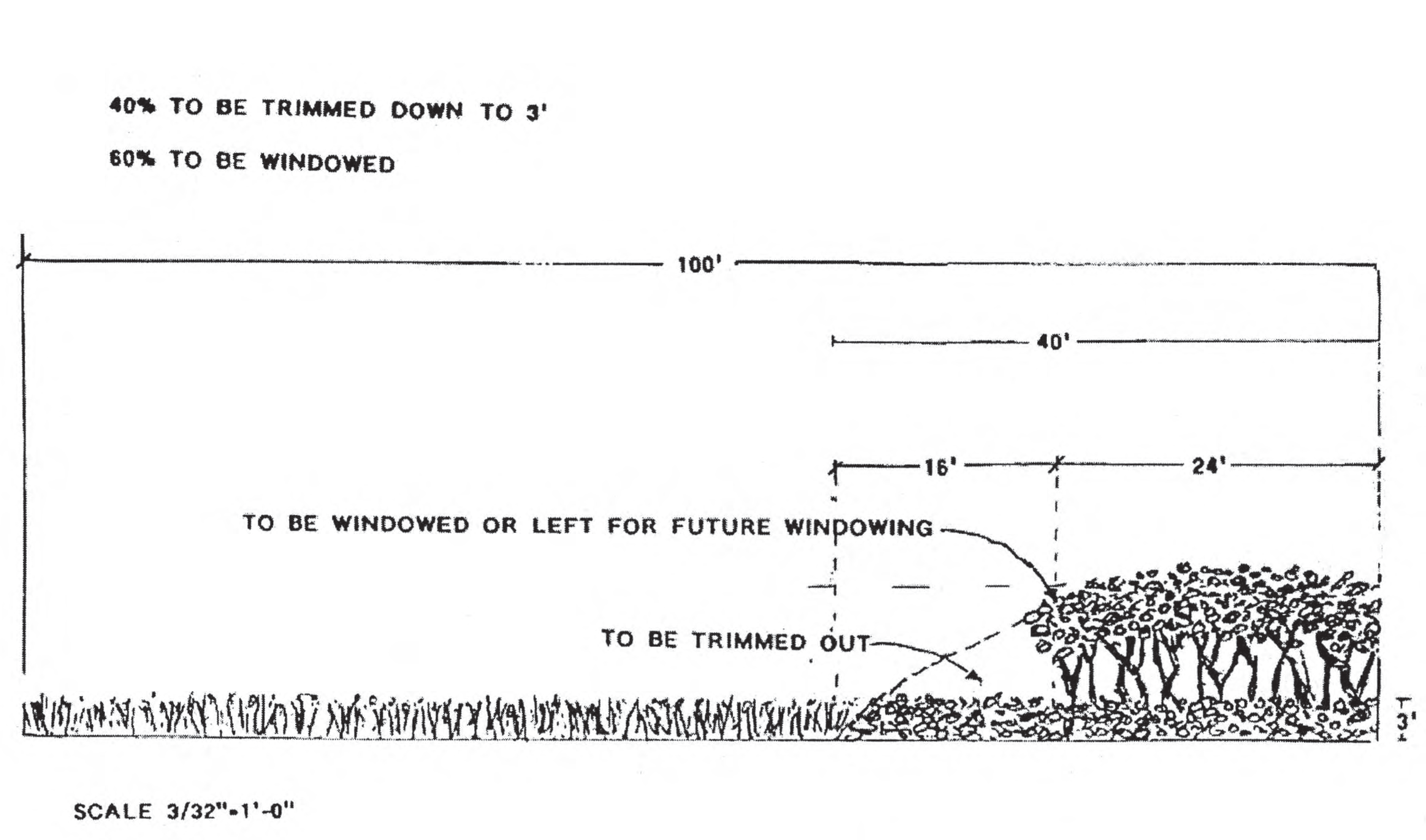
Trimmed Down Figure 66-1
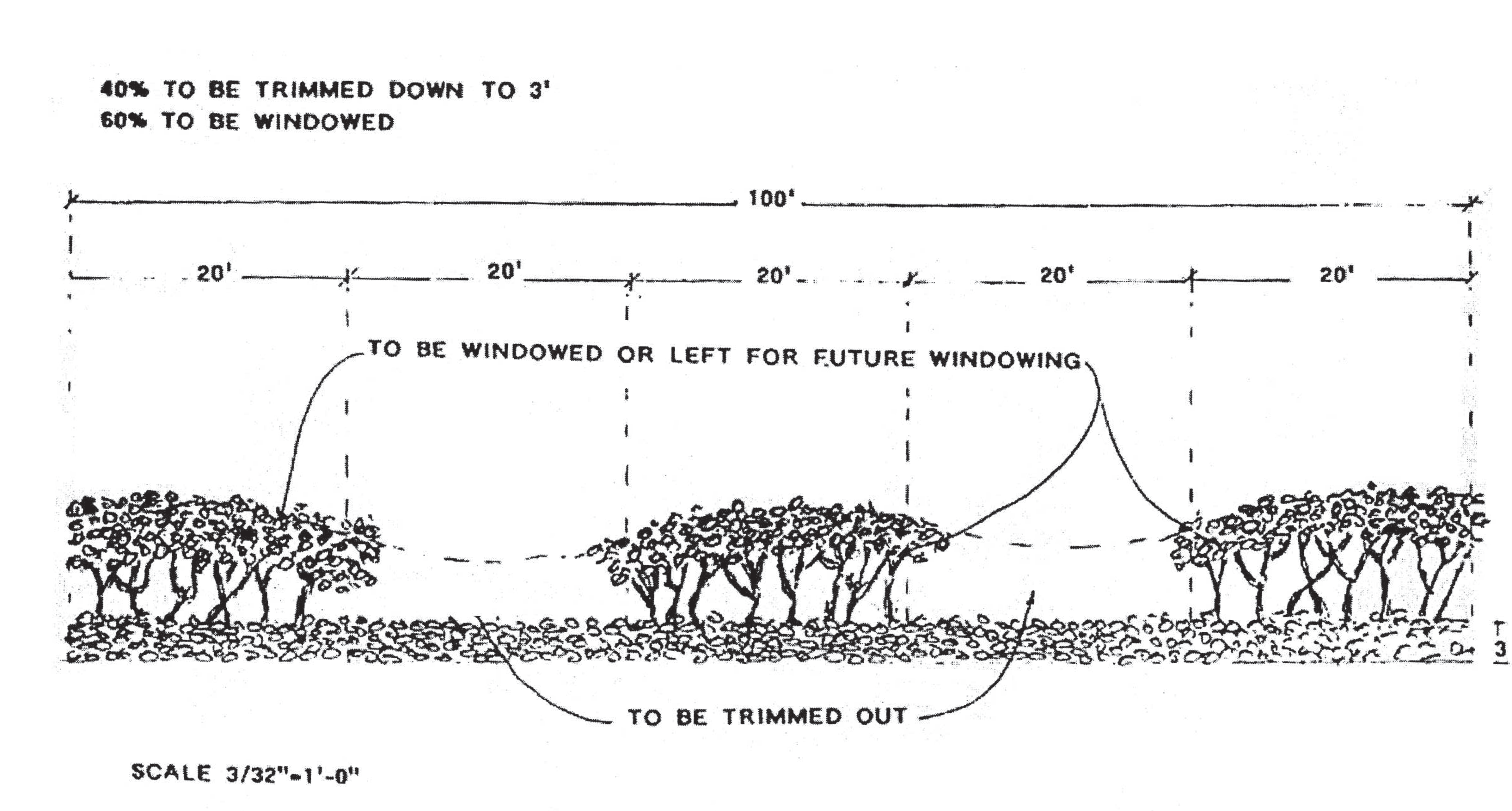
Trimmed Figure 66-2
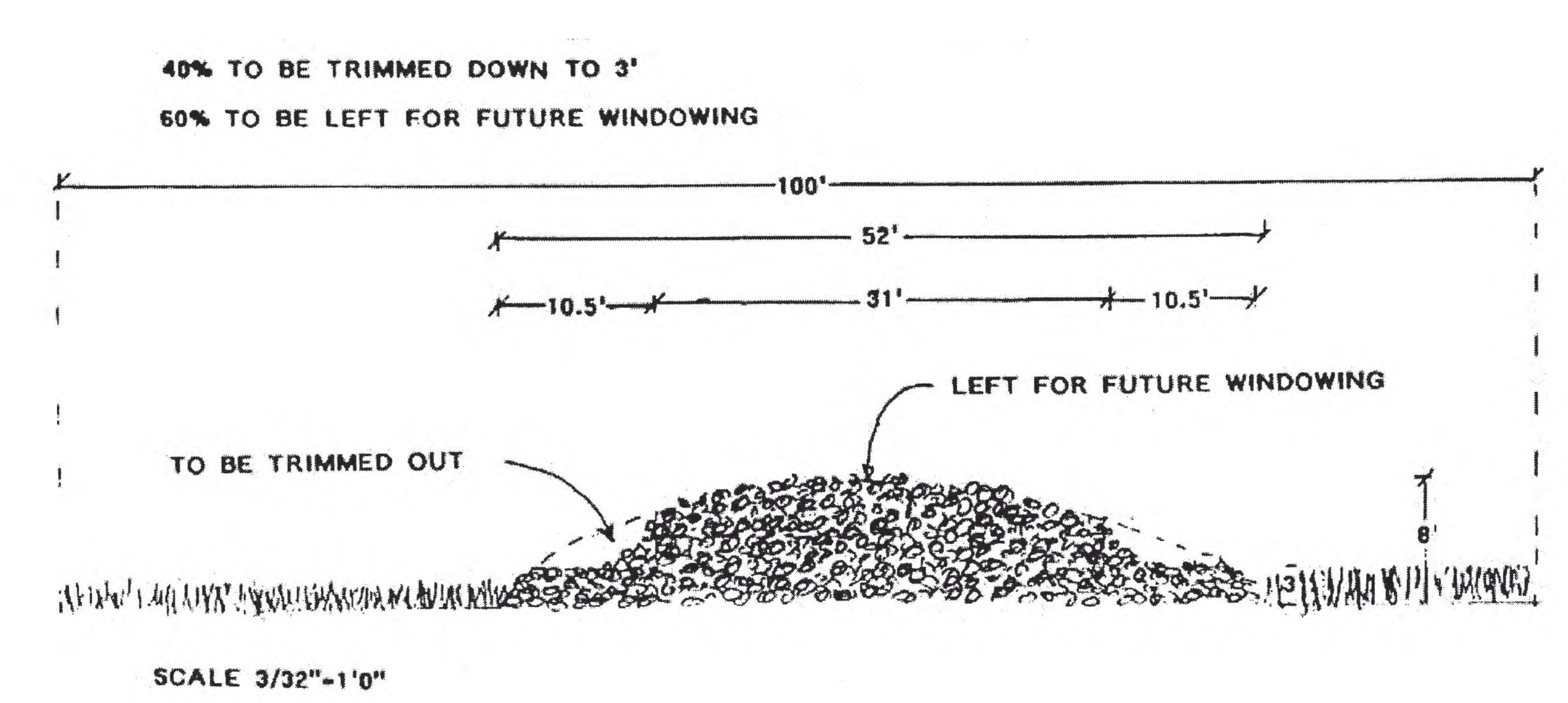
Trimmed Down Figure 66-3
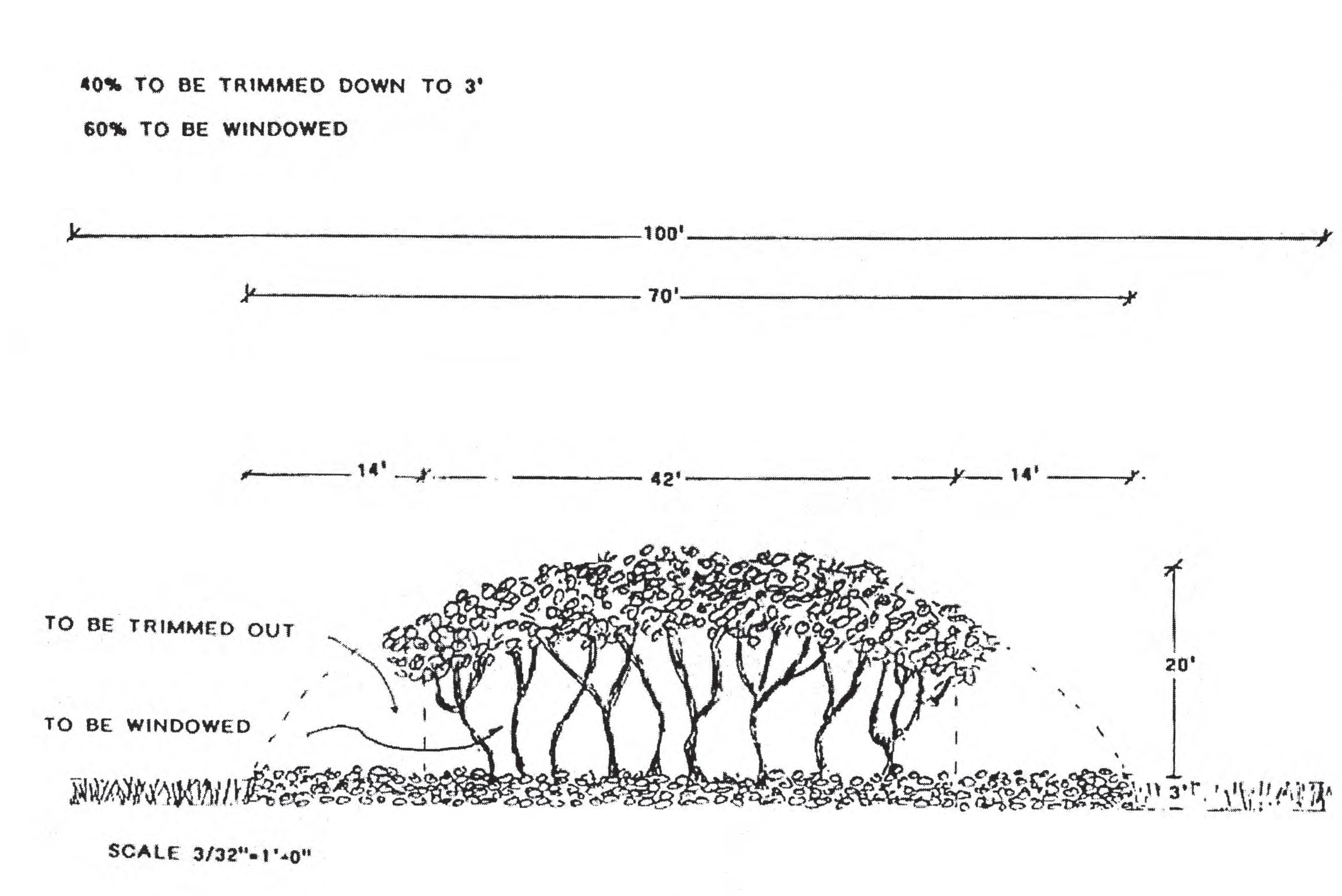
Windowed Figure 66-4
(g)
Dune plant types; prohibited; permitted.
(1)
In addition to those species prohibited for planting in the town, no non-native or invasive vegetation such as scavola, Australian pines, St. Augustine grass, shall be planted upon the coastal dunes. Any such invasive plant now located on the dune shall be removed as a condition for the granting of a permit within this section.
(2)
Only native salt-tolerant dune vegetation is permitted on the dunes. The following are examples of permitted vegetation:
(3)
Consideration will be given to the planting of substitute plant materials which are native, or which otherwise contribute to the overall benefit of the dunes. No other materials shall be planted upon the dunes, except upon the approval of the town commission.
(Code 1993, § 26-109; Ord. No. 577, § 2, 5-5-2008)
Sec. 66-162. - Definitions.
(a)
For this division, the following terms shall have the meanings set forth in this section unless the context clearly indicates otherwise.
(1)
Administrator means the town manager, or an administrative official of the town designated by the town manager to administer and enforce the provisions of this article.
(2)
Application or apply means the actual physical deposit of fertilizer to turf or landscape plants.
(3)
Applicator means any person who applies fertilizer on turf and/or landscape plants within town boundaries.
(4)
Board or governing board means the town commission.
(5)
Best management practices means turf and landscape practices or combination of practices based on research, field-testing, and expert review, determined to be the most effective and practicable on-location means, including economic and technological considerations, for improving water quality, conserving water supplies and protecting natural resources.
(6)
Code enforcement officer, official, or inspector means any designated employee or agent of the town whose duty it is to enforce codes.
(7)
Commercial fertilizer applicator, except as provided in F.S. § 482.1562(9), means any person who applies fertilizer for payment or other consideration to property not owned by the person or firm applying the fertilizer or the employer of the applicator.
(8)
Fertilize,fertilizing or fertilization means the act of applying fertilizer to turf, specialized turf, or landscape plants.
(9)
Fertilizer means any substance or mixture of substances that contains one or more recognized plant nutrients and promotes plant growth, or controls soil acidity or alkalinity, or provides other soil enrichment, or provides other corrective measures to the soil.
(10)
Guaranteed analysis means the percentage of plant nutrients or measures of neutralizing capability claimed to be present in a fertilizer.
(11)
Institutional applicator means any person, other than a private, non-commercial or a commercial applicator (unless such definitions also apply under the circumstances), that applies fertilizer for the purpose of maintaining turf and/or landscape plants. Institutional applicators shall include, but shall not be limited to, owners, managers or employees of public lands, schools, parks, religious institutions, utilities, industrial or business sites and any residential properties maintained in condominium and/or common ownership.
(12)
Landscape plant means any native or exotic tree, shrub, or groundcover (excluding turf).
(13)
Low maintenance zone means an area a minimum of ten feet wide adjacent to water courses which is planted and managed in order to minimize the need for fertilization, watering, mowing, etc.
(14)
Person means any natural person, business, corporation, limited liability company, partnership, limited partnership, association, club, organization, and/or any group of people acting as an organized entity.
(15)
Prohibited application period means the time period during which a flood watch or warning, or a tropical storm watch or warning, or a hurricane watch or warning is in effect for any portion of the town, issued by the National Weather Service, or if heavy rain is likely.
(16)
Approved best management practices training program means a training program approved per F.S. § 403.9338, that includes the most current version of the Florida Department of Environmental Protection's "Florida-friendly Best Management Practices for Protection of Water Resources by the Green Industries, 2008."
(17)
Saturated soil means a soil in which the voids are filled with water. Saturation does not require flow. For the purposes of this ordinance, soils shall be considered saturated if standing water is present or the pressure of a person standing on the soil causes the release of free water.
(18)
Slow release,controlled release,timed release,slowly available, or water insoluble nitrogen means nitrogen in a form which delays its availability for plant uptake and use after application, or which extends its availability to the plant longer than a reference rapid or quick release product. "Turf," "sod," or "lawn" means a piece of grass-covered soil held together by the roots of the grass.
(19)
Turf, sod, or lawn means any surface layer of earth containing a dense growth of grass and its matted roots.
(20)
Urban landscape means pervious areas on residential, commercial, industrial, institutional, highway rights-of-way, or other nonagricultural lands that are planted with turf or horticultural plants.
(Ord. No. 602, § 2, 5-6-2013)
Sec. 66-163. - Applicability of division.
This division shall be applicable to and shall regulate any and all applicators of fertilizer and areas of application of fertilizer within town boundaries unless such applicator is specifically exempted by the terms of this division from the regulatory provisions of this division. The provisions of this division shall be prospective only, and shall not impair any contracts in existence at the time of the enactment of the ordinance creating this division.
(Ord. No. 602, § 2, 5-6-2013)
Sec. 66-164. - Timing of fertilizer application.
No applicator shall apply fertilizers containing nitrogen and/or phosphorus to turf and/or landscape plants during the prohibited application period, or to saturated soils.
(Ord. No. 602, § 2, 5-6-2013)
Sec. 66-165. - Fertilizer-free zones.
Fertilizer shall not be applied within ten feet of any pond, stream, watercourse, lake, canal, or wetland as defined by the Florida Department of Environmental Protection (Chapter 62-340, Florida Administrative Code) or from the top of a seawall, unless a deflector shield, drop spreader, or liquid applicator with a visible and sharply defined edge, is used, in which case a minimum of thee feet shall be maintained. Newly planted turf and/or landscape plants may be fertilized in this zone only for a 60-day period beginning 30 days after planting if needed to allow the plants to become well established. Caution shall be used to prevent direct depositing of nutrients into the water.
(Ord. No. 602, § 2, 5-6-2013)
Sec. 66-166. - Low maintenance zones.
A voluntary ten-foot low maintenance zone is strongly recommended, but not mandated, from any pond, stream, water course, lake, wetland or from the top of a seawall. A swale/berm system is recommended for installation at the landward edge of this low maintenance zone to capture and filter runoff. No mowed or cut vegetative material may be deposited or left remaining in this zone or deposited in the water. Care should be taken to prevent the over-spray of aquatic weed products in this zone.
(Ord. No. 602, § 2, 5-6-2013)
Sec. 66-167. - Application practices.
(a)
Spreader deflector shields are required when fertilizing via rotary (broadcast) spreaders. Deflectors must be positioned such that fertilizer granules are deflected away from all impervious surfaces, fertilizer-free zones and water bodies, including wetlands.
(b)
Fertilizer shall not be applied, spilled, or otherwise deposited on any impervious surfaces.
(c)
Any fertilizer applied, spilled, or deposited, either intentionally or accidentally, on any impervious surface shall be immediately and completely removed to the greatest extent practicable.
(d)
Fertilizer released on an impervious surface must be immediately contained and either legally applied to turf or any other legal site, or returned to the original or other appropriate container.
(e)
In no case shall fertilizer be washed, swept, or blown off impervious surfaces into stormwater drains, ditches, conveyances, or water bodies.
(Ord. No. 602, § 2, 5-6-2013)
Sec. 66-168. - Management of grass clippings and vegetative matter.
In no case shall grass clippings, vegetative material, and/or vegetative debris be washed, swept, or blown off into stormwater drains, ditches, conveyances, water bodies, wetlands, or sidewalks or roadways. Any material that is accidentally so deposited shall be immediately removed to the maximum extent practicable.
(Ord. No. 602, § 2, 5-6-2013)
Sec. 66-169. - Exemptions.
The provisions of sections 66-162 through 66-170 shall not apply to any lands used for bona fide scientific research, including, but not limited to research on the effects of fertilizer use on urban stormwater, water quality, agronomics, or horticulture.
(Ord. No. 602, § 2, 5-6-2013)
Sec. 66-170. - Certification and licensing requirements of commercial applicators.
(a)
All businesses applying fertilizer to turf and/or landscape plants (including but not limited to residential lawns, commercial properties, and multi-family and condominium properties) must ensure that at least one employee has a "Florida-friendly Best Management Practices for Protection of Water Resources by the Green Industries" training certificate offered by the Florida Department of Environmental Protection through the University of Florida IFAS "Florida-friendly Landscapes" program, or an approved equivalent program, prior to applying fertilizer within town boundaries.
(b)
After December 31, 2013, all commercial applicators of fertilizer applying fertilizer within town boundaries, shall have and carry in their possession at all times when applying fertilizer, evidence of certification by the Florida Department of Agriculture and Consumer Services as a Commercial Fertilizer Applicator per 5E-14.117(18) F.A.C.
(c)
Any commercial applicators of fertilizer, applying fertilizer within town boundaries, must comply with all Town Codes.
(Ord. No. 602, § 2, 5-6-2013)