
Oconee County Unincorporated
City Zoning Code
City Zoning Code
ARTICLE 9
- GENERAL PROVISIONS
Sec. 38-9.1. - Use interpretation.
(a)
Each zoning district has uses permitted by right, conditional uses, and special exception uses. Lists are shown for each district placing uses under one of the three categories. Uses not expressly permitted are prohibited. The following describes the processes of each of the three categories that the uses are subject to:
(1)
Uses permitted by right: Administrative review and approval subject to district provisions and other applicable requirements only.
(2)
Conditional uses: Administrative review and approval subject to district provisions, other applicable requirements, and conditions outlined in this chapter.
(3)
Special exceptions: The board of zoning appeals review and approval is subject to any and all district provisions, other applicable requirements, and conditions of approval. Some special exceptions may also be subject to conditions in this chapter. Those uses currently governed by the Unified Performance Standards Sections of the Oconee County Code of Ordinances as special exceptions shall be governed by those standards unless otherwise noted in this chapter.
(b)
A mix of two or more uses on the same lot of record is permitted as long as both uses are listed as permitted within the zoning district. The requirements for the most restricted use shall apply. For example, if "Use A" is permitted by right and "Use B" is permitted with a special exception, then the property requires a special exception for both uses.
(Ord. No. 2012-14, § 1, 5-15-2012)
Sec. 38-9.2. - Zoning map interpretation.
The map entitled Oconee County Official Zoning Map, as adopted and amended by the Oconee County Council establishes the official zoning districts and overlay districts. Where uncertainty exists as to the boundaries of any district shown on the official zoning map, the zoning official shall employ the following rules of interpretation.
(1)
Centerline: Where a boundary line lies within and follows a street or alley right-of-way, a railroad right-of-way, or utility easement, the boundary shall be construed to be the centerline of such street or alley right-of-right, railroad right-of-way, or utility easement boundary. If such a street or alley right-of-way, railroad right-of-way, or utility easement forming the boundary between two separate zoning districts is abandoned or removed from dedication, the district boundaries shall be construed as following the edge of the abandoned or vacated road bed or utility easement.
(2)
Edge line: Where a boundary line follows the edge of a street or alley right-of-way, a railroad right-of-way, or utility easement, the boundary shall be construed to be on the centerline of such street or alley right-of-way, railroad right-of-way, or utility easement boundary.
(3)
Lot line: Boundaries indicated as approximately following lot lines shall be construed as following such lot lines.
(4)
County/municipal limits: Boundaries indicated as approximately following county/municipal limits or extraterritorial boundary lines shall be construed as following the county/municipal limits or extraterritorial boundary lines.
(5)
Watercourses: Boundaries indicated as approximately following the centerlines of streams, rivers, canals, lakes, or other bodies of water shall be construed to follow such center lines.
(6)
Extensions: Boundaries indicated as parallel to or extensions of street or alley rights-of-way, utility easements, lot lines, city limits, county lines, or extraterritorial boundaries shall be so construed.
(7)
Scaling: In a case where a district boundary does not coincide with any boundary lines as above and no distances are described by specific ordinance; the boundary shall be determined by the use of the scale appearing on the map.
(8)
In the event physical features existing on the ground, or actual property lines or other man-made boundary lines used to depict zoning district boundaries, are different than those shown on the official zoning map, the board of zoning appeals shall have the authority to interpret zoning district boundaries.
(Ord. No. 2012-14, § 1, 5-15-2012)
Sec. 38-9.3. - Dimensional requirements: General provisions and exceptions.
In addition to the dimensional requirements listed below and district dimensional requirements, further dimensional requirements may be set forth in article 5 for those uses listed as conditional. The control free district shall be exempt from the provisions of this section except provisions listed under item (2), setbacks.
(1)
Lot size and configuration.
a.
Public utilities and government. Public utilities and government uses shall not be subject to the minimum lot size requirements, but shall meet the setback requirements.
b.
Flag lots. Flag lots may be permitted under the following conditions:
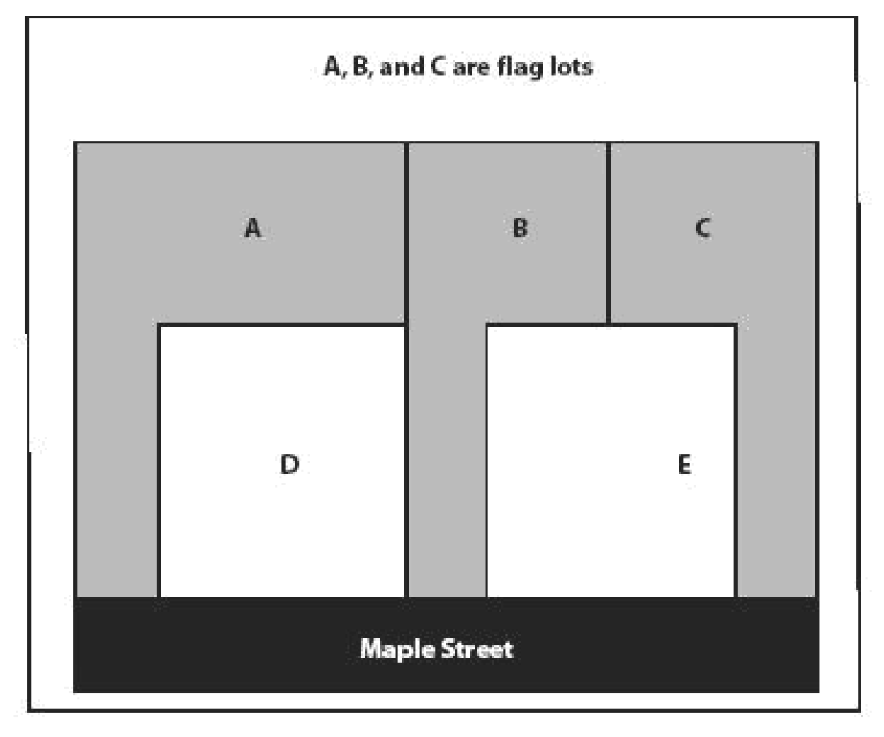
1.
The maximum length of the pole of a flag lot shall be 300 feet.
2.
The minimum width of the pole of a flag lot shall be 22 feet, and the maximum width of the pole of a flag lot shall be 40 feet.
3.
The front setback shall be measured from where the flag portion of the flag lot meets the district minimum width requirements.
4.
The pole portion of a flag lot shall not be used to calculate width, or setbacks of the lot, or to provide off-street parking.
5.
There shall be no more than one flag lot per each four lots, per subdivision or development.
Flag lot illustration:
(2)
Setbacks.
a.
The required front, side, and rear yards for individual lots shall be measured inward toward the center of said lot from all points along the respective front, side, and rear property lines of the lot, or from the road right-of-way if applicable. Once the yard areas of a given lot have been established, the remaining area of the lot which is not included in any required front, side, or rear lot shall be known as the "buildable" area within which the approved structure(s) shall be placed.
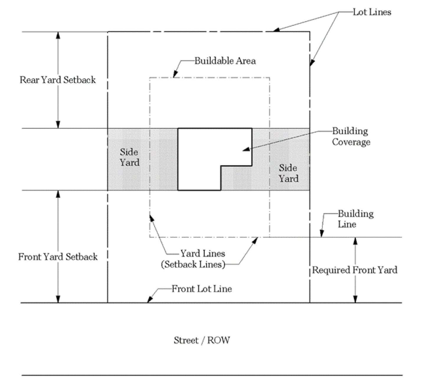
b.
Where a road right-of-way projects over a property line, the setback shall be measured from the road right-of-way line.
c.
Corner lots shall be considered to have two fronts and shall meet the front setback for the district.
d.
Front yard setbacks for double frontage lots shall be provided for both streets upon which the lot has frontage, and any accessory use(s) shall be prohibited from the required front yard setback of the street upon which the principal building fronts.
e.
For lots not meeting the required minimum lot width for the respective district at the front property line or road right-of-way, as applicable, the setback shall be measured such that the distance from the front property line or road right-of-way, as applicable, shall nonetheless be included in the measurement for the required setback. The buildable area shall not, however, include any area where the minimum lot width is not met. This provision is meant to apply to irregularly shaped lots, as generally determined by their existing lot width and configuration in relation to the district minimum lot width. This provision does not apply to flag lots. See section 38-9.3(1)(b) for flag lot provisions.
f.
Road design and encroachment criteria is governed by the standards in chapter 26, of the Oconee County Code of Ordinances, as amended.
g.
Any garage door shall be set back a minimum of 20 feet from the property line that it faces so that vehicles may be parked in the driveway without encroaching into the right-of-way. If the district setback is greater than 20 feet, then the more restrictive setback shall prevail.
h.
The side and rear setbacks in the CCD and HCD shall not apply to the shared property line of attached buildings.
i.
The space in any required yard shall be open and unobstructed except for the ordinary projections of window sills, cornices, eaves, window air conditioning units, and other architectural features, provided that such features shall project no more than two feet into any required yard.
j.
Steps and heating and cooling units may project into a required yard a distance not to exceed five feet but no closer than five feet of a property line. Fences, freestanding walls, retaining walls and appurtenances, hedges, and septic lines may be located in any setback, so long as they remain on the property.
(Ord. No. 2012-14, § 1, 5-15-2012; Ord. No. 2018-19, § 1(Att. A), 8-21-2018; Ord. No. 2024-23, §§ 1, 2(Exh. A), 10-15-2024; Ord. No. 2025-08, § 1, 5-6-2025)
Sec. 38-9.4. - Height.
(a)
Requirements. All proposed structures not specifically exempted by this article that are greater than 65 feet in height, or otherwise subject to the exemptions found in subsection 38-9.4.(b)(1)a.18. and 19. and greater than 199 feet in height, shall be subject to review and approval by the Oconee County Board of Zoning Appeals only as a special exception. In addition to the requirements for special exceptions established in Chapter 38, Article 7 of this Code, as amended, the board shall issue findings on each of the following criteria:
(1)
Projected traffic and ability of existing roadways to accommodate the increase caused by the proposed structure.
(2)
Anticipated cost of any specialized emergency response equipment and training required to serve the proposed structure.
(3)
Potential noise, light, fumes, shadows, obstruction of air flow, and other negative secondary effects caused by the proposed structure that may impact existing uses and/or adjacent properties.
(4)
The aesthetic and cultural character of the environs, specifically regarding any potential degradation by the proposed structure of scenic views, historic sites, significant landmarks, and other sensitive areas.
(5)
Appropriateness of proposed structure in relation to the character of the community.
(b)
Height.
(1)
Structure height is measured from the average elevation of the finished grade of the structure to the highest point of the structure; all methods relating to the establishment of elevations, grades, and distances shall conform to those set forth in codes adopted by Oconee County.
a.
Exemptions. The height limitations of this chapter shall not apply to the following:
1.
Belfries.
2.
Chimneys.
3.
Church spires.
4.
Conveyors.
5.
Cooling towers.
6.
Cupolas.
7.
Domes.
8.
Elevator bulkheads.
9.
Fire towers.
10.
Flag poles.
11.
Ornamental towers and spires.
12.
Public monuments.
13.
Public utility poles.
14.
Silos.
15.
Skylights.
16.
Smoke stacks.
17.
Stage towers or scenery lofts.
18.
Structures, not otherwise exempt by this section, that are 200 feet or less in height, and located on property zoned as an Industrial District (ID) in accordance with chapter 38 of the Oconee County Code of Ordinances.
19.
Structures, not otherwise exempt by this section, that are 200 feet or less in height, and located on property designated by Oconee County as county industrial parks.
b.
Such features shall be erected only to such height as is necessary to accomplish the purpose they are intended to serve and no height extension shall serve as a place for human habitation.
c.
This section shall in no way exempt any structure from the application of standards or regulations contained in other chapters of this Code or other articles of this chapter, including, without limitation, any standards or regulations regarding height restrictions for certain areas of Oconee County, such as airport approach height restrictions.
(2)
Communication towers, antennas, and water tanks shall be exempt from district height requirements in these standards, but shall instead be subject to standards provided for in the Oconee County Unified Performance Standards Chapters of the Oconee County Code of Ordinances; however, all other district dimensional standards shall apply as specified.
(Ord. No. 2012-14, § 1, 5-15-2012; Ord. No. 2014-28, § 3(Att. C), 12-16-2014; Ord. No. 2015-25, § 2(Att. A), 9-15-2015)
Sec. 38-9.5. - Other requirements.
In addition to zoning district regulations see the following sections for other requirements:
(1)
See Article 5 for "Conditional uses".
(2)
See Article 7 for "Special exceptions".
(3)
See Appendix A for specifications on "Landscaping", "Buffering", "Parking", "Lighting", and "Signage". Standards contained on Appendix A shall apply only to those zoning districts or overlay districts specifically identified in Article 10, "Zoning District", and Article 11, "Overlay Districts", as being subject to Appendix A, each of which may be subject to all or part of the entire appendix, but only as specified. In no instance shall standards contained in Appendix A apply to any zoning district or overlay district unless so specified in such sections.
(4)
Notwithstanding any other provision herein to the contrary, proposed utility generation facilities and structures needed by regional and local utility providers in the production, transmission, and distribution of electricity, natural gas, water, or sewer services, as well as any facility or structure necessary to comply with any federal or state license requirements, related to such production, transmission, and distribution, shall be permitted by right in any district and shall be exempt from any standard set forth in this chapter.
(Ord. No. 2012-14, § 1, 5-15-2012)