
Orange County Unincorporated
City Zoning Code
City Zoning Code
ARTICLE VIII
- P-D PLANNED DEVELOPMENT DISTRICT
DIVISION 7. - FOUR CORNERS COMMUNITY VILLAGE CENTER GUIDELINES AND STANDARDS[9]
Editor's note— Ord. No. 96-36, § 1, adopted Nov. 12, 1996, set out provisions intended for use as Div. 6A. For purposes of organization, and at the editor's discretion, these provisions have been redesignated Div. 7.
Sec. 38-1201.- Intent and purpose of district.
The intent and purposes of the P-D planned development district are as follows:
(1)
To provide for planned residential communities, containing a variety of residential structures and diversity of building arrangements, with complementary and compatible commercial or industrial uses or both; planned commercial centers with complementary and compatible residential or industrial uses or both; planned tourist commercial centers with complementary and compatible uses which may include tourist attractions, theme parks, residential and light storage; or planned industrial parks with complementary and compatible residential or commercial uses or both; and public and quasipublic facilities developed in accordance with an approved development plan.
(2)
To allow diversification of uses, structures, and open spaces in a manner compatible with existing and permitted land uses on abutting properties.
(3)
To reduce improvement and energy costs through a more efficient use of land design and smaller networks of utilities and streets than is possible through application of other zoning districts and subdivision requirements.
(4)
To ensure that development will occur according to limitations of use, design, density, coverage and phasing stipulated on an approved development plan.
(5)
To preserve the natural amenities and environmental assets of the land by encouraging the preservation and improvement of scenic and functional open areas.
(6)
To encourage an increase in the amount and use of open space areas by permitting a more economical and concentrated use of building areas than would be possible through conventional zoning districts.
(7)
To provide maximum opportunity for application of innovative concepts of site planning in the creation of aesthetically pleasing living, shopping and working environments on properties of adequate size, shape and location.
(8)
The P-D district is a flexible zoning district which is intended to provide an appropriate balance between the intensity of development and the ability to provide adequate capacity within the support services and facilities.
(P & Z Res., art. XXIX, § 1)
Sec. 38-1202. - Uses permitted.
The following uses shall be permitted in the planned development district if designated on an approved land use plan, subdivision plan, or development plan:
(Ord. No. 2023-46, § 31, 12-12-23)
(1)
Planned residential communities. Complementary and compatible commercial and industrial uses may be included if they are compatibly and harmoniously designed into the total residential community within a planned development district.
(2)
Planned commercial centers. Complementary and compatible residential and industrial uses may be included if they are compatibly and harmoniously designed into the total commercial center within a planned development district.
(3)
Planned tourist commercial, tourist attractions or theme parks. Complementary and compatible residential uses may be included, provided that their design within the planned development district will produce a reasonable living environment.
(4)
Planned industrial parks. Complementary and compatible residential and commercial uses may be included if properly related to the total industrial park within a planned development district.
(5)
Other uses. Any other private, public or semipublic use complementary to, and compatible with, planned residential, commercial, tourist commercial or industrial developments (including sewer and water utility plants) may be included. An incinerator facility as defined in the incinerator management ordinance, Orange County Code chapter 15, article XIV, may be included provided the P-D approval contains a condition stating that prior to construction of an incinerator facility the incinerator facility shall first receive a special exception through the exception process as set forth in Orange County Code chapter 30, article II and is otherwise consistent with the requirements of the incinerator management ordinance.
(Ord. No. 92-41, § 47, 12-22-92)
(6)
Big box developments (defined in section 38-1, Orange County Code.) Complementary and compatible residential, office, and industrial uses may be incorporated if they are compatibly designed into the total big box development within a planned development.
(Ord. No. 2007-01, § 15, 3-20-07)
(P & Z Res., art. XXIX, § 2; Ord. No. 2023-46, § 31, 12-12-23)
Sec. 38-1203. - Approval procedure.
The procedure for obtaining approval of a planned development shall be as follows:
(1)
Land use plan. The applicant shall submit to the planning division an electronic file of the land use plan and support data. The planning division shall schedule the project for staff review. Upon resolution of staff comments, or at the discretion of the assigned project manager from the Planning Division when certain comments or issues cannot be resolved, a Planned Development application may be scheduled for a Development Review Committee (DRC) meeting. The planning and zoning managers shall determine if review of the project is necessary by other advisory boards other than the planning and zoning commission. Upon recommendation by the DRC, the planning manager shall schedule the project for the next regular meeting of the planning and zoning commission for a review hearing.
a.
The DRC shall review the proposed land use plan, and issue a written recommendation to the planning and zoning commission. A copy of the DRC recommendation shall be sent to the applicant at least five (5) days prior to the planning and zoning commission public hearing. (The DRC must complete their review at least twenty-one (21) days prior to the date of the planning and zoning commission public hearing in order to be placed on the agenda.)
b.
Upon receipt of the DRC's written recommendation, the planning and zoning commission shall hold a public hearing to review the application and shall submit its recommendation (which may include conditions of approval) to the county commission for its official action. Public notice to consider the land use plan shall include a generalized list of the proposed land uses and shall indicate that the board of county commissioners will hold a public hearing to consider the project. The public hearing before the board of county commissioners shall be held at least ten (10) days after the planning and zoning commission hearing.
c.
In addition to complying with all approval procedures contained in this section 38-1203, a big box development shall comply with all the standards and requirements outlined or referenced in section 38-79(153). Any big box development applicant seeking a waiver from any such standard or requirement shall, concurrently with and as a part of the land use plan submittal, include such waiver request, stating and explaining, in detail, the exceptional circumstances which the applicant believes justify a waiver. Orange County shall review such request, and may either deny or grant the waiver. Furthermore, before any public hearing is held regarding a big box development land use plan, a community meeting shall be held with public notice issued to the owners of record of properties located within a two thousand-foot radius of the proposed development site. In establishing the limits of public notification, all addresses within an entire neighborhood, any part of which falls within the two thousand-foot notification radius, shall be noticed. In addition, the applicant shall be responsible for prominently and conspicuously posting notice of the community meeting directly on the property.
(2)
Development plan. The applicant shall submit to the planning division an electronic file of the development plan and support materials.
a.
The development plan may cover all or a portion of the approved land use plan. The planning department shall review the plans to determine if all appropriate data and information has been properly provided.
b.
The development plan shall be reviewed by the DRC in order to determine that:
1.
It substantially complies with the land use plan;
2.
The phase of development can exist as a stable independent unit; and
3.
Existing or proposed utility services and transportation systems are adequate for the uses proposed.
c.
The DRC shall review the development plan and shall evaluate it for consistency with the land use plan and all applicable ordinances, regulations and policies. The DRC shall either approve the development plan (which may include technical conditions consistent with applicable county ordinances, regulations and policies) or deny the development plan based upon specific findings which shall be stated.
d.
The decision of the DRC may be appealed to the board of county commissioners by an aggrieved party. Any party choosing to appeal the DRC decision shall file a notice of appeal within fifteen (15) days of the rendition of the DRC decision. If the developer or applicant proposes to create a subdivision, a preliminary subdivision plan should be processed concurrently with the development plan and shall be subject to approval by the board of county commissioners.
e.
In addition to complying with all approval procedures contained in this section 38-1203, a big box development plan shall comply with the land use plan and with all the standards and requirements outlined or referenced in section 38-79(153), except that any PD approved for commercial uses prior to April 3, 2006, shall not be subject to the two hundred-foot buffer requirement adjacent to single-family residentially-zoned property only to the extent that it can be demonstrated that the property is physically constrained from meeting that requirement. Any big box development applicant seeking a waiver from any standard or requirement governing big box development shall, concurrently with and as a part of the development plan submittal, include such waiver request, stating and explaining, in detail, the exceptional circumstances which the applicant believes justify the waiver. Such a request shall be deemed a substantial change to the land use plan, and shall require a public hearing before the board of county commissioners. The board may approve or deny the waiver request.
(P & Z Res., art. XXIX, § 3; Ord. No. 98-37, § 16, 12-15-98; Ord. No. 2007-01, § 16, 3-20-07; Ord. No. 2023-46, § 32, 12-12-23)
Sec. 38-1204. - Concept plan requirements.
(a)
The concept plan shall consist of a generalized sketch which is drawn to scale (the proportion and locations of land uses may be generalized), and which shows or addresses (with supporting information) the following items and matters:
(1)
Boundary of the subject property, identified by a heavy line.
(2)
Major natural features such as lakes, streams and conservation areas.
(3)
Existing or proposed streets abutting the project and other major streets and intersections within five hundred (500) feet of access points to the subject property.
(4)
Generalized location map and legal description, including acreage.
(5)
Proposed land use types and their locations (land use or building bubbles are acceptable).
(6)
Gross densities.
(7)
Approximate minimum lot size.
(8)
Approximate number of units.
(9)
Approximate floor area for commercial or industrial.
(10)
Adjacent zoning.
(11)
Anticipated internal major road network.
(12)
Anticipated maximum building height.
(13)
Anticipated phasing plan.
(14)
Proposed method of providing:
a.
Water service (including fire protection).
b.
Sewage disposal.
c.
Stormwater management.
d.
Parks/recreation facilities.
e.
Schools.
(b)
The plan shall include all information known by the applicant at the time of submission. Review of the plan shall be based on the data submitted.
(P & Z Res., art. XXIX, § 4)
Sec. 38-1205. - Land use plan requirements.
The land use plan, consisting of properly identified exhibits and support materials, shall clearly indicate the following:
(1)
The project name, legal description, total acreage and location map.
(2)
Existing topography at one-foot contours based on the county datum (or as approved by the county engineer) and other natural features including lakes, watercourses and conservation area. On-site soil (based on the soil conservation service classification system), flood hazard areas and generalized vegetation. All plans shall be drawn to scale, not to exceed one (1) inch equals two hundred (200) feet, unless otherwise permitted.
(3)
Existing and proposed land uses, with each phase of the total development identified.
a.
Residential. Maximum gross density, total number of units, type of unit where feasible or necessary, minimum net lot size, minimum net living floor area, building height, open space and recreation area.
b.
Commercial. Types of uses, gross floor area, floor area ratio, building height, setbacks and open space.
c.
Industrial. Types of uses, gross floor area, floor area ratio, building height, setbacks, open space and buffers.
(4)
The phasing of development and the manner in which each phase of development can exist as an independent stable unit.
(5)
The location of collector and arterial streets and highways proposed in the development, right-of-way widths, the location of access points to abutting streets and highways, and projected traffic generation based on established standards. (A traffic study may be required.)
(6)
Identification of existing major street setbacks and planned right-of-way lines as required by article XV of this chapter.
(7)
Proposed method of providing the following services:
a.
Water service (including fire flows), plus gallons-per-day requirement.
b.
Sewage disposal, plus gallons per day generated.
c.
Stormwater management concept.
d.
School age population.
e.
Parks/recreation facilities.
(8)
Waivers from the subdivision regulations or the site development standards of the P-D district shall be indicated on the land use plan or submitted in writing.
(9)
The proposed location(s) and height(s) of communication towers.
(P & Z Res., art. XXIX, § 5; Ord. No. 96-10, § 1, 4-30-96)
Sec. 38-1206. - Development plan.
The development plan for the entire project or any phase, consisting of fourteen (14) copies of properly identified exhibits and support materials, shall include the following:
(1)
Project name (indicate if different than approved land use plan).
(2)
Legal description and the gross acreage of the proposed development, including and identifying land and water bodies.
(3)
A location map identifying the relationship of the development plan to the approved land use plan.
(4)
Preliminary subdivision plan if the applicant proposes to subdivide the project.
(5)
Waivers from the subdivision regulations or site development standards of the P-D district shall be indicated on the development plan or submitted in writing.
(6)
The development plan, drawn at an appropriate scale (one (1) inch equals one hundred (100) feet) with all dimensions provided, shall identify:
a.
Certified topography drawn at one-foot contours using county datum and showing natural features.
b.
Existing street intersections or rights-of-way within five hundred (500) feet of access points.
c.
Surface improvements of primary streets serving the project.
d.
Proposed uses.
e.
Number of dwelling units, density, minimum square footage of living area, minimum net lot area.
f.
Total square footage of commercial, industrial or office space and floor area ratio.
g.
Maximum building height (stories and feet).
h.
Maximum building coverage.
i.
Acreage, types and percent of open space and recreation area.
j.
Pedestrian/bike path facilities.
k.
Stormwater management plan, including direction of surface drainage flow.
l.
On-site soils based upon the soil conservation service classification system (if muck soils exist, their depth and extent must be identified).
m.
On-site vegetation.
n.
Method of providing support utilities including water, sewer, fire flows and refuse storage areas.
o.
Existing or proposed easements.
p.
Parking spaces and location, in accordance with article XI.
q.
Exterior lighting.
r.
Signing and pavement marking plans with details of installation consistent with traffic engineering division specifications.
(7)
Recreation area plan.
(8)
Landscape, tree planting and screening concept plan.
(9)
Design elevations or renderings of structures.
(10)
Sign plan, including scaled plans of proposed signs.
(11)
Preliminary engineering plans for the provisions of road, water, sewer and stormwater management for the proposed phase and its relationship to the master stormwater concept.
(12)
Proposed covenants, conditions, restrictions, agreements and grants which govern the use, maintenance and continued protection of building structures, drainage systems and landscaping within the planned development.
(13)
Areas to be conveyed or dedicated and improved for roadways, parks, parkways, playgrounds, school sites, utilities, public buildings and other similar public and public service uses. Improvement bonds for facilities to be owned and maintained by the county and not completed, shall be posted before the issuance of building permits.
(14)
Identification of owners, developers and the consultants involved in the development plan.
(P & Z Res., art. XXIX, § 6; Ord. No. 2020-30, § 7G, 10-13-20)
Sec. 38-1207. - Alterations to the land use plan and development plans.
(a)
Alterations to the approved land use plan or development plan shall be classified as either substantial or nonsubstantial amendments. The following criteria shall be used to identify a substantial amendment:
(1)
A change which would include a land use not previously permitted under the approved P-D zoning.
(2)
A change which would alter a land use type adjacent to a property boundary, except when it is (i) a reduction in the density or (ii) a reduction of intensity of approved residential development, unless the reduction locates the residential use adjacent to an incompatible land use.
(Ord. No. 95-28, § 1, 9-12-95)
(3)
A change which would require an amendment to the board of county commissioners' conditions of approval.
(4)
A change which would increase the land use intensity within any development phase without a corresponding decrease in some other portion of the overall P-D.
(5)
An amendment to the phasing which would propose a land use in advance of the development it was designed to support.
(6)
Any proposed change in the type, location or size (except reduction in the number of units) of a multi-family land use or student housing land use in the PD.
(b)
The determination of a substantial or nonsubstantial alteration shall be made jointly by the planning and zoning managers. Either or both managers may opt to direct that the determination be made instead by the Development Review Committee (DRC).
(c)
Where the developer proposes to reduce the number of units or floor area in one (1) phase of the project, a corresponding increase in the number of units of floor area in another phase may be considered, if other conditions of approval are not adversely affected, nor any other change is proposed which would be considered a substantial change as described above.
(d)
Alterations to the land use plan determined to be substantial must submit plans and support data (following the land use plan requirements) for review by the DRC and then a public hearing for final action by the board of county commissioners.
(e)
All nonsubstantial alterations must be submitted (including plans and support data) and approved by the DRC.
(Ord. No. 2023-46, § 33, 12-12-23)
(f)
When partial amendments are requested to the land use plan, the overall project shall be evaluated in conjunction with the proposed amendment, to determine its compatibility with the remaining portion of the P-D. Amendments which the DRC considers to be incompatible or conflict with the proposed plans or conditions of approval, will be required to update the land use plan or may be subject to an administrative rezoning public hearing.
(P & Z Res., art. XXIX, § 7; Ord. No. 94-4, § 4, 2-8-94; Ord. No. 2023-46, § 33, 12-12-23; Ord. No. 2023-46, § 33, 12-12-23)
Sec. 38-1208. - Control of development following approval.
(a)
Upon the approval of the development plan or any phase thereof, the use of land and the construction or modification of any buildings or structures within the P-D shall be in accordance with the development plan. However, all other county codes, ordinances, policies and resolutions shall apply.
(b)
The zoning director shall be responsible for certifying that all aspects of the P-D, including conditions of approval (applicable to the subject portion of the project) have been satisfactorily completed prior to the issuance of a certificate of completion for the project or phase.
(c)
After certification no changes may be made in the approved development plan except under the procedures provided below:
(1)
Any structural extension, alteration or modification of existing building structures which are consistent with the approved development plan may be authorized by the zoning director.
(2)
A building or structure that is seventy-five (75) percent or more destroyed may be reconstructed only in compliance with the development plan unless an amendment to the development plan is approved under the provisions of this article.
(P & Z Res., art. XXIX, § 8; Ord. No. 2008-06, § 15, 5-13-08)
Sec. 38-1209. - Other requirements.
(a)
Off-site improvements may be required in conjunction with the land use plan approval in order to offset the impacts created by the proposed development. All projects shall be required to provide an adequate level of facilities and services to accommodate the project as proposed in the development plan.
(b)
At the time of development, the P-D or any phase proposed for development shall comply with all regulations and ordinances in force at the time of engineering plan approval.
(c)
Those projects which the board of county commissioners considers to be inconsistent with the provisions of this article may be required to update the land use plan or may be subject to an administrative rezoning public hearing.
(P & Z Res., art. XXIX, § 9)
Sec. 38-1226.- Purpose.
Site development standards are established for planned development to insure adequate levels of light, air and density, to maintain and promote functional compatibility of uses, to promote the safe and efficient circulation of pedestrian and vehicular traffic, to provide for orderly phasing of development, and to otherwise protect the public health, safety and general welfare.
(P & Z Res., art. XXIX, § 10(a)(1))
Sec. 38-1227. - Waivers.
(a)
For good cause shown, waivers from the minimum standards set forth in this Chapter may be granted by the board of county commissioners. However, such waivers must be specified in conjunction with the land use plan, otherwise all standards shall apply. Waiver requests shall be identified in the public hearing notice.
(Ord. No. 2023-46, § 34, 12-12-23)
(b)
Waivers requested after approval of the land use plan must be approved by the board of county commissioners at a public hearing, after notification of abutting property owners.
(P & Z Res., art. XXIX, § 10(a)(2); Ord. No. 2016-19, § 26, 9-13-16)
Editor's note— Ord. No. 2016-19, § 26, adopted Sept. 13, 2016, amended § 38-1227 and in so doing changed the title of said section from "Variances" to "Waivers," as set out herein.
Sec. 38-1228. - Natural features/project design.
(a)
The natural topography, soils and vegetation should be preserved and utilized, where possible, through the careful location and design of circulation ways, buildings and structures, parking areas, recreation areas, open space, and drainage facilities. Designation and use of conservation areas must be consistent with the adopted growth management policy.
(b)
The proposed location and arrangement of structures should not be detrimental to the existing or committed adjacent land uses or to the existing or committed development of the neighborhood. Building setbacks from the normal high-water elevation of all natural water bodies shall be a minimum of fifty (50) feet. Established minimum floor elevations shall be observed. The major street setback requirements which are governed by article XV of this chapter shall apply. Lighting, access point, or activities resulting in high noise levels which adversely affect abutting property shall be prohibited.
(P & Z Res., art. XXIX, § 10(a)(3))
Editor's note— Ord. No. 95-31, § 2, adopted September 26, 1995, set out the following provisions: "Any references in Chapter 38 of the Orange County Code to noise level requirements . . . are hereby repealed."
Sec. 38-1229. - Street facilities.
(a)
All streets, including pedestrian and bicycle facilities, that are or will become part of public rights-of-way, shall meet all applicable standards of chapter 34 and section 21-176, including accessibility requirements of the most recent edition of Florida Department of Transportation Americans with Disabilities Act Standards for Transportation Facilities.
(b)
All streets shall meet minimum county standards with appropriate design for vehicle, pedestrian, and bicycle safety and efficient circulation within the development and connections to roadways and bus stops adjacent to the development. Roadway connections shall be in compliance with all requirements of the Americans with Disabilities Act and corresponding standards.
(c)
Provisions should be made for the continuation of all functionally-classified roadways where applicable. Collector streets shall provide a direct connection from local streets to arterial roadways and shall be designed and located such that future development will not require their conversion to arterial roadways.
(d)
Local streets shall provide access to each parcel of land within the planned development in a manner that will provide convenient vehicle, pedestrian, and bicycle access to parking areas serving each group of units. Local streets shall be designed and located so that future urban development will not require their conversion to functionally-classified roadways. Arterial and major collector streets shall be free of backing movement from adjoining parking areas.
(e)
Private streets may be permitted subject to guarantees for adequate maintenance as required by chapter 34.
(f)
Street facilities shall meet all access management requirements of section 30-248.
(g)
Streets, driveways, and shared use path/trail crossings shall provide appropriate horizontal and/or vertical sight distances in accordance with the latest edition of the Florida Department of Transportation Manual of Uniform Minimum Standards for Design, Construction and Maintenance for Streets and Highways (Florida Greenbook).
(P & Z Res., art. XXIX, § 10(a)(4); Ord. No. 2020-30, § 7H, 10-13-20)
Sec. 38-1230. - Parking facilities.
(a)
Vehicle and bicycle parking and loading facilities shall meet the minimum requirements set forth in article XI of this chapter. Vehicle parking areas shall be located within one hundred fifty (150) feet of the uses they serve. Parking areas shall be paved and designed with regard to pedestrian safety requirements of section 30-250. Parking areas should be surfaced with a hard, dustless material, properly drained, and designed with regard to pedestrian safety and, where appropriate, with regard to conservation and filtration of surface water into the aquifer. Alternative parking surfaces may be permitted where frequency of use is appropriate for the proposed surface, but shall meet accessibility requirements.
(b)
Vehicular and pedestrian passageways shall be separated on public rights-of-way and within parking facilities and shall meet all accessibility requirements of applicable federal and state standards. A system of pedestrian and bicycle facilities connecting buildings, common open spaces, recreation areas, community facilities and parking areas, and transit stops shall be provided and adequately lighted for nighttime use. Within the alternative mobility area or an urban area transportation impact fee district, whichever one is applicable and governs, pedestrian and bicycle access between adjacent commercial, multifamily, and office uses will be required to promote accessibility. On parcels more than six hundred sixty (660) feet deep, vehicular connections between adjacent commercial and office projects are required, whenever practicable.
(c)
The entrances to parking areas should be easily accessible and identifiable from public streets and should not interfere with vehicular, pedestrian, and bicycle traffic movement on adjoining streets or driveways.
(d)
All parking areas should be designed and landscaped to be visually and functionally integrated with other land uses. A minimum of three (3) percent of all commercial, office, or industrial parking areas should be landscaped.
(P & Z Res., art. XXIX, § 10(a)(5); Ord. No. 2013-08, § 10, 3-26-13; Ord. No. 2020-30, § 7I, 10-13-20)
Sec. 38-1231. - Stormwater management.
The design and construction of stormwater management systems shall be in accordance with the subdivision regulations and applicable codes, ordinances, resolutions, rules and regulations.
(P & Z Res., art. XXIX, § 10(a)(6))
Sec. 38-1232. - Utilities systems.
Central water systems, sewerage systems, utility lines, and easements shall be provided in accordance with the appropriate sections of the subdivision regulations and applicable codes, ordinances, resolutions, rules and regulations.
(P & Z Res., art. XXIX, § 10(a)(7))
Sec. 38-1233. - Landscaping.
Landscaping consisting of trees, shrubs, vines, ground cover or any combination thereof shall be installed. Irrigation facilities shall be installed in all landscaped common areas. Special attention should be given to the type and location of trees in order to provide for relief from the exposure of the sun on both buildings and paved areas. Attention shall also be given to the location and type of planting in and around parking areas, around refuse storage areas and in building setback and separation areas to achieve proper screening of these areas from occupied buildings and exterior roadways. Development plans shall comply with chapter 24, article II (pertaining to landscaping of paved surface areas).
(P & Z Res., art. XXIX, § 10(a)(8))
Sec. 38-1234. - Open space.
Open space areas shall be provided within all planned developments in order to enhance the living and working environment.
(1)
Open space areas are defined as areas serving any one of the following four (4) basic functions:
a.
Shapes urban patterns. Areas which define and delineate urban concentration on a large scale. They can be used to separate or consolidate development and prevent development in undesirable locations.
b.
Production. Lands which are utilized for the production of products which contribute to the county's economy. This includes croplands (vegetable and citrus), pasture, commercial forests and plant nurseries.
c.
Recreation. Lands which support a specified recreation pursuit, whether it is an active or passive form of recreation.
d.
Conservation. Areas with unique natural qualities or physical benefits which need protection or preservation from man-built developments.
(2)
All planned developments shall provide open space in the form of greenbelts and buffer zones at a ratio of two (2) percent of the gross land area.
(3)
Open space shall be provided within the planned development based on the following ratios:
a.
Residential: .....
1.
Single-family, (excluding lot area) .....10%
2.
Multifamily .....25%
b.
Office .....20%
c.
Commercial .....20%
d.
Tourist-commercial .....25%
e.
Industrial .....15%
f.
Big box development: .....
1.
One (1) story and two hundred thousand (200,000) square feet or greater .....30%
2.
One (1) story and less than two hundred thousand (200,000) square feet .....25%
3.
Two (2) stories, provided that the second story is forty (40) percent or more of the gross floor area that is open to customers .....20%
4.
Two (2) stories with multi-level structured parking, provided that the second story is forty (40) percent or more of the gross floor area that is open to customers .....15%
(4)
Open space in the form of greenbelts or buffers provided within the legal description portion of the proposed phase or project may be included to meet the minimum open space criteria. Excess open space committed in prior phases adjacent to a proposed development phase may be considered to meet up to seventy-five (75) percent of the open space criteria.
(5)
Category A open space. All of the uses listed below shall count one hundred (100) percent towards meeting the total open space required:
a.
Buffer zones and greenbelts.
b.
Recreational areas (active and passive).
c.
Landscaped areas.
d.
All other permanently undeveloped uplands.
(6)
Category B open space. All of the uses listed below may be credited towards meeting the minimum open space requirements if the performance standards are met but shall not account for more than fifty (50) percent of the total open space required.
a.
Wet-bottom stormwater management ponds that meet the following requirements:
1.
Minimum of 1.0 acre.
2.
5:1 side slopes.
3.
Sodded or an equivalent ground cover.
4.
Unfenced.
5.
Curvilinear in shape rather than angular.
6.
Landscaped in accordance with the following criteria:
i.
1.0—2.5 acres: At least ten (10) percent of the land above the design high-water level excluding maintenance berms shall be landscaped with at least fifty (50) percent of the required area landscaped with plant materials other than ground cover (the use of native plant species is encouraged); or a littoral zone band of at least five (5) feet in width for at least fifty (50) percent of the shoreline established with native aquatic or semiaquatic plant species;
ii.
2.5—5.0 acres: At least five (5) percent of the land above the design high-water level excluding maintenance berms shall be landscaped with at least fifty (50) percent of the required area landscaped with plant materials other than ground cover (the use of native plant species is encouraged); or a littoral zone band of at least five (5) feet in width for at least thirty-five (35) percent of the shoreline established with native aquatic or semiaquatic plant species;
iii.
More than 5.0 acres: A littoral zone band of at least five (5) feet in width for at least twenty (20) percent of the shoreline established with native aquatic or semiaquatic plant species.
7.
Access provided for all residents/employees of the P-D.
8.
One hundred (100) feet minimum width.
b.
Dry-bottom stormwater management ponds that meet the following requirements:
1.
Sodded.
2.
Unfenced.
3.
Must be dry within seventy-two (72) hours after a twenty-five-year storm event.
4.
A skimmer must be provided to minimize the accumulation of trash and pollutants.
5.
At least five (5) percent of the area above the peak stage elevation must be landscaped with at least fifty (50) percent of the required area landscaped with plant materials other than ground cover (the use of native plant species is encouraged).
c.
Easements that meet the following requirements:
1.
Minimum twenty-five (25) feet wide.
2.
Accessible for public use.
3.
Written verification from the easement holder authorizing unrestricted access.
d.
Plazas/hardscapes that meet the following requirements:
1.
Twenty (20) percent landscaped.
2.
Seating areas.
3.
Thirty (30) percent pedestrian accessible (excluding sidewalks) for area remaining after landscaping and water features/sculptures.
e.
Natural lakes that meet the following requirements:
1.
Only lakes which are totally within the legal description of the land use plan shall be credited towards open space.
2.
Must be accessible to all residents/employees.
3.
Common access to natural lakes shall be at least equal to the minimum lot size established by the land use plan or one-half acre, whichever is greater.
(7)
Category C open space. Areas within a project, phase, or tract, which are classified as conservation areas (including mitigation areas), pursuant to chapter 15, article X (the conservation ordinance), shall be identified at the time of development plan submission. Conservation areas shall qualify as open space. However, to insure that conservation areas or mitigation areas which comprise a high percentage of a project or tract do not constitute the only open space for the project, the amount of open space credit shall be limited to no more than fifty (50) percent of the total open space required.
(8)
Open space categories "B" and "C" cannot count more than seventy-five (75) percent of the total open space required for the project, phase or tract.
(9)
Big box development open space. All of the uses listed below may be credited towards meeting the minimum open space requirements if the performance standards are met, but shall not account for more than fifty (50) percent of the total open space required:
a.
All retention ponds, fenced or nonfenced, which are meant to fulfill a portion of the open space requirements shall be designed as a project landscaping amenity. As such, they shall have curvilinear water edges which incorporate substantial curve off-sets along the water perimeter. Furthermore, all ponds shall incorporate a continuous row of drought-tolerant shrubs and understory trees along their top edge. Understory trees shall be planted at a rate of one (1) per twenty-five (25) feet of perimeter edge. Clustering of understory trees is acceptable.
1.
Nonfenced ponds may fulfill up to fifty (50) percent of the project's open space requirement, provided they meet the curvilinear requirements above.
2.
Decoratively-fenced ponds may fulfill up to fifty (50) percent of the project's open space requirements. However, the decorative fencing shall be constructed with black wrought iron-styled post and railing system, and shall incorporate landscaping along the exterior of the fencing. The post and railing system, while including a gated access system for pond maintenance purposes, shall incorporate masonry columns, minimum twenty-four (24) inches in diameter, space at a maximum of fifty (50) feet on-center. The columns shall incorporate a decorative cap feature, and the surface (or veneer) and trim of the columns shall replicate those of the principal structure. Furthermore, the decoratively-fenced ponds shall incorporate the required shrubs and understory trees mentioned above along the exterior base of the fence.
3.
Ponds which are fenced with chain link, or with any other system which fails to meet the decorative fence description above, shall not fulfill any of the required project open space.
(P & Z Res., art. XXIX, § 10(a)(9); Ord. No. 2007-01, §§ 17, 18, 3-20-07)
Sec. 38-1235. - Planned development guidelines.
The following planned development guidelines shall serve as site development standards for planned developments unless specifically waived by the planning and zoning commission. They are intended to complement applicable provisions of chapter 34 (pertaining to subdivisions).
(1)
Natural features:
a.
The natural topography, soils, natural vegetation, and surface water should be preserved and utilized through the careful location and design of circulation ways, buildings and structures, parking areas, recreation areas, open space, and drainage facilities.
b.
Buildings and recreation areas should be situated to take advantage of natural air flow, sun angle, and views.
(2)
Pedestrian accommodations: Pedestrian accommodations shall meet all requirements of section 30-250.
(3)
Utilities:
a.
All utilities should be supplied through underground networks.
b.
A planned development shall connect to an existing central sewer system which is adequate to serve the anticipated needs of the development, or a private sewer system shall be constructed according to regulations prevailing at the time construction is begun. The sewage treatment and disposal system shall be approved by the county and state health departments.
c.
Water pipelines shall be of sufficient size and located appropriately to provide adequate fire protection for all structures in the planned development.
(4)
Residential densities in general. Residential densities within the urban service area shall be consistent with Future Land Use Element Policy 1.1.11 of the Comprehensive Policy Plan (CPP). Within rural settlements, densities shall comply with Future Land Use Element Policy 2.1.10 of the CPP. Within the rural service area, densities shall comply with Future Land Use Element Policy 2.2.4 of the CPP.
The criteria for establishing the residential density shall include:
a.
The location of the development in relation to current and anticipated growth patterns in the county.
b.
The preservation of natural features of the site.
c.
The provision of landscaped common open space for the leisure and recreational use of residents and/or employees.
d.
The adequacy of public utilities, services, and facilities to serve the development.
For the purpose of calculating net density, land shall be included only if it is committed to the explicit use of residential buildings or structures or contributes to the amenities of residents of the development such as usable park and open space. Land devoted to nonresidential, nonpublic uses, streets or other public and semipublic uses, other than to usable park and common open space use, shall not be included.
(5)
Density credits within rural settlements. For any area designated 1/1 within a rural settlement, an applicant may opt to apply for a density credit subject to the following:
a.
The developer may offer to dedicate land within Orange County for a specified public purpose, including, but not limited to, parks, schools, fire stations, and utility plants. Acceptance of such offers shall be subject to the discretion of the board of county commissioners.
b.
If the offer of dedication is accepted, the developer shall transfer the density from the dedicated property to the development plus a sixty (60) percent credit from the property being dedicated. The allowable density on the property being dedicated shall be the same as the property being developed.
c.
The applicant may opt to pay into the Orange County Parks and Recreation Department Parks fund in lieu of dedication of the property. The payment in lieu of dedication shall be equal to the market value of at least five (5) acres of unimproved, developable land in the subdivision. The applicant shall transfer the density for payment plus a sixty (60) percent density credit for the payment in lieu of dedication. The value of the payment in lieu of dedication shall be based upon a valid appraisal of the property as accepted and approved by the county. Such payment in lieu of dedication is subject to approval by the parks and recreation department and the board of county commissioners.
(P & Z Res., art. XXIX, App.; Ord. No. 98-37, § 17, 12-15-98; Ord. No. 2013-08, § 11, 3-26-13; Ord. No. 2020-30, § 7J, 10-13-20)
Sec. 38-1236. - Communication towers in planned developments.
(a)
A communication tower within a planned development shall comply with the standards and performance criteria set forth in section 38-1427 of this Code and the criteria set forth in subsections (b) and (c) below.
(b)
A communication tower may be permitted as part of the land use plan, provided that: (1) the area designated for the communication tower is specifically designated on the land use plan and (2) the communication tower has a distance separation consistent with section 38-1427(d)(2)d. of this Code, pertaining to communication tower separation from off-site uses/designated areas including existing or planned residential or nonresidential properties.
(c)
A communication tower which has not been previously identified as a permitted land use on the land use plan shall be a substantial change pursuant to section 38-1207 of this Code.
(d)
A communications tower located within a planned development shall be processed pursuant to the PD approval process and as described in subsections (a), (b) and (c) above. If any standard of subsection 38-1427(d)(2)d or (d)(3) cannot be met, the applicant must request a waiver. The DRC shall review the waiver request and make a recommendation to the board of county commissioners.
(Ord. No. 96-10, § 2, 4-30-96; Ord. No. 2016-19, § 27, 9-13-16)
Sec. 38-1251.- General Provisions.
(a)
For purposes of this division, residential developments include single-family detached, duplexes, single-family attached (townhomes), and multi-family developments. Vertically integrated mixed-use developments, in which nonresidential units are located on the ground floor, with multifamily units above, shall also be considered residential development for purposes of this division.
(b)
Development standards listed in this section shall be the applicable standards utilized for all residential development, unless otherwise specified in the code.
(c)
The applicant shall propose the maximum residential density, type of development, maximum height limitations, minimum lot size, setbacks, and living area. Different types of residential developments may be intermixed as long as adopted residential densities are consistent with the comprehensive plan and future land use map.
(d)
The criteria for establishing the type of residential development shall include:
(1)
Compatibility with other zoning districts in the vicinity of subject property and with adopted densities in the county comprehensive policy plan and future land use map;
(2)
The preservation of natural features and environmental assets of the site; and
(3)
The adequacy of public roads, utilities, public services and facilities required to serve the development.
(e)
Townhouse developments shall comply with Section 38-79(20), in addition to the standards set forth in this Division.
(f)
Multi-family developments in the I-Drive Activity Center and US 192 Growth Center shall comply with the development standards listed in Chapter 38, Division 4, Subdivision II-Tourist Commercial, however they shall provide recreation facilities as required in Section 38-1253.
(P & Z Res., art. XXIX, § 10(b)(1); Ord. No. 91-29, § 2(Exh. A), 12-10-91; Ord. No. 98-37, § 18, 12-15-98; Ord. No. 2023-46, § 35, 12-12-23)
Sec. 38-1252. - Open space and lot coverage.
(a)
Open space shall be provided per the requirements of section 38-1234.
(b)
Lot coverage shall meet the following requirements:
(1)
Multi-family: Maximum impervious coverage may not exceed seventy (70) percent of the net land area.
(2)
Single-family attached and duplex: Impervious coverage for individual lots within a subdivision shall not exceed eighty (80) of the land area of the lot.
(3)
Single-family detached: Impervious coverage for individual lots within a subdivision shall not exceed seventy-five (75) percent of the land area of the lot.
(P & Z Res., art. XXIX, § 10(b)(2); Ord. No. 2023-46, § 36, 12-12-23)
Sec. 38-1253. - Recreation facilities.
(a)
Recreation areas in the form of usable land shall be provided to serve the variety of needs for age groups included in the resident populations of the project.
(b)
Both active and passive recreation areas shall be provided at a combined ratio of two and five-tenths (2.5) acres per one thousand (1,000) projected population. Population shall be calculated on the basis of three and one-tenth (3.1) persons per single-family unit and two and one-tenth (2.1) persons per multifamily unit, and two and one-tenth (2.1) persons per unit for student housing developments (regardless of the number of bedrooms). The required active and passive recreational areas shall be provided in equal amounts fifty (50) percent of each type. The following requirements shall govern when designing these areas:
(1)
Active recreation. Typical facilities include playgrounds, athletic fields (improved with Bermuda grass), various types of courts (tennis, basketball, racquetball), swimming pools, exercise trails (with a minimum of one exercise station, plus one additional station for every six-hundred (600) feet), clubhouses, or other similar uses as determined by the zoning manager.
(2)
Passive recreation. Typical facilities include picnic areas, benches and seating, boat docks, dog parks, and trails, or similar uses as determined by the zoning manager.
(3)
For both required passive or active recreation where walking or other paths are provided, mulch or other degradable surface material is prohibited.
The zoning manager is authorized to grant deviations from this subsection (b) where its application to a specific site would result in practical difficulty or a physical hardship affecting the use of the property. Where a substantial deviation from this subsection is proposed or the zoning manager determines that the deviation does not further the intent and purpose of this subsection, the Development Review Committee may consider an appeal from the zoning manager's determination.
(c)
All recreation areas should be easily accessible by all residents of the community and include, where appropriate, sidewalk/bike path facilities, as well as parking areas for both motor vehicles and bicycles. Attention should be given to screening and buffering light and noise from adjacent residents.
(d)
All land shown on a development plan or subdivision plan as common open space or, private recreational areas and facilities shall be subject to covenants and restrictions which ensure the payment of future taxes and the maintenance of areas and facilities for a safe, healthful and attractive living environment, when applicable.
(P & Z Res., art. XXIX, § 10(b)(3); Ord. No. 2023-46, § 37, 12-12-23)
Sec. 38-1254. - Setbacks and building heights.
(a)
Setbacks from PD boundaries, lakes, and internal and external rights-of-way for all types of residential development shall be as follows:
(1)
PD Boundary: Twenty-five (25) feet.
(2)
Functionally Classified Road: Twenty-five (25) feet (measured from abutting property line).
(3)
All other existing street rights-of-way: Twenty (20) feet (measured from abutting property line).
(4)
Normal High-Water Elevation (NHWE) measured from the contour line: fifty (50) feet.
(b)
Setbacks for individual lots within a single-family detached or duplex residential development shall be proposed by the applicant. Setbacks for individual lots within a single-family attached (townhouse) residential development shall comply with Section 38-79(20).
(c)
Setbacks for multi-family developments shall be as follows:
(1)
Front yard setback: Twenty-five (25) feet.
(2)
Side yard setback: Ten (10) feet.
(3)
Rear yard setback: Twenty-five (25) feet.
(4)
Abutting single family district or use: Twenty-five (25) feet.
Multi-family development shall also comply with the requirements of section 38-1258, where applicable.
(d)
Maximum building height for residential development shall be as follows:
(1)
Single-family dwellings: Thirty five (35) feet.
(2)
Multi-family buildings: Forty (40) feet, except thirty-five (35) feet within one hundred (100) feet of any single-family residential use or district.
(P & Z Res., art. XXIX, § 10(b)(4); Ord. No. 98-37, § 19, 12-15-98; Ord. No. 2008-06, § 16, 5-13-08; Ord. No. 2023-46, § 38, 12-12-23)
Sec. 38-1255. - Landscaping.
Landscaping shall be provided per the requirements of section 38-1233, chapter 24 (landscape ordinance), and chapter 15 (arbor ordinance).
(P & Z Res., art. XXIX, § 10(b)(5); Ord. No. 91-29, § 2(Exh. A), 12-10-91; Ord. No. 2023-46, § 39, 12-12-23)
Sec. 38-1256. - Solid waste storage areas.
Solid waste storage areas, such as dumpster enclosures and trash compactors, within multi-family developments shall comply with section 38-1272(a)(7).
(P & Z Res., art. XXIX, § 10(b)(6); Ord. No. 2023-46, § 40, 12-12-23)
Sec. 38-1257. - Notification.
(a)
Subject to subsection (b) below, these notification criteria establish minimum requirements for providing notice to any person who is the first-time purchaser of a lot or single-family home in a PD project where the PD Land Use Plan includes a multi-family land use.
For purposes of these criteria, a "person" is defined to mean any natural person or legal entity other than a residential building contractor licensed in the State of Florida. Additionally, any reference to "lot" herein shall be deemed to mean a platted, single family lot with or without a dwelling unit constructed thereon.
(1)
The party responsible for providing notice is the party who conveys title to the lot/home to the first time purchaser. The notice shall be printed in all capital letters and in bold print and placed immediately above the signature line in the contract for the person contracting to purchase the lot/home. Such notice shall inform the reader that the PD approval includes multi-family land use, and that a copy of the PD Land Use Plan showing the location of the multi-family development is attached to the contract and can be reviewed at the Orange County Planning Division or Zoning Division. The party conveying the lot/home shall be responsible for attaching to the contract as an exhibit a copy of the current PD Land Use Plan for the PD project which clearly identifies the location of both the portion of the PD project where the lot is situated and the portion where the multi-family land use has been approved.
(2)
The party who prepares the declaration of covenants and restrictions for the entire PD project and for any single-family development located therein shall be responsible for including a provision stating that the PD approval includes multi-family land use.
(3)
A weather durable sign shall be posted as provided below stating that it is a multi-family site and indicating the total number of multi-family units proposed. Such a sign shall be at least sixteen (16) square feet in size setting forth the copy in capital letters and bold print. The sign shall be posted along the right-of-way frontage within a distance such that the copy is visible and clearly legible from the paved portion of the right-of-way. The sign shall be posted prior to the platting of any single family residential tracts within the PD project. The owner of the multi-family tract shall maintain the sign until the multi-family tract is developed. Another such sign meeting the foregoing criteria shall be posted along any common boundary between a multi-family tract and single family tract in a PD.
(4)
The up-to-date PD Land Use Plan shall also be conspicuously displayed at the sales center, if any.
(b)
The notice requirements of subsection (a) above apply only with respect to the following:
(1)
PD projects approved by Orange County after April 11, 2000; and
(2)
All platted single-family lots where a change determination or Land Use Plan amendment for multi-family use is approved for a PD project after April 11, 2000.
(c)
Substantial compliance with the notice requirements contained in subsection (a) above shall be deemed acceptable.
(d)
Orange County is not responsible or liable to any person for ensuring that parties responsible for satisfying these notice criteria substantially comply with these notice criteria.
(Ord. No. 2000-08, § 8, 4-11-00)
Sec. 38-1258. - Multi-family development.
A multi-family development in a PD shall satisfy the following criteria, except that, in the event of a conflict in height requirements between this section and any other section in chapter 38, such other section shall control:
(1)
Multi-family buildings located within one hundred (100) feet of single-family zoned property, as measured from the proposed multi-family building to the nearest property line of the single-family zoned property, shall be restricted to single story in height.
(2)
Multi-family buildings located more than one hundred (100) feet from single-family zoned property shall not exceed three (3) stories or (forty (40) feet) in height.
(3)
Parking and other paved areas for multi-family development shall be located at least twenty-five (25) feet from any single-family zoned property. A twenty-five-foot landscape buffer shall be provided consistent with Type C landscape buffer requirements, as set forth in chapter 24 of the Orange County Code.
(4)
A six-foot high masonry, brick, or block wall shall be constructed, wherever a multi-family development is located adjacent to single-family zoned property. The wall height shall be measured from the finished elevation of the side of the wall which is highest. If a right-of-way is located between the multi-family development and the single-family zoned property, such a wall is not required. However, if a fence or wall is provided between the right-of-way and multifamily property, then pedestrian access points shall be required providing access to public rights-of-way required at least every five hundred (500) linear feet or where appropriate as directed by the county. Pedestrian access points are encouraged to be located near open space and stormwater ponds and may be included in calculations of required open space.
(5)
A multi-family development located adjacent to a right-of-way shall be landscaped, and may be fenced, whenever single-family zoned property is located across the right-of-way. However, the opacity of such fencing shall be limited to fifty (50) percent by utilizing fencing materials such as aluminum picket or something similar. Chain link fences shall be prohibited.
(6)
A multi-family development may directly access any right-of-way serving platted single-family residential development from one access point of the multi-family development. Access to collector and arterial roads shall be permitted.
(7)
Recreation areas with associated bicycle parking shall be provided within a multi-family development to serve the needs of the residents of the multi-family buildings in accordance with section 38-1253. The recreation areas shall be located internally away from any single-family zoned property. The multi-family residential population shall not be included in the calculation for determining the recreation requirements for the balance of the PD.
(Ord. No. 2000-08, § 8, 4-11-00; Ord. No. 2004-01, § 10, 2-10-04; Ord. No. 2008-06, § 17, 5-13-08; Ord. No. 2020-30, § 7K, 10-13-20; Ord. No. 2023-46, § 41, 12-12-23)
Sec. 38-1259. - Student housing.
Student housing developments shall comply with the development standards for multi-family developments, including recreation facility requirements, and the multi-family compatibility standards in Section 38-1258. In addition, the following requirements for new development and additions or expansions to existing development of student housing shall also apply:
(1)
A student housing development plan shall require approval through a public hearing before the board of county commissioners. Prior to the public hearing, a community meeting shall be held.
(2)
A student housing development shall maintain a minimum distance separation of four hundred (400) feet from any single-family zoned property as measured from the property line of the proposed student housing development to the nearest property line of the single-family zoned property.
(3)
A student housing complex, including a multi-phase complex, shall contain not more than seven hundred and fifty (750) total bedrooms.
(4)
The development plan for all student housing projects shall include a mobility plan submitted to the transportation planning division and a community/site design plan for crime prevention through environmental controls submitted to the planning division that is consistent with the Crime Prevention through Environmental Design ("CPTED") Manual used by the International CPTED Association and Florida CPTED Network. The student housing mobility plan shall describe and depict pedestrian and bicycle systems and facility needs consistent with this section, transit service and facility needs, university and county coordination measures that will be implemented by the developer to manage transportation demand and promote pedestrian and bicycle safety, and designation of appropriate space within the development for carsharing, bikesharing, and electric car charging stations, as they may be implemented within the university area. The student housing mobility plan also shall describe and depict the pedestrian and bicycle safety features cross-sections, marked and stamped crosswalks, safety beacons, traffic signal modifications, pedestrian-scale lighting, and other pedestrian and bicycle safety features (with associated funding and maintenance responsibilities) that will be provided and are needed (and warranted, as applicable) to ensure safe pedestrian and bicycle access to adjacent land uses and across major roadways to commercial land uses and transit facilities. Improvements identified by the plans shall be constructed or implemented prior to issuance of a certificate of occupancy and shall be consistent with the most recent editions of Florida Department of Transportation standards.
(5)
Pedestrian accommodations shall meet all requirements of Section 30-250.
(6)
Reasonable breaks in landscaping in parking areas shall be made to allow pedestrians and bicyclists access through parking areas to points of destination.
(7)
Vehicle and bicycle parking spaces shall be provided as specified in Chapter 38, Article XI, Orange County Code. Each carsharing space provided may replace at least one (1) required vehicle parking space, and additional reductions may be approved by the Zoning Manager based on the findings of the mobility plan. In addition to the short-term bicycle parking required under this section, long-term bicycle parking spaces that are indoors or otherwise protected from the weather and theft shall be provided at a rate of one (1) space per ten bedrooms and shall consist of bicycle racks in fenced areas with restricted access installed under roof, under stairwells, or in structured parking facilities. Bicycle parking spaces available inside of a clubhouse or common area, such as in a storage room with restricted access; in bicycle lockers; and/or in garages assigned to individual units can provide long-term parking consistent with this section.
(8)
If a student housing development is served by a university-affiliated shuttle or other transit option, one (1) or more transit shelters shall be depicted on the mobility plan and provided on or adjacent to the development site to accommodate transit ridership from the development.
(9)
For density calculation to determine consistency with the Comprehensive Plan, four (4) bedrooms shall count as one (1) multifamily dwelling unit.
(Ord. No. 2000-08, § 8, 4-11-00; Ord. No. 2020-30, § 7L, 10-13-20; Ord. No. 2023-46, § 42, 12-12-23)
Sec. 38-1260. - Accessory structures.
Accessory structures for single-family residential (attached or detached) and duplexes within a Planned Development shall comply with Section 38-1426.
(Ord. No. 2004-01, § 2, 2-10-04; Ord. No. 2023-46, § 43, 12-12-23)
Sec. 38-1326.- Application.
The provisions of this division shall apply to industrial developments.
(P & Z Res., art. XXIX, § 10(d))
Sec. 38-1327. - Lot coverage.
The maximum impervious surface coverage of any lot coming under this division shall not exceed seventy (70) percent.
(P & Z Res., art. XXIX, § 10(d)(1))
Sec. 38-1328. - Open space.
Open space shall be provided per the requirements of section 38-1234.
(P & Z Res., art. XXIX, § 10(d)(2))
Sec. 38-1329. - Setbacks.
The setback criteria established in the industrial zoning districts shall be utilized as guidelines for the planned development district. Variations to the buffer zones and setbacks distances may be proposed, provided that acceptable alternatives are incorporated to alleviate the potential negative impacts on adjacent parcels or properties.
(P & Z Res., art. XXIX, § 10(d)(3))
Sec. 38-1330. - Performance standards.
Industrial developments shall comply with the performance standards as specified in article X of this chapter.
(P & Z Res., art. XXIX, § 10(d)(4))
Sec. 38-1340.- Intent and purpose.
The intent and purpose of this division are as follows:
(1)
To implement the community village center policies of the future land use element of the county comprehensive plan by authorizing the board of county commissioners to designate an area or areas from time to time as "community village centers" and to apply thereto the procedures, guidelines and standards set forth in this division.
(2)
To provide for an integrated, unified pattern of development that takes into account the unique qualities and characteristics of the designated area.
(3)
To ensure that development occurs in the designated area according to the use, design, density, coverage and phasing as stipulated on an approved development plan.
(4)
To preserve natural amenities and environmental assets in the designated area.
(5)
To encourage an increase in the amount and use of open space areas in the designated area by permitting a more economical and concentrated use of building areas than would be possible through conventional zoning districts.
(6)
To provide maximum opportunity in the designated area for application of innovative concepts of site planning in the creation of aesthetic living, shopping and working environments and civic facilities on properties of adequate size, shape and location.
(7)
To establish development guidelines, design guidelines and site development standards for the designated area which promote the physical and functional integration of a mixture of land uses as required by the community village center policies of the comprehensive plan.
(8)
To provide that these community village center regulations shall be administered by the county zoning division, except that any non-zoning aspects of these regulations shall be administered by the appropriate department or division.
(Ord. No. 96-33, § 1, 10-29-96; Ord. No. 2016-19, § 28, 9-13-16)
Sec. 38-1341. - Authority; method of establishment; and landowner election.
(a)
From time to time the board of county commissioners may designate an area or areas of land within the county (but not within any municipality) as a "community village center." Thereafter, any owner of land within the designated community village center may elect to develop the land with the uses and at the densities and intensities allowed in the particular community village center, all in accordance with, subject to, and as limited by this division.
(b)
The designation by the board from time to time of areas to be community village centers ("CVC's") shall be accomplished only through the enactment by the board of an ordinance setting forth a legal description of the lands so designated and the uses, densities, intensities, design and development guidelines, design and development standards, and design and development requirements for each parcel of record within the community village center, all of which shall be codified in this Code. Additions or deletions of lands to or from the CVC and any amendment of uses, densities, intensities, and design and development guidelines, standards, and requirements shall be done in like manner. The foregoing shall not act, however, to prevent the board from granting variances from time to time from the restrictions and requirements of this division and the ordinance establishing the CVC when the intent and purposes thereof can be accomplished by other means.
(c)
On and after the effective date of an ordinance creating a community village center, any owner or developer of land within the CVC may elect to develop the land in accordance with, subject to, and as limited by this division and the ordinance establishing the CVC. Alternatively, an owner or developer of land in a CVC may elect to develop the land in accordance with (1) such lesser land use intensities or densities as the board may approve in its discretion in the future or (2) the zoning on the land immediately prior to the establishment of the CVC. However, upon an election to develop the land in accordance with this division and the ordinance establishing the CVC, the election shall run with the land, and the provisions of this division and the ordinance establishing the CVC, as they may be amended from time to time, shall govern development and redevelopment thereon.
(Ord. No. 96-33, § 1, 10-29-96)
Sec. 38-1342. - Applicability.
(a)
These guidelines and standards shall apply to all new development occurring on lands within a community village center ("CVC"), and for which the owner or developer has elected to develop in accordance with this division as set forth in section 38-1341, except for (1) the construction of single-family residences that meet the de minimus standards of the county concurrency management ordinance, and (2) the expansion of any institutional structures (church, post office) existing as of October 29, 1996, to the extent such expansion does not conflict with the land use restrictions on the subject site(s) in effect on October 28, 1996.
(b)
These CVC guidelines and standards and the ordinance establishing a particular CVC shall supplement and complement all applicable laws, ordinances, rules and regulations, including the guidelines and standards for planned developments. However, to the extent these CVC guidelines and standards and the guidelines and standards in the ordinance establishing a CVC may conflict with or may not be consistent with other applicable laws, ordinances, rules or regulations, including the guidelines and standards for planned developments, these guidelines and standards and the guidelines and standards in the ordinance establishing a CVC shall govern and control.
(Ord. No. 96-33, § 1, 10-29-96)
Sec. 38-1343. - Development guidelines; general.
(a)
A nonresidential development shall be developed or redeveloped as a single, unified and integrated project pursuant to the CVC guidelines and standards in this division and the guidelines and standards for the particular CVC. A disjointed, fragmented, and uncoordinated development which is physically or functionally separated from a single, unified and integrated project, such as development on an outparcel, shall be prohibited. It shall be determined whether a proposed development constitutes a single, unified and integrated project at the time of development plan review or at the time of review of any amendment thereto. This determination shall be made based primarily upon the following criteria:
(1)
Building location and massing to emphasize a pedestrian scale, such as a village street.
(2)
Vehicular access shall be interconnected between parcels within the project and at common median breaks on the major roadways within the CVC.
(3)
Architectural features emphasizing a strong relationship to the pedestrian circulation system.
A project shall maintain architectural compatibility in order to cause the project to be unified and integrated, but such shall not require architectural uniformity.
(b)
Redevelopment subsequent to initial development pursuant to the CVC guidelines and standards and the guidelines and standards for the particular CVC shall, to the greatest extent practicable, be consistent and compatible with the CVC guidelines and standards and the guidelines and standards for the particular CVC.
(c)
Any other private, public or semi-public use complementary to, and compatible with, planned nonresidential development in a CVC may be permitted if designated on an approved development plan.
(Ord. No. 96-33, § 1, 10-29-96)
Sec. 38-1344. - Approval procedure.
Except to the extent a developer has complied with the procedure set forth below, the procedure for obtaining approval of a CVC planned development shall be as follows:
(1)
Concept plan, preapplication conference. The applicant shall submit to the zoning department four (4) copies of a non-binding concept plan which is consistent with section 38-1345. No sooner than ten (10) working days thereafter, a preapplication conference scheduled by the applicant shall be held with the planning manager, zoning manager, public utilities director and county engineer, or their designees. The purposes of this conference shall be to acquaint the staff with the proposed project, to provide the applicant with preliminary comments and questions, to identify any major concerns, and/or to express the need for additional data or information. Within five (5) working days following the conference, the zoning manager shall send a letter to the applicant summarizing the major points of the conference.
(2)
Land use plan.
a.
After payment of an application fee to the zoning department, the applicant shall submit to the engineering department fourteen (14) copies of a land use plan and support data in information, all of which is consistent with section 38-1346. The land use plan shall be scheduled for review by the development review committee ("DRC"). The DRC shall review the plan for compliance with the CVC guidelines and standards in this division and the guidelines and standards for the particular CVC. The DRC shall submit a written recommendation, which may include conditions of approval, to the planning and zoning commission ("P&ZC"). The zoning manager shall schedule the project for a review hearing at the next regular meeting of the P&ZC.
b.
Upon receipt of the DRC's written recommendation, the P&ZC shall hold a public hearing to review the land use plan. Thereafter, it shall submit a written recommendation, which may include conditions of approval, to the board of county commissioners ("BCC"). Public notice advertising that the BCC will hold a public hearing to consider the land use plan shall identify the proposed land uses and any proposed changes in uses or intensities. The public hearing before the BCC shall be held at least ten (10) working days after the P&ZC hearing. The BCC shall approve the land use plan, approve it with conditions, or disapprove it.
(3)
Development plan.
a.
After payment of an application fee to the zoning department, the applicant shall submit to the engineering division fourteen (14) copies of a development plan and support data and information, all of which is consistent with section 38-1347. The development plan may cover all or a portion of the approved land use plan. If the applicant proposes to create a subdivision, a preliminary subdivision plan shall be processed concurrently with the development plan. The engineering division shall review the development plan to determine whether all necessary and appropriate data and information has been provided.
b.
The applicant shall then submit fourteen (14) copies of the development plan to the engineering department. The development shall then be scheduled for review by the DRC.
c.
The DRC shall review the development plan to determine whether:
1.
It is consistent with the approved land use plan;
2.
It is consistent with applicable laws, ordinances, rules and regulations;
3.
The development, and any phase thereof, can exist as a stable independent unit; and
4.
Existing or proposed utility services and transportation systems are adequate for the uses proposed.
5.
It is consistent with CVC provisions requiring a single, unified and integrated development plan.
(Ord. No. 96-33, § 1, 10-29-96; Ord. No. 2008-06, § 20, 5-13-08; Ord. No. 2016-19, § 28, 9-13-16)
Sec. 38-1345. - Concept plan; requirements.
The concept plan, consisting of a generalized sketch, shall, where applicable, be drawn to scale (although the proportions and locations of land uses may be generalized), shall include all relevant data and information that is known by or could reasonably be known by the applicant at the time of submission, and shall indicate (with supporting data or information) the following:
(1)
The boundary of the subject property, identified by a heavy line.
(2)
Major natural features, such as lakes, streams and conservation areas.
(3)
Existing or proposed streets abutting the project and other major streets and intersections within five hundred (500) feet of access points to the subject property.
(4)
A generalized location map, legal description, and acreage.
(5)
Proposed land use types and their locations (land use or building bubbles are acceptable).
(6)
Gross densities.
(7)
Approximate minimum lot size.
(8)
Approximate number of units.
(9)
Approximate floor area for commercial and/or office uses.
(10)
Adjacent zoning.
(11)
Proposed internal major road network.
(12)
The proposed maximum building height.
(13)
The proposed phasing plan.
(14)
The proposed method of providing:
a.
Water service (including fire protection);
b.
Sewage disposal;
c.
Stormwater management;
d.
Parks/recreation facilities (if any); and
e.
Schools.
(Ord. No. 96-33, § 1, 10-29-96)
Sec. 38-1346. - Land use plan; requirements.
The land use plan, consisting of properly identified exhibits and support materials, shall, where applicable, be drawn to scale (one (1) inch equals two hundred (200) feet), shall include all relevant data and information that is known by or could reasonably be known by the applicant at the time of submission, and shall indicate the following:
(1)
The project names, legal description, acreage and location map.
(2)
Existing topography at a one-foot contour interval based on the county datum (or as approved by the county engineer).
(3)
Natural features, including lakes, watercourses and conservation areas.
(4)
On-site soils (based on the soil conservation service classification system).
(5)
Flood hazard areas.
(6)
Generalized vegetation.
(7)
Existing and proposed land uses, with each phase of the development identified.
a.
Residential. Maximum gross density (excluding conservation areas and natural lakes), total number of units, type of units where feasible or necessary, minimum net lot size, minimum net living floor area, building height, setbacks, open space and recreation area, if any.
b.
Commercial/office. Types of uses, gross floor area, floor area ratio, building height, setbacks and open space.
(8)
The phasing of development and the manner in which each phase of development can exist as an independent stable unit.
(9)
The location of collector and arterial streets and highways proposed in the development, right-of-way widths, the location of access points to abutting streets and highways, and projected traffic generation (p.m. peak hour) based on established standards. (A traffic study may be required.)
(10)
Identification of existing major street setbacks and right-of-way lines as required by article XV of this chapter.
(11)
Proposed methods of providing or dealing with the following:
a.
Water service (including fire flows), including gallons per day requirement.
b.
Sewage disposal, including gallons per day generated.
c.
Stormwater management.
d.
School age population.
e.
Parks/recreation facilities (if any).
(Ord. No. 96-33, § 1, 10-29-96)
Sec. 38-1347. - Development plan; requirements.
The development plan for the project, or any phase thereof, consisting of properly identified exhibits and support materials, shall, where applicable, be drawn to scale (one (1) inch equals one hundred (100) feet) with all dimensions provided, shall include all relevant data and information that is known by or could reasonably be known by the applicant at the time of submission, and shall indicate the following:
(1)
The project name (indicate if different than the project name on the approved land use plan).
(2)
The legal description and the gross acreage of the proposed development.
(3)
Identification of land and water bodies, including conservation areas.
(4)
A location map identifying the relationship of the development plan to the approved land use plan.
(5)
A preliminary subdivision plan, if the applicant proposes to subdivide the project.
(6)
Certified topography drawn at a one-foot contour interval using county datum and showing natural features.
(7)
Existing street intersections or rights-of-way within five hundred (500) feet of access points.
(8)
Surface improvements of primary streets serving the project.
(9)
Proposed uses.
(10)
Number of dwelling units, density, minimum square footage of living area, minimum net lot area.
(11)
Total square footage of commercial or office space and floor area ratio.
(12)
Maximum building height (stories and feet).
(13)
Maximum building coverage.
(14)
Acreage, types and percent of open space and recreation area.
(15)
Pedestrian/bike path facilities.
(16)
Stormwater management plan, including direction of surface drainage flow.
(17)
On-site soils based upon the soil conservation service classification system (if muck soils exist, their depth and extent shall be identified).
(18)
On-site vegetation.
(19)
Method of providing support utilities including water, sewer, fire flows and refuse storage areas.
(20)
Existing or proposed easements.
(21)
Parking spaces and location, in accordance with article XI of this chapter.
(22)
Exterior lighting. Photometric analysis is required to address commercial light sources and quantities which fall outside the limits of the CVC.
(23)
Recreation area plan, if applicable.
(24)
Landscape, tree planting and screening concept plan, consistent with chapter 24 of this Code.
(25)
Design elevations or renderings of all dissimilar nonresidential and multi-family structures sufficient to indicate the architectural style that will be employed for structures within the development, including the following:
a.
The applicant shall show and identify a minimum of one (1) type of finish roofing material and one (1) type of exterior wall finish material from the architectural style proposed by the applicant. Additionally, the applicant shall submit materials that are harmonious with the proposed architectural style for roof and exterior wall covering material. The plan shall also incorporate sufficient architectural features and/or treatments into the design of the building, or show architectural features and/or treatments that are consistent and compatible with the proposed architectural style.
b.
The applicant may choose an architectural amenity from the proposed architectural style or present architectural amenities that are harmonious with the proposed architectural style and incorporate the amenity or amenities into the site.
c.
Colored elevation drawings will only be required for the front elevation of a structure when all sides of a building are consistent in color and materials. Each colored elevation drawing shall identify the type of each exterior finish material and state the color by name, manufacturer and model or style number. A color sample shall be submitted as an example along with the color or product identified on the plans. The sample will be used for the final site inspection to ensure that the correct product and color were used for the project.
(26)
A master signage plan, including scaled plans of proposed signs which indicates sign material, means of lighting and color palette for all signs visible from any existing public right-of-way.
(27)
Preliminary engineering plans for the provisions of road, water, sewer and stormwater management for the proposed phase and its relationship to the master stormwater concept.
(28)
Proposed covenants, conditions, restrictions, agreements and grants which govern the use, maintenance and continued protection of building structures, drainage systems and landscaping within the planned development.
(29)
Any areas to be conveyed or dedicated and improved for roadways, parks, parkways, playgrounds, school sites, utilities, public buildings and other similar public and public service uses. Improvement bonds for facilities to be owned and maintained by the county and not complete shall be posted before the issuance of building permits.
(30)
Identification of owners, developers and consultants involved in the preparation of the development plan.
(31)
Documentation that the proposed development plan meets the intent of a single, unified and integrated plan of development.
(32)
Signing and pavement marking plans with details of installation consistent with traffic engineering division specifications.
(Ord. No. 96-33, § 1, 10-29-96; Ord. No. 2020-30, § 7Q, 10-13-20)
Sec. 38-1348. - Design guidelines; general.
(a)
A nonresidential development shall be designed or redesigned as a single, unified and integrated project pursuant to the CVC guidelines and standards in this division and the guidelines and standards for the particular CVC. A disjointed, fragmented, uncoordinated development which is physically or functionally separated from a single, unified and integrated project, such as development on an outparcel, shall be prohibited.
(b)
The natural topography, conservation areas, soils and vegetation shall be preserved and utilized, to the greatest extent practicable, through the careful location and design of circulation ways, buildings and structures, parking areas, recreation areas, open space, and drainage facilities.
(c)
The proposed location, arrangement and scale of buildings and structures shall, to the greatest extent practicable, not be detrimental to the existing or committed adjacent land uses or to the existing or committed development of the surrounding neighborhood.
(d)
Building setbacks from the normal high-water elevation of all natural water bodies shall be a minimum of fifty (50) feet. Established minimum floor elevations shall be observed.
(e)
Buildings, structures and recreation areas shall, to the greatest extent practicable, be situated to take advantage of the natural air flow, sun angle and views. Where feasible, view corridors shall be maintained.
(f)
Lighting, access points, or activities resulting in high noise levels which would adversely affect abutting property shall be prohibited.
(g)
Cascading planters, balconies, canopies or other similar architectural features shall be used along all second story facades which front any existing public right-of-way, and such features shall make up at least fifty (50) percent of the lineal frontage along the right-of-way.
(Ord. No. 96-33, § 1, 10-29-96)
Sec. 38-1349. - Street facilities.
All streets shall meet minimum county standards with appropriate design widths of pavement surfaces to accommodate projected traffic, providing free movement for safety and efficient use within the development, and shall meet the following design guidelines:
(1)
Local streets shall be designed and located so that future urban development will not necessitate the conversion of such streets to arterial routes. Arterial and major collector streets shall not be impacted by backing movement from adjoining parking areas. Provisions shall be made for the continuation of all arterial streets and highways, where applicable.
(2)
If loop roads are constructed within nonresidential developments, they shall be aligned with each other to encourage through traffic and reduce congestion at any intersection.
(3)
Internal streets and driveways shall be designed to provide optimum conditions for the free movement and safety of vehicular traffic, and to provide safe, efficient, and convenient access to land uses within the development and to roadways adjacent to the development. Joint access shall be provided between separate properties within each quadrant of the area for all nonresidential development. To the greatest extent practicable, median cuts and cross access shall be coordinated between property owners on opposite sides of any major roadways.
(4)
Public streets shall be constructed in accordance with the subdivision standards in chapter 34 of this Code.
(5)
Alternative internal street design may be permitted, such as on street parking, provided it is consistent with the urban design concepts of the particular CVC.
(Ord. No. 96-33, § 1, 10-29-96)
Sec. 38-1350. - Parking facilities.
(a)
Parking and loading facilities shall meet the minimum requirements set forth in article XI of chapter 38. Parking areas shall be located within three hundred (300) feet of the uses they serve. Parking areas shall be paved and designed with regard to pedestrian safety.
(b)
Pedestrian accommodations shall meet all requirements of section 30-250. Vehicular and pedestrian circulation systems shall be separated on public rights-of-way and within parking facilities. A system of walkways and bicycle paths connecting buildings, common open spaces, recreation areas, community facilities and parking areas shall be provided and adequately lighted for nighttime use. This system of walkways and bicycle paths shall be designed so as to connect all properties within the CVC as they are developed. However, nothing in this paragraph shall be construed as prohibiting private, gated vehicular and/or pedestrian access to residential developments.
(c)
The entrances to parking areas shall be easily accessible and identifiable from public and private streets, shall not interfere with traffic movement on adjoining streets or driveways, and shall provide appropriate horizontal and/or vertical sight distances in accordance with the latest edition of Florida Department of Transportation Manual of Uniform Minimum Standards for Design, Construction and Maintenance for Streets and Highways (Florida Greenbook).
(d)
All parking areas shall be designed and landscaped to be visually and functionally integrated with other land uses. A minimum of ten (10) percent of all nonresidential parking areas shall be landscaped.
(e)
Parking areas shall be surfaced with a hard, dustless material, properly drained, and designed with regard to pedestrian safety and, where appropriate, with regard to conservation and filtration of surface water into the underground aquifer. Alternative parking surfaces may be permitted where frequency of use is appropriate for the proposed alternative surface, but all parking areas shall meet accessibility requirements of the most recent editions of applicable federal and state standards as adopted.
(f)
Alternative parking, including on-street parking and loading on internal streets, may be permitted where it is consistent with the urban design concepts of the particular CVC and is consistent with on-street parking requirements of section 34-171.
(g)
A method of coordinating joint use of parking areas during off-peak hours shall be encouraged and, if employed, shall be incorporated into the design as a means to reduce the total number of required parking spaces.
(h)
All parking bays shall be designed with tree planting cutouts at a minimum of every fifty (50) lineal feet between parking bays. Such cutouts shall be a minimum of twenty-five (25) square feet and shall be protected by car stops or curbs. In lieu of tree planting cutouts, landscape islands may be provided at not less than one (1) island for each ten (10) parking spaces. Landscape islands shall be at least five (5) feet wide.
(Ord. No. 96-33, § 1, 10-29-96; Ord. No. 2020-30, § 7R, 10-13-20)
Sec. 38-1351. - Stormwater management.
The design and construction of stormwater management systems shall be in accordance with all applicable laws, ordinances, regulations, resolutions, and rules. The following design criteria shall apply to all privately owned and maintained stormwater management systems:
(1)
A stormwater facility shall be designed as an open space amenity which is consistent with the urban design concepts of the particular CVC. Stormwater facilities serving nonresidential development may be located outside of the area designated for commercial or office development.
(2)
Except as stated below, a retention or detention facility shall be designed with a maximum side slope of 5:1, so that fencing is not required. A wet-bottom retention pond with a side slope steeper than 5:1 may be permitted as an integral element of the urban design or architectural theme of the development.
(3)
A wet-bottom retention pond shall be landscaped in accordance with the following criteria:
a.
Up to two and one-half (2½) acres. At least ten (10) percent of the land above the design high-water level, excluding maintenance berms, shall be landscaped with plant materials other than ground cover over at least fifty (50) percent of the required area, and at least fifty (50) percent of those plant materials shall be native species; or a littoral zone band at least five (5) feet in width for at least fifty (50) percent of the shoreline shall be established with native aquatic or semi-aquatic plant species.
b.
From two and one-half (2½) to five (5) acres. At least five (5) percent of the land above the design high-water level excluding maintenance berms shall be landscaped with plant materials other than ground cover over at least fifty (50) percent of the required area, and at least fifty (50) percent of those plant materials shall be native species; or a littoral zone band at least five (5) feet in width for at least thirty-five (35) percent of the shoreline shall be established with native aquatic or semi-aquatic plant species.
c.
More than five (5) acres. A littoral zone band at least five (5) feet in width for at least twenty (20) percent of the shoreline shall be established with native aquatic or semi-aquatic plant species.
(4)
A wet-bottom retention pond shall be designed as a barrier-free aesthetic amenity.
(5)
A skimmer shall be provided on a wet-bottom stormwater management facility to minimize the accumulation of trash and pollutants.
(6)
Any wet-bottom retention pond visible from any existing arterial right-of-way shall provide an aquatic planting in a continuous band on the side of the pond remote from the right-of-way to screen the bank area between the normal water elevation and the high-water elevation. This littoral zone planting shall be at least four (4) feet wide and average six (6) feet wide.
(7)
A dry-bottom stormwater management facility shall be designed with at least five (5) percent of the area above the peak stage elevation landscaped with plant materials other than ground cover over at least fifty (50) percent of the required area, and at least fifty (50) percent of those plant materials shall be native species.
(8)
A dry-bottom stormwater management facility shall be unfenced with a maximum side slope of 5:1 and shall be sodded.
(9)
Any dry-bottom stormwater management facility visible from any existing arterial right-of-way shall provide screening in the form of a hedge, berm, wall or combination in a continuous band on the side of the facility proximate to the right-of-way to screen the bank area of the facility.
(Ord. No. 96-33, § 1, 10-29-96)
Sec. 38-1352. - Utilities.
Central water systems, central sewer systems, utility lines, and easements shall be provided in accordance with all applicable laws, ordinances, regulations, resolutions, and rules. In addition, they shall comply with the following:
(1)
All new and existing utilities, including transmission lines, regardless of whether such utilities are located on-site or within an adjacent right-of-way, shall be installed underground.
(2)
All developments shall connect to the central water and sewer systems.
(3)
Water pipelines shall be of sufficient size and located appropriately to provide adequate fire protection for all structures in the planned development.
(4)
Wherever appropriate, a continuous, twenty-foot-wide utility easement shall be provided along all property that fronts on any major road. The width of easements shall be measured from the existing or proposed right-of-way line, whichever is greater.
(Ord. No. 96-33, § 1, 10-29-96)
Sec. 38-1353. - Open space.
Open space areas shall be provided in order to enhance the living and working environment and to promote the design concepts of the particular CVC.
(1)
An open space area shall be defined as any area serving any one (1) or more of the following three (3) functions:
a.
Shapes village patterns. An area which separates or consolidates development and prevents development in undesirable locations.
b.
Recreation. An area which supports a specified recreation pursuit, whether it is active or passive.
c.
Conservation. An area with unique natural qualities or physical benefits which needs protection or preservation from man-built developments.
(2)
A planned development shall provide open space in the form of greenbelts and buffer zones at a minimum of two (2) percent of the gross land area.
(3)
Open space shall be provided within a planned development based on the following ratio:
a.
Residential
1.
Up to one (1) unit per acre .....0%
2.
Greater than one (1) unit per acre .....20%
b.
Office .....20%
c.
Commercial .....30%
(4)
Open space in the form of greenbelt or buffers provided within the legal description portion of the proposed phase or project may be included to meet the minimum open space criteria. Excess open space committed in prior phases adjacent to a proposed development phase may be considered to meet up to seventy-five (75) percent of the open space criteria.
(5)
Category A open space. All of the uses listed below shall count one hundred (100) percent towards meeting the total open space required for the development or phase thereof:
a.
Buffer zones and greenbelts.
b.
Recreational areas (active and passive).
c.
Landscaped areas.
d.
All other permanently undeveloped uplands.
e.
Plazas/hardscape that meet the following requirements:
1.
Twenty (20) percent landscaped;
2.
Outdoor seating areas for the general public; and
3.
Thirty (30) percent pedestrian accessible (excluding sidewalks) for area remaining after landscaping and water features/sculptures.
(6)
Category B open spaces. All of the uses listed below may be credited toward meeting the minimum open space requirements if the performance standards are met, but they shall not count for more than seventy-five (75) percent of the total open space required for the development or phase thereof:
a.
Stormwater management ponds.
b.
Easements that meet the following requirements:
1.
Minimum twenty-five (25) feet wide;
2.
Accessible for public use; and
3.
Written verification from the easement holder authorizing unrestricted access.
(7)
Category C open space. An area within a development or phase thereof, which is classified as a conservation area (including a mitigation area), pursuant to article X of chapter 15, shall qualify as open space. However, conservation and/or mitigation areas shall not count for more than fifty (50) percent of the total open space required for the development or phase thereof.
(8)
Open space categories "B" and "C" collectively shall not count for more than seventy-five (75) percent of the total open space required for the development or phase thereof.
(9)
Open space provided in other phases or parcels within a development shall not count for more than seventy-five (75) percent of the total open space requirements.
(Ord. No. 96-33, § 1, 10-29-96)
Sec. 38-1354. - Reserved.
Editor's note— Ord. No. 2015-17, § 30(b), adopted Sept. 22, 2015, repealed § 38-1354, which pertained to signage and derived from Ord. No. 96-33, § 1, adopted Oct. 29, 1996.
Sec. 38-1355. - Landscaping standards for nonresidential development.
(a)
Landscaping; general.
(1)
Landscaping consisting of trees, shrubs, bushes, vines, ground cover or any combination thereof, shall be planted. Regarding the planting of trees, attention shall be given to the type and location of trees in order to provide for relief from the exposure to the sun of both buildings and paved areas. Attention shall also be given to the location and type of planting of trees, shrubs and bushes in and around parking areas, around refuse storage areas and in building setback and separation areas to achieve proper screening of those areas from occupied buildings and exterior roadways.
(2)
Furthermore, attention shall be given to the preservation of existing trees over the strict interpretation of the minimum standards set forth herein, provided the proposed design will produce a unique or aesthetically pleasing design.
(3)
All landscaped areas shall be irrigated by a permanent sprinkler system in order to provide for the continued life of the landscaping and to ensure it will serve its intended purpose. Where practical, water efficient landscaping as defined in section 24-6 of this Code shall be utilized.
(4)
Any area not covered by buildings, paving or landscaping shall be sodded and irrigated.
(5)
The design choice and placement of landscape materials shall not obstruct the cross-visibility of street traffic, on-site traffic, or pedestrian areas. The cross-visibility area is that area created by measuring from the intersecting point of any two (2) travelways a distance of twenty-five (25) feet along the right-of-way and the driveway with a connecting point between the terminal points, thereby creating a triangular shaped cross-visibility area. The landscape material shall not obstruct the visibility in the area between three (3) feet and eight (8) feet from the ground.
(6)
The submission of construction plans shall include a landscape plan identifying:
a.
Existing and/or proposed structures;
b.
Paved area;
c.
Other features relating to the development of the site;
d.
Landscaped areas;
e.
Location, name, site, quantity and spacing of all plant materials;
f.
Existing trees with eight (8) inches diameter breast height (DBH) or more;
g.
Existing trees proposed for removal;
h.
Irrigation system.
(b)
Perimeter landscaping.
(1)
Perimeter landscaping shall be provided adjacent to the rights-of-way as shown on the applicable CVC streetscape master plan. Additional landscaping within the utility easement required under section 38-1352 shall be designed to complement the design of the applicable CVC streetscape master plan. At a minimum, perimeter landscaping adjacent to roads within the CVC streetscape master plan shall include a continuous hedge, wall, berm or combination screen when adjacent to a parking bay. The screen shall be at least four (4) feet in height one (1) year after installation. Perimeter landscaping adjacent to roads within the CVC streetscape master plan shall include a shade tree averaging fifty (50) feet on center, provided not more than one hundred (100) continuous linear feet along the perimeter of a property line shall be void of shade trees. Small trees shall be incorporated within the perimeter landscaping at a rate averaging three (3) trees per two hundred (200) linear feet or fraction thereof. Frontage perimeter shade trees shall be a minimum four (4) inches caliper and fifteen (15) feet in height.
(2)
Shade trees shall be provided along side and rear lot lines not abutting rights-of-way, at a ratio of one (1) tree for each fifty (50) linear feet or fraction thereof. (Existing trees may be counted toward meeting this requirement.) Trees shall be placed within the buffer yard areas with at least fifty (50) percent of the required trees located within fifteen (15) feet of the property line. Fifty (50) percent of such trees shall be three-inch caliper minimum and fifty (50) percent shall be two-inch caliper minimum.
(3)
The application of the perimeter landscaping criteria shall be flexible. Preference shall be given to aesthetically pleasing landscape design over a rigid interpretation of the tree spacing standard. However no more than seventy-five (75) linear feet along the perimeter of a property line shall be void of trees.
(c)
Screens, hedges, berms.
(1)
All paved areas shall be screened from rights-of-way or adjacent residential property by a continuous hedge, wall, berm, or combination thereof.
(2)
A berm may be utilized to provide screening of paved areas or stormwater retention facilities, provided it is a minimum of two (2) feet in height, a maximum of five (5) feet in height, with a maximum side slope of four (4) to one (1). A berm less than three (3) feet in height shall be supplemented with landscaping in order to provide a minimum three-foot high screen.
(3)
A berm constructed adjacent to a right-of-way shall not exceed seventy-five (75) feet in length without a landscape break. Overlapping berms may be utilized in lieu of a landscape break.
(4)
A paved area adjacent to side or rear property lines shall be screened from abutting properties by hedging or berms equaling seventy-five (75) percent of the paved frontage. No more than fifty (50) continuous linear feet along the property line shall be void of screening. Additional landscaping shall be provided to screen any on-site uses having a negative impact on adjacent property, including complying with the landscaping and buffering requirements of sections 24-4 and 24-5 of this Code.
(d)
Interior landscaping.
(1)
Landscaping shall be provided in scattered locations throughout the parking areas in an amount equal to at least ten (10) percent of the total paved area. Except as provided in subsection 38-1350(h) for cutouts, each landscaped area shall be a minimum of one hundred (100) square feet and shall contain at least one (1) shade tree. A landscape starter shall be provided at the end of each parking area adjacent to the travel lane serving the parking isle. A minimum of fifty (50) percent of the required landscaped area shall be landscaped with plant materials other than ground cover.
(2)
Any such landscaped area shall be protected from vehicle encroachment by curbing or wheel stops.
(3)
A minimum of fifty (50) percent of the required trees provided within the interior landscaped area shall be of a large shade tree variety.
(e)
Building landscaping.
(1)
A landscaped area shall be provided between the base of any building and any adjacent right-of-way, parking area or residential development.
(2)
Any such landscaped area shall be equal to fifty (50) percent of the linear length of the building base oriented toward the right-of-way, parking area, or residential development, and shall have a minimum width of four (4) feet.
(3)
At least half of any such landscaped area shall contain landscape material other than ground cover, with trees provided at a ratio of one (1) tree per two hundred (200) square feet of required landscaped area or fraction thereof. Fifty (50) percent of such trees shall be three-inch caliper minimum and fifty (50) percent shall be two-inch caliper minimum.
(4)
Any such landscaped area may include plazas and hardscapes as defined in subsection 38-1353(5)e. as an alternative to the required landscaped area on the side of the main ingress/egress of the building. This plaza or landscape area shall consist of a minimum ten-foot wide sidewalk with pedestrian street lighting, street furniture every one hundred (100) linear feet, and shade trees every fifty (50) linear feet.
(5)
The front and side facades of office building shall meet the landscaping standards for the sides of commercial buildings.
(f)
Plant material specifications. The following specifications shall be utilized for all landscape materials chosen for the project site:
(1)
The quality of plant materials used shall meet or exceed "Grade 1," as established in "Grades and Standards for Nursery Plants," Part I, 1963, State of Florida, and amendments thereto.
(2)
All plant materials shall be suitable to Central Florida climate and soil conditions.
(3)
Shade trees. A shade tree shall mean a woody species which is capable of growing to a minimum height of fifteen (15) feet with an average mature crown spread greater than fifteen (15) feet and a clear trunk of seven (7) feet from the ground. No more than twenty-five (25) percent of the required trees may be palms. When planted, any required shade tree shall be at least ten (10) feet tall with a minimum trunk diameter of two (2) inches. At least fifty (50) percent of the required shade trees shall be selected from the following list:
(4)
Small trees. The incorporation of small trees in the landscape is expressly encouraged. Small trees should be used as accents through color, texture, or flowers. At least fifty (50) percent of small trees should be selected from the following list:
(5)
Hedges. Plant materials utilized to provide a continuous screen shall be a minimum of thirty (30) inches in height upon planting, with a maximum spacing of two-and-one-half (2½) feet on center. All plant materials shall be capable of attaining at least seventy-five (75) percent opacity within twelve (12) months after planning.
(Ord. No. 96-33, § 1, 10-29-96)
Sec. 38-1356. - General site development standards for nonresidential developments.
(a)
Impervious coverage. Impervious coverage shall not exceed seventy (70) percent of the net land area. This requirement shall be met on a parcel-by-parcel basis unless the parcels are part of a master drainage plan.
(b)
Open space. Open space shall be provided in accordance with the requirements of the CVC guidelines and standards.
(c)
Setbacks. Setbacks from the side and rear property lines shall be at least ten (10) feet. However, where adjacent to a residential development, a minimum twenty-five-foot setback shall be provided. Unless otherwise approved by the county, front setbacks from public streets shall meet the following minimum guidelines, unless more stringent requirements are established in article XV of this chapter.
(1)
Collector .....30 feet
(2)
Arterial .....40 feet
(3)
Internal street .....20 feet
(d)
Access cuts and driveways.
(1)
The number of access cuts or access driveways shall be based upon the frontage of the site and the functional classification of the highway. (See Article XV of this chapter.)
(2)
In instances where the developer desires additional access cuts, frontage roads shall be designed and constructed to county standards and constructed by the developer on private property with access and pedestrian easements dedicated to the county.
(3)
Access driveways shall be located a minimum of one hundred (100) feet from an intersection with a collector road and one hundred twenty-five (125) feet from an intersection with an arterial highway. The measurements shall be from the center-line of the driveway to the nearest right-of-way line of the intersecting street as measured along the right-of-way.
(4)
The design of access driveways shall conform to county standards.
(5)
All vehicular maneuvering areas and parking areas shall be paved to meet county standards.
(e)
Service areas. Any service area visible from a right-of-way or abutting property shall be screened by a six-foot high maintenance-free masonry wall or a ten-foot high landscaped buffer. Landscaping shall be a minimum of three (3) feet in height upon planting and shall attain a height of four (4) feet within twelve (12) months of planting with an opacity of seventy-five (75) percent.
(f)
Solid waste refuse receptacles. Any solid waste refuse receptacle located in an area visible by patrons, visible from abutting property, or located within the building setback area, shall be screened by a six-foot high maintenance-free masonry wall on three (3) sides with the access side oriented toward the interior of the site.
(g)
Screening walls.
(1)
Maintenance-free masonry walls on side or rear property lines may be permitted. However, such walls shall be specifically identified on the construction plans. Such walls shall be designed and constructed of materials that are compatible with the applicable CVC streetscape master plan. Such walls on side property lines shall not be more than two (2) feet high when located forward of the building setback line.
(2)
Wood fences shall not be permitted.
(3)
A fence or wall on a side or rear lot line shall not exceed six (6) feet in height. Landscaping shall be provided in the form of trees and/or shrubs planted adjacent to the wall or fence equal to seventy-five (75) percent of its length.
(h)
Outdoor storage. Outdoor storage of articles, goods or materials shall not be permitted unless totally screened from right-of-way and adjacent properties. Display areas shall not be visible from the right-of-way or adjacent properties. Utility fixtures when located outside of a structure, shall be screened with dense plant materials or berms, or a combination of both, or within a completely enclosed area.
(Ord. No. 2023-46, § 58, 12-12-23)
(i)
Mechanical equipment. Subject to Section 38-79(16).
(Ord. No. 2023-46, § 58, 12-12-23)
(j)
Exterior lighting. Lighting devices for the illumination of the ground, driveways, walkways, signs, parking areas and building exteriors, shall be installed and maintained in such a manner as to confine direct rays to the premises and prevent direct rays and glare onto adjacent properties or rights-of-way. All parking lot and security lighting shall be shielded and directed downward. All exterior lighting shall be complementary in style to the lighting used throughout a single, unified and integrated project. A photometric analysis shall be submitted with the development plan. The analysis shall act as a guide for acceptable light levels shining onto properties located outside the CVC.
(k)
Sidewalks. Sidewalk facilities shall be designed to provide access by the handicapped. Pedestrian sidewalks shall be provided adjacent to storefronts.
(l)
Utilities.
(1)
All new and existing utility lines, transmission lines, pipes, cables, services, including sewer, water, electrical, telephone, gas and cable television, regardless of whether they are located on-site or within an adjacent right-of-way, shall be installed underground. Site plans shall indicate the nearest service source for the proposed development, as well as the effects on existing public systems or facilities resulting from the extension of new service, i.e., open cut.
(2)
Any facility or equipment which cannot be located underground shall be adequately screened from view from any right-of-way or abutting property.
(m)
Architecture/urban design. The urban design of the P-D shall include the following components:
(1)
All structures, including walls, roofs, trim, building ornamentation, signage, etc., shall be designed to be compatible and complementary to the existing architecture of the CVC.
(2)
Continuous, covered, colonnaded walkways or other urban design elements shall be provided for visual linkage, unity of design and scale definition in building groups.
(3)
Every building shall have a decorative roof treatment compatible with the architectural style of the particular development. The roof treatment shall include a complete roof of not less than three-twelfths ( 3/12 ) pitch, a mansard roof with a minimum height of eight (8) feet, or an architecturally acceptable front facade with flat roof.
(4)
A pedestrian scale streetscape shall be created with trees, street furniture along the sidewalks, pedestrian colonnades and/or awnings or canopies over the sidewalks, and building arrangements that promote pedestrian activity.
(5)
Integrated architectural elements that emphasize one (1) of the following shall be used:
a.
Brick, block covered with stucco, dryvit or other similar building materials;
b.
Clear glass windows and storefronts. Windows should be a residential or pedestrian scale and character; or
c.
Pavements of concrete, imprinted concrete pavers and brick. Use of asphalt on internal streets should be broken up with other materials mentioned in the foregoing sentence.
(6)
Clear glass windows and storefronts shall be encouraged, but not required, on the ingress/egress sides of nonresidential buildings. When installed, the glass storefront shall be encouraged, but not required, to cover a minimum of seventy-five (75) percent of the storefront. The glass storefront shall be encouraged, but not required, to extend from a minimum of three (3) feet above the sidewalk to a maximum of seven (7) feet above the sidewalk.
(n)
Maximum building height. Maximum building height shall be fifty (50) feet and three (3) stories.
(o)
To the greatest extent practicable, pedestrian and bicycle facilities shall be incorporated into the transportation system of each development.
(Ord. No. 96-33, § 1, 10-29-96)
Sec. 38-1357. - General site development standards for residential developments.
(a)
Open space. Open space shall be provided in accordance with the requirements contained in the CVC guidelines and standards.
(b)
Setbacks. Setbacks from side and rear property lines shall relate to the height of the structures. The following guidelines shall be utilized to review proposed setbacks for a project; however, they may vary depending upon conditions and design considerations:
(1)
Major collector streets .....35 feet
(2)
Arterial street .....50 feet
(c)
Landscaping. In addition to the general landscape provisions contained in this chapter and chapter 24 of this Code, three-inch dbh shade trees shall be provided at the rate of two (2) trees per residential lot. Street trees shall be planted fifty (50) feet on-center along both sides of all residential streets. The street trees will be credited toward the residential lot tree requirement. The street trees shall be selected from the following list:
(1)
Live oak.
(2)
Magnolia.
(3)
Shumard oak.
(4)
Sycamore.
(d)
Subdivision design. Subdivisions shall be designed in accordance with chapter 34 of this Code. The minimum width of perimeter lots shall be the same as the width requirements under the zoning for the adjacent lots located outside the CVC. Furthermore, the side and rear setbacks for perimeter lots shall be the same as the setback requirements under the zoning for such adjacent lots.
(Ord. No. 96-33, § 1, 10-29-96)
Sec. 38-1370.- Intent and purpose.
The intent and purpose of these guidelines are as follows:
(1)
To implement the "Four Corners Community Village Center" special area study.
(2)
To supplement and complement the CVC guidelines and standards set forth in division 6, article VIII, of this chapter.
(3)
To ensure that the Four Corners CVC, which was located within the Windermere Rural Settlement with a residential density of only one (1) unit per acre prior to the adoption of the community village center objectives and policies, is developed with nonresidential and residential uses in a responsible and careful manner.
(4)
To preserve the major visual amenity in the area of the Four Corners CVC, Lake Down.
(5)
To protect the environmental integrity of Lake Down, an Outstanding Florida Water.
(6)
To create a pedestrian-friendly, mixed-use, village center.
(7)
To ensure that each development in the village center reflects an architectural character that is harmonious with development in the Four Corners CVC area.
(8)
To create a village with a pedestrian scale and sense of place.
(9)
To create a pedestrian-friendly village center through the use of sidewalks, shade trees, mini-parks, and careful design of vehicular parking areas.
(10)
To design streetscapes that are pedestrian in scale, safe, secure, and offer protection from climatic elements.
(11)
To develop an effective, design-criteria framework to guide, develop, and control signage lighting and architectural character.
(12)
To provide open space as a social gathering place for residents, visitors, and workers.
(13)
To create a distinct streetscape with a defined edge along the major roads.
(14)
To maintain a pedestrian scale in terms of building height.
(15)
To provide that these four (4) corners (CVC) regulations shall be administered by the county zoning division, except that any non-zoning aspects of these regulations shall be administered by the appropriate department or division.
(Ord. No. 96-36, § 1, 11-12-96; Ord. No. 2016-19, § 29, 9-13-16)
Sec. 38-1371. - Establishment of Four Corners CVC; applicability.
(a)
There is established hereby, pursuant to division 6 of this article, a community village center to be known as the "Four Corners Community Village Center" (or "Four Corners CVC").
(b)
These guidelines and standards shall apply only to the Four Corners Community Village Center. Generally speaking, the Four Corners CVC encompasses the four (4) quadrants situated at the intersection of Apopka-Vineland Road and Conroy-Windermere Road in west Orange County. The Four Corners CVC is comprised of the following property:
Begin at intersection of Conroy-Windermere Road (County Road #439) and Apopka-Vineland Road, run south a distance of about one thousand three hundred twenty-two (1,322) feet, west about two thousand six hundred forty (2,640) feet, north about one thousand three hundred twenty (1,320) feet, east along the centerline of Conroy-Windermere Road about one thousand six hundred forty-five (1,645) feet, north along the eastern line of the Windermere Reserve Subdivision about one thousand two hundred eighty-eight (1,288) feet to the northeast corner of Lot 5 of the Windermere Reserve Subdivision, west about three hundred thirty-four (334) feet, north about one thousand three hundred thirteen (1,313) feet, east along the half section line about one thousand three hundred twenty-two (1,322) feet to the centerline of Apopka-Vineland Road and south about two thousand six hundred twenty-four (2,624) feet to the point of beginning. (All land described in this paragraph is located in Sections 9 and 16 of Township 23, Range 28.)
AND
Begin at intersection of Conroy-Windermere Road (County Road #439) and Apopka-Vineland Road, run north a distance of about two thousand six hundred forty (2,640) feet, east about one thousand three hundred twenty (1,320) feet, south about three thousand nine hundred twenty-two (3,922) feet, west about one thousand three hundred forty (1,340) feet, and north about one thousand three hundred thirty-two (1,332) feet to the point of beginning. (All land described in this paragraph is located in Sections 10 and 15, Township 23, Range 28.)
(c)
These Four Corners guidelines and standards shall supplement and complement all applicable laws, ordinances, rules and regulations, including the guidelines and standards for a community village center set forth in division 6 of this article. However, to the extent these Four Corners CVC guidelines and standards may conflict with or may not be consistent with any other applicable laws, ordinances, rules or regulations, including the CVC guidelines and standards in division 6, these guidelines and standards shall govern and control.
(Ord. No. 96-36, § 1, 11-12-96)
Sec. 38-1372. - Acreage, maximum square footage, and use allocations for nonresidential development.
(a)
The respective acreage, maximum square footage (gross leasable area), and use allocations for nonresidential development occurring within the four (4) quadrants comprising the Four Corners CVC shall be as shown in the following chart:
* ;hg;The parcel ID numbers in the chart correlate with the parcel ID numbers shown on the map attached hereto as Appendix A, which map is hereby adopted and incorporated herein by reference.
** ;hg;The word "commercial" in the chart means retail commercial use and office use.
(b)
(1)
New commercial development within the four (4) quadrants shall not exceed a total of three hundred thousand (300,000) square feet. However, subject to subsection (b)(2) below, second-story office development shall be permitted only within a parcel designated for commercial use under the chart, provided the square footage of such office development within the parcel does not exceed forty (40) percent of the commercial square footage allocated under the chart for that parcel and provided such office development does not serve and is unrelated to the retail commercial uses at the parcel.
(2)
a.
Up to nine thousand forty-six (9,046) feet of the square footage allocated for second-story office at parcel ID number 16-23-28-0000-00-002 in the southwest quadrant may be transferred to the southeast quadrant and, if transferred, shall be used there only as second-story office.
(i)
Up to sixty-seven thousand two hundred ninety-two (67,292) of the square footage permittable for second-story office in the southwest quadrant may be converted to second-story commercial square footage based upon an equivalent number of p.m. peak hour trips, provided that all such converted square footage shall be utilized solely and exclusively by an anchor tenant. The ability to implement this conversion requires demonstration of design intent and is subject to approval during the Land Use Plan approval phase. If second-story office is converted to second-story commercial space, the converted square footage shall not count against the three hundred thousand (300,000) square-foot commercial cap. Furthermore, if second-story office is converted to second-story commercial space, then, in addition to its financial responsibility under subsection 38-1377(a)(3), the developer of the second-story commercial shall pay the county two dollars and forty-three cents ($2.43) per square foot of second-story commercial. Such amount shall be paid prior to issuance of the certificate of occupancy for the first building, and shall be used for the items identified in section 38-1377(a)(4).
(ii)
Up to nine thousand forty-six (9,046) feet of the square footage allocated for second-story office at parcel ID number 16-23-28-0000-00-002 in the southwest quadrant may be transferred to the southeast quadrant and, if transferred, shall be used there only as second-story office.
b.
To further the intent and purpose of the guidelines for the Four Corners CVC, the square footage allocated for second-story office at the northwest quadrant shall be transferred to the southeast quadrant and shall be used there only as second-story office.
(c)
(1)
a. The following parcels in the southwest quadrant have been developed as of October 29, 1996: 16-23-28-0000-00-011 and 16-23-28-0000-00-014. Parcel ID No. 16-23-28-0000-00-014 is entitled to be redeveloped for up to twenty-nine thousand five hundred and thirty (29,530) square feet of office space based upon the trip generations calculated utilizing as a basis the intensity existing on that parcel on October 29, 1996. If that parcel is redeveloped, twelve thousand six hundred (12,600) square feet of this office square footage shall be transferred to and allocated to Parcel ID No. 16-23-28-0000-00-002 which is located adjacent to and to the west of Parcel ID No. 16-23-28-0000-00-014 in the southwest quadrant, and the remaining sixteen thousand nine hundred and thirty (16,930) square feet of office square footage shall be transferred to and allocated to Parcel ID Nos. 15-23-28-0000-00-020 and 15-23-28-0000-00-059, located in the southeast quadrant and which are under a single, unified and integrated development. Following the aforesaid transfers and allocations, Parcel ID No. 16-23-28-0000-00-014 shall become part of the overall development plan for Parcel ID No. 16-23-28-0000-00-002.
b.
If Parcel ID No. 16-23-28-0000-00-011 is redeveloped, it shall be redeveloped only for office use with a 0.25 floor area ratio (FAR), and to appear and function only as a single, unified and integrated development with the other nonresidential development in the southwest quadrant. Such redevelopment shall be submitted as a planned development in accordance with these guidelines and standards. For purposes of this article, FAR shall be calculated based upon gross acreage of the affected parcel.
c.
If the transfer and allocation (totaling sixteen thousand nine hundred thirty (16,930) square feet) for the southeast quadrant outlined in paragraph (c)(1)a. is exercised, no variances from any applicable performance standards (for example, setbacks, height requirements, parking requirements) may be applied for or granted regarding development directly associated with the actual square footage being transferred and allocated in the southeast quadrant, which variance is necessitated by the transfer and allocation.
(2)
The following parcel in the southwest quadrant has been developed as of October 29, 1996: 16-23-28-0000-00-001. If this parcel is redeveloped, it shall be redeveloped only at the greater of 0.14 FAR or the intensity existing on October 29, 1996, based on trip generation, and to appear and function only as a single, unified and integrated development with the other nonresidential development in the southwest quadrant.
(3)
Notwithstanding the above, upon redevelopment of any of the parcels in the southwest quadrant, office square footage entitlements may be transferred to any of the parcels within the southwest quadrant under the common ownership of the developer/owner of the site to which density is being transferred and used as a single, unified and integrated development.
(d)
The following parcels in the southeast quadrant have been developed as religious institutions as of October 29, 1996: 15-23-28-0000-00-004 and 15-23-28-0000-00-025. If either of these parcels is redeveloped, it shall be redeveloped only for office use at a FAR not to exceed 0.14, and to appear and function only as a single, unified and integrated development with the other office uses in the southeast quadrant. Such redevelopment shall be submitted as a planned development in accordance with these guidelines and standards.
(e)
(1)
To further the intent and purposes of the guidelines for the Four Corners CVC, the square footage and acreage allocated for commercial use at the northwest quadrant under the stipulated settlement agreement approved by the board of county commissioners on December 27, 1994 (sixty-five thousand two hundred fifty-three (65,253) square feet and ten and seven-tenths (10.7) acres) has been reduced as shown by the figures on the chart. The amount it has been reduced by has been transferred to the southwest quadrant.
(2)
If the retention area in the northwest quadrant is relocated, some of the residential use allocated to the northwest quadrant may be located on the former retention area.
(f)
Those parcels designated for commercial use shall be limited to the permitted uses allowed in the retail commercial (C-1) district, as established in this chapter, excluding pawn shops, bottle clubs and private lounges, cocktail lounges that are not primarily a restaurant, laundromats, biomedical "biohazardous" waste incinerator facilities, animal crematoriums, human crematories, skating rinks, bowling alleys, video arcades, movie theaters, gas stations, restaurants with drive-throughs, car washes and free-standing package sales of alcoholic beverages.
(g)
Those parcels designated for office use shall be limited to those uses allowed in the professional (P-O) office district, as established in this chapter.
(h)
Residential uses may occur vertically above nonresidential uses, but any such residential uses shall be counted against the second-story office allocations permitted under section 38-1372 and against the density allocations permitted under section 38-1373.
(i)
Nonresidential development shall be separated from residential areas located outside the Four Corners CVC by a tier of residential development. The tier shall be developed in a manner consistent with the CVC guidelines and standards set forth in division 6 of this article, including subsection 38-1357(d), and the Four Corners CVC guidelines and standards.
(j)
(1)
Maximum building height on the northeast, southeast and southwest quadrants shall be thirty-five (35) feet and two (2) stories, except, subject to approval by the board, clock towers, cupolas, atriums, domes and similar architectural features may exceed such height, but in no event may exceed fifty (50) feet in height or include any habitable or leasable square footage.
(2)
Maximum building height on the northwest quadrant shall be twenty (20) feet and one (1) story.
(Ord. No. 96-36, § 1, 11-12-96; Ord. No. 2000-09, § 2, 5-16-00; Ord. No. 2002-05, § 1, 6-4-02; Ord. No. 2009-20, § 1, 8-25-09)
Sec. 38-1373. - Density allocations for residential development.
(a)
The respective density allocations for residential development occurring within the four (4) quadrants comprising the Four Corners CVC shall be as shown in the following chart:
* ;hg;The parcel ID numbers in the chart correlate with the parcel ID numbers shown on the map attached hereto [by reference] as Appendix A.
** ;hg;The total acreage allotted for residential development per parcel shall equal the total acreage of the parcel less the acreage allotted for nonresidential at that parcel (if any) pursuant to section 38-1372.
(b)
Clustering may be permitted in each of the Four Corners residential planned developments, provided the density may not exceed three (3) dwelling units per acre within any quadrant.
(c)
Maximum building height shall be thirty-five (35) feet and two (2) stories.
(Ord. No. 96-36, § 1, 11-12-96; Ord. No. 2000-09, § 3, 5-16-00)
Sec. 38-1374. - Four Corners Charrette Executive Summary Report.
The following general recommendations contained in the Four Corners Charrette Executive Summary Report dated June 10, 1994 ("executive summary report"), as modified herein, are hereby adopted and shall be implemented:
(1)
Pedestrian access and use.
a.
Create a pedestrian walk on each side of the major roads within the CVC (Apopka-Vineland Road and Conroy-Windermere Road).
• Create crosswalks at the future loop road intersections which occur away from the actual intersection of the major roads.
• Use landscape design to minimize the intimidating effects for foot travelers along the major roads.
• Make the roadside safe, pleasant spaces for pedestrians.
b.
Treat the major roads with special paving, landscaping and/or other traffic calming devises which blend with the overall aesthetics of the CVC.
c.
Use design, materials and graphics to define pedestrian areas for oncoming vehicles.
(2)
Vehicular access and use. Design and construct internal streets within the four (4) quadrants which are organized for safety and convenient access between developments for both pedestrians and vehicles.
• To the greatest extent practicable, an entry from a major road to an internal street shall be aligned with the entry to an internal street on the opposite side of the major road.
• Maintain the continuity of landscape design and pedestrian-friendly treatment at all vehicular ingress/egress points.
(3)
Roadway landscape features and style.
a.
Landscape the major roads fronting the development properties. Use a clearly unified, structured landscape statement which provides a strong sense of arrival at and departure from the CVC.
• Use regularly spaced canopy trees to define and emphasize enclosure of the major roads.
• Design the roadway landscape so as to maintain ample sighting opportunities through the streetscaping to the nonresidential development.
• Use smaller scale undercanopy along with flowering shrubs and groundcovers to relate to pedestrians and to provide color and distinction of place.
• Carry over the palette of landscape design to the nonresidential development entrances for design continuity.
• Use street furniture and hardscape features which harmonize with the design concepts of the CVC.
b.
Create an identification statement with landscape and architectural features at the intersection of the major roads.
• Use landscape materials and architectural statements which provide a strong visual message but have a relatively low maintenance requirement.
c.
Install adjacent to the rights-of-way along the major roads either a continuous landscape buffet twenty (20) feet in width or a hardscape supplemented with landscape as may be approved by the county.
d.
Place utilities underground along the major roads pursuant to section 38-1352.
e.
Install mast arm standards for traffic signals at the intersection of the major roads.
f.
Use low profile signage for development and tenant identification along the major roads.
• Maintain the importance of the visual message of the landscape treatment by subordinating other messages.
(4)
Site design standards.
a.
Provide tree canopies for parking lots within the nonresidential developments.
• Maintain a plant palette for large plant materials within the developments similar to the roadway palette.
• Use special landscape design as accents and to define special places.
b.
Design and locate retention/detention facilities to be visual amenities.
c.
Encourage view corridors to Lake Down.
d.
Create identifiable environments within the developments through the careful design and use of materials for paving, street furniture, graphics, etc.
• Set common standards for landscape, street and parking treatments graphics, signage, etc.
e.
Require landscape setbacks between public facades of buildings and parking and traffic areas.
f.
Buffer service areas from views from adjacent residential areas and other public areas with landscape and other appropriate screening.
• Design for noise and light pollution screening.
• To the greatest extent practicable, clearly separate service traffic facilities from public traffic facilities.
(5)
Architectural features and style.
a.
Create a special environment within the developments through the careful design and use of materials for walls, walkways, roofs, trim, building ornament, graphics, etc.
• Provide for controlled materials selection rather than dictating style.
• Carefully control design through clear architectural and landscape architectural standards documents and monitoring and review activities.
b.
Provide continuous covered colonnaded walkways and/or awnings or canopies for visual linkage, unity of design and scale definition in building groups.
• Minimum width of walkways should be ten (10) feet.
• Heights of walkway covers shall be appropriate to the scale of the adjacent building and provide for actual climatic protection to users.
c.
Use sloped roofs to provide design unity and a pleasant, more sympathetic, architectural aesthetic for all publicly visible building parts.
• Design publicly visible roof surfaces with slopes of not less than three (3) in twelve (12) or with facades or parapets that create the foregoing effect. Flat roofs shall be prohibited except in service/loading areas.
(Ord. No. 96-36, § 1, 11-12-96)
Sec. 38-1375. - Four Corners Streetscape Master Plan.
The Four Corners Streetscape Master Plan prepared by Ivey, Harris & Walls dated received January 12, 1996 ("streetscape master plan"), a copy of which is attached hereto as Appendix B, is hereby adopted and incorporated herein by reference and shall be implemented.
(Ord. No. 96-36, § 1, 11-12-96)
Sec. 38-1376. - Stormwater management.
Every stormwater management system shall detain the post development runoff rate equal to or less than the predevelopment runoff rate for a one-hundred-year storm frequency, seventy-two-hour duration storm, shall recover, the same over a fourteen-day period, and shall retain one hundred (100) percent of pollution abatement volume as defined by the applicable "Outstanding Florida Waters" criteria.
(Ord. No. 96-36, § 1, 11-12-96)
Sec. 38-1377. - Sharing of costs of implementing and maintaining applicable general recommendations of executive summary report and streetscape master plan and of costs of installing overhead transmission lines underground.
(a)
(1)
The costs of implementing and maintaining the roadway landscape features of the
executive summary report and the streetscape master plan (unified street lighting,
unified landscaping, mast arm signals, specialty paving, walls, monuments and other
architectural features within the rights-of-way of major roads and as referenced in
the streetscape master plan) shall be borne solely and shared proportionately by the
owners of the commercial properties within the CVC equal to the square footage allocated
per parcel for commercial use under the chart in section 38-1372. All of those properties shall be deemed specially benefitted by those features.
(2)
The costs of installing overhead transmission lines underground shall also be borne solely and shared proportionately by the owners of the commercial properties within the CVC equal to the square footage allocated per parcel for commercial use under the chart in section 38-1372. All of those properties shall be deemed specially benefitted by those features.
(3)
The costs incurred under subsections (a)(1) and (a)(2) above, excluding those for maintenance, shall not exceed seven hundred thirty thousand dollars ($730,000.00) in 1996 dollars. The costs for maintenance shall not be capped.
(4)
The improvements identified in subsections (a)(1) and (a)(2) above shall be installed in the following prioritized order:
a.
Overhead transmission lines;
b.
Mast arm signals; and
c.
Streetscape.
(b)
Those costs shall be assessed, allocated and may be collected pursuant to a municipal service taxing unit (MSTU) or MSTUs, municipal service benefit unit (MSBU) or MSBUs, or other special assessment district or districts to be established at a public hearing generally applicable to the Four Corners CVC.
(c)
Costs or assessments paid by any owner of nonresidential property in the Four Corners CVC prior to the establishment of an MSTU, MSBU or other special assessment district shall be appropriately credited and/or reimbursed upon implementation of the MSBU, MSTU and/or other special assessment district.
(Ord. No. 96-36, § 1, 11-12-96; Ord. No. 98-37, § 24, 12-15-98)
Sec. 38-1378. - Developer's agreement.
Any developer may propose to enter into a developer's agreement with the county designed to set forth terms and conditions appropriate to meet the circumstances of the specific proposed development. Such an agreement shall be reviewed by the DRC and then presented to the board of county commissioners for consideration concurrent with or, at the option of the developer, after approval of the land use plan. The developer's agreement shall be consistent with the CVC guidelines and standards set forth in division 6 and the Four Corners CVC guidelines and standards.
(Ord. No. 96-36, § 1, 11-12-96)
Sec. 38-1379. - Vested rights.
All property within the Four Corners CVC is vested to develop pursuant to the zoning existing as of October 29, 1996.
(Ord. No. 96-36, § 1, 11-12-96)
Sec. 38-1380.- Intent and purpose.
The intent and purpose of this division are as follows:
(1)
To implement the goals, objectives and policies of the village land use classification of the Orange County Comprehensive Plan, future land use element;
(2)
To ensure development in accordance with the Horizon West Special Planning Area Land Use Map (referred to throughout this Division 8 as the "SPALUM") and Comprehensive Plan provisions related to any particular village;
(3)
To promote the development of neighborhoods, villages and community centers that reflect the characteristics of a traditional southern town; where streets are convenient and pedestrian-friendly, and where parks, open space and civic facilities are a focus for public activity;
(4)
To provide for development that has a variety of land uses and housing types in a compact integrated community pattern which creates opportunities for pedestrian, bike and transit use;
(5)
To promote development that utilizes a neighborhood focus as a building block to provide a sense of place and community;
(6)
To provide a system of fully connected streets and paths which provide interesting routes and encourage pedestrian and bicycle use by being spatially defined by buildings, trees, and lighting;
(7)
To provide a system of public open space in the form of accessible squares, greens and parks whose frequent use is encouraged through placement and design;
(8)
To enhance the character of the neighborhoods through the use of building massing, building placement, materials and architectural features which create interesting spaces and pedestrian scaled street frontages.
(9)
To provide that these Village PD Code regulations shall be administered by the zoning division, except that any non-zoning aspects of these regulations shall be administered by the appropriate department or division.
(Ord. No. 97-09, § 1, 5-20-97; Ord. No. 2016-19, § 30, 9-13-16; Ord. No. 2022-21, § 1, 6-7-22)
Sec. 38-1381. - Applicability.
(a)
Except for those exemptions listed below, this village development code shall apply to all development occurring on lands within an adopted village as depicted on the Horizon West Special Planning Area and Village Boundary Map (Future Land Use Map Series - FLUM 3).
(1)
Planned developments, approved prior to June 6, 1995, and located within an adopted village, and vested developments, which have received a vested rights certificate for consistency with the Comprehensive Plan in accordance with chapter 30, article XI, of this Code, are not subject to this village development code. Subject to compliance with other provisions of this Code, any amendments to such previously approved planned developments will not require a comprehensive plan amendment and shall be considered consistent as long as the densities do not exceed those depicted on the future land use map as of June 6, 1995. Until such time as a property has been rezoned in accordance with this village development code, and the property has met the adequate public facilities requirements of chapter 30, article XIV, division 2, all properties within the adopted village shall maintain the future land use designation existing prior to June 6, 1995. Development may proceed under the future land use and zoning designation existing prior to June 6, 1995; however, Orange County shall require that all such development which requires special exception, variance, or preliminary subdivision plan approval shall be evaluated on a case by case basis to determine the effects of the development in the approved village. Such developments may need to be clustered or designed in such a way as to not adversely impact the adopted village.
(2)
Any planned development land use plan or preliminary subdivision plan approved prior to June 2, 2009, that is consistent with and located within an adopted village, shall have the option of complying with either the original approval or this division. The selection of which standard to comply with must be made by June 2, 2011; if no selection is made by that date, the applicant will be required to comply with their original approval. Once such selection is made, the development must meet all of the requirements of whichever standard is selected.
After June 2, 2011, property owner (s) within an undeveloped preliminary subdivision plan (PSP) or development plan (DP) located within a planned development that is subject to the requirements of chapter 38, Article VIII, Division 8 as it existed prior to June 2, 2009 ("Original Village PD Code"), may elect to subject the PSP or DP to compliance with the requirements of chapter 38, Article VIII, Division 8 ("Village PD Code"), as it exists at the time the election is made. Such election shall be made through the PSP or DP submission and approval process, either by applying for a new PSP or DP, or by applying for a change to an existing PSP or DP, and shall be subject to approval by the board of county commissioners at a public hearing. Waivers to any development standard of Chapter 38 may be granted by the board of county commissioners at a public hearing in conjunction with the approval for a PSP or DP, except as may be provided to the contrary in section 38-1207 regarding changes to a PD land use plan. A revised PD land use plan (applicable to the specific PSP or DP) shall be submitted with the PSP or DP application. Notification of waiver requests prior to the public hearing shall be the same as that required for a substantial change to a PD land use plan, (e.g., including notice to owners of property within 300 feet of the perimeter of the land use plan). The election to comply with this Division may require a substantial change to the PD land use plan. Any related PD, PSP, or DP applications may also be considered by the board of county commissioners at the same public hearing; however, the effective date of an approved PSP or DP shall be subject to the applicable PD appeal period. Once the election has been made and the property has become subject to this Division by the PSP or DP submission and approval process, and has been approved at a board of county commissioners public hearing, the election is final.
Until such time as a property has been rezoned in accordance with the SPALUM and this village development code, and the property has met the adequate public facilities (APF) requirements of chapter 30, article XIV, division 2, all properties within the adopted village shall maintain the future land use designation existing prior to June 2, 2009. Development may proceed under the future land use and zoning designation existing prior to June 2, 2011; however, Orange County shall require that all such development which requires special exception, variance, or preliminary subdivision plan approval shall be evaluated on a case by case basis to determine the effects of the development in the approved village. Such developments may need to be clustered or designed in such a way as to not adversely impact other areas within the adopted village.
All other proposed development shall be processed as a village planned development in accordance with this division.
(b)
This village development code shall complement all applicable laws, ordinances, rules and regulations, including the guidelines and standards for planned developments. In case of conflict with this village development code and article II, chapter 18 (the Fire Prevention Code), the fire prevention code shall govern and control. However, to the extent this village development code may conflict with or may not be consistent with other applicable laws, ordinances, rules or regulations, including the guidelines and standards for planned developments, this village development code shall govern and control (and waivers from chapter 38, articles VII and VIII shall not be required for those provisions in conflict with the village P-D code). For the purposes of this village development code, the words "shall" or "must" are mandatory; the word "should" is directive but not necessarily mandatory; the word "may" is permissive. The word "includes" shall not limit a term to the specific examples, but is intended to extend its meaning to all other instances and circumstances of like kind or character. For purposes of comprehensive plan and Village Code consistency, the planning manager or his/her designee shall review architectural and/or project design content and guidelines.
(Ord. No. 97-09, § 1, 5-20-97; Ord. No. 99-09, § 2, 3-23-99; Ord. No. 09-16, § 1, 6-2-09; Ord. No. 2014-04, § 1, 2-11-14; Ord. No. 2016-19, § 30, 9-13-16; Ord. No. 2022-21, § 1, 6-7-22)
Sec. 38-1382. - General development guidelines and standards.
(a)
Consistency with the Horizon West Special Planning Area Land Use Map (SPALUM). The Horizon West SPALUM establishes the land uses for all property within any particular village and establishes the public facilities lands required by each neighborhood and the village center. Development within any specific neighborhood may be initiated only when the adequate public facilities requirements in accordance with chapter 30, article XIV, division 2, have been met. Any proposed amendments to the land uses as established by a Planned Development / Land Use Plan (PD/LUP) are subject to the following conditions:
(1)
Any amendment to a village PD/LUP shall be subject to approval by the board of county commissioners in accordance with this division and Future Land Use Element Policy 4.1.9. Waivers from the general development guidelines and standards within this division may also be considered and approved at a public hearing before the board of county commissioners at the time of preliminary subdivision plan or development plan, and processed as a non-substantial change to the PD/LUP.
(2)
The proposed amendment shall be consistent with all applicable requirements of the village land use classification of the comprehensive plan, future land use element.
(3)
Except as provided for in chapter 30, article XIV, division 3, of this Code (transfer of development rights), the proposed amendment shall not change the proposed density for any particular neighborhood.
(4)
The proposed amendment shall not preclude the provision of any adequate public facilities, as identified on the Horizon West SPALUM.
(5)
Public school sites must be consistent with the size and locations described in the Comprehensive Plan or as designated on the Horizon West SPALUM. Alternative school site locations and configurations may be considered through the planned development rezoning, land use plan amendment or change determination process, provided they are consistent with the provisions of Future Land Use Element Policy FLU4.1.5 and FLU4.2.1 of the comprehensive plan.
(b)
Developable land area shall be defined as the total gross land area less natural surface waterbodies and designated conservation areas (wetland areas). Net developable land area is defined as developable land area less land for adequate public facilities (as defined in section 30-710), public open space, upland greenbelts, and stormwater facilities. The required density of each district within the village shall be a minimum average based on the net developable land area.
(c)
Village upland greenbelt. In accordance with Future Land Use Element Policy FLU4.5.1, a village upland greenbelt area has been provided consistent with requirements of the village land use classification of the comprehensive plan, future land use element. Transfer of development rights may be applied to property designated as the village upland greenbelt in accordance with chapter 30, article XIV, division 3, of this Code. Development within the upland greenbelt area shall be limited to a density of one (1) residential dwelling unit per ten (10) acres and may include road crossings, parks, golf courses, stormwater management areas and passive recreational uses such as bike/pedestrian and equestrian trails, and, to a limited extent, communication towers. In order to accomplish the purpose of the upland greenbelt, residential development may be clustered at an overall gross density of one (1) unit per ten (10) acres on lots no smaller than one-fourth (¼) acre, subject to the requirements of chapter 37, article XVII, of this Code regarding individual on-site sewage disposal. Areas for such clustering or development of communication towers shall only be permitted on upland areas within the upland greenbelt subject to dedication of development rights for the balance of the property and rezoning to planned development. Development rights shall be dedicated to Orange County at the time of platting. Dedication of the development rights will limit the use of the property to agriculture as permitted in the county A-1 zoning district. A twenty-five (25) foot setback at the village perimeter is required for any PD located along the perimeter of a village except where the boundary of the PD is adjacent to a village greenbelt in which case no setback shall be required.
(d)
Village civic association. Each village may establish a civic association for the purpose of promoting civic pride and community events within the village. The Village Civic Association shall be authorized to charge reasonable fees for participation in community events and to raise funds from community activities. Each residential community association or other property owners' association that is established in the village should be a member of the Village Civic Association. Each residential community association or other property owners' association should designate a delegate to the Village Civic Association. The Village Civic Association is not intended to have any regulatory authority or architectural review authority over land uses within the village.
(e)
Utilities. All development parcels within each village shall connect to Orange County's central water, wastewater and reclaimed water facilities. The County may require all participating property owners within a village to sign a private agreement addressing their proportionate share of funds for the costs of all off-site and on-site master utilities, sized to the full village needs. The agreement may be required prior to or concurrent with the approval of the village or as part of a planned development zoning.
(f)
Compatibility with the surrounding area. Each development shall be designed to consider compatibility with the surrounding area and consistency with the densities and intensities outlined in the Comprehensive Plan. In addition, the preliminary subdivision plan or development plan for any village planned development which abuts an existing subdivision that is not zoned Village PD or is outside an adopted village boundary, or is located across a water body from an existing subdivision may include measures to ensure compatibility including one (1) or more of the following:
(1)
Comparable living area and/or lot widths with the existing subdivision; or
(2)
Open space, retention facilities, conservation areas, buffering, or an expanded village upland greenbelt to serve as a separation from the existing and proposed development; or
(3)
Other compatibility measures as deemed appropriate by the board of county commissioners.
(g)
Reclaimed water. All village planned developments shall install reclaimed water lines in such a manner as to provide service to each property of the development. The distribution mains shall be extended across the total property frontage to facilitate future extensions to other developments. The distribution system shall be installed at the time of development along with the water and wastewater systems. The system shall be designed and sealed by an engineer registered in the state in accordance with regulations of the county and the state department of environmental protection. Costs for the installation of such reclaimed water system shall be borne by the owner and/or developer. Application for a development shall include, where practical, a plan to take back reclaimed water in the same quantity as wastewater is produced. The reclaimed water distribution system for all village planned developments shall connect or cause to be connected with the village SAP reclaimed water distribution system. All irrigation connections to the reclaimed water system, within a village planned development, shall be made in accordance with polices and regulations of the county. If reclaimed water is not available at the time of development, the reclaimed water distribution system shall be installed as a "dry-line" system. At such time that reclaimed water is made available, all existing irrigation connected to the existing potable water system shall be terminated and re-connected to the reclaimed distribution system.
(h)
Streets. Standards for the streets within any particular village shall be consistent with the intent of Future Land Use Element Objective FLU4.3 and its underlying policies.
(1)
Street type and pattern. Consistent with Future Land Use Element Policy FLU4.3.1 each village shall be designed with a transportation network that encourages connectivity between internal land uses and allow connection of major streets to existing or planned streets outside the village. The location of streets and primary access locations shall be identified on the PD/LUP. Precise locations of internal streets shall be determined in conjunction with the approvals of the preliminary subdivision plans/development plans for each village planned development.
(2)
All streets, alleys, and pedestrian pathways shall connect to other streets within the village and to existing or planned streets outside the village and shall include roadway connections that are in compliance with all accessibility requirements of currently-adopted editions of federal and state standards. Culs-de-s, T-turnarounds, or dead-end streets are not permitted unless otherwise approved by the county or where their use is in connection with preserving wetlands, specimen trees, or ecologically significant vegetative communities. To encourage the development of connected and integrated communities within each neighborhood and village center, the twenty-five (25) foot setback on the perimeter of the PD is not required for those PDs that are internal to a neighborhood or village center. The twenty-five (25) foot setback is required for only that portion of the perimeter of the PD that is located on a perimeter of a village.
(3)
Each preliminary subdivision plan or development plan within a village shall provide for a circulation pattern of fully connected and integrated streets, bicycle and pedestrian facilities to reinforce the sense of community as required by the village classification policies.
(4)
Alleys are required for any block containing lots with a width of fifty (50) feet or less, exclusive of corner lots. Subject to County review and approval, all alleys, shall be designed as a private easement (or tract) with a minimum twenty (20) feet of unobstructed and drivable width. All alleys shall be posted "no parking," and shall have a minimum turning radius which must be approved by the Fire Rescue Department.
(5)
Street standards. All streets shall meet the following minimum standards:
a.
All streets (excluding alleys) shall have raised curbs (curbs at medians may be mountable);
b.
Minimum lane width shall be ten (10) feet (with a one-foot curb). Narrow lanes are encouraged; however, wider lanes may be appropriate in higher density residential areas where increased parking on the street is expected;
c.
Where trees are planned, medians shall be a minimum of twelve (12) feet in width;
d.
Dedicated parallel parking spaces shall be a minimum of seven (7) feet in width, including gutter pan, and meet all applicable standards of Section 34-171;
e.
Landscape strips between the curb and sidewalk shall be a minimum of six (6) feet in width. However, for a description of the required planter strip within the neighborhood and village commercial centers, see Sections 38-1388 and 38-1389.
f.
Sidewalks shall be a minimum of five (5) feet in width and shall be on both sides of all streets. In Village Centers and Neighborhood Centers, sidewalks along the front of commercial buildings shall be a minimum of ten (10) feet in width to encourage safe pedestrian activity. (See sections 38-1388 and 38-1389 for a description of required sidewalk widths and utility easements within Neighborhood Center and Village Center districts.)
g.
All streets, including pedestrian and bicycle facilities, that are or will become part of public rights-of-way shall meet the applicable standards of Section 21-176, including accessibility requirements.
h.
All streets shall meet the requirements of Section 30-248 unless approved by the County Engineer.
i.
All streets shall have signage and pavement marking plans with details of installation consistent with Traffic Engineering Division specifications.
(6)
Mews. Mews are designed to accommodate residential structures where the front façade faces a green space, park, or square and where all vehicular access is provided from a rear alley that is designed to function as a roadway by accommodating emergency vehicle access and required public utilities. A mews green space, park, or square may accommodate a sidewalk, path, or trail, but not roads. Subject to county review and approval, all rear alleys that serve mews developments shall be recorded as a private easement (or tract) and meet the following standards:
a.
Residential structures shall have a forty-two-foot-wide paved and unobstructed pedestrian access directly to each residential unit from the mews alley.
b.
For addressing purposes, mews alleys shall be assigned street names that are reviewed and approved by Orange County, with specific addressing located on both the front and rear of each residential unit or garage, as applicable.
c.
A durable key map of doorway locations with addresses for each attached residential unit shall be installed at a visible location on both ends of each mews alley accessing attached residential structure(s).
d.
All mews alleys shall be consistent with the design standards set forth in Subsection 38-1382(h)(4).
e.
Mews developments may only be considered and approved in neighborhoods where on-street parking is provided on adjacent streets or blocks. All required parking for each residential unit along a mews green space, park, or square, and where all vehicular access is limited to the rear alley, shall be provided on-site. Parking within the limits of the rear alley easement or tract is prohibited to ensure safe and navigable emergency vehicle access.
(7)
Close Culs-de-sac. Where culs-de-sac are approved by the county as referenced in Subsection 38-1382(h)(2), they shall reflect a 'close' design that generally incorporates an elongated center island and typically features turf, seating, shade, and paved walkways. The roadway curbs along a close island must maintain emergency vehicle minimum curve and curb radii as well as a clear width between adjacent parked cars, and are subject to review and approval by the Fire Rescue Department (See Figure V1).
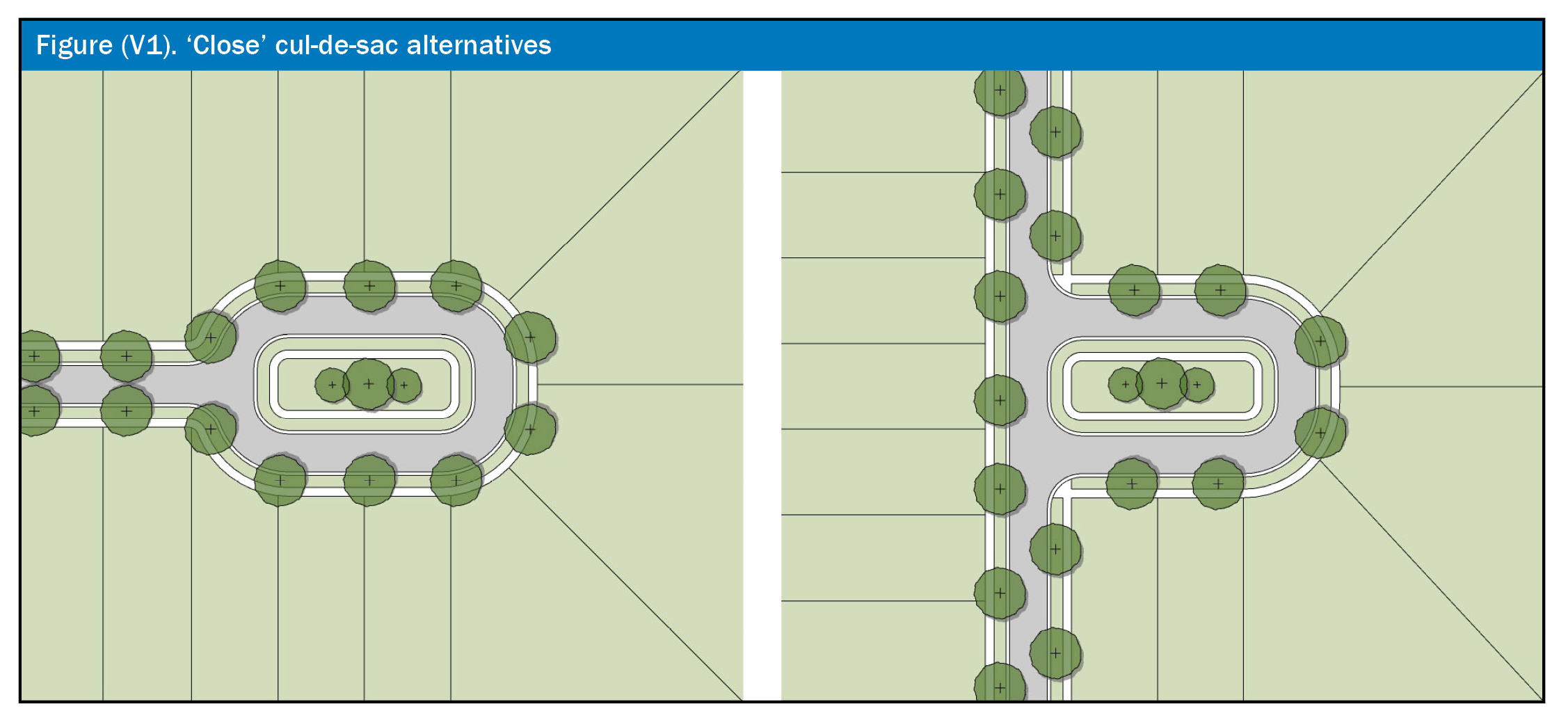
(i)
Public open space and public tracts. In addition to the adequate public facilities (APF) parks shown on the Horizon West SPALUM, a minimum of seven and one-half (7.5) percent of the developable land area of any development project shall be permanently allocated to public open space tracts in the form of neighborhood parks, squares, mews, greens, or linear parks designed to augment the village pedestrian/bikeways system and designed to create a focal point for the neighborhood. These neighborhood parks and squares shall be distributed throughout all land use districts within the village. The distribution of neighborhood parks and squares should be generally proportionate to the number of dwelling units within each area of the development.
(Ord. No. 2023-46, § 59, 12-12-23)
(j)
Stormwater facilities. Stormwater facilities shall be designed as an open space amenity in accordance with the design principles of this village development code. The design of stormwater facilities shall be in accordance with Section 38-1383 of this division and all other applicable codes, ordinances, resolutions, rules and regulations. Aesthetically designed "curvilinear shaped" stormwater facilities when designed as an amenity with clustered or regularly-spaced shade trees, planted at no more than forty (40) feet on-center, as well as a combination of two (2) or more additional aesthetic features (e.g., park benches, trails, gazebos, trellises, fountains, decorative cement forms at the water edge to create reflecting pools, etc.) may be applied toward no more than fifty (50) percent of the seven and one-half (7.5) percent open space requirement. The aesthetic features mentioned above, except for turf, shall be installed outside of the storm water facility required maintenance area.
(Ord. No. 2023-46, § 59, 12-12-23)
(k)
Natural water bodies. The design of any village planned development should consider natural water bodies as a public amenity. The scenic values of natural water bodies may be enhanced through appropriate design elements such as pedestrian access, waterfront parks and public street frontage. Public access to such waterbodies and use of motorized watercraft may be restricted as part of a planned development, preliminary subdivision plan, or development plan approval.
(l)
Block Pattern. A land use plan shall include a graphically depicted conceptual block layout for a typical single block showing the location, size, and layout of residential, non-residential, and mixed use developments. Subsequent preliminary subdivision and development plans shall be generally consistent with the conceptual block layout.
(m)
Screening. Ground-level mechanical equipment, outdoor storage areas and service areas, except those associated with single-family detached units, shall be screened by a one hundred (100) percent opaque buffer. Dumpsters or other refuse areas shall be screened by one hundred (100) percent opaque buffering, including a six-foot masonry wall with gate, and landscaping with shrubs or vines around the entire walled area. The wall shall be designed with similar architectural features as the principle structure and the gate shall be opaque.
(n)
Communication Towers. All communication towers shall comply with the requirements of section 38-1427 of the Orange County Code except that chain link fencing and opaque wall systems are prohibited. Decorative or ornamental metal fencing allowing transparency, with the exposed picket points for security, may be used around the base. Barbed wire, if any, should be on the interior side of the fence. Landscaping requirement may not be waived where adjacent to lands that may be developed or visible from a public right-of-way. In order to further the intent of Subsection 38-1427(n)(5), camouflage facilities for communication towers shall, when practicable, include architectural elements in building structures, such as church steeples, clock towers, bell towers, chimneys, rooftop cupolas, or flagpoles. Communication towers may be a permitted use in areas designated as APF parks and schools; and Office, Neighborhood Center and Village Center Districts on the Horizon West SPALUM, and provided the PD/LUP identifies such towers as a permitted use. Communication towers may also be permitted in areas designated Upland Greenbelt when a minimum twenty-foot fee simple access between the tower and a dedicated public paved street is maintained, and when the tower is located on developable uplands. Communication towers shall be prohibited in all other residential districts, wetlands (conservation areas), wetland upland buffers, designated wildlife corridors, and sites critical for Floridan Aquifer protection.
(Ord. No. 97-09, § 1, 5-20-97; Ord. No. 99-09, §§ 3, 4, 3-23-99; Ord. No. 09-16, § 1, 6-2-09; Ord. No. 2014-04, § 1, 2-11-14; Ord. No. 2016-19, § 30, 9-13-16; Ord. No. 2020-30, § 7S, 10-13-20; Ord. No. 2022-21, § 1, 6-7-22)
Sec. 38-1383. - Aquifer recharge.
The data and analysis provided in support of the village land use classification amendment adopted by Orange County in June 1995 found that the area designated by the village land use classification on the future land use map of Orange County contains high recharge areas. Subsequent studies have shown that the existing stormwater management requirements for high recharge areas in the county provide an appropriate measure of protection for both water quality and water quantity. In addition, on December 19, 1996, the board of county commissioners adopted a high-water recharge protection tax assessment program, implementing the provisions of the Henry Swanson-Bruce McEwan Bluebelt Act of 1996, for protection of this vital natural resource (Ordinance No. 96-38). This ordinance provides tax incentives for maintaining high recharge properties in a natural state. In addition to these requirements, the following measures are provided:
(1)
Water quality. In accordance with Future Land Use Element Policy FLU4.2.1, and subsection 38-1382(e) of this division, all village planned developments shall be required to hookup to central sewer service. In addition, the village classification limits high risk land uses, such as heavy industrial and those uses which store chemicals requiring technical containment, except those uses otherwise allowed in the neighborhood center or village center.
(2)
Water quantity. In accordance with subsection 38-1382(e) of this division, all village planned developments shall be required to connect to a reclaimed water system which will increase water recharge. In addition, with the adoption of a village, the soils types for all land within the village boundary as identified by the Natural Resources Conservation Service (formerly the U.S.D.A. Soil Conservation Service) shall be identified. In accordance with chapter 34, article VII, division 2, subdivision regulations, if the site contains hydrologic soil group type "A" retention of the total runoff generated by a twenty-five-year frequency, twenty-four-hour duration from the development site will be required. Where there is no positive outfall, retention of the total runoff generated by a one-hundred-year frequency, twenty-four-hour duration storm event from the development site will be required. A detailed soils report prepared by a geotechnical engineer shall be submitted to the county engineer for review prior to the development of final drainage plans for the site. The report shall contain recommendations as to the method of providing recharge on the site.
(Ord. No. 97-09, § 1, 5-20-97; Ord. No. 09-16, § 1, 6-2-09; Ord. No. 2014-04, § 1, 2-11-14; Ord. No. 2016-19, § 30, 9-13-16; Ord. No. 2022-21, § 1, 6-7-22)
Sec. 38-1384. - General residential development standards.
(a)
Density. Density is calculated by dividing the total number of units by the developable land area. Net density is calculated by dividing the total number of units by the net developable land area. Regardless of the applicable Village PD Code, accessory dwelling units shall not be included in density calculations.
The net density required by the land use designation may be increased or decreased provided that an equivalent number of units (transfer of development rights) have been purchased from uplands or wetlands (sending areas) in the designated upland greenbelt and wetland areas within the village in accordance with the provisions of chapter 30, article XIV, division 3, transfer of development rights (TDRs), and provided that the resulting overall net density within the village is consistent with future land use element policy FLU4.1.4. All TDR sending and receiving areas shall be identified on the affected PD/LUP. If proposed, all wetlands and upland greenbelts may be designated as TDR sending areas and all development parcels may be designed as receiving areas. Development rights from sending areas located beyond the boundary of the receiving area PD but within the same village, must be transferred through an executed agreement approved by the County prior to or concurrent with approval of the new or amended PD/LUP and must be consistent with the TDR Ordinance (Chapter 30, Article XIV, Division 3, Orange County Code). The internal transfer of density within a planned development may be approved without using TDRs pursuant to subsection 30-726(b)(2) and section 38-1207, so long as the resulting net density of the affected planned development parcels is consistent with the ranges identified in Section 30-727, and provided that the resulting density is consistent with the compatibility requirement of this Code and the comprehensive plan. The density within a parcel shall be established with the initial PD/LUP and subsequent modifications to the established density shall be subject to the PD change determination process.
(b)
Blocks.
(1)
Residential blocks shall be the area defined as one (1) block length by two (2) lot depths. A residential block is defined as a block length by one (1) lot depth when said block backs up to the perimeter of a property or another use.
(2)
Block depth. A prototypical block of two hundred forty (240) feet in depth where alleys are required and two hundred twenty (220) feet without alleys shall be utilized for all attached and detached single-family residential development within the village limits. Block depth requirements may only be reduced where the dimensions cannot be accommodated due to property ownership, natural features, or the need to accommodate other site planning provisions of this village development code. Any such alternatives to this standard shall be identified and approved through the preliminary subdivision plan or development plan review process.
(3)
Block face. A block face shall be defined as the linear street frontage on one (1) side of a block length, where the lot fronts are oriented to that same street.
(4)
Block size and length. Block size shall be required as follows:
a.
Blocks in and within one-fourth (¼) mile of a designated Village Center or Neighborhood Center District shall have an average perimeter not to exceed one thousand three hundred twenty (1,320) feet, measured at the property/right-of-way line of surrounding streets or mews, and excluding alleys.
b.
Blocks beyond one-fourth (¼) mile of a designated Village Center or Neighborhood Center District shall have an average perimeter not to exceed two thousand six hundred forty (2,640) feet, measured at the property/right-of-way line of surrounding streets or mews, and excluding alleys.
c.
Any blocks greater than one thousand nine hundred and eighty (1,980) feet in perimeter shall include a minimum fifteen-foot wide mid-block pedestrian passageway. Such passageways are defined as a narrow pedestrian tract (with limited vehicular access) that extends between residential lots and connects one (1) side of the block to the opposite side, or to an adjacent public open space tract. All mid-block pedestrian passageways shall be designed to include a minimum five-foot wide walkway constructed of concrete, stamped or textured concrete, or any other material as may be approved by the development engineering manager.
d.
Blocks or block faces located along ecologically significant vegetative communities, or where topography limits the ability to meet the block standards described above, may be excluded from an average block perimeter calculation.
(c)
Landscaping of streets and alleys.
(1)
Street trees shall be planted along both sides of all streets at an average maximum of forty (40) feet on center and shall be located in planter strips between the curb and sidewalks, except as provided in the road cross-sections of an approved planned development. Planter strips shall be irrigated by the abutting property owner. Reclaimed water shall be utilized when available. Street trees shall be canopy trees chosen from the recommended stock list as established in section 15-283. All street trees shall be Florida Grade #1, and shall have a clear trunk of six (6) feet and a minimum caliper of three (3) inches at the time of planting.
(2)
A continuous hedge and canopy trees planted at an average of forty (40) feet on center shall be provided between alleys and open spaces or park tracts. Hedges and plantings along alleys shall not exceed six (6) feet in height or four (4) feet in height in conjunction with a fence or wall.
(d)
Front porch. For the purposes of this village development code, a front porch is defined as an un-air-conditioned, roofed, raised above grade structure which is attached to the front of the building. Porches may wrap around the sides of structures as well. The minimum dimension of a front porch shall not be less than eight (8) feet deep or less than twelve (12) feet wide. (See Figure V2.)
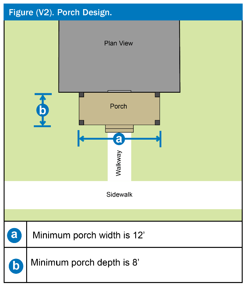
Front porches shall be required on fifty (50) percent of detached single-family lots of less than seventy-five (75) feet in width. Front porches that do not meet the minimum front porch size requirements shall not be considered in achieving this fifty (50) percent front porch requirement.
Attached single-family residences less than or equal to twenty (20) feet in width shall, at a minimum, provide covered stoops with columns which support a gabled or hipped roof structure. Alternative designs may be proposed but must be reviewed for consistency with architectural style.
(e)
Fences (See Figure V3). Fencing is permitted in the front yard within three (3) feet of the sidewalk to define the separation of public and private spaces. Such fencing shall be no higher than three (3) feet six (6) inches in height. Materials shall be limited to decorative metal, wood or PVC. Other fencing shall only be allowed consistent with section 38-1408 of this chapter, except that chain link fencing is prohibited unless vinyl coated black and used in association with a tennis or other sports court or field. Fences or walls parallel to alleys, or fences along any street, shall not exceed six (6) feet in height and shall be no more than fifty (50) percent opaque above four (4) feet in height. The restriction on fence opacity shall not apply to any fencing or wall along, or parallel to, the rear lot line of front-loaded lots, (including those which may abut an alley in the rear, or any side yard fencing placed between the front and rear planes of a principal structure on an interior lot or on the interior side of a corner lot). In addition, rear yard fencing on rear-loaded lots that does not meet the opacity restriction but that received a permit from the county prior to April 30, 2016, shall be considered conforming under this Code.
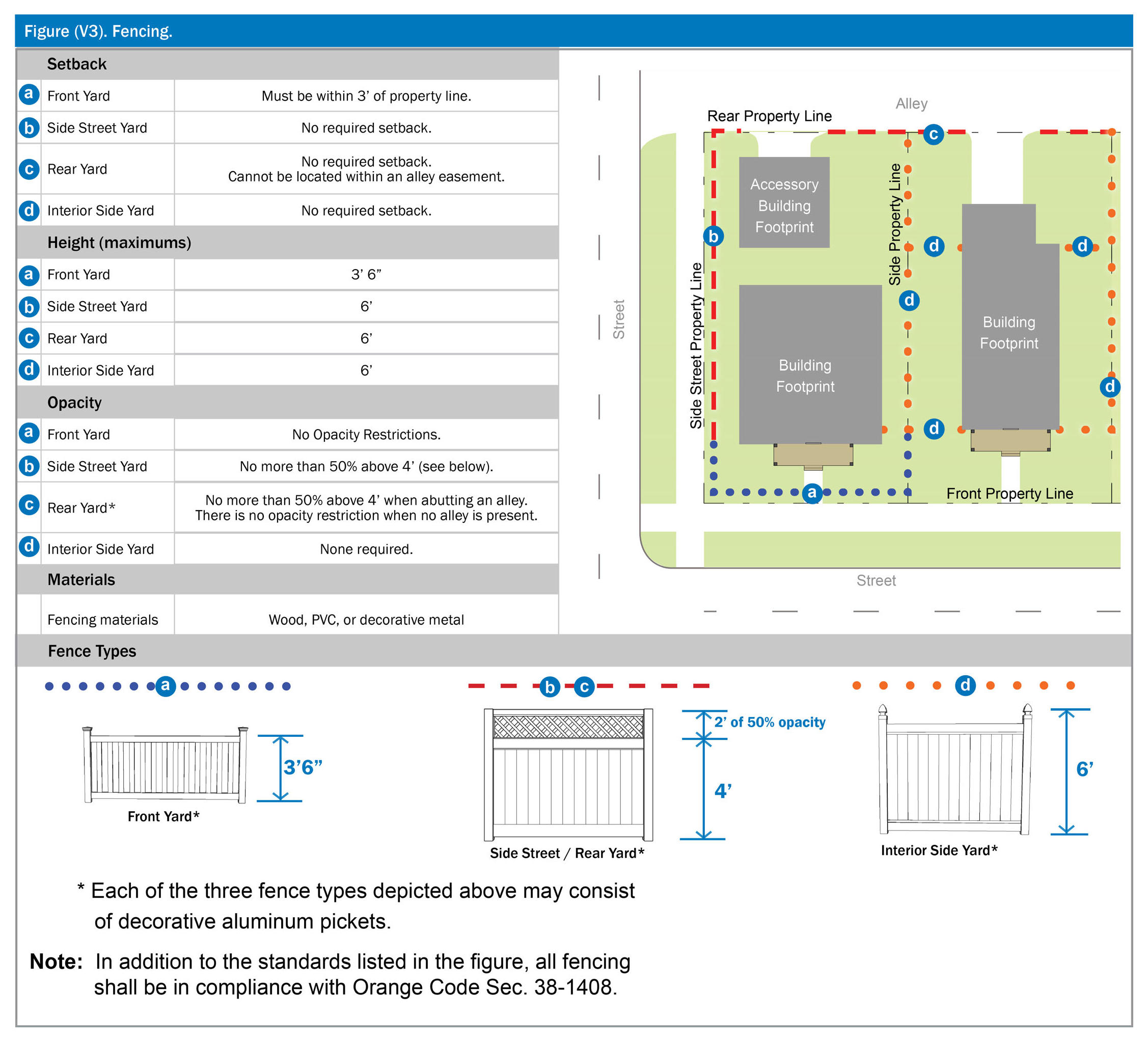
(f)
Village neighborhood character. The following requirements are intended to enhance the neighborhood character and create a pedestrian oriented environment within each village planned development. Modifications to these requirements may be permitted where alternative development practices will further the intent of providing diverse neighborhoods. Any such alternatives to these standards shall be identified and approved through the preliminary subdivision or development plan review process.
(1)
The same front façade for single-family detached residential units shall not be repeated more than five (5) times within one (1) block face for both sides of any street and shall be separated by at least two (2) lots with different façades. To the greatest extent possible, houses with the same front façade should not be located across the street from each other. One (1) and two (2) story units should be intermixed in each block face. Front loaded units should randomly alter the location of the driveway on the left and right sides of the façade.
(2)
Architectural styles and floor plans shall vary throughout the development and special attention shall be given to the appearance and scale of housing as it relates to the street. House façades shall be varied and articulated to provide visual interest to pedestrians along the street frontage. Except for lot widths one hundred (100) feet or greater, the façade of the main body of the house shall not exceed forty (40) feet except for wings or Ls which are setback from the front façade. All lots with alleys shall include primary entrances that are visible and accessible from the street and shall have a pedestrian path or walkway from the primary entrance to the sidewalk. For front-loaded lots, the primary entrance shall be visible and accessible from the street and there shall be a pedestrian path or walkway from the primary entrance to either the sidewalk or driveway. In addition, the following mechanisms should serve as a guide to ensure a pedestrian scale neighborhood and enhanced neighborhood character.
a.
Utilization of arcades, bays and balconies;
b.
Façades that are located at the front setback line;
c.
Decorative porch railing on the side and front of required porches;
d.
Variations in color and avoiding the same principal color on houses next to, or across from, each other;
e.
Hip, gable or gambrel roofs, unless another roof type is consistent with the architectural style;
f.
Design of vehicular access and garages which take into account the pedestrian scaled street frontage with preference given to garages located at the rear of the main house;
g.
Other similar architectural features such as balconies, covered entries, trim details, shutters, and bay windows which enhance the street front appearance and promote an appropriate massing and scale;
h.
Use of a variety of architectural styles (i.e., Victorian, Colonial, Florida Vernacular, Tudor, Mission, Craftsman, etc.) and not only the use of minor details associated with these styles;
i.
Use of extended eaves;
j.
Use of multiple roof and porch planes;
k.
Variation in floor plan, entryway location and building placement on each block;
l.
Use of detached garages with porte-cochere;
m.
Use of window trim and/or shutters on sides of the unit; and
n.
Use of dormers with real window frames;
o.
For garages accommodating three (3) vehicles or more, one (1) or more deeper bays allowing tandem parking, with one (1) vehicle behind the other, is preferred to vehicle bays which are side-by-side and face the street (See Figure V4).
p.
Mixing attached and detached garages on blocks that are alley-loaded.
q.
Side-street facing façade should be articulated with projections and recesses.
r.
Lots at the end of an alley should incorporate garages facing the internal side yard (J-loaded).
(3)
The following components shall be required on all townhouse and detached single-family residential structures and lots, as applicable:
a.
First floor elevations with a minimum of three (3) steps above the finished grade of the sidewalk;
b.
Articulation of side street facades for corner lots (i.e., repeat any window molding, muntins, shutters, expression lines, wainscot veneer - which appears on the front façade);
c.
For front-loaded and side-loaded lots, driveways shall not exceed twelve (12) feet in width as measured anywhere between the front property line and the first ten (10) feet from the front property line (See Figure V4).
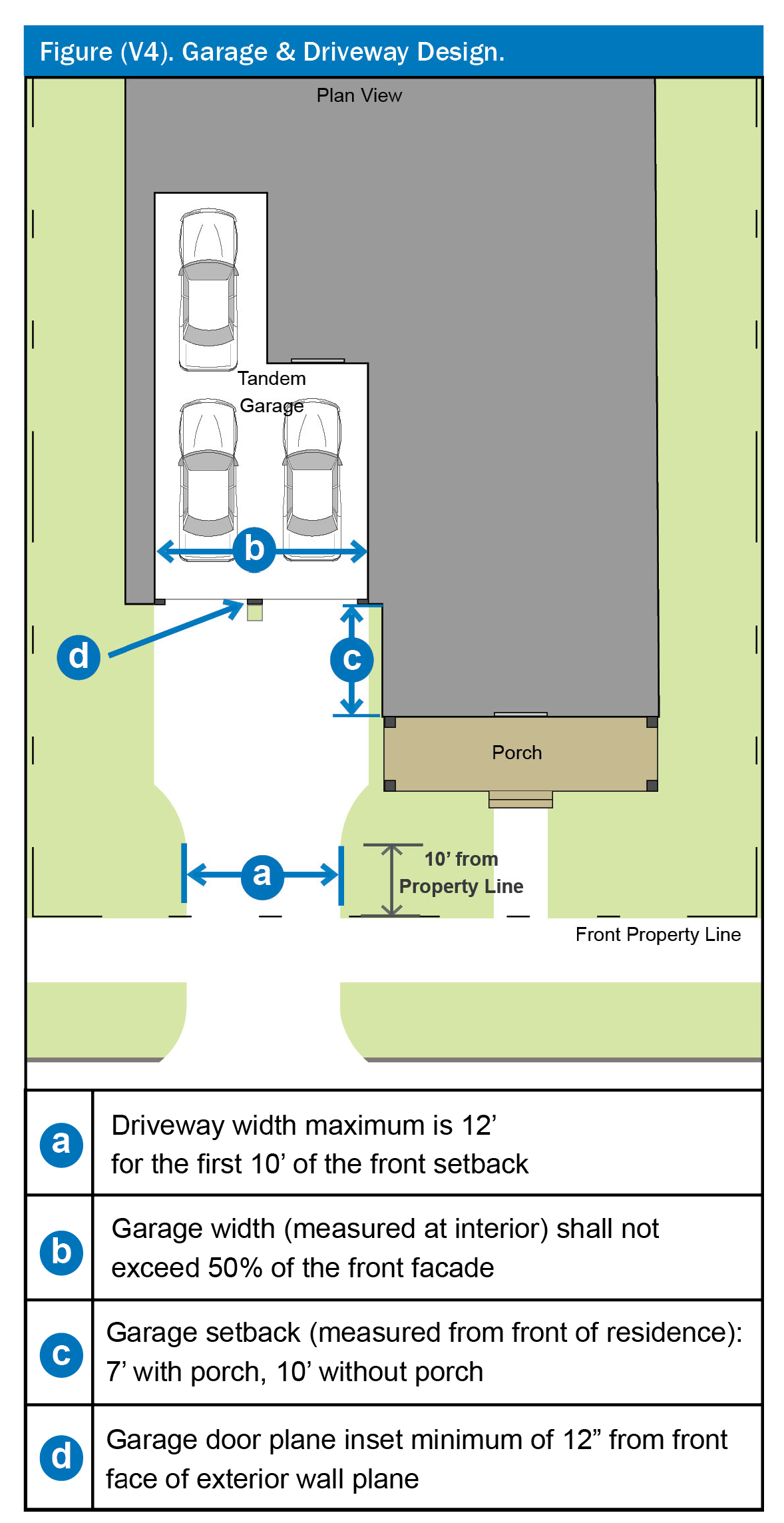
(g)
Garages and garage doors. Unless otherwise indicated, the term "garage" shall mean the entirety of the garage, as measured within the interior width of the garage space (See Figure V4). Garages shall be constructed in accordance with the following standards:
(1)
Rear alley access. Garage access must be provided by a rear alley where lots are fifty (50) feet or less in width, or where any lot abuts a rear alley easement (or tract) (See Figure V4). Garages with direct access from an alley shall be setback with a minimum of nine (9) feet from the edge of the alley easement (or tract) or shall provide an additional off-street parking space. When an additional off-street parking space is added, the garage shall be setback a minimum of three (3) feet from the edge of the alley easement (or tract).
(2)
Front-loaded garage setbacks. Garage doors of front-loaded lots shall be recessed a minimum of ten (10) feet behind the nearest adjacent plane of the primary structure (See Figure V4). However, when a porch is provided in front of the forward-most plane of the structure, which meets the minimum standards of subsection 38-1384(d), the garage door setback behind the nearest adjacent plane of the primary structure may be decreased to seven (7) feet. In no case shall a front-loaded garage door be setback less than twenty (20) feet from the front property line.
(3)
Detached garages. Detached garages without access to a rear alley easement or tract, including garages with an accessory dwelling unit, shall be located a minimum of five (5) feet from side and rear property lines, and a minimum of fifteen (15) feet from side streets.
(4)
Front and side-loaded garages. The prominent appearance of garages shall be diminished and instead appear to be an extension of the home's living space. As such, front and side-loaded garages shall be located and detailed in accordance with the following:
a.
All garage doors shall be recessed a minimum of twelve (12) inches from the front plane of the garage.
b.
For double-car garages, two (2) single-wide garage doors are preferable to a double-wide door. Double-wide garage doors shall not exceed sixteen (16) feet in width. Double-wide (or wider) garage doors are not permitted to face the front street on front-loaded lots of less than sixty-five (65) feet in width. Side-facing double-wide garage doors are permitted on lots of any width (See Figure V5).
c.
Where single garage doors are provided for multi-car garages, single-wide garage doors shall not exceed twelve (12) feet. Each entry shall be separated by a column or other visually substantial supporting vertical feature which is a minimum of sixteen (16) inches wide.
d.
Garage doors shall either incorporate windows along the upper one-quarter (¼) of the door or substantial architectural patterning shall be incorporated throughout the door plane including carriage style hinges and handles, and patterning which emulates two (2) smaller doors.
e.
For interior lots sixty-five (65) feet wide or greater, and excluding any requirements of subsection 38-1384(i)(3), (i)(4) and (i)(5), garages may be placed in front of the primary structure, but must be oriented toward either side yard and shall meet the setbacks for the primary structure. The street-facing façades of such garages shall be detailed and articulated the same as the primary structure, with particular attention to similar roof lines, roofing material, finish, gables, brackets, window patterns, molding, wainscot, etc. For lots over one hundred twenty (120) feet in width, the requirements of this subsection may be waived as part of the preliminary subdivision plan approval.
f.
Side-street facing garages shall be setback a minimum of five (5) feet behind the side-street façade of the principal structure, with five (5) feet rear and side setbacks.
g.
Garages and garage doors that do not meet the provisions of this section 38-1384, but which received a building permit from the county and were constructed in accordance with the issued building permit prior to January 1, 2016, shall be considered conforming structures under this Code.
h.
In no case shall more than fifty (50) percent of the front façade of a house consist of an unarticulated block wall or garage.
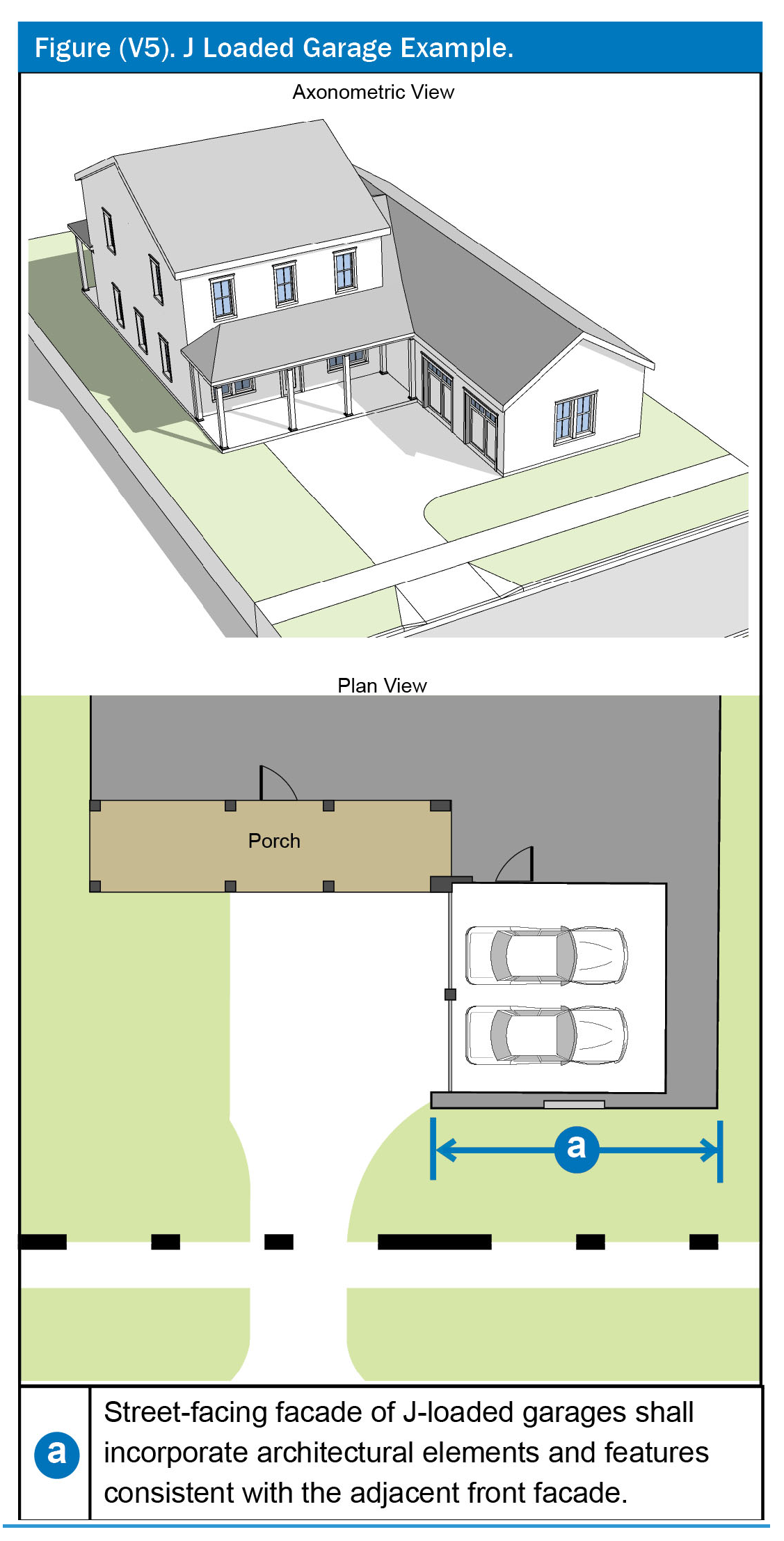
i.
Three car-wide front-facing garages shall also incorporate at least one (1) or more of the following additional components (see Figure V6):
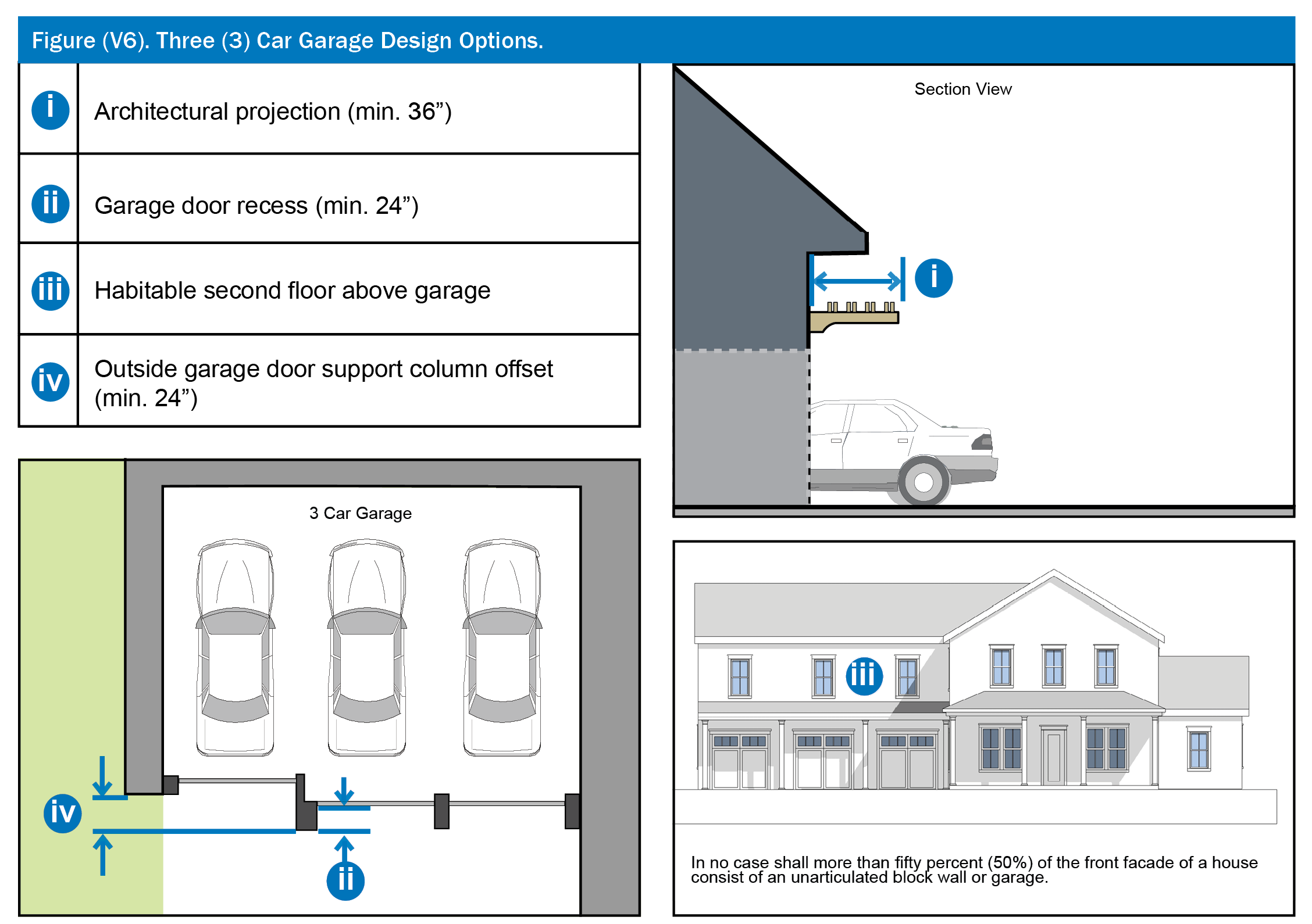
1.
Individual architectural projections over each door (e.g., trellis or awning) which extend a minimum of thirty-six (36) inches from the overhead support of each door opening.
2.
Garage doors recessed a minimum of twenty-four (24) inches from the front plane of the garage.
3.
Structure must be two stories tall, and incorporate habitable second floor space immediately above the garage.
4.
The outside garage door shall be set back a minimum of two (2) feet behind the front plane of the column which supports the adjacent door.
(h)
Design guidelines. Planned development land use plans and preliminary subdivision/development plans shall include documentation providing illustrative design guidelines representing these and other development standards that demonstrate how the development will achieve the general residential design standards contained herein. PD/LUP design guidelines should be general, with more detailed and very specific guidelines submitted with the preliminary subdivision plan or development plan. The detailed guidelines, required at the time of PSP or DP submittal, shall include architectural elevations (drawn to scale) of all sides of all proposed townhouses, apartments, and detached single-family structures. One (1) complete set of architectural elevations (e.g. four (4) façades) shall be submitted only for each unique structure or "model."
These architectural elevations shall depict, and label, proposed architectural forms and trim including window molding and muntins, exposed rafter tails, columns, porches, railings, "water table" veneer, and shutters. All finished surface materials shall be labeled, and conceptual grade changes associated with entry sidewalks, steps, and porches, shall be delineated. Conceptual drawings and sketches which illustrate wall offsets, voids, projected molding and trim, awnings, porch depth, and overhanging eaves are encouraged.
(i)
Access and off-street parking.
(1)
Parking for residential uses shall be provided in accordance with article XI of this chapter; however, minimum parking, including required remote parking, for residential uses must be reviewed and approved by the Fire Rescue Department prior to development plan/preliminary subdivision plan approval.
(2)
Vehicular access to garages or other off-street parking surfaces on all lots fifty (50) feet or less in width, or where any lot abuts a rear alley easement (or tract) pursuant to subsection 38-1384(i)(5) below, shall be provided from a rear alley easement (or tract).
(3)
Vehicular access to garages or other off-street parking surfaces on all lots facing the primary side of an APF school or any other APF park, road or trail shall be provided from a rear alley easement (or tract).
(4)
Vehicular access to garages or other off-street parking surfaces on all lots greater than fifty (50) feet in width that face functional non-APF neighborhood squares and parks shall be provided from a rear alley easement (or tract) or from a front driveway where the garages are located at or beyond the rear wall of the primary structure.
Neighborhood squares and parks are defined as active or passive recreational and open space tracts of varying sizes that have been designed to create a discernable neighborhood focal point. The landscape within a neighborhood square or park may consist of naturalistic or formally designed features such as sidewalks, trails, sports fields, hardscaped amenities and structures.
(5)
Garage access from the front or street side of any lot that abuts a rear alley easement (or tract) shall be prohibited. However, garages located on the front or side of lots that abut a rear alley easement (or tract) shall be considered conforming structures under this Code, if they received a building permit from the county prior to April 30, 2016.
(j)
Accessory Structures and Uses. All accessory structures, including accessory dwelling units, shall be subject to the standards found in Section 38-1426, except that the cumulative square footage of both detached and attached accessory structures on any lot that abuts a rear alley easement or tract shall not exceed one thousand five hundred (1,500) square feet, with a maximum of seven hundred fifty (750) square feet per story. Swimming Pools, screen enclosures, and screen rooms shall only be located in the rear or side yard, and shall have the same side yard and side-street yard setback as the principal structure. Swimming pools and screen enclosures shall provide a minimum five (5) foot setback from the rear lot line or the rear alley easement or tract (when such an easement or tract exists). Screen rooms may extend up to fifty (50) percent into the required rear yard, but in no case shall the screen room be located closer than five (5) feet from the rear alley easement or tract (when such an easement or tract exists). Neighborhood clubhouses shall be limited to a maximum building height of thirty-five (35) feet, and supporting and detached facilities shall not exceed the height of the clubhouse. Such facilities shall be architecturally similar to the clubhouse.
(k)
Civic and Institutional Uses. Civic and institutional uses include libraries, schools, police and fire stations, post offices, community centers, churches and religious buildings, museums, cultural societies, visual and performing arts buildings, public parks, governmental buildings, and other similar uses as determined by the Planning and Zoning Division Managers. These uses shall be permitted in all districts, but must be identified on the approved PD land use plan and shall be designed in accordance with the design guidelines established with the PD and development standards of Section 38-1390. Such uses should be located at the termination of street vistas where practicable.
(Ord. No. 97-09, § 1, 5-20-97; Ord. No. 99-09, § 5, 3-23-99; Ord. No. 09-16, § 1, 6-2-09; Ord. No. 2014-04, § 1, 2-11-14; Ord. No. 2016-10, § 1, 5-24-16; Ord. No. 2022-21, § 1, 6-7-22)
Sec. 38-1385. - Estate district.
(a)
Development guidelines. The following development standards shall apply to all development within the estate district.
(1)
Density. Except for transfer of development rights as provided for in chapter 30, article XIV, division 2, of this Code, or as otherwise provided in subsection 38-1384(a), the average net density within an area designated Estate District on a Village PD/LUP and per each Preliminary Subdivision Plan (PSP) shall be two (2) dwelling units per acre.
(2)
Permitted uses. Single-family detached residential homes accessory structures, and uses as defined in subsection 38-1384(j), and all other uses listed in the use table of Section 38-77 that reflect the abbreviation "P" in the correlating R-1AA zoning district cells shall be permitted in the Estate District. Those uses listed as a special exception in the use table of Section 38-77 and reflect the abbreviation "S" in the correlating R-1AA zoning district cells may also be permitted, but must be identified as a special exception on the PD/LUP. Uses that require a special exception and are also included in the list of civic and institutional uses under Subsection 38-1384(k), shall be designed as a neighborhood focal point, and located at the terminus of street vistas where practicable. All other uses are prohibited.
(b)
Development standards. The following standards shall apply to all development within the estate district. Modifications to these standards may be permitted where alternative development practices will reinforce the planning principles established by the goals objectives and policies of the village land use classification, and this village development code. Any such modifications to these standards shall be identified separately in bold on the Village PD land use plan, PSP or development plan for approval by the board of county commissioners at a public hearing.
(1)
Maximum lot area: None.
(2)
Minimum average lot size: Ten thousand (10,000) square feet. (Where transfer of development rights are utilized, the minimum lot size may vary from this standard and shall be determined at the time of preliminary subdivision plan approval.)
(3)
Minimum living area: One thousand five hundred (1,500) square feet. Living area is defined as the area that is heated and cooled.
(4)
Minimum lot width: Eighty-five (85) feet and ninety (90) feet for corner lots.
(5)
Minimum lot depth: One hundred ten (110) feet. (one hundred twenty (120) feet with alley)
(6)
Maximum building height: Three (3) stories and a maximum of forty-five (45) feet.
(7)
Accessory structures: See subsection 38-1384(j).
(8)
Maximum lot coverage: Sixty-five (65) percent. (The area of a front porch is not included in the calculation of lot coverage.)
(9)
Minimum building setback requirements:
a.
Front: Twenty (20) feet; ten (10) feet for front porch.
b.
Side: Five (5) feet. Side Street: Ten (10) feet.
c.
Rear: Twenty-five (25) feet for primary structure.
d.
Lakefront: Fifty (50) feet from the normal high-water elevation contour in accordance with chapter 30, article XII, of this Code.
e.
Garages: See section 38-1384(g).
(10)
Driveways: Driveways must be set back a minimum of five (5) feet from the side property line within the front ten (10) feet from the road right-of-way; otherwise, driveways must be set back a minimum of two (2) feet from the side property line.
(Ord. No. 99-09, § 7, 3-23-99; Ord. No. 09-16, § 1, 6-2-09; Ord. No. 2014-04, § 1, 2-11-14; Ord. No. 2022-21, § 1, 6-7-22)
Sec. 38-1385.5. - Estate home district.
(a)
Development guidelines. The following development guidelines shall apply to all development within the estate home district.
(1)
Density. Except for transfer of development rights as provided for in chapter 30, article XIV, division 2, of this Code or as otherwise provided in subsection 38-1384(a), the average net density within an area designated Estate Home District on village PD/LUP and per each Preliminary Subdivision Plan (PSP) shall be three (3) dwelling units per acre.
(2)
Permitted uses. Single-family detached residential homes, accessory structures, and uses as defined in subsection 38-1384(j), and all other uses listed in the use table of Section 38-77 that reflect the abbreviation "P" in the correlating R-1AA zoning district cells shall be permitted in the Estate Home District. Those uses listed as a special exception in the use table of Section 38-77 and reflect the abbreviation "S" in the cells that correlate with the R-1AA zoning district may also be permitted, but must be identified as a special exception on the PD/LUP. Uses that require a special exception and are also included in the list of civic and institutional uses under Subsection 38-1384(k), shall be designed as a neighborhood focal point, and located at the terminus of street vistas where practicable All other uses are prohibited.
(b)
Development standards. The following standards shall apply to all development within the estate home district. Modifications to these standards may be permitted where alternative development practices will reinforce the planning principles established by the goals, objectives and policies of the village land use classification and this village development code. Any such modifications to these standards shall be identified separately in bold on the village PD land use plan, PSP or development plan for approval by the board of county commissioners at a public hearing.
(1)
Maximum lot area: None.
(2)
Minimum average lot size: Seven thousand two hundred (7,200) square feet. (Where transfer of development rights are utilized, the minimum lot size may vary from this standard and shall be determined at the time of preliminary subdivision plan approval.)
(3)
Minimum living area: One thousand two hundred (1,200) square feet. Living area is defined as the area that is heated and cooled.
(4)
Minimum lot width: Fifty (50) feet.
(5)
Minimum lot depth: One hundred ten (110) feet. (one hundred twenty (120) feet with alley)
(6)
Maximum building height: Three (3) stories and a maximum of forty-five (45) feet.
(7)
Accessory structures: See subsection 38-1384(j).
(8)
Maximum lot coverage: Sixty-five (65) percent. (The area of a front porch is not included in the calculation of lot coverage.)
(9)
Minimum building setback requirements:
a.
Front: Twenty (20) feet; ten (10) feet for front porch.
b.
Side: Five (5) feet. Side Street: Ten (10) feet.
c.
Rear: Twenty-five (25) feet for primary structure.
d.
Lakefront: Fifty (50) feet from the normal high-water elevation contour in accordance with chapter 30, article XII, of this Code.
e.
Garages: See section 38-1384(g).
(10)
Driveways: Driveways must be setback a minimum of five (5) feet from the side property line within the front ten (10) feet from the road right-of-way; otherwise, driveways must be setback a minimum of two (2) feet from the side property line.
(Ord. No. 97-09, § 1, 5-20-97; Ord. No. 99-09, § 8, 3-23-99; Ord. No. 09-16, § 1, 6-2-09; Ord. No. 2014-04, § 1, 2-11-14; Ord. No. 2022-21, § 1, 6-7-22)
Sec. 38-1385.6. - Estate rural district.
(a)
Development guidelines. The following development guidelines shall apply to all development within the estate rural district.
(1)
Density. Except for transfer of development rights as provided for in chapter 30, article XIV, division 2, of this Code, or as otherwise provided in subsection 38-1384(a), the average net density within an area designated Estate Rural District on a village PD/LUP and per each Preliminary Subdivision Plan (PSP) shall be one (1) or less dwelling unit per acre.
(2)
Permitted uses. Single-family detached residential homes accessory structures, and uses as defined in subsection 38-1384(j), and all other uses listed in the use table of section 38-77 that reflect the abbreviation "P" in the correlating R-CE zoning district cells may be permitted in the estate rural district. Those uses listed as a special exception in the use table of Section 38-77 and reflect the abbreviation "S" in the cells that correlate with the R-CE zoning district may also be permitted, but must be identified as a special exception on the PD/LUP. Uses that require a special exception and are also included in the list of civic and institutional uses under Subsection 38-1384(k), shall be designed as a neighborhood focal point, and located at the terminus of street vistas where practicable. All other uses are prohibited.
(b)
Development standards. The following standards shall apply to all development within the estate rural district. Modifications to these standards may be permitted where alternative development practices will reinforce the planning principles established by the goals, objectives and policies of the village land use classification and this village development code. Any such modification to these standards shall be identified separately in bold on the village PD land use plan, PSP or development plan for approval by the board of county commissioners at a public hearing.
(1)
Maximum lot area: None.
(2)
Minimum average lot size: Forty-three thousand, five hundred sixty (43,560) square feet (one (1) acre).
(3)
Minimum living area: One thousand five hundred (1,500) square feet. Living area is defined as the area that is heated and cooled.
(4)
Minimum lot width: One hundred thirty (130) feet.
(5)
Minimum lot depth: One hundred ten (110) feet. (one hundred twenty (120) feet with alley)
(6)
Maximum building height: Three (3) stories and a maximum of forty-five (45).
(7)
Accessory structures: See subsection 38-1384(j).
(8)
Maximum lot coverage: Sixty-five (65) percent. (The area of front porch is not included in the calculation of lot coverage.)
(9)
Minimum building setback requirements:
a.
Front: Thirty-five (35) feet; twenty-five (25) feet for front porch.
b.
Side: Ten (10) feet. Side Street: Ten (10) feet.
c.
Rear: Fifty (50) feet for primary structure.
d.
Lakefront: Fifty (50) feet from the normal high-water elevation contour in accordance with chapter 30, articles XII, of this Code.
e.
Garages: See section 38-1384(g).
(10)
Driveways: Drives must be setback a minimum of ten (10) feet from the side property line within the front ten (10) feet from the road right-of-way; otherwise, driveways must be setback a minimum of five (5) feet from the side property line.
(Ord. No. 09-16, § 1, 6-2-09; Ord. No. 2014-04, § 1, 2-11-14; Ord. No. 2022-21, § 1, 6-7-22)
Sec. 38-1385.7. - Garden home single-family district.
(a)
Development guidelines. The following development guidelines shall apply to all development within the garden single-family home district.
(1)
Density. Except for transfer of development rights as provided for in chapter 30, article XIV, division 2, of this Code or internal transfers provided in subsection 38-1384(a), the average net density within an area designated as garden home single-family district on a village PD/LUP and per each Preliminary Subdivision Plan (PSP) shall be four (4) dwelling units per acre.
(2)
Permitted uses. Single-family detached residential homes, accessory structures, and uses as defined in subsection 38-1384(j), and all other uses listed in the use table of Section 38-77 that reflect the abbreviation "P" in the correlating R-1AA zoning district cells shall be permitted in the Garden Home Single-Family District. Those uses listed as a special exception in the use table of Section 38-77 and reflect the abbreviation "S" in the cells that correlate with the R-1AA zoning district may also be permitted, but must be identified as a special exception on the PD/LUP. Uses that require a special exception and are also included in the list of civic and institutional uses under Subsection 38-1384(k), shall be designed as a neighborhood focal point, and located at the terminus of street vistas where practicable. All other uses are prohibited.
(b)
Development standards. The following standards shall apply to all development within the garden home district. Modifications to these standards may be permitted where alternative development practices will reinforce the planning principles established by the goals objectives and policies of the village land use classification and this village development code. Any such modifications to these standards shall be identified separately in bold on the village PD land use plan, PSP or development plan for approval by the board of county commissioners at a public hearing.
(1)
Maximum lot area: None.
(2)
Minimum average lot size: Thirty-two hundred (3,200) square feet. (Where transfer of development rights are utilized, the minimum lot size may vary from this standard and shall be determined at the time of preliminary subdivision plan approval.)
(3)
Minimum living area: One thousand two hundred (1,200) square feet. Living area is defined as the area that is heated and cooled.
(4)
Minimum lot width: Thirty-two (32) feet for single-family detached dwelling units.
(5)
Minimum lot depth: One hundred ten (110) feet. (ninety (90) feet with alley)
(6)
Maximum building height: Three (3) stories and a maximum of forty-five (45) feet.
(7)
Accessory structures: See section 38-1384(j).
(8)
Maximum lot coverage: Sixty-five (65) percent. (The area of a front porch is not included in the calculation of lot coverage.)
(9)
Minimum building setback requirements:
a.
Front: Fifteen (15) feet; seven (7) feet for front porch.
b.
Side: Four (4) feet (subject to easement). Side Street: Ten (10) feet.
c.
Rear: Twenty (20) feet for primary structure.
d.
Lakefront: Fifty (50) feet from the normal high-water elevation contour in accordance with chapter 30, article XII, of this Code.
e.
Garages: See section 38-1384(g).
(10)
Driveways: Shared driveways are encouraged; however, when driveways are not shared, they must be setback a minimum of two (2) feet from the side property line.
(Ord. No. 99-09, § 9, 3-23-99; Ord. No. 09-16, § 1, 6-2-09; Ord. No. 2014-04, § 1, 2-11-14; Ord. No. 2022-21, § 1, 6-7-22)
Sec. 38-1385.8. - Garden home mixed use district.
(a)
Development guidelines. The following development guidelines shall apply to all development within the garden home mixed used district.
(1)
Density. Except for transfer of development rights as provided for in chapter 30, article XIV, division 2, of this Code or as otherwise provided in subsection 38-1384(a), the average net density within an area designated Garden Home Mixed Use District on a village PD/LUP and per each Preliminary Subdivision Plan (PSP) shall be four (4) dwelling units per acre.
(2)
Permitted uses. Single-family detached residential homes, townhomes, condominiums, accessory structures, and uses as defined in section subsection 38-1384(j), and all other uses listed in the use table of Section 38-77 that reflect the abbreviation "P" in the correlating R-1AA zoning district cells shall be permitted in the Garden Home Mixed-Use District. Those uses listed as a special exception in the use table of Section 38-77 and reflect the abbreviation "S" in the cells that correlate with the R-1AA zoning district may also be permitted, but must be identified as a special exception on the PD/LUP. Uses that require a special exception and are also included in the list of civic and institutional uses under Subsection 38-1384(k), shall be designed as a neighborhood focal point, and located at the terminus of street vistas where practicable. All other uses are prohibited.
(b)
Single-family development standards. The following standards shall apply to all single-family developments within the garden home mixed use district. Modifications to these standards may be permitted where alternative development practices will reinforce the planning principles established by the goals objectives and policies of the village land use classification and this village development code. Any such modifications to these standards shall be identified separately in bold on the village PD land use plan, PSP or development plan for approval by the board of county commissioners at a public hearing.
(1)
Maximum lot area: None.
(2)
Minimum average lot size: Thirty-two hundred (3,200) square feet. (Where transfer of development rights are utilized, the minimum lot size may vary from this standard and shall be determined at the time of preliminary subdivision plan approval.)
(3)
Minimum living area: One thousand two hundred (1,200) square feet. Living area is defined as the area that is heated and cooled.
(4)
Minimum lot width: Thirty-two (32) feet for single-family detached dwelling units.
(5)
Minimum lot depth: One hundred ten (110) feet. (ninety (90) feet with alley)
(6)
Maximum building height: Three (3) stores and a maximum of forty-five (45) feet.
(7)
Accessory structures: See subsection 38-1384(j).
(8)
Maximum lot coverage: Sixty-five (65) percent. (The area of a front porch is not included in the calculation of lot coverage.)
(9)
Minimum building setback requirements:
a.
Front: Fifteen (15) feet: seven (7) feet for front porch.
b.
Side: Four (4) feet (subject to easement). Side Street: Ten (10) feet.
c.
Rear: Twenty (20) feet for primary structure.
d.
Lakefront: Fifty (50) feet from the normal high-water elevation contour in accordance with chapter 30, article XII, of this Code.
e.
Garages: See section 38-1384(g).
(10)
Driveways: Shared driveways are encouraged; however, when driveways are not shared, they must be setback a minimum of two (2) feet from the side property line.
(c)
Townhouse development guidelines. Guidelines for townhouses developed in the garden home mixed use district shall be those specified for townhouses in section 38-1387.1.
(d)
Condominiums development guidelines. Guidelines for condominiums developed in the garden home mixed use district shall be those specified for condominiums in section 38-1387.3, except that the maximum building height shall be limited to three (3) stores and forty-five (45) feet.
(Ord. No. 09-16, § 1, 6-2-09; Ord. No. 2014-04, § 1, 2-11-14; Ord. No. 2022-21, § 1, 6-7-22)
Sec. 38-1386. - Village home district.
(a)
Development guidelines. The following development guidelines shall apply to all development within the village home district.
(1)
Density. Except for transfer of development rights as provided for in chapter 30, article XIV, division 2, of this Code or as otherwise provided in section 38-1384(a), the average net density within an area designated as village home district on a village PD/LUP and per each Preliminary Subdivision Plan (PSP) shall be six (6) dwelling units per acre.
(2)
Permitted uses. Single-family detached residential homes, townhomes, condominiums, accessory structures, and uses as defined in subsection 38-1384(j), and all other uses listed in the use table of Section 38-77 that reflect the abbreviation "P" in the correlating R-1AA zoning district cells shall be permitted in the Village Home District. Those uses listed as a special exception in the use table of Section 38-77 and reflect the abbreviation "S" in the cells that correlate with the R-1AA zoning district may also be permitted, but must be identified as a special exception on the PD/LUP. Uses that require a special exception and are also included in the list of civic and institutional uses under Subsection 38-1384(k), shall be designed as a neighborhood focal point, and located at the terminus of street vistas where practicable. All other uses are prohibited.
(3)
Ground-floor nonresidential uses. Retail commercial and professional office uses may be permitted on the first floor of a multi-story residential structure when located fronting a neighborhood center or village center. Such nonresidential uses shall be integrated into the residential building and shall be limited to one thousand (1,000) square feet of gross leasable area, and shall be primarily oriented to serve the residents of the immediate area. These nonresidential use areas shall be identified on the PD land use plan. The PSP shall include covenants, conditions and restrictions identifying these as primary residential uses with accessory commercial and professional office.
(b)
Development standards. The following standards shall apply to single-family detached residences within the village home district. Modifications to these standards may be permitted where alternative development practices will reinforce the planning principles established by the goals, objectives and policies of the village land use classification and this village development code. Any such modifications to these guidelines shall be identified separately in bold on the village PD land use plan, PSP or development plan for approval by the board of county commissioners at a public hearing.
(1)
Maximum lot area: None.
(2)
Minimum average lot size: Twenty-eight hundred (2,800) square feet. (Where transfer of development rights or townhouses are utilized, the minimum lot size may vary from this standard and shall be determined at the time of preliminary subdivision plan approval.)
(3)
Minimum living area: One thousand (1,000) square feet. Living area is defined as the area that is heated and cooled.
(4)
Minimum lot width: Thirty-two (32) feet for single-family detached dwelling units.
(5)
Attached units shall be subject to the standards in section 38-1387.1.
(6)
Minimum lot depth: One hundred ten (110) feet. (ninety (90) feet with alley)
(7)
Maximum building height: Three (3) stories and forty-five (45) feet.
(8)
Accessory structures: See subsection 38-1384(j).
(9)
Maximum lot coverage: Sixty-five (65) percent. (The area of a front porch is not included in the calculation of lot coverage.)
(10)
Minimum building setback requirements:
a.
Front: Fifteen (15) feet; seven (7) feet for front porch.
b.
Side: Four (4) feet (subject to easement). Side Street: Ten (10) feet.
c.
Rear: Twenty (20) feet for primary structure.
d.
Lakefront: Fifty (50) feet from the normal high-water elevation contour in accordance with chapter 30, article XII, of this Code.
e.
Garages: See section 38-1384(g).
(11)
Shared driveways are encouraged; however when driveways are not shared, they must be setback a minimum of two (2) feet from the side property line.
(c)
Townhome development standards. Standards for townhomes developed in the village home district shall be those specified for townhouses in section 38-1387.1.
(d)
Condominium development standards. Standards for condominiums developed in the village home district shall be those specified for condominiums in section 38-1387.3, except that the maximum building height shall be limited to four (4) stories and fifty-five (55) feet.
(Ord. No. 97-09, § 1, 5-20-97; Ord. No. 99-09, § 10, 3-23-99; Ord. No. 09-16, § 1, 6-2-09; Ord. No. 2014-04, § 1, 2-11-14; Ord. No. 2022-21, § 1, 6-7-22)
Sec. 38-1387. - Townhome district, Townhouse Apartment district, Apartment district, and Condominium district.
(a)
Townhouse/apartment/condominium guidelines. The following development guidelines shall apply to all development within the Townhome District, Townhouse/Apartment District, Apartment District and Condominium District, regardless of the form of ownership.
(1)
Density. Except for transfer of development rights as provided in chapter 30, article XIV, division 2, of this Code, or as otherwise provided in subsection 38-1384(a); the average net density [in] areas designated Townhome District, Townhouse/Apartment District or Condominium District on a PD Land Use Plan (LUP), Preliminary Subdivision Plan (PSP) or Development Plan (DP) shall be as follows:
- Townhome District: Eight (8) to ten (10) dwelling units per acre.
- Townhouse/Apartment District: Twelve (12) dwelling units per acre.
- Apartment District: Sixteen (16) to twenty-five (25) dwelling units per acre.
- Condominium District: Sixteen (16) to twenty (20) dwelling units per acre.
(2)
Permitted uses. Unless otherwise stated in the Comprehensive Plan or if identified as a prohibited use in subsection (a)(3) below attached and detached single-family units, attached multi-family and condominium units, accessory structures, and uses as defined in subsection 38-1384(j), and all other uses listed in the use table of Section 38-77 that reflect the abbreviation "P" in the correlating R-3 zoning district cells shall be permitted in the Townhome District, Townhouse/Apartment District and Apartment District. Those uses listed as a special exception in the use table of Section 38-77 and reflect the abbreviation "S" in the cells that correlate with the R-3 zoning district may also be permitted, but must be identified as a special exception on the PD/LUP. Uses that require a special exception and are also included in the list of civic and institutional uses under Subsection 38-1384(k), shall be designed as a neighborhood focal point, and located at the terminus of street vistas where practicable. All other uses are prohibited.
Retail commercial and professional office uses may also be permitted on the first floor of a townhouse or apartment structure when fronting a neighborhood center or village center district. However, such nonresidential uses shall be integrated into the residential building, shall be limited to one thousand (1,000) square feet of gross leasable area, shall be primarily oriented to serve the residents of the immediate area, and shall be deducted from the allowable square footage of the Neighborhood Center or village center district in which it fronts.
Covenants and restrictions shall identify the areas of nonresidential uses. Certain structures and uses required to serve educational, religious, utilities and non-commercial recreational needs may be permitted by the Board of County Commissioners through PD or PD substantial change approval and shall be identified on the PD/LUP.
a.
Single-family detached standards. The development standards of Section 38-1386 shall apply for all single-family detached residential products.
(3)
Prohibited Uses. Apartments within the Condominium District, and all short term rental (rental of less than one hundred eighty (180) days).
(Ord. No. 97-09, § 1, 5-20-97; Ord. No. 99-09, § 11, 3-23-99; Ord. No. 09-16, § 1, 6-2-09; Ord. No. 2014-04, § 1, 2-11-14; Ord. No. 2022-21, § 1, 6-7-22)
Sec. 38-1387.1. - Townhouses.
(a)
Townhouse Development Standards. The following standards shall apply to constructed townhouse product. Modifications to these standards may be permitted where alternative development practices will reinforce the planning principles established by the goals, objectives and policies of the village land use classification and this village development code. Any such modifications to these standards shall be identified separately in bold on the village PD land use plan or preliminary subdivision plan for approval by the board of county commissioners at a public hearing.
(1)
Minimum lot width: Sixteen (16) feet.
(2)
Minimum living area: One thousand (1,000) square feet per dwelling unit. Living area is defined as the area that is heated and cooled.
(3)
Minimum lot depth: One hundred (100) feet, except for garage under units.
(4)
Maximum building height: Four (4) stories and a maximum of fifty-five (55) feet.
(5)
Accessory structures: See subsection 38-1384(j).
(6)
Maximum lot coverage: Seventy-five (75) percent for townhouse units. (The area of a front porch is not included in the calculation of lot coverage.)
(7)
Open Space: In addition to the minimum seven and one-half (7.5) percent of developable land area within a project allocated as publicly accessible open space as required by Section 38-1382(i), an additional seventeen and one-half (17.5) percent (minimum) of the developable land area within each townhouse development shall be allocated as common open space. Allocated common open space may include private areas and may be dispersed throughout a respective Preliminary Subdivision Plan.
(8)
Recreation Areas: Recreation areas shall be provided in accordance with section 38-1253.
(9)
Minimum building setback requirement:
a.
Front: Fifteen (15) feet; ten (10) feet for front porch.
b.
Side: Zero (0) feet required for at least one (1) property line; seven (7) feet for end units. Side Street Setback: Ten (10) feet.
c.
Rear: Fourteen (14) feet for the primary structure. Garage setbacks shall be in accordance with section 38-1384(g).
d.
Garage: Garage setbacks shall be in accordance with subsection 38-1384(g).
e.
Lakefront: Fifty (50) feet from the normal high-water elevation contour in accordance with chapter 30, article XII.
(10)
Minimum Building Separation: Fourteen (14) feet. Minimum building separation of forty-five (45) feet when utilized as common open spaces, parks or recreation areas, or park tracts as to achieve a block break which may be counted toward the seven and one-half (7.5) percent required open space in accordance with subsection 38-1382(i).
(11)
Building Length: Townhouse buildings shall be attached (built with no side setback or as a single building) with not less than four (4) attached units. Lots at the end of a block may be permitted with a minimum of two (2) attached units.
(12)
All townhouse units shall be accessed with a rear alley and garages for townhouses shall be accessed from a rear alleyway only.
(13)
Maximum number of units per building: Eight (8).
(14)
Porches shall be provided consistent with section 38-1384(d).
(b)
Design and architectural detail:
(1)
Townhouses shall include a first floor front elevation which is visually elevated above finished sidewalk grade. The front porch or stoop shall be a minimum of two (2) steps above the adjacent sidewalk grade. The residence and front door shall be oriented toward and visible from the street which shall possess a direct pedestrian connection to the external sidewalk system.
(2)
The subdivision plan for townhouse projects shall include building elevations and design guidelines. The design guidelines shall include requirements for complete, scaled building elevations which clearly indicate rough dimensions, roof slopes, and exterior surface materials of all residences, garages, mail kiosks, common-area outdoor pavilions and the like. The design guidelines shall include detailing and articulation of façades, roof styles, jogged roof peaks, and projecting eaves. The guidelines shall address architectural elements such as ornamental gables, chimneys, dormers, balconies (functional or decorative), wall plane projections, windows (proportions, transoms, shutters, mullions, surrounds) garage door and trim treatment, decorative pediments, fencing and screening details.
(3)
The side façades of gables and townhouse end units which are located adjacent to, or which are visible from, side streets shall not be left unarticulated. Such façades shall incorporate the same proportion of window surfaces, window molding and trim (e.g. sills, lintels, keystones, muntins, shutters) peaked eaves, decorative gables, exposed rafters, and variation in materials, as provided on the adjacent front façade. Multi-story end-unit side façades, which face an adjacent street, shall highlight the floor line between each successive floor with horizontal trim/bands, color variations, or other approved means.
(Ord. No. 09-16, § 1, 6-2-09; Ord. No. 2014-04, § 1, 2-11-14; Ord. No. 2022-21, § 1, 6-7-22)
Sec. 38-1387.2. - Apartments.
(a)
Apartment Development Standards. The following [standards] shall apply to constructed apartment product. Modifications to these standards may be permitted where alternative development practices will reinforce the planning principles established by the goals, objectives and policies of the village land use classification and this village development code. Any such modifications to these standards shall be identified separately in bold on the village PD land use plan or development plan for approval by the board of county commissioners at a public hearing.
(1)
Minimum lot width: Eighty-five (85) feet.
(2)
Minimum living area: Five hundred (500) square feet per dwelling unit.
(3)
Dispersal of Apartment Buildings. Excluding areas designated Village Center District or Apartment District on a PD/LUP, the maximum number of apartment dwelling units in any one location without an intervening park, open space, civic or townhouse use, shall be limited to three hundred (300) units. This restriction is intended to govern building placement only; not to discourage common ownership and management of projects involving more than three hundred (300) units. Uses such as parking, maintenance facilities and condominiums having an appearance similar to the apartments, shall not be used to meet the dispersal requirement.
In order to help ensure that the apartment development is a pedestrian-oriented, high-quality living environment, four (4) or more of the following concepts shall be incorporated in the design standards for such purposes:
a.
Variations in front setbacks.
b.
Larger open spaces, courtyards, or plazas separating buildings.
c.
Variations in façade treatments and roofline heights.
d.
Reduced heights for end units.
e.
Step down heights when adjacent to lower density residential uses.
f.
Creating clusters of buildings with distinct architectural variations to give the appearance of different developments.
g.
Because on-street parking is encouraged, a plan that utilizes parking lots as part of the site circulation system is prohibited. Buildings shall be aligned to create and reinforce the streetscape, but shall incorporate variations in front setbacks; variances in façade treatments and roofline heights; and architectural treatments to provide visual variety to the streetscape. In addition, a significant percentage of the required common open space shall be in the form of "civic" spaces such as parks and plazas that are visible from the streets and consequently serve as breaks to what would otherwise be a monotonous development pattern.
(4)
Maximum building height: Five (5) stories and a maximum sixty-five (65) feet.
(5)
Maximum impervious coverage: Seventy-five (75) percent for apartment developments. (The area of a front porch is not included in the calculation of lot coverage.)
(6)
Open Space: In addition to the minimum seven and one-half (7.5) percent of developable land area within a project allocated as publicly accessible open space as required by Section 38-1382(i), an additional seventeen and one-half (17.5) percent (minimum) of the developable land area within each apartment development shall be allocated as common open space, which may include private areas.
(7)
Recreation areas: Recreation areas shall be provided in accordance with sections 38-1253 and 38-1258, and individual recreation tracts shall not be less than one-quarter (¼) acre in size. Parks and open spaces may be distributed throughout the apartment district rather than within each block.
(8)
Minimum building setback requirements. Multi-family building setback requirements are listed below; however, alternative setbacks may be required to ensure compatibility with the surrounding area. In recognition of the Horizon West long-term buildout and its master-planned development framework, multi-family buildings located adjacent to single-family zoned property shall not be subject to the height requirements of Section 38-1258.
a.
Front: Ten (10) feet including front porch.
b.
Side: Fifteen (15) feet; ten (10) feet for front porch or bay. Side Street setback: Fifteen (15) feet; ten (10) feet for front porch.
c.
Rear: Twenty (20) feet for the primary structure; Garage setbacks per section 38-1384(g).
d.
Lakefront: Fifty (50) feet from the normal high-water elevation contour in accordance with chapter 30, article XII, of this Code.
e.
Minimum building separation: Twenty (20) feet. Minimum building separation of forty-five (45) feet when utilized as common open space, recreation area, or park tract as to achieve a block break which may be counted toward the seven and one-half (7.5) percent required open space in accordance with section 38-1382(i).
(9)
To screen the view of parking lots and to better frame the surrounding street corridors, off-street surface parking lots for apartments shall be prohibited from between residential structures and the street rights-of-way, and shall instead be placed within the interior of blocks. Apartment projects shall be designed such that the residential structures are pulled forward toward the street, with associated parking areas located behind the apartment structures, within the interior of the block. Access to the interior parking areas shall be achieved with pass-throughs between adjacent structures.
When it can be demonstrated that site conditions will preclude strict block-interior parking configurations, portions of surface parking areas may be located along the side of structures, adjacent to street rights-of-way. In no case, however, may parking be placed closer to the street right-of-way than the adjacent residential structure.
When a surface parking lot is placed adjacent to a building (e.g. adjacent to the street), a decorative high knee wall, a minimum forty-two (42) inches high, shall be installed along the full length of the parking lot. Said knee wall shall incorporate a planter space between the wall and the back edge of the street sidewalk. The planter space shall serve as an irrigated shrub planter strip along the front foundation of the knee wall. Said planter strip shall be no less than thirty (30) inches wide (±sixty (60) inches at inward-jogged sections of the knee wall). The knee wall shall incorporate a continuous, cantilevered cap block, and shall not extend more than twenty-five (25) feet in a single, uninterrupted span, without incorporating a minimum thirty (30) inches offset or "jog."
Knee walls constructed of unpainted smooth face Concrete Masonry Unit ("CMU") are prohibited. Knee wall surfaces shall instead feature brick, stone, split face, scored, ribbed, offset, or other surface treatment, including stucco. Veneer surfaces shall feature brick or stone patterns. Ornate cap features are encouraged such as decorative metal railings placed along the top of the cap block. Painted stucco walls are acceptable, so long as a distinct cap is used.
On-street parking (parallel or angled) is permitted and may be counted toward the parking requirements when located within the projected property lines on the street facing the building they are meant to serve. A waiver for reduced parking will be reviewed on a case by case basis.
(10)
Landscaping shall be provided in accordance with village center landscape requirements.
(11)
Building Massing: Front façades shall be varied and articulated to provide visual interest to pedestrians along the street frontage. Continuous flat building walls shall not exceed forty (40) feet in length. Both horizontal and vertical projections and recesses of building walls are encouraged to break up the mass of the building.
(b)
Design and architectural detail.
(1)
The following design criteria are intended to be guidelines for the development of all buildings, including maintenance buildings, mail kiosks and other structures. General design criteria shall be included in the PD land use plan; specific design criteria and architectural details shall be included with the preliminary subdivision plan / development plan. Buildings shall have appropriate pedestrian-scaled trim and detailing, exterior wall materials, building entry prominence, massing, façade articulation, fenestration, bays, roof styles, and roof materials. Flat roofs may be considered on a project-by-project basis, if deemed appropriate based on the criteria set forth in Subsection 38-1387.2(b)(3). Nothing in this section is intended to apply to projects located within the Village Center District or the Horizon West Town Center. Architectural elements including awnings, gables, dormers, chimneys, balconies, balustrades and wall plane projections shall be utilized. The plan and design shall promote pedestrian convenience and circulation by providing prominent and formalized pedestrian access from the primary building entrances to the project's external sidewalk systems including formal connections between and among apartment buildings and any adjacent commercial uses. Apartment developments shall incorporate design elements such as porches, balconies, and visible entryways from the street to foster pedestrian scale development, but the inclusion of these architectural features is not intended to imply that separate street-front entrances for individual apartment units are required.
(2)
Building size, length, height and separation shall be compatible with the other buildings in the area.
(3)
Flat roofs may be considered if the following architectural features are included, and graphically depicted, on the preliminary subdivision/development plan:
a.
A minimum five-foot parapet wall along all façades of the building;
b.
The upper portion of the parapet wall shall have a distinct horizontal trim (either flat or ornamental), molding or cornice treatment that crowns the building;
c.
The primary building façade shall have at least one (1) significant roofline height variation along the parapet; and
d.
At least two (2) of the following are also included:
1.
Gables, shed roofs, or pitched roof elements covering at least twenty (20) percent of the primary façade length;
2.
Architectural appendages (i.e., porches, stoops, porticos, colonnades, balconies, etc.) along the primary façade of the building(s) to emphasize the main entrance and visually reduce apparent building mass; or
3.
Minimum two-foot primary façade plane projections or recesses at intervals of at least every forty (40) feet.
(Ord. No. 09-16, § 1, 6-2-09; Ord. No. 2014-04, § 1, 2-11-14; Ord. No. 2022-21, § 1, 6-7-22)
Sec. 38-1387.3. - Condominiums.
(a)
Condominium development standards. The following development standards shall apply to all constructed condominium product, except for condominiums constructed in a designated Apartment District, which shall comply with the development standards addressed in Section 38-1387.2.
(1)
Prohibited uses: Short term rental [rental of less than one hundred eighty (180) days] and apartments.
(2)
Minimum lot width: Eighty-five (85) feet.
(3)
Minimum living area: Five hundred (500) square feet per dwelling unit.
(4)
Pedestrian layout: In order to help ensure that the condominium development is a pedestrian-oriented, high-quality living environment, the following concepts shall be incorporated in the design for such properties.
a.
The site shall be organized around a street pattern, with the majority of the off-street parking contained within parking lots located in the interior of blocks.
b.
Because on-street parking is encouraged, a plan that utilizes parking lots as part of the site circulation system is prohibited. Buildings shall be aligned to create and reinforce the streetscape, but shall incorporate variations in front setbacks; variations in façade treatments and roofline heights; and architectural treatments to provide visual variety to the streetscape. In addition, a significant percentage of the required common open space shall be in the form of "civic" spaces such as parks and plazas that are visible from the streets and consequently serve as breaks to what would otherwise be a monotonous development pattern.
c.
Creating clusters of buildings with distinct architectural variations to give the appearance of different developments shall be encouraged.
d.
When adjacent to lower density residential uses, buildings shall be designed to moderate the differences in scale and massing. Use of reduced height for end units, addition of small-scale architectural detail, and other such architectural treatments are examples of ways to moderate the differences in scale and massing.
(5)
Maximum building height: Five (5) stories and a maximum of sixty-five (65) feet.
(6)
Maximum impervious coverage: Seventy-five (75) percent of the condominium development. (The area of a front porch is not included in the calculation of lot coverage.)
(7)
Open space: In addition to the minimum seven and one-half (7.5) percent of developable land area within a project allocated as publicly accessible open space as required by Section 38-1382(i), an additional seventeen and one-half (17.5) percent (minimum) of the developable land area within each condominium development shall be allocated as common open space, which may include private areas.
(8)
Recreation areas: Recreation areas shall be provided in accordance with sections 38-1253 and 38-1258. Parks and open space may be distributed throughout the condominium district rather than within each block. However, individual recreation tracts shall not be less than one-quarter (¼) acre in size.
(9)
Minimum building setback requirements: Condominium building setback requirements are listed below; however, alternative setbacks may be required to ensure compatibility with the surrounding area. In recognition of the Horizon West long-term buildout and its master-planned development framework, condominium buildings located adjacent to single-family zoned property shall not be subject to the height requirements of Section 38-1258.
a.
Front: Ten (10) feet, including front porch.
b.
Side: Fifteen (15); ten (10) feet for front porch or bay. Side street setback: Fifteen (15) feet; ten (10) feet for front porch.
c.
Rear: Twenty (20) feet for the primary structure; garage setbacks per section 38-1384(g).
d.
Lakefront: Fifty (50) feet from the normal high-water elevation contour in accordance with chapter 30, article XII, of this Code.
e.
Minimum building separation: Twenty (20) feet. Minimum building separation of forty-five (45) feet when utilized as common open space, landscaped courtyard, or recreation area.
(10)
Screening: To screen the view of parking lots, and to better frame the surrounding street corridors, a majority of off-street surface parking lots for condominiums shall be prohibited between residential structures and the street rights-of-way, and shall instead be placed within the interior of blocks. Condominium projects shall be designed such that the residential structures are pulled forward toward the street, with the associated parking areas located behind the condominium structures within the interior of the block.
When it can be demonstrated that site conditions will preclude strict block-interior parking configurations, only portions of surface parking areas may be located along the side of structures, adjacent to street rights-of-way. In no case, however, may parking be placed closer to the street right-of-way than the adjacent residential structure.
When a surface parking lot is placed adjacent to a building (e.g. adjacent to the street), a decorative forty-two (42) inch high knee wall shall be installed along the full length of the parking lot. Said knee wall shall incorporate a planter strip between the wall and the back edge of the street sidewalk. The planter strip shall serve as an irrigated shrub planter strip along the front foundation of the knee wall. Said planter strip shall be no less than thirty (30) inches wide [±sixty (60) inches at inward-jogged sections of the knee wall]. The knee wall shall incorporate a continuous, cantilevered cap block, and shall not extend more than twenty-five (25) feet in a single, uninterrupted span, without incorporating a minimum thirty (30) inches offset or "jog."
Knee walls constructed of unpainted smooth face CMU are prohibited. Knee wall surfaces shall instead feature brick, stone, split face, scored, ribbed, offset, or other surface treatment. Veneer surfaces shall feature brick or stone patterns. Ornate cap features are encouraged such as decorative metal railings placed along the top of the cap block. Painted stucco walls are acceptable, so long as a distinct cap is used.
On-street parking (parallel or angled) is strongly encouraged and shall be counted toward the parking requirements when located within the same property line alignment as the building they are meant to serve. A waiver for reduced parking will be reviewed on a case by case basis.
(11)
Landscaping shall be provided in accordance with the village center landscape requirements.
(12)
Building massing: Front façades shall be varied and articulated to provide visual interest to pedestrians along the street frontage. Continuous flat building walls shall not exceed forty (40) feet in length. Both horizontal and vertical projections and recesses of building walls are encouraged to break up the mass of the building.
(b)
Design and architectural detail.
(1)
The following design criteria are intended to be guidelines for the development of all buildings, including maintenance buildings, mail kiosks and other structures. General design criteria shall be included in the PD land use plan; specific design criteria and architectural details shall be included with the preliminary subdivision plan / development plan. Buildings shall have appropriate pedestrian-scaled trim and detailing, exterior wall materials, building entry prominence, massing, façade articulation, fenestration, bays, roof styles, and roof materials. Flat roofs may be considered on a project-by-project basis, if deemed appropriate based on the criteria set forth in Subsection 38-1387.3(b)(3). Nothing in this section is intended to apply to projects located within the Village Center District or the Horizon West Town Center. Architectural elements, including awnings, gables, dormers, chimneys, balconies, balustrades and wall plane projections, shall be utilized. The plan and design shall promote pedestrian convenience and circulation by providing prominent and formalized pedestrian access from the primary building entrances to the project's external sidewalk systems including formal connections between and among apartment buildings and any adjacent commercial uses. Condominium developments shall incorporate design elements such as porches, balconies, and visible entryways from the street to foster pedestrian scale development, but the inclusion of these architectural features is not intended to imply that separate street front entrances for individual condominium units are required.
(2)
Building size, length, height and separation shall be compatible with the other buildings in the area.
(3)
Flat roofs may be considered if the following architectural features are included, and graphically depicted, on the preliminary subdivision/development plan:
a.
A minimum five-foot parapet wall along all façades of the building;
b.
The upper portion of the parapet wall shall have a distinct horizontal trim (either flat or ornamental), molding or cornice treatment that crowns the building;
c.
The primary building façade shall have at least one (1) significant roofline height variation along the parapet; and
d.
At least two (2) of the following are also included:
1.
Gables, shed roofs, or pitched roof elements covering at least twenty (20) percent of the primary façade length;
2.
Architectural appendages (i.e., porches, stoops, porticos, colonnades, balconies, etc.) along the primary façade of the building(s) to emphasize the main entrance and visually reduce apparent building mass; or
3.
Minimum two-foot primary façade plane projections or recesses at intervals of at least every forty (40) feet.
(Ord. No. 09-16, § 1, 6-2-09; Ord. No. 2014-04, § 1, 2-11-14; Ord. No. 2022-21, § 1, 6-7-22)
Sec. 38-1388. - Neighborhood center district.
(a)
Generally. Neighborhood center districts shall be located generally at the center of the neighborhood adjacent to the neighborhood park or green and the neighborhood school and uses should be primarily oriented to serve the residents of the immediate neighborhood. The maximum size of any neighborhood center district shall not exceed two (2) acres. The maximum total gross floor area of commercial uses shall be twenty thousand (20,000) square feet unless otherwise specified in the comprehensive plan. No single building shall exceed ten thousand (10,000) square feet.
(1)
Within the established village, a single commercial building up to a maximum of ten thousand (10,000) square feet can be constructed in a neighborhood center.
(2)
If a ten thousand (10,000) square foot commercial building has been constructed in a neighborhood center in a village, no additional commercial use shall exceed five thousand (5,000) square feet unless approved on the PD Land Use Plan.
(b)
Permitted uses. All C-1 uses identified by the letter "P" in the use table set forth in Section 38-77, excluding all prohibited uses found in subsection (3) below. Residential uses are also permitted vertically above nonresidential uses. Residential uses, except to entrances, shall not be permitted on the ground floor of buildings used for commercial or office use.
(1)
Convenience stores. The land use plan may allow a maximum of four (4) gas pump stations to serve a maximum of eight (8) vehicles at any one (1) time. Gas pumps shall require substantial change approval to the land use plan (LUP) by the board of county commissioners. The development shall comply with the following standards:
a.
All gas pumps shall be located behind or to the side of the principal structure and not closer to the right-of-way than the principal structure itself.
b.
If the gas pumps are located within direct view from the roadway, a decorative forty-two (42) inch high knee wall shall be installed along the full length of the street sidewalk edge exclusive of vertical and/or horizontal sight distances from any intersections or driveways and pedestrian access which is visually exposed to gas pumps. Said decorative knee wall shall incorporate a space between the wall and the back edge of the street sidewalk. The gap shall serve as an irrigated shrub or vine planter strip along the back edge of the street sidewalk. The planter strip shall be no less than thirty (30) inches wide and approximately sixty (60) inches wide at inward-jogged sections of the knee wall. The knee wall shall incorporate a continuous, cantilevered cap block, and shall not extend more than twenty-five (25) feet in a single uninterrupted span without incorporating the minimum thirty (30) inch offset or "jog" inward, toward the property interior as mentioned above. Such interior jogs shall incorporate shrub massing, vines, and understory trees. Gas station knee walls constructed solely of smooth face CMU and stucco are prohibited. Notwithstanding the finish materials utilized on the adjacent principal structure, the subject knee wall shall not present a blank stucco surface to the adjacent sidewalk and street rights-of-way. Instead, gas station knee wall surfaces shall feature a brick or stone veneer or split face, scored, ribbed, or other ornamental block surface. Painted stucco walls are acceptable, so long as a distinct cap is used.
(2)
Neighborhood center corner general store. A neighborhood center general store, up to two thousand (2,000) square feet under air, may be built as an amenity. The general store shall carry in its inventory basic groceries, personal hygiene products, over the counter pharmaceutical, and other convenience items.
a.
One (1) or more apartments, other dwellings, or office spaces may be constructed vertically over the general store and rented at normal market rates without delay. Such mixed uses are encouraged.
b.
The general store should normally be built at a corner of two (2) streets to anchor the Neighborhood Center. A bicycle rack shall be provided with spaces for no fewer than four (4) bicycles that meets all requirements of section 38-1388(e)(11).
c.
The following transferable incentives shall apply:
1.
The open space requirement shall be reduced by two (2) times the square footage of space allotted to the general store if a front porch or patio is constructed and furnished as a neighborhood gathering place. Alternatively, additional residential density or additional square footage for office or commercial uses shall be awarded.
2.
There shall be no parking requirement associated with the general store beyond on-street parking consistent with all applicable standards of section 34-171. If the general store is located in a multi-use building, parking requirements shall apply for the other uses.
3.
These incentives shall apply only to a general store located near the geographic center of the neighborhood, not adjacent to an arterial road.
(c)
Prohibited uses. The following uses are prohibited:
(1)
Drive-throughs;
(2)
Lounges;
(3)
Bars;
(4)
Video arcades;
(5)
Pawn shops;
(6)
Escort services and tattoo parlors:
(7)
Fortune tellers, tarot card readers, palm readers, psychics and similar uses;
(8)
"Check Cashing" or "Pay Day Loan" businesses;
(9)
Body art, or body piercing businesses;
(10)
Labor pools and labor halls; and
(11)
Hotels/motels/and timeshares.
(d)
Residential development standards.
(1)
Residential uses, except for entrances, shall not be permitted on the ground floor.
(2)
Residential uses located above nonresidential uses shall not exceed five (5) dwelling units per net developable acre unless increased by use of the TDR's.
(3)
The façade of residential structures shall utilize architectural details, materials, patterns and forms which are consistent, and in scale with, a residential setting. The façades of attached residential structures shall feature extensive use of windows with vertical proportions, balconies (faux or otherwise), arched forms, planter boxes, material variations, color change, and any combination which communicates a residential community. Façades shall incorporate substantial projections and voids, including jogging, rooflines and projecting or recessing individual façades.
(4)
Individual balconies which project from the façade and over the adjacent sidewalk may project up to four (4) feet over the adjacent sidewalk. Faux (e.g., shallow with projecting railing or balustrade only) balconies are also permitted. Second floor balconies must, however, provide a minimum twelve (12) feet clear zone from the finished grade below. In no case may second floor balconies project into the vehicular travel way. Balconies on higher floors may project four (4) feet into the adjacent vehicular travel way provided they are no lower than seventeen (17) feet above the travel way.
(5)
Where residential uses are constructed above commercial use, first floor finished ceiling heights shall be a minimum of ten (10) feet.
(e)
Design and Development standards. The design standards herein shall apply to all development within the neighborhood center district. General design standards shall be submitted as part of the PD land use plan for all development within the neighborhood center. Specific design standards and architectural details shall be submitted with the preliminary subdivision plan/development plan for development within the neighborhood center. Both specific and general design standards shall include a continuous pedestrian access route a minimum of forty-eight (48) inches wide and meet all accessibility requirements of currently-adopted editions of federal and state standards. The design standards shall include site-specific requirements for all building facades including maintenance, ancillary structures, and out-parcel structures. The standards shall outline architectural requirement for pedestrian-scaled trim and detailing, exterior wall materials, building entry prominence, articulation of facades, fenestration, bays, roof styles, roof materials, and massing. Architectural elements, including colonnades, pergolas, columns, awnings, gables, dormers, porches, balconies, balustrades, and wall plane projections, shall be addressed. Prominent, formalized, and shaded pedestrian connections between adjacent commercial uses shall be emphasized as well as pedestrian scaled and uninterrupted visual interest along the street face.
Modifications to these standards may be permitted where alternative development practices will reinforce the planning and urban design principles established by the goals, objectives and policies of the village land use classification and this village development code. Any such modifications to these standards shall be identified separately in bold on the village PD land use plan, PSP or development plan for approval by the board of county commissioners at a public hearing.
In addition to the design standards listed above, the following development standards shall apply:
(1)
Minimum lot depth: One hundred twenty (120) feet.
(2)
Minimum lot width: Twenty-five (25) feet.
(3)
Maximum building height: Three (3) stories and forty-five (45) feet.
(4)
Accessory structures: See subsection 38-1384(j).
(5)
Maximum floor area ratio: .70 FAR (nonresidential only).
(6)
Minimum building setback requirements:
a.
Front: Ten (10) feet; awnings and other overhangs may extend up to five (5) feet into this setback.
b.
Side: Zero (0) feet.
c.
Rear: Ten (10) feet from the primary structure.
d.
Side street: Six (6) feet.
e.
Neighborhood center perimeter exterior side setback: Fifteen (15) feet.
(7)
Façades shall be built directly on the front building setback line for at least fifty (50) percent of the linear footage of each building.
(8)
In addition to the design standards established in the required PD design guidelines, all developments within the neighborhood commercial district shall comply with the design, landscape, and lighting standards established in the commercial design standards ordinance, as it may be amended from time to time.
(9)
When a rear or side of a building is adjacent to a residential district, that side of the building shall include roof, landscape and façade treatments consistent with a primary façade.
(10)
On-street angled or parallel parking within three hundred (300) feet of the proposed use that meets the requirements of Section 34-171 shall be permitted. Off-street parking may be provided at a maximum rate of three (3) spaces/one thousand (1,000) square feet of building area.
(11)
Bicycle racks shall be consistent with the design standards set forth in Sections 38-1484 and 38-1485.
(12)
Commercial building and site design guidelines:
a.
An unenclosed canopy, awning, or second story porch/balcony shall be required over all first-floor building openings (windows and doors). Such coverings shall be a minimum of five (5) feet in width.
b.
Owner (or property owners association) maintained sidewalk areas at the front of neighborhood commercial areas shall be placed in a utility easement and not made part of the public right-of-way. Such sidewalks shall be a minimum of ten (10) feet in width to facilitate pedestrian traffic, street furniture, and narrow store-front planters or planter pots. Such sidewalks shall extend from the right-of-way line (property line), to adjacent building face. A continuous, six (6) foot, unobstructed clear zone, for pedestrian movement, shall be maintained within the sidewalk corridor. In addition, a continuous, five (5) foot wide planter strip (or intermittent tree planter cutout) zone shall be constructed within and along the exterior edge of the right-of-way. This public portion of neighborhood center sidewalk systems shall be placed immediately contiguous to the ten (10) foot wide, owner-maintained sidewalk described above. A continuous concrete expansion joint shall be constructed five (5) feet from the back of the curb in order to distinguish the public and private portions of the sidewalk systems. Any exceptions to these standards must be approved by the County Engineer and be consistent with the approved roadway cross-section, if applicable.
c.
Primary entries shall face a public street or walkway and shall be accessed from a sidewalk open to the public. All entries shall meet accessibility requirements of the most recent editions of applicable federal and state standards as adopted.
d.
At least fifty (50) percent of the first-floor exterior elevation primary façades (façades which face the street rights-of-way, or which feature any customer entrance) shall incorporate transparent glass. Spandrel, faux, or glass block shall not satisfy this requirement. The transparent glass system shall not be consolidated to any one (1) side of the façade, instead, the glass surfaces shall be distributed across the width of said façade.
e.
Sides or rears of buildings, which may not be a primary or secondary façade, shall incorporate roof ridge, roof eave, and façade variations similar to those provided on the primary façade.
f.
Driveways on all functionally-classified roadways shall have special-emphasis crosswalk markings that are the maintenance responsibility of the property owner and shall otherwise be consistent with Section 30-250.
(13)
Landscaping.
a.
Street trees shall be provided pursuant to subsection 38-1384(c).
b.
Landscaping shall be provided as required in chapter 9 and chapter 24, except that where buildings are immediately abutting the sidewalk, the seven-foot wide landscape tree and shrub strip shall not be required. In addition, the eight (8) foot wide planter strip along the foundation of building primary façades shall not be required. Instead, plantings shall be encouraged within narrower (twelve-inch to twenty-four-inch wide) sidewalk cutouts, or raised planters or pots, located along the foundation of building primary façades. Alternative methods and clustering of landscape that meet the intent of this division may be approved by the county.
(14)
Distance separation from religious institutions and schools for alcoholic beverages in neighborhood centers. Notwithstanding the provisions of subsection 38-1415(a), in order to promote a mixed use in neighborhood centers, the distance separation requirements for establishments selling alcoholic beverages for on-site consumption only, as specified in section 38-1415, shall be reduced to one-hundred (100) feet for restaurants with on-premises consumption only for those establishments possessing a 1COP, 2COP, or 4COP SRX state liquor license. Such establishments may sell beer, wine and liquor for consumption in the restaurant only after the hour of 4:00 p.m. on days school is in session. The method of measurement shall be as provided in subsection 38-1415(c). An established religious use or school may voluntarily waive the distance separation requirement for establishments proposing to sell alcoholic beverages for on-site consumption (that otherwise meet the requirements of this subsection) by executing a waiver. Such waiver must be acceptable to the county in form and substance and shall be kept on file in the zoning division. All other provisions under section 38-1415 shall apply. The county may place other restrictions related to signage, outdoor seating, and outdoor amplification as part of the PD approval process to ensure compatibility with schools.
(Ord. No. 97-09, § 1, 5-20-97; Ord. No. 99-09, § 12, 3-23-99; Ord. No. 09-16, § 1, 6-2-09; Ord. No. 2014-04, § 1, 2-11-14; Ord. No. 2015-17, § 30(g), 9-22-15; Ord. No. 2016-19, § 30, 9-13-16; Ord. No. 2020-30, § 7T, 10-13-20; Ord. No. 2022-21, § 1, 6-7-22)
Sec. 38-1389. - Village center district.
(a)
Generally. The village center district shall be located generally at the center of the village adjacent to a collector road which serves that particular village. Commercial development within the village center district should be primarily oriented to serve the residents of the immediate neighborhood. The total maximum size of all development within the village center district shall be sixty (60) acres and the maximum total floor area for office and commercial nonresidential uses shall be four hundred thousand (400,000) square feet, unless otherwise expressly allowed in the comprehensive plan. The maximum floor area ratio shall be four-tenths (0.4). Development in the village center district shall conform to the block standards and conceptual master street and block plan approved with the PD land use plan approval and shall meet accessibility requirements of currently-adopted editions of federal and state standards.
(b)
Master street and block plan. Any PD/LUP containing property within a designated Village Center District shall include a conceptual master street and block plan which at a minimum identifies the general location of public circulator street(s), major local street(s), and defined internal circulator/corridors (defined as other than maneuvering lanes, but less than public streets). Special attention shall be paid to cross access between adjacent parcels, which may be required by the County Engineer to serve abutting building sites and enforced by cross-access easements that run with the land and that are recorded by the property owner at his or her expense. Said plan shall be approved as part of the first PD land use plan approval for property in the village center. In any case, no preliminary subdivision plan or development plan within the village center shall be approved prior to the approval of a conceptual master street and block plan.
It is intended that the master street and block plan shall show conceptual building massing and layout that create an urban corridor or center. Such conceptual building massing plan is to be considered a guideline for, rather than binding on, future development. Structures shall be brought forward to a build-to-line adjacent to the rights-of-way, along public streets and defined internal circulators/corridors. Although entries may be from several directions, primary building entries and façades shall face these internal streets and circulator ways. Pedestrian plazas and courtyards may be used as breaks in the building.
(c)
Development standards. The following development standards shall apply to all development within the village center district.
(1)
Village center land use mix.
(2)
Permitted uses.
a.
Permitted residential uses in the village center district are as follows:
1.
Townhouses;
2.
Apartments;
3.
Condominiums;
4.
Residential dwelling units above commercial or office uses;
b.
Permitted non-residential uses in the village center district shall be limited to the following and subject to all of the conditions for permitted uses within the C-1 zoning district as listed in section 38-79 of this chapter:
c.
The following uses and any other uses which are not expressly permitted shall be prohibited within the village center district:
1.
Pawn shops;
2.
Bottle clubs;
3.
Veterinary services for livestock;
4.
Hotels and motels (more than twenty-five (25) rooms);
5.
Time share units and transient rentals (rentals less than one hundred eighty (180) days);
6.
Escort services and tattoo parlors;
7.
Fortune tellers, tarot card readers, palm readers, psychics and similar uses;
8.
"Check Cashing" or "Pay Day Loans" business:
9.
Body art, or body piercing business;
10.
Labor pools and labor halls;
11.
"Big Box" Developments.
d.
The following uses shall be allowed as a condition of approval or as a substantial change to the land use plan as approved by the board of county commissioners:
* Service bays shall not face the rights-of-way.
** Specific design standards for self storage facilities shall be established at the time of PD approval, PD substantial change approval, or PSP and DP approval (as may be applicable), and included on the respective land use plan or site plan. Notwithstanding application type, the specific design standards shall be subject to approval at a public hearing before the board of county commissioners. To ensure that self storage facilities are developed in an architecturally compatible fashion, while not precluding pedestrian accessibility, design standards shall include the following:
-
Building modulation shall be employed to break up long façades and create a visually unique project. Building modulation may be achieved through the use of horizontal and vertical projections or recesses, including awnings, overhangs or other similar architectural features. Color and textural changes that diminish the perceived horizontal scale and massing of buildings, with particular attention given to building corners and primary entrances, may also be used. Regardless of building modulation, self storage facilities shall have a maximum building length of two hundred seventy-five (275) feet;
-
At least one primary building facade shall have a minimum transparency of fifty (50) percent on the ground floor, and a minimum transparency of twenty-five (25) percent on all remaining floors. Each other primary building facade shall have a minimum combined transparency of twenty-five (25) percent for all floors. For purposes of these design standards, transparency may consist of transparent windows, vehicular breezeways, or spandrel glass features (without opening into building wall or structure); and dormers, shutters or other architectural elements may be used to further enhance facades;
-
Building elements shall not function as signage, and unique or symbolic business elements shall be secondary to the overall architectural design;
-
Access to storage units shall be encouraged from the interior of the building; however, any outdoor storage or outdoor access to storage units shall be screened from street view and shall not face or be visible from any street; and
-
Regardless of street frontage, projects shall be limited to two (2) curb cuts on any block face and no more than three (3) curb cuts for any parcel.
e.
The following criteria shall be used in determining whether to approve or deny a substantial change:
1.
The change shall be consistent with the comprehensive plan and/or specific area plan.
2.
The change shall be similar and compatible with the surrounding area and shall be consistent with the pattern of surrounding development.
3.
The change shall not act as a detrimental intrusion into the surrounding area.
4.
The use shall be similar in noise, vibration, dust, odor, glare, heat producing and other characteristics that are associated with the majority of uses currently permitted in the zoning district.
(3)
Ground level retail. Buildings fronting on any APF right-of-way, or village main street within a village center district must be designed to accommodate ground level retail and shall have a minimum first floor finished ceiling height of ten (10) feet. The ground level floor area may also be used for office, or civic uses. Ground level retail is not required in residential only areas, which shall be designated on the PD land use plan.
(4)
Maximum retail floor area. The maximum allowable gross floor area per retail establishment (excluding grocery stores and self-storage facilities/buildings) is seven thousand five hundred (7,500) square feet. Retail establishments with a gross floor area between seven thousand five hundred (7,500) square feet and fifteen thousand (15,000) square feet may be approved at a public hearing by the board of county commissioners. Grocery stores may not exceed fifty-four thousand (54,000) square feet and self-storage facilities/buildings may not exceed seventy-six thousand (76,000) leasable square feet and one hundred thousand (100,000) gross square feet.
(5)
Residential development. Residential development must achieve a minimum net density of five (5) dwelling units per net developable acre, unless otherwise provided in the comprehensive plan. Residential development may be permitted up to twenty-four (24) dwelling units per net developable acre with transfer of development rights or as otherwise as provided for in Subsection 38-1384(a).
(6)
Transit stops. Transit stops should be centrally located in the village center commercial area so that, generally, no building is more than one thousand three hundred twenty (1,320) feet from a proposed transit stop. The county may require ADA-compliant shelter facilities and/or pull off bays, which must be consistent with the latest edition of the Manual of Uniform Minimum Standards for Design, Construction and Maintenance for Streets and Highways (Florida Greenbook), as published by the Florida Department of Transportation, as part of a development plan for the village center.
(7)
Outside dining and seating areas are encouraged for full-service or other restaurants which possess twenty (20) linear feet or more of street frontage. Such outdoor dining and seating areas are subject to the following requirements:
a.
No table, chair, bench, umbrella, planter, or fencing may encroach upon the sidewalk through-corridor, on-site traffic circulation, or landscaping or drainage areas.
b.
The limits of any proposed outdoor seating areas, including the number and location of tables and chairs, must be delineated on the development plan.
c.
Outdoor seating areas shall be factored in calculating the project's gross floor area in relation to required parking, stormwater, impact fees, and similar development regulations.
d.
Planters, with appropriately-sized plant materials, are encouraged for the purpose of delineating and buffering seating/dining areas from the adjacent sidewalk corridor, or any adjacent on-street parking. Such planted edges shall feature raised masonry or potted planters and, if appropriate, black decorative fencing.
e.
Outside dining and seating areas must be consistent with the accessibility requirements of the most recent editions of applicable federal and state standards as adopted.
(8)
Distance separation from religious institutions and schools for alcoholic beverages in village centers. Notwithstanding the provisions of subsection 38-1415(a), in order to promote a mixed use village center, the distance separation requirements for establishments selling alcoholic beverages for onsite consumption, as specified in subsection 38-1415(a), shall be reduced for those establishments possessing a 1COP, 2COP or 4COP SRX state liquor license within the village center from one thousand (1,000) feet to one hundred (100) feet from an established church or school (regardless of such church or school being located inside or outside of the village or neighborhood centers). Notwithstanding the foregoing regarding schools, pursuant to F.S. § 562.45, except for establishments that are licensed as restaurants and that derive at least fifty-one (51) percent of their gross revenues from the sale of food and nonalcoholic beverages pursuant to F.S. ch. 509, no establishments serving alcoholic beverages for on-site consumption may be located within five hundred (500) feet of an elementary school, middle school, or high school, however, with respect to such restaurants located within three hundred (300) feet of a school, alcoholic beverages may not be served before 4:00 p.m. on days that school is in session. The method of measurement shall be as provided in subsection 38-1415(c). A religious use or school located in or around the village center may voluntarily waive the distance separation requirement for establishments proposing to sell alcoholic beverages for on-site consumption (that otherwise meet the requirements of this subsection) by executing a waiver. Such waiver must be acceptable to the county in form and substance and shall be kept on file in the Zoning Division. All other provisions under section 38-1415 shall apply. The county may place other restrictions related to signage, outdoor seating, and outdoor amplification as part of the PD approval process to ensure compatibility with religious uses or schools.
(9)
Streets. All streets and blocks in the village center shall conform to the provisions of this section.
a.
Street standards. Standards for streets shall be as set forth in the village street cross-sections as approved on a PD/LUP. All streets shall meet all applicable standards of Chapter 34 and Section 21-176, including accessibility requirements.
b.
Owner (or property owners association) maintained sidewalks areas, at the front of neighborhood commercial areas, shall be placed in a utility easement and not made part of the public right-of-way. Such sidewalks shall be a minimum of ten (10) feet in width to facilitate pedestrian traffic, street furniture, and narrow store-front planters or planter pots. Such sidewalks shall extend from the right-of-way line (property line), to adjacent building face. A continuous, six (6) foot, unobstructed clear zone, for pedestrian movement, shall be maintained within the sidewalk corridor. In addition, a continuous five (5) foot wide planter strip (or intermittent tree planter cutout) zone shall be constructed within and along the exterior edge of the right-of-way. This public portion of the neighborhood center sidewalk systems shall be placed immediately contiguous to the ten (10) foot wide, owner-maintained sidewalk described above. A continuous concrete expansion joint shall be constructed five (5) feet from the back of the curb to distinguish the public and private portions of the sidewalk systems. Owner-maintained portions of sidewalk and all other private portions of the sidewalk systems shall meet accessibility requirements of currently-adopted editions of federal and state standards.
c.
Street type and pattern. The types and patterns of all streets in the village shall be in conformity with the transportation provisions outlined in Future Land Use Element Objective FLU4.3 and its underlying policies. The location of streets on the master transportation plan is approximate. Precise locations of streets, consistent with the conceptual master block plan, shall be determined in conjunction with approval of a final development plan. Street patterns shall be based primarily upon a good system of interconnecting streets. Roadway connections to existing streets shall be in compliance with all accessibility requirements of currently-adopted editions of federal and state standards and shall provide two (2) ramps per intersection quadrant on functionally classified roadways.
d.
Direct access. Direct access to the village center shall be from a village center major local or village center circulator street as defined by the PD/LUP. Direct access from an arterial road serving the village is prohibited.
(d)
Development standards and approval process. The following standards shall apply to all development within the village center district. Modifications to these standards may be permitted where alternative development practices will reinforce the planning principles established by the goals, objectives and policies of the village land use classification, the comprehensive plan and this village development code. Any such modifications to these standards shall be identified separately in bold on the village PD land use plan, preliminary subdivision plan or development plan for approval by the board of county commissioners at a public hearing.
(1)
Buildings on both sides of the street should be designed with similar height, bulk and yard standards. Heights of adjacent structures may vary, but ordinarily by not more than one (1) story.
(2)
All townhouse development shall have access and off-street parking from the rear or via an alley.
(3)
Site development standards.
a.
Minimum lot width:
b.
Minimum lot depth for all uses shall be one hundred (100) feet.
c.
Maximum lot coverage and open space:
d.
Maximum F.A.R. for uses in the village center is four-tenths (0.4).
e.
Minimum living area per residential dwelling unit shall be five hundred (500) square feet.
f.
Maximum building heights are as follows, with the exception of a turret, spire, tower, or other similar architectural feature, which may exceed the maximum height of the principal building by up to fifteen (15) feet:
g.
The build-to-line for all primary buildings, structures, walks and fences shall be ten (10) feet on all public street frontages, except residential streets which shall have setbacks as per the village home section individual residential districts of this Code. A minimum of seventy (70) percent of the build-to-line of any block or parcel must be occupied by buildings and/or street-walls. Landscaped street-walls should not make up more than fifty (50) percent of the required frontage.
1.
Up to twenty-five (25) percent of any street frontage of a building may vary from the build to line, but shall not be less than five (5) feet or more than twenty-five (25) feet in variation.
2.
The area between the right-of-way line and the build to line shall be landscaped in accordance with the appropriate provisions of the Village PD Code.
3.
There shall be no build to line for temporary buildings or structures.
4.
Street-facing façades for ground floors of all buildings shall be planned for a minimum of fifty (50) percent transparency except in those areas of the village center designated for only residential uses in the PD land use plan.
h.
Front setback: Ten (10) feet; awnings and other overhangs may extend up to five (5) feet into this setback.
i.
Side setback: Zero (0) feet.
j.
Side street setback: Six (6) feet.
k.
Village Center perimeter exterior side setback: Fifteen (15) feet.
l.
Primary buildings or parking structures may not be constructed closer than twenty (20) feet from an adjacent building or structure except where a fire wall meeting Orange County Code requirements is provided.
m.
Minimum setback requirements shall apply in all cases, except that fireplaces, eves, balconies, and fireproof stairways may extend up to a maximum of five (5) feet into the required setbacks.
n.
Patios may not be constructed within the required setback zone. This limitation, however, does not apply to sidewalk cafes.
o.
Site access. Site access and curb cuts shall be limited as follows:
(4)
Parking.
a.
Off-street and on-street facilities shall be provided for multifamily use, hotel use, retail use, office use, and civic use in accordance with this subsection.
b.
The village code encourages public safety and crime prevention through environmental design. All at grade parking lots fronting village roadways shall be set setback not less than ten (10) feet from the right-of-way line from such roadways, and buffered from the street utilizing landscaping in accordance with the landscape requirements of the village code, and may include approved public art or approved street vendor stands.
c.
Parking structures, if required, should be designed to accommodate ground level retail. This ground level floor may also be used for office, civic, or approved conditional uses. Steel parking garages and steel guard cables on garage façades are prohibited. Structures shall separate pedestrians and automobiles, shall provide covered bicycle parking on the ground floor, and shall be enhanced with façade treatment to integrate with the surrounding buildings when they front public streets.
d.
Maximum frontage for parking lots along a village center circulator or a village center major local street shall be sixty-five (65) feet. Maximum frontage for parking lots along any other street shall be two hundred (200) feet
e.
On-street parallel parking may be counted toward the parking requirements when said parking is on the same block as the building it serves. Assignment and allocation of on-street parking shall be shown on the final development plan and shall meet the requirements of section 34-171.
f.
Shared parking. Uses may join in establishing shared parking areas if it can be demonstrated that the parking for two (2) or more specific uses occurs at alternating time periods. Required parking shall be determined based on parking demand for the peak parking period, as determined by parking analysis study approved by the county zoning division.
g.
Parking lots and parking garages shall not:
1.
Abut street intersections or civic use areas;
2.
Be adjacent to public squares; or
3.
Occupy lots which are at the terminus of a street vista.
h.
Parking. Off-street parking shall be located to the rear or side of buildings. Off-street parking shall comply with the parking standards established in section 38-1476. Waivers for reduced parking will be reviewed on a case by case basis for mixed-use density. Landscaping for the screening and interior of off-street parking shall comply with chapter 24, including canopy trees planted forty (40) feet on-center average, no closer than twenty (20) feet and no farther than sixty (60) feet on center, and one (1) understory tree for every twenty (20) feet. In addition, a minimum forty (40) inch masonry street wall/knee wall with decorative finish, such as stucco or brick, including a decorative cap shall be installed between the parking lot and the right-of-way but shall be outside the vertical and/or horizontal sight distances of any intersection or driveway. The wall shall not extend over twenty-five (25) feet without an offset/projection, pilaster, or column feature to provide aesthetic variety. On-street parallel parking is encouraged and may be counted toward the parking requirements when it is within the projected property lines as the building it serves and consistent with the requirements of section 34-171.
i.
Grocery store parking. Grocery store development shall encourage walking, feature a compact layout, and be integrated into the village's block design and configuration.
(i)
Parking shall be located at the rear or side of the grocery store front façade, if the front façade faces a public right-of-way. In order to reduce parking lot depth and allow the dispersal of parking on at least two (2) sides of the grocery store, placement of the grocery store entrance is encouraged at a corner of the building.
(ii)
If the side or rear of the grocery store faces the right-of-way, parking may be permitted in the front; however, side or rear façades, which face an adjacent right-of-way, shall not project blank, flat, or featureless walls. Instead, such walls shall, at a minimum, imply a building front by incorporating projected architectural features, including decorative trim, pilasters, recessed window glazing (transparent and spandrel) and surrounds, awnings, varied roof and eaves lines, and paint color variations.
(iii)
Outlying portions of grocery store parking lots shall also be screened from view by locating ancillary buildings directly along the right-of-way. Such secondary inline retail, or free-standing buildings shall feature an architectural style or architectural features found on the adjacent grocery store. Parking for these buildings shall again be prohibited between the right-of-way, and the structure. Instead, parking for these buildings shall also be located at the rear or side. Fire lanes, without designated parking areas, may be allowed between the structure and the adjacent right-of-way.
(iv)
Parking shall be located in modules involving delineated groups of parking spaces which are separated by landscaping, landscaped pedestrian ways, and/or architectural features.
(v)
Pedestrian walkways shall be designed to provide access between parking areas and the building entrance in a coordinated and safe manner using clearly delineated pavement markings and/or crosswalks consistent with section 30-250.
j.
Parking lot drives. In order to ensure shorter block patterns with a comfortable, convenient, and walkable scale, the village center's more expansive surface parking lots shall incorporate clearly-defined pass-throughs which serve to extend the surrounding street pattern while keeping traffic speeds slow and providing shoppers with a safe, shaded, convenient environment. Drives can be defined by means of:
-
Parking modules
-
Repeated street tree patterns
-
Knee walls repeated within lot
-
Bollards
-
Pedestrian walkways with textured or stamped concrete or asphalt and painted or thermoplastic crosswalk markings
-
Narrow dimensions
-
Shade
-
Pedestrian oriented signage
-
Parallel parking spaces
(5)
Street trees and parking lot landscaping requirements. Landscaping should compliment the pedestrian scale and character of the neighborhood, screen vehicle use areas, provide shade for large expanses of pavement, provide visual interest, and enhance the common open space within the neighborhood center. Accordingly, all development within the village center shall meet the following landscape requirements:
a.
Landscaping shall be provided as required in chapter 9 and chapter 24, except that where buildings are located immediately abutting the sidewalk, the seven-foot-wide landscape tree and shrub strip shall not be required. In addition, the eight-foot-wide planter strip along the foundation building primary façades shall not be required. Instead, plantings shall be encouraged within narrower (twelve-inch to twenty-four-inch wide) sidewalk cutouts, or raised planters or pots, located along the foundation of building primary façades. Alternative methods and clustering of landscape that meet the intent of this division may be approved by the county.
b.
Street trees shall be arranged and maintained at intersections to provide reasonable visibility for warranted traffic control devices. Street trees shall not be planted closer than fifteen (15) feet to the corner.
c.
Off-street parking and vehicle use areas. Except as provided herein, off-street parking and vehicle use areas shall be landscaped in accordance with chapter 24. Shade trees shall be a minimum of ten (10) feet tall and have six (6) feet of clear trunk and a minimum caliper of three (3) inches at time of planting.
d.
Screening of off-street parking and vehicle use areas. Off-street parking and vehicle use areas visible from the right-of-way/roadway shall be screened per landscape code chapter 24 and as detailed in subsection d.1 below. In addition, a minimum forty (40) inch tall solid masonry wall or other approved type of solid construction with decorative finish, such as stucco or brick including a decorative cap, shall be installed between the parking lot and the right-of-way. The wall shall not extend over twenty-five (25) feet without an offset/projection, pilaster, or column feature to provide aesthetic variety.
1.
A continuous hedge, a minimum of thirty (30) inches in height, shall be planted along the outside of the wall along the full linear length of the street wall/knee wall with one (1) canopy tree planted on average of forty (40) feet on-center and one (1) understory tree planted on average of twenty (20) feet on-center. Groundcover, other than sod, shall be utilized for at least fifty (50) percent of the remaining landscaped area.
2.
The width of the landscaped area shall be consistent with chapter 24 for vehicle use areas and the street wall shall be placed no closer than five (5) feet from the property line.
3.
Edges of vehicle use areas which abut an adjacent property shall be planted with shrubs at least three (3) feet high at time of planting with a maximum spacing of thirty (30) inches on-center with canopy trees and understory trees planted in accordance with subparagraph 1 above.
4.
All walls shall include reasonable breaks for pedestrian connections to adjacent uses and external sidewalks. Linear wall length shall not exceed twenty-five (25) feet without a column, offset, or projections, or other architectural feature.
5.
For parking areas with one hundred (100) or more spaces, an eight (8) foot wide landscape strip, including a continuous hedge at a minimum thirty (30) inches in height and canopy trees at an average of forty (40) feet on-center, shall be required along the primary entrance drive lanes.
(i)
Primary entrance drive lanes are drive lanes or isles which are created at a primary access point or curb cut into a development or shopping center, as well as those drive lanes that abut and are parallel to a building front.
(ii)
Back-out parking is not permitted onto primary entrance drive lanes. Angle parallel parking is permitted along primary entrance drive lanes.
(iii)
One (1) isle access or isle break to the primary entrance drive lane shall be allowed for each two (2) internal parking lot drive isles that are provided within the parking area.
(iv)
Buffer yards. With the exception of zero (0) lot line commercial, office or mixed-use buildings and the landscape requirements of off-street parking areas, all property lines, regardless of use, shall be planted with canopy trees on average of forty (40) feet on-center and in accordance with the buffer requirements of section 24-5. For buildings constructed at the front building setback, the required street tree plantings will meet this requirement along the abutting front or side-street buffer.
(v)
Except as stated herein, all development shall comply with the landscape requirements set forth in chapter 24 of this code. Alternative methods, buffering, and clustering of landscape may be approved by the zoning division manager or his designee, as long as the intent of the code is met.
(vi)
Where buildings or customer service/seating areas are placed at the front setback line, the parking is provided in the rear of the building, street trees are provided along the primary façade, and the building area is less than six thousand (6,000) square feet, the landscape adjacent to the perimeter of the building's primary façade, as required by the commercial design standards ordinance, may be reduced from eight (8) feet for four (4) feet in width with only the requirement for shrubs and groundcover. Required street trees shall serve to meet the tree planting requirements. Up to fifty (50) percent of the required landscape area may be provided within the street tree planters.
(vii)
For apartment or other multifamily structures, landscape adjacent to the primary façade of the building shall be provided at the base of the building at a minimum of eight (8) feet in width and shall include a combination of hedges, a minimum of thirty (30) inches in height, and groundcover and a maximum of twenty-five (25) percent sod.
(Ord. No. 97-09, § 1, 5-20-97; Ord. No. 99-09, § 13—20, 3-23-99; Ord. No. 09-16, § 1, 6-2-09; Ord. No. 2014-04, § 1, 2-11-14; Ord. No. 2015-17, § 30(g), 9-22-15; Ord. No. 2016-19, § 30, 9-13-16; Ord. No. 2020-30, § 7U, 10-13-20; Ord. No. 2022-21, § 1, 6-7-22)
Sec. 38-1390. - Park and civic use development standards.
(a)
Park and civic use areas. Land designated for park and civic use shall include land for community buildings which shall be open to the public including: meeting halls; libraries; schools; child care centers; police and fire stations; post offices; clubhouses; religious buildings; playgrounds; museums; cultural societies; visual and performing arts buildings; public art; and governmental buildings.
(b)
Site development standards. The site development guidelines and standards for civic use buildings shall be the same as those for uses in the village center. Design standards shall be submitted for all civic uses in the village, and shall be consistent with the intent of this code and the comprehensive plan. Such uses must be processed as a PD. This provision is not intended to apply to public schools.
(Ord. No. 97-09, § 1, 5-20-97; Ord. No. 09-16, § 1, 6-2-09; Ord. No. 2014-04, § 1, 2-11-14; Ord. No. 2022-21, § 1, 6-7-22)
Subdivision II. - Walkable Community Standards
Subpart 1. Block Standards
Subdivision IV. - Placemaking
Orange County recognizes the importance of ensuring that residents, visitors, and workers have a choice of living, working, and shopping environments. The County's goal is to facilitate a variety of lifestyles. These design standards offer Orange County residents, employers, and shoppers lifestyle choices featuring more urbanized and compact conditions within the Town Center area of Horizon West. The TCSAP expresses a preference for compact, vibrant, and pedestrian-scaled places featuring mixed-use residential, employment, and shopping choices. This Part serves as a guide to the form and placement of structures, parking and sidewalk corridors to facilitate development of safe, popular, and economically vibrant settings to work, live, shop, and recreate.
Subdivision V. - Reserved[11]
Editor's note— Ord. No. 2015-17, § 30(a), adopted Sept. 22, 2015, repealed Subdivision V, §§ 38-1395—38-1395.2, which pertained to signage and derived from Ord. No. 2001-04, § 1, adopted Feb. 13, 2001.
Sec. 38-1400.- Intent and purpose.
The Lake Willis Neighborhood Buffering and Design Guidelines are intended to protect and shield the Lake Willis single-family residential enclave from the impacts of approved residential and nonresidential developments within the international drive activity center. These buffering and designs guidelines are in accordance with International Drive Activity Center Element Policy ID5.1.3 of the 2010-2030 Comprehensive Plan. These Lake Willis regulations shall be administered by the county zoning division, except that any non-zoning aspects of these regulations shall be administered by the appropriate department or division.
(Ord. No. 2003-01, § 1, 1-28-03; Ord. No. 2016-19, § 33, 9-13-16)
Sec. 38-1400.1. - Applicability.
Except as provided in section 38-1400.10, the provisions of this division apply to all ACR/ACMU designated property within the Lake Willis Neighborhood which abut properties located within the Lake Willis single-family residential district, a neighborhood comprised of approximately thirty-five (35) single-family residential homes, on one (1) acre lots situated along the shoreline of Lake Willis, fronting one mile of Lake Willis Drive. The Lake Willis Neighborhood boundary and the Lake Willis single-family residential district are identified on the map, which is attached hereto and incorporated herein by reference as Appendix A.
(Ord. No. 2003-01, § 1, 1-28-03; Ord. No. 2003-21, § 2, 12-9-03)
Sec. 38-1400.2. - Building heights.
Notwithstanding the provisions of chapter 38 to the contrary, building heights shall be based on the proximity to single-family zoned properties within the Lake Willis single-family residential district as follows:
(1)
Multi-family buildings (including time-shares, condominiums, and townhouses; or hotels and other commercial non-residential developments) located within one hundred (100) feet from the property line of single-family zoned property shall be restricted to a single story in height, not to exceed twenty (20) feet.
(2)
Multi-family buildings (including time-shares, condominiums, and townhouses; or hotels and other commercial non-residential developments) located at a distance in excess of one hundred (100) feet from the property line of single-family zoned property may be up to two-stories in height, not to exceed thirty (30) feet.
(3)
Multi-family buildings (including time-shares, condominiums, and townhouses; or hotels and other commercial non-residential developments) located at a distance in excess of one hundred and fifty (150) feet from the property line of single-family zoned property may be up to three-stories in height, not to exceed forty (40) feet.
(4)
Multi-family buildings (including time-shares, condominiums, and townhouses; or hotels and other commercial non-residential developments) located at a distance in excess of two hundred (200) feet from the property line of single-family zoned property may be up to four-stories in height, not to exceed fifty (50) feet. However, no four story, multi-family buildings shall be permitted unless and until at least one (1) tier of buildings permitted pursuant to (b) or (c) above has commenced construction.
An additional five (5) feet in height may be added to the limitations established in subsections (a)—(d) for sloped roofs and screening purposes as required by section 38-1400.7. Such additional height shall not be used to accommodate additional living area.
(Ord. No. 2003-01, § 1, 1-28-03; Ord. No. 2003-21, § 3, 12-9-03)
Sec. 38-1400.3 - Screening and fencing.
(a)
A six (6) to eight (8) foot high masonry or brick, capped wall shall be constructed ten (10) feet from the property line adjoining all development that abuts the Lake Willis Drive right-of-way. The wall height shall be measured from the highest finished elevation.
(b)
Landscaping shall be planted on both sides of the wall, including the installation of irrigation facilities, and shall be maintained by the developer and/or subsequent condominium/homeowner association or property owner. At a minimum, thirty (30) inch tall shrubs shall be planted averaging thirty (30) inches on center on the Lake Willis Drive side of the wall. At a minimum, sixteen (16) foot shade trees shall be planted averaging forty (40) feet on center, on both sides of the wall in a staggered formation.
(Ord. No. 2003-21, § 4, 12-9-03)
Sec. 38-1400.4. - Buffering.
A ten (10) foot landscaped buffer shall be provided along the required masonry wall adjacent to the Lake Willis drive right-of-way. A twenty (20) foot landscaped buffer shall be provided adjacent to the development side of the required masonry wall.
(Ord. No. 2003-01, § 1, 1-28-03)
Sec. 38-1400.5. - Vehicular access.
All developments adjoining Lake Willis Drive shall be restricted from vehicular access to the road, except for emergency purposes.
(Ord. No. 2003-01, § 1, 1-28-03)
Sec. 38-1400.6. - Lighting.
Lighting shall be installed and maintained in a manner as to confine direct rays to the premises and prevent direct rays and glare from intruding on the homes along Lake Willis Drive. All development shall comply with the exterior lighting ordinance as that ordinance may be amended from time to time.
(Ord. No. 2003-01, § 1, 1-28-03; Ord. No. 2003-21, § 5, 12-9-03)
Sec. 38-1400.7 - Roof treatment.
Roofs shall be designed in accordance with the Orange County Architectural Standards and Guidelines for Commercial Buildings and Projects, subject to the following:
(1)
No visible flat roofs. The primary facades of a structure shall have sloped roofs (e.g., gable, hip, or lean to) or parapet walls with sloped features (e.g. canopies, awnings, colonnades) or a combination of the two. At least seventy-five (75) percent of the linear length of a primary facade shall have one (1) or more sloped roofs, one (1) or more sloped features, or a combination thereof.
(2)
Parapet wall finish materials shall match the main wall finish material. A parapet wall shall be decorative in style. A flat parapet wall shall have a cornice.
(3)
Parapet walls when used on flat canopy (non-walls) shall be constructed at the edge of the flat roof. (This type of parapet wall and canopy are common to service stations or drive up bank facilities). The material used for parapet walls on a flat canopy shall be compatible with the material used on the principal building.
(4)
Metal framed roof panels, corrugated metal roof panels, and similar roof materials shall be prohibited.
(5)
A sloped roof (gable, hip and lean to) shall be used in conjunction with a large area of flat roof to create smaller mass and variation on the subject building facade.
(6)
Minimum pitch for a sloped roof or sloped feature shall be a slope of 4:12.
(7)
All developments adjoining the Lake Willis single-family residential district shall incorporate design elements that screen all rooftop mechanical equipment from view. Additionally, the screening devices shall be designed to assure noise attenuation.
(Ord. No. 2003-01, § 1, 1-28-03; Ord. No. 2003-21, § 6, 12-9-03)
Sec. 38-1400.8 - Ancillary structures.
Ancillary structures should have similar architectural details as the main building(s).
(Ord. No. 2003-01, § 1, 1-28-03)
Sec. 38-1400.9. - Business orientation.
All nonresidential developments located in close proximity to the Lake Willis single-family residential district shall be oriented away from residential development. For alterations to a land use plan or development plan for non-residential development of businesses that operate in the evening or late-night hours (for example, fast food restaurants, night clubs, theaters), the location of such development shall be furthest from the Lake Willis single-family residential district.
(Ord. No. 2003-21, § 7, 12-9-03)
Note— See editor's note following section 38-1400.10.
Sec. 38-1400.10. - Exceptions.
(a)
Properties zoned P-D planned development within the Lake Willis Neighborhood boundary on January 28, 2003, shall be exempt from sections 38-1400 through 38-1400.8. Any alteration to a previously approved land use plan or development plan shall be subject to sections 38-1400 through 38-1400.8.
(b)
ACR designated developments within the Lake Willis single-family residential district shall be limited to single-family residential and ancillary uses.
(Ord. No. 2003-01, § 1, 1-28-03; Ord. No. 2003-21, §§ 7, 8, 12-9-03
Editor's note— Ord. No. 2003-21, § 7, adopted Dec. 9, 2003 renumbered section 38-1400.9 as 38-1400.10. Section 8 of said ordinance enacted new provisions to read as herein set out.
Sec. 38-1271. - Categorization.
For the purposes of this division, commercial development will be categorized as either general commercial or tourist commercial.
(1)
General commercial shall refer to commercial development designed as a support feature to a residential or industrial project or the general community area.
(2)
Tourist commercial development shall refer to those commercial and multi-family developments located within the I-Drive Activity Center (those properties with a future land use designation of ACR or ACMU), and US-192 Growth Center, as outlined in the Comprehensive Plan.
(P & Z Res., art. XXIX, § 10(c); Ord. No. 2023-46, § 44, 12-12-23)
Sec. 38-1272. - General commercial.
(a)
General commercial development shall be subject to the following restrictions:
(1)
Lot coverage. The maximum impervious coverage shall not exceed seventy (70) percent of the net land area.
(2)
Open space. Open space shall be provided per the requirements of section 38-1234.
(3)
Building setbacks. Minimum building setbacks shall be as follows:
a.
Front and side street yard setbacks: Thirty (30) feet.
b.
Side yard setback: Five (5) feet; however, where adjacent to a residential use a minimum twenty-five-foot setback shall be provided.
c.
Rear yard setback: Ten (10) feet; however, where adjacent to a residential use a minimum twenty-five-foot setback shall be provided.
d.
Normal High-Water Elevation (NHWE) setback from the contour line: Fifty (50) feet.
e.
PD perimeter setback: Twenty-five (25) feet.
(4)
Access management. All access cuts or driveways serving a commercial project shall meet all requirements of Section 30-248.
(5)
Height. The maximum height shall be fifty (50) feet, except thirty-five (35) feet within one hundred (100) feet of any residential use or residential district, in which case the maximum height shall be thirty-five (35) feet. The one hundred (100) foot distance shall be measured from the structure that exceeds thirty-five (35) feet to the property line of the parcel with residential uses/structures. A height greater than fifty (50) feet may be requested, provided the applicant can demonstrate that there will not be any detrimental impact to adjacent property.
(6)
Architectural standards. The requirements of the ordinance relating to architectural standards and guidelines for commercial buildings, codified at Chapter 9, Article XIII, Sections 9-551 through Section 9-570, as those sections may be subsequently changed or renumbered from time to time, shall be met.
(7)
Solid waste storage areas. Solid waste refuse facilities shall be screened in accordance with Sections 9-560 and 24-4(f) and meet the following requirements:
a.
Shall have a minimum setback from all rights-of-way of thirty (30) feet.
b.
Shall not be located within any required buffer yard.
c.
Shall have a minimum side yard and rear yard setback of five (5) feet.
d.
Shall have a minimum setback of fifty (50) feet from the NHWE.
(P & Z Res., art. XXIX, § 10(c); Ord. No. 98-37, § 20, 12-15-98; Ord. No. 2001-14, § 9, 6-19-01; Ord. No. 2020-30, § 7M, 10-13-20; Ord. No. 2023-46, § 45, 12-12-23)
Sec. 38-1286. - Lot width.
The minimum width of a lot in a tourist commercial development shall be one hundred fifty (150) feet.
(P & Z Res., art. XXIX, § 10(c))
Sec. 38-1287. - Setbacks.
The following setback criteria shall apply to the location of buildings and pavement on the site of a tourist commercial development. The twenty-five-foot PD boundary setback established for general commercial districts shall not apply to tourist commercial districts.
(1)
Minimum building setback from rights-of-way: Thirty (30) feet.
(2)
Minimum side yard setback: Ten (10) feet unless adjacent to a road right-of-way, in which case the greater setback shall apply.
(3)
Minimum rear yard setback: Twenty (20) feet.
(4)
Minimum Normal High Water Elevation (NHWE) contour line setback: Fifty (50) feet.
(5)
Paving setback. The following setback standards shall be utilized to create buffer yard areas between paved areas and property lines:
(P & Z Res., art. XXIX, § 10(c); Ord. No. 98-37, § 21, 12-15-98; Ord. No. 2023-46, § 46, 12-12-23)
Sec. 38-1288. - Access management.
(a)
All access cuts and driveways serving a commercial or residential site in a tourist commercial development shall meet all requirements of section 30-248.
(b)
These requirements shall apply unless more stringent criteria have been established during preparation of a specific plan for an area and approved by the county engineer.
(P & Z Res., art. XXIX, § 10(c); Ord. No. 2020-30, § 7N, 10-13-20)
Sec. 38-1289. - Parking.
(a)
Parking facilities shall be provided for each phase or unit of development in a tourist commercial development in accordance with the standards established in article XI of this chapter.
(b)
Major theme parks or attraction-type developments which experience holiday or special event parking demands may, subject to the approval of the zoning manager, use unpaved parking areas to meet those demands, provided they meet all accessibility requirements of the most recent editions of applicable federal and state standards as adopted.
(Ord. No. 96-17, § 2, 7-9-96; Ord. No. 2008-06, § 18, 5-13-08; Ord. No. 2020-30, § 7O, 10-13-20; Ord. No. 2023-46, § 47, 12-12-23)
Sec. 38-1290. - Open space and lot coverage.
(a)
Open space shall be provided in each tourist commercial development per the requirements of Section 38-1234.
(b)
Lot coverage: The maximum impervious area shall not exceed seventy (70) percent of the net land area of the parcel.
(P & Z Res., art. XXIX, § 10(c); Ord. No. 2023-46, § 48, 12-12-23)
Sec. 38-1291. - Landscaping.
(a)
Generally. Landscaping shall comply with Section 24-10(b) of the Orange County Code, as well as all other applicable requirements of Chapter 24.
(b)
Plant material specifications. The following specifications shall be utilized for all landscape materials on the project site:
(1)
The quality of plant materials used shall meet or exceed "Grade I," as established in "Grades and Standards for Nursery Plants," State of Florida, Department of Agriculture, Tallahassee, Florida, and amendments thereto.
(2)
All plant materials must be suitable to central Florida climate and soil conditions.
(c)
Trees. A minimum of fifty (50) percent of the required trees adjacent to the right-of-way and within parking areas shall be shade trees. No more than twenty-five (25) percent of the required trees may be palms.
(d)
Hedges. Plant materials utilized to provide a continuous screen must be a minimum of thirty (30) inches high upon planting, with a maximum spacing of two and five-tenths (2.5) feet on center. All plant materials must be capable of attaining at least seventy-five (75) percent opacity within twelve (12) months.
(P & Z Res., art. XXIX, § 10(c); Ord. No. 2023-46, § 49, 12-12-23)
Sec. 38-1292. - Service areas and utility fixtures.
(a)
Service areas shall be screened from abutting public right-of-way and abutting properties by a six-foot high maintenance-free masonry wall or a ten-foot high landscaped buffer. Landscaping shall be a minimum of thirty-six (36) inches in height upon planting and attain a height of forty-eight (48) inches within twelve (12) months with an opacity of seventy-five (75) percent.
(b)
Utility fixtures shall be screened with dense vegetation or berms, or a combination of both, or located within a completely enclosed area.
(P & Z Res., art. XXIX, § 10(c); Ord. No. 2023-46, § 50, 12-12-23)
Sec. 38-1293. - Solid waste storage areas.
Solid waste refuse facilities shall be screened in accordance with Sections 9-560 and 24-4(f) and meet the following requirements:
(1)
Shall not be located in front of any principal structure.
(2)
Shall not be located within any required landscape buffer.
(3)
Shall have a minimum side yard setback of seven and one-half (7.5) feet.
(4)
Shall have a minimum rear yard setback of five (5) feet.
(5)
Shall have a minimum side street yard setback of thirty (30) feet.
(6)
Shall have a minimum setback from the NHWE of fifty (50) feet.
(P & Z Res., art. XXIX, § 10(c); Ord. No. 2023-46, § 51, 12-12-23)
Sec. 38-1294. - Screening walls.
(a)
Masonry walls on side or rear property lines may be permitted, with a maximum height of six (6) feet. Walls on side property lines shall be no more than three and one-half (3.5) feet high when located within the front or side street yard setback.
(b)
All other fencing shall comply with Section 38-1408, except that no fence shall exceed six (6) feet in height. Chain link fences shall be prohibited. Landscaping shall be provided in the form of hedge material or shrubs planted adjacent to all walls or fences equal to twenty-five (25) percent of its length.
(P & Z Res., art. XXIX, § 10(c); Ord. No. 2023-46, § 52, 12-12-23)
Sec. 38-1295. - Outdoor storage.
Open storage of articles, goods or materials shall not be permitted unless totally screened from the public right-of-way and adjacent properties. Display areas shall not be visible from the public right-of-way or abutting properties.
(P & Z Res., art. XXIX, § 10(c); Ord. No. 2023-46, § 53, 12-12-23)
Sec. 38-1296. - Mechanical equipment.
Mechanical equipment shall be subject to Section 38-79(16).
(P & Z Res., art. XXIX, § 10(c); Ord. No. 2023-46, § 54, 12-12-23)
Sec. 38-1297. - Exterior lighting.
Lighting devices for the illumination of the ground, driveways, walkways, signs, parking areas and building exteriors, shall be installed and maintained in such a manner as to confine direct rays to the premises and prevent direct rays and glare onto adjacent properties or rights-of-way.
(P & Z Res., art. XXIX, § 10(c))
Sec. 38-1298. - Sidewalks.
Sidewalks shall be required along all rights-of-way (other than limited access highways) to provide for and encourage pedestrian and bicycle movement and shall meet all requirements of Section 30-250. The following additional criteria shall be utilized for the installation of sidewalk facilities:
(1)
Arterial and collector roadways, minimum six (6) feet wide.
(2)
All other roadways, minimum five (5) feet wide.
(P & Z Res., art. XXIX, § 10(c); Ord. No. 2020-30, § 7P, 10-13-20; Ord. No. 2023-46, § 55, 12-12-23)
Sec. 38-1299. - Utilities.
(a)
All utility services including sewer, water, electrical, telephone and television shall be located underground. Site plans must indicate the nearest service source for the proposed development, as well as the effects on existing public systems or facilities resulting from the extension of new service, i.e., open cut.
(b)
Any equipment which cannot be located underground shall be adequately screened from view from any street or abutting property.
(P & Z Res., art. XXIX, § 10(c))
Sec. 38-1300. - Height.
The maximum height shall be sixty (60) feet, but thirty-five (35) feet within one hundred (100) feet of single-family residential uses. For purposes of this section, vacant, undeveloped properties zoned A-1, A-2, or R-CE and having a future land use designation of ACMU or ACR shall not be considered a single family residential use. The maximum height shall be two hundred (200) feet for a hotel or time share, provided the applicant can demonstrate to the county that there will not be any adverse impact on adjacent development and the hotel or time share will not be located within three hundred (300) feet of any single-family residential.
(Ord. No. 98-37, § 22, 12-15-98; Ord. No. 2023-46, § 56, 12-12-23)
Secs. 38-1301—38-1325. - Reserved.
Editor's note— Ord. No. 2023-46, § 57, adopted December 12, 2023, repealed § 38-1301, which pertained to site development standards and derived from Ord. No. 98-37, § 23, 12-15-98; Ord. No. 2008-06, § 19, adopted May 13, 2008.
Sec. 38-1390.1. - Short title.
This Division, titled "Horizon West Town Center Planned Development Code" may also be known and cited as the "Town Center PD Code" or the "Town Center Code."
(Ord. No. 2013-02, § 1, 1-29-13)
Sec. 38-1390.2. - Purpose and intent.
The purpose of the Town Center Planned Development Code is to implement the Horizon West Town Center, as more fully set forth in the Orange County Comprehensive Plan, and more specifically in Future Land Use Element Goal FLU4 and its associated objectives and policies. The goals, objectives and policies related to the Horizon West Town Center and Comprehensive Plan are based upon the development principles listed below. These principles are included to illustrate the intent supporting the Town Center PD Code and shall be utilized, where necessary, to determine how the Town Center PD Code will be applied in cases of uncertainty.
(a)
The purpose and intent of the Town Center PD Code is as follows:
(1)
To implement the goals, objectives and policies related to the Horizon West Town Center and found in the Orange County Comprehensive Plan.
(2)
To support the Horizon West Villages by accommodating greater employment and commercial uses than planned for Village Centers.
(3)
To concentrate commercial development in the Town Center rather than in radial, strip, isolated, or ribbon development patterns, providing commercial service and civic support uses within one-half-mile walking distance of residential, office, and employment uses.
(4)
To create a compact urban mixed use development, within the Traditional Town Center Core and Corporate Neighborhood Center, supported by a diverse mix of uses that provides necessary employment, commercial, housing and lifestyle opportunities for current and future residents of Horizon West.
(5)
To plan employment (office) areas in conjunction with residential and retail areas, creating integrated, mixed-use neighborhood units.
(6)
To develop an interconnected system of local streets, regional and local transit routes, bicycle trails and routes, and pedestrian walkways.
(7)
To create a variety of higher density neighborhoods that incorporate a mix of housing types as well as limited neighborhood-scale commercial and office uses.
(8)
To provide a system of linked civic, recreation public open space uses, and wetland and lake edges that create a significant network of functional open spaces.
(9)
To accommodate higher density and intensity of development through the implementation of innovative stormwater techniques or stormwater master plans for each Neighborhood Planning Area.
(10)
To combine compact urban form, an emphasis on land uses providing jobs and community-regional retail uses that will reduce the vehicle miles of travel typically generated by single-use developments and those lacking internal roadway connectivity.
(b)
The purpose and intent statements will be achieved through the application of the following Horizon West Town Center Principles.
(1)
Development Pattern.
a.
Planning for Town Center should be considered in the context of the greater Horizon West, West Orange County, and East Lake County, making Town Center a critical element of the regional environmental, transportation and land use systems.
b.
The long-term vision for Town Center should promote a framework that will evolve and redevelop into a compatible, but rich mix of land uses that combine to create active, lively neighborhoods and enhance the quality of life for residents of Horizon West.
c.
Town Center shall have a well-defined core, developed with emphasis on traditional city planning and design principles.
d.
The Town Center PD Code and design requirements for Town Center should address the objective of creating livable and sustainable places that improve with time.
(2)
Employment Housing Balance.
a.
Town Center shall provide office, retail and light-industrial land uses with regional market bases, to become a major Orange County employment center with a full spectrum of employment opportunities.
b.
Town Center shall serve the retail and commercial needs of the residents of Horizon West and surrounding areas; it shall not be designed as a tourist destination.
c.
To ensure the sustainability of Horizon West, Town Center shall accommodate the demand for appropriate regional and community land uses, which may not otherwise be located within a village.
d.
Town Center shall contain a diversity of housing types to enable citizens from a wide range of economic levels and age groups to live within its boundaries.
e.
The Traditional Town Center Core shall include residential development, especially higher-density residential uses, along with retail and office uses, to ensure employees have an opportunity to live close to where they work.
(3)
Transportation.
a.
Town Center development should recognize the importance of the automobile, but strive to minimize its adverse impacts and maximize pedestrian safety and walkability.
b.
Town Center should promote a balanced transportation system that provides freedom to choose alternative and energy-efficient transportation modes.
c.
Town Center developments shall have direct access to the interchanges of the SR 429 "Western Beltway" providing convenient connection to the Central Florida Region.
d.
Town Center developments should encourage and accommodate linkage with the regional transit system.
e.
Town Center should provide a connected, integrated system of collector streets, local streets, pedestrian walkways, bike paths and recreational trails.
(4)
Environment and Open Space.
a.
The development regulations for Town Center should address water management, including water quality, water balance, innovative stormwater management and low impact development techniques.
b.
Town Center should contain an ample supply of open space, parks, greens and squares whose frequent use is encouraged through proper placement, connectivity and design.
c.
Civic, recreation public open space uses, and wetland and lake edges should be linked to create a significant network of functional open spaces winding throughout Town Center.
d.
Town Center should provide for the protection of floodprone areas, lakes and wetlands.
(Ord. No. 2013-02, § 1, 1-29-13; Ord. No. 2018-08, § 3, 4-10-18)
Sec. 38-1390.3. - Applicability.
Except for those exemptions listed in subsection (a) below, the Town Center Code shall apply to all development within the adopted Horizon West Town Center Specific Area Plan. Development may also be subject to the provisions of chapter 38, article VIII, division 8, Village Planned Development Code, but only to the extent that certain regulations, standards or procedures are not addressed herein. In the event of conflicts between the regulations, standards and procedures of article VIII, division 8 and this Town Center Code, the provisions herein shall prevail.
(a)
The following real property is exempt from the requirements of this article:
(1)
A single-family house or a single-family lot of record, existing as of the date the TCSAP was adopted (December 14, 2004);
(2)
Any development that is consistent with the Future Land Use Map ("FLUM") and zoning regulations and approvals existing on the property as of the date the TCSAP was adopted (December 14, 2004), provided such development is consistent with those designations and approvals; and
(3)
Any development with a consistency vested rights determination provided the vested rights have not expired and the development occurs in a manner that is consistent with the vested rights determination.
(b)
Complementary Regulations:
(1)
This Town Center Code (TCC) shall complement all applicable laws, ordinances, rules and regulations. However, to the extent this TCC may conflict with or may not be consistent with other applicable provisions of chapter 38 and chapter 34, particularly the guidelines and standards for planned developments and subdivisions, this TCC development code shall govern and control.
(c)
Compliance Review for Property Not Included in an Approved PD/UNP:
(1)
Unless the property is located within an approved Planned Development/Unified Neighborhood Plan or Open Space District, any property within the Town Center shall maintain the existing future land use designation (e.g., Rural/Agricultural: one (1) dwelling unit per ten (10) acres, Conservation, Rural Settlement). All applications for development approvals (i.e., lot splits, special exceptions, variances, etc.) on any property within the Town Center shall be reviewed on a case-by-case basis for the effect of such development approval on future or adopted PD/UNPs. All applications for development approval (i.e., lot splits, special exceptions, variances) under the existing zoning shall be evaluated for compatibility with the adopted TCSAP and Comprehensive Plan.
(Ord. No. 2013-02, § 1, 1-29-13)
Sec. 38-1390.4. - Map provisions.
(a)
The Town Center Land Use District boundaries shall be depicted on each approved Planned Development/Unified Neighborhood Plan "Districts" Map.
(b)
The regulations applicable to the Horizon West Town Center Land Use Districts are written to be applied generally to all uses and development types throughout a specific district. Districts represent separate and distinct place types that were defined during the original adoption of a Town Center land use plan by the Board of County Commissioners, and now reflected on the overall Horizon West Special Planning Area Land Use Map.
(c)
The PD/UNP confirms the location and specific boundaries of any one (1) or more of the six (6) District types. The purpose and intent of each of these Districts is more fully described in subsequent sections of this Town Center PD Code.
(d)
Any addition or deletion of property, or changes to the Neighborhood Planning Area boundaries and land use districts identified on the originally adopted Town Center land use plan shall be considered through the PD/UNP plan review process as described in section 38-1390.13. Such changes and adjustments shall be evaluated for consistency with the following, and shown on the Horizon West Special Planning Area Land Use Map when approved:
(1)
General Village principles outlined in FLU4.1.1;
(2)
Minimum densities for each Village summarized in FLU4.1.4;
(3)
Consistency with Adequate Public Facilities (APF) and open space requirements for each Village identified in FLU4.2.2, FLU4.6.8 and/or APF Ordinance as codified at division 2, article XIV, chapter 30 of the Orange County Code; and
(4)
Consistency with Village Greenbelt requirements of FLU4.5.1 and Transfer of Development Rights (TDR) provisions for each Village identified in FLU4.5.3, FLU4.5.4 and/or TDR Ordinance as codified at division 3, article XIV, chapter 30 of the Orange County Code.
(Ord. No. 2013-02, § 1, 1-29-13; Ord. No. 2018-08, § 3, 4-10-18)
Sec. 38-1390.5. - Project review.
Project Review subject to this Code shall be administered by the appropriate County agency based on applicable subject matter.
(Ord. No. 2013-02, § 1, 1-29-13)
Sec. 38-1390.6. - Land use determinations and interpretations.
In the event of uncertainty, or where no land use type listed in Section 3 [subdivision III] corresponds with the requested use, then the listed land use type with the most similar characteristics, as determined by the Planning and Zoning Managers, shall apply. Notwithstanding the provisions of section 30-43, appeals of Planning and Zoning Manager determinations regarding section 38-77.1, Horizon West Town Center Land Use Table, may be appealed to the Development Review Committee (DRC).
(Ord. No. 2013-02, § 1, 1-29-13; Ord. No. 2018-08, § 3, 4-10-18)
Sec. 38-1390.7. - Land use district boundary determinations and interpretations.
In cases of uncertainty as to the location of a Land Use District boundary, the following rules of interpretation shall apply:
(a)
Where district boundaries appear to follow center lines of streets, alleys, easements or other types of public or private rights-of-way they shall be construed as following such center lines.
(b)
Where district boundaries appear to follow lot, property or tract lines, they shall be construed as following such lines.
(c)
Where district boundaries are indicated as approximately parallel to the center lines of streets or highways, such district boundaries shall be construed as being parallel thereto and at such distance therefrom as indicated on the Official Zoning Map or, on the adopted Future Land Use Map.
(d)
Where district boundaries are indicated by specific dimensions, such specific dimensions shall control.
(e)
Where district boundaries divide platted lots or cross unsubdivided property, and where no specific dimensions are indicated on the Official Zoning Map or Future Land Use Map, the scale of the applicable map shall control.
(f)
When physical or cultural features existing on the ground are at variance with those shown on or by the Official Zoning or Future Land Use Map, the actual location shall govern.
(g)
Where the rules above fail to clarify the status of land in a particular case, the Zoning Manager shall interpret in such a manner as to carry out the intent and purpose of these regulations.
(Ord. No. 2013-02, § 1, 1-29-13)
Sec. 38-1390.10. - Lots, building and development sites.
Throughout this Code the terms lots, building and development sites are used to describe a basic unit of development.
(a)
The term "lot" refers to a parcel of land that has been created through the subdivision or lot split process. Land areas that have not been created through the subdivision or lot split process are referred to as "parcels". Lots are considered to be a basic unit of ownership upon which a unit of development can be placed. Lots can also be combined to form a building or development site.
(b)
A "building site" refers to one (1) or more lots or leaseholds (a parcel that has been created through a long-term lease) upon which a basic unit of development can be placed. A lot and a building site can refer to the same land area. However, two (2) lots can be combined to form a building site intended for development of a single one-family residential dwelling, or a single mixed use building, or any of several other types of buildings or structures. Also, building sites may exist within a larger development site. This is most common in commercial centers with several "outparcels" that may be conveyed by fee simple title or by leasehold interest.
(c)
"Development site" is used to describe lots and/or parcels that are intended for development of several buildings and/or structures which share some elements of infrastructure. This type of site is designed as a single, coordinated unit of development.
(Ord. No. 2013-02, § 1, 1-29-13)
Sec. 38-1390.12. - Land use districts.
Each of the districts authorized by the Comprehensive Plan is described generally on the following pages to provide an overview of the purpose and scope of each district.
(a)
Urban Residential District. The Urban Residential District reflects the character and quality of a traditional neighborhood, and includes a mix of attached and detached housing, civic uses, neighborhood parks and recreational facilities. A limited number of sites appropriate for neighborhood scale commercial and office use may be included within this district to provide close-to-home opportunities for neighborhood residents to purchase convenience goods and services. The typical street and block pattern is fully interconnected to accommodate pedestrians, bicyclists and motor vehicles, and the pedestrian and bike trail systems are linked to the APF bike and recreational trail system of the Town Center.
(b)
Corporate Campus Mixed-Use District. The Corporate Campus Mixed-Use District includes a mix of detached single-family and attached housing, office, hotel, limited warehouse and associated light industrial uses, and civic, open space and recreation uses. Limited support retail uses may be allowed, which is consistent with the location, design, and compatibility standards described within the Town Center land development code, either as ancillary uses within buildings where the primary use is office or residential or in freestanding buildings. Within Corporate Campus Mixed-Use Districts, office uses will dominate and the residential development will be of a higher density than Urban Residential Districts.
(c)
Corporate Neighborhood Center District. The Corporate Neighborhood Center District is intended to provide retail and service support to and within walkable distance from the adjacent Urban Residential and Corporate Campus Mixed-Use districts. The Corporate Neighborhood Centers will provide neighborhood serving retail, service and civic activities and dwelling units may be allowed as part of mixed use buildings. This district is intended to be pedestrian-oriented.
(d)
Retail/Wholesale District. The Retail/Wholesale District is intended to accommodate regional retail business, personal services, office, warehouse and warehouse showroom uses for the Horizon West area. Transit stops and on-site parking for such stops will be incorporated in the planning for these district parcels. Attached residential uses may be allowed either as an ancillary use within buildings where the primary use is office, retail or hotel, or as a freestanding use on a site whose location was approved as part of the original approval of a PD/UNP or by substantial change request.
(e)
Traditional Town Center Core District. The Traditional Town Center Core District will serve as the civic and retail heart of Horizon West and the surrounding area. It is intended to be a vital, mixed-use center that contains a variety of residential, retail, office, hotel, civic and entertainment uses. The district will be designed as the primary pedestrian-oriented activity center of the entire Town Center Specific Area Plan. The Traditional Town Center Core District street and block system will be a grid or modified grid design, reminiscent of traditional community downtown centers, providing convenient pedestrian and vehicular access throughout the town Center. Alleys, Lanes and Standard Street types should be allowed to provide access to parking and service areas. Building fronts will have a primary orientation to streets and parks. Civic spaces and public buildings will be encouraged, designed and located as focal points throughout the Traditional Town Center Core.
(f)
Open Space District. These districts are interspersed throughout the Town Center. As depicted on the TCSAP, several of the designated areas encompass Water Conservation II lands, the existing Orange County Golf Center and two (2) former landfill sites. Other designated areas serve as a common thread that links adjacent Land Use Districts, neighborhoods, land uses and residents together, creating community character, image, and identity. In addition, Open Space Districts may include public elementary schools and other types of civic uses (such as libraries and churches) pursuant to locational, site and building design criteria included in the Town Center Code.
(Ord. No. 2013-02, § 1, 1-29-13)
Sec. 38-1390.13. - Planned development/unified neighborhood plan review (PD/UNP).
PD/UNP review is intended to ensure that the Neighborhood Planning Areas of the Horizon West Town Center are developed in a cohesive, integrated, big-picture manner. Specifically, PD/UNPs shall demonstrate how development within the neighborhoods can create a sense of community, ensure that wetland areas are not unnecessarily interrupted, that lake and wetland edges are protected, and street and pedestrian/bikeway connectivity will be achieved. PD/Unified Neighborhood Plans will, over time, encompass the entirety of each of the five (5) Neighborhood Planning Areas (NPA) identified on the Horizon West Special Planning Area Land Use Map. However, each NPA includes multiple property owners. Therefore, the administrative procedures for implementation of the Town Center Code must anticipate the need for an incremental PD/UNP review, approval and amendment process.
The Planned Development (PD) component of the PD/UNP establishes the boundaries of land use districts authorized by the Town Center Code. The PD also establishes the development program of land uses authorized by the Comprehensive Plan.
The Unified Neighborhood Plan component of a PD/UNP includes, but is not limited to, several categories of information such as a Connectivity Analysis and a Stormwater Alternatives Analysis. Several of the required elements may be addressed with the initial PD/UNP submittal for all or a portion of a Neighborhood Planning Area, or deferred and addressed with each Preliminary Subdivision Plan (PSP) or Development Plan (DP) for all or a portion of the area included in the approved PD/UNP. The purpose of the Connectivity Analysis is to ensure that proposed vehicular and pedestrian facilities provide appropriate and sufficient connections with lands or vehicular/pedestrian facilities that adjoin, are located within the same land use district, or are located within the same Neighborhood Planning Area. The purpose of the Stormwater Alternatives Analysis is to identify one (1) or more Low Impact Development techniques which may be utilized as part of the stormwater management plan, and to determine opportunities available to create joint use (master) stormwater retention and detention facilities within the area of the PD/UNP and/or with other property owners. The Stormwater Alternatives Analysis does not preclude a single development from implementing its own on-site stormwater management system.
(Ord. No. 2013-02, § 1, 1-29-13; Ord. No. 2018-08, § 3, 4-10-18)
Sec. 38-1390.14. - When UNP/PD required.
UNP Review is required for every Neighborhood Planning Area (NPA) and/or Land Use District identified on the Town Center land use plan. Approval of a PD/UNP is a required prerequisite to the acceptance for review of any application for Preliminary Subdivision Plan or Development Plan Review for sites within the area of an approved PD/UNP.
Provided, however, PD/UNP Review is not required for building or development sites contained within an Open Space District designated on the Horizon West Special Planning Area Land Use Map. Under this circumstance the applicant may proceed to Preliminary Subdivision Plan or Development Plan Review for the subject property.
(Ord. No. 2013-02, § 1, 1-29-13; Ord. No. 2018-08, § 3, 4-10-18)
Sec. 38-1390.15. - General requirements.
(a)
A Planned Development/Unified Neighborhood Plan (PD/UNP) may include all or a portion of one (1) or more Town Center Neighborhood Planning Areas.
(b)
As part of the PD/UNP review, an applicant shall address all elements described in section 38-1390.16. However, the following elements may be deferred by the applicant to the Preliminary Subdivision Plan or Development Plan stage for any portion of the property included in the PD/UNP.
(1)
Master Street Plan and Connectivity Analysis (see section 38-1390.16(4), for additional information).
(2)
Master Block Design Element.
(3)
Proposed Parks and Open Space, Civic Spaces and Sites, and Gateways Element—Part 2.
(4)
Stormwater Alternatives Analysis (see section 38-1390.16(4)d., for additional information).
(c)
The PD/UNP Application and Review Process shall be comprised of the following elements:
(1)
Pre-Application Conference. Except where this requirement is specifically waived by the DRC Chairman, the applicant shall meet with the Development Review Committee prior to submitting the application to discuss basic procedures and requirements, and to consider the physical characteristics of the Neighborhood Planning Area (NPA), the proposed development, the policies of the Comprehensive Plan, and vehicular and pedestrian connections to adjoining areas within or external to the subject property, the NPA, or the overall Town Center boundary.
(2)
Submittal of the Application. The applicant shall submit to the Development Review Committee staff a Planned Development/Unified Neighborhood Plan application which conforms to the requirements specified herein. No application shall be deemed accepted unless it is complete.
(3)
Development Review Committee (DRC). Upon acceptance of a complete application, copies shall be forwarded to all members of the DRC. The members shall meet to review the complete application.
(4)
Request for Additional Information (if necessary). If the DRC staff finds that additional information is needed for the proper review of the application, the applicant shall be notified in writing within ten (10) working days following the DRC review meeting for the application, specifying the information needed. Submittal and review of such information shall be the same as for the original application.
(5)
DRC Action. Following review by the DRC, the application shall be forwarded with a finding of consistency or inconsistency with the adopted Comprehensive Plan and a recommendation for approval or denial (with or without conditions), to the Planning and Zoning Commission (PZC). The applicant shall file the required number of copies of the revised application and supporting documents within ten (10) working days of the DRC review meeting which concludes the application review. Failure to file the necessary documents shall render the application void.
(6)
PZC Action. A public hearing shall be conducted by the Planning and Zoning Commission to review the PD/UNP application, including any conditions of approval recommended by the Development Review Committee. The PZC shall make a recommendation to the Board of County Commissioners whether to find the application consistent (or inconsistent) with the Comprehensive Plan and approve (or deny) the PD/UNP application.
(7)
BCC Action. A public hearing shall be conducted by the Board of County Commissioners to review the PD/UNP application, including any conditions of approval recommended by the Development Review Committee and the Planning and Zoning Commission. The BCC shall determine whether the application is, or is not, consistent with the adopted Comprehensive Plan and shall approve, approve with conditions, or deny the PD/UNP application.
(8)
Conditions. When the DRC completes the review of any PD/UNP it may recommend appropriate conditions and safeguards in conformity with the intent and provisions of this Code, including any of those listed below. Conditions may be related to:
a.
Transportation Connectivity specifying modifications to the PD/UNP that maintain or improve connectivity envisioned within the Town Center;
b.
Block Size/Orientation specifying modifications to the PD/UNP that address consistency Code provisions relative to blocks, pedestrian passageways and connectivity;
c.
The phasing of the transportation, stormwater or civic space improvements required for development of Land Use Districts and/or Neighborhood Planning Areas;
d.
Provision or extension of potable water, stormwater, sanitary sewer or other required utility service;
e.
Provision of public safety facilities or services;
f.
Land Use District Based Development Program elements specifying modifications that address consistency with the Comprehensive Plan policies for the Town Center;
g.
Density or Intensity Bonus requests, density or intensity/open space/TDR transfer requests, proposed use conversions based on a conversion/equivalency matrix, specifying modifications that address consistency with: the Comprehensive Plan policies for Town Center; the Town Center Code; or other provisions of the Orange County Code of Ordinances;
h.
The phasing of development program elements of Town Center Land Use Districts;
i.
Any request for the establishment of sites and/or areas for uses permitted by location within the PD/UNP;
j.
Conditions related to any Agreement required for submittal with the PD/UNP or
k.
Modifications to Land Use District boundaries.
(d)
Communication Towers. All communication towers shall comply with the requirements of section 38-1427 of the Orange County Code except that chain link fencing and opaque wall systems are prohibited. Decorative or ornamental metal fencing allowing transparency, with the exposed picket points for security, may be used around the base. Barbed wire, if any, should be on the interior side of the fence. Landscaping requirement may not be waived where adjacent to lands that may be developed or visible from a public right-of-way. In order to further the intent of section 38-1427(n)(5), camouflage facilities for communication towers shall, when practicable, include architectural elements in building structures, including, but not limited to, church steeples, clock towers, bell towers, chimneys, rooftop cupolas, as well as flagpoles. Communication towers may be a permitted use in the areas designated as APF parks and schools as well as in the Corporate Campus Mixed Use, Retail/Wholesale, and Corporate Neighborhood Center Districts provided the Planned Development (PD)/ Unified Neighborhood Plan (UNP) has identified communication towers as a permitted use. Communication towers shall be prohibited in all other residential districts, designated upland greenbelts (perimeter upland buffers and open space), wetlands (conservation areas), and wetland upland buffers.
(Ord. No. 2013-02, § 1, 1-29-13; Ord. No. 2018-08, § 3, 4-10-18)
Sec. 38-1390.16. - Submittal requirements for PD/UNP.
The following information shall be provided in graphic or written form as necessary to satisfy requirements:
(Ord. No. 2023-46, § 60, 12-12-23)
(1)
Number of Copies: As determined by the Development Review Committee.
(2)
Cover Sheet including:
a.
Name of the development;
b.
A physical/legal description of the property that is the subject of the PD/UNP and gross acreage calculations for land and water areas;
c.
A graphic depiction of the physical relationship of the property to the Town Center and the applicable Neighborhood Planning Area(s);
d.
Scale (1":100' preferred);
e.
North Arrow;
f.
A description of the existing use, future land use plan designation and zoning of all abutting properties that are external to the proposed PD/UNP and/or TCSAP;
g.
Date of preparation;
h.
Name, Address and Phone Number of all the following applicable professionals: Property Owner(s), Developer(s), Planner, Landscape Architect, Engineer(s), Surveyor(s), and/or Agent(s) of the property owner or others involved in the proposal.
(3)
Existing Conditions Sheet including:
a.
Existing streets, both on and within five hundred (500) feet of the proposed development including: street names; location of each street; right-of-way width and centerline setbacks of each street; driveway approaches and locations; medians and median cut locations.
b.
Existing crosswalks, sidewalks, bike paths, transit stops, or other form of transportation related improvement, including accessibility needs based on currently-adopted editions of federal and state standards.
c.
Existing utilities serving the property, and their location and size.
d.
Existing buildings and structures on the property.
e.
Existing topography at one-foot contours based on the county datum (or as approved by the county engineer) and other natural features including lakes, water-courses, and conservation area.
f.
Soils Conservation Map, for comparison with proposed development activities, showing soils classifications as identified by the U.S.D.A. Soil Conservation Service or other competent expert evaluation.
g.
The 100-year flood elevation and limits of the 100-year floodplain for all developments extending into Zone "A."
h.
Location and extent of all classified wetlands, surface water, and appropriate upland buffer as determined by a valid Orange County Conservation Area Determination (CAD) or a wetland determination approved by the Environmental Planning Division.
(Ord. No. 2023-46, § 60, 12-12-23)
i.
Other generalized existing vegetation.
j.
Existing habitat areas for endangered, threatened or protected species. An applicant may elect to defer submission of this information and submit concurrently with the CAD information referenced in subsection h., above.
k.
The approximate normal high-water elevations or boundaries of existing surface water bodies, wetlands, streams and canals, both on and within fifty (50) feet of the proposed development.
(4)
PD/UNP Sheet(s) including:
a.
Master Street Plan and Connectivity Analysis: This sheet shall graphically depict: the location, type and extent (extent includes the beginning and ending point of each street type, such as an intersection, property boundary, water body or other physical feature) of all proposed functionally classified/urban collector and framework streets; all proposed transit routes and planned transit stops; bicycle facilities and shared-use paths, mid-block pedestrian passageways; other types of pedestrian safety enhancements; the first phase of development of the planned system of connected streets, transit bicycle and/or pedestrian facilities; and signing and pavement marking plans with details of installation consistent with traffic engineering division specifications. The street type shall be clearly identified according to the street types identified in the Town Center Code. If alternative street types or cross-sections are proposed, each shall be graphically depicted with the same information as provided for street types included in the Code. A justification for the alternative(s) proposed will also be included with the submittal. In addition, the applicant shall complete a connectivity analysis to identify vehicular and/or pedestrian connections to adjoining properties and existing or planned streets and/or pedestrian/bicycle paths and passageways. The analysis shall result in the depiction of vehicular and pedestrian connections from the development site to: other portions of the Land Use District in which the subject property is located; and, any functionally classified/urban collector adjoining or within the subject Land Use District. The connectivity analysis will be evaluated based on the following criteria:
1.
Link-to-Node Ratio. The number of links (Framework Street segments between intersections, cul-de-sacs, or approved through-block pedestrian passageways) is divided by the number of nodes (intersections or cul-de-sacs). The node count represents the total number of intersections, including dead-end cul-de-sacs. As a result, a higher number of dead-end streets reduces the link-to-node ratio of the street network. Accordingly, higher link-to-node values indicate a more connected street network. Generally, a ratio of 1.35, or higher, indicates an acceptable level of vehicular and pedestrian connectivity. When a ratio less than 1.35 is indicated, the applicant will submit a justification that addresses specific site conditions, project phasing or other elements that should be taken into consideration when evaluating a link-to-node ratio that is less than 1.35. The applicant may also propose alternative or supplemental vehicular or pedestrian improvements or planning techniques intended to address a substandard ratio;
2.
The proposed street type is appropriate to its connectivity function (Framework Streets connecting two (2) or more Functionally Classified/Urban Collectors shall be a Parkway, Avenue or Main Street);
3.
Links from existing or planned (included in an approved PD/UNP or PSP) Framework Streets and/or block defining pedestrian and/or bicycle only "streets" within adjoining properties have been continued to nodes within the proposed PSP; and
4.
Where more than four (4) blocks are proposed to be combined to create a single development site, the analysis or proposed commitments/conditions demonstrate that connectivity requirements and criteria have been satisfied.
b.
Master Block Design Element: This sheet shall, in graphic and/or tabular form: depict and dimension the primary block face for all proposed blocks; and, label all proposed blocks that have a primary block face of less than two hundred fifty (250) feet and indicate the proposed use.
c.
Proposed Park and Open Space, Civic Spaces and Sites, Gateways Element: This sheet shall be comprised of two (2) parts. The first part shall locate, delineate (by type), and dimension all sites proposed or designated for a civic use or purpose including neighborhood and/or district parks, gateways, public safety facility, and public school sites. Second part of this sheet shall include a TCSAP open space calculation for each Land Use District included in the PD/UNP shall be provided and where appropriate the proposed location and type of open space depicted and described.
d.
Stormwater and Utility Design Element: This sheet shall depict, in graphic and/or tabular form, the: approximate boundaries of all drainage basins; approximate location of existing or proposed stormwater outfalls; stormwater design criteria based on the type of basin; and, the location, type and physical extent of regional/town center utility services and facilities addressed through a Master Utility, Roadway and/or Adequate Public Facilities Agreement.
e.
Districts Element: This sheet shall provide, in tabular and/or graphic form, a delineation of the boundaries and area calculations for all Land Use Districts to be included in the PD/UNP. District boundaries shall generally be consistent with those depicted on the Town Center SAP Recommended Land Use Plan as specified in section 38-1390.16 of this Code. Where district boundaries do not follow a street, a general text description for the location of the boundary shall be provided.
f.
Development Program Element: This sheet shall identify in tabular and/or graphic form, the land use development program for each Land Use District consistent with the district based development programs provided in the adopted Comprehensive Plan. When a district encompasses properties not controlled/owned by the applicant, nor included as part of the PD/UNP, a proportionate share of the entitlements assigned to the district will be allocated to the respective property owners. This share shall be determined based on the number of dwelling units and/or nonresidential square feet of use that comprise the development program, multiplied by the percentage ownership of the developable land area of the district relative to each land owner. This element shall also include the land use conversion matrix to be utilized to convert one (1) type of land use to another type of land use. Any proposed use conversions, transfers of development rights from designated greenbelts or wetlands, transfers of entitlements between districts, or proposed transfers between Neighborhood Planning Areas shall be included and described in tabular and graphic form.
Example: Five (5) acres of developable property within Neighborhood Parcel CNC-1 shall be entitled to thirty-one thousand eight hundred (31,800) square feet of nonresidential development (fifty (50) percent of ten (10) developable acres and fifty (50) percent of the sixty-three thousand six hundred (63,600) square foot nonresidential development program.)
g.
Development Program Bonuses, Incentives, Transfer of Development Rights: This information may be combined with the Development Program Element. Requests for development program bonuses, such as the dwelling unit bonus associated with UNPs, shall be described and an assignment proposed to the applicable District development program. Transfers of Development Rights shall also be described and assigned to a District development program. TDR Agreements shall be listed as part of this information and a copy of the Agreement provided with the submittal. Also, any proposed transfers of development entitlements between Neighborhood Planning Areas, or Land Use Districts included in the PD/UNP, can be included as a request for approval by the BCC.
h.
Land Use Permissions and Waivers Element: The applicant shall list and describe the location and extent of any use requested as permitted by location and all waivers to a provision of the Town Center Code.
i.
Additional Development Standards: This sheet may depict, in graphic, text and/or tabular form as may be appropriate, standards by the applicant that would supplement development standards included in the Town Center Code. Such standards may address such topics as architectural elements of buildings or special landscaping standards relative to urban parks in the Traditional Town Center Core District. When approved by the BCC, such standards shall apply uniformly to all development within the District for which the standards have been approved.
(5)
Developers Agreements. The applicant shall address how the PD/UNP addresses, incorporates or is consistent with the following, if applicable.
a.
The applicable conditions of any outstanding Developers Agreement that is applicable to the subject property;
b.
The applicable capacity reservation and conditions of any submitted or approved OCPS Capacity Enhancement Agreement;
c.
The required Adequate Public Facilities Agreement;
d.
Any road agreement, as approved by the Roadway Agreement Committee, required to conform with the Horizon West Global Term Sheet;
e.
The applicable conditions of any other type of agreement to which the property owner and County are participants.
(Ord. No. 2013-02, § 1, 1-29-13; Ord. No. 2020-30, § 7V, 10-13-20)
Sec. 38-1390.17. - Town Center Plan Review.
Town Center Plan Review (TCPR) encompasses multiple types of plan submittals that follow approval of a PD/UNP. This Part of the Town Center Code identifies submittal requirements and review procedures for: the creation of development and building sites (Preliminary Subdivision Plan and Plat); plans for development or building sites (Development Plan); plans for public and private infrastructure necessary to support development and building sites (Construction Plans); the construction of buildings and structures (Building Plans); and, plans that address other elements of the development process regulated through this Code (Roadway and/or Adequate Public Facility Agreements). TCPR may be requested for all or a portion of the property included in an approved PD/UNP, or for property within an Open Space District that is exempt from UNP/PD review.
(Ord. No. 2013-02, § 1, 1-29-13)
Sec. 38-1390.18. - Preliminary subdivision plan review.
Except for mass grading which shall require a development plan, preliminary subdivision plan (PSP) review shall be required for all single family residential and other developments within the town center where the PD/UNP elements described in section 38-1390.15 were expressly deferred to PSP review. Procedural requirements and specifications for PSPs shall be as set forth in chapter 34, articles III and IV, and modified through the provisions and additional requirements identified below. The development review committee (DRC) shall review all PSPs for consistency with the approved PD/UNP, Town Center PD Code and other applicable county Code requirements not otherwise contained herein.
(Ord. No. 2013-02, § 1, 1-29-13; Ord. No. 2016-19, § 31, 9-13-16; Ord. No. 2018-08, § 3, 4-10-18)
Sec. 38-1390.19. - Construction plans and plats.
Construction Plan (CP) and plat review shall be required for all lands within Town Center. Procedural requirements and specifications for CPs and plats shall be as set forth in chapter 34, articles III through VIII.
(Ord. No. 2013-02, § 1, 1-29-13)
Sec. 38-1390.20. - Development plans.
Excluding single family residential projects with the exception of development plans which are required for mass grading, Development Plan (DP) review shall be required for all lands within Town Center. Procedural requirements and all specifications for DPs shall be as set forth in chapter 38, sections 38-1203 and 38-1206, and modified through the provisions and additional requirements identified below. The Development Review Committee (DRC) shall review all DPs for consistency with the approved PD/UNP, applicable Preliminary Subdivision Plan, Town Center PD Code and other applicable County Code requirements not otherwise contained herein. The purpose of Development Plan (DP) review is intended to ensure that development will occur according to limitations of use, design, density, coverage and phasing stipulated with the PD/UNP or otherwise required by the provisions of the County Code.
Modifications to provisions of chapter 38 applicable to lands within Town Center:
(a)
Development Plan review and approval is required for every non-single family residential building or development site within an approved PD/UNP or exempt Open Space District. Approval of a DP is a required prerequisite to: submittal of an Application for Building Permit/Site Development Plan for an individual development or building site; final approval of construction plans for public infrastructure; and, issuance of any permits, including grading and construction permits, within the area of any approved PD/UNP or exempt Open Space District.
(b)
A DP must be submitted to the County for review by the Development Review Committee (DRC). Development Plans shall be reviewed by the DRC for consistency with the approved PD/UNP, the provisions of this Code and other applicable County Code requirements not otherwise contained in this ordinance but incorporated by reference.
(c)
The purpose of DP review and approval is to establish the specific development and design standards that will apply to development within the DP area to ensure that such development will comply with the principles, objectives and policies of the Town Center outlined in the Comprehensive Plan (CP) and this Town Center Planned Development Code. The review will evaluate potential impacts on both the site and surrounding areas, and resolve planning, development and design issues so that development may proceed.
(Ord. No. 2013-02, § 1, 1-29-13; Ord. No. 2018-08, § 3, 4-10-18)
Sec. 38-1390.21. - Application and review process.
(a)
Pre-Application Conference. An applicant may choose to meet with the DRC prior to submitting an application, to discuss basic procedures and requirements, and to consider the elements of the site in question and the proposed development.
(b)
Submittal of the Application. The applicant shall submit to the DRC the required number of copies of a Development Plan application which conforms to the requirements of this Code. The application may cover all or a portion of the area of the PSP with which the subject site is associated. No application shall be deemed accepted unless it is complete. Upon acceptance of the application, copies shall be forwarded to all members of the DRC. If additional information is needed for the proper review of the application, the DRC Office staff shall notify the applicant, specifying the information needed to complete the application. Submittal and review of such information shall be the same as for the original application.
(c)
Development Review Committee (DRC). Upon acceptance of the application, copies shall be forwarded to all members of the DRC. The members shall review the application and forward all comments to the DRC Office. All DRC member comments shall be combined to form a staff report that will be made available to the applicant prior to the scheduled DRC meeting at which the application will be formally reviewed.
(d)
Type of Review. A Development Plan is intended to be reviewed by the DRC for compliance with the Comprehensive Plan, applicable PD/UNP and PSP, this Code, and agreements/development orders in effect for the project that is subject of the proposed Development Plan. The DRC shall review the Development Plan to determine whether:
(1)
It is consistent with the approved PD/UNP, applicable PSP, and all applicable laws, ordinances, rules and regulations;
(2)
All Uses Permitted by Location and shown on the Plan have been previously approved by the Board of County Commissioners and all requirements for such uses have been satisfied;
(3)
The development, and any phase thereof, can exist as a stable independent unit;
(4)
Sufficient development program has been committed to support the type and quantity of uses included in the Plan;
(5)
Existing or proposed utility services and transportation systems are adequate for the uses proposed and required agreements with Orange County for road improvements and/or right-of-way dedications have been executed; and
(6)
Adequate Public Facilities requirements for Town Center have been satisfied relative to the property included in the Development Plan.
(e)
Final Action. Following the completion of DRC review, the application will be approved, approved with conditions, or denied based upon specific findings, or approved subject to revised plan. If a revised plan is not submitted within six (6) months of DRC approval subject to revised plan, the applicant must return to DRC for further review. Final action by DRC is approval, approval with conditions, or denial of the DP application.
(Ord. No. 2013-02, § 1, 1-29-13)
Sec. 38-1390.22. - Submittal requirements for development plans.
(a)
The following information shall be provided in graphic or written form as necessary to satisfy the requirements.
(1)
Number and Type of Copies: As determined by the DRC staff.
(2)
Cover Sheet including:
a.
The sheet size shall be 24" x 36". (Larger sheets may be submitted if necessitated by the size and nature of the project.) Plans including more than one (1) sheet shall provide a key map relating sheets to the entire planned area. The information required on the face of this sheet should be positioned in one (1) of three (3) places: in the title block, on the location sketch or on the plotting design scheme. The information requirements are detailed below.
1.
Title, Legend and Location Block. The title of the proposed plan, the name and address of the owner and the name and address of the engineer and surveyor engaged to prepare and design the plan shall be included. The date, revision dates, graphic scale of plans, north arrow, current zoning, total number of lots/building sites/development sites, and total site area in acres or portions thereof shall also be included along with the section, township and range in which the subject property is located and the Property Identification Number. This information is to be located on the lower right-hand corner of the sheet.
2.
Location Sketch. A sketch showing the general location of the development in relation to the surrounding area shall be placed on the sheet, in the upper left-hand corner. The location sketch shall be oriented the same direction as the plotting design. It also shall be drawn to a scale large enough to show the relationship of the tract to existing and proposed community features such as Functionally Classified and Framework Streets, schools and recreation areas. An appropriate scale is 1" = 2,000'.
3.
The design scheme shall be drawn to a scale no smaller than 1" = 100'. All other plan sheets shall be drawn to sufficient scale to show all details, with north oriented to the top or right hand edge of the sheet.
b.
Name of the development as well as the associated PD/UNP and PSP;
c.
A boundary survey of the property that is the subject of the Development Plan that has been signed and sealed by a land surveyor registered in the State of Florida;
d.
A graphic depiction of the physical relationship of the property to the approved PD/UNP and PSP, and the boundaries of all applicable Land Use Districts included within the area of the Development Plan;
e.
Acreage of the property included within the Development Plan boundaries with and without lands included in any water body, classified wetland or designated Greenbelt, or within any dedicated right-of-way;
f.
A description of the use and zoning of all abutting properties that are external to the PD/UNP and/or TCSAP;
g.
Date of preparation;
h.
Name, Address and Phone Number of all the following applicable professionals: Property Owner(s), Developer(s), Planner, Landscape Architect, Engineer(s), Surveyor(s), and/or Agent(s) of the property owner or others involved in the proposal;
i.
Notarized Owner's Affidavit and, if necessary, Agents Authorization Letter;
j.
Application(s) for Concurrency Evaluation, if required.
(3)
Notes should be used whenever possible to explain, verify or identify additional information that is important to the understanding of the site and the plan of development.
(b)
Existing Conditions Sheet including:
(1)
The following information regarding existing conditions on and off the site shall be shown: boundary lines, location, distance, and bearings for boundary lines, and the width and purpose of all easement lines. The boundary lines of the tract shall be clearly delineated by a heavy solid line.
(2)
Certified topography drawn at one-foot contours using county datum and showing natural features.
(3)
Existing streets, street intersections or rights-of-way, both on and within five hundred (500) feet of the proposed development including: street names; location of each street; right-of-way width and centerline setbacks of each street; surface improvements; driveway approaches and locations; medians and median cut locations; intersection curb ramps and accessibility needs based on currently-adopted editions of federal and state standards.
(4)
Existing crosswalks, sidewalks, bike paths, transit stops or other form of transportation related improvement, including accessibility needs based on currently-adopted editions of federal and state standards.
(5)
All setbacks from functionally classified streets shall be illustrated.
(6)
The development line of natural water bodies shall be illustrated.
(7)
Existing utilities serving the property, and their location and size.
(8)
Existing buildings and structures on the property.
(9)
The 100-year flood elevation and limits of the 100-year floodplain for all developments extending into Zone "A".
(10)
Location of wetlands, conservation areas and associated upland buffers shall be shown on the boundary survey.
(11)
Other generalized existing vegetation.
(12)
Existing habitat areas for endangered, threatened or protected species.
(13)
The approximate normal high-water elevations or boundaries of existing surface water bodies, wetlands, streams and canals, both on and within fifty (50) feet of the proposed development.
(c)
Development Plan Sheets, drawn at an appropriate scale (one (1) inch equals one hundred (100) feet) with all dimensions provided. Sheets may be combined depending on the scope and type of project submittal.
(d)
Deferred PD/UNP Elements: For any of the following PD/UNP elements that were expressly deferred to the Development Plan stage, an applicant must address such elements through graphic and tabular information provided on Development Plan sheets, or through supplemental documentation as deemed acceptable by the Planning and Zoning Managers:
(1)
Master Street Plan and Connectivity Analysis (see section 38-1390.16(4)a. for additional information).
(2)
Master Block Design Element (see section 38-1390.16(4)b. for additional information).
(3)
Proposed Parks and Open Space, Civic Spaces and Sites, and Gateways Element (see section 38-1390.16(4)c. for additional information).
(4)
Stormwater Alternatives Analysis (see section 38-1390(4)d. for additional information).
(Ord. No. 2013-02, § 1, 1-29-13; Ord. No. 2018-08, § 3, 4-10-18; Ord. No. 2020-30, § 7W, 10-13-20)
Sec. 38-1390.23. - Uses permitted by location.
Uses permitted by location is a type of land use permission whereby uses may be permitted within a district based on a specific location, to allow for the integration of limited scale and specific types of support uses within residential, corporate campus or retail/wholesale districts. This section addresses the process and requirements associated with a request for approval of a Use Permitted by Location.
(a)
Process: A use Permitted by Location may be requested as part of the original submittal for a PD/UNP, or by a subsequent substantial amendment (to the PD/UNP) request submitted in conjunction with a Development Plan or Preliminary Subdivision Plan. The applicant shall provide: information sufficient to determine the area, site, or sites, that are the subject of the request; justification for the use at the proposed location, demonstrating that the use will be compatible with surrounding uses and otherwise consistent with the Horizon West Town Center goals, objectives and related policies; development program units are available within the district to support the proposed use; and, site development standards or proposed site and/or building improvements that address compatibility of each proposed Permitted by Location site with uses and sites that will abut or may be impacted. Proposed Permitted by Location sites shall be depicted on the PD/UNP submittal describing Land Use Districts and any standards or improvements proposed for one (1) or more sites shall also be included.
(b)
Review Criteria: In reviewing any request for a use Permitted by Location, the following criteria shall be met:
(1)
The use shall be consistent with Town Center intent, principles, goals, objectives and policies included in the Horizon West Special Planning Area Land Use Map, the adopted Comprehensive Plan, and this Code;
(2)
The use shall not adversely affect land use relationships of the Horizon West Special Planning Area Land Use Map;
(3)
The use shall be compatible with the surrounding area and shall be consistent with the pattern of surrounding development;
(4)
The use shall primarily support the residents, employees and/or tenants of the designated district in which the proposed use is to be located;
(5)
The use shall not constitute or contribute to the proliferation of strip commercial or aggregation of commercial uses in the UR or CCMU districts;
(6)
The use shall not substantially displace or replace the uses permitted in RW or CCMU districts;
(7)
The use shall not adversely affect the connectivity of the Town Center;
(8)
The use shall not act as a detrimental intrusion into a surrounding area; and
(9)
The use shall meet the general performance standards applicable to all uses Permitted by Location, as well as specific site related standards approved as part of the PD/UNP request to establish a use Permitted by Location.
(c)
Conditions: When the Board of County Commissioners approves any request to approve a Use Permitted by Location, it may prescribe appropriate conditions and safeguards in conformity with the intent and provisions of the Comprehensive Plan that pertain to the Town Center, the PD/UNP, the applicable Preliminary Subdivision Plan, the Town Center PD Code or any other applicable provision of the County Code.
(d)
Approvals: Use Permitted by Location approvals shall be in accordance the information provided as part of the request and graphically depicted on the PD/UNP Land Use Districts sheet. In addition, an approval shall be consistent with all other applicable statutes, ordinances, laws, regulations, and rules. Any proposed deviation, change or modification to the information or question of interpretation about the tabular or graphic information is subject, at the outset, to the Zoning Manager's review. After reviewing such proposed deviation, change or modification, the Zoning Manager shall do one (1) of the following: (a) give his/her written approval regarding any nonsubstantial or insignificant proposed deviation or make a determination concerning any minor question of interpretation, or (b) refer the proposed deviation or question of interpretation to the Planning and Zoning Commission for a discussion between the Zoning Manager and the PZC as to PZCs original intent or position; or (c) require the applicant to apply for a Permitted by Location request and schedule and advertise a public hearing before the PZC in the same manner as for the original approval of the request. Requests to approve a use Permitted by Location shall always be reviewed by the Development Review Committee, which shall make a recommendation to the PZC.
(e)
Identification of Permitted by Location Areas or Sites: The following information shall guide the determination as to whether an "area" or "site" identification is required for consideration of a request.
(1)
The identification of an "area" comprised of multiple blocks will constitute sufficient information for identification of a Permitted by Location site. The area shall be sufficient to accommodate the proposed Permitted by Location use. Approval of the area as part of the PD/UNP will authorize the applicant to proceed to the Development Plan or Preliminary Subdivision Plan stage where a final geographic determination of the area shall be made in conjunction with a DP or PSP plan approval. An increase or decrease to the area originally approved as part of the PD/UNP shall require a substantial amendment request and approval. The PD/UNP Land Use Districts information shall be amended to reflect the approved boundaries for the Permitted by Location use.
(2)
The identification of one (1) or more "sites" that represent specific building or development sites defined by existing or planned streets and blocks will constitute sufficient information for identification of a Permitted by Location site. Although these sites may be identified during the PD/UNP review and approval process, the most appropriate time is to include the request as part of the submittal of a DP or PSP. Approval of one (1) or more sites as part of the PD/UNP will authorize the applicant to proceed to the Development Plan or Preliminary Subdivision Plan stage where a final geographic determination of the area shall be made in conjunction with a DP or PSP plan approval. An increase or decrease to the area originally approved as part of the PD/UNP shall require a substantial amendment request and approval. The PD/UNP Land Use Districts information must be amended to reflect the approved boundaries for the Permitted by Location use.
(f)
Required Development Program: A prerequisite to approval of any Permitted by Location use request is the documentation of sufficient development program units/entitlements to support the request. This can be accomplished through a transfer of entitlements from another district within the PD/UNP, use conversion utilizing an approved conversion matrix, application for use of TDRs, or demonstration that sufficient units are included in the proposed or approved PD/UNP development program.
(g)
Alteration or Waiver of Development Standards: The development standards of the Town Center Planned Development Code or any standards subsequently approved as part of a PD/UNP, DP or PSP and applicable to Permitted by Location areas or sites, shall not be altered or waived in conjunction with the approval of a use Permitted by Location.
(h)
Effect of Approval: Approval/designation of an area or site for a use Permitted by Location shall not expire. However, if an area or site is developed for uses other than the approved use Permitted by Location, the designation shall be voided.
(Ord. No. 2013-02, § 1, 1-29-13; Ord. No. 2018-08, § 3, 4-10-18)
Sec. 38-1390.25. - Amendments to the PD/UNP, PSP or DP.
(a)
Amendments (changes) to the approved PD/UNP, PSP or DP shall be classified as either substantial or nonsubstantial. Substantial amendments shall be reviewed and approved in the same manner as for the original application. The following criteria shall be used to identify a substantial amendment:
(1)
A waiver of any provision of the Orange County Code.
(2)
A change which would include a land use not previously permitted under the approved PD/UNP.
(3)
A change which would alter a land use type adjacent to a property boundary, except when it is (i) a reduction in the density or (ii) a reduction of intensity of approved residential or nonresidential development, unless the reduction locates the residential use adjacent to an incompatible land use.
(4)
A change which would require an amendment to the Board of County Commissioner's conditions of approval.
(5)
An amendment to the phasing which would propose a land use in advance of the development it was designed to support.
(6)
A change to the approved type, standards, or a reduction to the extent by more than two (2) links of an Avenue, Parkway or Main Street (Framework Streets). A change in type would include, for example, a change in type from an Avenue to a Standard Street. A change of extent would address, for example, a reduction in the number of links (links are portions of a street between intersections) of one (1) of the listed street types. A change to the geographic alignment/placement of one (1) of the listed street types would not necessarily constitute a substantial change unless the proposed change would affect the placement/alignment of a street within an adjoining property.
(7)
A change to the approved type, standards, or a reduction to the extent by more than two (2) links of a Multi-use Path or Trail. A change in type would include, for example, a change in type from a Multi-use Path to a sidewalk. A change of extent would address, for example, a reduction in the number or length of links (a link is a portion of a Path or Trail between intersections, or a six hundred (600) foot length where intersections are not present). A change to the geographic alignment/placement of one (1) of the types would not necessarily constitute a substantial change unless the proposed change would affect the placement/alignment of a type within an adjoining property.
(8)
A change reducing the length of a primary block face adjoining a functionally classified street from the length depicted on the approved PD/UNP. However, if the proposed reduction does not create an additional vehicular access to the functionally classified street the amendment can be classified as nonsubstantial.
(9)
A change to the boundary of an area delineated for a use permitted by location.
(10)
Any change to the boundary of a Land Use District from that shown on the approved PD/UNP.
(11)
A proposed transfer of land use entitlements between Neighborhood Planning Areas (NPA), unless the transfer is proposed between lands within the same PD/UNP.
(12)
A proposed conversion of more than twenty-five (25) percent of the dwelling units or nonresidential land use entitlements permitted within any district as part of the approved PD/UNP (the reference to "conversion" means the conversion of a dwelling unit to another use permitted within the same Land Use District).
(13)
Changes to a PD/UNP affecting a neighboring property not included in the PD/UNP and to which the affected property owner(s) has not provided written consent.
(b)
The Development Review Committee may determine that other types of proposed changes warrant classification as a substantial change requiring BCC review and approval.
(c)
The determination of a substantial or nonsubstantial amendment not specifically addressed herein may be made jointly by the Planning and Zoning Division Managers. Either or both managers may opt to direct that the determination be made by the Development Review Committee (DRC). A determination by the Planning and Zoning Division Managers may be requested by an applicant upon forms supplied by the DRC staff.
(d)
Where the developer proposes to reduce the number of units or floor area in one (1) phase of the project, a corresponding increase in the number of units of floor area in another phase may be considered, if other conditions of approval are not adversely affected, the change would occur within the same district, and the change is not associated with any other proposed change which would be considered a substantial change as described above.
(e)
Alterations to the PD/UNP determined to be substantial must submit plans and support data (following requirements for the original review and approval of a PD/UNP) for review by the DRC and then a public hearing for final action by the board of county commissioners.
(f)
When an amendment is requested, it shall be evaluated in conjunction with the overall project, to determine the amendment's compatibility with the remainder of the PD/UNP. If the DRC considers any amendment to be incompatible or in conflict with the UNP/PD or its conditions of approval, the applicant will be required to amend the UNP/PD or may be subject to an administrative rezoning public hearing.
(Ord. No. 2013-02, § 1, 1-29-13)
Sec. 38-1390.26. - Control of development following approval.
(a)
Upon approval of the PD/UNP, or any phase thereof, the use of land and the construction or modification of any buildings or structures within the PD/UNP shall be in accordance with the approved development plan. However, all other county codes, ordinances, policies and resolutions shall apply to the project.
(b)
The applicable department director and/or division manager shall be responsible for certifying that all aspects of the PD/UNP, including conditions of approval (applicable to the subject portion of the project) have been satisfactorily completed prior to the issuance of a certificate of completion for the project or phase.
(c)
After certification no changes may be made in the approved development plan except under the procedures provided below:
(1)
Any structural extension, alteration or modification of existing building structures which are consistent with the approved development plan may be authorized by the zoning manager.
(2)
A building or structure that is seventy-five (75) percent or more destroyed may be reconstructed only in compliance with the approved PD/UNP and DP unless an amendment to the DP is approved under the provisions of this article.
(Ord. No. 2013-02, § 1, 1-29-13)
Sec. 38-1390.27. - Other requirements.
(a)
Off-site improvements may be required in conjunction with the PD/UNP approval in order to offset the impacts created by the proposed development. All projects shall be required to provide an adequate level of facilities and services to accommodate the project as proposed and approved.
(b)
At the time of development, the PD/UNP or any phase proposed for development shall comply with all regulations and ordinances in force at the time of engineering plan approval.
(Ord. No. 2013-02, § 1, 1-29-13)
Sec. 38-1390.28. - Bonus for unified neighborhood plan.
Within each Neighborhood Planning Area, the maximum number of residential dwelling units permitted by the Comprehensive Plan may not be exceeded, except as may be permitted through PD/UNP review and the provision of density and intensity bonuses as specified herein. Density and intensity bonuses may be acquired in accordance to the conditions prescribed below. A density bonus program is hereby established, which will allow district development programs to exceed thresholds established through the Comprehensive Plan. A "bonus bank" was established with the adoption of the Town Center provisions in the Comprehensive Plan, which includes a total of one thousand five hundred forty (1,540) dwelling units. This bonus may be earned by completing the PD/UNP review and approval process.
(a)
Bonus for PD/UNP Review and Approval. An applicant may request an increase to the PD/UNP development program by a pro rata share of the number of dwelling units reserved in the bonus bank. The share shall be determined by the ratio of the percentage of net developable land area included in the applicable PD/UNP, to the net developable area included in the overall Town Center boundary. This ratio is applied to the total number of units reserved in the "bank" to determine the number of bonus units that may be awarded. The approval of the PD/UNP with the bonus units shall confirm the bonus. In addition, the bonus units may be assigned to any district included in the PD/UNP, and may be converted to nonresidential floor area based on the approved land use conversion/equivalency table. However, nonresidential floor area created through a conversion of bonus units shall not be assigned to any Urban Residential district in which nonresidential uses are not permitted.
(b)
Density-intensity equivalency rates. Earned bonuses may be used to increase development entitlements based on land use equivalency rates determined from the most current edition of the Institute of Transportation Engineers (ITE) Manual.
(Ord. No. 2013-02, § 1, 1-29-13; Ord. No. 2016-19, § 31, 9-13-16; Ord. No. 2018-08, § 3, 4-10-18)
Sec. 38-1390.29. - Transfer criteria.
(a)
As part of the approval of an PD/UNP, subsequent substantial amendment to the PD/UNP, or PSP approval, development units and the required seven (7) percent open space may be transferred from any district within the UNP to another land use district within the same PD/UNP under the following conditions:
(1)
The use is allowable in the receiving district;
(2)
The transfer is consistent with the Principles and Goals, Objectives and Policies of the Town Center and Comprehensive Plan;
(3)
The transfer will contribute to fulfilling the desired characteristics of the applicable NPA; and
(4)
The transfer does not exceed the adopted PD/UNP Development Program Element.
(b)
Transfer of development units or the open space requirements from one (1) approved PD/UNP to another PD/UNP is allowed under the following conditions:
(1)
The transfer occurs as part of a simultaneous approval (or amendment) of both affected PD/UNPs; and
(2)
The transfer represents a simultaneous decrease and increase in the development programs of the respective PD/UNPs, such that the PD/UNPs pro-rata share of the overall development program for the Town Center is not increased or decreased.
(c)
Simultaneous increases and decreases may allow for the exchange of residential uses for an equivalency of office and/or retail use based upon an equivalency matrix as approved on the approved PD/UNP.
(d)
To facilitate the creation of an interconnected open space network throughout the Town Center comprised of linear parks, trails, wildlife corridors, etc., open space transfers shall be permitted as a nonsubstantial change. Non-substantial changes are limited to: no more than twenty (20) percent of the seven (7) percent open space set aside in each district; and, the transfer must be to another district within the same PD/UNP. Proposed open space transfers that exceed twenty (20) percent of the standard set aside or that would effect a transfer to a site external to the PD/UNP are classified as a substantial change request requiring approval of the Board of County Commissioners. Such transfers are not justification for an increase in the number of dwelling units or nonresidential uses on sending parcels. Receiving parcels are not required to be located adjacent to sending parcels.
(e)
Transfer credits for upland greenbelts and wetlands internal to the Town Center are available at the following rates:
•
One (1) acre of upland greenbelt:
—Residential—17.1 dwelling units.
—Nonresidential—Not applicable.
•
One (1) acre of wetland:
—Residential—0.3 dwelling units.
—Nonresidential—Not applicable.
(Ord. No. 2013-02, § 1, 1-29-13; Ord. No. 2016-19, § 31, 9-13-16; Ord. No. 2018-08, § 3, 4-10-18)
Sec. 38-1390.30. - APF ratio and conveyance requirement.
Consistent with the Adequate Public Facilities (APF) requirements of chapter 30, article XIV, division 2, Orange County Code, to ensure that APF land is available to support development in the Town Center, all Town Center landowners shall participate in the dedication of APF land, or in the alternative, pay a fee in lieu of dedicating land, at the following ratio:
•
Net Developable Acreage: Required Public Facilities
Equals 5.1 (acres of net developable acreage): 1.0 (acre of APF acreage or equivalent fee)
(Ord. No. 2013-02, § 1, 1-29-13)
Sec. 38-1390.31. - General interpretation.
For the purpose of this Code, certain words, terms and symbols are to be interpreted as follows, unless the context clearly indicates otherwise:
(a)
Tense; Number. Words used in the present tense can include the future; words in the masculine gender can include the feminine and neuter, and vice versa; words in the singular number can include the plural; and words in the plural can include the singular, unless the obvious construction of the wording indicates otherwise.
(b)
Shall; Should; May; Includes. The word "shall" is mandatory; the word "should" is directive but not necessarily mandatory; the word "may" is permissive. The word "includes" shall not limit a term to the specific examples, but is intended to extend its meaning to all other instances or circumstances of like kind or character.
(c)
Measurement of Distances. Unless otherwise specified, all distances shall be measured horizontally and at right angles to the line in relation to which the distance is specified.
(d)
Text, Figures and Illustrations. Any chart or graphic presentation which is specifically designated as a "Figure" shall be deemed to be a part of the text and controlling on all development. Wherever illustrations are not specifically so designated, they are provided only as aids to the user of these regulations and shall not be deemed a part of its text.
(e)
Conflicts. The particular shall control the general. In case of any difference of meaning or implication between the text of these zoning regulations and any caption, figure, illustration, summary table, or illustrative table, the text shall control.
(f)
Interpretation of Undefined Terms. Terms not otherwise defined herein shall be interpreted first by reference to section 38-1; second to the adopted Comprehensive Plan, if specifically defined therein; third, by reference to generally accepted engineering, planning, or other development usage; and otherwise according to common usage, unless the context clearly indicates otherwise.
(Ord. No. 2013-02, § 1, 1-29-13)
Sec. 38-1390.32. - Definitions.
For the purposes of the Code the following terms, phrases, words and their derivations shall have the meaning contained herein, except where the context clearly requires otherwise.
Abutting. Touching and sharing a common point or line. This term shall not be deemed to include parcels which are across the street from each other.
Accessory Structure or Use. A subordinate building or structure situated on the same lot or parcel as the principal building or structure, or a subordinate use of land, and which building, structure or use is customarily incidental to and typically found in association with such principal building or use. Factors to be considered in determining whether a building, structure or use is "subordinate" and "customarily incidental" include the size of the lot or parcel, the uses of adjacent lots or parcels, and the size, shape, height, and roof type (if any) of the building or structure.
Adjacent or Adjoining. Near to but not necessarily touching; sharing a common boundary which may include a street or public right-of-way.
Alley. See Street, Neighborhood Street, Alley
Ancillary Use. A use which is subordinate in purpose, area and extent to the principal use served; contributes primarily to the comfort and convenience of the owners, occupants, employees, customers, or visitors of the principal use and is located within the building housing the principal use served.
Bicycle Lane. A portion of a roadway which has been designated for the preferential or exclusive use of bicycles by striping, signing and pavement markings for the preferential or exclusive use of bicycles.
Bicycle Path. A bikeway physically separated from motorized vehicular traffic by an open space or barrier and located either within the highway right-of-way or within an independent right-of-way.
Block. A surface land area that is separated, and distinguished from other surface land areas by streets, pedestrian or bicycle paths, or other natural or man-made features.
Block, Development. A group of lots existing within well-defined and fixed boundaries, usually being an area surrounded by street or pedestrian passage rights-of-way or other physical barriers and having an assigned number, letter, or other name through which it is identified. For nonresidential development, the block may be bounded by appropriately designed drive aisles that create the effect of a street boundary.
Block Length. The longest horizontal distance between the well-defined and fixed boundaries of a development block right-of-way to right-of-way.
Block Depth. The shortest horizontal distance between the well-defined and fixed boundaries of a development block right-of-way to right-of-way.
Brewpub. A restaurant that is licensed by the Florida Department of Business and Professional Regulation, Division of Alcoholic Beverages and Tobacco to produce malt beverages for onsite consumption.
Buildable Area. The area of a lot determined by building placement standards and/or setback requirements and not included within an open space that is required by regulation or action of the approving authority.
Building Frontage. The percentage of the total width of a lot which is required to be building wall, measured where the front yard ends and the front of the building begins.
Building Placement or Setback Line. A line drawn parallel to a lot line at a distance equal to the minimum depth of a required yard/frontage zone. The term also includes front yard setback, side yard setback, rear yard setback and privacy building.
Building Site. Any group of one (1) or more lot(s) or parcel(s) occupied or intended for development as a unit, whether or not as part of a larger Development Site.
Build-to-Line. A line extending through a lot which is generally parallel to the front property line and marks the maximum setback, from which the principle vertical plane of the front building elevation, exclusive of permitted arcades, building recesses or similar appurtenances, must be erected.
Building Plane. An exterior flat or level surface of a building, such as a building wall.
Civic Space. An outdoor area dedicated for public use, including active and passive recreation. Civic spaces include parks, greens, squares, plazas, and playgrounds.
Common Area. Any part of a development designed and intended to be used in common by the owners, residents, or tenants of the development and by the general public if the area is so designated. These areas may contain such complementary structures and improvements as are necessary and appropriate for the benefit and enjoyment of the owners, residents, tenants, and/or the general public.
Common Improvements. All streets, driveways, parking spaces, and other vehicular use areas, and all uses, facilities, structures, buildings, and other improvements, or portions thereof, which are designed and provided for the common use, benefit, and enjoyment of all residents or occupants of all or a designated portion of a development or neighborhood, or for the protection of adjacent properties.
Common Ownership. Ownership of common open space or common improvements which grants at least some undivided and common rights in such lands or improvements to the residents or occupants of a development or a neighborhood either directly, or indirectly through shares or other interests in the property of a separate legal entity.
Connection (Vehicular). A driveway, street, turnout, or other means of providing for property access to or from controlled access facilities. For the purpose of access, two (2) one-way connections to a property may constitute a single connection.
Construction Easement. A temporary easement designed to accommodate grading, sloping and other construction related activities outside a permanently dedicated right-of-way or easement.
Contiguous. See Abutting.
Court. An open space which may or may not have direct street access, and around which is arranged a single building or a group of related buildings.
Corner Lot. A lot fronting on two (2) streets at their point of intersection.
Craft Distillery. An establishment that is licensed by the Florida Department of Business and Professional Regulation, Division of Alcoholic Beverages and Tobacco to produce distilled spirts. The establishment may also include a tasting room and retail space to sell spirits produced on the premises along with related retail items and food.
Curb. The stone or concrete boundary at the edge of the pavement of a street, which also usually includes gutters.
Dedication. The transfer of property from the owner to another party.
Density, Net Residential. The number of residential dwelling units permitted per acre of land, determined by dividing the number of dwelling units by the net developable area of the Building Site or Development Site.
Developer. Any person, firm, corporation, partnership, or association, including the holder of an option or contract to purchase, who lays out, for the purpose of sale or development, any subdivision, or part thereof, as defined herein, either for himself or others.
Development. Except where the context otherwise requires, "development" shall mean the performance of any man-made change to improved or unimproved real estate including, but not limited to, building or mining, dredging, filling, grading, paving, excavating, or drilling operations; the permanent storage of materials and equipment; the making of any material change in the use or appearance of any structure or land; the division of land into two (2) or more parcels; and any construction of improvements to facilitate a residential, commercial, business, industrial, or public use.
Development Site. The property under consideration for a development, which may contain one (1) or more Building Sites.
Elevation. An exterior wall of a building. The front elevation is also known as the facade.
Encroachment. Any structure or object occupying, projecting into or obstructing any portion of a designated public right-of-way, yard, floodplain, buffer, landscaped area or other designated area in which the structure or object is not permitted by these regulations, including, but not limited to: building or other materials, all or portions of permanent or temporary buildings or other structures, fences and ornamental structures, and where appropriate to the context, vehicles; but excluding federally approved mailboxes, where permitted, and approved driveways.
Encroachment, Vehicular. The projection of a motor vehicle into a landscaped area and where appropriate to the context right-of-way.
End Lot. A lot in which one (1) side lot line is adjacent to the street.
Facade. Any separate face of a Building, including Parapet walls and omitted wall lines, or any part of a Building, which encloses or covers usable space. Where separate faces are oriented in the same direction, or in the directions within forty-five (45) degrees of one another, they are to be considered as part of a single facade.
Facade, Primary. An exterior wall of a structure that faces or that can largely been seen from a public right-of-way.
Facade, Secondary. An exterior wall of a structure that does not face a public right-of-way.
Farmers Market. Utilization of common outdoor and/or indoor space for individual vendors to conduct the selling of produce, meat products, fruits, small home craft products, food and beverages and similar goods from individual stands or booths.
Fence. Any barrier constructed of wood, metal, masonry or similar material erected for the purpose of assuring privacy or protection, but excluding shrubbery or plantings.
Floor Area, Gross. The sum of the horizontal areas of the stories of a building or buildings, measured from the exterior faces of exterior walls or from the centerlines of walls which separate buildings. Included within such sum shall be the areas of all stories and attic spaces providing a minimum of seven (7) feet of head room; interior balconies or mezzanines; and any other space reasonably usable for any purpose except parking, no matter where located within a building. This term does not include the area of any parking garage structure, but does include all other interior spaces including those which are not heated or air conditioned.
Floor Area Ratio. The ratio of gross floor area of a building or buildings on a lot or building site, divided by the net developable area of the lot or building site.
Frontage Zone. The area between a right-of-way and the build-to-line or a building placement/setback line.
Front Door. The entrance into the principal building on the building site facing the street.
Front Porch. The ground floor platform attached to the front or street side of the main building.
Front Property Line. The shorter building lot line which coincides with the right-of-way of the street or other defining element such as a sidewalk or common open space. In the case of a residential corner lot, the part of the building lot having the narrowest frontage on any street shall be considered the frontage line. In the case of a nonresidential corner lot, the front property line is the width of the lot abutting the street with heaviest traffic usage.
Green. An open space, available for unstructured recreation. The green is surrounded by roadways or the fronts of buildings and, consist of grassy areas and trees.
Height (of a Building or Structure). The vertical distance from the ground level to the highest point of a building or structure. When applied to a building, height shall be measured to the highest point of the coping of a flat roof or the ridge for gable, hip or gambrel roofs. Where no ground level has been established the height may be measured from the mean elevation of the finished lot grade at the front of the building or structure.
Impervious Surface Area. An area of ground that releases as runoff all or a majority of the precipitation that falls on it. "Impervious surface" includes buildings, rooftops, streets, vehicular use areas, or any other structure, improvement, facility or material which prevents or severely restricts natural percolation of moisture unless specifically designed, constructed and maintained to be pervious. Gravel surfaces shall be considered impervious when used for a vehicular use area, and porous otherwise. Unpaved vehicular use areas shall also be considered impervious, except those designated and approved for occasional vehicular use only. Wooden patios shall be considered pervious.
Impervious Surface Ratio (ISR). The Impervious Surface Area divided by the Building or Development Site Area.
Improvements (or Site Improvements). Any grading, filling, or excavation of unimproved property; additions or alterations to existing buildings or other structures requiring alterations to the ground; the construction of new buildings or other structures, including parking lots; and street pavements, curbs and gutters, sidewalks, alley pavements, walkway pavements, water mains, sanitary sewers, storm sewers or drains, street names, signs, landscaping, permanent reference monument, permanent control points, or any other improvement required by these regulations.
Intersection (Node). The junction of the centerlines of any two (2) streets and/or through block pedestrian passageways.
Landscaping. Landscaping shall consist of, but not be limited to, grass, ground covers, shrubs, vines, hedges, trees, berms, and architectural landscape features and material.
Land Use. A description of how land is occupied or utilized. The terms "land use" and "use of land" shall be deemed also to include building use.
Loading Berth (Off-Street). An off-street storage space, either outside or within a building, used for the parking of commercial vehicles during loading or unloading.
Lot, Front. Except for lots served by an alley or lane, the lot front determination shall be where the principal vehicular access to the lot abuts the approved public or private right-of-way. If the principal vehicular access is provided by an alley or lane and the lot is intended to front on a mew, greencourt, passage or pedestrian corridor, the Zoning Manager shall determine the location of the lot front. Lot width shall be measured at the mid-point of the side lot lines.
Lot Line (or Property Line). Any legal boundary of a lot. Where applicable, the lot line may coincide with the right-of-way line. This term includes the front, side or rear property line.
Marquee. A permanent roof-like structure projecting beyond a building wall at an entrance to a building or extending along and projecting beyond the building's wall and generally designed and constructed to provide protection against the weather.
Massing. The width, volume and proportions of a building and its parts.
Median, Restrictive. That portion of a divided roadway or divided driveway separating vehicular traffic traveling in opposite directions. Restrictive medians include physical barriers that prohibit movement of traffic across the median such as a concrete barrier, a raised concrete curb and/or island that is not designed to be mountable by a motor vehicle, and a grassed or swale median.
Median Opening, Directional. An opening in a restrictive median which provides for only U-turns and/or left-turn movements.
Median Opening, Full. An opening in a restrictive median designed to allow all turning movements to take place from both the roadway and the adjacent connection.
Micro Brewery. An establishment that is licensed by the Florida Department of Business and Professional Regulation, Division of Alcoholic Beverages and Tobacco to manufacture malt beverages. The establishment may also include a tasting room and retail space to sell malt beverages produced on the premises along with related retail items and food.
Micro Winery. An establishment that is licensed by the Florida Department of Business and Professional Regulation, Division of Alcoholic Beverages and Tobacco to produce wine. The establishment may also include a tasting room and retail space to sell wine produced on the premises along with related retail items and food.
Multimodal. Pertaining to transportation involving more than one (1) mode of travel (e.g., pedestrian, bike, auto, transit).
Outdoor Lighting. The night-time illumination of an outside area or object by any manmade device located outdoors that produces light by any means. This includes any luminaire used to illuminate advertising signs, landscaping, architectural features, walkways, driveways and parking areas.
Parapet. A low, protective wall constructed as the continuation of the exterior wall of a building and placed along the entire perimeter of the roof of a building.
Parking Aisle. An area within a parking facility intended to provide ingress and egress to parking spaces.
Parking Module (or Bay). A standard arrangement of parking spaces containing two (2) tiers of spaces served by a single parking aisle.
Parking Lot, Surface. An off-street, ground level area for the parking of motor vehicles.
Parking, Shared. Joint use of a parking area or space for more than one (1) establishment.
Parking Space. An enclosed or unenclosed surfaced area permanently reserved for the temporary storage of one (1) automobile/motor vehicle, and connected with a street or alley by a surfaced driveway which affords ingress and egress for automobiles/motor vehicles. Such spaces are considered "on-street" if they are located on a dedicated street right-of-way and are considered "off-street" if they are not.
Pavement, Street. The portion of a street intended for vehicular movement and parking, having an improved surface of asphalt, concrete, brick or other paving materials.
Pavement Width, Street. The width of the pavement of a street, as measured from edge to edge but excluding the curbs, if any.
Permitted Use. A use which is specifically authorized in a particular zoning or land use district.
Perimeter. The boundaries or borders of a lot, tract, or parcel of land.
Phase. The designated portion of a larger development, which is to be constructed as a unit and which is so designed that it can stand on its own even if the other phases of the development are never constructed.
Plaza. An open space that is set aside for civic purposes and short term, incidental commercial activity such as a farmers market.
Porch. An exterior appendage to a building, forming a covered approach to a doorway and which is not enclosed other than by porous screens.
Principal Use or Structure. The primary or predominant use, building or structure of any lot, as distinguished from an ancillary use or accessory use, building or structure.
Primary Facade. A side of a building that is visible from a public right-of-way or has the primary customer entrance.
Property. Any lot, parcel, or tract of land together with the building and structures located thereon.
Property Line. See Lot Line.
Public Entrance. An entrance to a structure that is maintained accessible to the public and free of encumbrances that might interfere with its use by the public.
Right-of-Way. Land owned or controlled by a governmental agency over which the public has a right of passage, including the streets, parkways, medians, sidewalks, and driveways constructed thereon.
Roof Line. The top edge of a roof or building parapet, whichever is higher, excluding any cupolas, pylons, chimneys or minor projections.
Scale. The apparent height, size and bulk of a structure compared to the height of adjacent buildings and to the height of a human and/or the apparent height, size and bulk of the components of the facade compared to the apparent height, size and bulk of the structure.
Setback. See Build-to-Line or Building Placement or Setback Line.
Screen Wall. A freestanding wall built along the property line, or parallel with a building facade. It may mask a parking lot from the street, provide privacy to a side yard, and/or strengthen the spatial definition of the public realm.
Sidewalk. An improved walkway intended primarily for pedestrians, usually running parallel to one (1) or both sides of the pavement of a street.
Single-Loaded Street. Developments are located on one (1) side of the street and open space is located on the other side of the street.
Street Frontage. The distance along which a lot line adjoins a street, public or private.
Street, Stub. A street that usually ends at a property line and is designated to be extended to adjoining property in the future.
Streetscape. This term refers to the various components that make up a street, both in the right-of-way, and on private lot frontages. It includes pavement, parking spaces, planting areas, street trees, streetlights, sidewalks, front yard fences, front yards, front porches, etc.
Through-Block Pedestrian Passageway. An uninterrupted corridor which provides highly visible, inviting, and convenient pedestrian access, through the interior of the block, to the next parallel block face. Such passageways offer an unobstructed view through the block, and feature landscaping, seating, overhead shade, lighting, and a paved walkway surface along their full length.
Tree Well, Street. A planting area for street trees, surrounded by paving; the tree well normally is situated in the sidewalk, between the curb and the edge of right-of-way.
Vehicular Use Area. An area used for the display or parking of any and all types of vehicles and equipment, and all land upon which vehicles traverse the property.
Yard. An open space at grade between a building or structure and the adjoining lot lines unoccupied and unobstructed by any portion of a building or structure from the ground upward, except as may be permitted by these regulations. For the purpose of determining the depth of front, rear and side yards, the minimum horizontal distance between the lot lines and the building or structure shall be used.
Yard, Front. A yard extending across the front of a lot, between the side lot lines, and being the minimum horizontal distance between the street right-of-way line and the principal building or any projections thereof other than the projections of uncovered steps, uncovered balconies or uncovered porches.
Yard, Rear. A yard extending across the rear of a lot, between the side lot lines, and being the minimum horizontal distance between the rear of the principal building or any projections thereof other than the projections of uncovered steps, uncovered balconies or uncovered porches, to the rear lot line. On all corner lots the rear yard shall be at the opposite end of the lot from the front yard.
Yard, Side. An open unoccupied space on the same lot with a main building, situated between the side line of the building and the adjacent side line of the lot and extending from the rear line of the front yard to the front line of the rear yard.
Yard, Street Side. A yard extending across the side of a corner lot between the rear line of the front yard and front line of the rear yard, and between the principal building and the street right-of-way line, and being the minimum horizontal distance between the principal building or any projections thereof other than the projections of uncovered steps, uncovered balconies or uncovered porches, to the right-of-way line.
(Ord. No. 2013-02, § 1, 1-29-13; Ord. No. 2018-08, § 3, 4-10-18)
Sec. 38-1390.33. - Block standards.
Streets and blocks comprise the "bones" of each of the Town Center neighborhoods. The location and types of streets and pedestrian pathways inform the size and configuration of the blocks in which development is expected to occur.
(a)
Purpose and Intent of Block Standards. The establishment of street and block plans and standards, and the consideration of substantial or nonsubstantial changes, shall be guided by the following statements of intent:
(1)
Variation of block lengths, widths and geometric configurations are encouraged in order to create diversity of place. Proposed changes in the location of streets that are designed to create variety of block size and shape should not be permitted to lessen the functionality and connectivity of the street network.
(2)
Blocks may be formed through an interconnected network of vehicular streets and, by means of an approved block-defining pedestrian passageway. Pedestrian passageways that form blocks shall connect streets, parks, open space or other pedestrian passageways and shall comply with the requirements contained in this Article.
(3)
Variability in the size and shape of blocks should be limited in areas and districts intended for higher density and intensity of mixed use development in order to preserve vehicular routes and capacity of the supporting street system.
(4)
The interconnected network of streets and pedestrian passageways can be curvilinear, within limits established by the applicable design speed, as a means of avoiding long views, incorporating traffic calming measures and stormwater facilities, and preserving conservation areas.
(5)
The context and use of a development site determines the degree of flexibility permitted for street and block plans. Development sites intended for hospital, educational or other types of large scale campuses may be afforded greater flexibility in the application of block standards, for example, to accommodate the placement and physical connection of multiple buildings and associated parking facilities. The physical context of a site should also be taken into consideration where natural or man-made conditions such as the presence of major roads, conservation areas, natural water bodies or utility corridors may also constrain block and connectivity planning as required by the provisions of this Code. Consistency with the street and block standards, as well as continuation of any street pattern which may be planned or established along the perimeter of abutting properties should be maintained. Flexibility in meeting connectivity and block standards is reserved for the internal portions of a development site or those areas most directly affected by existing constraints.
(b)
Block Attributes—Size and Shape of Blocks.
(1)
The primary block face is determined pursuant to the following hierarchy:
a.
The block face adjoining an Urban Collector/Functionally Classified Street; or
b.
The block face adjoining a Parkway, Avenue or Main Street (Framework Street types); or
c.
The longest face of a block adjoining any other type of Framework Street.
(2)
Primary block faces that are two hundred fifty (250) feet or less in length may be permitted to accommodate parks and open space, small scale civic uses or neighborhood scale commercial or office uses approved for locations within Urban Residential districts, and/or in other locations where the number of such blocks is limited to one (1) per one thousand two hundred (1,200) linear feet of adjoining street. However, this type of block shall not be permitted adjoining a functionally classified street unless both sides of the block adjoin a pedestrian passageway and not a vehicular street.
(3)
A block may be comprised of less than four (4) sides.
_____
(c)
Block Length and Depth Standards.
Notes:
(1)
Primary block length adjacent to a functionally classified street cannot be less than six hundred (600) feet right-of-way to right-of-way where the block edges are formed by streets; however, where a block edge is defined by an approved pedestrian passageway the primary block face may be less than six hundred (600) feet.
(2)
Primary block faces that are more than six hundred (600) feet in length shall include a mid block pedestrian passageway at either: the mid-point of the primary block face; a point approximating the six hundred-foot dimension of the block face; or, at a location approved as part of the PD/UNP or PSP.
(3)
See section 38-1390.33(b)(2) for limitations related to blocks with a primary block face of less than two hundred fifty (250) feet.
(4)
Right-in and right-out driveways shall not constitute a block for the purpose of determining compliance with minimum or maximum block length standards.
(5)
A block length that is between ninety-five (95) percent and one hundred five (105) percent of the standard block length shall be considered in compliance with the block length standard, and shall not require an amendment or waiver.
(Ord. No. 2013-02, § 1, 1-29-13)
Sec. 38-1390.34. - Combination of blocks permitted; stormwater facilities exempt.
(a)
Blocks may be combined and exceed the maximum block length standards to form building or development sites without a requirement for a substantial or nonsubstantial change when all of the following criteria have been satisfied: the combination involves blocks that are perpendicular (and not parallel) to a functionally classified street; the combination maintains vehicular and/or pedestrian connections to the adjoining street network that would have been provided if the blocks were not combined; and, the combination supports development consistent with the desired character of the applicable district.
(b)
Except where restricted through standards contained in this Section, blocks may be combined to create larger development or building sites for the following purposes: to accommodate the footprint of one (1) or more single or mixed use buildings that will share off-street parking facilities immediately or through a phased development program; to accommodate an educational campus, sports complex, hospital complex; or, a park or civic use such as a place of worship or library.
(c)
The block standards shall not be applicable for lands required to accommodate a required stormwater facility designed as an amenity; or, preserve an existing wetland or protected habitat. Master planning for stormwater facilities should, to the maximum extent feasible, avoid significant disruption of the network of streets surrounding the facility and maintain connectivity. The storm amenity shall incorporate a pedestrian through block passageway which connects streets.
(d)
Blocks that adjoin a Main Street (Framework Street type) may be combined to form a single development or building site consistent with the following restrictions:
(1)
No more than two (2) blocks adjoining the Main Street may be combined;
(2)
One (1) combination of blocks may be permitted along each side of all street links that form a Main Street; and
(3)
The primary block face standard applicable for a Main Street shall be maintained through the inclusion of an approved civic space, pedestrian passageway or access driveway in the same location as would have occurred had the blocks not been combined.
(e)
No more than four (4) blocks (two (2) that are parallel to the street and two (2) additional blocks that adjoin perpendicular to the street) may be combined for any single purpose identified in subsection (a) above.
(f)
When blocks are combined, access driveways with sidewalks and/or pedestrian passageways shall be placed in such a manner as to form four-way intersections with the interrupted streets. Additionally, the combined development or building site shall be planned in such a manner that the interconnected street network and block pattern can be maintained.
(Ord. No. 2013-02, § 1, 1-29-13)
Sec. 38-1390.35. - Pedestrian accommodations.
(a)
Where practical, pedestrian passageways, drive aisles with sidewalks, or standard Framework Streets shall be incorporated in combined blocks in order to provide opportunities for pedestrians to cross through the site.
(b)
Planning and Design Standards for Through-Block Pedestrian Passageways. During the initial phases of project programming and development, owners may find it necessary to combine blocks. If the resulting block length exceeds the standards of this Code, owners shall incorporate approved through-block pedestrian passageways which make a direct connection to the opposite side of the block. As development projects are redeveloped and portions of surface parking areas are replaced with structures, such passageways will eventually delineate formal pedestrian corridors between structures and outdoor urban plazas. All through-block pedestrian passageways shall meet all accessibility requirements of the currently-adopted editions of applicable federal and state standards.
(1)
Through-block pedestrian passageways, consistent with the design standards of this chapter, shall be an acceptable substitute for required block termination. Through-block pedestrian passageways shall function as an uninterrupted continuation of the surrounding street sidewalk grid system and shall signal a safe through-block pedestrian connection to the next parallel block face.
(2)
The entryway and full length of through-block pedestrian passageways shall be highly visible, and safely lit in a way that and invites regular and convenient use by pedestrians seeking a destination on the opposite side of the block. Installation of security features, such as video and/or alarm systems, should be considered and may be required. These facilities shall be placed in a public easement which provides for unrestricted public access. They shall be recorded on a plat map within the plan sheets of the Preliminary Subdivision Plan application and meet all access conditions required by the Orange County Fire Rescue Division.
(3)
Regardless of the form through which public pedestrian access is provided, the costs of construction, maintenance, repair, accessibility requirements, and security of passageways shall be borne by the adjacent property owner or an entity approved by Orange County such as a property owner association, or Municipal Services Taxing Unit.
(4)
Plan submittals for all Through-Block Pedestrian Passageways shall, at a minimum, delineate the following three (3) components along their full length:
•
Walk Clear Zone. A centralized walk clear zone for safe, convenient and unimpeded pedestrian circulation that provides a minimum width of forty-eight (48) inches as a continuous pedestrian access route.
•
Tables, Seating, Shrub and Groundcover Plantings. Benches with backs or tables with seats, and planters (raised with seat walls, or cut-out style) shall be incorporated. Planters may include required canopy trees.
•
Overhead Shade and Shelter. Overhead shade and shelter, in the form of approved canopy shade trees or fabricated structures shall be provided in accordance with the spacing and weather protection requirements below. Approved overhead fabricated awnings or trellises, or public art structures, may meet the overhead shade and shelter protection requirement. Fabricated overhead shade structures are intended to provide shade and protection from inclement weather. As such, a minimum of seventy (70) percent of the area within the limits of a fabricated shade structure shall provide solid overhead weather protection. A combination of fabricated overhead shade, and canopy trees, is encouraged to meet the overhead shade and shelter requirement.
•
Customer access doors and windows. Doors and windows associated with uses directly abutting passageways are encouraged.
(5)
When provided or required, Through-Block Pedestrian Passageways shall be provided in accordance with the following standards:
(Ord. No. 2013-02, § 1, 1-29-13; Ord. No. 2020-30, § 7X, 10-13-20)
Subpart 2. Framework Street Standards
Sec. 38-1390.36. - Purpose.
The purpose of Framework Street standards is to provide a network of interconnected streets that supports the needs of all users, including pedestrians, bicyclists and motor vehicles, offering multiple routes to a destination, and reducing reliance on urban arterial and collector roadways. Also, these standards are intended to result in the provision of a safe, comfortable, and attractive pedestrian environment that emphasizes accessibility, while providing secondary consideration for vehicular mobility.
(Ord. No. 2013-02, § 1, 1-29-13)
Sec. 38-1390.37. - General requirements.
Whenever public or private streets, rights-of-way, pedestrian passageways, bikeways or driveway approaches are to be constructed as part of any development after the effective date of this Code, they shall be utilized, designed and installed in accordance with the requirements contained herein and shall include roadway connections that are in compliance with all accessibility requirements of the currently-adopted editions of applicable federal and state standards. All streets, including pedestrian and bicycle facilities, that are or will become part of public rights-of-way shall meet all applicable standards of chapter 34 and of section 21-176. Whenever existing public streets, right-of-way, pedestrian passageways, trails, shared use paths or driveway approaches abutting and serving a specific development do not meet the requirements listed herein and the transportation impacts of the specific development would result in unsafe facility operating conditions, the DRC may recommend appropriate conditions that would require the affected facilities be improved to conform to these requirements.
(Ord. No. 2013-02, § 1, 1-29-13; Ord. No. 2020-30, § 7Y, 10-13-20)
Sec. 38-1390.38. - Encroachments within a right-of-way.
No encroachment shall be erected in or on any right-of-way unless consistent with the Right-of-Way Utilization Regulations of Orange County, Article VI of Chapter 21, Orange County Code.
(Ord. No. 2013-02, § 1, 1-29-13)
Sec. 38-1390.39. - Site access standards.
The provision of vehicular access to lots, building or development sites within the Town Center shall be governed by the following standards.
(a)
Lots, building and development sites within blocks that adjoin an urban collector/functionally classified street, avenue or parkway may be subject to a requirement for a Unified Circulation and Access Plan and the requirements of Section 30-248. This Plan shall be established at the time of a Preliminary Subdivision Plan approval for the affected block(s). The DRC shall be authorized to designate cross-access corridors for blocks that adjoin one (1) of the aforementioned framework streets or an urban collector/functionally classified street. The following requirements apply to cross-access corridors:
(1)
Design of Cross-Access Corridors. These corridors shall be designed to provide unified access and circulation among individual sites in order to assist in local traffic movement. Each corridor should be designed to include the following elements:
a.
A continuous linear travel corridor extending the entire length of the block which it serves.
b.
Sufficient width to accommodate two-way travel aisles designed to accommodate automobiles, service vehicles and loading vehicles.
c.
Stub-outs and other design features which made it visually obvious that the abutting properties may be tied in to provide cross-access.
d.
Linkage to other cross-access corridors in the area.
e.
Closure of pre-existing curb cuts, as applicable, that will be eliminated after the construction of the cross-access corridor, which may be required by the county engineer.
Commentary: Unified Access and Circulation Plans are intended to address vehicular circulation internal to blocks (individual or combined) and connecting lots, building sites and development sites that are intended for separate ownership. Where a block, group of blocks or combined blocks will be under common ownership, such as shopping center or apartment projects, the function of a Unified Circulation and Access Plan may be adequately addressed through the development plan review and approval process.
(2)
Easements Required to be Dedicated. Wherever a cross-access corridor is designated no other development order shall be approved unless the property owner shall grant an easement, running with the land, allowing general cross-access to and from the other properties within the PSP or DP. Such easement shall be recorded, by the property owner at his or her own expense, in the public records of Orange County and constitute a covenant running with the land. The property owner shall provide a copy of the recorded cross-access easement to the development engineering division.
(3)
Coordinated Access and Circulation Systems or Joint/Shared Parking Design. Wherever a cross-access corridor has been designated in accordance with subsection (2) above, the sites within the affected area may be so designed as to provide for coordinated access and circulation systems. When elected by the affected property owners, joint/shared parking facilities may also be included as an element of a unified system.
(4)
Development Prior to Abutting Use. In the event that a site is developed prior to an abutting property, it shall be designed to ensure that parking, access and circulation elements may be easily tied in to create a unified system at a later date.
(5)
Existing Abutting Uses. In the event that a site abuts an existing developed property, it shall be so designed as to tie into the abutting parking, access and circulation to create a unified system unless the county engineer finds that this would be impractical due to adverse topographical, soil, stormwater, or conservation conditions.
(b)
Criteria for county engineer approval of mid-block driveway access include, but are not limited to those listed below, accessibility requirements of the currently-adopted editions of applicable federal and state standards, and access management requirements of section 30-248. The county engineer may base an approval or denial of a driveway based on one (1) or more of the applicable criteria.
(1)
The proposed driveway is connected to a cross-access easement that is part of a Unified Circulation and Access Plan approved for the associated block;
(2)
Access rights along the block adjoining a functionally classified/urban collector, avenue or parkway have been dedicated to Orange County;
(3)
Unrestricted access driveways may be permitted for avenues and at designated median openings along functionally classified/urban collectors and parkways;
(4)
Restricted access (right-in/right-out) driveways may be permitted for two-lane framework streets with a nonraised median that is consistent with the latest edition of the Manual of Uniform Minimum Standards for Design, Construction and Maintenance for Streets and Highways (Florida Greenbook), as published by the Florida Department of Transportation; and
(5)
The pedestrian crossing area of the driveway shall be clearly marked with thermoplastic crosswalk markings that are the maintenance responsibility of the property owner, and MUTCD consistent signage shall be erected to alert drivers exiting the block to the presence of pedestrians and bicyclists.
(Ord. No. 2013-02, § 1, 1-29-13; Ord. No. 2020-30, § 7Z, 10-13-20)
Sec. 38-1390.40. - Framework Street Standards.
(a)
The Town Center multimodal transportation system is comprised of Functionally Classified/Urban Collector and Framework Streets. The purpose of the Framework Street network is to connect Town Center Neighborhoods and Land Use Districts; provide connections to community parks internal to the Town Center; and connect the Town Center with the regional network of roads and transit facilities/services. Additional purposes associated with Framework Streets include:
(1)
Framework Streets serve a public purpose by forming an interconnected network of streets designed to provide access to property, and provide for the movement of people and goods;
(2)
Framework Streets are intended to provide a broad range of opportunities for people to satisfy their trip making needs by the most efficient and economical modes available; and
(3)
The placement, design and naming of Framework Streets provides a means of way finding within Town Center as well as provides geographic reference points for travelers.
(b)
On-street parking shall be required for main streets and shall either be parallel to the curb or may be angled in areas deemed appropriate by the development review committee and consistent with specifications approved by the county engineer, including designation of accessible on-street parking spaces consistent with section 34-171 and any on-street loading zones that may be needed to ensure the safe movement and interaction of people and goods. On-street parking for avenues and parkways shall always be parallel to the curb. When elected by a property owner, on-street parking for standard streets may either be parallel to the curb or angled in areas deemed appropriate by the development review committee and consistent with specifications as submitted by the applicant and approved by the county engineer. Where required, the minimum width of on-street parking is seven (7) feet. The gutter portion of a curb and gutter section shall not be included as part of the width of an on-street parking space.
Where designated on-street parking is not included as part of a standard framework street, the applicable preliminary subdivision plan or development plan shall address the type and signage required to provide notice that on-street parking of vehicles is not permitted, which must be approved by the traffic engineering division.
(c)
Bicycle lanes are always included within avenue and parkway framework street types and the minimum width shall be five (5) feet. The inclusion of bicycle lanes within any other framework street type is at the option of the developer and subject to approval at DRC in conjunction with a PSP or DP.
(d)
The typical cross-section and standards for a framework street shall not be modified through the substantial or nonsubstantial change process.
(e)
Alternative cross-sections and standards for a framework street type other than those defined herein may be proposed as a substantial change subject to the approval of the county engineer, DRC and the board of county commissioners.
(f)
The location, type and design of transit stations, stops and pull-out bays within the right-of-way of framework streets shall be determined by the county engineer during the PSP or DP review process and must be consistent with the latest edition of the Manual of Uniform Minimum Standards for Design, Construction and Maintenance for Streets and Highways (Florida Greenbook), as published by the Florida Department of Transportation.
(g)
The posted speed of a framework street shall be the same as the design speed unless otherwise determined by the county engineer.
(h)
Bicycle lanes shall be striped, designed, and delineated in accordance with the latest edition of the Manual of Uniform Minimum Standards for Design, Construction and Maintenance for Streets and Highways (Florida Greenbook), as published by the Florida Department of Transportation and the NACTO Urban Bikeway Design Guide (as it may be updated from time to time). No required part of a bicycle lane shall be included in any part of a curb and/or gutter section.
(i)
The minimum spacing of vehicular intersections with a functionally classified street/urban collector (FCS) shall be consistent with section 30-248. Driveway access to a FCS at locations between vehicular intersections may be approved by the county engineer to accommodate right-in and right-out driveway access as well as access to public facilities (fire stations, police sub-stations, schools or libraries).
(j)
Placement of traffic signals must meet the warrant requirements of the Manual of Uniform Traffic Control Devices (MUTCD). When signals are proposed at intervals closer than the minimum intersection spacing referenced in subsection (i) above, they shall be considered only where the need for such signals is warranted and approved by the county engineer. They shall be evaluated based upon the safe and efficient operation of the framework street or functionally classified street/urban collector. The traffic analysis supporting the signalization must show no significant reduction of service for through traffic on the functionally classified street/urban collector.
(k)
Direct vehicular access from a lot, building or development site to an avenue or parkway shall be limited to one (1) right-in/right-out per block face with an exception for public facilities such as fire stations, police substations, schools or libraries. All lots, building or development sites that adjoin a main street shall have direct access from another street, inclusive of alleys or lanes. All lots, building or development sites that adjoin any other framework Street are encouraged to have direct access from another street, inclusive of alleys or lanes.
(l)
Utilities placed under pavement within any framework street shall include a sufficient number of lateral connections to adjoining properties to provide service without the need to cut any part of a curb, pavement or walkway.
(m)
Curb or gutter, sub-base and pavement construction standards shall be as specified by the county engineer. Durable pavement materials other than asphalt or concrete may be substituted for the wearing surface of on-street parking and within gateway intersections with the approval of the county engineer.
(n)
Streetlights, which shall be consistent with the latest edition of the Manual of Uniform Minimum Standards for Design, Construction and Maintenance for Streets and Highways (Florida Greenbook) published by the Florida Department of Transportation, are required along all framework streets and shall be placed within a furnishing zone (includes the area of a bulb-out), unless an alternate location is approved by the DRC.
(o)
Where framework streets are programmed to include underground utility pipes with a diameter of sixteen (16) inches, or larger, the minimum width of the framework street walking zone sidewalk over such pipe(s) shall be a minimum of twelve (12) feet. The subject underground utility pipe should be aligned under the street-side edge of the subject sidewalk, not the private property side. In no case may the facade of a building be placed within eighteen (18) feet of utility pipes possessing a diameter of sixteen (16) inches, or larger.
(p)
Bulb-out planting areas for street trees shall be required for any framework street that has been designated as a main street. Bulb-out planting areas shall be optional on all other framework streets.
(q)
Cul-de-sacs shall be subject to approval by the development review committee (DRC) on a case-by-case basis when natural or manmade constraints impede roadway connectivity. The DRC shall endeavor to ensure that pedestrian and bicycle connectivity is maintained when cul-de-sacs are considered for approval.
(r)
Front loaded lots shall not be utilized where: they front a block containing a public or private school, or a public park/civic space owned and maintained by Orange County.
(s)
Where feasible, all utilities that are intended for placement within the right-of-way of a framework street shall be placed under pavement or the sidewalk sections along either side.
(t)
Wherever a development or building site abuts unplatted land or a future development phase of the same development, street stubs shall provide pedestrian and vehicle access to abutting properties or to logically extend the street system into the surrounding area. The determination that street stubs are required shall be made by the DRC as part of the review of PSPs.
(Ord. No. 2013-02, § 1, 1-29-13; Ord. No. 2020-30, § 7AA, 10-13-20)
Sec. 38-1390.41. - Framework street cross-sections and standards.
(a)
Each Framework Street cross-section is comprised of several elements including: traveled way, furnishing zone, walking zone, and frontage zone. Requirements and restrictions relative to each of these elements are provided below.
(1)
The traveled way includes through lanes, bicycle lane, parking lane and edge zone. Bulb-outs may extend into the traveled way consistent with standards determined and approved by the County Engineer.
(2)
The furnishing zone is intended to accommodate: street light standards; canopy or understory trees; trash receptacles and street furniture such as benches, wayfinding signage standards and kiosks; and public bicycle parking facilities.
(3)
The walking zone is intended for pedestrian travel and shall be kept clear of permanent or movable obstacles to pedestrian movement. When a use agreement is approved by the county engineer, overhangs, awnings, canopies, marquees and other facilities specified in the Right-of-Way Utilization Regulations contained in chapter 21 of the Orange County Code may extend over or be placed within the walking zone to the full extent of the width of the zone or as otherwise provided in the approved use agreement, but may not conflict with accessibility requirements of the currently-adopted editions of applicable federal and state standards.
(4)
The frontage zone extends beyond the public right-of-way to the face of a building or to the front edge of a required setback. This type of zone may serve a variety of purposes. The first purpose is to provide an area for outdoor seating and related activities associated with residential or nonresidential uses. The frontage zone also delineates the minimum or maximum setback for properties adjoining Framework Streets.
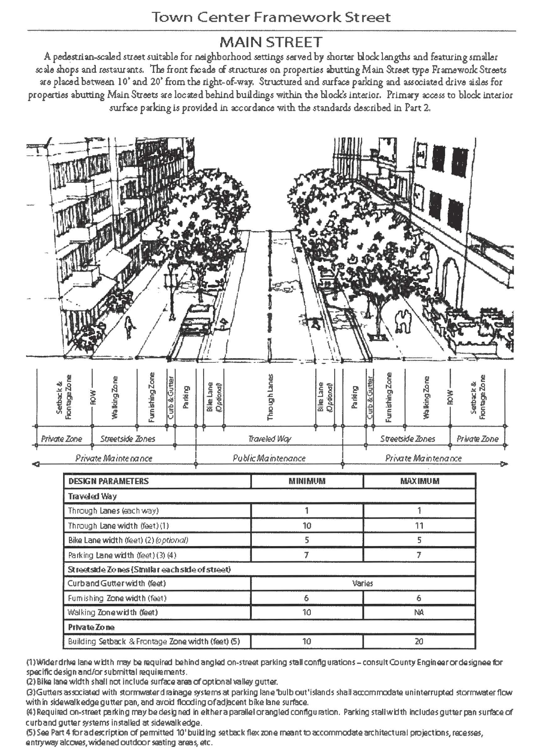
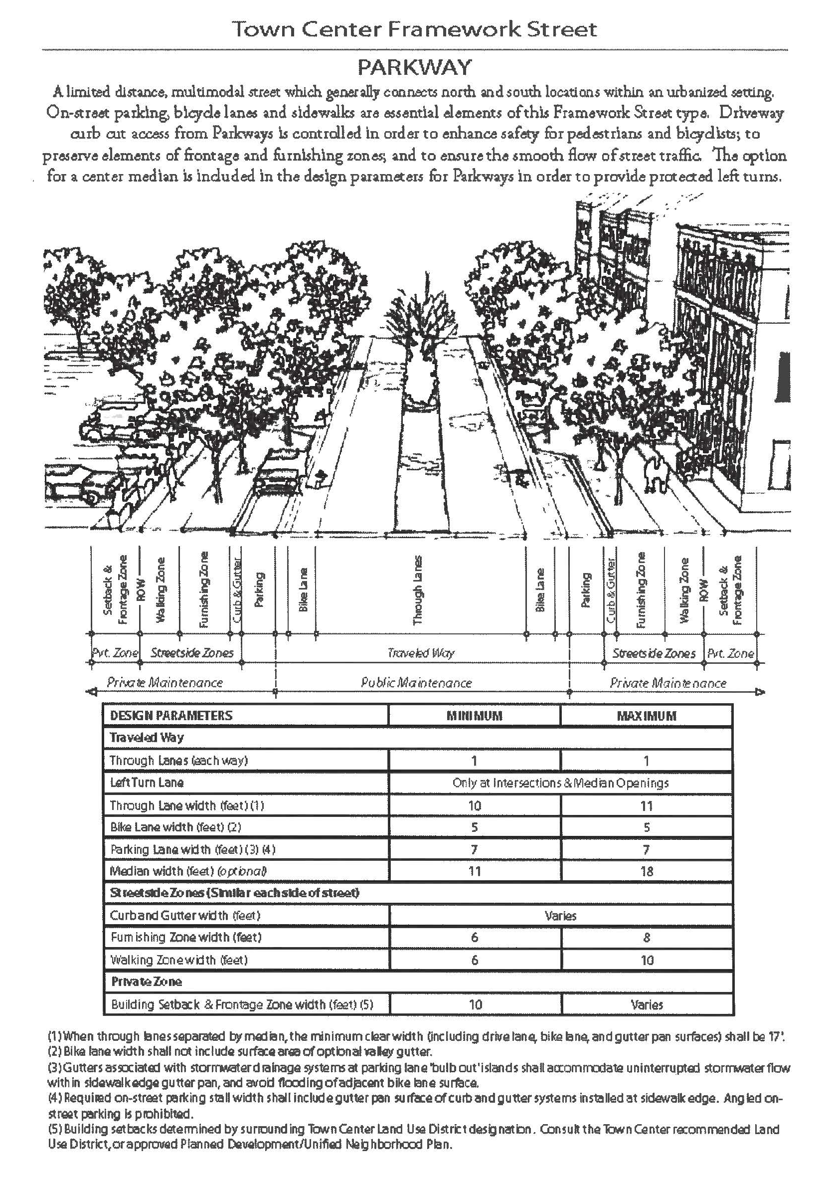
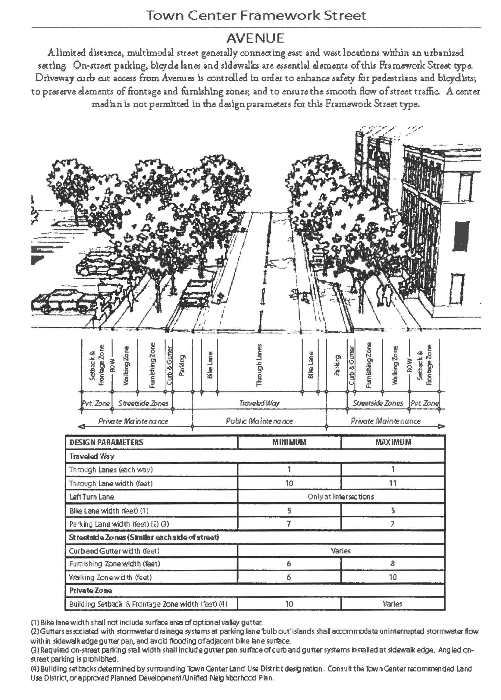
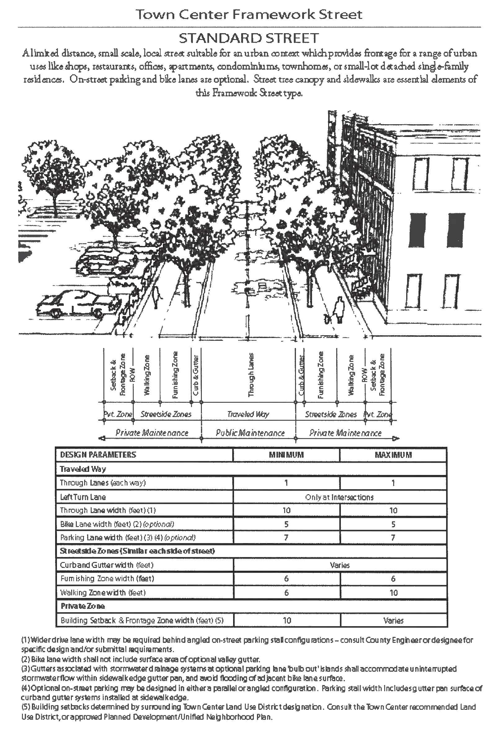
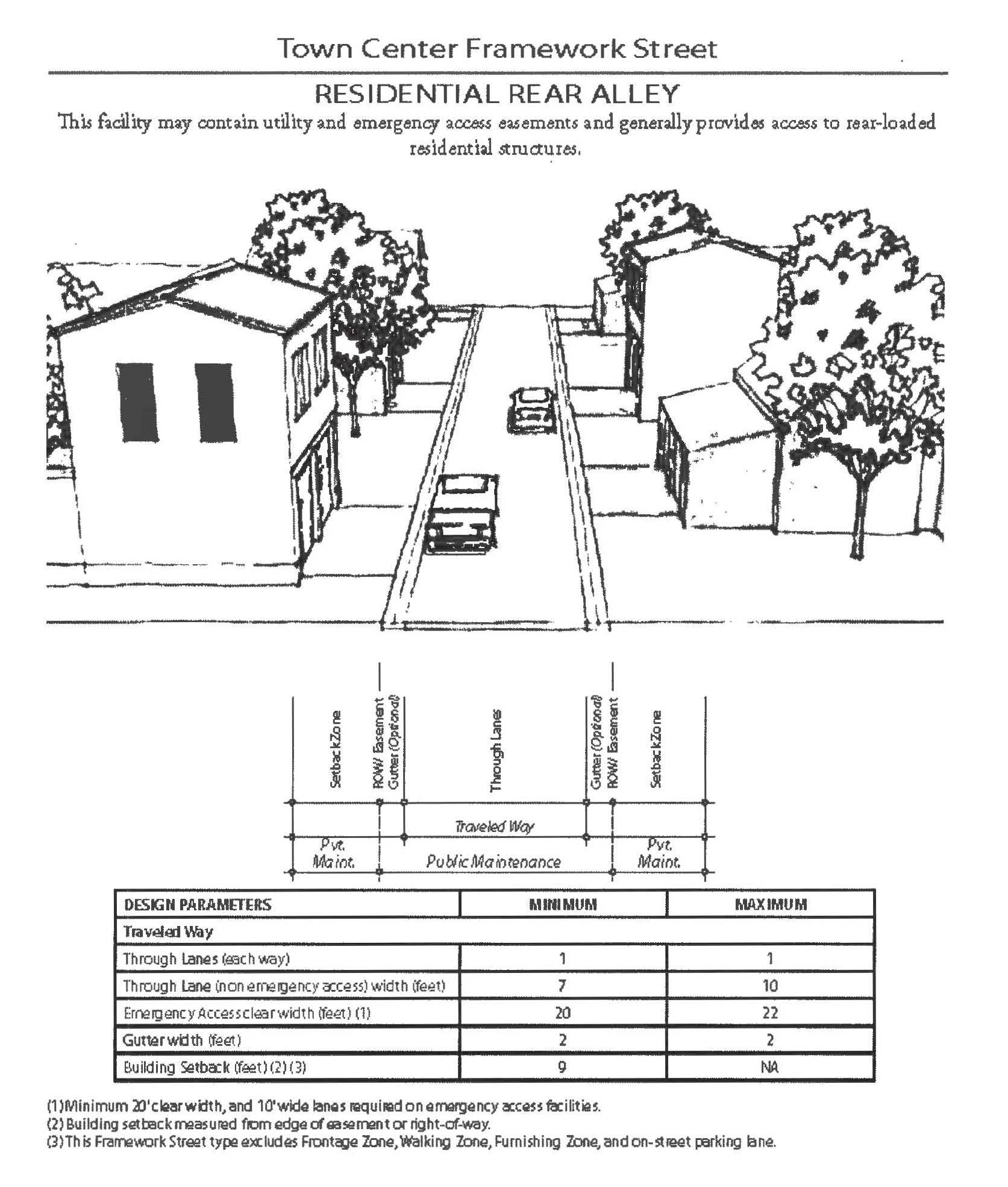
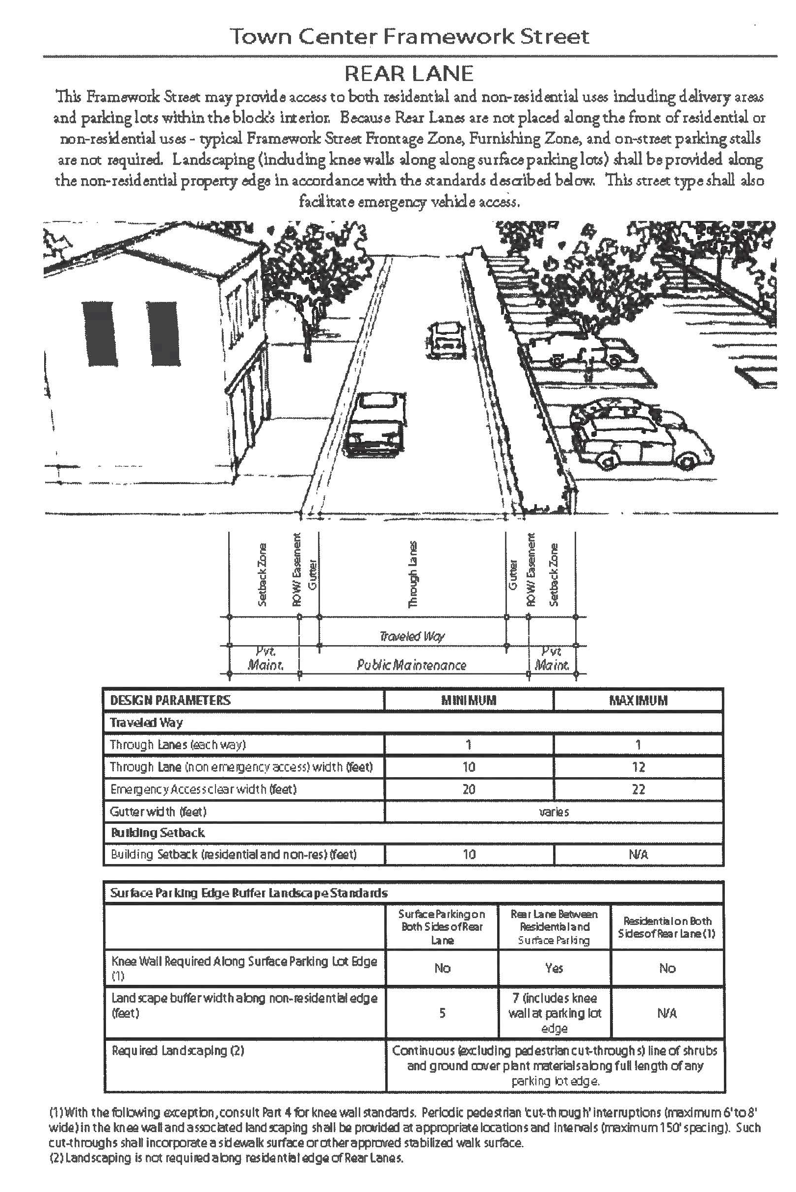
Roundabout
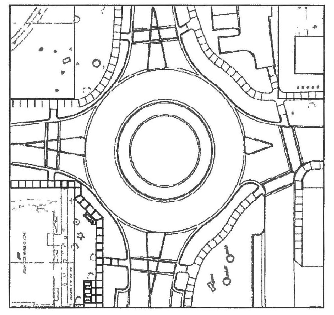
NOTE: The roundabout graphic above is only provided as a local roundabout example. Roundabouts along town center framework streets shall be designed and reviewed, on a case-by-case basis, in accordance with county standards. Roundabout planning and design shall factor adjacent development context, the safety of pedestrians and bicyclists, and safe visibility. For a thorough roundabout design reference resource, consult the latest edition of the FHWA document Roundabouts: An Informational Guide, subject to requirements specific to Florida published by the Florida Department of Transportation.
(Ord. No. 2013-02, § 1, 1-29-13; Ord. No. 2020-30, § 7BB, 10-13-20)
Sec. 38-1390.42. - General standards.
(a)
All streets and public ways shall be paved and curbed in accordance with the standards for framework street types, and the following requirements:
(1)
Additional Improvements for Streets in Existence Prior to the Adoption of this Chapter. Where any street(s) lying within or abutting a proposed development requires construction of additional lanes or other improvements to meet the standards of this Code or the requirements of a pre-existing development order or agreement, the extent of the improvements required (or money escrowed) shall be commensurate with the impact of the proposed development, in accordance with the requirements of Orange County, and shall include construction of accessibility needs based on currently-adopted editions of applicable federal and state standards.
(2)
Intersection/Access Improvements. Intersection and access improvements to framework or functionally classified streets, such as acceleration, deceleration, and turning lanes, shall be installed at the developer's expense within the area of the applicable and approved PSP or development plan and on abutting streets and in accordance with standards established by the county engineer.
(3)
Improvements Required to Nearest Acceptable Improved Public Street. Each development shall abut, or have as its primary access, a street whose improvements have been approved by the Orange County Development Engineering Division pursuant to the minimum requirements of this chapter. Wherever the abutting street does not meet these requirements, the developer shall construct the street where it abuts the development and to the nearest structurally acceptable paved public street as determined by the county engineer, including roadway connections that are in compliance with all accessibility requirements of the currently-adopted editions of applicable federal and state standards and that provide two (2) ramps per intersection quadrant on functionally-classified roadways.
(4)
Paving, Base Courses, Wearing Surfaces, etc. As established in chapter 34, Subdivision Regulations, of the Orange County Code.
(5)
Pavement Markings. All travel lanes, lines, turning arrows and other pavement markings needed to control traffic flow shall be approved by the traffic engineering division and shall be placed on the pavement by the developer, in accordance with the Manual for Uniform Traffic Control Devices.
(6)
Traffic Control Devices. All required regulatory, warning and/or guide signs; signalization/hazard ahead warning devices and other traffic control devices shall be approved by the Orange County Traffic Engineering Division and installed by the developer in accordance with the Manual of Uniform Traffic Control Devices.
(7)
Driveway Approaches. Driveway approaches shall be provided in accordance with the grades and specifications as established by Orange County. Such construction shall be subject to inspection and approval by the county engineer. If any paving or curb defects, or any damage from heavy equipment shall occur within one (1) year from the date of acceptance, the defects shall be remedied by the developer at the developer's expense.
(b)
Adjoining property owners shall have maintenance responsibility for required on-street parking, bulb outs, furnishing zones and walking zones, including accessibility requirements of the currently-adopted editions of applicable federal and state standards and of section 34-171. This responsibility shall be assigned to a Property Owner Association, Municipal Services Benefit Unit (MSBU), Municipal Services Taxing Unit (MSTU) or Community Development District when approved by the board of county commissioners. Such funding mechanism shall be in place prior to or concurrent with a Preliminary Subdivision Plan.
(c)
All intersections and curves shall be designed in accordance with the following or an alternative approved by the county engineer:
(1)
Right Angle Intersections. Streets shall be designed so as to intersect as nearly as possible at right angles. The approach to an intersection should be approximately at right angles for a minimum of one hundred fifty (150) feet on framework streets.
(2)
Non Right Angle Intersections. With the approval of the county engineer, one (1) approach to an intersection may be designed with a maximum of sixty (60) degrees of offset from a right angle.
(3)
Relationship to Existing Intersections. New intersections to an existing street shall wherever practical be located directly across from any existing intersection on the opposite side of the street, so as to form a single four-way intersection.
(d)
All streets shall be designed in accordance with the latest editions of the Orange County Road Construction Specifications; the Florida Department of Transportation Manual of Uniform Minimum Standards for Design, Construction and Maintenance for Streets and Highways (Florida Greenbook) and the following minimum standards:
(1)
The minimum right-of-way width shall be as depicted on the applicable street type cross-section, or of sufficient width to provide for adequate ultimate drainage facilities, utilities, and sidewalks, whichever is greater.
(2)
The minimum lane/pavement widths shall be determined based on the information presented with each framework street cross-section and the anticipated vehicular volume as described in chapter 34 of the Orange County Code.
(3)
The minimum pavement width for a one-way street, exclusive of alleys and lanes, shall be twenty (20) feet, not including on-street parking.
(4)
Minimum median width shall be consistent with the Florida Greenbook.
(5)
Pavement widths shall be measured exclusive of curbs.
(6)
Gutter curbing may be used in framework street type cross-sections where bulb outs are utilized for tree planting or to separate on-street parking spaces.
(e)
Intersection Design Standards and Requirements. Reserved.
(Ord. No. 2013-02, § 1, 1-29-13; Ord. No. 2020-30, § 7CC, 10-13-20)
Subpart 3. Pedestrian and Bicycle
Facility Design Standards
Sec. 38-1390.43. - Pedestrian and bicycle facility design standards.
The purpose of this section is to identify standards that are applicable to the timing, construction, location and responsibility for pedestrian and bicycle facilities supporting specific public and civic uses, or which are in addition to those facilities included within the typical cross-sections of Framework Streets. The following standards shall be addressed during the review and approval of a PD/UNP, DP or PSP.
(a)
Pedestrian and bicycle access to an elementary public school is required to be available at the time of issuance of the first certificate of occupancy for a nonmodel residential dwelling unit included in an approved PSP or Development Plan. The PD/UNP that includes the area encompassed by the Development Plan should address how pedestrian and bicycle access to the elementary school site serving the area will be accomplished. The minimum level of access shall be either a Framework Street, or a temporary or permanent Multi-use Path. In either case, the Street or Path shall connect directly to the school site or to a Framework or Functionally Classified Street abutting the school site.
(b)
Pedestrian and/or bicycle facility connections from or to Framework Streets and an Open Space District, as required and depicted by the applicable PD/UNP, shall be provided by the applicable property owner at the time of PSP or Development Plan approval for lands that include the connection(s). The property owner may choose to provide the necessary right-of-way or easement connection and construct the connection, or to escrow funds with the County equal to the cost of construction.
(c)
Pedestrian facility connections that are in compliance with all accessibility requirements of the currently-adopted editions of applicable federal and state standards from or to a designated or constructed Horizon West Trail shall be required from all adjoining Horizon West Village properties. The location, type and design standards for any pedestrian facility connection to a designated or constructed Trail shall be included in the PSP and approved by the board of county commissioners. If the Trail has not yet been constructed at the time of the submittal of a PD/UNP, the PD/UNP shall include sufficient information to determine the location of the Trail within the property subject to the PD/UNP, and an agreement between the property owner and Orange County shall be executed providing for the dedication of right-of-way or access easements, design of the facility, and financial responsibility for improvements associated with the Trail.
(d)
Shared Use Paths and Trails shall be designed and constructed in conformance with AASHTO standards and the latest edition of the Manual of Uniform Minimum Standards for Design, Construction and Maintenance for Streets and Highways (Florida Greenbook), as published by the Florida Department of Transportation. Nonstreet sidewalks shall be constructed to the same standards as street related sidewalks, including compliance with accessibility requirements of the currently-adopted editions of applicable federal and state standards. Shared Use Paths and Sidewalks shall also be marked or signed in accordance with the AASHTO/MUTCD standards.
(e)
Pedestrian and/or bicycle facilities included in the cross-section of a framework street may be permitted to be located outside the right-of-way within an Open Space District, APF Park or other type of open space designated on an approved PSP or DP, but shall maintain connections to the overall network of pedestrian and bicycle facilities. The DRC shall have the authority to approve the alternative pedestrian and/or bicycle facility location as part of a PD/UNP, PSP or Development Plan.
(f)
Pedestrian and/or bicycle facilities shall not be reduced in width from the standards established herein, but widths may be increased at the discretion and cost to the applicant/property owner.
(g)
Design and location standards for pedestrian facilities are as follows:
(1)
Pedestrian passageways and sidewalks shall provide a minimum width of 48 inches as a continuous pedestrian access route, shall meet all accessibility requirements of the currently-adopted editions of applicable federal and state standards, and shall be well lit and physically separated from driveways and parking spaces by landscaping, barriers, grade separations, or other means to protect pedestrians from vehicular traffic.
(2)
A special-emphasis crosswalk shall be required when a sidewalk crosses a public driveway accessing a functionally-classified roadway and shall be the maintenance responsibility of the property owner.
(3)
Crosswalks shall be designed and coordinated to move people safely to and from buildings and parking areas. Where pathways cross a parking area, driveways or on-site roadway, they shall be clearly marked with contrasting concrete, stamped or textured concrete or asphalt material, humps, or raised crossing and thermoplastic or painted striping.
(4)
Whenever walkways are provided, raised crosswalks or other traffic-calming measures may be used to slow traffic. If located within the public right-of-way or roadway, they must be approved by the Orange County Traffic Engineering Division.
(5)
Crosswalks shall be located at all points where a sidewalk crosses a lane of vehicular travel and shall be the maintenance responsibility of the property owner.
(6)
Public entrance. New buildings that are open to the public shall have an entrance for pedestrians from the street to the building interior that meets all accessibility requirements of the most recent editions of applicable federal and state standards as adopted. This entrance shall be designed to be a distinctive and prominent element of the architectural design, and shall be open to the public during business hours. Buildings shall incorporate lighting and changes in mass, surface or finish which places an emphasis to the entrance.
(h)
Design and standards for off-street bicycle facilities are as follows:
(1)
Shared use paths or bicycle paths included within the right-of-way of functionally classified streets/urban collectors (or where permitted within designated open space areas adjoining the right-of-way) shall be designed and constructed to include ten (10) feet of pavement width and shall be consistent with the latest edition of the Manual of Uniform Minimum Standards for Design, Construction and Maintenance for Streets and Highways (Florida Greenbook), as published by the Florida Department of Transportation.
(2)
All bicycle paths should provide clear signage indicating:
a.
Hours of operation (if limited).
b.
Maximum speed.
c.
Protocols for passing.
d.
Direction of flow of traffic.
e.
Stop signs, where needed.
(i)
Design and location standards for bicycle parking facilities are as follows:
(1)
Short-term bicycle parking devices shall be durable, have a powder-coated or galvanized weatherproof surface, be securely anchored to a concrete or pavement surface large enough to support bicycles locked to the rack, and support the frame of a bicycle in at least two (2) places. The device shall also accommodate a high security U-shaped lock that can secure the frame and at least one (1) wheel. Acceptable parking devices include, but are not limited to, inverted "U" racks, post and ring rack, or similar device that accommodates two (2) bicycle parking spaces per rack and enables users to lock the frame and both wheels.
(2)
Long-term bicycle parking devices include, but are not limited to, bicycle lockers, bike stations, bicycle racks in covered loading dock areas or parking garages, and bicycle parking spaces that are indoors or otherwise protected from the weather and theft. Areas provided inside of multi-story multifamily or office buildings for residents, employees, and visitors may count as long-term bicycle parking with an approved parking plan.
(3)
If there is one (1) building associated with the installation, the bicycle parking device(s) shall be located as close to the primary building entrance as the nearest parking space not designated as accessible and shall maintain the accessibility of the building entrance. Bicycle racks are encouraged to be covered, such as by building soffits or by stairways in multifamily development, provided the accessibility of the building entrance is maintained.
(4)
Bicycle parking spaces must be at least six (6) feet long and two (2) feet wide, with an overhead clearance of seven (7) feet.
(5)
The parking device must be a minimum of three (3) feet from a parallel wall and four (4) feet from a perpendicular wall.
(6)
An aisle at least five (5) feet shall be provided between rows of bicycle parking.
(7)
If located on or next to a sidewalk, a minimum of five (5) feet of clear sidewalk must remain when bicycles are parked at a device.
(8)
If a device is installed at a transit stop, its location shall not impede transit boarding or the accessibility of the transit stop.
(9)
A bicycle parking device shall not impede pedestrian travel or freight loading and shall be accessible to users without users having to ascend or descend stairs.
(10)
Bicycle parking shall be separated from vehicle parking spaces by physical barriers, such as curbs, wheel stops, bollards or other similar features, to protect bicycles from being damaged by vehicles. Where automobile parking is covered, bicycle parking shall also be covered.
(11)
If the device is near a curb on a street with automobile parking, at least five (5) feet of space must remain between a bicycle parking device and the curb.
(Ord. No. 2013-02, § 1, 1-29-13; Ord. No. 2020-30, § 7DD, 10-13-20)
Subpart 4. Transit Standards
Sec. 38-1390.44. - Transit facility design standards.
Transit service will play an important role in securing mobility for visitors, residents and employees of Town Center Land Use Districts. The location, design and amenities associated with transit access are addressed in the standards provided below.
(a)
The provision of on-street transit access shall be addressed in the PD/UNP for Neighborhood Planning Areas, or may be deferred to the Preliminary Subdivision Plan (PSP) process when the Master Street and Block Plan submittal requirement has also been deferred. The applicant for a PD/UNP or PSP review should coordinate transit access planning with the local service provider in order to identify preferred locations and integration with street design as well as building design plans. This planning process should be guided by the LYNX Mobility/Design Manual and the LYNX Customer Amenities Manual as may be updated from time to time.
(Ord. No. 2013-02, § 1, 1-29-13)
Sec. 38-1390.45. - Neighborhood planning area and district based development programs.
Development entitlements authorized through the PD/UNP, PSP or DP process, or assigned to an Open Space District parcel, shall be consistent with the adopted Comprehensive Plan and chapter 30 of the Orange County Code of Ordinances. Authorized development programs may be comprised of the following:
(a)
The land uses, per Neighborhood Planning Area and applicable Neighborhood Parcel, from Table 1.1 (FLU4.8.3) of the adopted Comprehensive Plan;
(b)
Any approved Transfer of a Development Right (TDR) from a sending to a receiving area authorized by chapter 30, article XIV, division 3 of the Orange County Code of Ordinances; and/or
(c)
Any development program bonus awarded with approval of a Planned Development/Unified Neighborhood Plan, Development Plan or Preliminary Subdivision Plan.
(Ord. No. 2013-02, § 1, 1-29-13)
Sec. 38-1390.46. - Internal transfer of uses/development program.
(a)
The transfer of land uses/development program between Neighborhoods and/or Neighborhood Parcels within the same PD/UNP may be approved consistent with applicable provisions of this Development Code. This type of request for transfer can be processed with the initial PD/UNP or as a nonsubstantial change request with a subsequent Development Plan (DP) or Preliminary Subdivision Plan (PSP).
(b)
A land use/development program transfer from one (1) Neighborhood Planning Area Parcel to another Neighborhood Planning Area (NPA) Parcel, where one (1) of the Parcels is not included in an approved PD/UNP, shall not be permitted.
(Ord. No. 2013-02, § 1, 1-29-13)
Sec. 38-1390.47. - Residential density standards.
(a)
Net density is calculated by dividing the total number of dwelling units by the net developable acreage. Net developable acreage is defined as the area in acres, after the area included in natural water bodies, conservation (wetland areas), APF (adequate public facilities) lands, greenbelts, stormwater (when incorporated into a publicly accessible open space as a landscaped amenity), and public open space has been deducted from the total area within a property or parcel boundary. (CP Policy FLU4.8.7)
(b)
The average minimum net density for Town Center, with the exception of lands designated as URD within Neighborhood Parcel UR-3, shall be four (4) dwelling units per net acre. An evaluation of the average minimum net density shall be determined for each PD/UNP, based on the total net acres of Land Use Districts that include dwelling units as part of the development program. When a PD/UNP development program does not include dwelling units, the average minimum net density evaluation shall not apply.
(c)
The maximum density for lands designated as URD within Neighborhood Parcel UR-3 shall be two (2) dwelling units per net acre.
(d)
The maximum residential net density for Town Center Land Use Districts, without Transfer of Development Rights (TDRs), shall be as identified below. All standards are dwellings per net acre.
•
Urban Residential District (UR): Five and one-half (5.5) dwellings.
•
Corporate Campus Mixed Use District (CCMU): Twelve (12) dwellings.
•
Corporate Neighborhood Center District (UNC): Five and one-half (5.5). dwellings
•
Retail/Wholesale District (RW): Twelve (12) dwellings.
•
Traditional Town Center Core District (TTCC): Forty-two (42) dwellings.
(e)
The maximum residential net density for Town Center Land Use Districts with Transfer of Development Rights (TDRs) shall be as identified below. All standards are dwellings per net acre.
•
Corporate Residential District (UR): Eight (8.0) dwellings.
•
Corporate Campus Mixed Use District (CCMU): Twenty (20) dwellings.
•
Urban Neighborhood Center District (UNC): Eight (8) dwellings.
•
Retail/Wholesale District (RW): Twenty (20) dwellings.
•
Traditional Town Center Core District (TTCC): No maximum.
(f)
The maximum net density without TDRs may be increased up to the maximum net density with TDRs provided that an equivalent number of units (transfer of development rights) have been obtained in accordance with the provisions of chapter 30, article XIV, division 3, transfer of development rights (TDRs). All TDR sending and/or receiving areas shall be identified on the Planned Development/Unified Neighborhood Plan (PD/UNP). All wetlands and upland greenbelts may be designated as TDR sending areas and all Neighborhood Parcels and building or development sites may be designated as sending and receiving areas. Development rights for sending areas located outside the boundary of the receiving PD/UNP must be transmitted through a development agreement prior to or concurrent with approval of the receiving zone through a PD/UNP, Development Plan or Preliminary Subdivision Plan.
(Ord. No. 2013-02, § 1, 1-29-13)
Sec. 38-1390.48. - Nonresidential intensity standards.
(a)
Net Floor Area Ratio (FAR) is expressed as a maximum standard for each type of Land Use District. The standards are based on the total net acres of land within a Land Use District, Development Plan or a Preliminary Subdivision Plan intended for a nonresidential or a mixed nonresidential and residential use. The Net FAR calculation requires a net acreage and a gross floor area.
(b)
The maximum net FAR for Town Center Land Use Districts, without Transfer of Development Rights (TDRs), shall be as identified below. All standards are expressed as the ratio of total gross floor area to net acres of building or development site area.
•
Urban Residential District (UR): Not applicable (when nonresidential uses in the UR District are allowed through the Permitted by Location Permission Type, the nonresidential intensity is controlled through the maximum amount of floor area per site).
•
Corporate Campus Mixed Use District (CCMU): 0.32 FAR.
•
Corporate Neighborhood Center District (UNC): 0.20 FAR.
•
Retail/Wholesale District (RW): 0.20 FAR.
•
Traditional Town Center Core District (TTCC): 0.60 FAR.
(c)
The maximum net FAR for Town Center Land Use Districts with Transfer of Development Rights (TDRs) shall be as identified below. All standards are expressed as the ratio of total gross floor area to net acres of building or development site area.
•
Urban Residential District (UR): Not applicable (when nonresidential uses in the UR District are allowed through the Permitted by Location Permission Type, the nonresidential intensity is controlled through the maximum amount of floor area per site).
•
Corporate Campus Mixed Use District (CCMU: 0.40 FAR.
•
Urban Neighborhood Center District (UNC): 0.40 FAR.
•
Retail/Wholesale District (RW): 0.40 FAR.
•
Traditional Town Center Core District (TTCC): No maximum.
(d)
Mixed Residential and Nonresidential Density or Floor Area Ratio (FAR). When a development proposal includes the vertical integration of residential and nonresidential uses, residential units may be converted to gross floor area and combined with nonresidential gross floor area to create a mixed use gross floor area for the purpose of determining compliance with maximum FAR standards. In mixed use buildings, the gross floor area of residential units is included in the calculation of floor area ratio even in the circumstance where the residential gross floor area is greater than fifty (50) percent of the total gross floor area of the building.
(Ord. No. 2013-02, § 1, 1-29-13)
Sec. 38-1390.49. - Town Center use table summary.
(a)
Uses that are permitted within Town Center land use districts by right, by location as identified on an approved Unified Neighborhood Plan, special exception, with approval by the Planning and Zoning Managers, or for ancillary purposes only, are indicated, respectively, by the letters "P," "P(UNP)," "S," "PM," and "A" in the cells of the Horizon West Town Center Land Use Table as set forth in section 38-77.1. Any conditions that apply to a specific use are listed in section 38-79 and at the end of the table in section 38-77.1. No use shall be permitted in a district except in accordance with the corresponding letter that appears for that use in the appropriate cell.
(b)
Except as may be provided otherwise, buildings, structures, lands and premises shall be used only in accordance with the uses and conditions contained in the "Horizon West Town Center Land Use Table" set forth in section 38-77.1, and the "Uses Permitted by Location" criteria set forth in section 38-1390.23.
(c)
When a use is permitted in a particular Horizon West Town Center Land Use District, it is permitted in that district subject to:
(1)
Compliance with all applicable requirements of the Orange County Code, in general, and chapter 38 specifically; and
(2)
Compliance with all standards and conditions specified in the section 38-79.
(d)
Ancillary uses (identified by the letter "A" in the Horizon West Town Center Land Use Table) must be located within the building occupied by the principal use and shall be limited in floor area to a cumulative total of ten (10) percent of the gross floor area of the ground floor of the building in which the ancillary use(s) is located.
(e)
Uses identified as "Permitted by Location" or "P(UNP)" in the Horizon West Town Center Land Use Table are limited to pre-designated locations specified on an approved PD/UNP.
(Ord. No. 2013-02, § 1, 1-29-13; Ord. No. 2018-08, § 3, 4-10-18)
Sec. 38-1390.50. - Reserved.
Editor's note— Ord. No. 2018-08, § 3, adopted April 10, 2018, repealed § 38-1390.50, which pertained to permitted uses with special standards and derived from Ord. No. 2013-02, § 1, adopted Jan. 29, 2013.
Sec. 38-1390.51. - General Building Placement, Site Planning, and Visual Buffer Standards.
Build-To and Minimum Setback Standards along Framework Streets.
Subdivision II distinguishes the Town Center's system of Framework Streets from the County's functionally classified streets (Arterials and Collectors). It also provides a series of graphic cross sections which further describe the parallel components (within the private property, and public realms) that make up the length of all Framework Streets and Through Block Pedestrian Passageways. Each of these street components plays an important role in shaping the visual character of the Town Center's many neighborhoods. The Frontage Zone component of Framework Streets plays a particularly visible and important role in shaping the street's visual character.
(a)
Structural "Build-To" Standards and Architectural Expression. When building front or side facades are placed adjacent to the public sidewalk, a continuous street wall is created which effectively delineates the sidewalk corridor's private property edge. In these settings, parking is placed behind the building (within the block's interior), and at adjacent on-street locations. Except as set forth in section 38-1390.52(b)(1)a., where build-to requirements apply, but no structure is proposed for a segment of a block face adjacent to a Framework Street (e.g., a gap in the street wall, between adjacent existing buildings), then parking and drive lanes (with the exception of permissible right-in/right-out driveways) may be placed no closer than ninety (90) feet from the right-of-way. If a building is constructed within any portion of such gap between adjacent existing buildings, the ninety (90) feet parking setback requirement does not apply to the area immediately behind the new building, within the interior of the block.
Ten Inch Build-To Line. Throughout the Corporate Neighborhood Center and Traditional Town Center Land Use Districts and along all Main Street type Framework Streets, building front facades will be pulled forward, toward the street, to a build-to line located ten (10) feet from the property line. The rooflines of buildings that form sidewalk edge street walls should vary in height, and have distinguishable individual facades that give the appearance of multiple buildings and uses. A ten (10) inch deep variation in the required build-to line, to accommodate visual interest and architectural expression, is described below.
Ten Inch Deep Architectural Design Flex Zone. To facilitate architectural expression and visual interest, and to avoid elongated stretches of featureless and rigidly aligned street walls, buildings are allocated an additional ten (10) feet deep flex zone (a dimensional variation in the build-to line) in a direction away from the Framework Street and commencing at the back of the Frontage Zone. Within this facade design flex zone (which spans between ten (10) and twenty (20) feet from the property line), building entryways shall be emphasized, and the facade should give the appearance of individual shop fronts and residences. Incorporating street-level recessed, projected (maintain ten-foot minimum setback), and/or freestanding architectural forms including columns, colonnades, pilasters, balconies, raised seat wall planters, and/or expanded outdoor seating areas will achieve visual interest and architectural character. However, a minimum of seventy (70) percent of the length of the building's forward-most facade shall be constructed directly on the ten-foot build-to line on the front street, and on any side street.
NOTE: Rear Lane and Residential Rear Alley type Framework Streets are exempt from "Build-To" conditions within all Town Center Land Use Districts. See Framework Street section standards within Subdivision II.
Front and side street corner lot build-to standards occur under three (3) circumstances:
(1)
Along All Main Street Type Framework Streets. Main Streets are intended to feature a compact mixture of smaller scale office, retail, personal service, and high-density residential uses served by slower vehicular movement. Owners of all properties along Main Streets shall construct front facades in accordance with the Build-To standards described above. On-site surface parking and associated driveway access for structures along any Main Street type Framework Street, regardless of the Land Use District setting, shall be located behind structures and within the interior of the block. Vehicular access to block interior surface parking facilities may be provided along the intersecting side streets.
(2)
Build-to standards throughout the Corporate Neighborhood Center (CNC) Land Use Districts. CNC Districts feature small scale, neighborhood-serving retail, personal service, and civic uses designed and scaled for convenient walking access from the surrounding neighborhood. CNC Districts shall be designed and configured to accommodate heavy pedestrian traffic from the surrounding Corporate Campus Mixed Use and Urban Residential Districts. Buildings on all properties within the CNC Land Use Districts shall be constructed with front and side street-facing facades in accordance with the build-to standards described herein.
(3)
Build-to standards throughout the Traditional Town Center Core (TTCC) Land Use District. The TTCC Land Use District will be designed as the primary activity center of the Horizon West Town Center, and surrounding Villages. The TTCC District shall be designed and configured to accommodate busy pedestrian traffic while featuring the Town Center's shortest blocks and tightest street grid pattern. The TTCC District will incorporate mixed-use buildings featuring first floor retail, personal service, and offices. Upper floors may contain residential and office uses. Buildings on all properties within the TTCC District shall be constructed with front (and side street) facades in accordance with the Build-To standards described herein.
TABLE 4-1
BUILDING SETBACK AND BUILD-TO STANDARDS
NOTES:
(1)
Includes residential uses located on top of nonresidential uses.
(2)
Must locate building at ten-foot line, but up to thirty (30) percent may be allowed at the twenty-foot line. See Flex-Zone.
(3)
Includes any porch.
(4)
30 feet allowed for garages with apartments above.
(5)
If on a Main Street, then building must be located at ten-foot line, but up to thirty (30) percent may be allowed at the twenty-foot line.
(6)
See Garage standards in section 38-1384(g).
(7)
CNC & UR = 45'; TTCC & CCMU = 150'
(b)
Refuse and Mechanical Equipment; Placement and Visual Screening. Ground-mounted meters, valves, and mechanical equipment, outdoor storage and service areas (except those associated with single-family detached units) shall, to the extent possible, be purposely oriented away (and located remote) from visible areas where high-volume vehicular and pedestrian traffic is anticipated. Such equipment or storage areas shall be visually screened by a one hundred (100) percent opaque fence, wall, or landscaping buffer.
Wall-mounted meters and associated hardware can visually detract from the appearance of project walls and building facades. Therefore, wall-mounted meters and associated hardware shall, to the extent possible, be located on walls possessing a minimum of visual exposure to high-traffic areas. Such meters shall, to the extent possible, be placed in cabinets and painted to match the surrounding wall surfaces and trim.
Dumpsters and other refuse areas shall also be screened by a one hundred (100) percent opaque buffer, including a six-foot masonry wall. The masonry wall shall be configured to incorporate a landscaped planter strip, for planted shrubs or vines, around the entire exterior foundation of the walled area. The wall shall incorporate a continuous decorative cap feature along its full length, and replicate the architectural trim, finish, and color of the principle structure. The gate shall be opaque and self-closing.
(Ord. No. 2013-02, § 1, 1-29-13)
Sec. 38-1390.52. - Parking.
NOTE: This section will occasionally refer to development standards in the Village Planned Development Code ("Village Code" division 8, section 38-1380 et seq., Orange County Code). Applicable references within the Village Code to "Village Roadways" or "Village Streets" shall be considered interchangeable with this Division's reference to Framework Streets.
(a)
Residential Parking. Residential parking, and related vehicular access, shall be provided in accordance with section 38-1384(i).
(b)
Nonresidential Parking. Nonresidential parking, and related vehicular access, shall be provided in accordance with the parking standards for Village Centers in section 38-1389(d)(4). However, the terms "village roadways" or "village" within that section refer to projects and development within the limits of the Horizon West Town Center. Proposals for shared parking may be submitted in accordance with the provisions outlined in chapter 38. All other provisions of section 38-1389(d)(4) shall apply, with the exception of the following modifications, deletions, and additions:
(1)
38-1389(d)(4)b. All at-grade parking lots fronting Town Center roadways shall be set back in accordance with the Framework Street Cross Sections in Article 2 [subpart 2], and the following:
a.
Corporate Neighborhood Center (CNC) Districts. Parking stalls are prohibited between CNC District buildings and the right-of-way of functionally classified roads.
Drive lanes may be permitted between CNC District buildings and the right-of-way of functionally classified roads.
No more than thirty (30) percent of an individual block face which abuts a Town Center Framework Street may include one (1) double-loaded drive aisle (e.g., single row of adjacent parking stalls placed on both sides of a two-way drive aisle). Drive lanes and parking stalls are prohibited between buildings and the adjacent roadway along the remainder of such block faces.
b.
Traditional Town Center Core (TTCC) District. On-site surface parking and associated driveway access for all structures within the TTCC District (regardless of Framework Street type or functionally classified road status) shall be located behind structures and within the interior of the block. Vehicular access to block interior surface parking facilities may be provided along the intersecting side streets or through approved right-in/right-out driveway curb cut locations.
(2)
38-1389(d)(4)d. Where off-street parking areas are permitted to adjoin Framework streets, there is no dimensional restriction on the maximum length of such street frontage. Within the Corporate Neighborhood Center District, limitations are placed on the percentage of individual block faces which may adjoin off-street surface parking areas.
(3)
38-1389(d)(4)h. (Parking). Off-street parking shall be located in accordance with the provisions of the Town Center Code. Landscaping for the screening and interior of off-street parking shall comply with chapter 24, and the framework street standards described in subdivision II of the Town Center Code. A masonry (with stucco finish) or brick knee wall, between forty (40) and fifty (50) inches high, including a decorative cap shall be installed along the parking lot edge, between the parking lot and the framework street, but shall be outside the vertical and/or horizontal sight distances of any intersection or driveway. The knee wall shall not extend over thirty (30) feet without an offset or projection (for insertion of accent plantings) or projected pilaster and column feature which provides aesthetic variety. The wall shall be installed along not less than seventy (70) percent of the length of any parking or drive aisles adjacent to framework streets or functionally classified roads. Opaque plantings shall be installed within any interruptions of the knee wall in accordance with the parking lot perimeter landscape buffering requirements of chapter 24.
Decorative screen fencing may be acceptable, with prior approval of the Development Review Committee (DRC), as an alternative to the masonry knee wall required along functionally classified roads. Such screen fencing shall be designed and constructed in a durable manner which minimizes the need for fence repairs. Decorative screen fencing shall be between forty (40) and sixty (60) inches high and shall feature at least fifty (50) percent opacity.
(4)
38-1389(d)(4)i. (Grocery Store Parking).
a.
Parking and parking access for grocery stores or other retail anchor establishments shall be located in accordance with the building and parking placement standards ascribed to the individual land use districts, or Framework Street type, of the Town Center.
b.
Regardless of the orientation of the side or rear of a grocery store, or other retail anchor establishment, relative to an adjacent roadway, parking and parking access shall be located in accordance with the building and parking placement standards ascribed to the individual land use districts, or Framework Street type, of the Town Center. Grocery store side or rear facades, which are visible from an adjacent Framework street, shall not project blank, or featureless walls. Instead, such walls shall incorporate projected architectural features including decorative trim, pilasters, recessed window glazing (transparent or spandrel) and projected window surrounds, awnings, varied roof and eaves lines, and paint color variations.
c.
Buildings within outlying portions of parking lots for grocery stores or other retail anchor establishments shall be located in accordance with the building placement standards ascribed to the individual land use districts, or Framework Street type, of the Town Center. Notwithstanding the colors or architectural forms or finishes which may be associated with any particular formula retail company, buildings within the outlying portions of parking lots for grocery stores or other retail anchor establishments shall, at a minimum, repeat the architectural style or selected trim on any existing adjacent retail anchor development or selected architectural features established. Parking for these buildings shall be located in accordance with the building and parking placement standards ascribed to the individual land use districts, or Framework Street type, of the Town Center.
d.
Parking lots shall be configured into a series of smaller modules or sub-lots and pedestrian pathways in accordance with section 38-79(153), Big Box development.
(5)
38-1389(d)(4)j. This provision for required pass-throughs in parking lots is redundant of the pedestrian pathways already required elsewhere and therefore is not applicable to the Town Center.
(c)
Front-Loaded Parking Options. Front-loaded parking configurations which place parking stalls, or drive aisles, in front of buildings (between buildings and the adjacent street) shall be limited to the following configurations. Listed from most preferred (narrowest footprint) to least preferred (widest footprint), they are:
(1)
One-way (or two-way) drive aisle. Drive aisle (with no associated parking), with no associated parking, which provides vehicle circulation around buildings.
(2)
Single (or double) loaded, one-way drive aisle for parallel parking stalls. One-way drive aisle which accesses a single row of parallel parking stalls, or which accesses parallel stalls on both sides of the aisle. Single-loaded configurations which place stalls only on the building side of drive aisles (not on the street side) are preferred.
(3)
Single (or double) loaded, one-way (or two-way) drive aisle for angled parking. One-way (or two-way) drive aisle which accesses a single (or double) row of angled parking stalls. Single-loaded configurations which place stalls only on the building side of drive aisles (not on the street side) is preferred.
(4)
Single (or double) loaded, one-way (or two-way) drive aisle for head-in (ninety (90) degree) parking. One-way (or two-way) drive aisle which accesses a single (or double) row of head-in parking stalls. Single-loaded configurations which place stalls only on the building side of drive aisles (not on the street side) is preferred.
(d)
Parking Lot Sub-Lots and Pedestrian Pathways. Expansive parking lot surfaces along framework and functionally classified streets can detract from the desired visual character of town center neighborhoods. Therefore, surface parking lots of commercial projects abutting any town center streets shall be configured into a series of smaller sub-lots, in accordance with section 38-79(153)g. ("Big Box" ordinance). Crosswalks shall be located at all points where a sidewalk crosses a lane of vehicular travel and shall be the maintenance responsibility of the property owner. NOTE: Through-block pedestrian passageways (otherwise required in order to meet block length standards), including their required components as described within subdivision II of this division, shall replace an individual parking lot pedestrian pathway whenever a pathway is coincidental with a through-block passageway. However, no individual substitution of a pedestrian passageway for a pathway may cause more than three (3) adjacent head-to-head parking stall aisles that lack a pedestrian pathway. Furthermore, projects not meeting the seventy-five thousand (75,000) square feet gross floor area definition of big box, shall (to the extent possible) align required parking lot pedestrian pathways with the entries of smaller commercial structures.
(Ord. No. 2013-02, § 1, 1-29-13; Ord. No. 2018-08, § 3, 4-10-18; Ord. No. 2020-30, § 7EE, 10-13-20)
Sec. 38-1390.53. - Framework street trees, landscaping at parking lots and building foundations.
(a)
Three-Tier Landscaping Buffering. When parking facilities (drive aisles or parking stalls) are constructed adjacent to Framework Streets or functionally classified roads, the following three-tiered system of landscaping, and knee wall (or decorative screen fencing only along functionally classified roads and intersecting framework streets to the nearest driveway), shall be required:
(1)
Parking lot perimeter landscape buffer strip in accordance with section 24-4(a)(1); and any related standards described within subdivisions II and IV of this division. NOTE: The landscape buffer strip described within chapter 24 shall be deepened to extend across the full depth of a Framework Street Frontage Zone; and
(2)
A decorative masonry knee wall, installed along the rear (private property side) edge of the Frontage Zone, designed, constructed, and located in accordance with the standards described in section 38-1390.52(b)(3). Decorative screen fencing may be acceptable, with prior approval of DRC, as an alternative to the masonry knee wall required along functionally classified roads; and
(3)
Eight-foot planter strip along the immediate base of the building's Primary and Secondary facades in accordance with section 9-554(f). When parking stalls are not proposed immediately adjacent to a building perimeter sidewalk, the required building base landscape strip may be relocated to the exterior edge (drive aisle side) of the building perimeter sidewalk. Reasonable interruptions in the relocated landscape strip, for pedestrian access, may be incorporated.
(b)
Exemptions from three-tier landscape buffering requirements. Following are exemptions from the three-tier landscape buffering requirements above:
(1)
Where a building facade is constructed directly abutting a Framework Street Frontage Zone (e.g., no parking placed between the building and road), the above three (3) tiers of landscaping shall not be required. However, street trees shall be required along the street curb in accordance with section 38-1384(c), and narrow planter cutouts, raised planters, or potted plantings are encouraged along building foundation edges within the Framework Street Frontage Zone.
(2)
Residential Rear Alley type Framework Streets. No landscaping required.
(3)
Rear Lane type Framework Streets. Nonresidential projects shall incorporate a landscape buffer, excluding street trees, along property edges which abut a Rear Lane type Framework Street in accordance with the standards established in subdivision II, and this section. Said landscape buffer shall be fully planted with groundcover, and a continuous shrub hedge at least thirty (30) inches high at planting, with a species capable of growing to at least thirty-six (36) inches in height within eighteen (18) months, which hedge shall be maintained at a height not less than thirty-six (36) inches. In addition, whenever a surface parking lot is placed adjacent to a Rear Lane, a knee wall, as described above shall be installed along the parking lot edge of the required landscape buffer. Residential uses abutting Rear Lanes are not required to incorporate any Framework Street related landscape buffering.
(c)
Framework Street Trees. Approved canopy Street trees shall be planted within the Furnishing Zone or bulb out planters of Town Center Framework streets as illustrated within subdivision II of this division. With the exception of Rear Lane type streets where street trees are not required, street trees shall be planted along all Framework streets at a maximum average spacing of forty (40) feet on-center. Trees shall have a clear trunk of six (6) feet, and minimum caliper of three (3) inches at the time of planting. Palms may not be used as Framework street trees.
(Ord. No. 2013-02, § 1, 1-29-13)
Sec. 38-1390.54. - Detached residential development standards.
With the following exceptions, detached residential structures and lots shall be developed in accordance with the residential district types described within division 8, Village Planned Development Code (e.g., Estate District, Estate Home District, Estate Rural District, Garden Home Single-Family District, Garden Home Mixed Use District, or Village Home District). Where a conflict exists between the Village Planned Development Code, and this section, the standards of this section shall prevail.
(a)
General Development Standards.
(1)
Density. Density standards shall be in accordance with those described within subdivision III.
(2)
Permitted Uses. Permitted uses and all other accessory uses within any Town Center Land Use District shall be consistent with subdivision III, Land Use Standards.
(3)
Driveways. Shared driveways are encouraged; when driveways are not shared, they must be set back a minimum of one (1) foot from the side property line.
(4)
Residential building finished floor elevations [along front and side streets] shall be elevated a minimum of three (3) steps above the adjacent sidewalk grade, and shall include any necessary components associated with applicable ADA requirements. NOTE: Individual structures may be exempt from the above grade separation requirement when it can be demonstrated that no air conditioned space within the structure is less than twenty (20) feet distance from the back of sidewalk.
(b)
Single-Family Detached Residential Development Standards. The following standards shall apply to all single-family detached residences, where such uses are permitted, in accordance with the Use Table referenced in subdivision III.
(1)
Maximum lot area: See the individual detached residential housing district types within the Village Code sections 38-1385 through 38-1386.
(2)
Minimum average lot size: See the individual detached residential housing district types within the Village Code sections 38-1385 through 38-1386.
(3)
Minimum living area: See the individual detached residential housing district types within the Village Code sections 38-1385 through 38-1386.
(4)
Minimum lot width: See the individual detached residential housing district types within the Village Code sections 38-1385 through 38-1386.
(5)
Minimum lot depth: One hundred (100) feet, one hundred ten (110) feet with alley.
(6)
Maximum building height: See individual Town Center Land Use Districts.
(7)
Maximum detached garage height: Twenty-two (22) feet or thirty (30) feet with living area over garage.
(8)
Maximum lot coverage: Reserved.
(9)
Open space: Reserved.
(10)
Building minimum setbacks*:
a.
Front: Ten (10) feet. Includes any provided porch.
b.
Side: Five (5) feet.
c.
Side street: Ten (10) feet. Includes any provided porch.
d.
Rear: Twenty (20) feet for primary structure.
e.
Lakefront: In accordance with chapter 30.
f.
Garages: See section 38-1384(g).
*
The Frontage Zone of Framework Streets may [depending on the surrounding Land Use District, and the adjacent street type) function as either a build-to line, or a minimum setback line. See section 38-1390.51 General Building Placement, Site Planning, and Visual Buffer Guidelines.
(Ord. No. 2013-02, § 1, 1-29-13)
Sec. 38-1390.55. - Attached residential development standards.
With the following exceptions, attached residential development shall develop in accordance with Use Table in subdivision III and section 38-1387 (Townhouse/Apartment/Condominium District) of the Village Code, regardless of the form of ownership. Where any conflicts exist between these development standards and those within the Village Code, the standards of this section shall prevail:
(a)
General Development standards.
(1)
Density: Attached residential projects shall meet density standards described within Subdivision III of this Code.
(2)
Minimum building separation: Twenty (20) feet, or as may be approved otherwise by the Building Official.
(3)
Permitted uses: Permitted uses, and all other accessory uses within any Town Center Land Use District shall be consistent with Subdivision III of this Code.
(4)
Driveways: Shared driveways are encouraged; however, when driveways are not shared, they must be set back a minimum of one (1) feet from the side property line.
(b)
Townhouse Development Standards. With the exceptions described below, Townhouse developments shall develop in accordance with section 38-1387.1 of the Village Planned Development Code.
(1)
Maximum building height: See individual Town Center Land Use Districts.
(2)
Maximum lot coverage: Reserved.
(3)
Open space: Reserved.
(4)
Maximum number of units per building: See Subdivision III, Use Table.
(5)
Building setbacks*:
a.
Front: Ten (10) feet. Includes any provided porch.
b.
Side: Five (5) feet for end units.
*
The Frontage Zone of Framework Streets may, depending on the surrounding Land Use District, and the adjacent street type, function as either a build-to line, or a minimum setback line. See section 38-1390.51 General Building Placement, Site Planning, and Visual Buffer Guidelines.
(c)
Apartment and Condominium Development Standards. With the exceptions described below, apartment and condominium developments shall develop in accordance with sections 38-1387.2 (apartments) and 38-1387.3 (condominiums) of the Village Planned Development Code. Where any conflict may exist between the Village Planned Development Code and this section, the standards of this section shall prevail.
(1)
Minimum lot depth: One hundred (100) feet, one hundred ten (110) feet with alley.
(2)
Minimum lot width: Reserved.
(3)
Maximum building height: See individual Town Center Land Use Districts.
(4)
Maximum detached garage height: Twenty-two (22) feet or thirty (30) feet with living area over garage.
(5)
Minimum living area: Five hundred (500) square feet per dwelling unit. Living area is defined as the area that is heated and cooled.
(6)
Maximum number of units per building: See subdivision III, Land Use Standards.
(7)
Maximum lot coverage: Reserved.
(8)
Open space: Reserved.
(9)
Maximum building length: Reserved.
(10)
Building setbacks:
a.
Front*: Ten (10) feet. Includes any provided porch.
b.
Side: Five (5) feet.
c.
Side street*: Ten (10) feet. Includes any provided porch.
*
The Frontage Zone of Framework Streets may, depending on the surrounding Land Use District, and the adjacent street type, function as either a build-to line, or a minimum setback line. See section 38-1390.51 General Building Placement, Site Planning, and Visual Buffer Guidelines.
(Ord. No. 2013-02, § 1, 1-29-13)
Sec. 38-1390.56. - Town Center land use districts development standards.
An overview description of the intended uses and character of each of the Town Center Land Use Districts is given in Subdivision I of this Code. The following standards further delineate the development standards of each District:
(a)
Generally.
(1)
Integrated, District-Wide, Non-vehicular Pathways. Each Town Center Land Use District shall feature a District-wide, integrated bicycle and sidewalk system which incorporates multiple connections to a Town Center-wide pedestrian/bikeway/recreation trail system. All bike, multi-use, and pedestrian systems shall ultimately prioritize safe and convenient access to the Traditional Town Center Core District.
(2)
Subdivision Walls. Subdivision perimeter walls, along any Framework Street, are prohibited.
(3)
Driveways. Shared driveways are encouraged; however, when driveways are not shared, they must be set back a minimum of one (1) foot from the side property line.
(4)
Signage. With the following exceptions, signage within the UR District shall be permitted and installed in accordance with section 38- 1389(d)(5).
(b)
Urban Residential District (UR).
(1)
Detached Single-Family. See section 38-1390.54 above, and Subdivision III, Use Table.
(2)
Townhome, Apartment, Condominium development guidelines. See section 38-1390.55, and subdivision III, Use Table.
(3)
Development Standards. The following standards shall apply to development within the Urban Residential District:
a.
Permitted uses: See subdivision III, Use Table. See also detached residential housing district types within the Village Code sections 38-1385 through 38-1386.
b.
Maximum lot area: None.
c.
Minimum average lot size: Reserved.
d.
Minimum living area: Reserved.
e.
Minimum lot width: Reserved.
f.
Minimum lot depth: One hundred (100) feet, one hundred ten (110) feet with alley.
g.
Maximum lot coverage: Reserved.
h.
Open space: Reserved.
i.
Building setbacks:
1.
Front*: Ten (10) feet. Includes any provided porch.
2.
Side: Five (5) feet.
3.
Side street*: Ten (10) feet. Includes any provided porch.
*
The Frontage Zone of Framework Streets may [depending on the surrounding Land Use District, and the adjacent street type) function as either a build-to line, or a minimum setback line. See section 38-1390.51 General Building Placement, Site Planning, and Visual Buffer Guidelines.
j.
Maximum building height: Three (3) stories, forty-five (45) feet maximum.
k.
Maximum detached garage height: Twenty-two (22) feet; thirty (30) feet with living area over garage.
(c)
Corporate Campus Mixed-Use District (CCMU).
(1)
Character and Scale. CCMU District projects will be planned and developed to achieve a campus-like setting for office development that is visually compatible with residential development. Buildings will project a primary orientation toward the adjacent streets. Visibly featureless sides of buildings are prohibited. Side facades shall, at a minimum, incorporate projected trim, architectural massing, and roof line expressions which replicate those surrounding building's primary entrance. Corner buildings will visually project entrance forms and trim along both streets.
(2)
Townhome, Apartment, Condominium development guidelines. See section 38-1390.55 above, and [subdivision III,] Use Table.
(3)
Development Standards. The following standards shall apply to development within the Corporate Campus Mixed Use District.
a.
Permitted uses: See subdivision III, Use Table.
b.
Maximum lot area: None.
c.
Minimum living area: Reserved.
d.
Minimum lot width: Reserved.
e.
Minimum lot depth: One hundred (100) feet, one hundred ten (110) feet with alley.
f.
Maximum lot coverage: Reserved.
g.
Open space: Reserved.
h.
Building setbacks:
1.
Front*: Ten (10) feet. Includes any provided porch.
2.
Side: Five (5) feet.
3.
Side street*: Ten (10) feet. Includes any provided porch.
*
The Frontage Zone of Framework Streets may, depending on the surrounding Land Use District, and the adjacent street type, function as either a build-to line, or a minimum setback line. See section 38-1390.51 General Building Placement, Site Planning, and Visual Buffer Guidelines.
i.
Maximum building height: Twelve (12) stories, one hundred fifty (150) feet.
j.
Maximum detached garage height: Twenty-two (22) feet; thirty (30) feet with living area over garage.
(d)
Corporate Neighborhood Center District (CNC).
(1)
Character and Scale. The scale, character, and convenient proximity of the CNC Districts make them ideal gathering places for neighborhood employees, visitors, and residents of the adjacent neighborhoods. Street sidewalks shall be lined with neighborhood-serving retail, personal service and civic uses, all within walkable distances of adjacent employers and residential settings. Building front facades shall be pulled-forward, and located at the rear of the Framework Street Frontage Zone, and surface parking stalls and drive surfaces shall be placed behind buildings, within the interior of the block.
(2)
Public Spaces. Small passive parks, plazas and squares will be provided throughout the Corporate Neighborhood Centers Districts as areas for shaded sitting, eating, outdoor conversations and relaxation.
(3)
Transportation System Connections. The Corporate Neighborhood Center District shall serve as a confluence of all modes of transportation, i.e., walking, bicycling, and automotive, bus and shuttle bus, with visible and convenient linkages provided to, from, and through the District.
(4)
Development Standards. The following standards shall apply to development within the Corporate Neighborhood Center Districts.
a.
Permitted uses: See subdivision III, Use Table.
b.
Maximum lot area: None.
c.
Minimum average lot size: Reserved.
d.
Minimum living area: Reserved.
e.
Minimum lot width: Reserved.
f.
Minimum lot depth: One hundred (100) feet, one hundred ten (110) feet with alley.
g.
Maximum lot coverage: Reserved.
h.
Open space: Reserved.
i.
Building setbacks:
1.
Front*: Ten (10) feet. Includes any provided porch.
2.
Side: Five (5) feet.
3.
Side street*: Ten (10) feet. Includes any provided porch.
*
The Frontage Zone of Framework Streets may [depending on the surrounding Land Use District, and the adjacent street type) function as either a build-to line, or a minimum setback line. See section 38-1390.51 General Building Placement, Site Planning, and Visual Buffer Guidelines.
j.
Maximum building height: Three (3) stories, forty-five (45) feet.
k.
Maximum detached garage height: Twenty-two (22) feet; thirty (30) feet with living area over garage.
(e)
Retail/Wholesale District (R/W).
(1)
Character and Scale. Retail/Wholesale Districts will have a mix of retail, personal services, office, warehouse and warehouse showroom, and attached residential uses. Development sites in Retail/Wholesale Districts may be designed with internal orientation however, side and rear building facades shall replicate the trim, molding, window surfaces, and roofline details of the building's front facade.
(2)
Townhome, Apartment, Condominium development guidelines: See also section 38-1390.55 above, and subdivision III, Use Table.
(3)
Development Standards. The following standards shall apply to development within the Retail/Wholesale District:
a.
Permitted uses: See subdivision III, Use Table.
b.
Maximum lot area: Reserved.
c.
Minimum average lot size: Reserved.
d.
Minimum lot width: Reserved.
e.
Minimum lot depth: One hundred (100) feet, one hundred ten (110) feet with alley.
f.
Maximum lot coverage: Reserved.
g.
Open space: Reserved.
h.
Building setbacks:
1.
Front*: Ten (10) feet. Includes any provided porch.
2.
Side: Five (5) feet.
3.
Side street*: Ten (10) feet. Includes any provided porch.
*
The Frontage Zone of Framework Streets may, depending on the surrounding Land Use District, and the adjacent street type, function as either a build-to line, or a minimum setback line. See section 38-1390.51 General Building Placement, Site Planning, and Visual Buffer Guidelines.
i.
Maximum building height: TO BE DETERMINED (so to accommodate hospital heights).
(f)
Traditional Town Center Core District (TTCC).
(1)
Character and Scale. The Traditional Town Center Core District will serve as the civic, cultural and retail heart of the Town Center, and the surrounding Villages. It will be a vibrant, mixed use center containing a variety of high-density residential, retail, office, hotel, civic, and entertainment uses. Passive parks, plazas and squares will be provided throughout the TTCC as areas for outdoor public activities and events, as well as sitting, outdoor conversations, shade and relaxation. The TTCC District will be designed as a pedestrian-oriented activity center with building fronts oriented toward streets and parks. Civic spaces and public buildings will be encouraged, designed and located as focal points throughout the TTCC District.
(2)
Short Blocks and Tight Grid Street System. The blocks within the TTCC District will be the shortest of the Town Center Land Use Districts and be reminiscent of traditional community downtown neighborhoods, in accordance with subdivision II. Convenient, safe, shaded, spacious, and clearly delineated pedestrian sidewalks and corridors will be the standard throughout the TTCC District.
(3)
Townhome, Apartment, Condominium development guidelines: See also section 38-1390.55 above, and subdivision III, Use Table.
(4)
Development standards. The following general development standards shall apply to all development within the Traditional Town Center Core District.
a.
Permitted uses: See subdivision III, Use Table.
b.
Building setbacks: See section 38-1390.51, and Framework Street Cross Sections, subpart 2.
c.
Minimum average lot size: Reserved.
d.
Maximum lot width: Reserved.
e.
Minimum living area: Reserved.
f.
Minimum lot depth: One hundred (100) feet, one hundred ten (110) feet with alley.
g.
Maximum square footage of individual establishment: Reserved.
h.
Maximum lot coverage: Reserved.
i.
Open space: Reserved.
j.
Building setbacks:
1.
Front*: Ten (10) feet. Includes any provided porch.
2.
Side: Five (5) feet.
3.
Side street*: Ten (10) feet. Includes any provided porch.
*
The Frontage Zone of Framework Streets may [depending on the surrounding Land Use District, and the adjacent street type) function as either a build-to line, or a minimum setback line. See section 38-1390.51 General Building Placement, Site Planning, and Visual Buffer Guidelines
k.
Maximum building height: Twelve (12) stories, one hundred fifty (150) feet.
(Ord. No. 2013-02, § 1, 1-29-13)
Sec. 38-1391. - In general; purpose and intent.
(a)
BVN district established. A special design overlay district is hereby established to be known as the Buena Vista North District ("BVN district"). Generally speaking, the BVN district is located in southwest Orange County in the area situated east of Apopka-Vineland Road and Amy Road, north of Lake Street, south of Fenton Street, and west of Interstate 4, inclusive of those rights-of-way (except for I-4). The BVN district's boundaries are identified on the map, which is incorporated herein by reference as appendix A [available for inspection in the office of the county clerk].
(b)
Purpose and intent. This division 9 is intended to provide specific design standards for the BVN district with the purpose of promoting a diverse mixed-use community that applies imagination, innovation, and variety, by focusing on unique design principles and encouraging creative solutions that accomplish the following:
(1)
Foster higher quality developments through unique design elements, including building materials, signs, and landscaping, etc.
(2)
Guide future developments as a transition area between higher intensity nonresidential development and the lower density single-family residential homes north of the BVN district.
(3)
Encourage unified developments where small individual parcels of land can be collectively planned for infrastructure improvements, coherent land use mix and unified physical appearance.
(4)
Minimize incompatible surroundings and visual clutter, which prevent orderly community development and reduce community property values.
(5)
Sustain the comfort, health, tranquility, and contentment of residents with a desirable environment.
(6)
Balance the man-made system with the natural environment, through mitigation and enhancement of impacted natural resources.
(7)
To provide that these BVN district regulations shall be administered by the zoning division, except that any non-zoning aspects of these regulations shall be administered by the appropriate department or division.
(Ord. No. 2001-04, § 1, 2-13-01; Ord. No. 2016-19, § 32, 9-13-16)
Editor's note— Ord. No. 2016-19, § 32, adopted Sept. 13, 2016, amended § 38-1391 and in so doing changed the title of said section from "In general" to "In general; purpose and intent," as set out herein.
Sec. 38-1391.1. - Development within BVN district.
(a)
Planned development required. In order to ensure quality development and maintain the desired characteristics of the BVN district, all new development and redevelopment within the BVN district shall be designated as planned development (PD), except as noted in subsection (b) below. The PD development plans shall follow the criteria and procedures set forth in divisions 1 through 5, article VIII, chapter 38, unless otherwise specified herein.
In addition, all projects occurring in the BVN district, but outside of an activity center land use classification, shall establish a building architectural design concept or set of design guidelines as part of the planned development process. Architectural design concept (for a single building) or design guidelines (for a multiple building complex) shall address, at a minimum, the following mass, facades (primary and secondary as defined by the Orange County Commercial Building Architectural Standards and Guidelines for Commercial Buildings and Projects), finish material, colors, roof forms, and signs. The planning manager or his/her designee shall review for architectural and/or project design content and guidelines.
(b)
Exceptions. The following development types shall not be required to be a planned development within the BVN district:
(1)
Residential uses. Single-family residential developments that are four (4) units or less.
(2)
Nonresidential uses.
a.
Freestanding professional office buildings that have either a gross floor area (GFA) of less than thirty-five hundred (3,500) square feet ("s.f.") or are one-half (0.5) acre in land size (residential conversion).
b.
Freestanding houses of worship, government institutions, and utility facilities that have either a building GFA of less than five thousand (5,000) s.f. or are one-half (0.5) acre in land size.
(3)
Redevelopment. Redevelopment of existing structures where there is neither an increase in GFA nor an increase in land size. If a change of use occurs subsequent to redevelopment, the new development shall comply with the BVN district requirements, unless it is excepted pursuant to (b)(1) or (2) above.
(Ord. No. 2001-04, § 1, 2-13-01; Ord. No. 2016-19, § 32, 9-13-16)
Sec. 38-1391.2. - Development density and intensity; conversion.
(a)
Compliance with future land use map designation. Permitted land uses and allowable densities/intensities within the BVN district shall be consistent with the future land use map designation in the comprehensive plan. Any proposed changes to the future land use map designation shall follow the comprehensive plan amendment procedures for application, review and approval.
(b)
Density/intensity conversion. Since specific uses may be proposed by a developer during the planned development review process, this subsection establishes conversion formulas between residential and certain non-residential uses. The formula for the conversion from residential to office, hotel, or timeshare shall be as follows: a density of ten (10) dwelling units per acre shall be equivalent to an intensity of .23 FAR. The formula for the conversion from residential to retail or tourist commercial as part of the PD shall be based on an equivalent average daily trips (ADT) generated by the particular use.
To encourage development density/intensity transition, cluster development and/or transfer of development density/intensity within a project shall be allowed, and approved as part of the planned development process only if the density/intensity remains consistent with the future land use map designation.
(Ord. No. 2001-04, § 1, 2-13-01; Ord. No. 2016-19, § 32, 9-13-16)
Sec. 38-1391.3. - Street design.
(a)
Street design requirements. In addition to the Orange County Engineering Standards for Roadway Design and the requirements of section 21-176, the following requirements shall apply within the right-of-way:
(1)
Arterial and collector roadways. The arterial and collector roadways of Palm Parkway, Apopka-Vineland Road, Daryl Carter Parkway, and Lake Street, shall be four-lane divided roadways. These roadways shall have at least:
a.
A twenty-foot wide landscaped median (see section 38-1394 Streetscape); and
b.
An eighteen-foot wide landscaped parkway on each side of the roadway, including an eight-foot wide concrete sidewalk on each side of the roadway.
(2)
Ruby Lake Road and related internal roadway corridors. Ruby Lake Road and related internal roadway corridors as defined in the Orange Center Land Use Study Transportation Analysis (May 1999) shall be two-lane undivided roadways. These roadways shall have a fifteen-foot wide landscaped parkway on each side of the roadway, including a minimum five-foot wide concrete sidewalk on each side of the roadway.
(3)
Local roads. Local roads shall be two-lane roadways. Local roads shall have a minimum eleven-foot wide landscaped parkway on each side of the roadway, including a five-foot concrete sidewalk on each side of the roadway. If planned as part of an urban village, which is defined as a place where the front building setback is zero (0) feet and the buildings on the entire block are oriented toward the road, then the required parkway for a local road may be designed as a paved pedestrian way. In an urban village, the eleven-foot wide paved sidewalk shall allow for urban street tree planting and pedestrian lighting, and the street tree planting requirements shall match the streetscape requirements of this Division 9 (see Section 38-1394).
(Ord. No. 2001-04, § 1, 2-13-01; Ord. No. 2020-30, § 7FF, 10-13-20)
Sec. 38-1392. - Minimum unified development site size.
Within the BVN district, land uses shall have the following minimum unified development site size:
(Ord. No. 2001-04, § 1, 2-13-01)
A planned development site of less than the applicable minimum acreage noted on the table above may be nevertheless approved as a PD land use plan provided such site does not meet the minimum acreage requirements because it is located adjacent to a previously approved PD. However, failure to unify a site of less than the minimum acreage with adjacent land not having a PD description shall not, in and of itself, be deemed sufficient reason to waive the applicable minimum acreage requirement. In order to approve a PD land use plan for a site that does not satisfy the minimum acreage requirement, the DRC shall make a determination that the applicable minimum acreage requirement cannot be met due to the configuration or location of improved or approved adjacent developments, or limitations due to roadways or planned roadways, or some combination of both. Upon determining that the minimum acreage requirement cannot be met, the DRC may impose conditions, including restricting uses and establishing special development standards. Once the DRC renders a finding that sufficient lands are not available to meet the minimum site size, the applicant shall submit a PD proposal for the entire site that addresses a unified approach similar to a full-scale development. Specifically, the application shall address a unified approach to the development, including roadway configuration, joint/shared driveway accesses between uses, landscaping, sign control, environmental and retention issues and other considerations unique to the site. In order to achieve a unified development plan, the proposed unified development plan shall take into consideration the approved PD land use plans of adjacent sites. If the applicant chooses to pursue a variance under Section 38-1227 to the minimum acreage requirements noted on the table above, the other requirements of this section shall still be met.
Sec. 38-1392.1. - Setbacks.
Since all new development in the BVN district will be zoned planned development (subject to the identified exceptions), the minimum setback requirements will vary according to the type of roadway, as defined in section 38-1602, on which a property has frontage, as described in the chart below. For property abutting land zoned residential, designated residential on the future land use map, or contains existing residential development, the minimum building setback shall be thirty-five (35) feet. In certain cases, the distance between buildings and property lines is also dependent upon the height of the buildings (see section 38-1393, Height Limitations). All other setbacks shall be as follows:
(Ord. No. 2001-04, § 1, 2-13-01; Ord. No. 2020-30, § 7GG, 10-13-20)
Sec. 38-1392.2. - Bufferyards.
Bufferyards are intended to provide ample area for green space between the edge of the road pavement and the building or paved parking area. Uses and structures that shall be allowed inside bufferyards include landscaping, masonry walls, flag poles, monument signs, and underground utilities. Sidewalks are allowed within a front bufferyard, but not in side or rear bufferyards unless the sidewalk creates pedestrian access to adjoining properties and buildings. Masonry walls, flag poles, monument signs, bricks, and pavers will not be permitted in public rights-of-way. The streetscape requirements, (see section 38-1394), provide landscape standards for a front bufferyard.
(1)
Principal and accessory structures and uses. Principal and accessory buildings shall not be allowed in bufferyards. Accessory structures such as stormwater ponds, cooling towers, mechanical yards, dumpsters, freestanding concession stands, and freestanding ticket booths, shall not be allowed in bufferyards. However, transit stops and shelters shall be allowed within a bufferyard and must be consistent with Sections 21-253 and 21-254.
(2)
Pedestrian orientation for individual buildings. For freestanding individual buildings facing a street, direct pedestrian pathways shall lead from sidewalks within bufferyards or public rights-of-way to the building's main entrance. The pedestrian pathways shall, at a minimum, consist of the following design requirements:
a.
Five-foot wide paved surface (concrete or textured/stamped concrete or asphalt);
b.
Crosswalk markings at all crossings of vehicular use areas; and
c.
Minimum ten-foot wide landscape strip along one side of the path.
(3)
Pedestrian orientation for multiple buildings. For multi-building developments, a pedestrian plan shall be submitted during the development plan review. Direct pedestrian pathways shall link the complex's internal pedestrian system to sidewalks located within bufferyards or public rights-of-way. The pedestrian pathways shall meet the following minimum design requirements:
a.
Six-foot wide paved surface (concrete or textured/stamped pavement);
b.
Crosswalk markings at all crossings of vehicular use areas;
c.
Minimum twelve-foot wide landscape strip along one (1) side (or six (6) foot on each side) of the connecting pathway. Landscape provided for pedestrian pathway may be counted toward the landscape requirements for parking lot and building base; and
d.
Pedestrian lighting in accordance with Orange County standards and the latest edition of the latest edition of the Manual of Uniform Minimum Standards for Design, Construction and Maintenance for Streets and Highways (Florida Greenbook), as published by the Florida Department of Transportation.
(Ord. No. 2001-04, § 1, 2-13-01; Ord. No. 2020-30, § 7HH, 10-13-20)
Sec. 38-1392.3. - Access management.
An access management plan shall be submitted during the development plan review stage. The access management plan shall comply with applicable provisions of section 30-248 and the Orange Center Land Use Study Transportation Analysis (May 1999). Development proposals shall:
(1)
Comply with the study requirements for vacation of various internal roadways in compliance with state statute and chapter 21, article III;
(2)
To the extent possible, comply with re-alignment for planned roadways;
(3)
Control the external roadway access from Apopka-Vineland Road, Lake Street, and Fenton Street (with attention to use of joint access/shared driveway facilities and with median openings); and
a.
Specifically, median openings on Apopka Vineland Road between Lake Street and Fenton Street shall be located at the median openings existing as of February 13, 2001. Any additional openings shall not be less than six hundred and sixty (660) feet from these established median openings.
b.
Right-in, right-out access drives shall not be spaced less than three hundred (300) feet apart unless approved by the county engineer for reasons of traffic safety or good engineering practice. Where right-in access is provided serving development in excess of fifty (50) peak hour trips, the developer/applicant shall provide a right turn deceleration lane and corresponding turn radius to meet proper engineering standards; and
(4)
Align internal access consistent with the internal roadway network.
a.
Wherever feasible, as determined by the county, the county engineer shall require the establishment of a joint-use driveway serving two (2) abutting building sites, with cross-access easements.
b.
The property owner shall, at his or her own expense, record a cross-access easement in the Orange County public records running with the land, allowing cross-access to and from the other properties in the affected area, and providing that pre-existing curb cuts on the building site shall be closed and eliminated after the construction of both sides of the joint-use driveway. The property owner shall provide a copy of the recorded cross-access easement to the development engineering division.
(5)
Identify all existing or proposed transit facilities along the adjacent roadways and all connections from the site to these facilities, which must provide accessibility consistent with applicable federal and state standards as adopted.
(Ord. No. 2001-04, § 1, 2-13-01; Ord. No. 2020-30, § 7II, 10-13-20)
Sec. 38-1392.4. - Utilities.
Streetscape shall be designed in a uniform manner located within public rights-of-way. The landscape plan submitted with the development plan shall include the streetscape design for all roadways and shall feature Florida-friendly landscape materials. The landscape plan shall demonstrate that safe vertical and/or horizontal sight distances can be achieved at driveway and street intersections after plantings reach maturity. Clusters of accent landscape planting areas shall be allowed at entrance driveway or around ground signs, but shall not be permitted in roadway rights-of-way. Accent landscape planting areas shall be at least one hundred (100) feet apart.
All median and parkway planting shall be done in compliance with the latest edition of the Manual of Uniform Minimum Standards for Design, Construction and Maintenance for Streets and Highways (Florida Greenbook) standards, as published by the Florida Department of Transportation, for clear zones and vertical and/or horizontal sight distances.
(Ord. No. 2001-04, § 1, 2-13-01; Ord. No. 2020-30, § 7JJ, 10-13-20)
Sec. 38-1392.5. - Parking lot design and parking lot landscape.
Parking space dimension and drive aisle standards shall be consistent with applicable provisions of the Orange County Code. Parking lot landscape requirements shall follow applicable provisions of the Orange County Code, except as set forth below:
(1)
Landscape area. A minimum of ten (10) percent of a parking lot area shall be landscaped. Bufferyards shall not be deemed as parking lot landscape area. At a minimum, one landscape planter (island) shall be located every one hundred (100) feet of continuous parking spaces. Tree-wells (diamonds) or landscape strips are allowed between planter islands. The parking lot perimeter and landscape islands shall be curbed. Minimum landscape planter width shall be thirteen (13) feet from face of curb to face of curb and extend the full length of the parking stall depth. Minimum tree well area, if used, shall be thirty (30) square feet.
(2)
Planting requirements. Canopy trees shall be planted within parking lot areas. The minimum number of canopy trees shall be based on a standard of 0.8 caliper inches of canopy trees for every parking space. All trees shall be Florida Number One, as presented in "Grades and Standards for Nursery Plants," FDOA (1988), with a minimum four-inch caliper with a minimum height of not less than fourteen (14) feet at the time of planting. (see Appendix B, which is attached hereto and incorporated herein by reference.)
(3)
Tree preservation. The county may require that specimen trees existing prior to development not be removed. For purposes of this section, a "specimen tree" shall mean any tree that is at least twenty-four (24) inches measured diameter at breast height that has been identified by the county as being of outstanding size, excellent form, and/or a healthy sample of the species.
Credit may be granted for the preservation of specimen trees and other healthy canopy trees located within the designated parking lot area. Retained trees shall be credited toward the required caliper inches at a rate of one (1) caliper inch of retained trees at one (1) inch of the required parking lot trees. (See Appendix "C," which is attached hereto and incorporated herein by reference, and refer to Article VIII of Chapter 15 of the Orange County Code regarding tree protection and removal for recommended stock list and replacement requirements.)
(Ord. No. 2001-04, § 1, 2-13-01)
Sec. 38-1392.6. - Service area screening and fencing.
Service areas and dumpsters shall be oriented away from adjacent residential development. Service areas and dumpsters shall be visually screened from public view by a masonry wall constructed at least six (6) feet high as measured from grade. No part of the dumpster or materials stored within the service area shall extend above the masonry wall. The masonry wall shall be decoratively finished concrete masonry unit (CMU), brick, stucco or other material matching the exterior of the principal building. Chain link, painted or unpainted CMU walls, barbed wire, and wood are prohibited as part of the screening wall. Each wall shall include a wood gate equal in height and color to the masonry wall.
Landscaping shall be planted adjacent to those portions of the wall abutting a bufferyard or visible to the public, excepting the gate, but such trees and plants shall not count toward meeting bufferyard landscape requirements.
(Ord. No. 2001-04, § 1, 2-13-01)
Sec. 38-1393. - Height limitations for multi-family residential and non-residential buildings.
Building height for multi-family and nonresidential buildings shall be based on proximity to single family residential properties. For multi-family residential or nonresidential buildings abutting existing single family residential development within the BVN district, single family zoned land outside the BVN district, or lands outside the BVN district designated as Low-Density Residential on the Future Land Use Map, the building heights shall be as follows:
(Ord. No. 2001-04, § 1, 2-13-01)
Sec. 38-1393.1. - Facade design.
Building facade design shall be in accordance with the Orange County Architectural Standards and Guidelines for Commercial Buildings and Projects. In addition:
(1)
A minimum of fifteen (15) percent of the ground floor primary facade shall be windowed.
(2)
A minimum of ten (10) percent of the ground floor secondary facade shall be windowed.
(Ord. No. 2001-04, § 1, 2-13-01)
Sec. 38-1393.2. - Roof treatments.
Roofs shall be designed in accordance with the Orange County Architectural Standards and Guidelines for Commercial Buildings and Projects, subject to the following:
(1)
No visible flat roofs. A primary facade of a structure shall have sloped roofs (e.g., gable, hip, or lean to) or parapet walls with sloped features (e.g., canopies, awnings, colonnades) or a combination of the two (2). At least seventy-five (75) percent of the linear length of a primary facade shall have one or more sloped roofs, one (1) or more sloped features, or a combination thereof.
(2)
Parapet wall finish material shall match the main wall finish material. A parapet wall shall be decorative in style. A flat parapet wall shall have a cornice.
(3)
Parapet walls when used on a flat canopy (non-walls) shall be constructed at the edge of the flat roof. (This type of parapet wall and canopy are common to service stations or drive up bank facilities.) The material used for parapet walls on a flat canopy shall be compatible with the material used on the principal building.
(4)
Metal framed roof panels, corrugated metal roof panels, and similar roof materials shall be prohibited.
(5)
A sloped roof (gable, hip and lean to) shall be used in conjunction with a large area of flat roof to create smaller mass and variation on the subject building facade.
(6)
Minimum pitch for a sloped roof or sloped feature shall be a slope of 4:12.
(Ord. No. 2001-04, § 1, 2-13-01)
Sec. 38-1393.3. - Color and material.
Building color and materials shall be in accordance with the Orange County Architectural Standards and Guidelines for Commercial Buildings and Projects, subject to the following:
(1)
High contrast and primary colors on a building facade shall be prohibited.
(2)
A maximum of three (3) colors may be used on the body of any one (1) building, plus one (1) additional color for trim and cornice work. However, for any section of a building that, by a clear break in the building style or architectural treatment, gives the appearance of constituting a separate building structure, such section shall be allowed a maximum of three (3) colors (which colors may be different than those used elsewhere on the body of the building). These limits on the number of allowable colors exclude unpainted natural stone or roof material.
(3)
Corrugated panels shall be prohibited.
(Ord. No. 2001-04, § 1, 2-13-01)
Sec. 38-1394. - Streetscape.
Streetscape shall be designed in a uniform manner within the green space located within public rights-of-way. The landscape plan submitted with the development plan shall include the streetscape design. The landscape plan shall demonstrate that safe sight distances can be achieved at driveway and street intersections after plantings reach maturity. Clusters of accent landscape planting areas shall be allowed at entrance driveway or around ground signs. Accent landscape planting areas shall not be closer than one hundred (100) feet from one (1) another.
(1)
Streetscape planting. Wherever a public right-of-way has a median, the developer/property owner shall install streetscape in both the median and parkway as follows:
a.
Thoroughfare: One (1) shade tree every forty (40) feet, four-inch caliper, fourteen-foot height minimum; and Five (5) ornamental trees every one hundred (100) feet; and Continuous shrub hedges, minimum twenty-four (24) inches in height at planting.
b.
Collector road: One (1) shade tree every forty (40) feet, four-inch caliper, fourteen-foot height minimum; and Three (3) ornamental trees every one hundred (100) feet.
c.
Local road: Three (3) shade trees every one hundred (100) feet, four-inch caliper, fourteen-foot height minimum; or Five (5) under-story trees in tree-wells for every one hundred (100) feet if parkway is paved for public sidewalk.
All median and parkway planting shall be done in compliance with the Florida Highway Landscape Guide, dated April 1995, and FDOT Standard Index 700 for clear zones.
(2)
Acceptable trees. Only live oaks and laurel oaks shall be planted as streetscape shade trees, unless otherwise prohibited. All trees planted in the right-of-way shall be "Florida Fancy," as defined in "Grades and Standards for Nursery Plants" by the Florida Department of Agriculture, 1998.
(Ord. No. 2001-04, § 1, 2-13-01)
Sec. 38-1394.1. - Site landscape.
(a)
Building base. A green space shall be designed around the base of each building according to criteria set forth below:
(1)
For multiple story buildings where the ground floor is solely used as a drop-off, porte-cochere, or service area, the ground floor shall not be counted as a habitable story. If a roofline or upper floor overhangs the first floor, the building base shall be measured from the furthest extension of the building. The maximum width required for a green space is twenty (20) feet from the edge of the designated building base.
(2)
Tree planting requirements within the building base landscape area shall include one (1) canopy tree planted for each twenty-five (25) feet or fraction thereof of the lineal building facade adjacent to the landscape area, or one (1) understory tree planted for each fifteen (15) feet or fraction thereof of the lineal building facade adjacent to the landscape area. The green space may be planted with grass, shrubs, hedges and other acceptable landscape material. A maximum of fifty (50) percent of building base landscape area may be grass. Pedestrian access paths to the building shall be allowed in the building base landscape area, but shall not count as green space. The building base landscape area may be used for meeting landscape requirements for the perimeter of a parking lot when adjacent to the subject building.
(Ord. No. 2023-46, § 61, 12-12-23)
(3)
Hardscape plaza for pedestrian facilities may be allowed on up to twenty-five (25) percent of the required building base green space areas between the building and parking lot area. In lieu of building base green space, a hardscape plaza between buildings may be allowed on up to one hundred (100) percent. The required amount of landscape or greenspace areas and trees in the hardscape plaza, however, shall remain the same as those identified in subsection (a)(2) above.
(b)
Sign area landscaping. A landscape planting area shall be required around all ground sign bases. The minimum ground sign planting area shall equal at least three (3) times the copy area of the ground sign. (If the sign has one (1) face, the required landscape area shall be based on the copy area of that one (1) face. If the sign is double-faced, the required landscape area shall be based on the copy area of both faces.)
(c)
Perimeter landscaping. Landscape buffers between land uses shall be consistent with applicable provisions of the Orange County Code. Hedges planted along common property lines shall be of identical species.
(Ord. No. 2001-04, § 1, 2-13-01)
Sec. 38-1394.2. - Plant material.
Unless otherwise specified herein, all landscape material shall equal a quality of "Florida Number One" or better. The minimum size of landscaping at time of planting shall meet the following standards:
(1)
Canopy tree size: Four-inch caliper and a height of fourteen (14) feet.
(2)
Under story tree size: Three-inch caliper and a height of twelve (12) feet.
(3)
Shrub size: 30-inch height and planted at thirty (30) inches on center.
(Ord. No. 2001-04, § 1, 2-13-01)
Sec. 38-1396. - Mounting height.
Lighting within roadway rights-of-way shall be consistent with the latest edition of the Manual of Uniform Minimum Standards for Design, Construction and Maintenance for Streets and Highways (Florida Greenbook), as published by the Florida Department of Transportation, and shall be provided pursuant to the following criteria within development sites:
(1)
Parking and driveway lights shall not exceed eighteen (18) feet in height. Light poles shall be centered in the landscape islands whenever feasible and be a minimum of five (5) feet from the face of the curb. In areas without landscape islands, light fixtures shall be placed at the intersections of parking lot spaces.
(2)
Exterior building lighting shall not be mounted higher than the cornice line or eve overhang with the exception of internally lit wall signs and balcony lighting, which shall be recessed in the ceiling.
(3)
Lighting under canopies or behind awnings shall be recessed.
(4)
Lighting for pedestrian walkways shall not exceed twelve (12) feet in height.
(Ord. No. 2001-04, § 1, 2-13-01; Ord. No. 2020-30, § 7KK, 10-13-20)
Sec. 38-1396.1. - Lighting fixtures.
Lighting fixtures shall be provided pursuant to roadway and pedestrian lighting standards within roadway rights-of-way in the latest edition of the Manual of Uniform Minimum Standards for Design, Construction and Maintenance for Streets and Highways (Florida Greenbook), as published by the Florida Department of Transportation, and to the following criteria:
(1)
The lamp source/light bulbs for any exterior lighting, whether for signs, entrance doors, service or drop-off areas, shall be shielded and not visible from public view, regardless of the mounting height.
(2)
Permitted light fixtures shall be decorative acorn type with a textured clear lens/globe, with frosted/phosphor coated light bulbs, and an internal optical system, that specifically reduce glare.
(3)
Featured lighting for landscaping, buildings, and water features may be allowed, provided light sources are completely shielded from public view.
(4)
Parking and pedestrian area lighting (other than for or over a public sidewalk) shall use metal halide phosphor coated lamp sources/light bulbs.
(Ord. No. 2001-04, § 1, 2-13-01; Ord. No. 2020-30, § 7LL, 10-13-20)
Sec. 38-1396.2. - Illumination.
Lighting shall meet roadway and pedestrian lighting standards within roadway rights-of-way in the latest edition of the Manual of Uniform Minimum Standards for Design, Construction and Maintenance for Streets and Highways (Florida Greenbook) published by the Florida Department of Transportation, which shall govern and supersede any conflicting Orange County Code provision, and the following illumination standards within development sites:
(1)
Two hundred and fifty (250) watt maximum for acorn fixtures used in parking areas, and one hundred (100) watt maximum for acorn fixtures used in conjunction with pedestrian walkways and bikeways.
(2)
Parking area:
a.
Minimum—0.6 foot candles (fc);
b.
Maximum (outside a twenty-foot radius from pole)—3.6 fc.
(3)
Pedestrian Walkway, Drop off area, and Bikeway:
a.
Minimum—0.2 fc;
b.
Maximum—2.5 fc.
(4)
Property Line: Illumination at the property line shall be 0.0 fc to 1.0 fc with as close to 0.0 fc as reasonably feasible when lighting is located next to residential. No light source shall be located closer than fifteen (15) feet from any property line, except pedestrian, sign, and landscape lighting shall be allowed within fifteen (15) feet of the property line along rights-of-way. Also, light fixtures along a public right-of-way shall be staggered.
(5)
Lighting at ATM's shall comply with Florida Statutes.
(6)
All lighting shall be designed as recommended by the Illuminating Engineering Society (IES).
(Ord. No. 2001-04, § 1, 2-13-01; Ord. No. 2020-30, § 7MM, 10-13-20)
Sec. 38-1397. - Property owners association.
A property owners association (POA) shall be created to promote, support and monitor compliance with the integrated approach to development required for the BVN district. The POA shall periodically review and report to Orange County on the street design, streetscape, landscape, signage and lighting in the BVN district as to the ongoing creation and continuance of a coherent community and sense of place. Additionally, the POA may be involved in the BVN district's or a larger area's marketing and tourist information networking efforts. The conditions of development approval shall require participation in the POA.
(Ord. No. 2001-04, § 1, 2-13-01)
Sec. 38-1398. - Municipal service taxing unit.
A municipal service taxing unit (MSTU) may be created as a funding mechanism to implement and maintain the required landscaping improvements on public property within the BVN district.
(Ord. No. 2001-04, § 1, 2-13-01)
Sec. 38-1399. - Miscellaneous.
(a)
Special event tents. Tents for special events shall only be white in color, and shall not be located on the subject property for more than ten (10) days.
(b)
Accessory structures. Freestanding concession/ticket booths, storage sheds, containers, and the like, shall not be allowed between the primary building and adjacent right-of-way.
(c)
Heavy vehicle parking. No overnight parking of tractor-trailers, company truck fleets, delivery trucks, and/or promotional trucks may be allowed within parking lot areas. Company truck fleets or delivery trucks shall be parked in designated areas and shall be screened from public view by masonry wall and landscaping.
(d)
Stormwater ponds. Stormwater ponds shall be designed to have sufficient side slope to avoid the need for security fencing.
(e)
Fences. Coated or uncoated chain-link fence, wire mesh fence, barbed wire and wood fences shall not be allowed between buildings and rights-of-way.
(Ord. No. 2001-04, § 1, 2-13-01)