
Palmetto City Zoning Code
DIVISION II
ZONING DISTRICTS
Sec. 4-1. - Zoning districts.
The City of Palmetto is divided into 14 classes of districts, as listed in Table 4-1.
Table 4-1. Zoning Districts
Sec. 4-2. - Official zoning map.
A.
The boundaries of the zoning districts are established as shown on the map entitled, "City of Palmetto Zoning Map" which accompanies and is a part of this ordinance.
B.
The city council may, at its discretion or upon formal application, amend the zoning map, in accordance with the amendment procedures of Article 21.
Sec. 4-3. - District boundaries interpreted.
A.
Where uncertainty exists with respect to the boundaries of the various districts, as shown on the zoning map, the following rules shall apply:
1.
When the exact boundaries of a district are uncertain, they shall be determined by use of the scale on the zoning map.
2.
Boundaries indicated as approximately following the centerlines of streets, highways or alleys shall be construed to follow those centerlines.
3.
Boundaries indicated as approximately following platted lot lines shall be construed as following those lot lines.
4.
Boundaries indicated as following railroad lines shall be construed to be midway between and parallel to those tracks.
5.
Boundaries indicated as following shorelines shall be construed to follow the shoreline. In the event of change in the shoreline, the boundary shall be construed as moving with the actual shoreline. Boundaries indicated as approximately following the center line of streams, rivers or other bodies of water shall be construed to follow the centerline. Any use of structures extending into or over a lake or other water body shall be subject to the same zoning restrictions as the adjoining land.
6.
When a right-of-way is vacated, the districts adjoining each side are respectively extended to the center of the area so vacated.
Sec. 4-4. - Annexed land.
Where land is annexed into the city, it shall be zoned RR, Rural Residential, until or unless the city council takes action to classify it as another zoning district.
Sec. 4-5. - Lot divided by zoning line.
Where a zone district boundary line divides a lot, the entire lot shall be considered to be wholly within the more restrictive zoning district.
Sec. 4-6. - Uses not listed.
A.
A use that is not listed, either by right or by special approval, in a zoning district shall not be permitted in that district and shall only be permitted in a district where it is specifically listed as either a use by right or by special approval.
B.
If a proposed use of land or building is not specified by this ordinance in any district, the city manager or designee shall determine if the use is similar to a permitted or special land use authorized in the district in which the land or building is located. If the use is found to be similar, it may be established in accordance with the requirements and procedures established in the ordinance for the similar use. The city manager or designee shall notify the planning and zoning board of this action, who shall then determine if the ordinance should be amended to specifically include the use.
C.
Alternatively, the city manager or designee may refer the determination to the planning and zoning board in the first instance.
D.
The determination by the city manager or designee, or the planning and zoning board, may be appealed to the zoning board of appeals.
Sec. 5-1. - Purpose.
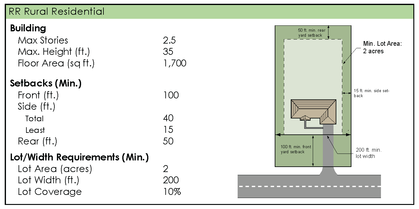
"RR," Rural Residential District. Recognizing that a significant element of Palmetto's character is its rural setting, this district is intended to protect those features within the rural areas of the city that are valued by the community and contribute to the prized character. The agricultural context, pastoral setting, natural features and wildlife habitats are essential components of that rural character. Single-family homes are permitted within this district at low densities, along with uses compatible with the openness of the district and the country setting. Conservation subdivisions and similar development practices are strongly encouraged.
Sec. 5-2. - Schedule of uses.
Buildings or land shall not be used and buildings shall not be erected, except for the following specified uses, unless otherwise provided for in this ordinance. Land and/or buildings in the district indicated at the top of Table 5-2 may be used for the purposes denoted by the following abbreviations:
A.
Permitted Use (P). Land and/or buildings in this district may be used by right.
B.
Conditional Use (C). Land and/or buildings in this district may be used by right, provided the specific conditions related to that use, as found in Article 14, are met.
C.
Special Use (S). Land and/or buildings may be permitted only if special land use approval is granted upon a finding that all applicable requirements in Article 15, Special Use Requirements.
D.
Specific Conditions. Indicates requirements or conditions applicable to conditional uses, as listed in Article 14, Conditional Use Requirements or Special Uses, as listed as Article 15.
Table 5-2. Schedule of Uses: Rural Residential District
( Ord. No. 2013-02 , § 1, 4-1-2013)
Sec. 5-3. - Spatial requirements.
A.
All lots and buildings shall meet the minimum area and width requirements listed below. New lots shall not be created, except in conformance with these requirements. In addition, all structures and their placement on a lot shall conform to the minimum dimensional requirements listed below.
Sec. 5-4. - Site development requirements.
In addition to the requirements of this article, all development in the residential districts shall meet the applicable requirements as listed elsewhere in this ordinance:
A.
General Provisions, see Article 13
B.
Conditional Use Requirements, see Article 14
C.
Special Use Requirements, see Article 15
D.
Parking and Loading, see Article 17
E.
Landscaping and Buffering Requirements, see Article 19
F.
Building Design and Material Requirements, see Article 18
G.
Site Plan Review Requirements, see Article 20
H.
Overlay Zone Requirements, see Article 11
In addition, development shall meet the applicable requirements of the Palmetto Sign Ordinance.
Sec. 6-1. - Purpose.
A.
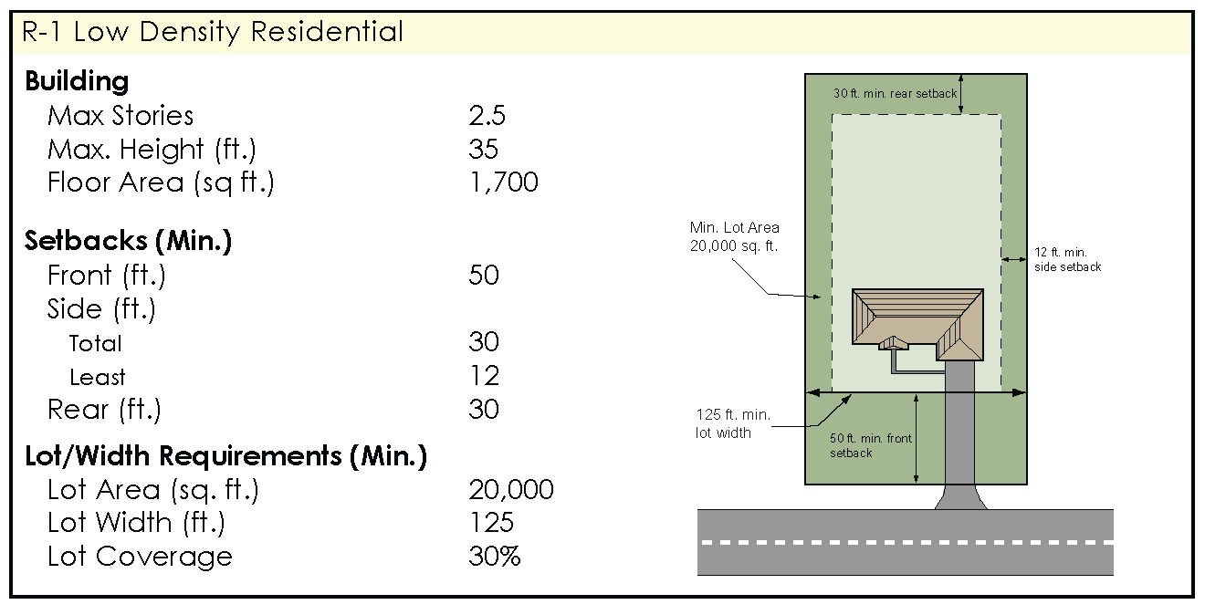
"R-1," Low Density Residential District. The R-1 District is intended to accommodate new residential subdivision development at densities of less than two units per acre, along with related uses generally on the periphery of the more intensely urbanized sectors of the city. Land within this district will be served by public sanitary sewer and water facilities.
B.
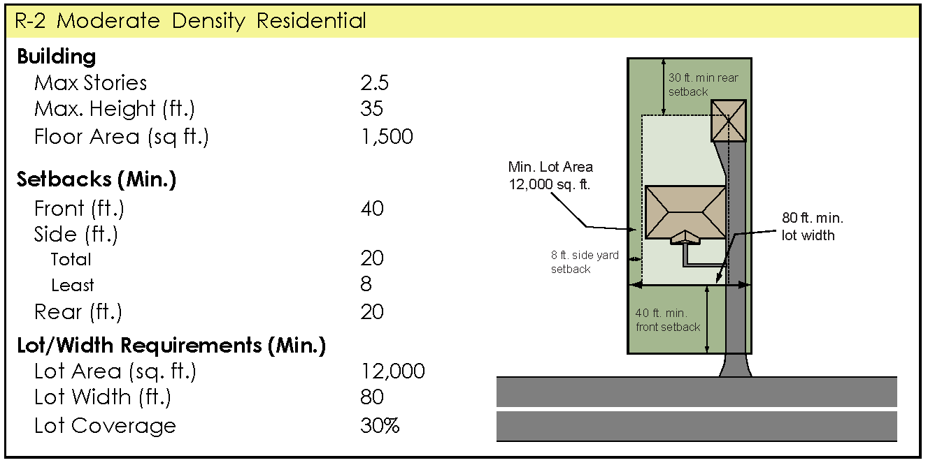
"R-2," Moderate Density Residential District. The R-2 District is intended to encompass much of the city's existing single-family residential development and accommodate similarly situated new development at densities of about three units per acre.
Sec. 6-2. - Schedule of uses.
Buildings or land shall not be used and buildings shall not be erected, except for the following specified uses, unless otherwise provided for in this ordinance. Land and/or buildings in the districts indicated at the top of Table 6-2 may be used for the purposes denoted by the following abbreviations:
A.
Permitted Use (P). Land and/or buildings in this district may be used by right.
B.
Conditional Use (C). Land and/or buildings in this district may be used by right, provided the specific conditions related to that use, as found in Article 14 are met.
C.
Special Use (S). Land and/or buildings may be permitted only if special land use approval is granted upon a finding that all applicable requirements in Article 15, Special Use Requirements.
D.
Specific Conditions. Indicates requirements or conditions applicable to conditional uses, as listed in Article 14 Conditional Use Requirements, or Special Uses, as listed in Article 15.
Table 6-2. Schedule of Uses: Single Family Residential Districts
( Ord. No. 2013-02 , § 2, 4-1-2013)
Sec. 6-3. - Spatial requirements.
A.
All lots and buildings shall meet the minimum area and width requirements listed below. New lots shall not be created, except in conformance with these requirements. In addition, all structures and their placement on a lot shall conform to the minimum dimensional requirements listed below.
Sec. 6-4. - Site development requirements.
In addition to the requirements of this article, all development in the residential districts shall meet the applicable requirements as listed elsewhere in this ordinance:
A.
General Provisions, see Article 13
B.
Conditional Use Requirements, see Article 14
C.
Special Use Requirements, see Article 15
D.
Parking and Loading, see Article 17
E.
Landscaping and Buffering Requirements, see Article 19
F.
Building Design and Material Requirements, see Article 18
G.
Site Plan Review Requirements, see Article 20
H.
Overlay Zone Requirements, see Article 11
In addition, development shall meet the applicable requirements of the Palmetto Sign Ordinance.
Sec. 7-1. - Purpose.
A.
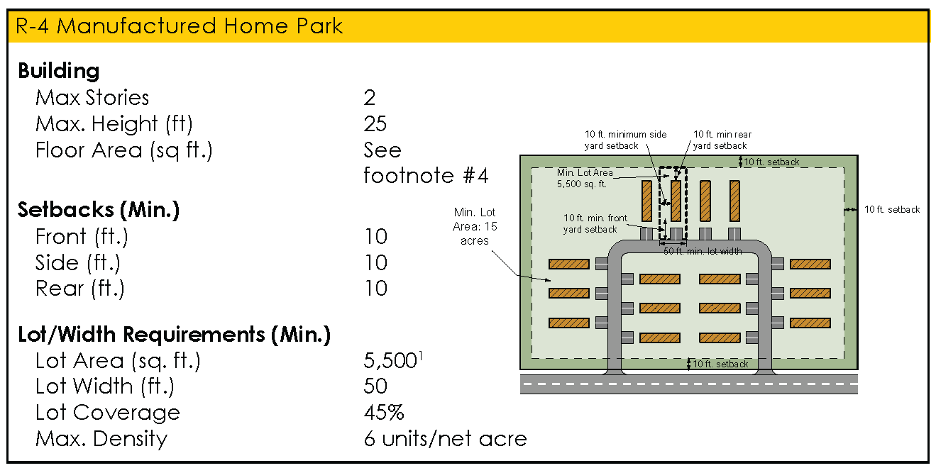
"R-4," Manufactured Home Community District. Accommodating the particular needs for manufactured home communities is the purpose of this district. The R-4 District is well suited to serving as a transitional use between other residential development and intense non-residential uses. Densities up to six units per acre are permitted and public water and sanitary sewer are required.
B.
"R-5," Medium Density Residential District. This district is intended to provide for housing options other than single-family dwellings, at densities of up to six units per acre. The R-5 District lends itself to serving as a buffer or transitional zone between lower density residential and non-residential development. Two-family dwellings and town homes are permitted, along with compatible public, quasi-public and institutional uses. Land within this district will be served by public sanitary sewer and water facilities.
C.
"R-6," High Density Residential District. The R-6 District is similar in character and purpose to the R-5 District, but also permits multiple family dwellings. It allows development at higher densities than any other district. Residential densities of up to 12 units per acre are permitted in this district.
Sec. 7-2. - Schedule of uses.
Buildings or land shall not be used and buildings shall not be erected, except for the following specified uses, unless otherwise provided for in this ordinance. Land and/or buildings in the districts indicated at the top of Table 7-2 may be used for the purposes denoted by the following abbreviations:
A.
Permitted Use (P). Land and/or buildings in this district may be used by right.
B.
Conditional Use (C). Land and/or buildings in this district may be used by right, provided the specific conditions related to that use, as found in Article 14 are met.
C.
Special Use (S). Land and/or buildings may be permitted only if special land use approval is granted upon a finding that all applicable requirements in Article 15, Special Use Requirements.
D.
Specific Conditions. Indicates requirements or conditions applicable to conditional uses, as listed in Article 14, Conditional Use Requirements, or Special Uses, as listed in Article 15.
Table 7-2. Schedule of Uses: Multiple Family Residential Districts
( Ord. No. 2013-02 , § 3, 4-1-2013)
Sec. 7-3. - Spatial requirements.
A.
All lots and buildings shall meet the minimum area and width requirements listed below. New lots shall not be created, except in conformance with these requirements. In addition, all structures and their placement on a lot shall conform to the minimum dimensional requirements listed below.
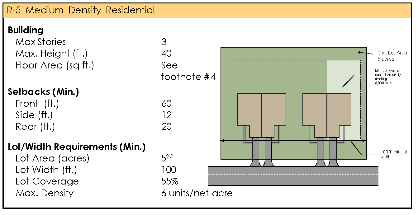
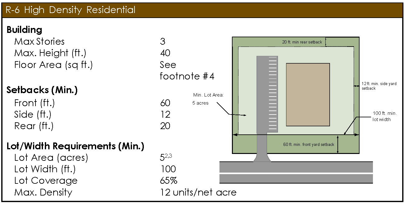
Notes:
1.
A minimum of 15 acres is required for a manufactured home community development. Non-residential development shall have no minimum lot size requirement.
2.
Each unit of a two-family dwelling shall have a minimum lot area of 8,000 square feet. Non-residential development shall have no minimum lot size requirement.
3.
Townhome and multiple family developments shall contain a minimum of 20 percent dedicated open space.
4.
Minimum floor area for all dwellings shall be 600 square feet for one bedroom units, 800 square feet for two bedroom units, 1,000 square feet for three bedroom units and an additional 100 square feet for each bedroom in excess of three.
Sec. 7-4. - Site development requirements.
In addition to the requirements of this article, all development in the residential districts shall meet the applicable requirements as listed elsewhere in this ordinance:
A.
General Provisions, see Article 13.
B.
Conditional Use Requirements, see Article 14.
C.
Special Use Requirements, see Article 15.
D.
Parking and Loading, see Article 17.
E.
Landscaping and Buffering Requirements, see Article 19.
F.
Building Design and Material Requirements, see Article 18.
G.
Site Plan Review Requirements, see Article 20.
H.
Overlay Zone Requirements, see Article 11.
In addition, development shall meet the applicable requirements of the Palmetto Sign Ordinance.
Sec. 8-1. - Purpose.
A.
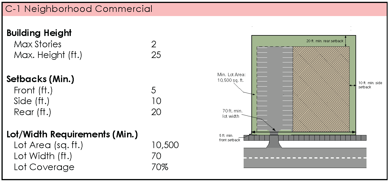
"C-1," Neighborhood/Commercial District. The C-1 zoning district is intended to provide a location for convenience goods and services for residents of nearby neighborhoods. Allowed uses should be of a low intensity nature, appropriate in scale and appearance, and compatible with the surrounding residential character. Pedestrian accessibility will be promoted. This district may be found as a node within residential neighborhoods or used as a transitional zone between residential and non-residential development.
B.
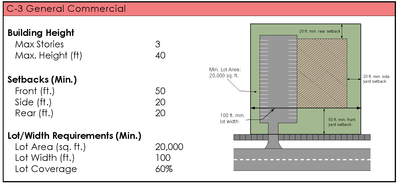
"C-3," General Commercial District. The C-3 zoning district is intended primarily to accommodate a range of retail and service uses serving the broader needs of the community and the motoring public. Large-scale retailers, auto-related businesses and similar uses not generally appropriate for other commercial districts will be permitted. While the district will be established primarily along arterial roadways, care should be taken to ensure compatibility with adjacent uses and minimize conflicts with traffic along abutting streets.
C.
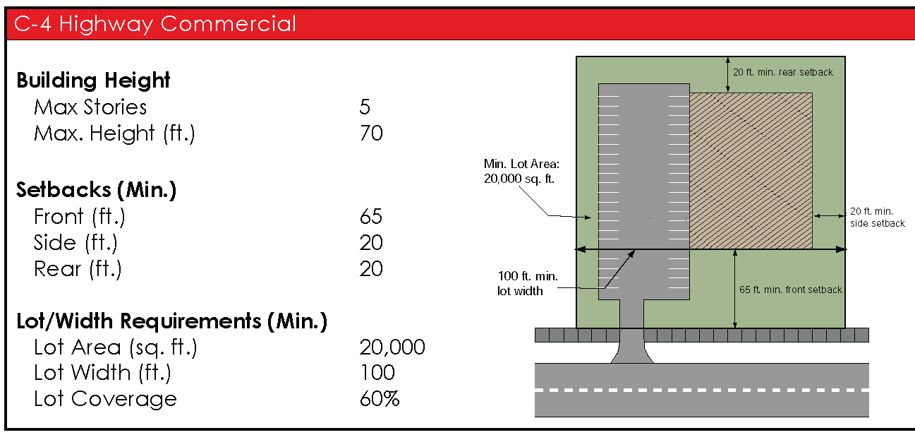
"C-4," Highway Commercial District. The C-4 zoning district is a specialized district intended to provide for those service uses catering to the motoring public along the interstate highway system and other high volume highways. Uses will be limited to auto-oriented uses and district boundaries will be confined to the immediate vicinity of interchanges and major intersections.
Sec. 8-2. - Schedule of uses.
Buildings or land shall not be used and buildings shall not be erected except for the following specified uses, unless otherwise provided for in this ordinance. Land and/or buildings in the districts indicated at the top of Table 8-2 may be used for the purposes denoted by the following abbreviations:
A.
Permitted Use (P). Land and/or buildings in this district may be used by right.
B.
Conditional Use (C). Land and/or buildings in this district may be used by right, provided the specific conditions related to that use, as found in Article 14 are met.
C.
Special Use (S). Land and/or buildings may be permitted only if special land use approval is granted upon a finding that all applicable requirements in Article 15, Special Use Requirements.
D.
Specific Conditions. Indicates requirements or conditions applicable to conditional uses, as listed in Article 14, Conditional Use Requirements, and Special Uses, as applied in Article 15.
Table 8-2. Schedule of Uses: Commercial Districts
( Ord. No. 2013-02 , § 4, 4-1-2013; Ord. No. 2018-02 , § 1, 4-2-2018; Ord. No. 2018-08 , § 1, 9-14-2018; Ord. No. 2020-08 , § 1, 9-8-2020)
Sec. 8-3. - Spatial requirements.
A.
All lots and buildings shall meet the minimum area and width requirements listed below. New lots shall not be created, except in conformance with these requirements. In addition, all structures and their placement on a lot shall conform to the minimum dimensional requirements listed below.
Sec. 8-4. - Site development requirements.
In addition to the requirements of this article, all development in the commercial districts shall meet the applicable requirements as listed elsewhere in this ordinance:
A.
General Provisions, see Article 13.
B.
Conditional Use Requirements, see Article 14.
C.
Special Use Requirements, see Article 15.
D.
Parking and Loading, see Article 17.
E.
Landscaping and Buffering Requirements, see Article 19.
F.
Building Design and Material Requirements, see Article 18.
G.
Site Plan Review Requirements, see Article 20.
H.
Overlay Zone Requirements, see Article 11.
In addition, development shall meet the applicable requirements of the Palmetto Sign Ordinance.
Sec. 9-1. - Purpose.
A.
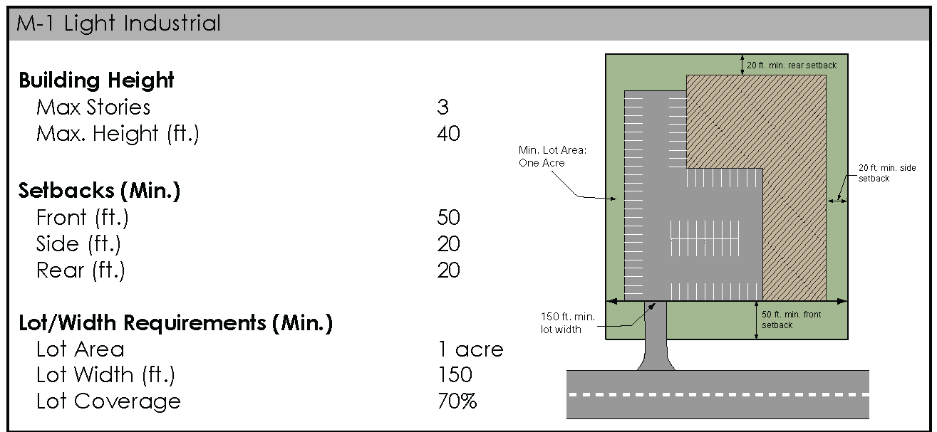
"M-1," Light Industrial District. The M-1 District is established for light industries such as light manufacturing or processing of previously refined materials and other industrial uses that have little or no adverse impact upon neighboring districts. This district also allows certain commercial uses of an industrial character or that are necessary to provide services to employees within the district. Limitations regarding the degree of noise, smoke, glare, odor and vibration are placed upon M-1 uses to preclude or minimize adverse effects upon nearby commercial or residential districts. It is intended that this district act as a transition between heavier manufacturing and non-industrial areas. Its purpose is to provide jobs for citizens of the community and surrounding area, establish a sustainable tax base and create value for property owners and the community.
B.
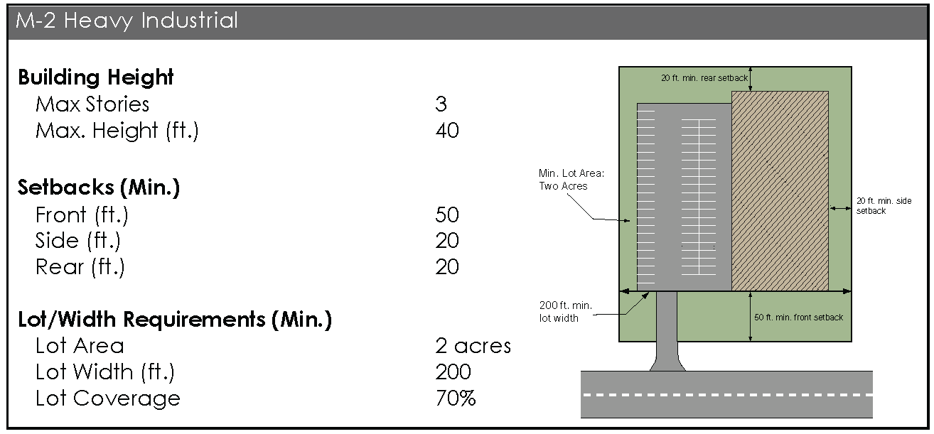
"M-2," Heavy Industrial District. The M-2 District is established to accommodate intense industrial uses that are primarily of a manufacturing, assembling and fabricating character. These tend to be large-scale or specialized industrial operations more likely to produce external physical effects impacting to some degree surrounding districts. This district is intended to be located in areas where the allowed uses can most efficiently utilize major roadways, utilities and other infrastructure, while minimizing potentially incompatible influences upon neighboring districts. Like the M-1 district, the M-2 district is also intended to support the economic vitality of the city through job creation and tax revenues.
Sec. 9-2. - Schedule of uses.
Buildings or land shall not be used and buildings shall not be erected except for one or more of the following specified uses, unless otherwise provided for in this ordinance. Land and/or buildings in the districts indicated at the top of Table 9-2 may be used for the purposes denoted by the following abbreviations:
A.
Permitted Use (P). Land and/or buildings in this district may be used by right.
B.
Conditional Use (C). Land and/or buildings in this district may be used by right, provided the specific conditions related to that use, as found in Article 14 are met.
C.
Special Use (S). Land and/or buildings may be permitted only if special land use approval is granted upon a finding that all applicable requirements in Article 15, Special Use Requirements.
D.
Specific Conditions. Indicates requirements or conditions applicable to conditional uses, as listed in Article 14, Conditional Use Requirements and Special Uses, as listed in Article 15.
Sec. 9-3. - Spatial requirements.
A.
All lots and buildings shall meet the minimum area and width requirements listed below. New lots shall not be created, except in conformance with these requirements. In addition, all structures and their placement on a lot shall conform to the minimum dimensional requirements listed below.
Sec. 9-4. - Site development requirements.
In addition to the requirements of this article, all development in the industrial districts shall meet the applicable requirements as listed elsewhere in this ordinance:
A.
General Provisions, see Article 13.
B.
Conditional Use Requirements, see Article 14.
C.
Special Use Requirements, see Article 15.
D.
Parking and Loading, see Article 17.
E.
Landscaping and Buffering Requirements, see Article 19.
F.
Building Design and Material Requirements, see Article 18.
G.
Site Plan Review Requirements, see Article 20.
H.
Overlay Zone Requirements, see Article 11.
In addition, development shall meet the applicable requirements of the Palmetto Sign Ordinance.
Sec. 10-1. - Purpose and guiding principles.
A.
Purposes. Palmetto's form-based districts provide specific regulations to achieve the following:
1.
Develop a fully integrated, mixed-use, pedestrian-oriented environment with traditional residential neighborhoods and a traditional downtown with buildings containing commercial, residential and office uses.
2.
Create a synergy of uses within the downtown area, supporting economic development and redevelopment.
3.
Calm traffic, thereby creating a more pedestrian-friendly environment and preventing a clustering of auto-oriented uses.
4.
Regulate building height and placement to achieve appropriate scale along streets and ensure a proper transition between the different areas of the city.
5.
Establish clear controls on building form and placement to frame a well-defined public realm comprised of human-scale streets, neighborhoods and public spaces, all of which contribute to creating a safe, comfortable and livable environment.
B.
Form-based Districts. A form-based code is established for the core area of Palmetto, which is divided into the following districts:
1.
Residential Form-based Districts.
a.
R-3A Traditional Residential District. The Traditional Residential District supports a predominantly single-family residential setting and preserves the traditional development patterns of the area. The intent of this district is to retain the period character of Palmetto's older neighborhoods. The R-3A District also includes currently undeveloped land, envisioned to be an extension of traditional residential development patterns.
b.
R-3B Mill Village Residential District. The Mill Village Residential District consists of historic dwellings built for cotton industry workers and is predominantly single-family. This district is characterized by modest worker housing with a distinctive and historic style that reflects Palmetto's heritage as a cotton milling and production center.
2.
C-2 Central Business District. The Central Business District protects the traditional, small town character of downtown Palmetto and enhances a pedestrian-oriented environment. The district accommodates a mix of retail stores, offices, entertainment, public spaces, residential uses and related activities that are mutually supporting and serve the needs of the community. The intent of this district is to encourage a lively social environment and economically viable downtown with a wide variety of uses in a pedestrian-oriented and unified setting.
C.
Requirements. All requirements of this ordinance shall apply within the form-based districts, except as modified by this article. If regulations elsewhere within this ordinance conflict or appear to conflict with the regulations in this article, the regulations of this article shall apply.
D.
Components of this Article. The article is comprised of Use Regulations, a Form-based District Regulating Plan, Lot Area, Siting, and Height Requirements, Architectural Standards, and Accessory Provisions (including parking, landscaping and sign requirements) as described below:
1.
Use Regulations. Uses in the form based districts are listed in Section 10-2. Those uses listed as conditional or special uses are subject to the review and approval requirements of Articles 14 and 15.
2.
Regulating Plan.
a.
A regulating plan provides standards for each property and illustrates how each relates to adjacent properties and the street. The regulating plan is the coding key for the form-based districts; it is similar to a zoning map but it provides specific information on permitted development for each property.
b.
The regulating plan identifies the form district for each property, which in turn determines the lot area, siting and height requirements for all building sites. The regulating plan also shows how each lot relates to public spaces and surrounding neighborhoods. There may be additional regulations for lots in special locations as identified on the regulating plan.
c.
The regulating plan determines the frontage street for each lot in the form districts, along which the required building line (RBL) shall apply. Principal structures shall face the frontage street. Yards (front, side, rear) shall be determined according to the frontage street.
d.
The boundaries of the form-based districts on the regulating plan shall be the same as those shown on the Official Zoning Map. Therefore, any change to the boundaries of the form-based districts shall be reviewed and approved according to the map amendment (rezoning) process in Section 21-10. The regulating plan shall be revised upon approval of any rezoning or change to the form-based district boundaries on the Official Zoning Map.
E.
Lot Area, Siting, and Height Standards.
1.
The lot area, siting and height requirements establish basic parameters governing building form, including the envelope for building placement (in three dimensions) and certain required or permitted building elements, such as shop fronts, doors, windows, balconies, and street walls. The lot area, siting and height standards establish both the boundaries within which things may be done and specific things that must be done. The applicable lot area, siting and height standard for a lot or parcel is determined by its street frontage, as designated on the regulating plan.
2.
The lot area, siting and height requirements shape public spaces throughout each form-based district through placement and envelope controls on buildings that frame streets. The standards aim for the minimum level of control necessary to meet that goal.
a.
Architectural Standards. The goal of the architectural standards is to promote a coherent and pleasing architectural character that is complementary to the best regional traditions. The standards govern a building's architectural elements regardless of its building envelope standards and set the parameters for allowable materials and configurations. Equivalent or better products than those specified are always encouraged and may be submitted for approval.
b.
Accessory Standards. The accessory standards govern development standards related to parking, site landscaping, signs and other accessory aspects of development within the form-based districts.
F.
How to Use this Code. Understanding how each property within the respective districts is regulated requires the following steps:
1.
Look at the regulating plan. Find the property and note the required building line or lines. Note the color of the fronting street-space, this determines the form based district for the property, which contains the lot area, siting and height requirements for buildings fronting that street.
2.
Review the use regulations. The use table describes the allowed uses within each form-based district.
3.
Review the lot area, siting, and height standards. These regulate siting of buildings and parking.
4.
Review the architectural standards. These define permitted building materials and architectural forms.
5.
Determine the accessory standards applying to the property. These list requirements for landscaping, lighting, and signs, among others.
6.
Submit plans for approval to the zoning administrator. Developments that conform to the standards and requirements of this article can be approved administratively, unless a special land use is also required. Projects that deviate from the standards may be approved, but are subject to site plan review by the planning and zoning board. Section 10-9 describes the processes.
Sec. 10-2. - Schedule of uses.
A.
Uses shall be permitted based upon the district. Land and/or buildings in the districts indicated at the top of Table 10-2 may be used for the purposes denoted by the following abbreviations:
1.
Permitted Use (P). Land and/or buildings in this district may be used by right.
2.
Conditional Use (C). Land and/or buildings in this district may be used by right, provided the specific conditions related to that use, as found in Article 14, are met.
3.
Special Use (S). Land and/or buildings may be permitted only if special land use approval is granted upon a finding that all applicable requirements as specified in Article 15 are met.
4.
Specific Conditions. Indicates requirements or conditions applicable to conditional uses, as listed in Article 14, Conditional Use Requirements and Special Uses, as listed in Article 15.
B.
Where the Regulating Plan indicates "Retail Frontage Required," such properties may only be used for retail and personal services, office, financial and business services, and entertainment and hospitality uses.
Table 10-2. Permitted, Conditional and Special Uses by District
1. Drive in and drive-through uses are not permitted.
( Ord. No. 2013-02 , § 5, 4-1-2013)
Sec. 10-3. - Residential form-based districts (R-3A and R-3B).
A.
Applicability. The form-based requirements for the residential districts apply to properties with frontage on existing streets, as shown on the Regulating Plan. Any lot or parcel created after the effective date of this ordinance shall be subject to the requirements of Section 10-7.
B.
Purpose and Intent. Implementation of the dimensional requirements of the residential form-based districts realizes a complementary residential development pattern that is based on traditional neighborhood design principles. It also ensures that a consistent architectural character is maintained and the street is neither dominated nor defined by imposing garages that project beyond the front façade of a building. Such a pattern will additionally help support a walkable, pedestrian environment and promote neighborhood accessibility. By regulating building character, facades can be located closer to a street and sidewalk and be aligned to form an edge that frames the public realm, while retaining sufficient room for people to walk and mingle with neighbors. Further, as expressed by traditional architectural forms, defined building entrances, window openings, materials and heights, new structures can be designed to blend with existing homes, thereby enhancing the character of residential neighborhoods.
C.
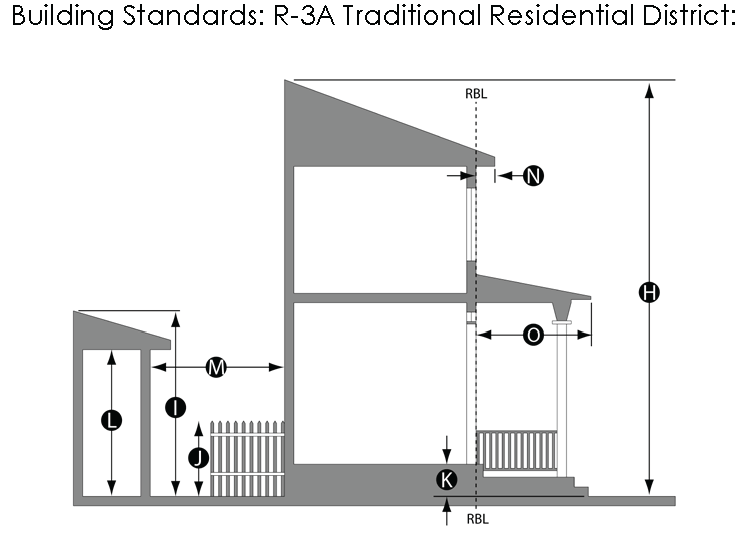
Lot Area, Siting, and Height Standards. Specific dimensional standards for the residential form-based districts are specified as follows:
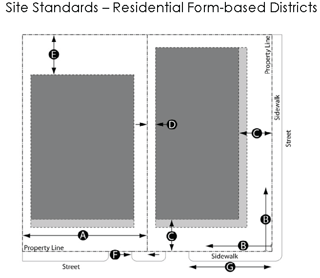 | |
| a. Lot Standards. | |
| i. | Lot area. |
| (A) R-3A District: Min. 5,000 sq. ft.; max. 8,000 sq. ft. | |
| (B) R-3B District: Min. 10,000 sq. ft.; max 20,000 sq. ft. | |
| ii. | Minimum Lot Width.Ⓐ |
| (A) R-3A District: 50 ft. | |
| (B) R-3B District: 90 ft. | |
| b. Street Façade. | |
| i. | The front building façade shall be parallel to the adjacent street and/or sidewalk.Ⓑ |
| ii. | For an addition or new structure: |
| (A) R-3A District: Where there is an existing and inconsistent pattern of building placement, the RBL shall be equal to the average of the front setbacks of existing principal buildings located on the same side of the street, in the same zoning district as the subject parcel, and within 200 ft. of the lot where building placement is being established. Where there is no established dimension, the RBL shall be between 15 ft. and 20 ft.Ⓒ | |
| (B) R-3B District: The RBL shall be between 25 ft. and 30 ft.Ⓒ | |
 | |
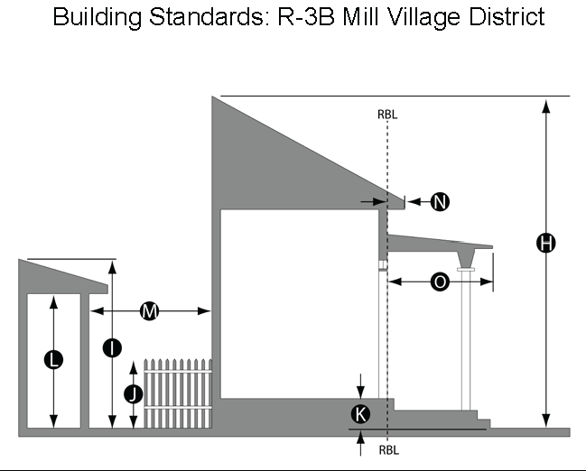 | |
| iii. | The front façade of the principal building shall occupy at least 60% of the lot frontage at the RBL. For lots 150 ft. wide or more, requests to relax this requirement shall be considered as a deviation instead of a variance (see Section 10-8).Ⓑ |
| iv. | On corner lots, the RBL shall be met on both frontages. On multiple frontage lots that are not corner lots (such as through lots) the RBL shall be met for the primary frontage street designated on the regulating plan.Ⓒ |
| c. Setbacks. | |
| i. | Side yard:.Ⓓ |
| (A) R-3A District: Min. 5 ft. on one side; 13 ft. total of both sides. | |
| (B) R-3B District: Min. 15 ft. on one side, 40 ft. total of both sides. | |
| ii. | Rear yard:Ⓔ |
| (A) R-3A District: Min. 25 ft. | |
| (B) R-3B District: Min. 40 ft. | |
| d. Parking. | |
| i. | Driveways, if located in the front and not shared with an adjacent property, shall be located at least 2 ft. from a common lot line. Ⓕ |
| ii. | If located on a corner lot, driveways shall be at least 40 ft. from any block corner or other driveway.Ⓖ |
| iii. | Parking is not allowed in a front yard, except on a residential driveway. |
| e. Principal Building Height. | |
| i. | A principal building shall not exceed:Ⓗ |
| (A) R-3A District: 2 stories. | |
| (B) R-3B District: 1 story. | |
| ii. | An attic story configured as habitable space is permitted within the roof area of a building and shall not count against the maximum story height.Ⓗ |
| iii. | Height requirements may be exceeded for certain related structures as specified in Section 13-2.E.Ⓗ |
| f. Ground Story Height | |
| i. | The finished elevation of the ground floor shall not be less than 2 ft. nor more than 5 ft. above the exterior sidewalk, or from the ground elevation, at the front of the building.Ⓚ |
| g. Fence Height. | |
| i. | A privacy fence, not more than 6 feet in height, is allowed on any portion of the lot that is behind the RBL/building façade and is not otherwise occupied by a building; however, a fence parallel to a lot line shall be either on the lot line or placed at least 2 ft. from the lot line.Ⓙ |
| ii. | A fence is allowed in a front yard to a maximum height of 40 inches. |
| h. Garages and Accessory Buildings. | |
| i. | One detached garage is permitted, which shall not exceed 16 ft. in height.Ⓘ |
| ii. | A detached garage shall be located in the rear yard and accessed either by an alley or driveway. |
| iii. | Front-facing attached garages: |
| (A) R-3A District: Permitted, provided they do not project beyond a line located 16 feet behind the façade of the building and do not encompass more than 40% of the total building frontage. | |
| (B) R-3B District: Not permitted. | |
| iv. | One accessory storage building is also permitted, which shall not exceed 12 ft. in height. |
| v. | A detached accessory building shall only be located in the side or rear yard. An accessory building attached to a principal building shall conform to the regulations applicable to the principal building. |
| vi. | Accessory buildings shall be at least 3 ft. from a side and rear lot line, 10 ft. from any dwelling, and 6 ft. from any other structure on the lot. Ⓜ |
| i. Projections. | |
| i. | Except for eaves, awnings, balconies, bay windows, front porches, stoops, and ADA compliant ramps, as specified by this article, no part of a building shall encroach into the RBL or required side or rear setbacks. |
| ii. | Eaves and awnings shall not project more than 2 ft. into the RBL or required side or rear setbacks.Ⓝ |
| iii. | Porches and stoops. A front porch or stoop is required.Ⓞ |
| (A) R-3A District: A stoop may project up to 6 ft. beyond the RBL. Porches are encouraged and may project up to 10 ft. beyond the RBL. | |
| (B) R-3B District: A porch is required for single-family homes and townhouses and may project up to 10 ft. beyond the RBL. A stoop is permitted for multiple family dwellings and may project 6 ft. beyond the RBL | |
| iv. | Bay windows may project up to 3 ft. beyond the RBL or required side or rear setbacks. |
| v. | Balconies may project up to 5 ft. beyond the RBL or required side or rear setbacks. |
D.
Public Buildings.
1.
Purpose and Intent. The design of a public building, such as a church, school, congregate child caring facility, or government office is subject to review and approval by the city council after receiving a recommendation from the planning and zoning board. While the intent is to allow flexibility in the design and siting of such unique structures they must also positively contribute to a desired community and neighborhood character.
2.
Street Façade. Public buildings may deviate from district RBL and setback requirements when key public amenities, compatible with the character of the surrounding area, have been accommodated, such as a plaza, park, or courtyard.
E.
Lots Not Fronting on Existing Streets. Lots (including both existing lots and lots created after the effective date of this ordinance) that do not front onto a street in existence on the effective date of this ordinance shall be developed according to Section 10-7.
Sec. 10-4. - C-2 Central Business District.
A.
Mixed-use, Commercial, and Residential Buildings.
1.
Purpose and Intent. The siting requirements for this district support a compact, mixed-use development pattern for downtown Palmetto and reinforce the significance of public spaces and traditional architectural character. They further emphasize walkable, pedestrian environments that promote a synergy between compatible land uses and strong ties to surrounding residential neighborhoods.
2.
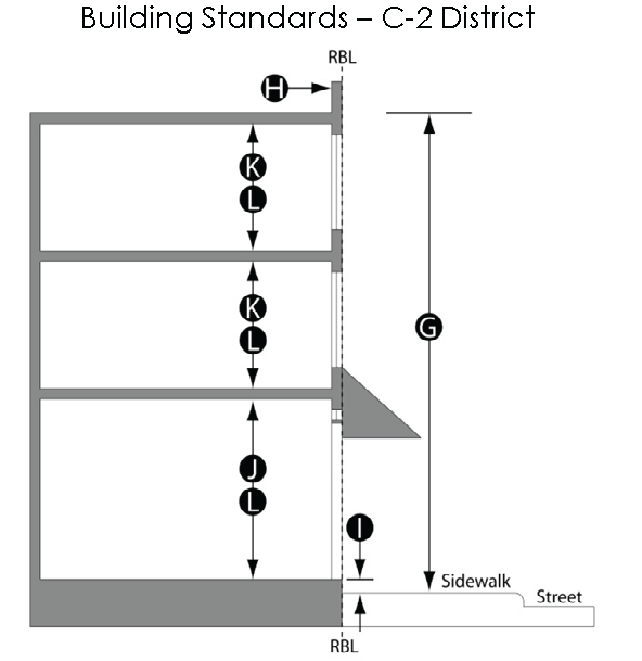
Lot Area, Siting, and Height Standards. Specific dimensional requirements for this district are specified as follows:
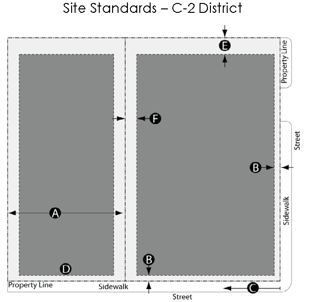 | |
 | |
| a. Lot Requirements. | |
| i. | Lot Width — No minimum.Ⓐ |
| ii. | Lot Area — No minimum. |
| b. Street Façade. | |
| i. | Horizontal distance to RBL — Min. 0 ft., max. 5 ft.Ⓑ |
| Residential buildings shall be located between 5 ft. and 10 ft. of the RBL.Ⓑ | |
| ii. | A building façade shall occupy at least 80% of the frontage length and shall be built to the RBL within 30 ft. of a block corner.Ⓒ |
| iii. | A street wall shall be required along any frontage that is not otherwise occupied by the principal building.Ⓓ |
| iv. | A street wall shall not be less than 4 ft. nor greater than 8 ft. high. |
| v. | An outdoor pedestrian area may occupy the frontage not occupied by the building and does not have to be enclosed by a street wall.Ⓓ |
| c. Setbacks. | |
| i. | Rear yard — A setback of 15 ft. is required, except for lots with access to a rear alley, where no setback is required.Ⓔ |
| ii. | Side yard — A setback is not required where a firewall is provided along the side lot line. Where a firewall is not provided, buildings shall be separated by at least 10 ft.Ⓕ |
| d. Building Height. | |
| i. | Height — Min. 2 stories or 20 ft.; max. 3 stories.Ⓖ |
| ii. | An attic story configured as habitable space is permitted within the roof area of a building and shall not count against the max. story height.Ⓖ |
| iii. | Required parapet walls may exceed allowed building heights by 42 in.Ⓗ |
| iv. | A parapet emphasizing the primary street level building entrance or corner of a building can be an additional 3 ft. high for a distance of 12 ft., or 15% of the façade length, whichever is greater.Ⓗ |
| v. | Height requirements may be exceeded for certain related structures as specified in Section 14-2E.Ⓗ |
| vi. | A detached garage shall not exceed 16 ft. in height. |
| e. Story Height. | |
| i. | Mixed Use and Commercial: The ground story finished floor elevation shall be equal to or no more than 18 in. above the exterior sidewalk elevation at the front of the building at the RBL.Ⓘ |
| ii. | Residential: The ground story finished floor elevation shall not be less than 3 ft. nor more than 5 ft. above the exterior sidewalk in front of the building at the RBL.Ⓘ |
| iii. | Mixed Use and Commercial: The ground story shall have a min. interior floor to ceiling height of 15 ft.Ⓙ |
| iv. | Mixed Use and Commercial: All other stories shall have a min. floor to ceiling height of 9 ft. and a max. 12 ft.Ⓚ |
| v. | Residential: The min. interior floor to ceiling height for all stories shall be 9 ft. and a max. 12 ft.Ⓛ |
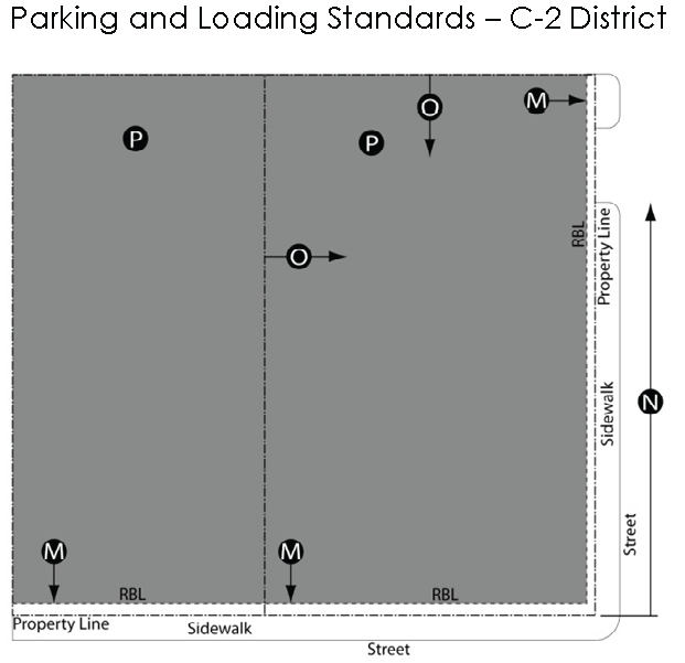 | |
| f. Parking and Loading. | |
| i. | Parking is not allowed forward of the RBL or in any front yard.Ⓜ |
| ii. | Driveways shall be at least 50 ft. from any block corner.Ⓝ |
| iii. | Off-street parking shall be permitted in the rear and side yards behind the RBL when screened by a 4 ft. tall street wall located between the property line and parking lot.Ⓞ |
| iv. | Loading shall be permitted only in the rear yard or within internal loading bays not visible from the street. |
| g. Detached Accessory Structures. | |
| i. | A detached accessory structure shall be located in the rear yard and accessed either by an alley or driveway. |
B.
Public Buildings.
1.
Purpose and Intent. The design of a public or quasi-public building, such as a church, school or government office is subject to review and approval by the city council after receiving a recommendation from the planning and zoning board. While the intent is to allow flexibility in the design and siting of such unique structures they must also positively contribute to a desired community and neighborhood character.
2.
Street Façade. Civic/institutional buildings may deviate from district RBL requirements when key public amenities, compatible with the character of the surrounding area, have been accommodated, such as a plaza, park, or courtyard.
Sec. 10-5. - Architectural standards.
A.
Purpose and Intent. By regulating building elements, facades can be aligned along streets and sidewalks to form a street edge that frames the public realm, while retaining a sufficient dimension to accommodate pedestrians, shoppers and outdoor diners. Strong architectural character should be reflected in the design of buildings by clearly defining a base, middle and roof line. Traditional storefronts should be expressed by their distinct front entries, ample window openings and appropriate building heights. Facades visible from streets and other public spaces must be divided by rhythmic architectural elements to define scale and include customary architectural features, such as awnings, cornices, columns, trim details or other character elements.
B.
Applicability. The architectural standards for specific building types shall apply in addition to any lot area, siting, and height standards for the individual form-based districts.
C.
General Standards.
1.
Dormers. Dormers are permitted as long as they do not break the primary eave line, are individually less than 15 feet wide and together do not constitute more than 60 percent of the length of the roof façade.
2.
Front Porches. Front porches, where required by the lot area, siting, and height standards, must be covered by a roof supported by posts. Other than a railing or wall as required below, a porch shall otherwise not be enclosed except with insect screening.
a.
In the R-3A District, porches shall enclosed by either a railing or wall not higher than 42 inches.
b.
In the R-3B District, a porch railing is not permitted unless required by the building code. Supporting posts and balustrades, if required, should be simple and square or round.
3.
Character. Architectural character shall reflect the patterns of traditionally designed buildings found in Palmetto with building facades that reflect and complement regional materials and construction techniques. Simple configurations and solid craftsmanship are favored over complex building forms and over-articulated details. All building materials shall express their specific properties. For example, heavier more permanent materials (masonry) shall support lighter materials (wood).
4.
Exterior Building Materials. The following materials are permitted. Calculations for material wall percentages do not include areas of the wall used for doors and windows.
a.
Primary Materials (80 percent of a building exterior or more):
1.
Brick and tile masonry (or synthetic equivalent).
2.
Native stone (or synthetic equivalent).
3.
Hardie-Plank™ or equivalent.
4.
Wood siding.
b.
Accent Materials (no more than 20 percent of facade):
1.
Pre-cast masonry (for trim and cornice elements only).
2.
Gypsum reinforced fiber concrete (GFRC—for trim elements only).
3.
Metal (for beams, lintels, trim elements and ornamentation only).
4.
Split-faced block (only for piers, foundation walls and chimneys).
c.
The planning and zoning board and city council may permit different materials if approved as a deviation (see Section 10-8.C, bellow).
5.
Building Facades.
a.
Cornice lines, string courses, roof lines and other architectural elements shall create a recognizable base, middle, and top to a building.
b.
Long, uninterrupted facades shall be avoided. Building bays, storefronts, entrances, columns, pilasters and other vertical elements shall be used in approximately 15 to 30 foot increments to "break-up" a building façade.
c.
Façade openings shall not vertically span more than one story, nor shall the horizontal size of an opening exceed its corresponding vertical opening. Façade openings shall be clearly defined, correspond to interior space and shall not span across building support structures.
6.
Awnings. Windows, storefronts and building entrances may be enhanced by awnings, provided the following conditions are met:
a.
Only traditional style awnings shall be permitted.
b.
Awnings shall be positioned immediately above ground floor windows and have a straight shed design.
c.
Awnings shall be constructed of durable fabrics (no shiny or reflective materials) such as canvas that will not fade or tear easily.
d.
Canopies, marquees, vinyl, barrel, waterfall, dome, box or curved awnings are prohibited.
e.
Awnings shall not be internally illuminated.
D.
Specific Building Requirements—Single-Family Dwellings.
1.
Floor Area. Minimum 1,400 square feet of floor area per residential unit.
2.
Windows/Transparency. Between 20% and 60% of a building facade facing a public street shall consist of windows and doors that open into habitable spaces.
3.
Entrances. A dwelling shall have a front door facing a street or public space that is accessed from a stoop or porch.
a.
A stoop shall have a minimum depth of four feet and a minimum area of 24 square feet.
b.
A front porch must be between eight and ten feet deep. In the R-3A District, if a front porch is provided, it shall be no less than 40 percent of the width of the façade at the RBL. In the R-3B District, a front porch is required and shall be no less than 90 percent of the width of the façade at the RBL.
c.
An ADA-compliant ramp that connects to the stoop or porch may project beyond the RBL.
4.
Roof Type.
a.
All residential buildings (except in the R-3B District, as required below) and related accessory buildings shall have pitched roofs with moderately steep slopes not less than 4:12 and not more than 12:12.
b.
In the R-3B District, a principal dwelling shall have a hipped roof with a pitch between 6:12 and 10:12. A porch in the R-3B district shall either be covered by an extension of the main roof of the house, or by a separate shed roof that is attached to the house, but with a lesser pitch than the main roof.
5.
Accessory Buildings. The building materials and colors of the accessory building shall match or complement at least one of the materials used on the principal building.
E.
Specific Building Requirements—Multiple Family Buildings.
1.
Floor Area. Minimum 700 square feet of floor area per residential unit.
2.
Windows/Transparency.
a.
Windows and doors on ground story facades shall comprise at least 20 percent, but not more than 90 percent, of the facade area (measured as a percentage of the facade between floor levels).
b.
Windows and doors on upper story facades shall comprise at least 20 percent, but no more than 60 percent, of the façade area per story (measured as a percentage of the façade between floor levels).
3.
Entrances.
a.
At least one functioning entry door shall be provided for a building along the ground story façade facing a street and at intervals not greater than 60 linear feet.
b.
If provided, a front stoop must be at least four feet deep with a minimum area of 32 square feet. An ADA-compliant ramp that connects to the stoop may project into the RBL.
4.
Roofs.
a.
Pitched roofs are permitted, but they must have at least a 4:12 and no more than a 12:12 pitch. For a building with a pitched roof, mechanical equipment located on the roof shall be on the back half of the building and screened on all sides so it is not visible from the ground as observed from the sidewalk, or if no sidewalk exists, from the curb or pavement edge of the street.
b.
Flat roofs shall be enclosed by a parapet, which shall be high enough to conceal mechanical equipment as observed from the sidewalk, or if no sidewalk exists, from the curb or pavement edge of the street.
c.
Parapet Height. A parapet emphasizing the primary street level building entrance or corner of a building can be an additional three feet higher than allowed in the lot area, siting and building height requirements for the district, for a distance of 12 feet, or 15 percent of the façade length, whichever is greater.
5.
Garages. Off-street parking lots and carports or garages shall be located behind the RBL and in the side or rear yard.
F.
Specific Building Requirements—Townhomes.
1.
Floor Area. Minimum 900 square feet of floor area per residential unit.
2.
Windows/Transparency. For each residential unit, between 25 percent and 50 percent of the front building facade shall consist of windows and doors.
3.
Entrances. A dwelling shall have a front door facing a street or public space that is accessed from a stoop or porch.
a.
A stoop shall have a minimum depth of four feet and a minimum area of 24 square feet.
b.
A front porch must be between eight and ten feet deep, with a width not less than 40 percent of the width of the unit at the RBL. In the R-3B District, a porch is required with a width not less than 90 percent of the width of the building at the RBL.
c.
An ADA-compliant ramp that connects to the stoop or porch may project beyond the RBL.
4.
Roofs.
a.
Pitched roofs are permitted, but they must have at least a 4:12 and no more than a 12:12 pitch. For a building with a pitched roof, mechanical equipment located on the roof shall be on the back half of the building and screened on all sides so it is not visible from the ground as observed from the sidewalk, or if no sidewalk exists, from the curb or pavement edge of the street.
b.
Flat roofs shall be enclosed by a parapet, which shall be high enough to conceal mechanical equipment as observed from the sidewalk, or if no sidewalk exists, from the curb or pavement edge of the street.
5.
Garages. Off-street parking lots and carports or garages shall be located in the side or rear yard.
G.
Specific Building Requirements—Mixed-use and Commercial Buildings.
1.
Windows/Transparency.
a.
Transparency requirements shall apply to the area of the facade between two feet and ten feet above the sidewalk, regardless of where windows are located.
b.
Only clear or lightly tinted, non-reflective glass in windows, doors, and display windows shall be considered transparent.
c.
Ground floor windows shall contain displays that are meant for viewing from the outside and shall be unobstructed for a depth of not less than four feet into the building.
d.
Building facades facing public streets and spaces and through-block walkways shall maintain the following transparency percentages of window and door openings:
1.
Minimum 70 percent for ground level storefronts.
2.
Minimum 40 percent and maximum 60 percent for the building facade above storefronts.
e.
Transparency requirements may be reduced by one-half for the first floor façade facing a lesser traveled street of a building on a corner lot.
f.
Ground floor window sills shall not be higher than two feet above grade, measured at the sidewalk.
g.
Exterior steel barriers and similar security devices are not permitted. If they are located inside a building, they may not be visible from the outside during business hours.
2.
Facades. Storefronts shall contain a ground floor that is visually distinct, as defined by traditional architectural features. These elements include display windows, a kick plate between the sidewalk and the base of a display window, a framed entry, piers/pilasters, awnings, transom windows, a sign band, a middle cornice separating the ground level façade from either upper stories or the top of the building and an upper cornice line.
3.
Roofs.
a.
Pitched roofs are permitted, but they must have at least a 4:12 and no more than a 12:12 pitch. For a building with a pitched roof, mechanical equipment located on the roof shall be on the back half of the building and screened on all sides so it is not visible from the ground as observed from the sidewalk, or if no sidewalk exists, from the curb or pavement edge of the street.
b.
Flat roofs shall be enclosed by a parapet, which shall be high enough to conceal mechanical equipment as observed from the sidewalk, or if no sidewalk exists, from the curb or pavement edge of the street.
4.
Entrances.
a.
A building entrance shall be clearly identifiable and reinforced by architectural features such as awnings, pediments, pilasters and arches.
b.
Recessed doorways are encouraged, but shall not be recessed more than five feet from the front façade unless a courtyard, window display, or other space that is actively used is provided between the doorway and the sidewalk. If recessed more than three feet, angled walls are preferred to promote visibility of the entrance. Doorways shall not span more than one story.
c.
A visible and usable building entrance is required for every 50 feet of frontage a building has on the primary (more highly traveled) street.
H.
Specific Building Requirements—Public Buildings.
1.
Front Façade. Walls that face a public street, plaza, green or park shall include windows and architectural features customarily found on the front of a building, such as awnings, cornice lines, brick detailing or decorative finish materials.
2.
Entrances. There shall be at least one usable building entrance along each front public sidewalk. Main entrances shall be designed to enhance their appearance and prominence so they are recognizable from the street and parking areas.
3.
Prominent Design. The requirements for mixed use and commercial buildings in this article shall be used as a basis for evaluating the design of civic and institutional buildings. Modifications may be allowed based on unique building requirements and a desire to create community landmarks.
Sec. 10-6. - Accessory standards.
The requirements of Article 17, Off-Street Parking and Loading, Article 19 for parking lot landscaping requirements, Section 18-4 for lighting, and the Palmetto Sign Ordinance shall apply except as modified by this article.
A.
Parking.
1.
Intent. The goals of the parking requirements are to:
a.
Promote a "park once" environment enabling people to conveniently park and access a variety of commercial and civic uses by encouraging shared parking.
b.
Reduce fragmented, uncoordinated, inefficient, single-purpose reserved parking.
c.
Avoid adverse parking impacts on neighborhoods adjacent to the form districts.
d.
Maximize on-street parking.
e.
Increase visibility and access to publicly available parking.
f.
Provide flexibility for redeveloping small sites.
g.
Promote projects using flexible and creative incentives.
h.
Incorporate convenient bicycle parking.
2.
Location.
a.
Off-street parking shall be located as delineated on the regulating plan and as required in Section 10-4.F., above.
b.
These provisions shall not apply to parking areas located forward of the RBL that were in existence at the time this ordinance was adopted. However, an event that triggers conformance with these requirements, as stated in Section 10-10.A., below shall require, at minimum, a streetwall and/or landscape screen to be installed at the right-of-way line or at the RBL.
3.
Number.
a.
The number of off-street parking spaces provided shall not exceed those enumerated in Table 17-1, Parking Requirements by Use.
b.
Fewer parking spaces may be allowed as provided in Section 17-1.D.
c.
On-street parking spaces located along the frontage of a property shall be included when calculating parking requirements for a use on that lot. Such spaces shall not be reserved for the exclusive use of patrons or occupants of the lot, but shall be available to the public. A parking space which is contiguous to a lot frontage for less than 50 percent of its length or width shall not be counted toward meeting the parking requirements for that property.
d.
A sidewalk dining area associated with an eating or drinking establishment is not subject to the parking requirements in Table 17-1.
B.
Exterior Areas.
1.
Temporary Outdoor Display Areas.
a.
Temporary outdoor displays are permitted, and may be located forward of the RBL or within the C-2 District upon a public sidewalk, but shall be limited to the property in question and located within three feet of the building façade. Access to sidewalks and building entrances shall be maintained so that pedestrian circulation is not impaired.
b.
Alternate outdoor display area locations may be approved as long as pedestrian circulation or entrances to a building are not impaired.
2.
Other. Space for bike racks, civic art, or other similar uses/activities may be permitted, provided a minimum five foot sidewalk clear area is maintained.
C.
Landscaping and Screening.
1.
Parking Lots.
a.
Parking lots serving multiple family dwellings and non-residential uses that are visible from a public street, sidewalk, or adjacent one or two family residential district or use shall be screened by a streetwall not less than four and no more than five feet in height, constructed at the RBL of the lot. However, the wall must provide a break at intervals no greater than 50 feet to allow pedestrian access.
b.
Landscaping of the same height (at planting) may be used if it screens the parking area with at least 75 percent opacity.
c.
Parking lots exceeding 15 spaces shall be landscaped to break up large expanses of pavement, provide shade and assist with vehicular and pedestrian flow. At least one landscaped island shall be provided per each ten parking spaces.
d.
The location and design of parking lot landscaping shall be approved by the zoning administrator, or the planning and zoning board, as applicable. The number of plants and island requirements shall meet the requirements of Chapter 23.5.27 of the City of Palmetto Code of Ordinances.
2.
Trash Enclosures and Other Outdoor Equipment.
a.
Exterior trash disposal areas and equipment shall be enclosed by brick, decorative concrete or other material that matches the main building. The enclosure shall be at least six feet high, with three sides and a gate on the fourth side. Outdoor mechanical equipment shall be similarly screened, provided that the enclosure needs to be only as tall as necessary to fully screen the equipment. Trash enclosures used in common by multiple users are permitted.
b.
A group enclosure that spans the width of more than one building may be constructed of a uniform material throughout, provided that it is complimentary to the adjoining buildings.
D.
Lighting (See Section 18-3 for general requirements).
1.
Lighting, if installed, shall be pedestrian-style lighting along all sidewalks, pedestrian walkways within parking areas, and along other pedestrian ways.
2.
Pole lighting shall be a maximum of 20 feet high.
3.
In the C-2 District, light fixtures not exceeding 30 feet may be permitted for pole lighting if the fixture is located at least 200 feet from the boundary of any residential district or use.
4.
All light fixtures or structures shall be architecturally compatible with the building.
E.
Public Art. Public art is encouraged and may be located in appropriate areas without regard to setbacks, RBLs, etc., provided that clear vision at corners is maintained.
F.
Sign Requirements.
1.
R-3A Traditional Residential District and R-3B, Mill Village Residential District. Signs in the R-3A District shall conform to the sign requirements in the Palmetto Sign Ordinance.
2.
C-2 Central Business District: Only those signs listed in Table 10-6 shall be permitted in the C-2 District. Except as modified by this article, signs shall comply with the requirements of the Palmetto Sign Ordinance.
Table 10-6. Sign Requirements for the C-2 District
"Exempt signs" as specified in Table 17-2
Notes to Table 10.6:
(1)
Except for a building located on a corner, a single building shall be permitted to have only one of the following types of signs: Awning sign or projecting sign.
(2)
Where a single use occupies both the ground and upper floors of a building only one wall sign shall be permitted on either the ground floor or the upper floor façade.
(3)
A sidewalk sign shall be removed from the sidewalk and taken inside at the close of business each day. At least 35 percent of the sign area shall be permanently painted or affixed graphics. The remainder may allow for changeable letters (reader board/message board) or handwritten advertisements. The owner of the sign shall provide proof of insurance in the amount determined from time to time by the city council and shall provide proof that the City of Palmetto is an additional named insured on the policy.
3.
All new signs and all existing signs, except "exempt signs" that are altered, relocated, replaced, or reconstructed shall be required to obtain a sign permit under the Palmetto Sign Ordinance.
Sec. 10-7. - Subdivisions and lots not fronting on existing streets.
A.
Intent. The subdivision of existing lots and the development of any lot or parcel that does not front on a street in existence on the effective date of this ordinance shall be subject to the requirements of this section. This section ensures undeveloped lands within form-based districts are developed in a manner consistent with traditional development patterns, block sizes and architectural character. Diverse block and lot sizes can help create an urban form that accommodates various housing types in a pedestrian friendly manner. Short blocks, defined by a traditional grid street layout, can yield multiple travel routes and choices that are more direct and safer for pedestrians, bicyclists and motorists. Lot and block design should promote development that is compatible with natural features, minimizes pedestrian and vehicular conflicts, promotes street life and activity, reinforces public spaces, promotes public safety, and visually enhances development.
B.
Existing Lots. A building containing a use allowed in the district and meeting the requirements of this article may be developed on a lot or parcel existing on the effective date of this ordinance, provided the lot or parcel can be accessed in accordance with Section 13-2.B. The building shall conform to the lot area, siting and building height requirements, architectural standards and accessory provisions applying to the district in which the property is located.
C.
New Subdivisions. A new lot or parcel shall not be created unless it fronts on a street in existence on the effective date of this ordinance, except in the R-3A District, as follows. All subdivisions, including minor and estate subdivisions, shall conform to the requirements of Appendix A of the Code of the City of Palmetto, except as modified by this section. Where the requirements of this section conflict or differ with any other requirements of the city, the requirements of this section shall prevail.
D.
R-3A District. An applicant seeking approval of a subdivision in the R-3A District shall submit a plan showing all proposed streets, lots and street extensions necessary to also serve adjacent undeveloped properties within the R-3A District. The plan for the subject property shall comply with the following minimum standards:
1.
Streets and Blocks.
a.
Streets shall be designed to implement the requirements of the R-3A District.
b.
Multiple street connections to and from a subject property shall integrate existing and planned streets and provide access to adjacent properties.
c.
Planned street extensions shall terminate at property lines to serve future development on adjacent property. A street terminating at a lot line shall interconnect with any future development.
d.
Streets shall be designed as an interconnected grid network and shall not result in cul-de-sacs or dead end streets, except as required in subparagraph c, above. Where possible, the design of streets should consider terminating vistas, interesting views and variety in the streetscape.
e.
Blocks that are defined by the street network shall be in the range of 200—400 feet deep by 400—800 feet long.
f.
Right-of-way widths shall be 50 feet. Pavement widths shall be no greater than 28 feet.
g.
Streets may intersect at angles less than 90 degrees, provided that adequate site distance for all turning movements is provided.
h.
Alleys for rear access to lots are permitted.
2.
Lots. Lots shall conform to the requirements of the R-3A District and comply with the following:
a.
A variety of lot sizes meeting or exceeding the district requirements should be provided to facilitate housing diversity and choice and meet the projected requirements of people with different housing needs.
b.
Lot widths should create a relatively symmetrical street cross section that reinforces the street as a simple, unified public space.
3.
Other Requirements.
a.
Sidewalks are required on both sides of all streets.
b.
Street lighting shall be designed to enhance vehicle and pedestrian safety and shall use fixtures and supports that are in character with the form-based district.
c.
Landscaping shall be provided to create transitions between the public realm of the street and sidewalk and the front yards and porches of dwellings. Canopy street trees shall be used to frame the streetscape.
4.
Procedure. A preliminary development plan that shows how the requirements of this section are met shall be approved prior to submittal of a preliminary plat of subdivision, minor subdivision or estate subdivision. The plan shall include the following:
a.
A preliminary survey, drawn to scale by a licensed surveyor or civil engineer, showing the proposed layout of lots, streets and public spaces.
b.
The plan shall show compliance with all of the requirements of this section and shall be accompanied by descriptions, specifications and other documents that show how the requirements of this section are met.
c.
The planning and zoning board shall review the preliminary development plan and shall recommend approval, approval with conditions or denial of the plan to the city council. Upon receipt of the recommendation of the planning and zoning board, the city council shall approve, approve with conditions or deny the preliminary development plan. If the plan is approved with conditions, the applicant shall submit a revised plan reflecting the approved conditions for final approval by the city council prior to submitting a preliminary plat of subdivision, minor plat or estate plat.
d.
The planning and zoning board and the city council shall find that:
1.
The preliminary development plan conforms in all ways with the requirements of this section;
2.
The arrangement of streets and lots reflects the intent and character of the R-3A District;
3.
Streets are arranged so that they can be extended into adjacent undeveloped properties and will provide for an efficient street grid that reflects the intent and character of the R-3A District.
4.
The subdivision is designed to account for development of all of the undeveloped area in the R-3A District and not just the property in question, so that the completed development will be cohesive and shall be an extension of the currently developed R-3A District areas.
e.
A preliminary plat, minor plat or estate plat shall be submitted for the property in question within one year of approval of the preliminary development plan. The planning and zoning board may approve one extension of up to one year, if the applicant can show that the delay is due to factors beyond the control of the applicant. Upon expiration of one year or upon expiration of any granted extension, the preliminary development plan shall lapse and any future development shall require approval of a new preliminary development plan.
f.
The preliminary and final plats of subdivision (or the minor or estate subdivision) shall conform to the approved preliminary development plan. Any deviation from or amendment to the approved plan shall be approved via the same process as the original approval. Upon approval of the preliminary plat of subdivision, minor plat or estate plat, the Regulating Plan shall be revised accordingly.
Sec. 10-8. - Variances and deviations.
Variances and deviations from the form-based requirements shall be considered according to the requirements of Table 10-8. Section 10-9 describes the procedures for review of variances and deviations.
Table 10-8. Variances and Deviations
Sec. 10-9. - Procedures.
A.
Administrative Approvals. An administrative approval provides an incentive to applicants who develop projects or sites within form-based districts that fully comply with all of the requirements of this article, without deviations or variances, and do not require conditional or special land use review or approval.
1.
The zoning administrator shall have the authority to make an administrative approval. The zoning administrator shall consult with designated representatives of other city departments, as deemed necessary, before making an administrative approval.
2.
Upon receiving a completed application, the zoning administrator shall administratively approve the plan, or shall inform the applicant in writing as to why the administrative approval has not been granted.
3.
Permits for building or site development shall not be submitted or applied for until administrative approval has been granted.
4.
Decisions by the zoning administrator may be appealed to the zoning board of appeals.
5.
The zoning administrator may elect to submit a plan for a level "B" site plan review, in accordance with Article 20, even if it is eligible for administrative approval when the scale or effect of the project is deemed significant enough to warrant such review.
B.
Variances. All variances listed in Table 10-8 shall be considered by the zoning board of appeals, in accordance with Article 23.
C.
Deviations from Form Based District Requirements. Any deviation from these Building Envelope Standards, Architectural Standards or Accessory Standards, other than those specified for a variance in Table 10-8, shall cause the plan to be reviewed as a level "B" site plan, in accordance with Article 20.
1.
A deviation from requirements not listed as variances shall be reviewed under the requirements of this subsection.
2.
The planning and zoning board and city council shall not have the authority to change part of a site plan that meets the development requirements of the district.
3.
In determining if a deviation is warranted, the planning and zoning board and city council shall consider the following:
a.
Deviations shall be permitted when an applicant demonstrates that the resulting design is superior in terms of compatibility with surrounding structures and better fits the character of the area than when it conforms to form-based requirements.
b.
The city council may also allow deviations when the applicant shows that conformance with the form-based requirements is impractical due to existing building or site layouts or on adjacent sites, where the deviation has no exterior effect, or where the deviation is necessary to meet other laws or regulations.
c.
The deviation shall be the least necessary to achieve the results in either subparagraphs 1 or 2, above.
d.
Cost, convenience or franchise/corporate designs shall not, by themselves, be reasons for granting a deviation.
e.
The planning and zoning board may grant a lesser deviation than requested.
f.
When approving a deviation, the planning and zoning board may attach conditions necessary to meet the requirements of this section and to uphold the intent of this article.
D.
Conditional and Special Use Procedures. Within the form-based districts, conditional and special land uses shall be considered according to the requirements and procedures specified in the zoning ordinance. Where the requirements of this article conflict with the requirements in Articles 14 and 15, the requirements of this article shall prevail.
Sec. 10-10. - Nonconformities in the form-based districts.
A.
Existing uses, structures (other than signs) and lots that do not conform to the standards of the form-based districts shall be subject to the regulations of Article 24, except that the following provisions shall apply:
1.
C-2 District. Any expansion of a nonconforming structure greater than 25 percent of the gross leasable area of the existing building or any expansion or renovation of such structure greater than 50 percent of the assessed value of the structure at the time of the expansion shall require the entire structure to meet the requirements of the form-based district. For any expansion, the more restrictive of these two criteria shall be controlling. For the purposes of this subsection:
a.
Expansion of a nonconforming structure shall be undertaken only one time per structure without requiring compliance with the code.
b.
The assessed value shall be determined at the time of the proposed expansion.
c.
An expansion on the front of a nonconforming building does not increase the extent of nonconformity if the expansion is at the same or less distance to the required build-to line as is the existing structure.
d.
Façade alterations to existing buildings or expansions that comply with the required build-to line shall also comply with the architectural standards of this article.
e.
Repair and maintenance work shall be allowed without regard to subparagraph 1, above. Such exempt activities include roof replacement, window replacement and maintenance, mechanical and electrical upgrades, interior fit out (tenant improvement work), parking resurfacing and other site work, such as stormwater improvements, landscaping, and site amenities. Any such expansion or site improvements shall nevertheless not occur outside of the required build-to lines of the property.
f.
A structure destroyed by any means by more than 50 percent of its value prior to such destruction shall be replaced only by a structure that conforms to the requirements of the form-based district; however, this does not preclude the property owner from seeking variances or deviations as provided by this article.
g.
Parking lots, bicycle facilities, loading areas, landscaping, screening, and other site improvements shall be considered structures for the purposes of these provisions.
2.
R-3A and R-3B Districts.
a.
Non-residential uses and structures in the R-3A and R-3B Districts shall be subject to the same requirements as for all nonconforming uses and structures in the C-2 District.
b.
Residential uses: Any expansion or renovation of a residential structure greater than 50 percent of the assessed value of the structure at the time of the expansion shall require the entire structure to meet the requirements of the district.
c.
A structure destroyed by any means by more than 50 percent of its assessed value prior to such destruction shall be replaced only by a structure that conforms to the requirements of the district. However, this does not preclude the property owner from seeking variances or deviations as provided by this article.
B.
Nonconforming signs. Existing signs that do not conform to the requirements of the form-based districts shall be subject to the regulations of the Palmetto Sign Ordinance.
Sec. 11-1. - Intent and scope.
A.
Intent. The intent of the overlay districts is to establish regulations in addition to the applicable regulations of the existing (underlying) zoning district that either supplement or replace those existing regulations. The Overlay Districts are applied in specific locations based on the environmental features, historic assets, traffic conditions or other unique characteristics of the area, regardless of the established zoning districts.
B.
Scope. Several overlay districts are established, as described in this article, to address the varied and unique needs of specific locations within the city. The boundaries of these districts shall be as described in this article and shown on the zoning map. The requirements of this article are in addition to and shall supplement those imposed on the same lands by any underlying zoning provisions of this ordinance or other ordinances of the City of Palmetto. These regulations supersede all conflicting regulations of the underlying districts to the extent of such conflict.
Sec. 11-2. - Arterial corridor overlay.
A.
Purpose. Certain arterial roadways within the city have been identified in the comprehensive plan as important gateways and areas of economic opportunity. In addition, these streets serve a vital traffic-carrying function for Palmetto and the surrounding communities. Studies by transportation organizations nationally have found a direct correlation between the number of access points and vehicle crashes. Therefore, protection and improvement of these corridors is of significant public benefit. The intent of the Arterial Corridor Overlay District is to establish specific requirements to preserve roadway capacity and safety; ensure that development does not inhibit future improvements to these roadways; protect property values along the corridors; promote economic development; minimize distractions and establish a high-quality and inviting image at the entrances to the city.
B.
Applicability.
1.
The Arterial Corridor Overlay District shall apply to all property having frontage along the following roads or road segments. However, agricultural uses and single-family homes are exempt from these regulations, but shall conform if the zoning or use changes to a non-agricultural or non-single-family use or district.
a.
US 29.
b.
SR154.
c.
Weldon Road.
d.
Johnson Road from the eastern city limits to Phipps Road.
e.
Tommy Lee Cook Road.
2.
The regulations of this overlay district shall apply in the following circumstances:
a.
Construction of any new building or structure;
b.
Enlargement or expansion of any existing building or structure by more than 20 percent of its gross floor area;
c.
Proposed subdivision of land; or
d.
Proposed construction or expansion of a parking lot.
C.
Permitted Uses. The uses permitted shall be regulated by the underlying zoning district and the review and approval process applicable in the underlying zoning district shall be followed.
D.
Dimensional Requirements. The minimum requirements for lot area, width, height and setbacks for the underlying district shall be modified, as shown in Table 11-2.
Table 11-2. Arterial Corridor Overlay District Setback Requirements
1. Parking refers to areas devoted to parking, drive aisles, loading/unloading, vehicle maneuvering, pads for dumpsters, pavement and similar surfaces. Entry drives into the site from the abutting street(s) or driveways/access roads connecting to adjoining properties may cross this setback area.
2. This setback may be reduced to 80 feet if the front yard contains only a single bay of parking (drive aisle and one row of parking spaces) or does not contain any parking.
E.
Landscaping. All requirements of Article 19 shall be met.
F.
Signs. All requirements of the City of Palmetto Sign Ordinance shall be met.
G.
General Building Design Standards.
1.
Drive-through window services shall be placed in the side or rear yard.
2.
The entrance to all service bays for vehicle repair businesses must be oriented away from view of any arterial or collector streets. All vehicle repair and service shall take place within the fully enclosed area of the building in which the use is located.
3.
Chain-link fences and unpainted or unfinished block fences or walls are prohibited. All sides and elevations of buildings, walls, or block fences visible at ground level from a public right-of-way or an adjacent parcel must be architecturally finished (i.e. brick, stucco, or textured concrete masonry units) in accordance with the requirements of Article 18.
4.
Doors, windows, or other architectural features shall be used to break large wall planes into smaller components. No more than 30 percent of a continuous facade that is oriented to and visible at ground level from a public right-of-way may remain unbroken by doors, windows or other architectural features.
5.
Rooftop equipment, excluding vents and stairwell accesses, visible at ground level from the centerline of abutting public right-of-way, shall be screened from view through use of parapet walls, screens, or other building elements or design features.
6.
For properties with multiple tenants and/or multiple structures, pedestrian connections via sidewalk or paved path shall be provided between tenants and/or structures. Sidewalks or paths shall be at least five feet wide, and where applicable, shall align with and connect to that of adjacent and contiguous properties. Sidewalk paving or other pedestrian connections, where applicable, must continue uninterrupted across the mouth of all curb cuts.
7.
Retention ponds smaller than five acres and visible at ground level from public right-of-way or an adjacent parcel shall be landscaped and/or contain special site features, such as fountains and reflecting pools. Existing natural vegetation may be used in lieu of new planting(s).
8.
Illuminated tubing (e.g. neon) which outlines a building, fence, or other similar structure or part thereof, measuring more than 20 linear feet, or enclosing any area greater than 20 square feet is prohibited.
H.
Access Management.
1.
Driveway location in general.
a.
All driveways serving townhouse, multiple-family, commercial, office, institutional or industrial uses, hereafter referred to as "commercial driveways," shall comply with the requirements of this subsection.
b.
Driveways for nonresidential uses shall be located so as to minimize interference with the free movement of traffic, to provide adequate sight distance, and to provide the most favorable driveway grade.
2.
Driveways, including the radii but not including right turn lanes, passing lanes and tapers, shall be located entirely within the right-of-way frontage, unless otherwise approved by the city or GDOT, as applicable, and upon written certification from the adjacent property owner agreeing to such encroachment.
3.
Driveway spacing standards. Minimum spacing requirements between a proposed commercial driveway and a street intersection, either adjacent or on the opposite side of the street, may be set on a case-by-case basis but in no instance shall the spacing be less than the distances listed in Table 11-2a. Measurements are from the near edge of the proposed driveway, measured at the throat perpendicular to the street, to the near lane edge of the intersecting street or pavement edge for uncurbed sections.
Table 11-2a. Minimum Commercial Driveway Spacing From Street Intersections
Table 11-2b. Minimum Commercial Driveway Spacing From Another Driveway
a.
Minimum spacing between two commercial driveways shall be determined based upon posted speed limits along the parcel frontage. The minimum spacing indicated in Table 11-2b. is measured from centerline to centerline.
b.
To reduce left-turn conflicts, new commercial driveways shall be aligned with those across the street, where possible. If alignment is not possible, driveways shall be offset from those on the opposite side of the street a minimum of 250 feet along arterial streets and 150 feet along collector and local streets. These standards may be reduced by the reviewing authority where there is insufficient frontage and shared access with an adjacent site is not feasible. Longer offsets may be required depending on the expected inbound left-turn volumes of the driveways.
4.
Modification of Requirements.
a.
Given the variation in existing physical conditions along arterials and the intersecting streets, modifications to the spacing and other requirements above may be permitted by the reviewing authority, as part of the site plan review. The reviewing authority shall consider the criteria in subparagraph 3.b. when determining if there is a need for modification, in the following circumstances, and the degree to which any modification is necessary:
1.
The modification will allow an existing driveway to remain that does not meet the standards of this section but that has, or is expected to have very low traffic volumes (less than 50 in- and out-bound trips per day) and is not expected to significantly impact safe traffic operations.
2.
The use is expected to generate a relatively high number of trips and an additional driveway will improve overall traffic operations.
3.
Practical difficulties exist on the site that make compliance unreasonable (sight distance limitations, existing development, topography, unique site configuration or shape), or existing off-site driveways make it impractical to fully comply with the standards.
4.
Because of restricted turning movements or presence of a median that restricts turning movements, the driveway does not contribute to congestion or an unsafe situation.
b.
The reviewing authority may waive certain requirements of this section upon consideration of the following:
1.
The proposed modification is consistent with the general intent of the standards of this overlay zone, the recommendations of the Palmetto Comprehensive Plan, and, if applicable, published GDOT guidelines.
2.
Driveway geometrics have been improved to the extent practical to reduce impacts on traffic flow.
3.
Shared access has been provided, or the applicant has demonstrated it is not practical.
4.
Such modification is the minimum necessary to provide reasonable access, will not impair public safety or prevent the logical development or redevelopment of adjacent sites and is not simply for convenience of the development.
5.
Commercial Driveways Permitted.
a.
The number of commercial driveways serving a property shall be the minimum number necessary to provide reasonable access and access for emergency vehicles, while preserving traffic operations and safety along the public street.
b.
Access shall be provided for each separately owned parcel. Access may be via an individual driveway, shared driveway or service drive. Additional driveways may be permitted for property only as follows:
1.
One additional driveway may be allowed for properties with a continuous frontage greater than 300 feet, if the reviewing authority determines there are no other reasonable access alternatives;
2.
The reviewing authority determines additional access is justified without compromising traffic operations along the public street; and
3.
The minimum spacing requirements, specified in Table 11-3b. can be met.
6.
Commercial Driveway Design.
a.
All commercial driveways shall be designed according to the standards of the City of Palmetto or Georgia Department of Transportation, as applicable.
b.
For high traffic generators, or for commercial driveways along streets experiencing or expected to experience congestion, the reviewing authority may require two egress lanes.
c.
Where a boulevard entrance is proposed by the applicant or required by the reviewing authority, a fully curbed island shall separate the ingress and egress lanes. The radii forming the edges on this island shall be designed to accommodate the largest vehicle that will use the driveway. The minimum area of the island shall be 180 square feet. The reviewing authority may require landscaping, tolerant of street conditions, on the section outside the public right-of-way.
7.
Shared Driveways, Frontage Roads and Service Roads.
a.
Where noted above, or where the reviewing authority determines that reducing the number of access points may have a beneficial impact on traffic operations and safety while preserving the property owner's right to reasonable access, a shared commercial driveway, frontage road or rear service drive connecting two or more properties or uses may be required. In particular, service drives may be required near existing traffic signals or locations having potential for future signalization; along arterial streets with high traffic volumes; and along street segments with a relatively high number of crashes or limited sight distance.
b.
Shared commercial driveways and service roads shall be within a recorded access easement. A draft of the access easement shall be provided to the city for review prior to filing.
c.
The number of access points along a service road shall be according to the standards of this section. The reviewing authority may allow temporary access where the service road is not completed if a financial guarantee is provided which assures elimination of the temporary access upon completion of the service road. Building permits shall not be issued until the financial guarantee has been submitted to the city.
8.
Service Road Design Standards.
a.
Location. Service roads shall generally be parallel to the front property line and may be located either in front of, adjacent to, or behind principal buildings. In considering the most appropriate alignment for a service road, the reviewing authority shall consider the setbacks of existing buildings and anticipated traffic flow for the site. However, placement of the service road intersection with the driveway from the abutting arterial should be as far as possible from the arterial for safe, more efficient operation. The distance between the roadway traffic and the first internal movement shall meet the minimum requirements shown in Table 11-2c. For large sites with high volumes or heavy truck traffic, and along high volume roadways, the required distance may be increased to avoid interference with the mainline traffic flow. If no other design alternatives exist, the reviewing authority may permit lesser separation distances, provided the left turning movement shall be prevented by means of a raised concrete median. Sites shall be designed so interior driveways accommodate at least 100 feet of storage.
Table 11-2c. Interior Drive Separation
b.
Access Easement. The service road shall be within an access easement permitting traffic circulation between properties. This easement shall be 60 feet wide, except an access easement parallel to a public street right-of-way may be 40 feet wide, if approved by the reviewing authority. The required width shall remain free and clear of obstructions, unless otherwise approved by the reviewing authority.
c.
Construction and Materials. Service roads shall have a base, pavement and curb with gutter in accordance with city standards for public streets, except the width of the service road shall have a minimum pavement width of 26 feet.
d.
Parking. The service road is intended to be used exclusively for circulation, not as a parking maneuvering aisle. The reviewing authority may require the posting of "no parking" signs along the service road. In reviewing the site plan, the reviewing authority may permit temporary parking in the easement area where a continuous service road is not yet available, provided that the layout allows removal of the parking in the future to allow extension of the service road.
e.
Access to Service Road. The reviewing authority shall approve the location of all access points to the service road, based on the driveway spacing standards listed in Table 11-3b.
f.
Elevation. The site plan shall indicate the proposed elevation of the service road at the property line and the city shall maintain a record of all service road elevations so their grades can be coordinated.
g.
Landscaping. The area between a service road and the public street right-of-way shall be planted as a landscaped greenbelt as specified in Section 19-4.
h.
Maintenance. Each property owner shall be responsible for maintenance of the easement and service road.
Sec. 11-3. - Watershed overlay.
A.
Purpose. In order to protect the health, safety, and welfare of the public and provide a sound economic climate within the city and surrounding communities, it is essential that the quality of public drinking water be assured. The ability of natural systems to filter stormwater runoff can be threatened by unrestricted development. Land-disturbing activities associated with development can increase erosion and sedimentation that threatens the storage capacity of reservoirs. In addition, stormwater runoff, particularly from impervious surfaces, can introduce toxins, nutrients and sediment into drinking water supplies, making water treatment more complicated and expensive and rendering water resources unusable for recreation. Industrial land uses that involve the manufacture, use, transport, and storage of hazardous or toxic waste materials result in the potential risk of contamination of nearby public drinking water supplies. The purpose of this article is to establish measures to protect the quality and quantity of the present and future water supply of the city; to minimize the transport of pollutants and sediment to the water supply; and to maintain the yield of the water supply watershed. This article shall apply to all existing and proposed water supply watersheds within the city.
B.
Applicability. The city water supply watershed district is hereby designated and shall comprise the land that drains to the city water supply reservoir. The boundaries of these overlays are defined by the ridgelines of the respective watersheds and the boundary of a radius of seven miles upstream of the city water supply reservoir. These overlays shall be further delineated and defined on the Water Supply Watershed Protection District Overlay Map of the city. The map is hereby incorporated into and made a part of this article by reference. The following water supply watershed districts and reservoirs are hereby defined and their boundaries shall be identified on the Water Supply Watershed District Overlay Map.
1.
The city water supply watershed district is a small water supply watershed. This water supply watershed contains a reservoir that is owned by the city and is located within the jurisdiction of the city. The city is responsible for the protection of this reservoir. An intake for the city is located on the reservoir. The city has two intakes on Cedar Creek and also lies within one of the City of Newnan's water supply watersheds known as the Line Creek water supply watershed, a small water supply watershed.
2.
The reservoir normal pool level of the city water supply reservoir is at MSL elevation 884.0.
C.
Regulations. The following regulations shall apply to the city water supply watershed district identified on the adopted map as a small water supply watershed with a reservoir known as the city water supply reservoir:
1.
The corridors of all perennial streams within a seven-mile radius upstream of a governmentally-owned public drinking water supply intake or water supply reservoir must be protected by the following criteria:
a.
A buffer shall be maintained for a distance of 100 feet on both sides of the stream, as measured from the stream banks.
b.
No impervious surface shall be constructed within a 150-foot setback area on both sides of the stream, as measured from the stream banks.
c.
Septic tanks and septic tank drain fields are prohibited in the 150-foot setback area as described in subparagraph 1.b. above.
2.
The impervious surface area, including all public and private structures, utilities, or facilities, of the entire water supply watershed shall be limited to 25 percent or the existing use, whichever is greater.
3.
New facilities which handle hazardous materials of the types listed in Section 312 of the Resource Conservation and Recovery Act of 1976, excluding underground storage tanks, in amounts of 10,000 pounds or more on any one day, shall perform their operations on impervious surfaces and in conformance with applicable federal spill prevention requirements or the requirements of the Standard Fire Prevention Code.
4.
A buffer shall be maintained for a distance of 150 feet from the reservoir boundary. The allowable buffer vegetation and disturbance is specified in the reservoir management plan.
5.
The city water supply reservoir is owned by the city and will be protected by the city.
6.
The city lies outside the seven-mile radius upstream of the City of Newnan's intake. The following regulations apply within the city's jurisdiction:
a.
The corridors of all perennial streams outside a seven-mile radius upstream of the City of Newnan's drinking water supply intake on Line Creek must be protected by the following criteria:
1.
A buffer shall be maintained for a distance of 50 feet on both sides of the stream, as measured from the stream banks.
2.
No impervious surface shall be constructed within a 75-foot setback area on both sides of the stream, as measured from the stream banks.
3.
Septic tanks and septic tank drain fields are prohibited in the 75-foot setback area as described in subparagraph a.2. above.
b.
The impervious surface area, including all public and private structures, utilities, or facilities, of the entire water supply watershed shall be limited to 25 percent or the existing use, whichever is greater.
c.
New facilities which handle hazardous materials of the types listed in Section 312 of the Resource Conservation and Recovery Act of 1976, excluding underground storage tanks, and amounts of 10,000 pounds or more on any one day, shall perform their operations on impervious surfaces and in conformance with any applicable federal spill prevention requirements or the requirements of the Standard Fire Prevention Code.
D.
Exemptions. The following uses shall be exempted from the Watershed Overlay regulations:
1.
Land uses existing prior to the adoption of this article.
2.
Mining activities permitted by the department of natural resources under the Surface Mining Act.
3.
Utilities may be exempt from the stream corridor buffer and setback area provisions if the utilities to be located in the buffer or setback areas cannot feasibly be located outside these areas and will meet the following conditions:
a.
The utilities shall be located as far from the stream bank as reasonably possible.
b.
The installation and maintenance of the utilities shall protect the integrity of the buffer and setback areas to the extent reasonably possible.
c.
The utilities shall not impair the quality of the drinking water stream.
4.
Specific forestry and agricultural activities in the stream corridor buffer and setback areas, in accordance with the following conditions:
a.
The activity shall be consistent with best management practices established by the state forestry commission or the state department of agriculture.
b.
The activity shall not impair the quality of the drinking water stream.
E.
Administration and Enforcement Procedures.
1.
Site Plans. Application for a local development permit within the city water supply watershed district shall include a site plan, drawn at a scale of not less than 1" = 50', with the following information:
a.
A map of all planned excavation and fill, including calculations of the volume of cut and fill involved, cross-sectional drawings showing existing and proposed grades. Elevations, horizontal scale and vertical scale must be shown on the cross-sectional drawings.
b.
A map of any wetland boundaries occurring within the site must be provided. This boundary may be included on other maps provided by the applicant.
c.
Location, dimensions and area of all impervious surfaces, both existing and proposed, on the site and adjacent to the site for a distance of 200 feet.
d.
The orientation and distance from the boundaries of the proposed site to the nearest bank of an affected perennial stream or water body.
e.
Elevations of the site and adjacent lands within 200 feet of the site at contour intervals of no greater the two feet and no greater than one foot for slopes less than or equal to two percent.
f.
Location and detailed design of any spill and leak collection systems designed for the purpose of containing accidentally released hazardous or toxic materials.
g.
All proposed temporary disruptions or diversions of local hydrology.
2.
Activities to Comply with Site Plan. All development activities or site work conducted after approval of the site plan shall conform to the specifications of the site plan. Significant changes to the site plan that would alter the amount and velocity of stormwater runoff from the site; increase the amount of impervious surface within the development; alter the overall density of development; result in a considerable increase in the amount of excavation or fill; or alter the overall appearance of the development as proposed, can be amended only with the approval of the zoning administrator. Minor changes, such as the realignment of streets or minor alterations to drainage structures and other infrastructure to meet unexpected conditions are exempted from this requirement.
3.
Exemptions to Site Plan Requirements. The following activities and developments are exempt from the requirement of subsection E.1. for detailed site plans.
a.
Single-family detached homes constructed within a subdivision of fewer than five lots.
b.
Repairs to a facility that is part of a previously approved and permitted development.
c.
Construction of minor structures, such as sheds or additions to single-family residences.
4.
Review Procedures. The application, including a fee as established by the city council, shall be made to the zoning administrator. The city may retain expert consultants who will review the application for compliance with this article. The applicant will receive written notification from the zoning administrator of the findings and whose decision may be appealed to the city council.
5.
Duration of Permit Validity.
a.
If construction described in the development permit has not commenced within 12 months from the date of issuance, the permit shall expire.
b.
If construction described in the development permit is suspended or abandoned after work has commenced, the permit shall expire 12 months after the date that work ceased.
c.
Written notice of pending expiration of the development permit shall be issued by the zoning administrator.
6.
Penalties.
a.
When a building or other structure has been constructed in violation of this section, the violator shall be required to remove the structure.
b.
When removal of vegetative cover, excavation, or fill has taken place in violation of this section, the violator shall be required to restore the affected land to its original contours and to restore vegetation, to the extent practicable.
c.
If the zoning administrator discovers a violation of this section that also constitutes a violation of any provision of the Clean Water Act, as amended, the city administrator will endeavor to issue written notification of the violation to the U.S. Environmental Protection Agency, the U.S. Army Corps of Engineers, and/or the landowner.
7.
Suspension, Revocation. The zoning administrator shall suspend or revoke a permit if found that the applicant has not complied with the conditions or limitations set forth in the permit or has exceeded the scope of the work set forth in the permit.
8.
Judicial Review. All final decisions of the city concerning denial, approval or conditional approval of a permit shall be reviewable in the city court.
Sec. 12-1. - Purpose.
The Planned Unit Development (PUD) District is established as an optional development tool to permit flexibility in the regulation of land development; to encourage innovation in land use, form of ownership and variety of design, layout and type of structures constructed; to achieve economy and efficiency in the use of land; to preserve farmland, significant natural, historical and architectural features and open space; to promote efficient provision of public services and utilities; to minimize adverse traffic impacts; to provide better housing, employment and shopping opportunities particularly suited to residents; to encourage development of convenient recreational facilities; and to encourage the use and improvement of existing sites when the uniform regulations contained in other zoning districts alone do not provide adequate protection and safeguards for the site and surrounding areas. It is the further intent of the PUD regulations to promote a higher quality of development than can be achieved from conventional zoning requirements in furtherance of the vision and goals of the adopted Palmetto comprehensive plan.
Sec. 12-2. - Qualifying conditions.
In order to qualify for PUD approval, the applicant shall demonstrate, in writing, that each of the following criteria is or will be met by the proposed PUD:
A.
Recognizable Benefit. A PUD shall achieve recognizable and substantial benefits that would not be possible under the existing zoning classification(s). At least three of the following benefits shall be accrued to the community as a result of the proposed PUD:
1.
Preservation of significant natural features,
2.
A complementary mix of land uses or housing types,
3.
Extensive open space and recreational amenities,
4.
Connectivity of open space with adjacent greenway corridors,
5.
Preservation of rural character or small town appeal,
6.
Improvements to public streets or other public facilities that mitigate traffic and/or other development impacts,
7.
Accommodating transit oriented development,
8.
Coordinated development of multiple small parcels, or
9.
Removal or renovation of blighted buildings, sites or contamination clean-up.
B.
Size. Each PUD shall contain a minimum of 30 acres. If the PUD contains a mix of residential and non-residential (commercial or industrial) uses, the minimum size shall be 60 acres. Sites containing less than the minimum required acres, but no less than 50 percent of the requirement, may be considered for rezoning to PUD, if the city council determines that the site will advance the purposes of the PUD District. When determining the appropriateness of areas less than the applicable minimum required, the city council shall determine that rezoning the area to PUD will not result in a significant adverse effect upon nearby or adjacent city lands; the proposed uses will complement the character of the surrounding area; the purpose and qualifying conditions of the PUD District can be achieved within a smaller area; and the PUD is not being used as a means to circumvent conventional zoning requirements.
C.
Utilities. The PUD shall be served by public water and sanitary sewer.
D.
Ownership. The PUD application shall be filed by the property owner, lessee or other person with legal interest in the property and written consent by the owner. The proposed development shall be under unified ownership or control, so one person or entity has proprietary responsibility for the full completion of the project. The applicant shall provide sufficient documentation of ownership or control in the form of agreements, contracts, covenants, and/or deed restrictions indicating that the development will be completed in its entirety as proposed.
E.
Comprehensive Plan. Proposed uses within the PUD shall be substantially consistent with the future development map of the city's adopted comprehensive plan.
F.
Pedestrian Accommodation. The PUD shall provide for integrated, safe and abundant pedestrian access and movement within the PUD and to adjacent properties.
G.
Architecture. Building forms, relationships and styles shall be harmonious and visually integrated through the use of common materials, colors, treatment and scale.
H.
Traffic. The PUD shall provide for safe and efficient vehicular movement within, into and out of the PUD site. Traffic calming techniques, parking lot landscaping, and other sustainable design solutions shall be employed to improve traffic circulation, storm water management, pedestrian safety and aesthetic appeal.
I.
Eligible Districts. Land within any conventional zoning district (excluding form-based districts) may qualify for PUD zoning.
Sec. 12-3. - PUD requirements.
A.
Permitted Uses. In order to achieve the stated purposes of providing flexibility and promoting variety of use and/or housing type, a range of uses may be permitted within a PUD, based on the district(s) in which the PUD site is located at the time of the application. Table 12-3 identifies the permitted uses and related requirements relevant to each zoning district. If the subject property lies within more than one zoning district, the mix of uses shall be proportionate to the land area within each zoning district.
Table 12-3. PUD Permitted Uses by District1
1. See section 12-3.D and E for regulations pertaining to previously approved developments.
B.
Residential Units Allowed. The maximum number of dwelling units permitted within the PUD shall be computed as the gross area of the underlying residential zoning district(s) multiplied by the "maximum residential density" permitted for that zoning district in Table 12-3. The gross area of the underlying zoning district shall not include existing street rights-of-way, wetlands, water bodies or 100-year flood plain, utility easements or other easements that prohibit buildings. If a property contains more than one residential zoning district with different density limits, the number of units allowed shall be the aggregate of each of the residential districts calculated separately.
C.
Minimum Lot Size and Zoning Requirements. Unless altered, in accordance with Section 12-4.E., the lot area, width, setbacks, height, lot coverage, minimum floor area, parking, landscaping, lighting and other provisions for the district in effect immediately prior to the rezoning to PUD shall be applicable for all uses proposed as part of a PUD. In no case shall a variation of the requirements, however, result in a greater density of residential units than permitted by Section 12-3.B.
D.
Foxhall Village Planned Unit Development. Prior to the adoption of this ordinance, the Foxhall Village PUD was proposed and reviewed pursuant to the State of Georgia requirements and procedures for developments of regional impact (DRI). Having undergone that process and having received authorization based on specific development parameters, the property designated as the Foxhall Village PUD is hereby zoned "planned unit development."
1.
Development Parameters. It is recognized that some elements of the previously reviewed project may not fully comport with the provisions of this article. Therefore, the following parameters are established for the Foxhall Village PUD and shall govern its development, except as otherwise specifically provided.
Table 12-3a. Foxhall Village Development Parameteres
2.
Permitted Uses. In addition to the uses listed in Table 12-3a, the Foxhall PUD shall be permitted to contain community uses, such as a worship center, elementary school, police and/or fire station, parks, public plazas and gathering spaces, trails and pathways and amenity centers.
3.
Conditions.
a.
In order to provide some degree of flexibility, a variation of up to five percent shall be permitted for any of the development parameters specified in Table 12-3a; provided the area of the PUD site shall not be increased or decreased. Any adjustment exceeding five percent shall require city council approval and may be cause for the city to initiate a change in zoning of all or part of the property.
b.
The PUD zoning of this property is based on its single ownership and the stated intent to develop the entire site as a planned development, consistent with the parameters specified in Table 12-3a. Therefore, any increase or decrease in the area of the proposed PUD or any sale or transfer of any portion of the total property shall nullify the provisions of this subsection, 12-3.D, and may be cause for the city council to initiate a change in zoning of all or part of the property. In any case, the allowed development parameters of Table 12-3a would no longer be in effect.
4.
Plan Review and Approval. The Foxhall PUD shall be subject to the review and approval procedures of Section 12-5, except for rezoning the property, and all other applicable provisions of this article, unless specifically waived or modified herein.
E.
Existing Planned Developments. Within the City of Palmetto there are two previously approved planned developments, Weldon Park and Princeton Village, identified on the zoning map as PUD. These developments shall be exempt from the requirements of this article and shall conform to the prior approved development plans for those specific projects. However, any expansion to or modification of the existing approved developments that constitutes a major change as defined in Section 12-7 shall be subject to the applicable requirements of Section 12-5.
Sec. 12-4. - General PUD provisions.
A.
Conditions. The planning and zoning board may recommend and the city council may impose reasonable conditions upon the PUD approval. Conditions may include, but are not limited to, those necessary to ensure public services and facilities will be capable of accommodating increased loads; to protect the natural environment and conserve natural resources and energy; to ensure compatibility with adjacent uses of land; be necessary to meet the intent and purpose of this ordinance; be related to the standards established in the ordinance for the proposed PUD; be necessary to ensure compliance with the final development plan and the provisions of this ordinance. The conditions imposed shall be recorded in the minutes of the approval action, and shall remain unchanged except upon amendment of the PUD in accordance with the procedures of Section 12-7.
B.
Performance Guarantees. The planning and zoning board may recommend and the city council may require reasonable performance guarantees, in accordance with Section 21-5 of this ordinance to ensure completion of specified improvements within the PUD.
C.
Interior Streets. Public or private streets may be required to be extended to exterior lot lines in order to allow connection to existing or planned streets on adjacent parcels, so as to provide for secondary access, continuity of the circulation system and to reduce traffic on collector streets.
D.
Time Limits. Each PUD shall be under construction within 12 months after the date of approval of the final development plan. If this requirement is not met, the city council may, in its discretion, grant one extension not exceeding up to 12 additional months; provided that prior to the expiration of the initial 12-month period, the applicant submits reasonable evidence in writing to the effect that unforeseen difficulties or special circumstances have been encountered, causing delay in commencement of the PUD. If the PUD has not been commenced within the initial 12 month approval period, or within any authorized extension thereof, any building permits issued for the PUD or any part thereof shall be of no further effect. At the expiration of the applicable period of time, the planning and zoning board or city council may initiate proceedings for the rezoning of the lands to some other zoning district.
E.
Variations from Minimum Requirements. District regulations applicable to a land use in a PUD may be altered from those of the district(s) in effect immediately prior to the PUD rezoning, including but not limited to, modification from the lot area and width, building setbacks, height, lot coverage, signs and parking. The applicant for a PUD shall identify, in writing, all intended variations from the prior zoning being proposed. Variations may be approved during the preliminary development plan review by the city council, after planning and zoning board recommendation. These adjustments may be permitted only if they will result in a higher quality of development or in better integration of the proposed use(s) with surrounding uses. The variations shall also satisfy one or more of the following criteria:
1.
Preserves the best natural features of the site;
2.
Creates, maintains or improves habitat for wildlife;
3.
Creates, improves or maintains open space for the residents;
4.
Enhances the views into the site as well as the view from dwellings to be built on site; and
5.
Results in a better development, consistent with the purposes of PUD expressed in Section 12-1 and the recommendations of the city's comprehensive plan.
F.
Open Space. Each PUD shall be required to provide open space within the PUD site, in accordance with the following requirements. All flood plains, wetlands, water bodies and steep slopes (25 percent or greater) shall be preserved as open space. However, only one-half of those areas shall be counted as part of the required open space, as outlined below.
1.
Areas Not Considered Open Space. The following land areas shall not be considered as required open space for the purposes of this section:
a.
The area within any public street right-of-way or private street easement;
b.
Any easement for overhead utility lines, unless adjacent to qualified open space;
c.
Fifty percent of any flood plain, wetland, water body or steep slope (25 percent or greater) area and 50 percent of the area of any golf course;
d.
The area within a platted lot, unless the lot has been dedicated to open space on the plat, via conservation easement or other means of ensuring that the lot is permanent open space;
e.
Parking and loading areas; and
f.
Storm water detention or retention areas.
2.
Specifications for Required Open Space. Required open space areas shall meet the following specifications:
a.
Shall be for use by all residents of the PUD, subject to reasonable rules and regulations. In the case of a golf course, stable or similar facility, membership shall be available to all residents of the PUD, subject to charges, fees or assessments for use;
b.
If the site contains a lake, stream or other body of water, the city may require that a portion of the required open space shall abut the body of water;
c.
Where any portion of the PUD site is located within an area zoned RR, a portion of the required open space shall be located along the public street frontage abutting the site. The depth of this area shall be at least 150 feet, not including public street right-of-way, and shall remain in its natural condition or be landscaped to help reduce the view of houses on site from the adjacent street and preserve the rural view;
d.
Leaves scenic views and vistas unblocked or uninterrupted, particularly as seen from public street rights-of-way;
e.
Protects the rural roadside character by establishing buffer zones along scenic corridors and improves public safety and vehicular carrying capacity by avoiding development that fronts directly on to existing roadways;
f.
Shall be configured so the open space is reasonably usable by residents of the PUD;
g.
The minimum size of a required open space shall be 20,000 square feet; provided, however, the required open space abutting a public street may be less than 20,000 square feet; and, further provided, that the planning and zoning board may recommend and the city council may approve other open space areas of less than 20,000 square feet if those areas are designed and established as pedestrian or bicycle paths or are otherwise determined to be reasonably usable by residents of the PUD;
h.
Shall be of sufficient size and dimension and located, configured, or designed in such a way as to achieve the applicable purposes of this article and enhance the quality of the development. The open space shall neither be perceived nor function simply as an extension of the rear yard of those lots abutting it;
i.
To the extent practical, open space areas shall be linked with adjacent open spaces, public parks, bicycle paths or pedestrian paths;
j.
Shall be located so as to be reasonably accessible to all residents of the PUD. Pedestrian access points to the required open space areas from the interior of the PUD shall be provided and shall be clearly identified by signs or a visible improved path for safe and convenient access;
k.
Grading shall be minimal, with the intent to preserve existing topography and landscaping where practical; and
l.
May contain ball fields, tennis courts, swimming pools and related buildings, community buildings, golf courses, and similar recreational facilities. However, no more than 50% of the required open space may contain any of these uses.
Sec. 12-5. - Review process.
The following procedures shall be followed in the establishment of any planned unit development:
A.
Pre-application Conference. Prior to filing a formal application for a planned unit development, the applicant shall meet with the zoning administrator and/or other city officials in order to review the general character of the proposed development, i.e., its scope, nature and location. At this time, the applicant shall be advised of the PUD review procedures and the various information, studies, etc., which may be required as part of the review process.
B.
Preliminary PUD Application. An application for rezoning to PUD shall be submitted to the zoning administrator on a form for that purpose, along with an application fee in accordance with the schedule of fees established by the city council. In addition, the application shall include the following:
1.
Preliminary Development Plan. A preliminary development plan containing the following information shall be submitted:
a.
General location map;
b.
Legal description of the subject property;
c.
Title block, date, north arrow, scale, name and contact information of applicant and name and contact information of plan preparer;
d.
Current topographical map clearly showing existing topographic conditions, including contour intervals of no more than two feet based on field survey or photo-grammetric methods;
e.
Map showing the existing flood plains as indicated by the Federal Emergency Management Agency;
f.
Location of existing natural features including woods, streams, ponds, wetlands and steep (25 percent or greater) slopes;
g.
Existing land uses within the development site and surrounding areas for a distance of one-half mile, including the approximate location of all buildings, structures, lots and streets;
h.
Location and identification of existing and proposed public, semi-public, or community facilities such as schools, parks, trails, churches, public buildings and dedicated open space;
i.
Existing zoning on all abutting properties;
j.
Approximate location of existing and proposed utilities, including a preliminary utility and drainage concept plan;
k.
Layout and type of uses proposed within the PUD;
l.
Number and type of dwelling units proposed;
m.
General location of proposed interior streets and access points to abutting streets;
n.
Number and location of off-street parking facilities; and
o.
Perspective drawings of representative building types, indicating the proposed architectural style and appearance.
2.
Summary of Intent. A written statement containing the following information shall be submitted with the preliminary development plan:
a.
Statement of how the proposed PUD meets each of the qualifying conditions of Section 12-2;
b.
Statement of the present ownership of all land within the proposed development;
c.
Explanation of the character of the proposed development including a summary of acres by type of use, number and type of dwelling units, gross density calculation for dwelling units, and minimum standards for floor area, lot size, and setbacks;
d.
A complete description of any requested variations from any applicable spatial or other requirements applying to the property, based on the underlying zoning, in accordance with Section 12-4.E.
e.
General statement of the proposed development schedule and progression of each phase or stage; and
f.
Intended agreements, provisions, and covenants to govern the use of the development, building materials or architectural styles and any common or open space areas, including the provisions which will organize, regulate and sustain the property owners association, where applicable.
C.
Preliminary PUD Plan and Rezoning.
1.
Planning and Zoning Board Review. Upon receipt of the PUD application and related materials, the planning and zoning board shall conduct a work session with the applicant to review the development concept and determine the need for additional information, prior to conducting a public hearing.
2.
Additional Information. If required by the planning and zoning board, the applicant shall submit additional information and/or studies to support the request which may include, but is not limited to:
a.
A community impact assessment describing the effect and impact, whether adverse or otherwise, that the proposed PUD will or may have upon or with respect to:
1.
Adjacent and nearby lands; streams, rivers, wetlands, and the quality and volume of surface and groundwater; wildlife; and trees and other significant vegetation;
2.
Population increase in the city and enrollment in the local school system;
3.
Fiscal impact of additional costs and revenues to the city and other applicable governmental jurisdictions for police and fire protection, storm water drainage, water supply and sewage disposal, administrative services, and education;
4.
Noise, vibration, dust and dirt, litter, smoke, odor, light, and glare; and
5.
Such other matters as the planning and zoning board may request to be included.
b.
Traffic impact study, in accordance with the City of Palmetto requirements;
c.
Economic feasibility study for the principal uses of the proposed PUD, indicating the market to be served, need for the proposed use(s), and expected absorption;
d.
Analysis of the nature and effect of storm water control and retention facilities, and water supply and distribution systems. This may include hydraulic, hydrologic, and drainage engineering studies.
3.
Public Hearing. Upon completion of its initial review and following receipt of any additional materials, the planning and zoning board shall conduct a public hearing, notice of which shall be in accordance with the requirements of Section 21-10.
4.
Recommendation. Following the public hearing, the planning and zoning board shall review the PUD request and the preliminary development plan, based on conformance with the standards of Section 12-6 and shall make a recommendation to the city council to approve, disapprove, or approve with modifications the request for PUD zoning and the preliminary development plan.
5.
City Council Action. Upon receipt of the planning and zoning board recommendation, the mayor and city council shall review the preliminary development plan, the record of the planning and zoning board proceedings, the standards of Section 12-6 upon which the planning and zoning board made its recommendation and the recommendation of the planning and zoning board and shall approve, disapprove, or approve with modifications the preliminary development plan and rezoning request.
6.
Zoning Map. If the PUD zoning is approved, the zoning administrator shall cause the zoning map to be changed to indicate the planned unit development. If the preliminary development plan is approved with modifications, the applicant shall file with the zoning administrator written notice of consent to the modifications and a properly revised preliminary development plan prior to the map being changed.
D.
Final Development Plan. Within 12 months of the city council's approval of the preliminary development plan and PUD rezoning, the applicant shall submit a final development plan for the entire PUD or one or more phases to the zoning administrator, in accordance with the requirements for final site plan review as contained in Section 20-5 of this ordinance. If determined to be complete by the zoning administrator, copies of the plan shall be forwarded to the planning and zoning board.
1.
Extension of Time Limit. One extension of the time period for submitting the final development plan may be granted by the mayor and city council for up to an additional 12 months, if a request is submitted by the applicant, in writing, prior to the expiration of the original 12-month approval period. If an application for final development plan approval has not been submitted prior to the expiration of the original 12 months or an approved extension, the preliminary development plan shall be null and void. In addition, the planning and zoning board or city council may initiate a rezoning of the property to another zoning district.
2.
Review and Recommendation. The planning and zoning board shall review the final development plan in relation to its conformance with the preliminary development plan and any conditions or modifications attached to the PUD rezoning by the city council. If it is determined that the final plan is not in substantial conformance with the preliminary development plan, the review process shall be conducted as a preliminary development plan review, in accordance with Section 12-5.B. If the final development plan is consistent with the approved preliminary development plan, the planning and zoning board shall review the final plan in accordance with the standards for final site plan review, Section 20-6 and the PUD standards of Section 12-6. The planning and zoning board shall prepare a record of its findings and shall make a recommendation to the city council to approve, disapprove, or approve with modifications the final development plan.
3.
Council Action. Upon receipt of the planning and zoning board recommendation, the mayor and city council shall review the final development plan, the record of the planning and zoning board proceedings, the standards of Section 12-6 upon which the planning and zoning board made its recommendation and the recommendation of the planning and zoning board and shall approve, disapprove, or approve with modifications the preliminary development plan and rezoning request.
4.
Phased Projects. If the PUD is to be developed in phases, the final development plan may be submitted for one or more phases of the overall PUD. The applicant must submit a request for final development plan review of the initial phase within 12 months of the council's approval of the PUD rezoning and the preliminary development plan. A tentative schedule for the completion of each phase and the commencement of the next phase shall also be submitted for approval by the planning and zoning board.
E.
Subdivision Approval.
1.
At the option of the applicant, a preliminary subdivision plat may be filed along with the preliminary development plan in order that tentative approval of the subdivision by the planning and zoning board may be granted, pending the approval by the mayor and council of the preliminary development plan.
2.
In no case shall final subdivision approval precede the approval of the preliminary development plan.
3.
Site development regulations, specifications, and procedures governing the platting of a planned unit development and plat approval shall be in accordance with the city subdivision regulations.
F.
PUD Agreement.
1.
Prior to issuance of any building permits or commencement of construction on any portion of the PUD, the applicant shall enter into an agreement with the city, in recordable form, setting forth the applicant's obligations with respect to the PUD.
2.
The agreement shall describe all improvements to be constructed as part of the PUD and shall incorporate, by reference, the final development plan with all required modifications, other documents which comprise the approved PUD, and all conditions attached to the approval by the city.
3.
A phasing plan shall also be submitted, describing the intended schedule for start and completion of each phase and the improvements to be undertaken in each phase.
4.
The agreement shall also establish the remedies of the city in the event of default by the applicant in carrying out the PUD, and shall be binding on all successors in interest to the applicant.
5.
All documents shall be executed and recorded in Fulton or Coweta County, as applicable.
Sec. 12-6. - Review standards.
In considering the PUD request, the reviewing body must find that the proposed development meets all applicable requirements and qualifying conditions, as well as the following general standards:
A.
The PUD will comply with the standards, conditions, and requirements of this article.
B.
The PUD will promote the intent and purpose of this article.
C.
The proposed project will be compatible with adjacent uses of land, the natural environment, and the capacities of public services and facilities affected by the proposed project.
D.
The proposed project will be consistent with the public health, safety, and welfare needs of the city.
E.
Granting the PUD rezoning will result in a recognizable and substantial benefit to ultimate users of the project and to the community, which would not otherwise be feasible or achievable under the conventional zoning districts.
F.
The PUD will not result in a significant increase in the need for public services and facilities and will not place a significant burden upon surrounding lands or the natural environment, unless the resulting adverse effects are adequately provided for or mitigated by features of the PUD as approved.
G.
The PUD will be consistent with the city's comprehensive plan and consistent with the intent and purposes of this article. Specifically, the following planning principles shall be adhered to, as applicable:
1.
Preserving existing views along roads where natural vegetation, open fields and meadows, and woods predominate;
2.
Protecting and preserving existing natural features and resources including wetlands, woodlands, streams, creeks, steep terrain and rural vistas;
3.
Creating greenway corridors of preserved open space, buffers adjacent to wetlands, and no disturb zones along streams and creeks; and
4.
Providing appropriate buffers and transitions with uses adjacent to the PUD.
H.
The PUD will not result in significant adverse effects upon nearby or adjacent lands in the city, and will not change the essential character of the surrounding area.
I.
The PUD will respect or enhance the established or planned character, use and intensity of development within the area of the city where it is to be located.
Sec. 12-7. - Changes to approved PUD.
Changes to an approved PUD shall be permitted only under the following circumstances:
A.
Notify Zoning Administrator. The holder of an approved PUD final development plan shall notify the zoning administrator of any desired change to the approved PUD.
B.
Minor Change Determination. Minor changes may be approved by the zoning administrator upon determining that the proposed revision(s) will not alter the basic design and character of the PUD, nor any specified modifications imposed as part of the original approval. Minor changes shall include the following:
1.
Reduction of the size of any building and/or sign;
2.
Movement of buildings and/or signs by no more than ten feet;
3.
Landscaping approved in the final development plan that is replaced by similar landscaping to an equal or greater extent;
4.
Changes in floor plans, of up to five percent of the total floor area, which do not alter the character of the use or increase the amount of required parking;
5.
Internal rearrangement of a parking lot that does not affect the number of parking spaces or alter access locations or design; or
6.
Changes required or requested by the City of Palmetto or other county, state or federal regulatory agency in order to conform to other laws or regulations.
C.
Major Change Determination. A proposed change not determined by the zoning administrator to be minor shall be submitted as an amendment to the PUD and shall be processed in the same manner as the original PUD application for the final development plan. While not required, the planning and zoning board and/or the city council may elect to hold a public hearing in which case the notification requirements of Section 21-10 shall be followed.
Sec. 12-8. - Appeals.
The zoning board of appeals shall have no jurisdiction or authority to accept or consider an appeal from any PUD determination or decision, or any part thereof, nor shall the zoning board of appeals have authority to grant variances for or with respect to a PUD or any part thereof.