
Pensacola City Zoning Code
CHAPTER 12
3.- ZONING DISTRICTS
Sec. 12-3-1. - Establishment of future land use and zoning districts and official maps.
(a)
Establishment of districts. For the purposes of this title, the city is divided into future land use and zoning districts in the manner provided for elsewhere in this title. Each land use district shall contain a set of zoning districts that may be permitted within its boundaries and are consistent with its allowable uses.
(b)
Official maps.
(1)
The boundaries of the future land use and zoning districts are hereby established and shall be delineated on official maps for the city entitled "The Future Land Use Map for the Comprehensive Plan of the City of Pensacola" and "The Zoning Map of the City of Pensacola" which, with all explanatory matter set forth thereon, are incorporated in and hereby made a part of this title. The official land use and zoning maps shall be identified by the signature of the mayor, attested by the city clerk, and bearing the seal of the city under the following words: "This is to certify that this is the Official Future Land Use Map referred to in section 12-2-3 of the Code of the City of Pensacola" and "This is to certify that this is the Official Zoning Map referred to in section 12-3-1 of the City of Pensacola Land Development Code," together with the date of certification.
(2)
If changes are made in district boundaries or other matter portrayed on the official land use or zoning map, such changes shall be made on the official maps promptly after the amendments have been approved by the city council. A land use and/or zoning number and an ordinance number shall be given to each change and a file of such changes kept by the city.
(c)
Interpretation of district boundaries. Where uncertainty exists as to the boundaries of districts as shown on the official land use or zoning map, the following rules shall apply:
(1)
Where district boundaries appear to follow centerlines of streets, alleys, easements, railroads and the like, they shall be construed as following centerlines.
(2)
Where district boundaries appear to follow lot, property or similar lines, they shall be construed as following such lines.
(3)
In subdivided property or where a district boundary divides a lot, the location of such boundary, unless the same is indicated by dimensions, shall be determined by use of the scale appearing on the map.
(4)
Where a district boundary line divides a lot or parcel of land the uses permitted in the zoning district on either portion of the lot may be extended a distance not to exceed 50 feet beyond the district line into the remaining portion of the lot.
(5)
Where any street or alley is hereafter officially vacated or abandoned, the regulations applicable to each parcel of abutting property shall apply to that portion of such street or alley added thereto by virtue of such vacation or abandonment.
(6)
Boundaries indicated as following shorelines shall be construed to follow the mean high water line and, in the event of change in the shoreline, shall be construed as moving within the high water mark; boundaries indicated as approximately following the centerlines of streams, rivers, canals, lakes or other bodies of water shall be construed to follow such centerlines.
(7)
All areas within the corporate limits of the city that are underwater and are not shown as included within any district shall be subject to all of the regulations of the district that immediately adjoins the water area. If the water area joins two or more districts, the boundaries of each district shall be construed to extend into the water area in a straight line until they meet the other district.
(d)
Future land use and zoning districts. In the establishment, by this chapter, of the respective zoning districts, the city council has given due and careful consideration to the peculiar suitability of each district for the particular regulations applied thereto, and the necessary, proper and comprehensive groupings and arrangements of the various uses and densities of population in accordance with a well-considered plan for the development of the city.
In order to regulate and limit the height and size of buildings, to regulate and limit the intensity of the use of lot areas, to regulate and determine the areas of open spaces surrounding buildings, to classify, regulate and restrict the location of trades and industries, and to regulate the location of buildings designed for specified industrial, business, residential, and other uses, the city is hereby divided into the following districts:
(Code 1986, § 12-2-1; Ord. No. 29-93, § 1, 11-18-1993; Ord. No. 13-06, § 4, 4-27-2006; Ord. No. 28-07, § 1, 6-14-2007)
Sec. 12-3-2. - Conservation land use district.
The regulations in this section shall be applicable to the conservation zoning district: CO.
(1)
Purpose of district. The conservation land use district is established to preserve open space as necessary for protecting water resources, preserving scenic areas, preserving historic sites, providing parklands and wilderness reserves, conserving endemic vegetation, preventing flood damage and soil erosion.
(2)
Generalized uses permitted.
a.
Wildlife and vegetation conservation:
1.
Wildlife refuge, nature trails and related facilities.
b.
Recreational facilities:
1.
Passive recreation.
2.
Bike trails.
3.
Jogging trails.
c.
Other similar and compatible conservation and recreational uses:
1.
Boat moorings, fishing piers, drainage areas, etc.
(3)
Specific plans for each district. For each conservation district site plan review shall be subject to the procedure described in section 12-3-120. In addition, site plans shall include the following provisions:
a.
Location and characteristics of all environmental features such as wetlands, trees, bluffs and wildlife areas;
b.
Location of all transportation and utility rights-of-way and easements;
c.
Location and characteristics of allowable types of development; and
d.
Any other factors deemed relevant to the health, safety, preservation and protection, or welfare of lands within or surrounding the designated areas.
(Code 1986, § 12-2-2)
Sec. 12-3-3. - Low-density residential land use district.
The regulations in this section shall be applicable to the single-family zoning districts: R-1AAAAA, R-1AAAA, and R-1AAA.
(1)
Purpose of district. The low-density residential land use district is established for the purpose of providing and preserving areas of single-family, low intensity development at a maximum density of 4.8 dwelling units per acre in areas deemed suitable because of compatibility with existing development and/or the environmental character of the areas. The nature of the use of property is basically the same in all three single-family zoning districts. Variation among the R-1AAAAA, R-1AAAA and R-1AAA districts is in requirements for lot area, lot width, and minimum yards.
(2)
Uses permitted.
a.
Single-family detached dwellings.
b.
Accessory residential units subject to regulations in section 12-3-81.
c.
Community residential homes licensed by the state department of health and rehabilitative services with six or fewer residents providing that it is not to be located within 1,000 feet of another such home, measured from property line to property line. If it is proposed to be within 1,000 feet of another such home it shall be permitted with city council approval after public notification of property owners in a 500-foot radius.
d.
Schools and educational institutions having a curriculum the same as ordinarily given in public schools and colleges subject to regulations in section 12-3-94.
e.
Libraries and community centers opened to the public and buildings used exclusively by the federal, state, county and city government for public purposes subject to regulations in section 12-3-90.
f.
Churches, Sunday school buildings and parish houses subject to regulations in section 12-3-86.
g.
Home occupations subject to regulations in section 12-3-57.
h.
Municipally owned and operated parks and playgrounds.
i.
Minor structures for the following utilities: unoccupied gas, water and sewer substations or pump stations, electrical substations and telephone substations subject to regulations in section 12-3-88.
j.
Accessory structures, buildings and uses customarily incidental to the above uses not involving the conduct of a business subject to regulations in section 12-3-55.
k.
Family day care homes licensed by the state department of children and family services as defined in state statutes.
(3)
Development permitted.
a.
Conventional subdivision subject to regulations in section 12-3-105.
b.
Special planned development subject to regulations in section 12-3-106.
(4)
Regulations for development within the low-density residential zoning districts. Table 12-3.1 describes requirements for the three single-family residential zoning districts:
TABLE 12-3.1. REGULATIONS FOR THE LOW-
DENSITY RESIDENTIAL ZONING DISTRICTS
(Code 1986, § 12-2-3; Ord. No. 6-93, § 2, 3-25-1993; Ord. No. 6-02, § 2, 1-24-2002)
Sec. 12-3-4. - Medium-density residential land use district regulations.
The regulations in this section shall be applicable to the one- and two-family zoning districts: R-1AA, R-1A and R-1B.
(1)
Purpose of district. The medium-density residential land use district is established for the purpose of providing a mixture of one- and two-family dwellings with a maximum density of 17.4 dwelling units per acre. Recognizing that, for the most part, these zoning districts are located in older areas of the city, the zoning regulations are intended to promote infill development which is in character with the density, intensity and scale of the existing neighborhoods.
(2)
Uses permitted.
a.
Single-family detached dwellings.
b.
Accessory residential units subject to regulations in section 12-3-81.
c.
Single-family attached dwellings (townhouse construction, maximum two units).
d.
Two-family attached dwellings (duplex).
e.
Community residential homes licensed by the state department of health and rehabilitative services with six or fewer residents providing that it is not to be located within 1,000 feet of another such home. If it is proposed to be within 1,000 feet of another home it shall be permitted with city council approval after public notification of property owners in a 500-foot radius.
f.
Cemeteries, when:
1.
Seventy-five percent of all owners of adjacent dwellings within 175 feet of the boundary of the cemetery give their written consent; and
2.
The provisions of section 12-3-85 have been met.
g.
Residential design manufactured homes are permitted in the R-1A district, with a maximum density of 12.4 units per acre subject to regulations in section 12-3-91.
h.
Schools and educational institutions having a curriculum the same as ordinarily given in public schools and colleges subject to regulations in section 12-3-94.
i.
Libraries and community centers opened to the public and buildings used exclusively by the federal, state, county and city government for public purposes subject to regulations in section 12-3-90.
j.
Churches, Sunday school buildings and parish houses subject to regulations in section 12-3-86.
k.
Home occupations subject to regulations in section 12-3-57.
l.
Municipally owned and operated parks and playgrounds.
m.
Minor structures for the following utilities: unoccupied gas, water and sewer substations of pump stations, electrical substations and telephone substations subject to regulations in section 12-3-88.
n.
Accessory structures, buildings and uses customarily incidental to the above uses not involving the conduct of a business subject to regulations in section 12-3-55.
o.
Family day care homes licensed by the state department of children and family services as defined in state statutes.
(3)
Conditional uses permitted.
a.
Residential design manufactured homes when proposed in the R-1AA zoning district subject to regulations in section 12-3-91.
b.
Bed and breakfast subject to regulations in section 12-3-84.
c.
Child care facilities subject to regulations in section 12-3-87.
d.
Accessory office units subject to regulations in section 12-3-80.
(4)
Development permitted.
a.
Conventional subdivision subject to regulations in section 12-3-105.
b.
Special planned development subject to regulations in section 12-3-106.
(5)
Regulations for development within the medium-density residential land use district. Tables 12-3.2 and 12-3.2A describe requirements for the one- and two-family residential zoning districts.
TABLE 12-3.2. REGULATIONS FOR THE MEDIUM-
DENSITY RESIDENTIAL ZONING DISTRICTS
TABLE 12-3.2A
(Code 1986, § 12-2-4; Ord. No. 6-93, § 2, 3-25-1993; Ord. No. 29-93, § 2, 11-18-1993; Ord. No. 45-96, § 2 (exh. 1), 9-12-1996; Ord. No. 6-02, § 2, 1-24-2002; Ord. No. 11-16, § 1, 5-12-2016; Ord. No. 23-16, § 1, 8-11-2016)
Sec. 12-3-5. - High-density residential land use district regulations.
The regulations in this section shall apply to the zero-lot-line zoning district (R-ZL) and to the multiple-family zoning districts (R-2A and R-2B).
(1)
R-ZL, zero-lot-line zoning district.
TABLE 12-3.3. REGULATIONS FOR THE R-ZL
ZONING DISTRICT
(2)
R-2A, multiple-family zoning district.
a.
Purpose of district. The R-2A zoning district is established to provide for the efficient use of land for multifamily residential development. As a buffer between low and medium-density residential developments and commercial, industrial, major transportation arteries, or other uses that are not compatible with a low-density residential environment, the R-2A zoning district shall encourage the establishment and maintenance of a suitable residential environment for high-density housing. The zoning regulations are intended to provide for development criteria to maintain a high standard of quality in development of multifamily housing.
b.
Uses permitted.
1.
Where any use other than a single-family, duplex or zero-lot-line development abuts an R-1AAAAA through R-ZL zoning district, there shall be a 20-foot yard unless the two districts are separated by a public street, body of water, or similar manmade or natural buffer of equal width. The following developments shall comply with the minimum standards for the R-1A zoning district for single-family detached dwellings in section 12-3-4(5):
i.
Single-family detached dwellings with a maximum density of 12.8 units per acre.
ii.
Community residential homes licensed by the state department of health and rehabilitative services with:
(a)
Six or fewer residents providing that it is not to be located within 1,000 feet of another such home, measured from property line to property line.
(b)
Seven to 14 residents providing such home is not within 1,200 feet of another such home in a multifamily district, and that the home is not within 500 feet of a single-family zoning district.
If it is proposed to be within the distance limits noted, measured from property line to property or district line, it shall be permitted with city council approval after public notification of property owners in a 500-foot radius.
iii.
Residential design manufactured homes at a density of up to 12.8 units per acre subject to regulations in section 12-3-91.
iv.
Bed and breakfast subject to regulations in section 12-3-84.
v.
Child care facilities subject to regulations in section 12-3-87.
vi.
Schools and educational institutions having a curriculum the same as ordinarily given in public schools and colleges subject to regulations in section 12-3-94.
vii.
Libraries and community centers opened to the public and buildings used exclusively by the federal, state, county and city government for public purposes subject to regulations in section 12-3-90.
viii.
Churches, Sunday school buildings and parish houses subject to regulations in section 12-3-86.
2.
Single-family attached (townhouse and quadraplex construction) and detached zero-lot-line dwellings with a maximum density of 21.8 units per acre. Development must comply with the minimum standards established for the R-ZL zoning district in subsection (1) of this section.
3.
Two-family attached dwellings (duplexes) with a maximum density of 17.4 units per acre. Development must comply with the minimum standards established for the R-1A zoning district for duplex dwellings in section 12-3-4(5).
4.
Multiple-family attached dwellings, at a maximum gross density of 35 units per acre, when in compliance with the minimum standards established in Table 12-3.4.
5.
Manufactured home park subject to regulations in section 12-3-91(e).
6.
Home occupations subject to regulations in section 12-3-57.
7.
Municipally owned and operated parks and playgrounds.
8.
Minor structures for the following utilities: unoccupied gas, water and sewer substations or pump stations, electrical substations and telephone substations subject to regulations in section 12-3-88.
9.
Accessory structures, buildings and uses customarily incidental to the above uses not involving the conduct of a business subject to regulations in section 12-3-55.
c.
Development permitted.
1.
Conventional subdivision subject to regulations in section 12-3-105.
2.
Special planned development subject to regulations in section 12-3-106.
d.
Regulations. All multiple-family residential and other permitted nonresidential uses are required to comply with design standards and are encouraged to follow design guidelines as established in section 12-3-121. Table 12-3.4 describes height, area and yard requirements for multifamily developments in the R-2A zoning district.
TABLE 12-3.4. REGULATIONS FOR MULTIFAMILY
DEVELOPMENT IN THE R-2A ZONING DISTRICT
e.
Additional regulations. In addition to the regulations established above in subsection (2)d of this section, all multiple-family dwelling developments will be subject to, and must comply with, the following regulations:
1.
Supplementary district regulations subject to regulations in sections 12-3-55 through 12-3-69.
2.
Off-street parking subject to regulations in chapter 12-4.
3.
Signs subject to regulations in chapter 12-5.
4.
Tree/landscape regulations subject to regulations in chapter 12-6.
5.
Stormwater management and control of erosion, sedimentation and runoff subject to regulations in chapter 12-8.
(3)
R-2B, multiple-family zoning district.
a.
Purpose of district. The R-2B zoning district is established to provide for the efficient use of land for multifamily residential development. As a buffer between low- and medium-density residential developments and commercial, industrial, major transportation arteries, or other uses that are not compatible with a low-density residential environment, the R-2B zoning district shall encourage the establishment and maintenance of a suitable residential environment for high-density housing. The zoning regulations are intended to provide for development criteria to maintain a high standard of quality in development of multifamily housing.
b.
Uses permitted.
1.
Where any use other than a single-family, duplex or zero-lot-line development abuts an R-1AAAAA through R-ZL zoning district, there shall be a 20-foot yard unless the two districts are separated by a public street, body of water, or similar manmade or natural buffer of equal width. The following developments shall comply with the minimum standards for the R-1A zoning district for single-family detached dwellings in section 12-3-4(5):
i.
Single-family detached dwellings with a maximum density of 12.8 units per acre.
ii.
Community residential homes licensed by the state department of health and rehabilitative services with:
(a)
Six or fewer residents providing that it is not to be located within 1,000 feet of another such home, measured from property line to property line.
(b)
Seven to 14 residents providing such home is not within 1,200 feet of another such home in a multifamily district, and that the home is not within 500 feet of a single-family zoning district.
If it is proposed to be within the distance limits noted, measured from property line to property or district line, it shall be permitted with city council approval after public notification of property owners in a 500-foot radius.
iii.
Residential design manufactured homes at a density of up to 12.8 units per acre subject to regulations in section 12-3-91.
iv.
Bed and breakfast subject to regulations in section 12-3-84.
v.
Child care facilities subject to regulations in section 12-3-87.
vi.
Schools and educational institutions having a curriculum the same as ordinarily given in public schools and colleges subject to regulations in section 12-3-94.
vii.
Libraries and community centers opened to the public and buildings used exclusively by the federal, state, county and city government for public purposes subject to regulations in section 12-3-90.
viii.
Churches, Sunday school buildings and parish houses subject to regulations in section 12-3-86.
2.
Single-family attached (townhouse and quadraplex construction) and detached zero-lot-line dwellings with a maximum density of 21.8 units per acre. Development must comply with the minimum standards established for the R-ZL zoning district in subsection (1) of this section.
3.
Two-family attached dwellings (duplexes) with a maximum density of 17.4 units per acre. Development must comply with the minimum standards established for the R-1A zoning district for duplex dwellings in section 12-3-4(5).
4.
Multiple-family attached dwellings, at a maximum gross density of 35 units per acre, when in compliance with the minimum standards established in Table 12-3.5.
5.
Manufactured home park subject to regulations in section 12-3-91(e).
6.
Home occupations subject to regulations in section 12-3-57.
7.
Municipally owned and operated parks and playgrounds.
8.
Minor structures for the following utilities: unoccupied gas, water and sewer substations or pump stations, electrical substations and telephone substations subject to regulations in section 12-3-88.
9.
Accessory structures, buildings and uses customarily incidental to the above uses not involving the conduct of a business subject to regulations in section 12-3-55.
c.
Development permitted.
1.
Conventional subdivision subject to regulations in section 12-3-105.
2.
Special planned development subject to regulations in section 12-3-106.
d.
Regulations. All multiple-family residential and other permitted nonresidential uses are required to comply with design standards and are encouraged to follow design guidelines as established in section 12-3-121. Table 12-3.5 describes height, area and yard requirements for multifamily developments in the R-2B zoning district.
TABLE 12-3.5(A). REGULATIONS FOR MULTIFAMILY DEVELOPMENT IN THE R-2B ZONING DISTRICT: BUILDING WITHIN 70 FEET OF A SINGLE-FAMILY OR ZERO-LOT-LINE ZONING DISTRICT
TABLE 12-3.5(B). REGULATIONS FOR MULTIFAMILY DEVELOPMENT IN THE R-2B ZONING DISTRICT: BUILDING OVER 70 FEET FROM A SINGLE-FAMILY OR ZERO-LOT-LINE ZONING DISTRICT
e.
Additional regulations. In addition to the regulations established above in subsection (2)d of this section, all multiple-family dwelling developments will be subject to, and must comply with, the following regulations:
1.
Supplementary district regulations subject to regulations in sections 12-3-55 through 12-3-69.
2.
Off-street parking subject to regulations in chapter 12-4.
3.
Signs subject to regulations in chapter 12-5.
4.
Tree/landscape regulations subject to regulations in chapter 12-6.
5.
Stormwater management and control of erosion, sedimentation and runoff subject to regulations in chapter 12-8.
(Code 1986, § 12-2-5; Ord. No. 13-92, § 3, 5-28-1992; Ord. No. 6-93, § 3, 3-25-1993; Ord. No. 29-93, § 3, 11-18-1993; Ord. No. 3-94, § 1, 1-13-1994; Ord. No. 33-95, § 2 (exh. 1), 8-10-1995; Ord. No. 9-96, § 1, 1-25-1996; Ord. No. 45-96, § 2 (exh. 1), 9-12-1996; Ord. No. 6-02, § 2, 1-24-2002; Ord. No. 28-07, § 2, 6-14-2007)
Sec. 12-3-6. - Residential/office land use district.
The regulations in this section shall be applicable to the residential/office zoning district: R-2.
(1)
Purpose of district. The residential/office land use district is established for the purpose of providing for a mixture of residential housing types and densities and office uses. Residential and office uses shall be allowed within the same structure. When the R-2 zoning district is located in older, developed areas of the city, the zoning regulations are intended to provide for residential or office infill development at a density, character and scale compatible with the surrounding area. In some cases the R-2 district is also intended as a transition area between commercial and residential uses.
(2)
Uses permitted.
a.
Single-family detached dwellings; two-family attached dwellings (duplexes).
b.
Single-family attached (townhouse and quadruplex construction) and detached zero-lot-line dwellings. The development must comply with the minimum standards established for the R-ZL zoning district in section 12-3-5(1).
c.
Multiple-family attached dwellings (three or more dwelling units), at a maximum gross density of 35 units per acre.
d.
Community residential homes licensed by the state department of health and rehabilitative services with:
1.
Six or fewer residents providing that it is not to be located within 1,000 feet of another such home, measured from property line to property line.
2.
Seven to 14 residents providing such home is not within 1,200 feet of another such home in a multifamily district, and that the home is not within 500 feet of a single-family zoning district. If it is proposed to be within the distance limits noted, measured from property line to property or district line, it shall be permitted with city council approval after public notification of property owners in a 500-foot radius.
e.
Cemeteries, subject to regulations in section 12-3-85.
f.
Home occupations, subject to regulations in section 12-3-57.
g.
Municipally owned and operated parks and playgrounds.
h.
Minor structures for the following utilities: unoccupied gas, water and sewer substations of pump stations, electrical substations and telephone substations subject to regulations in section 12-3-88.
i.
Child care facilities subject to regulations in section 12-3-87.
j.
Private clubs and lodges, except those operated as commercial enterprises.
k.
Boarding and lodging houses.
l.
Bed and breakfast subject to regulations in section 12-3-84.
m.
Dormitories.
n.
Office buildings.
o.
Hospitals, clinics (except animal hospitals and clinics).
p.
Nursing homes, rest homes, convalescent homes.
q.
Schools and educational institutions having a curriculum the same as ordinarily given in public schools and colleges subject to regulations in section 12-3-94.
r.
Libraries and community centers opened to the public and buildings used exclusively by the federal, state, county and city government for public purposes subject to regulations in section 12-3-90.
s.
Churches, Sunday school buildings and parish houses subject to regulations in section 12-3-86.
t.
Social services homes/centers.
u.
Banks and financial institutions.
v.
Barber and beauty shops are permitted uses provided that they are located with property frontage on a four-lane roadway facility. Such properties must be proven to be a lot of record that was owned as a separate unit as shown of record on or prior to February 18, 2016.
w.
Accessory structures, buildings and uses customarily incidental to any of the above uses subject to regulations in section 12-3-55.
x.
Studios as defined in section 12-13-1.
(3)
Development permitted.
a.
Conventional subdivision subject to regulations in section 12-3-105.
b.
Special planned development subject to regulations in section 12-3-106.
(4)
Regulations. All developments are required to comply with design standards and are encouraged to follow design guidelines as established in section 12-3-121. Table 12-3.5 describes height, area and yard requirements for the residential/office zoning district:
TABLE 12-3.5. REGULATIONS FOR THE R-2
ZONING DISTRICT
(5)
Additional regulations. In addition to the regulations established above in subsection (4) of this section, all R-2 developments will be subject to, and must comply with, the following regulations:
a.
Supplementary district regulations subject to regulations in sections 12-3-55 through 12-3-69.
b.
Off-street parking subject to regulations in chapter 12-4.
c.
Signs subject to regulations in chapter 12-5.
d.
Tree/landscape regulations subject to regulations in chapter 12-6.
e.
Stormwater management and control of erosion, sedimentation and runoff subject to regulations chapter 12-8.
(Code 1986, § 12-2-6; Ord. No. 6-93, § 4, 3-25-1993; Ord. No. 29-93, § 4, 11-18-1993; Ord. No. 3-94, § 2, 1-13-1994; Ord. No. 33-95, § 2 (exh. 1), 8-10-1995; Ord. No. 9-96, §§ 2, 3, 1-25-1996; Ord. No. 45-96, § 2 (exh. 1), 9-12-1996; Ord. No. 6-02, § 2, 1-24-2002; Ord. No. 13-14, § 1, 3-27-2014; Ord. No. 10-15, § 1, 5-14-2015; Ord. No. 05-16, § 1, 2-11-2016)
Sec. 12-3-7. - Residential/neighborhood commercial land use district.
The regulations in this section shall be applicable to the residential/neighborhood commercial zoning district: R-NC and the residential/neighborhood commercial B: R-NCB.
(1)
Purpose of district. The residential/neighborhood commercial land use district is established for the purpose of providing for a mixture of residential housing types and densities, professional uses and certain types of neighborhood convenience-shopping-retail sales and service uses. Residential and office or commercial uses shall be allowed within the same structure. When the R-NC/R-NCB zone is established in older sections of the community in which by custom and tradition the intermixing of such uses has been found to be necessary and desirable, the zoning regulations are intended to provide for infill development at a density, character and scale compatible with the surrounding area. When the R-NC/R-NCB zoning district is located in newer developing areas where it is necessary and desirable to create a transition zone between a residential and a commercial district, the zoning regulations are intended to provide for mixed office, commercial and residential development.
(2)
Uses permitted.
a.
R-NC residential neighborhood commercial zoning district.
1.
Any use permitted in the R-2 district.
2.
Residential design manufactured homes subject to regulations in section 12-3-91.
3.
Manufactured home parks subject to regulations in section 12-3-91(d).
4.
The following uses, with no outside storage or work permitted, except as provided herein:
i.
Retail food and drugstore (including medical marijuana dispensaries and liquor package store).
ii.
Personal service shops as defined in section 12-13-1.
iii.
Clothing and fabric stores.
iv.
Home furnishing, hardware and appliance stores.
v.
Specialty shops.
vi.
Bakeries, whose products are sold at retail and only on the premises.
vii.
Consignment and vintage clothing shops.
viii.
Floral shops.
ix.
Health clubs, spas, and exercise centers.
x.
Martial arts studios.
xi.
Laundromats and dry cleaners using combustible or flammable liquids of solvents with a flash point of 190 degrees Fahrenheit or greater.
xii.
Laundry and dry-cleaning pick-up stations.
xiii.
Outdoor sales of trees, shrubs, plants and related landscaping materials as an accessory to indoor retail sales uses permitted by this section, provided that the area is enclosed within a fence attached to the rear or side of the main building, and provided that the outdoor area does not exceed 20 percent of the total area of the main building.
xiv.
Restaurants.
xv.
Studios as defined in section 12-13-1.
xvi.
Mortuary and funeral parlors.
xvii.
Appliance repair shops.
xviii.
Gasoline and service stations with up to three wreckers. Minor repair work not involving major motor or drive train repairs, straightening of body parts, painting, welding, or other major mechanical and body work involving noise, glare, fumes, or smoke, is permitted within a building.
xix.
Tattoo parlor/studio.
xx.
Accessory buildings and uses customarily incidental to the above uses.
b.
R-NCB residential neighborhood commercial - B zoning district.
1.
Any use permitted in the R-2 district with the exception of cemeteries.
2.
The following uses, with no outside storage or work permitted, except as provided herein:
i.
Retail food and drugstore (including medical marijuana dispensaries but excluding liquor package store).
ii.
Personal service shops as defined in section 12-13-1.
iii.
Clothing and fabric stores.
iv.
Home furnishing, hardware and appliance stores.
v.
Specialty shops.
vi.
Bakeries, whose products are sold at retail and only on the premises.
vii.
Consignment and vintage clothing shops.
viii.
Floral shops.
ix.
Health clubs, spas, and exercise centers.
x.
Martial arts studios.
xi.
Laundry and dry-cleaning pick-up stations.
xii.
Outdoor sales of trees, shrubs, plants and related landscaping materials as an accessory to indoor retail sales uses permitted by this section, provided that the area is enclosed within a fence attached to the rear or side of the main building, and provided that the outdoor area does not exceed 20 percent of the total area of the main building.
xiii.
Restaurants.
xiv.
Studios as defined in section 12-13-1.
xv.
Appliance repair shops.
xvi.
Accessory buildings and uses customarily incidental to the above uses.
(3)
Development permitted.
a.
Conventional subdivision subject to regulations in section 12-3-105.
b.
Special planned development subject to regulations in section 12-3-106.
(4)
Regulations. All developments are required to comply with design standards and are encouraged to follow design guidelines as established in section 12-3-121. Table 12-3.6 describes height, area and yard requirements for the residential/neighborhood commercial zoning district and the residential/neighborhood commercial B zoning district:
TABLE 12-3.6. REGULATIONS FOR THE R-NC/R-
NCB ZONING DISTRICTS
(5)
Additional regulations. In addition to the regulations established above in subsection (4) of this section, all R-NC/R-NCB developments will be subject to, and must comply with, the following regulations:
a.
Supplementary district regulations subject to regulations in sections 12-3-55 through 12-3-69.
b.
Off-street parking subject to regulations in chapter 12-4.
c.
Signs subject to regulations in chapter 12-5.
d.
Tree/landscape regulations subject to regulations in chapter 12-6.
e.
Stormwater management and control of erosion, sedimentation and runoff subject to regulations in chapter 12-8.
f.
Alcoholic beverages regulations subject to chapter 7-4.
(Code 1986, § 12-2-7; Ord. No. 6-93, § 5, 3-25-1993; Ord. No. 29-93, § 5, 11-18-1993; Ord. No. 3-94, § 3, 1-13-1994; Ord. No. 33-95, § 2(exh. 1), 8-10-1995; Ord. No. 45-96, § 2(exh. 1), 9-12-1996; Ord. No. 40-99, § 1, 10-14-1999; Ord. No. 13-12, § 1, 6-14-2012; Ord. No. 13-14, § 2, 3-27-2014; Ord. No. 01-16, § 1, 1-14-2016; Ord. No. 12-16, § 1, 5-12-2016)
Sec. 12-3-8. - Commercial land use district.
The regulations in this section shall be applicable to the retail and downtown commercial and wholesale and light industry zoning districts: C-1, C-2A, C-2, and C-3.
(1)
Purpose of district.
a.
The commercial land use district is established for the purpose of providing areas of commercial development ranging from compact shopping areas to limited industrial/high intensity commercial uses. Conventional residential use is allowed as well as residential uses on upper floors above ground floor commercial or office uses and in other types of mixed-use development. New development and redevelopment projects are strongly encouraged to follow the city's design standards and guidelines contained in section 12-3-121.
b.
The C-1 zoning district's regulations are intended to provide for conveniently supplying the immediate needs of the community where the types of services rendered and the commodities sold are those that are needed frequently. The C-1 zoning district is intended to provide a transitional buffer between mixed-use neighborhood commercial areas and more intense commercial zoning. The downtown and retail commercial (C-2A and C-2) zoning districts' regulations are intended to provide for major commercial areas intended primarily for retail sales and service establishments oriented to a general community and/or regional market. The C-3 wholesale and light industry zoning district's regulations are intended to provide for general commercial services, wholesale distribution, storage and light fabrication.
c.
The downtown retail commercial (C-2A) zoning district's regulations are intended to provide a mix of restaurants, retail sales, entertainment, and service establishments with an emphasis on pedestrian-oriented ground floor shops and market spaces.
d.
The commercial retail (C-2) zoning district's regulations are intended to provide for major commercial areas intended primarily for retail sales and service establishments oriented to a general community and/or regional market.
e.
The C-3 wholesale and light industry zoning district's regulations are intended to provide for general commercial services, wholesale distribution, storage and light fabrication.
(2)
Uses permitted.
a.
C-1, retail commercial zoning district. Any use permitted in the R-NC district and the following uses, with no outside storage or repair work permitted:
1.
Retail sales and services.
2.
Motels/hotels.
3.
Vending machine when as accessory to a business establishment and located on the same parcel of land as the business.
4.
Car washes.
5.
Movie theaters, except drive-in theaters.
6.
Open air sales of trees, plants and shrubs. The business shall include a permanent sales or office building (including restrooms) on the site.
7.
Pet shops with all uses inside the principal building.
8.
Parking lots and parking garages.
9.
Pest extermination services.
10.
Animal hospitals and veterinary clinics with fully enclosed kennels and no outside runs or exercise areas.
11.
Business schools.
12.
Trade schools.
13.
Medical marijuana dispensary.
14.
Recreation or amusement places operated for profit.
15.
Accessory buildings and uses customarily incidental to the above uses.
16.
Food truck courts, subject to regulations in section 12-3-95.
b.
C-2A, downtown retail commercial district. Any use permitted in the C-1 district with the exception of manufactured home parks, and conditional uses. The following uses with no outside storage or repair work permitted:
1.
Bars.
2.
Pool halls.
3.
Newspaper offices and printing firms.
4.
Marinas.
5.
Major public utility buildings and structures including radio and television broadcasting station.
6.
Accessory buildings and uses customarily incidental to the above uses.
c.
C-2, commercial district (retail). Any use permitted in the C-2A district and the following uses with no outside storage or repair work permitted:
1.
Cabinet shops and upholstery shops.
2.
Electric motor repair and rebuilding.
3.
Garages for the repair and overhauling of automobiles.
4.
Sign shop.
5.
Accessory buildings and uses customarily incidental to the above uses.
d.
C-3, commercial zoning district (wholesale and limited industry).
1.
Any use permitted in the C-2 district. Outside storage and work shall be permitted for those uses and the following uses, but shall be screened by an opaque fence or wall at least eight feet high at installation. Vegetation shall also be used as a screen and shall provide 75 percent opacity. The vegetative screen shall be located on the exterior of the required fence.
2.
Outside kennels, runs or exercise areas for animals subject to regulations in section 12-3-83.
3.
Growing and wholesale of retail sales of trees, shrubs and plants.
4.
Bakeries, wholesale.
5.
Ice cream factories and dairies.
6.
Quick-freeze plants and frozen food lockers.
7.
Boat sales and repair.
8.
Outdoor theaters.
9.
Industrial research laboratories and pharmaceutical companies.
10.
Truck sales and repair.
11.
Light metal fabrication and assembly.
12.
Contractors shops.
13.
Adult entertainment establishments subject to the requirements of chapter 7-3.
14.
Industrial laundries and dry cleaners using combustible or flammable liquids or solvents with a flash point of 190 degrees Fahrenheit or less which provide industrial type cleaning, including linen supply, rug and carpet cleaning, and diaper service.
15.
Retail lumber and building materials.
16.
Warehouses.
17.
Plumbing and electrical shops.
18.
New car and used car lots, including trucks which do not exceed 5,000 pounds.
19.
Car rental agencies and storage, including trucks which do not exceed 5,000 pounds.
20.
Pawnshops and secondhand stores.
21.
Mini-storage warehouses.
22.
Advanced manufacturing and/or processing operations provided that such use does not constitute a nuisance due to emission of dust, odor, gas, smoke, fumes, or noise.
23.
Accessory buildings and uses customarily incidental to the above uses.
(3)
Regulations. All developments are required to comply with design standards and are strongly encouraged to follow design guidelines as established in section 12-3-121. Table 12-3.7 describes height, area and yard requirements for the C-1, C-2, C-2A and C-3 commercial zoning districts:
TABLE 12-3.7. REGULATIONS FOR THE COMMERCIAL
ZONING DISTRICTS
(4)
Additional regulations. In addition to the regulations established above in subsection (3) of this section, all developments within the commercial zoning districts will be subject to, and must comply with, the following regulations:
a.
Supplementary district regulations subject to regulations in sections 12-3-55 through 12-3-69.
b.
Off-street parking subject to regulations in chapter 12-4.
c.
Signs subject to regulations in chapter 12-5.
d.
Tree/landscape regulations subject to regulations in chapter 12-6.
e.
Stormwater management and control of erosion, sedimentation and runoff subject to regulations in chapter 12-8.
f.
Alcoholic beverages regulations subject to chapter 7-4.
(Code 1986, § 12-2-8; Ord. No. 25-92, § 1, 7-23-1992; Ord. No. 6-93, § 6, 3-25-1993; Ord. No. 29-93, § 6, 11-18-1993; Ord. No. 3-94, § 4, 1-13-1994; Ord. No. 44-94, § 1, 10-13-1994; Ord. No. 33-95, § 2 (exh. 1), 8-10-1995; Ord. No. 40-99, §§ 2, 3, 10-14-1999; Ord. No. 17-06, § 1, 7-27-2006; Ord. No. 11-09, § 1, 4-9-2009; Ord. No. 13-12, § 1, 6-14-2012; Ord. No. 12-13, § 1, 5-9-2013; Ord. No. 40-13, § 1, 11-14-2013; Ord. No. 01-16, § 1, 1-14-2016; Ord. No. 06-17, § 1, 3-9-2017; Ord. No. 12-19, § 1, 5-16-2019; Ord. No. 10-23, § 1, 8-17-2023)
Sec. 12-3-9. - Industrial land use district.
The regulations in this section shall apply to the light industrial (wholesale and light industry) and heavy industrial zoning districts: M-1 and M-2.
(1)
Purpose of district. The industrial land use district is established for the purpose of providing areas for industrial development for a community and regionally oriented service area. The industrial zoning district's regulations are intended to facilitate the manufacturing, warehousing, distribution, wholesaling and other industrial functions of the city and the region. New residential uses are prohibited in the M-2 zoning district. The industrial district regulations are designed to:
a.
Encourage the formation and continuance of a compatible environment for industries, especially those which require large tracts of land and/or employ large numbers of workers;
b.
Protect and reserve undeveloped areas that are suitable for industries;
c.
Discourage development of new residential or other uses capable of adversely affecting or being affected by the industrial character of this district; and
d.
Provide an opportunity for review by the planning board and approval by the city council for specific uses that may be an environmental nuisance to the community.
(2)
Uses permitted.
a.
M-1, light industrial district.
1.
Any use permitted in the C-3 district.
2.
Outdoor storage and work, but shall be screened by an opaque fence or wall at least eight feet high at installation. Vegetation shall also be used as a screen and shall provide 75 percent opacity. The vegetative screen shall be located on the exterior of the required fence, and shall be subject to the regulations contained in chapter 12-6.
3.
Wholesale business.
4.
Lumber, building material yards.
5.
Furniture manufacture/repair.
6.
Assembly of electrical appliances, instruments, etc.
7.
Welding and metal fabrication, except the fabrication of iron and steel or other metal for structural purposes, such as bridges, buildings, radio and television towers, oil derricks, and sections for ships, boats and barges.
8.
Processing/packaging/distribution.
9.
Canning plants.
10.
Ice plant/storage buildings.
11.
Bottling plants.
12.
Stone yard or monument works.
13.
Manufacturing uses of a scale and intensity likely to be capable of producing sound, vibration, odor, etc., that is incompatible with the general commercial districts.
14.
Conditional uses permitted:
i.
Residential and nonresidential community correction centers, probation offices, and parole offices provided that no such site shall be located any closer than one-quarter mile, 1,320 feet, from a school for children in grade 12 or lower, licensed day care center facility, park, playground, nursing home, convalescent center, hospital, association for disabled population, mental health center, youth center, group home for disabled population or youth, or other place where children or a population especially vulnerable to crime due to age or physical or mental disability regularly congregates.
b.
M-2, heavy industrial district.
1.
Any use permitted in the M-1 district.
2.
Any use or the expansion of any use or building not permitted in the preceding district may be permitted upon development plan review by the planning board and city council approval subject to regulations in section 12-3-120.
(3)
Regulations. All developments are required to comply with design standards and are encouraged to follow the design guidelines as established in section 12-3-121. Table 12-3-8 describes requirements for the industrial zoning districts:
TABLE 12-3.8. REGULATIONS FOR THE
INDUSTRIAL ZONING DISTRICTS
(4)
Additional regulations. In addition to the regulations established above in subsection (3) of this section, all developments within the industrial zoning districts will be subject to, and must comply with, the following regulations:
a.
Supplementary district regulations subject to regulations in sections 12-3-55 through 12-3-69.
b.
Off-street parking subject to regulations in chapter 12-4.
c.
Signs subject to regulations in chapter 12-5.
d.
Tree/landscape regulations in chapter 12-6.
e.
Stormwater management and control of erosion, sedimentation and runoff subject to regulations in chapter 12-8.
f.
Alcoholic beverages regulations subject to chapter 7-4.
(Code 1986, § 12-2-9; Ord. No. 1-95, §§ 1, 2, 1-2-1995; Ord. No. 33-95, § 2 (exh. 1), 8-10-1995; Ord. No. 9-96, § 4, 1-25-1996; Ord. No. 40-99, §§ 4, 5, 10-14-1999; Ord. No. 13-12, § 1, 6-14-2012; Ord. No. 01-15, § 1, 2-12-2015; Ord. No. 09-18, § 1, 5-10-2018)
Sec. 12-3-10. - Historic and preservation land use district.
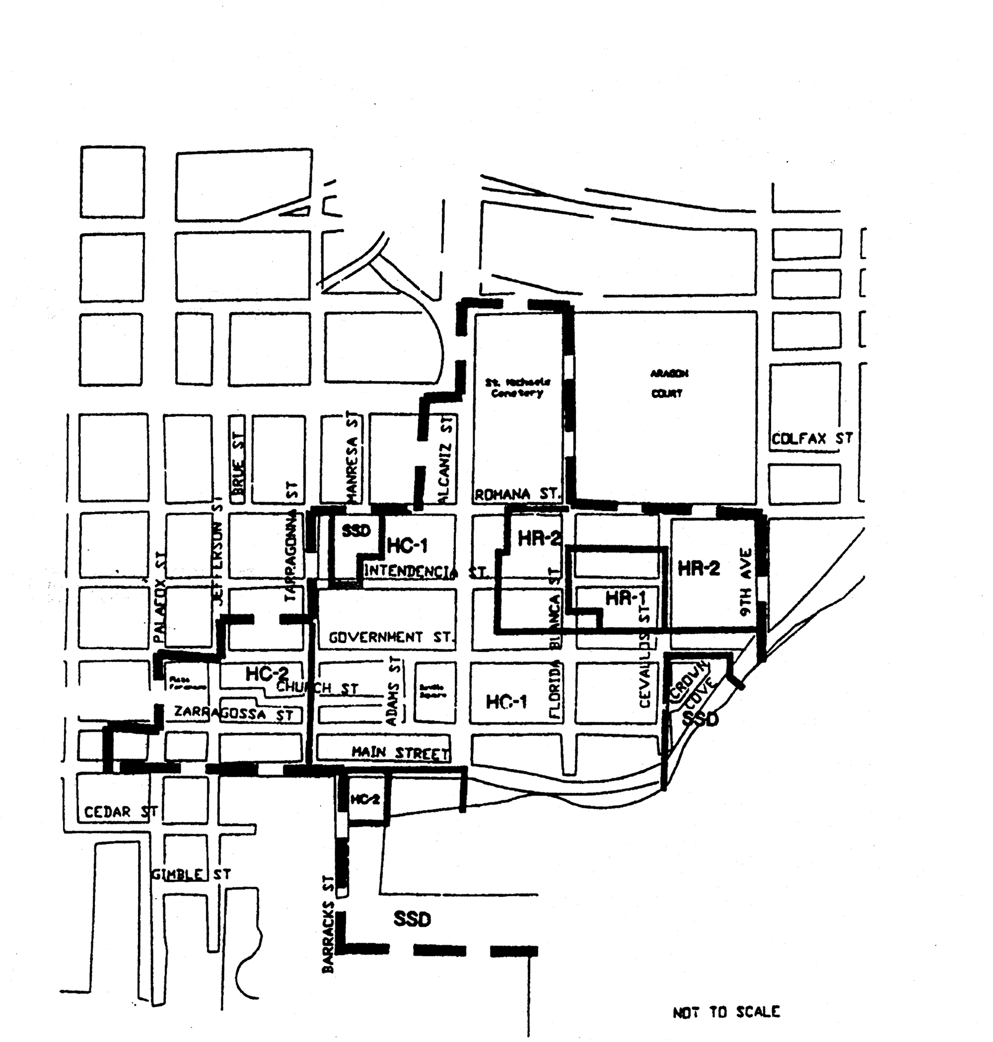
The regulations in this section shall be applicable to the Pensacola historic district, the North Hill preservation district and the Old East Hill preservation district: HR-1, HR-2, HC-1, HC-2, PR-1AAA, PR-2, PC-1, OEHR-2, OEHC-1, OEHC-2 and OEHC-3.
(1)
Historic zoning districts: HR-1, HR-2, HC-1 and HC-2.
a.
Purpose. The historic zoning districts are established to preserve the development pattern and distinctive architectural character of the district through the restoration of existing buildings and construction of compatible new buildings. The official listing of the Pensacola historic district (which includes all areas designated as historic zoning districts) on the National Register of Historic Places and the authority of the architectural review board reinforce this special character. Zoning regulations are intended to ensure that future development is compatible with and enhances the pedestrian scale of the existing structures and period architectural character of the districts.
b.
Character of the district. The historic district is characterized by lots with narrow street frontage (based on the original British city plan, c. 1765), and the concentration of Frame Vernacular, Folk Victorian and Creole homes which date from the early 19th Century and form a consistent architectural edge along the street grid. These buildings and historic sites and their period architecture make the district unique and worthy of continuing preservation efforts. The district is an established business area, residential neighborhood and tourist attraction, containing historic sites and museums, a variety of specialty retail shops, restaurants, small offices, and residences.
c.
Uses permitted.
1.
HR-1, one- and two-family.
i.
Single-family and two-family (duplex) dwellings.
ii.
Libraries, community centers and buildings used exclusively by the federal, state, county or city government for public purposes.
iii.
Churches, Sunday school buildings and parish houses.
iv.
Home occupations allowing: not more than 60 percent of the floor area of the total buildings on the lot to be used for a home occupation; retail sales shall be allowed, limited to uses listed as conditional uses in subsection (1)c.2.vi of this section; two nonfamily members shall be allowed as employees in the home occupation; and a sign for the business not to exceed three square feet shall be allowed.
v.
Publicly owned or operated parks and playgrounds.
vi.
Community residential homes licensed by the state department of health and rehabilitative services with six or fewer residents providing that it is not to be located within 1,000 feet of another such home. If it is proposed to be within 1,000 feet of another such home, measured from property line to property line, it shall be permitted with city council approval after public notification of property owners in a 500-foot radius.
vii.
Bed and breakfast subject to regulations in section 12-3-84.
viii.
Conditional uses permitted:
(a)
Single-family attached dwellings (townhouses).
(b)
Multiple-family dwellings.
ix.
Accessory buildings and uses customarily incidental to any of the above uses, including storage garages, when located on the same lot and not involving the conduct of business.
x.
Family day care homes licensed by the state department of children and family Services as defined in state statutes.
2.
HR-2, multiple-family and office.
i.
Any use permitted in the HR-1 district, including conditional uses.
ii.
Boarding and lodging houses.
iii.
Offices under 5,000 square feet.
iv.
Community residential homes licensed by the state department of health and rehabilitative services with seven to 14 residents providing that it is not to be located within 1,200 feet of another such home in a multifamily district, and that the home is not within 500 feet of a single-family zoning district. If it is proposed to be within 1,200 feet of another such home in a multifamily district, measured from property line to property line, and/or within 500 feet of a single-family zoning district, measured from property line to district line, it shall be permitted with city council approval after public notification of property owners in a 500-foot radius.
v.
Child care facilities subject to regulations in section 12-3-87.
vi.
Conditional use permitted:
The following uses limited to a maximum area of 3,000 square feet:
(a)
Antique shops.
(b)
Bakeries whose products are sold at retail and only on the premises.
(c)
Grocery stores.
(d)
Barbershops and beauty parlors.
(e)
Laundromats, including dry-cleaning pick-up stations.
(f)
Clothing and fabric shops.
(g)
Studios.
(h)
Vending machines when an accessory to a business establishment and located in the same building as the business.
(i)
Small appliance repair shops.
(j)
Floral gardens and shops.
(k)
Hand craft shops for custom work or making custom items not involving noise, odor, or chemical waste.
(l)
Secondhand stores.
(m)
Specialty shops.
vii.
Accessory buildings and uses customarily incidental to any of the above uses, including storage garages, when located on the same lot.
3.
HC-1, historical commercial district.
i.
Any use permitted in the HR-2 district, including the conditional uses, with no size limitations.
ii.
Small appliance repair shops.
iii.
Marinas.
iv.
Restaurants (except drive-ins).
v.
Motels.
vi.
Commercial parking lots.
vii.
Accessory buildings and uses customarily incidental to any of the above uses, including storage garages, when located on the same lot.
4.
HC-2, historical commercial district.
i.
Any use permitted in the HC-1district.
ii.
Private clubs and lodges except those operated as commercial enterprises.
iii.
Health clubs, spas and exercise centers.
iv.
Tavern, lounges, nightclubs, cocktail bars.
v.
Accessory buildings and uses customarily incidental to any of the above uses, including storage garages, when located on the same lot.
vi.
Adult entertainment establishments subject to the requirements of chapter 7-3 when located within the dense business area as defined in chapter 12-13, Definitions.
d.
Procedure for review.
1.
Review and approval by the architectural review board. All activities regulated by this subsection shall be subject to review and approval by the architectural review board as established in section 12-12-3. The board shall adopt written rules and procedures for abbreviated review for paint colors, minor repairs and minor deviations in projects already approved by the board. This process may authorize the board to designate one of its members to undertake such abbreviated review without the necessity for review by the entire board; provided, however, such abbreviated review process shall require review by the staff of West Florida Historic Preservation, Inc. If agreement cannot be reached as it pertains to such request for abbreviated review by the board designee and West Florida Historic Preservation, Inc. staff, then the matter will be referred to the entire board for a decision.
2.
Decisions.
i.
General consideration. The board shall consider plans for existing buildings based on their classification as contributing, non-contributing or modern infill as depicted on the map entitled "Pensacola Historic District" adopted herein, and shall review these plans based on regulations described herein for each of these building classifications. In their review of plans for both existing buildings and new construction, the board shall consider exterior design and appearance of the building, including the front, sides, rear and roof; materials, textures and colors; plot plans or site layout, including features such as walls, walks, terraces, off-street paved areas, plantings, accessory buildings, signs and other appurtenances; and relation of the building to immediate surroundings and to the district in which it is located or to be located. The term "exterior" shall be deemed to include all of the outer surfaces of the building and exterior site work, including painting, and is not restricted to those exteriors visible from a public street or place. The board shall consider requests for design materials, alterations or additions, construction methods, paint colors or any other elements regulated herein, which do not meet the regulations as established in this subsection, when documentary proof in the form of photographs, property surveys, indication of structural foundations, drawings, descriptive essays and similar evidence can be provided. The board shall not consider interior design or plan. The board shall not exercise any control over land use or construction standards such as are controlled by this chapter.
ii.
Rules governing decisions. Before approving the plans for any proposed building located or to be located in a district, the board shall find:
(a)
In the case of a proposed alteration or addition to an existing building, that such alteration or addition will not impair the architectural or historic value of the building.
(b)
In the case of a proposed new building, that such building will not, in itself or by reason of its location on the site, impair the architectural or historic value of buildings on adjacent sites or in the immediate vicinity. No plans for new building will be approved if that building will be injurious to the general visual character of the district in which it is to be located considering visual compatibility standards such as height, proportion, shape, scale, style, materials and colors.
iii.
No provision of this section shall be interpreted to prevent the restoration or reconstruction of any historic building or feature (as listed by the Historic Pensacola Preservation Board) in its original style, dimensions or position on its original structural foundation.
3.
Plan submission. Every activity that requires plans in order to erect, construct, demolish, renovate or alter an exterior of a building, sign or exterior site work, located or to be located in the historic zoning districts shall be accompanied with drawings or sketches. All drawings must be drawn to scale and be legible. The minimum size scale for site plans is 1″ = 30′0″; the minimum scale for floor plans is 1/8″ = 1′0″; and the minimum scale for exterior elevations is 1/8″ = 1′0″. The scale for other items, such as signs and details, shall be as large as necessary to fully define the detail of those items. Major projects with very large buildings may vary from the scale referenced above for ease of presentation.
i.
Site plan.
(a)
Indicate overall property dimensions and building size and location on the property.
(b)
Indicate relationship of adjacent buildings, if any.
(c)
Indicate layout of all driveways and parking on the site.
(d)
Indicate all fences, and signs with dimensions as required to show exact locations.
(e)
Indicate existing trees and existing and new landscaping.
ii.
Floor plan.
(a)
Indicate locations and sizes of all exterior doors and windows.
(b)
Indicate all porches, steps, ramps and handrails.
(c)
For renovations or additions to existing buildings, indicate all existing conditions and features as well as the revised conditions and features and the relationship of both.
iii.
Exterior elevations.
(a)
Indicate all four elevations of the exterior of the building.
(b)
Indicate the relationship of this project to adjacent structures, if any.
(c)
Indicate exposed foundation walls, including the type of material, screening, dimensions, and architectural elements.
(d)
Indicate exterior wall materials, including type of materials, dimensions, architectural elements and color.
(e)
Indicate exterior windows and doors, including type, style, dimensions, materials, architectural elements, trim, and colors.
(f)
Indicate all porches, steps, and ramps, including type of materials, dimensions, architectural elements and color.
(g)
Indicate all porch, stair, and ramp railings, including type of material, dimensions, architectural elements, trim, and color.
(h)
Indicate roofs, including type of material, dimensions, architectural elements, associated trims and flashing, and color.
(i)
Indicate all signs, whether they are built mounted or freestanding, including material, style, architectural elements, size and type of letters, and color. The signs must be drawn to scale in accurate relationship to the building and the site.
iv.
Miscellaneous.
(a)
Show enlarged details of any special features of either the building or the site that cannot be clearly depicted in any of the above-referenced drawings.
4.
Submission of photographs.
i.
Renovations/additions to existing buildings.
(a)
Provide at least four overall photographs per building so that all sides are clearly shown. In addition, photographs depicting the "streetscape" — that is, the immediate vicinity and all adjacent buildings — should be supplied.
(b)
If doors and/or windows are to be modified, provide a photograph of each door to be changed and at least one representative photograph of the type of window to be altered and replaced.
(c)
Provide any additional photographs as required to show specific details of any site or building conditions that will be altered or modified in any way by the proposed construction.
ii.
New construction.
(a)
Provide photographs of the site for the proposed new construction in sufficient quantity to indicate all existing site features, such as trees, fences, sidewalks, driveways, and topography.
(b)
Provide photographs of the adjoining "streetscape," including adjacent buildings to indicate the relationship of the new construction to these adjacent properties.
5.
Submission of descriptive product literature/brochures.
i.
Provide samples, photographs, or detailed, legible product literature on all windows, doors and shutters proposed for use in the project. The information must be sufficiently detailed to show style, dimensions, detailing, material type, and color.
ii.
Provide descriptive literature, samples, or photographs showing specific detailed information about signs and letters, if necessary to augment or clarify information shown on the drawings. The information must be sufficiently detailed to show style, dimensions, detailing, material type, and color.
iii.
Provide samples or descriptive literature on roofing material and trip to augment the information on the drawings. The information must indicate dimensions, details, material, color and style.
iv.
Provide samples or literature on any exterior light fixtures or other exterior ornamental features, such as wrought iron, railings, columns, posts, balusters, and newels. Indicate size, style, material, detailing and color.
6.
Conceptual approval is permitted by the board only when the applicant specifies on their application that is the approval they are seeking. Conceptual approval applications shall be complete with the exception of final details such as material and color selections. Conceptual approval by the board does not permit the issuance of a building permit.
e.
Regulations and guidelines for any development within the historic zoning districts. These regulations and guidelines are intended to address the design and construction of elements common to any development within the historic district that requires review and approval by the architectural review board. Regulations and guidelines which relate specifically to new construction and/or structural rehabilitation and repair to existing buildings, applicable to building heights, setbacks, architectural elements and construction types, are established in subsections (1)f through h of this section. Illustrations, photographs and descriptive examples of many of the design elements described in this subsection can be found in the document prepared by the Florida Northwest Chapter of the American Institute of Architects entitled "Seville Historic District Guideline Study."
1.
Building height limit. No building shall exceed the following height limit established by zone: HR-1 (one- and two-family), HR-2 (multiple-family), HC-1 (historic commercial), HC-2 (historic commercial)— 35 feet.
i.
Bayfront Parkway setback/height requirement. The following height/setback requirement shall be observed along Bayfront Parkway between Tarragona Street and 9th Avenue (setback distance measured from northern right-of-way line) to create a scenic open space image along the parkway.
2.
Protection of trees. It is the intent of this section to recognize the contribution of shade trees and certain flowering trees to the overall character of the historic zoning districts and to ensure the preservation of such trees as described below:
i.
Any of the following "specimen tree" species having a minimum trunk diameter of eight inches (25.1 inches in circumference) at a height of one foot above grade: Live Oak, Water Oak, Pecan, and Magnolia having a minimum trunk diameter of six inches (18.8 inches in circumference) at a height of one foot above grade; and
ii.
Any of the following flowering trees with a minimum trunk diameter of four inches (12.55 inches in circumference) at a height of one foot above grade: Redbud, Dogwood, and Crape Myrtle.
No person, organization, society, association or corporation, or any agent or representative thereof, directly or indirectly, shall cut down, destroy, undertake tree removal, or effectively destroy through damaging, any specimen or flowering tree, whether it be on private property or right-of-way within the district, without first having obtained a permit from the city to do so. Refer to section 12-6-7 for tree removal permit application procedures and guidelines.
3.
Fences. The majority of original fences in the historic district were constructed of wood with a paint finish in many varying ornamental designs. To a lesser extent, fences may have been constructed of brick or wrought iron. The style of the fence and the materials used typically related directly to the style and type of materials used for the building on the property.
All developments in the historic zoning districts shall comply with fence regulations as established in section 12-3-63(a) through (d), applicable to maximum heights permitted. In addition, the following provisions apply:
i.
Chain-link, concrete block and barbed wire are prohibited fence materials in the historic district. Approved materials will include, but not necessarily be limited to, wood, brick, stone and wrought iron.
ii.
All wood or wrought iron fences shall be painted if the principal building is painted. Wood fences shall be constructed utilizing one of a variety of "picket" designs, especially a design that will reflect details similar to those on the building. It is recommended that the use of wrought iron or brick fences be constructed in conjunction with buildings that use masonry materials in their construction.
4.
Signs. Those few signs that may have originally been used in the historic district, including those which were used in the commercial areas, were typically smaller in scale than many signs in current use. Ordinarily, their style was complementary to the style of the building on the property. The support structure and trim work on a sign was typically ornamental, as well as functional.
Refer to sections 12-5-2 and 12-5-3 for general sign standards and criteria and for a description of sign area calculations. In addition to the prohibited signs listed below, all signs listed in section 12-5-7 are prohibited within the historic district. The design, color scheme and materials of all signs shall be subject to approval by the architectural review board. All official signs within the district will be authorized, created, erected and maintained by the city or the Historic Pensacola Preservation Board using as their guide the document entitled "A Uniform System for Official Signs in the Seville Square Historical District." This document also includes recommendations for and descriptive drawings of commercial signs appropriate to the district.
i.
Permitted signs.
(a)
Temporary accessory signs.
(1)
One non-illuminated sign advertising the sale, lease, or rental of the lot or building, said sign not exceeding six square feet in area.
(2)
One non-illuminated sign not more than 50 square feet in area in connection with new construction work and displayed only during such time as the actual construction work is in progress.
(b)
Permanent accessory signs.
(1)
One sign per lot per street frontage for churches, schools, apartment buildings, boarding or lodging houses, libraries, community centers, commercial buildings (including retail and office buildings) or historic sites serving as identification and/or bulletin boards not to exceed 12 square feet in area and having a maximum height of eight feet; provided, however, that signs projecting from a building or extending over public property shall maintain a clear height of nine feet six inches above the public property and shall not exceed a height of 12 feet six inches. The sign may be mounted to the face of a wall of the building, hung from a bracket that is mounted to a wall of a building, hung from other ornamental elements on the building, or may be freestanding. Attached or wall signs may be placed on the front or one side of the building. The sign may be illuminated provided the source of light is not visible beyond the property line of the lot on which the sign is located.
(2)
One non-illuminated nameplate designating the name of the occupant of the property; the nameplate shall not be larger than three square feet and shall be attached flat against the wall of the building.
(3)
Municipal or state installed directional signs, historical markers and other signs of a general public interest when approved by the mayor and board.
ii.
Prohibited signs.
(a)
Any sign using plastic materials for lettering or background.
(b)
Internally illuminated signs.
(c)
Portable signs.
(d)
Nonaccessory signs.
5.
Screening. The following uses must be screened from adjoining property and from public view with fencing and/or landscaping or a combination of the two approved by the board:
i.
Parking lots.
ii.
Dumpsters or trash handling areas.
iii.
Service entrances or utility facilities.
iv.
Loading docks or spaces.
6.
Landscaping. Within the original historic district development, the majority of each site not covered by a building was typically planted in trees, shrubbery or ground cover. No formal landscape style has been found to predominate in the district. The following regulations apply for landscaping:
i.
Within the front yard setback the use of grass, ground cover or shrubs is required and trees are encouraged in all areas not covered by a drive or walkway.
ii.
The use of brick or concrete pavers set on sand may be allowed in the front yard in addition to drives or walkways, with board approval based on the need and suitability of such pavement.
7.
Driveways, sidewalks and off-street parking. Original driveways in the historic district were probably unimproved or sidewalks were typically constructed of brick, cobblestones or small concrete pavers using two different colors laid at diagonals in an alternating fashion. Parking lots were not a common facility in the historic district. The following regulations and guidelines apply to driveways, sidewalks and parking lots in the historic district:
i.
Driveways. Unless otherwise approved by the board, each building site shall be allowed one driveway, standard concrete ribbons, or access drive to a parking lot. No new driveways or access drives to parking lots may be permitted directly from Bayfront Parkway to any development where alternative access from the inland street grid is available.
(a)
Where asphalt or concrete is used as a driveway material, the use of an appropriate coloring agent is required.
(b)
From the street pavement edge to the building setback the only materials allowed shall be shell, brick, concrete pavers, colored asphalt and approved stamped concrete or #57 granite or marble chips.
ii.
Sidewalks. Construction, repair and maintenance of sidewalks are all required on public rights-of-way within the district. Sidewalks shall be constructed of the following materials or combination of materials and approved by the board:
(a)
Brick pavers;
(b)
Concrete pavers;
(c)
Poured concrete stamped with an ornamental pattern and colored with a coloring agent;
(d)
A combination of concrete with brick or concrete paver bands along the edges of the sidewalk. This combination may also include transverse brick or concrete paver bands spaced at regular intervals.
Walkways shall be provided from the street side sidewalk to the front entrance as approved by the board.
iii.
Off-street parking. Off-street parking is not required in the HC-1 and HC-2 zoning districts. Because parking lots have not been a common land use in the district, their location is encouraged behind the structures which they serve.
(a)
Parking lots shall be screened from view of adjacent property and the street by fencing, landscaping or a combination of the two approved by the board.
(b)
Materials for parking lots shall be concrete, concrete or brick pavers, asphalt, oyster shells, clam shells or #57 granite or marble chips. Where asphalt or concrete are used, the use of a coloring agent is required. The use of acceptable stamped patterns on poured concrete is also encouraged.
8.
Paint colors. The architectural review board has adopted palettes of historic colors from several paint manufacturers that represent acceptable historic colors for use in the historic district. Samples of these palettes can be reviewed at the Historic Pensacola Preservation Board and at the office of the building inspector.
9.
Residential accessory structures. Residential accessory structures shall comply with regulations set forth in section 12-3-55 except that the following shall apply: Accessory structures shall not exceed one story in height for a maximum in height of 25 feet in order for the accessory structure to match the style, roof pitch, or other design features of the main residential structure.
10.
Additional regulations. In addition to the regulations established above in subsections (1)e.1 through 9 of this section, any permitted use within the historic district where alcoholic beverages are ordinarily sold is subject to the requirements of chapter 7-4.
f.
Restoration, rehabilitation, alterations or additions to existing contributing structures in the historic district. The Secretary of the Interior's standards for rehabilitation, codified at 37 CFR 67, and the related guidelines for rehabilitating historic buildings shall form the basis for rehabilitation of existing contributing structures. The following regulations and guidelines for specific building elements are intended to further refine some of the general recommendations found in the Department of the Interior's document to reflect local conditions in the rehabilitation of structures. In the case of a conflict between the Department of the Interior's publication and the regulations set forth herein, the more restrictive shall apply. The "Seville Historic District Guideline Study" describes the building styles that are typical in the historic district. This definition of styles should be consulted to ensure that the proper elements are used in combination in lieu of combining elements that, although they may be typical to the district, are not appropriate for use together on the same building.
For all of the following elements, the documented building materials, types, styles and construction methods shall be duplicated when making repairs, alterations and/or additions to contributing structures. Any variance from the original materials, styles, etc., shall be approved only if circumstances unique to each project are found to warrant such variances. The following regulations and guidelines shall apply to renovations, repairs and alterations to contributing structures which may or may not have documentary proof of the original elements and to alterations or additions to a contributing structure which seek to reflect the original elements.
1.
Exterior lighting. Exterior lighting in the district in its original development typically consisted of post-mounted street lights and building-mounted lights adjacent to entryways. Occasionally, post lights were used adjacent to the entry sidewalks to buildings. Lamps were typically ornamental in design with glass lenses and were mounted on ornamental cast iron or wooden posts.
i.
Exterior lighting fixtures shall be in a design typical to the district in a pre-1925 Era. They shall be constructed of brass, copper, or painted steel and have clear lenses.
ii.
If exterior lighting is detached from the building, the fixtures shall be post-mounted and used adjacent to sidewalk or driveway entrances or around parking lots. If post-mounted lights are used, they shall not exceed 12 feet in height.
iii.
The light element itself shall be a true gas lamp or shall be electrically operated using incandescent or high pressure sodium lamps. Fluorescent and mercury vapor lamps are prohibited.
iv.
The use of pole mounted high pressure sodium utility/security lights is discouraged. If absolutely necessary, they will be considered, but only in the rear portions of the property.
2.
Exterior walls. The two building materials basic to the historic district are clapboard style wood siding and brick masonry, the former being most prevalent. In general, the wood siding is associated with the residential-type buildings and the brick masonry is associated with more commercially-oriented buildings. Brick is used in predominantly wooden structures only for foundation piers and for fireplaces and chimneys.
i.
Vinyl or metal siding is prohibited.
ii.
Wood siding and trim shall be finished with paint, utilizing colors approved by the board. If documentary evidence is submitted showing that the original structure was unpainted, the board may not require a paint finish unless the condition of the wood warrants its use.
iii.
Foundation piers shall be exposed brick masonry or sand textured plaster over masonry. If infill between piers was original then it must be duplicated. It is encouraged that infill of wood lattice panels is utilized.
3.
Roofs. The gable roof is the most typical in the historic district. On shotgun house types or buildings placed on narrow deep lots the gable-end is usually oriented toward the street. On the creole type houses or buildings having larger street frontages the gable-end is typically oriented towards the side yard. Some hip roofs are found in newer, typically larger than average buildings. Dormers are found typically in association with the creole type houses. The roof slope is at least six on 12, but can be found to slope as much as 12 on 12. Roofing materials typically consisted of wood shingles, tin and corrugated metal panels.
i.
The combination of varying roof styles or shapes on a single building is prohibited. The only exception to this is when a three-sided hip roof is used over a porch on the front of a gable roofed building.
ii.
In order to protect the architectural integrity of the district and structure, roof materials original to each structure should be used. Alternatives to the materials may be considered on a case-by-case basis, but shall match the scale, texture, and coloration of the historic roofing material. Unless original to the structure, the following materials shall be prohibited: less than 30-year fiberglass or asphalt dimensional shingles, rolled roofing, and metal shingles. Thirty-year or 40-year dimensional shingles may be permitted. Provided, however, existing flat-roofed commercial structures may retain the same style roof and continue to use built-up or single-ply roofing.
iii.
Eave metal and flashing shall be naturally weathered copper or galvanized steel, or may be painted.
iv.
Gutters and downspouts are discouraged within the district except on brick commercial buildings.
4.
Porches. The porch, consisting of raised floor platform, sheltering roof, supporting columns, handrails and balustrade, and connecting steps is typical to wood structures in the district.
i.
Porches are required in any renovation or alteration of a contributing structure that originally had a porch, and are encouraged as additions when the style of the building will allow it.
ii.
The original materials, method of construction and style of building elements shall be duplicated when making repairs, alterations or additions to existing porches.
iii.
The size and design of all porch elements, i.e., the flooring, the columns, the handrails, the pickets, the roof beam, the floor support piers, and any other ornamentation shall be consistent with any one single style that is typical to the district. The elements shall maintain proper historical scale, dimensions and detailing.
5.
Doors. Entrance doors made up of a solid wood frame, with an infill of raised wood panels below and glazed panels above, are historically correct for the district. Single doorways with a glazed transom above allowed for both light and ventilation to enter the entrance way or entrance foyer of the building. Double doors were usually associated with a larger home or building layout.
The placement of the doorway was not necessarily in the center of the front wall; in fact, it was usually off to one side in most cases, specifically in the shotgun house types. The larger creole cottage, and French creole house type, normally had the front door centered, leading to a center hallway or stair hall.
i.
Doors are to be fabricated of solid wood, with three horizontal rails and two vertical stiles. The lower infill panels shall be constructed of wood and shall be located below the locking device with glazed panels located above the locking device. The top of the upper glazed panels can be semi-circular/half rounded. Beveled glass is encouraged.
ii.
Panel infill may vary slightly from that noted in subsection (1)f.5.i of this section, but usually shall not exceed six panels. Variations must be approved by the architectural review board.
iii.
Trim or casing shall be used on all doors and sidelights and shall typically range in width between five inches and eight inches.
6.
Windows. Traditionally the windows employed in the Seville Historic District were constructed of wood and were the double hung or triple hung type. The windows opening toward the front porch of the building usually were triple hung with the sill close to or almost flush with the adjacent floors. This allowed for optimum flow of air, and for passage to and from the exterior space. The other windows of the building had the normal placement of the window sill at approximately 30 inches above finished floor. Typical windows ranged in width from 32 to 36 inches and ranged in height from six to seven feet exclusive of trim dimensions. The taller windows, when double hung, frequently had the lower section greater in vertical dimension than the upper section, giving freer movement through to the adjacent porch or veranda.
i.
Windows are to be fabricated of wood and must, in the judgement of the architectural review board, closely approximate the scale and configuration of the original window designs.
ii.
The window proportions/dimensions will be decidedly vertical, following the historic appearance and character of those encountered throughout the district.
iii.
Window sections shall typically be divided into two to six panes, and in the usual double hung window, the layout of window panes will be six over six. All windows shall have true divided lites. Any variation to this division of the window opening shall be approved by the architectural review board.
iv.
The window frame will be given a paint finish appropriate to the color scheme of the exterior of the building.
v.
Window trim or casing is to be a nominal five-inch member at the two sides and the head.
vi.
Other than the full height windows at the front porch and smaller windows at kitchens and bathrooms, all remaining windows shall be proportioned with the height between two and 2½ times the width. The sill height for standard windows shall be approximately 30 inches above finished floor.
vii.
Glass for use in windows shall typically be clear, but a light tinted glass will be given consideration by the architectural review board.
7.
Shutters. Shutters are an exterior ornamental and functional architectural feature that have traditionally been used on windows, and occasionally, on doors within the historic district. On renovation projects to existing contributing structures, it is recommended that shutters not be installed unless they were original to the structure.
i.
If shutters are to be used on a project, they must be dimensioned to the proper size so that they would completely cover the window both in width and height if they were closed.
ii.
The shutters must be installed in a manner that will appear identical to an original operable installation. Shutters installed currently are not required to be operational, but rather can be fixed in place; however, they must be installed with some space between the back of the shutter and the exterior wall surface material and must overlap the door or window trim in a fashion identical to an original operable installation.
iii.
The style of the shutters must be louvered, flat vertical boards or panelled boards, with final determination being based on compatibility with the overall building design.
8.
Chimneys. Chimneys constructed of brick masonry, exposed or cement plastered, are typical to original construction in the district.
The chimney in the historic district is that necessary element usually serving back-to-back fireplaces, and as such, would not be located on the exterior wall of the building. Consequently, the appropriate location for chimneys would be projecting through some portion of the roof of the building, in lieu of being placed on an exterior wall.
i.
The chimney or chimneys are to be located within the slope of the roof, rather than being placed on an exterior wall, and shall extend above the roof ridge line.
ii.
The chimney or chimneys are to be constructed of masonry with the exposed surface to be brick or sand textured plaster. Rough texture stucco is prohibited.
iii.
The finished exposed surface of chimneys are to be left natural without any paint finish.
iv.
Flashing shall consist of galvanized steel, copper sheet metal or painted aluminum.
v.
The extent of simplicity or ornamentation shall be commensurate with the overall style and size of the building on which the chimney is constructed.
vi.
The use in contributing structures of prefabricated fireplaces with steel chimneys is prohibited.
9.
Trim and miscellaneous ornament. Most trim, except for window and door casings/trim, was used more for decorative than functional purposes. Trim and ornament was almost always constructed of wood, and was painted to match other elements (doors, windows, porches, etc.) of the building. Ornament on masonry buildings was typically limited to corbling or other decorative use of brick at window openings, door openings, columns, parapet walls and on major facades above the windows and doors.
i.
In renovation work, only that decorative trim or ornament historically significant to the specific building will be permitted.
ii.
The scale and profile/shape of existing ornament used within the district will dictate approval for all new proposals.
iii.
Trim and ornament, where used, is to be fabricated of wood.
iv.
Trim and ornament will be painted to match, or be coordinated with, door and window casings, porch railings, porch columns, and basic projecting elements of the building.
10.
Miscellaneous mechanical equipment.
i.
Air conditioning condensing units shall not be mounted on any roof where they are visible from any street.
ii.
Air conditioning condensing units that are mounted on the ground shall be in either side yards or rear yards. No equipment shall be installed in a front yard.
iii.
Visual screening consisting of ornamental fencing or landscaping shall be installed around all air conditioning condensing units to conceal them from view from any adjacent street or property owner.
v.
Exhaust fans or other building penetrations as may be required by other authorities shall be allowed to penetrate the wall or the roof but only in locations where they can be concealed from view from any street. No penetrations shall be allowed on the front of the building. They may be allowed on side walls if they are properly screened. It is desirable that any penetrations occur on rear walls or the rear side of roofs.
11.
Accessibility ramps and outdoor stairs.
i.
Whenever possible, accessibility ramps and outdoor stairways shall be located to the side or the rear of the property.
ii.
The design of accessibility ramps and outdoor stairs shall be consistent with the architectural style of the building.
iii.
Building elements, materials and construction methods shall be consistent with the existing structure.
g.
Renovation, alterations and additions to noncontributing and modern infill structures within the historic district. Many of the existing structures within the district do not meet the criteria established for contributing structures, even though they may be similar in style to the historic structures, and some structures are modern in style with no relation to the historic structures. All of these buildings shall be recognized as products of their own time. The regulations and guidelines established in subsection (1)e of this section, relating to streetscape elements, and paint colors described in subsection (1)f.3 of this section shall apply to noncontributing and modern infill structures. In review of these structures the board may make recommendations as to the use of particular building elements that will improve both the appearance of the individual structure, its relationship with surrounding structures and the overall district character.
h.
New construction in the historic district. This subsection does not intend to mandate construction of new buildings of historical design. New construction shall complement original historic buildings or shall be built in a manner that is complementary to the overall character of the district in scale, building materials, and colors.
For purposes of describing the scale and character required in new construction within the historic district, the district is herein subdivided into two general building style districts as shown on Map 12-3.1: the "residential" wood cottages district and the "commercial" brick structures district. Within the wood cottages district all new construction shall conform to the building types I and II (described herein) in scale, building materials and colors. Within the brick structures district all new construction shall conform to the building types I, II, or III (described herein) in scale, building materials and colors. The regulations for the two building style districts will establish building heights and setbacks and will illustrate relationships between the streetscape, the building and exterior architectural elements of the building. The streetscape element regulations established in subsection (1)e of this section are applicable to all new construction in the historic district, no matter what style building. If new construction is intended to match historical designs, then the building elements described in subsection (1)f.1 through 12 of this section should be utilized as guidelines. If it is to be a replica of a historic building, the building must be of a historic style characteristic of the Pensacola historic district.
1.
Figure 12-3.1 illustrates the scale and characteristics of building types I and II for the wood cottages district.
2.
Figure 12-3.2 illustrates the scale and characteristics of building type III for the brick structures district.
3.
Aragon subdivision Block "L" & "N" and lots within Privateer's Alley shall conform to section 12-3-12(2)e.10, GRD-1 Architectural Review Standards, with the exception of section 12-3-12(2)e.10.v, Doors. Exterior doors shall comply with subsection (1)f.5 of this section.
MAP 12-3-1-HISTORIC BUILDING
STYLE DISTRICTS
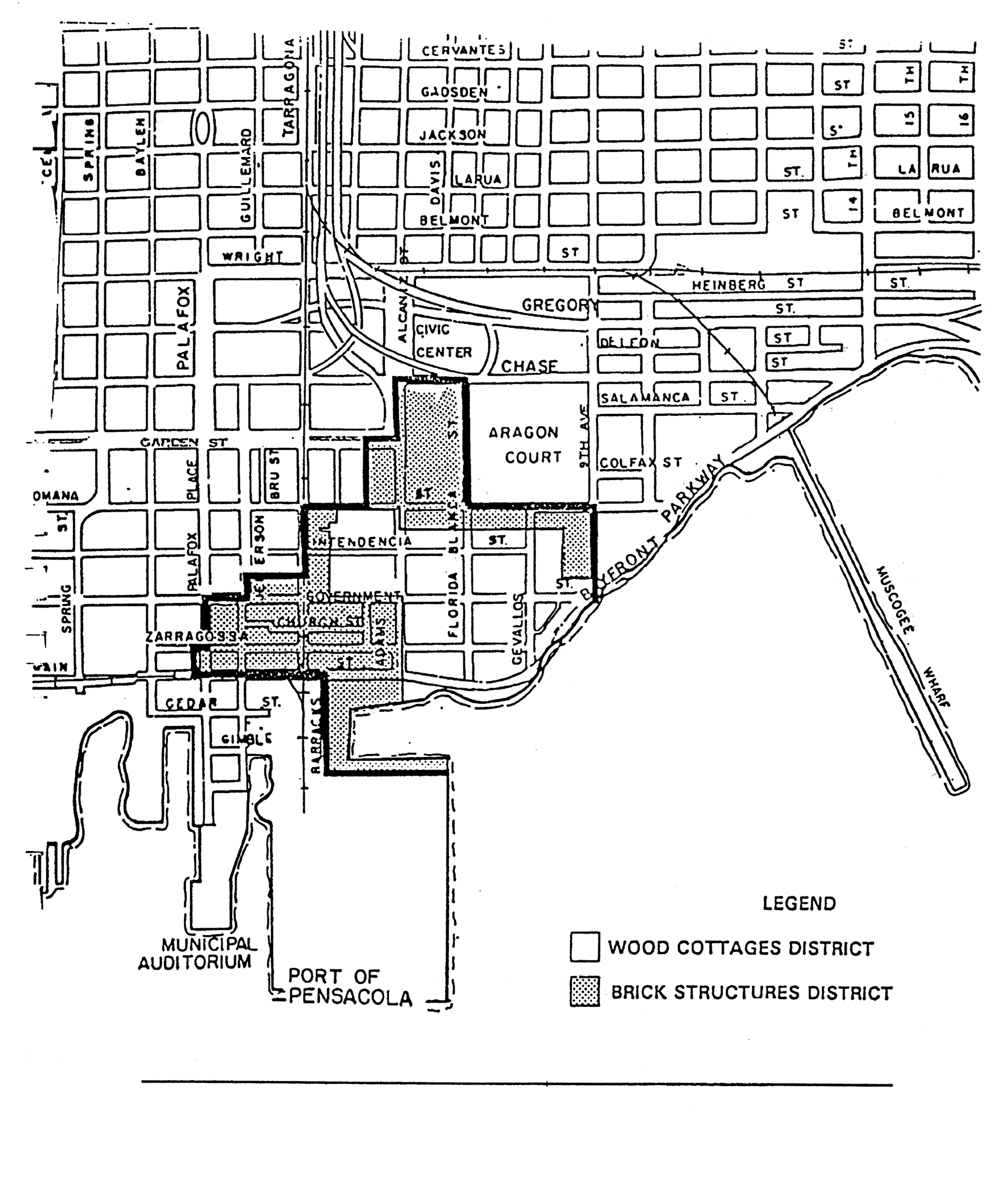
FIGURE 12-3.1. WOOD COTTAGES DISTRICT-STREETSCAPE, TYPE 1
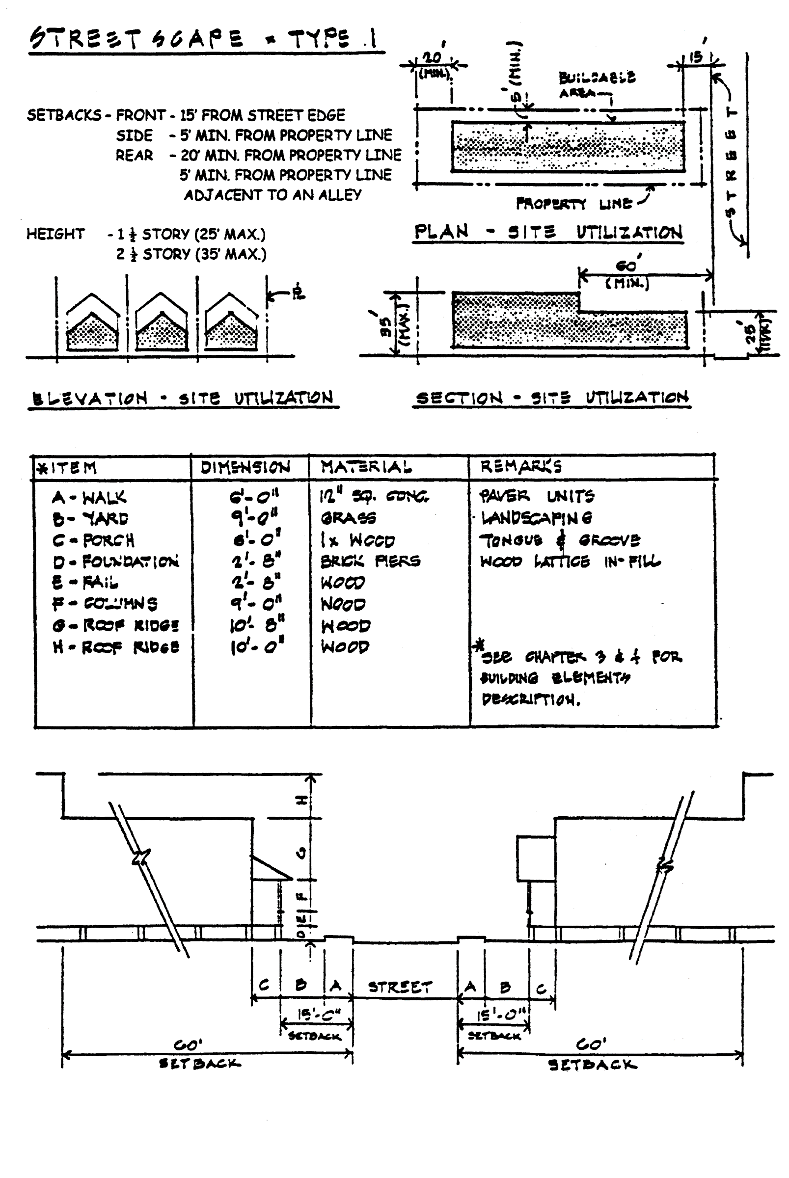
FIGURE 12-3.1. WOOD COTTAGES DISTRICT-STREETSCAPE, TYPE 1
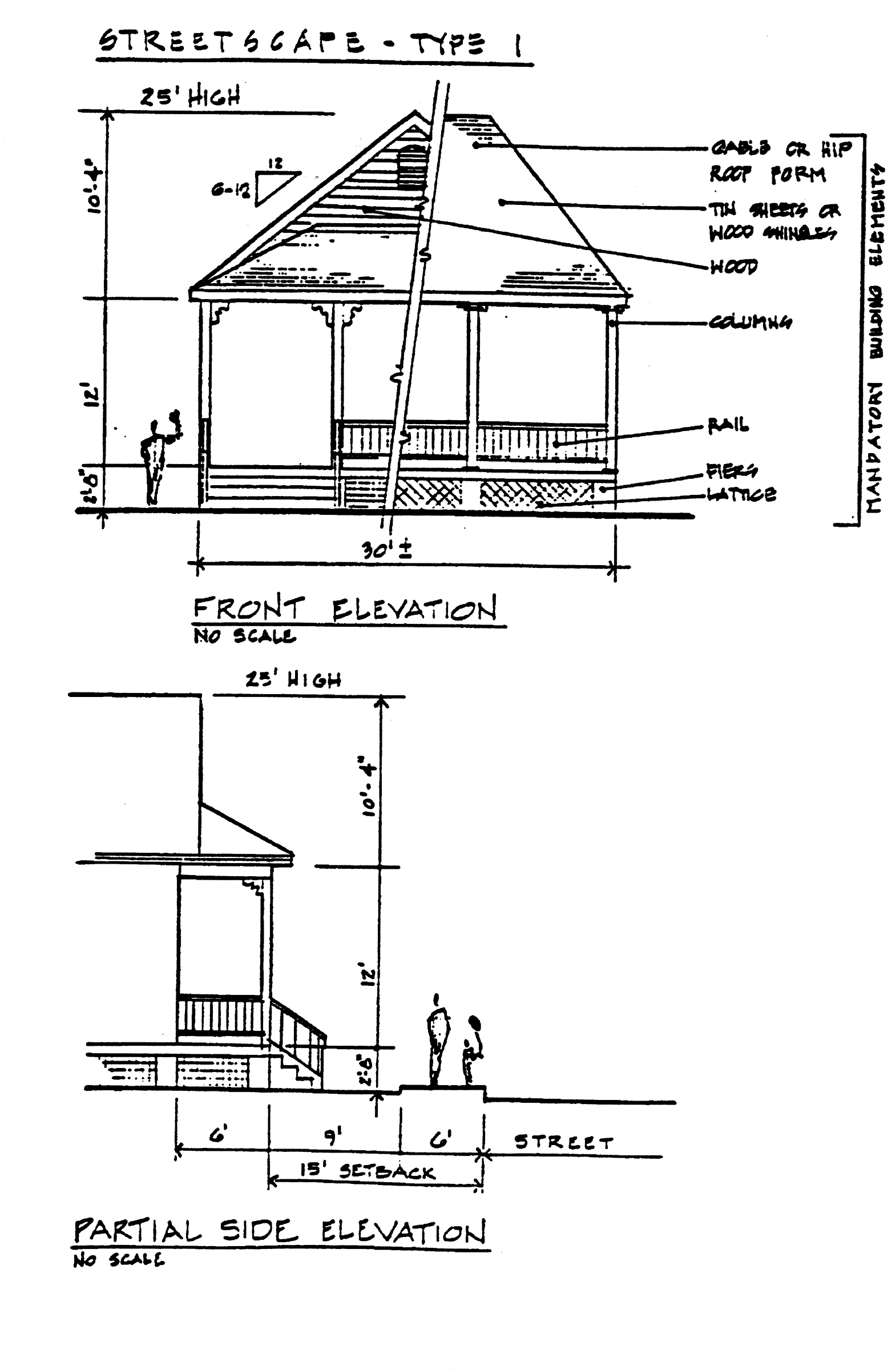
FIGURE 12-3.1. WOOD COTTAGES DISTRICT-STREETSCAPE, TYPE 2
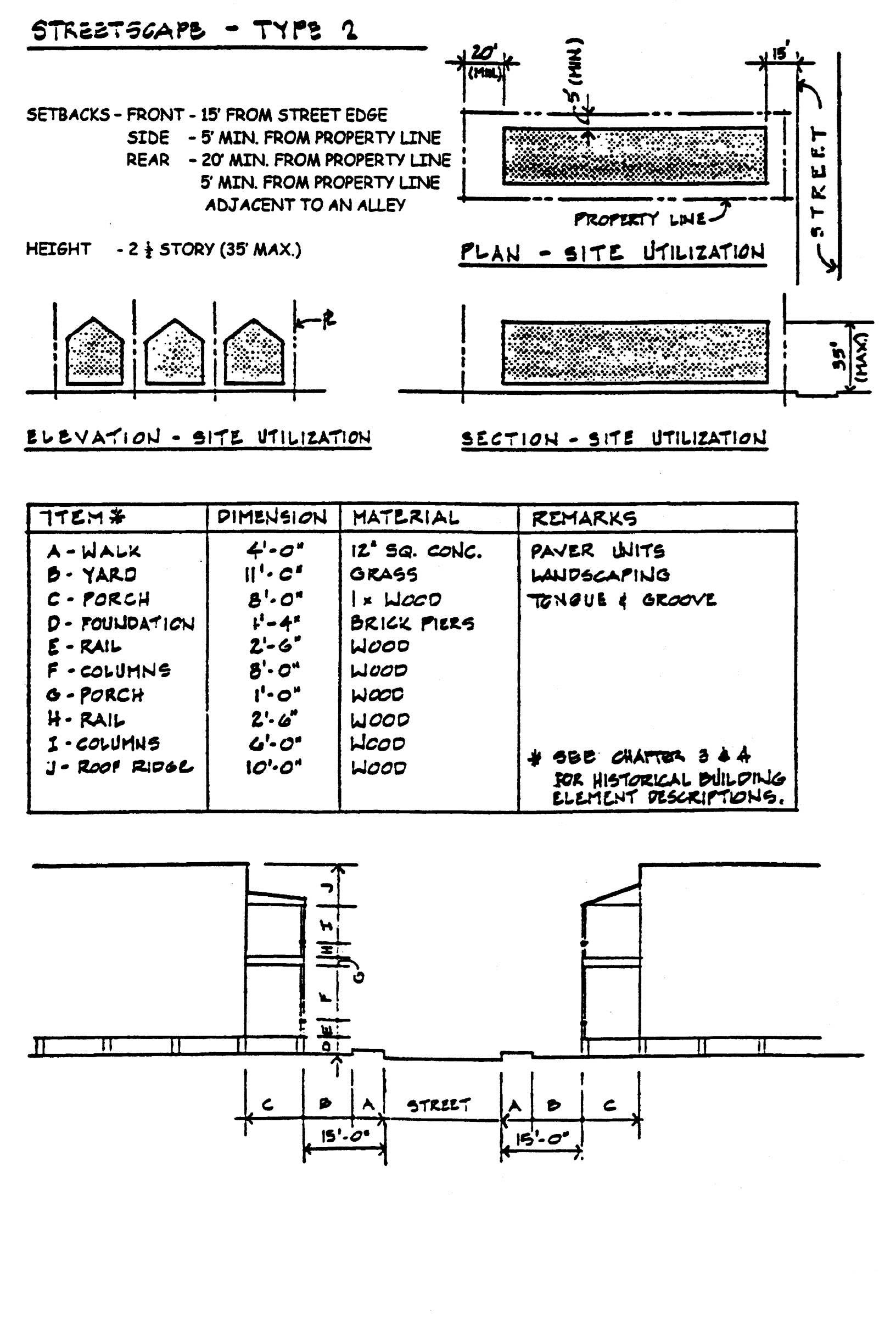
FIGURE 12-3.1. WOOD COTTAGES DISTRICT-STREETSCAPE, TYPE 2
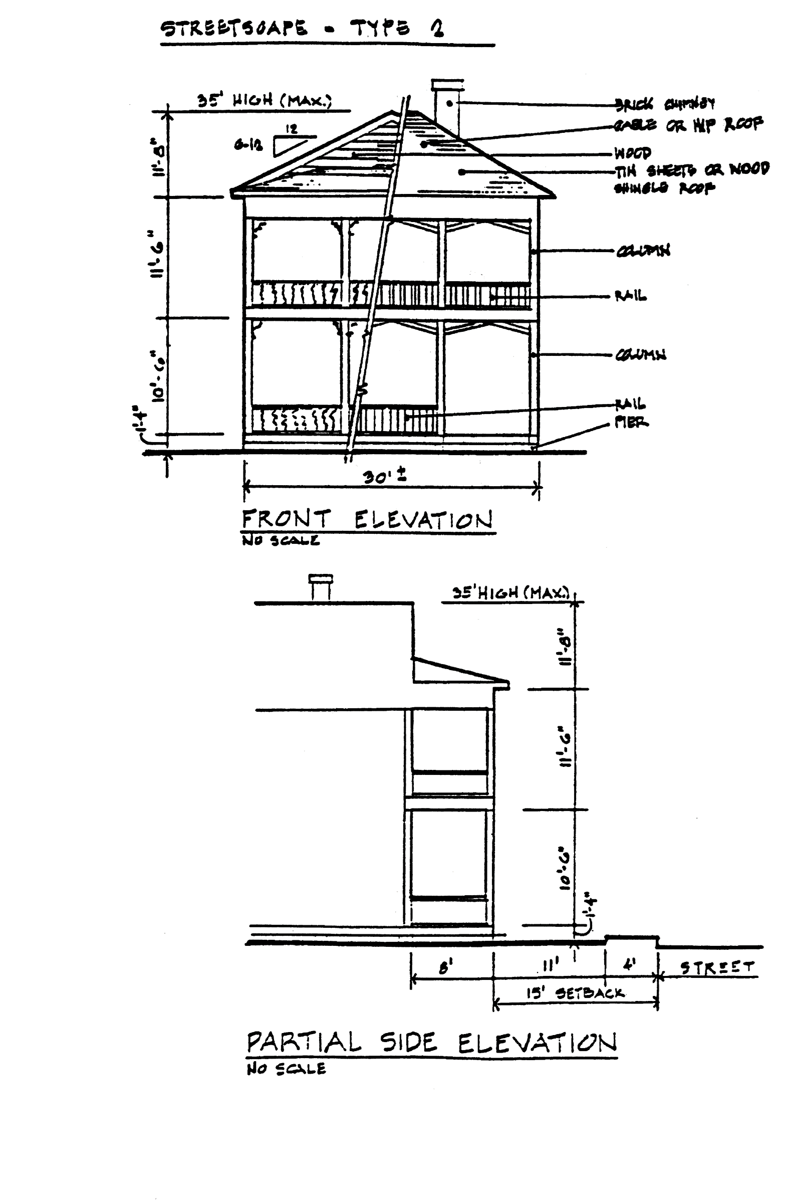
FIGURE 12-3.2. BRICK STRUCTURES DISTRICT-STREETSCAPE, TYPE 3
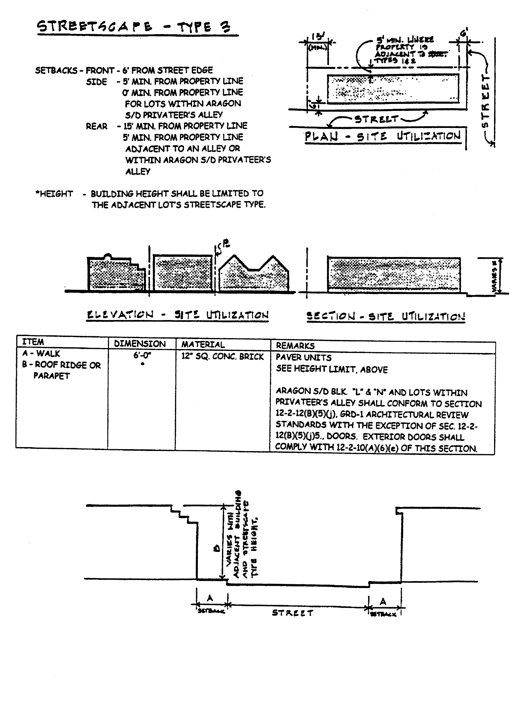
FIGURE 12-3.2. BRICK STRUCTURES DISTRICT-STREETSCAPE, TYPE 3
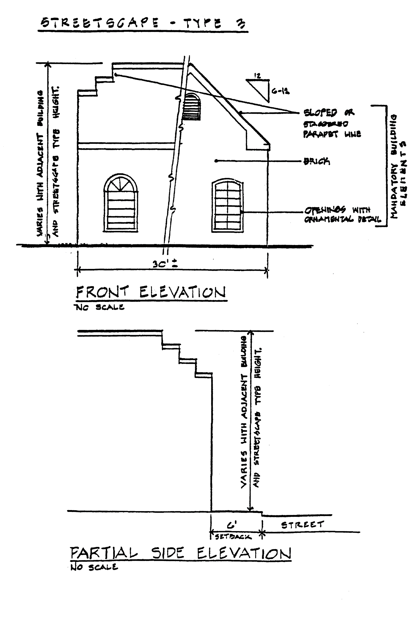
i.
Demolition of contributing structures. Demolition of a contributing structure constitutes an irreplaceable loss to the quality and character of the historic district and is strongly discouraged. Therefore, no permit shall be issued for demolition of a contributing structure unless the owner demonstrates to the board clear and convincing evidence of unreasonable hardship. Provided, however, nothing herein shall prohibit the demolition of a contributing structure if the building official determines that there is no reasonable alternative to demolition in order to bring the structure in compliance with the unsafe building code. When the owner fails to prove unreasonable economic hardship the applicant may provide to the board additional information that may show unusual and compelling circumstances in order to receive board recommendation for demolition of the contributing structure.
The board shall be guided in its decision by balancing the historic, architectural, cultural and/or archaeological value of the particular structure against the special merit of the proposed replacement project.
1.
Unreasonable economic hardship. When a claim of unreasonable economic hardship is made, the public benefits obtained from retaining the historic resource must be analyzed and duly considered by the board. The owner shall submit to the board for its recommendation the following information:
i.
For all property:
(a)
The assessed value of the land and improvements thereon according to the two most recent assessments;
(b)
Real estate taxes for the previous two years;
(c)
The date of purchase of the property or other means of acquisition of title, such as by gift or inheritance, and the party from whom purchased or otherwise acquired;
(d)
Annual debt service, if any, for the previous two years;
(e)
All appraisals obtained within the previous two years by the owner or applicant in connection with his or her purchase, financing or ownership of the property;
(f)
Any listing of the property for sale or rent, price asked and offers received, if any;
(g)
Any consideration by the owner as to profitable adaptive uses for the property;
(h)
Replacement construction plans for the contributing structure in question;
(i)
Financial proof of the ability to complete the replacement project which may include, but not be limited to, a performance bond, a letter of credit, a trust for completion of improvements, or a letter of commitment from a financial institution; and
(j)
The current fair market value of the property, as determined by at least two independent appraisals made by appraisers with competent credentials.
ii.
For income-producing property:
(a)
Annual gross income from the property for the previous two years;
(b)
Itemized operating and maintenance expenses for the previous two years, including proof that adequate and competent management procedures were followed;
(c)
Annual cash flow, if any, for the previous two years; and
(d)
Proof that efforts have been made by the owner to obtain a reasonable return on his or her investment based on previous service.
The applicant shall submit all necessary materials to the board at least 15 days prior to the board hearing in order that staff may review and comment and/or consult on the case. Staff and/or professional comments shall be forwarded to the board for consideration and review and made available to the applicant for consideration prior to the hearing.
The board may require that an applicant furnish such additional information that is relevant to its determination of unreasonable economic hardship and may require that such additional information be furnished under seal. The board or its agent may also furnish additional information as the board believes is relevant. The board shall also state which form of financial proof it deems relevant and necessary to a particular case.
In the event that any of the required information is not reasonably available to the applicant and cannot be obtained by the applicant, the applicant shall file with his or her affidavit a statement of the information that cannot be obtained and shall describe the reasons why such information cannot be obtained.
2.
Unusual and compelling circumstances and demolition of a contributing structure. When an applicant fails to prove economic hardship in the case of a contributing structure, the applicant may provide to the board additional information that may show unusual and compelling circumstances in order to receive board recommendation for demolition of the contributing structure. The board, using criteria set forth in this subsection, shall determine whether unusual and compelling circumstances exist and shall be guided in its recommendation in such instances by the following additional considerations:
i.
The historic or architectural significance of the structure;
ii.
The importance of the structure to the integrity of the historic district;
iii.
The difficulty or the impossibility of reproducing such a structure because of its design, texture, material, detail, or unique location;
iv.
Whether the structure is one of the last remaining examples of its kind in the historic district;
v.
Whether there are definite plans for reuse of the property if the proposed demolition is carried out and what effect such plans will have on the architectural, cultural, historical, archaeological, social, aesthetic, or environmental character of the surrounding area, as well as the economic impact of the new development; and
vi.
Whether reasonable measures can be taken to save the structure from further deterioration, collapse, arson, vandalism or neglect.
3.
Recommendation of demolition.
i.
Should the applicant for demolition of a contributing structure satisfy the board that he or she will suffer an economic hardship if a demolition permit is not recommended, or, if in failing to demonstrate economic hardship, the applicant demonstrates unusual and compelling circumstances that dictate demolition of the contributing structure, either a recommendation for demolition or a recommendation for a six-month moratorium on the demolition shall be made.
ii.
In the event that the board recommends a six-month moratorium on the demolition, within the moratorium period, the board shall consult with the Historic Pensacola Preservation Board, the city and any other applicable public or private agencies to ascertain whether any of these agencies or corporations can preserve or cause to be preserved such architectural or historically valuable buildings. If no agencies or organizations are prepared to preserve the buildings or cause their preservation, then the board shall recommend approval of the demolition.
iii.
Following recommendation for approval of demolition, the applicant must seek approval of replacement plans prior to receiving a demolition permit and other building permits. Replacement plans for this purpose shall include, but shall not be restricted to, project concept, preliminary elevations and site plans, and adequate working drawings for at least the foundation plan that will enable the applicant to receive a permit for foundation construction. The board may waive the requirements for replacement plans under extreme, unusual and compelling circumstances or public safety purposes.
iv.
Applicants that have received a recommendation for demolition shall be permitted to receive such demolition permit without additional board action on demolition, following the board's recommendation of a permit for new construction.
4.
Prevention of demolition by neglect.
i.
All contributing structures within the historic district shall be preserved against decay and deterioration and kept free from certain structural defects by the owner thereof or such other person who may have legal custody and control thereof. The owner or other person having such legal custody and control shall repair such building, object, site, or structure if it is found to have any of the following defects:
(a)
Deteriorated or inadequate foundation. Defective or deteriorated flooring or floor supports or flooring or floor supports of insufficient size to carry imposed loads with safety;
(b)
Members of walls, partitions or other vertical supports that split, lean, list or buckle due to defective material or deterioration. Members of walls, partitions or other vertical supports that are of insufficient size to carry imposed loads with safety;
(c)
Members of ceilings, roofs, ceiling and roof supports or other horizontal members that sag, split, or buckle due to defective materials or deterioration. Members of ceilings, roofs, ceiling and roof supports or other horizontal members that are of insufficient size to carry imposed loads with safety;
(d)
Fireplaces or chimneys that list, bulge or settle due to defective materials or deterioration. Fireplaces or chimneys that are of insufficient size or strength to carry imposed loads with safety;
(e)
Deteriorated or ineffective waterproofing of exterior walls, roofs, foundations or floors, including broken windows or doors. Defective protection or lack of weather protection for exterior wall coverings, including lack of paint, or weathering due to lack of paint or other protective covering. Any fault or defect in the building that renders same structurally unsafe or not properly watertight.
In addition, the owner or other person having legal custody and control of a historic landmark or a building, object, site, or structure located in a historic district shall keep all property, including vacant property, clear of all weeds, fallen trees or limbs, debris, abandoned vehicles, and all other refuse.
ii.
The board, on its own initiative, may file a petition with the building official requesting that he or she proceed to require correction of defects or repairs to any structure covered by subsection (1)i.4.i of this section so that such structure shall be preserved and protected in accordance with the purposes of this section and the public safety and housing ordinance.
j.
Other demolition permits.
1.
All applications for permits to demolish structures other than contributing structures shall be referred to the board for the purpose of determining whether or not the structure may have historical, cultural, architectural, or archaeological significance. Such determination shall be made in accordance with the criteria found in subsections (1)i.2.i through vi of this section.
2.
The board shall make such determination within 30 days after receipt of the completed application and shall notify the building official in writing. If the structure is determined to have no cultural, historical, architectural, or archaeological significance, a demolition permit may be issued immediately, provided such application otherwise complies with the provisions of all city code requirements.
3.
If said structure is determined by the board to have historical significance, the board shall make such information available to the preservation board for review and recommendation as to significance. If the board concurs in the significance, using criteria set forth in subsections (1)i.2.i through vi of this section, the board shall recommend to the city council that the structure be designated a contributing structure.
4.
Upon such a recommendation by the board, issuance of any permit shall be governed by subsection (1)i.3 of this section.
k.
Treatment of site following demolition. Following the demolition or removal of any buildings, objects or structures located in the historic district, the owner or other person having legal custody and control thereof shall:
1.
Remove all traces of previous construction, including foundation;
2.
Grade, level, sod and/or seed the lot to prevent erosion and improve drainage; and
3.
Repair at his or her own expense any damage to public rights-of-way, including sidewalks, curb and streets, that may have occurred in the course of removing the building, object, or structure and its appurtenances.
(2)
North Hill preservation zoning districts: PR-1AAA, PR-2, PC-1.
a.
Purpose. The North Hill preservation zoning districts are established to preserve the unique architecture and landscape character of the North Hill area, and to promote orderly redevelopment that complements and enhances the architecture of this area of the city.
b.
Character of the district. The North Hill preservation district is characterized by mostly residential structures built between 1870 and the 1930s. Queen Anne, Neoclassical, Tudor Revival, Craftsman Bungalow, Art Moderne and Mediterranean Revival are among the architectural styles found in North Hill. North Hill is listed on the National Register of Historic Places.
c.
Uses permitted.
1.
PR-1AAA, single-family district.
i.
Single-family dwellings at a maximum density of 4.8 units per acre.
ii.
Home occupations, as regulated in section 12-3-57.
iii.
Community residential homes licensed by the state department of health and rehabilitative services with six or fewer residents providing that it is not to be located within 1,000 feet of another such home. If it is proposed to be within 1,000 feet of another such home, measured from property line to property line, it shall be permitted with city council approval after public notification of property owners in a 500-foot radius.
iv.
Municipally owned or operated parks or playgrounds.
v.
Public schools and educational institutions having a curriculum the same as ordinarily given in public schools and colleges.
vi.
Libraries, community centers and buildings used exclusively by the federal, state, regional, county and city government for public purposes.
vii.
Churches, Sunday school buildings and parish houses.
viii.
Conditional uses permitted: two-family dwellings (duplex) at a maximum density of 9.6 units per acre.
ix.
Accessory buildings and uses customarily incidental to the above uses not involving the conduct of a business.
x.
Family day care homes licensed by the state department of children and family services as defined in state statutes.
2.
PR-2, multiple-family district.
i.
Any use permitted in the PR-1AAA district.
ii.
Single-family, two-family and multifamily residential attached or detached units with a maximum density of 35 dwelling units per acre.
iii.
Community residential homes licensed by the state department of health and rehabilitative services with seven to 14 residents providing that it is not to be located within 1,200 feet of another such home in a multifamily district, and that the home is not within 500 feet of a single-family zoning district. If it is proposed to be within 1,200 feet of another such home in a multifamily district and/or within 500 feet of a single-family zoning district it shall be permitted with city council approval after public notification of property owners in a 500-foot radius.
iv.
Bed and breakfast subject to regulations in section 12-3-84.
v.
Conditional uses permitted:
(a)
Private clubs and lodges except those operated primarily as commercial enterprises.
(b)
Office buildings (under 5,000 square feet).
(c)
Antique shops—No outside displays.
(d)
Art galleries—No outside displays.
(e)
Social services homes/centers.
(f)
Boarding and lodging houses.
(g)
Child care facilities subject to regulations in section 12-3-87.
vi.
Accessory buildings. Buildings and uses customarily incidental to any of the above uses, including storage garages when located on the same lot not involving the conduct of a business.
3.
PC-1, preservation commercial district.
i.
Any use permitted in the PR-2 district, including conditional uses.
ii.
Hand craft shops for custom work or making custom items not involving unreasonable noise, odor or chemical waste.
iii.
Office buildings (under 7,000 square feet).
iv.
Barbershops and beauty parlors.
v.
Florists.
vi.
Studios.
vii.
Vending machines when an accessory to a business establishment and located inside the same building as the business.
viii.
Conditional uses permitted:
(a)
Gas stations.
(b)
Other retail shops.
(c)
Office buildings (over 7,000 square feet).
(d)
Restaurants, with the exception of drive-in restaurants.
(e)
Food truck courts, subject to regulations in section 12-3-95.
ix.
Accessory buildings and uses customarily incidental to the above uses.
d.
Procedure for review.
1.
Review and approval. All activities regulated by this subsection shall be subject to review and approval by the architectural review board as established in section 12-12-3. The board shall adopt written rules and procedures for abbreviated review for paint colors, minor repairs and minor deviations in projects already approved by the board. This process may authorize the board to designate one of its members to undertake such abbreviated review without the necessity for review by the entire board; provided, however, such abbreviated review process shall require review by the staff of the Historic Pensacola Preservation Board. If agreement cannot be reached as it pertains to such request for abbreviated review by the board designee and Historic Pensacola Preservation Board staff, then the matter will be referred to the entire board for a decision.
2.
Decisions.
i.
General consideration. The board shall consider plans for existing buildings based on its classification as contributing, non-contributing or modern infill as depicted on the map entitled "North Hill Preservation District" adopted herein, and shall review these plans based on regulations described herein for each of these building classifications. In its review of plans for both existing buildings and new construction, the board shall consider exterior design and appearance of the building, including the front, sides, rear and roof; materials, textures and colors; plot plans or site layout, including features such as walls, walks, terraces, off-street paved areas, plantings, accessory buildings, signs and other appurtenances; and relation of the building to immediate surroundings and to the district in which it is located or to be located. The term "exterior" shall be deemed to include all of the outer surfaces of the building and exterior site work, and is not restricted to those exteriors visible from a public street or place. The board shall consider requests for design materials, alterations or additions, construction methods, paint colors or any other elements regulated herein, which do not meet the regulations as established in this subsection, when documentary proof in the form of photographs, property surveys, indication of structural foundations, drawings, descriptive essays and similar evidence can be provided. The board shall not consider interior design or plan. The board shall not exercise any control over land use or construction standards such as are controlled by this chapter.
ii.
Rules governing decisions. Before approving the plans for any proposed building located or to be located in a district, the board shall find:
(a)
In the case of a proposed alteration or addition to an existing building, that such alteration or addition will not impair the architectural or historic value of the building.
(b)
In the case of a proposed new building, that such building will not, in itself or by reason of its location on the site, impair the architectural or historic value of buildings on adjacent sites or in the immediate vicinity. No plans for new building will be approved if that building will be injurious to the general visual character of the district in which it is to be located considering visual compatibility standards such as height, proportion, shape, scale, style, materials and colors.
iii.
No provision of this section shall be interpreted to prevent the restoration or reconstruction of any historic building or feature (as listed by the Historic Pensacola Preservation Board) in its original style, dimensions or position on its original structural foundation.
3.
Plan submission. Every application for a building permit to erect, construct, demolish, renovate or alter an exterior of a building, sign or exterior site work (i.e., paving and landscaping), located or to be located in the North Hill preservation district, shall be accompanied with plans for the proposed work pursuant to subsections (1)d.3 through 5 of this section, applicable to the historic district.
e.
Regulations and guidelines for any development within the preservation district. These regulations and guidelines are intended to address the design and construction of elements common to any development within the North Hill preservation district which requires review and approval by the architectural review board. Regulations and guidelines that relate specifically to new construction and/or structural rehabilitation and repair to existing buildings, applicable to building heights, setbacks, architectural elements and construction types, are established in subsections (2)f through h of this section.
1.
Off-street parking. All development within the North Hill preservation district shall comply with the regulations established in chapter 12-4. Parking lots shall comply with the requirements of chapter 12-6. Design of and paving materials for parking lots, spaces and driveways shall be subject to approval of the architectural review board. For all parking lots, a solid wall, fence or compact hedge not less than four feet high shall be erected along the lot lines when autos or lots are visible from the street or from an adjacent residential lot.
2.
Signs. Refer to sections 12-5-2 and 12-5-3 for general sign standards and criteria and for a description of sign area calculations. The location, design and materials of all accessory signs, historical markers and other signs of general public interest shall be subject to the review and approval of the architectural review board. Only the following signs shall be permitted in the North Hill preservation district:
i.
Temporary accessory signs.
(a)
One non-illuminated sign advertising the sale, lease or rental of the lot or building, said sign not exceeding six square feet of area.
(b)
One non-illuminated sign not more than 50 square feet in area in connection with new construction work, and displayed only during such time as the actual construction work is in progress.
ii.
Permanent accessory signs.
(a)
One sign per street frontage for churches, schools, boarding and lodging houses, libraries, and community centers, multiple-family dwellings and historic sites serving as identification and/or bulletin boards not to exceed 12 square feet in area. The signs shall be placed flat against the wall of the building, perpendicular or may be freestanding. Such signs may be illuminated provided that the source of light shall not be visible beyond the property line of the lot on which the sign is located.
(b)
Commercial establishments may have one attached or one freestanding sign per street frontage not to exceed 12 square feet provided that the freestanding sign be no closer to any property line than five feet. The attached or wall signs may be placed on the front or one side of the building. As used herein, "commercial establishments" shall mean an establishment wherein products are available for purchase. Such signs may be illuminated provided the source of light shall not be visible beyond the property line of the lot on which the sign is located. Office complexes may have one freestanding sign per street frontage not to exceed 12 square feet.
(c)
One non-illuminated nameplate designating the name of the occupant of the property; the nameplate shall not be larger than 100 square inches and may be attached to the dwelling. This section shall be applicable to occupants and home occupations.
(d)
Municipal or state installed directional signs, historical markers and other signs of a general public interest when approved by the mayor and board.
(e)
The maximum height for freestanding signs shall be eight feet. No attached sign shall extend above the eave line of a building to which it is attached.
3.
Protection of trees. The purpose of this subsection is to establish protective regulations for specified trees within the North Hill preservation zoning districts. It is the intent of this subsection to recognize the contribution of shade trees and certain flowering trees to the overall character of the preservation district and to ensure the preservation of such trees as described below.
i.
Any of the following species having a minimum trunk diameter of eight inches (25.1 inches in circumference) at a height of one foot above grade: Live Oak and Water Oak; Magnolia having a minimum trunk diameter of six inches (18.8 inches in circumference) at a height of one foot above grade; and any of the following flowering trees with a minimum trunk diameter of four inches (12.55 inches in circumference) at a height of one foot above grade: Redbud, Dogwood, and Crape Myrtle.
ii.
Tree removal. No person, organization, society, association or corporation, or any agent or representative thereof, directly or indirectly, shall cut down, destroy, remove, or effectively destroy through damaging, any specimen tree, whether it be on private property or right-of-way within the defined limits of the preservation district of the city, without first having obtained a permit from the city to do so. Refer to section 12-6-7 for application procedures and guidelines for a tree removal permit.
iii.
In addition to the specific tree preservation provisions outlined in this subsection, the provisions of chapter 12-6 shall be applicable in this district.
4.
Fences. All developments in the North Hill preservation zoning districts shall comply with fence regulations as established in section 12-3-63. Fences are subject to approval by the architectural review board. Approved materials will include but not necessarily be limited to wood, brick, stone or wrought iron. No concrete block or barbed wire will be permitted. Chain-link fences shall be permitted in side and rear yard only with board approval.
5.
Paint colors. The architectural review board has adopted palettes of historic colors from several paint manufacturers that represent acceptable historic colors for use in the Preservation District. Samples of these palettes can be reviewed at the Historic Pensacola Preservation Board and at the office of the building inspector.
6.
Residential accessory structures. Residential accessory structures shall comply with regulations set forth in section 12-3-55 except that the following shall apply: Accessory structures shall not exceed one story in height for a maximum in height of 25 feet in order for the accessory structure to match the style, roof pitch, or other design features of the main residential structure.
7.
Additional regulations. In addition to the regulations established above in subsections (2)e.1 through 6 of this section, any permitted use within the North Hill preservation district where alcoholic beverages are ordinarily sold is subject to the requirements of chapter 7-4.
f.
Restoration, rehabilitation, alterations or additions to existing contributing structures in the North Hill preservation district.
1.
The document entitled "Standards for Rehabilitation and Guidelines for Rehabilitating Historic Buildings," published by the United States Department of the Interior in 1983, shall form the basis for rehabilitation of existing contributing buildings. The proper building elements should be used in combinations that are appropriate for use together on the same building.
2.
Documented building materials, types, styles and construction methods shall be duplicated when making repairs, alterations and/or additions to contributing structures. Any variance from the original materials, styles, etc., shall be approved only if circumstances unique to each project are found to warrant such variances.
3.
Regulations established in Table 12-3.9 shall apply to alterations and additions to contributing structures. The regulations and guidelines established in subsection (2)e of this section, relating to streetscape elements, shall apply to contributing structures.
g.
Renovation, alterations and additions to noncontributing and modern infill structures within the North Hill preservation district.
1.
Many of the existing structures within the district do not meet the criteria established for "contributing" structures, even though they may be similar in style to the historic structures, and some structures are modern in style with no relation to the historic structures. All of these buildings shall be recognized as products of their own time. The regulations and guidelines established in subsection (2)e of this section, relating to streetscape elements, shall apply to noncontributing and modern infill structures. Regulations established in Table 12-3.9 below, shall apply to alterations and additions to existing noncontributing structures. The architectural review board has adopted palettes of historic colors from several paint manufacturers that represent acceptable historic colors for use in the district. Only paint colors approved by the board shall be permitted.
2.
In review of these structures the board may make recommendations as to the use of particular building elements that will improve both the appearance of the individual structure, its relationship with surrounding structures and the overall district character.
h.
Regulations for new construction and additions to existing structures in the North Hill preservation district. New construction is encouraged to be built in a manner that is complementary to the overall character of the district in scale, building materials and colors. The regulations established in subsection (2)e of this section, relating to streetscape elements, shall apply to new construction. Table 12-3.9 describes height, area and yard requirements for new construction and, where applicable, for additions to existing structures in the North Hill preservation district.
TABLE 12-3.9. REGULATIONS FOR THE
NORTH HILL PRESERVATION
ZONING DISTRICTS
i.
Demolition of structures within the North Hill preservation district. The demolition provisions established in subsections (1)i through k of this section, applicable to contributing and noncontributing structures within the historic district, shall apply in the preservation district.
(3)
Old East Hill preservation zoning districts: OEHR-2, OEHC-1, OEHC-2 and OEHC-3.
a.
Purpose. The Old East Hill preservation zoning districts are established to preserve the existing residential and commercial development pattern and distinctive architectural character of the structures within the district. The regulations are intended to preserve, through the restoration of existing buildings and construction of compatible new buildings, the scale of the existing structures and the diversity of original architectural styles.
b.
Character of the district. The Old East Hill neighborhood was developed over a 50-year period, from 1870 to the 1920's. The architecture of the district is primarily vernacular, but there are also a few properties that display influences of the major architectural styles of the time, such as Craftsman, Mission and Queen Anne styles.
c.
Boundaries and zoning classifications. The boundaries of the Old East Hill preservation district shall be identified as per a map and legal description, and the zoning classifications of properties within the district shall be identified as per a map, filed in the office of the city clerk.
d.
Uses permitted.
1.
OEHR-2, residential/office district.
i.
Single-family detached dwellings.
ii.
Single-family attached (townhouse or quadraplex type construction) and detached zero-lot-line dwellings. Development must comply with the minimum standards established for the R-ZL zoning district in section 12-3-5(1).
iii.
Two-family attached dwellings (duplex).
iv.
Multiple-family attached dwellings (three or more dwelling units).
v.
Community residential homes licensed by the state department of health and rehabilitative services with seven to 14 residents providing that it is not to be located within 1,200 feet of another such home in a multifamily district, and that the home is not within 500 feet of a single-family zoning district. If it is proposed to be within 1,200 feet of another such home in a multifamily district and/or within 500 feet of a single-family zoning district it shall be permitted with city council approval after public notification of property owners in a 500-foot radius
vi.
Home occupations subject to regulations in subsection (1)c.1.iv of this section.
vii.
Bed and breakfast subject to regulations in section 12-3-84.
viii.
Boarding and lodging houses.
ix.
Office buildings.
x.
Studios.
xi.
Municipally owned or operated parks or playgrounds.
xii.
Public schools and educational institutions having a curriculum the same as ordinarily given in public schools and colleges subject to regulations in section 12-3-94.
xiii.
Libraries, community centers and buildings used exclusively by the federal, state, regional, county and city government for public purposes subject to regulations in section 12-3-90.
xiv.
Churches, Sunday school buildings and parish houses subject to regulations in section 12-3-86.
xv.
Minor structures for the following utilities: unoccupied gas, water and sewer substations or pumpstations, electrical substations and telephone substations subject to regulations in section 12-3-88.
xvi.
Accessory structures, buildings and uses customarily incidental to the above uses subject to regulations in section 12-3-55, except that the following shall apply:
(a)
Accessory structures shall not exceed one-story in height for a maximum height of 25 feet in order for the accessory structure to match the style, roof pitch, or other design features of the main residential structure.
(b)
The wall of an accessory structure shall not be located any closer than six feet to the wall of the main residential structure.
xvii.
Family day care homes licensed by the state department of children and family services as defined in state statutes.
2.
OEHC-1, neighborhood commercial district.
i.
Any use permitted in the OEHR-2 district.
ii.
Child care facilities subject to regulations in section 12-3-87.
iii.
Nursing homes, rest homes, convalescent homes.
iv.
Parking lots.
v.
The following uses, retail only, with no outside storage or work permitted, except as provided herein:
(a)
Food and drugstore.
(b)
Personal service shops.
(c)
Clothing and fabric stores.
(d)
Home furnishing, hardware and appliance stores.
(e)
Craft and specialty shops.
(f)
Banks.
(g)
Bakeries.
(h)
Secondhand stores.
(i)
Floral shops.
(j)
Martial arts studios.
(k)
Outdoor sales of trees, shrubs, plants and related landscaping materials as an accessory to indoor retail sales uses permitted by this section, provided that the area is enclosed within a fence attached to the rear or side of the main building, and provided that the outdoor area does not exceed 20 percent of the total area of the main building.
(l)
Restaurants.
(m)
Mortuary and funeral parlors.
(n)
Pet shops with all uses inside the principal building.
(o)
Printing firms.
(p)
Business schools.
(q)
Upholstery shops.
vi.
Conditional uses permitted: animal hospitals, veterinary clinics and pet resorts with fully enclosed kennels and no outside runs. Outside exercise areas permitted only if supervised and limited to five or fewer animals.
3.
OEHC-2, retail commercial district.
i.
Any use permitted in the OEHC-1 district.
ii.
Open air sales of trees, plants and shrubs. The business shall include a permanent sales or office building (including restrooms) on the site.
iii.
Hospitals, clinics.
iv.
Private clubs and lodges, except those operated as commercial enterprises.
v.
Electric motor repair and rebuilding.
vi.
Appliance repair shop.
vii.
Garages for the repair and overhauling of automobiles.
viii.
Sign shop.
ix.
Photo shop.
x.
Plumbing and electrical shop.
xi.
Pest extermination services.
4.
OEHC-3, commercial district.
i.
Any use permitted in the OEHC-2 district.
ii.
Dive shop.
iii.
Fitness center.
iv.
Theater, except for drive-in.
v.
Taverns, lounges, nightclubs, cocktail bars.
e.
Procedure for review of plans.
1.
Plan submission. Every application for a building permit to erect, construct, demolish, renovate or alter an exterior of a building or sign, located or to be located in the Old East Hill preservation district, shall be accompanied with plans as necessary to describe the scope of the proposed work pursuant to subsections (1)d.3 through 5 of this section.
2.
Review and approval. All such plans shall be subject to review and approval by the architectural review board established in section 12-12-3. The board shall adopt written rules and procedures for abbreviated review for minor repairs and minor deviations in projects already approved by the board. This process may authorize the board to designate one of its members to undertake such abbreviated review by the entire board; provided, however, such abbreviated review process shall require review by the staff of West Florida Historic Preservation, Inc. If agreement cannot be reached as it pertains to such request for abbreviated review by the board designee and West Florida Historic Preservation, Inc. staff, then the matter will be referred to the entire board for a decision.
3.
Decisions.
i.
General consideration. The board shall consider plans for existing buildings based on its classification as contributing, non-contributing or modern infill as depicted on the map entitled "Old East Hill Preservation District" adopted herein, and shall review these plans based on regulations described herein for each of these building classifications. In its review of plans for both existing buildings and new construction, the board shall consider exterior design and appearance of the building, including the front, sides, rear and roof; materials and textures; plot plans or site layout, including features such as walls, walks, terraces, off-street paved areas, plantings, accessory buildings, signs and other appurtenances; and relation of the building to immediate surroundings and to the district in which it is located or to be located. The term "exterior" shall be deemed to include all of the outer surfaces of the building and exterior site work, and is not restricted to those exteriors visible from a public street or place. The board shall consider requests for design materials, alterations or additions, construction methods or any other elements regulated herein, which do not meet the regulations as established in this subsection, when documentary proof in the form of photographs, property surveys, indication of structural foundations, drawings, descriptive essays and similar evidence can be provided. The board shall not consider interior design or plan. The board shall not exercise any control over land use or construction standards such as are controlled by this chapter.
ii.
Rules governing decisions. Before approving the plans for any proposed building located or to be located in a district, the board shall find:
(a)
In the case of a proposed alteration or addition to an existing building, that such alteration or addition will not impair the architectural or historic value of the building.
(b)
In the case of a proposed new building, that such building will not, in itself or by reason of its location on the site, impair the architectural or historic value of buildings on adjacent sites or in the immediate vicinity. No plans for new building will be approved if that building will be injurious to the general visual character of the district in which it is to be located considering visual compatibility standards such as height, proportion, shape, scale, style and materials.
iii.
No provision of this section shall be interpreted to prevent the restoration or reconstruction of any historic building or feature (as listed by West Florida Historic Preservation, Inc.) in its original style, dimensions or position on its original structural foundation.
iv.
No provision of this section shall be interpreted to require a property owner to make modifications, repairs or improvements to property when the owner does not otherwise intend to make any modifications, repairs or improvements to the property, unless required elsewhere in this Code.
f.
Regulations and guidelines for any development within the Old East Hill preservation district. These regulations and guidelines are intended to address the design and construction of elements common to any development within the Old East Hill preservation district which requires review and approval by the architectural review board. Regulations and guidelines that relate specifically to new construction and/or structural rehabilitation and repair to existing buildings, applicable to building heights, setbacks, architectural elements and construction types, are established in subsections (3)f through h of this section.
1.
Off-street parking. Design of, and paving materials for, parking lots, spaces and driveways shall be subject to approval of the architectural review board. For all parking lots, a solid wall, fence or compact hedge not less than three feet high shall be erected along the lot lines when automobiles or parking lots are visible from the street or from an adjacent residential lot.
i.
OEHR-2 district. All nonresidential development shall comply with off-street parking requirements established in chapter 12-4.
ii.
OEHC-1, OEHC-2 and OEHC-3 districts. All nonresidential development shall comply with off-street parking requirements established in chapter 12-4. The required parking may be provided off-site by the owner/developer as specified in section 12-4-1(4).
2.
Landscaping. Landscape area requirements and landscape requirements for parking lots within the OEHR-2, OEHC-1 and OEHC-2 districts shall comply with regulations established in section 12-6-3 for the R-2, C-1 and C-2 zoning districts.
3.
Signs. Refer to sections 12-5-2 and 12-5-3 for general sign standards and criteria and for a description of sign area calculations. The location, design and materials of all accessory signs, historical markers and other signs of general public interest shall be subject to the review and approval of the architectural review board. Only the following signs shall be permitted in the Old East Hill preservation district:
i.
Temporary accessory signs.
(a)
One non-illuminated sign advertising the sale, lease or rental of the lot or building, said sign not exceeding six square feet of area.
(b)
One non-illuminated sign not more than 50 square feet in area in connection with new construction work, and displayed only during such time as the actual construction work is in progress.
ii.
Permanent accessory signs.
(a)
North 9th Avenue, Wright Street, Alcaniz Street and Davis Street. For churches, schools, apartment buildings, boarding or lodging houses, libraries, community centers, commercial buildings (including office and retail buildings) or historic sites serving as identification and/or bulletin boards, one freestanding or projecting sign and one attached wall sign or combination of wall signs placed on the front or one side of the building not to exceed 50 square feet in area. The signs may be painted on the building, mounted to the face of the wall of the building, hung from a bracket that is mounted to a wall of a building, hung from other ornamental elements on the building, or may be freestanding. Signs projecting from a building or extending over public property shall maintain a clear height of nine feet, six inches above the public property and shall not exceed a height of 12 feet. Freestanding signs shall not exceed a height of 12 feet.
(b)
All other streets in the district. One sign per lot per street frontage for churches, schools, apartment buildings, boarding or lodging houses, libraries, community centers, commercial buildings (including office and retail buildings) or historic sites serving as identification and/or bulletin boards not to exceed 12 square feet in area and eight feet in height; provided, however, that signs projecting from a building or extending over public property shall maintain a clear height of nine feet six inches above the public property and shall not exceed a height of 12 feet six inches. The sign may be mounted to the face of the wall of the building, hung from a bracket that is mounted to a wall of a building, hung from other ornamental elements on the building, or may be freestanding. The sign may be illuminated provided that the source of light is not visible beyond the property line of the lot on which the sign is located.
(c)
One non-illuminated nameplate designating the name of the occupant of the property; the nameplate shall not be larger than three square feet and shall be attached to the dwelling. This section shall be applicable to occupants and home occupations.
(d)
Municipal or state installed directional signs, historical markers and other signs of a general public interest when approved by the board.
4.
Fences. All developments in the Old East Hill preservation zoning districts shall comply with fence regulations as established in section 12-3-63. Fences are subject to approval by the architectural review board. Approved materials will include but not necessarily be limited to wood, brick, stone or wrought iron. No concrete block or barbed wire fences will be permitted. Chain-link fences shall be permitted in side and rear yard only.
5.
Additional regulations. In addition to the regulations established above in subsections (1)f.1 through 4 of this section, any permitted use within the Old East Hill preservation district where alcoholic beverages are ordinarily sold is subject to the requirements of chapter 7-4.
g.
Restoration, rehabilitation, alterations or additions to existing contributing structures in the Old East Hill preservation district.
1.
The Secretary of the Interior's standards for rehabilitation, codified at 37 CFR 67, and the related guidelines for rehabilitating historic buildings shall form the basis for rehabilitation of existing contributing buildings. The proper building elements should be used in combinations that are appropriate for use together on the same building. Documented building materials, types, styles and construction methods shall be duplicated when making repairs, alterations and/or additions to contributing structures. Any variance from the original materials, styles, etc., shall be approved only if circumstances unique to each project are found to warrant such variances.
2.
The regulations established in subsection (3)f of this section, relating to streetscape elements, shall apply to contributing structures. Regulations established in Table 12-3.10 shall apply to alterations and additions to contributing structures.
h.
Renovation, alterations and additions to non-contributing and modern infill structures within the Old East Hill preservation district.
1.
Many of the existing structures within the district do not meet the criteria established for contributing structures, even though they may be similar in style to the historic structures, and some structures are modern in style with no relation to the historic structures. All of these buildings shall be recognized as products of their own time. The regulations established in subsection (3)f of this section, relating to streetscape elements, shall apply to non-contributing and modern infill structures. Regulations established in Table 12-3.10 shall apply to alterations and additions to existing non-contributing structures.
2.
In review of these structures the board may make recommendations as to the use of particular building elements that will improve both the appearance of the individual structure, its relationship with surrounding structures and the overall district character.
i.
Regulations for new construction in the Old East Hill preservation district. New construction shall be built in a manner that is complementary to the overall character of the district in height, proportion, shape, scale, style and building materials. The regulations established in subsection (3)f of this section, relating to streetscape elements, shall apply to new construction. Table 12-3.10 describes height, area and yard requirements for new construction in the Old East Hill preservation district.
j.
Demolition of structures within the Old East Hill preservation district. The demolition provisions established in subsections (1)i through k of this section, applicable to contributing and non-contributing structures within the historic district, shall apply in the preservation district.
TABLE 12-3.10. REGULATIONS FOR OLD EAST
HILL PRESERVATION
ZONING DISTRICTS
(Code 1986, § 12-2-10; Ord. No. 6-93, §§ 7, 8, 3-25-1993; Ord. No. 17-93, § 1, 6-10-1993; Ord. No. 29-93, §§ 7—12, 11-18-1993; Ord. No. 32-93, §§ 1, 2, 12-16-1993; Ord. No. 3-94, §§ 5, 6, 1-13-1994; Ord. No. 11-94, § 2, 4-14-1994; Ord. No. 9-96, §§ 5—8, 1-25-1996; Ord. No. 35-97, §§ 1—3, 10-23-1997; Ord. No. 40-99, §§ 6—9, 10-14-1999; Ord. No. 44-99, § 1, 11-18-1999; Ord. No. 13-00, § 1, 3-9-2000; Ord. No. 50-00, §§ 1, 2, 10-26-2000; Ord. No. 2-01, §§ 1—3, 1-11-2001; Ord. No. 6-02, § 2, 1-24-2002; Ord. No. 22-02, § 1, 9-26-2002; Ord. No. 13-06, §§ 5—9, 4-27-2006; Ord. No. 03-09, § 1, 1-8-2009; Ord. No. 16-10, §§ 198, 199, 9-9-2010; Ord. No. 05-17, § 1, 3-9-2017; Ord. No. 11-18, § 1, 9-13-2018; Ord. No. 24-21, § 1, 10-28-2021; Ord. No. 10-23, § 2, 8-17-2023)
OLD EAST HILL PRESERVATION DISTRICT
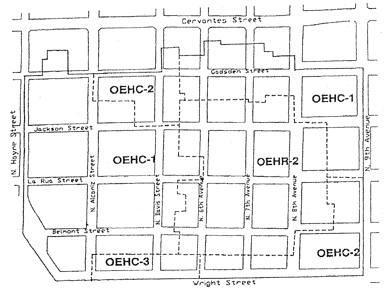
Sec. 12-3-11. - Airport land use district.
The regulations in this section shall be applicable to the airport restricted and airport transition zoning districts: ARZ, ATZ-1 and ATZ-2.
(1)
Purpose of district. The airport land use district is established for the purpose of regulating land, owned by the Pensacola International Airport or immediately adjacent to the airport, which is considered sensitive due to its relationship to the runways and its location within noise zones "A" and "B" as defined in chapter 12-10. Land zoned ARZ is owned by the city and allows only open space, recreational or commercial and industrial uses customarily related to airport operations. The areas designated as airport transitional zones are permitted a range of uses.
(2)
Uses permitted.
a.
ARZ, airport restricted zone (city-owned property).
1.
The following three sections of the airport restricted zone are limited to specific uses as defined below:
i.
ARZ-1. The parcel of land located north of Summit Boulevard between two airport transition zones (includes the Scott Tennis Center and airport drainage system). Uses within this zone will be limited to those uses described below in subsections (2)a.2 and 3 of this section.
ii.
ARZ east of runway 8/26. The parcel of land on the eastern end of runway 8/26, located between Avenida Marina and Gaberonne Subdivision and between Spanish Trail and Scenic Highway. All land within this zone outside of the 15 acres required for clear zone at the eastern end of runway 8/26 will be retained as open space.
iii.
ARZ south of runway 17/35. The parcel of land at the southern end of runway 17/35, located north of Heyward Drive and east of Firestone Boulevard. All land within this zone outside of the 28.5 acres required for clear zone at the southern end of runway 17/35 will be retained as open space.
2.
Airport, airport terminal, air cargo facilities, and uses customarily related to airport operations and expansions.
3.
Golf course, tennis court, driving range, par three course, outdoor recreational facilities, provided that no such uses shall include seating or structures to accommodate more than 100 spectators or occupants.
4.
Service establishments such as auto rental and travel agencies, commercial parking lots and garages, automobile service station and similar service facilities.
5.
Warehousing and storage facilities.
6.
Industrial uses compatible with airport operations.
7.
Commercial uses to include hotels, motels, extended stay facilities, pharmacy, restaurant and drive through facilities, banks, office, post secondary education facilities, meeting facilities, dry cleaner, health club, exercise center, martial arts facility, bakery, floral shop, day care/child care facility, medical clinic, doctor and dentist offices, and retail services to include specialty shops and studios; or other similar or compatible uses.
8.
Other uses that the city council may deem compatible with airport operations and surrounding land uses pursuant to the city's comprehensive plan and the airport master plan and as such uses that meet the FAA's requirements for airport activities.
b.
ATZ-1, airport transitional zone.
1.
Single-family residential, attached or detached, 0—5 units per acre.
2.
Home occupations, subject to regulations in section 12-3-57.
3.
Offices.
4.
Family day care homes licensed by the state department of children and family services as defined in state statutes.
5.
Recreational facilities - Not for profit.
6.
Conditional uses permitted:
i.
Communications towers in accordance with section 12-3-67.
ii.
Rooftop-mounted antennas in accordance with section 12-3-68.
c.
ATZ-2, airport transitional zone.
1.
Any use allowed in the ATZ-1;
2.
Retail and service commercial;
3.
Aviation related facilities; and
4.
Conditional uses permitted:
i.
Communications towers in accordance with section 12-3-67.
ii.
Rooftop-mounted antennas in accordance with section 12-3-68.
(3)
Review and approval process. All private, nonaviation related development in the ARZ zone and all developments other than single-family residential within approved subdivisions within the ATZ-1 and ATZ-2 zones must comply with the development plan review and approval process as established in section 12-3-120.
(4)
Regulations. All development shall comply with applicable height and noise regulations as set forth in chapter 12-10. All development must comply with design standards and is encouraged to follow design guidelines as established in section 12-3-121. All private, nonaviation related development within the ARZ zone and all development within ATZ-1 and ATZ-2 zones must comply with the following regulations:
a.
Airport land use restrictions. Notwithstanding any provision to the contrary in this chapter, no use may be made of land or water within any zone established by this chapter in such a manner as to interfere with the operation of an airborne aircraft. The following special requirements shall apply to each permitted use:
1.
All lights or illumination used in conjunction with street, parking, signs or use of land structures shall be arranged and operated in such a manner that is not misleading or dangerous to aircraft operating from a public airport or in the vicinity thereof.
2.
No operations of any type shall produce electronic interference with navigation signals or radio communication between the airport and aircraft.
3.
No continuous commercial or industrial operations of any type shall produce smoke, glare or other visual hazards, within three statute miles of any usable runway of a public airport, which would limit the use of the airport.
4.
Sanitary landfills will be considered as an incompatible use if located within areas established for the airport through the application of the following criteria:
i.
Landfills located within 10,000 feet of any runway used or planned to be used by turbine aircraft.
ii.
Landfills located within 5,000 feet of any runway used only by nonturbine aircraft.
iii.
Landfills outside the above perimeters but within conical surfaces described by FAR Part 77 and applied to an airport will be reviewed on a case-by-case basis.
iv.
Any landfill located and constructed in a manner that attracts or sustains hazardous bird movements from feeding, water, or roosting areas into, or across, the runways or approach and departure patterns of aircraft. The landfill operator must incorporate bird management techniques or other practices to minimize bird hazards to airborne aircraft.
5.
Obstruction lighting. Notwithstanding any provisions of section 12-10-2, the owner of any structure over 150 feet above ground level shall install lighting on such structure in accordance with Federal Aviation Administration Advisory Circular 70/7460-1 and amendments thereto. Additionally, the high-intensity white obstruction lights shall be installed on a high structure that exceeds 749 feet above mean sea level. The high-intensity white obstruction lights must be in accordance with Federal Aviation Administration Advisory Circular 70/7460-1 and amendments thereto.
6.
Noise zones. The noise zones based on the Pensacola International Airport FAR Part 150 Study adopted in 1990 and contained in section 12-10-3 shall establish standards for construction materials for sound level reduction with respect to exterior noise resulting from the legal and normal operations at the Pensacola International Airport. It also establishes permitted land uses and construction materials in these noise zones.
7.
Variances. Any person desiring to erect or increase the height of any structures, or use his or her property not in accordance with the regulations prescribed in this chapter, may apply to the zoning board of adjustment for a variance from such regulations. No application for variance to the requirements of this part may be considered by the zoning board of adjustment unless a copy of the application has been furnished to the building official and the airport manager.
8.
Hazard marking and lighting. Any permit or variance granted shall require the owner to mark and light the structure in accordance with FAA Advisory Circular 70/7460-1 or subsequent revisions. The permit may be conditioned to permit the county or the city at its own expense, to install, operate and maintain such markers and lights as may be necessary to indicate to pilots the presence of an airspace hazard if special conditions so warrant.
9.
Nonconforming uses.
i.
The regulations prescribed by this subsection shall not be construed to require the removal, lowering or other changes or alteration of any existing structure not conforming to the regulations as of the effective date of this chapter. Nothing herein contained shall require any change in the construction or alteration of which was begun prior to the effective date of this chapter, and is diligently prosecuted and completed within two years thereof.
ii.
Before any nonconforming structure may be replaced, substantially altered, repaired or rebuilt, a permit must be secured from the building official or his or her duly appointed designee. No permit shall be granted that would allow the establishment or creation of an airport hazard or permit a nonconforming structure to become a greater hazard to air navigation than it was as of the effective date of this chapter. Whenever the building official determines that a nonconforming use or nonconforming structure has been abandoned or that the cost of repair, reconstruction, or restoration exceeds the value of the structure, no permit shall be granted that would allow said structure to be repaired, reconstructed, or restored except by a conforming structure.
10.
Administration and enforcement. It shall be the duty of the building official, or his or her duly appointed designee, to administer and enforce the regulations prescribed herein within the territorial limits over which the city has jurisdiction. Prior to the issuance or denial of a tall structure permit by the building official, the Federal Aviation Administration must review the proposed structure plans and issue a determination of hazard/no hazard. In the event that the building official finds any violation of the regulations contained herein, he or she shall give written notice to the person responsible for such violation. Such notice shall indicate the nature of the violation and the necessary action to correct or abate the violation.
b.
Minimum lot size and yard requirements/lot coverage. There are no minimum requirements for lot size or yards, except that the development plan shall take into consideration the general development character of adjacent land uses. The maximum combined area occupied by all principal and accessory buildings shall be 50 percent.
c.
Maximum height of structures. For the ATZ-1 and ATZ-2 zoning districts the maximum height for residential structures is 35 feet and for office, commercial or aviation-related facilities, is 45 feet. Communications towers and rooftop-mounted antennas may be permitted within the ATZ-1 and ATZ-2 districts upon conditional use permit approval in accordance with section 12-3-108. Provided, however, that no structure shall exceed height limitations established in section 12-10-2(a).
d.
Additional regulations. In addition to the regulations established above all development must comply with the following regulations:
1.
Supplementary district regulations. (Refer to sections 12-3-55 through 12-3-69.)
2.
Signs. (Refer to chapter 12-5.)
3.
Tree/landscape. (Refer to chapter 12-6.)
4.
Subdivision. (Refer to chapter 12-7.)
5.
Stormwater management, and control of erosion, sedimentation and runoff. (Refer to chapter 12-8.)
(Code 1986, § 12-2-11; Ord. No. 33-95, § 3, 8-10-1995; Ord. No. 6-02, § 2, 1-24-2002; Ord. No. 12-03, § 1, 5-8-2003; Ord. No. 02-09, § 1, 1-8-2009; Ord. No. 13-17, § 1, 6-8-2017; Ord. No. 14-19, § 1, 7-18-2019)
Sec. 12-3-12. - Redevelopment land use district.
The regulations in this section shall be applicable to the gateway and waterfront redevelopment zoning districts: GRD and WRD.
(1)
GRD, Gateway Redevelopment District.
a.
Purpose of district. The gateway redevelopment district is established to promote the orderly redevelopment of the southern gateway to the city in order to enhance its visual appearance, preserve a unique shoreline vista, improve traffic safety, and encourage a high quality of site planning and architectural design. Site specific analysis of each development proposal within the gateway district is intended to ensure that the scenic orientation and open space image of the Bayfront Parkway is maintained, the development character of the Chase-Gregory corridor is upgraded, and the boundary of the adjacent historic district is positively reinforced.
b.
Uses permitted.
1.
Single-family residential (attached or detached) at a maximum density of 17.4 units per acre. Multifamily residential at a maximum density of 100 dwelling units per acre.
2.
Home occupations, subject to regulations in section 12-3-13.
3.
Offices.
4.
Adult entertainment establishments subject to the requirements of chapter 7-3 when located within the dense business area as defined in chapter 12-13, Definitions.
5.
All commercial uses permitted in the C-2A zone, with no outside storage or repair work allowed, with the exception:
i.
Mortuaries and funeral parlors.
ii.
Appliance and repair shops.
iii.
Public parking lots and parking garages.
iv.
New car lots or used car lots.
v.
Public utility plants, transmission and generating stations, including radio and television broadcasting stations.
vi.
Car or truck rental agencies or storage facilities.
6.
Family day care homes licensed by the state department of children and family services as defined in state statutes.
c.
Procedure for review of plans.
1.
Plan submission. All development plans must comply with development plan requirements set forth in section 12-3-120(c) and (d), and design standards and guidelines established in section 12-3-121. Every application for a new certificate of occupancy or a building permit to erect, construct, demolish, renovate or alter a building or sign, or exterior site work (i.e., paving and landscaping of off-street parking areas), located or to be located in the gateway redevelopment district shall be accompanied with drawings or sketches with sufficient detail to show, as far as they relate to exterior appearances, the architectural design of the building, sign, or exterior work (both before and after the proposed work is done in cases of altering, renovating, demolishing or razing a building or structure) including proposed materials, textures and colors, and the plot plan or site layout including all site improvements or features such as walls, fences, walks, terraces, plantings, accessory buildings, paved areas, signs, lights, awnings, canopies and other appurtenances.
2.
Review and approval. All plans shall be subject to the review and approval of the planning board established in chapter 12-12. At the time of review the board may require that any aspect of the overall site plan which does not meet the standards established in this section be incorporated and brought into compliance within a time limit approved by the board.
3.
Abbreviated review. Sign requests, paint colors, fencing, and emergency repairs that are consistent with the regulations and guidelines set forth in this section, may be approved by letter to the building official from the planning board secretary and the chairperson of the board. This provision is made in an effort to save the applicant and the board time for routine approval matters. If agreement cannot be reached as it pertains to such requests by the board secretary and chairperson, then the matter will be referred to the board for a decision.
4.
Final development plan. If the planning board approves a preliminary development plan, the owner shall submit a final development plan in accordance with the procedure set forth below within six months of the date of approval of the preliminary plan of development. For good cause shown, the planning board may, in its discretion, extend the time within which to file the final development plan for successive periods, the total of which shall not be more than an additional six months. The final development plan shall be in basic conformity with the preliminary plan of development and comply with the other provisions of section 12-3-120 pertaining to the final development plan. If the applicant submits a final development plan that conforms to all the conditions and provisions of this chapter, then the planning board shall conclude its consideration at its next regularly scheduled meeting.
d.
Regulations. Except where specific approval is granted by the planning board for a variance due to unique and peculiar circumstances or needs resulting from the use, size, configuration or location of a site, requiring the modification of the regulations set forth below the regulations shall be as follows:
1.
Signs. Refer to sections 12-5-2 and 12-5-3 for general sign regulations and for a description of sign area calculations. In addition, the following regulations shall be applicable to signs only in the gateway redevelopment district:
i.
Number of signs. Each parcel under single ownership shall be limited to one sign per street adjacent to the parcel; provided, however, if there exists more than one establishment on the parcel, there may be one attached sign per establishment.
ii.
Signs extending over public property. Signs extending over public property shall maintain a clear height of nine feet above the sidewalk and no part of such signs shall be closer than 18 inches to the vertical plane of the curb line or edge of pavement.
iii.
Permitted signs.
(a)
Gregory, Chase and Alcaniz Streets, 9th Avenue.
(1)
Attached signs.
a.
Height. No sign may extend above the roof line of the building to which it is attached. For purposes of this section roof surfaces constructed at an angle of 75 degrees or more from horizontal shall be regarded as wall space.
b.
Size. Ten percent of the building elevation square footage (wall area) which fronts on a public street, not to exceed 50 square feet.
(2)
Freestanding signs.
a.
Maximum sign height—20 feet.
b.
Maximum area for sign face—50 square feet.
(b)
Bayfront Parkway.
(1)
Attached signs.
a.
Height. No sign shall extend above the roof line of a building to which it is attached.
b.
Size. Ten percent of the building elevation square footage (wall area) which fronts on a public street, not to exceed 50 square feet.
(2)
Freestanding signs.
(c)
All other streets and areas within the gateway redevelopment district:
(1)
Attached signs.
a.
Height. No sign shall extend above the main roof line of a building to which it is attached.
b.
Size. Ten percent of the building elevation square footage (wall area) which fronts on a public street, not to exceed 25 square feet.
(2)
Freestanding signs.
iv.
Other permitted signs.
(a)
Signs shall not exceed three square feet in size.
(b)
Official traffic signs or signals, informational signs erected by a government agency and temporary signs indicating danger.
v.
Submission and review of sign plans. It shall be the responsibility of the contractor or owner requesting a sign permit to furnish two plans of sign drawn to scale, including sign face area calculations, wind load calculations and construction materials to be used.
vi.
Review of sign plans. All permanent signs within the gateway redevelopment district shall be reviewed as follows:
(a)
The contractor or owner shall submit sign plans for the proposed sign as required herein. The planning services department shall review the sign based on the requirements set forth in this section and the guidelines set forth in subsection (1)e.2.vii of this section and forward a recommendation to the planning board.
(b)
The planning board shall review the planning staff recommendation concerning the sign and approve, or disapprove, the sign, it shall give the owner written reasons for such action.
(c)
The owner shall have the right to appeal an adverse decision of the planning board to the city council within 30 days of the decision of the planning board.
vii.
Prohibited signs. Refer to section 12-5-7 for prohibited signs. In addition the following signs are prohibited within the gateway redevelopment district:
(a)
Portable signs are prohibited except as permitted in section 12-5-6(5).
(b)
Signs that are abandoned or create a safety hazard are not permitted. Abandoned signs are those advertising a business that becomes vacant and is unoccupied for a period of 90 days or more.
(c)
Signs that are not securely fixed on a permanent foundation are prohibited.
(d)
Signs that are not consistent with the standards of this section are not permitted.
viii.
Temporary signs. Only the following temporary signs shall be permitted in the gateway redevelopment district:
(a)
Temporary banners indicating that a noncommercial special event, such as a fair, carnival, festival or similar happening, is to take place, are permitted with the following conditions:
(1)
Such signs may be erected no sooner than two weeks before the event.
(2)
Such signs must be removed no later than three days after the event.
(3)
Banners extending over street rights-of-way require approval from the mayor.
(b)
One non-illuminated sign per street frontage advertising the sale, lease or rental of the lot or building upon which the sign is located. Such sign shall not exceed 12 square feet in size, and shall be removed immediately after occupancy.
(c)
One non-illuminated sign not more than 50 square feet in area in connection with the new construction work and displayed only during such time as the actual construction work is in progress.
(d)
Temporary signs permitted in section 12-5-6(8).
ix.
Nonconforming signs.
(a)
Compliance period. All existing signs that do not conform to the requirements of this section shall be made to comply by April 24, 1991. Provided, however, existing portable signs must be removed immediately.
(b)
Removal of nonconforming signs. The building official shall notify the owner of a nonconforming sign in writing of compliance period specified above. Nonconforming signs shall either be removed or brought up to the requirements stated herein within the period of time prescribed in the compliance schedule. Thereafter, the owner of such sign shall have 30 days to comply with the order to remove the nonconforming sign, or bring it into compliance. Upon expiration of the 30-day period, if no action has been taken by the owner, he or she shall be deemed to be in violation of this section and the building official may take lawful enforcement action.
2.
Off-street parking. The following off-street parking requirements shall apply to all lots, parcels or tracts in the gateway redevelopment district:
i.
Off-street parking requirements in the district shall be based on the requirements set forth in chapter 12-4. The required parking may be provided off-site by the owner/developer as specified in section 12-4-1(4).
ii.
Off-street parking and service areas are prohibited within the Bayfront Parkway setback described in subsection (1)d.3 of this section, unless these requirements cannot be met anywhere else on the site due to its size or configuration.
iii.
Screening. Screening shall be provided along the edges of all parking areas visible from street rights-of-way. The screening may take the form of:
A solid wall or fence (chain-link fences are prohibited) with a minimum height of four feet that is compatible in design and materials with on-site architecture and nearby development; or an earth berm approximately three feet in height that is landscaped to provide screening effective within three years; or a combination of walls or fences and landscape screening; or landscape screening designed to provide positive screening within three years.
3.
Street setback. The following building setbacks shall apply to the district:
i.
Bayfront Parkway setback/height requirements. All buildings located adjacent to the Bayfront Parkway shall be set back a minimum of 50 feet from the northern parkway right-of-way line. At this minimum setback, building height may not exceed 50 feet. Above 50 feet in height, an additional one-foot setback shall be required for each additional two feet in building height. This setback is intended as a landscaped buffer zone that preserves the open space character of the parkway.
ii.
Gregory, Alcaniz and Chase Streets, 9th Avenue. Ten feet from the right-of-way line.
iii.
All other streets. Five feet from the right-of-way line.
4.
Street frontage. Every lot, tract, or parcel of land utilized for any purpose permitted in this district shall have a street frontage of not less than 50 feet. Any lot of record on the effective date of this title which is less than 50 feet may be used as a site for only one establishment listed as a permitted use in subsection (1)b of this section.
5.
Building height. No building shall exceed a maximum height of 100 feet.
6.
Vehicular access. Access to the following streets shall be limited as follows:
i.
Bayfront Parkway. No access shall be permitted from the parkway unless no other means exist for ingress and egress from the site.
ii.
Gregory Street, Chase Street, Alcaniz Street, 9th Avenue and 14th Avenue. For each lot, tract, or parcel under single ownership, the maximum number of access points shall not exceed two per street footage if driveway spacing standards can be met pursuant to section 12-3-121(c)(2).
7.
Landscaping. Landscaping requirements in the gateway redevelopment district shall be based on applicable requirements of chapter 12-6. All service areas (i.e., trash collection containers, compactors, loading docks) shall be screened from street and adjacent buildings by one of the following techniques:
i.
Fence or wall, six feet high;
ii.
Vegetation, six feet high (within three years);
iii.
A combination of the above.
8.
Underground utility services. All new building construction or additions of floor area to existing structures along Bayfront Parkway, Chase Street, Gregory Street, 9th Avenue and all property fronting Salamanca Street, shall be required to install underground utilities.
9.
Lot coverage. The total coverage of all development sites within the gateway redevelopment district, including all structures, parking areas, driveways and all other impervious surfaces, shall not exceed 75 percent.
10.
Sidewalks. Developers of new construction or redevelopment projects shall repair, reconstruct, or construct new sidewalks on all sides of property fronting on a street.
11.
Consideration of floodprone areas. Portions of the district are within the 100-year floodplain. Site planning shall consider the special needs of floodprone areas.
12.
Storm drainage. Adequate storm drainage must be provided to prevent flooding or erosion. The surface drainage after development should not exceed the surface drainage before development. Flexibility in this guideline shall be considered by the city engineer based on capacity of nearby off-site stormwater drainage systems, the surrounding topography and the natural drainage pattern of the area.
13.
All mechanical equipment, satellite dishes and other similar equipment should be completely screened by the architecture of the structure, or fences, walls, or vegetation.
14.
Exemptions. All detached single-family and duplex residential development proposals are exempt from the provisions of this section and shall be developed in accordance with R-1A regulations set forth in section 12-3-4(5), with the exception of the height requirements.
e.
Development guidelines. The gateway redevelopment district is characterized by a variety of architectural styles with no common theme. The intent of these guidelines is to reduce the level of contrast between buildings and to create a more compatible appearance in architectural design, scale, materials and colors. All development within the gateway redevelopment district is encouraged to follow design guidelines as established in section 12-3-121(d). In addition, the following site planning guidelines shall be used by the planning board in the review and approval of all development plans:
1.
Site planning. The integration of site features such as building arrangement, landscaping and parking lot layout is critical in producing a pleasant and functional living or working environment. In reviewing development proposals, the following guidelines shall be taken into consideration.
i.
Maximum preservation of bay views. Considering the bayfront location within the district, the placement of buildings, signs, service areas, parking and landscaping shall be planned to maximize the preservation of views of the bay and to protect the bayfront's scenic open space character. To prevent the effect of a "wall" of development along the inland edge of the parkway, the long axis of all buildings located on the corridor should be oriented parallel to the inland street grid, rather than parallel to the parkway itself. The preservation of ample open space between buildings, and the creation of a campus-like development pattern, are encouraged especially in the bayfront area. In addition, site planning throughout the district should recognize existing topographical variations and maximize this variation to maintain bay views.
ii.
Development coordination. The preservation of bay views and the creation of a campus character development pattern cannot be achieved through the site planning of any single development; all development efforts within the district must be coordinated to achieve these objectives.
iii.
Off-street parking and service. Off-street parking shall be discouraged within all street setbacks. Where possible, any service areas (i.e. trash collection, loading docks) shall be located to be screened by the building itself; otherwise, walls, fences, landscaping and earth berms shall be used to achieve effective screening.
2.
Architectural design and building elements.
i.
Buildings or structures that are part of a present or future group or complex shall have a unity of character and design. The relationship of forms and the use, texture, and color of materials shall be such as to create a harmonious whole.
ii.
Buildings or structures located along strips of land or on single sites and not a part of a unified multibuilding complex shall strive to achieve visual harmony with the surroundings. It is not to be inferred that buildings must look alike or be of the same style to be compatible with the intent of the district. Compatibility can be achieved through the proper consideration of scale, proportions, site planning, landscaping, materials and use of color.
iii.
Materials such as metal and plastic shall be discouraged on exterior surfaces of buildings.
iv.
Severe or angular roof lines that exceed a pitch of 12-12 (45-degree angle) are discouraged. Exceptions to this guideline (i.e., churches) shall be considered on a case-by-case basis.
v.
Bright colors and intensely contrasting color schemes are discouraged within the district.
vi.
Proposed development adjacent to the historic district should give special consideration to visual compatibility in scale and architectural design in order to positively reinforce the character of the historic area and provide a buffer and transition.
vii.
The following guidelines concerning design, materials, lighting, landscaping, and positioning of permitted signs shall be considered:
(a)
Design/materials. The architectural character of the building to which the sign relates should be reflected in the lettering of the sign, the materials used for the supporting structure and the sign face.
(b)
Lighting. Indirect and internal lighting is encouraged. Neon and exposed fluorescent lighting is not encouraged.
(c)
Landscaping. The landscaping and positioning of the sign should compliment the overall site plan and landscaping of the development.
f.
Maintenance standards. The following maintenance standards shall be applied to all structures and land parcels respectively, whether occupied or vacant within the gateway redevelopment district, subject to review and approval by the planning board. Properties that do not conform to the maintenance standards described in subsections (1)f.1 through 7 of this section shall be made to comply as required by the city inspections office based on regular inspections or complaints.
1.
Building fronts, rears, and sides abutting streets and public areas. Rotten or weakened portions shall be removed, repaired or replaced.
2.
Windows. All windows must be tight-fitting. All broken and missing windows shall be replaced with new glass.
3.
Show windows and storefronts. All damaged, sagging or otherwise deteriorated storefronts, show windows or entrances shall be repaired or replaced.
4.
Exterior walls.
i.
Existing miscellaneous elements on the building walls, such as empty electrical conduit, unused signs and/or sign brackets, etc., shall be removed.
ii.
Sheet metal gutters, downspouts and copings shall be repaired or replaced as necessary and shall be neatly located and securely installed.
iii.
All exterior finishes and appurtenances such as paint, awnings, etc., shall be kept in a state of repair.
5.
Roofs.
i.
All auxiliary structures on the roofs shall be kept clean, repaired or replaced.
ii.
Roofs shall be cleaned and kept free of trash, debris or any other elements that are not a permanent part of the building.
6.
Front, rear, and side yards, parking areas and vacant parcels.
i.
When a front, rear or side yard, parking area or vacant parcel exists or is created through demolition, the owner may utilize the space in accordance with the provisions of the zoning district; provided, however, that the site shall be properly maintained free of weeds, litter, and garbage.
ii.
Any landscaping that was installed to comply with regulations of this subsection must be maintained.
7.
Walls, fences, signs. Walls, fences, signs and other accessory structures shall be repaired and maintained.
(2)
GRD-1, Gateway redevelopment district, Aragon redevelopment area.
a.
Purpose of district. The gateway redevelopment district, Aragon redevelopment area is established to promote the orderly development of the southern gateway to the city in order to enhance its visual appearance, preserve a unique shoreline vista, improve traffic safety, and encourage a high quality of site planning and architectural design. Site specific analysis of development proposed within the district is intended to ensure that the scenic orientation and open space image of the Bayfront Parkway is maintained and the boundary of the adjacent historic district is positively reinforced. Zoning regulations are intended to ensure that future development is compatible with and enhances the pedestrian scale of the existing structures and period architectural character of the adjacent historic district.
b.
Urban character of the district. The Aragon redevelopment area is characterized by integration of houses, shops, and work places. Mixed land use is encouraged by allowing home occupations and first floor work spaces with apartments and townhouses above. The historic district is the basis for district architectural guidelines, which reflect the scale and lot sizes, and the list of permitted uses is similar to those uses permitted in the historic district to the south.
c.
Uses permitted.
1.
GRD-1, residential uses.
i.
Single-family and multifamily residential (attached or detached) at a maximum overall density of 17.4 units per acre.
ii.
Bed and breakfast (subject to section 12-3-84).
iii.
Home occupations allowing: not more than 60 percent of the floor area of the total buildings on the lot to be used for a home occupation; retail sales shall be allowed limited to uses listed as conditional uses in subsection (2)c.3.i of this section; two nonfamily members as employees in the home occupation; and a sign for the business not to exceed three square feet shall be allowed.
iv.
Community residential homes licensed by the state department of children and family services with six or fewer residents providing that it is not to be located within 1,000 feet of another such home. If it is proposed to be within 1,000 feet of another such home, measured from property line to property line, it shall be permitted with city council approval after public notification of property owners in a 500-foot radius.
v.
Limited office space allowed only with residential use occupying a minimum of 50 percent of total building square footage of principal and outbuildings.
vi.
Family day care homes licensed by the state department of children and family services as defined in state statutes.
2.
GRD-1, public uses.
i.
Meeting hall, U.S. Post Office pavilion, buildings used for community purposes, not to exceed 5,000 square feet.
ii.
Publicly owned or operated parks and playgrounds.
iii.
Churches, Sunday school buildings and parish houses.
3.
GRD-1, commercial uses.
i.
The following uses limited to a maximum area of 5,000 square feet:
(a)
Antique shops.
(b)
Art galleries.
(c)
Bakeries whose products are sold at retail and only on the premises.
(d)
Banks (except drive-through).
(e)
Barbershops and beauty shops.
(f)
Child care facilities (subject to section 12-3-87).
(g)
Health clubs, spas, and exercise centers.
(h)
Jewelers.
(i)
Laundry and dry-cleaning pick-up stations.
(j)
Office buildings.
(k)
Restaurants (except drive-ins).
(l)
Retail sales and services.
(m)
Retail food and drugstore.
(n)
Specialty shops.
(o)
Studios.
4.
GRD-1, miscellaneous uses.
i.
Outbuildings and uses can include:
(a)
Garage apartments.
(b)
Carriage houses.
(c)
Studios.
(d)
Granny flats.
(e)
Storage buildings.
(f)
Garages.
(g)
Swimming pools.
(h)
Hot tubs.
(i)
Offices.
Refer to Aragon Urban Regulations in Aragon Design Code for maximum impervious surface per lot type.
ii.
Minor structures for utilities (gas, water, sewer, electric, telephone).
d.
Procedure for review.
1.
Review and approval by the planning board. All activities regulated by this subsection, including preliminary and final site plan review, shall be subject to review and approval by the planning board as established in section 12-12-2. Abbreviated review for paint colors, minor repairs and minor deviations in projects already approved by the board shall be in accordance with section 12-12-2(11). If agreement cannot be reached as it pertains to such request for abbreviated review by the board secretary and chairperson then the matter will be referred to the planning board for a decision.
2.
Decisions.
i.
General consideration. The board shall consider plans for buildings based on regulations described herein. In their review of plans for new construction, the board shall consider exterior design and appearance of the building, including the front, sides, rear and roof; materials, textures and colors; plot plans or site layout, including features such as walls, walks, terraces, off-street paved areas, plantings, accessory buildings, signs and other appurtenances; and relation of the building to the immediate surroundings and to the district in which it is located. The term "exterior" shall be deemed to include all of the outer surfaces of the building and exterior site work, including painting, and is not restricted to those exteriors visible from a public street or place.
ii.
Rules governing decisions. Before approving the plans for any proposed building located or to be located in a district, the board shall find:
(a)
In the case of a proposed new building, that such building will not, in itself or by reason of its location on the site, impair the architectural or historic value of buildings in the immediate vicinity. No plans for new building will be approved if that building will be injurious to the general visual character of the district in which it is to be located considering visual compatibility standards such as height, proportion, shape, scale, style, materials and colors.
(b)
In the case of a proposed alteration or addition to an existing building, that such alteration or addition will not impair the architectural value of the building.
3.
Plan submission. Every activity that requires plans in order to erect, construct, demolish, renovate or alter an exterior of a building, sign or exterior site work, located or to be located in the GRD-1 district shall be accompanied with drawings or sketches. All drawings must be drawn to scale and be legible. The minimum size scale for site plans is 1" = 20'0"; the minimum scale for floor plans is 1/8" = 1'0"; and the minimum scale for exterior elevations is 1/8" = 1'0". The scale for other items, such as signs and details, shall be as large as necessary to fully define the detail of those items. Major projects with very large buildings may vary from the scale referenced above for ease of presentation.
i.
Site plan.
(a)
Indicate overall property dimensions and building size, and building setback line and building frontage zone.
(b)
Indicate relationship of adjacent buildings, if any.
(c)
Indicate layout of all driveways and parking on the site including materials.
(d)
Indicate all fences, including materials, dimensions, architectural elements and color, and signs, with dimensions as required to show exact locations.
(e)
Indicate existing trees and existing and new landscaping.
ii.
Floor plan.
(a)
Indicate locations and sizes of all exterior doors and windows.
(b)
Indicate all porches, steps, ramps and handrails.
(c)
For renovations or additions to existing buildings, indicate all existing conditions and features as well as the revised conditions and features and the relationship of both.
iii.
Exterior elevations.
(a)
Indicate all four elevations of the exterior of the building.
(b)
Indicate the relationship of this project to adjacent structures, if any.
(c)
Indicate exposed foundation walls, including the type of material, screening, dimensions, and architectural elements.
(d)
Indicate exterior wall materials, including type of materials, dimensions, architectural elements and color.
(e)
Indicate exterior windows and doors, including type, style, dimensions, materials, architectural elements, trim, and colors.
(f)
Indicate all porches, including ceilings, steps, and ramps, including type of materials, dimensions, architectural elements and color.
(g)
Indicate all porch, stair, and ramp railings, including type of material, dimensions, architectural elements, trim, and color.
(h)
Indicate roofs, including type of material, dimensions, architectural elements, associated trims and flashing, and color.
(i)
Indicate all signs, whether they are building-mounted or freestanding, including material, style, architectural elements, size and type of letters, and color. The signs must be drawn to scale in accurate relationship to the building and the site.
iv.
Miscellaneous.
(a)
Show enlarged details of any special features of either the building or the site that cannot be clearly depicted in any of the above-referenced drawings.
4.
Submission of photographs.
i.
Provide photographs of the site for the proposed new construction in sufficient quantity to indicate all existing site features, such as trees, fences, sidewalks, driveways, and topography.
ii
Provide photographs of the adjoining "street scape," including adjacent buildings to indicate the relationship of the new construction to these adjacent properties.
5.
Submission of descriptive product literature/brochures.
i.
Provide samples, photographs, or detailed, legible product literature on all windows, doors and shutters proposed for use in the project. The information must be sufficiently detailed to show style, dimensions, detailing, material type, and color.
ii.
Provide descriptive literature, samples, or photographs showing specific detailed information about signs and letters, if necessary, to augment or clarify information shown on the drawings. The information must be sufficiently detailed to show style, dimensions, detailing, material type, and color.
iii.
Provide samples or descriptive literature on roofing material and type to augment the information on the drawings. The information must indicate dimensions, details, material, color and style.
iv.
Provide samples or literature on any exterior light fixtures or other exterior ornamental features, such as wrought iron, railings, columns, posts, balusters, and newels. Indicate size, style, material, detailing and color.
e.
Regulations for any development within the GRD-1 zoning district. These regulations are intended to address the design and construction of elements common to any development within the GRD-1 zoning district which requires review and approval by the planning board. Regulations and standards that relate specifically to new construction and/or structural rehabilitation and repairs to existing buildings, applicable to building heights, setbacks, architectural elements and construction types, are established below. The Aragon Design Code describes the building types and architectural styles that are considered to be compatible with the intent of the GRD-1 regulations. This definition of styles should be consulted to ensure that the proper elements are used in combination in lieu of combining elements that are not appropriate for use together on the same building. Amendments to the Aragon Design Code may be made by the city council following a recommendation of the planning board and a public hearing before the city council, without necessity for amending this chapter.
1.
Building height limit. No building shall exceed the following height limits: Type I Townhouses and Type III Park Houses shall not exceed 55 feet or 3½ stories. Type II Cottages, Type IV Sideyard House, Type V Small Cottage, and Type VI Row House shall not exceed 45 feet or 2½ stories. No outbuilding shall exceed 35 feet or 2½ stories. Refer to Aragon Design Code.
2.
Landscaping.
i.
Landscaping requirements in the GRD-1 district shall be based on Aragon Design Code.
ii.
All service areas (i.e., dumpsters or trash handling areas, service entrances or utility facilities, loading docks or space) must be screened from adjoining property and from public view by one of the following:
(a)
Fence or wall, six feet high;
(b)
Vegetation, six feet high (within three years);
(c)
A combination of the above.
3.
Protection of trees. It is the intent of this section to recognize the contribution of shade trees and certain flowering trees to the overall character of the Aragon redevelopment area and to ensure the preservation of such trees as described below:
i.
Any of the following species having a minimum trunk diameter of eight inches (25.1 inches in circumference) at a height of one foot above grade: Live Oak and Water Oak; Magnolia having a minimum trunk diameter of six inches (18.8 inches in circumference) at a height of one foot above grade; and
ii.
Any of the following flowering trees with a minimum trunk diameter of four inches (12.55 inches in circumference) at a height of one foot above grade: Redbud, Dogwood, and Crape Myrtle.
No person, organization, society, association or corporation, or any agent or representative thereof, directly or indirectly, shall cut down, destroy, undertake tree removal, or effectively destroy through damaging, any specimen or flowering tree, whether it be on private property or right-of-way within the GRD-1 district, without first having obtained a permit from the city to do so. Refer to section 12-6-7 for tree removal permit application procedures and guidelines.
4.
Fences.
i.
Original fences in the older sections of the city were constructed of wood with a paint finish in many varying ornamental designs, or may have been constructed of brick or wrought iron. The style of the fence and the materials used typically related directly to the style and type of materials used for the building on the property. Refer to Aragon Design Code for required types of fences at different locations.
ii.
On every corner lot on both public and private streets intersecting 9th Avenue a sight triangle described by the intersection of the projection of the outer curb (next to the driving lane) lines extended, and a line joining the points on those lines 30 feet from said intersection shall be clear of any structure, solid waste container, parked vehicles, including recreational vehicles, or planting of such nature and dimension as to obstruct lateral vision, provided that this requirement shall generally not apply to tree trunks trimmed of foliage to eight feet, and newly planted material with immature crown development allowing visibility, or a post, column, or similar structure that is no greater than one foot in cross-section diameter. Lateral vision shall be maintained between a height of three feet and eight feet above grade. All other streets and intersections within the GRD-1 district shall be exempt from the requirements of section 12-3-58, Required Visibility Triangle. In addition the following provisions apply:
(a)
Chain-link, exposed masonry block and barbed wire are prohibited fence materials in the GRD-1 district. Approved materials will include but not necessarily be limited to wood, brick, stone (base only) and wrought iron, or stucco. Materials can be used in combination.
(b)
All wood or wrought iron fences shall be painted if the principal building is painted. Wood fences shall be constructed utilizing one of a variety of designs, especially a design that will reflect details similar to those on the building. It is recommended that the use of wrought iron or brick fences be constructed in conjunction with buildings that use masonry materials in their construction or at locations requiring them. "Dog ear pickets" are not acceptable. Refer to Architectural Standards in Aragon Design Code.
(c)
Fences in the required front yard will be no higher than four feet and six feet, six inches in the side and rear yards. On corner lots, fences constructed within the required street side yard shall not exceed four feet in height if the fence would obstruct the visibility from an adjacent residential driveway. Otherwise fences within the required street side yard may be built to a maximum of six feet, six inches.
5.
Signage.
i.
Informational signs. All informational signs, even if erected on private property, are subject to regulations contained in this section.
ii.
Commercial signs. It is the intent of the Aragon redevelopment area to recapture the turn-of-the century feeling of commerce in Aragon's core neighborhood. To this end, special consideration will be given to a variety of painted signs on brick and stucco walls, building cornices, canopies and awnings, even on sidewalks and curbs.
iii.
Sign style shall be complementary to the style of the building on the property. In the older sections of the city the support structure and trim work on a sign was typically ornamental, as well as functional.
Refer to sections 12-5-2 and 12-5-3 for general sign standards and criteria and for a description of sign area calculations. In addition to the prohibited signs listed below, all signs listed in section 12-5-7 are prohibited within the GRD-1 district. The design, color scheme and materials of all signs shall be subject to approval by the planning board. Only the following signs shall be permitted in the GRD-1 district:
(a)
Permitted signs.
(1)
Temporary accessory signs.
a.
One non-illuminated sign advertising the sale, lease, or rental of the lot or building, said sign not exceeding two square feet in area.
b.
One non-illuminated sign per street frontage, not more than 32 square feet in area in connection with new construction work related to Aragon's development, community sites, parks, or Privateer's Alley.
(2)
Permanent accessory signs.
a.
Each mixed-use or commercial property shall be limited to one sign per lot for Type II through VI. The sign may be placed on the street side or alley frontage. Type I shall be limited to one sign per street and one for alley frontage. The sign may be projected from the building, a wall-mounted sign, or a painted sign. Signs projecting from a building or extending over public property shall maintain a clear height of nine feet six inches above the public property and shall not extend above the roof line on which it is attached. The sign may be mounted to or painted on the face of a wall of the building, hung from a bracket that is mounted to a wall of a building, or hung from other ornamental elements on the building. Attached or wall signs may be placed on the front or one side of the building. The sign may be illuminated provided the source of light is not visible beyond the property line of the lot on which the sign is located.
b.
Advertising display area.
1.
GRD-1, Type II through Type VI residential home occupation and mixed-use lots are not to exceed ten square feet.
2.
GRD-1, Type I commercial lots are not to exceed 35 square feet per street front.
3.
A combination of two attached wall signs may be used, but shall not exceed a total of 35 square feet.
4.
If fronting an alley the size shall not exceed 12 square feet.
c.
One non-illuminated nameplate designating the name of the occupant of the property; the nameplate shall not be larger than three square feet and shall be attached flat against the wall of the building.
d.
Municipal or state installed directional signs, historical markers and other signs of a general public interest when approved by the mayor and board.
(b)
Prohibited signs.
(1)
Any sign using plastic materials for lettering or background.
(2)
Internally illuminated signs.
(3)
Portable signs.
(4)
Nonaccessory signs.
(5)
Back lit canvas awnings.
(6)
Flashing, strobe, or neon signs.
(7)
Neon signs placed inside a window.
6.
Driveways and sidewalks. The following regulations and standards apply to driveways and sidewalks in the GRD-1 district:
i.
Driveways shall be allowed at locations indicated in the Aragon Design Code.
(a)
Where asphalt or concrete is used as a driveway material, the use of an appropriate coloring agent is allowed.
(b)
From the street pavement edge to the building setback the only materials allowed shall be brick, concrete pavers, colored or approved stamped concrete or poured concrete.
ii.
Sidewalks, construction, repair and maintenance of sidewalks are all required on public rights-of-way within the district. Sidewalks shall be constructed of concrete, a combination of concrete and either brick, concrete pavers or concrete poured and stamped with an ornamental pattern or smooth finish.
7.
Off-street parking. Off-street parking is required in the GRD-1 district. The requirements for off-street parking in this district recognize that the Aragon redevelopment area forms a transition neighborhood between the adjacent historic district to the south, where off-street parking is not required in the historic commercial zoning districts and the remainder of the gateway redevelopment district where conventional off-street parking requirements apply. The off-street parking requirements in the GRD-1 district reflect a land use pattern that encourages small scale commercial land uses adjacent to residential uses that are accessible through a network of pedestrian improvements, such as sidewalks, plazas and open spaces. Because parking areas were not a common land use in the older sections of the city, their location is set forth in the standards.
i.
Residential uses.
(a)
Single-family and accessory unit—One space/unit.
(b)
Townhouse and multifamily—One space/unit.
(c)
Bed and breakfast—One space per owner plus one space/sleeping room.
(d)
Home occupation—One space/nonfamily employee.
(e)
Community residential home—One space/two beds.
ii.
Public uses.
(a)
Meeting hall, U.S. Post Office pavilion, buildings used exclusively for federal, state, county or city governments for public purposes—One space/500 square feet.
(b)
Publicly owned or operated parks and playgrounds—None required.
(c)
Churches, Sunday school buildings and parish houses—One space/four fixed seats.
iii.
Commercial uses.
(a)
Antique shops—One space/500 square feet.
(b)
Art galleries—One space/500 square feet.
(c)
Bakeries (retail only)—One space/500 square feet.
(d)
Barbershops and beauty shops—One space/station and one space/employee.
(e)
Day care centers—One space/employee plus one space/classroom.
(f)
Health clubs, spas and exercise centers—One space/300 square feet.
(g)
Jewelers—One space/500 square feet.
(h)
Laundry and dry-cleaning pick-up stations—One space/employee.
(i)
Office buildings—One space/500 square feet.
(j)
Restaurants (except drive-ins)—One space/500 square feet.
(k)
Retail sales and services—One space/500 square feet.
(l)
Retail food and drugstore—One space/500 square feet.
(m)
Specialty shops—One space/500 square feet.
(n)
Studios—One space/50 square feet unless owner occupied.
iv.
For Type I Townhouse the uses identified in subsections (2)e.7.i through iii of this section, on-street parking on Romana Street and 9th Avenue within 500 feet of the building may be used towards this requirement for nonemployee parking only. One off-street parking space shall be required for each employee in the building.
v.
Parking shall be screened from view of adjacent property and the street by fencing, landscaping or a combination of the two approved by the board, except in alley locations.
vi.
Materials for parking areas shall be concrete, concrete or brick pavers, asphalt, oyster shells, clam shells or #57 granite, pea gravel or marble chips. Where asphalt or concrete are used, the use of a coloring agent is allowed. The use of acceptable stamped patterns on poured concrete is encouraged.
viii.
For Type I Townhouse as an option to providing the required off-street parking as specified in subsections (2)e.7.i through iii of this section, the required parking may be provided off-site by the owner/developer as specified in section 12-4-1(4).
8.
Paint colors. The planning board has adopted palettes of colors considered compatible with historic colors from several paint manufacturers that represent acceptable colors for use in the GRD-1 district. Samples of these palettes can be reviewed at the office of the building inspector or the secretary of the GRD board.
9.
Outbuildings. Outbuildings shall not exceed a maximum height of 35 feet. The accessory structure shall match the style, roof pitch, and other design features of the main residential structure.
10.
Architectural review standards.
i.
Exterior lighting. Exterior lighting in the district will be post-mounted street lights and building-mounted lights adjacent to entryways or landscaping lights that are shielded. Lamps shall be typically ornamental in design and appropriate for the building style. Refer to Aragon Design Code, Architectural Standards.
(a)
Exterior lighting fixtures must be appropriate for building style. Refer to Aragon Design Code, Architectural Standards.
(b)
Exterior. Where exterior lighting is allowed to be detached from the building, the fixtures visible from off-premises (other than landscape lighting that is permitted) shall be post-mounted and used adjacent to sidewalk or driveway entrances or around parking. If post-mounted lights are used, they shall not exceed 12 feet in height. Exterior lights shall be placed so that they do not shine directly at neighbors.
(c)
The light element itself shall be a true gas lamp or shall be electrically operated using incandescent, halogen, metal halide or high pressure sodium lamps. Fluorescent and mercury vapor lamps are prohibited.
(d)
The use of pole mounted high pressure sodium utility/security lights is prohibited.
ii.
Exterior building walls. Exterior treatments will be of wood, cedar shingles, wood clapboard, board and batten or board on board, fiber-cement smooth lap siding (Hardiplank), brick, stone for Craftsman style buildings, or stucco. Building wall finish must be appropriate for building style (Refer to Aragon Design Code, Architectural Standards). Individual windows and porch openings, when rectangular, shall be square or vertical proportion and have multiple lights, unless architectural style dictates other combinations. Chimneys shall be architecturally compatible with the style. All primary structures are required to elevate their first finished floor 18 to 36 inches above grade, except Type I Townhouse. Base treatment shall be articulated.
(a)
Vinyl or metal siding is prohibited.
(b)
Wood siding and trim shall be finished with paint or stain, utilizing colors approved by the board.
(c)
Foundation piers shall be exposed brick masonry or sand textured plaster over masonry. If in-fill between piers is proposed, piers shall be skirted and screened in an opaque manner. It is encouraged that in-fill panels of wood lattice be utilized or brick screens where appropriate.
iii.
Roofs. Roofs may be of metal, wood shake, dimensional asphalt shingle, slate, diamond shape asphalt shingles or single ply membrane or built up (for flat roofs), and must be of the appropriate architectural style. Roof pitch for sloped roofs above the main body shall be at least eight on 12 on one- and two-story buildings and six on 12 on buildings with three stories, unless architectural style dictates other slope, for example Craftsman. Eaves shall be appropriate for the architectural style. Shed roofs shall be allowed only against a principal building or perimeter wall. Flat roofs shall not be permitted without parapets, cornices, eaves overhangs boxed with modillions, dentrils, or other moldings. The maximum size of the roof deck, window's walks, towers, turrets, etc., is 200 square feet, with the maximum height of ten feet above the maximum allowable building height.
(a)
Eaves and soffits may be: wood, painted or stained; smooth finish or sand textured stucco soffits, if detailed appropriately; or fiber-cement, if detailed appropriately ("Hardisoffit" or Hardipanel" vertical siding panels). Eaves shall be appropriate for architectural style and type.
(b)
Flashing may be anodized or pre-finished aluminum, galvanized steel of naturally weathered copper.
(c)
Gutters and downspouts may be anodized or pre-finished aluminum, galvanized steel or naturally weathered copper.
iv.
Balconies and porches. Front porches are required for all Type II through Type V principal structures, and porches or balconies are required for Type I and Type VI principal structures. Type I principal structure balconies supported by columns, the outside edge of the columns shall be located at the outside edge of the public sidewalk, and the balcony shall not extend past the columns. Balconies shall not be cantilevered more than eight feet. See the below figures for balcony and porch dimensions.
v.
Doors. Entrance doors with an in-fill of raised panels below and glazed panels above were typically used in older sections of the city. Single doorways with a glazed transom above allows for both light and ventilation to enter the entrance way or entrance foyer of the building. Double doors are usually associated with a larger home or building layout.
(a)
Doors are to be appropriate for building style and type. Entrance doors shall be fabricated of solid wood, metal, or fiberglass. Refer to Aragon Design Code, Architectural Standards and Architectural Styles.
vi.
Windows. Individual windows shall have vertical proportion.
(a)
Windows are to be fabricated of wood or vinyl clad wood windows. Solid vinyl windows may be used if the components (jamb, sash, frame, sill, etc.) are sized and proportioned to duplicate wood. Steel or aluminum windows are prohibited.
(b)
All individual windows shall conform to vertical proportions of not less than 1:1.5, unless architectural styles dictate otherwise. Assemblage of complying window units to create large window openings is acceptable. Kitchen and bathroom windows are considered exceptions and are not regulated by vertical proportions, but are subject to approval if they detract from the overall vertical orientation.
(c)
Window sections shall be appropriate for style. Refer to Aragon Design Code.
(d)
The window frame will be given a paint finish appropriate to the color scheme of the exterior of the building.
(e)
Window trim or casing is to be a nominal five-inch member at all sides, head and sill.
(f)
Glass for use in windows shall typically be clear, but a light tinted glass will be given consideration by the planning board.
(g)
Highly reflected glazing is prohibited. Insulated glass units are encouraged.
vii.
Shutters. Shutters are an exterior ornamental and functional architectural feature that have traditionally been used on windows, and occasionally, on doors.
(a)
Shutters may be operable or fixed.
(b)
If shutters are to be used on a project, they must be dimensioned to the proper size so that they would completely cover the window both in width and height if they were closed.
(c)
The style of the shutters must be louvered, flat vertical boards or paneled boards, with final determination being based on compatibility with the overall building design.
(d)
Shutters to be fabricated of wood or vinyl.
(e)
Shutters are to be appropriate for building style and type. Refer to Aragon Design Code, Architectural Styles.
viii.
Chimneys. Chimneys constructed of brick masonry, exposed or cement plastered, are architecturally compatible.
(a)
The chimneys are to be constructed of masonry with the exposed surface to be brick or sand textured plaster. Rough texture stucco is prohibited.
(b)
The finished exposed surface of chimneys are to be left natural without any paint finish, unless the chimney is plastered or stuccoed.
(c)
Flashing shall consist of galvanized steel, copper sheet metal or painted aluminum.
(d)
The extent of simplicity or ornamentation shall be commensurate with the overall style and size of the building on which the chimney is constructed.
ix.
Trim and miscellaneous ornament.
(a)
Trim and ornament, where used, is to be fabricated of wood, stucco or stone.
(b)
Trim and ornament will be painted to match, or be coordinated with, door and window casings, porch railings, porch columns, and basic projecting elements of the building.
x.
Miscellaneous mechanical equipment.
(a)
Air conditioning condensing units shall not be mounted on any roof where they are visible from any street.
(b)
Air conditioning condensing units that are mounted on the ground shall be in either side yards or rear yards.
(c)
Visual screening consisting of ornamental fencing or landscaping shall be installed around all air conditioning condensing units to conceal them from view from any adjacent street or property owner.
(d)
Exhaust fans or other building penetrations as may be required by other authorities shall be allowed to penetrate the wall or the roof but only in locations where they can be concealed from view from any street. No penetrations shall be allowed on the front of the building. They may be allowed on side walls if they are properly screened. It is desirable that any penetrations occur on rear walls or the rear side of roofs.
xi.
Accessibility ramps and outdoor stairs.
(a)
Whenever possible, accessibility ramps and outdoor stairways shall be located to the side or the rear of the property.
(b)
The design of accessibility ramps and outdoor stairs shall be consistent with the architectural style of the building.
(c)
Building elements, materials and construction methods shall be consistent with the existing structure.
xii.
Outbuildings.
(a)
Outbuildings shall be detailed in a manner similar to the house. Detached garages are strongly encouraged.
(b)
Accessory dwelling units are permitted and encouraged, and shall be detailed in a manner similar to the house.
11.
Additional regulations. In addition to the regulations established above in subsections (2)e.1 through 10 of this section, any permitted use within the GRD-1 zoning district where alcoholic beverages are ordinarily sold is subject to the requirements of chapter 7-4, Alcoholic Beverages.
f.
Procedures for review of renovation, alterations, and additions to structures within the GRD-1 district. The regulations and standards established in subsections (2)a through e of this section, shall apply to all plans for the renovation, alteration and addition to structures within the GRD-1 district.
1.
Abbreviated review. Sign requests, paint colors, fencing, and emergency repairs that are consistent with the regulations and standards set forth in subsection (2) of this section may be approved by letter to the building official from the board secretary and the chairperson of the planning board. If agreement cannot be reached as it pertains to such request for abbreviated review by the board secretary and chairperson, then the matter will be referred to the entire board for a decision.
ARAGON MAXIMUM HEIGHTS
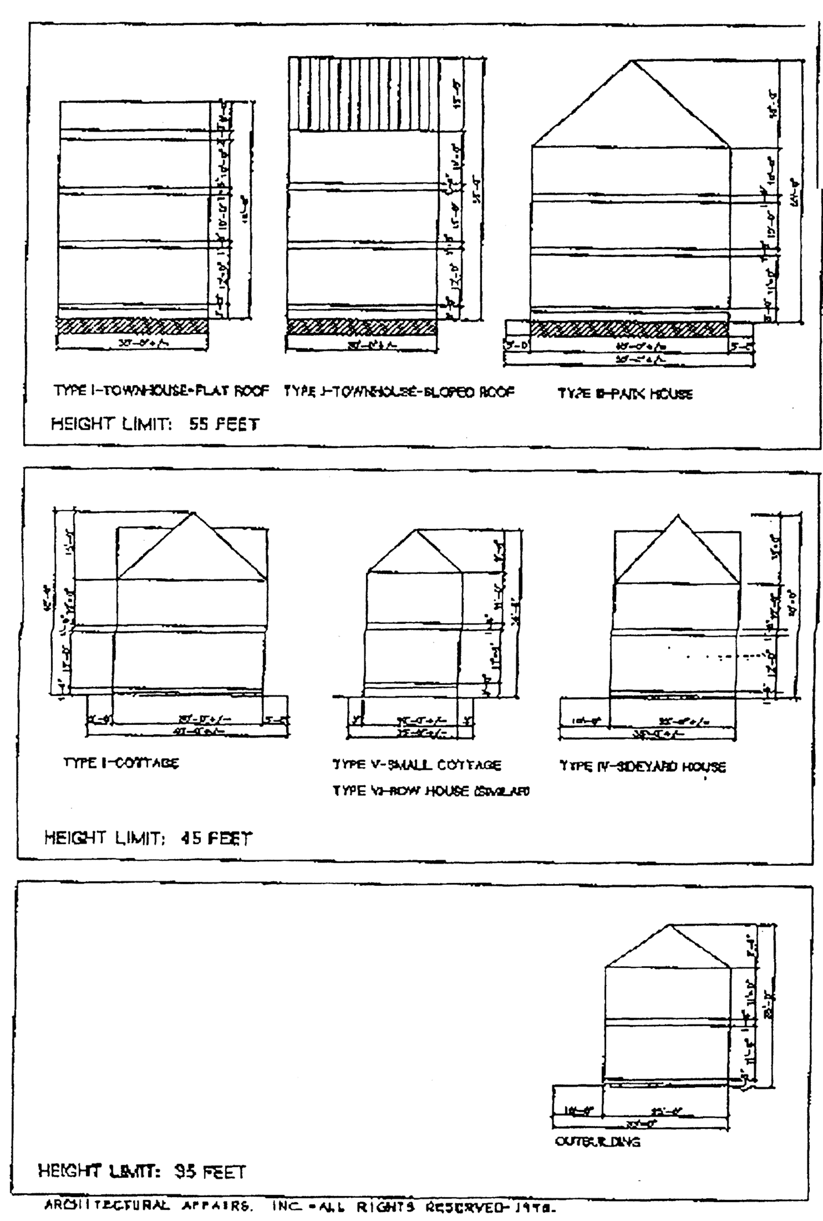
ARAGON TOWNHOUSE-TYPE I
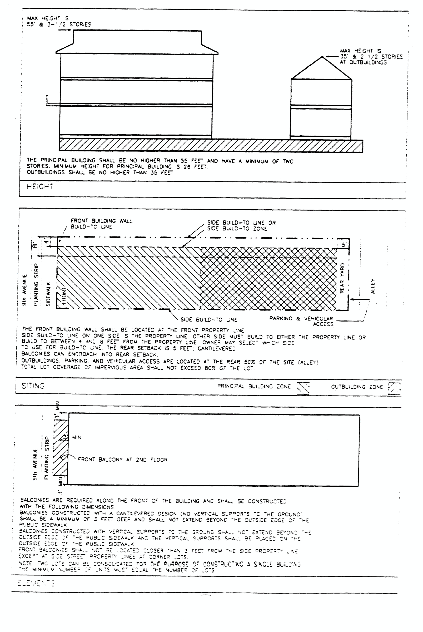
ARAGON COTTAGE-TYPE II
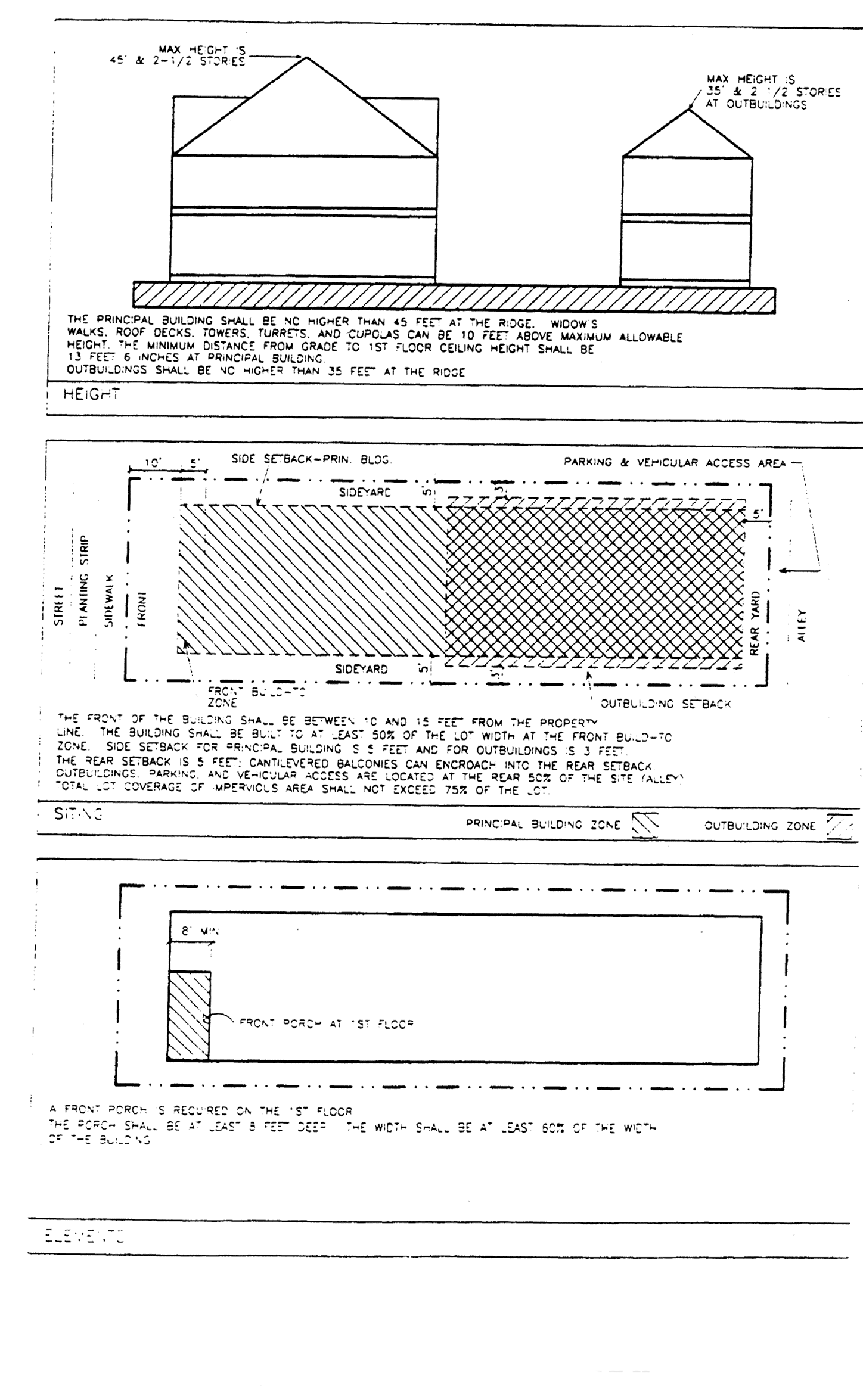
ARAGON PARK HOUSE-TYPE III
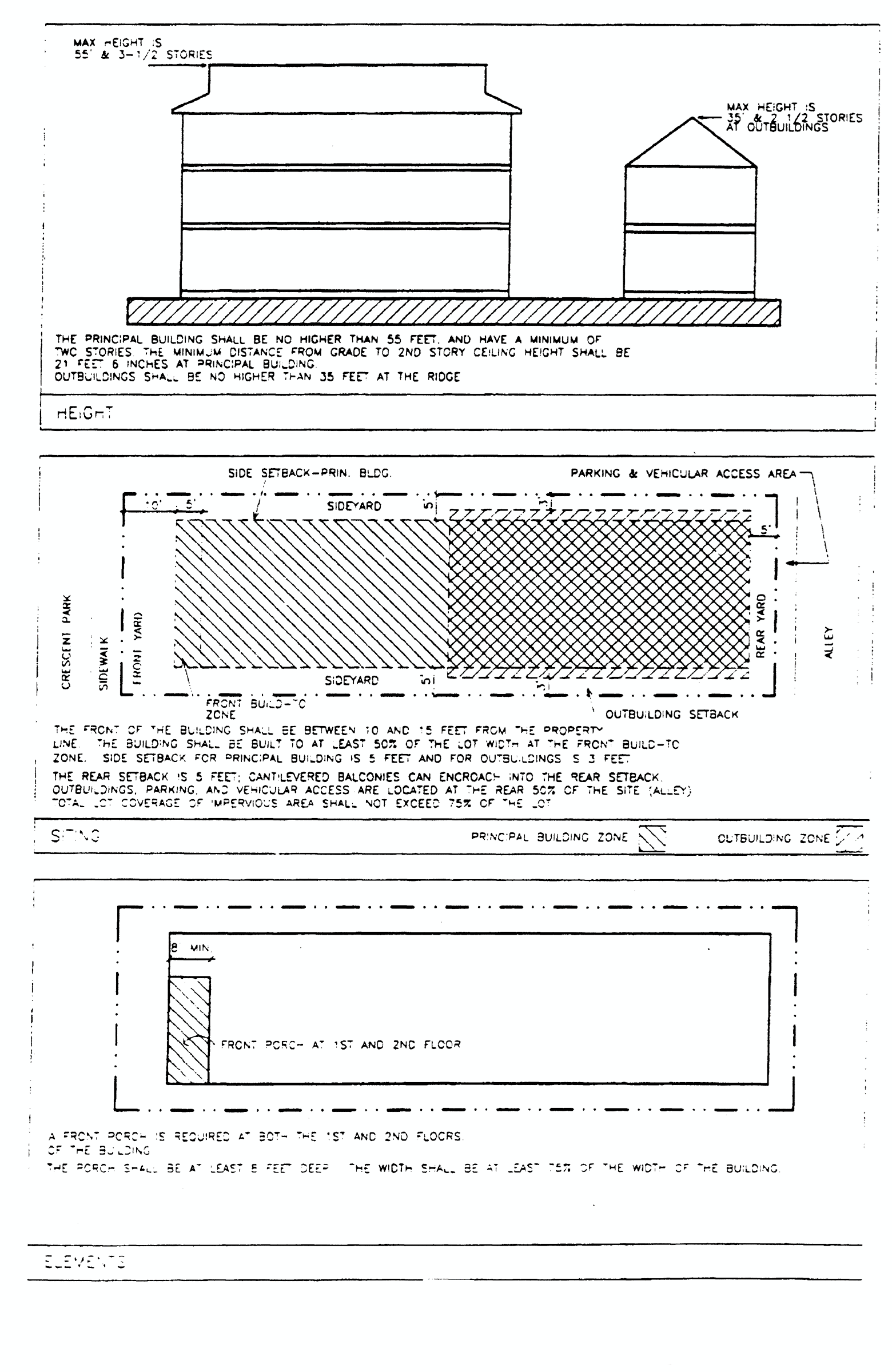
ARAGON SIDEYARD HOUSE WITH ALLEY
ACCESS-TYPE IVA
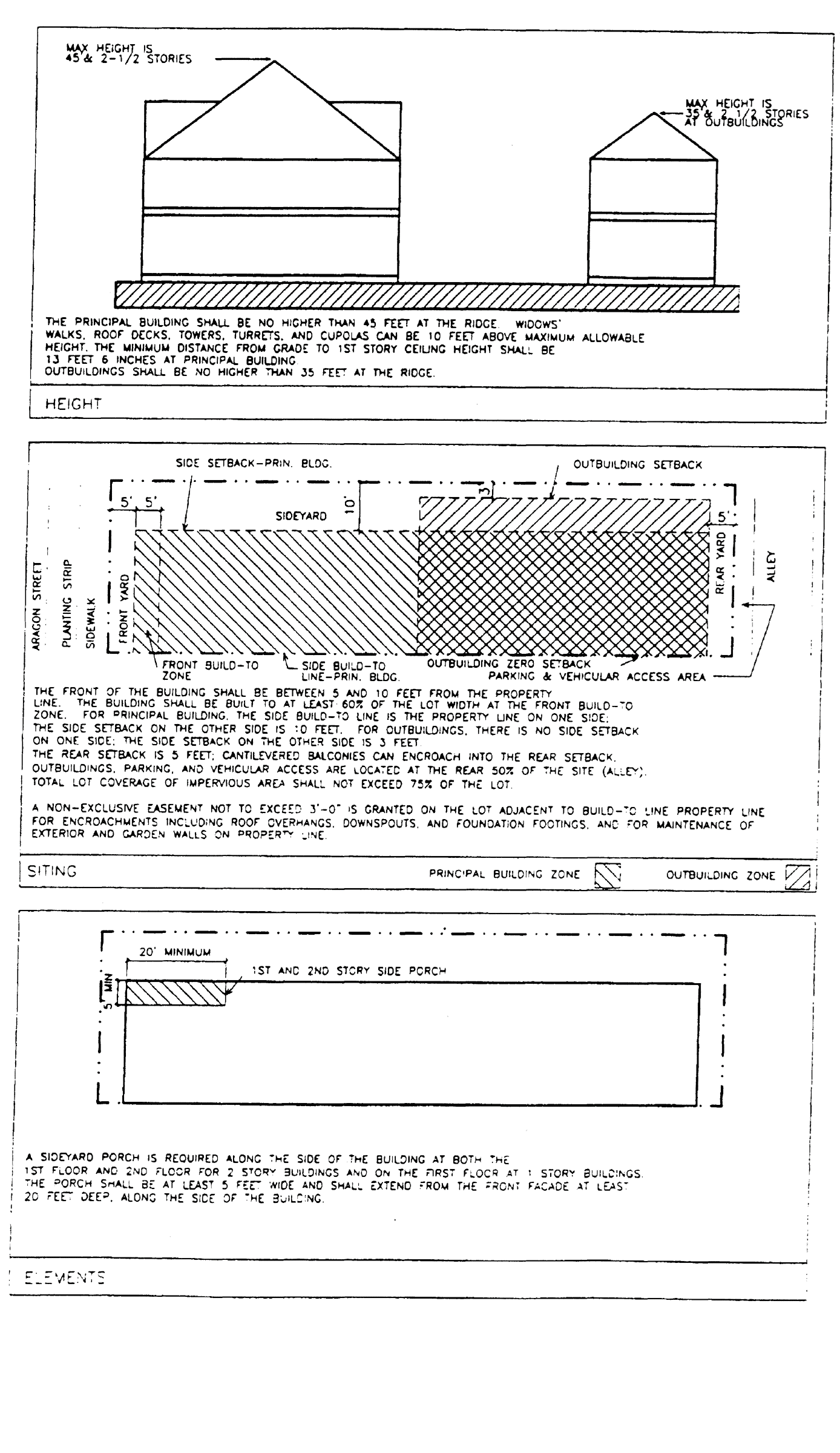
ARAGON SIDEYARD HOUSE WITH STREET
ACCESS-TYPE IVB-INTERIOR LOTS
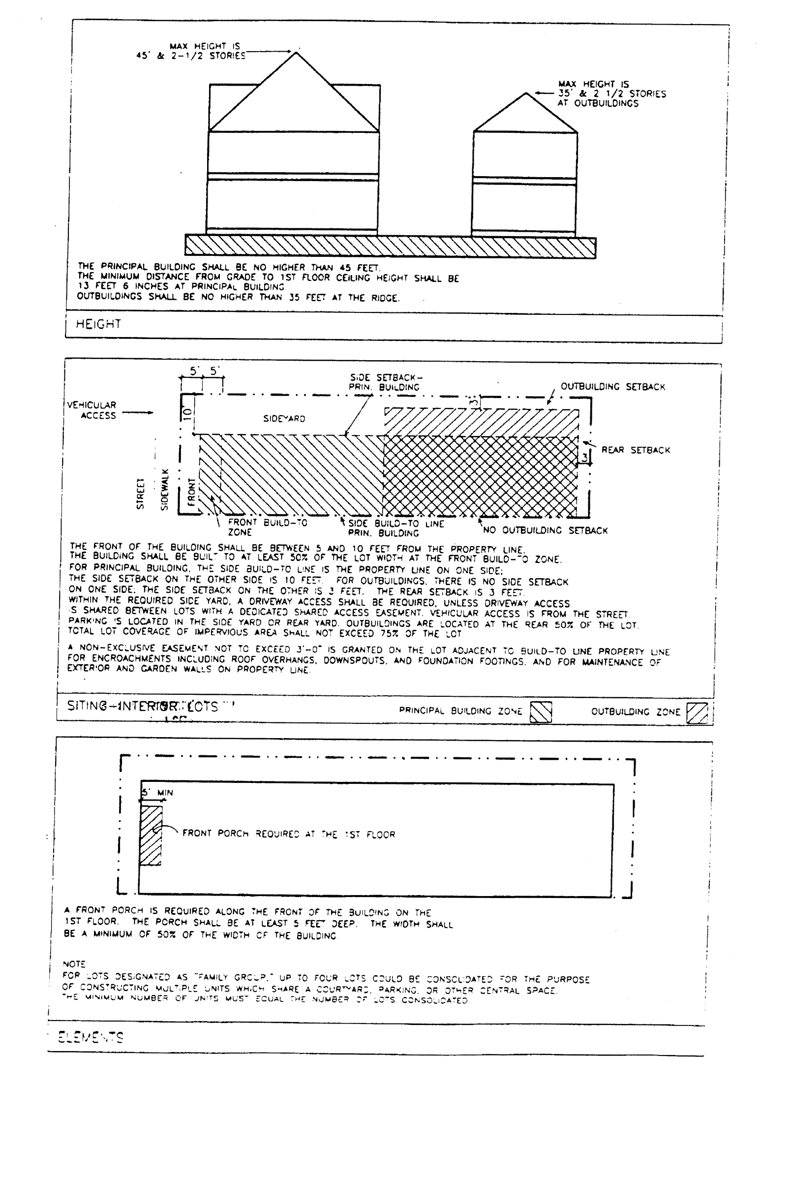
ARAGON SIDEYARD HOUSE WITH STREET
ACCESS-TYPE IVB-CORNER LOTS
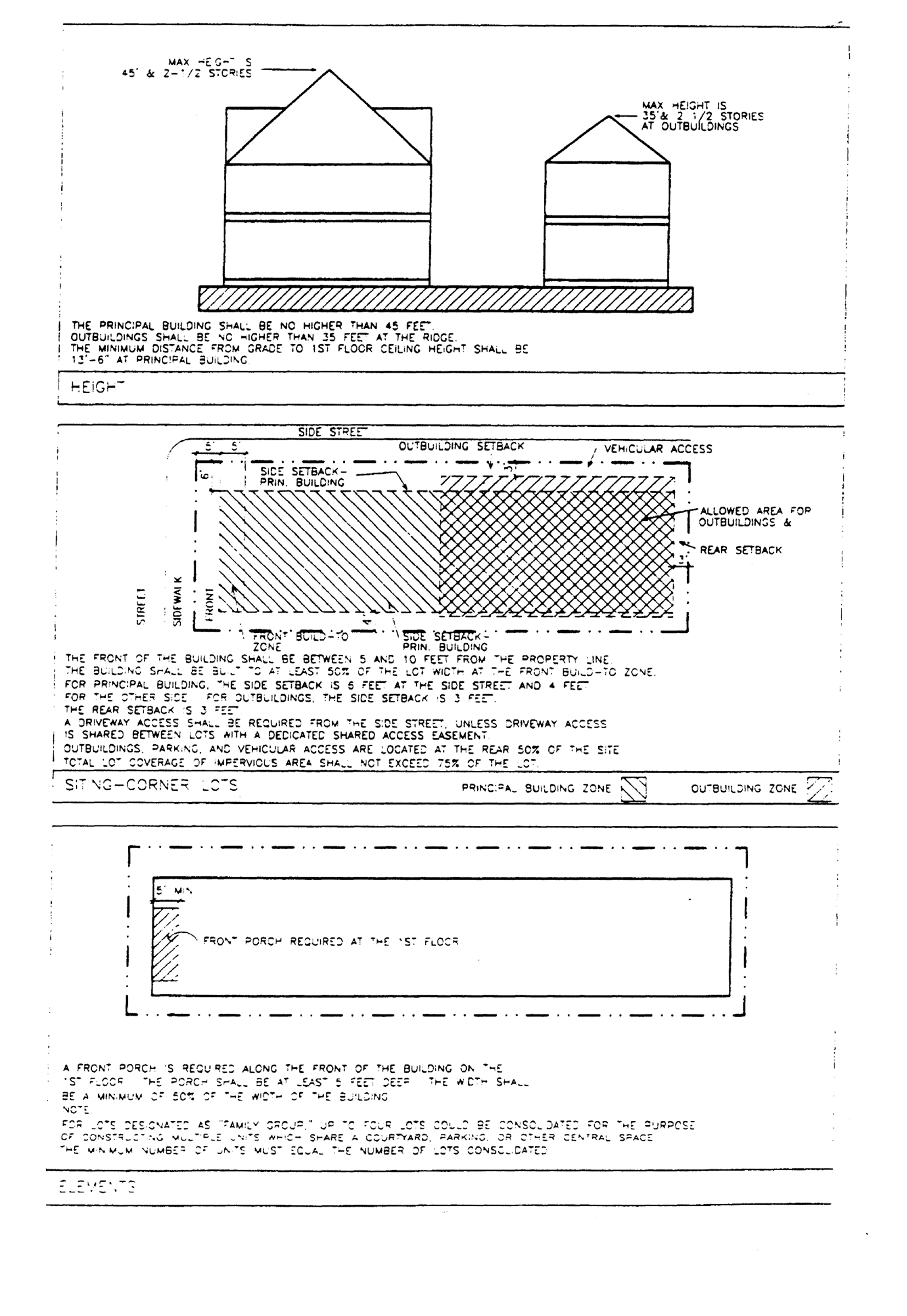
ARAGON SMALL COTTAGE-TYPE V-NORTH CORNER LOTS
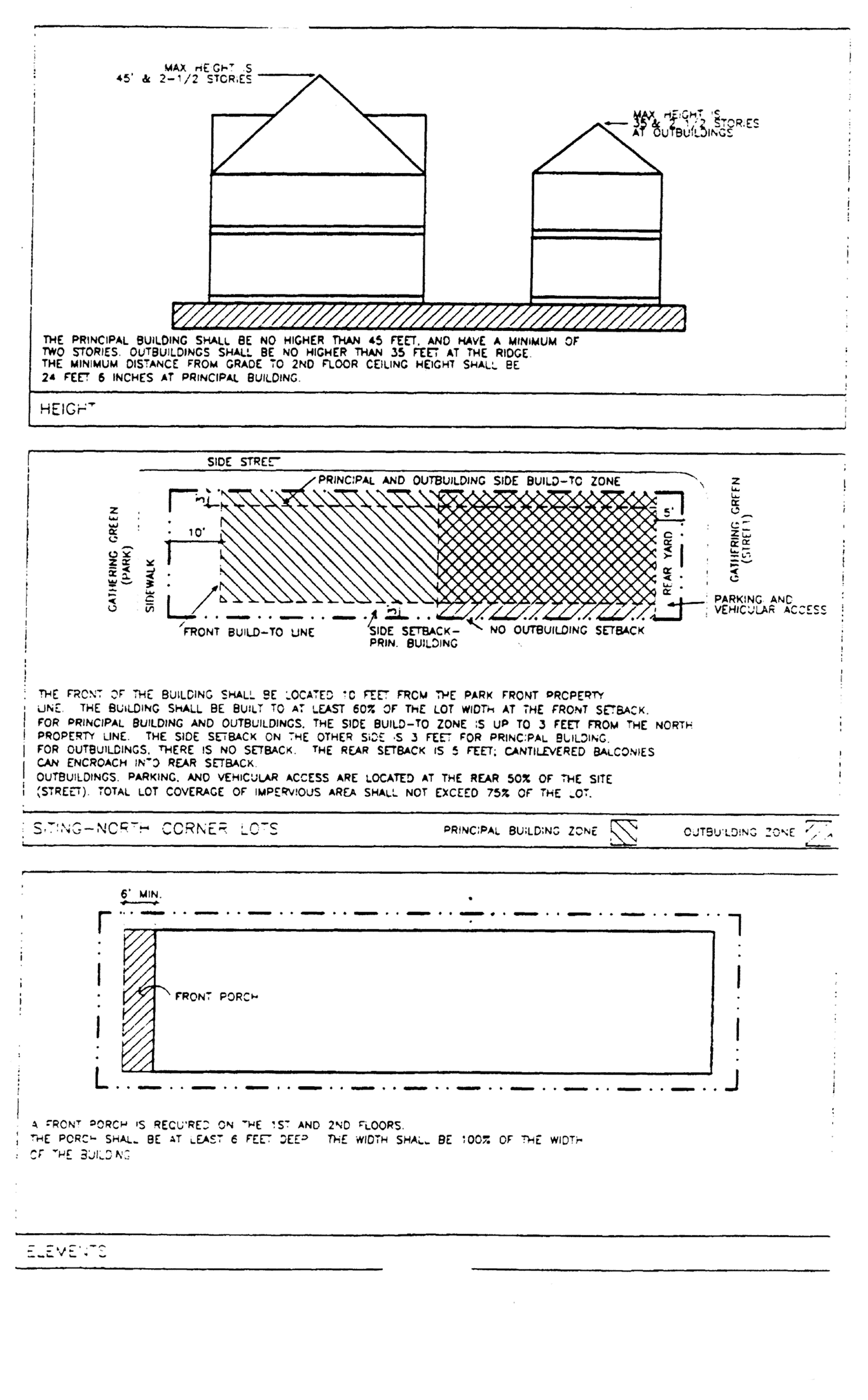
ARAGON ROW HOUSE-TYPE VI-LOTS D-1 THRU D-5
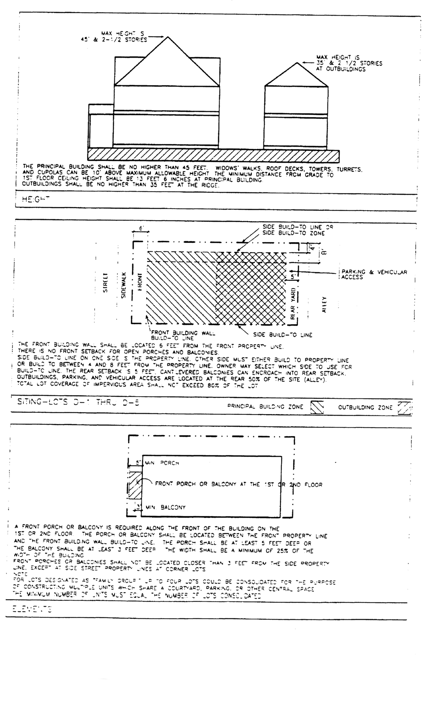
ARAGON ROW HOUSE-TYPE VI-LOTS D-6 THRU 10 AND H-7 THRU H-10
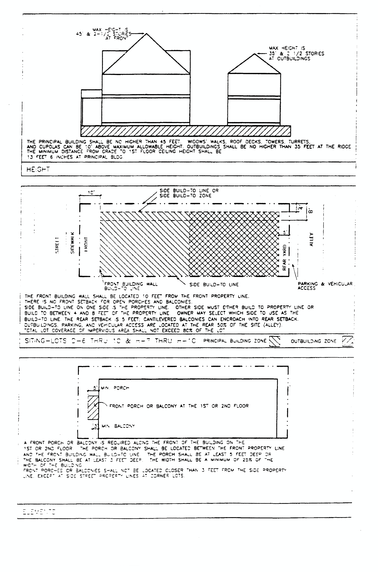
ARAGON ROW HOUSE-TYPE VI-LOT H-6

(3)
WRD, waterfront redevelopment district.
a.
Purpose of district. The waterfront redevelopment district is established to promote redevelopment of the city's downtown waterfront with a compatible mixture of water-dependent and water-related uses that preserve the unique shoreline vista and scenic opportunities, provide public access, create a cultural meeting place for the public, preserve the working waterfront activities historically located in the waterfront area, and encourage a high quality of site planning and architectural design. Site specific analysis of each development proposal within the district is intended to ensure that the scenic vistas and marine-oriented image of the district are maintained, that the development character of the waterfront is upgraded and that the boundaries of the adjacent special districts are positively reinforced.
b.
Uses permitted.
1.
Single-family residential (attached or detached) at a maximum density of 17.4 units per acre. Multifamily residential at a maximum density of 60 dwelling units per acre.
2.
Home occupations, subject to regulations in section 12-3-57.
3.
Offices.
4.
Libraries and community centers opened to the public and buildings used exclusively by the federal, state, county and city government for public purposes.
5.
Hotels/motels.
6.
Marinas.
7.
Parking garages.
8.
The following retail sales and services:
i.
Retail food and drug stores (including medical marijuana dispensaries and package liquor store).
ii.
Personal service shops.
iii.
Clothing stores.
iv.
Specialty shops.
v.
Banks.
vi.
Bakeries whose products are sold at retail on the premises.
vii.
Antique shops.
viii.
Floral shops.
ix.
Health clubs, spa and exercise centers.
x.
Laundromats.
xi.
Laundry and dry-cleaning pick-up stations.
xii.
Restaurants.
xiii.
Studios.
xiv.
Art galleries.
xv.
Sale or rental of sporting goods or equipment including instructions in skiing, sailing, or scuba diving.
xvi.
Boat rentals waterside only with limited upland storage.
xvii.
Bars.
xviii.
Commercial fishing.
xix.
Ferry and passenger terminals.
xx.
Cruise ship operations.
xxi.
Food truck courts, subject to regulations in section 12-3-95.
9.
Family day care homes licensed by the state department of children and family services as defined in state statutes.
c.
Procedure for review of plans.
1.
Plan submission. Every application to construct a new structure in the waterfront redevelopment district shall be subject to the development plan review and approval procedure established in section 12-3-120. Every application for a new certificate of occupancy or a building permit to erect, construct, demolish, renovate or alter a building or sign, or exterior site work (i.e., paving and landscaping of off-street parking areas), located or to be located in the waterfront redevelopment district shall be accompanied with drawings or sketches with sufficient detail to show, as far as they relate to exterior appearances, the architectural design of the building, sign, or exterior work (both before and after the proposed work is done in cases of altering, renovating, demolishing or razing a building or structure) including proposed materials, textures and colors, and the plot plan or site layout including all site improvements or features such as walls, fences, walks, terraces, plantings, accessory buildings, paved areas, signs, lights, awnings, canopies and other appurtenances. All developments within the waterfront redevelopment district must comply with design standards as established in section 12-3-121.
2.
Review and approval. All plans shall be subject to the review and approval of the planning board established in chapter 12-12. At the time of review the board may require that any aspect of the overall site plan that does not meet the standards established in this section be incorporated and brought into compliance within a time limit approved by the board. Review by the planning board of applications for zoning variances shall be as provided for under section 12-12-2(6)f.
3.
Abbreviated review. Sign requests, paint colors, fencing, and emergency repairs that are consistent with the regulations and guidelines set forth in this section, may be approved by letter to the building official from the planning board secretary and the chairperson of the board. This provision is made in an effort to save the applicant and the board time for routine approval matters. If agreement cannot be reached as it pertains to such requests by the board secretary and chairperson, then the matter will be referred to the board for a decision.
d.
Regulations.
1.
Signs. The following provisions shall be applicable to signs in the district:
i.
Number of signs. Each parcel shall be limited to one sign per street frontage; provided, however, if there exists more than one establishment on the parcel, there may be one attached sign per establishment.
ii.
Signs extending over public property. Signs extending over public property shall maintain a clear height of nine feet above the sidewalk and no part of such signs shall be closer than 18 inches to the vertical plane of the curb line or edge of the pavement.
iii.
Sign size and height limitations.
(a)
Attached signs.
(1)
Size. Ten percent of the building elevation square footage (wall area) that fronts on a public street, not to exceed 50 square feet. Buildings exceeding five stories in height; one attached wall sign or combination of wall signs not to exceed 200 square feet and mounted on the fifth floor or above.
(2)
Height. No sign may extend above the roof line of the building to which it is attached. For the purposes of this section roof surfaces constructed at an angle of 65 degrees or more from horizontal shall be regarded as walls.
(b)
Freestanding signs.
(1)
Size. Fifty square feet.
(2)
Height. Ten feet (top of sign).
iv.
Other permitted signs.
(a)
Signs shall not exceed two square feet in size.
(b)
Official traffic signs or signals, informational signs erected by a government agency and temporary signs indicating danger.
v.
Prohibited signs. Refer to section 12-5-7 for a description of prohibited signs. In addition the following signs are prohibited within the district:
(a)
Portable signs.
(b)
Signs that are abandoned or create a safety hazard. Abandoned signs are those advertising a business that becomes vacant and is unoccupied for a period of 90 days or more.
(c)
Signs that are not securely fixed on a permanent foundation.
(d)
Strings of light bulbs, other than holiday decorations, streamers and pennants.
(e)
Signs that present an optical illusion, incorporate projected images, or emit sound.
(f)
Secondary advertising signs (i.e., signs that advertise a brand name product in addition to the name of the business).
vi.
Temporary signs. The following temporary signs shall be permitted in the district:
(a)
Temporary banners indicating that a noncommercial special event such as a fair, carnival, festival or similar happening is to take place, are permitted with the following conditions: Such banners may be erected no sooner than two weeks before the event and banners extending over street rights-of-way require approval from the mayor.
(b)
One non-illuminated sign per street frontage advertising the sale, lease or rental of the lot or building upon which the sign is located. Such sign shall not exceed 12 square feet in size, and shall be removed immediately after occupancy.
(c)
One non-illuminated sign not more than 50 square feet in area in connection with new construction work and displayed only during such time as the actual construction work is in progress.
2.
Off-street parking. The following off-street parking requirement shall apply to all lots, parcels, or tracts in the district: Off-street parking requirements in the waterfront redevelopment district shall be based on the requirements set forth in chapter 12-4. The required parking may be provided off-site by the owner/developer as specified in section 12-4-1(4). Screening shall be provided along the edges of all parking areas visible from the street rights-of-way. This screening may take the form of:
i.
A solid wall or fence (chain-link fences are prohibited) with a minimum height of four feet that is compatible in design and materials with on-site architecture and nearby development;
ii.
An earth berm approximately three feet in height that is landscaped to provide positive screening effective within three years; or
iii.
A combination of walls or fences and landscape screening, or landscape screening designed to provide positive screening within three years.
3.
Vehicular access. For each lot, tract or parcel under single ownership, the maximum number of access points shall not exceed two per street frontage.
4.
Landscaping. Landscaping requirements in the district shall conform to the requirements of chapter 12-6. All service areas (i.e., trash collection containers, compactors, loading docks) shall be screened with at least 75 percent opacity from the street and adjacent buildings by one of the following techniques:
i.
Fence or wall and gate, six feet high;
ii.
Vegetation, six feet high (within three years); or
iii.
A combination of the above.
5.
Underground utility services. All new building construction or additions of floor area to existing structures shall be required to install underground utilities on the site.
6.
Lot coverage. The total coverage of the site including all structures, parking areas, driveways and all other impervious surfaces shall not exceed 75 percent.
7.
Setback/height requirements. No building shall exceed a maximum height of 60 feet in the waterfront redevelopment district.
i.
Shoreline setback/height requirements. All buildings shall be set back a minimum of 30 feet from the shoreline or the bulkhead line. At this minimum setback line, the building height may not exceed 35 feet. Above 35 feet in height, an additional one foot in building height may be permitted for each additional one foot in setback with a maximum building height of 60 feet. The minimum setback from the shoreline may be decreased by the planning board and the council during the review process to permit reuse of existing buildings, structures or foundations with a lesser setback.
ii.
Main Street setback/height requirements. All buildings shall be set back a minimum of 60 feet from the centerline of Main Street. At this minimum setback line, the building height may not exceed 60 feet.
8.
Additional regulations. In addition to the regulations established above in subsections (3)d.1 through 7 of this section, any permitted use within the WRD zoning district where alcoholic beverages are ordinarily sold is subject to the requirements of chapter 7-4.
e.
Regulations. All developments within the waterfront redevelopment district are encouraged to follow the design guidelines established in section 12-3-121(d). In addition, the following site planning guidelines should be taken into consideration in the required development plans.
1.
Site planning. The integration of site features such as building arrangement, landscaping, parking lot layout, public access points, building orientation, and scenic vantage points is critical in producing a pleasant and functional living or working environment. In reviewing development proposals, the following guidelines shall be taken into consideration:
i.
Maximum preservation of waterfront views. Considering the waterfront location of the district, the placement of buildings, signs, service areas, parking and landscaping shall be planned to maximize the preservation of views of the bay and to protect the waterfront scenic open space character. To prevent the effect of a "wall" of development along the edge of the waterfront and adjacent streets, open space should be encouraged between buildings and under elevated buildings. Pedestrian circulation systems should be designed to form a convenient, interconnected network through buildings, landscaped open spaces and public walkways. The longer side of each building should be sited perpendicular to the water's edge in order to preserve water views from the street.
ii.
Building orientation. Buildings should be oriented to maximize the waterfront view potential within the district while maintaining quality facade treatment and design on the streetside. Structures should be positioned to provide viewing opportunities of the water and the shoreline edge between buildings. The location of solid waste receptacles, service entrances, loading docks, storage buildings and mechanical and air conditioning equipment and other items typically situated at the backside of buildings should be discouraged within the area between the building and the water's edge.
iii.
Off-street parking and service. Off-street parking shall be discouraged within the shoreline setback area. Where possible, service areas (i.e., trash collection, loading docks) shall be located to be screened by the building itself; otherwise, walls, fences, landscaping and earth berms shall be used to achieve effective screening.
2.
Aesthetic considerations. Development projects within the district are not subject to special architectural review and approval. In lieu of a special separate review procedure, the following general architectural and aesthetic design criteria will be considered to enhance the character of the district:
i.
Buildings or structures that are part of a present or future group or complex shall have a unity of character and design. The relationship of forms and the use, texture, and color of materials shall be such as to create a harmonious whole.
ii.
Natural materials such as brick, wood and stucco should be encouraged. Materials such as metal and plastic shall be discouraged on exterior surfaces of buildings.
iii.
All mechanical equipment, satellite dishes and other similar equipment should be completely screened by the architecture of the structure, or fences, walls or vegetation.
iv.
Proposed developments within the waterfront redevelopment district that are located adjacent to a historic district should give special consideration to visual compatibility in scale and architectural design in order to positively reinforce the character of the historic area and provide a buffer and transition.
v.
Projects should be encouraged that enhance the setting or provide for adaptive reuse of historic buildings and sites.
3.
Landscaping guidelines. Landscaping should be used to enhance waterfront views and vistas and to screen undesirable features. Low lying plant material should be used in open areas to retain views of the water. Trees should be selectively utilized and carefully located along the waterfront in both public and private developments in order to maintain existing views as much as possible. Plantings should be coordinated near buildings to provide view corridors.
4.
Sign guidelines.
i.
Design/materials. The architectural character of the building to which the sign relates should be reflected in the lettering of the sign, and the materials used for the supporting structure and the sign face.
ii.
Lighting. Indirect and internal lighting is encouraged. Neon and exposed fluorescent lighting is not encouraged.
iii.
Landscaping. The landscaping and positioning of the sign should complement the overall site plan and landscaping of the development.
(4)
WRD-1, Waterfront Redevelopment District-1.
a.
Purpose of district. The waterfront redevelopment district is established to promote redevelopment of the city's downtown waterfront with a compatible mixture of uses that further the goals of downtown Pensacola's comprehensive plan, encourage a walkable mixed-use urban environment, preserve the unique shoreline scenic opportunities, provide continuous public waterfront access, create cultural meeting places for the public, and encourage a high quality of site planning and architectural design. Site specific analysis of each development proposal within the district is intended to ensure that the scenic vistas of the district are maintained, that the development character of the waterfront is upgraded and that the boundaries of the adjacent special districts are positively reinforced.
b.
Uses permitted.
1.
Single-family residential (attached or detached) at a maximum density of 17.4 units per acre. Multifamily residential at a maximum density of 60 dwelling units per acre.
2.
Home occupations, subject to regulations in section 12-3-57.
3.
Offices.
4.
Libraries and community centers opened to the public and buildings used exclusively by the federal, state, county and city government for public purposes.
5.
Hotels/motels.
6.
Marinas.
7.
Parking garages.
8.
The following retail sales and services:
i.
Retail food and drug stores (including medical marijuana dispensaries and package liquor store).
ii.
Personal service shops.
iii.
Clothing stores.
iv.
Specialty shops.
v.
Banks.
vi.
Bakeries whose products are sold at retail on the premises.
vii.
Antique shops.
viii.
Floral shops.
ix.
Health clubs, spa and exercise centers.
x.
Laundromats.
xi.
Laundry and dry-cleaning pick-up stations.
xii.
Restaurants.
xiii.
Studios.
xiv.
Art galleries.
xv.
Sale or rental of sporting goods or equipment including instructions in skiing, sailing, or scuba diving.
xvi.
Boat rentals waterside only with limited upland storage.
xvii.
Bars.
xviii.
Commercial fishing.
xix.
Ferry and passenger terminals.
xx.
Cruise ship operations.
xxi.
Food truck courts, subject to regulations in section 12-3-95.
9.
Family day care homes licensed by the state department of children and family services as defined in state statutes.
c.
Procedure for review of plans.
1.
Plan submission. Every application to construct a new structure in the waterfront redevelopment district-1 shall be subject to the development plan review and approval procedure established in section 12-3-120. Every application for a new certificate of occupancy or a building permit to erect, construct, demolish, renovate or alter a building or sign, or exterior site work (i.e., paving and landscaping of off-street parking areas), located or to be located in the waterfront redevelopment district-1 shall be accompanied with drawings or sketches with sufficient detail to show, as far as they relate to exterior appearances, the architectural design of the building, sign, or exterior work (both before and after the proposed work is done in cases of altering, renovating, demolishing or razing a building or structure) including proposed materials, textures and colors, and the plot plan or site layout including all site improvements or features such as walls, fences, walks, terraces, plantings, accessory buildings, paved areas, signs, lights, awnings, canopies and other appurtenances. All developments within the waterfront redevelopment district must comply with design standards as established in section 12-3-121.
2.
Review and approval. All plans shall be subject to the review and approval of the planning board established in chapter 12-12. At the time of review the board may require that any aspect of the overall site plan that does not meet the standards established in this section be incorporated and brought into compliance within a time limit approved by the board. Review by the planning board of applications for zoning variances shall be as provided for under section 12-12-2(6)f.
3.
Abbreviated review. Sign requests, paint colors, fencing, and emergency repairs that are consistent with the regulations and guidelines set forth in this section, may be approved by letter to the building official from the planning board secretary and the chairperson of the board. This provision is made in an effort to save the applicant and the board time for routine approval matters. If agreement cannot be reached as it pertains to such requests by the board secretary and chairperson, then the matter will be referred to the board for a decision.
d.
Regulations.
1.
Signs. The following provisions shall be applicable to signs in the district:
i.
Number of signs. Each parcel shall be limited to one sign per street frontage; provided, however, if there exists more than one establishment on the parcel, there may be one attached sign per establishment. Additionally, retail sales and services may have an A-frame sign in addition to the one sign per frontage.
ii.
Signs extending over public property. Signs extending over public property shall maintain a clear height of nine feet above the sidewalk and no part of such signs shall be closer than 18 inches to the vertical plane of the curb line or edge of the pavement.
iii.
Sign size and height limitations.
(a)
Attached signs.
(1)
Size. Ten percent of the building elevation square footage (wall area) that fronts on a public street, not to exceed 50 square feet. Buildings exceeding five stories in height; one attached wall sign or combination of wall signs not to exceed 200 square feet and mounted on the fifth floor or above.
(2)
Height. No sign may extend above the roof line of the building to which it is attached. For the purposes of this section roof surfaces constructed at an angle of 65 degrees or more from horizontal shall be regarded as walls.
(b)
Freestanding signs.
(1)
Size. Fifty square feet.
(2)
Height. Ten feet (top of sign).
(c)
A-frame sign.
(1)
Size. Ten square feet.
(2)
Height. Forty-two inches (top of sign).
iv.
Other permitted signs.
(a)
Signs shall not exceed two square feet in size.
(b)
Official traffic signs or signals, informational signs erected by a government agency and temporary signs indicating danger.
v.
Prohibited signs. Refer to section 12-5-7 for a description of prohibited signs. In addition the following signs are prohibited within the district:
(a)
Signs that are abandoned or create a safety hazard. Abandoned signs are those advertising a business that becomes vacant and is unoccupied for a period of 90 days or more.
(b)
Signs that present an optical illusion, incorporate projected images, or emit sound.
(c)
Secondary advertising signs (i.e., signs that advertise a brand name product in addition to the name of the business).
vi.
Temporary signs. The following temporary signs shall be permitted in the district:
(a)
Temporary banners indicating that a noncommercial special event such as a fair, carnival, festival or similar happening is to take place, are permitted with the following conditions: Such banners may be erected no sooner than two weeks before the event and banners extending over street rights-of-way require approval from the mayor.
(b)
One non-illuminated sign per street frontage advertising the sale, lease or rental of the lot or building upon which the sign is located. Such sign shall not exceed 12 square feet in size, and shall be removed immediately after occupancy.
(c)
One non-illuminated sign not more than 50 square feet in area in connection with new construction work and displayed only during such time as the actual construction work is in progress.
2.
Off-street parking. The following off-street parking requirement shall apply to all lots, parcels, or tracts in the district: Off-street parking requirements in the waterfront redevelopment district-1 shall be based on the requirements set forth in section 12-4-1(4). The required parking may be provided off-site by the owner/developer as specified in section 12-4-1(4). Screening shall be provided along the edges of all parking areas visible from the street rights-of-way. This screening may take the form of:
i.
A solid wall or fence (chain-link fences are prohibited) with a minimum height of four feet that is compatible in design and materials with on-site architecture and nearby development;
ii.
Landscaping approximately three feet in height that is landscaped to provide positive screening effective within three years; or
iii
A combination of walls or fences and landscape screening, or landscape screening designed to provide positive screening within three years.
3.
Vehicular access. For each lot, tract or parcel under single ownership, the maximum number of access points shall not exceed two per street frontage.
4.
Landscaping. Landscaping requirements in the district shall conform to the requirements of chapter 12-6. All service areas (i.e., trash collection containers, compactors, loading docks) shall be screened with at least 75 percent opacity from the street and adjacent buildings by one of the following techniques:
i.
Fence or wall and gate, six feet high;
ii.
Vegetation, six feet high (within three years); or
iii.
A combination of the above.
5.
Underground utility services. All new building construction or additions of floor area to existing structures shall be required to install underground utilities on the site.
6.
Lot coverage. The total coverage of the site including all structures, parking areas, driveways and all other impervious surfaces shall not exceed 95 percent.
7.
Setback/height requirements. No building shall exceed a maximum height of six stories in the waterfront redevelopment district-1, as defined in section 12-3-31, community redevelopment area (CRA) urban design overlay district.
i.
Shoreline setback/height requirements. All buildings shall be set back a minimum of 30 feet from the shoreline or the bulkhead line. The minimum setback from the shoreline may be decreased by the planning board and the council during the review process to permit reuse of existing buildings, structures or foundations with a lesser setback.
ii.
Main Street setback/height requirements. All buildings shall be set back a minimum of 60 feet from the centerline of Main Street. At this minimum setback line, the building height may not exceed six stories.
iii.
All other setbacks shall be as specified on the regulating plan.
8.
Additional regulations. In addition to the regulations established above in subsections (3)d.1 through 7 of this section, any permitted use within the WRD-1 zoning district where alcoholic beverages are ordinarily sold is subject to the requirements of chapter 7-4.
e.
Regulations. All developments within the waterfront redevelopment district-1 are encouraged to follow the design guidelines established in section 12-3-121(d). In addition, the following site planning guidelines should be taken into consideration in the required development plans:
1.
Site planning. The integration of site features such as building arrangement, landscaping, parking lot layout, public access points, building orientation, and scenic vantage points is critical in producing a pleasant and functional living or working environment. In reviewing development proposals, the following guidelines shall be taken into consideration:
i.
Maximum preservation of waterfront views. Considering the waterfront location of the district, the placement of buildings, signs, service areas, parking and landscaping shall be planned to maximize the preservation of views of the bay and to protect the waterfront scenic open space character. To prevent the effect of a "wall" of development along the edge of the waterfront and adjacent streets, open space should be encouraged between buildings and under elevated buildings. Pedestrian circulation systems should be designed to form a convenient, interconnected network through buildings, landscaped open spaces and public walkways. The longer side of each building should be sited perpendicular to the water's edge in order to preserve water views from the street.
ii.
Building orientation. Buildings should be oriented to maximize the waterfront view potential within the district while maintaining quality facade treatment and design on the streetside. Structures should be positioned to provide viewing opportunities of the water and the shoreline edge between buildings. The location of solid waste receptacles, service entrances, loading docks, storage buildings and mechanical and air conditioning equipment and other items typically situated at the backside of buildings should be discouraged within the area between the building and the water's edge.
iii.
Off-street parking and service. Off-street parking shall be discouraged within the shoreline setback area. Where possible, service areas (i.e., trash collection, loading docks) shall be located to be screened by the building itself; otherwise, walls, fences, landscaping and earth berms shall be used to achieve effective screening.
2.
Aesthetic considerations. Development projects within the district are not subject to special architectural review and approval, however compliance with the CRA Overlay Standards and Guidelines as defined in section 12-3-31, community redevelopment area (CRA) urban design overlay district, is encouraged. In lieu of a special separate review procedure, the following general architectural and aesthetic design criteria will be considered to enhance the character of the district:
i.
Buildings or structures should have a unity of character and design. The relationship of forms and the use, texture, and color of materials shall be such as to create a harmonious whole.
ii.
Natural materials such as brick, wood and stucco should be encouraged. Materials such as metal and plastic shall be discouraged on exterior surfaces of buildings.
iii.
All mechanical equipment, satellite dishes and other similar equipment should be completely screened by the architecture of the structure, or fences, walls or vegetation.
iv.
Proposed developments within the waterfront redevelopment district-1 which are located adjacent to a historic district should give special consideration to visual compatibility in scale and architectural design in order to positively reinforce the character of the historic area and provide a buffer and transition.
v.
Projects should be encouraged that enhance the setting or provide for adaptive reuse of historic buildings and sites.
3.
Landscaping guidelines. Landscaping should be used to enhance waterfront views and vistas and to screen undesirable features. Low lying plant material should be used in open areas to retain views of the water. Trees should be selectively utilized and carefully located along the waterfront in both public and private developments in order to maintain existing views as much as possible. Plantings should be coordinated near buildings to provide view corridors.
4.
Sign guidelines.
i.
Design/materials. The architectural character of the building to which the sign relates should be reflected in the lettering of the sign, and the materials used for the supporting structure and the sign face.
ii.
Lighting. Indirect and internal lighting is encouraged. Neon and exposed fluorescent lighting is not permitted.
iii.
Landscaping. The landscaping and positioning of the sign should complement the overall site plan and landscaping of the development.
WATERFRONT DEVELOPMENT DISTRICT
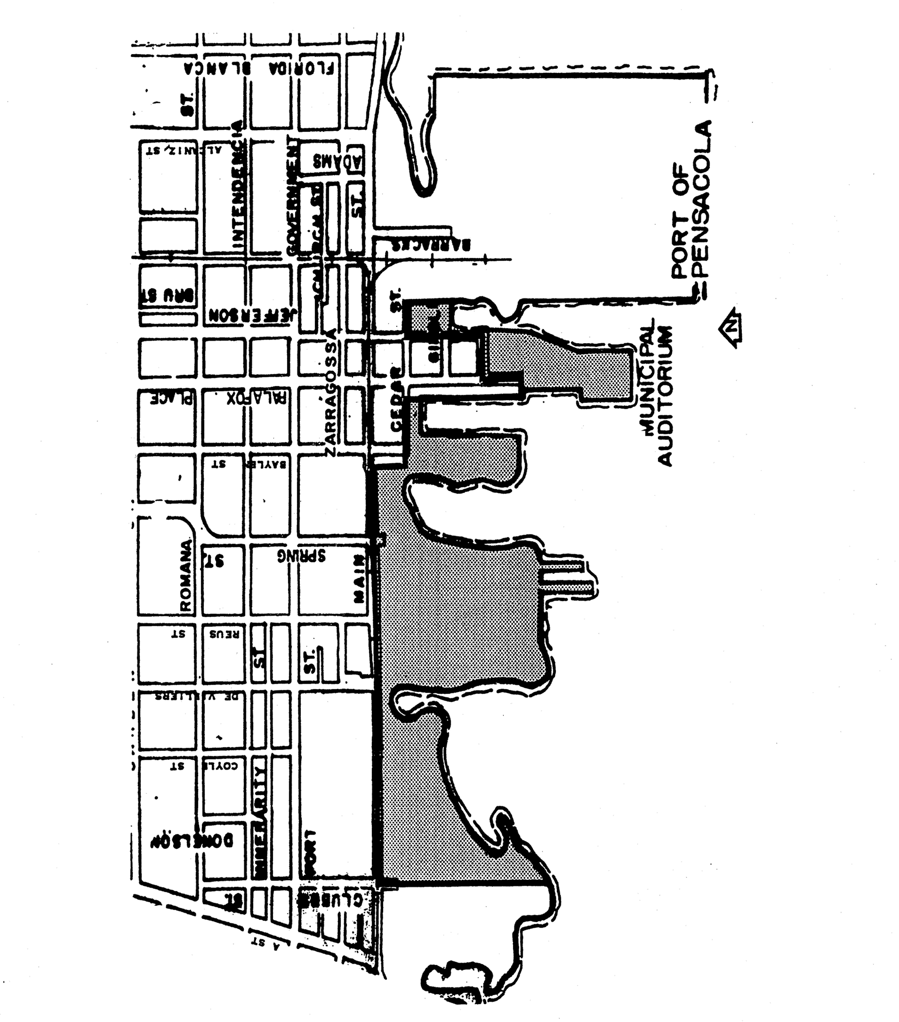
(Code 1986, § 12-2-12; Ord. No. 25-92, § 2, 7-23-1992; Ord. No. 6-93, § 9, 3-25-1993; Ord. No. 21-93, § 1, 8-16-1993; Ord. No. 29-93, §§ 13, 14, 11-18-1993; Ord. No. 33-95, §§ 4, 5, 8-10-1995; Ord. No. 9-96, § 9, 1-25-1996; Ord. No. 45-96, § 3, 9-12-1996; Ord. No. 33-98, § 2, 9-10-1998; Ord. No. 40-99, §§ 10—13, 10-14-1999; Ord. No. 43-99, § 1, 11-18-1999; Ord. No. 12-00, § 1, 3-9-2000; Ord. No. 50-00, § 3, 10-26-2000; Ord. No. 3-01, § 2, 1-11-2001; Ord. No. 6-01, §§ 1—3, 1-25-2001; Ord. No. 6-02, § 2, 1-24-2002; Ord. No. 13-06, § 10, 4-27-2006; Ord. No. 17-06, §§ 2, 3, 7-27-2006; Ord. No. 16-10, §§ 200—202, 9-9-2010; Ord. No. 06-16, §§ 1, 2, 2-11-2016; Ord. No. 20-19, § 3, 9-26-2019; Ord. No. 27-19, § 1, 11-14-2019; Ord. No. 10-23, § 3, 8-17-2023)
Sec. 12-3-13. - South Palafox business district.
The regulations in this section shall be applicable to the South Palafox business district: SPBD.
(1)
Purpose of district. The South Palafox business district is established to promote the compatible redevelopment of the city's historic downtown waterfront by encouraging high quality site planning and architectural design that is compatible with both the historic character of the existing structures and the waterfront activities. The zoning regulations are intended to help avoid excessive building height and mass and vehicular congestion.
(2)
Uses permitted.
a.
Single-family residential (attached or detached) at a maximum density of 17.4 units per acre. Multifamily residential at a maximum density of 108 dwelling units per acre.
b.
Home occupations, subject to regulations in section 12-3-57.
c.
Offices.
d.
Libraries and community centers opened to the public and buildings used exclusively by the federal, state, county and city government for public purposes.
e.
Hotels/motels.
f.
Marinas.
g.
Parking garages.
h.
The following retail sales and services with no outside storage or major repair work permitted:
1.
Retail food and drug stores (including medical marijuana dispensaries and liquor package store).
2.
Personal service shops.
3.
Clothing stores.
4.
Specialty shops.
5.
Banks.
6.
Bakeries, whose products are sold at retail on the premises.
7.
Antique shops.
8.
Floral shops.
9.
Health clubs, spas and exercise centers.
10.
Laundromats and dry cleaners.
11.
Restaurants.
12.
Studios.
13.
Art galleries.
14.
Bars.
i.
Retail sales and services with outside storage or major repair work permitted:
1.
Sale or rental of sporting goods or equipment including instructions in skiing, sailing, or scuba diving.
2.
Boat sales/rentals.
3.
Boat fueling.
4.
Commercial fishing.
j.
Accessory buildings and uses customarily incidental to the above uses.
k.
Family day care homes licensed by the state department of children and family services as defined in state statutes.
(3)
Procedure for the review of plans.
a.
Plan submission. Every application to construct a new structure in the South Palafox business district shall be subject to the development plan review and approval procedure established in section 12-3-120. Every application for a new certificate of occupancy or a building permit to erect, construct, demolish, renovate or alter a building or sign, or exterior site work (i.e., paving and landscaping of off-street parking areas), located or to be located in the South Palafox business district shall be accompanied with drawings or sketches with sufficient detail to show, as far as they relate to exterior appearances, the architectural design of the building, sign, or exterior work (both before and after the proposed work is done in cases of altering, renovating, demolishing or razing a building or structure) including proposed materials, textures and colors, and the plot plan or site layout including all site improvements or features such as walls, fences, walks, terraces, plantings, accessory buildings, paved areas, signs, lights, awnings, canopies and other appurtenances. All developments within the South Palafox business district must comply with design standards as established in section 12-3-121.
b.
Review and approval. All plans shall be subject to the review and approval of the planning board established in chapter 12-12. At the time of review the board may require that any aspect of the overall site plan which does not meet the standards established in this section be incorporated and brought into compliance within a time limit approved by the board.
c.
Abbreviated review. Sign requests, paint colors, fencing, and emergency repairs that are consistent with the regulations and guidelines set forth in this section, may be approved by letter to the building official from the planning board secretary and the chairperson of the board. This provision is made in an effort to save the applicant and the board time for routine approval matters. If agreement cannot be reached as it pertains to such requests by the board secretary and chairperson, then the matter will be referred to the board for a decision.
(4)
Regulations.
a.
Building height and setback. Buildings and other structures may be constructed to a maximum height of 80 feet above the required flood plain elevation. There shall be no minimum front, rear or side yard buildings setback requirements, except as may be necessary to comply with applicable fire safety codes.
b.
Signs. Any proposed new, altered or replacement sign may not impair the architectural or historical value of buildings within the district. Such sign shall be consistent with the character of the South Palafox business district. The sign's lettering and construction should complement the building to which it is attached.
1.
Permitted signs. See section 12-5-3 for sign area calculation.
i.
Temporary accessory signs.
(a)
One non-illuminated sign advertising the sale, lease, or rental of the lot or building, said sign not to exceed six square feet in area.
(b)
One non-illuminated sign not more than 50 square feet in area in connection with new construction work and displayed only during such time as the actual construction work is in progress.
ii.
Portable signs. Businesses located within the South Palafox business district may place one portable (two-sided A-Frame) sign on the sidewalk adjacent to the business location subject to the following conditions:
(a)
The maximum size of the sign shall not exceed two feet wide by three feet high;
(b)
The sidewalk width shall be a minimum of eight feet;
(c)
A one-time fee of $40.00 shall be paid to the city for a license to use the sidewalk for placement of a sign;
(d)
A license to use agreement, with proof of insurance, shall be required to use an identified area of the sidewalk for locating a sign;
(e)
The sign shall be removed from the sidewalk at the close of business hours daily;
(f)
Signs shall require approval by the planning board.
iii.
Permanent accessory signs.
(a)
One sign per street frontage subject to the following limitations:
Sign height. No attached sign shall extend above the eave line of a building to which it is attached. Roof surfaces constructed at an angle of 65 degrees or more from horizontal shall be regarded as wall space. Signs projecting from a building or extending over public property shall maintain a clear height of nine feet six inches. The sign may be mounted to the face of a wall of the building, hung from a bracket that is mounted to a wall of a building, hung from other ornamental element on the building. Attached or wall signs may be placed on the front or one side of the building. The sign may be illuminated provided the source of light is not visible beyond the property line of the lot on which the sign is located.
(b)
One non-illuminated nameplate designating the name of the occupant of the property; the nameplate shall not be larger than three square feet and shall be attached flat against the wall of the building.
(c)
Municipal or state installed directional signs, historical markers and other signs of a general public interest when approved by the mayor.
2.
Prohibited signs.
i.
Any sign using plastic materials for lettering or background.
ii.
Internally illuminated signs or awnings.
iii.
Portable signs (except as noted in subsection (4)b.1.ii of this section).
iv.
Nonaccessory signs.
v.
Rooftop signs.
vi.
Any sign containing or illuminated by flashing or intermittent lights if changing degrees of intensity.
vii.
Signs with visible motion.
viii.
Signs that incorporate projected images or emit sound.
ix.
Strings of light bulbs other than holiday decorations.
x.
Gas or hot-air balloon-type signs.
xi.
Banners, pennants and streamers except on a temporary basis as provided for in section 12-5-6.
xii.
Signs that are posted, painted, or otherwise affixed to any rock, fence, tree or utility pole.
xiii.
Signs that are not securely fixed on a substantial structure.
xiv.
Signs that are not in good repair or that may create a hazardous condition.
xv.
Signs that are illegal under state laws and regulations.
xvi.
Nonaccessory signs attached to any craft or structure in or on a water body designed or used for the primary purpose of displaying advertisements. Provided, however, that this provision shall not apply to any craft or structure that displays an advertisement or business notice of its owner, so long as such craft or structure is engaged in the usual business or regular work of the owner, and not used merely, mainly or primarily to display advertisement.
c.
Vehicular access. For each lot, tract or parcel under single ownership, the maximum number of vehicular access points shall not exceed two per street frontage. Provided, however, for each 50 feet of street frontage in excess of 100 feet, one additional access may be permitted.
d.
Landscaping. Landscaping shall be subject to applicable provisions of section 12-6-3. In addition all service areas (i.e., trash collection containers, compactors, loading docks) shall be screened from street and adjacent buildings by one of the following techniques:
1.
Fence or wall and gate, six feet high;
2.
Vegetation; six feet high (within three years);
3.
A combination of the above.
e.
Underground utility services. All new building construction or increases of floor area of 50 percent or more to existing structures shall be required to install underground utilities on the site.
f.
Off-street parking. New construction of buildings that do not exceed 40 feet in height, or the renovation of existing buildings that do not exceed 40 feet in height shall be exempt from the off-street parking requirements set forth in section 12-4-1. The off-street parking requirements set forth in said section shall be required for the gross floor area contained in newly constructed or renovated buildings above the 40-foot elevation. The required parking may be provided by the owner on the same parcel of property proposed for development, or off-site as specified in section 12-4-1(4). In addition to the requirements of section 12-4-1, screening shall be provided along the edges of all parking areas visible from the street rights-of-way. This screening may take the form of: a solid wall or fence (chain-link fences are prohibited) with a minimum height of four feet that is compatible in design and materials with on-site architecture and nearby development, or an earth berm approximately three feet in height that is landscaped to provide positive screening effective within three years, or a combination of walls or fences and landscape screening, or landscape screening design to provide positive screening within three years.
g.
Buildings fronts, rears, and sides abutting streets and public areas. All structural and decorative elements of building fronts, rears, and sides abutting streets or public improvement areas shall be repaired or replaced to match as closely as possible the original materials and construction of that building or be compatible with the SPBD architectural character.
h.
Walls and fences. The size, design and placement of these features within the South Palafox business district shall be consistent with the architectural character within the immediate area of their location.
i.
Paint colors. Planning board-approved paint palettes from several manufacturers, that represent acceptable historic colors for use in the South Palafox business district, shall be maintained in the planning office for public review.
j.
Additional regulations. In addition to the regulations established above in subsections (4)a through f of this section, any permitted use within the South Palafox Business district where alcoholic beverages are ordinarily sold is subject to the requirements of chapter 7-4.
(5)
Development guidelines. All development shall be subject to the provisions of section 12-3-121(d) and the following provisions:
a.
Site planning. The integration of site features such as building arrangement, landscaping, parking lot layout, building orientation, and scenic vantage points is critical in producing a pleasant and functional living or working environment. In reviewing development proposals, the following guidelines shall be taken into consideration:
1.
Waterfront character. Considering the waterfront location of the district, the placement of buildings, signs, service areas, parking and landscaping should be planned to maximize the preservation of views of the bay and to protect the waterfront scenic open space character.
2.
Service areas and mechanical equipment. Where possible, service areas (i.e., trash collection, loading docks), mechanical equipment, satellite dishes and all similar equipment shall be located to be screened by the building itself; otherwise, walls, fences, landscaping or earth berms shall be used to achieve effective screening.
3.
Aesthetic considerations. Development projects within the district are not subject to special architectural review and approval. In lieu of a special separate review procedure, the following general architectural and aesthetic design criteria will be considered to enhance the character of the district:
i.
Buildings or structures that are part of a present or future group or complex shall have a unity of character and design. The relationship of forms and the use, texture, and color of materials shall be such as to create a harmonious whole.
ii.
Natural materials such as brick, wood and stucco should be encouraged. Materials such as metal and plastic shall be discouraged on exterior surfaces of buildings.
4.
Proposed developments within the district, that are located adjacent to a historic district should give special consideration to visual compatibility in scale and architectural design in order to positively reinforce the character of the historic area and provide a buffer and transition.
5.
Projects should be encouraged that enhance the setting or provide for adaptive reuse of historic buildings and sites.
b.
Landscaping guidelines.
1.
Landscaping should be used to enhance waterfront views and vistas and to screen undesirable features.
2.
Low lying plant material should be used in open areas to retain views of the water.
3.
Trees should be selectively utilized and carefully located along the waterfront in both public and private developments in order to maintain existing views as much as possible.
4.
Plantings should be coordinated near buildings to provide view corridors.
(6)
District rehabilitation, repair and maintenance standards. The following rehabilitation, repair and maintenance standards shall be applied to all existing structures and land parcels respectively, whether occupied or vacant within the South Palafox business district. These standards shall be considered by the planning board when reviewing development plans in other areas of the South Palafox business district.
a.
Building fronts, rears, and sides abutting streets and public areas. Rotten or weakened portions shall be removed, repaired and replaced to match as closely as possible the original materials and construction of that building or be compatible with the SPBD architectural character.
b.
Windows.
1.
All windows must be tight fitting and have sashes of proper size and design. Sashes with rotten wood, broken joints or loose mullions or muntins shall be replaced. All broken and missing windows shall be replaced with new glass.
2.
Windows openings in upper floors of the front of the building shall not be filled or boarded-up. Window panes shall not be painted.
c.
Show windows and storefronts. All damaged, sagging or otherwise deteriorated storefronts, show windows or entrances shall be repaired or replaced.
d.
Exterior walls.
1.
Existing miscellaneous elements on the building walls, such as empty electrical conduit, unused signs and/or sign brackets, etc., shall be removed.
2.
Sheet metal gutters, downspouts and copings shall be repaired or replaced as necessary.
3.
Rear and side walls shall be repaired and finished as necessary to cover evenly all miscellaneous patched and filled areas to present an even and uniform surface.
e.
Roofs. Roofs shall be cleaned and kept free of trash, debris or any other element, that is not a permanent part of the building.
f.
Front, rear, and side yards, parking areas and vacant parcels. When a front, rear or side yard, parking area or vacant parcel exists or is created through demolition, the owner may utilize the space in accordance with the provisions of the zoning district in which the space is located; provided, however, that the site shall be properly maintained free of weeds, litter, and garbage in accordance with applicable provisions of the Code.
g.
Walls, fences, signs. Walls, fences, signs and other accessory structures shall be properly maintained.
(7)
Survey and classification. A survey of the district to determine in which areas historical themes are appropriate, and to classify buildings, by architectural design, and materials as historically significant, supportive, neutral, and nonconforming shall be available at the offices of the Historic Pensacola Preservation Board.
(Code 1986, § 12-2-13; Ord. No. 34-99, §§ 1—4, 9-9-1999; Ord. No. 40-99, §§ 14—16, 10-14-1999; Ord. No. 3-01, § 2, 1-11-2001; Ord. No. 6-02, § 2, 1-24-2002; Ord. No. 17-06, § 4, 7-27-2006; Ord. No. 16-10, § 203, 9-9-2010)
Sec. 12-3-14. - Interstate corridor land use district.
The regulations in this section shall be applicable to the interstate corridor zoning district: IC.
(1)
Purpose of district. The purpose of this district is to provide for nonhighway land uses both below and adjoining the Interstate 110 corridor on land owned by the state department of transportation and leased by the city as shown in the site development plan in the DOT "Corridor Location, Design and Multiple Use Report: Interstate 110, Pensacola, Escambia County, Florida, 1972."
(2)
Permitted uses.
a.
Recreation and open space facilities, and community centers owned and operated by the city.
b.
Public utilities and city government buildings and facilities.
c.
Service commercial and light industrial uses with site plan approval from city council.
d.
Public transportation facilities.
e.
Tourist commercial.
f.
Community commercial.
(3)
Procedure for review of plans. Every application for development or redevelopment in the interstate corridor zoning district shall be subject to the development plan review and approval procedure established in section 12-3-120. All development must comply with design standards established in section 12-3-121(c) and is encouraged to follow design guidelines established in section 12-3-121(d).
(Code 1986, § 12-2-14)
Sec. 12-3-15. - Site specific zoning district.
The regulations in this section shall be applicable to the site specific development zoning district: SSD.
(1)
Purpose of district. This section is enacted to provide for the option of amending an approved final development plan for any parcel of property that was zoned SSD (site specific development) prior to May 1, 1990. Subsequent to May 1, 1990 no rezonings to SSD have been allowed.
(2)
Minor changes to an approved SSD final development plan. Minor changes to a final development plan may be approved by the mayor, city engineer, the planning services department and building official when in their opinion the changes do not make major changes in the arrangement of buildings or other major features of the final development plan.
(3)
Major changes to an approved SSD final development plan. Major changes such as, but not limited to, changes in land use or an increase or decrease in the area covered by the final development plan may be made only by following the procedures outlined in filing a new preliminary development plan as described in section 12-3-120.
(Code 1986, § 12-2-15; Ord. No. 16-10, § 204, 9-9-2010)
Sec. 12-3-16. - Neighborhood land use.
(a)
Purpose of district. The purpose of this district is to provide for land uses and aesthetic considerations that are distinctive and unique to neighborhoods defined by specific geographic boundaries as established in this chapter.
(b)
Permitted uses. In the absence of an approved neighborhood master plan land use shall be permitted as designated by the city's zoning regulations.
(c)
Procedure for review of plans. If a review board has been established in this title for a special neighborhood district, every application for development or redevelopment shall be subject to review and approval by said board.
(Code 1986, § 12-2-16; Ord. No. 6-93, § 10, 3-25-1993)
Sec. 12-3-27. - Palafox historic business district.
(a)
Purpose. The Palafox historic business district is established to preserve the existing development pattern and distinctive architectural character of the historic downtown commercial district. The regulations are intended to preserve, through the restoration of existing buildings and construction of compatible new buildings, the scale of the existing structures and the diversity of original architectural styles, and to encourage a compact, convenient arrangement of buildings.
(b)
Character of the district. The Palafox historic business district is characterized by sites and facilities of historical value to the city. These buildings and historic sites and their period architecture (i.e., Sullivanesque, Classical Revival, Renaissance Revival, and Commercial Masonry) blend with an overall pattern of harmony, make the district unique and represent the diversity of business activity and commercial architecture over a long period of Pensacola history. The district is an established business area, tourist attraction, containing historic sites, and a variety of specialty retail shops, restaurants, private and governmental offices, and entertainment centers.
(c)
Historic theme area. That portion of Palafox Place between Garden Street and Main Street is hereby designated a historical theme area, with a theme based on materials, signs, canopies, facades or other features as they existed in 1925 or earlier.
(d)
Boundaries of the district. The boundaries of the Palafox historic business district shall be the same as the Pensacola downtown improvement district, plus the west 14.25 feet of lot 214 and all of lots 215 and 216, old city tract.
(e)
Procedure for review and submission of development plan.
(1)
Submission of plans. Every application for a building permit to erect, construct, renovate and/or alter an exterior of a building, or sign, located or to be located in the district shall be accompanied by plans for the proposed work. As used herein, "plans" shall mean drawings or sketches with sufficient detail to show, as far as they relate to exterior appearance, the architectural design of the building or sign (both before and after the proposed work is done in the cases of altering, renovating, demolishing or razing a building or structure), including proposed materials, textures and colors, and the plat plan or site layout, including all site improvements or features such as walls, fences, walks, terraces, plantings, accessory buildings, paved areas, signs, lights, awnings, canopies and other appurtenances. Such plans shall be promptly forwarded by the building official to the architectural review board.
(2)
General conditions, procedures and standards. Prior to submitting a formal application for approval of a proposed exterior alteration, the owners shall confer with the staff of the architectural review board, who will seek the advice of the downtown improvement board staff, the Historic Pensacola Preservation Board staff and appropriate city staff if necessary to review:
a.
The relationship between the proposed exterior alteration or proposed exterior to buildings in the immediate surroundings and to the district in which it is located or to be located.
b.
At the time of the predevelopment conference, the applicant shall provide a sketch plan indicating the location of the proposed exterior alteration and its relationship to surrounding properties. The advisory meeting should provide insight to both the developer, the city, the downtown improvement board, and the Historic Pensacola Preservation Board staff regarding potential development problems that might otherwise result in costly plan revisions or unnecessary delay in development.
(3)
Review and approval by the architectural review board. All such plans shall be subject to review and approval by the architectural review board as established in section 12-12-3 and in accordance with the provisions of section 12-3-10(1)d.1 through 3, applicable to the historic zoning districts. The board shall adopt written rules and procedures for abbreviated review for paint colors, minor repairs, emergency repairs and minor deviations in projects already approved by the board. This process may authorize the board to designate one of its members to undertake such abbreviated review without the necessity for review by the entire board; provided, however, such abbreviated review process shall require review by the director of the downtown improvement board and the staff of the Historic Pensacola Preservation Board. If agreement cannot be reached as it pertains to an abbreviated review by the board designee, director of the downtown improvement board, Historic Pensacola Preservation Board staff and secretary to the architectural review board then the matter will be referred to the full board for a decision.
(f)
Architectural review of proposed exterior development.
(1)
General considerations. The board shall consider plans for existing buildings based on their classification as significant, supportive, compatible or nonconforming as defined and documented in files located at the office of the downtown improvement board. In reviewing the plans, the board shall consider exterior design and appearance of the building, including the front, sides, rear and roof, materials, textures and colors; plot plan or site layout, including features such as walls, walks, terraces, plantings, accessory buildings, signs, lights, awnings, canopies, and other appurtenances; and conformity to plans and themes promulgated, approved and/or amended from time to time by the city council; and relation of the building to immediate surroundings and to the district in which it is located or to be located. The term "exterior" shall be deemed to include all of the outer surfaces of the building and is not restricted to those exteriors visible from a public street or place. The board shall not consider interior design or plan. The board shall not exercise any control over land use, which is governed by particular provisions of this title, or over construction, which is governed by chapter 14-2.
(2)
Decision guidelines. Every decision of the board, in their review of plans for buildings or signs located or to be located in the district, shall be in the form of a written order stating the findings of the board, its decision and the reasons therefor, and shall be filed with and posted with the building permit on site. Before approving the plans for any proposed building, or signs located or to be located in the district, the board shall find:
a.
In the case of a proposed alteration or addition to an existing building, that such alteration or addition will not impair the architectural or historic value of the building or if due to a new use for the building the impairment is minor considering visual compatibility standards such as height, proportion, shape, and scale.
b.
In the case of a proposed new building, that such building will not, in itself or by reason of its location on the site, impair the architectural or historic value or character of buildings on adjacent sites or in the immediate vicinity.
c.
In the case of a proposed new building, that such building will not be injurious to the general visual character of the district in which it is to be located considering visual compatibility standards such as height, proportion, shape, and scale.
d.
In the case of the proposed razing or demolition of an existing building, that the regulations established in section 12-3-10(1)i through k shall apply.
e.
In the case of a proposed addition to an existing building or the base of a proposed new building, or building relocation, that such addition, new building or relocation will not adversely affect downtown redevelopment plans or programs or the comprehensive plan of the city.
(3)
Recommendation for changes. The board shall not disapprove any plans without giving its recommendations for changes necessary to be made before the plans will be reconsidered. Such recommendations may be general in scope, and compliance with them shall qualify the plans for reconsideration by the board.
(4)
Board review standards. The architectural review board shall use the Secretary of the Interior's Standards for Rehabilitation and Guidelines for Rehabilitation of Historic Buildings as the general governing standards for existing structures. New construction shall maintain scale and quality of design. All new construction shall be reviewed in terms of massing, rhythm, materials and details, building elements and site. Generally, all structures should be compatible in these categories to surrounding structures. In addition the following standards shall apply:
a.
Signs. In the case of any proposed new or altered sign, that the sign will not impair the architectural or historical value of any building to which it is attached, nor any adjacent building, and that such sign is consistent with the theme and spirit of the block where it is to be located, and that such sign is consistent with the following provisions:
1.
Within the Palafox historic business district, signs protruding into or overhanging the public right-of-way are permitted subject to prior approval by the board, and are subject to removal on 30 days' notice if the city actually requires the space for any public purpose. Such signs must be of a character and size consistent with maintenance of the theme and character of the district. Existing overhanging signs are hereby approved and will not require further board approval unless altered.
2.
Businesses located within the Palafox historic business district may place one portable (two-sided A-frame) sign on the sidewalk adjacent to the business location subject to the following conditions:
i.
The maximum size of the sign shall not exceed two feet wide by three feet high;
ii.
The sidewalk width shall be a minimum of eight feet;
iii.
A one time fee of $40.00 shall be paid to the city for a license to use the sidewalk for placement of a sign;
iv.
A license to use agreement, with proof of insurance, shall be required to use an identified area of the sidewalk for locating a sign;
v.
The sign shall be removed from the sidewalk at the close of business hours daily;
vi.
Signs shall require approval by the downtown improvement board and architectural review board.
3.
Rooftop signs are prohibited, provided the business for which the sign is erected remains continuously in business, existing signs violating this provision may continue in use. Upon application to and approval by the board, such existing signs may be permitted to remain in place for a longer period if the board finds that the sign is consistent with the theme and character of the district.
4.
Whirling and flashing signs attached to a building are prohibited, unless such signs replicate an original sign used at that location in the historical theme area. Balloon-type, portable or nonaccessory signs are prohibited.
5.
Internally illuminated signs shall be prohibited.
b.
Building fronts, rears, and sides abutting streets and public areas. All structural and decorative elements of building fronts, rears, and sides abutting streets or public improvement areas shall be repaired or replaced to match as closely as possible the original materials and construction of that building.
c.
Windows.
1.
Window openings in upper floors of the front of the building shall not be covered from the outside.
2.
Window panes shall not be painted.
3.
The number of window panes and use of shutters should reflect the style and period of the structure.
4.
Windows not in front of buildings shall be kept properly repaired or, with fire department approval, may be closed, in which case sills, lintels and frame must be retained and the new enclosure recessed from the exterior face of the wall.
d.
Show windows and storefronts.
1.
A show window shall include the building face, porches, and entrance area leading to the door, sidelights, transoms, display platforms, and devices including lighting and signage designated to be viewed from the public right-of-way.
2.
Show windows, entrances, signs, lighting, sun protection, porches, security grilles, etc., shall be compatible with the original scale and character of the structure and the surrounding structures.
3.
Show windows shall not be painted for advertising purposes but may be painted for authorized identification of the place of business as authorized by the architectural review board.
4.
Show windows with aluminum trim, mullions, or muntins shall be placed or painted consistent with and compatible to the overall facade design as authorized by the board.
5.
Solid or permanently closed or covered storefronts shall not be permitted, unless treated as an integral part of the building facade using wall materials and window detailing compatible with the upper floors, or other building surfaces.
e.
Exterior walls.
1.
All exterior front or side walls that have not been wholly or partially resurfaced or built over shall be repaired or replaced in a manner approved by the board. Existing painted masonry walls shall have loose material removed and painted a single color except for trim that may be another color. Patched walls shall match the existing adjacent surfaces as to materials, color, bond and joining.
2.
Historic painted advertising on walls should be preserved at the discretion of the board.
3.
Rear and side walls, where visible from any of the streets or alleys, shall be finished so as to harmonize with the front of the building.
f.
Roofs.
1.
Chimneys, elevator penthouses or other auxiliary structures on the roofs shall be repaired or replaced to match as closely as possible the original.
2.
Any mechanical equipment placed on a roof shall be so located as to be hidden from view or to be as inconspicuous from view as possible. Equipment shall be screened with suitable elements of a permanent nature or finished in such a manner as to be compatible with the character of the building or to minimize its visibility.
g.
Walls and fences. The size, design and placement of these features within the Palafox historic business district shall be consistent with the architectural character within the immediate area of their location.
h.
Landscaping and screening. Landscaping and screening requirements in the Palafox historic business district shall be based on applicable requirements of chapter 12-6. All service areas (i.e. trash collection containers, compactors, loading docks) shall be fully screened from street and adjacent buildings by one of the following techniques: fence or wall, six feet high; vegetation six feet high (within three years); a combination of the above.
(5)
Review. Any person aggrieved by a decision of the board may, within 15 days thereafter, apply to the city council for review of the board's decision. He or she shall file with the city clerk a written notice requesting the council to review said decision.
(g)
District rehabilitation, repair and maintenance guidelines. The following rehabilitation, repair and maintenance standards shall be applied to all existing structures and land parcels respectively, whether occupied or vacant within the Palafox Historic Theme Area. These standards shall be considered as guidelines by the board when reviewing development plans in other areas of the Pensacola historic business district. In cases where an owner owns property comprising a total city block, the board shall consider the burden on the owner and may approve an incremental adherence to the standards or guidelines.
(1)
Building fronts, rears, and sides abutting streets and public areas. Rotten or weakened portions shall be removed, repaired and replaced to match as closely as possible the original.
(2)
Windows.
a.
All windows must be tight-fitting and have sashes of proper size and design. Sashes with rotten wood, broken joints or loose mullions or muntins shall be replaced. All broken and missing windows shall be replaced with new glass.
b.
Window openings in upper floors of the front of the building shall not be filled or boarded-up. Window panes shall not be painted.
(3)
Show windows and storefronts. All damaged, sagging or otherwise deteriorated storefronts, show windows or entrances shall be repaired or replaced.
(4)
Exterior walls.
a.
Existing miscellaneous elements on the building walls, such as empty electrical conduit, unused signs and/or sign brackets, etc., shall be removed.
b.
Sheet metal gutters, downspouts and copings shall be repaired or replaced as necessary.
c.
Rear and side walls shall be repaired and finished as necessary to cover evenly all miscellaneous patched and filled areas to present an even and uniform surface.
(5)
Roofs. Roofs shall be cleaned and kept free of trash, debris or any other element that is not a permanent part of the building.
(6)
Auxiliary structures. Structures, at the rear of buildings, attached or unattached to the principal structure, that are structurally deficient shall be properly repaired or demolished as authorized by the architectural review board.
(7)
Front, rear, and side yards, parking areas and vacant parcels. When a front, rear or side yard, parking area or vacant parcel exists or is created through demolition, the owner may utilize the space in accordance with the provisions of the zoning district in which the space is located; provided, however, that the site shall be properly maintained free of weeds, litter, and garbage in accordance with applicable provisions of the Code.
(8)
Walls, fences, signs. Walls, fences, signs and other accessory structures shall be properly maintained.
(h)
Survey, classification and technical assistance.
(1)
Survey and classification. A survey of the district to determine in which areas historical themes are appropriate, and to classify buildings, by architectural design, and materials as historically significant, supportive, neutral, and nonconforming shall be available at the offices of the downtown improvement board and the community redevelopment agency of the city.
(2)
Technical assistance. Within the limits of staff capability and availability of funds, the board may provide sketches or renderings to property owners and/or merchants, showing suitable designs and themes for facade improvement.
(Code 1986, § 12-2-21; Ord. No. 28-94, § 2, 9-18-1994; Ord. No. 45-96, § 4, 9-12-1996; Ord. No. 8-99, § 2, 2-11-1999; Ord. No. 16-10, § 205, 9-9-2010; Ord. No. 31-17, § 1, 12-14-2017)
Sec. 12-3-28. - Governmental center district.
(a)
Purpose of district. The purpose for the establishment of this district is to provide the redevelopment of a centralized area for government related land use; and to encourage a coordinated architectural character within the district.
(b)
Procedure for review of plans.
(1)
Submission of plans. Every application for a building permit to erect, construct, renovate and/or alter an exterior of a building, or sign, located or to be located in the district shall be accompanied by plans for the proposed work. As used herein, "plans" shall mean drawings or sketches with sufficient detail to show, as far as they relate to exterior appearance, the architectural design of the building or sign (both before and after the proposed work is done in the cases of altering, renovating, demolishing or razing a building or structure), including proposed materials, textures and colors, and the plat plan or site layout, including all site improvements or features such as walls, fences, walks, terraces, plantings, accessory buildings, paved areas, signs, lights, awnings, canopies, screening and other appurtenances. Such plans shall be promptly forwarded by the building official to the architectural review board.
(2)
Review and approval by the architectural review board. All such plans shall be subject to review and approval by the architectural review board as established in section 12-12-3 and in accordance with the provisions of section 12-3-10(1)d.1 through 3, applicable to the historic zoning districts. The board shall adopt written rules and procedures for abbreviated review for paint colors, minor repairs, emergency repairs and minor deviations in projects already approved by the board. This process may authorize the board to designate one of its members to undertake such abbreviated review without the necessity for review by the entire board; provided, however, such abbreviated review process shall require review by the director of the downtown improvement board and the staff of the Historic Pensacola Preservation Board. If agreement cannot be reached as it pertains to an abbreviated review by the board designee, director of the downtown improvement board, Historic Pensacola Preservation Board staff and secretary to the architectural review board then the matter will be referred to the full board for a decision.
(3)
Notification and building permit. Upon receiving the order of the board, the board's secretary shall thereupon notify the applicant of the board's decision. If the board approves the plans, and if all other requirements of the city have been met, the building official shall issue a permit for the proposed building or sign. If the board disapproves the plans, the building official shall not issue such permit. In a case where the board disapproves the plans, the secretary of the board shall furnish the applicant with a copy of the board's written order, and may at the discretion of the board include recommendations for changes necessary to be made before the board will reconsider the plans.
(4)
Failure to review plans. If no action upon plans submitted to the board has been taken at the expiration of 31 days from the date of submission of the application for a building permit and required plans to the board, such plans shall be deemed to have been approved, and if all other requirements of the city have been met, the building official shall issue a permit for the proposed building or sign.
(c)
Decisions. Every decision of the board, in their review of plans for building or signs located or to be located in the district, shall be in the form of a written order stating the finding of the board, its decision and the reasons therefor. The board may at its discretion make recommendations for changes necessary to be made before the plans will be reconsidered. If recommendations for changes are made by the board, they may be general in scope and compliance with them shall only qualify the plans for reconsideration by the board but compliance with recommendations shall not bind or stop the board from disapproving the plans under reconsideration.
(1)
Proposed plans shall be approved unless the board finds that the proposed erection, construction, renovation and/or alteration is not compatible with the built environment of the governmental center district.
(2)
The board shall not consider interior design or plan. The board shall not exercise any control over land use, such as is governed by the city's zoning ordinance, chapters 12-3 and 12-4, or over construction, such as is governed by the city's building codes.
(3)
Plans for proposed new or altered signs shall be approved unless the board finds that the sign is inconsistent with the theme and character of the district, or that such sign does not comply with the requirements of the Code or with any of the following provisions:
a.
The board may adopt and promulgate rules and regulations controlling the number and size of signs, their heights and materials, relating such rules to the number of square feet served, frontage, and type of business. Such rules and regulations shall be subject to review and approval by the city council.
b.
Within the governmental center district, roof signs, flashing and/or rotating signs, and signs protruding into or overhanging the public right-of-way are hereby prohibited except as set forth herein.
c.
Signs existing prior to February 22, 1979, may remain until the business for which the sign was erected ceases to do business at that location or until the property on which such sign is located is acquired for a public purpose, which ever shall first occur.
d.
On application to the approval of the board, rules relating to the number and size of signs may be waived for grand openings, special sales, going-out-of-business sales, and similar occasions when consistent with this Code.
(d)
Disqualification of member from voting. Any member of the board who shall be employed to design or construct a building or who shall have any proprietary tenancy or personal interest in such building requiring approval of plans by the board shall be disqualified from voting thereon.
(e)
Boundaries of the district. The boundaries of the governmental center district shall be as outlined on Map 12-3.2.
(Code 1986, § 12-2-22; Ord. No. 45-96, § 5, 9-12-1996)
MAP 12-2-2 GOVERNMENTAL CENTER
DISTRICT
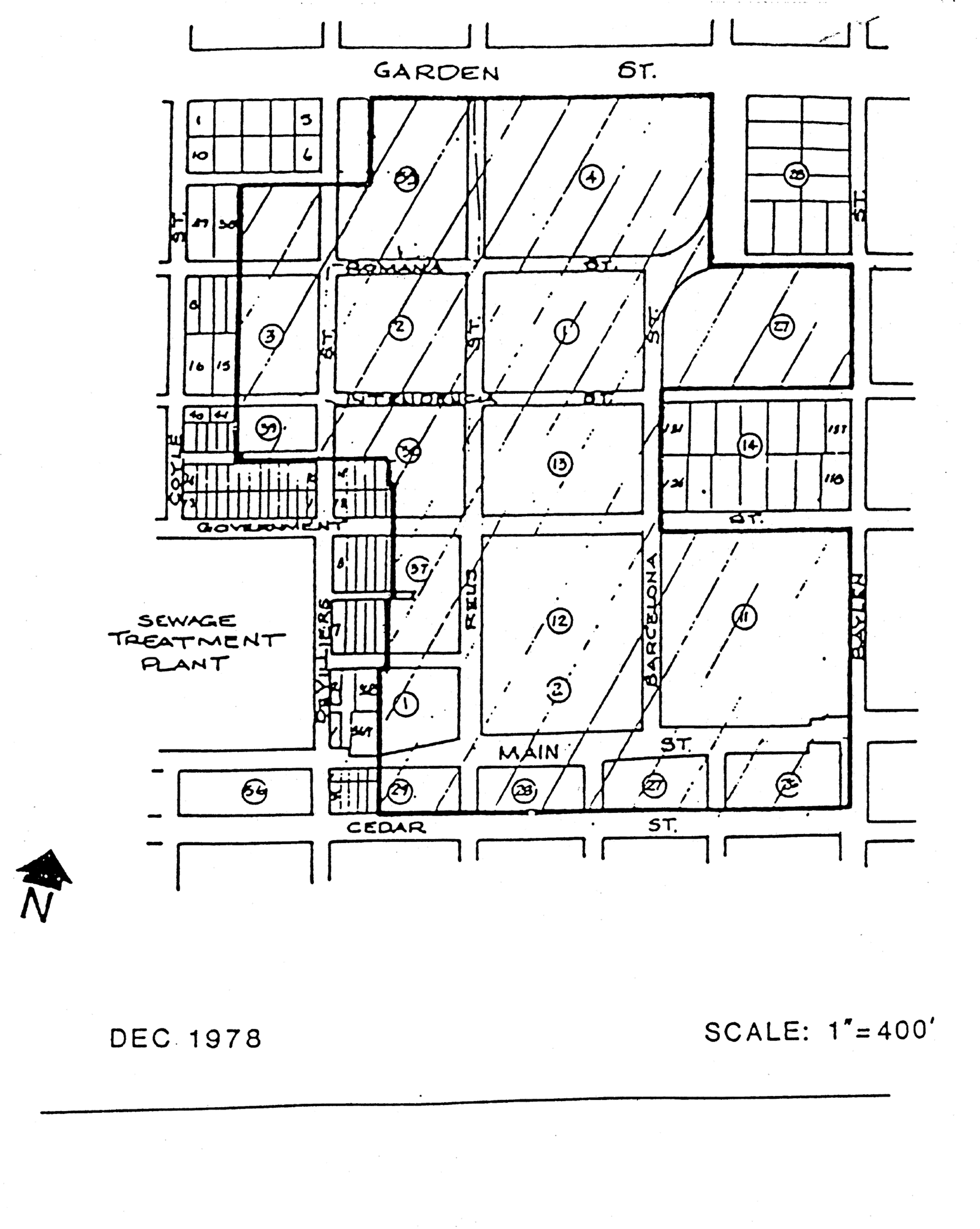
Sec. 12-3-29. - Airport development corridor overlay district.
(a)
Creation and description of corridor. There is hereby created the airport development corridor overlay district within the area described as follows: all property within 100 feet of either side of the centerline of 12th Avenue between the south line of the city airport property zoned ARZ (airport restricted zone) and the north line of Underwood Avenue, and all property within 100 feet of either side of the centerline of Airport Boulevard between 9th Avenue and 12th Avenue.
(b)
Purpose. The purpose for creating the airport development corridor is to promote orderly development along major roadways accessing the Pensacola International Airport in order to enhance the corridor's visual appearance as an entranceway into the city. Review of each development proposal, with special emphasis on similar style signage, landscaping requirements and access management, is intended to encourage a high quality of site planning.
(c)
General conditions, procedures and standards. Prior to obtaining construction permits the developer shall submit a site plan to and meet with the planning services department staff and obtain its approval of the following:
(1)
The relationship between the proposed development plan and the surrounding land uses.
(2)
The character and/or design of the following factors:
a.
Traffic egress and ingress to the site;
b.
Signage;
c.
Provision of open space and visual corridors;
d.
Preservation of existing vegetation and proposed landscaping; and
e.
Fencing and screening if applicable.
(d)
Development requirements.
(1)
Permitted land uses. Land uses within the airport development corridor shall be those permitted within the underlying zoning district classifications.
(2)
Signs. The provisions set forth in chapter 12-5 shall generally apply within the airport development corridor except as described below:
a.
Permanent accessory signs. The provisions set forth in section 12-5-4 shall be applied to signs constructed within the airport development corridor.
b.
Existing nonconforming permanent accessory signs. Existing nonconforming permanent accessory signs shall be permitted, however no such sign may be enlarged or altered in a way that increases its nonconformity. The sign may be reconstructed if destroyed by fire, explosion, or other casualty, or act of God, or the public enemy, however new construction must duplicate the original sign or the sign must comply with the regulations described herein.
c.
Nonaccessory signs. New nonaccessory signs shall be prohibited. Existing nonaccessory signs on the date of adoption of this ordinance may continue in place. Provided, however, any such existing signs located within 150 feet of the intersection of 12th Avenue and Airport Boulevard may be relocated or reconstructed, one time only, to a location more than 150 feet from the intersection of 12th Avenue and Airport Boulevard, on or before March 1, 1993, subject to the spacing requirements set forth in section 12-5-5(4)b.
d.
Temporary signs. Temporary sign requirements shall be subject to the provisions set forth in section 12-5-6.
e.
Prohibited signs. In addition to the prohibition of billboards, prohibited signs within the airport development corridor shall be subject to the provisions set forth in section 12-5-7.
f.
Guidelines for aesthetic design of signs.
1.
The use of monument signs (a sign that is not mounted on a pole) is recommended within the corridor.
2.
Design materials. The architectural character of the building to which the sign relates should be reflected in the lettering and materials used in the sign.
3.
Lighting. Indirect or internal lighting.
(3)
Landscaping and buffer requirements. Landscaping and buffer requirements shall be subject to the minimum provisions set forth in chapter 12-6, with the additional requirements described below:
a.
Preservation of existing trees. Where it is not absolutely necessary for construction of buildings, egress and ingress points, and visual clearance for signs, existing trees having a minimum trunk diameter of eight inches at a height of four feet above the ground shall be protected.
b.
Guidelines for other landscaping. Preservation of other existing vegetation and new plantings of understory vegetation is encouraged to visually link development to the wooded character of the airport property and the grounds of the Pensacola State College campus.
(4)
Vehicular access. For each lot tract or parcel under single ownership it is recommended that access points be limited to one per street frontage. In the event that more than one access point is necessary for vehicular safety or engineering reasons a maximum of two access points on one street frontage will be permitted.
(5)
Fencing and screening. No concrete block or barbed wire fences will be permitted. Approved materials will include, but not necessarily be limited to, wood, brick, stone or wrought iron and combinations thereof. Chain-link fences shall be permitted only if used in conjunction with vegetation plantings for at least partial screening.
(6)
Off-street parking. Placement of off-street parking outside the airport development corridor is encouraged.
(e)
Contents of the development plan. The site plans and elevations depicting the proposed project within the airport development corridor shall contain all the elements at the scale designated in section 12-3-120.
(f)
Appeals. Anyone wishing to appeal the decision of the planning staff may petition the city council.
(Code 1986, § 12-2-23; Ord. No. 28-92, § 1, 8-27-1992)
Sec. 12-3-30. - North 9th Avenue corridor management overlay district.
(a)
Creation and description of the overlay district. There is hereby created the North 9th Avenue corridor management overlay district within the area described as follows: all properties abutting North 9th Avenue between Fairfield Drive and Bayou Boulevard.
(b)
Purpose. The purpose of this overlay district is to establish specific criteria to address access management of vehicular traffic and to enhance safety in the district for both pedestrians and the operators of motor vehicles. Further, creation of the district will allow for the orderly rezoning and redevelopment of the district over time, allow for a compatible mixture of residential and business uses, maintain the residential appearance and quality of the district by implementation of design standards, and enhance the corridor's visual appearance. These objectives will be accomplished through comprehensive site planning on the part of the developer, combined with site plan review and approval by the planning board, planning staff, the city engineer and the district office of the state department of transportation.
(c)
Permitted land uses. Land uses within the North 9th Avenue corridor management overlay district are those permitted in the underlying zoning district classifications.
(d)
General conditions, procedures and standards.
(1)
Rezoning requests alone will not require submission of a site plan.
(2)
Prior to making application for a building permit and/or obtaining a certificate of occupancy for nonresidential development, the developer must submit a site plan that meets the access management requirements and design standards listed below to the planning board for aesthetic review. The developer shall submit this site plan to the planning services division and meet with the planning staff and the city engineer to obtain their input and/or review of the following prior to or concurrent with the planning board submittal:
a.
The relationship between the proposed development plan and the surrounding land uses.
b.
The character and/or design of the following factors:
1.
Traffic egress and ingress to the site;
2.
Parking;
3.
Provision of open space and visual corridors;
4.
Preservation of existing vegetation and proposed landscaping;
5.
Applicable screening, fencing and buffering;
6.
Signage; and
7.
Preservation of the residential quality of the district through architectural and design standards as outlined in subsection (f) of this section.
(3)
Procedure for review of plans.
a.
Plan submission. All development plans must comply with development plan requirements set forth in section 12-3-120(c) and (d), and design standards and guidelines established in section 12-3-121. Every application for a new certificate of occupancy or a building permit to erect, construct, demolish, renovate or alter a building or sign, or exterior site work (i.e., paving and landscaping of off-street parking areas), located or to be located in the North 9th Avenue corridor management overlay district shall be accompanied with drawings or sketches with sufficient detail to show, as far as they relate to exterior appearances, design of the site, signage, or exterior work (both before and after the proposed work is done in cases of altering, renovating, demolishing or razing a building or structure) including proposed materials, textures and colors, and the plot plan or site layout including all site improvements or features such as walls, fences, walks, terraces, plantings, accessory buildings, paved areas, signs, lights, awnings, canopies and other appurtenances.
b.
Review and approval. All plans shall be subject to the review and approval of the planning board established in chapter 12-12. At the time of review the board may require that any aspect of the overall site plan that does not meet the standards established in this section be incorporated and brought into compliance within a time limit approved by the board.
c.
Final development plan. If the planning board approves a preliminary development plan, the owner shall submit a final development plan in accordance with the procedure set forth below within six months of the date of approval of the preliminary plan of development. For good cause shown, the planning board may, in its discretion, extend the time within which to file the final development plan for successive periods, the total of which shall not be more than an additional six months. The final development plan shall be in basic conformity with the preliminary plan of development and comply with the other provisions of section 12-3-120 pertaining to the final development plan. If the applicant submits a final development plan that conforms to all the conditions and provisions of this chapter, then the planning board shall conclude its consideration at its next regularly scheduled meeting.
(e)
Development requirements.
(1)
Access management. In keeping with the district's goal of access management of vehicular traffic, each nonresidential lot or parcel under single ownership must address access management objectives in its initial site plan.
In the interest of vehicular safety, traffic circulation, and roadway level of service (LOS), driveways to nonresidential parcels of property must be at least 245 feet from the next adjacent driveway in either direction. This requirement can be accomplished by one of the following methods:
a.
A property owner requesting approval of nonresidential use shall own a sufficiently sized parcel of land so as to gain the required frontage on North 9th Avenue to meet the 245-foot spacing requirement.
b.
A property owner may assemble multiple parcels of land so as to achieve the 245-foot spacing requirement.
c.
In the event that the 245-foot spacing requirement cannot be met on an individual parcel, One driveway will be allowed; however an access management plan incorporating the concept of shared driveways with adjoining parcels that will accomplish this spacing requirement must be submitted to, and approved by, the planning staff.
Under this scenario, existing driveways will be designated interim driveways until such time as shared access development plans can be completed and shared driveways are constructed. To accomplish this objective, property owners must submit an easement allowing cross access to and from other properties served by joint and cross access drives and an agreement within their deed that the remaining access rights will be relinquished to the city and that preexisting driveways along the thoroughfare will be closed and eliminated after construction of the joint access system. These easements will be recorded by the city in the public records of the county and be kept on file in the city's planning services division. A joint maintenance agreement should also be established in order to define the maintenance responsibilities of the property owners. See Exhibits A-1, A-2, A-3, and A-4.
Unless the minimum spacing requirement of 245 feet between connections can be met, parcels located on corner lots shall use the side street for full-access connections and have limited access to North 9th Avenue. Direct access to North 9th Avenue shall be allowed in the form of directional openings designed to enhance the safety and operation of the roadway. Driveway connections on corner side streets shall provide a corner clearance of 120 feet from the travel lane of North 9th Avenue. This distance may be reduced if the depth of the lot cannot support this distance or if the location is within a primary portion of the lesser classified roadway and could pose a conflict or nuisance with the surrounding existing residential uses, such as in the case of direct alignment with an existing residential driveway or dwelling.
(2)
Driveway design. In order to permit a safe transition from the roadway to the site, two-way driveways must have a minimum width of 24 feet and a maximum of 36 feet and a minimum flare of ten feet on both sides in accordance with Florida Department of Transportation Standard Index 515, Roadways and Traffic Design Standard Indices, latest edition. Further, to prevent the stacking of vehicles on the roadway, driveways should have a minimum length of 36 feet from the edge of the roadway to the beginning of the parking area for business developments. See Exhibit B below. As long as the roadway remains under FDOT maintenance, a copy of the FDOT Pre-Application Meeting Notes should be provided to the city during the site plan submittal process to allow staff to review for consistency with the state requirements as well as city standards.
FDOT DRIVEWAY DESIGN STANDARDS 1
(3)
Off-street parking. Off-street parking must be provided as required for the specific use of the property as set forth in chapter 12-4. The design of parking lots must meet the minimum requirements as set forth in chapter 12-4. Additionally, parking areas shall be placed towards the rear of the site for business establishments. Where the constraints of the lot limit parking at the rear of the site, additional landscaping shall be required within the parking area and along the front of the property to soften the streetscape and enhance the aesthetic appearance of the development.
(4)
Landscaping and buffers. Landscaping and buffer requirements are subject to the minimum provisions set forth in chapter 12-3, section 12-3-56 and chapter 12-6. When off-street parking is located at the front of the project, a year-round landscaped hedge or low wall along the street edge of the parking lot must be used as a means of buffering. Additional design standards are outlined in subsection (f) of this section.
(5)
Signs. Refer to chapter 12-5 for general sign standards and criteria and for a description of sign area calculations. The specific standards as outlined in subsection (f) of this section shall be applied to all signage within this district.
(f)
Design standards.
(1)
Landscaping and buffers. Preservation of existing vegetation is required and new plantings of native, non-invasive understory vegetation is strongly encouraged to visually link the development to the wooded character and mature landscape of the district.
(2)
Signage.
a.
Freestanding signs. Freestanding signage shall observe a maximum overall sign height of eight feet with a maximum sign face area of 32 square feet. Monument signs are required; however, if a pole sign is existing, decorative covers to conceal the frame are required. Additionally, landscaping at the base of all freestanding signage is required.
b.
Design materials. The architectural character of the building to which the sign relates should be reflected in the lettering and materials used in the sign.
c.
Lighting.
1.
In addition to the standards within sections 12-4-3 and 12-5-2, parking lot lighting and lighting on buildings shall be direct (downlighting) to promote dark sky lighting and minimize light pollution. The maximum allowed trespass of light at the property line shall not exceed 0.5 footcandles. Parking lot lighting shall be full cutoff to minimize light pollution and nuisances.
2.
Freestanding signs may be uplit with shielded landscape lighting to promote dark sky lighting and minimize light pollution and nuisances.
3.
Signage may not be internally illuminated. However back-lighting of letters will be permissible with opaque faces to create the effect of channel letters.
4.
Electronic reader boards shall not be allowed within this district.
(3)
Architectural design and building elements.
a.
Buildings or structures that are part of a present or future group or complex shall have a unity of character and design. The relationship of forms and the use, texture, and color of materials should be such as to create a harmonious whole within the residential context and nature of the district.
b.
Buildings or structures located along strips of land or on single sites and not a part of a unified multi-building complex shall strive to achieve visual harmony with the surroundings. It is not inferred that the buildings must look alike or be of the same style to be compatible with the district. Compatibility can be achieved through the proper consideration of scale, proportions, site planning, landscaping, materials and use of color.
(4)
Fencing and screening. Approved materials for nonresidential developments include wood, brick, stucco finished masonry, stone, or wrought iron, and combinations of these materials. Synthetic materials with the appearance of approved materials are included. Black powder-coated chain-link fences will be permitted for new nonresidential developments if screened in their entirety by appropriate vegetation. Exposed concrete block and barbed wire are prohibited within the district.
(g)
Contents of the development plan. The site plans and elevations depicting the proposed project within the overlay district must contain all the elements at the scale designated in section 12-3-120(c) and (d).
(h)
Conformity. Existing commercial developments are required to comply with the above standards with respect to landscaping, lighting, signage and fencing by December 31, 2024. Compliance will be required for all redevelopment that exceeds 50 percent of the value of the building.
(Code 1986, § 12-2-24; Ord. No. 33-96, § 1, 7-25-1996; Ord. No. 01-17, § 1, 1-12-2017)
Sec. 12-3-31. - Community redevelopment area (CRA) urban design overlay district.
The regulations in this section shall be applicable to the community redevelopment area (CRA) urban design overlay district (CRAUDOD).
(1)
Intent. The requirements set forth in this section are intended to:
a.
Preserve and maintain the urban pattern and architectural character of Pensacola's community redevelopment areas, while encouraging new construction that is compatible with that heritage, but also reflective of its time.
b.
Improve the physical appearance of the community redevelopment areas with urban design standards that provide more predictable results in terms of the form and character of buildings.
c.
Support the removal of blight within the community redevelopment areas by encouraging quality redevelopment.
d.
Support the future growth of the city, to ensure compatible and cohesive development, to remain resilient long-term, and to support the goals, objectives and policies of the city's comprehensive plan and community redevelopment area master plans.
e.
Coordinate the placement, orientation, and design of buildings to ensure a coherent and walkable streetscape and traditional urban character by creating well-defined street edges with continuous building walls, articulated facades, and architectural features that create visual interest and an attractive pedestrian environment.
f.
Capitalize on opportunities to attract and grow a variety of residential building types, retail, service, and cultural establishments to serve local needs, create regional attractions and a robust economic base.
g.
Enable and encourage mixed-use development within the community redevelopment areas in support of viable and diverse locally-oriented business and cultural institutions.
h.
Achieve context-based development and complete streets.
(2)
Boundaries of the district. The boundaries of the CRA urban design overlay district shall be as outlined on Figure 12-3-31.1. A more detailed map of the boundaries of the overlay is on file in the office of the city clerk.
FIGURE 12-3-31.1. CRA URBAN DESIGN
OVERLAY DISTRICT BOUNDARIES

(3)
Applicability.
a.
These standards shall apply to all new construction within the CRA urban design overlay district. For purposes of this section, "new construction" includes construction on a parcel that is vacant or becomes vacant following demolition of an existing structure on the parcel; it also includes construction of a freestanding accessory building and ancillary improvements on a parcel, but does not include an addition to a current structure.
b.
This section shall apply as an overlay to the underlying land development regulations. The land development regulations contained within this title shall apply unless pre-empted by this section. Where a conflict exists between this section and the underlying land development regulations, contained within this title, this section shall prevail.
c.
Standards, activated by "shall," are regulatory in nature, as defined within section 12-1-8 (general interpretative terms). Deviations from these standards shall only be permitted by variance in accordance with section 12-11-2 (appeals and variances).
d.
Guidelines, activated by "should," are encouraged and recommended but not mandatory, as defined within section 12-1-8 (general interpretative terms). Developments subject to this overlay district are encouraged to incorporate them as appropriate in order to enhance and complement the built and natural environment. The intent is to create the highest level of design quality while providing the needed flexibility for creative site design.
e.
Figures, tables and illustrations shall be interpreted as defined in section 12-1-8 (general interpretative terms) unless the context clearly indicates otherwise.
f.
The provisions of this section are not intended to supersede, conflict with or replace any requirement in federal or state law pertaining to design, construction or accommodation requirements pertaining to persons with disabilities, and it is hereby declared to be the intent of the city that such requirements in federal or state law shall prevail over any provisions of this section to the extent of any conflict.
(4)
Existing conditions. Existing buildings and structures that do not conform to the requirements of this overlay district may be occupied, operated, repaired, renovated or otherwise continue in use in their existing nonconforming state unless demolished and rebuilt.
(5)
Procedure for review. All development regulated by this subsection shall be subject to the submission requirements contained within sections 12-11-5 (building permits), 12-3-120 (development plan requirements), and 12-3-121 (design standards and guidelines), as applicable. In addition to the plan submission requirements listed in sections 12-11-5 and 12-3-120, drawings illustrating compliance with this section shall be provided. Plans shall include drawings or sketches with sufficient detail to show, as far as they relate to exterior appearance, the architectural design of the building, including proposed materials, textures, and colors, and the plat plan or site layout, including all site improvements or features such as walls, fences, walkways, terraces, landscaping, accessory buildings, paved areas, signs, lights, awnings, canopies, screening, and other appurtenances. Facade and frontage yard types shall be specified along frontages in accordance with Table 12-3-31.10 (Facade Types) and Table 12-3-31.9 (Frontage Yard Types).
(6)
Modifications and appeals. The standards established in this section are intended to achieve the principles outlined in subsection (1). However, specific site features, physical barriers or easement, and challenging characteristics affiliated with a particular site or type of use may create conditions that make compliance with a specific standard impractical or undesirable. In such instances alternative design solutions that achieve the principles defined in subsection (1) of this section may be considered. This section establishes the procedures for considering requests for a modification to the standards.
Modifications shall be approved through an abbreviated review process. This process shall require review by an architect advisor appointed by the city council, the chair of the applicable redevelopment board representing the redevelopment district for which the project is located and the urban design specialist or the mayor's designee. City council shall appoint two architects to serve as the architect advisor(s), a primary and an alternate. In the absence of the architect advisor or in the event of a conflict of interest, the alternate architect shall serve in the capacity of the architect advisor. The appointed architects shall not be employed by the same firm or have any other relationship that would constitute a conflict of interest between them.
1.
Review shall consider the principles defined in subsection (1) of this section.
2.
The decision to approve, deny or approve with modifications shall be based on the following considerations:
i.
The physical conditions of the property such as floodplain, drainage, tree preservation, or small or irregular lot shape making compliance to the specific standard physically impossible and this hardship is not created by the applicant; and/or
ii.
If by its nature, including its function and intensity, the development constitutes a special use or presents a particular circumstance that causes challenges integrating into an urban, walkable, neighborhood environment; and
iii.
The modification will not significantly impact adjacent property owners, the character of the area, traffic conditions, parking, public infrastructure, water quality, or other matters affecting the public health, safety and general welfare; and
iv.
The modification will not result in a substantial departure from the key principles that buildings should:
(a)
Front the street and be located close to the street edge;
(b)
Provide interest to those walking and biking past by avoiding blank walls;
(c)
Create a human-scaled street edge and add value to the walkability of streets; and
(d)
Include key architectural features which reflect traditional neighborhood character.
3.
Appeals shall be referred to the zoning board of adjustments.
(7)
Urban design standards and guidelines.
a.
Building height.
1.
Intent. Within the overlay district, height for single-family residential types will be measured in feet and multifamily, mixed-use and nonresidential buildings will be measured in stories. Measuring height in stories rather than feet has numerous benefits which include:
i.
To provide greater creativity for a natural variety of roof forms;
ii.
To recognize the need of different users, as commercial floor plates are different than residential floor plates;
iii.
To remove the incentive to create short floorplates, and instead encourage more gracious floor-to-ceiling heights for environmental health, without penalizing property owners; and
iv.
To protect the historical proportions of Pensacola's community redevelopment areas.
2.
Maximum building heights for principal and accessory buildings shall be as defined by the form standards in Tables 12-3-31.3 to 12-3-31.8.
3.
Building height is measured as follows:
i.
Where maximum height is specified, the measurement shall be taken from the finished grade at the front of the building.
ii.
Building height shall be measured in feet for single-family residential types as defined in the form standards in Tables 12-3-31.3 to 12-3-31.8 and as follows:
(a)
For pitched roof buildings, to the bottom of the lowest eave of the principal structure.
(b)
For flat roof buildings, to the bottom of the parapet.
(c)
Minimum floor to ceiling height in single-family residential types shall be nine feet per floor.
iii.
Building height shall be measured in stories for multifamily, mixed-use and nonresidential buildings as follows:
(a)
Multifamily buildings shall be limited by ground floor story and above ground story height in accordance with Table 12-3-31.1.
TABLE 12-3-31.1. MULTIFAMILY STORY HEIGHT
REQUIREMENTS
(b)
Mixed-use and nonresidential buildings shall be limited by ground floor story and above ground story height in accordance with Table 12-3-31.2.
TABLE 12-3-31.2. MIXED-USE/NONRESIDENTIAL
STORY HEIGHT REQUIREMENTS
(c)
Stories are measured from finished floor to finished floor with the exception of one-story buildings that shall be measured floor to ceiling.
(d)
Story heights that exceed the maximum permitted height specified in Tables 12-3-31.1 and 12-3-31.2 shall count as two stories. Height defined within this subsection shall not supersede height as defined by the Florida Building Code.
iv.
See Illustration 12-3-3.1 for a depiction of height measurements in feet and stories.
ILLUSTRATION 12-3-3.1. MEASURING
BUILDING HEIGHT
4.
Parking garages shall not exceed the height of the principal building on the site. Parking garages shall not be subject to floor to floor height requirements according to subsection (7)a.3.iii of this section. Stand-alone parking garages shall only conform to the number of stories permitted within the form standards in Tables 12-3-31.3 to 12-3-31.8.
5.
Roof pitch.
i.
Gable or hipped roofs shall have a minimum pitch of 6:12 and a maximum pitch of 12:12.
ii.
Shed roofs shall have a minimum pitch of 4:12.
b.
Building orientation.
1.
Intent. Buildings should have their principal pedestrian entrance along a street, pedestrian way or open space, with the exception of entrances off a courtyard, visible from public rights-of-way.
2.
Building frontage occupation shall conform to the form standards in Tables 12-3-31.3 to 12-3-31.8.
3.
Buildings shall be oriented so that the principal facade is parallel to the street it faces for the minimum building frontage occupation required in the form standards in Tables 12-3-31.3 to 12-3-31.8. See Illustration 12-3-31.2 for a depiction of minimum frontage occupation requirements.
ILLUSTRATION 12-3-31.2. MINIMUM
BUILDING FRONTAGE OCCUPATION
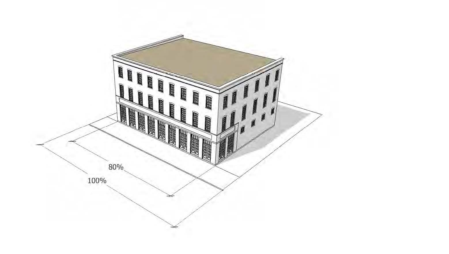
4.
Lot width shall be measured along the right-of-way at the front property line. Lot width measurements at the building setback line and minimum lot area shall not apply.
5.
Forecourts, courtyards and other such defined open spaces shall count towards minimum frontage requirements. See Illustration 12-3-31.3 for an illustration depicting minimum frontage occupation requirements with open space.
ILLUSTRATION 12-3-31.3. MINIMUM
BUILDING FRONTAGE OCCUPATION
WITH OPEN SPACE
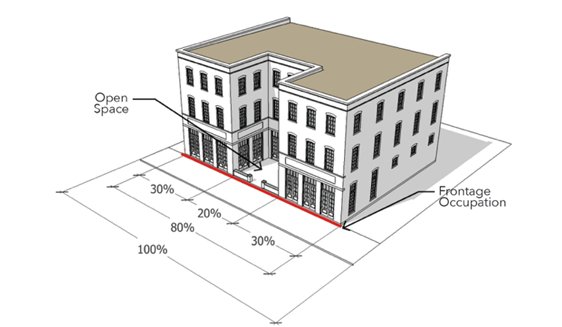
6.
Ground floor units in multifamily residential buildings shall provide landscaping, walls, and/or fences that provide some privacy for the building.
c.
Building massing.
1.
Intent. Buildings should be designed in proportions that reflect human-scaled pedestrian movement, and to encourage interest at the street level.
2.
Where provided, multifamily building courtyards shall maintain a minimum width to height ratio of 1 to 3 in at least one dimension in order to avoid light well conditions. Courtyards should be wider than the minimum where possible. See Illustration 12-3-31.4 for depiction of courtyard ratio measurements.
ILLUSTRATION 12-3-31.4. COURTYARD HEIGHT TO WIDTH RATIO MEASUREMENTS
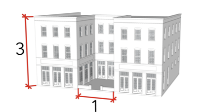
3.
The design and facade treatment of mixed-use buildings shall differentiate commercial from residential uses with distinguishing expression lines (such as cornices, projections, banding, awnings, terraces, etc.), changes in fenestration, facade articulation and/or material changes. See Illustration 12-3-31.5 for depiction of mixed-use building differentiation of uses.
ILLUSTRATION 12-3-31.5. MIXED USE BUILDING DIFFERENTIATION OF USES
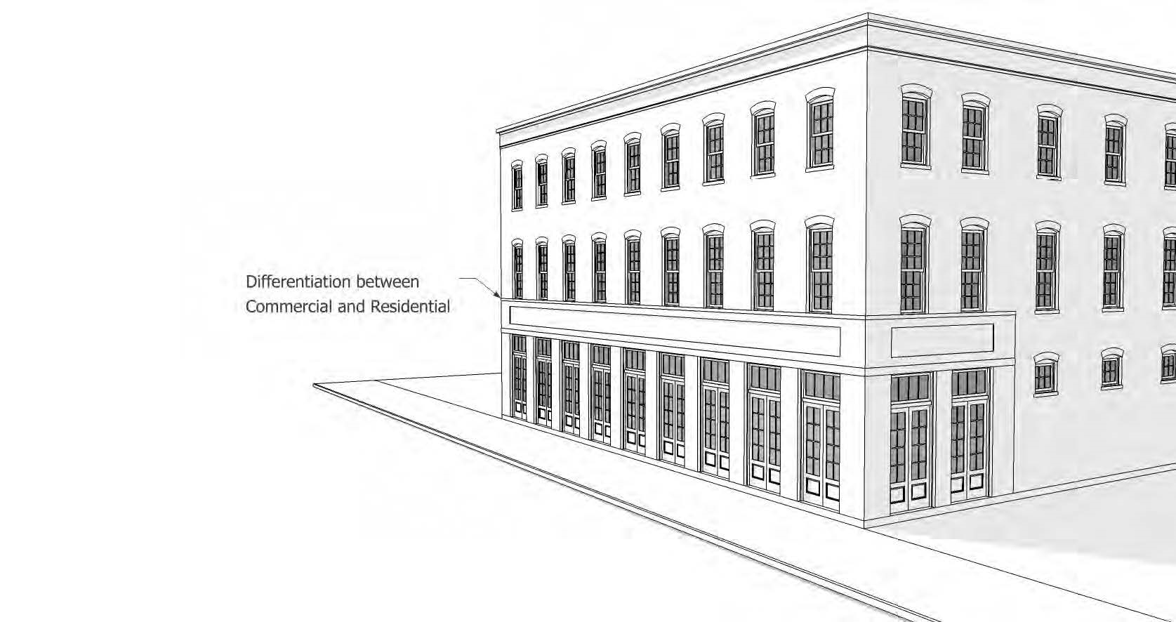
4.
Single-family units shall be distinguished from abutting units with changes in unit entry, plane, color, materials, front porches, front stoops, fenestration, and/or building elements such as railings.
5.
All service and loading areas shall be entirely screened from public right-of-way as follows:
i.
Equipment shall be screened.
ii.
If outdoor storage areas are separate from the building they serve, the fence materials shall be limited to masonry, concrete, stucco, wood, PVC and metal, excluding chain-link.
6.
HVAC and mechanical equipment are restricted as follows:
i.
They shall be prohibited in frontage yards.
ii.
They shall be integrated into the overall building design and not be visible from adjoining streets and or open spaces.
iii.
Through-wall units shall be prohibited along street frontages and open spaces, unless recessed within a balcony.
7.
Mechanical equipment on roofs shall be visually screened from the street with parapets or other types of visual screens of the minimum height necessary to conceal the same.
8.
Roof top parking shall be visually screened with articulated parapet walls or other architectural treatment.
9.
Exterior wall materials prohibited for all single-family residential types shall include:
i.
Corrugated metal panels; and
ii.
Exposed concrete block.
10.
Material requirements contained within section 12-3-121(c)(8) (design standards and guidelines) shall apply within the CRA urban design overlay district.
d.
Form standards.
1.
Form standards within the CRA urban design overlay district shall be as defined in Tables 12-3-31.3 to 12-3-31.8.
2.
Exceptions to form standards.
i.
Front setbacks in R-1AAA, R-1AA, and R-1A shall not be less than the average setback of all frontage yards (front and exterior side yards) located on either side of the block face, up to the minimum front setback defined in form standards in Tables 12-3-31.3 and 12-3-31.5. In cases where no other dwellings exist within the block, the front setback shall be no less than the front setback defined in form standards in Tables 12-3-31.3 and 12-3-31.5.
ii.
Each single-family attached dwelling unit shall be located on its own lot. If a development requires subdivision procedures, it shall be subject to and must comply with subdivision regulations as set forth in chapter 12-7.
iii.
Where lot occupation and setback standards differ from the dense business area (DBA), as defined in chapter 12-13 (definitions), the standards in the DBA shall prevail.
TABLE 12-3-31.3. SINGLE-FAMILY DETACHED AND
TWO-FAMILY ATTACHED (DUPLEX) RESIDENTIAL BUILDING TYPES - R-1AAA THROUGH R-1A
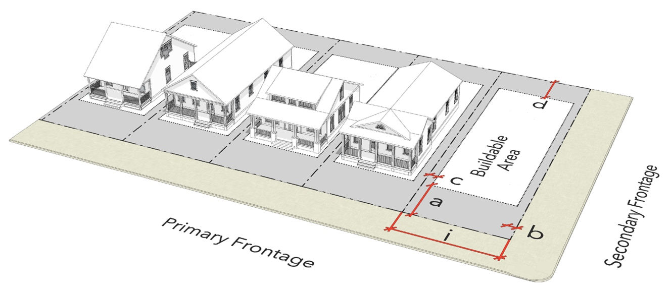
TABLE 12-3-31.4. SINGLE-FAMILY DETACHED AND TWO-FAMILY ATTACHED (DUPLEX) RESIDENTIAL BUILDING TYPES- R-1B THROUGH C-3
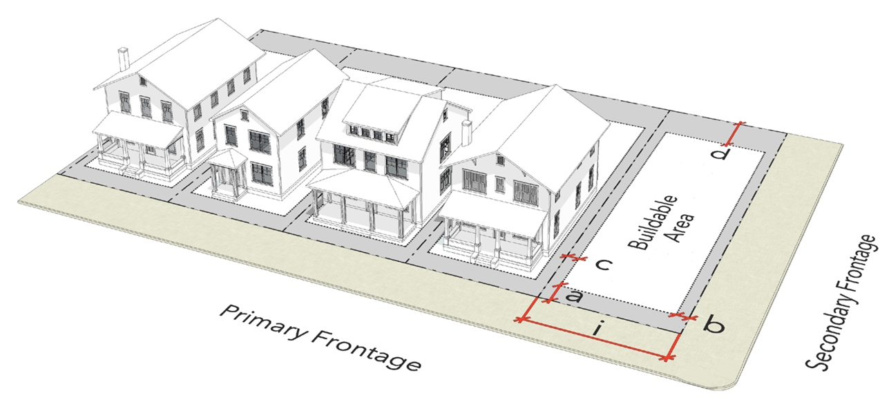
TABLE 12-3-31.5. SINGLE-FAMILY ATTACHED
(TOWNHOUSE) RESIDENTIAL BUILDING TYPES - R-1AA THROUGH C-3
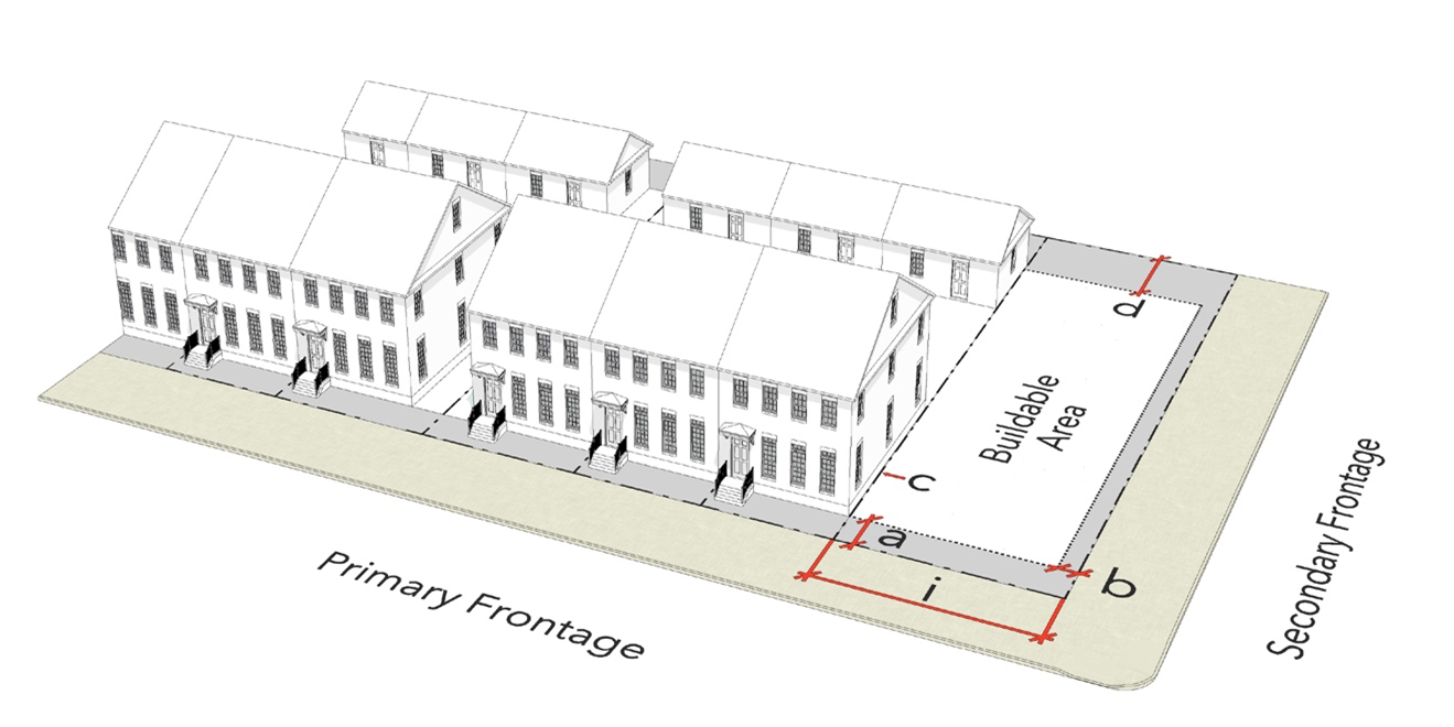
TABLE 12-3-31.6. MULTIFAMILY, MIXED-USE,
NEIGHBORHOOD COMMERCIAL AND COMMERCIAL BUILDING TYPES
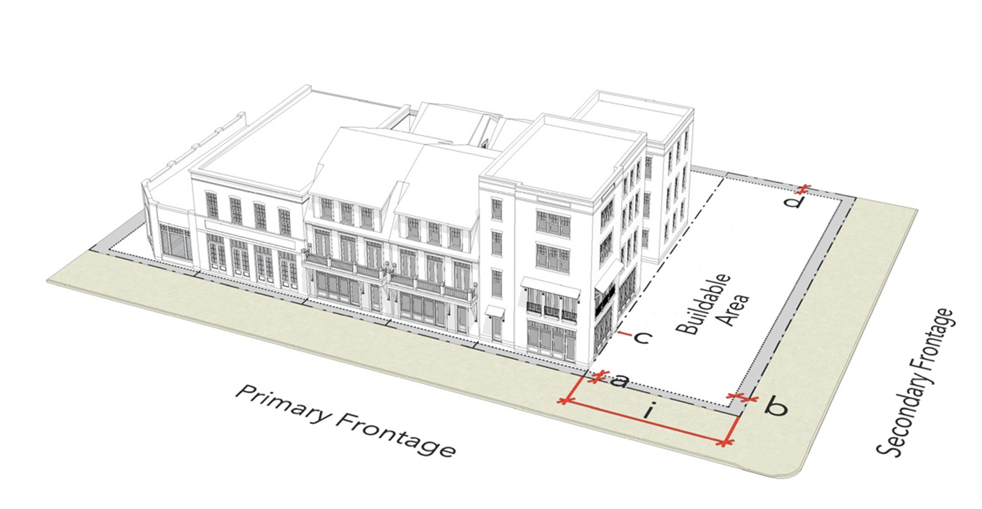
TABLE 12-3-31.7. MULTIFAMILY, MIXED-USE AND COMMERCIAL BUILDING TYPES - C-2A, C-2, C-3

TABLE 12-3-31.8. HYBRID COMMERCIAL: MULTIFAMILY, MIXED-USE AND COMMERCIAL BUILDING TYPES - C-3 ALONG C3C FDOT CONTEXT ZONE
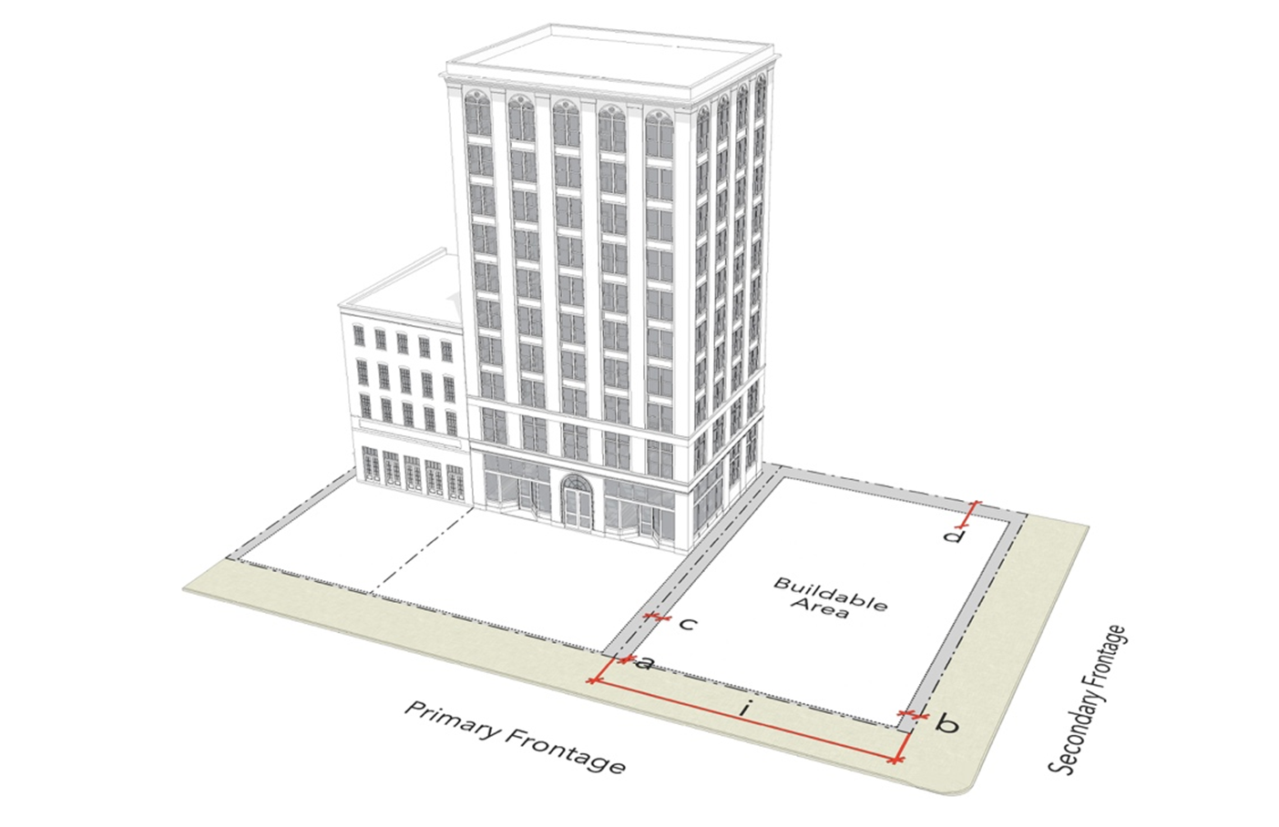
e.
Frontage types.
1.
Intent. New buildings proposed for existing neighborhoods should be compatible with or complement the architectural character and siting pattern of neighboring buildings. Maintaining a consistent street-wall is a fundamental component for a vibrant pedestrian life and a well-defined public realm. Buildings closely aligned to the street edge with consistent setbacks, provide a clear sense of enclosure of streets, enabling them to function as pedestrian-scaled outdoor rooms. The placement of buildings along the edge of the sidewalk should be given particular attention, as it is that portion of the buildings that is the primary contributor to pedestrian activity.
2.
Frontage yard type shall be selected and specified along frontages in accordance with the frontage yard types in Table 12-3-31.9 and subject to the standards and guidelines in this section, including the form standards in Tables 12-3-31.3 to 12-3-31.8.
3.
In addition to the frontage yard type standards contained within Table 12-3-31.9, the following shall be required:
i.
Frontage yards shall be wholly open to the sky and unobstructed, except for trees, roof projections, and permitted encroachments attached to principal buildings.
ii.
Impervious surfaces and walkways in frontage yards shall be subject to the following requirements:
(a)
Where single-family attached units occupy a common site, each attached single-family unit with an entrance towards a frontage shall have a walkway connecting the sidewalk to the attached single-family entrance. See Table 12-3-31.9.A (Frontage Yard Types - Shallow Yard) for an illustration depicting single-family attached walkway connections.
(b)
At cluster courts, the shared court shall have a walkway connecting the sidewalk at the primary frontage with building entries. See Table 12-3-31.9.B (Frontage Yard Types - Cluster Court) for an illustration depicting cluster court walkway connections.
iii.
For multifamily, mixed-use and nonresidential types, any portion of a frontage not occupied by buildings, driveways, or walkways shall be lined with a streetscreen as follows:
(a)
Streetscreens shall meet the fencing and wall standards according to the frontage yard types specified in Table 12-3-31.9.
(b)
Streetscreens, up to 24 feet long, shall count towards minimum frontage requirements.
(c)
Streetscreens shall be coplanar with the primary building facade, as depicted in Illustration 12-3-31.6 below.
ILLUSTRATION 12-3-31.6. STREETSCREEN
ILLUSTRATED
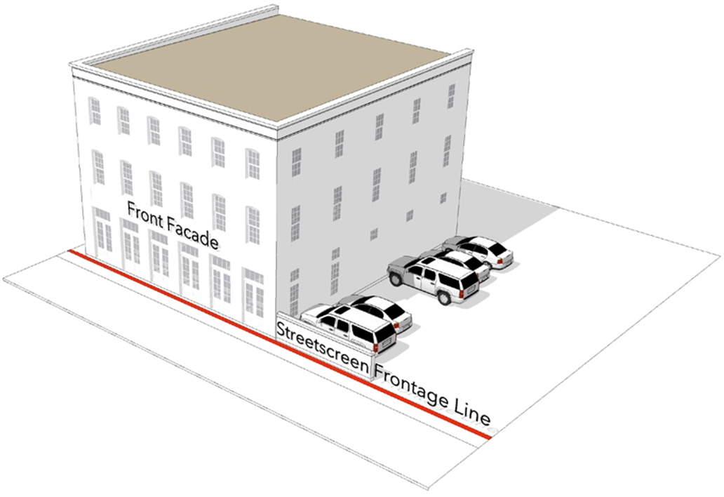
iv.
Street trees and landscaping in frontage yards shall comply with the requirements of subsection (8) of this section.
v.
Stormwater ponds shall be prohibited along frontages.
vi.
Frontage yard setbacks shall be as follows:
(a)
Buildings shall be set back in accordance with the form standards specified in Tables 12-3-31.3 to 12-3-31.8.
(b)
Where maximum setbacks are specified, they pertain only to the amount of building facade required to meet the minimum building frontage occupation requirements defined in the form standards specified in Tables 12-3-31.3 to 12-3-31.8.
TABLE 12-3-31.9. FRONTAGE YARD
TYPES
| A. Standard Yard (Fenced or not) | |
| Illustration | |
| Surface | Fifty percent minimum shall be pervious material. A minimum of one tree is required per subsection (6)a of this section. Paving is limited to walkways, and driveways. |
| Walkways | One per frontage connecting the sidewalk at the primary frontage with building entries. |
| Fencing | Permitted along frontage lines, and according to subsection (5)h of this section. |
| B. Cluster Court | |
| Illustration | |
| Surface | A minimum 50 percent of the court shall be landscaped with ground cover, trees, or understory trees. Paving is limited to walkways, and driveways. |
| Walkways | Court shall be a minimum 20 feet wide and a min. 1,000 square feet in size, and shall have a walkway connecting the sidewalk at the primary frontage with building entries. |
| Fencing | Permitted except along street frontages, fronted by a shared court, according to subsection (5)h of this section. |
| C. Shallow Yard | |
| Illustration | |
| Surface | Maximum setback of eight feet. Fifty percent minimum shall be landscaped in R-1A, and R-1B and up to 100 percent may be paved in R-NC and R-NCB. |
| Walkways | One per frontage connecting the sidewalk at the primary frontage with building entries. |
| Fencing | Permitted interior to the building setback line at primary street frontages. Permitted at or interior to secondary street frontage lines according to subsection (5)h of this section. |
| D. Urban Yard | |
| Illustration | |
| Surface | Shall be paved at sidewalk grade. |
| Walkways | Shall be paved at sidewalk grade. Vegetation is permitted in raised containers. |
| Fencing | Not permitted |
| E. Pedestrian Forecourt | |
| Illustration | |
| Surface | Minimum 80 percent paving. |
| Fencing | Permitted at or interior to building setback lines and according to subsection (5)h of this section. |
| Area | Forecourt: A minimum 20 feet wide up to 30 percent of the allowable frontage, and a maximum 50 feet deep. |
| Activation | Shall be lined with habitable space on three sides, or on two sides at corner sites. |
| F. Vehicular Forecourt | |
| Illustration | |
| Surface | Driveway shall be paved at sidewalk grade. The remainder of front setback may be paved or landscaped. |
| Fencing | Low wall, maximum 24 inches high, of either brick or stone is permitted. |
| Area | Forecourt: 4,200 square feet maximum. |
| Activation | Shall be lined with habitable space on three sides, or on two sides at corner sites. |
f.
Building elements.
1.
Intent. Buildings should be architecturally articulated with such elements as distinguishing expression lines, changes in fenestration, material and/or color and designed in proportions that reflect human-scaled pedestrian movement to encourage interest at the street level.
2.
Facade types. Facade types shall be as follows:
i.
Porches, stoops, common entries, galleries and storefronts shall constitute allowable facade types as defined in Table 12-3-31.10 in accordance with the form standards in Tables 12-3-31.3 to 12-3-31.8.
ii.
Facade types shall be selected and specified along frontages in accordance with Table 12- 2-25.10.
(a)
Porches shall not be required for single-family detached and two-family (duplex).
iii.
Projections into setbacks shall be permitted as follows:
(a)
Roof overhangs, cornices, window and door surrounds and other facade decoration may project up to two feet.
(b)
Where permitted, shading devices may project into the front setback up to the property line with a minimum eight-foot clearance.
(c)
Balconies may project up to three feet.
(d)
Bay windows may project up to three feet.
(e)
Porches and stoops may project in accordance with the facade types defined in Table 12-3-31.10.
(f)
Projections shall not, in any instance, exceed beyond the property line.
TABLE 12-3-31.10. FACADE TYPES
| A: Porch | ||
| Entry Grade | Minimum 18 inches above finished grade | |
| Requirements | Required at the primary building entrance. | 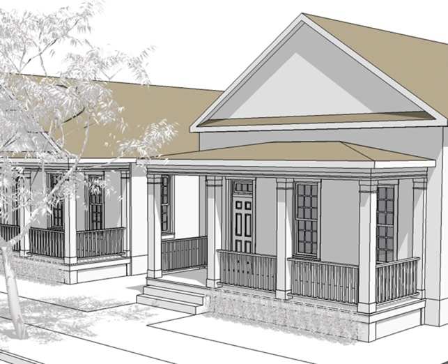 |
| Porches shall be a minimum six feet in depth. | ||
| Porches and related structures may project into front setbacks a maximum ten feet. | ||
| Porch openings shall be vertical in proportion. | ||
| Porches shall be a maximum ten feet in height. Columns shall have a minimum diameter of six inches, and should have a capital and a base. | ||
| B: Stoop | ||
| Entry Grade | Minimum 34 inches above finished grade. | |
| Requirements | A stoop is required at building entrances, projecting from the facade. | 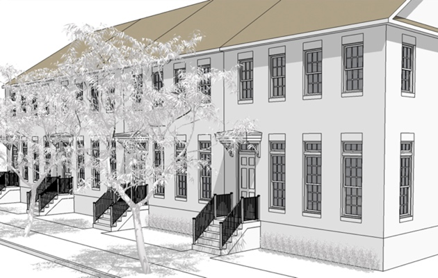 |
| Wood is prohibited for stoop railings. | ||
| Stoops and related structures may project into front setbacks up to 100 percent. | ||
| C: Common Entry | ||
| Entry Grade | Minimum 18 inches and a maximum 24 inches above finished grade | |
| Requirements | A single collective entry to a multifamily lobby is required at the primary building entrance. | 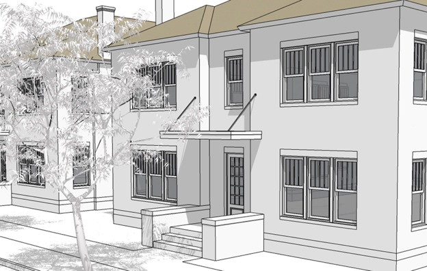 |
| Canopies and awnings are permitted to project into front setbacks up to 100 percent of their depth. | ||
| D: Gallery | ||
| Entry Grade | At sidewalk grade | |
| Requirements | Where a gallery occurs, it is required along a minimum of 80 percent of the frontage. | 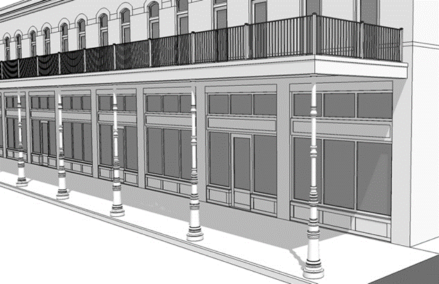 |
| Encroachments are permitted according to subsection (5)g of this section. | ||
| Awnings are not permitted in galleries. | ||
| E: Storefront | ||
| Entry Grade | At sidewalk grade | |
| Requirements | A storefront is required at the primary entrance of the tenant space. Storefronts are permitted according to subsection (7)f.4 of this section. | 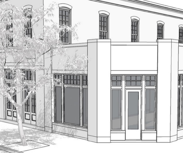 |
3.
Building entries. Building entries shall be as follows:
i.
Building entrances shall be clearly visible from the street.
ii.
One building entry shall be provided every 80 feet of facade leading to a habitable space.
iii.
Building entries for mixed-use buildings shall differentiate entrances for residential and commercial uses.
iv.
Entries for multifamily buildings shall provide protection from the elements with canopies, marquees, recesses or roof overhangs.
v.
Residential building entries shall be restricted as follows:
(a)
Single-family and multifamily residential buildings shall be raised above finished grade, at the front of the building, according to facade types defined in Table 12-3-31.10.
(b)
In no instance shall single-family and multifamily residential building entries be raised less than 18 inches above finished grade.
(c)
Entry grade shall be measured from the finished grade to the first finished floor.
vi.
Mixed-use and commercial building entries shall be at sidewalk grade.
4.
Storefronts.
i.
Intent. Storefronts should be architecturally articulated through the varied use of high-quality durable materials, display windows, entrances, awnings and buildings signs. Their signage, glazing and doors should be conceived as a unified design. High quality, durable materials are especially important at street level within reach of pedestrians.
ii.
Storefronts shall provide a minimum of 70 percent glazing (void to solid ratio of surface area along principal facades at the ground level).
iii.
Extruded aluminum storefront frames are discouraged, and where used, shall present a simple, relatively flat profile to avoid heavily extruded profiles.
iv.
Opaque, smoked, and reflective glass on storefront windows shall be prohibited. Low-E shall be permitted as per Florida Building Code.
v.
Materials for storefronts shall consist of stone, brick, concrete, stucco, metal, glass, cementitious siding and/or wood. Construction detail and finish shall adhere to craftsman standards.
vi.
Outdoor dining areas on sidewalks and/or within the public right-of-way shall be permitted subject to the following standards:
(a)
Outdoor dining areas shall be separated from public walkways and streets using railings, fences, bollards, planters, and/or landscaping.
(b)
A minimum unobstructed pedestrian path of at least six feet wide shall be provided along public rights-of-way.
(c)
Outdoor dining areas within the public right-of-way shall comply with section 12-11-7 (license to use).
g.
Building encroachments.
1.
Encroachments located within the public right-of-way shall comply with section 12-11-7 (license to use), section 12-3-58 (visibility triangle) and any clearance standards established by the engineering division of the city public works and facilities department and the Florida Greenbook.
2.
Awnings for storefronts and canopies are not subject to section 12-11-7 (license to use) but shall be restricted as follows:
i.
Awning and canopies may project into the public right-of-way, up to a maximum of two feet from the curb.
ii.
Awnings and canopies shall be a minimum of six feet in depth and have a minimum of eight feet of vertical clearance. See Illustration 12-3-31.7 for a depiction of awning and canopy encroachment measurements.
ILLUSTRATION 12-3-31.7. AWNING AND
CANAOPY ENCROACHMENT MEASUREMENTS
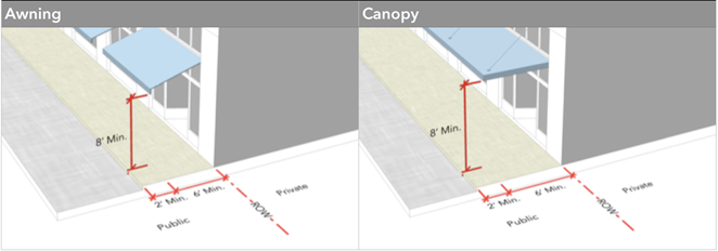
3.
Galleries shall be restricted as follows:
i.
Galleries shall be subject to and shall comply with section 12-11-7 (license to use).
ii.
Galleries shall not alter height or width along a building facade.
iii.
Galleries shall be a minimum of eight feet in depth and a minimum of 12 feet in height, maintaining a 1.2:1 to a 2:1 height to width ratio, as depicted in Illustration 12-3-31.8.
iv.
Gallery columns should have a diameter between one-ninth and 1/20 their height, measured from the base to the bottom of the entablature, as depicted in Illustration 12-3-31.8, and should have a capital and a base.
v.
Galleries should encroach into building setbacks.
vi.
Galleries should encroach over sidewalks.
vii.
Where galleries encroach over sidewalks, they shall not extend beyond a maximum of two feet from the curb, as depicted in Illustration 12-3-31.8.
ILLUSTRATION 12-3-31.8. GALLERY
ENCROACHMENTS
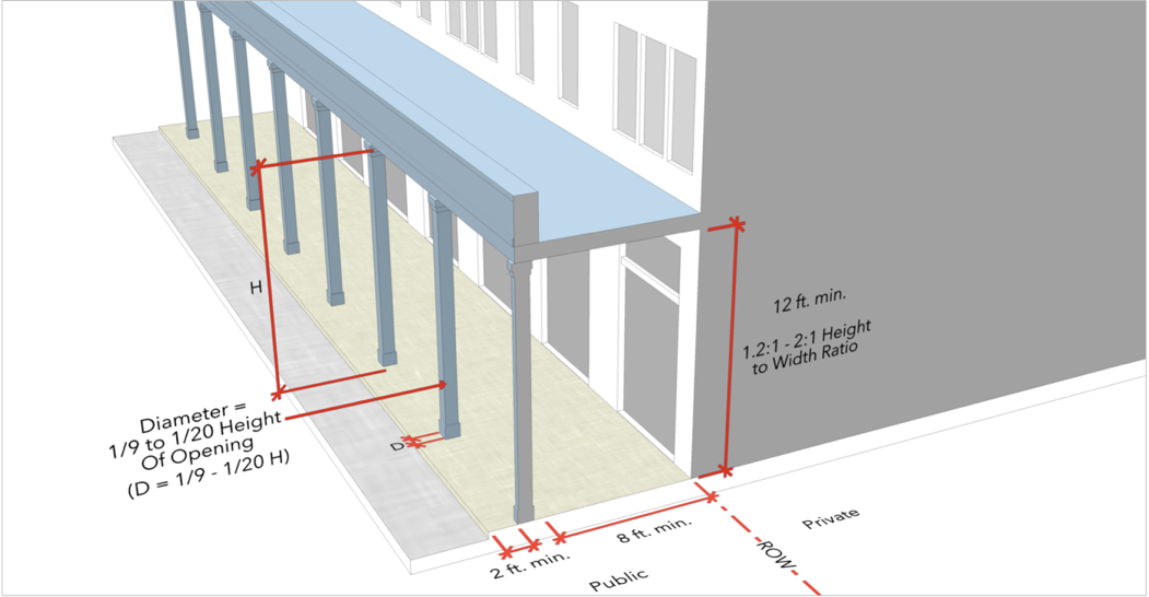
h.
Parking access, design and reductions.
1.
Intent. The intent of these standards is to guide the placement and design of parking, when it is provided. Vehicular parking spaces should be carefully integrated to avoid the negative impacts of large surface parking areas on the pedestrian environment. In general, parking supply should be shared by multiple users and property owners to facilitate the ability to "park once and walk." On-street parallel parking is encouraged on both sides of the street to provide a supply of convenient shared parking, and as a means to provide a protective buffer for pedestrians on the sidewalk. Where surface parking is permitted, it should be hidden or screened from the pedestrian realm by use of garden walls and narrow landscape edges. Parking garages, where provided, should be masked from frontages by liner buildings no less than 24 feet in depth. They are encouraged to be designed for possible future conversion to other non-parking functions, including office, residential and/or commercial use.
2.
All parking access and design shall comply with the form standards in Tables 12-3-31.3 to 12-3-31.8 and the following:
i.
Parking standards in the dense business area (DBA) defined in chapter 12-13 (definitions) shall take precedence over the form standards in Tables 12-3-31.3 to 12-3-31.8 and those included in this subsection.
ii.
Minimum parking requirements are as follows:
(a)
Parking requirements shall be in accordance with section 12-4-1(2) (parking requirements for specific land uses) with the following exception:
(1)
Off-street parking requirements for residential use types shall be one space per unit unless otherwise exempted.
(b)
Shared parking shall be according to section 12-4-1(4) (off-site parking).
(c)
Parking reductions shall be calculated according to Table 12.3-1 (Downtown Pensacola CRA Parking Reductions).
(d)
Lots 30 feet or less in width shall not be subject to minimum parking requirements, except for:
(1)
Lots fronting streets where on-street parking is not permitted.
(e)
Lots less than 42 feet wide shall be accessed from a rear lane, where possible. Where not possible, the following exceptions shall be permitted, in coordination with the engineering division of the city public works and facilities department:
(1)
Parking in the rear of the lot, subject to accessory structure setbacks as defined within the form standards in Tables 12-3-31.3 to 12-3-31.8. Shared driveways are encouraged.
(2)
A single-car garage, subject to the minimum frontage occupation requirements defined within the form standards in Tables 12-3-31.3 to 12-3-31.8.
(3)
Driveways shall be exempt from minimum width and spacing requirements defined in subsection (9)b.4 of this section.
(f)
Lots shall be accessed through a rear lane when the development is over 75 percent of the block.
iii.
Vehicular parking location is restricted as follows:
(a)
Single-family residential types.
(1)
Residential off-street parking, where required, shall be provided within garages, carports or on driveways for all single-family residential types.
(2)
Uncovered parking shall be permitted the entire length of the driveway, including within the front setback, but not beyond the property line.
(3)
Single-family detached and two-family (duplex) off-street parking.
a.
Covered or garage parking for single-family detached and two-family (duplex) buildings shall be set back a minimum 20 feet behind the principal building facade. See Illustration 12-3-31.9 for a depiction of covered parking placement for single-family detached and two-family attached (duplex) buildings.
ILLUSTRATION 12-3-31.9. GARAGE
LOCATIONS ILLUSTRATED
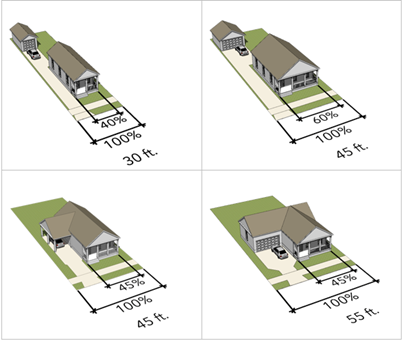
b.
The outer edge of driveways shall be placed a maximum of two feet from either side property line. See Illustration 12-3-31.10 for a depiction of driveway placement for single-family detached and two-family attached (duplex) buildings on 30 feet wide lots.
ILLUSTRATION 12-3-31.10. DRIVEWAY
LOCATIONS ILLUSTRATED
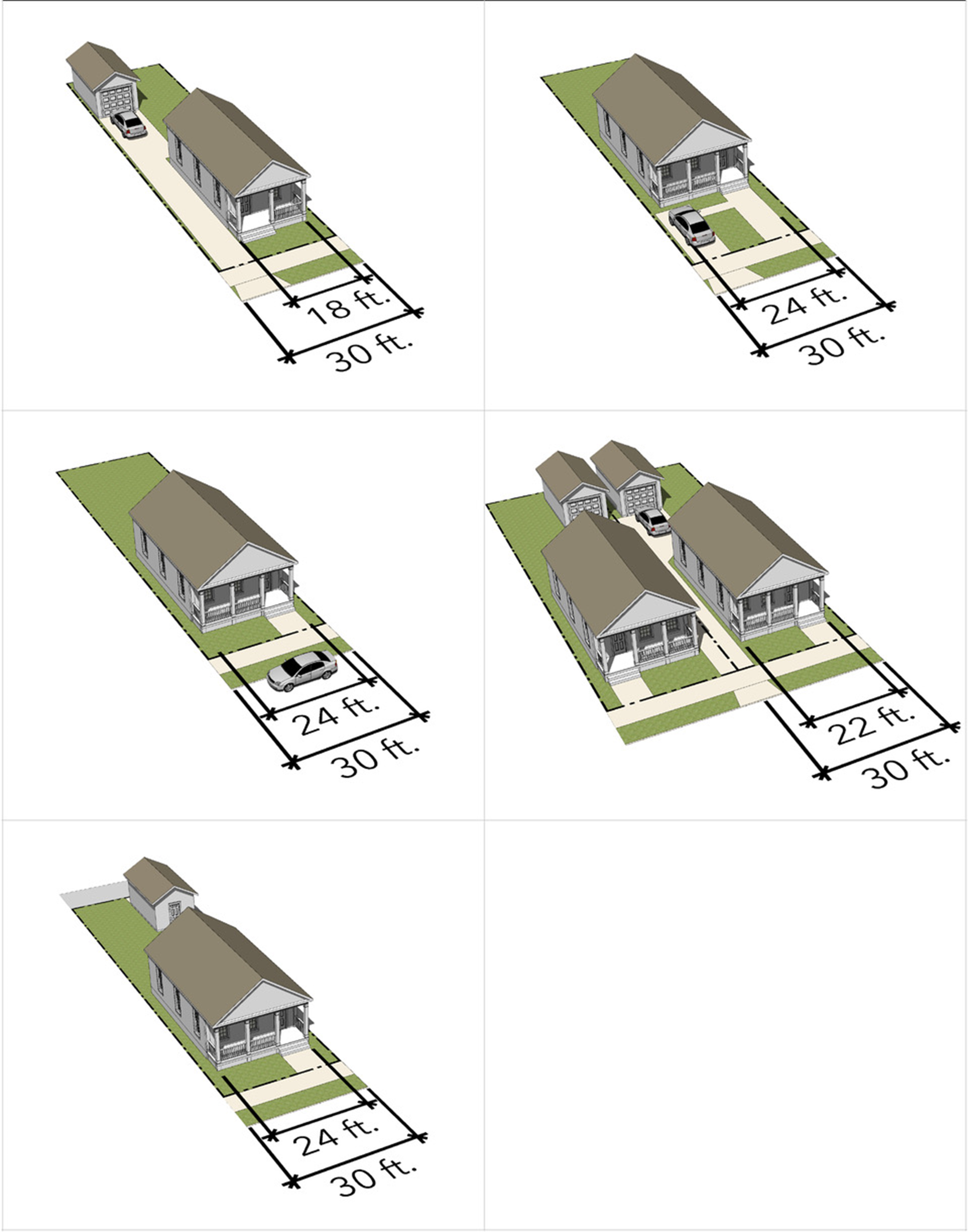
(4)
Single-family attached. Off-street parking for single-family attached residential types shall only be permitted in the rear 50 percent of the lot.
(5)
Tandem parking is encouraged.
(6)
Shared driveways are encouraged.
(b)
Multifamily, mixed-use and nonresidential types.
(1)
Off-street parking shall not be permitted within the front setback area. Exceptions include:
a.
Properties adjacent to a thoroughfare identified as an FDOT C3C Suburban Commercial Context Classification Zone as defined within subsection (9)a.2 of this section (context classification). Such properties shall conform to the form standards according to Table 12-3-31.8 (Hybrid Commercial).
(2)
Off-street parking shall be masked from frontages by liner buildings no less than 24 feet in depth to achieve the minimum frontage occupation. See Illustration 12-3-31.11 depicting off-street parking lot masking with liner buildings and subsection (7)e.3.iii of this section for permitted streetscreen requirements.
ILLUSTRATION 12-3-31.11. PARKING LOT
MASKING WITH LINER BUILDINGS
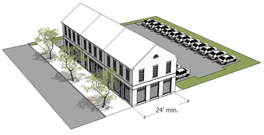
(3)
The ground floor of commercial buildings with a gross floor area less than 1,500 square feet shall be exempt from parking requirements.
iv.
Bicycle parking.
(a)
Minimum bicycle parking requirements shall be as follows:
(1)
Bicycle parking shall not be required for single-family residential or multifamily residential with less than eight units.
(2)
Bicycle parking requirements shall be according to Table 12-3-31.11.
TABLE 12-3-31.11. MINIMUM REQUIRED
BICYCLE PARKING
*Excluding C3C Context Zones.
(3)
Bicycle parking locations within the public right-of-way shall be coordinated with the engineering division of the city public works and facilities department and subject to section 12-11-7 (license to use), and minimum clearance distances.
(b)
Bicycle parking configuration shall be as follows:
(1)
Bicycle racks shall not be located within:
a.
Five feet of fire hydrants.
b.
Four feet of loading zones and bus stop markers.
c.
Three feet of driveways and manholes.
d.
Two feet of utility meters and tree planters.
See Illustration 12-3-31.12 for a depiction of bicycle parking clearances.
ILLUSTRATION 12-3-31.12. BICYCLE
RACK CLEARANCES
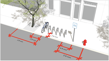
(c)
Bicycle parking located along private or public streets shall be subject to the following:
(1)
Bicycle racks installed parallel to curbs shall be set back from the curb a minimum of two feet, as illustrated in Illustration 12-3-31.11.
(2)
Bicycle racks installed perpendicular to curbs shall allow for a minimum clearance of two feet at the curb and six feet of pedestrian way with a 56 cm or 22 in bicycle properly locked to the rack.
(3)
Bicycle racks should be spaced a minimum of 36 inches apart.
(4)
Bicycle racks shall allow bicycle frames to be locked at two points of contact with the rack.
i.
Fences and walls.
1.
Where provided, fences and walls shall provide full enclosure.
2.
Fences and walls shall be restricted according to frontage yard types in Table 12-3-31.9 and section 12-3-58 (visibility triangles).
3.
Height of fences and walls shall comply with the following:
i.
Height shall be limited to a minimum 30 inches and a maximum 42 inches within the front setback.
ii.
Height shall be limited to eight feet behind the building face at non-frontages.
4.
Materials for fences and walls shall be limited as follows:
i.
Approved materials shall include, but are not limited to, wood, brick, stone, and wrought iron.
ii.
Vinyl is discouraged on all frontages.
iii.
Chain-link, exposed concrete block, barbed wire and razor wire shall be prohibited.
iv.
Wood fences shall have the finished side to the public frontage.
v.
Where hedges are utilized along frontages, they shall be maintained in accordance with subsection (8)b.1.v of this section.
j.
Windows and glazing.
1.
Windows shall meet the following requirements:
i.
Windows on frontages shall be square or vertical in proportion, with the exception of transoms and special windows.
ii.
Windows should have muntins for residential building types, which should be vertical in proportion.
iii.
Single panes of glass shall not exceed 20 square feet for residential building types.
2.
Glazing shall meet the following requirements:
i.
Storefront glazing requirements shall be according to Table 12-3-31.12.
ii.
For residential and mixed-use buildings, excluding commercial uses at grade, the percentage of glazed wall area shall be a minimum 20 percent.
iii.
Reflective and tinted windows shall be prohibited for residential buildings.
iv.
Stained, reflective and tinted windows shall be prohibited at ground floor commercial uses. Low-E is permitted as per Florida Building Code.
TABLE 12-3-31.12. GLAZING REQUIREMENTS
k.
Lighting on private property.
1.
Lighting shall be arranged to be contained on-site and to reflect away from adjacent property.
(8)
Landscape standards and guidelines.
a.
Intent. Supplement the urban canopy, accommodate stormwater, increase access to open space and facilitate pedestrian movement throughout the existing block patterns to meet the urban design goals of the community redevelopment agency. A healthy tree canopy contributes to the health of citizens and the environment, and is fundamental to a vibrant pedestrian life and a well-defined public realm. Trees closely aligned to the street edge with consistent setbacks, provide a clear sense of enclosure of streets, enabling them to function as pedestrian-scaled outdoor rooms. The placement of trees along the edge of the sidewalk should be given particular attention as a major contributor to pedestrian activity. Trees and other native plants placed in drainage rights-of-way and parking islands contribute to the control of stormwater quantity and quality.
b.
Landscape on private property.
1.
Landscaping in frontage yards are subject to the requirements of the frontage yard types in Table 12-3-31.9, and section 12-3-58 (visibility triangles), and the following:
i.
For single-family detached and two-family lots, one tree for every lot or for every 50 feet of linear frontage along the right-of-way shall be preserved or planted. Trees planted to meet this requirement shall be as follows:
(a)
Measured at diameter breast height (DBH), as described in section 12-6-2(e) (DBH).
(b)
For lots with a front setback of less than eight feet where planting in front yards is not possible, required trees shall be planted elsewhere on the block itself.
ii.
Ground vegetation or shrub plantings with spines, thorns, or needles that may present hazards to pedestrians, bicyclists, or vehicles shall be maintained a minimum distance of two feet from the edge of walkways and sidewalks.
iii.
In single-family detached and two-family lots, trees shall be protected in accordance with section 12-3-10(1)e.2 (protection of trees).
iv.
When off-street parking is located in front or side setbacks, a year-round streetscreen along the street edges of the parking lot shall be installed as a means of buffering, according to section 12-6-3(2) (off-street parking and vehicle use areas).
v.
Hedges planted along street rights-of-way shall be between three and five feet in height at maturity.
2.
Minimum landscape area requirements of the development site for all building types except single-family detached and two-family attached (duplex) shall be according to Table 12-3-31.13. Landscape requirements for single-family detached and two-family attached shall be in accordance with subsection (8)b.1 of this section and Table 12-3-31.9, frontage types.
TABLE 12-3-31.13. MINIMUM LANDSCAPE AREA
REQUIREMENTS
c.
Buffer yards.
1.
In addition to the buffer yard requirements of section 12-3-56 the following shall apply:
i.
Berms shall not be installed as part of a required buffer without review and approval by the engineering division of the city public works and facilities department to ensure a proposed berm will not have a detrimental effect on adjacent properties by impeding or diverting stormwater flow.
ii.
Berms shall be planted and stabilized to prevent erosion.
iii.
Buffer yards may be used to create rain gardens or other stormwater facilities with the selection of appropriate plant material, according to the city's approved plant list and approval by the engineering division of the city's public works and facilities department.
iv.
Plants in these stormwater facilities shall be selected to meet any applicable buffer yard screening requirements, and they should be tolerant of periodic inundation and drought. It is recommended that native plants be selected from the Florida Friendly Landscaping Guide to Plant Selection and Landscape Design, Northern Region, and Waterwise Landscapes by the South Florida Water Management District, according to Table 12-3-31.14.
TABLE 12-3-31.14. BIORETENTION & RAINWATER
GARDEN PLANT LIST
d.
Street trees in the public right-of-way.
1.
Street trees shall be provided in the public right-of-way for all developments except single-family detached and two-family (duplex), in accordance with section 11-4-88 (placement of trees and poles), section 12-6-3 (landscaping requirements) and this subsection.
2.
Where street trees cannot reasonably be planted, payment in lieu of planting shall be made to a new and dedicated CRA tree planting fund, at the value established in section 12-6-6(2)e.
3.
Street tree planting, and maintenance requirements shall be as follows:
i.
For each lot, one tree shall be provided on an average of 35 linear feet of public right-of-way frontage, where no underground utility conflicts exist.
ii.
Where greenways exist, trees shall be required to be planted within the greenway. The following exceptions shall apply:
(a)
Where no greenway exists or where the greenway is less than three feet wide, between sidewalk and curb, required street trees shall be planted on the block.
(b)
Where planting within the greenway is infeasible due to utility conflicts, required street trees shall be planted on the block.
iii.
Trees planted three feet or less from a public sidewalk shall have a minimum clearance of six feet and six inches between the public walking surface and the lowest branches at planting.
iv.
Mature trees shall be maintained at a minimum clearance of eight feet above the public walking surface.
v.
Trees planted within the public right-of-way shall include a root barrier to prevent the shifting of sidewalks at maturity.
vi.
Installation of tree pits and grates within the public right-of-way shall be coordinated with the city public works and facilities department for style consistency. Installed tree pits and grates shall be maintained by the property owner in perpetuity.
vii.
Where possible, trees may be clustered together to share soil space.
4.
Tree selection shall be limited to those allowable plantings contained within the tree replant list specified in chapter 12-6, Appendix B (Tree Replant List). The following conditions shall apply:
i.
Where overhead utilities occur, a tree with smaller size at maturity shall be selected.
5.
Tree selection and placement shall be coordinated with the engineering division of the city public works and facilities department and subject to section 12-3-58 (visibility triangle) and section 12-11-7 (license to use).
6.
Mixed-use and nonresidential building types shall comply with the following:
i.
Where galleries are not provided, street trees shall be planted, unless in conflict with underground utilities. Where there are overhead utilities, appropriate species from the tree replant list specified in chapter 12-6, Appendix B shall be selected.
ii.
Where a gallery is provided, and the greenway that occurs between the sidewalk and the back of curb is less than three feet wide, no street trees shall be required.
iii.
Where a greenway at least three feet wide occurs between the gallery and the back of curb, and no overhead or underground utilities prevent street tree installation, planting of a street tree shall be required.
iv.
Where paved surface occurs between the gallery and curb, installation of street trees in individual tree pits with tree grates, or linear planters with pervious pavers between several trees, shall be required.
v.
Where trees are planted in sidewalk planters, the minimum sidewalk planting pit dimensions shall be four feet by four feet.
(9)
Thoroughfare standards and guidelines.
a.
Context classification.
1.
The context classification system, as developed by FDOT and described within the FDOT Complete Streets Manual, shall be adopted to identify place and guide streets and other transportation features, and to allow transportation to support adjacent land uses. See Illustration 12-3-31.13 depicting context classification zones.
ILLUSTRATION 12-3-31.13. CONTEXT CLASSIFICATION ZONES ILLUSTRATED
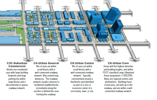
2.
Streets shall be classified in accordance with the zoning to context classification translations specified in Table 12-3-31.15.
TABLE 12-3-31.15. ZONING TO CONTEXT CLASSIFICATION TRANSLATION
b.
Street design.
1.
Design of local streets shall be guided by the Florida Greenbook, Chapter 19 Traditional Neighborhood Design.
2.
Where a greenway of at least five feet exists, driveway approaches and curb cuts shall not be permitted to interrupt the sidewalks.
3.
Sidewalks. Sidewalks shall be required on all street frontages in residential, nonresidential, commercial and industrial developments in accordance with standards established by the Engineering Division of the City's Public Works and Facilities and the Florida Greenbook.
4.
Driveways and curb cuts. Driveway, driveway approaches and curb cut requirements shall be as follows:
i.
Single-family residential types. Driveway and curb cut widths for single-family residential types shall be according to Table 12-3-31.16.
TABLE 12-3-31.16. SINGLE-FAMILY
RESIDENTIAL DRIVEWAY AND CURB
CUT WIDTHS
ii.
Multifamily, mixed-use and nonresidential types. Driveway and curb cut widths for multifamily and nonresidential types shall be according to Table 12-3-31.17.
TABLE 12-3-31.17. MULTIFAMILY/
NONRESIDENTIAL DRIVEWAY AND
CURB CUT WIDTHS
iii.
Driveway and curb cut spacing on a single property shall be a minimum of 42 feet with the following exception:
(a)
Lots equal to or less than 42 feet wide shall be limited to one driveway and curb cut.
(10)
Definitions. The following words, terms and phrases, when used in this section, shall have the meanings ascribed to them in this subsection, except where the context clearly indicates a different meaning:
Building height, multifamily and nonresidential means the vertical distance of a building measured by stories. The restrictions to story height are according to subsection (7)c.3 of this section.
Building height, single-family residential means the vertical distance of a building measured from the finished grade to the bottom of the eave for pitched roof buildings or the bottom of the parapet for flat roof buildings.
Cluster court means a collection of buildings on a semi-public, privately owned open space.
Colonnade means a row of columns joined by an entablature. Colonnades may cover sidewalks and may front storefronts.
Complete street means a thoroughfare that is designed giving each user an equal level of priority including pedestrians, cyclists, transit users, and drivers.
Craftsman standards means a baseline of construction quality denoting a finished project.
(FDOT) Distinct Context Classifications Zone means classifications, along with functional classification and design speed, determine the corresponding thoroughfare design standards within the Florida Design Manual. (http://www.fdot.gov/roadway/CSI/files/FDOT-context-classification.pdf)
Eave means the edge of the roof that meets or overhangs the walls of a building.
Encroachment means certain permitted building elements that may cross established setbacks or rights-of-way.
Entablature means a horizontal, continuous building element supported by columns or a wall.
Facade, building means the exterior wall of a building that faces a frontage line.
Facade type means the different configurations of building elements that make up a building facade, such as a storefront, porch, etc. See Table 12-3-31.10.
Figures and tables. Any chart or graphic presentation in this title that is specifically designated as a "Figure" or "Table" shall be deemed to be a part of the text of the title and controlling on all development.
Frontage line means a property line bordering a public frontage. Facades facing frontage lines define the public realm and are therefore more regulated than the elevations facing other property lines.
(Building) Frontage occupation means the length of the frontage that is occupied by a building or a building and open space.
Frontage, primary means the frontage facing a public space such as a street of higher pedestrian importance (i.e. traffic volume, number of lanes, etc.). Typically, the shorter side of a lot.
Frontage, secondary means the frontage facing the public space such as a street that is of lesser pedestrian importance (i.e. traffic volume, number of lanes, etc.). Typically, the longer side of the lot.
Frontage yard type means the configuration of the area between the facade of the building and the frontage line such as a standard, shallow, cluster court, etc. See Table 12-3-31.9.
Frontage yard type (cluster court) means a frontage yard type where a group of houses has their primary facades facing a common green or open space that is horizontal to the primary frontage.
Frontage yard type (pedestrian forecourt) means a frontage yard type where the primary facade is located near the lot line with an area setback to accommodate open space and the primary entrance of the building.
Frontage yard type (shallow) means a frontage yard type where the facade is slightly set back from the lot line.
Frontage yard type (standard) means a frontage yard type where the facade is set back from the lot line. Fences are permitted and the setbacks are visually continuous with adjacent yards.
Frontage yard type (urban yard) means a frontage yard type where the facade is at or near the lot line and the surface is paved.
Frontage yard type (vehicular forecourt) means a frontage yard type where the primary facade is located near the lot line with an area setback to accommodate a driveway meant for passenger loading and unloading.
Gallery means a covered sidewalk in front of a storefront that supports either a roof or outdoor balcony above.
Habitable space means building space which use involves human presence with direct view of the enfronting streets or public or private open space, excluding parking garages, self-service storage facilities, warehouses, and display windows separated from retail activity.
Human-scaled means buildings and their elements designed to be comfortably viewed and experienced by people on foot.
Hybrid commercial means a commercial type in the C3C FDOT Context Zone that transitions between urban and suburban types, typically permitting one row of parking at the frontage.
Liner building means a building specifically designed to mask a parking lot or a parking structure from a frontage.
Parallel means two lines or planes that are equidistant apart and do not touch on an infinite plane.
Parapet means the extension of a false front or wall above a roof line.
Parkway, greenway, verge means the planting strip between the edge of the road and sidewalk or right-of-way, which may be used for tree planting. See sections 11-4-86 through 11-4-88.
Paving means to cover or lay with concrete, stones, bricks, tiles, wood or the like to make a firm, level surface. The term paving in this section includes all pavement materials, both pervious and impervious.
Pervious means materials or natural earth that allows for the natural percolation of water.
Porch means a private facade type that is an open-air room appended to the mass of a building with a floor and roof but no walls on at least two sides.
Principal building means the main building on a lot, usually located toward the frontage.
Principal building facade means the front of the building that faces the front of the lot.
Single-family residential means a single-family ownership on a single lot. Multiple ownership on a single lot is not construed as a single-family type. Single-family is restricted to the following types on their own lots: detached single-family, attached single-family and two-family attached (duplex).
Stoop means a private facade type wherein the facade is aligned close to the front property line with the first story elevated for privacy with an exterior stair and landing at the entrance. This type is suitable for ground-floor residential uses at short setbacks with townhouses and apartment buildings. Stoops may encroach into the setback.
Streetscreen means a freestanding wall built along the frontage line, or aligned with the facade. It may mask a parking lot from the thoroughfare, provide privacy to a side yard, and/or strengthen the spatial definition of the public realm.
Travel mode means the different means of transport around an area including by foot, bicycle, public transit, and car.
Walkability means a measurement of comfort, convenience, safety, and ease of pedestrian movement throughout an area.
(Code 1986, § 12-2-25; Ord. No. 13-19, § 1, 5-30-2019; Ord. No. 05-20, § 1, 2-13-2020; Ord. No. 03-22, § 1, 2-10-2022)
Sec. 12-3-42. - Wellhead protection district.
(a)
Purpose and findings. The purpose of this section is to avoid risks of damage to sources of drinking water by prohibiting within close proximity of public water wells certain land uses, facilities and activities that involve a reasonable likelihood of discharges of pollutants into or upon surface water or groundwater. The council finds that the land uses, facilities and activities identified in this section involve a reasonable likelihood of discharges of pollutants into or upon surface water or groundwater and, therefore, that the prohibition of such land uses within wellhead protection areas is necessary to avoid risks of damage to sources of drinking water.
(b)
Location of wellhead protection areas. Wellhead protection areas are located within a radius of 200 feet of the public supply water wells located as follows and specifically identified on maps available in the building inspections and planning offices:
(1)
Cervantes and "I" Streets.
(2)
DeSoto and Guillemard Streets.
(3)
Lee and Tarragona Streets.
(4)
Jordan and Guillemard Streets.
(5)
Mallory Street and 10th Avenue.
(6)
Royce Street and Skyline Drive.
(7)
Cordova Place Subdivision and Airport Property.
(8)
Hidden Oaks Final Edition Subdivision and Airport Property.
(9)
9th Avenue and Underwood Road.
(10)
9th Avenue and McAllister Boulevard.
(11)
Davis Highway and Burgess Road.
(c)
Prohibited installations.
(1)
Prohibited land uses, facilities or activities. Except as provided in subsection (c)(2) of this section, the following land uses, facilities or activities are prohibited within wellhead protection areas:
a.
Automobile, truck or boat sales, rental, storage, maintenance or repair;
b.
Battery manufacturing, rebuilding or storage;
c.
Building or road contractor facilities other than offices;
d.
Chemical manufacturing, production, sales, storage, transfer or disposal facilities;
e.
Dry cleaners or laundries;
f.
Electroplating;
g.
Equipment or machinery sales, rental, storage, maintenance or repair;
h.
Furniture production, repair or refinishing;
i.
Gasoline stations or other refueling facilities;
j.
Laboratories;
k.
Landscape maintenance services;
l.
Liquid bulk plants or terminals;
m.
Manmade pits, ponds, lagoons or retention or impoundment areas;
n.
Medical or veterinary clinics;
o.
Paint sales, production or contracting facilities;
p.
Pest control services;
q.
Photography processing;
r.
Printing or copying equipment;
s.
Septic tanks;
t.
Storage tanks;
u.
Swimming pools;
v.
Wood, coal or fuel yards; and
w.
Wood preservation.
(2)
Exceptions. Any of the land uses, facilities or activities identified in subsection (c)(1) of this section lawfully in existence within a wellhead protection area on June 1, 1991, may continue to exist on the parcel upon which is located and permits for its replacement or repair may be granted; but such land uses, facilities, and activities may not be added to or expanded.
(Code 1986, § 12-2-26)
Sec. 12-3-43. - Bayou Texar shoreline protection district.
(a)
Purpose. The purpose of this district is to establish standards that recognize and protect the environmental resources of the Bayou Texar shoreline. This section ensures the preservation of the natural buffering effect of open spaces along the shoreline for storm surge abatement and the filtering of stormwater runoff; and enhances the public's recreational and aesthetic utilization of the shoreline and adjacent waters.
(b)
Shoreline protection zone. The Bayou Texar shoreline protection zone includes all property abutting Bayou Texar bounded on the north by the 12th Avenue bridge and on the south by the L & N trestle located at the mouth of the bayou.
(c)
Permitted land use. Land use shall be permitted in the shoreline protection zone as designated by the city comprehensive plan and zoning regulations.
(d)
Procedure for review of plans. Prior to the issuance of a building permit for construction within the Bayou Texar shoreline protection district the owner, developer or contractor shall submit to the city planning and engineering departments a drainage plan indicating soil erosion and sedimentation control measures that will be undertaken to prevent runoff into Bayou Texar during construction and indicating methods to accommodate stormwater runoff on-site during and after construction. The drainage plan shall include the following information:
(1)
Existing topographical contours of the site (two-foot intervals).
(2)
Location of all structures, parking areas, curb cuts and other construction activities that could contribute to removal of vegetation, erosion and stormwater runoff.
(3)
Design of grades and retention measures to control stormwater runoff during and after construction, including type of surfacing material to be used, vegetation to be removed, and revegetation of the site.
a.
Review and approval. The required drainage plan shall be subject to the review and approval of the planning services department and city engineer. If the developer intends to request a waiver of any of the provisions of this section concerning the drainage plan, the request must be submitted, in writing, with the drainage plan to the planning services department and the city engineer. The request shall itemize and shall state the reasons for which each waiver is requested. When considering waivers, the planning services department and the city engineer shall review the comprehensive plan objectives and policies pertaining to coastal management and conservation to determine if the waiver request is consistent with the intent of said plan.
b.
Exemptions. Operations that shall be exempt from this section are set forth below. However, any exemption from this section does not relieve responsibility to take all action necessary to prevent erosion and sedimentation from occurring.
1.
Home gardening or other similar activity not expected to contribute to any on-site generated erosion or chemical pollution.
2.
Emergency repairs such as those on public and private utilities and roadways systems.
3.
Improvements such as driveways, buildings, pools, etc. and/or accessory structures that do not exceed 1,500 square feet and which are not part of a larger/future development plan shall be exempt from installation of a stormwater treatment facility. Specifically, this 1,500 square foot exemption is a cumulative, one-time exemption. Even so, any such construction shall go through the city's permitting process, have proper erosion/sedimentation control meeting city standards as described in section 12-8-6(c), and neither create nor exacerbate any flooding problems. The city engineer may increase this requirement as warranted based upon site-specific circumstances and conditions.
(e)
Regulations.
(1)
Shoreline setback. All habitable structures shall observe the following minimum setback from the mean high water line. Docks and boathouses shall conform to the regulations set forth in section 12-3-60.
a.
R-2, R-2A and R-ZL zones shall require a 20-foot setback from the mean high water line of the bayou.
b.
R-1AA, R-1AAA and R-1AAAA zones shall require a 30-foot setback from the mean high water line of Bayou Texar.
c.
R-1AAAAA shall require a 60-foot setback from the mean high water line of Bayou Texar.
d.
Lots of record shall require a minimum 20-foot setback from the mean high water line of Bayou Texar.
(2)
Required yards. The front and rear yard requirements shall be the same as the applicable zoning district requirements. Each required side yard shall be ten percent of the lot width, not to exceed 15 feet. For lots of record the front and rear yard requirements shall be the same as described in section 12-1-6(b), and the required side yards shall be ten percent of the lot width, not to exceed ten feet.
(3)
Protection of trees. No person, organization, society, association or corporation, or any agent or representative thereof, directly or indirectly, shall cut down, destroy, undertake tree removal, or effectively destroy through damaging, any tree listed in chapter 12-6, Appendix A, "Protected Tree List," whether it be on private property or public right-of-way within the Bayou Texar shoreline protection district, without first having obtained a permit from the city to do so. Refer to section 12-6-7 for tree removal permit application procedures and guidelines.
(f)
Development guidelines. The following guidelines should be utilized in the review of each development proposal within the district. The adoption of guidelines herein are intended to provide flexibility in the development of property within the district in a manner that balances the interests of the property owner with the public's need for assurance that development will be orderly and consistent with the intent of this section. Individual parcels of property may have physical attributes that justify departure from regulatory norms when strict application of such norms would deny a property owner a reasonable use of his or her property and when deviation from such norms is consistent with the intent of this regulation as described herein.
(1)
Structures should be sited to retain the maximum amount of open space for natural stormwater retention.
(2)
Where possible and practical, existing vegetation, including shoreline vegetation, should be maintained as a buffer between development and the surface waters of Bayou Texar.
(3)
Development within the shoreline protection zone which would be dependent on future bulkheading or other shoreline fortification for protection shall be discouraged.
(4)
Proposed stormwater treatment facility(ies) shall be situated laterally across the width of the subject property and parallel to the shoreline (or provide grading, collection, and conveyance mechanism) to the greatest extent possible, in order to route and contain stormwater runoff from the up gradient yard into stormwater treatment facility(ies).
(5)
Proposed stormwater treatment facility(ies) shall be located at the farthest possible and practical downstream location adjacent to the shoreline without causing any adverse impacts to the shoreline or existing vegetative buffers. Facility(ies) shall be sized to provide treatment for one inch of runoff and provide a minimum of six inches of freeboard above the treatment volume elevation. The city engineer may increase these requirements as warranted based upon site-specific circumstances and conditions.
(g)
Public access to the shoreline. All extensions of street rights-of-way that are perpendicular to or otherwise intersect Bayou Texar within the shoreline protection zone shall be reserved for public use unless officially vacated by city council action.
(h)
Conflicts. It is not intended that this section interfere with or abrogate or annul any other ordinances, rules, or regulations except where this section imposes a greater restriction upon land within a zone.
(Code 1986, § 12-2-27; Ord. No. 8-99, § 3, 2-11-1999; Ord. No. 12-21, § 1, 6-17-2021)
Sec. 12-3-44. - Escambia Bay shoreline protection district.
(a)
Purpose. The purpose of this district is to establish standards that recognize and protect the unique scenic vistas and environmental resources of the Escambia Bay shoreline. The regulations for this district shall provide for the alleviation of the harmful and damaging effects of on-site generated erosion and runoff caused by clearing the natural vegetation, changing the existing contours of the land and/or not adequately addressing stormwater runoff. These regulations also ensure the preservation of the bluffs, the wetland areas and scenic views along the bay.
(b)
Escambia Bay shoreline protection district boundaries. The Escambia Bay shoreline protection district includes all property within the city limits bounded by Scenic Highway on the west and the Escambia Bay shoreline on the east, beginning at Mallory Street and continuing north to the city limits line.
(c)
Permitted land use. Land use shall be permitted in the Escambia Bay shoreline protection district as designated by the city comprehensive plan and zoning regulations.
(d)
Procedure for review of plans. The procedure established in section 12-3-43(d), applicable to the Bayou Texar shoreline protection district shall be followed for the Escambia Bay shoreline protection district.
(e)
Regulations.
(1)
Building setbacks.
a.
There shall be a minimum setback of 30 feet on both sides of the L & N rail right-of-way line for habitable structures.
b.
There shall be a minimum setback of 30 feet from the mean high water line of Escambia Bay for habitable structures.
(2)
Required yards. The front and rear yard requirements shall be the same as the zoning district requirements as described in section 12-3-2, except that if overall lot coverage requirements otherwise specified in this section are more restrictive, those shall supersede yard requirements. Each required side yard shall be ten percent of the lot width, not to exceed 15 feet. For lots of record the front and rear yard requirements shall be the same as described in section 12-1-6(b), and the required side yards shall be ten percent of the lot width, not to exceed ten feet.
(3)
Protection of trees. No person, organization, society, association or corporation, or any agent or representative thereof, directly or indirectly, shall cut down, destroy, undertake tree removal, or effectively destroy through damaging, any tree listed in chapter 12-6, Appendix A, "Protected Tree List," whether it be on private property or public right-of-way within the Escambia Bay shoreline protection district, without first having obtained a permit from the city to do so. Refer to section 12-6-7 for tree removal permit application procedures and guidelines.
(4)
Lot coverage. Total coverage of all development sites within the Escambia Bay shoreline protection district, including all structures, parking areas, driveways and all other impervious surfaces, shall not exceed 75 percent.
(5)
Protection of bluffs.
a.
Structures allowed on the bluffs. Only the following structures shall be allowed to be built on the bluffs:
1.
Elevated buildings, walkways, steps and decks;
2.
Pilings and footings necessary for construction of buildings, walkways, steps or decks; and
3.
Access roads or driveways that are essential to the economically viable use of the development.
b.
Vegetation. Clearing of the natural vegetation covering the bluffs within the Escambia Bay shoreline protection district is prohibited except for the minimum area needed for construction of allowable structures. As soon as the construction processes are completed, vegetation must be replanted in all disturbed areas.
c.
Construction. Development that would require alteration of the bluffs shall be prohibited except for approved access roads. Grading and other site preparation shall be kept to an absolute minimum, and shall not be undertaken any longer than 30 days from the proposed start of actual construction.
(f)
Development guidelines. The following guidelines should be utilized in the review of each development proposal within the district. The adoption of guidelines herein are intended to provide flexibility in the development of property within the district in a manner that balances the interests of the property owner with the public's need for assurance that development will be orderly and consistent with the intent of this section. Individual parcels of property may have physical attributes which justify departure from regulatory norms when strict application of such norms would deny a property owner a reasonable use of his or her property and when deviation from such norms is consistent with the intent of this regulation as described herein.
(1)
Site planning. All structures should be designed in a manner that complements the natural contours of the site. Developments should take into account the topography, soils, geology, hydrology and other natural conditions existing on the proposed site;
(2)
Preservation of existing vegetation, except as provided in subsection (e)(5)b of this section. Where possible and practical, existing vegetation, including trees that are not required to be protected under this section and existing shrubs and understory vegetation, should be left undisturbed, especially in the wetland areas. When vegetation is disturbed, the use of native vegetation is encouraged for replanting.
(g)
Conflicts. It is not intended that this section interfere with or abrogate or annul any other ordinances, rules, or regulations except where this section imposes a greater restriction upon land within a zone.
(Code 1986, § 12-2-28)
Sec. 12-3-55. - Accessory uses and structure standards.
In addition to the principal uses that are designated herein as being permitted within the several zoning districts established by this title, it is intended that certain uses which are customarily and clearly accessory to such principal uses, which do not include structures or structural features inconsistent with the principal uses, and which are provided electrical and plumbing service from the main building service shall also be permitted.
For the purposes of this chapter, therefore, each of the following uses is considered to be a customary accessory use, and as such, may be situated on the same lot with the principal use or uses to which it serves as an accessory.
(1)
Uses and structures customarily accessory to dwellings.
a.
Private garage.
b.
Open storage space or parking area for motor vehicles provided that such space shall not be used for more than one commercial vehicle licensed by the state as one ton or more in capacity per family residing on the premises.
c.
Shed or building for the storage of equipment.
d.
Children's playhouse.
e.
Private swimming pool, bathhouse or cabana, tennis courts, and private recreation for tenants of principal buildings.
f.
Structures designed and used for purposes of shelter in the event of manmade or natural catastrophes.
g.
Noncommercial flower, ornamental shrub or vegetable greenhouse.
h.
Television antenna or satellite TV receiving dish.
i.
Attached or detached, uncovered decks.
j.
Solar panels.
k.
Screened enclosures.
(2)
Uses customarily accessory to multifamily residential, retail business, office uses, and commercial recreation facilities.
a.
Completely enclosed building not to exceed 49 percent of the floor area of the main structure for the storage of supplies, stock, merchandise or equipment for the principal business.
b.
Lounge as an accessory use to a package liquor store, not to exceed 49 percent of the floor area of the package store.
c.
Lounge as an accessory use to a restaurant, not to exceed 49 percent of the floor area of the restaurant.
d.
Car wash as an accessory use to a service station not to exceed 49 percent of the square footage of the total site.
e.
Restaurants, cafes, coffee shops and small scale retail uses are permitted as an accessory use in multifamily developments over 20 units in size, and office buildings over 4,000 square feet. Such accessory uses shall be clearly subordinate to the principal use, shall be located on the first floor within the multifamily or office structure, and shall not exceed ten percent of the gross floor area of the structure in which it is located.
f.
Standards for accessory structures shall be as follows:
1.
The use shall be clearly incidental to the use of the principal building, and shall comply with all other city regulations. No accessory structure shall be used for activities not permitted in the zoning district except as noted above.
2.
No insignia or design of any kind may be painted or affixed to an accessory use or structure except such signs as are permitted in the provisions of chapter 12-5.
3.
Detached vending and transaction machines shall meet the following restrictions:
i.
Placement must be outside required landscape islands and stormwater management systems.
ii.
Anchoring to trees, traffic signs, fire hydrants, fire connectors, lift stations or other site infrastructure is prohibited.
iii.
Dispensers and service machines placed in parking lots shall have a finished exterior of brick, stucco, stone, metal or stained wood and shall not contain windmills or similar objects.
iv.
A sloped roof with a peak or parapet roof is preferred to be affixed to dispensers placed in parking lots with shingle, tile or other roof material in accordance with Florida Building Codes. Screened mechanical rooftops, and other screening or railings with no more than 50 percent openings, may be used subject to approval by the planning board.
v.
Signage may not exceed 25 percent of the proposed street elevation.
(3)
Uses customarily accessory to cemeteries. A chapel is an accessory use to a cemetery.
(4)
Residential accessory structures standards.
a.
Accessory structures shall not be permitted in any required front or required side yard except as exempted in this section. Accessory structures shall be permitted in a required rear yard. Figure 12-3.3 shows permitted locations for residential accessory structures.
FIGURE 12-3.3. PERMITTED LOCATION OF
RESIDENTIAL ACCESSORY STRUCTURES
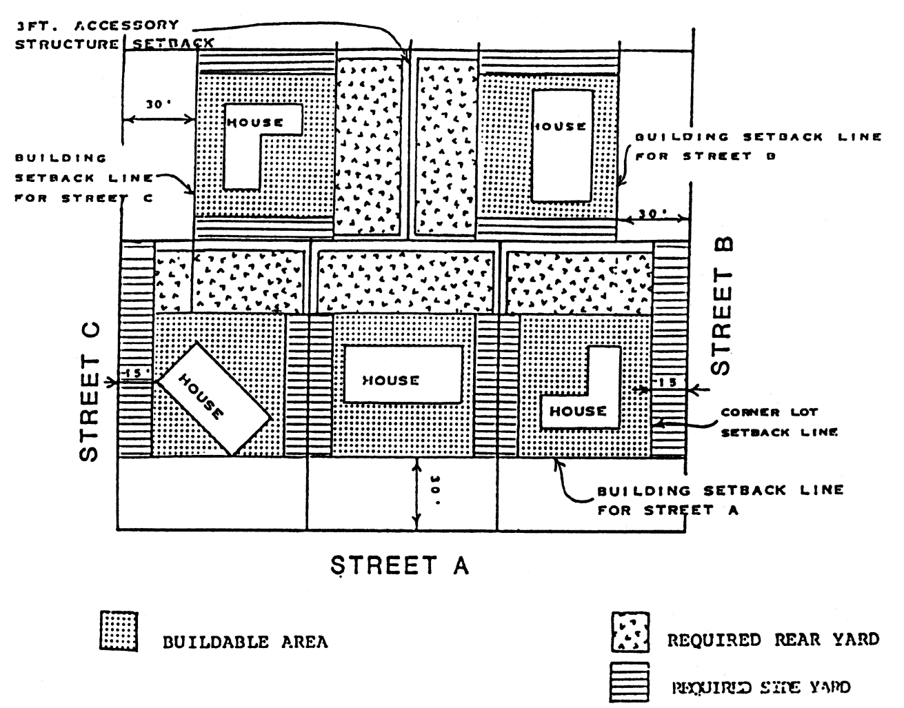
1.
Permitted only in shaded areas noted as buildable area or required rear yard as shown above.
2.
Shall occupy not more than 25 percent of required rear yard area. For purposes of calculating this percentage in a corner lot rear yard, the yard shall be measured from the interior side lot line to the street right-of-way line. Swimming pools and their surrounding decking shall be exempt from this calculation.
3.
Except for corner lots, accessory structures shall not be located closer than three feet from a property line in a required rear yard.
4.
No part of an accessory structure may be located any closer than four feet to any part of the main dwelling unit. An open covered walkway no more than six feet wide may connect the main structure to the accessory structure.
5.
Maximum height shall be determined as follows:
i.
Accessory structures located within three feet of the side and rear property lines shall have a maximum allowed height of 15 feet.
ii.
Accessory structures exceeding 15 feet must meet the side yard setback requirements of the principal dwelling unit. For every additional one foot that an accessory dwelling unit is set back from the rear property line above and beyond five feet, an additional one foot in height shall be allowed up to a maximum allowed height of 20 feet as measured at the roof peak.
6.
Accessory dwelling units must meet the requirements set forth in section 12-3-81.
(Code 1986, § 12-2-31; Ord. No. 6-93, § 11, 3-25-1993; Ord. No. 13-06, § 11, 4-27-2006; Ord. No. 45-07, § 1, 9-13-2007; Ord. No. 40-13, § 2, 11-14-2013; Ord. No. 25-19, § 1, 10-24-2019)
Sec. 12-3-56. - Buffer yards.
(a)
Purpose. The purpose of establishing buffer yard and screening requirements is to protect and preserve the appearance, character and value of property within the city and to recognize that the transition between certain uses requires attention to eliminate or minimize potential nuisances such as dirt, litter, glare of lights, signs, parking areas and different building styles and scales associated with different land uses. The buffer yard and screening requirements are not meant to replace regulations for specific zoning district side and rear property line requirements, except that buffer yard and screening requirements may be more stringent than specific zoning district regulations.
(b)
Application of buffer yard and screening requirements. The provisions of this section must be met at the time that building sites are developed or redeveloped.
(c)
Locations for required buffer yards and screening of specific uses or facilities.
(1)
Required buffer yards.
a.
Within or adjacent to a residential zoning district. Any developing land use other than a single-family or duplex residential land use, adjacent to a single-family or duplex residential land use or a vacant parcel, shall be responsible for providing a buffer yard.
b.
Within or adjacent to a cumulative zoning district. Any developing land use other than a single-family or duplex residential land use, adjacent to a single-family or duplex residential land use, shall be responsible for providing a buffer yard. A developing land use adjacent to a vacant parcel within or adjacent to a cumulative zoning district shall not be responsible for providing a buffer yard.
c.
Adjacent to a historic or preservation land use district. Any developing land use other than a single-family or duplex residential land use, adjacent to any existing land use or a vacant parcel in a historic or preservation land use district shall be responsible for providing a buffer yard.
(2)
Specific uses or facilities. The following specific uses or facilities must be screened from public view from a public street and from adjoining property when the subject site is zoned or adjacent to property zoned residential, historic or preservation, redevelopment or airport. Screening material shall meet the requirements of subsection (d)(2)a of this section.
a.
Dumpsters or trash handling areas.
b.
Service entrances or utility facilities.
c.
Loading docks or spaces.
(d)
Requirements for buffer yards.
(1)
Description of buffer yard. Where relationships exist between land uses or zoning districts that would require a buffer yard, as described in subsection (c)(1) of this section, a ten-foot buffer yard shall be required. Said buffer yard shall extend the entire length of the common property line or zoning district boundary except when the boundary is located within a public street or right-of-way. The buffer yard may be located within a larger required yard or may supersede the requirements for smaller required yards depending on the specific zoning district regulations.
(2)
Buffer material requirements. A buffer yard must contain trees and screening materials as specified in this subsection.
a.
Screening materials. A buffer yard must contain one or more of the following type screening materials sufficient to provide a minimum of 75 percent opacity for that area between the finished grade level at the common boundary line and six feet above said level and horizontally along the length of all common boundaries: fence, wall, hedge, landscaping, earth berm or any combination of these. The composition of the screening material and its placement within the buffer yard or surrounding the use or facility to be screened will be left up to the discretion of the developer so long as the purpose and requirements of this section are met. A fence or earth berm that is located within the required buffer yard must comply with maximum height requirements established in section 12-3-63, applicable to fences.
b.
The minimum height for screening will be six feet (at maturity for vegetation).
c.
Trees must be installed as part of the screening material. One tree must be installed for each 25 linear feet or majority portion thereof, with a minimum of 50 percent of said trees being shade trees. Trees shall be spaced so as to allow mature growth of shade trees. Trees may be evergreen or deciduous as long as they are of a variety approved by the city, and said trees must be at least three inches in diameter (9.4 inches in circumference) measured one foot above grade at the time of planting. Protection of existing healthy trees within a required buffer yard is encouraged, and when existing trees are protected the spacing requirements and the number of trees required may be adjusted to take into account the growth characteristics of the trees.
d.
Shrubs used in any screening or landscaping may be of evergreen or deciduous varieties. They must be at least two feet tall when planted and no further apart than five feet. They must be of a variety and adequately maintained so that a minimum height of six feet could be expected as normal growth within three years of planting. Protection of existing healthy shrubs is encouraged, and when existing shrubs are protected the spacing requirements may be adjusted to take into account the growth characteristics of the shrubs. Table 12-3.11 lists recommended vegetation for screening.
e.
Any earth berm used to meet the requirements of this section must be stabilized to prevent erosion and must be landscaped with grasses, shrubs, or other materials.
f.
Grass, other ground cover or permeable mulching material shall be planted or placed on all areas of the buffer yard required by this section that are not occupied by other landscape materials.
g.
There are other landscaping and tree planting requirements contained in chapter 12-6. Nothing in this section will exempt any development from complying with those other requirements when they would require a higher level of performance.
TABLE 12-3.11. RECOMMENDED VEGETATION LIST
FOR BUFFER YARD VISUAL SCREEN
(e)
Alternative screen methods. Under certain circumstances the application of the standards above is either inappropriate or ineffective in achieving the purposes of this section. When the site design, topography, unique relationships to other properties, natural vegetation, or other special considerations exist relative to the proposed development, the developer may submit a specific plan for screening.
(f)
Use of existing screening. When a lot is to be developed so that a buffer yard is required and that lot abuts an existing hedge, fence or other screening facility on the adjoining lot, then that existing screen may be used to satisfy the buffer screening material requirements of this section; however, the ten-foot buffer yard must be provided. The existing screen must meet the minimum standards for screening established by this section and it must be protected from damage by pedestrians or motor vehicles. The burden to provide the necessary screening remains with the use to be screened and is a continuing obligation that runs with the land so long as the original relationship exists.
(g)
Hardship determination. If the city engineer and planner determine that the construction of a buffer yard required by this chapter would create a hardship because of the unique and peculiar circumstances or needs resulting from the size, configuration or location of the site or for the renovation of existing structures or vehicular use areas, the above stated city staff may approve a buffer yard with a width no less than five feet, provided such buffer yard meets the visual screening requirements of this section.
(Code 1986, § 12-2-32; Ord. No. 13-92, § 2, 5-28-1992; Ord. No. 29-93, § 15, 11-18-1993; Ord. No. 50-00, § 4, 10-26-2000)
Sec. 12-3-57. - Home occupation permits.
(a)
Findings. The city recognizes that tangible benefits will be gained by allowing residents to earn income from occupations conducted within their homes. These benefits include in part:
(1)
A reduction in automobile trips;
(2)
Encouraging more citizens, including the handicapped, the aged, and parents of small children, to participate in the workforce; and
(3)
Allowing many of these citizens to have jobs while meeting various family obligations.
(b)
Purpose. The city recognizes that its residents should expect their neighborhoods to be quiet and safe places to live and that home occupations should not be allowed to alter the primarily residential character of these neighborhoods. Home occupations should not be allowed to create a nuisance of any kind or to endanger the health or safety of residents of the neighborhood. For these reasons, it is the purpose of this section to:
(1)
Protect residential areas from the adverse impacts of activities associated with home occupations;
(2)
Permit residents of the community a broad choice in the use of their homes as a place of livelihood for the production or supplementation of personal and family income;
(3)
Establish criteria, development standards and performance standards for home occupations conducted in dwelling units.
(c)
Permits. A person desiring a home occupation permit shall make an application in the planning services department. A person may only apply for a home occupation permit to be used at his or her primary place of residence.
(1)
Occupational license required. All home occupations shall be required to obtain an occupational license concurrent with the application for a home occupation permit.
(2)
Acknowledgement of applicant required. An applicant for a home occupation permit shall, at the time of application, sign an acknowledgement stating that the applicant:
a.
Agrees to comply with the standards set forth in this section;
b.
Agrees to comply with the conditions imposed by the city to ensure compliance with such standards;
c.
Acknowledges that a departure therefrom may result in a revocation of the home occupation permit; and
d.
Acknowledges that the city shall have the right to reasonably inspect the premises upon which the home occupation is conducted to ensure compliance with the foregoing standards and conditions, and to investigate complaints, if any, from neighbors.
(3)
Application for a permit. Such application for a permit shall include the following:
a.
Name of applicant;
b.
The exact nature of the home occupation;
c.
Location of dwelling unit where the home occupation will be conducted;
d.
Total floor area of the dwelling unit;
e.
Area of room or rooms to be utilized in the conduct of the home occupation; and
f.
A sketch with dimensions showing the floor plan and the area to be utilized for the conduct of the home occupation. This sketch must show the location and nature of all equipment to be utilized in the conduct of the home occupation, as well as the locations for storage of materials used in the conduct of the home occupation and the identity and nature of these materials. If the nature of the business is such that clients or customers will visit the premises, then the sketch must show available off-street parking and the ingress/egress to be used.
If the proposed home occupation complies with all of the requirements of subsection (d) of this section, the planning services department shall issue the home occupation permit. Home occupation permits are non-transferable, except that, in the case of death, should a surviving spouse or child residing at the same address desire to continue the home occupation, written notice to that effect shall be given to the planning services department and the permit may be transferred. Such home occupation permit cannot be used by the applicant for any premises other than that for which it was granted.
(4)
Revocation of a home occupation permit. Any person may seek revocation of a home occupation permit by making application therefor to the building official, and an investigation will be made to determine whether the permit holder is conducting such home occupation in a lawful manner as prescribed in this section. In the event that the building official determines that the permit holder is in violation of the provisions of this section, the permit shall be immediately revoked. The decision of the building official shall be subject to appeal to the board of adjustment as prescribed in section 12-11-2. During such an appeal, the action of the inspection services department is stayed. If the inspection services department determines that the public safety is at risk, appropriate regulating agencies and authorities shall be immediately notified.
The following shall be considered as grounds for the revocation of a home occupation permit:
a.
Any change in use or any change in extent or nature of use or area of the dwelling unit being used, that is different from that specified in the granted home occupation permit form, that is not first approved by the city planner shall be grounds for the revocation of a home occupation permit. The operator of a home occupation must apply for a new home occupation permit prior to any such changes;
b.
Any change in use, extent of use, area of the dwelling unit being used, or mechanical or electrical equipment being used that results in conditions not in accordance with the provisions of the required conditions of subsection (d) of this section shall result in immediate revocation of the home occupation permit;
The following conditions shall apply for home occupation permits that have been revoked:
1.
Initial revocation. Reapplication may only occur when the conditions causing the revocation has been corrected;
2.
Second revocation. Reapplication may only occur after one year and when the conditions causing the revocation has been corrected;
3.
Third revocation. The home occupation permit shall not be reissued.
(d)
Required conditions. All permitted home occupations shall comply with the following standards and criteria:
(1)
The home occupation may be conducted within the principal building or in an accessory building, except for any related activities conducted off the premises.
(2)
No person other than a member of the family residing on the premises shall be employed or engaged in the home occupation at the premises.
(3)
There shall be no alteration or change to the outside appearance, character or use of the building or premises, or other visible evidence of the conduct of such home occupation, including outside storage or signs pertaining to the home occupation. There shall be no display of products visible in any manner from the outside of the dwelling.
(4)
No home occupation shall occupy more than 500 square feet. When located within the principal building, no home occupation shall occupy more space than 25 percent of the total floor area of the dwelling unit, provided that in no event shall such home occupation occupy more than 500 square feet.
(5)
No commodities or goods of any kind shall be sold on the premises with the following exceptions:
a.
The sale and display of items produced or fabricated on the premises as part of the home occupation, such as art and handicrafts, is permitted. In no instance is any outside display allowed.
b.
Orders made by phone, mail or sales party may be filled on the premises.
(6)
No equipment or process shall be used in such home occupation that creates prolonged noise, sound or vibration. Heat, glare, fumes, dust, odors or electrical interference detectable to the normal senses outside the dwelling, or in multiple-family dwellings, detectable to the normal senses beyond the walls of the dwelling unit shall not be permitted. Combustible materials located anywhere on the premises in quantities that are in violation of the city's fire code shall not be permitted. No equipment shall be used that creates any visual or audible interference in any radio, telephone or television receivers off the premises, or causes fluctuations in line voltage off the premises.
(7)
No articles or materials used in connection with such home occupation shall be stored on the premises other than in the area permitted for the home occupation, and any area used for storage shall be counted toward the maximum permissible floor area used for such home occupation.
(8)
No home occupation shall be permitted that involves the visitation of clients, customers, salesmen, suppliers or any other persons to the premises that would generate vehicular traffic in excess of two vehicles concurrently or more than 12 vehicles per day.
(9)
The total number of home occupations conducted within a dwelling unit is not limited, except that the cumulative impact of all home occupations conducted within the dwelling shall not exceed the limits of one home occupation as established in this subsection.
(10)
There shall be no illegal discharge of any materials, fluids or gases into the sewer system or any other manner of discharging such items in violation of any applicable government code.
(11)
Home occupations shall comply with all local, state or federal regulations pertinent to the activity pursued, and shall not be construed as an exemption from such regulations.
(e)
Prohibited activities. A home occupation permit shall not be issued for any of the following uses or for a home occupation that requires any of the following activities:
(1)
Activities regulated by the Federal Bureau of Alcohol, Tobacco and Firearms;
(2)
Activities that produce hazardous wastes regulated by the United States Environmental Protection Agency or the state department of environmental protection;
(3)
Beauty/barber shops with more than two chairs;
(4)
Group instruction of more than two students at one time;
(5)
Outdoor repair shops;
(6)
Provision of transportation services such as taxi or limousine service;
(7)
Sales of food or drink to the public on the premises;
(8)
Sales of retail items other than described in subsection (d)(5) of this section; and,
(9)
Sales, service or repair of motorized vehicles.
(Code 1986, § 12-2-33; Ord. No. 45-96, § 7, 9-12-1996; Ord. No. 44-99, § 2, 11-18-1999)
Sec. 12-3-58. - Required visibility triangle.
(a)
Location and general provisions. On every corner lot on both public and private streets, the triangle formed by the street right-of-way lines of such lot and a line drawn between points on such street lines which are 30 feet from the intersection thereof shall be clear of any structure, solid waste container, parked vehicles, major recreational equipment, or planting of such nature and dimension as to obstruct lateral vision, provided that this requirement shall generally not apply to the trunk of a tree (but usually shall apply to branches or foliage), or a post, column, or similar structure which is no greater than one foot in cross-section diameter.
FIGURE 12-3.4. VISIBILITY TRIANGLE
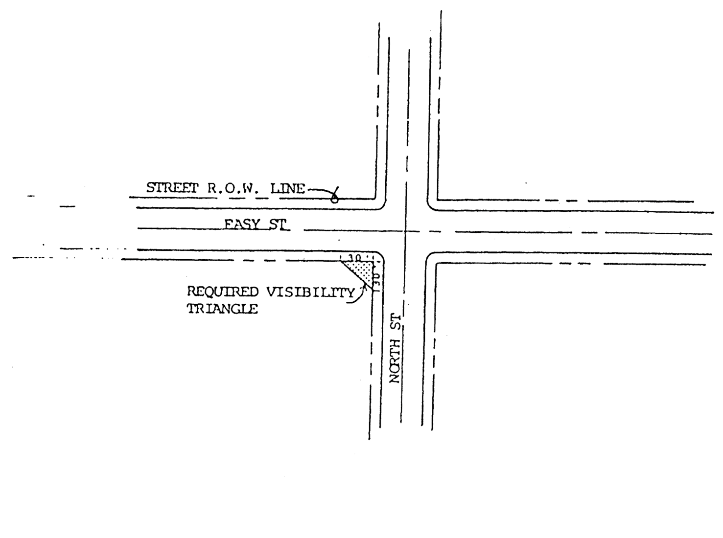
(b)
Vertical clearance. Lateral vision shall be maintained between a height of three feet and eight feet above the average elevation of the existing surface of both streets measured along the centerlines adjacent to the visibility triangle.
(c)
Exemptions.
(1)
The C-2A and HC-1 zoning districts shall be exempt from the visibility triangle provision.
(2)
Lots of record shall be exempt from the visibility triangle provision.
(3)
Transparent fences including chain-link, wrought iron and similar materials, shall be exempt from the visibility triangle provision.
(d)
Hardship determination. If the city engineer and planner determine that the visibility triangle required by this section would create a hardship because of the unique and particular circumstances or needs resulting from the size, configuration or location of the site or for the renovation of existing structures or vehicular use areas, the above stated city staff may approve a visibility triangle of no less than 15 feet from the intersection.
(Code 1986, § 12-2-35; Ord. No. 8-99, § 4, 2-11-1999; Ord. No. 22-02, § 1, 9-26-2002)
Sec. 12-3-59. - Parking and storage of major recreational equipment.
(a)
General requirements.
(1)
Parking or storage of major recreational equipment, except for loading and unloading not to exceed 24 hours, shall not be permitted in any portion of any public right-of-way.
(2)
Repairing or maintaining major recreational equipment, except repairs necessitated by an emergency, shall not be permitted in any portion of any public right-of-way.
(3)
Major recreational equipment shall not be parked or stored on any vacant lot except where such vacant lot adjoins a lot on which a principal structure under the same ownership is located.
(4)
Major recreational equipment may not be parked or stored on a parking lot for the principal purpose of displaying such equipment for sale except on parking lots where the sale of vehicles and major recreational equipment is a duly authorized permitted use (i.e., new and used car lot, major recreational equipment sales lot).
(5)
Major recreational equipment may not be used for storage of goods, materials or equipment other than those items considered to be part of the vehicle or major recreational equipment essential for its immediate use.
(6)
Parking or storage of major recreational equipment is allowed in duly authorized facilities designed for storage and parking of major recreational equipment and on residential premises as provided in subsection (b) of this section.
(b)
Residential requirements. Parking or storage of major recreational equipment on residential premises shall be allowed as shown in Figure 12-3.5 subject to the following conditions:
(1)
May be parked or stored in:
a.
Permanent equipment enclosures such as carports or garages;
b.
The driveway of the owner's residence but not in any portion of any public right-of-way;
c.
Rear yards not closer than three feet to the rear and side property lines;
d.
The front yard except in the required visibility triangle (refer to section 12-3-58) but only perpendicular to the front lot line and within 15 feet of either side lot line; or
e.
One of the required side yards but not both. May be parked on corner lots in the required street side yard except in the required visibility triangle.
(2)
May be parked anywhere on residential premises not to exceed 24 hours during loading or unloading.
(3)
Shall not be used for living, sleeping or housekeeping purposes while stored on a residential premises.
(4)
Shall not be connected to any utilities except electricity.
(5)
May not be parked or stored in required parking spaces of multiple-family developments.
(6)
Must be maintained in an operable condition and must be properly licensed in accordance with all laws of the state.
FIGURE 12-3.5. STORAGE OF MAJOR
RECREATIONAL VEHICLES
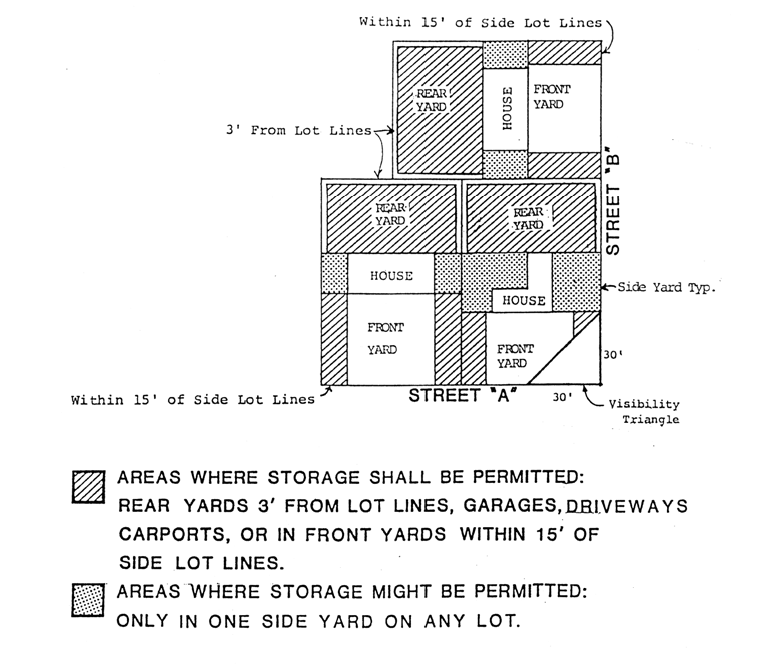
(Code 1986, § 12-2-36; Ord. No. 8-95, § 1, 2-23-1995; Ord. No. 23-02, § 1, 9-26-2002)
Sec. 12-3-60. - Boathouses, piers and docks, all residential zones.
In a residential zone, bordering upon either Bayou Chico, Bayou Texar, Pensacola Bay or Escambia Bay within the city limits, piers, docks and boathouses may be built provided that all permits have been obtained from the state department of environmental protection and the Army Corps of Engineers prior to city building permit application. No piers, docks or boathouses shall be built along the shores in or upon the waters of Bayou Texar or Bayou Chico, Pensacola Bay and Escambia Bay except those that shall conform to the following regulations:
(1)
No pier, dock and/or boathouse shall be constructed or altered hereafter without first obtaining a permit from the building inspector and upon the submission of plans and a plat describing the proposed construction.
(2)
No boathouse, pier, dock or approach to the said boathouse shall be closer to the side lot lines of the designated lots (lot line measured at right angle from shoreline) in any subdivision bordering Bayou Texar, Bayou Chico, Pensacola Bay or Escambia Bay than a minimum footage of ten feet, nor shall any boathouse extend to a height of more than 15 feet from the above mean low tide.
(3)
The square foot area of any boathouse shall not exceed 40 percent of the total area of the principal dwelling unit and that an uncovered platform at the end of a pier or dock shall not exceed 250 square feet.
(4)
No boathouse shall be used for living quarters, and the use of boathouses shall be confined to the housing of boating and related equipment.
(Code 1986, § 12-2-37; Ord. No. 22-02, § 1, 9-26-2002; Ord. No. 19-16, § 1, 7-14-2016)
Sec. 12-3-61. - Private streets.
(a)
Permitted locations. Private streets may be constructed in residential and nonresidential developments and subdivisions.
(b)
Construction of private streets.
(1)
Private streets shall be constructed solely at the expense of the developer or the homeowners' association and shall have a hard surface travel way of a minimum of 12 feet per travel lane and a minimum of two lanes per street, or 24 feet of pavement in a two-way street. Narrower pavement widths may be approved by the planning board and city council upon recommendation by the city engineer.
(2)
Private streets shall be contained within a private ingress and egress easement, private right-of-way or private common area of sufficient width to contain the roadway, sidewalks and any utilities.
(3)
Private streets shall be designed and constructed in accordance with the requirements of section 12-3-121 and chapter 12-7 where a subdivision is involved.
(c)
Maintenance of private streets. The owners of a development that includes private streets shall utilize one of the following general plans for providing for the ownership and maintenance of the private streets:
(1)
Establish an association or nonprofit corporation of all individuals and entities owning property within the development.
(2)
Owner to retain ownership control of such area and be responsible for the maintenance thereof.
(3)
Any other method proposed by the owner that is acceptable to the city council. Said proposed alternative method shall serve the purpose of providing for the ownership, use, and maintenance, of the private streets.
(Code 1986, § 12-2-38; Ord. No. 13-06, § 12, 4-27-2006)
Sec. 12-3-62. - Height exceptions.
The following height exceptions qualify or supplement as the case may be, the district regulations or requirements appearing elsewhere in this land development code:
(1)
Public or semipublic buildings, schools, and churches or temples, where permitted in an R-1AAAAA, R-1AAAA, R-1AAA, R-1AA, R-1A, R-ZL zoning district or in the North Hill preservation district, may be erected to a height not exceeding 75 feet when the front, rear and side yards are increased an additional foot for each foot such buildings exceed the height limit otherwise provided in the district in which the building is built.
(2)
Single- and two-family dwellings in a residential district may be increased in height by not more than ten feet when two side yards of not less than 15 feet each are provided.
(3)
The height limitations contained in this chapter do not apply to chimneys, water tanks or towers, elevator bulkheads, stacks, ornamental towers or spires, monuments, cupolas, domes, false mansards, parapet walls and necessary mechanical appurtenances usually required to be placed above the roof level and not intended for human occupancy. However, the heights of these structures or appurtenances shall not exceed the height limitations prescribed by the Federal Aviation Administration within the flight approach zone patterns of the Pensacola International Airport. (Refer to chapter 12-10.)
(4)
Private radio antenna towers provided same are established pursuant to the following conditions:
a.
Private radio antenna towers are permitted up to 75 feet above grade. Height of tower to be measured from grade to the uppermost portion of the tower and its appurtenances, said distance to be measured when tower is extended to its greatest height.
b.
Private radio antenna towers shall be permitted in the side yard other than the required side yard, and in the rear yard.
c.
A private radio antenna tower shall not be constructed without a building permit. Antenna towers shall meet the minimum requirements of chapter 14-2. Any portion of an antenna tower above 75 feet in height shall require a variance from the zoning board of adjustment (ZBA).
(Code 1986, § 12-2-39; Ord. No. 6-93, § 12, 3-25-1993; Ord. No. 29-93, § 16, 11-18-1993)
Sec. 12-3-63. - Fences.
(a)
General provisions.
(1)
Visibility triangle requirements. All opaque fences shall conform to the required visibility triangle requirements as set forth in section 12-3-58.
(2)
Prohibited fences. No electrical fences or fences with cutting edges, including, but not limited to, fences using razor, ribbon or concertina wire, shall be permitted within the city. Notwithstanding the foregoing, electrical fences may be used at wildlife sanctuaries permitted by the U.S. Department of Wildlife and Fisheries to harbor and protect federally protected and/or endangered species. Electrical fences must be wholly within the interior of such sanctuaries and may not be used as perimeter fences. Site plans and installation diagrams must be submitted to the city planning services department and the building official for review and approval. Electrical fences may not be in use during hour of operation when the public is present and appropriate warning signs must be attached to electrical fences.
(3)
Pillars and posts. Pillars and posts may extend up to 12 inches above the height limitations of this section, provided such pillars and posts are no less than eight feet apart.
(4)
Existing nonconforming fences. Existing nonconforming fences in any zoning district may be repaired or replaced, with the exception of opaque fences in a visibility triangle.
(b)
Regulations for the R-1AAAAA, R-1AAAA, R-1AAA, R-1AA, R-1A, R-ZL, R-2A, R-2, R-NC, R-NCB, WRD, GRD and airport zoning districts.
(1)
Maximum height of fences. Fences may be built to the maximum heights within required yards as follows:
On corner lots, fences constructed within the required street side yard shall not exceed four feet in height if the fence would obstruct the visibility from an adjacent residential driveway. Otherwise fences within the required street side yard may be built to a maximum of six feet, six inches.
a.
Fences may be built to the maximum height allowed for structures in the zoning district at the building setback line or within the buildable area of a site.
b.
Multifamily developments having a building site area of at least one acre and street frontage of at least 200 feet shall be permitted fences six feet, six inches in height along property lines surrounding the development around the perimeter. All fences shall conform to visibility triangle requirements as set forth in section 12-3-58.
c.
Subdivisions having an area of at least one acre and street frontage of at least 200 feet shall be permitted fences six feet, six inches along property lines surrounding the subdivision around the perimeter. All fences shall conform to visibility triangle requirements as set forth in section 12-3-58.
(2)
Barbed wire fences. In residential districts, barbed wire fences shall be permitted only to surround a public utility and federal, state, county or municipal property. Any such fence may incorporate three strands of barbed wire only on top of a solid or chain-link fence at least six feet high, but no higher than eight feet.
(3)
Location of fences. Fences shall be permitted to the right-of-way line of a public street.
(c)
Regulations for the historic and preservation zoning districts. All requirements must be met as established in section 12-3-10(1)e.3 and (2)e.4, and in addition the following provisions apply:
(1)
No concrete block or barbed wire fences will be permitted. Approved fence materials will include, but are not limited to, wood, brick, stone or wrought iron. Chain-link fences shall be permitted in the PR-1AAA, PR-2 and PC-1 zoning districts in side and rear yards only with the approval of the architectural review board.
(2)
Fences are subject to approval by the architectural review board.
(d)
Regulations for the commercial and industrial zoning districts. All requirements established in subsection (a) of this section must be met and in addition the following provisions apply: There shall be no maximum height for fences in these districts except as provided in subsections (d)(2) and (3) of this section.
(1)
Fences incorporating barbed wire are permitted provided that barbed wire may be used only on top of a six-foot-high or higher solid or chain-link fence surrounding a public utility, uses permitted in a C-3, M-1 or M-2 zoning district and federal, state, county or municipal property.
(2)
Where a dwelling is located in a commercial, industrial or redevelopment district, subsection (b) of this section shall regulate fences for that dwelling.
(3)
Where a dwelling unit is located adjacent to an industrial or commercial use, a fence may be constructed to a maximum height of eight feet, six inches on the property line contiguous to the industrial or commercial use.
(Code 1986, § 12-2-40; Ord. No. 6-93, § 13, 3-25-1993; Ord. No. 29-93, §§ 17, 18, 11-18-1993; Ord. No. 25-97, § 1, 7-10-1997; Ord. No. 22-02, § 1, 9-26-2002)
Sec. 12-3-64. - Yard requirements.
(a)
General requirements.
(1)
Except as otherwise specified herein, every lot shall have a front yard, side yards, and a rear yard with minimum depths not less than those specified for the respective zone and as illustrated in Figure 12-3.6.
(2)
Side yard requirements for dwellings shall be waived where dwellings are erected above stores or shops; however, such dwellings shall meet the same yard requirements established for the ground floor commercial structure.
(3)
Every part of a required yard shall be open from its lowest point to the sky unobstructed, except for that portion occupied by permitted accessory structures, trees and shrubs and the ordinary projection of sills, belt courses, cornices, buttresses, ornamental features and eaves; provided, however, none of the above projections shall project into a required yard more than 24 inches.
Open or enclosed fire escapes, outside stairways and landings projecting into a minimum yard or court not more than 3.5 feet and the ordinary projections of chimneys and flues may be permitted by the building official.
(b)
Corner lots. On lots having frontage on more than one street at an intersection, a required front yard shall only be required on one street frontage; the required side yard fronting the other street shall be reduced by 50 percent of the required front yard for the district.
(c)
Double frontage or through lots. On lots having frontage on more than one street, but not located on a corner, a minimum front yard shall be provided for each street in accordance with the provisions of this section, unless a nonaccess easement is established on one frontage of such lot.
FIGURE 12-3.6. REQUIRED YARDS
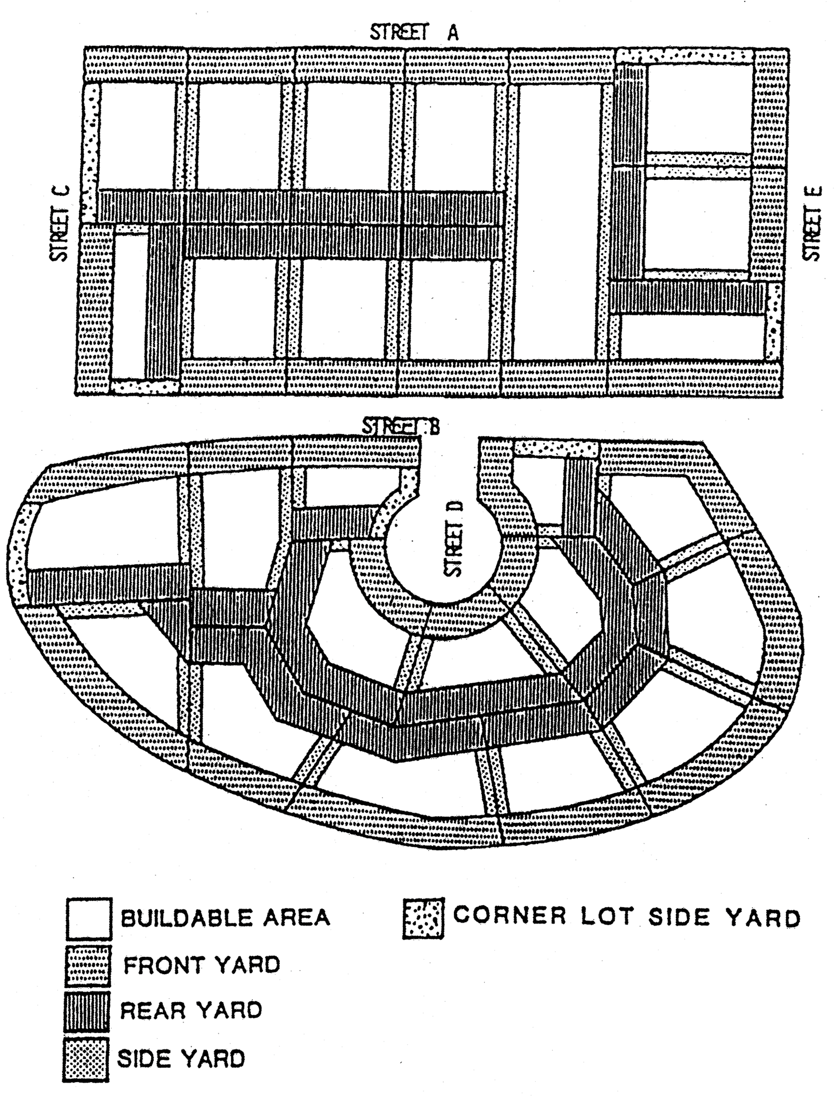
(Code 1986, § 12-2-41; Ord. No. 25-92, § 3, 7-23-1992; Ord. No. 9-96, § 10, 1-25-1996; Ord. No. 8-99, § 5, 2-11-1999)
Sec. 12-3-65. - Reserved.
Editor's note— Ord. No. 23-21, § 1, adopted October 28, 2021, repealed § 12-3-65, which pertained to parking for certain uses prohibited and derived from Code 1986, § 12-2-42; Ord. No. 9-96, § 11, 1-25-1996; Ord. No. 04-06, § 1, 2-9-2006.
Sec. 12-3-66. - Parking of commercial vehicles in residential neighborhoods.
(a)
Large commercial vehicles.
(1)
Parking or storage of any large commercial vehicle, except for loading and unloading not to exceed 12 hours, shall not be permitted in any portion of the right-of-way located within a residential district or development. Loading and unloading means that the commercial vehicle is attended and materials are being actively loaded/unloaded into and out of the commercial vehicle.
(2)
Parking or storage of any large commercial vehicle on any residential premises shall not be permitted except as follows:
a.
Temporary parking during loading and unloading not to exceed 12 hours. Loading and unloading means that the commercial vehicle is attended and materials are being actively loaded/unloaded into and out of the commercial vehicle.
b.
Temporary parking of construction equipment and delivery vehicles on or adjacent to a properly permitted construction site.
(3)
Large commercial vehicles shall not be used for living, sleeping or housekeeping purposes while temporarily parked as provided above.
(4)
The mayor may, for good cause shown, grant a temporary permit with reasonable conditions exempting any large commercial vehicle from the provisions of this section for a period not to exceed 72 hours.
(5)
Permanent parking or storage of large commercial vehicles on a residential premises may be permitted according to the following specific requirements:
a.
Must be contained within a garage or similar enclosed accessory structure meeting the requirements of section 12-3-55(4): residential accessory structures standards.
b.
Shall not be connected to any utilities.
c.
Shall not be used for living, sleeping or housekeeping purposes.
d.
Must be maintained in an operable condition and must be properly licensed in accordance with all laws of the state.
(b)
Small commercial vehicles.
(1)
Small commercial vehicles when not in active service shall not be parked or stored in any portion of the right-of-way located within a residential district or development between the hours of 6:00 p.m. and 6:00 a.m.
(2)
Permanent parking or storage of small commercial vehicles on residential premises is permitted subject to the following conditions:
a.
May be parked or stored in:
1.
Garage, carport or similar enclosed accessory structure meeting the requirements of section 12-3-55(4): residential accessory structures standards.
2.
The driveway of the residential premises of the vehicle's owner and/or operator.
b.
Must be maintained in an operable condition and properly licensed in accordance with all laws of the state.
c.
Must be owned and/or operated by a resident of the residential premises.
d.
Shall not be connected to any utilities.
e.
Shall not be used for living, sleeping or housekeeping purposes.
f.
Shall not be more than two small commercial vehicles on a residential premises.
(c)
Public school buses. Public school buses operated by drivers employed by the Escambia County School District during the school year shall be permitted to park on the residential premises of the operator. Public school buses shall not be parked or stored in any portion of the right-of-way in a residential district or development between the hours of 6:00 p.m. and 6:00 a.m. Effective with the end of the 2006—2007 school year, public school buses shall adhere to all provisions of subsection (a) of this section.
(Code 1986, § 12-2-43; Ord. No. 04-06, § 2, 2-9-2006; Ord. No. 16-10, § 206, 9-9-2010)
Sec. 12-3-67. - Communications tower review.
(a)
Permitted locations.
(1)
Communications towers shall be permitted in the C-2, C-3, M-1, and M-2 zoning districts except where prohibited in subsection (a)(2) of this section and only in accordance with the standards and procedures set forth in this section and other applicable provisions of the Code.
(2)
Communications towers shall be prohibited within the CO, zoning districts. In addition, communications towers are prohibited as follows: on any lot in any zoning district within 500 feet of Bayou Texar, Escambia Bay or Pensacola Bay; within the governmental center district; and within the Palafox Historic business district.
(3)
Communications towers may be permitted by conditional use approval as provided in section 12-3-108 in the R-1AAAAA, R-1AAAA, R-1AAA, R-1AA, R-1A, R-ZL, R-2A, R-2, R-NC, R-NCB, C-1, C-2A, HR-1, HR-2, HC-1. HC-2, PR-1AAA, PR-2, PC-1, OEHR-2, OEHC-1, OEHC-2, OEHC-3, ATZ-1, ATZ-2, GRD, GRD-1, WRD, WRD-1, SPBD, and IC zoning districts.
(4)
Communications towers may be permitted in the ARZ zoning district as provided in section 12-3-11(2)a.7 and in accordance with the standards and procedures set forth in this section and other applicable provisions of the Code.
(b)
Illumination. Artificial lighting of communications towers shall be limited to mandatory safety lighting required by state or federal regulatory agencies having jurisdiction over communications towers. Equipment cabinets and other facilities located at the base of communications towers may be lighted provided any lighting conforms with the requirements of this chapter.
(c)
Inventory of existing sites. Each applicant for permission to construct a communications tower shall provide to the city an inventory of its existing towers, antennas, or sites approved for towers or antennas, that are either within the jurisdiction of the city or within one mile of the border thereof, including specific information about the location, height and design (including the number of antenna arrays the tower is designed to support, the number currently on the tower, and the height at which any additional arrays could be placed) of each tower. The planning services department may share such information with other applicants applying for administrative approvals or conditional use permits under this section and with other organizations seeking to locate antennas within the city; provided, however, that the planning services department shall not, by sharing such information, be deemed to be in any way representing or warranting that such sites are available or suitable.
(d)
Co-location.
(1)
Design and construction. Monopoles shall be engineered and constructed to accommodate a minimum of two antenna arrays. Antenna support structures shall be engineered and constructed to accommodate a minimum of three antenna arrays.
(2)
Due diligence. An applicant for construction of a monopole or antenna support structure shall demonstrate that it has made diligent but unsuccessful efforts to co-locate its antenna and associated equipment on an existing structure. Evidence submitted to demonstrate that no existing tower or other structure can accommodate the applicant's proposed antenna shall consist of the following:
a.
No existing towers or structures are located within the geographic area required to meet the applicant's engineering requirements.
b.
Existing towers or structures are not of sufficient height to meet applicant's engineering requirements.
c.
Existing towers or structures do not have sufficient structural strength to support applicant's proposed antenna and related equipment.
d.
The applicant's proposed antenna would cause impermissible electromagnetic interference, as determined by the FCC, with the antenna on the existing towers or structures, or the antenna on the existing towers or structures would cause interference, as determined by the FCC, with the applicants proposed antenna.
e.
The fees or costs required to share an existing tower or structure or to adapt an existing tower or structure for sharing are unreasonably high. Costs exceeding the expense of designing and constructing a new tower shall be presumed to be unreasonably high.
f.
Property owners or owners of existing towers or structures are unwilling to accommodate the applicant's needs.
g.
The applicant demonstrates that there are other limiting factors that render existing towers and structures unsuitable.
(e)
Height limitation. Personal wireless towers shall not exceed the height limits established on the Airspace Height Limitation Zoning Map and in no case shall exceed a maximum height of 220 feet.
(f)
Aircraft hazard. Communications towers shall not encroach into or through any established public or private airport approach path as established by the FAA. Each application to construct a communication tower shall include proof of application for approval from the FAA. Based upon the location or height of a proposed communications tower, the city may require a statement of no objection from the city airport director. A building permit for an approved communications tower shall not be issued until FAA approval is obtained.
(g)
Setbacks and separation.
(1)
Except as provided in section 12-3-67(g)(2), the distance between the base of any communications tower and the nearest residential district or nearest lot line of any single-family, two-family or multifamily dwelling shall be at least equal to the height of the tower.
(2)
The distance between the base of a communications tower and any single-family, two-family or multifamily dwelling located in the M-1 or M-2 district may be reduced to a specified amount if the applicant provides a certification from the tower manufacturer or a qualified engineer stating that the tower is designed and constructed in such a way as to crumple, bend, collapse or otherwise fall within the specified distance. In no event shall the distance between the base of a communications tower and the nearest residential lot line be less than 20 percent of the tower height.
(3)
Proposed communications towers shall be separated from all other existing communications towers by a minimum of 1,000 feet as measured from the center base of the communications tower.
(h)
Plans approved. No communications tower shall be installed, erected or constructed unless the plans therefor are approved by the city planner and building official after consideration of the standards set forth in this section.
(1)
Submission of plans; review. Prior to the issuance of a building permit, all plans for communications towers shall be submitted to the city planner. The city planner and building official shall review plans according to the review criteria provided in subsection (h)(3) of this section.
(2)
Contents of the plans. All plans shall show the following:
a.
Location and approximate size and height of all buildings and structures within 500 feet adjacent to the site of the proposed communications tower.
b.
Site plan of entire development, indicating all improvements including landscaping, screening, and any trees that are to be preserved.
c.
Elevations showing all facades, indicating exterior materials and color of all communications towers on the site of the proposed communications tower.
d.
Plans shall be drawn at a scale of at least 50 feet to the inch.
(3)
City staff approval of plans. The city planner and building official shall approve the plans if they find:
a.
That the distance between the base of the communications tower and the nearest residential lot line complies with subsection (g) of this section;
b.
That the lowest six feet of the communications tower shall be visually screened by trees, large shrubs, solid walls or fences and/or nearby buildings;
c.
That the height and mass of the communications tower shall not exceed that which is essential for its intended use and public safety;
d.
That the proposed communications tower meets all applicable co-location requirements as specified in subsection (d) of this section;
e.
That the proposed communications tower has been approved by the FAA, if required;
f.
That the owner of the communications tower has agreed to permit other persons to attach antennas and other communications apparatus that do not interfere with the primary purpose of the communications tower, provided that such other persons agree to negotiate a reasonable compensation to the owner from such liability as may result from such attachment;
g.
That there exists no other communications tower that can reasonably serve the needs of the owner of the proposed communications tower;
h.
That the proposed communications tower is not designed in such a manner as to result in needless height, mass and guy-wire supports;
i.
That the color of the proposed communications tower shall be of such light tone as to minimize its visual impact, and blend into the surrounding environment;
j.
That a security fence around the tower base or along the perimeter of the site shall be provided; and
k.
That the proposed communications tower shall fully comply with all applicable building codes, safety codes, and local ordinances.
(4)
Consultant expense. Costs incurred by the city for the use of outside consultants, both legal and technical, in the review of applications and plans for the installation of towers and antennas shall be reimbursed to the city by the applicant.
(i)
Removal of unused communications towers. If a communications tower is no longer being used for its original intended purpose, the owner of the tower shall notify the city in writing within 30 days after the use of the communications tower ceases. A communications tower shall be considered abandoned if it has not been used for its original intended purpose for more than 180 days. The city may require the owner of any abandoned communications tower to remove the tower at the owner's expense within 30 days after written notice from the city. The owner shall restore the site to a condition as good as or better than its condition prior to construction of the tower. If the owner of an abandoned communications tower fails to remove the tower within ten days, the city may remove or demolish the tower and place a lien on the property for the amount required to reimburse the costs of demolition or removal.
(j)
Exemption.
(1)
Siting on city property. Personal wireless towers or personal wireless antennas to be located on city property or city-owned right-of-way shall be exempt from the provisions of this section, provided that the owner of the tower or antenna enters into a lease with the city providing for the payment of compensation and compliance with such conditions, including, without limitation, requirements for co-location and stealth technology, that the city deems reasonable in light of the character of the site and the surrounding area. If the city property is a public park, the city council shall consider the recommendation of the recreation board before entering into such a lease. The recreation board shall make its recommendation to the mayor within 30 days of being advised that a public park is under consideration for siting such a facility.
(2)
Public safety facilities. Any communications tower or antenna owned by a federal, state or local government agency, and used in connection with public safety services shall be exempt from the requirement of this section.
(3)
Amateur radio. Any tower operated by a person holding a license issued under 47 CFR part 97, and used solely in connection with that license shall be exempt from the requirements of this section.
(k)
Inspections. Each owner or operator of a communications tower shall provide the city a certified engineering inspection report on each tower it owns or operates every two years, and after the occurrence of an act of God, including, but not limited to, any hurricane, tornado, or lightning strike, certifying as to the safety of each tower.
(Code 1986, § 12-2-44; Ord. No. 27-98, § 2, 7-23-1998; Ord. No. 09-02, § 1, 3-14-2002; Ord. No. 12-03, § 2, 5-8-2003; Ord. No. 06-10, § 2, 2-11-2010; Ord. No. 16-10, § 207, 9-9-2010)
Sec. 12-3-68. - Siting of rooftop-mounted antennas.
(a)
Commercial communications antennas.
(1)
Rooftop-mounted commercial communications antennas may be installed, erected or constructed in the governmental center district, the Palafox historic business district and the gateway redevelopment district, subject to the review and approval of the appropriate review board based on the following standards:
a.
Rooftop-mounted commercial communications antennas shall not exceed the height of 20 feet above the existing roofline of the building;
b.
Antenna support structures shall be set back from the outer edge of the roof a distance equal to or greater than ten percent of the rooftop length and width;
c.
Such structures shall be the same color as the predominant color of the exterior of the top floor of the building, and/or the penthouse structure;
d.
Where technically possible, microwave antennas shall be constructed of open mesh design rather than solid material;
e.
Where possible, the design elements of the building (i.e., parapet wall, screen enclosures, other mechanical equipment) shall be used to screen the commercial communications antenna. Such rooftop-mounted commercial communications antennas, which comply with the above standards and are approved by the appropriate review board, are exempt from the review and approval process set forth in subsection (a)(3) of this section.
(2)
Rooftop-mounted commercial communications antennas located in commercial and industrial zones outside the special districts identified in subsection (a)(1) of this section, will be permitted if such structures are determined to be in compliance with the standards set forth in subsections (a)(1)a through e of this section by the building official. Rooftop-mounted commercial communications antennas which do not comply with said standards shall be subject to the review and approval process outlined in subsection (a)(3) of this section.
(3)
City staff approval of plans. The city planner and building official shall approve the plans if they find:
a.
That the height and mass of the antenna shall not exceed that which is essential for its intended use and public safety;
b.
That the proposed antenna support structure meets the applicable co-location requirements as specified in section 12-3-67(d);
c.
That the proposed antenna support structure has been approved by the FAA, if required;
d.
That there exists no other communications tower or antenna support structure that can reasonably serve the needs of the owner of the proposed rooftop-mounted antenna;
e.
That the proposed antenna or antenna support structure is not designed in such a manner as to result in needless height, mass and guy-wire supports;
f.
That the color of the proposed antenna shall be of such light tone as to minimize its visual impact, and blend into the surrounding environment; and
g.
That the proposed antenna shall fully comply with all applicable building codes, safety codes, and local ordinances.
(4)
Consultant expense. Costs incurred by the city for the use of outside consultants, both legal and technical, in the review of applications and plans for the installation of antennas and support structures shall be reimbursed to the city by the applicant.
(b)
Personal wireless antennas.
(1)
Permitted locations. Rooftop-mounted personal wireless antennas may be installed in zoning districts R-1AAAAA, R-1AAAA, R-1AAA, R-1AA, R-1A, R-ZL, R-2A, R-2, R-NC, R-NCB, C-1, C-2A, C-2, C-3, M-1, and M-2 and in the Pensacola historic district, the North Hill preservation district, the Old East Hill preservation district, the governmental center district, the Palafox historic business district, the South Palafox business district, the waterfront redevelopment district, the gateway redevelopment district and the airport land use district, provided that they are mounted on structures over 40 feet in height and have been approved by any applicable review board.
(2)
Structures. Personal wireless antennas not mounted on communications towers may be installed as an ancillary use to any commercial, industrial, office, institutional, multifamily or public utility structure, or permanent nonaccessory sign.
(3)
Conditional use. Rooftop-mounted personal wireless antennas may be permitted by conditional use approval, as provided in section 12-3-108, on structures less than 40 feet in height or on any lot whose primary use is as a single-family dwelling. In addition, personal wireless antennas shall not be installed, erected or constructed on any lot within 300 feet of Bayou Texar, Escambia Bay, Pensacola Bay or the Pensacola historic district except in accordance with a conditional use permit.
(4)
Inventory of existing sites. Each applicant for permission to install a personal wireless antenna shall provide to the city an inventory of its existing towers, antennas, or sites approved for towers or antennas, that are either within the jurisdiction of the city or within one mile of the border thereof, including specific information about the location, height and design of each tower. The city planner may share such information with other applicants applying for administrative approvals or conditional use permits under this section and with other organizations seeking to locate antennas within the city; provided, however, that the city planner shall not, by sharing such information, be deemed to be in any way representing or warranting that such sites are available or suitable.
(5)
Plans approved.
a.
Review. Installation of personal wireless antennas and associated equipment cabinets must be reviewed and approved by the city planner and building official pursuant to the standards set forth in this section. Installations of personal wireless antennas and associated equipment cabinets in the Pensacola historic district, the North Hill preservation district, the Old East Hill preservation district, the governmental center district and the Palafox historic business district must be approved by the architectural review board in accordance with the standards applicable to the relevant district, in addition to the requirements of subsection (b)(6) of this section. Installation of personal wireless antennas and accessory equipment within the gateway redevelopment district must be approved by the planning board. Installations of personal wireless antennas and associated equipment cabinets in the airport land use district must be approved by the city council after consultation with the Pensacola International Airport. Installation of personal wireless antennas on personal wireless towers shall be governed by section 12-3-67.
b.
Contents of plans. Each applicant for a permit to install a personal wireless antenna shall submit a design plan showing how the applicant proposes to comply with the requirements of this section. Applicants shall make appropriate use of stealth technology and shall describe their plans for doing so.
(6)
Site design standards. All installations of personal wireless antennas and associated equipment cabinets shall comply with the following requirements:
a.
No personal wireless antennas or associated equipment cabinets shall be installed on any lot whose primary use is as a single-family dwelling.
b.
No personal wireless antenna shall be installed on any structure that is less than 40 feet in height.
c.
No personal wireless antenna shall be mounted so as to extend more than 20 feet above the highest point of the structure on which it is mounted.
d.
Equipment cabinets shall be completely screened from view by compatible solid wall or fence, except when a ground-mounted cabinet, or combination of all ground-mounted cabinets on a site, is smaller than 180 cubic feet. Equipment cabinets smaller than 180 cubic feet may not be required to be screened from view if the cabinets have been designed with a structure, material, colors or detailing that are compatible with the character of the area.
e.
All equipment cabinets with air conditioning units shall be enclosed by walls, if located within 300 feet of existing single-family detached homes.
f.
Any exterior lighting within a wall shall be mounted on poles or on the building wall below the height of the screening fence or wall.
g.
Rooftop-mounted equipment cabinets shall be screened from off-site views to the extent possible by solid screen walls or the building parapet.
h.
Building-mounted personal wireless antennas shall be mounted a minimum of two feet below the top of the parapet, shall be extended no more than 12 inches from the face of the building, and shall be either covered or painted to match the color and texture of the building, as approved by the planning services department. Where a building has a penthouse, a rooftop structure containing or screening existing equipment, or other structure set back from the outer perimeter of the building, building-mounted antennas shall be mounted on such structure rather than the outer parapet, if feasible.
i.
Building-mounted equipment, which is part of a new structural addition on top of a roof, shall not exceed heights allowed by this chapter and shall be either covered or painted to match the color and texture of the building, as approved by the planning services department.
j.
The support structure for antenna arrays shall be minimized as much as possible, while maintaining structural integrity.
k.
All installations of personal wireless facilities shall comply with all applicable building codes and all applicable FCC and FAA regulations.
(7)
Stealth technology. In addition to the site design standards required by subsection (b)(6) of this section, the planning services department and any applicable review board may impose additional requirements for stealth technology, depending on the nature and location of the planned installation and the character of the surrounding area.
(8)
Removal of unused antennas. If a personal wireless antenna is no longer being used for its original intended purpose, the owner of the antenna shall notify the city in writing within 30 days after the use of the antenna ceases. An antenna shall be considered abandoned if it has not been used for its original intended purpose for more than 180 days. The city may require the owner of any abandoned antenna to remove the antenna and any associated equipment cabinets at the owner's expense within 30 days after written notice from the city. The owner shall restore the site to a condition as good as or better than its condition prior to installation of the antenna and the equipment cabinet. If the owner of an abandoned antenna fails to remove the antenna and any associated equipment within 30 days, the city may remove the antenna and the equipment and place a lien on the property for the amount required to reimburse the costs of removal.
(9)
Siting on city property. Personal wireless antennas to be located on city property shall be exempt from the provisions of this section, provided that the owner of the antenna enters into a lease with the city providing for the payment of compensation and compliance with such conditions, including, without limitation, requirements for co-location and stealth technology, that the city deems reasonable in light of the character of the site and the surrounding area.
(Code 1986, § 12-2-45; Ord. No. 33-95, § 6, 8-10-1995; Ord. No. 12-98, § 1, 3-26-1998; Ord. No. 27-98, § 3, 7-23-1998; Ord. No. 09-02, § 1, 3-14-2002; Ord. No. 20-19, § 4, 9-26-2019)
Sec. 12-3-69. - Public access to the shoreline.
All extensions of street rights-of-way that are perpendicular to or otherwise intersect water bodies within the city shall be reserved for public use unless officially vacated by city council action. No private access or use will be permitted across an unimproved public right-of-way, or extension thereof, that terminates at a body of water. Any exception shall require the approval of city council based upon the following criteria:
(1)
Availability of alternative access or given the lack of an alternate means of access, a proposal that is minimally intrusive.
(2)
Current and anticipated use of the right-of-way.
(3)
Need for public access to the water body in the general vicinity.
(4)
Unique environmental factors that impact the right-of-way or the surrounding area.
(Code 1986, § 12-2-46; Ord. No. 13-06, § 13, 4-27-2006)
Sec. 12-3-80. - Accessory office units.
(a)
Purpose. The purpose of allowing accessory office units as a conditional use for single-family detached dwellings is to allow for the more efficient use of the city's existing stock of detached single-family housing in the medium-density residential land use district. A homeowner may build or convert a portion of the interior of a dwelling unit to a separate office unit that may be utilized by the homeowner or rented. The intent of the regulations for accessory office units is to ensure that the residential character of the land use district is preserved.
(b)
Permitted locations. Accessory office units shall be allowed as a conditional use accessory to detached single-family dwellings in the R-1AA and R-1A zoning districts.
(c)
General requirements.
(1)
Number of units. Only one accessory office unit shall be allowed for each single-family detached dwelling.
(2)
Number of employees. No more than three nonfamily member employees shall be allowed in an accessory office unit.
(3)
Lot size. The minimum lot size shall be at least 5,000 square feet, except that no lot shall be smaller than the legal size as required by the zoning regulations.
(4)
Off-street parking. One off-street parking space for each 300 square feet of gross floor area shall be provided for the office unit in addition to the parking space required for the residence. Parking for the accessory office unit is prohibited in the required front or street side yard, except that which can be accommodated on a double driveway.
(5)
Accessory office unit requirements. The gross floor area of the accessory office unit shall not exceed 25 percent of the gross floor area of the principal dwelling unit up to a maximum 900 square feet. Each accessory office unit shall contain its own separate and private restroom and optional kitchen wholly within the unit, and must be provided utilities from the principal dwelling unit. Building codes applicable to office construction shall apply to the accessory office unit.
(6)
Exterior modifications. The architectural treatment of the accessory office structure shall be such as to portray the character of a residential dwelling.
(7)
Signs. No sign shall be permitted other than a non-illuminated nameplate not exceeding two square feet in area and no more than two feet in height above ground if freestanding.
(d)
Review and approval process. All applications for accessory office units shall comply with conditional use requirements established in section 12-3-120.
(Code 1986, § 12-2-51; Ord. No. 29-93, § 19, 11-18-1993)
Sec. 12-3-81. - Accessory residential units.
(a)
Purpose. The purpose of allowing accessory dwelling units as a permitted use for single-family detached dwellings is to allow for the more efficient use of the city's existing stock of detached single-family housing by providing the opportunity for a homeowner to build or convert a portion of the interior of a dwelling unit, a detached garage or accessory building to a separate housekeeping unit that may be rented. The intent of the regulations for accessory dwelling units is to ensure that the single-family residential character of the zoning district is preserved, while allowing for attractive and affordable housing opportunities. Accessory dwelling units provide housing opportunities through the use of surplus space either in or adjacent to a single-family dwelling to allow for a garage conversion or a backyard cottage or guest-house. The planning board may adopt prototype plans to be kept on file with the city.
(b)
Permitted locations. Accessory dwelling units shall be allowed as an accessory to detached single-family dwellings.
(c)
General requirements.
(1)
Lot size. The minimum lot size for a standard accessory dwelling unit shall be at least 5,000 square feet. For lots under 5,000 square feet, a floor-to-lot area ratio of 20 percent shall be used to determine the maximum allowed floor area of the accessory structure.
(2)
Number of units. Only one accessory dwelling unit shall be allowed for each single-family detached dwelling.
(3)
Identification of unit. The entrance to the accessory dwelling unit shall be identifiable and shall have its own address for purposes of emergency service and postal access.
(4)
Accessory dwelling unit requirements. The living area of the accessory dwelling unit shall not exceed 60 percent of the living area of the principal dwelling unit, up to a maximum of 1,500 square feet. The accessory dwelling unit (or combination of structures) shall not occupy more than 25 percent of the required rear yard area. The livable floor area of the accessory dwelling unit may be located on the first or second floor of the structure. Each accessory dwelling unit shall contain its own separate and private bathroom and kitchen wholly within the unit. The maximum allowed height shall be based on the distance that the structure is set back from the property lines as listed below:
a.
Accessory dwelling units located within three feet of the side and rear property lines shall have a maximum allowed height of 15 feet.
b.
Accessory dwelling units located within five feet of the side and rear property lines shall have a maximum allowed height of 20 feet.
c.
Accessory dwelling units exceeding 20 feet must meet the side yard setback requirements of the principal dwelling unit. For every additional one foot that an accessory dwelling unit is set back from the rear property line above and beyond five feet, an additional one foot in height shall be allowed up to a maximum allowed height of 30 feet as measured at the roof peak. A detached garage with an accessory residential unit constructed above shall have a maximum allowed height of 30 feet in height at the roof peak, in order to allow the accessory dwelling unit to match the style, roof pitch, or other design features of the main residential structure.
d.
When an accessory dwelling unit is located wholly within the buildable area of the lot on which it is located (i.e. meets the setback requirements for the primary dwelling unit) it shall be allowed at a maximum allowed height of 35 feet.
(5)
Exterior modifications.
a.
The architectural treatment of the dwelling structure shall be such as to portray the character of a residential dwelling.
b.
An accessory dwelling unit in a single-family zoning district shall have separate access unless there is a single access from the front of the building with a split access inside the building or unless it provides needed access for a handicapped occupant.
c.
In single-family zoning districts, attached accessory dwelling unit accommodations housed within the principal structure are to be established without structural alterations except those deemed necessary by the building inspections department to provide bathroom and kitchen facilities, and the resulting arrangement must not be such as to divide the dwelling nor give the appearance of dividing the dwelling into two separate dwelling units capable of independent occupancy.
(6)
Off-street parking. One additional off-street parking space shall be provided for the accessory dwelling unit.
(Code 1986, § 12-2-52; Ord. No. 27-92, § 1, 8-13-1992; Ord. No. 45-07, § 2, 9-13-2007)
Sec. 12-3-82. - Alcoholic beverage establishments.
It shall be unlawful to sell, or offer to keep for sale alcoholic beverages containing more than one percent of alcohol by weight in any place or establishment, including a private club or bottle club, for which a certificate of compliance with the provisions of chapter 7-4 has not been issued. It shall also be unlawful for a bottle club to operate at any location for which a certificate of compliance has not been issued. It shall also be unlawful for a private club to serve or receive or keep for consumption on the premises, whether by members, nonresident guests or other persons, alcoholic beverages containing more than one percent of alcohol by weight at any location for which a certificate of compliance has not been issued.
(Code 1986, § 12-2-53; Ord. No. 13-06, § 14, 4-27-2006)
Sec. 12-3-83. - Animal hospitals, veterinary clinics, commercial kennels and businesses that board animals.
(a)
Minimum setbacks. Any animal hospital, veterinary clinic, commercial kennel or business that boards animals, which includes outside cages and runs, shall be located no closer than 100 feet to a residence or residential zoning district boundary line, measured from the outside of the building, cages or runs to the residential property or residential zoning district line unless the boundary line is located within a street or public right-of-way.
(b)
Buffer yard required. The animal hospital, veterinary clinic, commercial kennel or business that boards animals which includes outside cages and/or runs shall comply with buffer yard regulations established in section 12-3-56.
(c)
Solid fence required. The outside cages, runs or exercise yards shall be totally enclosed by a solid fence at least six feet six inches in height.
(Code 1986, § 12-2-54)
Sec. 12-3-84. - Bed and breakfast facilities.
(a)
Permitted locations and number of lodging units. Bed and breakfast facilities are not allowed in the R-1AAAAA, R-1AAAA, R-1AAA, PR-1AAA and R-ZL zoning districts; shall be allowed as a conditional use in the R-1AA and R-1A zoning districts; and shall be allowed as a permitted use in all other zoning districts. No more than four rooms or lodging units shall be provided on any building site. These rooms or lodging units may be located within the principal building or in a detached garage or accessory building.
(b)
Exterior modifications. No alterations shall be made to the external appearance of the principal structure of the building site which change the residential characteristics thereof.
(c)
Signs. No sign shall be permitted other than a non-illuminated nameplate attached to the main entrance of the principal building. This nameplate shall not exceed two square feet in area.
(d)
Owner occupancy required. No bed and breakfast facility shall be permitted except where the principal building is owner-occupied.
(e)
Off-street parking. One parking space shall be required for each sleeping room.
(f)
Review and approval process. All applications for bed and breakfast facilities within an R-1AA or R-1A district shall comply with conditional use requirements established in section 12-3-120.
(Code 1986, § 12-2-55; Ord. No. 6-93, § 14, 3-25-1993)
Sec. 12-3-85. - Cemeteries.
(a)
Minimum site area. For new cemeteries the minimum size shall be five acres.
(b)
Setbacks. All grave sites and other structures shall be set back at least 25 feet from all property lines within a residential zoning district and from any residential zoning district and boundary line unless the boundary line is located within a street or public right-of-way. All grave sites and structures shall be set back 25 feet from the street right-of-way line in any residential zoning district. New maintenance buildings or additions to existing maintenance buildings and accessory maintenance equipment shall be set back at least 100 feet from residential property lines.
(c)
Buffer yard required. Cemeteries shall comply with buffer yard regulations established in section 12-3-56.
(d)
Review and approval process. All applications for cemeteries within the residential zoning districts shall comply with requirements established in section 12-3-120.
(Code 1986, § 12-2-56; Ord. No. 27-92, § 2, 8-13-1992)
Sec. 12-3-86. - Churches and other religious institutions.
(a)
Regulations. All churches and other religious institutions shall comply with building setback, area and height regulations set forth within each zoning district. Where a church or other religious institution is proposed adjacent to a residential land use or vacant property within or contiguous to a residential zoning district, there shall be a 20-foot yard between the church and the surrounding property line.
(b)
Off-street parking. Parking shall comply with applicable regulations in chapter 12-4. One space for each four fixed seats shall be required. On-street parking within 500 feet of the building, except in residential districts, may be used towards fulfilling this requirement.
(1)
Parking requirements in residential zones. Parking shall be prohibited in the required front or street side yards.
(2)
Landscaping. All landscaping requirements for parking lots as established in section 12-6-3(2) shall apply.
(c)
Buffer yard required. The church or religious institution shall comply with buffer yard regulations established in section 12-3-56.
(d)
Lot coverage in residential districts. The maximum combined area of all principal and accessory buildings shall not exceed 30 percent of the site.
(Code 1986, § 12-2-57; Ord. No. 6-93, § 15, 3-25-1993; Ord. No. 29-93, § 20, 11-18-1993; Ord. No. 44-94, § 2, 10-13-1994)
Sec. 12-3-87. - Child care facilities.
(a)
Permitted locations. Child care facilities shall be allowed as a permitted use in the following zoning districts: R-2A, R-2, R-NC, C-1, C-2, C-2A, C-3, HR-2, HC-1, HC-2, and PC-1. Child care facilities shall be allowed as a conditional use in the following zoning districts: R-1AA, R-1A, R-ZL and PR-2. Family day care homes, as defined by state statutes, are permitted in all zoning districts except for the conservation zoning district.
(b)
Building site area required. For new facilities minimum building site area shall be one lot or parcel of land 7,500 square feet in area for each child care facility. For facilities that will occupy existing buildings, there shall be no required minimum building site area, as long as the other requirements of this section can be met.
(c)
Regulations. All child care facilities shall comply with building site area, and height regulations set forth within each zoning district.
(d)
Fencing. There shall be a fence or wall a minimum of four feet in height surrounding all play areas except where visibility triangle requirements apply. Such fence or wall shall be continuous with latching gates at exit and entrance points.
(e)
Off-street parking. Parking shall comply with all applicable requirements in chapter 12-4. One off-street parking space per two employees, plus one space per classroom shall be required. Landscaping requirements for parking lots as established in section 12-6-3(2) shall apply.
(f)
Buffer yard required. The child care facility shall comply with buffer yard requirements established in section 12-3-56.
(g)
Review and approval process. All applications for child care facilities within the R-1AA and R-1A zoning districts shall comply with conditional use requirements established in section 12-3-120.
(Code 1986, § 12-2-58; Ord. No. 6-93, § 16, 3-25-1993; Ord. No. 44-94, § 3, 10-13-1994; Ord. No. 6-02, § 2, 1-24-2002)
Sec. 12-3-88. - Electric and gas substations, sewer treatment plants, and other similar utility structures.
The following provisions are applicable to electric and gas substations, sewer treatment plants, and other similar utility structures:
(1)
Lots must conform to minimum area and yard requirements of the district in which they are located.
(2)
Fences or walls at a minimum height of six feet must be installed and maintained in order to make the facility inaccessible to the public.
(3)
Portions of properties not used for buildings, parking or related services must be maintained with natural ground cover.
(4)
A buffer yard must be provided in accordance with the provisions of section 12-3-56.
(Code 1986, § 12-2-59)
Sec. 12-3-89. - Junkyards.
(a)
Permitted location and minimum site area required. Junkyards shall be permitted only in the M-2 district. The minimum lot or parcel area shall be one acre.
(b)
Distance requirements. No junkyard shall be located any closer to a residence or residential, R-2 and R-NC district, than 100 feet, measured from property line to property line or district boundary.
(c)
Buffer yard required. A buffer yard must be provided in accordance with the provisions of section 12-3-56.
(Code 1986, § 12-2-60; Ord. No. 6-93, § 17, 3-25-1993)
Sec. 12-3-90. - Libraries, community centers and public buildings.
(a)
Regulations. All libraries, public community centers and public buildings shall comply with building setback, area and height regulations set forth within each zoning district, except that where proposed adjacent to a residential land use or vacant property within or contiguous to a residential zoning district, there shall be a 20-foot yard between the building and the surrounding property line.
(b)
Off-street parking. Parking shall comply with all applicable requirements in chapter 12-4. In residential districts parking shall be prohibited in the required front or street side yards. Landscaping requirements for parking lots as established in section 12-6-3(2) shall apply.
(1)
Libraries. One space for each two employees, plus one space for each 500 square feet shall be required.
(2)
Community centers. One space for each 300 square feet shall be required.
(3)
Government offices. One space shall be required for each 500 square feet. On-street parking within 500 feet of the building, except in residential districts, may be used towards fulfilling this requirement for non-employee parking only. In any event, one off-street parking space shall be required for each employee in the government office building.
(c)
Buffer yard required. The library, public community center or public building shall comply with buffer yard regulations established in section 12-3-56.
(d)
Lot coverage in residential districts. The maximum combined area of all principal and accessory buildings shall not exceed 30 percent of the site.
(Code 1986, § 12-2-61; Ord. No. 6-93, § 18, 3-25-1993; Ord. No. 29-93, § 21, 11-18-1993; Ord. No. 44-94, § 4, 10-13-1994)
Sec. 12-3-91. - Manufactured homes.
(a)
Placement of manufactured homes.
(1)
Residential design manufactured home units shall be permitted on individual lots in the R-1A, R-2A, R-NC, C-1, C-2 and C-3 zoning districts and shall be allowed as a conditional use in the R-1AA zoning district. Residential design manufactured home units shall be permitted in approved mobile home parks existing as of May 1, 1991, and in approved manufactured home parks. Standard design manufactured home units permitted in approved mobile home parks existing as of May 1, 1991, and in approved manufactured home parks. An existing residential designed manufactured or mobile home may be replaced by a residential design manufactured home on property that is zoned M-1 of M-2 industrial district.
(2)
Manufactured homes are not permitted in any location other than those described above except as described below:
a.
Temporary use of manufactured homes during emergency circumstances. Notwithstanding anything to the contrary contained in this Code, the temporary use of a manufactured home shall be permitted for a period not to exceed 120 days under the emergency circumstances and terms outlined below:
In the event of emergency circumstances, the temporary use of a manufactured home as living quarters located on the property involved in the disaster shall be permitted in order to protect said property, but only after the approval of the city council, and then for a period not to exceed 120 days to be set at the council's discretion. Thirty-day extensions of this permitted temporary use may be granted at the discretion of the council.
b.
Temporary use of manufactured homes during emergency health situation.
1.
The temporary use of a manufactured home shall be permitted in any area when specifically authorized by the council after it has determined that an emergency health situation exists.
2.
If the council determines that an emergency health situation exists, then it may allow the temporary use of a manufactured home in any area, but only for the period of time necessary, depending upon the circumstances surrounding the emergency health situation. The use of said manufactured home shall be immediately terminated upon abatement of the circumstances that caused the emergency to exist. In making its decision whether to allow the temporary use of a manufactured home, the city council shall take into consideration the objections, if any, of the surrounding neighbors and the availability of utilities in proximity to the proposed location.
c.
Use of manufactured homes in M-1 and M-2 industrial districts.
1.
The use of a manufactured home is permitted within the corporate limits on such property that is zoned M-1 or M-2 industrial district. The manufactured home shall be allowed only for the purpose of housing a guard or caretaker for the property in question.
2.
The permission given above shall be deemed to be temporary only, and any such manufactured home shall be removed by the party who placed it thereon at any time that the city council deems it to be in the best interest of the public to do so.
(b)
Storing or parking of manufactured homes. A manufactured home shall not be stored or parked on any public street or alley or in any district other than in an approved mobile home park.
(c)
General regulations for residential design manufactured homes on individual lots.
(1)
Number of manufactured homes per lot. There shall be no more than one residential design manufactured homes per lot.
(2)
Zoning district requirements. All residential design manufactured homes shall meet all requirements for lot sizes, yards, building setbacks and any other requirements for the zoning district in which it is located.
(3)
Accessory structures. Accessory structures shall meet all requirements as described in section 12-3-55.
(4)
Installation of residential designed manufactured homes. All residential design manufactured homes units shall meet the permanent foundation, anchoring and other rules, as contained within the Florida Administrative Code, including use of a permanent perimeter underfloor enclosure. All transportation equipment must be removed.
(5)
Building permits; inspections. City permits must be obtained and inspections performed for on-site installation of the residential design manufactured homes and any structural alterations or repair. Permits are required for additions to the residential design manufactured homes and any accessory structures. All structural alterations and repairs, and construction of additions and accessory structures must be built to the Florida Building Code.
(d)
Residential design criteria for residential design manufactured homes.
(1)
Minimum width of residential design manufactured homes. Residential designed manufactured homes must have a minimum on-site assembled home width of 20 feet, as measured across the narrowest portion (this is not intended to prohibit offsetting of portions of the home).
(2)
Siding and roofing materials. Residential design manufactured homes must be constructed with siding and roofing of a type generally acceptable for site-built housing in the general proximity.
(3)
Roof pitch. Residential design manufactured homes must have a minimum pitch of the main roof of three feet rise for each 12 feet of horizontal run and a minimum roof overhang of four inches per side.
(4)
Alterations to structures to meet residential design criteria. Residential design manufactured homes that do not meet residential design criteria for siding and roofing materials and roof pitch will be allowed to obtain permits for on-site installation, with the condition that building permits must be acquired for alterations necessary to meet the design criteria within 90 days of installation and construction must be completed within 180 days of installation.
(5)
Skirting requirements; materials. Residential design manufactured homes must construct a permanent perimeter structural system completely enclosing the space between the floor joists of the home and the ground except for required openings for ventilation and access.
a.
Foundation siding/skirting and back up framing shall be weather-resistant and must blend with the exterior siding of the home.
b.
Below grade level and for a minimum of six inches above finish grade the materials shall be unaffected by decay or oxidation.
(e)
Manufactured home parks.
(1)
Minimum size of park; permitted location. A manufactured home park shall have a minimum of 1½ acres and contain a minimum of ten manufactured home spaces. Manufactured home parks will be permitted in the following zoning districts: R-2A, R-NC and C-1.
(2)
Plans and specifications required; conformity of construction with city codes. Complete plans and specifications of all manufactured home parks shall be submitted to the building official prior to construction. These plans shall include area and dimensions of land to be developed, park layout, number and size of manufactured home spaces, location and width of roadways and walkways, buildings to be constructed, water and sewerage facilities and any other information required by the building official. All construction shall conform with city codes where applicable and shall require the approval of the city engineer and the building official.
(3)
Development criteria.
a.
Setbacks required. No manufactured home or attached structure shall be located closer than 25 feet to the property lines of the manufactured home park or a public right-of-way.
1.
Front yard required—minimum of 20 feet.
2.
Side yard required—minimum of five feet.
3.
Rear yard required—minimum of 15 feet.
b.
Maximum density. Density shall not exceed 17 manufactured home units per acre.
c.
Private streets. No manufactured home in a park shall be allowed direct access to a public street. All lots in a manufactured home park must have access from a private street that shall comply with regulations established in section 12-3-61.
d.
Landscaping and buffering. Manufactured home parks shall be screened from view according to the following requirements: screen of vegetation and/or opaque fence six feet in height shall be provided and maintained around the perimeter of the park. Where vegetation is used as a screen, such vegetation shall be at least three feet in height when planted.
e.
Recreational area requirement. Manufactured home parks with ten or more units shall retain an area of not less than five percent of the gross site area devoted to recreational facilities, generally provided in an area accessible to all property owners.
f.
Each manufactured home shall be independently served by separate electric, gas and other utility services.
g.
A minimum of one off-street parking space shall be required for each manufactured home.
h.
Fences. If the manufactured home park management allows fences for individual lots, these fences shall comply with regulations established in section 12-3-63.
i.
Storage of recreational vehicles. Storage of recreational vehicles shall be allowed only on sites reserved for such storage within the manufactured home park.
(f)
Review and approval process. All applications for a residential design manufactured home within an R-1AA zoning district shall comply with conditional use requirements established in section 12-3-120.
(Code 1986, § 12-2-62; Ord. No. 35-92, § 1, 10-22-1992; Ord. No. 8-99, § 6, 2-11-1999)
Sec. 12-3-92. - Mobile homes.
(a)
Placement of mobile homes. Mobile homes are not permitted in any location other than approved mobile home parks existing on or before May 1, 1991.
(b)
Storing or parking of mobile homes. A mobile home shall not be stored or parked on any public street or alley or in any district other than in an approved mobile home park.
(Code 1986, § 12-2-63)
Sec. 12-3-93. - Nonresidential parking in R-1AAA, R-1AA, R-1A, R-ZL, R-2A, R-2, PR-1AAA and PR-2 zoning districts.
(a)
General conditions. Accessory off-street parking facilities serving nonresidential uses of property in R-2, PR-2, R-NC, R-NCB C-1, PC-1, C-2, C-3 or SSD zones may be permitted in R-1AAA, PR-1AAA, R-1AA, R-1A, R-ZL, R-2A, R-2 or PR-2 zoning districts where such property is contiguous to such commercial zoned area or is separated therefrom by an alley, and may be authorized by the planning board, subject to the following conditions:
(1)
The parking lot shall be accessory to, and for use in connection with one or more existing nonresidential establishments located in adjoining districts or in connection with one or more existing professional or institutional office buildings or institutions. In the event that the use of the professional or institutional office building or institution or other nonresidential establishment changes or is abandoned for a period of not less than 180 days after the special use is approved, said approval will terminate automatically. This provision is in no way intended to prohibit the property owner from applying for approval for the changed use pursuant to applicable provisions of this Code.
(2)
Said parking lot shall be used solely for the parking of vehicles. These vehicles shall be those of the customers and employees of the adjacent business.
(3)
No commercial repair work or service of any kind shall be conducted on said parking lot.
(4)
Parking lot plans are to be reviewed and approved by the city engineer. The city engineer shall base his or her approval of the plans upon sound engineering principles as well as the safety and general welfare of the citizens of the city.
(5)
No sign of any kind other than signs designating entrances, exits, and conditions of use shall be maintained on said parking lot, and said sign shall not exceed 20 square feet in area.
(6)
Said parking lot shall not encroach more than 150 feet into the residential zone.
(7)
In addition to the foregoing requirements such parking lots shall conform to section 12-4-1 and chapter 12-6.
(b)
Review and approval process. All applications for nonresidential parking in residential zones shall comply with regulations established in section 12-3-120.
(Code 1986, § 12-2-64; Ord. No. 29-93, § 22, 11-18-1993; Ord. No. 3-94, § 7, 1-13-1994)
Sec. 12-3-94. - Schools and educational institutions having a curriculum the same as ordinarily given in public schools and colleges.
The following regulations shall be applicable to schools and educational institutions having a curriculum the same as ordinarily given in public schools and colleges:
(1)
Minimum lot area. The minimum lot area shall be one acre for every 100 students for kindergarten through high school institutions.
(2)
Setbacks. The front, rear and side yard setbacks shall be the same as those required for the specific district, except that when adjacent to a residential land use or vacant property within or contiguous to a residential zoning district there shall be a 20-foot yard between the school and the surrounding property line.
(3)
Off-street parking. Off-street parking shall comply with applicable requirements in chapter 12-4.
a.
Kindergarten, elementary and middle schools shall provide one space for each two employees plus one space for each classroom.
b.
Senior high schools and colleges shall provide one space for each two employees, plus one space for each ten students figuring maximum capacity of the school.
c.
Landscaping requirements for parking lots as established in chapter 12-6 shall apply.
(4)
Off-street loading.
a.
Loading and unloading facilities shall be provided on the premises for distribution of goods by motor vehicle. No motor vehicle shall be allowed to extend onto a public street or sidewalk while loading or unloading.
b.
School bus drop-off facilities. Facilities must be provided for off-street bus loading and unloading of students. Use of the street right-of-way may be allowed if a license agreement is executed with the city.
(5)
Buffer yard required. A buffer yard must be provided in accordance with the provisions of section 12-3-56.
(6)
Lot coverage in residential districts. The maximum combined area of all principal and accessory buildings shall not exceed 30 percent of the site.
(Code 1986, § 12-2-65; Ord. No. 6-93, § 19, 3-25-1993; Ord. No. 29-93, § 23, 11-18-1993)
Sec. 12-3-95. - Food truck courts.
(a)
Purpose. The purpose of allowing food truck courts which provides parking pads for one or more mobile food trucks and may also include other site development features, such as parking and seating, is to allow for innovative development options within the commercial zoning district.
(b)
Permitted locations.
a.
Food truck courts shall be allowed as a permitted use in the C-1, C-2, C-2A, C-3, M-1, M-2, GRD, WRD, and WRD-1 zoning districts, exclusive of the area defined by Ordinance No. 26-21.
b.
Food truck courts shall be allowed as a conditional use within PC-1 and the area defined within Ordinance No. 26-21 and must comply with the conditional use requirements established within section 12-3-120(a)(3).
(c)
General requirements.
(1)
Site development requirements. The development of the site shall comply with the requirements of the zoning district and any applicable overlay district, with the exception of the following:
a.
Food truck stalls and additional structures shall observe a minimum setback of ten feet from any side or rear property line, notwithstanding any applicable landscape buffers or setbacks from a residential zoning district as outlined in Table 12-3.7.
b.
Food truck stalls and additional structures shall be located at least ten feet from any other space or structure.
c.
Drive-thru services are prohibited.
d.
Outdoor refuse and utilities, and storage areas shall not be allowed within the 25 feet of the front property line and shall be screened per section 12-3-121.
(2)
Number of food truck parking pads. A minimum of one stationary food truck pad shall be developed with each food truck court. The maximum number of mobile food truck pads shall be six.
(3)
Lot coverage, landscaping, and buffers.
a.
The maximum lot coverage for the mobile food truck pads, all structures, and defined outdoor dining areas shall be 50 percent.
b.
Landscaping and buffer requirements shall be subject to the minimum provisions set forth in chapter 12-6. When off-street parking is located at a street frontage, a year-round landscape hedge or low fence or wall along the street edge of the parking lot must be used as a means of buffering and subject to visibility triangle requirements in section 12-3-58.
(4)
Off-street parking. One off-street parking space shall be provided for the food truck court for each food truck pad plus one per 100 square feet of gross floor area, or fraction thereof, of all buildings on the site with the exception of those located within the Dense Business Area or the Urban Core CRA.
(5)
Mobile food truck pad requirements. Each food truck space shall provide the following:
a.
A connection to a water source.
b.
A connection to a sewer system and a grease trap or a gray-water system with off-site disposal.
c.
A solid surface pad measuring at least ten feet in width and 20 feet in length.
(6)
Restrooms. Permanent restrooms are required as part of the food truck court. This facility must be within the same parcel as the mobile food truck pad(s). The minimum requirement shall be two stalls each for male and female.
(7)
Seating. At least one table, with a minimum of four seats per table, shall be required for every mobile food truck pad.
(8)
Exterior modifications.
a.
Architectural design and building elements. All buildings, structures, fences, walls, etc. shall follow design standards and guidelines in subsection 12-3-121(d) and shall strive to achieve visual harmony with the surrounding area. If located in a district subject to architectural review board or planning board review, or located in the CRA Urban Design Overlay, the project shall be subject to the standards applicable to the relevant district.
b.
Fencing and screening. Approved materials include wood, brick, stucco finished masonry, stone, or wrought iron, and combinations of these materials. Black powder-coated chain-link fences will be permitted if screened in their entirety by appropriate vegetation. Exposed concrete block and barbed wire are prohibited. All service areas (i.e. trash collection containers, compactors, etc.) shall be screened from street and adjacent buildings by a fence, wall, and/or vegetation.
c.
Site lighting. Exterior lighting shall follow standards set forth in subsection 12-3-121(c)(9).
(9)
Food truck requirements.
a.
Each food truck must meet the requirements of the Florida Fire Prevention Code, NFPA 1, section 50.7 Mobile and Temporary Cooking Operations. Section 50.7.1.5 Separation. Mobile or temporary cooking operations shall be separated from buildings or structures, combustible materials, vehicles, and other cooking operations by a minimum of ten feet, Section 50.7.1.7 Fire Department Access. Mobile or temporary cooking operations shall not block fire department access roads, fire lanes, fire hydrants, or other fire protection devices and equipment.
b.
A copy of the Commissary Agreement should be maintained on the food truck or mobile food vending establishment.
c.
The food truck owner should obtain a license from DBPR, then an inspection from the fire department before obtaining a city BTR.
d.
Each food truck operating on the site is required to have a city BTR, business tax receipt, but is not required to obtain any other city permits or licenses.
e.
A copy of the appropriate license(s) from the Florida Department of Business and Professional Regulation (Division of Hotels and Restaurants) shall be maintained on the food truck or mobile food vending establishments at all times along with a copy of a valid city business tax receipt when the vehicle is in operation in the city, and shall be made available for inspection upon request by the city's law or code enforcement officers.
f.
If a gray-water system is to be used, a contract for off-site disposal must be made available upon request.
(10)
Alcohol. If alcohol is to be sold on-site, the provisions within chapter 7 shall apply.
(11)
Signs. Signage shall comply with the standards for the respective zoning district.
(d)
Review and approval process. All applications for food truck courts shall comply with development standards and guidelines established in section 12-3-121.
(Ord. No. 09-23, § 1, 8-17-2023)
Sec. 12-3-105. - Conventional subdivision.
(a)
Purpose. The conventional subdivision requirements are intended to provide for the division of a parcel of land into two or more parcels for development or redevelopment, when the development or redevelopment complies with all zoning regulations for the zoning district in which it is located.
(b)
Location and permitted uses. Conventional subdivision development is permitted within any zoning district for any land use permitted within the zoning district.
(c)
Minimum size of development. There are no minimum size requirements for a conventional subdivision development. Subdivision of four or less lots constitute a minor subdivision; five or more constitute a major subdivision.
(d)
Requirements. All lots in a conventional subdivision must comply with width and area requirements for the zoning district. Chapter 12-7 describes the platting and review requirements for a conventional subdivision.
(Code 1986, § 12-2-76)
Sec. 12-3-106. - Special planned development.
(a)
Purpose. Conventional subdivision development may not always result in the most optimal use of land in terms of environmental or historic resource protection and/or changing development patterns. The comprehensive plan encourages infill development that is compatible with the surrounding land uses. The requirements for special planned developments have been established in order to allow for flexibility and creativity in site planning for residential or mixed residential/office/commercial developments by allowing deviations from lot size and yard requirements and by allowing private streets.
(b)
Location and permitted uses. Special planned developments shall be allowed in any residential, R-2, R-NC, or R-NCB zoning district provided that only land uses permitted within the future land use district are allowed.
(c)
General requirements. All residential densities for the future land use district must be met. A special planned development may include more than one housing type, providing that all the proposed housing types are permitted within the future land use district. The special planned development must submit development plans in accordance with section 12-3-120. The special planned development shall meet all design standards as required by section 12-3-121, and is encouraged to meet all design guidelines established in the same section. If applicable, the development must comply with subdivision design and platting requirements as set forth in chapter 12-7.
(1)
Where use is made of the special planned development process, as provided in this section, a building permit shall not be issued for such development, or part thereof, until the city council has approved the final development plan, and the approved final development plan has been recorded in the office of the county comptroller.
(2)
Private streets and drives may be permitted within a special planned development pursuant to compliance with requirements established in section 12-3-61.
(3)
Any tract of land for which a special planned development application is made shall be owned by an individual or group of persons, partnerships, business associations, or corporations; and such applications shall be jointly made by all such owners. The owner shall utilize one of the following general plans for providing for the ownership, use, maintenance and protection of any private streets and/or proposed common open space areas:
a.
Establish an association or nonprofit corporation of all individuals and entities owning property within the special planned development.
b.
Owner to retain ownership control of such area and be responsible for the maintenance thereof.
c.
Any other method proposed by the owner that is acceptable to the city council. Said proposed alternate method shall serve the purpose of providing for the ownership, use, maintenance, and protection of the common open space areas.
(4)
Application for building permits to construct a special planned development shall be required within one year from the date of approval of the final development plan. If substantial and continuous construction has not been demonstrated within two years from the date of approval of the final development plan, then the special planned development shall be considered null and void.
(5)
All plans approved and recorded hereunder shall be binding upon the owner, his or her successors and assigns, and the subject property, and shall limit and control the issuance and validity of all building permits and shall restrict and limit the construction, location, use and operation of all land and structures included within such plans to all conditions and limitation set forth in such plans.
a.
Minor changes to the final development plan may be approved by the mayor, city engineer, the planning services department and building official when in their opinion the changes do not violate these regulations or make major changes in the arrangement of buildings or other major features of the final development plan. Major changes may be made only by following the procedures outlined in filing a new preliminary development plan. The city council shall approve such modification only if the revised plan meets the requirements of this chapter in its entirety.
b.
The building official shall ensure that when development is undertaken, it shall be completed in compliance with approved development plans prior to the issuance of an occupancy permit. No individual building permits shall be issued for buildings not conforming to the final development plan as approved by the city council, or as amended in compliance with the provisions of this chapter.
c.
Issuance of final occupancy permit by the building official as far as the owner, his or her successors or assigns, are concerned shall be conclusive evidence of compliance with this chapter and the requirements for the final development plan theretofore recorded. A building permit may be revoked in any case where the conditions of the final development plan have not been or are not being complied with, in which case the building official shall follow permit revocation procedures.
(d)
Specific types of special planned developments.
(1)
Zero-lot-line. Zero-lot-line developments provide for only one side yard for each individual lot for detached units and no side yard for attached units except for the end units. A special planned development may be partially or totally comprised of zero-lot-line lots. A zero-lot-line special planned development shall comply with the minimum standards established for the R-ZL zoning district in section 12-3-5(1).
(2)
Cluster development. A special planned development may take the form of a cluster development, which is intended to provide for the protection of environmental and historic resources and common areas. A reduction in lot sizes and areas is allowed if all the land that is saved is reserved for permanent common use in the form of common areas and that the following requirements are met:
a.
The amount of common area contained in a cluster development must be equal to or greater than the amount of open space provided by required yards or of park land that would have been required by subdivision regulations for the same site.
b.
Historic buildings, structures or sites may be included as part of the common area requirements, provided that the site is restored and maintained in a manner consistent with guidelines established by the United States Department of the Interior in their publication "Standards for Rehabilitation and Guidelines for Rehabilitating Historic Buildings."
(Code 1986, § 12-2-77; Ord. No. 29-93, § 24, 11-18-1993; Ord. No. 33-95, § 7, 8-10-1995; Ord. No. 16-10, § 208, 9-9-2010)
Sec. 12-3-107. - Conditional use permit.
(a)
Authorization and purpose. The city council may, under the prescribed standards and procedures contained herein, authorize the construction of any use that is expressly permitted as a conditional use in a particular zoning district; however, the city reserves full authority to deny any request for a conditional use permit or to impose reasonable conditions on the use. Provisions for a conditional use permit are intended to establish a process for submitting a site plan for specific uses that require further review by the planning board and city council to assess the impacts of the proposed use on the surrounding neighborhood.
(b)
Applicability.
(1)
Conditional uses listed under zoning district regulations, or in this section for a specific land use type. Any proposed development or redevelopment of property within the R-1AAA, R-1AA, R-1A, R-ZL, R-2A, R-2, HR-1, HR-2, PR-1AAA, PR-2 and PC-1 zoning districts may apply for conditional uses listed under the zoning regulations for the district.
(2)
Vacant public, semi-public, institutional, church or historically significant structures within the R-1AA, R-1A, R-ZL, R-2A and R-2 zoning districts. To allow for adaptive reuse of vacant public, semi-public, institutional, church or historically significant structure within the R-1AA, R-1A, R-ZL, R-2A and R-2 zoning districts which, by nature of its size, structural layout, site layout or other unique features, could not feasibly be redeveloped for adaptive reuse under existing zoning regulations, a conditional use permit may be granted. Redevelopment of an existing building may occur within its existing footprint or may be expanded subject to compliance with the lot coverage, intensity and height standards for the applicable zoning district. Existing buildings that exceed 45 feet may be redeveloped within the existing building envelope height; buildings that are less than 45 feet in height may not be expanded to exceed 45 feet in height. The following uses or combinations of uses shall be eligible to apply for a conditional use permit:
a.
Any type of residential development at a maximum density of 35 units per gross acre, dormitories.
b.
Child care facilities, nursing homes, rest homes, convalescent homes.
c.
Studios, with no outside storage or work permitted.
d.
Banks, office buildings.
e.
Restaurants.
f.
Retail food and drugstores; personal service shops; clothing and fabric stores; home furnishing stores, hardware and appliance stores; specialty shops; pastry shops; floral shops.
g.
Fitness centers, martial arts studios.
h.
Laundry and dry-cleaning pick-up stations.
(3)
Mobile restaurant facilities may be permitted on private property having frontage on South Palafox Place in the area located between the southern right-of-way line of Main Street and Pensacola Bay. Mobile restaurant facilities shall only be permitted as an accessory use to an adjacent existing and operational restaurant subject to the following conditions:
a.
Mobile restaurant units will be permanently fixed to the ground (the attachments can be removed in the event the mobile restaurant needs to be moved due to lease termination or declaration of emergency).
b.
Storage areas and mechanical equipment shall be screened from view.
c.
Mobile restaurant units shall be connected to the sewer system and utilize a grease trap.
d.
Mobile restaurant units shall have permanent restrooms provided for customers via the adjacent principal restaurant use.
e.
Mobile restaurant development sites shall provide one customer seat per linear foot of mobile unit on site.
f.
In addition to minimum landscaping requirements, mobile restaurant development sites shall provide both hardscape and landscape details with sufficient quality of design to create a formalized outdoor plaza environment. This shall be accomplished through the incorporation of grated tree wells for the planting of shade and canopy trees within outdoor seating areas. Outdoor seating areas shall be constructed with a minimum of 40 percent decorative architectural pavers comprising the overall seating area.
g.
Each individual mobile restaurant unit shall have a water source located within 30 feet behind the structure.
h.
Mobile restaurant units shall be allowed one menu attached to the facade not to exceed 16 square feet and one identifying sign not to exceed 25 square feet.
i.
There will be a maximum of four mobile restaurant units per development site. If a mobile restaurant development site has more than one mobile restaurant unit on the parcel then all mobile restaurant units will be of a consistent design, size, and color. Mobile restaurant units and associated developments shall comply with the regulations and reflect the character of the district in which they are located. Accent features to distinguish unique culinary concepts are encouraged.
j.
Mobile restaurant units shall not occupy more than 25 percent of the overall development site area.
k.
Underground utilities shall be required for each mobile restaurant unit. Generators are not permitted with the exception of during the course of emergencies and power outages.
l.
A designated screened dumpster area shall be located within 500 feet of a mobile restaurant unit.
(c)
Requirements. Applicants for a conditional use must submit development plans in accordance with section 12-3-120. The conditional use development plan shall meet all design standards as required by section 12-3-121 and is encouraged to meet all design guidelines established in the same section. A building permit shall not be issued for a conditional use until the city council has approved the final development plan.
(d)
Standards for approval. A conditional use may be approved by the city council only upon determination that the application and evidence presented clearly indicate that all of the following standards have been met:
(1)
The proposed use shall be in harmony with the general purpose, goals, objectives and standards of the city comprehensive plan, the land development regulations, or any other applicable plan, program, map or regulation adopted by the city council.
(2)
The proposed use will not adversely affect the public health, safety or welfare.
(3)
The proposed use shall be compatible with the surrounding area and not impose an excessive burden or have substantial negative impact on surrounding or adjacent uses.
(4)
The proposed use shall be provided with adequate public facilities and services, including roads, drainage, water, sewer, and police and fire protection.
(5)
The proposed use will not create undue traffic congestion.
(6)
The proposed use shall minimize, to the extent reasonably possible, adverse effects on the natural environment.
(e)
Conditions. The city council may prescribe appropriate conditions and restrictions upon the property benefitted by the conditional use approval as may be necessary to comply with the standards set out in subsection (d) of this section, to reduce or minimize any potentially injurious effect of such conditional use upon the property in the neighborhood, and to carry out the general purpose and intent of these regulations. Failure to comply with any such condition or restriction imposed by the city council shall constitute a violation of these regulations. Those conditional uses that the city council approves subject to conditions, shall have specified by the city council the time allotted to satisfy such conditions. In approving any conditional use, the city council may:
(1)
Limit or otherwise designate the following: the manner in which the use is conducted; the height, size or location of a building or other structure; the number, size, location, height or lighting of signs; the location and intensity of outdoor lighting or require its shielding.
(2)
Establish special or more stringent buffer, yard or other open space requirements.
(3)
Designate the size, number, location or nature of vehicle access points.
(4)
Require berming, screening, landscaping or similar methods to protect adjacent or nearby property and designate standards for installation or maintenance of the facility.
(5)
Designate the size, height, location or materials for a fence or wall.
(6)
Specify the period of time for which such approval is valid for the commencement of construction of the proposed conditional use. The city council may, upon written request, grant extensions to such time allotments not exceeding six months each without notice or hearing.
(Code 1986, § 12-2-78; Ord. No. 33-95, § 8, 8-10-1995; Ord. No. 6-02, §§ 1, 2, 1-24-2002; Ord. No. 05-12, § 1, 4-12-2012; Ord. No. 29-16, § 1, 10-13-2016)
Sec. 12-3-108. - Conditional use permits for placement of personal wireless antennas, rooftop-mounted antennas, or communications towers.
(a)
Purpose. This section establishes procedures and standards for reviewing requests for conditional use permits for the placement of communications towers, personal wireless antennas, rooftop-mounted antennas, and related equipment cabinets.
(b)
Applicability. The city council may, under the prescribed standards and procedures contained herein, authorize the construction of communications towers, personal wireless antennas, rooftop-mounted antennas, and related equipment cabinets where such use is expressly permitted as a conditional use in a particular zoning district; however, the city reserves full authority to deny any request for a conditional use permit or to impose reasonable conditions on the use. Applications for conditional use approval under this section must first be approved by any applicable review board.
(c)
Cost recovery. The city may require any applicant for a conditional use permit under this section to reimburse the city for all costs and consultants fees associated with the processing of the application, including, but not limited to, visual impact analysis, co-location analysis, analysis of the applicants ability to provide service without the facility, inspections, plan review, and land use compatibility.
(d)
Standards for approval. A conditional use may be approved by the city council only upon determination that the application and evidence presented clearly indicate that all of the standards prescribed in section 12-3-107(d) have been met. Additionally, conditional use permit applications under this section must demonstrate to the city council that, without the grant of a conditional use permit, the applicant will be unable to provide personal wireless services within the area of the city that would be served by the proposed personal wireless facility.
(e)
Site plan requirements.
(1)
The applicant shall submit a proposed siting plan including the following information to the planning services department:
a.
A map of the service area for the proposed facility.
b.
A map showing other existing or planned facilities used by the applicant to provide personal wireless services, including the height, mounting style and number of antennas on each facility.
c.
A description of the need for the proposed facility, including a precise description of any area in which service would not be available without construction of the proposed facility.
d.
A map identifying all zoning districts and protected areas within one-half mile of the proposed facility.
e.
A map showing any personal wireless towers then existing or under construction that are located within a one-mile radius of the proposed facility.
f.
A description of any efforts to co-locate the proposed facility on any personal wireless tower then existing or under construction, including engineering information and correspondence from the existing tower describing why co-location is not possible.
g.
A map showing any structures over 40 feet high that are located within a one-mile radius of the proposed facility.
h.
A description of any efforts to locate the proposed facility on any existing structure, including engineering information and correspondence from the owners of any such structures describing why installation of the proposed facility on the structure is not possible.
i.
A map showing other potential locations for the proposed facility that have been explored by the applicant, including a description of why the proposed site is superior. The application shall include in this discussion an analysis of visual aspects, setbacks, and proximity to single-family residences and protected areas.
j.
A description of any planned use of stealth technology.
k.
A description of efforts to minimize the diameter and mass of any proposed structure, including engineering information related to these efforts.
l.
A description of any equipment cabinet and any other ancillary equipment, a description of the function of the equipment, and an explanation of the reasons for any need to co-locate it at the proposed site.
m.
A photographic simulation of the proposed site after construction of the proposed facility.
n.
In the case of rooftop facilities, a drawing in which a sight-line is drawn from the closest facade of each building, private road or right-of-way within 500 feet of the proposed facility to the highest point of the proposed facility. Each sight-line shall be depicted in profile, drawn at one inch equals 40 feet unless otherwise specified by the planning services department. The profiles shall show all intervening trees and structures.
(2)
All applications for conditional use permits for personal wireless antennas or communications towers shall comply with conditional use requirements established in section 12-3-120.
(f)
Conditions. In granting any conditional use permit under this section, the city council may prescribe conditions and restrictions upon the property benefitted by the conditional use as provided in section 12-3-107(e). In addition, the following conditions shall be mandatory:
(1)
All conditional use permits granted under this section shall expire a maximum of five years after the date of city council approval. Prior to expiration of any use permit, the applicant shall be responsible for initiating a review of the permitted facility. The applicant shall bear the burden of demonstrating that changes in technology, after taking economic considerations into account, have not minimized or eliminated the need for the permitted facility. If a new use permit is not granted, the applicant shall remove the facility in accordance with this chapter.
(2)
All conditional use permits shall include appropriate stealth technology requirements.
(g)
Siting on city property. Personal wireless facilities to be located on city property shall be exempt from the provisions of section 12-3-67(g), provided that the owner of the facility enters into a lease with the city providing for the payment of compensation and compliance with such conditions, including, without limitation, requirements for co-location and stealth technology, if applicable, that the city deems reasonable in light of the character of the site and the surrounding area.
(Code 1986, § 12-2-79; Ord. No. 27-98, § 4, 7-23-1998; Ord. No. 6-02, § 1, 1-24-2002)
Sec. 12-3-109. - Residential density bonuses.
Residential density bonuses. Residential density bonuses above the limit otherwise established by future land use category may be approved in exchange for the construction of affordable housing and as an incentive to achieve superior building and site design, preserve environmentally sensitive lands and open space, and provide public benefit uses including access to the waterfront. Standards for approval shall be as follows:
(1)
Density bonuses and transfers for superior building and site design, preservation of environmentally sensitive lands and open space, and provision of public benefit uses shall not exceed 10% of the limit otherwise established by land use category and shall be available to residential developments in the medium density residential land use district, high density residential land use district, office land use district, residential/neighborhood commercial land use district, commercial land use district, redevelopment land use district and business land use district.
(2)
Density transfers of up to 50% of the limit otherwise established by the land use category of the donor site may be approved for superior building and site design, preservation of archeologically and environmentally sensitive lands and open space, and provision of public benefit uses, and shall be available to residential developments in the medium density residential land use district, high density residential land use district, office land use district, residential/neighborhood commercial land use district, commercial land use district, redevelopment land use district and business land use district.
(3)
Density bonuses and transfers for superior building and site design, preservation of environmentally sensitive lands and open space, and provision of public benefit uses shall be based upon clear and convincing evidence that the proposed design will result in a superior product that is compatible with the surrounding land uses and produces a more desirable product than the same development without the bonus.
(4)
Density bonuses for the provision of affordable housing shall not exceed 25% of the limit otherwise established by land use category and shall be available to residential developments in the medium density residential land use district, high density residential land use district, office land use district, residential/neighborhood commercial land use district, commercial land use district, redevelopment land use district and business land use district.
(5)
Density transfers of up to 50% of the limit otherwise established by land use category of the donor site may be permitted for the provision of affordable housing, and shall be available to residential developments in the medium density residential land use district, high density residential land use district, office land use district, residential/neighborhood commercial land use district, commercial land use district, redevelopment land use district and business land use district.
(6)
Density bonuses and transfers for the provision of affordable housing shall be based upon ratios of the amount of affordable housing to market rate housing within a proposed residential development and shall include mechanisms to assure that the units remain affordable for a reasonable timeframe such as resale and rental restrictions and rights of first refusal.
(7)
Density transfers of up to 50% of the limit otherwise established by the land use category of the donor site may be permitted for proposed developments that are compatible with adopted neighborhood and Community Redevelopment Area plans, and shall be available to residential developments in the medium density residential land use district, high density residential land use district, office land use district, residential/neighborhood commercial land use district, commercial land use district, redevelopment land use district and business land use district.
(8)
The maximum combined density bonus for superior building and site design, preservation of environmentally sensitive lands and open space, provision of public benefit uses and affordable housing provided to any single development shall not exceed 35% of the limit otherwise established by land use category.
(9)
Density transfers shall be a direct transfer of up to 100% of unutilized residential density from a donor site to a receiving site, subject to applicable land use regulations and site requirements.
(10)
All density bonuses and density transfers shall be approved by the City Planning Board.
(Code 1986, § 12-2-80; Ord. No. 13-13, § 1, 5-9-2013; Ord. No. 20-21, § 1, 9-23-2021)
Sec. 12-3-120. - Development plan requirements.
(a)
Development requiring development plans. All development described herein shall submit development plans that comply with requirements established in subsections (c) and (d) of this section. These development plans must comply with design standards and are encouraged to follow design guidelines as established in section 12-3-121.
(1)
Nonresidential parking in R-1AAA, R-1AA, R-1A, R-ZL, R-2A, R-2, R-NCB, PR-1AAA, and PR-2 zoning districts. A development plan shall be submitted and the following process shall be used for the foregoing uses:
a.
A pre-application conference will be held at which time a decision will be made as to which elements of the final development plan are applicable to the review of a specific use.
b.
Applicant files an application with the planning services department.
c.
The planning services department must mail a letter describing the development and, if necessary, a map or other graphic information to all property owners within 300 feet of the development, at least 15 days prior to the planning board public hearing.
d.
Submit final development plan 30 days prior to the planning board public hearing.
e.
Planning board conducts a public hearing and makes the final decision about the plan.
f.
Any person aggrieved by a decision of the planning board may, within 15 days thereafter, apply to the city council for review of the board's decision.
(2)
New development within the: conservation, airport (except single-family in an approved subdivision), waterfront redevelopment, business, interstate corridor and the governmental center (except for single-family or duplex residential) districts; multifamily developments over 35 feet in height within the R-2A district; buildings over 45 feet in height in the R-2, R-NC, R-NCB and C-1 districts. A development plan shall be submitted and the following process shall be used for the review of these developments:
a.
A pre-application conference is held, at which time a decision will be made as to whether a separate preliminary and final development plan shall be submitted, or if a combined preliminary and final plan shall be submitted.
b.
Applicant submits the preliminary plan or combined preliminary/final development plan to the planning services department 30 working days prior to the planning board meeting.
c.
Planning board meeting is held.
d.
The planning board will send a recommendation for the plan to city council.
e.
City council holds a public hearing. If a combined preliminary/final development plan was submitted, the final decision will be made at this meeting.
f.
Applicant submits final plan to the planning board.
g.
A planning board meeting is held with a recommendation being forwarded to the city council.
h.
City council holds a public hearing and makes the final decision about the plan.
(3)
Conditional uses, special planned developments, major revisions to SSDs and exceptions to the 4,000 square foot maximum area for a commercial use in an R-NC district shall require a development plan and the following process shall be used for the review of these developments:
a.
A pre-application conference is held, at which time a decision will be made as to whether a separate preliminary and final development plan shall be submitted, or if a combined preliminary and final development plan shall be submitted.
b.
Applicant submits the preliminary plan or combined preliminary/final development plan to the planning services department 30 days prior to the planning board meeting.
c.
The planning services department shall notify property owners within a 500-foot radius, as identified by the current county tax roll, of the property proposed for development with a public notice at least five days prior to the board meeting. The public notice shall state the date, time and place of the board meeting. Notice shall be at the expense of the applicant.
d.
Planning board meeting is held and the final plan is forwarded to city council for review and action.
e.
The city council shall set a date for a public hearing.
f.
The city shall mail a letter describing the development and, if necessary, a map or other graphic information to all property owners within 500 feet of the development, at least 30 days prior to the city council public hearing.
g.
A public notice shall be published in a local newspaper of general distribution stating the time, place and purpose of the hearing at least ten days prior to the public hearing.
h.
City council conducts a public hearing and makes the final decision.
(b)
General conditions, procedures and standards.
(1)
Preapplication conference. Prior to submitting a formal application for approval of a proposed new development plan or plan for an addition to an existing development, the owners shall request a preapplication conference with city staff to review:
a.
The relationship between the proposed development plan and the surrounding land usage and the comprehensive plan of the city.
b.
The adequacy of the existing and proposed vehicular and pedestrian right-of-way, utilities and other public facilities and services, which will serve the proposed development.
c.
The character, design and applicability of the following factors:
1.
Traffic control;
2.
Noise reduction;
3.
Sign and light control;
4.
Preservation of open space and visual corridors;
5.
Police and fire protection;
6.
Storm drainage;
7.
Landscaping;
8.
Fencing and screening; and
9.
Other matters specifically relevant to the proposed development site necessary to foster desirable living and working conditions and compatibility with the existing environment.
At the time of the preapplication conference, the developer shall provide a sketch plan indicating the location of the proposed development and its relationship to surrounding properties. The advisory meeting should provide insight to both the developer and the city staff regarding potential development problems that might otherwise result in costly plan revisions or unnecessary delay in development. At this time a decision will be made as to whether the review process will require a separate preliminary and final plan or if they can be combined.
(2)
Preliminary development plan.
a.
Subsequent to the preapplication conference, the owner shall submit a formal application for development plan approval along with a preliminary plan of development to the planning services department at least 30 days prior to the meeting at which it is to be considered by the planning board. This preliminary development plan must cover the entire property under consideration. Prior to the planning board meeting scheduled to consider the preliminary development plan, appropriate city departments, divisions, and utility companies shall submit written recommendations of approval or disapproval, or suggested revisions as may be deemed appropriate, and reasons therefore.
b.
The city staff shall review the preliminary plan of development with respect to its design and compatibility with surrounding uses, major thoroughfare plan, comprehensive land use plan and existing and future community services. Efforts to resolve differences between the developer's proposal and staff positions shall be made prior to submittal of the plan to the planning board.
c.
If the planning board does not approve the preliminary plan of development, it shall give the owner a reasonable period of time to make appropriate amendments to the plan. The owner shall have the right to appeal an adverse decision of the planning board to the city council within 30 days of the decision of the planning board.
(3)
Development of regional impact.
a.
If, at the time of submission of a preliminary plan, the planning board or planning staff determines that a proposed project could constitute a development of regional impact (DRI) pursuant to F.S. § 380.06, the developer will be notified that compliance with the DRI procedure will be necessary prior to final local approval of the development. At that time, the developer will contact the Emerald Coast Regional Planning Council to apply for a binding letter of interpretation to determine the DRI status of the proposal or to initiate the DRI review process. This process shall not prohibit the concurrent review of the development plan while the determination for DRI is being made. Provided, however, no final plan approval shall be granted until a determination has been made whether or not the development has to undergo DRI review.
b.
After the planning board has reviewed the proposal that has been determined to be a DRI and makes a recommendation for approval of the preliminary plan, the developer or his or her authorized representative will be required to complete an application for DRI approval. Copies of the completed application will be filed with the city, the Emerald Coast Regional Planning Council, and the Bureau of Resource Planning and Management, Florida Department of Community Affairs.
c.
Within 30 days of receipt of the application, the Emerald Coast Regional Planning Council will determine the sufficiency of the information presented in the application. If the application is considered insufficient to complete a review, the developer will be requested to furnish the additional information requested by the planning council. When the application is considered sufficient, the regional planning council will give notice to the city to schedule a public hearing. Public notice of the hearing will then be published at least 60 days in advance of the public hearing. Development may begin 45 days after the issuance of the development order by the city council.
(4)
Public notification. If public notification is required the city clerk will set a date for a public hearing to be conducted during a regularly scheduled city council meeting.
(5)
Final development plan.
a.
The owner shall submit to the planning services department final development plan at least 30 days prior to the meeting at which it is to be considered by the planning board. The plan will be distributed to appropriate city departments. The city shall attempt to resolve any differences between city departments and divisions and the developer prior to submittal of the final development plan to the planning board. If such differences are not resolved within 30 days of submission by the owner of a final development plan, the plan shall be submitted to the planning board at its next meeting whether or not such differences are resolved. If the planning board approves the final development plan a favorable recommendation shall be forwarded to the architectural review board (ARB), if required, as outlined in subsection (b)(4) of this section. Upon the review and approval of the ARB, the city council shall then hold a meeting for the purpose of determining whether the final plan should be approved. If the planning board does not approve the final plan of development, it shall give the owner written reasons for such action giving the owner a reasonable period of time to make appropriate amendments to the plan. The owner shall have the right to appeal an adverse decision of the planning board to the city council within 30 days of the decision of the planning board.
b.
If the city council approves the plan of development, the original shall be filed with the city clerk, planning services department and additional copies shall be filed with the city building official and such other places as required by law.
c.
Any plan approved and filed hereunder shall be binding upon the owner, his or her successors and assigns, and the subject property, and shall limit and control the issuance and validity of all building permits and shall restrict and limit the construction, location, use and operation of all land and structures included within the plan to all conditions and limitations set forth in the plan. Application for a building permit shall be initiated within six months from the date of approval of the final development plan. If such application has not been filed within such period, the applicant shall be required to resubmit the development plan in accordance with this subsection, prior to obtaining a building permit.
d.
Minor changes to the final development plan may be approved by the city engineer, planning services director, and building official when, in their opinion, the changes do not violate the provisions of this title, do not make major changes in the arrangement of the buildings or other major features of the final development plan, and do not substantially conflict with action taken by the city council. Major changes such as, but not limited to, changes in land use or an increase or decrease in the area covered by the final development plan may be made only by following the procedures outlined in filing a new preliminary development plan. The city council shall approve such modification only if the revised plan meets the requirements of this title.
e.
A building permit may be revoked in any case where the conditions of the final development plan have not been or are not being complied with, in which case the building official shall follow permit revocation procedure.
(6)
Review of preliminary plan by planning board. All final development plans within the gateway redevelopment district shall be subject to review and approval by the planning board as established in chapter 12-12.
(7)
Concurrent submission of preliminary and final development plans. For review of specific uses and upon approval of the planning services department and the mayor for applicable new development and conditional uses, development plans may be reviewed and approved through an abbreviated procedure that provides for the submittal of both preliminary and final plan concurrently. All plan requirements set forth in this section shall be complied with when exercising this abbreviated procedure. When this concurrent submission option is exercised, the planning board review of development plans will take place prior to city council review/approval.
(c)
Contents of the preliminary development plan.
(1)
General information. The following information shall be provided in graphic or written form as necessary to satisfy the requirements:
a.
Legend, including:
1.
Name of the development;
2.
Total area of the property in square feet and acres;
3.
Scale (at a minimum of 1″ = 100′);
4.
North arrow;
5.
Existing zoning on the property, including any overlay districts; and
6.
Date of preparation.
b.
Vicinity map, at a scale not less than 1″ = 2,000′, showing the relationship of the proposed development to surrounding streets and public facilities within a one-mile radius.
(2)
Existing conditions, including:
a.
Existing streets, both on and within 300 feet of the proposed development;
b.
Zoning districts, major shopping areas, residential areas, public buildings, rights-of-way, public utilities and other major facilities surrounding the proposed development for a radius of 300 feet;
c.
Existing lot lines and major easements on the property indicating the purpose of each easement;
d.
Existing land uses and location of buildings and structures on the property;
e.
100-year flood elevation and limits of the 100-year floodplain;
f.
The approximate normal high water elevations or boundaries of existing surface water bodies, wetlands, streams and canals; and
g.
Generalized tree cover and existing vegetation cover limits.
(3)
Proposed development. Preliminary layout showing as applicable:
a.
Location of proposed lots, land uses and building sites, including, among other things, total area in square feet and acres, number of dwelling units, dwelling unit density by land use, floor area minimum standards, lot size, height of structures, yard and spacing requirements and amount and location of recreation and common open space areas;
b.
General location of all existing and proposed off-street parking and loading areas and roadways, by type, including width of right-of-way and paved streets;
c.
If applicable, a statement proposing how the developer plans to limit adverse effects on threatened or endangered native flora or fauna;
d.
Location of all rights-of-way, easements, utilities and drainage facilities that are proposed for the development; and
e.
A general statement of the proposed development schedule.
(d)
Contents of final development plan. The final development plan may be on several sheets. However, in that event, an index shall be provided. For a large project, the final development plan may be submitted for approval progressively in contiguous sections satisfactory to the planning board.
(1)
General information. The same information as required in subsection (b)(1) of this section shall be provided in graphic or written form as necessary to satisfy the requirements.
(2)
Existing conditions. The same information as required in subsection (b)(2) of this section shall be provided with the addition of the following detailed information:
a.
Existing streets, both on and within 300 feet of the proposed development, shall be described including:
1.
Street names;
2.
Right-of-way width of each street;
3.
Driveway approaches and curb cut locations; and
4.
Medians and median cuts locations.
b.
Conceptual drainage report showing direction of flow and proposed methods of stormwater retention.
c.
The location of any geodetic information system monuments.
(3)
Proposed development. The same information as required in subsection (b)(3) of this section shall be provided with the addition of the following detailed information:
a.
A detailed statement of agreement, provisions, and covenants that govern the ownership, development, use maintenance, and protection of the development, in any common or open areas;
b.
Location of existing and proposed land uses and exact locations of all existing and proposed improvements including:
1.
Buildings and structures;
2.
Curb cuts;
3.
Driveways and interior drives;
4.
Off-street parking and loading;
5.
Storage facilities;
6.
Proposed roadways, by type, including width of right-of-way and paved streets; and
7.
Traffic control features and signage.
c.
Exact location of lots and building sites, including, among other things, total acreage of the proposed project; total acreage in residential use, commercial use, common open space, recreational area, parking lots; number of dwelling units broken down by type (garden apartments, single-family, etc.) and overall dwelling unit density, floor area minimum standards, lot size, height of structures, yard and spacing requirements and amount and location of recreation and common open space areas;
d.
The exact location and use of existing and proposed public, semipublic or community facilities including areas proposed to be dedicated or reserved for community or public use;
e.
If applicable, drawings depicting general architectural features and appearance of representative building types, locations of entrances, and types of surfacing such as paving, gravel and grass, and signing and lighting devices;
f.
Location of outdoor waste disposal facilities, if applicable;
g.
Provisions for access by emergency vehicles, if applicable; and
h.
A specific statement of the development schedule including, if applicable, a phasing plan.
(Code 1986, § 12-2-81; Ord. No. 6-93, § 20, 3-25-1993; Ord. No. 29-93, § 25, 11-18-1993; Ord. No. 3-94, § 8, 1-13-1994; Ord. No. 44-94, § 5, 10-13-1994; Ord. No. 15-00, §§ 2, 3, 3-23-2000; Ord. No. 12-09, § 1, 4-9-2009; Ord. No. 16-10, §§ 209, 210, 9-9-2010; Ord. No. 20-19, § 5, 9-26-2019)
Sec. 12-3-121. - Design standards and guidelines.
(a)
Purpose. The requirements set forth in this section are intended to coordinate land development in accordance with orderly physical patterns; to implement goals, objectives and policies of the comprehensive plan; to provide for adequate access to building sites for ingress and egress; to improve the physical appearance of the city; and to preserve the environmental character of the city.
(b)
Applicability. This section shall be applicable to all new construction, additions to existing structures or additional structures on a developed site. For the purposes of this section, the term "shall" indicates a regulatory requirement or standard, and the term "should" indicates a suggested guideline that is not considered a regulatory requirement.
(c)
Design standards. Except where specific approval is granted by the city engineer and planning services department due to unique and peculiar circumstances or needs resulting from the size, configuration or location of a site requiring a modification of the standards as set forth below, the minimum standards shall be as follows:
(1)
Streets and rights-of-way. Whenever public or private streets, rights-of-way, pedestrian ways, bikeways or driveway approaches are to be constructed as part of any development after the effective date of this chapter, they shall be designed in accordance with the requirements of this subsection. Whenever existing public or private streets, rights-of-way, pedestrian ways, bikeways or driveway approaches abutting a development do not meet the requirements of this subsection, the city engineer may require that they be improved to conform to these requirements.
a.
Driveway approaches and curb cuts.
1.
Width (residential except multifamily). In properties developed for residential use (except multifamily), curb cuts and driveway approach shall conform to the following requirements:
2.
Width (residential multifamily). Properties developed for residential multifamily use shall have curb cuts for driveways not less than 24 feet wide and not more than 40 feet wide.
3.
Width (nonresidential). Properties developed for commercial use shall have curb cuts for driveways not less than 12 feet nor more than 40 feet wide.
4.
Distance from drainage inlet. No curb cut shall be made within three feet of a drainage inlet.
5.
Spacing. Where more than one curb cut is to be located on any single property, the minimum distance between such curb cuts on local streets shall be 42 feet, and on all arterial and collector streets shall be in accordance with the requirements set forth in subsection (c)(2) of this section.
6.
Number and location on midblock properties. Except where specific approval is granted as provided above, there shall be no more than two curb cuts for the use of any single property fronting any single local street, and no more than one curb cut for the use of any single property fronting on any single arterial or collector.
7.
Number and location on corner properties. Where property is located on a corner lot fronting more than one street, not more than one curb cut for the benefit of such property shall be made on each street except where specific approval is granted as provided above. Corner safety islands shall be provided at all corners and no curb cuts or driveway shall be constructed or maintained on the radius of any curved curbing nor closer to the point of curvature than 15 feet on a local street and not within 30 feet on the point of curvature of an intersecting arterial or collector street.
8.
Sidewalk section. All driveway approaches constructed in areas of the city with existing or required sidewalks shall contain a sidewalk section of the width and grade and minimum construction standards established by the city engineer for sidewalks in such areas.
9.
Pavers. Any new pavers to be set in the City right-of-way shall be underlain with six (6) inches of concrete.
10.
Removal. All existing driveways or aprons not being reused shall be removed from the site.
11.
Joint use driveways. No curb cut for a driveway approach shall be made within one foot of the extended side property line of the property to be serviced by the driveway unless a joint-use driveway for the two adjoining properties shall be located on the common property line by written agreement running with the land, recorded in the public records of the county and signed by all the owners of the adjoining property using the common driveway. The execution of the said agreement must be notarized. The city engineer shall be authorized to require the establishment of joint-use driveways in connection with the reduction of the driveway spacing requirements of subsection (c)(1)a.5 of this section and of subsection (c)(2) of this section.
12.
Authority to alter curb cuts. Where the use, convenience and necessity of the public require, the city engineer shall have the authority to order the owners or agents in charge of property adjacent to which curb cuts are maintained, to alter the curb cut in such manner as he or she shall find reasonably necessary under the circumstances. The notice required by this section shall require compliance by permittee within 30 days of such notice; be in writing; and be served upon permittee as required by law.
13.
Right-of-way construction. Nothing shall be constructed in the city's right-of-way without first obtaining either a right-of-way permit or a License-to-Use permit (LTU). Any work done in the city's right-of-way must meet the specifications of the city engineer and the city's standard details. It is the responsibility of the individual to ensure that they have the most recent city standard detail.
14.
Duty to repair and replace. Any existing curb or sidewalk, along the frontage of a parcel, which was damaged before or during construction shall be the responsibility of the property owner to repair or replace during construction.
b.
Vehicular access for multifamily, office, commercial or industrial developments. Direct or indirect vehicular access to local residential streets shall not be permitted, other than from corner lots, for the uses described above when adequate access is available from either collector or arterial streets.
c.
Dedication of streets and rights-of-way. No site plan shall be approved unless it is accompanied by a dedication of all streets and rights-of-way that are required to be dedicated under this section. The exception to this is private streets, which shall be provided for by the developer in accordance with the requirements of section 12-3-61. Any land lying within a proposed development that is necessary to widen or extend local streets, arterials or collectors as required to meet city standards shall be dedicated.
d.
Street improvements. All streets and public ways shall be paved and curbed in accordance with standards established by the city engineer and the following requirements:
1.
Additional improvements for existing thoroughfares. Where any existing arterial or collector lying within or abutting a proposed development requires construction of additional lanes or other improvements to meet the standards of the city engineer, the amount of construction required (or money escrowed) for such improvements shall be commensurate with the impact of the proposed development.
2.
Missing arterial or collector links. Where there are missing segments in the arterial or collector system or new arterials or collectors are to be constructed that are designated in the comprehensive plan, such segments lying within or abutting the proposed development shall be improved (or money escrowed in an appropriate manner) by the developer along with other required improvements. Where such construction creates an undue hardship in a particular case, appeals are available in accordance with chapter 12-12.
3.
Traffic control devices. Intersection improvements and traffic control devices such as acceleration, deceleration, and turning lanes, signalization devices, and other traffic control devices required by the development shall be installed at the developer's expense in accordance with the State of Florida Manual for Uniform Traffic Control Devices.
4.
Improvements required to nearest acceptable paved public street. Each development shall abut, or have as its primary access, a street improved to the minimum requirements of the city engineer. Wherever the abutting street does not meet these requirements, the developer shall construct the street where it abuts the development and to the nearest structurally acceptable paved public street as determined by the city engineer.
5.
Street cut and patch. The cut and patch of city streets shall comply with the city standard cut and patch detail. Should there be multiple adjacent patches, the entire road (width and length) shall be milled and overlaid in accordance with the city standard cut and patch detail. The contractor shall provide density testing results from a certified geotechnical laboratory for each cut and patch inspection prior to final approval.
e.
Sidewalks. For any new nonresidential, commercial, and industrial developments, all street frontages are required to have five feet (minimum) wide sidewalks with handicap ramps in the right-of-way adjacent to the proposed project. Proposed sidewalks shall be designed and constructed in accordance with the Florida Accessibility Code, City Standards, and any other state laws applicable to sidewalk design and construction. In addition, the physical location of the proposed sidewalks shall be depicted on the site plans submitted to the city.
(2)
Driveway and curb cut design along arterial and collector streets. Recognizing that the traffic movement function of arterial and collector streets can be compromised by the provision of unlimited access to individual properties. Whenever any building site will require vehicular access from an arterial or collector street as designated on the city's adopted Future Traffic Circulation Map, the development shall be designed in accordance with the requirements of this subsection.
a.
Driveways and curb cuts. In addition to any applicable driveway approach and curb cut requirements of subsection (c)(1) of this section, the following standards shall apply:
1.
Curb cut spacing. The minimum distance between curb cuts on any one block face, whether or not such curb cuts are located on the same property, shall be based upon the posted speed of the thoroughfare, in accordance with the following schedule:
2.
Spacing reductions and joint-use driveways. Where the existing configuration of properties and curb cuts in the vicinity of the building site precludes spacing of a curb cut access in accordance with the schedule above, the city engineer shall be authorized to reduce the spacing requirement if he or she finds that all of the following conditions have been met: wherever feasible, the city engineer shall require the establishment of a joint-use driveway serving two abutting building sites, with cross-access easements provided; the property owner shall agree to close and eliminate any pre-existing curb cuts on the building site after the construction of both sides of the joint-use driveway; and where feasible, the building site shall incorporate unified access and circulation in accordance with the requirements of subsection (c)(2)a.3 of this section.
3.
Unified access and circulation. The planning services director, in coordination with the city engineer, shall be authorized to designate cross-access corridors on properties adjacent to arterial or collector streets. Such designation may be made in connection with the approval of any site plan within the affected area, or as part of an overall planning program. The planning services director, in coordination with the city engineer, shall be authorized to modify the requirements of this subsection where he or she finds that abutting properties have been so developed that it is clearly impractical to create a unified access and circulation system within part or all of the affected area.
(3)
Public facilities. All developments shall be provided with sufficient utility easements including potable water, sanitary sewer, electric power and light, telephone, natural gas, cable television, and any other franchised utilities, including access for maintenance. Sufficient easements shall be provided for stormwater management facilities, including access for maintenance. All public and private street networks and parking lots shall be designed to allow easy access for solid waste disposal and emergency service vehicles. In addition to new development, any remodeling, enlargement, reconstruction or redesign of any existing building site for specific uses and within the gateway redevelopment district and the resource protection overlay districts shall require submittal of a drainage plan to ensure that stormwater management requirements are met pursuant to chapter 12-8.
(4)
Private recreation and open space facilities for multifamily residential developments. Multifamily residential developments, with the exception of those located within the boundaries of the city's dense business area, are required to reserve five percent of the total lot area for recreation and open space facilities. This land area requirement shall be provided in addition to the 20 percent landscaping area requirement established in section 12-6-4. In the event a buffer yard is required between the multifamily development and an adjacent single-family land use or zoning district, the buffer yard land area requirements may be credited toward the recreation/open space land area requirement.
(5)
Solid waste disposal facilities for multifamily residential, nonresidential, office, commercial or industrial developments.
a.
Dumpsters, centralized garbage storage areas, compactors and similar solid waste disposal facilities associated with the land uses described above shall not be allowed any closer than ten feet to either the property line or zoning district boundary line of a single-family or duplex residential development or zoning district.
b.
Solid waste disposal facilities shall not be located within public street rights-of-way of arterial or collector streets in any zoning district, and they shall not be located within local street rights-of-way in mixed residential/office, residential/commercial or redevelopment zoning districts without the mayor's approval.
c.
Solid waste facilities must be screened from adjoining property and from public view.
(6)
Mechanical equipment. Mechanical equipment for multifamily residential, nonresidential, office, commercial or industrial developments shall not be allowed any closer than ten feet to either the property line or zoning district boundary line of a single-family or duplex residential development or zoning district; and shall be screened from adjoining property and from public view. Roof-mounted electrical, mechanical, air conditioning and communications equipment shall be completely screened from adjacent properties and public view from the public right-of-way. The equipment screening shall be such that the equipment is not visible within a 200-foot radius. The radius shall be measured from the exterior side of the screen to a point ten feet above finished grade.
(7)
Parking.
a.
The city discourages construction of more than the minimum number of parking spaces required by this title, in order that more natural vegetation may be preserved and in order to control stormwater runoff in a more natural manner. Parking in excess of more than ten spaces or ten percent (whichever is greater) above the parking total dictated by chapter 12-4 will require an administrative waiver as described in this subsection (c).
b.
The use of permeable paving materials is encouraged for use in parking lots, especially for "overflow" parking or parking spaces in excess of the requirements of this title.
Site design should minimize the impact of automobile parking and driveways on the pedestrian environment, adjacent properties and pedestrian safety.
c.
The following are some examples of techniques used to minimize the impacts of driveways and parking lots:
1.
Locate surface parking at the rear or side of the zoning lot.
2.
Break large parking lots into multiple smaller ones.
3.
Minimize the number and width of driveways and curb cuts.
4.
Share driveways with abutting zoning lots.
5.
Locate parking in less visible areas of the site.
6.
Locate driveways so they are visually less dominant.
7.
Provide special pavers or other surface treatments to enhance and separate pedestrian areas from vehicle maneuvering and parking areas.
8.
Parking located along a commercial street front where pedestrian traffic is desirable lessens the attractiveness of the area to pedestrians and compromises the safety of pedestrians along the street. On-site surface parking on a commercial street front should be minimized and where possible should be located behind a building.
(8)
Building facade finish. Metal curtain walls shall be limited to a maximum of 30 percent per elevation of a building in the R-2 and R-NC districts, 40 percent per elevation in the remaining commercial districts (with the exception of historic and special aesthetic districts which have their own guidelines for review), and 75 percent per elevation of a building in industrial districts. The remaining percentage of each facade elevation shall have a finish treatment. Planning board may grant requests to exceed this maximum standard on a case-by-case basis with consideration being given to developments that incorporate design guidelines suggested in this section and exhibit superior site design.
(9)
Nonresidential site lighting. Nonresidential and multiple-family developments shall be designed to provide safe and efficient lighting for pedestrians and vehicles. Lighting shall be designed in a consistent and coordinated manner for the entire site (including outparcels). Lighting shall be designed so as to enhance the visual impact of the project and/or should be designed to blend into the surrounding landscape. Lighting design and installation shall ensure that lighting accomplishes on-site lighting needs without intrusion on adjacent properties and shall meet the following design requirements:
a.
Fixture (luminaire). When feasible, the light source shall be completely concealed within an opaque housing and shall not be visible from any street right-of-way or adjacent properties.
b.
Light source (lamp). Only florescent, LED, metal halide, or color corrected high-pressure sodium may be used. The same light source type must be used for the same or similar types of lighting on any one site throughout any development.
c.
Mounting. Fixtures shall be mounted in such a manner that the maximum candela from each fixture is contained on-site and does not cross any property line of the site.
d.
Limit lighting to periods of activity. The use of controls such as, but not limited to, photocells, occupancy sensors or timers to activate lighting during times when it will be needed may be required by the planning services department to conserve energy, provide safety, and promote compatibility between different land uses.
e.
Illumination levels.
1.
All site lighting levels shall be designed per the most recent IESNA (Illumination Engineering Society of North America) recommended standards and guidelines.
2.
Minimum and maximum levels are measured on the pavement within the lighted area. Average level is the overall, generalized ambient light level, and is measured as a not-to-exceed value calculated using only the area of the site intended to receive illumination.
3.
Lighting for automated teller machines shall be required to meet the standards of F.S. § 655.962.
f.
Excessive illumination.
1.
Lighting unnecessarily illuminates another lot if it clearly exceeds the requirements of this section.
2.
All outdoor lighting shall be designed and located such that the maximum illumination measured in footcandles at the property line does not exceed 0.2 on adjacent residential sites, and 0.5 on adjacent commercial sites and public rights-of-way. These values may be adjusted based on unique and/or unusual needs of specific projects.
3.
Lighting shall not be oriented so as to direct glare or excessive illumination onto streets in a manner that may distract or interfere with the vision of drivers on such streets.
4.
Fixtures used to accent architectural features, landscaping or art shall be located, aimed or shielded to minimize light spill into the night sky.
5.
Reflectors and/or refractors within fixtures or fixtures with a top shield shall be utilized to assist in eliminating "sky glow."
(d)
Design guidelines. Most development in the city is located on infill or redevelopment sites; therefore, projects should take their surroundings into account. These recommended design guidelines are intended as suggested methods to improve the character and fit of new development and to encourage respect for how architecture, landscape features, and public improvements help establish context, and steadily improve the quality of the city's residential and commercial neighborhoods. These guidelines are intended for designers and developers to look closely at the area surrounding their specific project and create developments that enhance and complement the built and natural environment. The design guidelines are flexible in their application and may be applied to specific projects during review by city staff and any applicable review boards. The intent is to create the highest level of design quality while providing the needed flexibility for creative site design. Use of the following design guidelines is a means for addressing aesthetic and environmental concerns in the development process:
(1)
Site planning.
a.
The construction of roads across isolated wetlands shall be limited, and any roads that are built should be constructed on pilings or with adequate culverts to allow the passage of flood waters.
b.
Runoff shall not be discharged directly into open waters. Vegetated buffers, swales, vegetated watercourses, wetlands, underground drains, catch basins, ponds, porous pavements and similar systems for the detention, retention, treatment and percolation of runoff should be used as appropriate to increase time of concentration, decrease velocity, increase infiltration, allow suspended solids to settle and remove pollutants.
c.
Natural watercourses shall not be filled, dredged, cleared, deepened, widened, straightened, stabilized or otherwise altered.
d.
The use of drainage facilities and vegetated buffer zones as open space, recreation and conservation areas is encouraged.
(2)
Building design and architectural elements. The placement of buildings should respond to specific site conditions and opportunities such as irregular-shaped lots, location on prominent intersections, views, or other natural features. On-site surface parking should be visually minimized and where possible should be located behind a building. Site characteristics to consider in building design include, but are not limited to, the following:
a.
Site buildings to avoid or lessen the impact of development on environmentally sensitive and critical areas such as wetlands, stream corridors, fragile vegetation and wildlife areas, etc.
b.
The design and placement of a structure and its massing on the site should enhance solar exposure for the project and consider the shadow impacts on adjacent buildings and public areas.
c.
The placement of buildings and other development features should enable the preservation of significant or important trees or other vegetation.
d.
Where a new structure shares a site with an existing structure, or a major addition to an existing structure is proposed, the design of the new should be designed to be compatible with the original structure. This is particularly important if the original structure has historical or architectural merit to the community.
e.
The placement and massing of a building should preserve desirable public views that would otherwise be blocked by the new development.
f.
The placement and orientation of buildings should acknowledge and reinforce the existing desirable spatial characteristics of the public right-of-way. For example, a multi-story mixed-use building proposed for a downtown corner zoning lot should reinforce the existing streetscape by utilizing the ground level for pedestrian oriented retail and restaurants and maintaining a consistent building edge abutting the sidewalk.
g.
Building entrances should be clearly visible from the street. Using entries that are visible from the street makes a project more approachable and creates a sense of association with neighboring structures.
h.
New development should be sited and designed to encourage human activity on the street. To accomplish this end, entrances, porches, balconies, decks, seating and other elements can be designed to promote use of the street front and provide places for human interaction. For example, for commercial developments such elements can include shop front windows, outdoor seating/dining, rooftop decks, balconies, and canopies that protect pedestrians from the elements.
i.
Development projects that are adjacent to a less-intensive zoning district with differing development standards, may create substantial adverse impacts that result from inappropriate height, bulk and scale relative to their neighbors. Careful siting and design treatments can help mitigate some height, bulk and scale impacts; in other cases, actual reduction in the height, bulk and scale of a project are advisable to adequately mitigate adverse effects. In some instances, careful siting and design treatment may be sufficient to achieve reasonable transition and mitigation of height, bulk and scale differences. Some techniques for achieving compatibility are:
1.
Use of architectural style, details (such as rooflines or fenestration), exterior colors or materials that derive from the less intensive zone district.
2.
Creative use of landscaping or other screening.
3.
Location of features on-site to facilitate transition, such as locating required open space on the zone district edge so the building is located farther from the lesser intensity zone district.
4.
In a mixed-use project, siting the more compatible uses near the zone district edge.
j.
The exterior architectural elements of buildings and structures (i.e., components which define the appearance of a building, such as roofs, windows, porches, modulations, entries, materials, balconies and details). New buildings developed in an established neighborhood with an identifiable character may be viewed as undesirable intrusions unless they respond positively to the architectural characteristic of existing buildings. Therefore, guidelines for architectural elements encourage new development in established neighborhoods to complement neighboring buildings and consider how design gives a neighborhood its identity. This does not mean that new buildings must excessively mimic older existing buildings. Rather, the guidelines suggest that new buildings use some traditional building concepts or elements. New buildings can successfully relate to older buildings while still looking contemporary, not stifling the designer's creativity and responding to changing societal needs and design opportunities.
k.
Architectural context. New buildings proposed for existing neighborhoods with a well-defined and desirable character should be compatible with or complement the architectural character and siting pattern of neighboring buildings.
1.
Architectural features. Taking note of the architectural characteristics of surrounding buildings can help new buildings be compatible with their neighbors when a consistent pattern is already established by similar building articulation; building scale and proportions; architectural styles; roof forms, building details and fenestration patterns; or materials. Even when there is no consistent architectural pattern, building design and massing can be used to complement and enhance certain physical conditions of existing surrounding development.
2.
In cases where an existing context is either not well defined, or may be undesirable, a well-designed new project has the opportunity to establish a pattern or identity that future redevelopment can build on.
(3)
Human scale. The design of new buildings should incorporate architectural features, elements and details that achieve a desirable human scale through the use of human-proportioned architectural features and site design elements clearly oriented to human activity. Building elements that may be used to achieve human scale are as follows:
a.
Pedestrian-oriented storefront windows and doors directly facing the street or publicly accessible open space such as courtyards, gardens, patios, or other unified landscaped areas.
b.
Window patterns, building articulation and other exterior treatments that help identify individual units in a multifamily building or mixed-use building.
c.
Stepping back upper stories (generally above the third or fourth floor).
d.
Porches or covered entries that offer pedestrian weather protection such as canopies, awnings, arcades, or other similar elements wide enough to protect at least one person.
(4)
Structured parking garages.
a.
The presence and appearance of structured parking garages and their entrances should be minimized so they do not dominate the street frontage. Ramps should be visually screened from streets and adjacent residential zoning districts and oriented towards the interior of the lot within a project where possible. Ramps profiles should be hidden on the exterior elevations. Roof top parking should be visually screened with articulated parapet walls or other architectural treatment. Exterior lighting should utilize fixtures provided with cut off shielding in order to eliminate glare and spillage onto adjacent properties and roadways. The openings of the garage should be designed in a manner that obscures parked vehicles. Decorative architectural elements on the ground floor level should be designed to accommodate the pedestrian scale. Parking levels above the ground floor should maintain the same vertical and horizontal articulation or rhythm and incremental appearance established on the ground floor.
b.
Due to the requirements of a particular land use or structural needs, parking garages or the garage portion of the building may request an increase from the building frontage requirements (to a maximum of 100 percent for all floors) or a waiver from the setback requirements for portions of the structure subject to the following: The garage or garage portion of the building elevation provides unified design elements with the main building through the use of similar materials and color, vertical and horizontal elements, and architectural style.
c.
Architectural features should be incorporated into the facade to mitigate the building's mass and bulk and along portions of the building adjacent to street rights-of-way.
(5)
Rooftop mechanical equipment. All rooftop mechanical equipment should be screened from public view from both above and below by integrating it into building and roof design.
(6)
Blank walls. Buildings should avoid large blank walls facing the street, especially near sidewalks. Where blank walls are unavoidable, due to the requirements of a particular land use or structural needs, they shall not exceed a length of 50 feet, or 20 percent of the length of the building facing the street, whichever is less, and should receive design treatment to increase pedestrian comfort and interest.
(7)
Utilities and service areas. Building sites should locate service elements like trash dumpsters, loading docks and mechanical equipment away from the street front wherever possible. When elements such as dumpsters, utility meters, mechanical units and service areas cannot be located away from the street front, they should be situated and screened from view and should not be located near pedestrian routes.
(8)
All telephones, vending machines, or any facilities dispensing merchandise, or a service on private property, should be confined to a space built into the building or buildings or enclosed in a separate structure compatible with the main building. All exterior forms, attached or not to buildings should be in conformity to and secondary to the building. They should be an asset to the aesthetics of the site and to the neighborhood.
(9)
Building height bonuses. Building height bonuses above the limit otherwise established by a zoning district may be approved, so long as the overall height of the building does not exceed 150 feet, in exchange for the construction of affordable housing or as an incentive to achieve superior building and site design, preserve environmentally sensitive lands and open space, or provide public benefit uses. Standards for approval shall be as follows:
a.
Building height bonuses for superior building and site design, preservation of environmentally sensitive lands and open space, or provision of public benefit uses shall be based upon clear and convincing evidence that the proposed design will result in a superior product that is compatible with the surrounding land uses and produce a more desirable product than the same development without the bonus and shall be in accordance with subsection 12-3-121(9)(c).
b.
Building height bonuses for the provision of affordable housing shall be based upon ratios of the amount of affordable housing to market rate housing within a proposed residential development; provided, however, that this bonus is contingent upon approval by the city council of a development agreement that includes mechanisms to assure that the units remain affordable for a minimum of ten years as well as provisions such as resale and rental restrictions and rights of first refusal as appropriate considering the project and shall be in accordance with subsection 12-3-121(9)(c).
c.
All height bonus applications shall be submitted for review and approval by the city planning board and shall be subject to the following review criteria:
1.
The construction of roads across isolated wetlands shall be limited, and any roads that are built shall be constructed on pilings or with adequate culverts to allow the passage of flood waters.
2.
Runoff shall not be discharged directly into open waters. Vegetated buffers, swales, vegetated watercourses, wetlands, underground drains, catch basins, ponds, porous pavements and similar systems for the detention, retention, treatment and percolation of runoff shall be used as appropriate to increase time of concentration, decrease velocity, increase infiltration, allow suspended solids to settle and remove pollutants.
3.
Natural watercourses shall not be filled, dredged, cleared, deepened, widened, straightened, stabilized or otherwise altered.
4.
Drainage facilities and vegetated buffer zones shall be used as open space, recreation or conservation areas.
5.
Buildings shall be sited to avoid or lessen the impact of development on environmentally sensitive and critical areas such as wetlands, stream corridors, fragile vegetation and wildlife areas, etc.
6.
The design and placement of a structure and its massing on the site shall enhance solar exposure for the project and shall consider the shadow impacts on adjacent buildings and public areas.
7.
The placement of buildings and other development features shall enable the preservation of significant or important trees or other vegetation.
8.
Where a new structure shares a site with an existing structure, or a major addition to an existing structure is proposed, the design of the new shall be designed to be compatible with the original structure. This is particularly important if the original structure has historical or architectural merit to the community.
9.
The placement and massing of a building shall preserve desirable public views that would otherwise be blocked by the new development.
10.
The placement and orientation of buildings shall acknowledge and reinforce the existing desirable spatial characteristics of the public right-of-way. For example, a multi-story mixed-use building proposed for a downtown corner zoning lot shall reinforce the existing streetscape by utilizing the ground level for pedestrian oriented retail and restaurants and maintaining a consistent building edge abutting the sidewalk.
11.
Building entrances shall be clearly visible from the street. Using entries that are visible from the street makes a project more approachable and creates a sense of association with neighboring structures.
12.
New development shall be sited and designed to encourage human activity on the street. To accomplish this end, entrances, porches, balconies, decks, seating and other elements shall be designed to promote use of the street front and provide places for human interaction. For example, for commercial developments such elements can include shop front windows, outdoor seating/dining, rooftop decks, balconies, and canopies that protect pedestrians from the elements.
13.
Development projects that are adjacent to a less-intensive zoning district with differing development standards, may create substantial adverse impacts that result from inappropriate height, bulk and scale relative to their neighbors. Careful siting and design treatments shall help mitigate some height, bulk and scale impacts; in other cases, actual reduction in the height, bulk and scale of a project may be required to adequately mitigate adverse effects. In some instances, careful siting and design treatment may be sufficient to achieve reasonable transition and mitigation of height, bulk and scale differences. Some techniques for achieving compatibility are:
i.
Use of architectural style, details (such as rooflines or fenestration), exterior colors or materials that derive from the less intensive zone district.
ii.
Creative use of landscaping or other screening.
iii.
Location of features on-site to facilitate transition, such as locating required open space on the zone district edge so the building is located farther from the lesser intensity zone district.
iv.
In a mixed-use project, siting the more compatible uses near the zone district edge.
14.
The exterior architectural elements of buildings and structures (i.e., components which define the appearance of a building, such as roofs, windows, porches, modulations, entries, materials, balconies and details). New buildings developed in an established neighborhood with an identifiable character may be viewed as undesirable intrusions unless they respond positively to the architectural characteristic of existing buildings. Therefore, guidelines for architectural elements shall encourage new development in established neighborhoods to complement neighboring buildings and shall consider how design gives a neighborhood its identity. This does not mean that new buildings must excessively mimic older existing buildings. Rather, the guidelines shall require that new buildings use some traditional building concepts or elements. New buildings can successfully relate to older buildings while still looking contemporary, not stifling the designer's creativity and responding to changing societal needs and design opportunities.
15.
Architectural context. New buildings proposed for existing neighborhoods with a well-defined and desirable character shall be compatible with or complement the architectural character and siting pattern of neighboring buildings.
16.
The design of new buildings shall incorporate pedestrian-oriented storefront windows and doors directly facing the street or publicly accessible open space such as courtyards, gardens, patios, or other unified landscaped areas.
17.
The design of new buildings shall incorporate window patterns, building articulation and other exterior treatments that help identify individual units in a multifamily building or mixed-use building.
18.
The design of new buildings shall incorporate stepping back upper stories (generally above the third or fourth floor).
19.
The design of new buildings shall incorporate porches or covered entries that offer pedestrian weather protection such as canopies, awnings, arcades, or other similar elements wide enough to protect at least one person.
20.
The presence and appearance of structured parking garages and their entrances shall be minimized so they do not dominate the street frontage. Ramps shall be visually screened from streets and adjacent residential zoning districts and oriented towards the interior of the lot within a project where possible. Ramps profiles shall be hidden on the exterior elevations. Roof top parking shall be visually screened with articulated parapet walls or other architectural treatment. Exterior lighting shall utilize fixtures provided with cut off shielding in order to eliminate glare and spillage onto adjacent properties and roadways. The openings of the garage shall be designed in a manner that obscures parked vehicles. Decorative architectural elements on the ground floor level shall be designed to accommodate the pedestrian scale. Parking levels above the ground floor shall maintain the same vertical and horizontal articulation or rhythm and incremental appearance established on the ground floor.
21.
Due to the requirements of a particular land use or structural needs, parking garages or the garage portion of the building may request an increase from the building frontage requirements (to a maximum of 100 percent for all floors) or a waiver from the setback requirements for portions of the structure subject to the following: The garage or garage portion of the building elevation provides unified design elements with the main building through the use of similar materials and color, vertical and horizontal elements, and architectural style.
22.
Architectural features shall be incorporated into the facade to mitigate the building's mass and bulk and along portions of the building adjacent to street rights-of-way.
23.
Rooftop mechanical equipment. All rooftop mechanical equipment shall be screened from public view from both above and below by integrating it into building and roof design.
24.
Blank walls. Buildings shall avoid large blank walls facing the street, especially near sidewalks. Where blank walls are unavoidable, due to the requirements of a particular land use or structural needs, they shall not exceed a length of 50 feet, or 20 percent of the length of the building facing the street, whichever is less, and shall receive design treatment to increase pedestrian comfort and interest.
25.
Utilities and service areas. Building sites shall locate service elements like trash dumpsters, loading docks and mechanical equipment away from the street front. When elements such as dumpsters, utility meters, mechanical units and service areas cannot be located away from the street front, they shall be situated and screened from view and should not be located near pedestrian routes.
26.
All telephones, vending machines, or any facilities dispensing merchandise, or a service on private property, shall be confined to a space built into the building or buildings or enclosed in a separate structure compatible with the main building. All exterior forms, attached or not to buildings should be in conformity to and secondary to the building. They shall be an asset to the aesthetics of the site and to the neighborhood.
(Code 1986, § 12-2-82; Ord. No. 11-94, § 3, 4-14-1994; Ord. No. 45-96, § 6, 9-12-1996; Ord. No. 13-06, § 15, 4-27-2006; Ord. No. 16-10, § 211, 9-9-2010; Ord. No. 25-10, § 1, 10-14-2010; Ord. No. 06-18, § 1, 4-12-2018; Ord. No. 29-21, § 1,12-16-2021; Ord. No. 01-24, § 1, 1-18-2024)