Pensacola City Zoning Code
CHAPTER 12
7.- SUBDIVISIONS
Sec. 12-7-1.- Purpose.
The purpose of this chapter is to provide that land to be subdivided shall be of such character that it can be used safely for building purposes without danger to health or peril from fire, flood, or other hazards. Subdivision development which adversely affects functioning natural systems shall be minimized or prevented pursuant to regulations in this chapter. Land shall not be subdivided until available public facilities and improvements exist and proper provision has been made for drainage, water, sewage, and capital improvements such as coordinated transportation facilities, parks, and other public improvements consistent with the comprehensive plan.
(Code 1986, § 12-8-1; Ord. No. 29-21, § 4, 12-16-2021)
Sec. 12-7-2. - Prohibition.
No person shall subdivide land within the city, nor commence construction of any building or public improvement on such land prior to the approval and recording of a final plat or, in the case of a two-lot division of land a boundary survey, in accordance with the provisions thereof; nor shall any person construct or build any building on any land not legally surveyed and set aside by plat or boundary survey as a building site. Provided, however, that nothing in this chapter shall be deemed to require the approval and recording of public acquisition of strips of land for the widening of existing streets or the combination or recombination of portions of previously platted and recorded lots where no new parcels or residual parcels are created which are smaller than minimum restrictions required by this title in the district in which such parcels are located.
(Code 1986, § 12-8-2; Ord. No. 21-93, § 4, 8-16-1993; Ord. No. 29-21, § 4, 12-16-2021)
Sec. 12-7-3. - Procedure for subdivision approval.
(a)
Procedure for subdivision requiring a plat.
(1)
Approval of preliminary plat by the planning board.
a.
Any person desiring to divide land into three or more lots shall first file with the planning services department an application and a preliminary plat of the subdivision prepared in accordance with the requirements of section 12-7-8 and F.S. § 472.027.
b.
Accompanying the application and preliminary plat shall be a general location sketch map showing the relationship of the proposed subdivision to existing community facilities that serve or influence it. On such sketch map shall show, the main traffic arteries, shopping centers, schools, parks, and playgrounds within one quarter of a mile.
c.
Where the preliminary plat submitted covers only a part of the total contiguous property under the subdivider's ownership, a sketch of the prospective future street system of the unsubdivided part shall be required if not shown on a previously approved conceptual plan or plans for the entire property. The street system of the unplatted portion shall be planned to coordinate and connect with the street system of the platted portion.
d.
A master drainage plan at a scale not smaller than one inch equals 200 feet, shall be provided. The master drainage plan shall be for the entire property and shall be reviewed by the city engineer in relation to the entire drainage basin. It is the specific intent of this requirement that rights-of-way and easements of all drainage improvements, including, but not limited to, retention ponds, ditches, culverts, channels, and the like required for the drainage of the site for both on-site and off-site improvements, shall be provided for in the master drainage plan. Instruments shall be submitted fully executed in sufficient form for recording for all off-site drainage rights-of-way and easements not included on the final plat. These instruments shall be submitted with the final plat for recordation.
e.
The preliminary plat shall be submitted to the planning services department at least 30 calendar days prior to the meeting at which it is to be considered.
f.
Prior to the examination of the preliminary plat, the planning board shall be furnished with reports from the city engineer, the city traffic engineer, Pensacola Energy, Emerald Coast Utilities Authority, fire department, and the secretary to the planning board to the effect that said plat does or does not conform to the comprehensive plan, the provisions of this chapter, and with sound principles and practices of planning and engineering and with such other items that may affect the health, safety and welfare of the people.
g.
When, after examination, the planning board finds as fact that the aforementioned requirements have been met, the preliminary plat may be approved; however, such approval shall not constitute an approval of the final plat. If the preliminary plat is rejected, the planning board shall provide the applicant in writing a detailed list of reasons for rejection. The applicant shall resubmit revised documents to the planning services department with a review fee to obtain approval according to the process in this chapter.
(2)
Approval of final plat by the planning board and city council.
a.
The final plat shall conform substantially to the preliminary plat. The applicant shall submit only that portion of the approved preliminary plat that he or she proposes to record and develop. Such portion shall conform to all requirements of this chapter. Such final plat shall be submitted within one year (365 days) of the date of the approval of the preliminary plat. If more than one year has elapsed since the approval of the preliminary plat, the applicant must resubmit to the planning services department a new application, new application fee, and revised documentation to begin the process in this chapter.
b.
The final plat and release for construction plans shall be submitted to the planning services department at least 30 calendar days prior to the meeting of the planning board at which it is to be considered. Before granting final approval of the plat, the planning board shall receive reports from the secretary to the planning board, the city engineer, the city traffic engineer, Pensacola Energy, Emerald Coast Utilities Authority and the fire department.
c.
After approval by the planning board, the final plat shall be transmitted to the city council for approval. Approval of the plat shall be granted by the city council upon its finding that all the requirements of this chapter have been met.
(b)
Procedure for division of land requiring a boundary survey.
(1)
A division of land into no more than two lots fronting on an existing public street, or an access easement not involving any new street or road, or the extension of governmental facilities, or the creation of any public improvements, and not adversely affecting the remainder of the parcel or adjoining property, and not in conflict with any provision of this Code or the comprehensive plan, may be reviewed and approved by the city engineer and planning services department.
(2)
Submission requirements.
a.
Any person desiring to divide land into no more than two lots shall first submit a metes and bounds description and a boundary survey (equal to that required by F.S. § 472.027, pertaining to the Standards of Practice for surveys) to the planning services department. The boundary survey shall depict all information required by sections 12-7-8(1) through (11).
b.
If an access easement is required for the subdivision, this document shall be attached to the boundary survey.
c.
Prior to development of residential properties, the owner or owner's agent shall provide a proposed lot grading and erosion control plan. The plan shall be to scale and must demonstrate that the flow of stormwater surface drainage from the development is diverted to a storm sewer conveyance or other approved point of collection that does not create a hazard. The grading plan should clearly exhibit that the proposed development neither creates nor exacerbates flooding on any adjacent properties. Commercial properties shall fall under the subdivision language of the Land Development Code and comply with all stormwater drainage requirements set forth therein.
d.
The planning services department shall notify the applicant of the approval or disapproval of the metes and bounds description or the boundary survey within ten working days from submission.
e.
If the metes and bounds description or the boundary survey is rejected, the planning services department shall provide the applicant, in writing, a detailed list of the reasons for the rejection.
f.
The applicant shall resubmit revised documents to the planning services department with a review fee and begin the process set forth at section 12-7-3(b) of this chapter.
(3)
Final approval.
a.
After the survey has been approved by city staff one copy of the survey shall be filed with the planning services department. In addition, one copy each of any applicable recorded access easements shall be filed with the planning services department.
b.
No building permit shall be issued until the survey has been approved by city staff and any accompanying documentation has been filed in accordance with section 12-7-3(b)(3)a.
(Code 1986, § 12-8-3; Ord. No. 35-92, § 2, 10-22-1992; Ord. No. 21-93, § 5, 8-16-1993; Ord. No. 9-96, § 13, 1-25-1996; Ord. No. 12-09, § 2, 4-9-2009; Ord. No. 29-21, § 4, 12-16-2021)
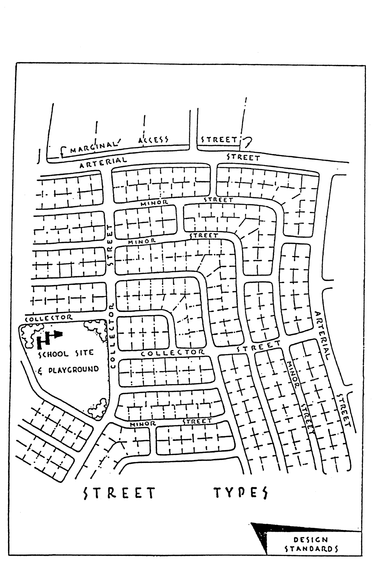
Sec. 12-7-4. - Design standards.
Land that the planning board has found to be unsuitable for subdivision due to flooding, bad drainage, or other features likely to be harmful to the health, safety and general welfare of future residents, shall not be subdivided, unless adequate methods of correction are formulated by the developer and approved by the city engineer. Appendix A, at the end of this chapter, illustrates selected design standards described herein.
(1)
Streets.
a.
Wherever a tract or parcel to be subdivided embraces any part of a street designated in the comprehensive plan, such part shall be platted in the location and width indicated on such plan.
b.
The arrangement, character, extent, width, grade, and location of all streets shall conform to the comprehensive plan and shall be considered in their relation to existing and planned streets, to topographical conditions, to public convenience and safety, in their appropriate relation to the proposed uses of the land to be served by such streets and the most advantageous development of the surrounding neighborhood.
c.
Where such is not shown in the comprehensive plan, the arrangement of streets in a subdivision shall either:
1.
Provide for the continuation or appropriate projection of existing principal streets in surrounding areas; or
2.
Conform to a plan for the neighborhood approved or adopted by the planning board.
d.
Minor streets shall be so laid out that their use by through traffic will be discouraged.
e.
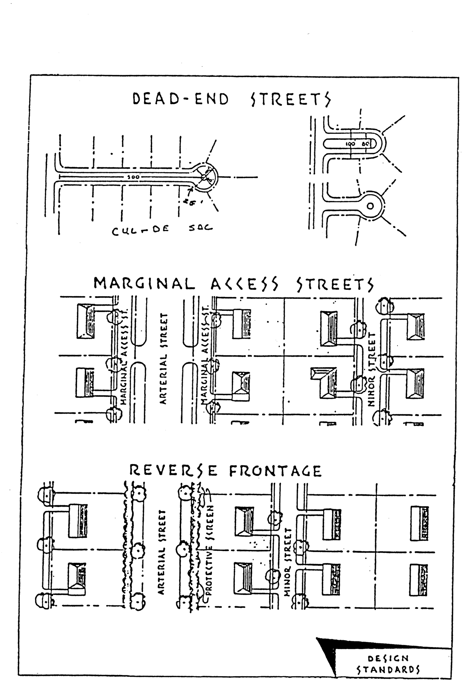
Where a subdivision abuts or contains an existing or proposed arterial street, the planning board may require marginal access streets, reverse frontage with screen planting contained in a nonaccess reservation along the rear property line, deep lots with rear service alleys, or such other treatment as may be necessary for adequate protection of residential properties and to afford separation of through and local traffic. Residential and nonresidential subdivisions located along arterial streets shall be encouraged to provide consolidated access points for all uses within the subdivision.
f.
Where a subdivision borders on or contains a railroad right-of-way or limited access highway (super highway) right-of-way, the planning board may require a street approximately parallel to and on each side of such right-of-way, at a distance suitable for the appropriate use of the intervening land, as for park purposes in residential districts, or commercial or industrial purposes in appropriate districts. Such distances shall also be determined with due regard for the requirements of approach grades of future grade separations.
g.
Reserve strips (nonaccess easements) controlling access to streets shall be prohibited except where their control is definitely placed in the city under conditions approved by the planning services department.
h.
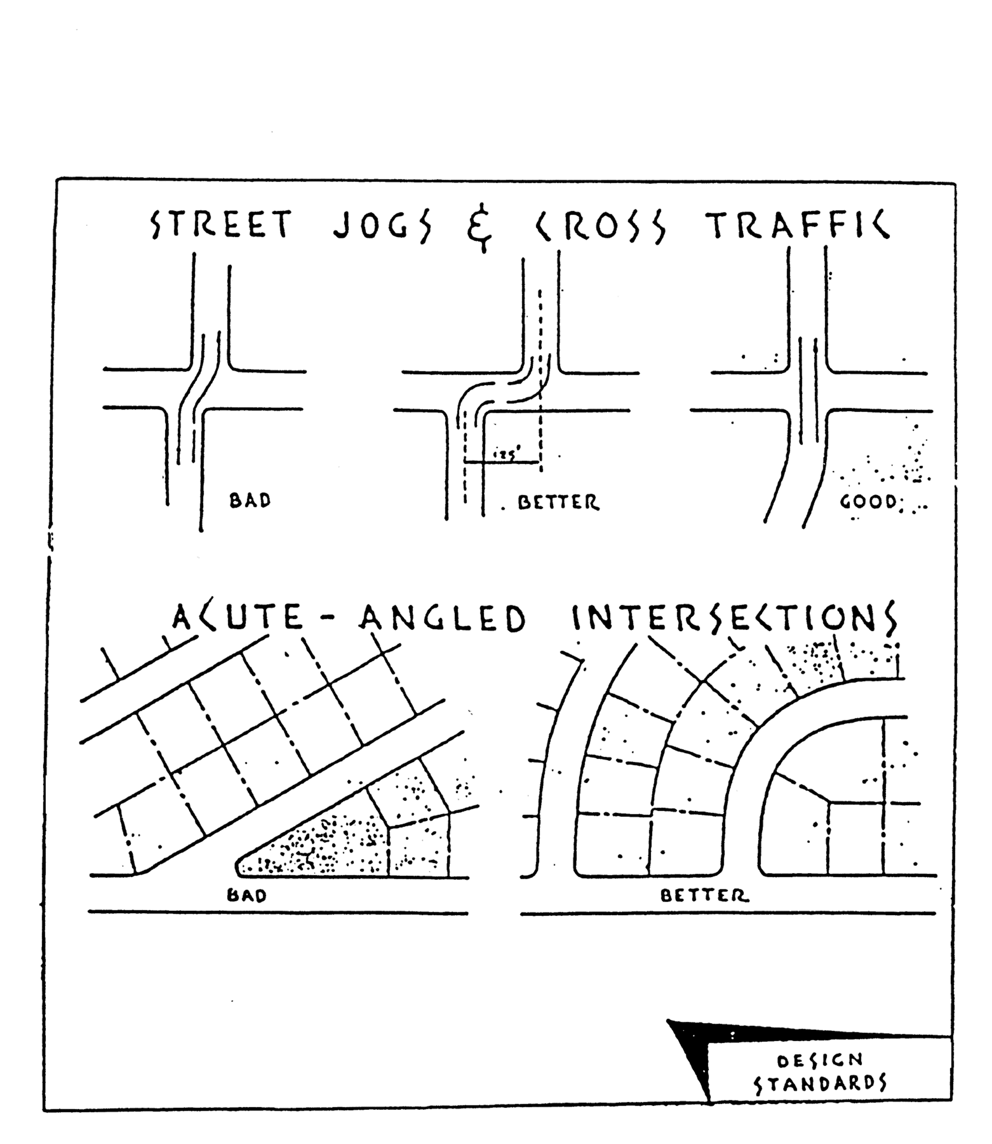
Street jogs with centerline off-sets of less than 125 feet shall be avoided.
i.
A tangent at least 100 feet long shall be introduced between reverse curves on arterial and collector streets.
j.
Streets shall be laid out so as to intersect as nearly as possible at right angles, and no streets shall intersect any other street at less than 60 degrees.
k.
Property lines at street intersections shall be rounded with a radius of 25 feet, or of greater radius where the planning board may deem it necessary.
l.
Street right-of-way widths shall be shown on the comprehensive plan and where not shown therein shall be not less than as follows:
m.
Half streets shall be prohibited, except where essential to the reasonable development of the subdivision in conformity with the other requirements of these regulations, and where the planning board finds it will be practicable to require the dedication of the other half when the adjoining property is subdivided. Whenever a half street is adjacent to a tract to be subdivided, the other half of the street shall be platted within such tract.
n.
Dead-end streets are prohibited except those designed to be so permanently. Permanent dead-end streets shall be not longer than 500 feet and shall be provided at the closed end with a turnaround having an outside roadway diameter of at least 80 feet and a street property line diameter of at least 100 feet. At the intersection of the turnaround and the straight portion of the right-of-way there shall be a 25-foot radius as a transition.
o.
Street names. A proposed new street, which is in alignment with a continuation of an existing street, with or a continuation of an existing street, shall have the same name as the existing street. In no case (including numbered or lettered streets) shall new streets have names or numbers that duplicate or that are phonetically similar to existing streets' names, regardless of the prefix or suffix used as "Avenue," "Boulevard," "Court," "Crescent," "Drive," "Place," "Street," and "Terrace." All street names shall be subject to approval of the planning board.
Note: In this respect, it is suggested that the developer check over his or her proposed street names with the postal authorities, before submitting his or her plat to the planning board for approval.
p.
Grades and transition of grades must be approved by the city engineer and in no case shall be less than two-tenths percent.
q.
Private streets. Private streets may be approved provided they are constructed according to the street design standards specified in sections 12-7-4 and 12-7-5 except that required private ingress and egress easements, private rights-of-way or private common area widths and pavement widths may be less than required for public rights-of-way and street widths. In the event that a private street is approved, the following statement shall be shown on the preliminary and final plats: "All roads and rights-of-way shown on this plat are private and are not subject to maintenance by the City of Pensacola." Maintenance of private streets shall be as provided in section 12-3-61.
(2)
Drainage easements.
a.
Easements along lot lines shall be provided for drainage where necessary and shall be at least 12 feet wide.
b.
Where a subdivision is traversed by a watercourse, drainageway, channel or stream, there shall be provided a stormwater easement or drainage right-of-way conforming substantially with the lines of such watercourse, and such further width, as will be adequate for the purpose. Parallel streets or parkways may be required in connection therewith.
(3)
Blocks.
a.
The length, width and shape of blocks shall be determined with due regard to:
1.
Provision of adequate building sites suitable to the special needs of the type of use contemplated.
2.
Zoning requirements.
3.
Needs for convenient access, circulation, control, and safety of street traffic.
4.
Limitations and opportunities of topography.
b.
Block length shall not exceed 1,400 feet or be less than 400 feet. Where blocks are 700 feet or more in length, the planning board may require a 20-foot pedestrian easement through the block. Long blocks should be oriented for drainage and toward such focal points as a shopping center or a school.
c.
Block width should be at least wide enough to allow two tiers of lots and should be a minimum width of 240 feet, except when reverse frontage is used.
(4)
Lots; building site area and yard restrictions.
a.
Minimum building site area and yard restrictions shall be governed by the requirements of chapter 12-3. Every lot or parcel of land shall abut a public street, or private street where permitted by this chapter.
b.
Insofar as practical, side lot lines shall be at right angles to straight right-of-way lines or radial to curved right-of-way lines.
c.
The lot size, width, depth, shape and orientation, and the minimum building setback lines shall be appropriate for the location of the subdivision and for the type of development of use contemplated.
d.
Double frontage and reverse frontage lots shall be avoided except where desirable to provide separation of residential developments from traffic arteries or to overcome specific disadvantages of topography and orientation. A nonaccess easement with a planting screen or solid fence shall be provided along the line of lots abutting such a traffic artery.
(Code 1986, § 12-8-4; Ord. No. 13-06, § 16, 4-27-2006; Ord. No. 29-21, § 4, 12-16-2021)
Sec. 12-7-5. - Required improvements.
(a)
Street and storm drainage improvements. The owner or developer shall prepare and submit to the city engineer for approval, plans for adequate storm drainage and street improvements that shall be installed by the owner or developer in accordance with specifications of the city set forth herein. Where a subdivision includes an arterial or collector street, the city shall pay the cost of all pavement over 24 feet in width and 50 percent of the cost of pavement adjoining parks and playgrounds. The cost of 50 percent of the pavement adjoining school sites shall be assessed to the county school board. If oversized storm drainage is required in a subdivision to serve an area beyond the project, these facilities shall be built and/or paid for by the subdivider and the city in such reasonable manner as the subdivider and the mayor shall agree to and shall be a proratable charge against the area to be benefitted. This shall apply to areas outside the project area that are owned by the city or for which the city has maintenance responsibility. The design of all required improvements shall conform to the following standards or an approved equal and detailed specifications obtainable from the city engineer's office.
(1)
Clearing, grubbing and grading. Clearing and grubbing shall be for the full width of the right-of-way except as permitted by the city engineer. Grading shall be done to plans approved by the city engineer.
(2)
Arterial streets.
a.
Right-of-way. One hundred feet if not determined otherwise on the comprehensive plan.
b.
Pavement width. See arterial street cross-section of the city engineer.
c.
Materials. Specifications of the city engineer.
d.
Curb and gutter. Specifications of the city engineer.
(3)
Collector streets.
a.
Right-of-way. Eighty feet.
b.
Pavement width. Thirty-five feet.
c.
Materials. Double layer of bituminous surface treatment over a six-inch compacted clay base.
d.
Curb and gutter. Layback type.
(4)
Minor street.
a.
Right-of-way. Sixty feet (described as 50 feet with two five-foot sidewalks provided within right-of-way).
b.
Pavement width. Twenty-four feet.
c.
Materials. Double layer of bituminous surface treatment over a six-inch compacted clay base.
d.
Curb and gutter. Layback type.
(5)
Marginal access streets.
a.
Right-of-way. Forty feet.
b.
Pavement width. Twenty-four feet.
c.
Materials. Double layer of bituminous surface treatment over a six-inch compacted clay base.
d.
Curb and gutter. Layback type.
(6)
Construction plans and profiles. Construction plans and profiles shall be submitted for approval to the city engineer's office for all street and storm drainage improvements. The drawings shall have a sheet size of 24 inches by 36 inches. The drawings shall have a horizontal scale of 20 feet to the inch and a vertical scale of two feet to the inch. The drawings, upon approval of the city engineer, shall become the possession of the city.
a.
Street paving plans and profiles shall show:
1.
Centerline stationing.
2.
Curve data.
3.
Rights-of-way dimensions.
4.
Roadways widths.
5.
Elevations on a datum approved by the city engineer at centerline stationing.
6.
Existing water lines, gas lines, underground cables, and any other features in the right-of-way as required in section 12-7-8.
7.
Lot lines.
8.
Typical sections of roadway, curbing and any other details as may be necessary to clearly express intent.
9.
Existing ground centerline on the profile as a long broken line separated by dots, north and east property lines by medium long dashed lines, and south and west property lines as a short dashed line, and the proposed centerline as a solid line.
10.
The gradient of the centerline and elevations of all vertical curves.
11.
Title, scale, north arrow, benchmarks, date, name of developer and engineer who prepared plan.
b.
Storm sewer plan and profiles shall show:
1.
Centerline stationing.
2.
Location of sewer line with respect to curb line.
3.
Location of manholes and inlets and type to be used.
4.
Elevations of manhole inverts and inlets inverts on plan view.
5.
Existing ground profile along centerline of sewer.
6.
Profile of proposed sewer inverts as heavy solid line.
7.
Gradient of proposed sewer invert.
8.
Title, scale, north arrow, benchmarks, date, name of developer and engineer who prepared plan.
(b)
Sanitary sewers. Any subdivision that has a public sewer system available for extension within 300 feet of its boundary shall have such available system extended by the subdivider to provide service to each lot in the subdivision. Construction plans and profiles shall be submitted for approval to the city engineer's office for all sanitary sewer improvements. The drawings shall have a sheet size of 24 inches by 36 inches. The drawings shall have a horizontal scale of 20 feet to the inch and a vertical scale of two feet to the inch. The drawings, upon approval of the city engineer, shall become the possession of the city. Sanitary sewer plan and profiles shall show:
(1)
Centerline stationing.
(2)
Location of manholes and lampholes.
(3)
Elevations of manhole inverts and inlets inverts on plan view.
(4)
Location of sewer line with respect to curb line.
(5)
Existing ground profile along centerline of sewer.
(6)
Profile of proposed sewer line invert as heavy solid line.
(7)
Gradient of proposed sewer line invert.
(8)
Title, scale, north arrow, benchmarks, date, name of developer and engineer who prepared plan.
(Code 1986, § 12-8-5; Ord. No. 13-06, § 17, 4-27-2006; Ord. No. 16-10, § 222, 9-9-2010; Ord. No. 29-21, § 4, 12-16-2021)
Sec. 12-7-6. - Sites for public use.
(a)
School sites. The planning board may, where necessary, require reservation of suitable sites for schools; and further, which sites shall be made available to the county school board for their refusal or acceptance. If accepted by the school board, it shall be reserved for future purchase by the school board from the date of acceptance for a period of one year.
(b)
Sites for park and recreation or open space. Each subdivision plat shall be reviewed by the planning and leisure services departments in order to assess the following: park and recreational or open space needs for the recreation service area within which the subdivision is located and for the city as a whole; and characteristics of the land to be subdivided for its capability to fulfill park, recreation or open space needs. Based on this review the city staff shall recommend one of the following options:
(1)
Dedication of land for park, recreation or open space needs. The subdivider or owner shall dedicate to the city for park and recreation or open space purposes at least five percent of the gross area of the residential subdivision. In no case shall the aggregate acreage donated be less than one-quarter acre.
(2)
Payment of money to an escrow account for park, recreation or open space needs in lieu of dedication of land. The subdivider or owner shall pay unto the city such sum of money equal in value to five percent of the gross area of the subdivision thereof, which sum shall be held in escrow and used by the city for the purpose of acquiring parks and developing playgrounds and shall be used for these purposes and no others. The aforementioned value shall be the value of the land subdivided without improvements and shall be determined jointly by the mayor and the subdivider. If the mayor and subdivider cannot agree on a land value, then the land value shall be established by arbitration. The mayor shall appoint a professional land appraiser, the subdivider shall appoint a professional land appraiser, and these two shall appoint a third.
(c)
Public streets. All streets delineated on all plats submitted to the city council shall be dedicated to all public uses including the use thereof by public utilities, unless otherwise specified herein.
(Code 1986, § 12-8-6; Ord. No. 9-96, § 14, 1-25-1996; Ord. No. 16-10, § 223, 9-9-2010; Ord. No. 29-21, § 4, 12-16-2021)
Sec. 12-7-7. - Variances.
(a)
Where strict adherence to any of the provisions of this chapter would cause unnecessary hardship due to topographical or other conditions peculiar to the site, the planning board may recommend, and the city council approve, a variance.
(b)
All variances from the provisions of this chapter that are proposed as part of a subdivision plat must be identified and justified in a letter by the applicant to be attached to the plat being submitted (e.g., Variance Requested: Non-Standard Street R.O.W.—Justification: Preservation of large live oak trees throughout the property). The reasons for the granting of any such variance shall be clearly specified and entered into the minutes of the city council.
(Code 1986, § 12-8-7; Ord. No. 29-21, § 4, 12-16-2021)
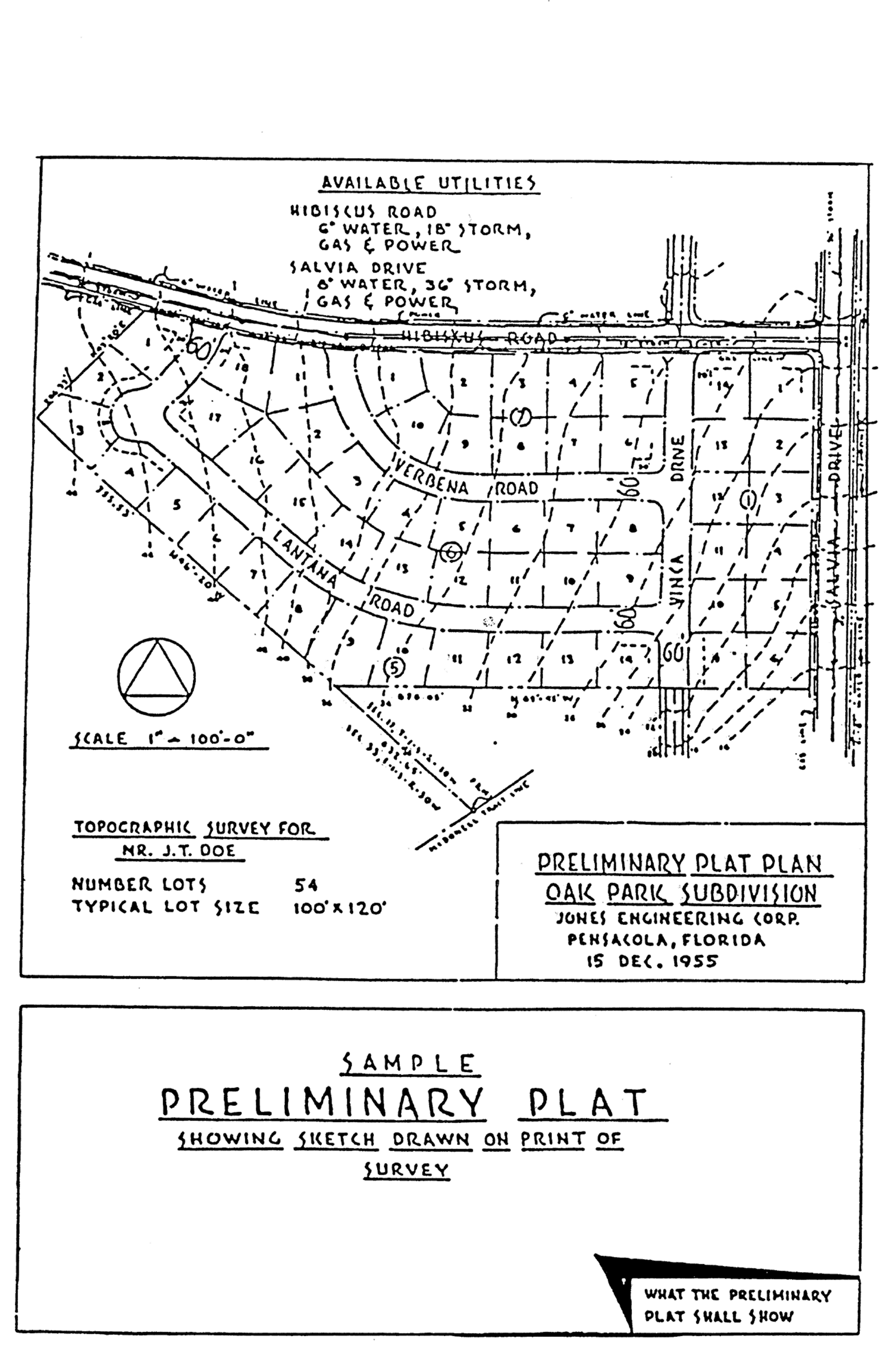
Sec. 12-7-8. - Preliminary plat.
Appendix B, at the end of this chapter, illustrates a sample preliminary plat. The preliminary plat shall show the following:
(1)
Drawn to a scale of 100 feet to the inch or less, show all improvements on the property and show all trees subject to section 12-6-2(d) of this Code.
(2)
Subdivision or development name, name of the owner or developer, name of surveyor and designer, north arrow, and date.
(3)
The boundary line of the tract to be subdivided drawn accurately to scale and with accurate linear and angular dimensions.
(4)
Streets: Names, right-of-way and roadway width; similar data for alleys, if any.
(5)
The location and size of water, gas and sanitary sewer mains, fire hydrants, storm drains, and all structures on the land to be subdivided and on the land within ten feet of it.
(6)
Other rights-of-way or easements; location; width and purpose, including navigation easements and maintenance easements for zero-lot-line dwellings (refer to section 12-3-5(1)).
(7)
Lot lines, lot numbers and block numbers.
(8)
Sites, if any, to be reserved or dedicated for parks, playgrounds or other public use.
(9)
Sites, if any, for multiple-family dwellings, shopping centers, churches, industry or other nonpublic uses exclusive of single-family dwellings.
(10)
Reference to recorded subdivision plats of adjoining platted land by record name, book and page number.
(11)
Minimum building setback lines (front, side and rear), as required in the zoning regulations.
(12)
Site data including number of residential lots, typical lot size and areas in parks, etc.
(13)
Ground contours at intervals not greater than two feet.
(14)
Orientation of subdivision or development in relation with surveyors bench marks and monuments.
(15)
The above information may be graphical except where detailed computations are required.
(16)
All plats located in the 100-year floodplain or within airport impact district shall state such information on the face of the plat.
(17)
All plats must include horizontal State Plane Coordinates on a minimum of two exterior boundary corners. State Plane Coordinates accuracy to one decimal place. Datum is NAD83 (2011) or most current realization as defined and maintained by the National Geodetic Survey (NGS). Projection zone is Florida North (State Plane—US Survey Foot Definition). Projection type is Lambert Conformal Conic.
(Code 1986, § 12-8-8; Ord. No. 29-21, § 4, 12-16-2021)
Sec. 12-7-9. - Final plat.
The final plat shall conform fully to the requirements of F.S. ch. 177, and shall depict thereon all information required by sections 12-7-8(1), (2), (3), (4), (6), (7), (8), (10), (11), (14), (16), and (17).
(Code 1986, § 12-8-9; Ord. No. 6-93, § 24, 3-25-1993; Ord. No. 29-21, § 4, 12-16-2021)
Sec. 12-7-10. - Final approval.
(a)
Approval of the final plat by the city council shall be granted upon the finding that the developers have complied with applicable laws and provisions of this Code. A true copy of the plat as approved shall be recorded by the applicant in the public records of the county within 180 days of city council approval.
(b)
If the approved plat is not recorded in the public records of the county within 180 days of city council approval, upon filing the recorded plat with planning services department, the applicant is subject to be charged a late fee.
(c)
No building permits may be issued until the recorded final plat has been filed with the planning services department.
(d)
All subdivision improvements shall be completed by the developers and accepted by the city engineer prior to the issuance of any building permits; provided, however, that in lieu of the immediate installation of the required improvements, the subdividers shall either file with the city, a performance bond or surety bond or deposit with the city in escrow cash or a certified check in an amount to be determined by the mayor with sureties satisfactory to the city guaranteeing the installation of the required improvements.
(e)
All subdivision improvements shown on the plat shall be completed within one year from the date the city council grants approval of the final plat, regardless of when said plat is recorded, and subject to the charging of a late fee. For good cause shown, the city council may grant a reasonable extension of this one-year time period.
(f)
No certificate of occupancy for a building shall be issued until all subdivision improvements meet a satisfactory engineering as-built inspection and are approved by the city engineer.
(Code 1986, § 12-8-10; Ord. No. 6-93, § 25, 3-25-1993; Ord. No. 16-10, § 224, 9-9-2010; Ord. No. 29-21, § 4, 12-16-2021)
APPENDIX A. DESIGN STANDARDS
APPENDIX B. SAMPLE PRELIMINARY PLAT