
Pine Mountain City Zoning Code
ARTICLE 11
- PROCEDURES AND PERMITS
Sec. 1101.- Land development process and procedures.
The following presents a summary of the plans and procedures involved in the land development approval and construction regulation process. In all cases, consult the specific requirements and procedures detailed under the various Divisions of this Article.
Sec. 1107.- Existing lots of record.
(a)
Any lot or parcel of land in any district which was on record in the Office of the Clerk of the Superior Court of Harris County at the date of adoption of this ordinance, November 1 st , 2022, or amendment thereof, which does not adjoin undeveloped land (or land which has been subdivided but a building permit has not been issued for the site), under the same ownership may be used as a building site even though such lot or parcel fails to meet the minimum requirements for lot area, lot width or both. With respect to such lots or parcels, yard requirements and other requirements shall be subject to the following:
(1)
Meet applicable setback requirements.
(2)
Not to exceed the maximum lot coverage requirements.
(3)
Must have an approved on-site sewage permit from the Harris County Board of Health.
Sec. 1113.- Rezoning application for resort development master plan revisions.
(a)
Resort Development is an inactive zoning district; see Article 14.
(b)
Amendments to the site plan of an existing resort development must be submitted to the Harris County Planning Commission and Harris County Board of Commissioners for review and approval.
(c)
A site plan for the total acreage must be submitted to the Planning Commission for review and approval to ensure consistency with the overall plans for the appropriate development of the County. Final approval of the plan rests with the Board of Commissioners.
(d)
Where resort development abuts a public road, the minimum setback requirements shall be those of the most restrictive adjacent zoning district.
Sec. 1114.- Special use application for telecommunications facilities.
Applications for a special use permit associated with Telecommunications Antennas and Towers and associated processes and conditions shall be in accordance with Section 341 of Article 3 (Restrictions on Particular Uses) of this Development Code.
Sec. 1115.- Special use application for agritourism development.
In addition to the requirements of this section, application requirements for Special Use associated with Agritourism shall be in accordance with the requirements below and shall comply with Section 309 of Article 3 (Restrictions on Particular Uses) and other applicable provisions of this Development Code.
Sec. 1117.- Road development directives.
In order for the Board of Commissioners to accept any streets/roads within Harris County, the following directives shall be complied with:
(a)
The subdivider/owner/developer of proposed streets/roads shall acquire a copy of this article. A copy may be obtained from the following County departments: Public Works Department, Community Development Department, or the County Manager's office, from 8:00 a.m. to 12:00 noon and from 1:00 p.m. to 5:00 p.m., Monday through Friday.
(b)
Prior to beginning construction on a street/road, following preliminary plat approval, the subdivider/owner/developer shall consult with the Public Works Director and submit a set of construction plans. Said plans will be reviewed for compliance; following approval, subdivider/owner/developer may proceed with construction of street/road. No construction will be started until the construction plans have been approved.
(c)
After the subdivider/owner/developer has completed construction of said streets/roads to include striping and the placement of all signs (stop, curve, street signs, etc.), he/she shall forward a letter requesting an inspection by the Public Works Director.
(d)
Upon receipt of said request, the Public Works Director or his designee shall conduct an inspection of said streets/roads for compliance with the approved construction plans and the road standards contained within this article.
(e)
Initial Inspection Report.
(1)
After the inspection has been accomplished, the Public Works Director shall complete an inspection report and forward the original to the Board of Commissioners office and a copy to the subdivider/owner/developer. This report will indicate any deficiencies noted and what the subdivider/owner/developer must correct/complete prior to the recommendation of acceptance by the Public Works Director. If there are no deficiencies, the report will indicate as such and the Public Works Director will recommend that said streets/roads be accepted and placed on the official Harris County Road Register.
(f)
After receipt of the successful inspection report, the subdivider/owner/developer shall forward the following to the Board of Commissioners:
(1)
A 4-year guarantee in the form of a cost bond, letter of credit, or certified check, effective for4 years from the date of the successful inspection, in the amount of 5% of the cost of the road work done, to include drainage system, base, and paving, accompanied by a copy of the contractor's invoices for said road work. If a cost bond is provided, it must be held by a company must be licensed to do business in Georgia.
(2)
A deed conveying said street/road and right-of-way to Harris County, Georgia.
(3)
A copy of the recorded plat referenced in the right-of-way deed.
(4)
A document showing the map and parcel numbers of the property being deeded.
(5)
A check made payable to Harris County Clerk of Superior Court to cover the cost of recording the deed.
(6)
A document showing the name and contact information of the person to whom the request for the actual title policy is to be sent and to whom copies of the recorded documents are to be sent.
(7)
A commitment policy of owner's title insurance to the Board of Commissioners insuring, except for title insurance standard exceptions, the fee simple title to the street/road being accepted by the Board of Commissioners and dedicated to public use.
Such title insurance shall be in the amount of the cost of the road to include drainage system, base and paving. The premium for the aforementioned title insurance shall be borne by the subdivider/owner/developer of the property. The requirement for title insurance shall be a pre-requisite to the acceptance of the road by the Board of Commissioners.
(g)
Following receipt of all required documents, a resolution for acceptance regarding the streets/roads will be prepared for consideration by the Board of Commissioners.
(h)
Following adoption of the resolution, the deed shall be recorded, and copies of the resolution and the recorded deed will be provided to the subdivider/owner/developer upon receipt of the owner's title insurance policy, which replaces the commitment policy submitted with the road acceptance documents.
(i)
Six months prior to expiration of the bond, letter of credit, or certified check, the Public Works Director or his designee shall conduct a final inspection of said streets/roads.
(j)
Final inspection report.
(1)
After the final inspection has been accomplished, the Public Works Director shall complete a final inspection report and forward the original to the Board of Commissioners and a copy to the subdivider/owner/developer. This report will indicate any deficiencies noted and what the contractor must correct/complete to bring the road into compliance with the County's standards for new road construction.
(2)
If the street/road does not meet standards within 60 days, the subdivider/owner/developer's bond or letter of credit will be called in, or the cash bond utilized, to accomplish required corrections.
(3)
If there are no deficiencies, the report will so indicate and at the end of the four-year guarantee period, the bond, letter of credit, or a check in the amount of the original certified check shall be returned to the subdivider/owner/developer.
(k)
Guarantees.
(1)
In the event a subdivision is developed in two or more phases, at the beginning of street/road development in each phase the subdivider/owner/developer must first furnish/post a surety bond, letter of credit, or certified check to the Board of Commissioners to guarantee existing county roads in the subdivision against damage directly attributable and caused by heavy truck traffic in the delivery of building materials and equipment in the construction of new structures within the subdivision.
(2)
Said bond, letter of credit, or certified check shall be in the amount of 75 percent of the cost to pave the existing road, with each succeeding year to remain the same until the development is 90 percent completed and if any repairs are required as a result of damage by heavy equipment, the developer will be billed for 75 percent of the repair costs in the form of a report of damage along with a list of repairs which must be accomplished.
(3)
If payment is not made to the County within 60 days, the subdivider/owner/developer will not be issued additional building permits for the subject subdivision until restitution is made.
(4)
It shall be the responsibility of the subdivider/owner/developer to notify the Board of Commissioners when the development is 90 percent complete, and upon verification of same by the appropriate county department, if the bond or letter of credit have not been called in, or the certified check not utilized for repairs, the bond or letter of credit, or a check in the amount of the original certified check shall be returned to the subdivider/owner/developer.
Sec. 1125.- Tree removal.
Timber harvesting requirements shall be as specified in Section 345 of Article 3 (Restrictions on Particular Uses) of this Development Code.
Sec. 1128.- Sign permits.
Sign permit requirements and process shall be as specified in Section 708 of Article 7: Sign Regulations of this Development Code.
Sec. 1129.- Manufactured home permits.
Permit requirements and processes for manufactured homes, including pre-owned manufactured homes, shall be as specified in Section 329 of Article 3 (Restrictions on Particular Uses as well as applicable provisions of Article 11 of this Development Code).
Sec. 1130.- Solar collection system permits.
Permit requirements and processes for solar collection systems shall be as specified in Section 336 of Article 3 (Restrictions on Particular Uses) as well as applicable provisions of Article 11 of this Development Code.
Sec. 1131.- Inert landfill permits.
Permit requirements and processes for inert landfills shall be as specified in Section 326 of Article 3 (Restrictions on Particular Uses) as well as applicable provisions of Article 11 of this Development Code and all applicable State and Federal requirements and limitations.
Sec. 1134.- Types of appeals.
Persons may appeal for relief under the following circumstances:
(a)
Special exception variance. When an exception (also referred to as a "waiver") is desired for a particular property from certain requirements of this Development Code, as specified in this Article.
(b)
Hardship variance. When compliance with the requirements of this Development Code would create a particular and unique hardship.
(c)
Flood damage prevention variance. When the requirements of this Development Code for flood damage prevention would create an exceptional hardship that would adversely affect the use of a property or an historic structure.
(d)
Administrative decision. When aggrieved by an action or an interpretation of the Planning Director or any other administrative official of the County made under this Development Code. An administrative official is defined as the head of any department subject to these regulations.
Sec. 1141.- Board of zoning adjustment.
The Board of Zoning Adjustment shall review and make decisions on applications as described in Section 1203 of Article 12 (Administration and Enforcement).
Sec. 1142.- Temporary suspension of permitting.
Upon submission of a valid application for the granting of any type of appeal on a property, no permits shall be issued, nor shall any actions be undertaken on the property that may be affected by the outcome of such application.
1101.01 - County approvals, in general.
(a)
All County approvals that are required for the use of land and structures and for the location and operation of businesses shall be obtained by the applicant and transmitted by applicant with request for a building permit, zoning change, variance or other development permit or plan approval. Except as otherwise required by State law, no local action shall be taken and no public hearings shall be held until the above required approvals have been obtained by the applicant.
(b)
Except as otherwise required by Georgia State Law, no local action shall be taken and no public hearings shall be held on any use request, permit, zoning change, master plan approval, preliminary or final plat approval, variance or other development permit or plan approval until all county and state taxes and other assessments due on the subject property have been paid in full and until all necessary approvals required for the use of the land and structures and for the location and operation of businesses and industries and any other requirements for said request have been granted by the responsible issuing authority and have been transmitted by the applicant with his request to the County.
1101.02 - Zoning changes, in general.
(a)
If a property is not appropriately zoned, a request for rezoning or approval of a Special Use must be approved prior to development or construction.
(b)
A concept plan is required for zoning changes as described in Section 1106.02.
1101.03 - Minor subdivisions.
Approval of a minor subdivision shall be conducted as follows:
(a)
Submission of minor subdivision plat approval shall be made to the Community Development Director, or designee, for administrative review and authorization to record the plat with the Clerk of Superior Court. Upon referral by the Director, the Planning Commission may review and authorize recordation of the plat. There shall be a fee payable in advance for review of the plat in such amount as in accordance with the current schedule approved by the Board of Commissioners for the Community Development Department.
(b)
Upon approval of a Minor Subdivision Plat by the Community Development Director, the subdivider shall be responsible for recording the subdivision plat with the Clerk of Superior Court of Harris County
(c)
As applicable, deeds and easement agreements for all public rights-of-way and other lands or facilities to be dedicated to Harris County are forwarded to the Board of Commissioners for acceptance. In the case of minor subdivisions, the road acceptance process as described in Section 1117 to turn roads over to the County must be followed.
(d)
Lots may not be sold, and building permits and driveway permits on the lots may not be obtained, prior to recording of a Minor Subdivision plat.
1101.04 - Major subdivisions.
Permitting and construction of a major subdivision will be conducted as follows:
(a)
Project Approval is granted upon review and approval of a Preliminary Subdivision Plat by the Planning Commission.
(b)
A Land Disturbance Permit is issued by the Community Development Department based on review and approval of development plans for subdivision construction by all affected departments and agencies. Receipt and approval by the Public Works Director (for streets and drainage) and the Water Works Director (for water and sewer) of accurate descriptions of the as-built condition of public improvements is required in order to allow filing of a Final Plat.
(c)
Approval of a Final Subdivision Plat by the Planning Commission will authorize recording of the plat with the Clerk of the Superior Court. The owner or applicant shall be responsible for the recording of such final plat in the office of the Clerk of the Superior Court.
(d)
Deeds and easement agreements, as applicable, for all public rights-of-way and other lands or facilities to be dedicated to Harris County are forwarded to the Board of Commissioners for acceptance in accordance with requirements set forth in this Development Code.
(e)
Lots may not be sold, and building permits and driveway permits on the lots may not be obtained prior to recording of the Final Plat.
(f)
At the end of the maintenance period, all public improvements will be inspected by the Community Development Department. After the developer has made any required repairs, public acceptance of the improvements shall be issued by the Public Works Department.
1101.05 - Multi-family and commercial/industrial projects.
(a)
Project approval is granted upon review and approval of a Preliminary Site Plan for the project by the Planning Commission.
(b)
A Land Disturbance Permit, when required, is issued by the Community Development Department based on review and approval by all affected departments and agencies of development plans for construction of the project.
(c)
A Building Permit is issued by the Community Development Department based on review and approval of architectural plans. Buildings falling under the authority of the State Fire Marshal shall be approved by the State Fire Marshal prior to issuance of the building permit.
(d)
Driveway and sign permits are issued by the appropriate departments.
(e)
Receipt by the Public Works Director (for streets and drainage) and the Water Department Director (for water and sewer) of accurate surveys of the as-built condition of all public improvements is required in order to authorize issuance of a Certificate of Occupancy.
(f)
Occupancy of the building is authorized by the Community Development Director or designee based on final inspection and issuance of a Certificate of Occupancy.
(Ord. No. 05-23, 12-5-2023)
1102.01 - Application submission process.
An application for any permit or approval under this Article or for a hardship variance or special exception variance under the provisions of this Development Code will first be considered as follows:
(a)
If the application is for a project that qualifies as a Development of Regional Impact (DRI) and is the first request for County action or is a revision to a previous DRI, refer to Section 1108 of this Article for details and procedures.
(b)
If the application is for approval of a minor subdivision plat, refer to Section 1101.03 and 1109 for the applicable procedures. For a major subdivision plat, see Section 1110.
(c)
If the application is for any other type of approval or permit, refer to the appropriate sections of this Article or of Article 3 (Restrictions on Particular Uses) or other applicable provisions of this Development Code for procedures pertinent to the request.
1102.02 - Pre-application review procedure.
Whenever the subdivision of a tract of land is proposed, the subdivider is urged to consult early and informally with the Community Development Department in accordance with Section 1110.
1102.03 - Responsible parties for application processing.
The Community Development department shall maintain a guide illustrating Departments, directors and others responsible for receiving, administering, reviewing, approving and permitting various applications under this Development Code. This guide is only intended for convenience to illustrate responsible parties; the details of the text of this Development Code should be relied upon in all cases.
1102.04 - Schedules and fees.
Fees for appeals and applications for amendments to this Development Code shall be in accordance with the current schedule approved by the Board of Commissioners for the Community Development Department and shall be payable by an individual prior to action by the Community Development Department to initiate the proceeding so requested.
1103.01 - Initiation of text amendment.
(a)
Changes made to standards contained within the Development Code are referred to in this Article as text amendments. These changes include amendments to this Development Code or adoption of a new Development Code authorized by a zoning decision made only after compliance with the procedures set forth in this section.
(b)
An amendment to the text may be made by the Board of Commissioners. A proposed amendment to the text may be initiated by the Board of Commissioners, Planning Commission or by any person who owns property within the zoning jurisdiction of the County.
1103.02 - Public hearing and notice requirements.
(a)
Before adopting any change to the text of the Development Code, the Board of Commissioners shall hold conduct a public hearing in accordance with Section 1105. Prior to the Board of Commissioners public hearing, the proposed text amendment shall be presented for public comment at a Planning Commission public hearing.
(b)
Notice of a Planning Commission or Board of Commissioners hearings shall be in accordance with Section 1104.04(a).
(c)
No posting of signs or mailing of notification letters is required.
1104.01 - Initiation of rezoning or special use.
(a)
Each proposed amendment to the official zoning map shall be initiated by filing an application with the Community Development Department on a form furnished by the Department.
(b)
Applications for special exceptions for uses in zoning districts denoted by an "SU" in Table 2-1 of Article 2 shall be initiated by the filing of an application for special use permit with the Community Development Department on a form furnished by the Department.
(c)
Unless initiated by the Board of Commissioners or by the Planning Commission, all proposed map amendments shall be submitted by the owner of such property or the authorized agent of the owner. An authorized agent shall have written authorization from the property owner, and such authorization shall be notarized and attached to the application.
1104.02 - Filing deadlines.
(a)
Applications for proposed amendments shall be submitted in accordance with a schedule adopted annually by the Board of Commissioners. Said schedule shall provide that each application for a proposed amendment shall be submitted at least 50 days prior to the date on which it is to be considered by the Board of Commissioners as related to the zoning district requested and the size of the property affected. A fee shall not be charged for proposed amendments initiated by members of the Board of Commissioners or by members of the Planning Commission.
(b)
Applications shall be submitted in accordance with a schedule adopted annually by the Board of Commissioners. The Planning Commission and the Board of Commissioners shall hold public hearings in accordance with the adopted schedule.
(c)
An incomplete rezoning or special use application will not be accepted.
1104.03 - Withdrawal of rezoning or special use application.
(a)
Withdrawal prior to advertising. If an application has not been advertised for public hearing, a written request for withdrawal with the reason for the request shall be made to and accepted by the Community Development Director. No refunds of petition fees will be made.
(b)
Withdrawal after advertising. An applicant shall not be permitted to withdraw an application for a proposed amendment after the legal advertising for said proposed amendment, as required by this Development Code, shall have first appeared, unless such withdrawal is made with the approval of the Board of Commissioners If requested by the applicant, the Board of Commissioners shall determine whether the withdrawal shall be subject to the 24-month interval before refiling, as described in Section 1105.04.
1104.04 - Public Hearing and Notice Requirements.
(a)
Legal notice.
(1)
Notice of public hearings for Zoning Decisions. All applications pertaining to zoning decisions as defined in O.C.G.A. 36-66-3(4) shall require a public hearing preceded by publication of a public hearing notice within a newspaper of general circulation within Harris County and shall state the time, place and purpose of the hearing and shall also include the location of property that is the subject of the zoning action, the present zoning district of said property, and the proposed zoning district of said property. Such notice shall be published at least 15 days, but not more than 45 days prior to the date of the hearing.
(2)
Notice of public hearings before Quasi-Judicial Officers, Boards, or Agencies. All applications before quasi-judicial officers, boards, or agencies as defined in O.C.G.A. 36-66-3(1.1) shall require a public hearing preceded by publication of a public hearing notice within a newspaper of general circulation within Harris County and shall state the time, place and purpose of the hearing and shall also include the location of the property that is the subject of the hearing, the present zoning district of said property, and the nature of the proposed action. Such notice shall be published at least 30 days prior to the date of the hearing.
(b)
Public hearing signs posted for zoning decisions. When an application has been made for a proposed zoning decision as defined in O.C.G.A. 36-66-3(4), including zoning change (rezoning or special use), the applicant shall post signs on the subject property as follows:
(1)
Said sign shall be located on private property at or near the margin of the public right-of-way upon which said property abuts or depends upon for access.
(2)
The signs shall be placed on the property at 500 foot intervals. If the property in question has a 500 foot or less frontage, only one sign is required. If the property fronts on more than one public right-of-way, one sign shall be required for each right-of-way.
(3)
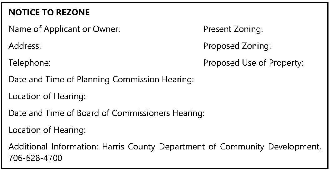
For a rezoning application, the sign shall read as follows:
(4)
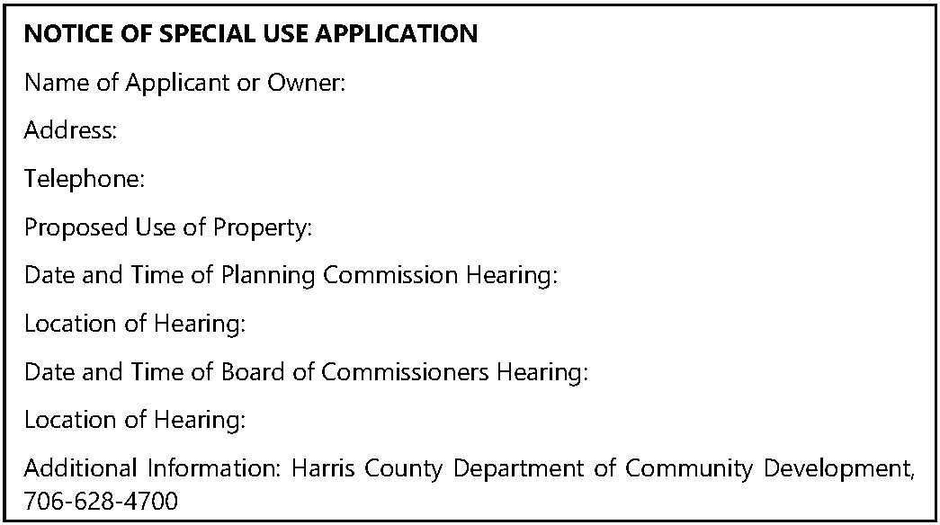
For a special use application, the sign shall read as follows:
(5)
Said sign shall be of wood, metal, or plastic, with minimum dimensions of 48 inches vertical by 96 inches horizontal in size, and the lettering thereon shall be black letters on a white background and the letters shall be at least three inches in height.
(6)
The applicant shall notify the Community Development Department in writing no less than 15 days prior to the first scheduled public hearing that the sign(s) has been erected and where it is located. Failure to do so may require the public hearing be rescheduled.
(7)
The sign(s) shall contain no additional advertisement or words other than those specified herein.
(8)
The sign(s) shall remain posted until final action has been taken by the Board of Commissioners. The sign(s) shall be removed by the applicant within ten days after final action by the Board of Commissioners.
(c)
Public hearing signs posted for hearings before quasi-judicial officers, boards, or agencies. When an application has been made that requires a hearing before quasi-judicial officers, boards, or agencies as defined in O.C.G.A. 36-66-3(1.1), the applicant shall post signs on the subject property as follows:
(1)
Said sign shall be located on private property at or near the margin of the public right-of-way upon which said property abuts or depends upon for access.
(2)
The signs shall be placed on the property at 500 foot intervals. If the property in question has a 500 foot or less frontage, only one sign is required. If the property fronts on more than one public right-of-way, one sign shall be required for each right-of-way.
(3)
Said sign shall be of wood, metal, or plastic, with minimum dimensions of 48 inches vertical by 96 inches horizontal in size, and the lettering thereon shall be black letters on a white background and the letters shall be at least three inches in height.
(4)
The applicant shall notify the Community Development Department in writing no less than 30 days prior to the first scheduled hearing that the sign(s) has been erected and where it is located. Failure to do so may require the public hearing be rescheduled.
(5)
The sign(s) shall contain no additional advertisement or words other than those required to describe the nature of the application.
(6)
The sign(s) shall remain posted until final action has been taken by the applicable quasi-judicial official, board or agency. The sign(s) shall be removed by the applicant within ten days after final action by the applicable official, board or agency.
(d)
Letters to abutting property owners: Where application is made for a proposed amendment that will require a zoning decision as defined in O.C.G.A. 36-66-3(4), the Community Development Department shall notify, by regular mail, the owners, as shown by Harris County tax records, of property that abuts the property that is the subject of the proposed amendment. Such notice shall be mailed at least 15 days prior to the date of the Planning Commission public hearing and shall include a description of the proposed amendment and the dates, times, and places of the public hearings before the Planning Commission and the Board of Commissioners. When an application has been made that requires a hearing before quasi-judicial officers, boards, or agencies as defined in O.C.G.A. 36-66-3(1.1), the Community Development Department shall provide notice by mail at least 30 days prior to the required hearing.
(Ord. No. 05-23, 12-5-2023)
1104.05 - Standards for consideration of a zoning change (rezoning or special use).
The Official Zoning Map of Harris County may be amended from time to time and a Special Use may be approved on a property by the Board of Commissioners under the procedures in this Development Code. In addition, changes in the conditions of approval pertaining to a specific rezoning or Special Use approval must also be approved by the Board of Commissioners following the procedures in this Development Code. However, no Amendment or Special Use approval shall become effective unless it has first been submitted to the Harris County Planning Commission for review and recommendation, as provided in this Article.
(a)
Zoning standards. The Planning Commission and Board of Commissioners shall consider the following standards in balancing the County's interest in promoting the public health, safety, morality, or general welfare against the right to the unrestricted use of property in its review of a rezoning application:
(1)
Whether the zoning proposal will permit a use that is suitable in view of the use and development of adjacent or nearby property;
(2)
Whether the zoning proposal will adversely affect the existing use or usability of adjacent or nearby property;
(3)
Whether the property affected by the zoning decision has a reasonable economic use as currently zoned;
(4)
Whether the zoning decision will result in a use which will or could cause a safety concern or an excessive or burdensome use of existing streets, transportation facilities, utilities, or schools;
(5)
Whether the zoning decision conforms with the policy and intent of the Harris County Comprehensive Plan; and
(6)
Whether there are other existing or changing conditions that may affect the use and development of the property in question and support either approval or disapproval of the zoning proposal.
(b)
Special use criteria. The Planning Commission and Board of Commissioners, in making its decision, shall consider the special use criteria in its review of the special use permit being sought by the applicant. In addition to the criteria listed in this section, when applicable, the criteria listed in Section 341.09 (a)(6) (Telecommunication Facilities), Section 509.08 (Planned Senior Housing Developments) and other specific use regulations in this Development shall be considered for specific types of special use permits.
(1)
Whether the zoning decision conforms with the policy and intent of and the Comprehensive Plan;
(2)
Whether the zoning decision will permit a use that is compatible with the use and development of adjacent or nearby property;
(3)
Whether the zoning decision will adversely affect the existing use of adjacent or nearby property;
(4)
Whether the zoning decision will result in a use which will or could cause an excessive or burdensome use of existing streets, transportation facilities, utilities, or schools;
(5)
Whether screening will be needed to protect adjacent uses from any negative impacts of the proposed use;
(6)
Whether outdoor lighting will negatively impact adjacent uses;
(7)
Whether the hours and manner of operation of the proposed use are compatible with surrounding uses;
(8)
Whether ingress and egress to the property reduce negative impacts of the proposed use or enhance safety;
(9)
Whether off-street parking spaces will be adequate and properly located to reduce any negative impact on surrounding property uses;
(10)
Whether there are any negative environmental impacts which should be considered, for example, topography, special geological features, soil, water runoff, air pollution, water pollution or contamination, wetlands, etc.; and
(11)
Whether there are other existing conditions that may affect the use and development of the property in question and support either approval or denial of the zoning decision.
(Ord. No. 05-23, 12-5-2023)
1105.01 - Procedures.
(a)
All public hearings held by the Planning Commission, Board of Commissioners, and Board of Zoning Adjustment, as applicable, shall be held in accordance with the procedures of this Section.
(b)
All applications for proposed amendments shall be reviewed by the Planning Commission in a public hearing in accordance with the procedures set forth in this Section.
(c)
Before taking action on a proposed amendment and after the receipt of the Planning Commission recommendations or reports thereon, if applicable, the Board of Commissioners shall hold a public hearing on the proposed amendment.
1105.02 - Open hearings.
(a)
The public hearing shall be convened at the scheduled time and place by the Chair of the Planning Commission, Board of Commissioners, or the Zoning Board of Adjustment, or their designee as applicable, who shall act as the presiding officer.
(b)
The public hearing shall be called to order by the presiding officer.
(c)
The presiding officer shall explain the procedures to be followed in the conduct of the public hearing and shall state the matter being considered at the hearing.
(d)
When any person wishes to speak at a public hearing in favor of or in opposition to an application, they shall raise their hand and, after being recognized by the presiding officer, shall come forward and give their name, address, relationship to the matter, and make any comment appropriate to the proposed zoning decision.
(1)
The presiding official may encourage reasonable limits on the number of persons who may speak for or against a proposal, on the time allowed for each speaker, and on the total time allowed for presentation of the application. All speakers are urged to make their comments brief and avoid repeating other comments.
(2)
Such reasonable time limitations, however, shall not deny any member of the general public to speak at the public hearing.
(3)
Equal time for proponents of proposed zoning decisions to present data, evidence, and opinion and for presentation by opponents of each proposed zoning decision shall be provided, such minimum time period to be no less than ten minutes per side.
(4)
Altogether, the total amount of time afforded the proponents of the application and the opponents, including rebuttal, shall be equal and shall be no less than ten minutes per side for the presentation of data, evidence, and opinions. Neither side, however, is required to use the total time available.
(e)
If the request for a zoning decision is initiated by the Board of Commissioners, all members of the Board of Commissioners shall be allowed to speak as they are recognized by the presiding officer, regardless of whether such Board member speaks in favor of or in opposition to the proposed zoning decision. Thereafter, all individuals who so desire shall be permitted to speak in favor of the zoning decision.
(f)
Proponents of the application.
(1)
Persons who support the application will be asked to comment first. If the subject of the hearing is a zoning decision initiated by a petitioner other than the Board of Commissioners; the petitioner requesting such zoning decision, or the petitioner's agent or counsel, shall be recognized first and shall be permitted to present and explain the request for the zoning decision.
(2)
The applicant or the applicant's representative shall be required to attend the public hearing unless written notice of hardship is received prior to the hearing. Failure of the applicant or the applicant's representative to attend the public hearing, except in cases of hardship, may be due cause for the tabling of the application.
(3)
The applicant shall have the burden of proof, which shall include the presentation of evidence and the burden of persuasion of each factor necessary to receive the approval of the request.
(4)
After completion of the presentation of the applicant, other persons who support the request will be asked to comment and will be allowed to speak in support of the request upon recognition and upon identification of the person's name, address, and relationship to the matter in accordance with (d) above.
(g)
Persons opposing the application.
(1)
Persons who oppose the application will next be asked to comment. After all individuals have had an opportunity to speak in in favor of the application under consideration, each individual present at the public hearing who wishes to speak in opposition to the application shall have an opportunity to speak after being recognized, and providing their name, address and relationship to the matter, shall be afforded an opportunity to speak.
(h)
Rebuttal. The applicant shall have an opportunity for rebuttal concerning the request. Rebuttal must be limited to points or issues raised by opponents to the application at the hearing.
In the case of an application for a proposed amendment to the zoning ordinance text or maps, the applicant shall have an opportunity, after all comments in opposition have been made, to make summary remarks concerning the proposed zoning decision.
(i)
Once all public comments have been heard, the presiding officer shall announce that the public hearing for the requested zoning decision is closed and the matter will be discussed among the board members.
(j)
Discussion. The members of the Planning Commission, the Board of Commissioners, or the Board of Zoning Adjustment, as applicable, may discuss the matter among themselves. During this discussion period, the members may call on the Community Development Director, any proponent or opponent, or other persons in attendance to clarify points made previously, to answer questions or to provide additional information. Such persons may respond upon recognition.
(k)
Delay, rescheduling or continuation of hearing. A public hearing on an application may be delayed, rescheduled or continued to another time and date, provided the announcement of the new time, place and date is given at the time and place of the advertised hearing, which announcement shall constitute public notice for the delayed, rescheduled or continued hearing.
(Ord. No. 05-23, 12-5-2023)
1105.03 - Decisions.
(a)
Findings of fact.
(1)
Following the public hearing, the Planning Commission, the Board of Commissioners, and the Board of Zoning Adjustments, as applicable, shall adopt findings of fact supporting their decision and may adopt any additional report it deems appropriate.
(2)
In order to approve an application, the Planning Commission, the Board of Commissioners, and the Board of Zoning Adjustments, as applicable, shall further make a finding that the reasons set forth in the application justify the granting of the application and that approval would be the minimum needed to make possible the reasonable use of the land, building or structure.
(3)
In preparing its findings of fact, the Planning Commission, the Board of Commissioners, or the Board of Zoning Adjustment, as applicable, must consider the standards for review set forth in Section 1104.05 and Section 1136 (hardship variances) as applicable.
(b)
Decision.
(1)
Planning commission.
a.
The Planning Commission shall then consider the proposed amendment and shall, at that time, take action on its recommendation to the Board of Commissioners.
b.
The Planning Commission may decide not to make a recommendation, or it may make any of the following recommendations with respect to an application for a proposed amendment: approval, denial, deferral, withdrawal, reduction of the land area for which the application is made, change of the zoning district requested, or imposition of zoning conditions. If no recommendation is decided by the Planning Commission, then it shall report to the Board of Commissioners that it makes no recommendation on the application.
c.
The Planning Commission shall submit its recommendation or report of no recommendation to the Board of Commissioners prior to the scheduled public hearing in which the Board of Commissioners will consider the application for a zoning decision. If the Planning Commission fails to submit a recommendation or report of no recommendation prior to the public hearing, the Planning Commission's recommendation shall be deemed to be one of approval.
(2)
Board of commissioners.
a.
At the close of the public hearing before the Board of Commissioners, the Board shall consider the recommendation for the zoning decision and take action on the proposed amendment.
b.
So that the purpose of this zoning ordinance will be served and so that health, public safety and general welfare will be secured, the Board of Commissioners in its decision on the application for a proposed amendment may, in its legislative discretion, approve or deny the application for proposed amendment as submitted, defer a decision until a specific meeting date, require applicant to file a site plan or other plans regarding the project development and defer action to a later meeting date, or allow a withdrawal of the application by the applicant, if requested. The Board of Commissioners may also require that the land area for such application for proposed amendment is made be reduced, that the zoning district be changed to one other than that requested, or that zoning conditions be added or deleted, as the Board deems appropriate.
(3)
Board of zoning adjustments.
a.
The Board of Zoning Adjustments shall consider applications and take action in accordance with Section 1203 of Article 12 (Administration and Enforcement) of this Development Code.
1105.04 - Refiling restrictions after denial of an application.
(a)
A proposed amendment to the zoning map affecting the same property shall not be submitted more than once every 24 months, regardless of final zoning decision, said interval shall begin with the date of final decision by the Board of Commissioners.
(b)
The Board of Commissioners may, in its discretion, reduce or waive the 24-month interval between applications for proposed amendments to the zoning map affecting the same property. However, there shall be at least a six-month interval between the date of the Board of Commissioners' final action on the original application and a subsequent application affecting the same property.
(c)
The 24-month interval shall not apply to applications for proposed amendments initiated by the Board of Commissioners or by the Planning Commission, in which case the interval required before a subsequent application may be filed shall be at least six months.
(d)
An application to amend zoning conditions may be submitted at any time.
1105.05 - Amendments to the conceptual site plan.
Minor changes in the approved conceptual plan may be authorized by the Planning Commission, provided such changes do not go beyond the minimum or maximum requirements of the plan or of this Development Code. Such approval shall follow the procedures of this Section applicable to the Planning Commission.
(Ord. No. 05-23, 12-5-2023)
1105.06 - Zoning conditions.
(a)
In approving the rezoning of a property or a special use for a property, the Board of Commissioners may impose conditions of approval that it deems necessary in order to make the requested action acceptable and consistent with the purposes of this Development Code and of the zoning district(s) involved, to ameliorate negative issues identified through evaluation of the standards governing consideration of a rezoning or special use, or to further the goals and objectives of any County adopted plan.
(b)
Zoning conditions proposed by applicant.
(1)
An applicant may file site plans, renderings, construction specifications, written development restrictions and other zoning conditions which the applicant proposes as binding restrictions upon the development and use of the property that is the subject of the proposed amendment. However, any such zoning conditions shall be submitted to the Community Development Department as part of the application prior to the public hearings before the Planning Commission and Board of Commissioners. If any such zoning conditions are proposed by an applicant and have not been filed as required by this subsection, the Planning Commission, at the time of the public hearing on the proposed amendment, shall defer any action on such proposed amendment to a specific meeting date. The date designated for action on the proposed amendment shall be set at a time which is sufficient to allow the applicant to comply with the filing requirements of this subsection.
1106.01 - General application process.
(a)
Each proposed amendment to the text or to the official zoning map shall be initiated by filing an application with the Community Development Department.
(b)
Applications for proposed text amendments, amendments to the zoning map, or special use requests shall include information requested on the application form furnished by the Community Development Department and any additional information required by the Department.
1106.02 - Applications for zoning map amendments (rezonings) or special use approval.
(a)
Zoning map amendments: Conceptual site plan required. Any applicant seeking rezoning of property to the following districts A/O, C-1, C-3, C-4, M-1 or M-2; or seeking rezoning for any property for residential development in A-1, R-R, and R-1;, and any request in R-2 or R-3. shall submit a conceptual site plan with the application for rezoning depicting the proposed use of the property, including:
(1)
Vicinity map.
(2)
Delineation and dimensions of the boundary of the proposed district.
(3)
The present zoning classification of all adjacent property.
(4)
A conceptual lot layout with lot sizes along with a conceptual street layout.
(5)
Required yard setbacks appropriately dimensioned.
(6)
For C-1, C-3, C-4, M-1 or M-2 rezonings, a conceptual building site layout depicting the proposed building(s) location.
(7)
The proposed location of ingress/egress points into the proposed development. For all property which ingress and egress must be obtained by access from a road within the state highway system, a letter giving preliminary approval of the access(es) location(s).
(8)
The location of all required off-street parking and loading areas; off street parking for individual, single-family residences is not required to be shown.
(9)
The location and extent of required buffer areas, depicting extent of natural vegetation and type and location of additional vegetation, if required.
(10)
Location and width of all easements.
(11)
Provisions for the supply of water and sewage to and throughout the development.
(12)
Date, north arrow, scale, property owner and/or developer and address.
(b)
Special use approval: Conceptual site plan required. An applicant seeking special use approval in any zoning district shall submit a conceptual site plan, with the special use application, depicting the proposed use of the property including:
(1)
Vicinity map.
(2)
Delineation and dimensions of the boundary of the proposed district.
(3)
The present zoning classification of all adjacent property.
(4)
A conceptual lot layout with lot sizes along with a conceptual street layout (if applicable).
(5)
For special use permits located in C-1, C-3, C-4, M-1 or M-2 districts, a conceptual building site layout depicting the proposed building(s) location.
(6)
The proposed location of ingress/egress points into the proposed development. For all property which ingress and egress must be obtained by access from a road within the state highway system, a letter giving preliminary approval of the access(es) location(s).
(7)
The location of all required off-street parking and loading areas; off street parking for individual, single-family residences is not required to be shown.
(8)
The location and extent of required buffer areas, depicting extent of natural vegetation and type and location of additional vegetation, if required.
(9)
Location and width of all easements.
(10)
Provisions for the supply of water and sewage to and throughout the development.
(11)
Date, north arrow, scale, property owner and/or developer and address.
(12)
Minor changes in the approved conceptual plan may be authorized by the Community Development Director, provided such changes do not go beyond the minimum or maximum requirements of the plan or of this Development Code.
(13)
For agritourism master plans, the conceptual site plan may be simplified to include vicinity map, property boundaries, conceptual layout of proposed agritourism uses, proposed ingress/egress points, off-street parking locations, natural vegetation and buffers, and plans for restroom accommodations, if applicable.
(c)
Impact analysis, when required.
(1)
When an impact analysis is required by this Development Code or by the DRI process, it shall be updated if land disturbance permits have not been obtained within five years of zoning approval. The Impact Study shall be updated before land disturbance permits will be issued.
1108.01 - Types of approvals covered.
The provisions of this Section apply to any type of governmental action requested by a private party related to a development project, such as a rezoning or special use approval, special exception variance or hardship variance approval, project approval of a subdivision or site plan, issuance of a land disturbance permit or building permit, or hook-up to a public utility.
1108.02 - Thresholds for regional review.
Any development project for which any governmental action is requested that meets or exceeds any of the development thresholds adopted by the Georgia Department of Community Affairs (DCA) shall be considered a Development of Regional Impact (DRI).
1108.03 - Process for DRI review.
The DRI review process shall conform to the rules adopted by DCA for Developments of Regional Impact. To the extent that the provisions of this Section differ with said rules, said rules shall control and take precedence.
(a)
Submission to the regional commission.
(1)
First request for project approval.
a.
Upon determination by the Community Development Director that an application qualifies for DRI review by the River Valley Regional Commission (RVRC), Director shall contact the RVRC to begin the process for DRI review, as outlined in the DCA's DRI Rules.
b.
The applicant shall provide such information as necessary for the DRI review on forms available from DCA. The DRI review forms and supporting information prepared by the applicant shall be submitted by the Community Development Department to the RVRC.
c.
Once the RVRC has accepted the DRI forms as complete, the review period officially begins as outlined in the DCA's DRI Rules.
d.
Throughout the DRI process, the applicant shall coordinate with the Community Development Department and the RVRC and provide such additional information as may be needed to complete the DRI evaluation.
(2)
Subsequent requests for project approval. Once the development project has been reviewed by the RVRC and the first governmental action has been granted, no further reviews by the RVRC of subsequent governmental actions need to be reviewed by the RVRC unless the project is revised by an increase of 10% or more in the applicable threshold factor.
(b)
Review by the County of the development project may proceed during the DRI process, but no final action on the application may be taken until the DRI process is completed. Examples of local development review activities that may take place during the DRI process include, but are not limited to, preliminary staff administrative functions, project evaluation/assessment, community participation meetings, site visits, and work sessions for the Board of Commissioners to discuss, but not vote on, the proposed local action that triggered the DRI process.
(c)
Final action by the County. Approval of the first request for governmental action by the County shall not be made on a DRI until either:
(1)
Any inter-jurisdictional conflicts related to the DRI have been brought to a conclusion; and
(2)
A report has been received from the RVRC reflecting its public findings and comments, if any; or
(3)
Said report is not received within 30 days of official determination by the RVRC that the DRI application is complete.
1109.01 - Review procedures.
A subdivision plat shall be submitted to the Community Development Department for review as follows:
(a)
Three copies of the plat shall be presented to the Community Development Director, or designee. The plat shall be complete and shall include all data specified in this section.
(b)
The Community Development Director, or designee, shall, within ten days of submission, approve or disapprove the subdivision plat. If action is not taken within ten days from the date of submittal, the plat shall be considered approved. The subdivider may waive this requirement and consent to an extension of time.
1109.02 - Administrative appeals.
(a)
If the plat is disapproved by the Community Development Director or designee, the subdivider may appeal the decision to the Planning Commission.
(b)
five copies of the subdivision plat shall be presented to the Planning Commission at least ten days prior to the date of the regular monthly meeting of the Planning Commission.
(c)
The subdivider, or duly authorized representative, shall attend meetings of the Planning Commission to discuss the plat.
(d)
Appeals procedures shall be in accordance with the "Appeals" Division of Article 11 (Procedures and Permits).
1109.03 - Minor subdivision plat specifications.
The subdivision plat shall include the following information:
(a)
Date, north point, map scale, name and address of record owner and subdivider.
(b)
Exact boundary lines of tract by bearings and distances, made and certified to by a licensed surveyor. The corners of the tract shall be located on the ground and marked by permanent monuments and shall be referenced and shown on the plat.
(c)
Names of record owners of adjoining land.
(d)
Existing streets, utilities, easements, watercourses, and structures on [the] tract.
(e)
Number of land lot and land district in which [the] tract is located.
(f)
Location of access from existing street to parcel with certification by surveyor of adequate sight distance as found in Geometric Design Standards of the Georgia Department of Transportation.
(g)
For minor subdivisions of more than one lot:
(1)
Subdivision name and copy of covenants or deed restrictions as are intended to cover all or part of tract, if such are proposed; and
(2)
Certification by the environmental health specialist on the plat that the lots meet the minimum specifications for on-site sanitation and water established by the state department of health.
1110.01 - Preapplication review procedure.
(a)
Whenever the subdivision of a tract of land is proposed, the subdivider is urged to consult early and informally with the planning commission. The purpose of the preapplication review is to facilitate the subsequent preparation of plans, and no fees are charged for this review.
(b)
The subdivider may submit sketch plans and data showing existing conditions within the site and in its vicinity and the proposed development layout of the subdivision. If the proposed plat is for a minor subdivision, the subdivider shall then comply with the procedure set forth in Section 1109.
(c)
If the plat is for a major subdivision:
(1)
The property shall be in the proper zone as required by the Development Code prior to approval of the preliminary plat.
(2)
The subdivider shall submit to the Health Department a detailed soils survey by a registered professional soils scientist, or other qualified individuals acceptable to the health department, 15 days prior to preliminary plat review by the Planning Commission.
(3)
The subdivider shall then comply with the procedure set forth in Section 1110.02 and comply with design standards and other required improvements as set forth in this Development Code.
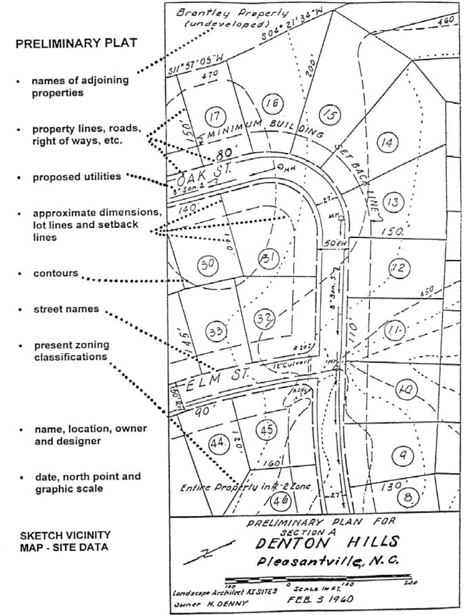
1110.02 - Preliminary plat application procedures and requirements.
(a)
Application for preliminary plat.
(1)
Following preliminary plat review of a proposed major subdivision and the payment of a fee in accordance with the current schedule approved by the Board of Commissioners for the Community Development Department, the subdivider shall submit to the Community Development Department at least 25 days prior to the next regularly scheduled meeting of the Planning Commission, the following:
a.
A letter requesting review and approval of a preliminary plat and giving the name and address of a person to whom the notice of the Planning Commission meeting to review the preliminary plat shall be sent.
b.
Thirteen copies of the preliminary plat and other related documents to be utilized by the following: Community Development, Planning Commission, Board of Commissioners, Water Department, Council of Fire Chiefs, EMS, EMA/911, Health Department, Public Works, Board of Education, Sheriff's Department. The 13th copy shall be returned to the subdivider or authorized agent with a notation of action taken by the Planning Commission.
(b)
Preliminary plat review procedures. Project Approval is granted upon review and approval of a Preliminary Subdivision Plat by the Planning Commission. Review of preliminary plat shall include the following:
(1)
The Planning Commission shall check the plat for conformance to this Development Code and shall hold a meeting to review the preliminary plat, notice of the time and place of which shall be sent to the Chairman of the Planning Commission or designated agent by regular mail to the person designated in the letter requesting preliminary plat review and approval, not less than ten days prior to the date of the meeting.
(2)
Thereafter, the Planning Commission shall give tentative approval or disapproval to the preliminary plat, including a statement of the reasons for disapproval if the preliminary plat is disapproved. one copy shall be returned to the subdivider or authorized agent and one copy added to the records of the Planning Commission.
(3)
Approval of a preliminary plat does not constitute approval of a final plat. It indicates only approval of the layout as a guide to the preparation of the final plat. Preliminary plat approval shall expire and be null and void after a period of one year or a period specified by the Planning Commission at the time of approval. The Planning Commission may grant extensions to the specified period of approval upon request of the subdivider or authorized agent.
(4)
If action on a preliminary plat is not taken by the Planning Commission within 65 days of the date of the public meeting to review the preliminary plat, it shall be considered approved and a certificate of approval shall be issued on demand. However, the applicant may waive this requirement and consent to an extension of time.
(c)
Preliminary plat specifications.
(1)
Scale. The preliminary plat shall be clearly and legibly drawn at a scale not smaller than 100 feet to one inch, unless a scale of 200 feet to one inch is approved by the Planning Commission at the time of the preapplication review.
(2)
Sheet Size. Sheet size shall not be less than 17 times 23 inches. If the complete plat cannot be shown on one sheet of this size, it may be shown on more than one sheet with an index map on a separate sheet of the same size.
(3)
Ground Elevations. The preliminary plat shall show ground elevations, based on the datum plane of the U.S. Coast and Geodetic Survey (or other approved datum plane) with contour lines at intervals of not more than five feet.
(4)
Preliminary Plat Specifications.
(5)
The preliminary plat shall contain the following information:
a.
Name and address of owner of record and of subdivider.
b.
Proposed name of subdivision and its acreage.
c.
North point and graphic scale and date.
d.
Vicinity map showing location and acreage of the subdivision.
e.
Exact boundary lines of the tract of bearings and distances.
f.
Names of owners of record of adjoining land.
g.
Existing streets, utilities, and easements on and adjacent to the tract.
h.
Proposed layout, including streets and alleys (to be reviewed by a registered engineer), with proposed street names, lot lines with approximate dimensions, easements, land to be reserved or dedicated for public uses, and any land to be used for purposes other than single-family dwellings.
i.
Block numbers and lot numbers.
j.
Provision for water supply, sewerage, and drainage (to be reviewed by the County sanitarian).
k.
Such street cross-sections and center-line profiles as may be required by the County.
l.
Floodplain boundaries, if applicable.
m.
Existing wetlands, as indicated on the Generalized Wetlands Map and/or the US Fish and Wildlife Service National Wetlands Inventory Map.
n.
Copy of covenants or deed restrictions as are intended to cover all or part of the subdivision, if such are proposed, shall accompany the plat. Homeowner's Association documents shall comply with Section 515 of Article 5 (Subdivisions and Planned Developments) of this Development Code.
(d)
Certificate of preliminary approval. A certificate of approval of the preliminary plat by the planning commission shall be inscribed on the plat as follows:
(1)
"Pursuant to the Land Subdivision Regulations of Harris County, Georgia, all the requirements of preliminary approval having been fulfilled, this preliminary plat was given preliminary approval by the Harris County Planning Commission on _______, 20___.
(2)
"This Preliminary Approval does not constitute approval of a Final Plat. This Certificate of Preliminary Approval shall expire and be null and void on _______, 20___.
1110.03 - Final plat application procedures and requirements.
(a)
Application for final plat. After the preliminary plat of a proposed land subdivision has been given tentative approval by the Planning Commission, the subdivider may, within the period specified for preliminary plat approval, submit to the Community Development Department, at least 15 days prior to the next regularly scheduled meeting of the Planning Commission, the following:
(1)
A letter requesting review and approval of a final plat and giving the name and address of the person to whom the notice of the Planning Commission meeting to review the final plat shall be sent.
(2)
Thirteen copies and two signed originals of the final plat and other related documents, as specified in Article 9. For final plats which do not require preliminary plat review, the subdivider must submit to the Community Development Department, at least 25 days prior to the next regularly scheduled meeting of the Planning Commission, all items required above.
(3)
A fee in accordance with the current fee schedule approved by the Board of Commissioners for the Community Development Department.
(b)
Final plat review procedures.
(1)
The Planning Commission shall check the final plat for conformance with the tentatively approved preliminary plat, and with the rules and regulations of this Development Code, and shall hold a meeting to review the final plat, notice of the time and place of which shall be sent by the Planning Commission or its agent by regular mail to the person designated in the letter requesting final plat review and approval, not less than ten days prior to the date of the hearing.
(2)
Thereafter, the Planning Commission shall approve or disapprove the final plat. A notation of the action shall be made on all copies of the final plat, including a statement of the reasons if the final plat is disapproved. If action is not taken by the Planning Commission within 65 days of the date of the public meeting to review the final plat, it shall be considered approved and a certificate of approval shall be issued on demand. However, the applicant for approval may waive this request and consent to an extension of time.
(3)
Upon approval of the final plat, it shall be recorded in the office of the Clerk of Superior Court of Harris County. The owner or applicant shall be responsible for the recording of such final plat in the office of the clerk of superior court.
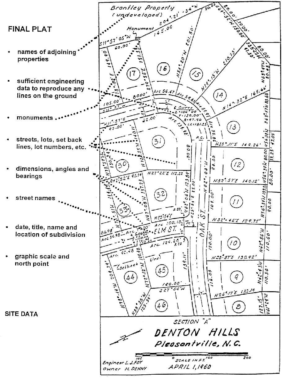
(c)
Final plat specifications.
(1)
General.
a.
The final plat shall conform to and meet the specifications of the preliminary plat. The final plat shall be clearly and legibly drawn.
b.
Sheet sizes shall be 17 inches times 23 inches and where more than one sheet is required an index map shall be required on the same size sheet.
(2)
The final plat shall show the following:
a.
Bearings and distances to the nearest existing street lines or benchmarks or other permanent monuments (not less than three) shall be accurately described on the plat.
b.
Municipal, county and land lot lines accurately tied to the lines of the subdivision by distances and angles when such lines traverse or are reasonably close to the subdivision.
c.
Exact boundary lines of the tract determined by a field survey.
d.
Name of subdivision, exact locations, widths, and names of all streets and alleys within and immediately adjoining the plat.
e.
Street centerlines showing angles of deflection, angles of intersection, radii, and lengths of tangents.
f.
Lot lines and building set back distances with dimensions to the nearest one-tenth foot and bearings to the nearest minute.
g.
Lots numbered in numerical order and blocks letter alphabetically.
h.
Location, dimensions, and purposes of all easements and all areas to be reserved or dedicated for public use.
i.
Accurate location, material and description of monuments and markers.
j.
House numbers at the center of each lot, measured and assigned in accordance with the Harris County numbering system.
k.
A statement, either directly on the plat or in an identified attached document, of any private covenants.
l.
The following certification:
1.
Placement of the surveyor's certification, directly on the final plat as follows:
"It is hereby certified that this Plat is true and correct and was prepared from an actual survey of the property by me or under my supervision; that all monuments shown hereon actually exist or are marked as 'future', and their location, size, type and material are correctly shown; and that all engineering requirements of the Land Subdivision Regulations of Harris County, Georgia, have been fully complied with."
By: ___________
Registered Georgia Land Surveyor
No. ___________
2.
An owner's certificate, directly on the final plat as follows:
Owner's Certification:
State of Georgia, Harris County
"The owner of the land shown on this Plat and whose name is subscribed hereto, in person or through a duly authorized agent, certifies that this plat was made from an actual survey, that all state, and county taxes or other assessments now due on this land have been paid."
Agent: ___________
Date: ___________
Owner: ___________
Date: ___________
3.
Certificate of dedication.
A certification by the owner setting forth the description of the areas and improvements he dedicates to the public and the extent of the title which he is dedicating should be attached to the final plat.
CERTIFICATE OF OWNERSHIP AND DEDICATION
"I (we) hereby certify that I (we) adopt this plan of subdivision, establish the minimum building setback lines, and dedicate all streets, alleys, walkways and other open spaces to public use as noted."
Date: ___________
Owner: ___________
Owner: ___________
4.
Certification of approval of water system, directly on the final plat in legible handwriting as follows:
"I hereby certify that the community or public water supply and distribution system installed or to be installed, and/or the plan for private water supplies in the subdivision plat attached hereto meet the requirements of the Health Department or Water Department."
Date: ___________
Health Department: ___________
Water Works Department: ___________
5.
Certification of sewer system, directly on the final plat as follows:
"I hereby certify that the community or public sewerage collection and disposal system installed or to be installed, and/or the plans for private sewage disposal system in the subdivision plat attached hereto meet the requirements of the Health Department. Lot Number(s): _______ is (are) not approved for private sewage disposal systems."
Date: ___________
Health Department: ___________
6.
Certification of approval of streets and drainage, directly on the Final Plat as follows:
"I hereby certify that the streets and drainage in this subdivision have been installed in an acceptable manner and meet all the requirements of the Land Subdivision Regulations of Harris County."
Date: ___________
X___________
Director of Public Works
7.
Certificate of approval for recording, directly on the final plat as follows:
"I hereby certify that the subdivision plat shown hereon has been found to comply with the Land Subdivision Regulations of Harris County and that it has been approved by the Harris County Planning Commission for recording in the office of the Clerk of Superior Court of Harris County, Georgia."
Date: ___________
X___________
Chairman, Harris County Planning Commission
X___________
Secretary, Harris County Planning Commission
1111.01 - Concept master plan.
(a)
A concept master plan shall be submitted at the time of a rezoning request for all Planned Unit Development (PUD) type projects. If the zoning of subject property is appropriate, only a concept plan is required.
(b)
An applicant shall file, together with the prescribed application and fee, a concept plan reflecting at a minimum, the following:
(1)
The boundaries of the entire tract or parcel.
(2)
Generalized location of existing and proposed external roads and adjacent land use and development.
(3)
Generalized location and description of various internal proposed land use components, including information as to proposed densities and intensities, proposed size and heights of the development.
(4)
Generalized location and description of proposed roads, proposed dedicated open spaces, and perimeter buffer areas.
(5)
Proposed phasing of the development.
(6)
An illustrative plan providing for the physical layout of the entire development including all streets, lots, parcels, and open space types.
(c)
During the concept plan approval phase, the Community Development Director and developer will review plans to determine if minimum standards are met prior to the Planning Commission review.
1111.02 - Preliminary development plan.
Any person, firm, company or other business entity applying for a zoning amendment to establish a planned unit development shall submit a preliminary development plan, along with the appropriate applications and fees, to the Community Development Department, consisting of:
(a)
A site plan showing:
(1)
The direction of north, appropriate scale, and topography.
(2)
The location of subject property in relation to the entire county.
(3)
The uses of the properties adjacent to the site.
(4)
The proposed uses and densities planned for the site.
(5)
The access to, and traffic circulation within, the site.
(b)
A proposed development schedule for the project.
(c)
The project shall be located in an area for which public facilities and services are available and adequate for the uses proposed; provided, however, that the applicant may provide such facilities which are not presently available, and written assurances of such provision shall be included as part of the preliminary development plan which is submitted.
(d)
The Planning Commission and Board of Commissioners shall review and act on the proposed zoning request and on any amendment to an approved preliminary development plan in accordance with the requirements of this Development Code.
1111.03 - Final development plan.
Prior to the removal of natural vegetation, restructuring of the land, or construction of any improvements, an approved final development plan is required. A final development plan, which shall be consistent with the preliminary development plan, shall be submitted to the Community Development Department, and shall contain:
(a)
A site plan showing:
(1)
The direction of north, appropriate scale, and topography in not greater than the intervals required under the Erosion and Sedimentation Act [of 1975] (O.C.G.A. § 12-7-1 et seq.) and listed in the "Manual for Erosion and Sediment Control in Georgia."
(2)
The proposed location and height of all structures.
(3)
The use of all land and structures.
(4)
The location and use of structures adjacent to the site.
(5)
The location and dimensions of street, common driveways and walkways pertinent to the site.
(6)
The location of service and loading areas and spaces.
(7)
The location, size, number, and character of all exterior signs and lighting.
(8)
The location, character, and extent of vegetative landscaping, retaining and screening walls, and other treatments for the protection of adjoining properties.
(9)
The facilities for stormwater drainage and control.
(10)
The location and character of all public improvements including utilities.
(b)
A copy of any deed restrictions to be recorded.
(c)
A comprehensive impact analysis indicating the probable effect of the planned development on the County school system, emergency services (fire, law enforcement, EMS) and any probable impact on existing traffic patterns and capacities of adjacent roads/streets in the immediate area. Such analysis shall be prepared by a professional civil engineer, registered in the State of Georgia, or other individual whose profession lends itself to adequate analysis.
(1)
If land disturbance permits have not been applied for five years after the final approval date of the final development plan, the impact analysis shall be updated and resubmitted to the Community Development Director to include analysis with current data.
(d)
A development schedule indicating the appropriate date when construction of the project, or stage thereof, can be expected to begin and be completed.
(e)
Any other information necessary to establish compliance with this and other ordinances of the availability of adequate utility compliance.
(f)
A detailed fire protection plan indicating the location and size of all existing and proposed fire mains, fire hydrants, and fire access lanes, as well as a description of all fire protection measures and devices for structures.
(g)
The public improvements included in the final development plan shall be consistent with this Development Code, and compliance with all applicable regulations shall be reviewed as part of the final development process.
(h)
The applicant shall provide for and establish an organization or other legal entity for the control and maintenance of any common property designated on the final development plan. Such entity shall be created by covenants running with the land, and such covenants shall be included as part of the final development plans and subject to approval by the board of commissioners.
1111.04 - Final development plan review.
(a)
Upon receipt of an applicant's final development plan, the Community Development Department shall transmit a copy of the plan to the appropriate departments and agencies for review, report, and recommendation.
(b)
Such officials and agencies shall each, within 30 days from receiving the plan and documentation, furnish the Community Development Department a report pertinent to their respective jurisdictional concerns.
(c)
Upon receipt of the various review comments, the department community development shall schedule the development plan for review at the next available scheduled meeting of the Planning Commission.
(d)
The Planning Commission shall review the applicant's final development plan, and within 30 days of their review shall also prepare and forward their written report and recommendation on the final development plan to the Board of Commissioners of approval or disapproval at the next available scheduled meeting of the Board of Commissioners.
1111.05 - Application for preliminary plat and final plat approval.
After the concept master plan and rezoning request has been recommended for approval by the Planning Commission and approved by the Board of Commissioners or, if the existing zoning is appropriate, preliminary and final plat procedures as provided in this Development Code shall apply.
1111.06 - Amending a final development plan.
(a)
The final development plan may be amended by the Board of Commissioners, provided the procedure specified in the previous section for review and approval is followed.
(b)
Minor changes in the locating, siting, or character of buildings and structures as shown on the final development plan may be authorized by the Community Development Director.
(c)
No change authorized by the Community Development Director under this section may increase the size of any building or structure by more than 10%, nor change the location of any building or structure by more than ten feet in any direction; provided, notwithstanding anything in the foregoing, the Community Development Director may not permit change beyond the minimum or maximum requirements set forth in this ordinance.
(d)
All other changes in the final development plan, including changes in the site plan and in the development schedule, must be made under the procedures that are applicable to the initial approval of a final development plan.
1112.01 - Conceptual master plan.
(a)
Any person, firm, company or other business entity applying for a zoning amendment to establish a CUPD shall along with the zoning application submit a conceptual master plan, along with the appropriate applications and fees, to the Community Development Department, consisting of:
(1)
A site plan showing:
a.
The direction of north, appropriate scale and topography.
b.
The location of subject property in relation to the entire county.
c.
The uses of property adjacent to the site.
d.
The proposed uses and densities planned for the site.
e.
The access to the site and general traffic circulation therein.
f.
Buffers adjacent to the property not subject to the CUPD.
(b)
Impact Analysis. A comprehensive impact analysis indicating the probable effect of the CUPD on the County school system, emergency services (fire, police, EMS) and any probable impact on existing traffic patterns and capacities of adjacent roads/streets in the immediate area. Such analysis shall be prepared by a professional civil engineer, registered in the State of Georgia, or other individual whose profession lends itself to adequate analysis.
(1)
If land disturbance permits have not been applied for five years after the final approval date of the final development plan, the impact analysis shall be updated and resubmitted to the Community Development Director to include analysis with current data.
(c)
Public utilities. The project shall be located in an area for which public facilities and services are available and adequate for the uses that are proposed; provided, however, that the applicant may provide such facilities which are not presently available, and written assurances of such provision shall be included as a part of the conceptual master plan which is submitted.
1112.02 - Rezoning and conceptual master plan review procedures.
(a)
The Planning Commission and Board of Commissioners shall review and act on the proposed zoning request for a CUPD and the conceptual master plan in accordance with the Development Code.
(b)
Upon the approval by the Board of Commissioners of the uses and densities contained in a conceptual master plan, and any buffers within the CUPD adjacent to property not subject to the CUPD, said densities shall not be exceeded, new uses introduced or buffer requirements reduced unless an amendment to the CUPD has been approved by the Planning Commission and Board of Commissioners to:
(1)
Permit additional uses at specified densities.
(2)
Increase the densities of already permitted use; and/or as the case may be.
(3)
Reduce the buffers requirements for property within the CUPD that is adjacent to property not subject to the CUPD. Except for the above, applicant shall have the right to modify the conceptual master plan approved by the Board of Commissioners, including the right to transfer or shift permitted uses and densities to different locations within the CUPD so long as the overall level of development yields of the approved plan are not exceeded.
1112.03 - Final development plan requirements.
Prior to removal of natural vegetation, restructuring of land, or construction of any improvements, an approved final development plan is required. All final development plans for that portion of the CUPD where development activities will be occurring shall be submitted to the Community Development Department for review and approval by the Community Development Director, and shall contain:
(a)
A site plan showing:
(1)
The direction of north, appropriate scale, and topography in not greater than the intervals required under the Georgia Erosion and Sedimentation Act (O.C.G.A. § 12-7-1 et seq.) and listed in the "Manual for Erosion and Sediment Control in Georgia."
(2)
The proposed location and height of all structures.
(3)
The use of all land and structures.
(4)
The location and use of structures adjacent to the site.
(5)
The location and dimensions of streets, common driveways and walkways pertinent to the site.
(6)
The location of service and loading areas and spaces.
(7)
The location, size, number and character of all exterior signs and lighting.
(8)
The location, character, and extent of existing vegetation landscaping, retaining and screening walls, and other treatment for the protection of adjoining properties.
(9)
The facilities for stormwater drainage and control.
(10)
The location and character of all public improvements including utilities.
(11)
The densities for that portion of the CUPD, provided, however, that nothing herein shall require the densities of uses for any portion of the CUPD to be equal to or less than the approved densities for that use within the CUPD as a whole, provided, however, that the overall densities for that use within the CUPD have not been exceeded.
(b)
An estimated development schedule indicating the approximate date when construction of the project, can be expected to begin and be completed and details on the proposed phasing plan by land use.
(c)
Any other information necessary to establish compliance with this and other ordinances of the availability of adequate utility capacity.
(d)
A detailed fire protection plan indicating the location and size of all existing and proposed fire mains, fire hydrants, and fire access lanes, as well as a description of all fire protection measures and devices for structures.
(e)
The public improvements included in the final development plan shall be consistent with this Development Code. In the event there is conflict with other sections of the Development Code, and these CUPD District Regulations, these district regulations shall control.
1112.04 - Final development plan review.
(a)
Upon receipt of an applicant's final development plan for that portion of the CUPD where development activities will be occurring, the Community Development Department shall within 30 days from the submission of the final development plan review and approve the same if it is in compliance with the above-referenced requirements for a final development plan.
(b)
If the final development plan is not in compliance with these requirements, the Community Development Department shall within the same time frame notify the applicant in writing of the exact nature of the deficiencies. Upon said deficiencies being corrected by applicant, the department shall within ten days of that date approve the final development plan. Upon the approval of the final development plan, the applicant may commence with the development activities on that portion of the CUPD for which a final development plan has been approved.
1112.05 - Amendment to final development plan.
(a)
Amendments to the final development plan shall be submitted, reviewed and approved in the same manner as the initial final development plan.
(b)
An owner of property within a CUPD may only have the right to seek to amend that portion of the CUPD owned by said owner.
1115.01 - Application requirements.
In addition to the requirements listed in Section 1106.02 The following must be provided when applying for a special use permit to allow for agritourism uses on a property:
(a)
A list and description of proposed uses, potential future uses, proposed uses within the agritourism property or development must be compatible with intent of Section 309 of Article 3 and must be approved by the Board of Commissioners.
(b)
Description of business operations related to proposed agritourism uses (i.e., how proposed use(s) relate to working farm on which they are to be located.)
(c)
Conceptual site plan required. A conceptual site plan shall be submitted in accordance with Section 1106.02(b) and shall depict all business operations related to the proposed agritourism uses.
1115.02 - Minor amendments.
(a)
Minor changes in the approved conceptual plan or proposed list of uses may be authorized by the Planning Commission, provided such changes are compatible with the original special use approval and any conditions of approval and do not go beyond the minimum or maximum requirements of the approved plan or of this Development Code. Alternatively, upon reviewing these minor changes, the Planning Commission may send the application to the Board of Commissioners as per the regular review process for special use permit approval.
(b)
The Community Development Director shall consider the standards in Section 1205 of Article 12 (Administration and Enforcement) of this Development Code.
(Ord. No. 05-23, 12-5-2023)
Sec. 1116.- General requirements/authorization required for land disturbance or development activities.
Persons seeking to undertake land-disturbing activity (as defined in this Development Code) shall not commence or proceed until development construction plans are approved by the Community Development Director or designee, and a land disturbance permit is issued by the Community Development Department. The process for approval of a land disturbance permit for site development is presented in this Division. If any portion of the property to be developed contains a flood hazard area (the 100-year flood plain), a floodplain management approval shall also be required and will be issued as part of the land disturbance permit. In addition, other permits as described in this Article may also be required as part of a development construction approval.
1118.01 - General requirements.
(a)
Required. A development permit shall be required in conformance with the provisions of this article prior to the commencement of any development activities.
(b)
Permit procedures. Application for a development permit shall be made to the Community Development Department on forms furnished by the Department prior to any development activities, and may include, but not be limited to the following: plans in duplicate drawn to scale showing the elevations of the area in question and the nature, location, dimensions, of existing or proposed structures, earthen fill placement, storage of materials or equipment, and drainage facilities.
1118.02 - Development permit application requirements.
(a)
Depiction of elevation in relation to mean sea level (or highest adjacent grade) of the lowest floor, including basement, of all proposed structures.
(b)
Depiction of elevation in relation to mean sea level to which any non-residential structure will be flood-proofed.
(c)
Design certification from a registered professional engineer or architect that any proposed non-residential floodproofed structure will meet the floodproofing criteria of Section 831.02(b).
(d)
Description of the extent to which any watercourse will be altered or relocated as a result of a proposed development.
1118.03 - Construction stage submittal requirements.
(a)
Certification required.
(1)
For all new construction and substantial improvements, the permit holder shall provide to the administrator an as-built certification of the regulatory floor elevation or floodproofing level immediately after the lowest floor or floodproofing is completed.
(2)
Any lowest floor certification made relative to mean sea level shall be prepared by or under the direct supervision of a registered land surveyor or professional engineer and certified by same.
(3)
When floodproofing is utilized for non-residential structures, said certification shall be prepared by or under the direct supervision of a professional engineer or architect and certified by same.
(b)
Review of certification data.
(1)
The Community Development Director shall review the above referenced certification data submitted.
(2)
Deficiencies detected by such review shall be corrected by the permit holder immediately and prior to further progressive work being allowed to proceed.
(3)
Failure to submit certification or failure to make said corrections required hereby, shall be caused to issue a stop work order for the project.
1119.01 - Responsibility for development actions.
(a)
No person shall conduct any land-disturbing activity, including grading, clearing and grubbing, tree clearance, land development or project construction without first obtaining a land disturbance permit from the Community Development Department to perform such activity.
(b)
Any person proposing development shall first submit to the Community Development Department an application for a land disturbance permit for site development, including all construction plans required by this Development Code. The application must be authorized by the property owner.
(c)
The Community Development Department is responsible for administering the review and approval process for issuance of land disturbance permits. The Community Development Department shall forward a copy of the permit application, including the construction plans for the project, to other County department heads, the Soil and Water Conservation Commission District, the GDOT or others as appropriate, for their review and comment. The Community Development Department shall provide all comments to the applicant for resolution. The Community Development Director or designee shall issue the land disturbance permit when all requirements of this Development Code and other agencies are met.
(d)
Approval of plans by the appropriate department or agency shall not imply or transfer acceptance of responsibility for the application of the principles of engineering, architecture, landscape architecture or any other profession, from the design professional under whose hand or supervision the plans were prepared.
(e)
The completion of inspections and authorization for work continuation shall not transfer responsibility for the quality of the work performed or materials used from the owner, nor imply or transfer acceptance of responsibility for project design or engineering from the design professional under whose hand or supervision the plans were prepared.
(f)
No permit shall be interpreted to relieve any owner of the responsibility of maintaining full compliance with all applicable codes, ordinances and other regulations. Any land disturbance permit issued in error or in contradiction to the provisions of this Development Code shall be considered to have been null and void upon its issuance.
(g)
Liability.
(1)
The approval of an erosion and sedimentation control plan or other plans under the provisions of this Development Code, the issuance of a land disturbance permit, or the compliance with any other provisions of this Development Code shall not relieve any person from the responsibility for damage to any person or property otherwise imposed by law nor impose any liability upon the Board of Commissioners or the Soil and Water Conservation District for damage to any person or property.
(2)
The fact that any activity for which a land disturbance permit has been issued results in injury to the property of another shall neither constitute proof of, nor create a presumption of, a violation of the standards provided for in this Development Code or the terms of the land disturbance permit.
1119.02 - Development activities authorized.
A land disturbance permit shall be issued to authorize site development activities associated with development activity regulated by this Development Code, including, but not limited to, clearing and grubbing, grading and the construction of such improvements as streets, surface parking areas and drives, storm water drainage facilities, sidewalks, water or sewerage utilities, or other structures permanently placed on or in the property except for buildings, signs, or other structures requiring the issuance of a building permit.
1119.03 - Floodplain management requirements.
If development or construction is proposed within or affecting an area of special flood hazard, approval of a land disturbance permit shall be dependent on compliance with the Provisions for Flood Hazard Reduction in Article 8 and Article 10 of this Development Code.
1119.04 - Process for approval of land disturbance permit.
An application for a land disturbance permit may proceed simultaneously with an application for project approval of a preliminary subdivision plat or site plan but may not be issued prior to approval of such plat or plan by the Community Development Department.
(a)
The application for a land disturbance permit shall be submitted to the Community Development Department and must include the following:
(1)
Application on the form furnished by the Community Development Department, requesting review for issuance of a land disturbance permit.
(2)
Copies in the number required by the Community Development Director of:
a.
The preliminary plat or preliminary site plan requesting or reflecting project approval by the Community Development Director or designee.
b.
The construction plans prepared in conformance with the specifications and standards in this Development Code under Section 1120, below.
c.
The hydrology study.
(3)
Payment of any land disturbance permit fee, as established from time to time by the Board of Commissioners.
(b)
The application will be checked for completeness within five work days of its submission. Incomplete applications will be returned to the applicant, who shall have three work days in which to resubmit the application complete in all respects.
(c)
Upon acceptance of a land disturbance permit application, the Community Development Director shall:
(1)
Refer the soil erosion and sedimentation control plan to the Soil & Water Conservation District for their review and approval or disapproval concerning the adequacy of the erosion and sedimentation control plan. No land disturbance permit will be issued unless the plan has been approved by the District and the Community Development Department, and any variances and bonding, if required, have been obtained.
(2)
Refer the grading plan, the stormwater management plan, the floodplain management/flood damage prevention plan (if any), and the street improvements plan to the Community Development Department for its review and approval or disapproval. No land disturbance permit will be issued unless the plans have been approved by the Community Development Department.
(3)
Refer the water and sewerage public utility plans to the Community Development Department for its review and approval or disapproval.
(4)
Refer the on-site septic system plans to the Health Department for its review and approval or disapproval.
(d)
The applicant may be required by the Community Development Director to secure development approval from other agencies if they are affected by the development. development approval may be required from but not limited to:
(1)
Harris County Volunteer Fire Department
(2)
State Fire Marshal.
(3)
Georgia Department of Transportation.
(4)
Georgia Department of Natural Resources.
(5)
U.S. Army Corps of Engineers.
(6)
U.S. Environmental Protection Agency.
(e)
Upon receipt of comments from other departments and agencies, and upon review by the applicable County departments, the Community Development Director or designee will indicate on one or more copies of the development construction plans or in writing all comments related to compliance with this Development Code, conditions of zoning approval, and other regulations or ordinances, as appropriate.
(f)
The Community Development Director or designee will forward all comments to the applicant.
(g)
Approval, denial or comments, if any, shall be provided to the applicant as soon as practical, but in no case more than 90 days from receipt of a complete application for a land disturbance permit.
(h)
The applicant will be responsible for compliance with all codes, regulations and zoning requirements and for the satisfaction of all of the comments received. The owner will also be responsible for obtaining approval from all other agencies affected by the project.
(i)
No land disturbance permit will be issued unless the applicant provides a statement by the County Tax Commissioner's office certifying that all ad valorem taxes levied against the property and due and owing have been paid.
1119.05 - Issuance of land disturbance permit.
(a)
Following satisfaction of all comments, receipt of approvals from all affected agencies and receipt of all required bonds, a final set of development construction plans shall be submitted to the Community Development Department. Upon certification from the Community Development Director that all issues have been resolved, the Community Development Director shall issue a land disturbance permit authorizing development activities to begin based on the approved final development construction plans.
(b)
If the tract is to be developed in phases, then a separate permit shall be required for each phase.
(c)
Additional provisions regarding permits are found in Article 8 and Article 10 of this Development Code.
1119.06 - Expiration of land disturbance permit.
(a)
A land disturbance permit shall expire if the development activity described in the permit is not begun within one year from the date of issuance or if such activity is suspended for 12 months. Written notice of pending expiration of the land disturbance permit may be issued by the Community Development Department.
(b)
Any change or amendment of design and construction plans for the project that may materially impact or negate the permit based on original approval of the plan shall require a permit amendment. All such amendments shall be applied for in writing and follow the same procedure for approval as original applications for a land disturbance permit, subject to the requirements of this Development Code applicable as of the date of application of such amendment.
1120.01 - General requirements: development construction plans.
Upon approval of a preliminary plat or preliminary site plan:
(a)
The owner shall obtain an engineering layout and profile of all proposed streets, utilities, storm drainage and other improvements for the development prepared by a Licensed Professional Engineer, Landscape Architect, or Land Surveyor.
(b)
Any utility system design must be performed by a Licensed Professional Engineer.
(c)
Said development construction plans shall include topographic data, existing and proposed contours, all signs and other required improvements specified in this Development Code.
(d)
No grading or clearing for construction of streets, utilities, storm drainage or other improvements shall commence until after written approval of the soil erosion and sediment control plan required by the Soil Erosion and Sedimentation Control regulations of Article 10 of this Development Code and provided that project engineering layout and road profiles have been approved by the Community Development Department who shall distribute the same to the applicable County departments for review, comment and subsequent correction by the developer before construction.
(e)
The development construction plans for a project shall conform in all respects with the requirements of this Development Code and shall include each of the plans in this Section as appropriate to the project. These include but are not limited to:
(1)
Erosion and Sedimentation Control Plan;
(2)
Grading Plan;
(3)
Stormwater Management Plan;
(4)
Street Improvement Plan;
(5)
Site Landscaping Plans;
(6)
Public Utility Plans;
(7)
On-site Septic System Plans; and
(8)
Lighting Plans and/or any other required plans.
(f)
All development construction plans and supporting studies shall be prepared by or under the supervision of a professional engineer or landscape architect registered in the State of Georgia, provided, however, that nothing in this Section shall prohibit a Georgia licensed design professional from providing services in a manner consistent with State regulations governing said design professionals.
(g)
The plans shall be drawn on standard size sheets as determined by the Community Development Department.
(h)
One copy of approved development construction plans must be at the job site when work is in progress.
1120.02 - Erosion and sedimentation control plan.
The application and plan requirements for erosion and sedimentation control plans are found in Article 10 of this Development Code.
1120.03 - Grading plan.
The grading plan may be combined with the erosion and sedimentation control plan if possible, to maintain plan clarity.
(a)
Grading plans shall identify existing and planned topographic contours as required for erosion and sedimentation control plans.
(b)
Grading plans shall include a Wetlands Certification indicating whether or not wetlands are located on the property. The design professional that prepared the grading plans shall add a statement to the grading plan sheet indicating whether or not wetlands are located on the property by checking the appropriate box. The Wetlands Certification shall read as follows:
(1)
Wetlands certification: The design professional whose seal appears herein certifies the following: 1) the US Fish and Wildlife Services National Wetlands Inventory (NWI) Wetlands Map and the Wetlands Protection Map (Comprehensive Plan) have been consulted; 2) the appropriate plan sheet does/does not (choose one) indicate wetlands as shown on the map or as determined by a certified wetlands delineator; and 3) if wetlands are indicated the landowner or developer has been advised that land disturbance of protected wetlands shall not occur unless the appropriate Section 404 Permit or Letter of Permission has been obtained from the US Army Corps of Engineers for jurisdictional wetlands, or approval has been obtained from Harris County to disturb other (non-jurisdictional) wetlands.
(c)
If the property contains any area of special flood hazard (the 100-year flood plain), grading plans in and around the flood plain shall be designed in conformance to all requirements relating to Flood Damage Prevention under Article 10 of this Development Code.
(d)
Grading plans shall outline any area that is required to remain undisturbed, such as a natural zoning buffer, stream buffer or wetland (see the landscaping and buffers standards in Article 4 and the Environmental Protection standards in Article 8 of this Development Code) and shall identify, describe and illustrate the protective fencing and signage to be placed surrounding such areas, along with notes regarding protection of undisturbed areas that shall read as follows:
(1)
Undisturbed area notes:
a.
All protection devices for undisturbed areas must be installed and inspected prior to clearing, grubbing or grading. Call the Community Development Department for an inspection.
b.
Tree protection shall be strongly enforced. No activities of any kind are to be allowed within any area shown to be undisturbed on this plan.
c.
The retention and planting of trees as shown on this plan must be verified prior to issuance of a Certificate of Occupancy or acceptance of the project by the Community Development Department. Call the Community Development Department for an inspection.
1120.04 - Stormwater management plan.
The application and plan requirements for stormwater management plans are found in the Erosion Control and Stormwater Management Article of this Development Code.
1120.05 - Street improvement plan.
(a)
Center line profiles and typical street sections of all proposed streets shall be required. Profiles shall be drawn on standard plan and profile sheets with plan sections showing street layout, pavement and right-of-way width, curvature, and required drainage facilities. Typical street sections shall be provided for street widening.
(b)
Where sanitary sewer or stormwater sewers are to be installed within a street, the grade, size, location, class of pipe and bedding type, and the location and invert elevation of manholes shall be indicated on the road profile.
(c)
Center line profiles covering streets that are extensions of existing streets shall include elevations at 50-foot intervals for such distance as may be adequate to provide continuity consistent with the standards required by this Development Code for street improvements, but no less than 100-foot intervals.
(d)
All plan elevations shall be coordinated and sited into any U.S. Coast and Geodetic Survey or GDOT benchmarks within one,200 feet of the street, or into reference monuments established by the Federal Emergency Management Agency.
(e)
A street striping plan, showing striping in accordance with the Manual on Uniform Traffic Control Devices, latest edition as published by the Federal Highway Administration, shall be prepared for any street newly constructed or widened to four or more lanes.
1120.06 - Site landscaping plans.
All proposed landscaping as required by this Development Code for parking lot landscape areas and parking lot trees; in zoning buffers; and trees and other landscaping to be retained or planted as required by the provisions of this Development Code or conditions of zoning approval, shall be illustrated on plans as described in this Section. The plans may be consolidated as one Site Landscaping Plan if the information can be clearly shown.
(a)
General requirements for all landscaping and buffer plans.
(1)
Landscaping and buffer plans should be drawn at a scale of between one inch = 20 feet and one inch = 50 feet, or as needed to clearly illustrate the proposed plantings. Multiple sheets keyed to an index sheet may be used.
(2)
Each plan sheet is to indicate:
a.
The name of the development and its acreage.
b.
Name, address, telephone and fax numbers of the property owner and subdivider or developer.
c.
Name, address, telephone, e-mail address, and fax numbers of the applicant.
d.
Name, address, telephone and fax numbers of the individual or company responsible for the design. The name, registration number and seal of the landscape architect under whom the plan was prepared shall be stamped on the plan and signed.
e.
Date of survey, north point and graphic scale, source of datum, date of plan drawing, and revision dates, as appropriate.
(3)
The location and size of all underground or aboveground utilities on the site, including the limits of any public or private utility easements and stormwater detention areas, are to be shown.
(4)
The standards and requirements for the quality and type of plant materials and their installation and maintenance are contained in Article 4 of this Development Code are to be indicated.
(b)
Landscape plan requirements. Landscaping plans must include the following, as appropriate to the landscaping requirements of this Development Code:
(1)
The location of all existing and proposed streets, sidewalks, parking lots and other paved surfaces.
(2)
The footprint of all existing and proposed structures.
(3)
The boundaries of all natural/undisturbed/landscaped zoning buffers, stream buffers, and other areas required to remain undisturbed along with description of protective fencing and signage requirements.
(4)
The boundaries of each landscape area required by this Development Code or conditions of zoning approval.
(5)
A planting plan showing location, size, common name and Latin name of proposed plant materials in required landscaping areas, as required by this Development Code, or as required by conditions of zoning approval. Existing plant materials that are intended to be retained and contribute to meeting requirements shall also be shown and clearly indicated.
(c)
Buffer plan. A buffer plan shall be prepared for any natural/undisturbed/landscaped or structural zoning buffer required in accordance with the specifications and standards contained in this Development Code or conditions of zoning approval. The buffer plan shall show:
(1)
The boundaries of each required zoning buffer area.
(2)
The location and size of all underground or aboveground utilities on the site, including the limits of any public or private utility easements and stormwater detention areas.
(3)
Methods to be employed to protect the drip line areas of trees in natural zoning buffers from disturbance during construction.
(4)
Proposed plantings intended to achieve and/or maintain an opaque visual buffer.
(5)
Proposed locations and construction details for any structural buffer that may be proposed, including fences, walls and earthen berms.
1120.07 - Public utility plans.
(a)
A domestic water supply plan shall be provided if connection to a public water system is proposed or required, and shall depict all water system improvements, water mains, fire hydrants, valves and other appurtenances and information as required by the Water Works Department.
(b)
A sewage disposal plan shall be provided if connection to a public sewer system is proposed, and shall depict all sanitary sewer infrastructure, including profiles of all mains and outfalls, lift station and force main details, typical manhole construction details, and other information as may be required by the Water Works Department.
1120.08 - On-site septic system plans.
For projects approved to be served by on-site sewage disposal systems, all plans and data required by the Health Department shall be submitted to and approved by the Health Department.
Sec. 1121. - Digital submission requirements: As-built data and final plans.
In addition to the requirements of this Development Code for the submission of printed copies, as-built data drawings and all final plats approved for recordation shall be submitted to the Community Development Director in a digital format as follows:
(a)
Digital drawing files shall be submitted in AutoCAD DWG or DXF format and shall include:
(1)
Final plat as approved.
(2)
Model space drawing of the engineering plans, reflecting any changes approved by the Community Development Department.
(b)
The DXF or DWG file shall have data divided into the following distinct and separate layers:
(1)
Parcel Lines (PL).
(2)
Right-of-Way (ROW).
(3)
Boundary (BL).
(4)
Water Lines (WL), when available.
(5)
Sewer Lines (SL), when available.
(6)
Electrical Lines (EL), when available.
(7)
GPS Monuments, when required or available.
(c)
In engineering plans, line and arc data must be unbroken where appropriate, such as no breaks in intersecting lot lines at corner pins and no breaks in utility lines.
(d)
The projection shall be in Georgia State Plane West Coordinate System North American Datum 1983.
(e)
Control shall be indicated.
(f)
Such additional information or requirements as may be established by the Community Development Director or designee necessary to convert the DXF or DWG file to ArcGIS format.
1122.01 - General.
(a)
The property owners, developer and designated planners and engineers shall design and review before submittal the general development plans.
(b)
The local issuing authority shall review the tract to be developed and the area surrounding it. They shall consult this Development Code and any other ordinances, rules, regulations or permits, which regulate the development of land within the jurisdictional boundaries of the County.
(c)
The owner and/or operator are the only parties who may obtain a permit.
1122.02 - Application requirements.
(a)
No person shall conduct any land-disturbing activity within the jurisdictional boundaries of Harris County without first obtaining a permit from the Community Development Department to perform such activity and providing a copy of the NOI submitted to EPD if applicable.
(b)
The application for a permit shall be submitted to the Community Development Department and must include the applicant's erosion, sedimentation and pollution control plan with supporting data, as necessary. Said plans shall include, as a minimum, the data specified in Section 1122.03of this article. Erosion, sedimentation and pollution control plans, together with supporting data, must demonstrate affirmatively that the land disturbing activity proposed to be carried out in such a manner that the provisions of Sections 1005.02 and 1005.03 of this Article will be met. Applications for a permit will not be accepted unless accompanied by three copies of the applicant's erosion, sedimentation and pollution control plans. All applications shall contain a certification stating that the plan preparer or the designee thereof visited the site prior to creation of the plan in accordance with EPD Rule 391-3-7-.10.
(c)
A permit fee in the amount indicated on the Fee Schedule approved by the Board of Commissioners shall be charged for application.
(d)
In addition to the foregoing permitting fees, fees will also be assessed pursuant to O.C.G.A. § 12-5-23(a)(5), provided that such fees shall not exceed the dollar amount per acre of land-disturbing activity, as approved by DNR/EPD, and these fees shall be calculated and paid by the primary permittee as defined in the state general permit for each acre of land-disturbing activity included in the planned development or each phase of development. All applicable fees shall be paid prior to issuance of the land disturbance permit. In a jurisdiction that is certified pursuant to O.C.G.A. § 12-7-8(a) half of such fees levied shall be submitted to the division; except that any and all fees due from an entity which is required to give notice pursuant to O.C.G.A. § 12-7-17(9) or (10) shall be submitted in full to the division, regardless of the existence of a local issuing authority in the jurisdiction.
(e)
Immediately upon receipt of an application and plan for a permit, the local issuing authority shall refer the application and plan to the district for its review and approval or disapproval concerning the adequacy of the erosion, sedimentation and pollution control pan. The district shall approve or disapprove a plan with 35 days of receipt. Failure of the district to act within 35 days shall be considered an approval of the pending plan. The results of the district review shall be forwarded to the local issuing authority. No permit will be issued unless the plan has been approved by the district, and any variances required by Section 1005.03(o) of this Article have been obtained, all fees have been paid, and bonding, if required as per Section 1006.02(g) of this article, have been obtained. Such review will not be required if the local issuing authority and the district have entered into an agreement which allows the local issuing authority to conduct such review and approval of the plan without referring the application and plan to the district. The local issuing authority with plan review authority shall approve or disapprove a revised plan submittal within 35 days of receipt. Failure of the local issuing authority with plan review authority to act within 35 days shall be considered an approval of the revised plan submittal.
(f)
If a permit applicant has had two or more violations of previous permits, this article section, or the Erosion and Sedimentation Act, as amended, within three years prior to the date of filing of the application under consideration, the local issuing authority may deny the permit application.
(g)
A permit applicant is required to post a bond in the form of government security, cash, irrevocable letter of credit, or any combination thereof up to, but not exceeding, the dollar amount per acre or fraction thereof of the proposed land-disturbing activity, as approved by DNR/EPD, prior to issuing the permit. If the applicant does not comply with this article or with the conditions of the permit after issuance, the local issuing authority may call the bond or any part thereof to be forfeited and may use the proceeds to hire a contractor to stabilize the site of the land-disturbing activity and bring it into compliance. These provisions shall not apply unless there is in effect an ordinance or statute specifically providing for hearing and judicial review of any determination or order of the local issuing authority with respect to alleged permit violations.
1122.03 - Plan requirements.
(a)
Plans must be prepared to meet the minimum requirements as contained in Section 1005.02 and 1005.03 of this Article; or through the use of more stringent, alternate design criteria which conform to sound conservation and engineering practices. The Manual for Erosion and Sediment Control in Georgia is hereby incorporated by reference into this Article. The plan for the land-disturbing activity shall consider the interrelationship of the soil types, geological and hydrological characteristics, topography, watershed, vegetation, proposed permanent structures including roadways, constructed waterways, sediment control and storm water management facilities, local ordinances and state laws. Maps, drawings and supportive computations shall bear the signature and seal of the certified design professional. Persons involved in land development design, review, permitting, construction, monitoring, or inspections or any land disturbing activity shall meet the education and training certification requirements, dependent on his or her level of involvement with the process, as developed by the commission and in consultation with the division and the stakeholder advisory board created pursuant to O.C.G.A. § 12-7-20.
(b)
Data required for site plan shall include all the information required from the appropriate erosion, sedimentation and pollution control plan review checklist established by the commission as of January 1 of the year in which the land-disturbing activity was permitted.
1122.04 - Permits.
(a)
Permits shall be issued or denied as soon as practicable but, in any event, not later than 45 days after receipt by the local issuing authority of a completed application, providing variances and bonding are obtained, where necessary and all applicable fees have been paid prior to permit issuance. The permit may include conditions under which the activity may be undertaken.
(b)
No permit shall be issued by the local issuing authority unless the erosion, sedimentation and pollution control plan has been approved by the district and the local issuing authority has affirmatively determined that the plan is in compliance with this Article, any variances required by Section 1005.03(o) of this Article are obtained, bonding requirements, if necessary, as per Section 1006.02(g) of this Article are met and all ordinances and rules and regulations in effect within the jurisdictional boundaries of the local issuing authority are met. If the permit is denied, the reason for denial shall be furnished to the applicant.
(c)
Any land-disturbing activities by a local issuing authority shall be subject to the same requirements of this Article, and any other ordinances relating to land development, as are applied to private persons and the division shall enforce such requirements upon the local issuing authority.
(d)
If the tract is to be developed in phases, then a separate permit shall be required for each phase.
(e)
The permit may be suspended, revoked, or modified by the local issuing authority, as to all or any portion of the land affected by the plan, upon finding that the holder or his successor in the title is not in compliance with the approved erosion, sedimentation and pollution control plan or that the holder or his successor in title is in violation of this Article. A holder of a permit shall notify any successor in title to him as to all or any portion of the land affected by the approved plan of the conditions contained in the permit.
(f)
No permit shall be issued unless the applicant provides a statement by the Tax Commissioner's Office certifying that all ad valorem taxes levied against the property and due and owing have been paid. The local issuing authority may reject a permit application if the applicant has had two or more violations of previous permits or the Erosion and Sedimentation Act permit requirements within three years prior to the date of the application, in light of O.C.G.A. § 12-7-7(f)(1).
1123.01 - Permit requirements.
(a)
Any development within an aquifer recharge area must obtain a local development permit from the Community Development Department.
(b)
Issuance of a local development permit is contingent on full compliance with the terms of this Article and other applicable regulations.
1123.02 - Aquifer protection site plan requirements.
Applications for a development permit within the aquifer recharge area district shall include a site plan, with the exception of certain exempted activities identified in this Section. The following information is required for all site plans:
(a)
A map, drawn to a scale of one inch = 50 feet, showing all planned improvements including the width, depth, and length of all existing and proposed structures, roads, watercourses, and drainage ways; water, wastewater, and stormwater facilities; and utility installations.
(b)
Location, dimensions and area of all impervious surfaces, both existing and proposed, on the site.
(c)
The orientation and distance from the boundaries of the proposed site to the nearest bank of an affected perennial stream or water body.
(d)
Elevations of the site and adjacent lands within 200 feet of the site at contour intervals of no greater than five feet.
(e)
Location and detailed design of spill and leak collection systems designed for the purpose of containing accidentally released hazardous or toxic materials.
(f)
Calculations of the amount of cut and fill proposed and cross-sectional drawings showing existing and proposed grades in areas of fill or excavation. Elevations, horizontal scales, and vertical scales must be shown on cross-sectional drawings.
(g)
Activities to comply with site plan. All development activities or site work conducted after approval of the site plan shall conform with the specifications of said site plan. Significant changes to the site plan, that would alter the amount and velocity of stormwater runoff from the site, increase the amount of impervious surface with the development, alter the overall density of development, result in a considerable increase in the amount of excavation, fill, or removal of vegetation during construction, or otherwise result in an alteration of the overall appearance of the development as proposed, can be amended only with the approval of the Harris Community Development Department. Minor changes, such as realignment of streets, or minor alterations to drainage structures and other infrastructure, to meet unexpected conditions, are exempted from this requirement.
1123.03 - Exemptions from site plan requirements.
The following activities and developments are exempt from the requirements for detailed site plans:
(a)
Single-family detached homes constructed within a subdivision of fewer than five parcels.
(b)
Repairs to a facility that is part of a previously approved and permitted development.
(c)
Construction of minor structures, such as sheds, or additions to single-family residences.
1123.04 - Activities to comply with site plan.
All activities or site work conducted after approval of the site plan shall conform with the specifications of said site plan. The site plan may be amended only with the approval of the Community Development Department.
1123.05 - Permit review procedures.
(a)
The application shall be made to the Community Development Department and will be reviewed within 45 working days. The review period shall include the preparation of findings (approval or disapproval) by the Community Development Department.
(b)
The applicant will receive written notification of the findings of the Community Development Department. If the review process is not completed within 45 working days, the application is considered to be approved.
(c)
Decisions of the Community Development Department may be appealed to the Planning Commission in accordance with the "Appeals" Division of this Article.
1123.06 - Duration of permit validity.
(a)
If construction described in the development permit has not commenced within 12 months from the date of issuance, the permit shall expire.
(b)
If construction described in the development permit is suspended or abandoned after work has commenced, the permit shall expire 12 months after the date that work ceased.
(c)
Written notice of pending expiration of the development permit shall be issued by the Community Development Department.
1124.01 - Permit requirements.
(a)
No regulated activity will be allowed within the Generalized Wetland Protection District without written permission from the Community Development Department in the form of a local development permit.
(b)
Issuance of a local development permit is contingent on full compliance with the terms of this Article and other applicable regulations.
(c)
All activities that are not identified in Section 811 or by other local development ordinances, shall be prohibited without prior issuance of a local development permit.
(d)
If the area proposed for development is located within 1,320 feet of the Generalized Wetland Protection District boundary, as determined from the Generalized Wetland Map, a U.S. Army Corps of Engineers determination shall be required. If the Corps determines that wetlands are present and that a Section 404 permit or letter of permission is required, a local development permit will be issued only following issuance of the Section 404 permit or letter of permission.
1124.02 - Wetland protection site plan requirements.
Applications for a development permit within the Generalized Wetland Protection District shall include a site plan, drawn at a scale of one inch = 50 feet, with the following information:
(a)
A map of all planned excavation and fill, including calculations of the volume of cut and fill involved, cross-sectional drawings showing existing and proposed grades. Elevations, horizontal scale, and vertical scale must be shown on the cross-sectional drawings.
(b)
Location, dimensions and area of all impervious surfaces, both existing and proposed, on the site and adjacent to the site for a distance of 100 feet.
(c)
The orientation and distance from the boundaries of the proposed site to the nearest bank of an affected perennial stream or water body.
(d)
Elevations of the site and adjacent lands within 200 feet of the site at contour intervals of no greater than two feet.
(e)
Location and detailed design of any spill and leak collection systems designed for the purpose of containing accidentally released hazardous or toxic materials.
(f)
All proposed temporary disruptions or diversions of local hydrology.
1124.03 - Activities to comply with site plan.
All development activities or site work conducted after approval of the site plan shall conform with the specifications of said site plan. The site plan may be amended only with the approval of the Community Development Department. The County may require a bond in the amount of $1,000.00 or more.
1124.04 - Filing fee.
At the time of the application, the applicant shall pay a filing fee specified by the Community Development Department. This fee may be used to retain expert consultants who will provide services pertaining to functional assessment and mitigation measures as deemed necessary by the Department of Community Development.
1124.05 - Bond.
The Department of Community Development may require a bond in an amount of $1,000.00 or more and with surety and conditions sufficient to secure compliance with the conditions set forth in the permit. The particular amount and the conditions of the bond shall be consistent with the purposes of this Article. In the event of a breach of any condition of any such bond, the Department of Community Development may institute an action in a court of competent jurisdiction upon such bond and prosecute the same to judgment and execution.
1124.06 - Permit review procedures.
(a)
The application shall be made to the Community Development Department and will be reviewed within 45 working days. The review period shall include the preparation of findings (approval or disapproval) by the Department of Community Development.
(b)
The applicant will receive written notification of the findings of the Community Development Department. If the review process is not completed within 45 working days, the application is considered to be approved.
1124.07 - Duration of permit validity.
(a)
If construction described in the development permit has not commenced within 12 months from the date of issuance, the permit shall expire.
(b)
If construction described in the development permit is suspended or abandoned after work has commenced, the permit shall expire 12 months after the date that work ceased.
(c)
Written notice of the pending expiration of the development permit shall be issued by the Department of Community Development
1126.01 - Driveway permit requirements.
(a)
Property owners shall secure a permit from the Public Works Department for the construction of driveways leading from county roads, to give access to their property.
(b)
Any person desiring a driveway leading from a county road shall make application for a permit from the Public Works Director to construct the driveway.
(c)
The application for a permit shall contain the following information (the permit shall contain the same information that is contained on the application):
(1)
The name, address and phone number of the applicant;
(2)
The location of the property; and
(3)
The date the driveway is to be installed.
(d)
Upon receipt of the application, the Public Works Director shall inspect the site to determine if a driveway pipe is required and that the slope is in accordance with county standards. If a pipe is required, he shall establish the size and length of pipe needed.
(e)
If a pipe is needed, it shall be installed under the supervision of the Public Works Director to ensure installation in accordance with county standards.
(f)
The permit shall be posted in a conspicuous place at the site during installation.
(g)
If an extension of time is required by the applicant to install the pipe or construct the driveway, an extension may be granted by the Public Works Director if request is made seven days prior to the expiration of the permit.
(h)
Failure to comply with any of the conditions in this section may result in the driveway being closed by the County until compliance is obtained.
1127.01 - Building permits; required.
It shall be unlawful to commence the excavation for or the construction of any building or other structure, including accessory structures, but not including accessory structures 400 square feet or less and located in A-1, R-1 and R-2 districts, or to store building materials or erect temporary field offices, or to commence the moving, alteration, or repair (except necessary repairs, not affecting the external or party walls, chimneys, stairways or heights of the buildings) of any structure, including accessory structures, until the Community Development Director has issued for such work a building permit including a statement that the plans, specifications and intended use of such structure in all respects conform with the provisions of this ordinance. Application for a building permit shall be made to the building inspector on forms provided for that purpose.
1127.02 - Approval of plans and issuance of building permit.
(a)
It shall be unlawful for the Community Development Director to approve any plans or issue a building permit for any excavation or construction until he has inspected such plans in detail and found them in conformity with this ordinance. To this end, the Community Development Director shall require that every application for a building permit for excavation, construction, use of land, moving or alteration be accompanied by a plan or plat drawn to scale and showing the following in sufficient detail to enable the Community Development Director to ascertain whether the proposed excavation, construction, use of land, moving or alteration is in conformance with this ordinance, and applicable building codes.
(1)
The actual shape, proportion and dimensions of the lot to be built upon.
(2)
The shape, size, and location of all buildings or other structures to be erected, altered or moved and any building or other structures already on the lot.
(3)
The existing and intended use of all such buildings or other structures.
(4)
The setback and side lines of buildings on adjoining lots and such other information concerning the lot or adjoining lots as may be essential for determining whether the provisions of this ordinance are being observed.
(5)
Must have certificate from Health Department that property will conform to all health standards.
(b)
If the proposed excavation, construction, moving or alteration as set forth in the application, are in conformity with the provisions of this ordinance and other related laws and ordinances, the Community Development Director shall issue a building permit accordingly. If an application for a building permit is not approved, the Community Development Director shall state in writing on the application the cause of such disapproval. Issuance of a building permit shall, in no case, be construed as waiving any provision of this ordinance.
1127.03 - Expiration of building permit.
If the work described in any building permit has not begun within six months from the date of issuance thereof, said permit shall expire.
1127.04 - Certificate of occupancy required.
(a)
No land or building or other structure or part thereof hereafter erected, moved or altered in its use shall be used until the County inspector/building official has issued a certificate of occupancy stating that such land or structure or part thereof is found to be in conformity with the provisions of this ordinance.
(b)
Within three days after the owner or his agent has notified the Community Development Department that a building or premises or part thereof is ready for occupancy or use, it shall be the duty of the Community Development Director to make a final inspection thereof, and to issue a certificate of occupancy if the building or premises or part thereof is found to conform with the provisions of this ordinance, or if such certificate is refused, to state the refusal in writing with the cause.
1132.01 - Purpose
This section is designed and intended to promote Harris County as a proactive county by being a broadband ready community.
1132.02 - Definitions.
As used in this section, the following terms shall have the meanings indicated:
(a)
Broadband network project means any deployment of broadband services.
(b)
Applicant means a person applying for a permit for a broadband network project.
(c)
Permit means any local permit, license, certificate approval, registration, or similar form of approval required by policy, administrative rule, regulation, ordinance, or resolution with respect to a broadband network project.
1132.03 - Single point of contact.
Harris County, Georgia, shall appoint a single point of contact for all matters related to a broadband network project.
(a)
The single point of contact shall be the Community Development Director of the Community Development Department. The applicable location, phone number and email address can be found on the Harris County website at www.harriscountyga.gov/community-development; and
(b)
The single point of contact shall be available for matters related to a broadband network project or a related liaison who may direct such inquiry in real time, with general scope and responsibilities to including permitting and right-of-way; and
(c)
The single point of contact information must be current to maintain designation, by updating with such change in contact information on web pages and associated sources, within 15 calendar days of change.
1132.04 - Application completeness review.
(a)
The Community Development Director shall determine whether an application is incomplete and notify the applicant by email of the determination within ten calendar days of receiving the application.
(b)
If the Community Development Director does not respond to the applicant on whether the application is incomplete within ten calendar days, the application shall be assumed to be completed on the 11th day.
1132.05 - Notification of incomplete application.
(a)
If the Community Development Director determines that an application is incomplete, the notification by email to the applicant shall specify all required components of the submitted application that were considered incomplete.
(b)
The Community Development Director's response shall include a checklist of sequenced items that resulted in the application being deemed incomplete, and the review timeline shall be as follows:
(1)
The applicant has up to 40 calendar days from the date of the notification of incompleteness to respond back with corrections; and
(2)
If the applicant does not respond back within 40 calendar days, the application is deemed cancelled.
(c)
If the applicant does not respond back within 40 calendar days, the application is deemed cancelled. If within ten calendar days, the Community Development Director does not respond to the applicant on whether the corrected application is incomplete, the application shall be assumed to be complete on the 11th day; and
(d)
The Community Development Director shall require a new submission and reset the process and application fees should an application be deemed incomplete a second time.
1132.06 - Approval or denial notification.
If on or before the 11th day as described in herein, an application is deemed complete, the Community Development Director shall approve or deny an application within ten calendar days unless a joint meeting between the applicant and the community development director is deemed as necessary.
(a)
If a joint meeting is deemed necessary, the joint meeting must occur within 15 calendar days of notification of completion and the joint meeting shall include:
(1)
Where applicant is going to conduct work;
(2)
When the work will be conducted;
(3)
What type of work will be done;
(4)
Who the community development director can contact for specific details or related questions; and
(5)
Any permit seeking approval under application.
(b)
Following a joint meeting between the applicant and the Community Development Director, the director shall deny or approve the application within ten calendar days.
(c)
Upon final approval, any required permit permitted shall be deemed issued.
1132.07 - Related fees.
(a)
Any fee imposed for the review of an application, issue of a permit, or performance of any other activity related to a broadband network project shall be reasonable, cost based, and nondiscriminatory to all applicants.
(b)
Any application fee that exceeds $100.00 shall be considered unreasonable unless the Community Development Director can provide documentation justifying such fee based on a specific cost.
1132.08 - Other information.
(a)
Double fee. The county shall not require an application or permit(s) when already approved by an authorized state or federal jurisdiction. Provider shall notify and provide a copy of the approved permit to the department of community development prior to access of right-of-way within the County's jurisdiction.
(b)
Application validity timeline. Any approved application shall be valid for six months from the date of approval. Should a provider not commence the service request qualified in the approved application within six months, the application shall expire, and it shall require a new permit approval and any associated fees, as applicable.
(c)
Single service drop. The county shall not require a permit for a broadband service provider to perform an installation of a broadband service at an individual customer's service address as long as the facility being utilized only transverses a de minimis portion of the public right-of-way to reach the customer's property. The provider must still comply with the provisions of Chapter 9 of Title 25 of the O.C.G.A.
1132.09 - County acknowledgement.
(a)
Harris County acknowledges that a Georgia Certified Broadband Ready Community has an affirmative duty to notify the Georgia Department of Community Affairs (DCA) of any changes to the information submitted as part of its application; and
(b)
Harris County acknowledges that failure to notify the DCA of changes may result in the revocation of Harris County's Broadband Ready Certification, should the certification be granted.
1133.01 - Field change; definition.
A "field change" as used in this Code is approval by the County for a developer or builder to deviate from approved development construction plans or architectural building plans necessitated by unanticipated conditions discovered during the project or building construction process.
1133.02 - Field change; approval.
(a)
Authority to approve field changes.
(1)
Field changes may be approved by the Community Development Director or designee upon satisfactory review by the Director of the Department responsible for the improvement for which the change is proposed.
(2)
Approval shall not be given for any change that is inconsistent with any provision or requirement of this Development Code. Such a change must be considered as a variance under the provisions of this Development Code. Consistency with all other codes, regulations and ordinances is required unless an appeal is granted under the provisions of such applicable code, regulation or ordinance.
(3)
Approval shall not be given for any change that is inconsistent with the conditions of zoning approval imposed by the Board of Commissioners through the rezoning or Special Use approval process. Such a change must be considered and approved as a change in zoning conditions under Section 1106.02.
1133.03 - Process for approval of field changes.
(a)
A request for a field change shall be made to the Community Development Director. Revised development construction plans or architectural building plans, as applicable, must be submitted with the proposed change clearly indicated.
(b)
The revised plans shall be distributed to the appropriate department director responsible for plan review and approval related to the improvement for which the change is proposed (i.e., the "responsible Director") and to the Community Development Department for review and comment. Each department representative must respond within ten work days of receipt of the plans that either:
(1)
They have no comments;
(2)
Plan review comments are forwarded;
(3)
The information submitted is inadequate to determine consistency with regulations; or
(4)
The proposed change is of a magnitude that further review is required.
(c)
Action on a field change request.
(1)
Upon consideration of the plan review comments received (or notification of "no comments") from the responsible Director and other departments, the Community Development Director shall take appropriate action to approve, approve with modification, or deny the proposed field change, as appropriate.
(2)
If further information or review time is required to consider adequately the proposed field change, the responsible Director shall coordinate the review and assure action on the request at the earliest reasonable time.
(3)
The field change, as ultimately approved by the responsible Director and the Community Development Director, shall be documented by the developer or builder on revised development construction plans or architectural building plans, as applicable.
1133.04 - Emergency field change requests.
In the case of an emergency field change request, the responsible Director, with consideration to or oral comments from other potentially affected departments, may provisionally approve the proposed field change or provisionally approve it with modification. The provisions of such approval are:
(a)
The field change subsequently shall be formally requested, documented and reviewed under the process set forth under Section 1133.03;
(b)
The developer or builder requesting the field change accepts all responsibility and liability that may result from emergency approval relative to requirements resulting from the formal review;
(c)
All requirements resulting from the formal review shall be implemented by the developer or builder that requested the field change in a timely manner; and
(d)
The field change, as ultimately approved through the formal review, shall be documented on revised development construction plans or architectural building plans, as applicable.
1135.01 - Special exceptions; authorized.
Where the Planning Commission finds that, due to the special circumstances of a particular plat, the provision of certain required improvements is not requisite in the interest of the public health, safety and general welfare or is inappropriate because of inadequacy or lack of connection facilities adjacent or in proximity to the proposed subdivision, it may waive such requirements subject to appropriate conditions. The process of Planning Commission consideration shall involve a public hearing in accordance with the procedures of Section 1105.
(Ord. No. 05-23, 12-5-2023)
1135.02 - Conditions of approval.
In granting variances and modifications, the Planning Commission, or other review board, as applicable, shall require such conditions that will, in its judgment, secure substantially the objectives of the standards or requirements so varied or modified.
1135.03 - Easement waivers.
(a)
The Planning Commission shall have the authority to approve subdivision of property on an easement as provided for in this Article and applicable provisions of Article 5, where the creation of an easement is for the purpose of property division among family members (i.e. for property distribution to heirs through estate settlement). This section is intended to provide flexibility in preventing the creation of land locked properties situations where property is distributed among family members and not with the intention to provide an exemption to the requirement that all property front on public roads and not with the intention to provide an exemption to facilitate commercial subdivision development on private easement roads.
(b)
In the event that the request for subdivision among family members is disapproved by the Planning Commission, the decision denying such may be appealed to the Board of Commissioners within 30 days of the denial.
(Ord. No. 05-23, 12-5-2023)
1136.01 - Variances; authorized.
Where the Board of Zoning Adjustments finds that extraordinary and unnecessary hardships may result from strict compliance with these regulations, it may vary the regulations so that substantial justice may be done and the public interest secured; provided that such variations will not have the effect of nullifying the intent and purpose of the official map, or the Comprehensive Plan within this Development Code, if any or all of such exists. The process of Board of Zoning Adjustments consideration shall involve a public hearing in accordance with the procedures of Section 1105 and variance public hearings constituting quasi-judicial decisions shall be noticed consistent with Section 1104.04(a) and 1104.04(c).
(Ord. No. 05-23, 12-5-2023)
1136.02 - Hardship criteria.
(a)
Primary variances shall only be granted by the Board of Zoning Adjustment and concurrent variances shall only be granted by the Board of Commissioners upon showing that, owing to special conditions, a literal enforcement of the provisions of this Development Code would result in unnecessary hardship and such approval will not be contrary to the public interest. A variance from the terms of this Development Code shall not be granted unless a written application is submitted demonstrating:
(1)
The application of the particular provision of the zoning resolution to a particular piece of property, due to extraordinary and exceptional conditions pertaining to that property because of its size, shape, or topography, would create an unnecessary hardship for the owner while causing no detriment to the public;
(2)
That literal interpretation of the provisions of this Development Code would deprive the applicant of rights commonly enjoyed by other properties within the same district under the terms of this Code;
(3)
That the special conditions and circumstances do not result from the actions of the appellant;
(4)
That granting the variance requested will not confer on the appellant any special privilege that is denied by this Development Code to other lands, structures or buildings in the same district;
(5)
That the request is limited to the extent necessary to alleviate the unnecessary hardship and not as a convenience to the appellant nor to gain any advantage or interest over similarly zoned properties; and
(6)
Relief, if granted, would be in harmony with, or, could be made to be in harmony with, the general purpose and intent of the Development Code.
1137.01 - In general.
(a)
The provisions for floodplain management set forth in Article 8 (Environmental Resources Protection) are minimum standards for flood loss reduction; therefore, any deviation from the standards must be weighed carefully.
(b)
Variances shall only be issued upon a determination that the variance is the minimum necessary, considering the flood hazard, to afford relief; and, in the instance of an historic structure, a determination that the variance is the minimum necessary so as not to destroy the historic character and design of the building.
(c)
Any applicant to whom a variance is granted shall be given written notice specifying the difference between the base flood elevation and the elevation of the proposed lowest floor and stating that the cost of flood insurance will be commensurate with the increased risk to life and property resulting from the reduced lowest floor elevation.
(d)
The Community Development Director shall maintain the records of all appeal actions and report any variances to the Federal Emergency Management Agency upon request.
(e)
Upon consideration of the factors listed above and the purposes of this article, the Board of Commissioners may attach such conditions to the granting of variances as it deems necessary to further the purposes of this article.
(f)
Appeals to the Board of Zoning Adjustment may be taken by any person aggrieved or by any officer, department, board or bureau affected by the decision of the administrative office of this ordinance.
1137.02 - Floodplain management variance procedures.
The following variance procedures apply specifically to the floodplain management provisions of this article.
(a)
The Board of Commissioners shall hear and decide requests for appeals or variance from the requirements of this article.
(b)
The Board of Commissioners shall hear and decide appeals when it is alleged an error in any requirement, decision, or determination is made by the building inspection director in the enforcement or administration of this article.
(c)
Any person aggrieved by the decision of the Board of Commissioners may appeal such decision to the Superior Court of Harris County, as provided in O.C.G.A. § 5-4-1.
(d)
Variances may be issued for the repair or rehabilitation of historic structures upon a determination that the proposed repair or rehabilitation will not preclude the structure's continued designation as a historic structure and the variance is the minimum to preserve the historic character and design of the structure.
(e)
Variances may be issued for development necessary for the conduct of a functionally dependent use, provided the criteria of this article are met, no reasonable alternative exists, and the development is protected by methods that minimize flood damage during the base flood and create no additional threats to public safety.
(f)
Variances shall not be issued within any designated floodway if any increase in flood levels during the base flood discharge would result.
(g)
In reviewing such requests, the Board of Commissioners shall consider all technical evaluations, relevant factors, and all standards specified in this and other sections of this article.
1137.03 - Standards for consideration of floodplain management variances.
A variance shall be issued only when there is:
(a)
A finding of good and sufficient cause;
(b)
A determination that failure to grant the variance would result in exceptional hardship; and
(c)
A determination that the granting of a variance will not result in increased flood heights, additional threats to public safety, extraordinary public expense, create nuisance, cause fraud on or victimization of the public, or conflict with existing local laws or ordinances.
1137.04 - Filing deadline.
Such appeal shall be filed 30 days in advance in writing with the Community Development Department stating the grounds thereof. The Community Development Director shall transmit to the Board all papers constituting the record upon which the action appealed was taken.
1137.05 - Public notice.
(a)
Owners of properties abutting any property under consideration for a variance to the subdivision regulations shall be notified, by regular mail at the owner's address as shown by the Harris County Tax Records, of the proposed variance. Such notice shall be mailed at least 15 days prior to the scheduled hearing of the variance request.
(b)
The Board of Zoning Adjustment shall establish a a meeting schedule for hearing of any appeals authorized under this Article. Notice of a public hearing to consider appeals before the Board of Zoning Adjustment shall be published within the newspaper of general circulation within the County 15 days prior to the hearing date and shall state the time, date, and location of the public hearing.
1137.06 - Notice to abutting property owners.
The board shall give written notice by regular mail to the owners, as shown by Harris County tax records, of property that abuts the property on which an appeal is filed. Such written notice shall include a description of the appeal and the time, date and location of the public hearing. All written notices required by this section shall be effective upon depositing such notice with the U.S. Postal Service with sufficient postage.
1138.01 - Appeals procedures.
(a)
Any person aggrieved by an administrative action or interpretation of an administrative official may initiate an appeal to the Board of Commissioners.
(b)
Decisions on permit applications made by the Community Development Department may be appealed to the Board of Commissioners.
(c)
The appeal must be made within 30 days of the date of the decision made by the Community Development Department.
(Ord. No. 05-23, 12-5-2023)
1138.02 - Public hearing procedures.
(a)
A public hearing shall be held for appeals in accordance with Section 1105.
1138.03 - Public notice.
(a)
Public announcement of the hearing shall be printed in the County's legal organ/newspaper at least 15 days, but not more than 45 days, prior to the hearing.
1139.01 - Appeals procedures.
(a)
Decisions on permit application appeals made by the Planning Commission may be appealed to the Board of Commissioners.
(b)
The appeal must be made within 30 days of the date of the decision made by the Planning Commission.
1139.02 - Public hearing procedures.
(a)
A public hearing shall be held for appeals in accordance with Section 1105.
1139.03 - Public notice.
(a)
Public announcement of the hearing shall be printed in the County's legal organ/newspaper at least 15 days, but not more than 45 days, prior to the hearing.
1140.01 - Appeals of zoning decisions.
Any person, persons, or entities jointly or severally aggrieved by a final zoning decision may appeal in accord with O.C.G.A. § 36-66-5.1(a)(1).
(Ord. No. 05-23, 12-5-2023)
1141.01 - Meeting procedures.
(a)
Meetings of the Board of Zoning Adjustment shall be held at the request of the Community Development Department upon receipt of an application that requires Board of Zoning Adjustment review, and at such other times as the board may determine.
(b)
Such chairman, or in the absence of a chairman, an acting chairman, may administer oaths and compel attendance of witnesses.
(c)
All called meetings shall be open to the public.
(d)
Any party may appear in person or by agent or attorney at the hearing.
(e)
The Board of Zoning Adjustment shall keep minutes and records of its proceedings which shall be open to the public.
(f)
Public hearings for variances heard by the Board of Zoning Adjustment shall be conducted in accordance with the procedures and requirements set forth in Section 1105 of Article 11 (Procedures and Permits). Public legal notice of hearings by the Board of Zoning Adjustment shall be made in accordance with Section 1104.04(a)(2). Public hearing signage shall be posted in accordance with Section 1104.04(c). Letters property owners shall be issued in accordance with Section 1104.04(d).
(Ord. No. 05-23, 12-5-2023)
1141.02 - Appeals of board of zoning adjustment decision.
(a)
Any party aggrieved by any final judgment or decision of such Board of Zoning Adjustment, may within 30 days thereafter appeal therefrom of the Superior Court or court of like jurisdiction by filing with such board a written notice of appeal specifying the judgment or decision from which appeal is taken.
(b)
In case of such appeal such Board shall cause a transcript of the proceedings in the case to be certified to the court to which the appeal is taken and the case in such court to be tried de novo.
(Ord. No. 05-23, 12-5-2023)
1143.01 - Authority to approve documents.
In order to comply with O.C.G.A. § 36-66-5.1(c), the Chair of the Board of Commissioners, Planning Commission, and/or Board of Zoning Adjustment, as appropriate, is authorized to issue any form or certificate necessary to perfect the petition described in Title 5 of the O.C.G.A. for review of the Board of Commissioners, Planning Commission, and/or Board of Zoning Adjustment.
(Ord. No. 05-23, 12-5-2023)
1143.02 - Authority to accept service.
For purposes of petition under Title 5 of the O.C.G.A., the Chair of the Board of Commissioners, Planning Commission, and/or Board of Zoning Adjustment, as appropriate, is authorized to accept service on behalf of the Respondent. The Chair to the Board of Commissioners is authorized to accept service of process on behalf of Harris County as opposite party.
(Ord. No. 05-23, 12-5-2023)