
Plattville City Zoning Code
ARTICLE II
ADMINISTRATION AND ENFORCEMENT
Sec. 36-35. - Zoning Administrator.
(a)
Appointment. The enforcement of this chapter is hereby vested in the Zoning Administrator of the County and such deputies or assistants as have been or shall be duly appointed by the County Board.
(b)
Powers and duties. The Zoning Administrator shall administer and enforce this chapter and, in addition thereto and in furtherance of said authority, shall:
(1)
Examine and approve an application pertaining to the use of land or structures when the application conforms with the provisions of this chapter.
(2)
Issue zoning certificates and make and maintain records thereof.
(3)
Issue occupancy certificates and make and maintain records thereof.
(4)
Supervise inspections of structures and uses of land to determine compliance with the terms of this chapter, and where there are violations, initiate action to secure compliance.
(5)
Receive, file and forward applications for zoning map and text amendments, special uses, variances, planned developments and other matters which under this chapter require referral to the Regional Planning Commission, the ZBA, the ZPAC, the PBZ Committee, or the full County Board.
(6)
Maintain permanent and current records of this chapter, including, but not limited to, maps, amendments, the rules or practice and procedure of the ZBA, special use, variations, appeals and applications therefor, and records of hearings thereon, including the recording of district amendments and special uses on the Official Zoning Map.
(7)
Decide or make recommendations on all other matters under this chapter upon which the Zoning Administrator is required to act.
(8)
Receive all notices of petitions for appeals, variations, amendments and special use permits which have been referred to the ZBA or other appropriate reviewing body.
(9)
Maintain all zoning records which are a part of the administration of this chapter.
(10)
Initiate, direct and review from time to time, a study of the provisions of this chapter, and make reports of this recommendation to the ZBA, the Regional Planning Commission and the County Board not less frequently than annually.
(11)
Direct the development of proposed amendments to the provisions of this chapter as may be necessary from time to time.
(12)
Publish periodically this chapter, including the Official Zoning Map.
(13)
Provide and maintain public information service relative to matters arising out of this chapter.
(c)
Procedure in case of violation.
(1)
Whenever the Zoning Administrator or designee determines that a violation of this chapter has occurred, the Zoning Administrator or designee shall sign and cause a written citation to be served upon the owner, tenant, and/or occupant of the property (it being the intent of this chapter to make all such persons jointly and severally liable for compliance), which citation shall inform the person served of the violation and the date of a required court appearance.
(2)
Any violation or attempted violation of this chapter, or any condition or requirement adopted pursuant hereto may be restrained, corrected, or abated, as the case may be, by any of the following remedies or any other remedies available at law or in equity:
a.
Issue a stop work order for any and all work or use;
b.
Revoke all permits and cause the cessation of any and all construction activities;
c.
Seek an injunction or other order of restraint or abatement that requires the removal of the signs, the correction of the nonconformity, or the abatement of the activity or use;
d.
Impose any penalties that can be imposed directly by the County under this chapter;
e.
Seek in court the imposition of any penalties that can be imposed by such court under this chapter;
f.
In the case of a sign, construction activity, or use that poses an immediate danger to the public health or safety, taking such measures as are available to the County under the applicable provisions of this chapter and the Building Code for such circumstances;
g.
Enforcement of building codes.
All enforcement procedures found in this chapter are cumulative and the County shall have available all remedies for violations of this chapter as provided for or allowed by State law.
(d)
Procedure in case of petition inactivity. The Zoning Administrator may declare an application for text amendment, map amendment, special use permit, major or minor amendments to special use permits, administrative or traditional variance, conditional use permit, or site plan review closed if the party requesting the action has ceased communications with the Planning, Building and Zoning Department for a period of six (6) months and the following actions are taken:
(1)
The Zoning Administrator shall send a certified letter to the applicant at the address stated on the original application stating that the petition will be closed for inactivity. The applicant will be informed that they have sixty (60) days from the date of the letter to re-activate the petition.
(2)
If the Zoning Administrator does not receive a response in writing within sixty (60) days of the date the letter was mailed, the petition shall be dismissed by the Zoning Administrator.
(3)
If the Zoning Administrator receives communication that the applicant would like to keep the petition active, the Zoning Administrator shall keep the petition open.
(4)
If an applicant believes that the Zoning Administrator incorrectly closed an application for inactivity, the applicant shall submit an appeal to the Planning, Building and Zoning Committee outlining the reasons why the application should remain active. The Planning, Building and Zoning Committee shall conduct an initial review of the appeal at their next available Committee meeting. If the Planning, Building and Zoning Committee rules in favor of the applicant, the application shall be re-activated. If the Planning, Building and Zoning Committee rules against the applicant, the application shall be considered closed.
(Ord. No. 2020-17, exh. M, § 13:01(A), 9-15-2020; Ord. No. 2023-20, § III, 5-16-2023)
Sec. 36-36. - County Regional Planning Commission.
The Regional Planning Commission shall have the following duties under this chapter:
(1)
To receive from the Zoning Administrator copies of all applications for amendments and special use permits along with the Committee report from the ZPAC and report thereon with its recommendations.
(2)
To hold conferences in regard to proposed plan developments under this chapter and submit a written report with its recommendations.
(3)
To initiate, direct and review a study of the provisions of this chapter and the Official Zoning Map and to make reports on its recommendation to the County Board not less frequently than annually.
(4)
To establish bylaws governing the calling and procedures of the Regional Planning Commission's meetings, provided such bylaws are not in conflict with applicable law.
(Ord. No. 2020-17, exh. M, § 13:01(C), 9-15-2020)
Sec. 36-37. - Zoning certificates.
(a)
(1)
Except as hereinafter provided, no permit pertaining to the use of land or buildings shall be issued by an officer, department or employee of the County unless the application for such permit has been examined by the office of the Zoning Administrator and has affixed to it a certificate of the Administrator's office that the proposed building or structure and use thereof complies with all the provisions of this chapter.
(2)
However, with respect to the performance standards of this chapter for manufacturing and other specified uses, the Zoning Administrator shall accept as proof of compliance with such standards as the certificate of an architect or structural engineer licensed by the State, stating that the building or structure and proposed use thereof does conform with the said performance standards for the district in which it is located. Upon receipt of such certificate and if all other relevant requirements of this chapter are met, the Zoning Administrator shall without further delay approve and authorize the issuance of a zoning certificate, provided that within fifteen (15) days from the date of such approval, the Zoning Administrator shall examine said application and shall advise the architect or structural engineer in writing if the building, structure, or use thereof may not in fact comply with the performance standards of this chapter for the district in which it is or is to be located, and in this case the Zoning Administrator may require posting of a performance bond, such bond to be subject to forfeiture, and the money to be applied to the cost of any remodeling or other alterations necessary to ensure compliance with the M-1 Limited Manufacturing District performance standards, should the establishment in fact, fail to so comply.
(3)
Failure of the architect or structural engineer to show compliance or to submit said bond or certified check within thirty (30) days of such notification shall be cause for revocation of the zoning certificate and all further work authorized by said certificate shall be immediately discontinued.
(b)
Any permit, zoning certificate, or certificate of occupancy issued in conflict with the provisions of this chapter shall be null and void.
(Ord. No. 2020-17, exh. M, § 13:02, 9-15-2020)
Sec. 36-38. - Certificates of occupancy or completion; scope of permits.
(a)
Required. No building or addition thereto, constructed after the effective date of the ordinance from which this chapter is derived, and no addition to a previously existing building shall be occupied, and no land vacant on the effective date of the ordinance from which this chapter is derived shall be used for any purpose, until a certificate of occupancy or completion has been issued by the office of the Zoning Administrator. No change in use to the production, processing, or storage of materials or goods, and no change is used from the production, processing, or storage of one kind of material or good to another kind shall be made until a certificate of occupancy or completion has been issued by the office of the Zoning Administrator. Every certificate of occupancy or completion shall state that the use or occupancy complies with all the provisions of this chapter.
(b)
Application. Every application for a building permit shall be deemed to be an application for an occupancy or completion certificate. Every application for an occupancy or completion certificate for a new use of land where no building is required shall be made directly to the office of the Zoning Administrator.
(c)
Issuance. No occupancy or completion certificate shall be issued until construction has been completed or the use established and has been inspected and certified by the office of the Zoning Administrator to be in compliance with all the provisions of this chapter, provided that pending the issuance of an occupancy or completion certificate, a temporary occupancy certificate may be issued to be valid for a period not to exceed six (6) months from its date during the completion of any addition or during the partial occupancy of the premises. An occupancy or completion permit shall be issued or written notice shall be given to the applicant stating the reasons why a certificate cannot be issued not later than fifteen (15) days after the office of the Zoning Administrator is notified in writing that the building or premises is ready for occupancy.
(d)
Fees. The County Board may establish by ordinance the fee to be charged for an occupancy or completion certificate.
(Ord. No. 2020-17, exh. M, § 13:03, 9-15-2020)
Sec. 36-39. - Variations.
(a)
Purpose and conditions.
(1)
In order that the spirit of this chapter may be observed and substantial justice done, the ZBA shall, upon application or appeal, determine and vary the terms thereof, other than a use the variance of which shall not be permitted, upon making a finding of fact that, owing to special conditions, a literal enforcement of the provisions of this chapter would result in a particular hardship or practical difficulty.
(2)
Variations shall run with the land and are transferred to the new owner provided a building permit has been issued (if required) and the use or structure has been lawfully established within one (1) year of variation approval.
(3)
In making its determination as to whether there is a particular hardship or practical difficulty, the ZBA shall take into consideration the extent to which the following conditions have been established by the evidence:
a.
That the particular physical surroundings, shape, or topographical condition of the specific property involved would result in a particular hardship or practical difficulty upon the owner if the strict letter of the regulations were carried out.
b.
That the conditions upon which the requested variation is based would not be applicable, generally, to other property within the same zoning classification.
c.
That the alleged difficulty or hardship has not been created by any person presently having an interest in the property.
d.
That the granting of the variation will not materially be detrimental to the public welfare or substantially injurious to other property or improvements in the neighborhood in which the property is located.
e.
That the proposed variation will not impair an adequate supply of light and air to adjacent property, or substantially increase the congestion in the public streets or increase the danger of fire or endanger the public safety or substantially diminish or impair property values within the neighborhood.
(4)
The ZBA may impose such conditions and restrictions upon the premises benefited by a variation as may be necessary to prevent injurious effects therefrom upon other property in the neighborhood, and better to carry out the general intent of this chapter.
(b)
Authorized variations. Variation from the regulations of this chapter shall be granted by the Zoning Board of Appeals only in accordance with the standards set forth in Subsection (a) of this section and may be granted for any item except for a use.
(c)
Application for variation and notice of hearing. An application for a variation shall be filed with the Zoning Administrator on a prescribed form, and the Zoning Administrator shall forward a copy of same to the ZBA without delay. The application shall contain such information as the ZBA may from time to time by rule provide. No more than ninety (90) days after the filing of such application, a hearing shall be held on the application. Notice of such hearing shall be published at least once not more than thirty (30) or less than fifteen (15) days before the hearing, in a newspaper of general circulation in the County. The published notice may be supplemented by such additional form of notice as the County Board may by rule provide.
(Ord. No. 2020-17, exh. M, § 13:04, 9-15-2020)
Sec. 36-40. - Administrative variations.
(a)
Purpose and conditions.
(1)
Administrative variations are intended to provide a streamlined approval procedure for minor modifications of zoning ordinance regulations while keeping with the general purpose and intent of zoning ordinance regulations and the established character of the area in which it is located.
(2)
Variations shall run with the land and are transferred to the new owner provided a building permit has been issued (if required) and the use or structure has been lawfully established within one (1) year of variation approval.
(b)
Authorized administrative variations.
(1)
The PBZ Director or the person designated by the County Board is authorized to grant relief from any numerical or quantitative standard in this chapter by up to ten (10) percent.
(2)
The administrative variation may not be approved unless the PBZ Director or the person designated by the County Board makes a written finding that the requested variation will not have significant adverse impact on the health, safety, or general welfare of surrounding property owners or the general public and that any adverse impact resulting from the administrative variance will be mitigated to the maximum extent feasible.
(c)
Application for administrative variation.
(1)
A complete application for administrative variation must be filed with the PBZ Department.
(2)
After the application and site plan are received, the applicant will need to provide notice via postal certificate of mailing to all adjoining property owners, even those located across the street. Proof of the mailing will need to be provided to the PBZ Department.
(3)
If no written objection is received within fifteen (15) days of the postal certificate of mailing, the PBZ Director or the person designated by the County Board may either grant or deny the application. If the petition is denied, or a written objection is received in a timely manner, the applicant will need to apply for a standard variation in front of the ZBA. If the PBZ Director or the person designated by the County Board does not feel comfortable making a recommendation, the Director or designated person may take the petition to the PBZ Committee for a final decision. Also, in the case of denial from the Director or the person designated by the County Board and the petitioner do not agree with the recommended denial, the petition can then be taken to the PBZ Committee for a final decision.
(4)
In granting an administrative variation, the PBZ Director or the person designated by the County Board may impose conditions upon the subject property that are necessary to reduce or minimize any potentially adverse impacts on other property in the surrounding areas, and to carry out the stated purpose and intent of this chapter.
(Ord. No. 2020-17, exh. M, § 13:05, 9-15-2020)
Sec. 36-41. - Appeals.
(a)
Scope. Except for violations of this chapter cited by the Zoning Administrator or designee, an appeal may be taken to the ZBA by any person, firm, or corporation, or office, department, board or bureau affected by a decision of the office of the Zoning Administrator. The appeal shall specify the grounds thereof and shall be filed within such time and in such form as may be prescribed by the Board by general rule. The Zoning Administrator shall, upon request of the ZBA, transmit to it all documents, plans, and papers constituting the record of the action from which an appeal was taken.
(b)
Hearing. The ZBA shall fix a reasonable time for the hearing of an appeal. Public notice shall be given of the hearing and due notice shall be given additionally to the interested parties. At the hearing, any party may appear in person, by agent, or by attorney.
(c)
Staying of work on premises. When an appeal from the decision of the Zoning Administrator has been taken and filed with the ZBA, all proceedings and work on the premises concerning which the decision was made shall be stayed unless the Zoning Administrator shall certify to the Board that, by reason of facts stated in the certificate, a stay would cause imminent peril to life or property. In such case, proceedings or work shall not be stayed except by a restraining order which may be granted by the ZBA or by the County Circuit Court, on application, on notice to the Zoning Administrator and the owner of the premises affected and on due cause shown. After the owner or agent or persons or a corporation in charge of the work on the premises affected have received notice that an appeal has been filed with the ZBA, the Zoning Administrator shall have full power to order such work discontinued or stayed and to call upon the police power of the County to give full force and effect to the order.
(d)
Decision. In exercising its powers, the ZBA may, upon the concurring vote of three (3) members of a five (5) member board or four (4) members of a seven (7) member board, reverse or affirm, wholly or partly, or may modify the order, requirement, decision, or determination appealed from as in its opinion ought to be done in the premises, and to that end have all the powers of the Zoning Administrator.
(Ord. No. 2020-17, exh. M, § 13:06, 9-15-2020)
Sec. 36-42. - Amendments.
(a)
Authority. The regulations imposed and the districts created under the authority of this chapter may be amended, from time to time, by ordinance in accordance with applicable State statutes. Two types of amendments are possible. A map amendment is needed to change the zoning classification of a particular parcel. A text amendment is needed to change the regulations of this chapter. An amendment shall be granted or denied by the County Board only after a public hearing before the ZBA, and a report of its findings and recommendations has thereafter been submitted to the County Board.
(b)
Initiation of amendments. Amendments may be proposed by the County Board, a committee designated by the County Board, the ZBA, the Regional Planning Commission, the Zoning Administrator, or by a person, firm or corporation having a possessory interest which is specifically enforceable on the land which is described in the application for an amendment.
(c)
Application for amendment.
(1)
An application for an amendment shall be filed with the Zoning Administrator.
(2)
A copy of such application shall thereafter be forwarded to the ZPAC, the Regional Planning Commission and to the County ZBA with a request to hold a public hearing and submit to the County Board a report of its findings and recommendations.
(3)
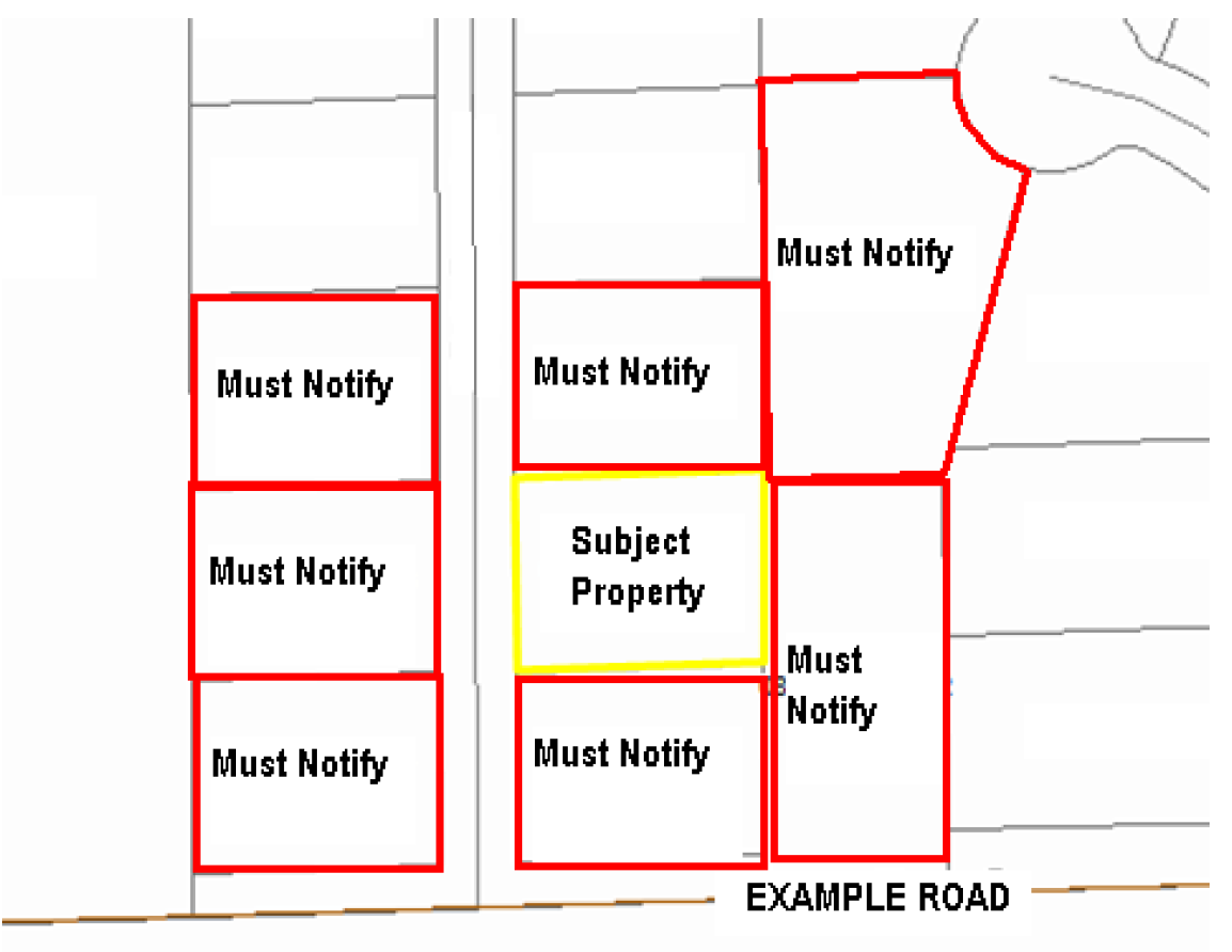
For all proposed map amendments, the applicant will promptly forward via certified mail, return receipt requested, a copy of the complete application and notice of public hearing to the township containing the subject parcel, and to any municipality within one and one-half (1½) miles of the subject parcel.
(d)
Hearing on applications. The ZBA shall hold a public hearing on each application for an amendment. Hearings on map amendments shall be held in the township affected by the terms of such proposed amendments or in the County office building, provided that if the owner of any property affected by such proposed map amendment so requests in writing, such hearing shall be held in the township affected by the terms of such proposed amendment. Hearings on text amendments shall be held in the County office building. The hearing shall be conducted and a record of such proceedings shall be preserved in such manner as the ZBA shall, by rule, prescribe from time to time.
(e)
Notice of public hearing.
(1)
The applicant shall publish notice of the time and place of the public hearing in a newspaper of general circulation in the County not less than fifteen (15) days before such hearing.
(2)
At least fifteen (15) days prior to each hearing, the PBZ Department shall post a sign on the road or street frontage of the land proposed to be reclassified by amendment and a copy of such notice shall be mailed to the clerk of each municipality, the corporate limits of which lie within one and one-half (1½) miles of the land proposed to be reclassified. Supplemental or additional notices may be published or distributed as the ZBA may, by rule, prescribe from time to time.
(3)
In addition to the above requirements, if the property is zoned A-1, the applicant shall provide notice of the public hearing at least fifteen (15) days prior to the hearing date by certified mail, return receipt requested, to the property owner of record for all parcels within five hundred (500) feet, excluding road rights-of-way, of the parcel to be rezoned.
(4)
For all other zoning categories, only adjacent properties must be notified via certified mail, return receipt requested.
(f)
Finding of fact and recommendation of the ZBA. Within thirty (30) days after the close of the hearing on a proposed amendment, the ZBA shall make written findings of fact and shall submit same together with its recommendation to the County Board. Where the purpose and effect of the proposed amendment is to change the zoning classification of a particular property, the Zoning Board of Appeals shall make findings based upon evidence presented to it in each specific case with respect to the following matters:
(1)
Existing uses of property within the general area of the property in question.
(2)
The zoning classification of property within the general area of the property in question.
(3)
The suitability of the property in question for the uses permitted under the existing zoning classification.
(4)
The trend of development, if any, in the general area of the property in question, including changes, if any, which may have taken place since the day the property in question was in its present zoning classification. The ZBA shall not recommend the adoption of a proposed amendment unless it finds that the adoption of such an amendment is in the public interest and is not solely for the interest of the applicant. The ZBA may recommend the adoption of an amendment changing the zoning classification of the property in question to any higher classification than that requested by the applicant. For the purpose of this section, the R-1 One-Family Residential District shall be considered the highest classification and the M-2 Heavy Industrial District shall be considered the lowest classification.
(5)
Consistency with the purpose and objectives of the Land Resource Management Plan and other adopted County or municipal plans and policies.
(g)
Decisions.
(1)
ZBA findings shall be forwarded to the PBZ Committee of the County Board for review and recommendation to the full Board. The County Board, upon report of the County ZBA and without further public hearing, may grant or deny any proposed amendment, or may refer it back to the County ZBA or the PBZ Committee for further consideration.
(2)
In case of written protest against any proposed map amendment, signed by the owners of at least twenty (20) percent of the land to be rezoned or signed by the owners of twenty (20) percent of the frontage proposed to be altered, or by the owners of twenty (20) percent of the frontage immediately adjoining or across an alley, street or public right-of-way therefrom, or by the owners of twenty (20) percent of the frontage directly opposite the frontage proposed to be altered, or in cases where the land affected lies within one and one-half (1½) miles of the limits of a zoned municipality with a recorded comprehensive plan, by the city council or president and board of trustees of the zoned municipality with limits nearest adjacent, filed with the Clerk of the County, such amendment shall not be passed except by the favorable vote of three-fourths (¾) of all the members of the County Board.
(Ord. No. 2020-17, exh. M, § 13:07, 9-15-2020)
Sec. 36-73. - Creation and membership.
(a)
Created. A Zoning Board of Appeals (ZBA) is hereby created, such Board to consist of five (5) members appointed by the County Board, at least four (4) of whom shall reside in the unincorporated area of the County. The County Board may provide for the appointment of an additional two (2) members to serve for a term of five (5) years. No two (2) of whom shall reside in the same Congressional township and shall be confirmed by the members of the County Board. At the end of the term of the two (2) additional members, the County Board may provide for the appointment of successors or may allow the Board of Appeals to revert to a membership of five (5). All members shall be residents of the County.
(b)
Terms of office. The members of the ZBA shall be appointed for a term of five (5) years. If a vacancy occurs, by resignation or otherwise, among the members of the Board, the County Board shall appoint a member for the unexpired term. The County Board shall also have the power to remove any member of the ZBA for cause, after public hearing.
(Ord. No. 2020-17, exh. M, § 13:01(B)(1), (2), 9-15-2020)
Sec. 36-74. - Officers.
The County Board shall name one (1) of the members of the ZBA as Chairman upon appointment, and, in the case of a vacancy, shall name a new Chairman.
(Ord. No. 2020-17, exh. M, § 13:01(B)(3), 9-15-2020)
Sec. 36-75. - Quorum.
A majority of members of the ZBA shall constitute a quorum.
(Ord. No. 2020-17, exh. M, § 13:01(B)(4), 9-15-2020)
Sec. 36-76. - Compensation of Secretary.
The County Board may appoint and fix the compensation of a Secretary and such other employees as are necessary for the discharge of its duties.
(Ord. No. 2020-17, exh. M, § 13:01(B)(5), 9-15-2020)
Sec. 36-77. - Offices.
The County Board shall provide suitable offices for the holding of hearings and the preservation of records, documents, and accounts.
(Ord. No. 2020-17, exh. M, § 13:01(B)(6), 9-15-2020)
Sec. 36-78. - Appropriations.
The County Board shall appropriate funds to carry out the duties of the ZBA and the Board shall give the authority to expend, under regular County procedure, all sums appropriated to it for the purposes and activities authorized herein.
(Ord. No. 2020-17, exh. M, § 13:01(B)(7), 9-15-2020)
Sec. 36-79. - Rules and procedures.
The ZBA shall adopt such rules concerning the filing of appeals and applications for amendments, variances and special use permits, giving of notice and conduct of hearings as shall be necessary to carry out their duties as defined herein. The Board shall keep minutes of its proceedings, keep records of its examinations and other official acts, and shall record the vote on all actions taken. All minutes and records shall be filed in the office of the ZBA and shall be a public record.
(Ord. No. 2020-17, exh. M, § 13:01(B)(8), 9-15-2020)
Sec. 36-80. - Meeting times.
All meetings of the ZBA shall be held at the call of the Chairman and at such other times as the ZBA may determine. Notice of said meetings shall occur in a manner defined by applicable law. All meetings of the ZBA shall be open to the public.
(Ord. No. 2020-17, exh. M, § 13:01(B)(9), 9-15-2020)
Sec. 36-81. - Powers and duties.
The ZBA shall:
(1)
Hear and determine appeals from and review any order, requirement, decision, or determination made by the Zoning Administrator charged with the enforcement of this chapter with the exception of violations.
(2)
Hear and decide all matters referred to it, or upon which it is required to pass under this chapter.
(3)
Hear and pass upon applications for variations when a property owner or agent shows that a strict application of the terms of this chapter in relation to the use, construction or alteration of buildings or structures, or the use of land, imposes practical difficulties or particular hardships.
(4)
Hear all applications for amendments to this chapter in the manner prescribed by, and subject to, the standards established herein, and report said findings and recommendations to the County Board.
(5)
Hear all applications for special use permits, major amendments to special use permits and revocation of special use permits in the manner prescribed by, and subject to, the standards established herein, and report said findings and recommendations to the County Board.
(6)
Hold public hearings and submit to the County Board a report and recommendation on each proposed ordinance for the amendment, supplement, change or repeal of the ordinance from which this chapter is derived as set forth herein.
(7)
No rehearing shall be held on a denied appeal or application for variance or special use or on a recommendation to deny a proposed amendment to the ordinance from which this chapter is derived for a period of twelve (12) months from the date of said denial or recommendation to deny.
(Ord. No. 2020-17, exh. M, § 13:01(B)(10), 9-15-2020)
Sec. 36-82. - Jurisdiction.
The concurring vote of three (3) members of a board consisting of five (5) members or the concurring vote of four (4) members of a board consisting of seven (7) members is necessary to reverse any order, requirement, decision or determination of the Zoning Administrator, or to decide in favor of the applicant any matter upon which it is authorized by this chapter to render decisions.
(Ord. No. 2020-17, exh. M, § 13:01(B)(11), 9-15-2020)
Sec. 36-83. - Judicial review.
All decisions and findings of the ZBA, on appeals, application for variations, special use permits, or amendments, shall, after a hearing, be subject to review by court as by law may be provided.
(Ord. No. 2020-17, exh. M, § 13:01(B)(12), 9-15-2020)
Sec. 36-179. - Purpose and intent.
Site plan approval is required to ensure that plans that are otherwise in conformance with this chapter also include the compatible arrangement of buildings, off-street parking, lighting, landscaping, ingress and egress, and drainage of the site in a manner that will promote safety and convenience for the public and will preserve surrounding property values. Site plan review is not a substitute for required State and County building permit reviews.
(Ord. No. 2020-17, exh. M, § 13.10(A), 9-15-2020)
Sec. 36-180. - Applicability.
(a)
Site plan review is required for all new construction or additions and changes in the use of land or existing buildings which results in any alteration or construction within the following zoning districts:
(1)
All business districts.
(2)
All manufacturing districts.
(3)
All commercial development within a planned development.
(4)
All nonresidential or nonagricultural structures within a residential or agricultural district.
(b)
The following activities are excluded from site plan review:
(1)
Normal maintenance.
(2)
Construction or alteration of any building in use exclusively as a single-family or two (2) family dwelling or any uses devoted exclusively to agriculture, horticulture or floriculture.
(3)
Home occupations, as defined in this chapter.
(4)
Restoration or reconstruction of a damaged structure if such restoration does not exceed fifty (50) percent of the value of the entire structure based on the County Assessor's records. Such restoration must commence within one (1) year from the date of the fire or other casualty or act of God. If restoration or reconstruction does not begin within one (1) year, a site plan shall be required.
(Ord. No. 2020-17, exh. M, § 13.10(B), 9-15-2020)
Sec. 36-181. - Variance.
The PBZ Director or the PBZ Committee of the County Board may grant exceptions from the site plan requirements.
(Ord. No. 2020-17, exh. M, § 13.10(C), 9-15-2020)
Sec. 36-182. - Site design standards.
The following development standards are established as criteria for the review of site plans:
(1)
Responsive to site conditions.
a.
Site plans should be based on an analysis of the site. Such site analysis shall examine characteristics such as site context; geology and soils; topography; climate and ecology; existing vegetation, structures and road network; visual features; current use of the site. In addition to the standards listed below, petitioners must also follow the regulations outlined in this chapter.
b.
To the fullest extent possible, improvements shall be located to preserve the natural features of the site, to avoid areas of environmental sensitivity, and to minimize negative effects and alteration of natural features. Fragile areas such as wetlands and floodplains should be preserved as open space. Slopes in excess of twenty (20) percent as measured over a ten (10) foot interval also should remain as open space, unless appropriate engineering measures concerning slope stability, erosion and safety are taken.
(2)
Traffic and parking layout.
a.
Site plans should minimize dangerous traffic movements and congestion, while achieving efficient traffic flow. An appropriate number of parking spaces shall be provided while maintaining County design standards. The number of curb cuts should be minimized and normally be located as far as possible from intersections. Connections shall be provided between parking areas to allow vehicles to travel among adjacent commercial or office uses. Cross access easements or other recordable mechanisms must be employed.
b.
Conflicts between pedestrians and vehicular movements should be minimized. When truck traffic will be present upon the site, the road size and configuration shall be adequate to provide for off-street parking and loading facilities for large vehicles.
c.
Barrier curbs should be employed for all perimeters of and islands in paved parking lots, as well as for all service drives, loading dock areas, and the equivalent. Relief from this provision may be considered by the PBZ Committee for rear yard parking facilities in M-1 Limited Manufacturing Districts, M-2 Heavy Industrial Districts, and B-4 Commercial Recreation Districts or for hardship cases, such as projects where barrier curb installation would conflict with drainage requirements. Parking lots in industrial or commercial areas shall be paved with hot-mix asphalt or concrete surfacing.
d.
Traffic studies may be required by the ZPAC or the PBZ Committee. Such traffic studies should address:
1.
Projected number of motor vehicle trips to enter or leave the site, estimated for daily and peak hour traffic levels;
2.
Projected traffic flow patterns, including vehicular movements at all major intersections likely to be affected by the proposed use of the site.
Existing and proposed daily and peak hour traffic levels as well as road capacity levels shall also be provided.
(3)
Site layout. Improvements shall be laid out to avoid adversely affecting groundwater and aquifer recharge; minimize cut and fill; avoid unnecessary impervious cover; prevent flooding and pollution; provide adequate access to lots and sites; mitigate adverse effects of shadow, noise, odor, traffic, drainage and utilities on neighboring properties.
(4)
Consistency with the LRMP. The proposed use and the design of the site should be consistent with the Land Resource Management Plan.
(5)
Building materials. The proposed site plan design shall provide a desirable environment for its occupants and visitors as well as its neighbors through aesthetic use of materials, textures and colors that will remain appealing and will retain a reasonably adequate level of maintenance. Buildings shall be in scale with the ultimate development planned for the area. Monotony of design shall be avoided. Variations in detail, form, and setting shall be used to provide visual interest. Variation shall be balanced by coherence of design elements.
(6)
Relationship to surrounding development. A site shall be developed in harmony with neighboring street patterns, setbacks and other design elements.
(7)
Open space and pedestrian circulation. Improvements shall be designed to facilitate convenient and safe pedestrian and bicycle movement within and to the property.
(8)
Buffering. Measures shall be taken to protect adjacent properties from any undue disturbance caused by excessive noise, smoke, vapors, fumes, dust, odors, glare or stormwater runoff. Incompatible, unsightly activities are to be screened and buffered from public view.
(9)
Emergency vehicle access. Every structure shall have sufficient access for emergency vehicles.
(10)
Mechanical equipment screening. All heating, ventilation and air conditioning equipment shall be screened on sides where they abut residential districts.
(11)
Lighting. The height and shielding of lighting fixtures shall provide proper lighting without hazard to motorists on adjacent roadways or nuisance to adjacent residents by extending onto adjacent property. Cut-off lighting should be used in most locations, with fixtures designed so that the bulb/light source is not visible from general side view.
(12)
Refuse disposal and recycling storage areas. All refuse disposal and recycling storage areas should be located in areas designed to provide adequate accessibility for service vehicles. Locations should be in areas where minimal exposure to public streets or residential districts will exist. Screening shall be required in areas which are adjacent to residential districts or are within public view. Such enclosures should not be located in landscape buffers. Refuse containers and compactor systems shall be placed on smooth surfaces of non-absorbent material such as concrete or machine-laid asphalt. A concrete pad shall be used for storing grease containers. Refuse disposal and recycling storage areas serving food establishments shall be located as far as possible from the building's doors and windows. The use of chain link fences with slats is prohibited.
(Ord. No. 2020-17, exh. M, § 13.10(D), 9-15-2020)
Sec. 36-183. - Petition for site plan review.
(a)
Standing. A petition for site plan review shall be made by a person, firm or corporation that is the legal owner or has a possessory interest on the land which is described in the application for site plan review.
(b)
Filing. Petitions for site plan review shall be filed in writing with the Zoning Administrator and shall be accompanied by such documents and information as the ZPAC or the PBZ Committee may require. Such documents and information shall include, but are not limited to, the following:
(1)
Completed petition for site plan review in a format developed by the County;
(2)
Application fee;
(3)
Generalized location map;
(4)
Plats and drawings depicting compliance with the aforementioned site design standards.
(c)
Plan requirements. The petition for site plan review and drawings should include the following:
(1)
Name of the project, boundaries, and location map showing the site's location in County, date, north arrow and scale of plan.
(2)
Name, address and telephone number of the owner of record.
(3)
All existing lot lines, easements and rights-of-way, including area in acres or square feet.
(4)
Contiguous land uses and zoning, and location and use of structures within two hundred (200) feet of the site.
(5)
Location and use of all existing and proposed structures within the development.
(6)
Location of all present and proposed roads, parking areas, driveways, sidewalks, fences, curbs, paths and walls.
(7)
Location and proposed screening details for all permanent waste disposal containers.
(8)
Location, height, intensity and bulb type of all external lighting fixtures. The direction of illumination and methods to eliminate glare into adjoining properties should be shown.
(9)
Location of all present and proposed utilities, including, but not limited to, sewage or septic systems, water supply, telephone, cable and electrical systems, and stormwater drainage systems, such as drain lines, culverts, catchbasins, hydrants and drainage swales. Detailed soil mapping may be required to ensure suitability of the property for septic field installation.
(10)
Location of existing and proposed natural features, including topography, forest cover and water sources.
(11)
Elevation plans for exterior facades of proposed structures, showing design features and indicating type and color of materials to be used.
(12)
Landscaping proposed for the development, including new plantings and existing plant material to be preserved, along with an indication of trees to be removed or transplanted. A separate landscape plan may be submitted in lieu of illustration on the site plan.
(13)
A copy of the permit application and any revisions required by the U.S. Army Corps of Engineers for any floodplain or wetland modification.
(14)
Timetable for construction of improvements.
(Ord. No. 2020-17, exh. M, § 13.10(E), 9-15-2020)
Sec. 36-184. - Procedure.
A written application for site plan review shall be submitted to the PBZ Department, which will schedule the item for review. Consultation with the appropriate County staff and consultants is encouraged throughout this process to ensure a minimum delay. If requested by the applicant, the County will review applications for site plan review concurrently with separate requests for rezoning or platting. The review process will include the following:
(1)
ZPAC. One (1) copy of the complete application, along with eight (8) copies of the site plan, shall be submitted by the property owner or certified agent to the Zoning Administrator at least fourteen (14) days prior to the ZPAC meeting. The purpose of the ZPAC meeting will be to evaluate the completeness of the application and to provide the applicant with feedback/input on the proposed site plan. Prior to the ZPAC meeting, the Zoning Administrator shall distribute copies of the site plan to Committee members. After discussion on a proposed site plan, the ZPAC may approve, deny, or approve with modifications, or request that the applicant revise the plan and return to a future ZPAC meeting for further review.
(2)
PBZ Committee. Site plan decisions by ZPAC may be appealed to the PBZ Committee.
(Ord. No. 2020-17, exh. M, § 13.10(F), 9-15-2020)
Sec. 36-185. - Nullification.
Where a site plan has been approved and where no substantial construction work is initiated within one (1) year from the date approving the site plan, then, without further action by the PBZ Committee, such site plan approval shall become null and void.
(Ord. No. 2020-17, exh. M, § 13.10(G), 9-15-2020)
Sec. 36-186. - Enforcement.
It is the policy of the County that enforcement of the site plan review requirements in this division is in the highest public interest. If any person, firm, or corporation violates the provisions of this division, the County may exercise any or all of the remedies and penalties available under law.
(Ord. No. 2020-17, exh. M, § 13.10(H), 9-15-2020)
Sec. 36-110. - Purpose.
The development and execution of this chapter is based upon the division of the County which is subject to County Zoning into districts, within which districts the uses of land and structures and the bulk and location of structures in relation to the land are substantially uniform. It is recognized, however, that there are other uses which, because of their unique characteristics, cannot be properly classified in any particular district without consideration, in each case, of the impact of those uses upon neighboring land and of the public need for the particular use of this particular location. Special uses may include, but are not limited to, public and quasi-public uses affecting the public interest; uses that have a unique, special, or unusual impact upon the use or enjoyment of neighboring property; uses that affect planned development. A use may be permitted in one (1) or more zoning districts and may be a special use in one (1) or more other zoning districts.
(Ord. No. 2020-17, exh. M, § 13:08(A), 9-15-2020)
Sec. 36-111. - Initiation of special uses.
Any individual, firm or corporation having a possessory interest entitled to exclusive possession in land, or several such owners acting jointly having such interest in parcels of land comprising one (1) contiguous tract, or the County Board may file an application for one (1) or more special uses as provided in this chapter.
(Ord. No. 2020-17, exh. M, § 13:08(B), 9-15-2020)
Sec. 36-112. - Processing.
(a)
An application for a special use shall be filed with the Zoning Administrator.
(b)
A copy of such application shall be forwarded to the ZPAC for review, comment, and recommendation.
(c)
A copy of such application and the Committee report from the ZPAC shall thereafter be forwarded to the Regional Planning Commission for review, comment, and recommendation.
(d)
A copy of such application and the reports from the ZPAC and Regional Planning Commission shall thereafter be forwarded to the ZBA with a request to hold a public hearing and submit to the County Board a report of its findings and recommendations.
(e)
The recommendation and findings of the ZBA shall be forwarded to the PBZ Committee of the County Board for review and recommendation prior to final action by the County Board.
(Ord. No. 2020-17, exh. M, § 13:08(C), 9-15-2020)
Sec. 36-113. - Conditions and guarantees.
Prior to or after the granting of a special use, the ZBA may recommend and the County Board may stipulate such conditions and restrictions upon the establishment, location, construction, maintenance, and operation thereof as deemed necessary to protect the value, utilization and enjoyment of the neighboring properties, and to secure compliance with the standards and requirements specified in this division. In cases in which a special use is granted, the County Board may require such evidence and guarantees as it may deem necessary as proof that the conditions stipulated in connection therewith are being and will be in compliance. Failure to comply with such conditions or restrictions imposed shall constitute a violation of this chapter.
(Ord. No. 2020-17, exh. M, § 13:08(D), 9-15-2020)
Sec. 36-114. - Decisions.
(a)
The ZBA shall report to the County Board a finding of fact using the criteria listed in Section 36-119 and a recommendation as whether the County Board should deny, grant, or grant subject to conditions.
(b)
The County Board, upon report of the ZBA and without further public hearing, may grant or deny a proposed special use, or may refer back to the ZBA for further consideration.
(c)
The County Board shall act to grant, deny, or amend the recommendations for every special use pertaining to a regulated use within thirty (30) days of the date of those recommendations.
(d)
In cases involving special use permit applications or applications for major amendments to existing special use permits for commercial solar energy facilities and commercial wind energy facilities, the County Board shall make its decision not more than thirty (30) days after the conclusion of the public hearing.
(Ord. No. 2020-17, exh. M, § 13:08(E), 9-15-2020; Ord. No. 2023-24, § XXXIX, 5-16-2023)
Sec. 36-115. - Revocation.
(a)
In any case where a special use has not been established within two (2) years from the date of granting thereof or if the special use has been discontinued for a continuous period of two (2) years, the County Board may revoke the special use. If a revocation is proposed, the ZBA shall hold a public hearing (following the procedures outlined in Section 36-117 and submit to the County Board a report of their findings and recommendations. The current property owner shall be provided notice at least fifteen (15) days in advance of the hearing.
(b)
If the special use permit holder wishes to discontinue the special use, the same may request revocation of said special use, no matter the duration of time that the special use has been discontinued. The owner shall submit to the PBZ Department, in writing, a request to the County Board to revoke said special use. Such a request shall be signed by the owner. No public hearing shall be required for an owner-initiated revocation. Said revocation shall be discussed by the PBZ Committee for review and recommendation to the County Board. A revocation shall not become effective unless approved by the County Board.
(Ord. No. 2020-17, exh. M, § 13:08(F), 9-15-2020)
Sec. 36-116. - Application for special use.
An application for special use or amendment of a special use shall be filed with the Zoning Administrator and shall include a statement in writing by the applicant and adequate evidence showing that the proposed special use will conform to the standards set forth herein.
(Ord. No. 2020-17, exh. M, § 13:08(G), 9-15-2020)
Sec. 36-117. - Hearing on application.
(a)
Upon receipt in proper form of the application and statement referred to in Section 36-116, the ZBA shall hold at least one (1) public hearing in the township in which the property is located, or in the County office building, provided that if the owner of any property affected by such proposed special use so requests in writing, such hearing shall be held in the township affected by the terms of such proposed amendment. At least fifteen (15) days in advance of each hearing, notice of the time, place and date of such hearing shall be published in a newspaper published in the township or road district where the property is located. If there is no newspaper published in the township or road district where the property is located, the notice must be published in a newspaper of general circulation in the County. The notice must also contain:
(1)
The particular location of the property for which the special use is requested by legal description and by street address, or, if there is no street address, by locating the property with reference to any well-known landmark, highway, road, thoroughfare, or intersection.
(2)
Whether the petitioner or applicant is acting on their own behalf or as an agent, alter ego, or representative of a principal and the name and address of the principal.
(3)
Whether the petitioner or applicant is a corporation, and if so, the correct names and addresses of all officers and directors of the corporation and of all stockholders or shareholders owning any interest in excess of twenty (20) percent of all of the outstanding stock or shares of the corporation.
(4)
Whether the petitioner or applicant, or principal, is a business or entity doing business under an assumed name, and, if so, the name and residence of all actual owners of the business or entity.
(5)
Whether the petitioner or applicant, or principal, is a partnership, joint venture, syndicate, or an unincorporated voluntary association, and, if so, the names and addresses of all partners or members of the partnership, joint venture, syndicate, or unincorporated voluntary association.
(6)
A brief statement of the proposed special use.
(b)
In addition to any other notice required by this section, the Zoning Board of Appeals must give at least fifteen (15) days' notice before the hearing to any municipality whose boundaries are within one and one-half (1½) miles of any part of the property proposed as a special use. If the property is zoned A-1, the applicant shall provide notice of the public hearing at least fifteen (15) days prior to the hearing date by certified mail, return receipt requested, to the property owner of record for all parcels within seven hundred fifty (750) feet, excluding road rights-of-way, of the parcel subject to the special use permit application. For all other zoning categories, only adjacent properties must be notified via certified mail, return receipt requested. The petitioner or applicant must pay the costs of the publication of the notices required by this division.
(c)
An audio recording of the proceedings shall be made by the County and shall be retained for a period of one (1) year from the date of hearing. The petitioner, at the petitioner's discretion, may elect to provide a court reporter, at the expense of the same, for the purposes of making a formal transcript of the proceedings. In addition to the application fee, the petitioner shall be responsible for the cost of the ZBA in conducting the hearing in accordance with the schedule of fees as established by the County Board.
(Ord. No. 2020-17, exh. M, § 13:08(H), 9-15-2020)
Sec. 36-118. - Authorization.
(a)
For each application for a special use, the Zoning Board of Appeals shall report to the County Board its findings and recommendations, including the stipulations of additional conditions and guarantees that such conditions will be complied with when they are deemed necessary for the protection of the public interest. The County Board may grant or deny any application for a special use.
(b)
No proposed special use once denied by the County Board shall be again, on a subsequent petition, considered for approval within a period of twelve (12) months from the date of said denial.
(Ord. No. 2020-17, exh. M, § 13:08(I), 9-15-2020)
Sec. 36-119. - Standards.
No special use shall be recommended by the ZBA unless the ZBA shall make a written finding. The ZBA shall consider the following in rendering a decision, but is not required to make an affirmative finding on all items:
(1)
The establishment, maintenance, or operation of the special use will not be detrimental to or endanger the public health, safety, morals, comfort, or general welfare.
(2)
The special use will not be substantially injurious to the use and enjoyment of other property in the immediate vicinity for the purposes already permitted, nor substantially diminish and impair property values within the neighborhood. The zoning classification of property within the general area of the property in question shall be considered in determining consistency with this standard. The proposed use shall make adequate provisions for appropriate buffers, landscaping, fencing, lighting, building materials, open space and other improvements necessary to ensure that the proposed use does not adversely impact adjacent uses and is compatible with the surrounding area and/or the County as a whole.
(3)
Adequate utilities, access roads and points of ingress and egress, drainage, and/or other necessary facilities have been or are being provided.
(4)
The special use shall in all other respects conform to the applicable regulations of the district in which it is located, except as such regulations may in each instance be modified by the County Board pursuant to the recommendation of the Zoning Board of Appeals.
(5)
The special use is consistent with the purpose and objectives of the Land Resource Management Plan and other adopted County or municipal plans and policies.
(Ord. No. 2020-17, exh. M, § 13:08(J), 9-15-2020)
Sec. 36-120. - Conditions.
The ZBA may recommend and the County Board may provide such conditions or restrictions reasonably necessary to meet the standards listed in Section 36-119 upon the construction, location and operation of a special use, including, but not limited to, provisions for the protection of adjacent property, the expiration of said special use after a specified period of time, off-street parking and loading, as shall be deemed necessary to secure the general objectives of this chapter and to reduce injury to the value of property in the neighborhood.
(Ord. No. 2020-17, exh. M, § 13:08(K), 9-15-2020)
Sec. 36-121. - Duration.
Special uses granted hereunder shall be transferable and shall run with the land unless otherwise specified by the terms of the special use permit.
(Ord. No. 2020-17, exh. M, § 13:08(L), 9-15-2020)
Sec. 36-122. - Amendments to approved special uses.
(a)
Unless amended, a special use shall be constructed/established in accordance with the terms and conditions as stated in the approving ordinance and any controlling site plans attached to or referenced in the ordinance which granted the special use. Modifications of the terms and conditions specified in the approving ordinance granting the special use or changes to any controlling site plans attached to or referenced in the ordinance which granted the special use (if applicable) shall require the processing and approval of either a minor or major change to a special use.
(b)
Amendment of special uses under this section shall apply to all existing, valid special uses issued prior to the date of the ordinance from which this chapter is derived as well as any future special uses granted under this chapter.
(Ord. No. 2020-17, exh. M, § 13:08(M), 9-15-2020)
Sec. 36-123. - Minor amendments on property governed by a special use ordinance.
(a)
Minor amendments are those that do not alter the intent or uses of the property for which a special use has been approved. Minor amendments shall be limited to the following:
(1)
Proposed additions, enlargements or changes in any existing or proposed buildings, shown on any controlling site plans attached to or referenced in the ordinance which granted the special use (if applicable), and the addition of accessory structures not shown on such plans may be permitted, provided that all of the following conditions are met:
a.
The proposed addition, enlargement or change will, in the opinion of the Zoning Administrator, result in a better utilization of the property or a more efficient and desirable use of the land.
b.
The change shall not constitute more than a ten (10) percent increase in the lot coverage of all approved buildings on the property or a ten (10) percent increase of the total floor area of all approved buildings on the property.
c.
The proposed addition, enlargement or change will not infringe upon or extend into any required building setback, off-street parking or loading space or required building separation or exceed the height or bulk regulations of the underlying zoning district.
d.
The additional off-street parking or loading spaces required for such proposed addition, enlargement or change can be supplied as required by the applicable provisions of this chapter.
e.
The proposed addition, enlargement or change will not result in an enlargement or increase of any previously approved variation.
(2)
Minor modifications of conditions, provided that all of the following are met:
a.
The proposed modification will, in the opinion of the Zoning Administrator, result in equal or better performance than the original condition imposed.
b.
The proposed modification or change shall not result in a change of more than ten (10) percent of any previously imposed condition.
c.
The result of the proposed modification shall be that the property will still be in substantial compliance with the previously approved ordinance.
(b)
An owner seeking an approval of such change shall submit an application for a minor amendment to be acted upon by the Zoning Administrator. The Zoning Administrator may, at the discretion of the same, refer the request for a minor amendment to the PBZ Committee of the County Board for recommendation prior to taking action. In addition, the petitioner may appeal the decision of the Zoning Administrator in the review of a minor amendment to the PBZ Committee. In such instances the PBZ Committee shall be the final authority in deciding upon such requests.
(Ord. No. 2020-17, exh. M, § 13:08(N), 9-15-2020)
Sec. 36-124. - Major amendments.
A change to a special use that alters the intent or substantially violates the terms of compliance as specified in the approving ordinance granting the special use and which is not otherwise defined in Section 36-123 as a minor amendment shall constitute a major amendment to a special use. Major amendments shall be processed in accordance with the provisions of Section 36-112. Notice that a major change is being sought shall be provided by the applicant in the manner provided for in State law governing the issuance of special use permits and additional requirements as specified in the bylaws of the ZBA.
(Ord. No. 2020-17, exh. M, § 13:08(O), 9-15-2020)
Sec. 36-125. - Planned developments.
(a)
Purpose. Planned developments are intended to encourage imaginative site planning which integrates the development proposal with existing topography and other natural environmental assets of the land while conserving the County's rural character. Clustering of units is encouraged to provide common open space. Procedures for approval of residential planned developments (RPDs) are outlined in Subdivision II of this division. All other planned developments (industrial, commercial, etc.) may be developed in accordance with standards herein.
(b)
Zoning map. Approved planned developments shall be delineated and designated by number on the Official Zoning Map. A file, available for inspection by the public, shall be maintained by the Zoning Administrator for each planned development so designated. The file shall contain a record of the approved development plan and all exceptions authorized therein.
(c)
Procedure.
(1)
a.
A preapplication conference shall be held with the Zoning Administrator or deputies. At such conference the applicant shall provide information as to the location of the proposed planned development; the uses, and approximate area of use category; a list of any and all exceptions to Chapter 30, pertaining to subdivisions, this chapter, and any other information necessary to clearly explain the planned development.
b.
The Zoning Administrator or deputies shall review and consider the proposal as to its compatibility with the Land Resource Management Plan and the goals and policies for planning of the County and advise the applicant on the information, documents, exhibits, drawings, and limitations on the proposal that should be included in the application to the County for a special use permit for a planned development.
(2)
The applicant shall request a concept review of the planned development/special use, by letter addressed to the Secretary of the Regional Planning Commission, to be placed on the agenda of ZPAC and the next regular meeting of the Regional Planning Commission for a preliminary discussion and concept review of the proposed planned development at such meeting, which may be continued from time to time. The applicant shall present such exhibits and written information as may be necessary to fully acquaint the Regional Planning Commission with the proposed development, which shall include, but not necessarily be limited to, the following:
a.
A tentative sketch plan, which may be in freehand sketch form, showing the location and extent of the types of land uses proposed.
b.
The existing topography at five (5) foot contour intervals which may be taken from USGS information.
c.
Existing streets surrounding the subject property.
d.
Existing utilities, including storm drainage facilities.
e.
The following shall be provided by either graphic exhibits or written statement:
1.
The density of commercial uses, including maximum lot coverage and building height.
2.
The off-street parking and other service facilities proposed.
3.
The exception or variations to the County zoning or subdivision requirements being requested as part of the planned development application.
(3)
After final adjournment of the meeting, the Regional Planning Commission shall submit to the PBZ Committee of the County Board a report in writing containing its recommendations. The PBZ Committee shall then review the concept at their next regular meeting and shall either:
a.
Provide the applicant with a recommendation for any suggested modifications and direction to proceed to a formal planned development submission; or
b.
Recommend that the applicant not proceed, along with reasons for the recommendation.
(4)
a.
The formal petition for a planned development shall be filed with the Zoning Administrator. The Zoning Administrator or deputies shall be responsible for distributing the complete application to the following at the appropriate time:
1.
ZPAC.
2.
Members of the Regional Planning Commission.
3.
ZBA.
4.
The County Board.
b.
The applicant shall be responsible for providing copies via certified mail, return receipt requested, to the following as soon as possible after filing the application with the County:
1.
Townships affected by the application.
2.
All municipalities within one and one-half (1½) miles of the subject property.
(5)
The ZBA shall set a hearing date and shall cause notice of the hearing to be published at least once following the procedures set forth in Section 36-117.
(6)
The petition shall be submitted to the County Board. The Regional Planning Commission shall submit its review to the ZBA prior to the public hearing. The report of the findings and recommendation shall be accompanied by such plats, exhibits and agreements as shall have been presented by the petitioner, each identified for reference by letter or number, together with any suggested changes therein.
(7)
The County Board may grant a special use for a planned development which shall be by specific ordinance and which shall contain or to which shall be appended all terms and conditions of the special use permit, including covenants and agreements, guarantees, performance bonds, plats, and the like.
(d)
Construction of improvements. The petitioner shall construct and install the required improvements in accordance with the County subdivision regulations contained in Chapter 30 and the special use ordinance.
(e)
Street classification. Street classifications, definitions, and specifications shall be in accordance with the regulations as established in the subdivision regulations contained in Chapter 30 and the Land Resource Management Plan of the County, as may be amended from time to time, as may be modified by the special use permit.
(f)
Standards. No planned development shall be authorized by the County Board unless the Regional Planning Commission shall find and recommend, in addition to those standards established herein for special uses, that the following standards will be met:
(1)
The uses permitted by such exceptions as may be requested or recommended are necessary or desirable and appropriate to the purpose of the development.
(2)
The uses permitted in such development are not of such nature or so located as to exercise an undue detrimental influence or effect upon the surrounding neighborhood.
(3)
That any industrial park areas established in the planned development conform to all requirements therefor as set forth elsewhere in this chapter.
(4)
That all minimum requirements pertaining to commercial, residential, institutional, or other uses established in the planned development are followed. When private streets and common driveways are made a part of the planned development or private common open space or recreation facilities are provided, the applicant shall submit as a part of the application the method and arrangement whereby these private facilities shall be operated and maintained. Such arrangements for operating and maintaining private facilities shall be subject to the approval of the County Board.
(g)
Agricultural planned developments. For planned developments located in the A-1 Agricultural District, exceptions may be made in the regulations of such district as follows:
(1)
Use regulations.
a.
The uses listed as permitted uses and special uses may be allowed.
b.
Residential, single-family uses, providing said use is limited to planned unit developments for conventional golf courses, and further providing that the gross area of residential use does not exceed forty (40) percent of the zoning parcel.
c.
Clubhouses, restaurants in which alcoholic beverages are sold, and other business uses specifically described which are complimentary to the principal use as a golf course providing such uses are limited to planned unit development for conventional golf courses.
(2)
Gross density premiums. The maximum gross densities for agricultural planned developments may be increased up to a maximum of fifteen (15) percent, in accordance with and when the development included one (1) or more of the following:
a.
Is adjacent to, or across from a public or permanent private open space which is not less than ten (10) acres in area with a depth perpendicular to a lot line of the planned development of not less than three hundred (300) feet. For the dedication of public recreational and educational sites recommended in the Comprehensive Plan: equal to the number of dwelling units that would otherwise have been permitted upon lands so dedicated.
b.
For the provision of unique design features which required unusually high development costs and which tend to achieve an especially attractive and stable development: as determined by the County Regional Planning Commission.
(3)
Yards. Yard requirements may be varied or waived, except along the perimeter of the development.
(h)
Residential planned developments. After August 18, 1998, all new residential planned developments shall be zoned R-1 PUD unless the property is already zoned R-2 or R-3. For planned developments located in one (1) or more residence districts, exceptions may be made in the regulations of such districts, as follows:
(1)
Use regulations.
a.
In any residential planned development uses listed as permitted uses are allowed, and single-family attached, single-family semi-detached, and multiple-family dwellings may be allowed.
b.
Uses listed as special uses in the zoning district in which the development is located may be allowed.
c.
In residential planned developments containing over fifty (50) dwelling units, permitted uses and special uses permitted in the B-1 Local Shopping District may be allowed, provided that such uses and accessory uses shall not occupy more than five (5) percent of the net land area of the development.
(2)
Base density. Maximum permitted density for a residential planned development will be based on the sum of the base density and the density premium provisions of this subdivision. Base density for all planned developments shall be twenty-five hundredths (0.25) dwelling units per buildable acre. To determine the permitted number of dwelling units, the buildable area of the site shall be multiplied by the sum of twenty-five hundredths (0.25) dwelling units per acre (the base density) and the appropriate density premium as noted below. The term "buildable area" means the total area of the property minus the following:
a.
Wetlands;
b.
The one hundred (100) year floodplain, as shown on official FEMA maps;
c.
Land within the required right-of-way of an existing roadway;
d.
Land under an existing permanent easement prohibiting future development (including electrical power lines, fiber optic lines and pipelines).
Lot sizes smaller that otherwise required in the underlying zoning district may be permitted, provided adequate septic systems are provided and lots have direct access to a common open space.
(3)
Density premiums. The maximum gross densities for residential planned developments may be increased up to a maximum of eight-tenths (0.8) dwelling units per buildable acre (twenty-five hundredths (0.25) dwelling units per acre base density, plus maximum premium of fifty-five hundredths (0.55) dwelling units per acre) if the development includes one (1) or more of the following:
a.
Secondary open space that is substantially more than the minimum size otherwise required for stormwater detention or through park dedication requirements. (Bonus not to exceed thirty-five hundredths (0.35) dwelling units per buildable acre.)
b.
Provision of recreational amenities, beyond minimum standards established in the subdivision regulations contained in Chapter 30, including, but not limited to, a golf course, ballfields, playground equipment, tennis courts, basketball courts, swimming pool, hiking and bicycling paths (beyond those designated on the County Transportation Plan), community centers, and exceptional landscape improvements such as native or natural plantings. (Bonus not to exceed ten hundredths (0.10) dwelling units per buildable acre.)
c.
Off-site and perimeter road improvements in addition to those needed to provide adequate access solely for the proposed development. (Bonus not to exceed ten hundredths (0.10) dwelling units per buildable acre.)
d.
Endowment of a permanent fund to offset continuing open space maintenance costs. Spending from this fund should be restricted to expenditure of interest, in order that the principal may be preserved. Assuming an annual average interest rate of five (5) percent, the amount designated for the endowment fund should be twenty (20) times the amount estimated to be required on a yearly basis to maintain the open space. This fund shall be transferred by the developer to the designated entity with ownership and maintenance responsibilities (such as a homeowners' association, a land trust, or the County). (Bonus not to exceed ten hundredths (0.10) dwelling units per buildable acre.)
e.
Conservation of traditional rural architecture reminiscent of the County's agricultural heritage, preservation of historical structures, or design of new structures which reflect these architectural themes. (Bonus not to exceed ten hundredths (0.10) dwelling units per buildable acre.)
f.
Protection of slopes exceeding twenty-five (25) percent as measured over a ten (10) foot interval and minimization of mass grading. (Bonus not to exceed ten hundredths (0.10) dwelling units per buildable acre.)
g.
Enhancement or expansion of an existing wetland or creation of a new wetland beyond that required for compliance with Army Corps of Engineers Section 404, Permit Requirements. (Bonus not to exceed ten hundredths (0.10) dwelling units per buildable acre.)
(4)
Yards. Yard requirements may be varied or waived if the lot is located adjacent to common open space.
(i)
Business planned developments. For planned development located in one (1) or more business districts, exceptions may be made in the regulations of such districts, as follows:
(1)
Use regulations. Uses listed as permitted and special uses in the residential and business districts are allowed.
(2)
Bulk regulations.
a.
Gross density:
1.
In the B-1 district, not more than nine (9) dwelling units per gross acre, except that an efficiency unit shall be counted as sixty-seven hundredths (0.67) of a dwelling unit, and a lodging room as five-tenths (0.5) of a dwelling unit.
2.
In the B-2 district, not more than seventeen (17) dwelling units per gross acre, except that an efficiency unit shall be counted as sixty-seven hundredths (0.67) of a dwelling unit, and a lodging room as five-tenths (0.5) of a dwelling unit.
(3)
Performance standards. Performance standards shall be in accordance with the standard of the district in which the development is located.
(j)
Industrial planned developments. For planned developments located in one (1) or more industrial districts, exceptions may be made in the regulations of such districts, as follows:
(1)
Use regulations. Uses listed as permitted and special uses in the commercial and manufacturing districts are allowed.
(2)
Bulk regulations.
a.
Yards. Yard requirements may be waived, except along the interior boundaries of the development.
b.
Floor area ratio. Floor area ratio requirements of the district are applicable to the entire planned development and not to specific uses which may be located within the planned development. For this purpose, the net site area shall be used in the computation.
(3)
Performance standards. Performance standards shall be in accordance with the requirements of the prevailing district.
(k)
Re-application. At least one (1) year shall elapse between the date of an adverse decision and reapplication or repetition for a variation, amendment or special use.
(Ord. No. 2020-17, exh. M, § 13:08(P), 9-15-2020)
Sec. 36-126. - Special manufacturing uses in M-1 districts.
(a)
(1)
In order to protect areas devoted to residential, business and light manufacturing uses from annoying or dangerous classes of industrial nuisances and hazards, the County has divided into two (2) manufacturing performance districts, M-1 Limited Manufacturing District and M-2 Heavy Industrial District, graduated respectively in terms of industrial performance standards from high to low. For practical purposes, the performance standards in the manufacturing districts have been supplemented by lists and of the uses permitted in these districts.
(2)
It is recognized, however, that among the uses first permitted in the M-2 Heavy Industrial Districts, there may be individual establishments having such high performance standards that they could safely be permitted in the M-1 Limited Manufacturing District even though engaged in operations not listed as permitted in the M-1 Limited Manufacturing District. It is consistent with the purposes of this chapter and with the welfare of the community that provisions be made to allow such individual establishments of high performance to be located in the M-1 Limited Manufacturing District.
(3)
The ZBA is hereby empowered, therefore, to authorize as a special use in the M-1 Limited Manufacturing District, if the ZBA is satisfied beyond a reasonable doubt that all performance standards for the M-1 Limited Manufacturing District, as well as all other regulations, will be complied with. In authorizing such special use, the ZBA may require the posting of a performance bond by the owners or operators of the proposed establishment, such bond to be subject to forfeiture and the money to be applied to the cost of any remodeling or other alterations necessary to ensure compliance with the M-1 Limited Manufacturing District performance standards should the establishment in fact fail to so comply.
(b)
Preliminary to granting a special use permit as prescribed in Section 36-117, the ZBA shall require the applicant for a special manufacturing use to furnish it with a certificate of an architect or structural engineer licensed by the State, which certificate shall include the following:
(1)
A complete inventory of all machinery and fuel-burning equipment to be used in the conduct of the enterprise, together with any performance ratings for same which may be available from the manufacturers thereof.
(2)
A statement that the proposed operation will conform with the performance standards for the M-1 Limited Manufacturing District, and a description of the methods, structural and mechanical, which will be employed to keep any potential sources of nuisance in conformity with the said performance standards.
(3)
Such other pertinent information as the ZBA shall deem necessary to assist it in making its findings and report.
(Ord. No. 2020-17, exh. M, § 13:08(Q), 9-15-2020)
Sec. 36-151. - Preliminary plan process.
(a)
Preapplication discussion. The purpose of this informal meeting is:
(1)
To introduce the applicant and the site designers to the County's zoning and subdivision regulations and procedures.
(2)
Discuss the applicant's objectives in relation to the County's official policies and ordinance requirements.
(3)
Identify early on, using the four (4) step process, the specific issues that will need to be addressed in designing the site. The meeting will include the applicant, the site designers as well as members of the County's Concept Plan Committee and additional representatives as may be required from the affected school and/or park districts, emergency service providers and representatives of any municipality within one and one-half (1½) miles of the proposed development.
(b)
Existing features (site analysis) plan.
(1)
Plans analyzing each site's special features are required for all proposed subdivisions, as they form the basis of the design process for greenway lands, house locations, street alignments, and lot lines. The applicant or representative shall bring to the preapplication discussion a copy of the existing features (site analysis) plan. Detailed requirements for existing features (site analysis) plans are contained in another section of this chapter but, at the minimum, must include:
a.
A contour map based at least upon topographical maps published by the U.S. Geological Survey;
b.
The location of severely constraining elements such as steep slopes (over twenty-five (25) percent), wetlands, watercourses, intermittent streams and one hundred (100) year floodplains, and all rights-of-way and easements;
c.
Soil boundaries as shown on USDA Natural Resources Conservation Service medium intensity maps and supplemental soils surveys of the property based on a two hundred (200) foot grid;
d.
The location of significant features such as woodlands, tree lines, open fields or meadows, scenic views into or out from the property, watershed divides and drainageways, fences or stone walls, rock outcrops, and existing structures, roads, tracks and trails and any sites listed on the Critical Trends Assessment Program of the State Department of Natural Resources;
e.
A drain tile study.
(2)
In order to adequately prepare the existing features (site analysis) plan, an NRI report shall be prepared, and shall be submitted as part of the preapplication materials supplied along with any additional studies as recommended in said report, including, but not limited to, a wetland delineation report or other similar studies.
(3)
The existing features (site analysis) plans shall identify both primary open space and secondary open space. Together, these primary and secondary open space areas comprise the development's proposed open space, the location of which shall be consistent with the Planning Goals and Objectives for Natural Resources of the Land Resource Management Plan. The existing features (site analysis) plan shall form the basis for the concept plan, which shall show the tentative location of houses, streets, lot lines, and greenway lands in new subdivisions, according to the four-step design process described in Section 36-153.
(c)
On-site inspection. After the existing features (site analysis) plan has been prepared, the Director of Planning, Building and Zoning or designated representative shall, if possible, schedule a mutually convenient date to walk the property with the applicant and the site designer. The purpose of this visit is to familiarize County officials with the property's special features, and to provide them an informal opportunity to offer guidance to the applicant regarding the tentative location of the secondary conservation areas and potential house locations and street alignments. Separate on-site inspections are encouraged if a convenient date cannot be established for a group visit. If this visit is not scheduled before submission of the sketch plan or the concept plan, it should occur soon thereafter.
(Ord. No. 2020-17, exh. M, § 13:09(A), 9-15-2020)
Sec. 36-152. - Concept plan process.
(a)
After the preapplication discussion, a sketch plan or a concept plan shall normally be submitted to the Concept Plan Committee for review and comment for all proposed subdivisions. The Concept Plan Committee shall at a minimum be composed of the Director of Planning, Building and Zoning, County Highway Engineer, the County's Consulting Engineer, Director of Environmental Health, Director of the County Forest Preserve, one (1) representative from each of the County Board, Building and Zoning Committee, Regional Planning Commission, Zoning Board of Appeals and a representative from the municipalities within one and one-half (1½) miles or other affected districts.
(b)
The purpose of the concept plan is to obtain the County's early sense on the appropriateness of the project as well as the overall pattern of streets, house lots, primary and secondary open space areas, and potential trail linkages (where applicable), prior to any significant expenditure on engineering costs in the design of streets, stormwater management, or the accurate delineation of internal lot boundaries.
(c)
As used in this chapter, the term "concept plan" refers to a preliminarily engineered sketch plan drawn to illustrate initial thoughts about a conceptual layout for greenway lands, house sites, and street alignments. This is the stage where drawings are tentatively illustrated before heavy engineering costs are incurred in the design of any proposed subdivision layout. For any project of ten (10) acres or more, these drawings shall be prepared by a team that includes a landscape architect and a civil engineer.
(d)
The concept plan shall include, at a minimum, the following:
(1)
A site plan of the planned development. This plan will be at a scale of not less than one (1) inch equals one hundred (100) feet which shall show all proposed streets (public and private), rights-of-way, preliminary lot locations and sizes, open space areas and any other information as determined by the Director of Planning, Building and Zoning.
(2)
How the plan follows the four (4) step process.
(3)
A topographic survey with two (2) foot contour intervals.
(4)
A preliminary tree preservation plan, that identifies all significant trees proposed to be preserved or removed.
(5)
A rendered plan of the planned development area showing in contrasting colors or by other means the respective location of all categories of land use.
(6)
A map of the general area showing the location of the planned development site and its relation to the existing roads and streets and use districts within the immediately adjacent and surrounding area.
(7)
Preliminary specifications of the following:
a.
Sequence of phases or stages of development of the planned development. Common open space areas shall generally be provided in each phase consistent with the phasing of dwelling units.
b.
A general landscape planting plan prepared by a landscape architect, which meets the approval of the Regional Planning Commission.
(8)
The following shall be provided by either graphic exhibits or written statement:
a.
The density of residential uses and the number of dwelling units by type.
b.
The ancillary and nonresidential uses to be provided in a residential planned development.
c.
The calculation of buildable acreage, the estimated percent and acreage of land used for each of primary and secondary conservation purposes, and the projected type and acreage of passive and recreational open space.
(e)
A concept plan shall be submitted by the applicant to the Director of Planning, Building and Zoning for referral to the Concept Plan Committee, the applicable township, and any municipality within one and one-half (1½) miles of the proposed development, for their review and comment. If requested by an affected municipality or township, the developer shall present their concept plan at an appropriate local government meeting. After a complete submission has been received, the PBZ Department shall prepare a report describing how the plan conforms to the requirements of the County's ordinances, including the development evaluation criteria of Section 36-372, and the Land Resource Management Plan and will discuss with the applicant and review their recommendations. The report shall include a copy of any correspondence received from local municipalities or townships.
(f)
If, in the opinion of the Concept Review Committee, the proposed design and layout of the project does not adequately preserve protect or incorporate the significant natural features of the site as identified in the four (4) step process in Section 36-153 with regard to wetlands, fens, seeps, high quality streams or significant trees, as defined in the County's subdivision regulations set forth in Chapter 30 or if there is a difference of opinion between the Committee and the developer regarding the quality of the features being recommended for preservation by the Concept Review Committee, the Committee may designate a consultant experienced in development design and in the protection of natural features and greenway lands to meet with the applicant and the Committee to provide an independent assessment of the proposal. All reasonable costs associated with use of the consultant shall be paid by the applicant.
(g)
In reviewing the proposal, the consultant shall provide the applicant and the Committee with comments as to how the proposed plan sensitively incorporates and maximizes the preservation of the significant natural resources and features of the site and how these proposed plans and documents conform with the:
(1)
Goals and objectives of the County Land Resource Management Plan;
(2)
Intent and rules of the residential planned development ordinance;
(3)
Principles and practices of conservation design.
In addition, the consultant shall supply an assessment of the quality of the natural resources and features present on the property along with input as to which features are significant enough to warrant preservation or enhancement. As part of this assessment, the consultant shall also present recommendations on how the concept plan should be revised to accomplish these objectives.
(h)
After receiving the input from the consultant, the developer may prepare a revised concept plan for presentation to the Concept Review Committee for review and recommendation to the Regional Planning Commission or request a recommendation on the original plan submitted. The Concept Plan Committee shall schedule a meeting within fifteen (15) days of submission of a revised plan to the Director of Planning, Building and Zoning. After review of the submitted plan, the Committee shall provide its recommendation.
(i)
The Director of Planning, Building and Zoning or designated representative shall then submit the concept plan and report to the Regional Planning Commission, for review and recommendation within forty-five (45) days of the original submission of the concept plan. The concept plan, report, and the minutes of the applicable Regional Planning Commission meeting shall then be transmitted to the PBZ Committee for their review. Each body shall review the proposal and provide their recommendation. Alternatively, the PBZ may recommend further review by the Concept Plan Committee. If the PBZ recommends further review by the Concept Plan Committee, the application shall be forwarded to that body, along with the report and the minutes of the applicable meetings of the Regional Planning Commission and the PBZ Committee. The Concept Plan Committee shall schedule a meeting within fifteen (15) days of the recommendation by the PBZ.
(j)
The Concept Plan Committee shall meet with the applicant on one (1) or more occasions and shall recommend approval, approval with conditions, or denial. Such recommendation shall be transmitted to the PBZ Committee of the County Board for final action.
(Ord. No. 2020-17, exh. M, § 13:09(B), 9-15-2020)
Sec. 36-153. - Four-step design process.
Each sketch plan or concept plan shall follow a four (4) step design process. When the concept plan is submitted, applicants shall be prepared to demonstrate to the Concept Plan Committee and the County Board that these four (4) design steps were followed by their site designers in determining the layout of their proposed streets, house lots, and greenway lands.
(1)
Designating the open space.
a.
During the first step, all potential conservation areas (both primary and secondary) are identified, using the existing features (site analysis) plan and the two hundred (200) foot grid soil survey. Primary conservation areas shall consist of wetlands, floodplains, slopes over twenty-five (25) percent, and soils susceptible to slumping. Secondary conservation areas shall include all remaining open space areas and shall strive to include the most sensitive and noteworthy natural, scenic, and cultural resources on the property.
b.
Guidance on which parts of the remaining land to classify as secondary conservation areas shall be based upon:
1.
The procedures described in Conservation Design for Subdivisions: A Practical Guide to Creating Open Space Networks, produced by Natural Lands Trust and published by Island Press;
2.
On-site visits or inspections;
3.
The open space location criteria contained in Section 36-371;
4.
The evaluation criteria listed in Section 36-372; and
5.
Information from published data and reports.
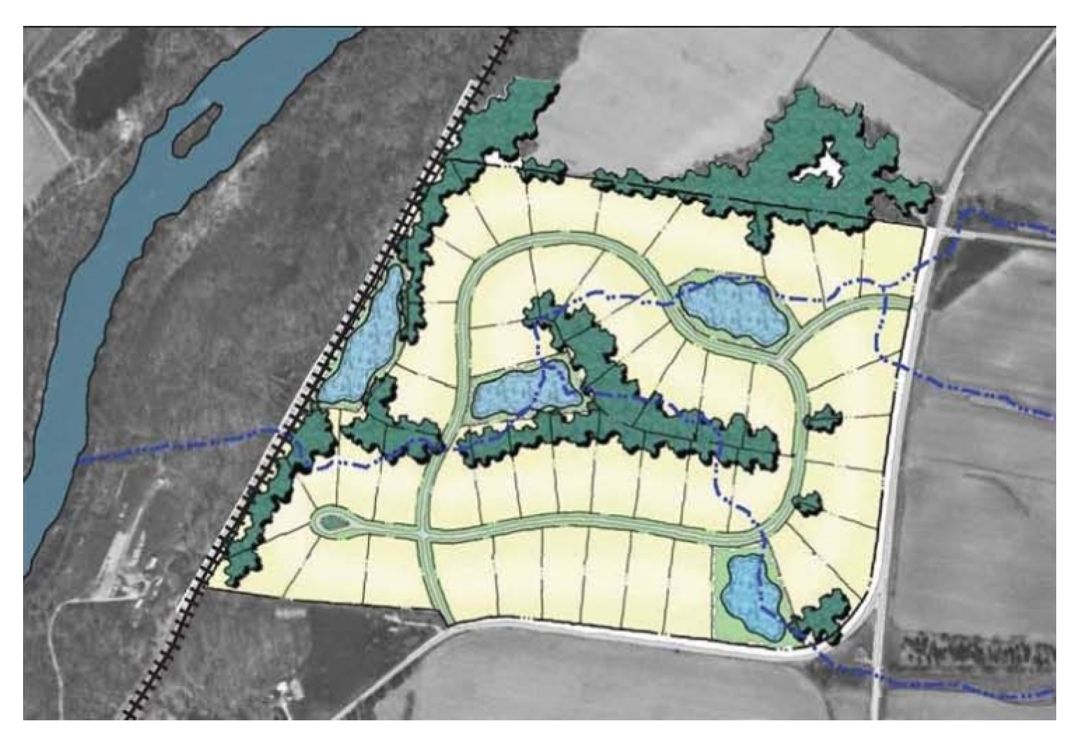
Step 1: Developing a "yield plan" to determine the
maximum allowable density for the site.
The site is 120 acres, which includes 10 acres devoted to wetlands. At 90,000 square feet per lot, the 110 buildable acres yield 47 total lots. In addition, the 120-acre site provides for about 15% open space.
(2)
Location of house sites. During the second step, potential house sites are tentatively located. Because the proposed location of houses within each lot represents a significant decision with potential impacts on the ability of the development to meet the evaluation criteria contained in Section 36-372, subdivision applicants shall identify tentative house sites on the concept plan and proposed house sites on the detailed final plan. House sites should generally be located not closer than one hundred (100) feet from primary open space areas but may be situated within fifty (50) feet of secondary open space areas, in order to enjoy views of the secondary open space without negatively impacting the primary open space. The building footprint of proposed residences may be changed by more than fifty (50) feet in any direction with majority approval from the members of the County Board. Changes involving less than fifty (50) feet do not require approval.
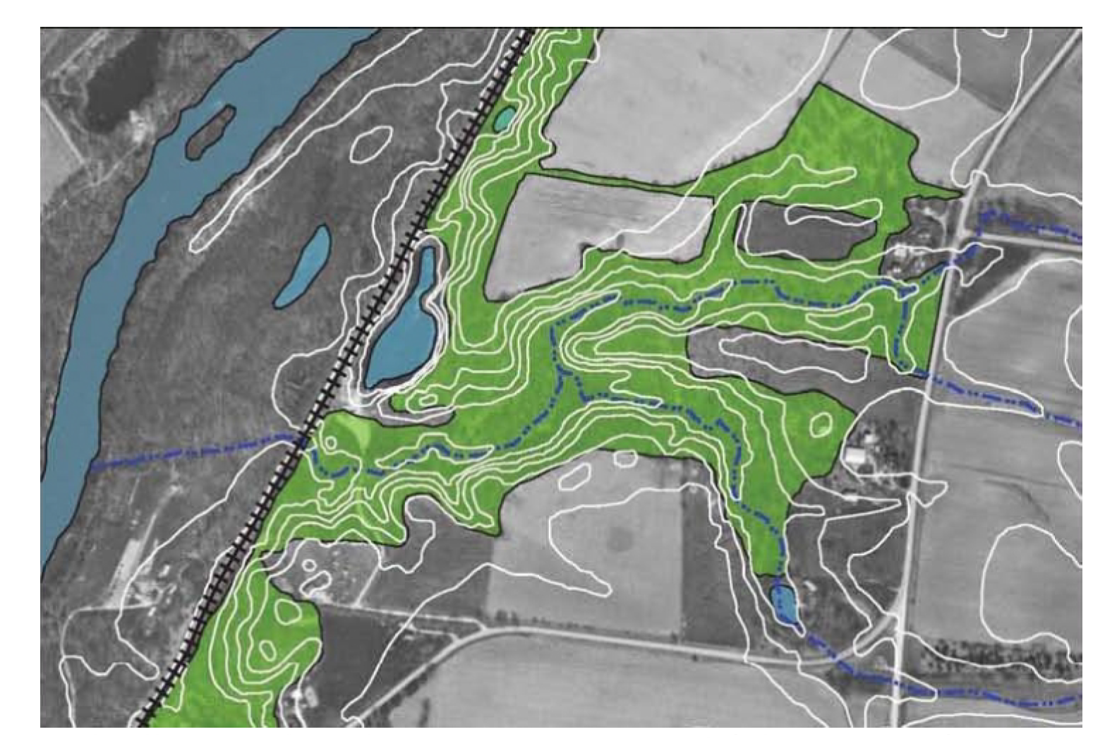
Step 2: Identifying and analyzing key environmental features such as
woodlands, topography, wetlands, and natural drainage.
This site has extensive environmental features, including large woodlands (shown as the green area) with natural drainageways (shown as the blue dotted line). One of the natural drainageways leads to a river on the west side of the graphic. Wetlands are shown as light blue shapes.
(3)
Street and lot layout.
a.
The third step consists of aligning proposed streets to provide vehicular access to each house in the most reasonable and economical way. When lots and access streets are laid out, they shall be located in a way that avoids or at least minimizes adverse impacts on both the primary and secondary conservation areas. To the greatest extent practicable, wetland crossings and streets traversing existing slopes over fifteen (15) percent shall be strongly discouraged. Street connections shall generally be encouraged to minimize the number of new culs-de-sac to be maintained by the County or township and to facilitate easy access to and from homes in different parts of the property (and on adjoining parcels). Culs-de-sac serving more than six (6) homes shall generally be designed with a central island containing indigenous trees and shrubs (either conserved on site or planted).
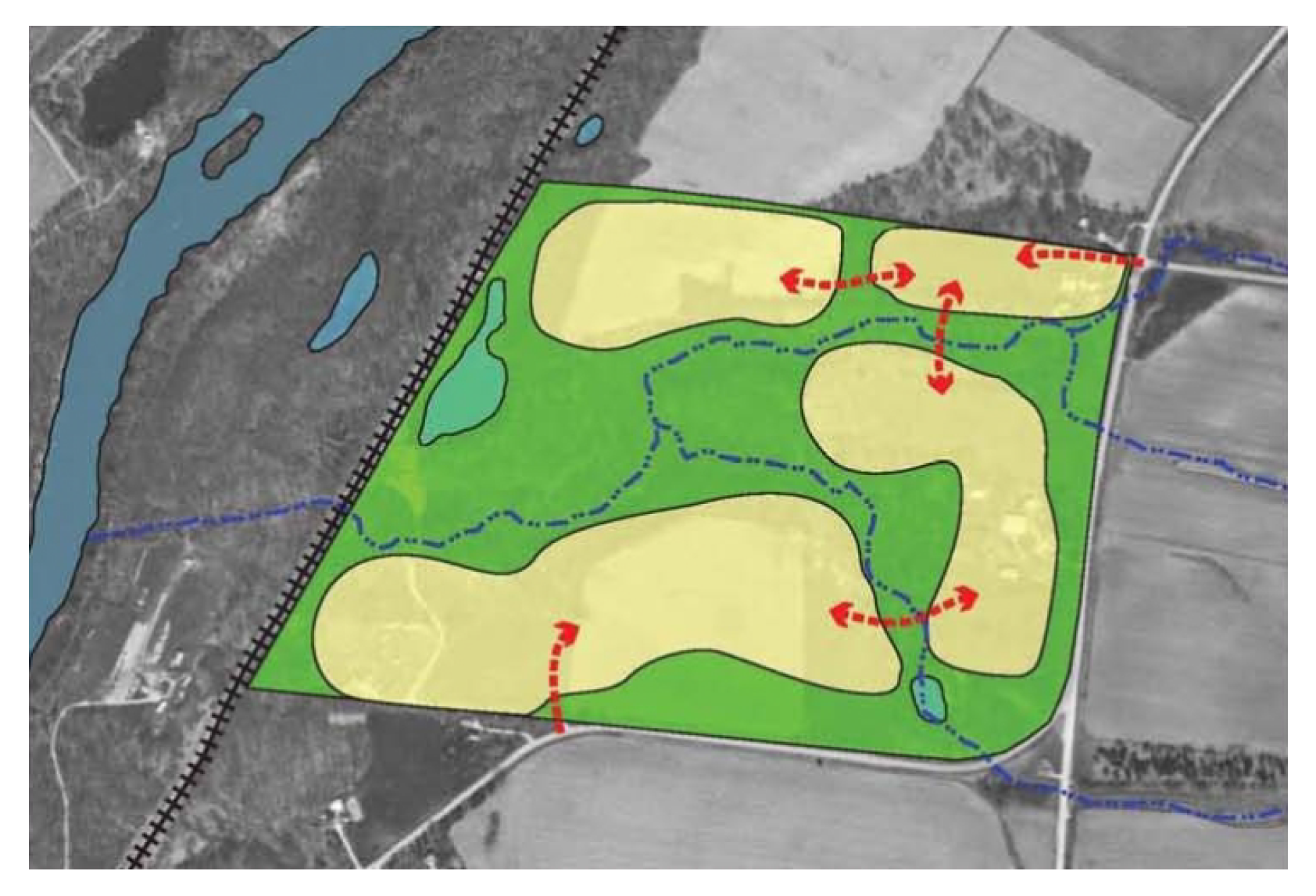
Step 3: Identifying "development opportunities" and
"conservation opportunities."
Illustrated in green, conservation opportunities are formed by the environmental features identified in Step 2. The yellow shapes represent development opportunities, offering sites for residential lots.
b.
The County generally encourages the creation of single-loaded residential access streets, in order that the maximum number of homes in new developments may enjoy views of open space.

c.
Note that in situations where more formal, "neo-traditional," or village-type layouts are proposed, Steps 2 and 3 may be reversed, so that the location of house sites follows the location of streets and squares.
(4)
Lot lines. The fourth step is simply to draw in the lot lines (where applicable). These are generally drawn midway between house locations.
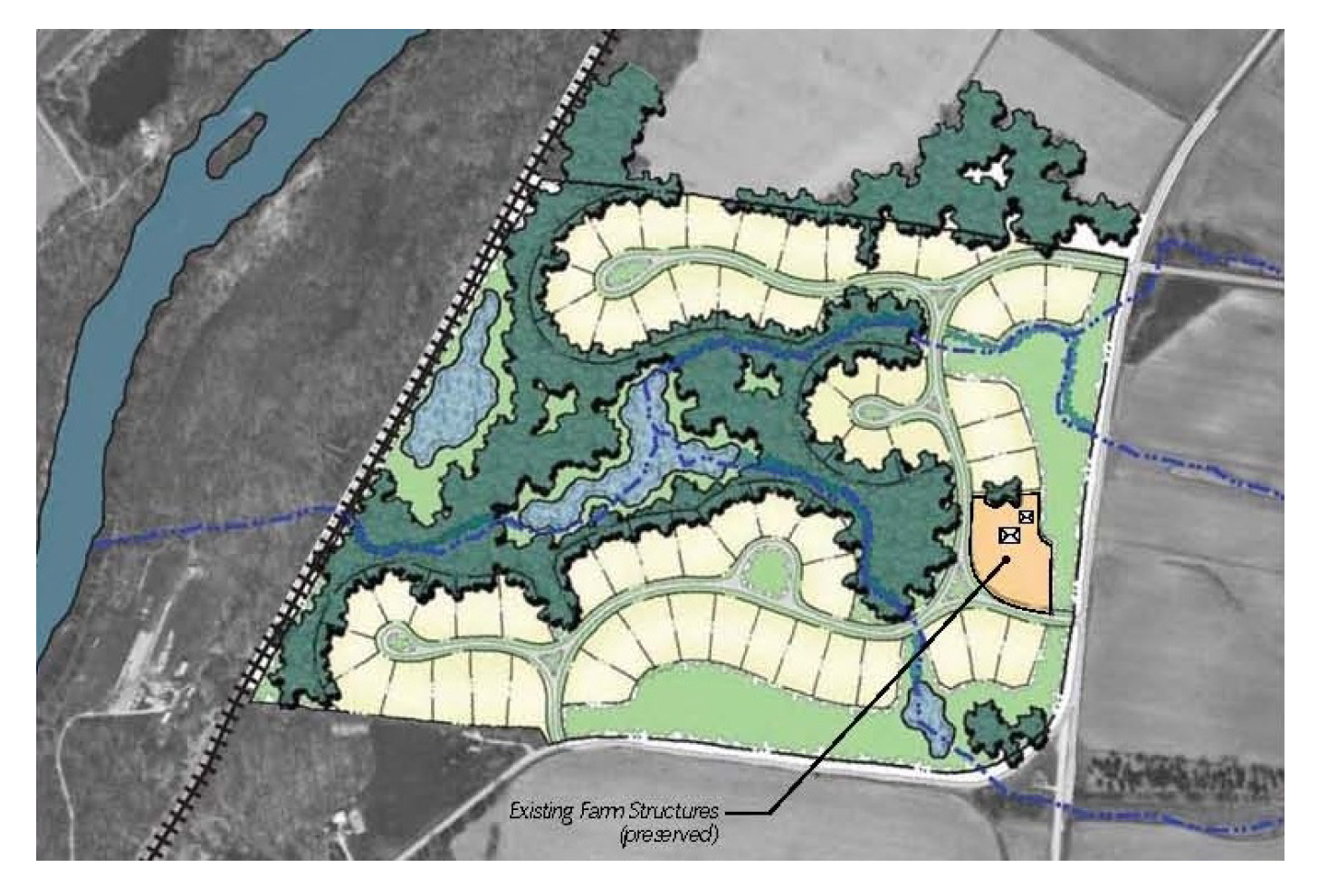
Step 4: Preparing a site design with residential lots,
a road network, and conservation areas.
At 40,000 square feet per lot, the 110 buildable acres yield 59 total lots in this conservation design plan. The 120-acre site provides about 60% open space, which is much greater than the yield plan from Step 1. The existing farm structure along the eastern edge was also preserved as its own lot (light orange area). The higher lot count and greater open space coverage emphasize the benefits of using the conservation design approach.
(Ord. No. 2020-17, exh. M, § 13:09(C), 9-15-2020)
Sec. 36-154. - Preliminary site plan/plat approval.
(a)
Preliminary site plan. Prior to approval of the concept plan, the applicant shall submit to the Regional Planning Commission a preliminary site plan/preliminary plat that shows the approximate layout of proposed streets, house lots, and open space lands complies with the zoning and subdivision ordinances of the County and any municipalities within one and one-half (1½) miles of the development, particularly those sections governing the design of subdivision streets and stormwater management facilities. This site plan requirement is meant to provide the County with assurance that the proposed plan is able to be accomplished within the current regulations of the County. The site plan shall also note any variations needed to implement the plan as drawn. At the applicant's own risk, an applicant may skip the preliminary plat stage and proceed directly to final plan approval or may combine preliminary and final plat approval.
(b)
Content of petition. The formal petition shall contain, in addition to all other requirements, the following:
(1)
A site plan of the planned development. This plan will be at a scale of not less than one (1) inch equals one hundred (100) feet which shall show all proposed streets (public and private), street classifications, rights-of-way, pavement width of street and driveways, all principal buildings, lot sizes, building lines, easements for utility services, off-street parking, service areas, open space recreation facilities and any other information necessary to clearly show the proposed elements of the planned development.
(2)
Preliminary architectural plans for all residential buildings proposed to contain more than one (1) dwelling unit shall be submitted in sufficient detail to show the basic planning, the number of units per building and the estimated number of bedrooms per dwelling unit. Building elevations shall be required only for structures containing more than one (1) dwelling unit. Preliminary architectural plans for business or other nonresidential buildings shall illustrate elevations and proposed exterior materials.
(3)
A topographic survey with two (2) foot contour intervals and the boundary survey of the subject area, prepared and certified by a registered State surveyor.
(4)
A rendered plan of the planned development area showing in contrasting colors or by other means the respective location of all categories of land use.
(5)
A map of the general area showing the location of the planned development site and its relation to the existing roads and streets and use districts within the immediately adjacent and surrounding area.
(6)
Preliminary engineering plans and specifications for the following improvements:
a.
Roads and streets, including classifications, width of rights-of-way, widths of paved surfaces and construction details.
b.
Sidewalks and trails, including widths of paved surfaces and construction details.
c.
Sanitary and storm sewer system.
d.
Water supply system.
e.
Street lighting and public area lighting system.
f.
Recommended installations for electric, gas and telephone facilities and distribution.
g.
Sequence of phases or stages of development of the planned development.
h.
A general landscape planting plan and tree removal and preservation plan, prepared by a landscape architect which meets the approval of the Regional Planning Commission.
(7)
The following shall be provided by either graphic exhibits or written statement:
a.
The density of residential uses and the number of dwelling units by type.
b.
The ancillary and nonresidential uses to be provided in a residential planned development.
c.
The off-street parking and other service facilities proposed.
d.
The exception or variations to the County zoning or subdivision requirements being requested as part of the planned development application.
e.
The calculation of buildable acreage, the percent and acreage of land used for each of primary and secondary open space purposes, and the type and acreage of passive and recreational open space.
f.
Other submittals as requested by the County PBZ Department (including, but not limited to, traffic studies, groundwater studies, etc.).
(c)
Procedures for approval.
(1)
The applicant shall request the preliminary plan/plat approval in addition to a petition for a zoning map amendment, by letter addressed to the PBZ or designee, to be placed on the agenda of the next regular meeting of the ZPAC for a preliminary discussion of the proposed planned development. The applicant shall present such exhibits and written information as may be necessary to fully acquaint the ZPAC with the proposed development.
(2)
A copy of the petition shall also be submitted to the applicable township and any municipality within one and one-half (1½) miles of the proposed development, with extra-territorial jurisdictional control. The applicant shall present the application at a regularly scheduled meeting of the Regional Planning Commission (or other applicable body) of the township or municipality. The township and/or municipality may submit comments to the County regarding the petition within thirty (30) days.
(3)
The Director of Planning, Building and Zoning or designated representative shall review the submission to ensure that it complies with the preliminary plan and any comments and conditions governing approval of the preliminary plan.
(4)
The petition shall be reviewed by the ZPAC within thirty (30) days of the date of the complete original submission of the final plan, and a recommendation shall be made, accompanied by such plats, exhibits and supporting documents as shall have been presented by the petitioner, each identified for reference by letter or number, together with any suggested changes therein. The director or staff shall submit minutes of the ZPAC meeting containing such recommendation shall be submitted to the Regional Planning Commission for review and recommendation, along with any written correspondence received from any municipality or township.
(5)
The petition shall be heard by the Regional Planning Commission within sixty (60) days of the ZPAC meeting provided any necessary revisions or supplemental information requested by ZPAC have been supplied at least thirty (30) days in advance the Regional Planning Commission meeting. Upon completion of their review of the preliminary plan or plat, a recommendation shall be made, accompanied by such plats, exhibits and supporting documents as shall have been presented by the petitioner, each identified for reference by letter or number, together with any suggested changes therein. The minutes of the Regional Planning Commission meeting containing such recommendation shall be submitted to the ZBA, along with any written correspondence received from any municipality or township.
(6)
The Chairman of the ZBA shall set a hearing date on the zoning map amendment to be held within thirty (30) days of the submission of the Regional Planning Commission report provided any necessary revisions or supplemental information requested by the Regional Planning Commission have been supplied at least fifteen (15) days in advance of the hearing. The Chairman shall cause notice of the hearing to be published at least once, not more than thirty (30) days nor less than fifteen (15) days before said hearing date in one (1) or more newspaper of general circulation in the County. Written notice shall be given by the applicant to all property owners as prescribed by the ZBA bylaws.
(7)
Upon completion of their review of the map amendment and preliminary plan or plat, the ZBA shall make a recommendation. The Director of Planning, Building and Zoning or designated representative shall forward a copy of the petition, the minutes of the applicable meetings containing the recommendations of the Regional Planning Commission and the Zoning Board of Appeals accompanied by such plats, exhibits and supporting documents as shall have been presented by the petitioner, each identified for reference by letter or number, together with any suggested changes therein, to the Planning, Building and Zoning Committee of the County Board. The PBZ Committee shall review the petition within thirty (30) days of the public hearing unless a legal objection is eligible for filing in which case the PBZ Committee shall review the petition within sixty (60) days.
(8)
The Director of PBZ or designated representative shall forward a copy of the petition and the minutes of the applicable meetings of the Regional Planning Commission, Zoning Board of Appeals and Planning, Building and Zoning Committee to the County Board. The County Board shall review the petition within thirty (30) days of the PBZ Committee's meeting.
(9)
The County Board may grant an ordinance approving a map amendment for the planned development as well as any related special use permits. A separate ordinance approving the concept plan and preliminary plan/plat may also be granted, including plats, landscape plans, and the like. The concept plan and preliminary site plan or plats required by this section and Section 36-152(d) shall be explicitly made a part of the planned development ordinance.
(d)
Zoning map. Approved residential planned developments shall be delineated and designated by a number on the zoning district map. A file, available for inspection by the public, shall be maintained by the Director of PBZ for each planned development so designated. The file shall contain a record of the approved development plan and all exceptions authorized therein.
(Ord. No. 2020-17, exh. M, § 13:09(D), 9-15-2020)
Sec. 36-155. - Final plan approval.
(a)
Request. The applicant shall request the final plan approval, by letter addressed to the Director of PBZ or designee, to be placed on the agenda of the next regular meeting of the Regional Planning Commission for a preliminary discussion of the proposed planned development at such meeting, which may be continued from time to time. The applicant shall present such exhibits and written information as may be necessary to fully acquaint the Regional Planning Commission with the proposed development.
(b)
Content of petition. The formal petition shall contain, in addition to all other requirements, the following:
(1)
A site plan of the planned development. This plan will be at a scale of not less than one (1) inch equals one hundred (100) feet which shall show all proposed streets (public and private), street classifications, rights-of-way, pavement width of street and driveways, all principal buildings, lot sizes, building lines, easements for utility services, off-street parking, service areas, open space recreation facilities and any other information necessary to clearly show the proposed elements of the planned development.
(2)
Preliminary architectural plans for all residential buildings proposed to contain more than one (1) dwelling unit shall be submitted in sufficient detail to show the basic planning, the number of units per building and the estimated number of bedrooms per dwelling unit. Building elevations shall be required only for structures containing more than one (1) dwelling unit. Preliminary architectural plans for business or other nonresidential buildings shall illustrate elevations and proposed exterior materials.
(3)
A topographic survey with two (2) foot contour intervals and the boundary survey of the subject area, prepared and certified by a registered State surveyor.
(4)
A rendered plan of the planned development area showing in contrasting colors or by other means the respective location of all categories of land use.
(5)
A map of the general area showing the location of the planned development site and its relation to the existing roads and streets and use districts within the immediately adjacent and surrounding area.
(6)
Specifications of the following improvements:
a.
Roads and streets, including classifications, width of rights-of-way, widths of paved surfaces and construction details.
b.
Sidewalks, including widths of paved surfaces and construction details.
c.
Sanitary and storm sewer system.
d.
Water supply system.
e.
Street lighting and public area lighting system.
f.
Recommended installations for electric, gas and telephone facilities and distribution.
g.
Sequence of phases or stages of development of the planned development.
h.
A general landscape planting plan, prepared by a landscape architect which meets the approval of the Regional Planning Commission.
(7)
The following shall be provided by either graphic exhibits or written statement:
a.
The density of residential uses and the number of dwelling units by type.
b.
The ancillary and nonresidential uses to be provided in a residential planned development.
c.
The off-street parking and other service facilities proposed.
d.
The exception or variations to the County zoning or subdivision requirements being requested as part of the planning development application.
e.
The calculation of buildable acreage, the percent and acreage of land used for each of primary and secondary conservation purposes, and the type and acreage of passive and recreational open space.
f.
Estimates of cost of installation of all proposed improvements, confirmed by a registered State engineer.
g.
Petitioner's proposed development agreement, covenants, restrictions and conditions, special service district and homeowners' association bylaws to be established as a part of the planned development.
h.
Open space maintenance and monitoring plan that complies with the standards set forth in Section 30-197.
i.
Other submittals as requested by the County PBZ Department.
1.
Construction of improvements. The petitioner shall construct and install the required improvements in accordance with the County subdivision regulations set forth in Chapter 30 and the special use ordinance.
2.
Street classification. Street classifications, definitions, and specification shall be in accordance with the regulations pertaining to same as established in the subdivision regulations set forth in Chapter 30 and the Comprehensive Plan of the County, as may be amended from time to time, as may be modified by the special use permit.
3.
Standards. No planned development shall be authorized by the County Board unless the Regional Planning Commission shall find and recommend that the following standards will be met:
(i)
The uses permitted by such exceptions as may be requested or recommended are necessary or desirable and appropriate to the purpose of the development.
(ii)
The uses permitted in such development are not of such nature or so located as to exercise an undue detrimental influence or effect upon the surrounding neighborhood.
(iii)
That all minimum requirements pertaining to commercial, residential, institutional, or other uses established in the planned development have been adhered to.
(iv)
When private streets and common driveways are made a part of the planned development or private common open space or recreation facilities are provided, the applicant shall submit as a part of the application the method and arrangement whereby these private facilities shall be operated and maintained. Such arrangements for operating and maintaining private facilities shall be subject to the approval of the County Board.
(c)
Procedures for approval.
(1)
A copy of the petition shall be filed with the PBZ Department, and ten (10) copies of the petition shall be filed with the Director of PBZ or designee. Attached to each copy shall be copies of the supporting documents and exhibits provided for herein.
(2)
A copy of the petition shall also be submitted to the applicable township and any municipality within one and one-half (1½) miles of the proposed development. The applicant shall present the application at a regularly scheduled meeting of the Regional Planning Commission (or other applicable body) of the township or municipality. The township and/or municipality may submit comments to the County regarding the petition within thirty (30) days.
(3)
The Director of the PBZ or designated representative shall review the submission to ensure that it complies with the preliminary plan and any comments and conditions governing approval of the preliminary plan.
(4)
The petition will be placed on the agenda of the next regular meeting of the ZPAC for a preliminary discussion of the proposed planned development. The applicant shall present such exhibits and written information as may be necessary to fully acquaint the ZPAC with the final plat for the proposed development.
(5)
The petition shall be reviewed by the ZPAC within thirty (30) days of the date of the complete original submission of the final plan, and a recommendation shall be made, accompanied by such plats, exhibits and supporting documents as shall have been presented by the petitioner, each identified for reference by letter or number, together with any suggested changes therein. The minutes of the ZPAC meeting containing such recommendation shall be submitted to the Regional Planning Commission for review and recommendation, along with any written correspondence received from any municipality or township.
(6)
The petition shall be reviewed by the Regional Planning Commission within sixty (60) days of the date of the ZPAC meeting provided any necessary revisions or supplemental information requested by ZPAC have been supplied at least thirty (30) days in advance the Regional Planning Commission meeting. Upon completion of their review of the final plat, a recommendation shall be made, accompanied by such plats, exhibits and agreements as shall have been presented by the petitioner, each identified for reference by letter or number, together with any suggested changes therein. The minutes of the Regional Planning Commission meeting containing such recommendation shall be submitted to the PBZ Committee of the County Board for review and recommendation to the County Board.
(7)
The Chairman of the PBZ Committee shall review the matter within thirty (30) days of the submission of the Regional Planning Commission report and receipt of the required approvals for the final engineering plans and supporting documents by all applicable reviewing agencies.
(8)
Following review and recommendation by the PBZ Committee, the Director of the PBZ Committee or designated representative shall forward a copy of the petition and the minutes of the applicable meetings of the Regional Planning Commission and the PBZ Committee to the County Board. The County Board shall review the petition within thirty (30) days of the PBZ Committee's meeting.
(9)
The County Board may grant an ordinance for the planned development which shall be by specific ordinance and which shall contain or to which shall be appended all terms and conditions of the special use permit, including covenants and agreements, guarantees, performance bonds, plats, and the like. The site development plan required by this subdivision shall be explicitly made a part of the planned development ordinance.
(d)
Relationship to subdivision approval.
(1)
An application for approval of a residential planned development, as provided for in this subdivision, may be undertaken concurrently with an application for subdivision plat approval, as provided in the County subdivision regulations set forth in Chapter 30.
(2)
Certain large projects may be platted and developed in phases. In such cases, the final subdivision plat may be done on a phase-by-phase basis, after receiving preliminary planned development approval and preliminary subdivision approval for the entire development. However, the final planned development plan for the entire development must be approved in advance of or concurrently with final plat approval of the first phase.
(3)
Required open space in a phased subdivision plat. In projects which are developed in phases, each subdivision plat phase need not provide thirty (30) percent of that phase's area as open space (in accordance with the minimum open space requirement for residential planned developments). However, each phase shall provide a reasonable amount of open space, to serve residents of that phase until the entire development is built out and the minimum required open space (thirty (30) percent of the total acreage of the entire development) is completed.
(Ord. No. 2020-17, exh. M, § 13:09(E), 9-15-2020)