
Port St Joe City Zoning Code
ARTICLE VIII
SUBDIVISION REGULATIONS
Sec. 8.00.- General provisions—Purpose.
The purpose of this article is to promote and protect the public health, safety, economy, order, appearance, convenience, morals and general welfare of the citizens of the city through the harmonious, orderly and progressive development of land within the unincorporated boundaries of the City of Port St. Joe, Florida.
Sec. 8.01. - Intent.
The regulation of the subdivision of land is intended:
(a)
To aid in the coordination of land development in the unincorporated areas of the city in accordance with orderly physical patterns to maintain and protect the local economy and natural resources and to discourage haphazard, uneconomic, or scattered land development.
(b)
To insure safe and convenient traffic control and to encourage development and maintenance of economically stable and healthful communities.
(c)
To prevent periodic and seasonal flooding by providing protective flood control and drainage facilities; and to provide public open spaces for recreation, assure land subdivision with installation of adequate and necessary physical improvements.
(d)
To assure that the citizens and taxpayers of the city will not have to bear the costs resulting from haphazard subdivision of land and the lack of authority to require installation by the developer of certain minimum improvements.
(e)
To serve as a tool for the implementation of the city comprehensive planning program.
Sec. 8.02. - Procedures for plat approval—Preliminary plat approval.
All proposed developments which involved the subdivision of land shall be considered level 2 major developments and shall be subject to the review procedures described in section 2.03 of this Code.
(a)
A complete application for development shall be submitted consistent with section 2.06 including the proposed number, minimum area and location of lots.
(b)
Issuance of a development order by the board of city commissioners shall constitute preliminary plat approval.
(c)
To prevent undue hardship on the subdivider through possible required plat revisions, a preliminary plat of the proposed subdivision at a scale not smaller than 100 feet to the inch may first be submitted.
Sec. 8.03. - Same—Final plat approval.
Final plats shall meet all the requirements of F.S. ch. 177, and shall be subject to the review procedures described in section 2.03 of this Code.
(a)
Final plat shall contain the following information:
(1)
The subdivision name, the names and addresses of the owners, the designer of the plat, and total acreage to be subdivided.
(2)
Date, north point, and a graphic scale.
(3)
The location of existing and platted property lines, roads and streets, water courses, railroads, sewers, bridges, culverts, drainpipes, water mains, and any other public utility easements.
(4)
The names, locations, widths, and other dimensions of proposed streets, alleys, easements, lot lines, building and set back lines, and bridges.
(5)
Topography of the entire plat showing contour lines denoting any elevation changes of two feet in elevation.
(6)
Proposed drainage plan, including ultimate destinations of flow and storm drainage systems and retention area, and a typical cross section of the streets.
(b)
The final plat shall be submitted to the commission in triplicate, of which one set shall be the original reproducible drawings. The final plat shall be submitted to the building inspector at least ten days prior to the regular meeting of the commission. The commission shall approve within 30 days of the commission meeting at which it is presented. If the plat is disapproved, the grounds for disapproval shall be stated upon the records of the commission, and a letter transmitted to the subdivider stating the reason for such disapproval.
(c)
The final plat shall be drawn on mylar, or vellum or other equal material and shall be at a scale of 100 feet to one inch or larger, where necessary the plat may be on several sheets accompanied by an index sheet showing the entire subdivision. The final plat shall show the following:
(1)
Primary control points, or descriptions and "ties" to such control points to which all dimensions, angles, bearings, and similar date on the plat shall be referred.
(2)
Tract boundary line, right-of-way lines of streets easements and other rights-of-way and property lines of residential lots and other sites; with accurate dimensions, bearings or deflection angles, and radii, arcs, and central angles of all curves.
(3)
Names and right-of-way width of each street or other right-of-way.
(4)
Location, dimensions, and purpose of any easements.
(5)
Number to identify lot or site.
(6)
Purpose for which sites, other than residential lots, are dedicated or reserved.
(7)
Minimum building setback line on all lots and other sites.
(8)
Location and description or monuments.
(9)
Reference to recorded subdivision plats of adjoining platted land.
(10)
Certification by surveyor or engineer certifying to accuracy of survey and plat.
(11)
Certification of title showing that applicant is the land owner.
(12)
Statement by owner dedicating streets, right-of-way and any sites for public uses.
(13)
Title, scale, north point, and date.
(14)
Certificate for recording by the clerk of circuit court.
(15)
In addition to the above requirements, any further requirements found in F.S. ch. 177.091, shall be included in the application for final approval.
(d)
The city commission shall not approve the final plat unless they receive the following:
(1)
A certificate from the city engineer or a licensed civil engineer that all improvements have been installed in accord with these regulations or provisions made therefore.
(2)
A certificate from the city clerk that a bond has been posted or requirements established by the commission have been met, assuring full performance.
(3)
Fees. When application is made for final plat approval, the subdivider shall pay fees consistent with resolution adopted pursuant to article II, section 2.18.
(e)
In the event the subdivision is a development of regional impact, as defined in Chapter 28-24, Florida Administrative Code, formal plat approval shall be given only after compliance with F.S. ch. 380.
(f)
Upon approval of the plat, one copy of the original reproducible drawings shall be retained in the file of the clerk of the circuit court. Upon approval of the plat, one copy of the original reproducible drawings shall be retained in the file of the clerk of circuit court.
Sec. 8.04. - Requirements.
Conformity to city plat: All proposed subdivisions shall conform to adopted city plans.
Sec. 8.05. - Streets.
(a)
Relations to adjoining street system. Local streets shall connect with surrounding streets to permit the convenient movement of traffic between residential neighborhoods or facilitate emergency access and evacuation. Proposed new streets shall extend existing streets to their projections at the same or greater width, but in no case less than minimum required width, unless variations are deemed necessary by the commission for reasons of topography, or design where in the opinion of the commission, it is desirable to provide street access to adjoining property, proposed streets shall extend to the boundary of such property. Half streets or half alleys along the boundary of land proposed for subdivision will not be permitted unless the title to the adjacent lands are furnished the city at the time the plat is filed. When existing roads are less than the required width, and not acceptable to the city for paving because of the width, the subdivision shall state on the face of the plat that the access road is not acceptable for paving without additional right-of-way and city accepts no responsibility for obtaining right-of-way.
(b)
Street widths. The minimum width of proposed streets measured from lot line to lot line, shall be shown on the major street plan. At the discretion of the commission, a major street plan should be provided by the developer, if not shown on such plan, the widths shall be not less than 60 feet; provided that a minimum of 50 feet connecting streets will be acceptable if there are existing street ends of the same width. Where the cause of drainage problems and other unique topographical configurations or problems, 60 feet is not sufficient, the city may require additional widths as needed. Alleys serving lots shall not be less than 20 feet.
(c)
Conformance to topographic conditions and street grades. In general, streets shall be planned to conform to existing topographic conditions. The maximum grade on major streets shall be five percent. The maximum grade on all other streets may not exceed eight percent.
(d)
Street intersections. Insofar as practical, acute angles at intersections shall be avoided. Where an acute angle of less than 75 degrees occurs between streets at their intersection, the commission may require the property lines to be rounded or otherwise set back to permit curb construction of desirable radius without curtailing the sidewalk at the street corner to less than normal width. Submission of a grading plan showing existing and proposed contours at one foot intervals and a detailed design for the intersection may be required by the commission. Unaligned intersections shall be separated by a minimum of 125 feet between center lines.
(e)
Curves in streets. Where a deflection angle of more than ten degrees in the alignment of a street occurs, a curve of reasonable long radius shall be introduced. On all streets except local service streets, the center line radius of curvature shall not be less than 100 feet.
(f)
Dead end streets. Streets designed to have one end permanently closed (cul de sac) shall be provided at the closed end with a turnaround with a minimum right-of-way diameter of 100 feet, and minimum driving surface radius of 40 feet.
(g)
Street names. Proposed streets obviously in alignment with existing and named streets shall bear the names of existing streets. In no case shall the names for the proposed streets duplicated existing street names irrespective of the suffix used.
(h)
Alleys. Alleys shall be provided along the rear of all lots to be used for business.
(i)
Connections to undeveloped or partially developed land. Proposed development shall include streets that extend to undeveloped or partially developed land that is adjacent to the development site or that is separated from the development site by a drainage channel, transmission easement, survey gap, or similar property condition. Street stubs shall be provided to the property line to provide for future development. The streets stubs shall be in locations that will not prevent the adjoining property from developing consistent with applicable standards.
The requirements of this paragraph may be waived if it is demonstrated, in the opinion of the technical advisory committee that a connection cannot be made because of the existence of one or more of the following conditions:
(1)
Physical conditions preclude development of the connecting street. Such conditions may include, but are not limited to, topography or likely impact to natural resource areas such as wetlands, ponds, streams, channels, rivers, lakes, wildlife habitat area, or other conservation or preservation features;
(2)
Buildings or other existing development on adjacent lands, including previously subdivided but vacant lots or parcels, physically preclude a connection now or in the future, considering the potential for redevelopment.
Sec. 8.06. - Street improvements required prior to acceptance—Large subdivisions.
Streets and alleys shall be brought to grade and improved to the dimensions required by the cross-section and the work shall be performed in the following manner:
(1)
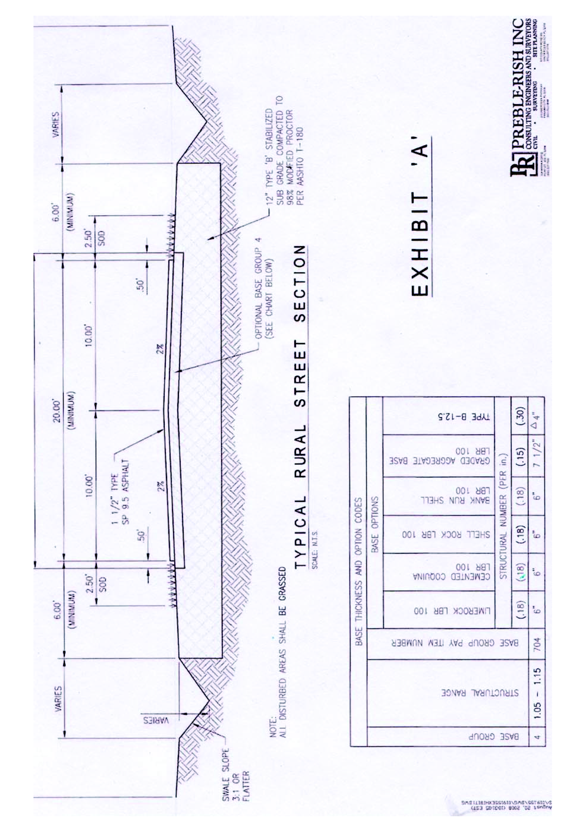
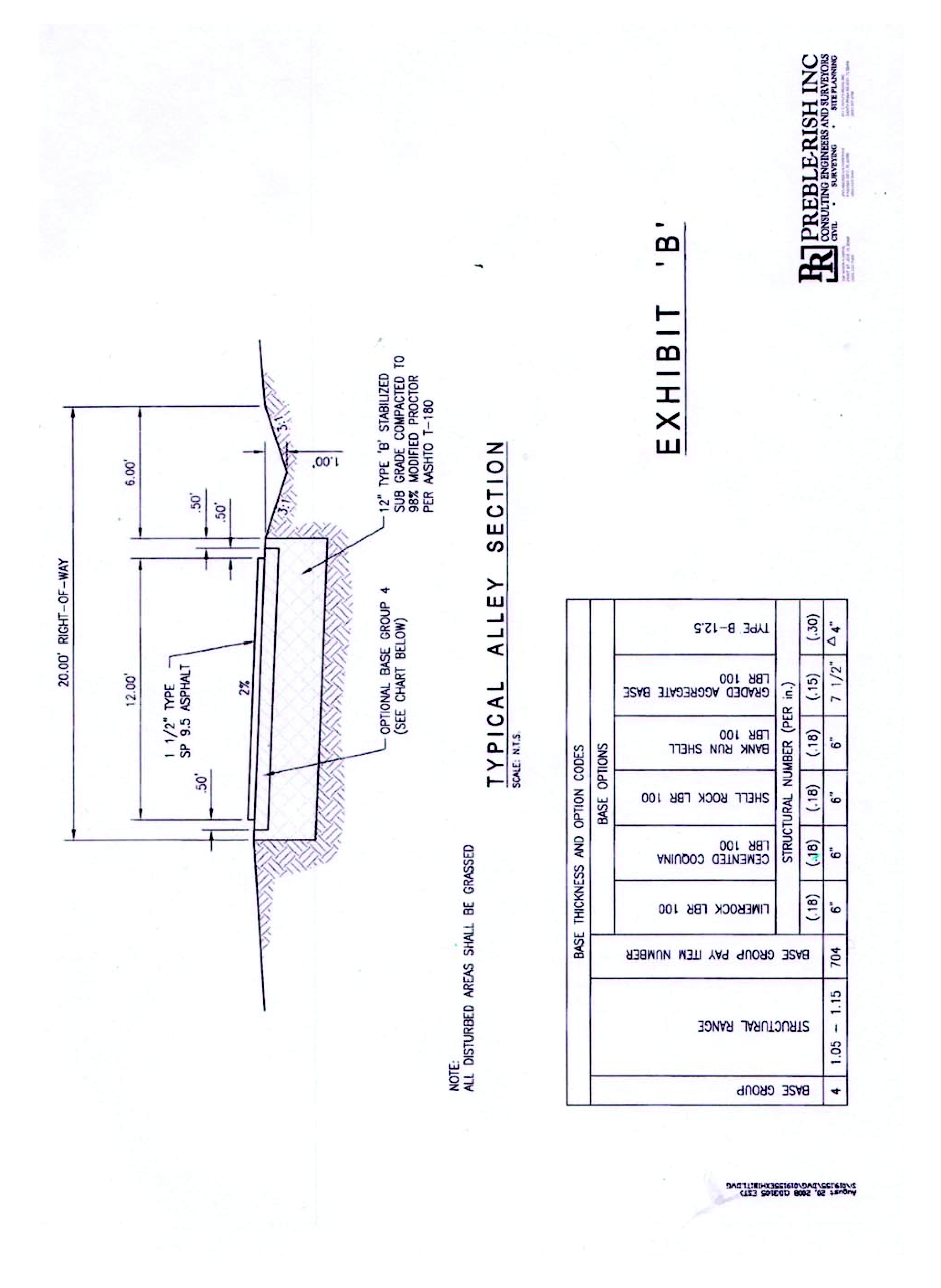
All streets and alleys shall be cleared, grubbed, and graded to the full width of the right-of-way and provided with a properly prepared subgrade, base and pavement in compliance with Exhibit A (Typical Rural Street Section) and Exhibit B (Typical Alley Section). Typical urban street sections shall be similar to rural street sections except for the roadside grass and swales. A typical urban street section is the same for the roadway cross section.
(2)
All materials used in the construction and paving of the streets are to be as specified in the most recent edition of the state department of transportation Standard Specifications for Road and Bridge Construction.
(3)
(4)
The subdivider, in preparing the streets within the subdivision, shall also acquire the necessary right-of-way and improve said right-of-way in accordance with these regulations for sufficient access roads for adequate ingress and egress to and from the subdivision.
(5)
Street name signs shall be installed at all street intersections. Street names as well as the design and placement of such signs shall be subject to the approval of the board of city commissioners.
Sec. 8.07. - Same—Small subdivisions.
(a)
The developer or subdivider shall maintain the streets for (a) a period of 12 months from plat approval, or (b) until 15 percent of the lots have been built on.
(b)
Prior to acceptance, the streets shall be constructed in compliance with Exhibit A.
(c)
The subdivider, in preparing the streets within the subdivision, shall also acquire the necessary right-of-way and improve said right-of-way in accordance with these regulations for sufficient access roads for adequate ingress and egress to and from the subdivision.
(d)
Prior to final acceptance, the streets, ditches and drainage structures must be brought up to standard according to these subdivision regulations or these streets shall revert to the developer or subdivider.
Sec. 8.08. - Blocks and lots.
Blocks shall not be more than 1,200 feet in length. In blocks over 800 feet in length the Commission may require one or more public cross walks with not less than a ten-foot right-of-way, when the public has an interest in the adjoining property behind the land being subdivided.
(a)
Minimum lot size and set back lines: Within the subdivision jurisdiction limits of the city, the minimum size and shape of residential lots shall be 75—150. Corner lots shall have the extra width sufficient to permit establishment of a building line at least 20 feet from the side street property line. The distance from the side street property line shall measure from the street right-of-way paralleling the long dimensions of the lot. Irregular lots with less measurements (minimum) may be permitted where total square foot is at least 11,250 square feet.
(b)
All residential lots within a subdivision shall have a minimum set back line on the front and side lines of not less than 7½ feet.
Sec. 8.09 - Sidewalks and bikeways.
Sidewalks and bikeways shall be provided in subdivisions created and approved pursuant to these regulations where new streets are created and paved and shall be installed in accordance with the requirements and specifications of the city and in coordination with the public works department. Such facilities shall be dedicated to and be maintained by the city.
Sec. 8.10. - Public uses and services areas.
(a)
Public uses. In a subdivision of more than 40 acres, the city commission shall require adequate provisions to be made for parks or commons areas as ascertained by the city commissioners. The amount required shall not exceed five percent. Neighborhood parks or common areas shall be physically accessible to pedestrians to encourage neighborhood interaction.
(b)
Easements for utilities. The commission may require easements for poles, wire, conduits, storms and sanitary sewers, gas, water and heat mains, or other utility lines on each side of the common real lot lines and along side lots lines if necessary or advisable in the opinion of the commission. The dedication of streets, alleys and ditches shall automatically grant to the city an exclusive ownership and control of utilities within the streets, alleys and ditches.
Sec. 8.11. - Environmental information.
The developer of any subdivision shall provide educational brochures informing property purchasers within the property of the of the necessity of, and the methods for, protecting the aquifer and any lakes, streams, wetlands or other sensitive environmental features on or adjacent to the subdivision. A reference to this requirement shall be placed in the restrictive covenants for the project.
Sec. 8.12. - Enforcement of penalties.
(a)
No plat of a subdivision shall be filed or recorded by the clerk of circuit court until the plat is submitted to and approved by the board of city commissioners and such approval has been entered in writing on the plat by the city clerk and mayor.
(b)
Misrepresentation of a misdemeanor: Any owner or agent of the owner who falsely represents to a prospective purchaser of real estate that roads and streets, sewers, water systems, or drainage facilities will be built, constructed or maintained by the city shall be deemed guilty of a second degree misdemeanor and shall be punishable as provided by law.
(c)
General enforcement: Violation of the provisions of these regulations or of any rules and regulations of this Code, shall be deemed a second degree misdemeanor, punishable as provided by law and with each day such violation continues constituting a separate offense.
Sec. 8.13. - Variance.
If strict compliance to these regulations may cause hardship, the planning and development review board may approve the modification requested by the applicant. Such a variance shall apply only to specific hardships, and shall not be detrimental to the intent of these regulations and shall be subject to the requirements and procedures described in section 2.14 of this Code.
Sec. 8.14. - Restrictions.
No lot shown on any plat recorded in the public records of Gulf County, Florida covering property within the city limits of the City of Port St. Joe shall be further subdivided. This section shall not apply to any such lot subdivided prior to the date of this Code although no further subdivision of such a lot will be allowed, nor shall it apply to the subdivision of a platted lot, the sole purpose of which is to increase the size of adjoining lots.

