
Powhatan County Unincorporated
City Zoning Code
City Zoning Code
ARTICLE XII
INTERPRETATIONS
Sec. 83-530.- General rules for interpretation.
The following rules shall apply for construing or interpreting the terms and provisions of this chapter:
(1)
Meanings and intent. All provisions, terms, phrases, and expressions contained in this chapter shall be interpreted in accordance with the general purposes set forth in section 83-102, Zoning ordinance—General purpose and intent, and the specific purpose statements set forth throughout this chapter. When a specific section of these regulations gives a different meaning than the general definition provided in Article XI: Definitions, the specific section's meaning and application of the term shall control.
(2)
Headings, illustrations, and text. In the event of a conflict or inconsistency between the text of this chapter and any heading, caption, figure, illustration, table, or map, the text shall control. Graphics and other illustrations are provided for informational purposes only and should not be relied upon as a complete and accurate description of all applicable regulations or requirements.
(3)
Lists and examples. Unless otherwise specifically indicated, lists of items or examples that use terms like "for example," "including," and "such as," or similar language are intended to provide examples and are not exhaustive lists of all possibilities.
(4)
Computation of time.
a.
The time in which an act is to be done shall be computed by excluding the first day and including the last day. If a deadline or required date of action falls on a Saturday, Sunday, or holiday observed by the county, the deadline or required date of action shall be the next day that is not a Saturday, Sunday, or holiday observed by the county. References to days are calendar days, unless otherwise stated.
b.
Whenever a person has the right or is required to do some act within a prescribed period of time following the service of a notice or other document via mailed delivery, three days shall be added to the prescribed period.
(5)
References to other regulations/publications. Whenever reference is made to a resolution, ordinance, statute, regulation, or document, it shall be construed as a reference to the most recent edition of such regulation, resolution, ordinance, statute, regulation, or document, unless otherwise specifically stated.
(6)
Delegation of authority. Any act authorized by this chapter to be carried out by the director or the administrator, as appropriate, may be delegated with appropriate authorization.
(7)
Technical and non-technical terms. Words and phrases shall be construed according to the common and approved usage of the language, but technical words and phrases that may have acquired a peculiar and appropriate meaning in law shall be construed and understood according to such meaning.
(8)
Public officials and agencies. All public officials, bodies, and agencies to which references are made are those of the County of Powhatan, unless otherwise indicated.
(9)
Mandatory and discretionary terms. The words "shall," "must," and "will" are mandatory in nature, establishing an obligation or duty to comply with the particular provision. The words "may" and "should" are permissive in nature.
(10)
Conjunctions. Unless the context clearly suggests the contrary, conjunctions shall be interpreted as follows:
a.
"And" indicates that all connected items, conditions, provisions or events apply; and
b.
"Or" indicates that one or more of the connected items, conditions, provisions or events apply.
(11)
Tenses and plurals. Words used in the present tense include the future tense. Words used in the singular number include the plural number and the plural number includes the singular number, unless the context of the particular usage clearly indicates otherwise. Words used in the masculine gender include the feminine gender, and vice versa.
(12)
Term not defined. If a term used in any article of this chapter, is not defined, the administrator is authorized to provide a definition through the Interpretation procedure (see section 83-123(o), Interpretation (zoning)) based upon the definitions used in accepted sources, including but not limited to A Planners Dictionary, A Glossary of Zoning, Development, and Planning Terms, and A Survey of Zoning Definitions, published by the American Planning Association.
(Ord. No. O-2014-13, 6-2-14; Ord. No. O-2019-28, 8-26-19)
Sec. 83-531. - Measurement, exceptions, and variations of intensity and dimensional standards.
(a)
Measurement.
(1)
Lot area. Lot area shall be determined by measuring the total horizontal land area (in acres or square feet) within the lot lines of the lot—excluding any area within existing or proposed public street rights-of-way or private road easements and excluding any area within a Floodplain Overlay District.
(2)
Lot width. Lot width shall be determined by measuring the horizontal distance along a line delineating the minimum front yard depth applicable to the lot, between its intersections with the side lot lines. For lots with more than one front yard, lot width is measured along the front yard that has the shorter street frontage.
(3)
Density (dwelling units per acre).
a.
Density (expressed as dwelling units per acre) shall be determined by dividing the total number of dwelling units located or proposed on a lot by the lot area (in acres) (see subsection (1) above).
b.
Maximum density standards apply only to development comprised of dwelling uses (e.g., household living uses). For a mixed-use development containing dwelling units and nonresidential or non-dwelling principal uses, density shall be determined by dividing the total number of dwelling units located or proposed on the lot by that portion of the lot area allocated to the dwelling uses (and not allocated to nonresidential or non-dwelling uses).
(4)
Floor area ratio. Floor area ratio shall be determined by measuring the gross floor area (in square feet) devoted to nonresidential and non-dwelling uses on all floors of all buildings located or proposed on a lot by the lot area (in square feet) (see subsection (1) above).
(5)
Lot coverage. Lot coverage (expressed as a percentage of lot area) shall be determined by measuring the total horizontal land area (in square feet) covered by all principal and accessory structures on the lot, dividing that coverage area by the lot area (see subsection (1) above), and multiplying the result by 100.
(6)
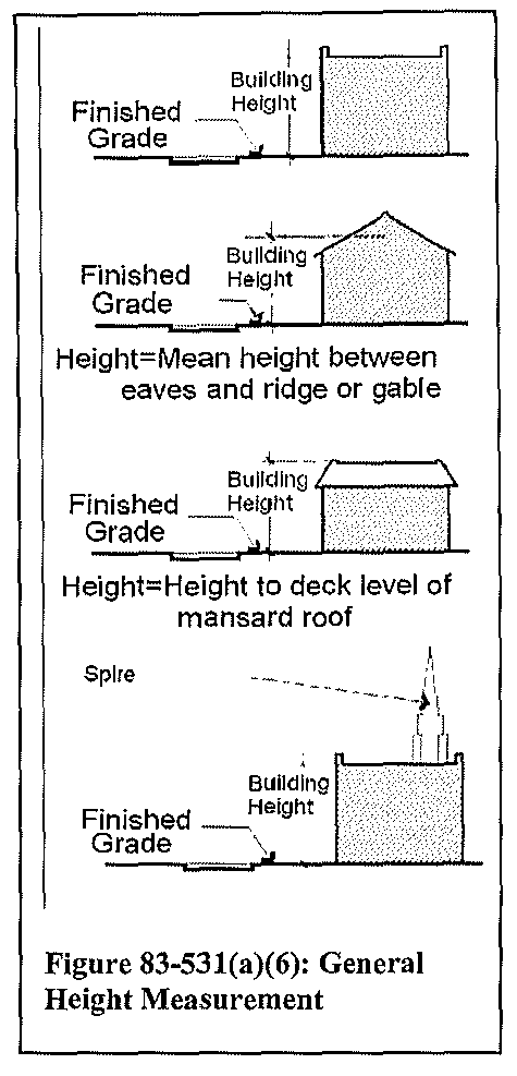
Structure height. The height of a structure shall be determined by measuring the vertical distance from the average elevation of the existing finished grade at the front of the structure to the top of the roof for a flat roof, to the deck line for a mansard roof, or to the mean height between eaves and ridge for a gable, hip, cone, gambrel, or shed roof.
(7)
Yard depth.
a.
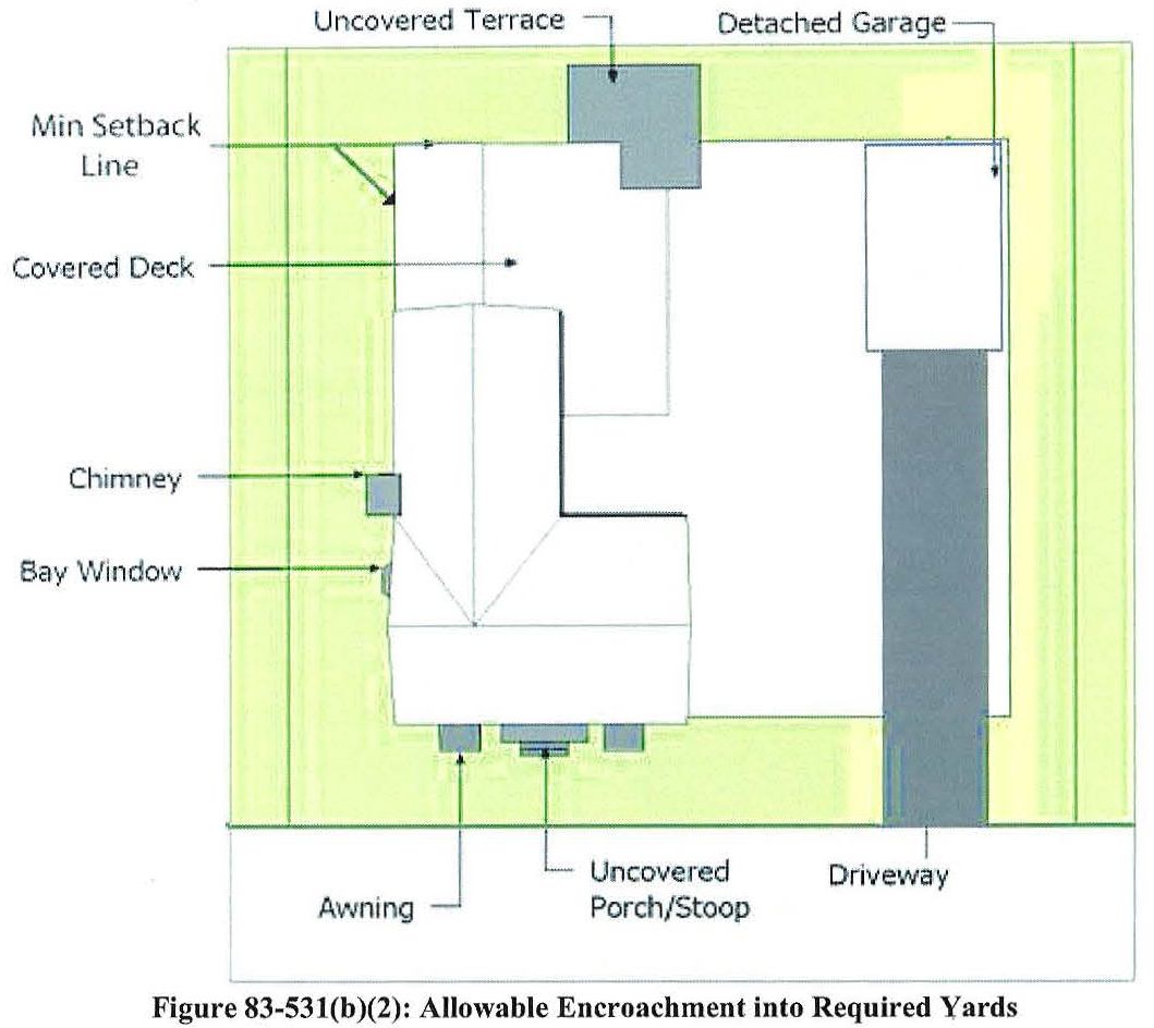
Generally. Front, side, and rear yard depths on a lot shall be determined by measuring the horizontal distance along a straight line extending at a right angle from the lot's front, side, or rear lot line (as appropriate) to the foundation of the nearest structure on the lot. (See figure 83-531(a)(7)a.: Lot shapes and yards) Allowable encroachments into required yards shall be ignored when measuring yard depths (see section 83-531(b)(5), Allowable encroachment into required yards).
b.
Front yard depth.
1.
Corner lot.
i.
On a corner lot (which is not a through lot), the front yard depth shall be measured—and the minimum front yard depth requirement applied—from each of the street-fronting lot lines, unless the zoning district in which the property is located specifically establishes a minimum corner lot yard depth, in which case the front yard depth shall be measured from the shorter lot line adjacent to a public street right-of-way or private road easement, regardless of the location of the principal entrance or approach to the main building, and the corner lot yard depth shall be measured from the longer lot line adjacent to a public street right-of-way or private road easement.
ii.
On a corner lot where the intersecting right-of-way boundaries are defined by a radius, the front yard depths shall be measured—and the minimum front yard depth requirement applied—from one street-fronting lot line as extended to form an intersecting angle with an extension of the other street-fronting lot line.
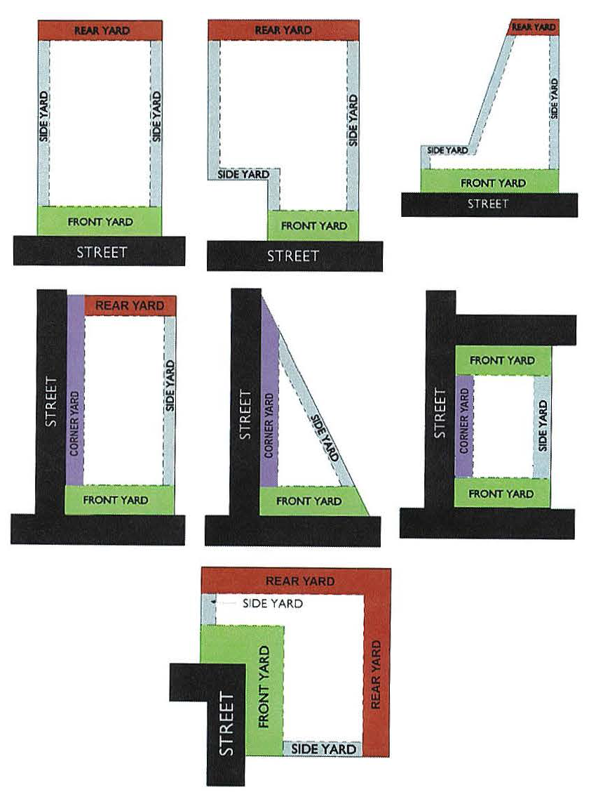
Figure 83-531(a)(7)a.
2.
Through lot. On a through lot, the front yard depth shall be measured—and the minimum front yard depth requirement applied—from each of the parallel or nearly parallel street-fronting lot lines.
3.
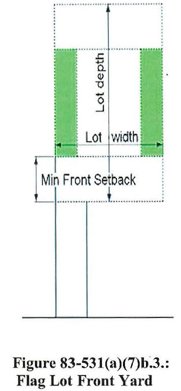
Flag lot. On a flag lot, the front yard depth shall be measured—and the minimum front yard depth applied—within the "flag" portion of the lot, from the lot line delineating the base of that portion. (See figure 83-531(a)(7)b.3. Flag lot front yard.)
4.
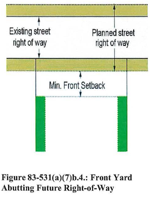
Measured from future street right-of-way. Where county-adopted plans call for the future widening of the street right-of-way abutting a lot and identify the future right-of-way boundary (e.g., by delineating the boundary or establishing its distance from the street's centerline), the front yard depth shall be measured—and the minimum front yard depth applied—from the future right-of-way boundary. (See figure 83-531(a)(7)b.4.: Front yard abutting future right-of-way.)
5.
Determining road classification. When the front yard depth is determined by the classification of the adjacent street (as specified in the intensity and dimensional standards for a specific zoning district), proposed and existing roadways shall be classified in accordance with the major thoroughfare plan adopted by the County of Powhatan.
(b)
Exceptions and variations.
(1)
Reduction of minimum lot area or width to block face average. If the average area or width of existing lots located on the same block face and in the same zoning district is less than the minimum lot area or minimum lot width (as appropriate) applied to a lot by the standards in Articles III, IV, V and VI (zoning districts), the minimum lot area or minimum lot width (as appropriate) applicable to the lot shall be reduced to such average.
(2)
Reduction of minimum yard depths to block face average. If the average front, side, or rear yard depth on improved lots located on the same block face and in the same zoning district is less than the front, side, or rear yard depth (as appropriate) applied to a lot by the standards in Articles III, IV, V and VI (zoning districts), the minimum front, side, or rear yard depth (as appropriate) applicable to the lot shall be reduced to such average.
(3)
Exceptions to maximum structure height. The maximum structure height limits established in Articles III, IV, V and VI (zoning districts), shall not apply to the following structures or structural elements:
a.
Monuments, water towers, silos, granaries, barns, utility transmission towers, derricks, cooling towers, fire towers, and other similar structures not intended for human occupancy.
b.
Spires, belfries, cupolas, domes, chimneys, elevator shaft enclosures, ventilators, skylights, mechanical equipment and appurtenances, and similar rooftop structures or structural elements not intended for human occupancy, provided they:
1.
Cover not more than 25 percent of the roof area of the structure to which they are attached;
2.
Comply with applicable screening requirements for mechanical equipment and appurtenances in section 83-465, Screening; and
3.
Extend above the applicable maximum height limit by no more than 25 percent of the height limit (unless otherwise allowed in this Code).
c.
Ham radio antennas, roof-mounted satellite dishes, and television or radio antennas, provided they comply with height limits established for the specific use in Article VII, Division B, Standards for accessory uses and structures.
d.
Roof-mounted solar energy collection systems, in accordance with the height standards in Article VII, Division B, Standards for accessory uses and structures.
e.
Small wind energy systems, in accordance with the height standards in Article VII, Division B, Standards for accessory uses and structures.
(4)
Allowable encroachment into required yards. Every part of every required yard shall remain open and unobstructed from the ground to the sky except as otherwise allowed in table 83-531(b)(5), Allowable encroachments into required yards, or allowed or limited by provisions in Article VII: Use Standards, Article VIII: Development Standards, or elsewhere in this Code. (See figure 83-531(b)(2): Allowable encroachment into required yards.)
(Ord. No. O-2014-13, 6-2-14; Ord. No. O-2018-01, 3-26-18; Ord. No. O-2019-28, 8-26-19)