Prince William County Unincorporated
City Zoning Code
City Zoning Code
ARTICLE V
- OVERLAY DISTRICTS
PART 501.- FLOOD HAZARD OVERLAY DISTRICT[8]
Editor's note— An attachment to Ord. No. 15-34, adopted June 16, 2015, amended in entirety the former Pt. 501, effectively repealing §§ 32-501.01—32-501.12, and enacting a new Pt. 501 as set out herein. The former Pt. 501 pertained to similar subject matter and derived from Ord. No. 95-10, adopted Jan. 17, 1995; and Ord. No. 04-78, adopted Dec. 21, 2004. See the Code Comparative Table for prior derivation.
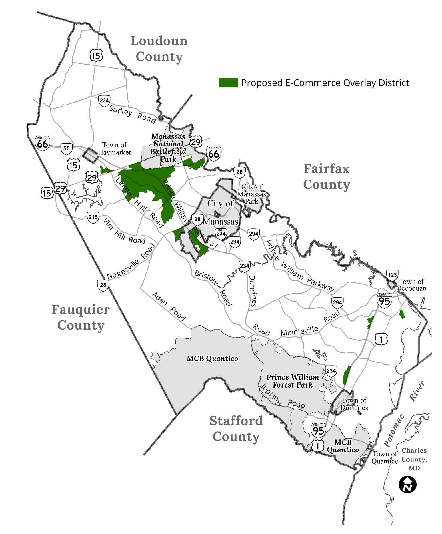
PART 506.- TECHNOLOGY OVERLAY DISTRICT[9]
Editor's note— Ord. No. 05-65, adopted Sept. 6, 2005, renamed Part 506 from the former "Higher Education Overlay District" to "Technology Overlay District."
Sec. 32-500.01.- Purpose and intent.
The purpose of the Special Public Interest Overlay Districts established in the following sections is to protect and enhance certain specific lands and structures which, by virtue of their type or location, have characteristics which are distinct from lands and structures outside such overlay districts. It is the intent of the Board of County Supervisors to permit, insofar as possible, those uses and structures which would otherwise be permitted, provided that reasonable and necessary conditions are met which insure the protection and enhancement of said lands and structures. It is the further intent of the Board of County Supervisors to specifically protect and enhance the following:
1.
Flood hazard areas.
2.
Historic areas.
3.
Designated highway corridors.
4.
Chesapeake Bay preservation areas.
5.
Airport safety.
6.
Institutes of higher education.
7.
Redevelopment (No. 95-94, Apps. A, A-1, 7-11-95).
8.
Keeping of domestic fowl.
9.
Data center opportunity zone.
(Ord. No. 95-54, Apps. A, A-1, 7-11-95; Ord. No. 11-22, 4-19-11; Ord. No. 16-21, Attch., 5-17-16)
Sec. 32-500.02. - General standards.
1.
The Special Public Interest Overlay Districts established in this article generally operate by establishing performance standards to effectuate the purposes of the district. Except as otherwise provided, they do not supersede the regulations of the underlying zoning district. As provided in section 32-200.05, the strictest or most restrictive standard shall apply in the event of conflict.
2.
Land lying within Special Public Interest Overlay Districts shall remain part of the underlying zoning districts established by other provisions of this chapter; and may, in addition, lie in one or more overlay districts in accordance with the designation of each.
Sec. 32-500.03. - Creation of Special Public Interest Overlay Districts.
1.
Amendments to this chapter or the zoning map shall be adopted in accordance with the provisions of Part 700 upon the recommendation of the Planning Director.
2.
Every recommendation for creation of a Special Public Interest Overlay District or addition of land thereto shall address the following, as applicable:
(a)
A statement of purpose and intent shall specify the nature of the special and substantial public interest involved and objectives to be promoted by creation of the Special Public Interest Overlay District and imposition of the regulations proposed therefor.
(b)
Proposed district boundaries shall be depicted on one or more maps which shall also display all other zoning districts applicable to the property proposed for inclusion in the district.
(c)
Regulations proposed to promote the special purposes of the district.
3.
Regulations proposed with any Special Public Interest Overlay District shall be designed to reasonably promote the purposes of the district, and may require or address any of the following, in addition to or in lieu of other regulations affecting property within the district:
(a)
Submission of specifically detailed site plans, building plans, elevations and maps showing the relation of proposed development to surrounding or otherwise affected property in terms of location, scale or intensity, character and continuity;
(b)
Protection of features designated as being of special concern within the district;
(c)
Mixtures or limitations of permitted uses;
(d)
Special performance standards and development regulations;
(e)
Other matters as appropriate to promote the special public interests of the district.
4.
Regulations for any Special Public Interest Overlay District may require special review of development plans by the Planning Director, the Department of Public Works, or other offices or agencies of the County, generally within the district or for specified classes of uses within the district.
(Ord. No. 92-59, 6-16-92)
Sec. 32-500.04. - Waivers.
No waiver may be granted from any regulation or restriction imposed in any Special Public Interest Overlay District except as specifically provided in the regulations for such district.
Sec. 32-500.05. - Mapping of special interest district.
Upon approval of a Special Public Interest Overlay District, a map of the district boundaries shall be incorporated into the zoning maps of the County.
Sec. 32-501.01.- Authorization and purpose.
1.
Authority. The ordinance from which this part is derived is adopted pursuant to the authority granted to the County by Code of Virginia, § 15.2-2200 et seq.
2.
Purpose. The Board of County Supervisors has made the following findings of fact:
(a)
That the flood hazard areas of the County are subject to periodic inundation which results in loss of life and property, health and safety hazards, disruption of commerce, and other governmental services, extraordinary public expenditures for flood protection, and impairment of the tax base and in order to address the impacts of periodic inundation, the Board of County Supervisors finds it necessary to:
(1)
Regulate uses, activities, and development which, alone or in combination with other existing or future uses, activities, and development, will cause unacceptable increases in flood heights, velocities, and frequencies;
(2)
Restrict or prohibit certain uses, activities, and development from locating within districts subject to flooding;
(3)
Require all those uses, activities, and developments that do occur in Flood Hazard Overlay Districts to be protected and/or floodproofed against flooding and flood damage; and
(4)
Protect individuals from buying land and structures which are unsuited for intended purposes because of flood hazards.
(b)
That all of the above factors adversely affect the public health, safety, and general welfare, and that suitable regulations pertaining to land disturbing activity in such areas should be adopted as an overlay zone, in addition to such zoning regulations as may be applicable to the underlying zoning district.
(Ord. No. 15-34, Attch., 6-16-15)
Sec. 32-501.02. - Definitions.
For the purposes of this Part 501, the following words and phrases shall have the meanings respectively ascribed to them by this section; provided that unless specifically defined below, words and phrases used in this section shall be interpreted so as to give them the same meaning as they have in common usage and so as to give this section its most reasonable application A more comprehensive set of definitions is contained in section 730.02 of the Design and Construction Standards Manual.
A zone means an area for which no detailed flood profiles or elevations are provided, but the one percent annual chance floodplain boundary has been approximated.
AE zone means an area inundated by the one percent annual chance flooding, for which base flood elevations have been determined.
Base flood means the flood having a one percent chance of being equaled or exceeded in any given year. Also referred to as the "100-year" flood.
Coastal A zone means flood hazard areas, as defined by the Virginia Uniform Statewide Building Code (USBC), that have been delineated as subject to wave heights between 1.5 feet and three feet.
Flood or flooding means:
(a)
A general and temporary condition of partial or complete inundation of normally dry land areas from:
1.
The overflow of inland or tidal waters;
2.
The unusual accumulation or runoff of surface waters from any source; or
3.
Mudflows which are proximately caused by flooding as defined in subsection (a)(2) of this definition and are akin to a river of liquid and flowing mud on the surfaces of normally dry land areas, as when earth is carried by a current of water and deposited along the path of the current.
(b)
The collapse or subsidence of land along the shore of a lake or other body of water as a result of erosion or undermining caused by waves or currents or water exceeding anticipated cyclical levels of or suddenly caused by an unusually high water level in a natural body of water, accompanied by a severe storm, or by an unanticipated force of nature such as flash flood or an abnormal tidal surge, or by some similarly unusual and unforeseeable event which results in flooding as defined in subsection (a)(1) of this definition.
Flood fringe means that portion of the flood zone that is outside the floodway where the floodway is delineated on the FIRM or where the floodway is defined in accordance with the Design and Construction Standards Manual.
Flood insurance rate map (FIRM) means an official map of Prince William County, on which the Federal Emergency Management(FEMA)has delineated both the special hazard areas and the risk premium zones applicable to Prince William County, adopted by the Board of County Supervisors, with an effective date of August 3, 2015. A FIRM that has been made available digitally is called a digital flood insurance rate map (DFIRM).
Flood insurance study (FIS) means a report by FEMA that examines, evaluates, and determines flood hazards and, if appropriate, corresponding water surface elevations, or an examination, evaluation, and determination of mudflow and/or flood-related erosion hazards, adopted by the Board of County Supervisors, with an effective date of August 3, 2015.
Floodplain or flood prone area means any land area that would be inundated by floodwater as a result of the base flood. The limits of the floodplain shall be established in accordance with the Design and Construction Standards Manual. See also section 32-501.04.
Floodproofing means a combination of structural and non-structural additions, changes, or adjustments to structures, which reduce or eliminate flood damage to real estate or improved real property, water and sanitary facilities, structures and their contents.
Floodway means the channel of a river or other watercourse and the adjacent land areas that must be reserved in order to discharge the base flood without cumulatively increasing the water surface elevation more than one foot in height for FEMA-studied streams. The floodway district includes all areas delineated as floodways in the FIS and shown on the accompanying FIRM and all floodways delineated from studies in accordance with the Design and Construction Standards Manual.
Floodway district means all areas delineated as floodways in the FIS and shown on the accompanying FIRM and all floodways delineated from studies in accordance with the Design and Construction Standards Manual.
(Ord. No. 15-34, Attch., 6-16-15)
Sec. 32-501.03. - Designation of the Floodplain Administrator.
The Director of Public Works is designated and shall serve as the Floodplain Administrator, shall enforce the requirements of the Flood Hazard Overlay District Ordinance, and shall perform the duties and responsibilities as set forth in section 730 of the Design and Construction Standards Manual. For purposes of the Flood Hazard Overlay District Ordinance only, the Director of Public Works is designated and shall serve as a deputy Zoning Administrator, and shall have all authority necessary for the enforcement of the requirements of the Flood Hazard Overlay District Ordinance and the applicable provisions of the Design and Construction Standards Manual. Duties and responsibilities of the Floodplain Administrator are described in section 730 of the Design Construction Standards Manual.
(Ord. No. 15-34, Attch., 6-16-15)
Sec. 32-501.04. - Areas of applicability.
1.
This flood hazard overlay district ordinance shall apply to all privately and publicly owned lands within the jurisdiction of the County and identified as areas of special flood hazard according to the FIRM that is provided to the County by FEMA. The various Flood Hazard Overlay Districts shall include areas subject to inundation by the waters of the 100-year flood. The basis for the delineation of these districts shall be:
(a)
The FIS and FIRM for Prince William County, prepared by FEMA, dated August 3, 2015, and any subsequent revisions or amendments thereto.
(b)
Engineering studies by the U.S. Army Corps of Engineers, the U.S. Soil Conservation Service, and County, state, and other federal agencies.
(c)
Floodplain studies conducted by professional engineers or surveyors in accordance with section 700 of the Design and Construction Standards Manual, which have been approved by the Department of Public Works.
2.
Areas comprising the Flood Hazard Overlay District shall be in one of the following subdistricts.
(a)
Floodway district. The floodway district includes all areas delineated as floodways in the FIS and shown on the accompanying Flood Boundary and Floodway Map or FIRM and all floodways delineated based on studies required by section 700 of the Design and Construction Standards Manual.
(b)
Floodway fringe district. The floodway fringe district shall include that area of the 100-year floodplain established in the FIS which is not included in the floodway district and the 100-year floodplain area established in accordance with section 32-501.04.1(b) and (c) which are not included in the floodway district.
(c)
Approximated floodplain district. The approximated floodplain district shall be that floodplain area for which no detailed flood profiles or elevations are provided, but where a 100-year floodplain boundary has been approximated. Areas shown as zone A on the maps accompanying the FIS and identified in subsection 2(a) of this section, and minor floodplain areas determined in accordance with section 700 of the Design and Construction Standards Manual shall be part of the approximated floodplain district.
(d)
Coastal high hazard district. The coastal high hazard flood zone district delineated as zone VE in the FIS and shown on the FIRM.
(e)
Non-tidal flood zone district (zone AE without floodway). The riverine flood zone district delineated as zone AE without floodway in the FIS and shown on the FIRM.
(f)
Tidal flood zone district (zone AE without floodway). The flood zone along tidally influenced watercourses, located just landward, and adjacent to VE zones, delineated as zone AE in the FIS and shown on the FIRM. Coastal A zones are included in this district.
(Ord. No. 15-34, Attch., 6-16-15)
Sec. 32-501.05. - Effect of Flood Hazard Overlay District Map.
1.
Designation of land included in the Flood Hazard Overlay District is made by text, as provided in section 32-501.04. The maps and studies referred to in section 32-501.04 should be consulted prior to undertaking any regulated activity (collectively, the Flood Hazard Overlay District Map).
2.
The delineation of any floodplain districts may be revised by Prince William County where natural or manmade changes have occurred and/or where more detailed studies have been conducted or undertaken by the U.S. Army Corps of Engineers or other qualified agency, or an individual document citing the need for such change. FEMA approval must be obtained prior to any such change.
3.
The flood hazard district overlay ordinance is not intended to repeal or abrogate any other County ordinance, including, but not limited to, provisions of the underlying zoning district. If there is any conflict between the Flood Hazard Overlay District Ordinance and any underlying zoning district, the more restrictive provision shall apply. In the event that any provision of the Flood Hazard Overlay District Ordinance is declared invalid, unenforceable, or inapplicable to a particular property(ies) as a result of any legislative, administrative, or judicial action or decision, all applicable underlying zoning district provisions shall remain in full force and effect.
(Ord. No. 15-34, Attch., 6-16-15)
Sec. 32-501.06. - Boundary disputes.
Should a dispute concerning any flood hazard district boundary arise, resolution of such dispute shall be made by the Zoning Administrator, based upon advice from of the Floodplain Administrator. Any party aggrieved by this decision may request an interpretation by the Board of Zoning Appeals as specified in Part 900 of this chapter.
(Ord. No. 15-34, Attch., 6-16-15)
Sec. 32-501.07. - Permit requirements.
All uses, activities, and development occurring within any floodplain district, including placement of manufactured homes, shall be undertaken only upon the issuance of a zoning permit. Such development shall be undertaken only in strict compliance with this part and with all other applicable codes and ordinances, including, but not limited to, the Virginia Uniform Statewide Building Code (USBC) and County Code chapter 25. Prior to the issuance of any such permit, the Floodplain Administrator shall require all applications to include compliance with all applicable federal, state, and County laws, codes, ordinances, regulations, and requirements, and shall review all sites to assure they are reasonably safe from flooding. Under no circumstances shall any use, activity, and/or development adversely affect the capacity of the channels or floodways of any watercourse, drainage ditch, or any other drainage facility or system. The Floodplain Administrator shall forward his recommendations regarding the application to the Zoning Administrator prior to the issuance of any zoning permit for uses, activities, or development within any floodplain district.
(Ord. No. 15-34, Attch., 6-16-15)
Sec. 32-501.08. - Platting lots within the 100-year floodplain.
1.
Residential lots in zoning districts where the required lot area is 10,000 square feet or less shall not be platted within the 100-year floodplain as established in accordance with Part 501. This includes lots with no minimum area requirements.
2.
In all other residential zoning districts (other than those listed in subsection 1 of this section), lots may be platted within the 100-year floodplain provided that all primary and accessory structures and onsite sewage disposal systems, including septic tanks and drainfields, are located outside of the floodplain and:
(a)
For lots where the minimum lot area is five acres or less: the minimum lot area required by the zoning district or one acre, whichever is less, shall be located outside the limits of the 100-year floodplain; or
(b)
For lots where the minimum required area is greater than five acres: a minimum of two acres shall be located outside the limits of the 100-year floodplain.
(Ord. No. 15-34, Attch., 6-16-15)
Sec. 32-501.09. - Use regulations; generally.
1.
[Permit required.] A flood hazard use permit shall be required for all development (as defined herein) in the flood hazard district.
2.
Permitted uses and activities. The following uses and activities and other uses determined by the Floodplain Administrator to pose equal or less risk of impairing flood flows, and uses excepted in accordance with subsection 3. of this section, where otherwise permitted in the underlying zoning district, having a low flood damage potential and causing no obstruction of flood flows shall be permitted within the floodway fringe to the extent that they are not prohibited by any other provision of this chapter or other ordinance, and provided they do not require the erection or construction of any structure or fences (except two wire fences as identified in section 700 of the Design and Construction Standards Manual; or other fences required to be erected around stormwater management facilities), fill or the storage of materials or equipment and provided further that no use shall adversely affect the water carrying capacity of the channels or floodways of any tributary to the main stream, drainage ditch, or any other drainage facility or system:
(a)
Agricultural uses and activities, such as farming, pasture, grazing, outdoor plant nurseries, horticulture, viticulture, truck farming, forestry, sod farming, and wild crop harvesting.
(b)
Industrial-commercial uses and activities, such as surface parking and loading areas.
(c)
Private and public recreational uses and activities such as baseball or softball fields, golf courses, tennis courts, archery ranges, picnic grounds, boat launching ramps, swimming areas, parks, wildlife and nature preserves, target ranges, trap and skeet ranges, hunting and fishing areas, and hiking and horseback riding trails.
(d)
Residential uses, such as lawns, gardens, surface parking areas, and play areas.
(e)
Roads and culverts, and cable, electrical, sewer, water and storm drainage lines, and other utility lines, if otherwise permitted.
3.
Other uses and activities generally prohibited. All uses other than those specified in subsection 2. of this section, otherwise permitted in the underlying zoning district, shall be prohibited unless an exception is allowed. Exceptions are allowed only after the applicable development standards have been waived by the Floodplain Administrator in accordance with section 700 of the Design and Construction Standards Manual.
(Ord. No. 15-34, Attch., 6-16-15)
Sec. 32-501.10. - Other regulations.
1.
This part shall be administered and plans and profiles reviewed in accordance with the specific provisions established by the Board of County Supervisors as set forth in the Design and Construction Standards Manual.
2.
No waiver shall be issued for any National Flood Insurance Program minimum standard(s), as determined by the Floodplain Administrator.
(Ord. No. 15-34, Attch., 6-16-15)
Sec. 32-501.11. - Nonconforming uses, structures, and lots.
1.
A structure, or the use of a structure or premises, which lawfully existed before September 23, 1975, or the date of adoption of an applicable amendment to this Part 501, may be continued only in accordance with the provisions of section 32-601 et seq., and section 700 of the Design and Construction Standards Manual.
2.
Residentially zoned unimproved lots of record that are nonconforming with respect to the Flood Hazard Overlay District Ordinance provisions may be developed provided that they meet all other zoning requirements and building codes for construction within a flood area.
(Ord. No. 15-34, Attch., 6-16-15)
Sec. 32-501.12. - Review of site plan.
1.
A site plan may not be approved except for permitted uses or activities set forth by section 32-501.09.2 of this chapter, for uses in a floodway area. A site plan may be approved for any use or activity within the floodway fringe area, otherwise permitted in the underlying zoning district, where applicable County ordinances and policies are complied with and where the standards and criteria of the Design and Construction Standards Manual are met.
2.
The burden shall be upon the applicant to establish that the proposal falls within the floodway fringe area, and to establish that the proposal meets all County flood hazard policies, ordinances, and the standards and criteria of the Design and Construction Standards Manual.
3.
Unless waived by the Floodplain Administrator in accordance with the requirements of the Design and Construction Standards Manual, the limits of the 100-year floodplain shall be depicted upon a plat for any property for which a site plan is required by Part 800 of this chapter or a subdivision plat by chapter 25, and such plat shall be recorded among the land records with the notation that any use of the property lying within the 100-year floodplain shall be consistent with the requirements of Part 501 of this chapter.
(Ord. No. 15-34, Attch., 6-16-15)
Sec. 32-501.13. - Application and approval.
1.
The application to the department of development services or public works shall conform with the requirements established in the Design and Construction Standards Manual for any subject or activity which lies wholly or partially within the flood hazard district.
2.
Any person aggrieved by a decision of the Floodplain Administrator in the administration of the flood hazard district may appeal as provided in Part 900 of this chapter.
(Ord. No. 15-34, Attch., 6-16-15)
Sec. 32-501.14. - Variances.
1.
Variances shall be issued only upon:
(a)
A showing of good and sufficient cause;
(b)
After the Board of Zoning Appeals has determined that failure to grant the variance would unreasonably restrict the utilization of the property, or that granting a variance would alleviate a hardship due to the physical condition relating to the property or improvements thereon at the time of the effective date of the ordinance;
(c)
The property interest for which the variance is being requested was acquired in good faith and any hardship was not created by the applicant for the variance;
(d)
The granting of the variance will not be of substantial detriment to adjacent property and nearby properties in the proximity of that geographical area;
(e)
The condition or situation of the property concerned is not of so general or recurring a nature as to make reasonably practicable the formulation of a general regulation to be adopted as an amendment to this chapter;
(f)
The granting of the variance does not result in a use that is not otherwise permitted on such property or a change in the zoning classification of the property; and
(g)
The relief or remedy sought by the variance application is not available through a special exception pursuant to Code of Virginia, § 15.2-2309 or modification process pursuant to Code of Virginia, § 15.2-2286. The Floodplain Administrator shall not modify any minimum national flood insurance program regulation or requirement.
2.
Application for and review of variances shall be in accordance with Part 900 of this chapter. The Board of Zoning Appeals may refer any application and accompanying documentation pertaining to any request for a variance to any provision of Part 501 to any engineer or other qualified person or agency for technical assistance in evaluating the proposed project in relation to flood heights and velocities, and the adequacy of the plans for flood protection and other related matters. Variances shall be processed through the Zoning Administrator after review and comment by the Floodplain Administrator.
3.
While the granting of variance generally is limited to a lot size less than one-half acre, deviations from that limitation may occur. However, as the lot size increases beyond one-half acre, the technical justification required for issuing a variance increases. Variances may be issued by the Board of Zoning Appeals for new construction and substantial improvements to be erected on a lot of one-half acre or less in size contiguous to and surrounded by lots with existing structures constructed below the base flood level, in conformance with this section.
4.
Variances may be issued for new construction and substantial improvements and for other development necessary for the conduct of a functionally dependent use provided that the criteria of this section are met, and the structure or other development is protected by methods that minimize flood damages during the base flood and create no additional threats to public safety.
5.
In passing upon applications for variances, the Board of Zoning Appeals shall satisfy all relevant factors and procedures specified in other sections of the zoning ordinance and consider the following additional factors:
(a)
The danger to life and property due to increased flood heights or velocities caused by encroachments. No variance shall be granted for any proposed use, development, or activity within any floodway district that will cause any increase in the one percent chance flood elevation.
(b)
The danger that materials may be swept on to other lands or downstream to the injury of others.
(c)
The proposed water supply and sanitation systems and the ability of these systems to prevent disease, contamination, and unsanitary conditions.
(d)
The susceptibility of the proposed facility and its contents to flood damage and the effect of such damage on the individual owners.
(e)
The importance of the services provided by the proposed facility to the community.
(f)
The requirements of the facility for a waterfront location.
(g)
The availability of alternative locations not subject to flooding for the proposed use.
(h)
The compatibility of the proposed use with existing development and development anticipated in the foreseeable future.
(i)
The relationship of the proposed use to the Comprehensive Plan and floodplain management program for the area.
(j)
The safety of access by ordinary and emergency vehicles to the property in time of flood.
(k)
The expected heights, velocity, duration, rate of rise, and sediment transport of the flood waters expected at the site.
(l)
The historic nature of a structure. Variances for repair or rehabilitation of historic structures may be granted upon a determination that the proposed repair or rehabilitation will not preclude the structure's continued designation as a historic structure and the variance is the minimum necessary to preserve the historic character and design of the structure.
(m)
Such other factors which are relevant to the purposes of this part.
6.
Variances shall be issued only after the Board of Zoning Appeals has determined that the granting of such will not result in (a) unacceptable or prohibited increases in flood heights; (b) additional threats to public safety; (c) extraordinary public expense; and will not (d) create nuisances; (e) cause fraud or victimization of the public; or (f) conflict with state laws or County ordinances.
7.
Variances shall be issued only after the Board of Zoning Appeals notifies the applicant for a variance, in writing, that the issuance of a variance to construct a structure below the one percent chance flood elevation (a) increases the risks to life and property, and (b) will result in increased premium rates for flood insurance. A record shall be maintained of the notification as well as all variance actions, including justification for the issuance of the variances.
8.
Any variance that is issued by the Board of Zoning Appeals shall be noted in the annual or biennial report submitted by the County to the Federal Insurance Administrator.
(Ord. No. 15-34, Attch., 6-16-15)
Sec. 32-501.15. - Alteration of watercourse; notice to appropriate agencies.
In the event that any proposed land disturbing activity will involve alteration or relocation of any channels or floodways of any watercourse, in accordance with section 32-501.07, approval therefor shall be obtained from the applicable state or federal agencies, before any land disturbing activity shall be permitted. Prior to any proposed alteration or relocation of any channels or of any watercourse within the jurisdiction of the County, a permit shall be obtained from the U.S. Army Corps of Engineers, the Virginia Department of Environmental Quality, and the Virginia Marine Resources Commission (a joint permit application is available from any of these organizations). Furthermore, in riverine areas, the applicant shall notify all affected adjacent jurisdictions, the Virginia Department of Conservation and Recreation (Department of Dam Safety and Floodplain Management), FEMA, and any other required federal and state department(s) and agency(ies) of the application.
(Ord. No. 15-34, Attch., 6-16-15)
Sec. 32-501.16. - Severability.
If any section, subsection, paragraph, sentence, clause, or phrase of this part shall be declared invalid for any reason whatsoever, such decision shall not affect the remaining portions of this part. The remaining portions shall remain in full force and effect; and for this purpose, the provisions of this part are hereby declared to be severable
(Ord. No. 15-34, Attch., 6-16-15)
Sec. 32-502.01.- Purposes.
Historic Overlay Districts are created for the purpose of imposing special requirements in addition to the requirements pertaining to the underlying zoning in designated areas of the County, in order to protect and perpetuate those areas or structures which have been designated as being of significant historic, architectural or cultural interest.
Regulations imposed in such districts are intended to protect against destruction of or encroachment upon such historic resources, to encourage uses which will continue to preserve them and to prevent the creation of adverse environmental influences.
Sec. 32-502.02. - Architectural Review Board.
The governing body shall appoint an Architectural Review Board (ARB or Review Board) of eight members for the purpose of administering this Part 502, subject to the following conditions:
1.
All members appointed to the Review Board shall have a demonstrated interest, competence or knowledge in historic preservation.
2.
At least one Review Board member shall be a registered architect with a demonstrated interest in historic preservation; at least a majority of Review Board members shall have professional training in any of the following disciplines: architecture, history, American studies, architectural history, archaeology, or planning. When adequate review of any proposed action would normally involve a professional discipline not represented on the Review Board, the ARB must seek appropriate professional advice before rendering its decision. Information on the credentials of all Review Board members shall be submitted to the State Historic Preservation Officer (SHPO) and shall be kept on file locally for public inspection.
3.
The Review Board shall adopt written bylaws that include at a minimum: provision for regularly scheduled meetings at least four times a year, a requirement that a quorum of three members be present to conduct business, rules of procedure for considering applications, written minutes for all meetings, minimum attendance requirements for Review Board members, and requirements for attendance at training sessions by Review Board members.
4.
Terms of office for Review Board members shall be coterminus with the terms of the Board of County Supervisors.
5.
Vacancies on the Review Board shall be filled by appointment by the Board of County Supervisors in accordance with subsection 4. above.
6.
In addition to those duties specified in this part, the Review Board shall at a minimum perform the following duties:
(a)
Conduct or cause to be conducted a continuing survey of cultural resources in the community according to guidelines established by the SHPO.
(b)
Act in an advisory role to other officials and departments of local government regarding protection of local cultural resources.
(c)
Disseminate information within the County on historic preservation issues and concerns.
(d)
Review all proposed National Register nominations for properties within the boundaries of the County. If the review of a nomination would normally involve a professional discipline not represented on the Review Board, the ARB must seek appropriate professional advice before rendering its decision.
(e)
Submit to the SHPO an annual report on the activities of the Review Board. Such reports shall include but not be limited to such items as the number of cases reviewed, newly designated historic zoning districts, revised resumes of Review Board members, new appointments to the Review Board, attendance records, and all minutes related to National Register nominations. The report shall also document Review Board members' attendance at educational meetings.
7.
Each Review Board member is required to attend at least one informational or educational meeting per year, approved by the SHPO, pertaining to the work and functions of the Review Board or to historic preservation.
The annual report shall be accompanied by a report on the expenditures of any grant funds received from the SHPO as part of a Certified Local Government program. The financial report shall be consistent with the U.S. Department of the Interior regulations for fiscal responsibility.
8.
The ARB shall provide for adequate public participation, including:
(a)
All meetings of the Review Board must be publicly announced, be open to the public, and have an agenda made available to the public prior to the meeting. Review Board meetings must occur at regular intervals at least four times a year. Public notice must be provided prior to any special meetings. The Review Board shall allow for testimony from interested members of the public, not just applicants.
(b)
Minutes of all decisions and actions of the Review Board or in appeals to the Board of County Supervisors (BOCS) must be kept on file and available for public inspection.
(c)
All decisions by the Review Board shall be made in a public forum and applicants shall be given written notification of decisions of the Review Board.
(d)
The rules of procedure adopted by the Review Board shall be available for public inspection.
(Ord. No. 94-68, 10-4-94; Ord. No. 96-48, 5-21-96; Ord. No. 15-29, Attch., 5-12-15)
Sec. 32-502.03. - Designation of historic resources.
In accordance with the Prince William County Code, the Historical Commission or Architectural Review Board shall recommend and the governing body may approve by ordinance the designation of historic resources. These historic resources may be, but are not required to be, landmarks established by the Virginia Landmarks Commission.
(Ord. No. 15-29, Attch., 5-12-15)
Sec. 32-502.04. - Designation of Historic Overlay Districts.
1.
The Historical Commission or ARB shall recommend and the governing body may, pursuant to Part 700 of this chapter, approve by ordinance the designation of an area as an Historic Overlay District within which the regulations set forth in this Part 502 shall apply.
2.
In order to fully protect historic resources and areas, the boundaries of an Historic Overlay District may include adjoining land closely related to and bearing upon the character of the historic resource.
3.
Individual owner consent for inclusion in the zoning district is not required.
4.
The Board of County Supervisors may create historical overlay districts provided such districts contain buildings or places in which historic events occurred or having special public value because of notable architectural or other features relating to the cultural or artistic heritage of the community, of such significance to warrant conservation and preservation. Each such district shall meet one or more of the following criteria:
(a)
Is closely associated with one or more persons, events, activities, or institutions that have made a significant contribution to local, regional or national history; or
(b)
Contains buildings or structures which the exterior design or features of which exemplify the distinctive characteristics of one or more historic types, periods or methods of construction, or which represent the work of an acknowledged master or masters; or
(c)
Has yielded, or is likely to yield, information important to local, regional or national history; or
(d)
Possesses an identifiable character representative of the architectural and cultural heritage of Prince William County; or
(e)
Contains a registered landmark, building or structure included on the National Register of Historic Places or the Virginia Landmarks Register.
Sec. 32-502.05. - Historic Overlay District regulations.
Historic Overlay Districts shall be subject to the following regulations in addition to those imposed pursuant to the adopted underlying zoning classification of the property. All Historic Overlay District boundaries shall be delineated on the official zoning map.
1.
A Certificate of Appropriateness (COA) issued by the Planning Director (Director) shall be required prior to the erection, reconstruction, exterior alteration, restoration or excavation of any building or structure within an Historic Overlay District, or prior to the demolition, razing, relocation or moving of any building or structure therein. The Director shall not issue a COA until an application therefor has been approved by the ARB, following the procedures set forth below. In addition, no demolition, razing, relocation or moving of a historic resource in a Historic Overlay District shall occur until approved by the ARB.
2.
Upon receipt of an application for a COA, the Director shall forward to the ARB copies of the permit application, plat, site plan and any other materials filed with such application.
3.
The ARB shall require the submission of information and materials to adequately describe the proposed project.
4.
The ARB shall determine if submitted material adequately describes the proposed project and depending on the project scope may require the submission of the following information:
(a)
A site plan including topography, exterior signs, graphics and lighting, scaled drawings showing building plans, elevations, sections, and construction details of significant architectural elements, and proposed materials and their color.
(b)
Photographs which show the subject property in relationship to nearby properties and show where work is proposed.
(c)
Small samples of materials such as masonry, slates and metals must be provided to illustrate appropriateness. Specific product identification must also be provided. Color samples, which indicate manufacturer, must be included for all exterior painting.
(d)
Proposed assemblies such as storm windows, replacement windows or stock items may be described by manufacturer's literature.
(e)
Location, dimensions, floor area and height of existing structures and proposed structures.
(f)
The precise location of the proposed work must be indicated on a building or property plan when the application involves an addition to a building, landscaping or new free-standing elements. Decks, balconies and enclosed roof space also require such plans.
Information on the Certificate of Appropriateness process and current submission requirements is available in the "Historic Overlay Districts Design Review Guidelines" or by consulting the Planning Office.
5.
If adequate information is not submitted, the application may be rejected as incomplete. The ARB shall determine the required additional information and planning staff shall notify the applicant, in writing. The application shall be reviewed by the ARB at the next regularly scheduled meeting following submission of required documents and plans.
6.
The ARB shall review and render a decision upon each application for a COA within 60 days of receipt of a complete submission package. Failure to act within that period shall constitute approval, and the Director may then issue a permit for the work.
7.
The ARB shall apply the following criteria for its evaluation of any application. In addition to the following criteria, the ARB shall consider the Secretary of Interior's "Standards for Rehabilitation," as may be amended from time to time, in determining appropriateness of any application for approval pertaining to existing structures. These criteria include:
(a)
Risk of substantial alteration of the exterior features of a historic resource.
(b)
Compatibility in character and nature with the historic, architectural or cultural features of the Historic Overlay District.
(c)
Contribution of the proposed use to the protection, preservation and utilization of the historic resource located in the Historic Overlay District.
(d)
Exterior architectural features, including all signs.
(e)
General design, scale and arrangement.
(f)
Texture and material.
(g)
The relationship of subsections (a), (b), (c), above, to other structures and features of the district.
(h)
The purpose for which the district was created.
(i)
The relationship of the size, design and siting of any new or reconstructed structure to the landscape of the district.
(j)
The extent to which denial of a Certificate of Appropriateness would constitute a deprivation to the owner of a reasonable use of his property.
8.
No application for a permit to erect, reconstruct, alter or restore any building or structure, including signs, shall be approved unless the ARB determines that it is architecturally compatible with the historic resources therein.
9.
In reviewing an application to raze or demolish a historic resource, the ARB shall review the circumstances and the condition of the structure proposed for demolition and shall report its findings based on consideration of the following criteria:
(a)
Is the historic resource of such architectural, cultural or historical interest that its removal would be detrimental to the public interest?
(b)
Is the historic resource of such old and unusual design, texture and material that it could not be reproduced or be reproduced only with great difficulty?
(c)
Would retention of the historic resource help preserve and protect another historic resource?
10.
In reviewing an application to move or relocate a historic resource, the ARB shall consider the following criteria:
(a)
Detrimental effect of the proposed relocation on the structural soundness of the historic resource.
(b)
Detrimental effect of the proposed relocation on the historical aspects of other historic resources, buildings or structures in the Historic Overlay District.
(c)
Compatibility of proposed new surroundings with the historic resource if relocated.
(d)
Benefits of relocation of the historic resource with regard to its preservation.
11.
The ARB, on the basis of the application and the criteria set forth herein shall approve, with or without modifications, or deny the application. If the ARB approves or approves with modifications the application, it shall authorize the Director to issue the permit. The permit shall expire after 12 months from the date of issuance if work has not yet commenced on the property. If the ARB denies the application, it shall so notify the applicant and the Director in writing.
12.
Minor work or actions, deemed by the Zoning Administrator not to have permanent effect upon the character of the historic property or district, shall be exempt from obtaining a Certificate of Appropriateness. The term "minor work" shall include but not be limited to the addition or removal of the following:
(a)
Appurtenances such as gutters, storm doors, storm windows, window boxes, portable air conditioners installed in windows, or similar devices which do not significantly affect the appearance of the structure.
(b)
In locations not visible from a public right-of-way accepted or planned for acceptance in the state highway system, antennas attached to a dwelling, sky lights or solar collectors.
(c)
Landscaping involving minor grading, walks, retaining walls less than 30 inches in height, temporary fencing, small fountains, ponds and the like, which will not substantially affect the character of the property and its surroundings.
(d)
Alterations or repainting of the interiors of buildings. Exterior painting, however, which results in a different color or the painting of unpainted surfaces shall not be considered minor work.
(e)
Building additions or deletions from existing buildings of less than 120 square feet which will not significantly change the architectural character of a property, provided such portions of the building are not visible from the public rights-of-way accepted or planned for acceptance into the state highway system.
Prior to commencing any minor exterior work, other than items named within subsections (a), (b), (c) and (d) above, the owner shall give written approval from the Zoning Administrator verifying that the alteration or improvement is in fact exempt from review by the ARB. The Zoning Administrator shall determine the appropriateness of the proposed alteration or improvement is in fact exempt from review by the ARB. The Zoning Administrator shall determine the appropriateness of the proposed alteration giving consideration to the preceding factors, the extent of the work proposed, resulting impact on the adjacent properties within the historic district, and compliance with all other applicable requirements of state and local ordinance.
(Ord. No. 92-59, 6-16-92; Ord. No. 94-76, 11-1-94; Ord. No. 15-29, Attch., 5-12-15)
Sec. 32-502.06. - Appeals; right to demolish a historic resource, offers to sell historic resources.
1.
Any owner or owners jointly or severally aggrieved by a decision of the ARB may appeal to the Board of County Supervisors by filing a written petition to review the decision of the ARB within 30 days of the final decision by the ARB. The filing of such petition shall not stay the decision of the ARB if such decision denies the right to demolish a historic resource. The BOCS after consultation with the ARB may reverse or modify the decision of the ARB, in whole or in part, or it may affirm the decision of the ARB.
2.
Any owner or owners jointly or severally aggrieved by a final decision of the Board of County Supervisors may appeal to the Circuit Court of Prince William County for review by filing a petition at law setting forth the alleged illegality within 30 days of the final decision of the BOCS, in accordance with Code of Virginia, § 15.2-2306, as amended. The filing of said petition shall stay the decision of the Board of County Supervisors pending the outcome of the appeal to the Circuit Court, provided that the filing of such petition shall not stay the decision of the Board of County Supervisors if such decision denies the right to raze or demolish a historic resource. The Circuit Court may reverse or modify the decision of the Board of County Supervisors, in whole or in part, if it finds upon review that the decision of the Board of County Supervisors is contrary to law or that its decision is arbitrary and constitutes an abuse of discretion, or it may affirm the decision of the Board of County Supervisors.
3.
In addition to the right to appeal set forth in subsection 2., the owner of a historic resource, the razing of which is subject to the provisions of section 32-502.05 of this chapter, shall, as a matter of right, be entitled to demolish such historic resource, provided that:
(a)
He has applied to the Board of County Supervisors for such right;
(b)
He has, for the period of time set forth in the time schedule contained in subsection 4. of this section, and at a price reasonably related to its fair market value, made a bona fide offer to sell such historic resource, and the land pertaining thereto, to the County, or any person, firm, corporation or agency thereof which gives reasonable assurance that it is willing to preserve and restore the historic resource and the land pertaining thereto;
(c)
No bona fide contract, binding upon all parties thereto, shall have been executed for the sale of such historic resource, and the land pertaining thereto, prior to the expiration of the application time period set forth in the time schedule contained in subsection 4. of this section.
4.
Any appeal which may be taken to the Circuit Court from the decision of the Board of County Supervisors, whether instituted by the owner or by any other proper party, notwithstanding the provisions heretofore stated relating to a stay of the decision appealed from, shall not affect the right of the owner to make the bona fide offer to sell such historic resource. No offer shall be made more than one year after a final decision by the BOCS, but thereafter the owner may renew his request to the BOCS to approve the razing of the historic resource. The time schedule for offers to sell shall be as follows:
(a)
Three months when the offering price is less than $25,000.00.
(b)
Four months when the offering price is $25,000.00 or more, but less than $40,000.00.
(c)
Five months when the offering price is $40,000.00 or more, but less than $55,000.00.
(d)
Six months when the offering price is $55,000.00 or more, but less than $75,000.00.
(e)
Seven months when the offering price is $75,000.00 or more, but less than $90,000.00.
(f)
Twelve months when the offering price is $90,000.00 or more.
5.
The time period specified in subsection 4 of this section shall commence upon receipt by the ARB of the owner's written notification of his intention to sell a historic resource. This statement shall identify the property, state the offering price and the name of the real estate agent, if any. The ARB shall, within five days, convey a copy of such statement to the County Executive.
6.
The ARB shall notify the Historical Commission that the owner of a historic resource intends to sell the resource. The Historical Commission may, at its own expense or as authorized by the Board of County Supervisors, advertise or otherwise seek to accomplish the sale of the historic resource and the land pertaining thereto, on behalf of the County or to any person, firm, corporation or agency thereof which gives reasonable assurance that it is willing to preserve and restore the historic resource, and land pertaining thereto.
7.
The ARB, within ten days of receipt of notification of the intent to sell, may protest the offering price as not being reasonably related to its fair market value. The County Executive may then appoint a disinterested appraiser, who shall within a reasonable time make and file with the County Executive a written appraisal of whether, in his opinion, the offering price of said historic resource is reasonably related to its fair market value.
(a)
If the appraiser's opinion is that the price is reasonably related to its fair market value, the owner may proceed pursuant to this section, as if no question had been raised.
(b)
If the appraiser's opinion is that the price is not reasonably related to its fair market value, the owner shall have no right to raze the building.
(Ord. No. 15-29, Attch., 5-12-15)
Sec. 32-502.07. - Violations and penalties.
Enforcement proceedings against violations of the requirements of this Part 502 shall be accomplished pursuant to the provisions of Part 1000 of this chapter.
(Ord. No. 15-29, Attch., 5-12-15)
Sec. 32-503.01.- Purposes.
In furtherance of the purposes set forth in Code of Virginia, §§ 15.2-2200, 15.2-2283, and 15.2-2284, and in general to protect the health, safety and general welfare of the public by the prevention or reduction of traffic congestion and distracting visual clutter which may result in danger on the public and private streets, a limitation is hereby placed on certain automobile oriented, fast service, quick turnover uses and related signage, which generate traffic in such amount and in such manner as to present the possibility of increased danger to the motoring public and other impediments to safe travel. This district is created to mitigate adverse impacts resulting from development along major thoroughfares in Prince William County.
Sec. 32-503.02. - Establishment of districts.
1.
A Highway Corridor Overlay District (HCOD) may be established on the land along any highway that has the following characteristics:
(a)
The major purpose of the highway is to carry through traffic and such highway either is presently carrying or reasonably anticipated to carry such substantial volumes of traffic during peak travel hours as to adversely affect the ability to function at acceptable levels or quality of service during such periods; and
(b)
Land development along the highway will likely have an adverse impact on the level or quality of service of traffic function which will tend to increase danger and congestion in the streets or impede the maintenance or creation of a convenient, attractive and harmonious community.
2.
An HCOD may be established by the board by separate ordinance adopted in accordance with the requirements of Part 700 and shall overlay all other zoning districts where it is applied so that any parcel of land lying in a Highway Corridor Overlay District shall also lie within one or more of the other zoning districts provided for by this ordinance. The regulations and requirements of both the underlying zoning district(s) and the Highway Corridor Overlay District shall apply, provided however that when the regulations applicable to an HCOD conflict with the regulations of the underlying zoning district, the more restrictive regulations shall apply.
(a)
For any HCOD established prior to February 20, 1996, regulations and requirements in sections 32-503.04 through 32-503.08, and any amendments thereto, remain in effect unless repealed by the Board of County Supervisors.
(b)
For any HCOD established after February 20, 1996, the Board of County Supervisors may apply the regulations and requirements contained in section 1000 of the Design and Construction Standards Manual (DCSM) and in sections 32-503.10 through 32-503.12 of this chapter or any amendments thereto. The adopting ordinance establishing the HCOD must reference the sections of this chapter that will be applicable.
(c)
The adopting ordinance establishing the HCOD shall specify the HCOD classification applicable under section 32-503.10. The HCOD classifications shall be established consistent with the land use designations and general intent of the Comprehensive Plan.
3.
Upon establishment of an HCOD, all other applicable regulations in this chapter as well as the Design and Construction Standards Manual (DCSM) shall be applied. For signs allowed in an HCOD, the HCOD sign regulations shall supersede or supplement the provisions set forth in sections 32-250.20 et seq., of this chapter and shall apply to all uses within an HCOD.
4.
Unless otherwise specified in the ordinance creating an HCOD, when any lot or use is partially located within an HCOD, the remainder of the lot or use shall not be subject to the provisions of this Part 503.
(Ord. No. 96-14, 2-20-96; Ord. No. 96-58, 6-25-96)
Sec. 32-503.03. - District boundaries.
1.
Highway corridor overlay district boundaries shall be set by the ordinance establishing such overlay district.
2.
In lieu of a metes and bounds description, the district boundaries may be described by fixing the points of beginning and end in the centerline of a street and the distance on one or both sides from the centerline to which the overlay district shall extend, or may be established by description of coterminous with property boundaries of lots along such street or highway.
Regulations Applicable to HCODs Created Prior to February 20, 1996:
Sec. 32-503.04. - Uses permitted by right.
All Uses Permited by Right in the underlying zoning district(s), shall be permitted in the HCOD unless specifically provided to the contrary in section 32-503.05.
Sec. 32-503.05. - Special uses.
All uses permitted by Special Use Permit in the underlying zoning district(s), and the following uses when permitted by right, as a secondary use, shall require a Special Use Permit when proposed to be established in an HCOD:
1.
Car wash, self-service.
2.
Drive-in facility, in accordance with the standards for drive-in facilities specified in county code section 32-400.07.
3.
Drive-through facility, in accordance with the standards for drive-through facilities specified in county code section 32-400.07.
4.
Hospital.
5.
Mortuary, funeral chapel, and wedding chapel.
6.
Quick service food store.
7.
Recreation facility, commercial.
8.
Restaurant, carry-out, except as provided in Sec. 32.400.07.
9.
Theaters, drive-in or indoor. Theaters that are drive-in theaters shall be subject to the standards for drive-in facilities specified in Sec. 32-400.07.
(Ord. No. 99-50, 7-6-99; Ord. No. 04-78, 12-21-04; Ord. No. 17-84, Attch., 10-17-17; Ord. No. 24-37, 6-4-24)
Editor's note— References to "provisional uses" in this section were repealed pursuant to Ord. No. 04-78, adopted Dec. 21, 2004, and have been relocated to by-right or special use sections.
Sec. 32-503.06. - Development standards.
All uses shall be subject to the limitations and development standards set forth in the underlying zoning district(s) and, in addition, all uses permitted by Special Use Permit in section 32-503.05 shall be subject to the following limitations in the HCOD:
1.
All uses shall have access designed so as not to impede traffic on a public street intended to carry through traffic. To such end, access via the following means may be given favorable consideration:
(a)
By the provision of shared entrances, interparcel travelways or on-site service drives connecting adjacent properties.
(b)
By access from a public highway other than that along which the district was established.
(c)
By the internal streets of a commercial, office, or industrial complex.
2.
Parcels of land existing at the time the HCOD is created shall not be denied access to a public highway if no reasonable joint or cooperative access is possible, at the time of development.
3.
Pedestrian circulation shall be provided for and coordinated with that generated from or using adjacent properties.
4.
All outside storage or display of goods shall generally be screened from the view of all public streets in accordance with section 800 of the Design and Construction Standards Manual, except as allowed by a Special Use Permit.
5.
Motor vehicle sales lots shall be landscaped in accordance with section 800 of the Design and Construction Standards Manual and otherwise developed in a manner which lessens the visual impact of the facility from the view of all public streets.
(Ord. No. 04-78, 12-21-04)
Sec. 32-503.07. - Development standards; shopping centers.
Freestanding buildings or pad sites located within a shopping center shall conform to the following standards which are subject to approval by the Zoning Administrator prior to issuance of site development permits:
1.
Building architecture shall be compatible with that of the shopping center in which the building or site is located.
2.
Landscaping shall be in accordance with section 800 of the Design and Construction Standards Manual.
3.
Signage shall be consistent with that of the shopping center as a whole.
4.
Access from public rights-of-way shall be limited.
(Ord. No. 0478, 12-21-04)
Sec. 32-503.08. - Setbacks.
All uses in the HCOD shall be subject to the setback requirements set forth in the underlying zoning district(s).
Sec. 32-503.09. - Reserved.
Editor's note— Former § 32-503.09 entitled "Signs" derived unchanged from Ord. No. 91-127, adopted Oct. 22, 1991, and repealed pursuant to Ord. No. 04-78, adopted Dec. 21, 2004. The provisions contained in former § 32-503.09 have been consolidated in Part 250, Schedule B.
Regulations Applicable to HCODs Created After February 20, 1996:
Sec. 32-503.10. - Classifications.
The following six classes of HCOD, as established by the Board of County Supervisors, shall determine the regulations and requirements applicable to each designated section of an HCOD.
1.
Rural parkway.
2.
Suburban parkway.
3.
Urban parkway.
4.
Rural arterial.
5.
Suburban arterial.
6.
Urban arterial.
(Ord. No. 96-14, 2-20-96; Ord. No. 96-58, 6-25-96)
Editor's note— Ord. No. 96-14, adopted Feb. 20, 1996, added new sections 32-503.10—32.503.15. Ord. No. 96-58, adopted June 25, 1996, subsequently amended sections 32-503.10—32-503.12, and repealed sections 32-503.13—32-503.15.
Sec. 32-503.11. - Special uses by HCOD classification.
1.
The following uses, when permitted by right as a secondary use in the underlying zoning district, shall require a Special Use Permit if located in HCODs designated as rural parkway or rural arterial:
(a)
Car wash, self-service.
(b)
Drive-in facility, in accordance with the standards for drive-in facilities specified in county code section 32-400.07.
(c)
Drive-through facility, in accordance with the standards for drive-through facilities specified in county code section 32-400.07.
(d)
Garden center/nursery.
(e)
Home improvement center.
(f)
Hospital.
(g)
Mortuary, funeral chapel and wedding chapel.
(h)
Motor vehicle service.
(i)
Motor vehicle service (limited).
(j)
Quick service food store.
(k)
Recreation facility, commercial (indoor or outdoor).
(l)
Theaters, drive-in or indoor. Theaters that are drive-in theaters shall be subject to the standards for drive-in facilities specified in Sec. 32-400.07.
(m)
Video cassette rental store.
(n)
Any other nonresidential use not listed above, except for the following:
(1)
Existing nonresidential Uses Permitted by Right in the underlying zoning district may continue or change to a new use permitted by right in the underlying zoning district.
(2)
Existing or proposed agricultural Uses Permitted by Right in the underlying zoning district.
(3)
Uses which are subject to proffered rezoning approved by the Board of County Supervisors after June 25, 1996.
2.
The following uses, when permitted by right as a secondary use in the underlying zoning district, require a Special Use Permit if located in HCOD'S designated as suburban parkway, urban parkway or suburban arterial:
(a)
Car wash, self-service.
(b)
Garden center/nursery.
(c)
Home improvement center.
(d)
Hospital.
(e)
Mortuary, funeral chapel and wedding chapel.
(f)
Motor vehicle service.
(g)
Motor vehicle service (limited).
(h)
Quick service food store.
(i)
Recreation facility, commercial (indoor or outdoor).
(j)
Restaurant, drive-in/drive-up, or drive-through, except as provided in Sec. 32.400.07.
(k)
Theaters, drive-in or indoor. Theaters that are drive-in facilities shall be subject to the standards for drive-in facilities specified in Sec. 32.400.07.
(l)
Video cassette rental store.
3.
The following uses, when permitted by right as a secondary use in the underlying zoning district, require a Special Use Permit if located in an HCOD designated as Urban Arterial:
(a)
Car wash, self-service.
(b)
Hospital.
(c)
Mortuary and funeral chapel.
(d)
Quick service food store.
(e)
Recreation facility, commercial (indoor or outdoor).
(f)
Restaurant, drive-in/drive-up, or drive-through, except as provided in Sec. 32.400.07.
(g)
Theaters, drive-in or indoor. Theaters that are drive-in facilities shall be subject to the standards for drive-in facilities specified in Sec. 32.400.07.
(Ord. No. 96-14, 2-20-96; Ord. No. 96-58, 6-25-96; Ord. No. 99-50, 7-6-99; Ord. No. 04-78, 12-21-04; Ord. No. 06-77, 9-5-06; Ord. No. 17-84, Attch., 10-17-17; Ord. No. 24-37, 6-4-24)
Editor's note— References to "provisional uses" in this section were repealed pursuant to Ord. No. 04-78, adopted Dec. 21, 2004, and have been relocated to by-right or special use sections.
Sec. 32-503.12. - Development standards.
HCODs designated as rural parkway, suburban parkway, urban parkway, rural arterial, suburban arterial, or urban arterial shall comply with the development standards set forth in section 1000 of the Design and Construction Standards Manual.
(Ord. No. 96-14, 2-20-96; Ord. No. 96-58, 6-25-96)
Sec. 32-504.01.- Title.
This ordinance shall be known and referenced as the "Chesapeake Bay Preservation Area Overlay District" of Prince William County.
(Ord. No. 25-49, Att., 9-9-25)
Sec. 32-504.02. - Findings of fact.
1.
The Chesapeake Bay is an important and productive estuary, providing economic and social benefits to the citizens of the Commonwealth of Virginia. The health of the bay is vital to maintaining the state's economy and the welfare of its citizens. Economic development and water quality protection not only may coexist, they must.
2.
The Chesapeake Bay waters have been degraded significantly by point source and nonpoint source pollution from land uses and development along the shores of the bay, its tributaries and other state waters. Existing high quality waters are worthy of protection from degradation to guard against further pollution. Certain lands that are proximate to shorelines have intrinsic water quality value due to the ecological and biological processes they perform. Other lands have severe development constraints from flooding, susceptibility to erosion, and soil limitations. With proper management, such lands offer significant ecological benefits by providing water quality maintenance and pollution control, as well as flood and shoreline erosion control. These lands together, designated by the Board of County Supervisors of Prince William County as resource protection areas and resource management areas comprise Chesapeake Bay Preservation Areas, in accordance with the requirements of the Chesapeake Bay Preservation Act, Code of Virginia, §§ 10.1-2100 et seq. ("the Act"), need to be protected from destruction and damage in order to protect the quality of water in the Bay and consequently the quality of life in the Commonwealth of Virginia.
3.
The mandates of the act constitute a material change in circumstances substantially affecting the public health, safety and welfare and necessitating an appropriate legislative response by the Board of County Supervisors.
(Ord. No. 25-49, Att., 9-9-25)
Sec. 32-504.03. - Purpose and intent.
1.
This ordinance is enacted to implement the requirements of the act. The intent of the Board of County Supervisors and the purpose of the Chesapeake Bay Preservation Area Overlay District is to: (a) protect existing high quality state waters; (b) restore all other state waters to a condition or quality that will permit all reasonable public uses and will support the propagation and growth of all aquatic life, including game fish, which might reasonably be expected to inhabit them; (c) safeguard the clean waters of the Commonwealth from pollution; (d) prevent any increase in pollution; (e) reduce existing pollution, and (f) promote water resource conservation in order to provide for the health, safety, and welfare of the present and future citizens of Prince William County.
2.
This district shall be in addition to and shall overlay all other zoning districts where they are applied so that any parcel of land lying in the Chesapeake Bay Preservation Area Overlay District shall also lie in one or more of the other zoning districts provided for by this chapter. Unless otherwise stated in these regulations, the review and approval procedures otherwise provided for in this chapter and in Chapter 25 of the Prince William County Code, and the Design and Construction Standards Manual shall be followed in reviewing and approving development and uses governed by these regulations.
3.
This ordinance is enacted under the authority of the Act and Code of Virginia, § 15.2-2283. Said section states that zoning ordinances may "also include reasonable provisions, not inconsistent with applicable state water quality standards, to protect surface water and groundwater as defined in section 62.1-255".
4.
With regard to designation of resource management areas in the County as required by the regulations, it is the finding of the Board of County Supervisors that it is authorized by Code of Virginia, § 10.1-2109, in addition to the authority cited above, to enact the measures attending development in resource management areas without regard to the mandates of the act, that the restrictions thereon attending constitute good development practice; that adoption of resource management area restrictions for less than all the County is unworkable and that, indeed, virtually all of the development practices mandated by the Act have heretofore been required in all or part of the County.
(Ord. No. 02-108, 12-3-02, effective 2-3-03; Ord. No. 25-49, Att., 9-9-25)
Sec. 32-504.04. - Definitions.
The following words and terms used in this part have the following meanings, unless the context clearly indicates otherwise.
Agricultural land uses means activities such as the tilling of the soil, planting and harvesting of crops or plant growth of any kind in the open; pasture; horticulture; dairying; floriculture; or raising of poultry or livestock. This does not include secondary noncommercial agricultural activities on lands within existing platted residential subdivisions.
Applicant means a person seeking any determination under this part or permit required by this ordinance.
Chesapeake Bay Preservation Area is any land so designated by the Board of County Supervisors pursuant to part III of the Chesapeake Bay Preservation Area Designation and Management Regulations, 9 VAC 10-20-070, et seq., and Code of Virginia, § 10.1-2110. Chesapeake Bay Preservation Areas shall consist of resource protection areas (RPAS) and resource management areas (RMAS).
Chesapeake Bay Preservation Area Review Board is the Board of County Supervisors appointed body which reviews exception requests for encroachment into RPA, and takes action following a public hearing.
Floodplain means all lands that would be inundated by flood water as a result of a storm event of a 100-year return interval. The limits of the floodplain shall be established in accordance with the Design and Construction Standards Manual.
Highly erodible soils means soils (excluding vegetation) with an erodibility index (EI) from sheet and rill erosion equal to or greater than eight. The erodibility index for any soil is defined as the product of the formula RKLS/T where K is the soil susceptibility to water erosion in the surface layer; R is the rainfall and runoff; LS is the combined effects of slope length and steepness; and T is the soil loss tolerance.
Highly permeable soils means soils with a given potential to transmit water through the soil profile. Highly permeable soils are identified as any soil having a permeability equal to or greater than six inches of water movement per hour in any part of the soil profile to a depth of 72 inches, permeability groups rapid and very rapid, as found in the National Soil Survey Handbook of November 1996, in the Field Office Technical Guide of the U.S. Department of Agriculture Soil Conservation Service.
Infill IDA means utilization of vacant land in previously intensely developed areas.
Intensely developed area (IDA) means those areas designated by the board of County Supervisors to meet the criteria for designation as an intensely developed area pursuant to the Code of Virginia, section 9 VAC 10-20-60 of the Chesapeake Bay Preservation Area Designation and Management regulations.
Living Shoreline. A shoreline management practice that: provides erosion control and water quality benefits; protects, restores, or enhances natural shoreline habitat; and maintains coastal processes through the strategic placement of plants, stone, sand fill, and other structural and organic materials. When practicable, a living shoreline may enhance coastal resilience and attenuation of wave energy and storm surge. Pursuant to Va. Code § 28.2-104.1, living shorelines are recognized as the preferred alternative for stabilizing shorelines in the Commonwealth. Only living shorelines shall be permitted for shoreline management unless the best available science shows that such approaches are not suitable.
Nontidal wetlands means those wetlands other than tidal wetlands that are inundated or saturated by surface or groundwater at a frequency and duration sufficient to support and that, under normal circumstances, do support a prevalence of vegetation typically adapted for life in saturated soil conditions, as defined by the U.S. Environmental Protection Agency, pursuant to section 404 of the Federal Clean Water Act, in C.F.R. Part 328.3(c)
Private road means a privately owned and maintained road designed and constructed in accordance with the Design and Construction Standards Manual.
Public road means a publicly owned road designed and constructed in accordance with the Design and Construction Standards Manual or the Virginia Department of Transportation standards.
Redevelopment means the process of developing land that is or has been previously developed lawfully under then-existing regulations.
Resource management area (RMA) means that component of the Chesapeake Bay Preservation Area that is not classified as the resource protection area and includes land types that, if improperly used or developed, have a potential for causing significant water quality degradation or for diminishing the functional value of the resource protection areas.
Resource protection area (RPA) means that component of the Chesapeake Bay Preservation Area comprised of lands adjacent to water bodies with perennial flow that have an intrinsic water quality value due to the ecological and biological processes they perform, or are sensitive to impacts which may result in significant degradation to the quality of state waters.
RPA buffer area means an area of natural or established vegetation managed to protect other components of a resource protection area and state waters from significant degradation due to land disturbances.
Silvicultural activities means forest management activities, including but not limited to the harvesting of timber, the construction of roads and trails for forest management purposes, and the preparation of property for reforestation that are conducted in accordance with the silvicultural best management practices developed and enforced by the state forester pursuant to Code of Virginia, § 10.1-1105, and are located on property defined as real estate devoted to forest use under Code of Virginia, § 58.1-3230.
Substantial alteration means expansion or modification of a building or development which would result in a disturbance of a land exceeding an area of 2,500 square feet in a resource management area.
Tidal shore or shore means land contiguous to a tidal body of water between the mean low water level and the mean high water level.
Tidal wetlands means vegetated and nonvegetated wetlands as defined in Code of Virginia, § 28.2-1300.
Water-dependent facility means a development of land that cannot exist outside of a resource protection area and must be located on the shoreline by reason of the intrinsic nature of its operation. For the purposes of this ordinance, these facilities include, but are not limited to, (1) ports; (2) the intake and outfall structures of power plants, of water treatment plants, of sewage treatment plants, and of storm sewers; (3) marinas and other boat docking structures; (4) beaches and other public water-oriented recreation areas; and (5) fisheries or other marine resources facilities; and (6) stream bank stabilization measures.
Wetlands means tidal and nontidal wetlands.
(Ord. No. 94-67, 10-4-94; Ord. 02-108, 12-3-02, effective 2-3-03; Ord. No. 04-78, 12-21-04; Ord. No. 25-49, Att., 9-9-25)
Sec. 32-504.05. - Areas of applicability.
1.
The Chesapeake Bay Preservation Area Overlay District shall apply to all lands identified as a resource protection area and resource management area as designated herein and as determined by section 700 of the Design and Construction Standards Manual. The Chesapeake Bay Preservation Area Overlay District Map, as amended by the Board of County Supervisors, is hereby adopted by reference and declared to be a part of this ordinance, and is given the effect set out in section 32-504.10.
2.
There is hereby established the resource protection area which shall consist of lands adjacent to water bodies with perennial flow that would include:
(a)
Tidal wetlands;
(b)
Nontidal wetlands connected by surface flow and contiguous to tidal wetlands or water bodies with perennial flow tributary streams;
(c)
Tidal shores;
(d)
Perennial water bodies;
(e)
A 100-foot area located adjacent to and landward of the components listed in subsections (a) through (d) above, and along both sides of a water body with perennial flow, to be known as the "RPA buffer area".
(f)
Other lands with sensitive environmental features that have the potential of significantly affecting water quality as determined by the Director of Public Works.
3.
Because of the prevalence of the following land categories: floodplains, highly erodible soils, including steep slopes, highly permeable soils and nontidal wetlands not included in the RPA; that portion of Prince William County not comprising a resource protection area is hereby designated as a resource management area. In accordance with the provisions of the Design and Construction Standards Manual, an applicant may establish those portions of his property which are exempt from the provisions of this ordinance.
(Ord. No. 94-67, 10-4-94; Ord. 02-108, 12-3-02, effective 2-3-03; Ord. No. 25-49, Att., 9-9-25)
Sec. 32-504.06. - Permitted uses.
1.
Uses permitted in resource management areas shall include all uses permitted in the underlying zoning district(s), provided that all standards established by this part and all requirements otherwise imposed by this chapter are met.
2.
Uses permitted in resource protection areas shall be limited to: (a) new or expanded water-dependent facilities as defined in section 32-504.04 above, or (b) redevelopment in intensely developed areas and as permitted in part 601 of this chapter, provided, however, that 1) water wells; 2) passive recreation facilities such as boardwalks, trails and pathways; 3) historic preservation and archaeological activities; and 4) regional SWM facilities may be permitted in the RPA so long as they comply with the Design and Construction Standards Manual.
3.
Except as expressly provided in this part, or as approved within the RPA area in accordance with the requirements of the Design and Construction Standards Manual, no accessory or secondary structures or uses may be located in the resource protection area on properties recorded after November 27, 1990, unless approved by exception in accordance with section 700 of the Design and Construction Standards Manual.
(Ord. No. 94-67, 10-4-94; Ord. 02-108, 12-3-02, effective 2-3-03; Ord. No. 04-78, 12-21-04; Ord. No. 14-10, Attch., 3-11-14; Ord. No. 25-49, Att., 9-9-25)
Sec. 32-504.07. - Intensely developed areas.
1.
Intensely developed areas shall consist of those areas so designated on the Chesapeake Bay Preservation Area Overlay District map adopted herewith and any lots designated pursuant to subsections 2. or 3. below.
2.
Any lot in an area of concentrated development which existed as a separate lot of record prior to November 27, 1990, and which was lawfully developed and in use on that date, may be designated as an intensely developed area by the Board of County Supervisors provided that one or more of the following conditions existed as of November 27, 1990.
(a)
Development had severely altered the natural state of the lot such that it had more than 50 percent impervious surface;
(b)
The lot is in an area served by public sewer and water; or
(c)
The density existing in the area of the lot equals or exceeds four dwelling units per acre; and provided, further, that the use existing or proposed on the lot is consistent with the Comprehensive Plan in effect at the time determination of IDA status is made.
3.
Vacant or undeveloped lots of record on November 27, 1990, may be designated as infill IDA, by the Board of County Supervisors, if the development proposed is consistent with the Comprehensive Plan in effect at the time determination of infill IDA status is made and such lots are located in areas served by public water and sewer, provided that such lots are generally surrounded by intensely developed areas.
4.
For purposes of subsections 2. and 3., a lot is located in an area served by public water and sewer if sewer and water lines have been constructed and served the area on or before November 1990, and if the area lies within 500 feet of water and sewer lines into which it may be connected.
5.
The boundaries of an intensely developed area shall ordinarily be determined by reference to the adopted Chesapeake Bay Preservation Overlay District map. In the event the map erroneously depicts the boundaries of any lot shown thereon, as an intensely developed area, the owner may apply to the Zoning Administrator for correction thereof. The owner shall supply a certified metes and bounds description and plat depicting the boundary of his lot as well as any verification required by the Zoning Administrator that the lot was intended to be embraced in the IDA map.
6.
Designation of a lot as an intensely developed area or infill IDA shall be in addition to, and not in lieu of, the designation of Chesapeake Bay Preservation Areas upon such lot. Except for any land exempted by the Design and Construction Standards Manual, development or redevelopment upon any lot designated as an intensely developed area or infill IDA shall conform to all requirements for redevelopment, as established by this ordinance and the Design and Construction Standards Manual.
(Ord. No. 94-67, 10-4-94; Ord. No. 02-108, 12-3-02, effective 2-3-03; Ord. No. 25-49, Att., 9-9-25)
Sec. 32-504.08. - Lot size.
Lot size containing RPA shall be subject to the requirements of section 700 of the Design and Construction Standards Manual and the underlying zoning district(s), provided that any lot shall have sufficient area outside the resource protection area to accommodate an intended use, when this use is not otherwise allowed in the resource protection area.
(Ord. No. 94-67, 10-4-94; Ord. No. 02-108, 12-3-02, effective 2-3-03; Ord. No. 25-49, Att., 9-9-25)
Sec. 32-504.09. - Required conditions.
Except as otherwise exempted in this Part 504, all use and development shall be subject to a plan of development, including the approval of a site plan and required studies in accordance with section 700 of the Design and Construction Standards Manual and the provisions of Part 800 of this chapter, or a subdivision plan in accordance with Chapter 25 and with the provisions of the Design and Construction Standards Manual.
(Ord. No. 94-67, 10-4-94; Ord. No. 02-108, 12-3-02, effective 2-3-03; Ord. No. 25-49, Att., 9-9-25)
Sec. 32-504.10. - Effect of Chesapeake Bay Preservation Area Overlay District Map.
1.
Designation of land as RPA is made by text, as provided in section 700 of the Design and Construction Standards Manual and section 32-504.05. The Chesapeake Bay Preservation Area Overlay District map adopted herewith shows the general location of resource protection areas and should be consulted prior to engaging in any regulated activity.
2.
The delineation of the RPA boundary shall be accomplished by the applicant in accordance with the requirements of the Design and Construction Standards Manual.
3.
Any person contemplating any land disturbing activity or grading for which no other County permit or approval is required that exceeds an area of 2,500 square feet on land designated as resource protection area or a resource management area on the adopted Chesapeake Bay Preservation Area Overlay District Map shall first submit for review and approval appropriate studies as required by the Design and Construction Standards Manual then secure a land disturbing permit.
(Ord. No. 94-67, 10-4-94; Ord. No. 02-108, 12-3-02, effective 2-3-03; Ord. No. 25-49, Att., 9-9-25)
Sec. 32-504.11. - Performance standards.
In addition to any other applicable requirements, all development or redevelopment in the Chesapeake Bay Preservation Area Overlay District shall comply with the performance standards set out therefor in the Design and Construction Standards Manual.
(Ord. No. 94-67, 10-4-94; Ord. No. 02-108, 12-3-02, effective 2-3-03; Ord. No. 25-49, Att., 9-9-25)
Sec. 32-504.12. - RPA buffer area requirements.
1.
That portion of the resource protection area designated as RPA buffer area shall be used only in accordance with the requirements therefor established in the Design and Construction Standards Manual.
2.
In the event restrictions governing use of the RPA buffer area are modified in accordance with the provisions of the Design and Construction Standards Manual, the applicant shall cause a plat demarcating such modifications and a description of the alternative measures to be implemented to be recorded in the land records after approval by the Planning Director.
(Ord. No. 92-59, 6-16-92; Ord. No. 94-67, 10-4-94; Ord. No. 25-49, Att., 9-9-25)
Sec. 32-504.13. - Nonconforming use in RPA.
1.
The lawful use of a building or structure which existed on November 27, 1990, or existing at the time of any amendment to these regulations, and which is not in conformity with the provisions of the Chesapeake Bay Preservation Area Overlay District may be continued in accordance with Part 601 of this chapter and the provisions of the Design and Construction Standards Manual. Expansion of a nonconforming use or structure must be in accordance with section 601.33 and subject to an exception approval in accordance with section 700 of the Design and Construction Standards Manual.
2.
Lawful nonconforming uses shall be established in accordance with the requirements of section 32-601.60.
(Ord. No. 94-67, 10-4-94; Ord. No. 02-108, 12-3-02, effective 2-3-03; Ord. No. 25-49, Att., 9-9-25)
Sec. 32-504.14. - Exemptions for utilities, railroads, and public roads.
1.
Construction, installation, operation, and maintenance of electric, natural gas, fiber optic, telephone transmission lines, underground telecommunications and cable television lines, railroads, public roads and their appurtenant structures shall be exempt so long as they comply with Erosion and Sediment Control Law, the Storm Water Management (SWM) Act of the Code of Virginia and the Design and Construction Standards Manual. The exemption of public roads is further conditioned on the road alignment and design being such as to minimize encroachment into the RPA and adverse effects on water quality. A WQIA study will be required for public roads, as determined by the Director of Public Works.
2.
Construction, installation, and maintenance of water and sewer lines owned, permitted, or both, by Prince William County or a regional service authority shall be exempt from the Chesapeake Bay Preservation Area Overlay District provided that:
(a)
To the degree possible, the location of such utilities and facilities should be outside resource protection areas;
(b)
No more land shall be disturbed than is necessary to provide for the necessary utility installation;
(c)
All such construction, installation, and maintenance of such utilities and facilities shall be in compliance with all applicable state and federal requirements and permits and designed and conducted in a manner that protects water quality;
(d)
Any land disturbance exceeding an area of 2,500 square feet shall comply with all erosion and sediment control requirements of the Design and Construction Standards Manual.
3.
Living Shorelines. A living shoreline, as defined by Va. Code § 28.2-104.1 [is or may be] exempt from additional performance criteria requirements of Section 107, including a water quality impact assessment in Section 108, provided the project minimizes land disturbance, maintains or establishes a vegetative buffer inland of the living shoreline, complies with the fill conditions in subsection 107(E)(1)(f) of this Ordinance, and receives approval from the VMRC or the local wetlands board, as applicable.
(Ord. No. 94-67, 10-4-94; Ord. No. 02-108, 12-3-02, effective 2-3-03; Ord. No. 04-78, 12-21-04; Ord. No. 06-77, 9-5-06; Ord. No. 25-49, Att., 9-9-25)
Sec. 32-504.15. - Exemptions for silvicultural activities.
Silvicultural activities are exempt from the requirements of this chapter provided that silvicultural operations adhere to water quality protection procedures prescribed by the Virginia Department of Forestry in the January 1997 edition of "Virginia Forestry's Best Management Practices for Water Quality".
(Ord. No. 04-78, 12-21-04; Ord. No. 25-49, Att., 9-9-25)
Sec. 32-504.16. - Agriculture uses in Chesapeake Bay preservation areas.
1.
Land upon which agricultural activities are being conducted, including but not limited to crop production, pasture, and dairy and feedlot operations, or lands otherwise defined as agricultural in accordance with section 32-504.04, shall have a soil and water quality conservation assessment conducted that evaluates the effectiveness of existing practices pertaining to soil erosion and sediment control, nutrient management, and management of pesticides and, where necessary, results in a plan that outlines additional practices needed to ensure that water quality protection is being accomplished consistent with the act and this chapter.
(a)
Recommendations for additional conservation practices need address only those conservation issues applicable to the tract or field being assessed. Any soil and water quality conservation practices that are recommended as a result of such an assessment and are subsequently implemented with financial assistance from federal or state cost-share programs must be designed consistent with cost-share practice standards effective in January 1999 in the "Field Office Technical Guide" of the U.S. Department of Agriculture Natural Resource Conservation Service or the January 2001 edition of the "Virginia Agricultural BMP Manual" of the Virginia Department of Conservation and Recreation, respectively. Unless otherwise specified in this section, general standards pertaining to the various agricultural conservation practices being assessed shall be as follows:
(1)
For erosion and sediment control recommendations, the goal shall be, where feasible, to prevent erosion from exceeding the soil loss tolerance level, referred to as "T," as defined in the "National Soil Survey Handbook" of November 1996 in the "Field Office Technical Guide" of the U.S. Department of Agriculture Natural Resource Conservation Service. However, in no case shall erosion exceed the soil loss consistent with an Alternative Conservation System, referred to as an "ACS", as defined in the "Field Office Technical Guide" of the U.S. Department of Agriculture Natural Resource Conservation Service.
(2)
For nutrient management, whenever nutrient management plans are developed, the operator or landowner must provide soil test information, consistent with the Virginia Nutrient Management Training and Certification Regulations (4 VAC 5-15-10, et seq.).
(3)
For pest chemical control, referrals shall be made to the local cooperative extension agent or an integrated pest management specialist of the Virginia Cooperative Extension Service. Recommendations shall include copies of applicable information from the "Virginia Pest Management Guide" or other extension materials related to pest control.
(b)
A higher priority shall be placed on conducting assessments of agricultural fields and tracts adjacent to resource protection areas. However, if the landowner or operator of such a tract also has resource management area fields or tracts in his operation, the assessment for that landowner or operator may be conducted for all fields or tracts in the operation. When such an expanded assessment is completed, priority must return to resource protection area fields and tracts.
(c)
The findings and recommendations of such assessments and any resulting soil and water quality conservation plans will be submitted to the local soil and water conservation district board, which will be the plan-approving authority.
2.
Permitted modifications to the agricultural buffer area. Buffer area consists of 100-foot wide area of natural or established vegetation adjacent to stream or core RPA components. On agricultural lands the agricultural buffer area shall be managed to prevent concentrated flows of surface water from breaching the buffer area and appropriate measures may be taken to prevent noxious weeds (such as Johnson grass, kudzu, and multiflora rose) from invading the buffer area. Agricultural activities may encroach into the buffer area as follows:
(a)
Agricultural activities may encroach into the landward 50 feet of the 100-foot wide buffer area when at least one agricultural best management practice which, in the opinion of the local soil and water conservation district board, addresses the more predominant water quality issue on the adjacent land—erosion control or nutrient management—is being implemented on the adjacent land, provided that the combination of the undisturbed buffer area and the best management practice achieves water quality protection, pollutant removal, and water resource conservation at least the equivalent of the 100-foot wide buffer area. If nutrient management is identified as the predominant water quality issue, a nutrient management plan, including soil tests, must be developed consistent with the Virginia Nutrient Training and Certification Regulations (4 VAC 5-15-10, et seq.) administered by the Virginia Department of Conservation and Recreation.
(b)
Agricultural activities may encroach within the landward 75 feet of the 100-foot wide buffer area when agricultural best management practices which address erosion control, nutrient management, and pest chemical control, are being implemented on the adjacent land. The erosion control practices must prevent erosion from exceeding the soil loss tolerance level, referred to as "T," as defined in the "National Soil Survey Handbook" of November 1996 in the "Field Office Technical Guide" of the U.S. Department of Agriculture Natural Resource Conservation Service. A nutrient management plan, including soil tests, must be developed, consistent with the Virginia Nutrient Management Training and Certification Regulations (4 VAC 5-15-10, et seq.) administered by the Virginia Department of Conservation and Recreation. In conjunction with the remaining buffer area, this collection of best management practices shall be presumed to achieve water quality protection at least the equivalent of that provided by the 100-foot wide buffer area.
(c)
The buffer area is not required to be designated adjacent to the agricultural drainage ditches if at least one best management practice which, in the opinion of the local soil and water conservation district board, addresses the more predominant water quality issue on the adjacent land—either erosion control or nutrient management—is being implemented on the adjacent land.
(d)
The planting of trees shall be incorporated into the reestablishment of the 100-foot buffer, as appropriate to site conditions and in such a manner to maximize the buffer function. Inclusion of native species in tree planting is preferred.
3.
If specific problems are identified pertaining to agricultural activities which are causing pollution of the nearby water body with perennial flow or violate performance standards pertaining to the vegetated buffer area, the County, in cooperation with the soil and water conservation district, shall recommend a compliance schedule to the landowner and require the problems to be corrected consistent with that schedule. This schedule shall expedite environmental protection while taking into account the seasons and other temporal considerations so that the probability for successfully implementing the corrective measures is greatest.
(Ord. No. 02-108, 12-3-02, effective 2-3-03; Ord. No. 25-49, Att., 9-9-25)
Sec. 32-504.17. - Exceptions.
Exceptions to the requirements of the Chesapeake Bay Preservation Area Overlay District may be granted only as permitted by section 740.06 of the Design and Construction Standards Manual. Exceptions for encroachment into the RPA will be processed either as administrative exceptions in accordance with section 700 of the Design and Construction Standards Manual or as public hearing exceptions in accordance with section 700 of the Design and Construction Standards Manual.
(Ord. No. 94-67, 10-4-94; Ord. No. 02-108, 12-3-02, effective 2-3-03; Ord. No. 25-49, Att., 9-9-25)
Sec. 32-504.18. - Chesapeake Bay Preservation Area Review Board.
The Chesapeake Bay Preservation Area Review Board shall conduct a public hearing to review a request for an exception for encroachment into the RPA, and the associated water quality impact assessment study and may grant the exception with such conditions and safeguards as stated in section 700 of the Design and Construction Standards Manual.
(Ord. No. 02-108, 12-3-02, effective 2-3-03; Ord. No. 25-49, Att., 9-9-25)
Sec. 32-505.01.- Purpose and intent.
The Airport Safety Overlay District is established in recognition of airport related hazards which may endanger lives and property; obstructions which effectively reduce air space required for aircraft take-off, landing, and maneuvering which reduce the utility of the Manassas Regional Airport and the public investment therein.
This district shall be in addition to and shall overlay all other zoning districts where it is applied so that any parcel of land lying in the airport impact overlay district shall also lie in one or more of the other zoning districts provided for by this ordinance. The effect is to create a new district which has the characteristics and limitations of the underlying district, together with the characteristics and limitations of the overlay district.
It is the intent of this overlay district to regulate vertical encroachment obstructions within the airport protection area.
(Ord. No. 04-78, 12-21-04)
Sec. 32-505.02. - Definitions.
Airport elevation means the highest point of an airport's usable landing area measured in feet above mean sea level.
Approach surface means a surface longitudinally centered on the extended runway centerline, extending outward and upward from the end of the primary surface and at the same slope as the approach zone height limitation slope set forth below.
Approach zone. The inner edge approach zone coincides with the width of the primary surface and begins 200 feet from each runway end. The approach expands outward uniformly to a width of 3,500 feet at a horizontal distance of 10,000 feet from the primary surface for runway 16R-34L and the approach to runway 34R. The approach zone for runway 16L expands outward uniformly to a width of 16,000 feet to a horizontal distance of 50,000 feet from the primary surface. The centerline of the approach zone is the continuation of the centerline of the respective runway.
Airport protection area (APA) consists of the imaginary conical, horizontal, transitional and approach surfaces as delineated and/or described on the Manassas Regional Airport Imaginary Surfaces Map, as amended.
Conical surface means a surface extending outward and upward from the periphery of the horizontal surface at a slope of 20:1 for a horizontal distance of 4,000 feet.
Conical zone (APC) is established on the area that commences at the periphery of the horizontal zone and extends outward therefrom for a distance of 4,000 feet, and upward at a slope of 20:1.
Hazard to navigation means an obstruction determined to have a substantial adverse effect on the safety and efficient utilization of the navigable airspace.
Height shall be mean sea level elevation unless otherwise specified, for the purpose of determining the height limits in the Airport Safety Overlay District.
Horizontal surface means a horizontal plane 150 feet above the established airport elevation, the perimeter of which in plan coincided with the perimeter of the horizontal zone.
Horizontal zone (APH). The horizontal zone is established by swinging arcs of 10,000 feet radii from the center of the end of the primary surface of each runway and connecting the adjacent arcs by drawing lines tangent to those arcs. The horizontal zone does not include the approach and transitional zones.
(MSL) means mean sea level as established by USGS maps.
Obstruction means any structure, growth or other object, including a mobile object, which exceeds a limited height set forth in subsection 32-505.03.2.
Primary surface means a surface longitudinally centered on a runway. The primary surface for runway 16L-34R extends 200 feet beyond each end and is 1,000 feet wide. The elevation of the primary surface is the same as the elevation of the nearest point on the runway centerline.
Runway means a defined area on an airport prepared for landing and takeoff of aircraft along its length.
Runway clear zone begins at the end of the primary surface on the runway ends and extends, with the width of each approach surface defined in FAR 77.25D. The clear zone on the north end of runway 16L-34R at Manassas Regional Airport is 1,000 feet wide where it connects to the primary surface and 1,750 feet wide at its northern edge and it extends south/north 2,500 feet. The clear zone on the south end of runway 16L-34R at Manassas Regional Airport is 1,000 feet wide where it connects to the primary surface and 1,425 feet wide at its southern boundary and it extends 1,700 feet north/south. The clear zone on the north end of runway 16R-34L at Manassas Regional Airport is 500 feet wide where it connects to the primary surface and 1,010 feet wide at its northern boundary and it extends 1,700 feet south/north. The clear zone on the south end of runway 16R-34L at Manassas Regional Airport is 500 feet wide where it connects to the primary surface and 1,010 feet wide at its southern boundary and it extends 1,700 feet north/south.
Safety area includes the airport primary surface and the runway clear zones at each end of the runway as shown on the Manassas Regional Airport Imaginary Surface Map.
Transitional surfaces. Surfaces extend outward at right angles (ninety degree angles) to the runway centerline and extend at a slope of seven feet horizontally for each foot vertically from the sides of the primary and approach surfaces to where they intersect the horizontal and conical surfaces.
Transitional zones (APT) means the areas beneath the transitional surfaces.
(Ord. No. 04-78, 12-21-04)
Sec. 32-505.03. - Establishment of districts and boundaries.
The Airport Safety Overlay District is hereby created and designated on the zoning map. These boundaries are based upon and include the subareas as defined in the Manassas Regional Airport Imaginary Surfaces Map, as amended.
1.
The Airport Safety Overlay District shall be established in a manner like any other zoning district permitted by this ordinance. The boundaries of this district may be subject to periodic updating and may be amended in accordance with the provisions of Part 700.
2.
For the purpose of administering these regulations there shall be an airport protection area as shown on the Manassas Regional Airport Imaginary Surfaces Map. All uses shall conform to the following restrictions:
(a)
No building, structure, object of natural growth, or use shall be permitted which shall penetrate the airport protection area. Penetration shall include, but shall not be limited to any use or activity which would cause the intrusion into any of the airport imaginary surfaces of light, glare, smoke, particles, projectiles, radiation, or electrical interference.
(b)
Airport zone height limitations: Except as otherwise provided in this section, no structure shall be erected, altered or maintained, and no trees shall be allowed to grow in any zone created by this section to a height in excess of the applicable height limitations herein established for each zone in question as follows:
(1)
Approach zone (APA): For the approach to runway 16L, the APA slopes 50 feet outward for each foot upward beginning at the end of and at the same elevation as the primary surface and extending to a horizontal distance of 10,000 feet along the extended runway centerline then an additional 40,000 feet at a slope of 40 to one. The inner dimension is 1,000 feet and its outer dimension is 16,000 feet. For all other runway approaches the APA slopes 34 feet outward for each foot upward beginning at the end of and at the same elevation as the primary surface and extending to a horizontal distance of 10,000 feet along the extended runway centerline. The inner dimension is 500 feet and its outer dimension is 3,500 feet.
(2)
Transitional zones (APT): Slopes seven feet outward for each foot upward beginning at the side of and at the same elevation as the primary surface and the approach surface, and extending to a height of 150 feet above the airport elevation or 343 feet above mean sea level. In addition to the foregoing, there are established height limits sloping seven feet outward for each foot upward beginning at the sides and at the same elevation as the approach surface, and extending to where they intersect the horizontal surface.
(3)
Horizontal zone (APH): Established at 150 feet above the airport or at an elevation of 343 feet above the mean sea level.
(4)
Conical zone (APC): Slopes 20 feet outward for each foot upward beginning at the periphery of the horizontal zone and at 150 feet above the airport elevation and extending to an elevation of 543 feet above mean sea level.
(c)
Prior to issuance of construction permits, the Zoning Administrator shall consult with the Federal Aviation Administration, the Virginia Department of Aviation or the Manassas Regional Airport board for determination of potential obstruction penetration when:
(1)
The proposed construction is located within a/an:
•Approach surface.
•Runway clear zone.
•Transition surface area.
(2)
The proposed construction is greater than 90 feet in height and located within the horizontal zone area where the elevation of the site exceeds 250 feet above MSL.
(3)
The proposed construction is greater than 90 feet in height and located within the conical surface area where the elevation of the site exceeds 250 feet above MSL.
(d)
Safety area, uses and restrictions. No uses except agricultural and open space type uses not involving concentrations of people shall be permitted in the safety area. A prominent disclosure statement to this effect shall be required upon any plans or plats approved by any official and on all land transfers within the airport protection area.
3.
Nonconforming uses and structures. The regulations prescribed by this ordinance shall not be construed to require the removal, lowering, or other changes or alterations of any structure or tree not conforming to the regulations as of the effective date of this ordinance, or otherwise interfere with the continuance of a nonconforming use. Nothing contained herein shall require any change in the construction, alteration or intended use of any structure under construction or alteration prior to the effective date of this ordinance and which completion is diligently pursued. The foregoing notwithstanding, the owner of any existing nonconforming structure or tree is hereby required to permit the installation, operation and maintenance thereon of such markers and lights as shall be deemed necessary by the Manassas Regional Airport vicinity of the airport, the presence of such airport hazards. Such markers and lights shall be installed, operated and maintained at the expense of the Manassas Regional Airport Board. Such owner is hereby further required to permit the trimming of any trees which presently conform to these regulations in such a manner as to prevent such trees from not conforming to these regulations in the future.
(Ord. No. 04-78, 12-21-04)
Sec. 32-505.04. - Violations and penalties.
Any violation of this division and the penalties for all such violations shall be as set forth in Part 1000 of this chapter.
Sec. 32-506.01.- Purpose and intent.
This district is intended to promote harmonious development which is conducive to establishing and maintaining collaborative public-private research partnerships. To achieve this intent, the district will be located adjacent to a major public institution, such as an institute of higher education. The district will primarily promote those nonresidential uses that support and enhance the activities of the major public institution and that respond to the County's targeted industries program. In addition, the district will provide for residential dwelling units for people primarily associated with the targeted industries and the major public institution. The district will also provide for compatible nonresidential service uses needed to support the overall public-private research environment.
The district is specifically intended to provide for primary employment uses consistent with the County's targeted industry program. These primary employment uses include research facilities, offices, prototype production facilities, and other light manufacturing operations that require the continual or recurrent application of advanced research.
Special requirements in addition to or in place of the requirements of an underlying zoning district may be imposed to achieve the desired goals set forth above. Such requirements are intended to promote harmonious development by:
1.
Ensuring that individual properties are developed so as to preserve existing natural topographical features and wooded areas;
2.
Promoting generous landscaping, building and parking lot setbacks;
3.
Encouraging innovative site designs which include continuity of architectural and design themes while allowing flexibility;
4.
Preventing the creation of or reducing the presence of adverse environmental influences such as noise, traffic, fumes, waste, unsightly views (i.e., outside storage, open off-street parking areas), and excessive lighting and signage;
5.
Encouraging development which results in a campus-like setting in developed areas and a park-like setting in preserved open space areas; and
6.
Encouraging nonmotorized access between individual properties through the development of a comprehensive sidewalk/trail system.
(Ord. No. 95-61, 7-25-95; Ord. No. 04-78, 12-21-04; Ord. No. 05-65, 9-6-05; Ord. No. 12-03, Attch., 1-10-12)
Sec. 32-506.02. - Establishment of Districts.
The Technology Overlay District (TeOD) may only be established on land that surrounds or includes any planned or existing major public institution subject to the following criteria:
1.
Establishment of a TeOD shall require preparation of a sector plan which shall include some or all of the following: a map showing the location of each subdistrict; guidelines for development within each land use classification; infrastructure studies (which may be used as the basis for additional study by future applications for rezoning, Special Use Permits, and site/subdivision plans in preparing applicant project impact studies); assessment of existing conditions, including cultural resources, environmental resources, existing development, and public services currently being provided to the site;
2.
The TeOD shall be established by the Board of County Supervisors by separate ordinance adopted in accordance with the requirements of Part 700 and shall overlay all other zoning districts where it is applied, so that any parcel of land lying in TeOD shall also lie within one or more of the other zoning districts provided for by this ordinance. The regulations and requirements of both the underlying zoning district(s) and the TeOD shall apply, provided, however, that when the regulations applicable to the TeOD conflict with the regulations of the underlying zoning district, the regulations associated with the TeOD shall apply;
3.
TeOD boundaries shall be set by the ordinance establishing such overlay district; and
4.
The district boundaries shall be determined by means of a metes and bounds description, or by reference to the boundaries of properties included within the district.
(Ord. No. 95-61, 7-25-95; Ord. No. 04-78, 12-21-04; Ord. No. 05-65, 9-6-05; Ord. No. 09-30, 5-19-09; Ord. No. 12-03, Attch., 1-10-12)
Sec. 32-506.03. - Establishment of Subdistricts.
1.
Unless otherwise specified in the ordinance creating a TeOD, when any lot or use is partially located within the TeOD, the portion of the lot or use lying outside the TeOD shall not be subject to the provisions of this Part 506.
2.
For the purposes of achieving the purpose and intent, as set forth in section 32-506.01, the following overlay zone subdistrict designations are established to act as subdistricts within the overall overlay district.
(a)
Town Center Mixed Use (TM)—In addition to providing for primary employment uses consistent with the County's targeted industry program, the TM subdistrict is intended to provide for an integrated mix of supporting uses that create a central focus and land use anchor for the TeOD. These supporting uses may include public, retail, lodging, conference center and multifamily residential uses.
(1)
Building height: 125 feet maximum.
(2)
Floor Area Ratio (FAR): 1.25 FAR maximum.
(b)
Commerce Office/R&D High Profile (CH)—The CH subdistrict is intended to provide primary employment uses including office, office-oriented R&D, and labs.
(1)
Building height: 90 feet maximum.
(2)
Floor Area Ratio (FAR): 1.00 FAR maximum.
(c)
Commerce Office/R&D (CO)—The CO subdistrict is intended to provide primary employment uses including office, office-oriented R&D, and labs.
(1)
Building height: 90 feet maximum.
(2)
Floor Area Ratio (FAR): 0.87 FAR maximum.
(d)
Higher Education Office/R&D (HO)—The HO subdistrict is intended to provide university-related office, office-oriented R&D, and labs.
(1)
Building height: 60 feet maximum.
(2)
Floor Area Ratio (FAR): 0.50 FAR maximum.
(e)
Employment Center Office/R&D High Profile (EH)—The EH subdistrict is intended to provide primary employment uses including office, office-oriented R&D, and labs.
(1)
Building height: 90 feet maximum.
(2)
Floor Area Ratio (FAR): 0.50 FAR maximum.
(f)
Employment Center Office/R&D (EO)—The EO subdistrict is intended to provide primary employment uses including office, office-oriented R&D, and labs.
(1)
Building height: 90 feet maximum.
(2)
Floor Area Ratio (FAR): 0.50 FAR maximum.
(g)
Employment Center R&D/Light Manufacturing (EL)—The EL subdistrict is intended to provide primary employment uses including industrially-oriented R&D, flexible use space, light manufacturing, office-oriented R&D, and office.
(1)
Building height: 75 feet maximum.
(2)
Floor Area Ratio (FAR): 0.50 FAR maximum.
(h)
Employment Center R&D/Manufacturing (EM)—The EM subdistrict is intended to provide primary employment uses including industrially-oriented R&D, manufacturing, light manufacturing, office-oriented R&D, and office.
(1)
Building height: 90 feet maximum.
(2)
Floor Area Ratio (FAR): 0.50 FAR maximum.
(i)
Employment Center Data Center (ED)—The ED subdistrict is intended to provide primary employment uses including data centers and computer services, and office. 0.30 FAR minimum to 0.50 FAR maximum.
(1)
Building height: 75 feet maximum.
(2)
Floor Area Ratio (FAR): 0.50 FAR maximum.
(j)
Commercial Retail (CR)—The CR subdistrict is intended to provide retail uses including retail, hotel, and office. Maximum building of 70 feet and 0.40 FAR maximum. For a hotel or motel, the FAR can be increased to a 0.80 maximum.
(k)
Residential Multifamily (RM)—The RM subdistrict is intended to accommodate existing multifamily residential uses.
(l)
Public Facilities (PF)—The PF subdistrict is intended to provide public facilities uses that support the TeOD such as police stations, fire and rescue stations, and libraries.
(m)
Commerce Transit Station (CT)—The CT subdistrict is intended to provide a transit facility and other uses that are compatible with a transit facility.
(Ord. No. 05-65, 9-6-05; Ord. No. 12-03, Attch., 1-10-12)
Editor's note— Former § 32-506.03 entitled "District Boundaries" which derived unchanged from Ord. No. 95-61, adopted July 25, 1995, was added to § 32-506.02 above. This new section was enacted pursuant to Ord. No. 05-65, adopted by the Board of County Supervisors on Sept. 6, 2005.
Sec. 32-506.04. - Use Regulations.
Use regulations are established by this section, the overlay zone subdistrict designations contained in section 32-506.03 above and the applicable underlying zoning district.
1.
The following uses are prohibited in the TM, CT, CH, and CO zone subdistricts.
(a)
Asphalt/concrete plant.
(b)
Assembly (HAZMAT).
(c)
Blacksmith, welding or machine shop.
(d)
Boat building and repair yard.
(e)
Building material sales yard.
(f)
Coal, wood or lumber yards.
(g)
Equipment storage yard; no trash or refuse equipment.
(h)
Extraction of mineral resources and related industrial/wholesale operations.
(i)
Feed and grain storage and distribution center.
(j)
Greenhouse, nursery (wholesale).
(k)
Manufacturing and fabrication of signs.
(l)
Manufacturing and processing (HAZMAT or non-HAZMAT).
(m)
Manufacturing, cosmetics and perfume.
(n)
Manufacturing, electronic components.
(o)
Manufacturing, fabricated metal.
(p)
Manufacturing, pharmaceutical (non-HAZMAT processes).
(q)
Manufacturing, pottery and ceramics.
(r)
Marble/tile, processing, cutting and polishing.
(s)
Masonry and stone working.
(t)
Mobile home or office sales, lease or service.
(u)
Motor vehicle auction, wholesale.
(v)
Motor vehicle fuel station, nonretail.
(w)
Motor vehicle fuel station, retail.
(x)
Motor vehicle graveyard.
(y)
Motor vehicle impoundment yard.
(z)
Motor vehicle repair, machine shop.
(aa)
Motor vehicle repair.
(bb)
Motor vehicle sales, secondary to motor vehicle repair.
(cc)
Motor vehicle service.
(dd)
Motor vehicle storage yard/lot.
(ee)
Motor vehicle towing.
(ff)
Moving and storage.
(gg)
Outside storage of equipment, materials and products (secondary only).
(hh)
Package, telecommunications and courier services (unlimited storage of equipment, supplies and vehicles).
(ii)
Parking, commercial except in the[.]
(jj)
Private school.
(kk)
Racetracks (equestrian).
(ll)
Racetracks (motorized vehicles).
(mm)
Railroad yard.
(nn)
Range, shooting (indoor or outdoor).
(oo)
Recreational vehicle park/campground.
(pp)
Recycling collection point.
(qq)
Religious institution, except in the TM with a Special Use Permit.
(rr)
Sawmill.
(ss)
Self-storage center.
(tt)
Sheet metal fabrication.
(uu)
Storage center (HAZMAT).
(vv)
Tool and equipment rental, service and repair.
(ww)
Trash and refuse removal service (local only).
(xx)
Truck stop with related facilities.
(yy)
Truck terminal.
(zz)
Truck wash.
(aaa)
Warehouse (HAZMAT).
(bbb)
Warehouse (non-HAZMAT).
(ccc)
Wholesaling (HAZMAT).
(ddd)
Wholesaling, storage and processing (HAZMAT).
(eee)
Veterinary Hospital.
2.
The following uses are prohibited (with the exceptions listed below) in the HO, EH, EO, EL, EM, and ED zone subdistricts.
(a)
Asphalt/concrete plant.
(b)
Assembly (HAZMAT).
(c)
Blacksmith, welding or machine shop.
(d)
Boat building and repair yard.
(e)
Building material sales yard.
(f)
Coal, wood or lumber yards.
(g)
Equipment storage yard; no trash or refuse equipment.
(h)
Extraction of mineral resources and related industrial/wholesale operations.
(i)
Feed and grain storage and distribution center.
(j)
Greenhouse, nursery (wholesale).
(k)
Manufacturing and fabrication of signs.
(l)
Manufacturing and processing (HAZMAT or non-HAZMAT), except within the EL (light manufacturing only) and EM subdistricts.
(m)
Manufacturing, cosmetics and perfume.
(n)
Manufacturing, fabricated metal.
(o)
Manufacturing, pottery and ceramics.
(p)
Marble/tile, processing, cutting and polishing.
(q)
Masonry and stone working.
(r)
Mobile home or office sales, lease or service.
(s)
Motor vehicle auction, wholesale.
(t)
Motor vehicle fuel station, retail.
(u)
Motor vehicle graveyard.
(v)
Motor vehicle impoundment yard.
(w)
Motor vehicle repair, machine shop.
(x)
Motor vehicle repair.
(y)
Motor vehicle sales, secondary to motor vehicle repair.
(z)
Motor vehicle service, retail.
(aa)
Motor vehicle storage yard/lot.
(bb)
Motor vehicle towing.
(cc)
Moving and storage.
(dd)
Outside storage of equipment, materials and products (secondary only).
(ee)
Package, telecommunications and courier services (unlimited storage of equipment, supplies and vehicles).
(ff)
Parking, commercial.
(gg)
Private school.
(hh)
Racetracks (equestrian).
(ii)
Racetracks (motorized vehicles).
(jj)
Railroad yard.
(kk)
Range, shooting (indoor or outdoor).
(ll)
Recreational vehicle park/campground.
(mm)
Recycling collection point.
(nn)
Religious Institution.
(oo)
Sawmill.
(pp)
Self-storage center.
(qq)
Sheet metal fabrication.
(rr)
Storage center (HAZMAT).
(ss)
Tool and equipment rental, service and repair.
(tt)
Trash and refuse removal service (local only).
(uu)
Truck stop with related facilities.
(vv)
Truck terminal.
(ww)
Truck wash.
(xx)
Warehouse (HAZMAT).
(yy)
Warehouse (non-HAZMAT), except within the EL and EM subdistricts.
(zz)
Wholesaling (HAZMAT).
(aaa)
Wholesaling, storage and processing (HAZMAT).
(bbb)
Veterinary Hospital.
3.
The following uses are prohibited in the CR zone subdistrict.
(a)
Asphalt/concrete plant.
(b)
Assembly (HAZMAT).
(c)
Blacksmith, welding or machine shop.
(d)
Boat building and repair yard.
(e)
Building material sales yard.
(f)
Coal, wood or lumber yards.
(g)
Equipment storage yard; no trash or refuse equipment.
(h)
Extraction of mineral resources and related industrial/wholesale operations.
(i)
Feed and grain storage and distribution center.
(j)
Manufacturing and fabrication of signs.
(k)
Manufacturing and processing (HAZMAT or non-HAZMAT).
(l)
Manufacturing, cosmetics and perfume.
(m)
Manufacturing, electronic components.
(n)
Manufacturing, fabricated metal.
(o)
Manufacturing, pharmaceutical (non-HAZMAT processes).
(p)
Manufacturing, pottery and ceramics.
(q)
Marble/tile, processing, cutting and polishing.
(r)
Masonry and stone working.
(s)
Mobile home or office sales, lease or service.
(t)
Motor vehicle auction, wholesale.
(u)
Motor vehicle fuel station, nonretail.
(v)
Motor vehicle fuel station, retail.
(w)
Motor vehicle graveyard.
(x)
Motor vehicle impoundment yard.
(y)
Motor vehicle repair, machine shop.
(z)
Motor vehicle repair.
(aa)
Motor vehicle sales, secondary to motor vehicle repair.
(bb)
Motor vehicle service.
(cc)
Motor vehicle storage yard/lot.
(dd)
Motor vehicle towing.
(ee)
Moving and storage.
(ff)
Outside storage of equipment, materials and products (secondary only).
(gg)
Package, telecommunications and courier services (unlimited storage of equipment, supplies and vehicles).
(hh)
Racetracks (equestrian).
(ii)
Racetracks (motorized vehicles).
(jj)
Railroad yard.
(kk)
Range, shooting (indoor or outdoor).
(ll)
Recreational vehicle park/campground.
(mm)
Sawmill.
(nn)
Self-storage center.
(oo)
Sheet metal fabrication.
(pp)
Storage Center (HAZMAT).
(qq)
Trash and refuse removal service (local only).
(rr)
Truck stop with related facilities.
(ss)
Truck terminal.
(tt)
Truck wash.
(uu)
Warehouse (HAZMAT).
(vv)
Warehouse (non-HAZMAT).
(ww)
Wholesaling (HAZMAT).
(xx)
Wholesaling, storage and processing (HAZMAT).
4.
Certain interim uses may be approved by the Board of County Supervisors upon determination that the interim use is not detrimental to the long-term goals of the TeOD. Specifically, an interim use may be allowed if approved through a Special Use Permit process.
5.
Residential uses are only permitted in the TM and RM zoning subdistricts.
6.
Roadside stands and carnivals are prohibited in all overlay zone subdistricts except the TM zoning subdistricts. The Board of County Supervisors may, at its discretion, permit food carts to operate in certain areas of the TM zoning subdistrict.
(Ord. No. 95-61, 7-25-95; Ord. No. 98-30, 4-21-98; Ord. No. 99-50, 7-6-99; Ord. No. 03-45, 6-3-03; Ord. No. 04-78, 12-21-04; Ord. No. 05-65, 9-6-05; Ord. No. 07-68, Attch. E, 8-7-07; Ord. No. 09-30, 5-19-09; Ord. No. 12-03, Attch., 1-10-12; Ord. No. 12-63, Attch., 11-20-12)
Sec. 32-506.05. - Site Planning—Generally.
The planning and development of uses in the TeOD shall meet the design standards set forth in the following sections:
1.
Lot coverage, height and density restrictions:
(a)
The maximum lot coverage for nonresidential overlay zone subdistricts shall not exceed 70 percent with a required open space of 30 percent, per a unified development plan consistent with the zoning subdistrict map.
(b)
Maximum allowed building height shall be as provided in section 32-506.03, except as provided for in Section 400.03 of the Zoning Ordinance, provided, however, that for a site located within the Airport Safety Overlay District, height restrictions associated with Airport Safety Overlay District shall not be exceeded.
(c)
The maximum allowed floor area ratio (FAR) shall be as provided in section 32-506.03 and subject to the provisions of section 32-400.04. FAR standards for properties within the TeOD shall not include any portion of the property that is within a designated Resource Protection Area, unless the designated Resource Protection Area is dedicated either to the County or the property owners association for use as open space, buffers and/or trail, in which case the dedicated property may be used to calculate the FAR. When a Resource Protection Area is dedicated to the County or property owners association for such use, one or more easements shall be dedicated for public access within the RPA.
(d)
No individual retail use may exceed 30,000 square feet except in the TM zoning subdistrict.
(e)
Residential density in the TM overlay zone subdistrict shall not be less than eight dwelling units per net acre. The performance standards of the PMR, planned mixed residential zoning district for multifamily buildings, mid- to high-rise residential buildings, and other comparable housing units and standards approved by the Zoning Administrator shall apply, in accordance with section 32-306.12.
(Ord. No. 95-61, 7-25-95; Ord. No. 05-65, 9-6-05; Ord. No. 09-30, 5-19-09; Ord. No. 12-03, Attch., 1-10-12)
Editor's note— This section, previously numbered as § 32-506.06, was amended and renumbered as § 32-506.05 pursuant to Ord. No. 05-65 adopted by the Board of County Supervisors on Sept. 6, 2005.
Sec. 32-506.06. - Same—External Relationships.
1.
Setbacks: The following setbacks shall apply unless the underlying zoning setbacks are stricter:
(a)
All buildings, on-site travelways, and open, off-street parking areas (including parking spaces, loading, and travelways) shall be setback 100 feet from all public street rights-of-way classified as interstate/freeway, parkway, and principal arterial in the transportation plan of the Comprehensive Plan. Setback areas shall contain plantings equivalent to a buffer type C in section 800 of the Design and Construction Standards Manual.
(b)
All buildings, on-site travelways, and open, off-street parking areas (including parking lot spaces, loading, and travelways) shall be set back 50 feet from all public street rights-of-way classified as minor arterial or collector street in the transportation plan of the Comprehensive Plan. Setback areas shall contain plantings equivalent to a buffer type C in section 800 of the Design and Construction Standards Manual.
(c)
In the TM, no setbacks are required except as specified in a town center Special Use Permit.
(d)
In all zoning subdistricts except the TM, all buildings, on-site travelways, and open, off-street parking areas (including parking lot spaces, loading and travelways) shall be set back 25 feet form all public street rights-of-way not otherwise classified as an interstate/freeway, parkway, arterial or collector street in the transportation plan of the Comprehensive Plan. Setback areas shall contain plantings equivalent to a buffer type A in section 800 of the Design and Construction Standards Manual.
(e)
The entire length and width of setback areas, except at locations of access points, sidewalks/trails, and utility easements shall contain one or more of the following:
(1)
Existing woodland vegetation;
(2)
A combination of existing woodland vegetation and supplemental landscape plantings intended to provide an integrated streetscape that is consistent with the landscape plan of adjacent properties; and/or
(3)
Low berms and landscape plantings, consistent with the landscape plan of adjacent properties.
2.
Street lighting: Street lights on both public and private streets shall not exceed 30 feet in height and shall employ a pole and fixture compatible with poles and fixtures used in parking areas and along streets throughout the TeOD, subject to the approval of the Director of Public Works. Street lights shall also be installed at appropriate intervals along all public streets, except roadways designated as freeways or parkways, as determined by the Director of Public Works.
(Ord. No. 95-61, 7-25-95; Ord. No. 04-78, 12-21-04; Ord. No. 05-65, 9-6-05; Ord. No. 11-33, Attch. A, 7-9-11; Ord. No. 12-03, Attch., 1-10-12)
Editor's note— This section, previously numbered as § 32-506.07, was amended and renumbered as § 32-506.06 pursuant to Ord. No. 05-65, adopted Sept. 6, 2005.
Sec. 32-506.07. - Same—Internal Relationships.
1.
Open, off-street parking areas:
(a)
Open, off-street parking areas for buildings greater than 200,000 square feet in overlay zone subdistricts designated for town center use or employment center use, shall reserve and designate five percent of the parking spaces for vehicles used for ridesharing by employees of the buildings for which the parking area is constructed. The minimum number of rideshare parking spaces provided for any building shall be 50 spaces. Rideshare parking spaces shall be located in the closest available location to a main building entrance or walkway, after parking spaces designated for the use of individuals with disabilities have been provided, pursuant to the Design and Construction Standards Manual.
(b)
Open, off-street parking areas shall have interior landscape areas as follows:
(1)
Open, off-street parking areas which are between 7,000 and 49,999 square feet shall contain interior planting strips or islands comprising at least 5 percent of the total parking area.
(2)
Open, off-street parking areas between 50,000 and one 149,999 square feet (approximately 125 to 375 parking spaces) shall contain interior planting strips or islands comprising at least seven percent of the total parking area.
(3)
Open, off-street parking areas greater than 150,000 square feet (more than 375 parking spaces) shall contain interior planting strips or islands comprising at least nine percent of the total parking area.
(4)
One-half of the interior open, off-street parking area landscaping shall be reasonably dispersed throughout the open, off-street parking area in islands which are a minimum dimension of ten feet by 36 feet. The other half of the required landscaped area shall be concentrated in 25-foot wide strips which separate parking areas into pods containing no more than 100 spaces.
(c)
Lighting for open, off-street parking areas shall not exceed 24 feet in height and light shall be shielded and directed downward. No sodium vapor lights shall be used.
2.
Driveways, service areas, access and orientation:
(a)
Shared access driveways and interparcel connecting streets or travelways shall be required, as determined by the Director of Public Works. Facilities and access routes for deliveries, service, and maintenance shall be separated from other parts of a development's on-site circulation system. All service and loading areas shall be located in interior courtyards serving one or more principal structures.
(b)
Service areas associated with residential or nonresidential development shall be setback 100 feet from all public street rights-of-way classified as arterial and collector roads in the transportation plan of the Comprehensive Plan.
(c)
Service areas associated with residential or nonresidential development shall be setback 150 feet from all public street rights-of-way classified as interstate/freeway and parkway in the transportation plan of the Comprehensive Plan.
(d)
When otherwise visible from the public street rights-of-way, service areas shall contain landscaping equivalent to the plantings specified in buffer type C of the Design and Construction Standards Manual.
3.
All developments shall provide sidewalks and/or trails for nonmotorized traffic, including pedestrian and bicycle connections from parking areas to buildings, between buildings, to adjacent parcels, along public streets, and to recreation facilities. Sidewalks or trails shall be required when shown on the adopted Comprehensive Plan, including trails identified within the sector plan, and shall be constructed by the developer where these trails abut or cross property to be developed. Sidewalks and trails shall be designed and constructed in accordance with the Design and Construction Standards Manual.
(Ord. No. 95-61, 7-25-95; Ord. No. 04-78, 12-21-04; Ord. No. 95-61, 7-25-95; Ord. No. 04-78, 12-21-04; Ord. No. 05-65, 9-6-05; Ord. No. 12-03, Attch., 1-10-12; Ord. No. 24-05, 3-12-24)
Editor's note— This section, previously numbered § 32-506.08, was amended and renumbered as § 32-506.07 pursuant to Ord. No. 05-65, adopted Sept. 6, 2005.
Sec. 32-506.08. - Signs.
Location, number, size, style, height and setbacks for signs: the following regulations shall supersede the provisions set forth in sections 32-250.20, et seq., of this chapter:
1.
General
(a)
All freestanding signs shall be monument style only.
(b)
Illumination of freestanding signs shall be external only, placed on the ground at a distance of no more than six feet from the base of the sign, in such a manner as to not cause glare or nuisance beyond the property lines. External lighting fixtures shall be shielded and concealed by landscaping.
(c)
Landscaping shall be provided at the base of a freestanding sign to soften its appearance. Landscaping may include a combination of shrubs, flowers, groundcover (other than grass or sod), or other vegetation. The landscaping shall screen the base of the sign and the on-ground illumination feature, and shall cover the entire ground area within a distance of the base of the sign which is equal to the greatest horizontal dimension (width or depth) of the sign.
(d)
All signage shall demonstrably complement the architectural style and color scheme of structures on the site by integrating architectural elements of the main building into the design of the sign. The Zoning Administrator shall determine whether a proposed sign complements the structures on the site by considering compatibility of materials, colors, typestyles, details, and shapes. Favorable consideration may also be given to signs which are compatible with adjacent properties.
2.
Signs for uses within office or industrial parks are subject to all provisions of section 32-250 and the following:
(a)
Location: as permitted in the B, O, M and planned development districts.
(b)
Number:
(1)
One office/industrial park sign per park entrance or one per 1,000 feet of public road frontage, whichever is greater, provided that each park shall be entitled to a minimum of one such sign per public street frontage;
(2)
One interior road entrance sign per entrance;
(3)
One individual tenant entrance sign per tenant entrance;
(4)
One building entrance sign per public entrance, located over or immediately beside the entrance;
(5)
Two building logo signs per building.
(c)
Maximum size per face shall be:
(1)
Office/industrial park sign: One-quarter square foot for every one linear foot of frontage along a public right-of-way with a maximum of 32 square feet total advertising area per face on a sign;
(2)
Interior road entrance sign: Maximum 24 square feet per face;
(3)
Individual tenant entrance sign: Maximum 12 square feet per face;
(4)
Building entrance sign: Maximum 12 square feet per face;
(5)
Building logo sign: One percent of the maximum square footage of the building face on the side where located.
(d)
Maximum height in any district: no portion of any office/industrial park sign, individual tenant entrance sign or building entrance sign, shall extend higher than six feet above the ground elevation at the foundation of the sign structure. No portion of any interior road entrance sign shall extend higher than five feet above the ground elevation at the foundation of the sign structure. The facade sign shall not extend above the roofline of the structure.
(e)
Minimum setbacks:
(1)
All office/industrial park signs shall be set back at least ten feet from the public right-of-way;
(2)
Interior road entrance sign: Ten feet minimum.
(Ord. No. 95-61, 7-25-95; Ord. No. 04-78, 12-21-04; Ord. No. 05-65, 9-6-05; Ord. No. 12-03, Attch., 1-10-12)
Editor's note— This section, previously numbered § 32-506.05, was amended and renumbered as § 32-506.08 pursuant to Ord. No. 05-65, adopted Sept. 6, 2005.
Sec. 32-506.09. - Waivers and modifications within a TeOD.
1.
The Board of County Supervisors may waive or modify any provision, including a use restriction, within this chapter pursuant to an approved rezoning. Requests to waive or modify any provision of this chapter must be submitted and justified as part of a rezoning application.
2.
For non-residential lots of three acres or less, TeOD setback widths required under county code Sec. 32-506.06 may be varied. Varied width and grouped plantings may be approved by the Director of Planning through a modification request by the applicant. The Director of Planning shall approve such an application if the following standards are satisfied:
(a)
Equivalent or better buffering is provided overall onsite;
(b)
The overall buffer area and minimum plant units shall still be provided onsite;
(c)
Environmental requirements (ex. tree cover, open space) shall still be met;
(d)
Stormwater requirements shall still be met;
(e)
Riparian/RPA/floodplain buffers shall still be met; and
(f)
The buffer widths abutting residentially zoned or planned lot lines shall not be modified, except as otherwise provided in Section 800 of the Design and Construction Standards Manual.
3.
For non-residential lots of three acres or less, minor encroachments, including stormwater facilities, retaining walls, and utility or other easements (easements that allow planting) may be allowed within the TeOD setback identified in county code Sec. 32-506.06 upon approval by the Director of Planning. The Director of Planning shall approve such a request if the following standards are satisfied:
(a)
The intent of the TeOD setback identified in county code Sec. 32-506.06 is maintained;
(b)
Comparable or better performance standards are maintained;
(c)
Additional planted open space is provided onsite at a 1:1 ratio;
(d)
Environmental requirements (ex. tree cover, open space) shall still be met;
(e)
Stormwater requirements shall still be met:
(f)
Riparian/RPA/floodplain buffers shall still be met: and
(g)
The buffer widths abutting residentially zoned or planned lot lines shall not be modified, except as otherwise provided in Section 800 of the Design and Construction Standards Manual.
(Ord. No. 17-85, Attch., 10-17-17)
Sec. 32-507.01.- Purpose and intent.
The purpose of creating a Redevelopment Overlay District (ROD) is to promote and perpetuate the continued economic viability of older commercial neighborhoods which are experiencing economic decline. To achieve this purpose, development regulations specific to the district are provisioned to encourage the redevelopment and the upkeep and upgrade of existing businesses, thereby providing an economic stimulus to the district.
(Ord. No. 95-54, Apps. A, A-1, 7-11-95; Ord. No. 11-31, Attch. A, 7-19-11)
Sec. 32-507.02. - Establishment of Redevelopment Overlay Districts.
1.
A Redevelopment Overlay District may be established by the Board of County Supervisors on lands in proximity to major thoroughfares which, based on express findings of fact by the Board of County Supervisors, has all of the following characteristics:
(a)
Area predominantly developed and with few vacant sites.
(b)
Number of developed parcels exceeding 100.
(c)
Developments are predominantly nonresidential.
(d)
Average age of the structures 25 years or more.
(e)
Developments lacking compliance with current standards and consequently unable to expand.
(f)
Area visually unattractive because of the proliferation of nonconforming signs, overhead utility lines, poorly maintained buildings and parking lots, and sparse landscaping.
(g)
Developments are accessed by numerous and closely spaced driveways connecting to the main highway.
(h)
Area in need of economic incentives such as grants, public/private partnerships, and special financing programs to prevent its further deterioration.
2.
A Redevelopment Overlay District shall be created by ordinance upon resolution of the Board of County Supervisors. The boundaries shall be set using a map. Such map shall display the properties contained in the district and its boundaries shall follow property lines.
3.
Said district shall overlay the existing zoning district. The regulations and requirements of the underlying zoning district and the Redevelopment Overlay District shall both apply, provided however, that when the regulations applicable to the Redevelopment Overlay District conflict with the regulations of the underlying zoning district, Highway Corridor Overlay District, or all parts of the nonconforming use provisions of Part 600 of this chapter except section 32-601.50, "Automobile Graveyards", and section 32-601.55, "Special Provisions Regarding Nonconformance Uses and Structures in Flood Hazard Overlay District", the Redevelopment Overlay District regulations shall apply.
(a)
The provisions of section 32-507.02.3 do not apply when a retail use exceeding 80,000 square feet of gross floor area is proposed in the Redevelopment Overlay District. The provisions of section 32-500.15 shall apply and shall supersede all other provisions of this Part 507.
4.
Areas within the district which are not zoned B-1, B-2 and B-3 are excluded from the district.
(Ord. No. 95-54, Apps. A, A-1, 7-11-95; Ord. No. 04-78, 12-21-04)
Sec. 32-507.03. - Uses permitted by right.
All Uses Permited by Right in the underlying zoning district shall be permitted in the Redevelopment Overlay District.
(Ord. No. 95-54, Apps. A, A-1, 7-11-95; Ord. No. 11-31, Attch. A, 7-19-11)
Sec. 32-507.04. - Secondary uses.
All permitted secondary uses in the underlying zoning district shall be permitted in the Redevelopment Overlay District.
(Ord. No. 95-54, Apps. A, A-1, 7-11-95; Ord. No. 11-31, Attch. A, 7-19-11)
Sec. 32-507.05. - Uses permitted by Special Use Permit.
All permitted special uses in the underlying zoning district, in addition to Merchant Craftsman/Artisan Shop, shall be permitted in the redevelopment overlay district.
(Ord. No. 95-54, Apps. A, A-1, 7-11-95; Ord. No. 11-31, Attch. A, 7-19-11)
Sec. 32-507.06. - General regulations and development standards.
New or existing construction and improvements for all Uses Permited by Right, as secondary uses or by Special Use Permit in sections 32-507.03, 32-507.04 and 32-507.05 shall be subject to the following standards in the Redevelopment Overlay District:
1.
Floor area ratios, lot coverage, and height limitations may be increased above the maximums established by the underlying zoning by twenty-five (25) percent.
2.
Buffering, except against property currently used as residential, open space, yards, setbacks and tree canopy cover requirements may be decreased below the minimums established by the underlying zoning by 25 percent. The yard and setback requirements for principal buildings shall also apply to accessory uses and structures, except parking, which is subject to setback standards contained in section 32-250.10.
3.
All sites shall be allowed to pay a pro rata share contribution in lieu of providing a SWM facility in accordance with the provisions contained in the Design and Construction Standards Manual. BMP improvements shall be provided if required by the Design and Construction Standards Manual.
4.
In any event, an existing structure may be replaced with a structure of up to the same size which is no more nonconforming than the original structure, as long as the new structure meets all current building code requirements.
5.
The adaptive re-use of existing structures and improvements shall be permitted throughout any lawfully nonconforming structure or improvement.
6.
The ratio of accessory uses to principal uses, the types of equipment and machinery used, hours of operation and other operational requirements for special uses permitted in the Redevelopment Overlay District shall be determined and specified as conditions in the Special Use Permit approved by the Board of County Supervisors.
(Ord. No. 95-54, Apps. A, A-1, 7-11-95; Ord. No. 04-78, 12-21-04; Ord. No. 11-31, Attch. A, 7-19-11; Ord. No. 14-10, Attch., 3-11-14)
Editor's note— Former § 32-507.06 derived from Ord. No. 95-54, adopted July 11, 1995, and pertained to provisional uses in the Redevelopment Overlay District. Since the provisional use sections were repealed pursuant to Ord. No. 04-78 adopted Dec. 21, 2004, the uses have been relocated to by-right or special use sections. Former §§ 32-507.07 and 32-507.08 have been renumbered accordingly.
Sec. 32-507.07. - Mapping of Redevelopment Overlay District.
1.
Upon approval by the Board of County Supervisors, a map of the district boundaries shall be incorporated into the zoning maps of the County.
2.
Should a dispute concerning the district boundary arise, resolution of such dispute shall be made by the Zoning Administrator.
(Ord. No. 95-54, Apps. A, A-1, 7-11-95)
Sec. 32-508.01.- Purpose and intent.
The purpose of creating a Domestic Fowl Overlay District is to permit the keeping of chickens, pigeons, doves and other domestic fowl on lots with a rural and semi-rural character that also contain a dwelling unit as a principal use. The keeping of domestic fowl is permitted by right on A-1 zoned properties and on SRR zoned properties by Special Use Permit on a lot with or without a principal residence within this district. To ensure reasonable protection of health, safety and welfare associated with the keeping of domestic fowl, development regulations specific to this district are provisioned. The keeping of domestic fowl is not permitted outside of the Domestic Fowl Overlay District, except on A-1 zoned lots of ten acres or larger.
(Ord. No. 11-22, 4-19-11)
Sec. 32-508.02. - Establishment of Domestic Fowl Overlay District.
1.
A Domestic Fowl Overlay District may be established by the Board of County Supervisors on properties of a minimum size of one acre that are zoned agriculture or rural residential.
2.
A Domestic Fowl Overlay District shall be created and amended by ordinance upon resolution of the Board of County Supervisors. The boundaries shall be set using a map. Such map shall display the properties contained in the district and its boundaries shall follow property lines.
3.
Said district shall overlay the existing zoning district. The regulations and requirements of the underlying zoning district and the Domestic Fowl Overlay District shall both apply, provided however, that when the regulations applicable to the Domestic Fowl Overlay District conflict with the regulations of underlying zoning district, the Domestic Fowl Overlay District regulations shall apply.
4.
Areas within the district that are not zoned A-1, SR-1, SR-3, or SR-5 are excluded from the district.
(Ord. No. 11-22, 4-19-11)
Sec. 32-508.03. - Uses permitted by right.
All Uses Permited by Right in the underlying zoning district shall be permitted in the Domestic Fowl Overlay District.
(Ord. No. 11-22, 4-19-11)
Sec. 32-508.04. - Secondary uses.
All permitted secondary uses in the underlying zoning district shall be permitted in the Domestic Fowl Overlay District.
(Ord. No. 11-22, 4-19-11)
Sec. 32-508.05. - Uses permitted by Special Use Permit.
All permitted special uses in the underlying zoning district shall be permitted in the Domestic Fowl Overlay District.
(Ord. No. 11-22, 4-19-11)
Sec. 32-508.06. - General regulations and development standards.
1.
The keeping of chickens, pigeons, doves, and other domestic fowl shall be permitted by right on any A-1 zoned property of a minimum size of one acre and by Special Use Permit on any SR-1, SR-3 or SR-5 zoned property of a minimum size of one acre where the restrictions set forth in subsections 2. through 7. below can be maintained. The maximum number of fowl permitted shall be proportional to the size of the parcel at the rate of one bird unit per acre for parcels from 1—4.99 acres and three bird units per acre from 5—9.99 acres. There will be no limit on the number of bird units per acre on parcels ten acres or larger in size. For the purposes of this section, one "bird unit" is defined as follows:
(a)
Twenty pigeons, doves, quail, or similar bird, or
(b)
Ten chickens, or
(c)
Six ducks, or
(d)
Four turkeys, geese, or pea fowl, or
(e)
One ostrich or emu.
Note: Permitted units apply only to fowl six weeks and older. In determining the number of fowl permitted, combinations of birds are allowed, provided that the ratios of bird units per acre as established above are maintained.
2.
Coops or cages and runs for chickens, pigeons, doves, ducks, geese, turkeys and similar birds shall be required on any lot less than five acres when the number of fowl equals one or more bird units. Such coops, cages or runs shall be enclosed with a minimum four feet high chicken wire fence and shall be kept clean and free from excess feed, excrement, and such substances that may attract rodents or other predators. Runs provided for emus, ostriches and similar fowl shall be enclosed with a fence of a minimum height of six feet. Structures for housing permitted fowl shall be located only in the rear or side yard and shall adhere to the same setbacks as non-commercial kennels. Such structures shall also be set back at least five feet from the principal dwelling on the property and at least 100 feet from an RPA stream and 50 feet from all other streams. A zoning permit must be obtained for all structures required under this subsection.
3.
Runs and cages for chickens shall be sized to accommodate a maximum density of four square feet per bird. For larger fowl, such as geese or turkey, the maximum run or cage density per bird is 15 square feet. For emus, ostriches and similar large birds, the maximum run or cage density is 100 square feet per bird.
4.
Cages, coops and runs on properties not served by public water shall be located so that such structures are separated from the private well head on the property. If the well is a class 3A or B well, then the minimum separation distance is 50 feet. If the well is a class 3C or class 4 well, then the minimum separation distance is 100 feet. If the chicken coop is enclosed, has a concrete floor and the chicken manure is removed and placed for trash pickup, or other best management practices are applied, then the separation distance for a class 3C or 4 well can be reduced to 50 feet.
5.
Roosters and guinea fowl shall be permitted at the rate of one rooster or two guinea fowl per acre, in addition to the allocation of fowl listed in subsection 1. above. Roosters and guinea fowl shall be confined between sunset and sunrise within a caged area on any lot less than ten acres, and such caged area shall be setback not less than 150 feet from neighboring dwellings.
6.
Waste management for surface and groundwater protection must be established using Prince William Soil and Water Conservation district guidelines.
7.
Fowl raised on properties less than five acres in size may only be used for production of eggs. No dispatch of fowl may take place on the premises.
8.
Fowl raided on properties five acres or larger but less than ten acres may be dispatched for domestic use only.
9.
Fowl raised on parcels of ten acres or larger shall be under the same provisions for dispatch as any other livestock.
(Ord. No. 11-22, 4-19-11)
Sec. 32-508.07. - Mapping of domestic fowl overlay district.
1.
Upon approval by the Board of County Supervisors, a map of the district boundaries shall be incorporated into the zoning maps of the County.
2.
Should a dispute concerning the district boundary arise, resolution of such dispute shall be made by the Zoning Administrator.
(Ord. No. 11-22, 4-19-11)
Sec. 32-509.01.- Purpose and intent.
The Data Center Opportunity Zone Overlay District was created for the purpose of promoting development of data centers within areas of the County where there is existing infrastructure that could adequately support the proposed use. This District continues the County's efforts to attract and advance high-tech industrial development while limiting negative impacts to communities.
(Ord. No. 16-21, Attch., 5-17-16)
Sec. 32-509.02. - Establishment of Data Center Opportunity Zone Overlay District.
1.
A Data Center Opportunity Zone Overlay District may be established by the Board of County Supervisors on lands in proximity to high voltage transmission lines of 115kv or more and planned or zoned for office or industrial uses.
2.
A Data Center Opportunity Zone Overlay District shall be created and amended by ordinance upon resolution of the Board of County Supervisors. The boundaries shall be set using a map.
3.
Said District shall overlay the existing zoning district. The regulations and requirements of the underlying zoning district and the Data Center Opportunity Zone Overlay District shall both apply, provided however, that when the regulations applicable to the Data Center Opportunity Zone Overlay District conflict with the regulations of an underlying zoning district, the Data Center Opportunity Zone Overlay District regulations shall apply.
4.
Data Center Design Standards. Data Centers shall meet the following design guidelines:
(A)
Principal building façades. Principal building façades shall include all building façades that face adjacent major arterials or interstates. When a building has more than one principal façade, such principal building façades shall be consistent in terms of design, materials, details, and treatment. Principal building façades associated with new construction shall meet the following standards:
(1)
Principal building façades shall avoid the use of undifferentiated surfaces by including at least two of the following design elements:
a.
change in building height;
b.
building step-backs or recesses;
c.
fenestration;
d.
change in building material, pattern, texture, color; or
e.
use of accent materials.
(B)
Screening of mechanical equipment. In order to minimize visibility from adjacent roads and adjacent properties, ground level and roof top mechanical equipment shall be screened from major arterials, interstates and abutting residentially zoned or planned properties. This screening may be provided by a principal building or existing vegetation that will remain on the property or is within a landscaping/buffer easement on an adjacent property. Mechanical equipment not screened by a principal building or existing vegetation shall be screened by a visually solid fence, screen wall or panel, parapet wall, or other visually solid screen that shall be constructed of materials compatible with those used in the exterior construction of the principal building. Notwithstanding the requirements of this section, mechanical equipment located in a manner found to have no adverse impact on adjacent roads and adjacent properties, as determined by the Planning Director, shall not be required to be screened.
(C)
Buffer yard requirement. A buffer yard is required in order to screen the data center from adjacent residentially zoned or planned properties. In lieu of the buffer yard requirement in DCSM Section 800, any side/rear yard abutting property that is not planned or developed with commercial or industrial uses shall include a buffer yard required plantings installed on an earthen berm that has a minimum height of six (6) feet and a slope not steeper than 2:1, planted to a type C DCSM buffer standard. The buffer yard plantings shall be installed in accordance with the requirements of the DCSM. Notwithstanding the requirements of this section, use of natural topography and preservation of existing vegetation, supplemented by new vegetation, if needed, or on the outside of a six foot tall solid fence, may be substituted for the above requirements when found by the Planning Director to provide visual screening from adjacent land uses at the density, depth, and height equivalent to the buffer yard with earthen berm.
(D)
Fencing. Fencing of the property is permitted, provided that fencing along public or private streets is not chain-link, with or without slatted inserts, and does not include barbed wire or other similarly visibly intrusive deterrence device. Chain-link fencing or barbed wire fencing are prohibited along public or private street frontages. This fencing allowance does not relieve a property owner from complying with all fire and access code requirements. The Planning Director may allow for alternative compliance with this requirement, provided the applicant demonstrates that the fencing visibility is reduced, through the use of landscaping and other methods to reduce visibility. Examples of permitted fencing include the following:
 |  |  |
(E)
Data Centers are permitted an increased FAR, within the Data Center Opportunity Zone Overlay District, up to 1.0 FAR provided all other development standards (excluding FAR limitations) for the underlying district are met. Data center outside of the Data Center Opportunity Zone Overlay District may request an increase in FAR through a special use permit process, as described and allowed in Section 32-400.04 of the Zoning Ordinance.
(F)
Substations. Substations shall be screened from adjacent major roads or residentially zoned/planned properties as follows:
(1)
Ten-foot-tall opaque fencing facing residentially zoned/planned properties.
(2)
All other buffering and landscaping requirements of the DCSM shall still apply.
(G)
Building façades facing County registered historic site Manassas Battlefield Park. Building façades facing Manassas Battlefield Park, that are visible from viewshed anchors as identified in the Manassas Battlefields Viewshed Preservation Study, shall be non-reflective and dark green or dark brown in color. The Planning Director may approve other colors provided the colors are demonstrated to be earth tones that will help the building façade blend into the tree line.
(Ord. No. 16-21, Attch., 5-17-16; Ord. No. 19-24, Attch., 6-18-19)
Sec. 32-509.03. - Uses permitted by right.
All uses permitted by right in the underlying zoning district shall be permitted in the Data Center Opportunity Zone Overlay District. Data centers shall be permitted by right in the Data Center Opportunity Zone Overlay District in the O(L), O(H), O(M), O(F), M-1, M-2, and M/T zoning districts and in designated office or industrial land bays in the PBD and PMD district.
(Ord. No. 16-21, Attch., 5-17-16)
Sec. 32-509.04. - Secondary uses.
All permitted secondary uses in the underlying zoning district shall be permitted in the Data Center Opportunity Zone Overlay District.
(Ord. No. 16-21, Attch., 5-17-16)
Sec. 32-509.05. - Uses permitted by Special Use Permit.
All permitted special uses in the underlying zoning district shall be permitted by special use permit in the Data Center Opportunity Zone Overlay District.
(Ord. No. 16-21, Attch., 5-17-16)
Sec. 32-509.06. - Prohibited Districts.
Data centers shall be prohibited in agricultural, residential, PMR, B-2, B-3, and V districts.
(Ord. No. 16-21, Attch., 5-17-16)
Sec. 32-510.01.- Purpose and Intent.
The purpose of the Agritourism And Arts Overlay District (AAOD) is to facilitate investment involving improvements to land and structures within the AAOD while encouraging agricultural and small business, artistic (including music and performing arts) uses. The AAOD overlay properties are already zoned A-1, Agricultural. The objective is to offer more flexibility in small business uses allowed and the development standards related to those uses in the AAOD as incentives for investment in agritourism and arts-related businesses. An intended result of the AAOD is to help establish an area with agritourism and art-related businesses integrated together in a manner that maintains the rural character of the Rural Area. The AAOD uses an innovative approach allowing artists and owners and operators of support businesses to occupy joint living and commercial space within the same structure that would otherwise not be allowed.
(Ord. No. 21-16, Attch., 2-16-21)
Sec. 32-510.02. - General requirements for Agritourism and Arts Uses.
The following requirements shall apply to agritourism and arts-related uses in the AAOD.
1.
The AAOD applies only to A-1, Agricultural, zoned properties containing minimum lot area of two acres in the Rural Area, as well as, A-1 zoned properties of a minimum of 20 acres in the Development Area, as shown on the agritourism and arts overlay district map and on the official zoning map.
2.
Hours of operation shall be limited to 7:00 a.m. - 10:00 p.m. daily, except as allowed through a temporary activity permit, subject to the restrictions set forth in Part 210, Temporary Uses. Special event venues hours of operation shall be limited to 7:00 a.m. - 11:00 p.m. on Fridays, Saturdays, and federal holidays.
3.
Adequate parking (grass, gravel, impervious surface, or paved) for all employees and customers shall be provided on-site.
4.
Outdoor amplified music shall be limited to 65 decibels. Decibels shall be measured at the property boundary of the sound source.
5.
If provided, lighting shall be in accordance with County Code section 32-250.202, with the following exceptions:
(a)
Freestanding lighting shall be limited to 16 feet in height.
(b)
Lighting outside of the hours of operation shall only be the minimum necessary for safety or security purposes. All other lighting outside of the hours of operations shall be prohibited.
6.
The following limitations apply to signage:
(a)
One sign, no more than 32 square feet, and no more than six feet in height or one façade sign, no more than 20 square feet, mounted on the front face of a building or placed within a front window, per site is permitted.
(b)
Signage shall have no internal illumination.
7.
Agritourism and arts uses shall have frontage on a public street. An applicant may apply for a special use permit for an agritourism and/or arts-related use with frontage on a private street, subject to Board of County Supervisors approval.
8.
Unless specifically stated otherwise in this part, any general zoning requirements, including in the A-1, shall apply in the AAOD.
(Ord. No. 21-16, Attch., 2-16-21)
Sec. 32-510.03. - General requirements for agritourism uses.
1.
The following requirements shall apply to agritourism uses in the AAOD. Agritourism uses shall be accessory to a bona fide agricultural use and may include the following:
(a)
Retail area for sale of agritourism-related products;
(b)
Area for instructional teaching which is related to the agricultural use on-site;
(c)
Outdoor display of goods for sale during the hours of operation of the agritourism use;
(d)
Allow sales of goods (not produced on-site when goods produced on site are also sold) related to agriculture; and
(e)
Special event venue, provided the performance standards in section 32-510.03.3(a) are met.
2.
Agricultural and agritourism uses within the AAOD may utilize sea containers for storage provided they meet the following performance standards:
(a)
Are screened, per Design and Construction Standards Manual (DCSM) section 802.49, from adjacent properties and right-of-way.
(b)
Provide a minimum of 75-foot setback from any lot line.
(c)
Sea containers shall not be stacked vertically.
3.
Agritourism uses shall meet the following performance standards:
(a)
Special event venue accessory to a bona fide agricultural use shall be subject to the above regulations and those provided below:
i.
A Special event venue is permitted on a property with a minimum of 20 acres. A Special event venue is permitted on a property with a minimum of 10 acres, subject to the restrictions set forth in Part 210, Temporary Uses.
ii.
No more than 150 guests are permitted on-site at any one time, unless a temporary activity permit is obtained subject to the restrictions set forth in Part 210, Temporary Uses.
(b)
An applicant may apply for a special use permit for an agritourism use(s) in the AAOD that is unable to meet these performance standards, subject to approval by the Board of County Supervisors.
4.
Accessory activities. An agritourism activity may include one or more of the following accessory uses.
a)
Value-added agricultural products or activities, including, but not limited to educational tours or processing facilities.
b)
Bakeries selling on premise baked goods.
c)
Playgrounds or equipment, such as slides, swings, climbing and bouncing apparatus (not including motorized vehicles or rides).
d)
Petting farms, animal display, and horse and domestic equine rides.
e)
Wagon, sleigh, and hayrides.
f)
Nature trails.
g)
Open air or covered picnic area with restrooms.
h)
Educational classes, lectures, and seminars.
i)
Historical agricultural exhibits.
j)
Kitchen facilities, for processing/cooking items for sale.
k)
Retail sale of agricultural products and agricultural-related products.
l)
Retail sale of non-agricultural-related products such as antiques or crafts, where sales of the non-agricultural-related products do not exceed 25 percent of gross sales of the agritourism activity.
m)
Farm stay (overnight stay at farm for rural living experience).
n)
Arts-related uses identified in section 32-510.04.3. (Subject to - General requirements for arts related uses stated in section 32-510.04.)
(Ord. No. 21-16, Attch., 2-16-21)
Sec. 32-510.04. - General requirements for arts-related uses.
The following requirements shall apply to arts-related uses in the AAOD.
1.
The arts-related use shall be accessory to the residential use and may include the following:
(a)
Retail area for sale of artwork created on-site;
(b)
Area for instructional teaching;
(c)
Outdoor display of goods for sale during the hours of operation of the arts-related use;
(d)
Employees who work in the art-related business.
(e)
Lighting shall be shielded and downward facing. Any ground lighting shall be limited to walkways and will be the minimum light necessary for safety; and
(f)
Allow limited sales of retail goods (not created on-site) related to the artistic use on the property.
2.
All arts-related uses shall have a principal residential use.
3.
The following limited list of nonresidential arts-related live/work uses are permitted within the AAOD:
(a)
Art studio (including music and performing arts).
(b)
Art gallery.
(c)
Art classes.
(d)
Culinary classes.
(e)
Photographic studio.
(f)
In-home catering, including an area of not more than 500 square feet to serve food.
(g)
Tea and coffee room (outdoor seating allowed).
(h)
Writing studio, including an area to sell books and serve coffee, food, or similar.
(i)
Picture framing studio.
(j)
Pottery/ceramics studio.
(k)
Jewelry-making/assembling studio.
(l)
Seamstress/tailor/sewing/quilting studio.
(m)
Barber/beauty salon.
(n)
Flower shop.
(o)
Antique store.
(p)
Bakery and Bakery Café (outdoor seating allowed).
(q)
Ice cream parlor where some of the products are made on-site (outdoor seating allowed).
4.
At least one person who is employed by an arts-related activity on the property shall be a resident of that property.
5.
In buildings with both a residential and nonresidential component, no more than 50 percent of the total floor area shall be designated or used for nonresidential purposes. Shared residential and nonresidential spaces shall be considered residential. If nonresidential use is operated from one or multiple accessory buildings, the aggregate gross floor area of all accessory buildings shall not exceed 50 percent of the gross floor area of the principal residential building. Accessory buildings shall otherwise comply with the underlying zoning regulations.
6.
The residential component shall contain sleeping space, cooking facilities, and complete sanitary facilities.
7.
Arts-related uses shall meet the following performance standards:
(a)
No more than 20 guests are permitted on-site at any one time, unless a temporary activity permit is obtained subject to the restrictions set forth in Part 210, Temporary Uses.
(b)
Are screened, per Design and Construction Standards Manual (DCSM) section 802.49, from adjacent properties and right-of-way.
(c)
Provide a minimum 50-foot setback from any lot line.
(d)
Arts-related uses that cannot meet these performance standards may apply for a special use permit subject to approval by the Board of County Supervisors.
(Ord. No. 21-16, Attch., 2-16-21)
Sec. 32-510.05. - Approval criteria.
All new development and additions, expansions, or modifications of existing structures within the AAOD shall meet the following criteria:
1.
Landowners desiring to improve their property have the option to proceed using the underlying A-1 zoning district regulations and/or requirements of the AAOD.
2.
The placement or erection of outdoor sculpture and murals within the AAOD which is intended to be viewed from a public right-of-way or other public property shall not be subject to setback standards of the A-1 zoning district and shall not require permit approval; provided, that:
(a)
The art is not for sale as the product of an art studio within the AAOD; and
(b)
The placement does not impede the flow of pedestrian, bicycle, or vehicular traffic, and does not block traffic visibility at intersections, alleys, or driveway entrances.
(c)
Outdoor sculpture and murals shall be limited to one per frontage of property with a maximum height of 10 feet, and overall cubic footage of 320 feet.
3.
Agritourism and arts-related live/work uses in an existing or new structure shall obtain zoning approval. Zoning approval shall require a site plan. Any addition, expansion, remodeling, parking, and similar changes to any agritourism or arts-related use in the AAOD requires zoning approval prior to issuance of any other County permits. A live/work use or other nonresidential use proposed within a new structure shall be approved as part of a residential lot grading plan review. In addition to a site layout, floor plans shall also be provided that show the residential and nonresidential areas within the structure.
(Ord. No. 21-16, Attch., 2-16-21)
Sec. 32-511.01.- Purpose and intent.
The E-Commerce Overlay District was created for the purpose of promoting development of last mile distribution and fulfillment centers within areas of the County where there is existing infrastructure that adequately supports the use. This overlay district continues the County's efforts to attract and advance specialized logistics and supply chain companies while limiting negative impacts on surrounding communities.
(Ord. No. 21-55, Attch., 10-5-21)
Sec. 32-511.02. - Establishment of e-commerce overlay district.
1.
An E-Commerce Overlay District may be established by the Board of County Supervisors, on appropriate land(s), including but not limited to, land(s) in proximity to roads classified as a major collector street or higher functional class. Functional street classifications shall be in accordance with Section 600 of the Design and Construction Standards Manual.
2.
An E-Commerce Overlay District, including the text and map, shall be created and amended by ordinance by the Board of County Supervisors. The E-Commerce Overlay District boundaries shall be set using a map. Amendments to the text or map may only be initiated by the Board of County Supervisors.
3.
The E-Commence Overlay District shall overlay the existing underlying zoning district. The regulations and requirements of the underlying zoning district and the E-Commerce Overlay District shall both apply, provided however, that when the regulations applicable to the E-Commerce Overlay District conflict with the regulations of an underlying zoning district, the E-Commerce Overlay District regulations shall govern.
(Ord. No. 21-55, Attch., 10-5-21)
Sec. 32-511.03. - Distribution and Fulfillment Center Design Standards.
Distribution and fulfillment centers occupying 150,000 square feet or more in gross floor area within a building shall be subject to the following provisions, except when located in a M/T, Industrial/Transportation zoning district:
1.
A 50-foot-wide buffer area shall be provided adjacent to each public street frontage. The buffer area shall allow for the location of vehicular access points in accordance with Section 600 of the Design and Construction Standards Manual ("DCSM"). The buffer area shall be planted in accordance with Section 800 of the Design and Construction Standards Manual.
2.
The visibility of loading docks shall be screened from all adjacent streets categorized as a major collector street or higher functional class. Functional street class categorizations shall be in accordance with Section 600 of the Design and Construction Standards Manual. Screening shall be in accordance with Section 800 of the Design and Construction Standards Manual.
3.
Principal building façades shall include all building façades that face adjacent major arterials or interstates. When a building has more than one principal façade, such principal building façades shall be consistent in terms of design, materials, details, and treatment. Principal building façades associated with new construction shall meet the following standards:
a.
Principal building façades shall avoid the use of undifferentiated surfaces by including at least three of the following design elements:
i.
change in building height;
ii.
building step-backs or recesses;
iii.
Fenestration;
iv.
change in building material, pattern, texture, and color; or
v.
use of accent materials.
b.
Building façades facing Manassas Battlefield Park, that are visible from viewshed anchors as identified in the Manassas Battlefields Viewshed Preservation Study, shall be non-reflective and dark green or dark brown in color. The Planning Director or their designee may approve other colors provided the colors are demonstrated to be earth tones that will help the building façade blend into the tree line.
4.
A buffer yard is required in order to screen the distribution and fulfillment center from adjacent residentially zoned or planned properties. In lieu of buffer yard requirements in DCSM Section 800, any side/rear yard abutting property planned or developed with residential uses shall include a buffer with required plantings installed on an earthen berm that has a minimum height of six feet and a slope not steeper than 2:1, planted to a type C DCSM buffer standard. The buffer yard plantings shall be installed in accordance with the requirements of the DCSM.
a.
Notwithstanding the requirements of this section, use of natural topography and preservation of existing vegetation, supplemented by new vegetation, if needed, or on the outside of a six-foot-tall solid fence, may be substituted for the above requirements when the Planning Director or their designee determines that it provides visual screening from adjacent land uses at the density, depth, and height equivalent to the buffer yard with earthen berm.
5.
Fencing of the property is permitted, provided that fencing along public or private streets is not chain-link, with or without slatted inserts, and does not include barbed wire or other similarly visibly intrusive deterrence device. Chain-link fencing and barbed wire fencing are prohibited along public or private street frontages. This fencing allowance does not relieve a property owner from complying with all fire and access code requirements. The Planning Director or their designee may allow for alternative compliance with this requirement, provided the applicant demonstrates that the fencing visibility is reduced, through the use of landscaping and other methods to reduce visibility.
(Ord. No. 21-55, Attch., 10-5-21)
Sec. 32-511.04. - Uses permitted by right.
1.
All uses permitted by right in the underlying zoning district shall be permitted in the E-Commerce Overlay District.
2.
Distribution and fulfillment centers shall be permitted by right in the E-Commerce Overlay District, in M-1, Heavy Industrial, M-2, Light Industrial, and M/T, Industrial/Transportation, Zoning Districts.
3.
Distribution and fulfillment centers shall be permitted by right in the E-Commerce Overlay District, in designated industrial land bays in the PBD, Planned Business, and PMD, Planned Mixed Use, Zoning Districts, subject to applicable square footage limitations.
(Ord. No. 21-55, Attch., 10-5-21)
Sec. 32-511.05. - Secondary uses.
All permitted secondary uses in the underlying zoning district shall be permitted in the E-Commerce Overlay District.
(Ord. No. 21-55, Attch., 10-5-21)
Sec. 32-511.06. - Uses permitted by Special Use Permit.
All permitted special uses in the underlying zoning district shall be permitted by special use permit in the E-Commerce Overlay District.
(Ord. No. 21-55, Attch., 10-5-21)
Sec. 32-511.07. - Prohibited Zoning Districts.
1.
Distribution and fulfillment centers shall be prohibited in all agricultural, residential (including Parts 302, 303, 304, 305, 350, and 351 of the Zoning Ordinance), commercial and office (including Parts 401, and 402 of the Zoning Ordinance) zoning districts, as well as, designated residential, office, or commercial land bays in the planned zoning districts.
2.
Distribution and fulfillment centers shall be prohibited in planned zoning districts containing more than one land use designation (mixed-use), if (a) one of the land bay designations are residential, office, or commercial, and (b) the gross floor area of distribution and fulfillment centers is over 80,000 square feet.
(Ord. No. 21-55, Attch., 10-5-21)
Sec. 32-511.08. - Waivers and modifications within the E-Commerce Overlay District.
The Board of County Supervisors may waive or modify any provision within Part 511 of this chapter pursuant to an approved special use permit or rezoning. Requests to waive or modify any provision of Part 511 of this chapter must be submitted and justified as part of a special use permit or rezoning application.
(Ord. No. 21-55, Attch., 10-5-21)