
Ramsey City Zoning Code
ARTICLE IX
OVERLAY DISTRICTS
Sec. 106-900.- Purpose.
In addition to the various zoning districts described in this chapter, an overlay zoning district may be applied based on the unique characteristics of an area or as required by state- and federally-designated areas. The underlying zoning district may have further regulations based on the overlay district and the more restrictive regulation prevails. The following overlay districts (MRCCA, GF, FW, FF, SMO, SRP, TO, H10S, and WPO) are hereby established according their purpose and the intent of the comprehensive plan. Collectively, these districts are herein this chapter called "overlay districts."
(Ord. No. 23-14, § 3, 11-14-2023)
Sec. 106-910. - Mississippi River Corridor Critical Area.
(a)
Authority, intent and purpose.
(1)
Statutory authorization. This Mississippi River Corridor Critical Area (MRCCA) section is adopted pursuant to the authorization and policies contained in Minn. Stats., ch. 116G, Minnesota Rules, parts 6106.0010—6106.0180, and the planning and zoning enabling legislation in Minn. Stats. chs. 462 and 473.
(2)
Policy. The Legislature of Minnesota has delegated responsibility to local governments of the state to regulate the subdivision, use and development of designated critical areas and thus preserve and enhance the quality of important historic, cultural, aesthetic values, and natural systems and provide for the wise use of these areas.
(b)
General provisions and definitions.
(1)
Jurisdiction. The provisions of this section apply to land within the river corridor boundary as described in the State Register, volume 43, pages 508 to 519 and shown on the zoning map.
(2)
Enforcement. The City of Ramsey is responsible for the administration and enforcement of this section. Any violation of its provisions or failure to comply with any of its requirements including violations of conditions and safeguards established in connection with grants of variances or conditional uses constitutes a misdemeanor and is punishable as defined by law. Violations of this section can occur regardless of whether or not a permit is required for a regulated activity listed elsewhere in this chapter.
(3)
Severability. If any section, clause, provision, or portion of this section is adjudged unconstitutional or invalid by a court of competent jurisdiction, the remainder of this section shall not be affected thereby.
(4)
Abrogation and greater restrictions. It is not intended by this section to repeal, abrogate, or impair any existing easements, covenants, or deed restrictions. However, where this section imposes greater restrictions, the provisions of this section shall prevail. All other sections inconsistent with this section are hereby repealed to the extent of the inconsistency only.
(5)
Underlying zoning. Uses and standards of underlying zoning districts apply except where standards of this overlay district are more restrictive.
(c)
Administration.
(1)
Purpose. The purpose of this section is to identify administrative provisions to ensure this section is administered consistent with its purpose.
(2)
Permits. A permit is required for the construction of buildings or building additions (including construction of decks and signs), the installation and/or alteration of sewage treatment systems, vegetation removal consistent with section 106-910(i) and land alterations consistent with section 106-910(j).
(3)
Variances. Variances to the requirements under this section may only be granted in accordance with Minn. Stats. § 462.357 and must consider the potential impacts of variances on primary conservation areas, public river corridor views, and other resources identified in the MRCCA plan. In reviewing the variance application, the City of Ramsey shall:
a.
Evaluate the impacts to these resources. and if negative impacts are found, require conditions to mitigate the impacts that are related to and proportional to the impacts, consistent with section 106-220 of this chapter; and
b.
Make written findings that the variance is consistent with the purpose of this section, as follows:
1.
The extent, location and intensity of the variance will be in substantial compliance with the MRCCA plan;
2.
The variance is consistent with the character and management purpose of the MRCCA district in which it is located;
3.
The variance will not be detrimental to PCAs and PRCVs nor will it contribute to negative incremental impacts to PCAs and PRCVs when considered in the context of past, present and reasonable future actions; and
4.
The variance will not negatively impact (other MRCCA plan-identified resources).
(4)
Conditional and interim use permits. All conditional and interim uses, required under this section, must comply with Minn. Stats. § 462.3595 and must consider the potential impacts on primary conservation areas, public river corridor views, and other resources identified in the MRCCA plan. In reviewing the application, the City of Ramsey shall:
a.
Evaluate the impacts to these resources and if negative impacts are found, require conditions to mitigate the impacts that are related to and proportional to the impacts, consistent with section 106-235 of this chapter; and
b.
Make written findings that the conditional use is consistent with the purpose of this section, as follows:
1.
The extent, location and intensity of the conditional use will be in substantial compliance with the MRCCA plan;
2.
The conditional use is consistent with the character and management purpose of the MRCCA district in which it is located;
3.
The conditional use will not be detrimental to pcas and prcvs nor will it contribute to negative incremental impacts to pcas and prcvs when considered in the context of past, present and reasonable future actions; and
4.
The conditional use will not negatively impact (other MRCCA plan-identified resources).
(5)
Conditions of approval. The City of Ramsey shall evaluate the impacts to PCAs, PRCVs, and other resources identified in the MRCCA plan, and if negative impacts are found, require conditions to mitigate the impacts that are related to and proportional to the impacts. Mitigation may include:
a.
Restoration of vegetation identified as "vegetation restoration priorities" identified in the MRCCA plan;
b.
Preservation of existing vegetation;
c.
Stormwater runoff management;
d.
Reducing impervious surface;
e.
Increasing structure setbacks;
f.
Wetland and drainageway restoration and/or preservation; and
g.
And other conservation measures.
(6)
Application materials. Applications for permits and discretionary actions required under this section must submit the following information unless the zoning administrator determines that the information is not needed:
a.
A detailed project description; and
b.
Scaled maps and plans, dimensional renderings, maintenance agreements, and other materials that identify and describe:
1.
Primary conservation areas;
2.
Public river corridor views;
3.
Buildable area;
4.
Existing and proposed topography and drainage patterns;
5.
Proposed stormwater and erosion and sediment control practices;
6.
Existing and proposed vegetation to be removed and established;
7.
Ordinary high water level, blufflines, and all required setbacks;
8.
Existing and proposed structures;
9.
Existing and proposed impervious surfaces; and
10.
Existing and proposed subsurface sewage treatment systems.
(7)
Nonconformities.
a.
All legally established nonconformities as of the date of this chapter may continue consistent with Minn. Stats. § 462.357, subd. 1e.
b.
New structures erected in conformance with the setback averaging provisions of section 106-910(f)(3)d are conforming structures.
c.
Site alterations and expansion of site alterations that were legally made prior to the effective date of this chapter are conforming. Site alterations include vegetation, erosion control, stormwater control measures, and other nonstructural site improvements.
d.
Legally nonconforming principal structures that do not meet the setback requirements of section 106-910(f)(3) may be expanded laterally provided that:
1.
The expansion does not extend into the shore or bluff impact zone or further into the required setback than the building line of the existing principal structure (see Figure 5); and
2.
The expanded structure's scale and bulk is consistent with that of the original structure and existing surrounding development.
Figure 5. Expansion of Nonconforming Structure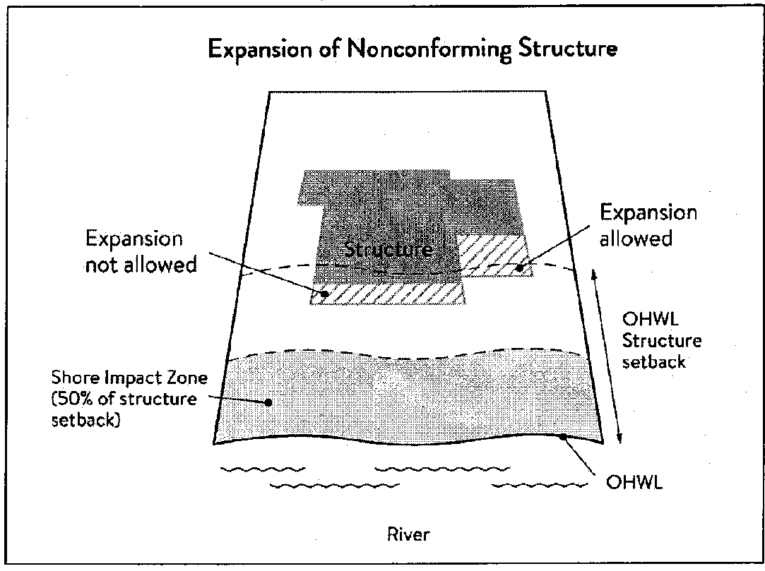
(8)
Notifications.
a.
Amendments to this section and to the MRCCA plan must be submitted to the Commissioner as provided in Minnesota Rules, part 6106.0070, Subp. 3, Items B-I.
b.
Notice of public hearings for discretionary actions, including conditional and interim use permits, variances, appeals, rezonings, preliminary plats, final subdivision plats, master plans, and PUDs, must be sent to the following entities at least 30 days prior to the hearing:
1.
The commissioner in a format prescribed by the DNR;
2.
National Park Service; and
3.
Where building heights exceed the height limits specified in section 106-910(f)(2) as part of the conditional use or variance process, adjoining local governments within the MRCCA, including those with overlapping jurisdiction and those across the river.
c.
Notice of final decisions for actions in section 106-910(c)(8)b, including findings of fact, must be sent to the commissioner, the National Park Service, and adjoining local governments within the MRCCA within ten days of the final decision.
d.
Requests to amend district boundaries must follow the provisions in Minnesota Rules, part 6106.0100, Subp. 9, Item C.
e.
The DNR will be notified at time of application submittal of master plans, PUDs, preliminary, and final plats.
(9)
Accommodating disabilities. Reasonable accommodations for ramps or other facilities to provide persons with disabilities access to the persons' property, as required by the federal Americans with Disabilities Act and the federal Fair Housing Act and as provided by Minnesota Rules, chapter 1341, must:
a.
Comply with subsections 106-910(f) to (l); or
b.
If subsections 106-910(f) to (l) cannot be complied with, ramps or other facilities are allowed with an administrative permit provided:
1.
The permit terminates on either a specific date or upon occurrence of a particular event related to the person requiring accommodation; and
2.
Upon expiration of the permit, the ramp or other facilities must be removed.
(d)
MRCCA districts.
(1)
Purpose. The purpose of this section is to establish districts under which building height and structure placement are regulated to protect and enhance the Mississippi River's resources and features consistent with the natural and built character of each district.
(2)
District description and management purpose. The MRCCA within the City of Ramsey is divided into the following MRCCA districts:
a.
Rural and Open Space (ROS).
1.
Description. The ROS district is characterized by rural and low-density development patterns and land uses, and includes land that is riparian or visible from the river, as well as large, undeveloped tracts of high ecological and scenic value, floodplain, and undeveloped islands. Many primary conservation areas exist in the district.
2.
Management purpose. The ROS district must be managed to sustain and restore the rural and natural character of the corridor and to protect and enhance habitat, parks and open space, public river corridor views, and scenic, natural, and historic areas.
b.
River Neighborhood (RN).
1.
Description. The RN district is characterized by primarily residential neighborhoods that are riparian or readily visible from the river or that abut riparian parkland. The district includes parks and open space, limited commercial development, marinas, and related land uses.
2.
Management purpose. The RN district must be managed to maintain the character of the river corridor within the context of existing residential and related neighborhood development, and to protect and enhance habitat, parks and open space, public river corridor views, and scenic, natural, and historic areas. Minimizing erosion and the flow of untreated stormwater into the river and enhancing habitat and shoreline vegetation are priorities in the district.
c.
Separated from River (SR).
1.
Description. The SR district is characterized by its physical and visual distance from the Mississippi River. The district includes land separated from the river by distance, topography, development, or a transportation corridor. The land in this district is not readily visible from the Mississippi River.
2.
Management purpose. The SR district provides flexibility in managing development without negatively affecting the key resources and features of the river corridor. Minimizing negative impacts to primary conservation areas and minimizing erosion and flow of untreated stormwater into the Mississippi River are priorities in the district. The RTC district must be managed in a manner that allows continued growth and redevelopment in historic downtowns and more intensive redevelopment in limited areas at river crossings to accommodate compact walkable development patterns and connections to the river. Minimizing erosion and the flow of untreated stormwater into the river, providing public access to and public views of the river, and restoring natural vegetation in riparian areas and tree canopy are priorities in the district.
(3)
MRCCA district map. The locations and boundaries of the MRCCA districts established by this section are shown on MRCCA Overlay District map which is incorporated herein by reference. The district boundary lines are intended to follow the center lines of rivers and streams, highways, streets, lot lines, and municipal boundaries, unless a boundary line is otherwise indicated on the map. Where district boundaries cross unsubdivided property, the district boundary line is determined by use of dimensions or the scale appearing on the map.
(e)
Special land use provisions.
(1)
Purpose. To identify development standards and considerations for land uses that have potential to negatively impact primary conservation areas and public river corridor views.
(2)
Underlying zoning. Uses within the MRCCA are generally determined by underlying zoning, with additional provisions for the following land uses:
a.
Agricultural use. Perennial ground cover is required within 50 feet of the ordinary high water level and within the bluff impact zone.
b.
Feedlots. New animal feedlots and manure storage areas are prohibited. Existing animal feedlots and manure storage areas must conform with Minnesota Rules, chapter 7020.
c.
Forestry. Tree harvesting and biomass harvesting within woodlands, and associated reforestation, must be consistent with recommended practices in Conserving Wooded Areas in Developing Communities: Best Management Practices in Minnesota.
d.
Nonmetallic mining. Nonmetallic mining requires a conditional use permit or interim use permit issued by the local government, subject to the following:
1.
New nonmetallic mining is prohibited within the shore impact zone and bluff impact zone and within the required structure setback from the bluffline and OHWL;
2.
Processing machinery must be located consistent with setback standards for structures as provided in section 106-910(f)(3);
3.
Only one barge loading area, which must be limited to the minimum size practicable, is permitted for each mining operation;
4.
New and, where practicable, existing nonmetallic mining operations must not be readily visible and must be screened by establishing and maintaining natural vegetation. The unscreened boundaries of nonmetallic mining areas are limited to only the barge loading area;
5.
A site management plan must be developed by the operator and approved by the local government before new nonmetallic mining commences. Operations must be consistent with the site plan throughout the duration of operations at the site. The site management plan must describe how the site will be developed over time with an emphasis on minimizing environmental risk to public waters;
6.
Explain where staged reclamation may occur at certain points during the life of the site;
7.
Address dust, noise, stormwater management, possible pollutant discharges, days and hours of operation, and duration of operations;
8.
Describe any anticipated vegetation and topographic alterations outside the pit, and reclamation plans consistent with the stated end use for the land; and
9.
Existing and new nonmetallic mining operations must submit land reclamation plans to the local government compatible with the purposes of this section.
e.
River-dependent uses. River-dependent uses must comply with the following design standards:
1.
Structures and parking areas, except shoreline facilities and private roads and conveyances serving river-dependent uses as provided in section 106-910(l) (Exemptions), must meet the dimensional and performance standards in this section must be designed so that they are not readily visible, and must be screened by establishing and maintaining natural vegetation;
2.
Shoreline facilities must comply with Minnesota Rules, chapter 6115 and must.
i.
Be designed in a compact fashion so as to minimize the shoreline area affected; and
ii.
Minimize the surface area of land occupied in relation to the number of watercraft or barges to be served; and
3.
Dredging and placement of dredged material are subject to existing federal and state permit requirements and agreements.
f.
Wireless communication towers. Wireless communication towers are subject to the following additional design standards:
1.
The applicant must demonstrate that functional coverage cannot be provided through co-location, a tower at a lower height, or a tower at a location outside of the MRCCA;
2.
The tower must not be located in a bluff or shore impact zone; and
3.
Placement of the tower must minimize impacts on public river corridor views.
(f)
Structure height and placement and lot size.
(1)
Purpose. To establish standards that protect primary conservation areas and public river corridor views from development impacts and ensure that new development is sited consistent with the purpose of the MRCCA.
(2)
Structure height. Structures and facilities must comply with the following standards unless identified as exempt in section 106-910(l)):
a.
Structures and facilities must comply with the following standards unless identified as exempt in section 106-910(l):
1.
ROS district: 35 feet.
2.
RN district: 35 feet.
3.
SR district: height is determined by underlying zoning, provided the allowed height is consistent with that of the mature treeline, where present, and existing surrounding development, as viewed from the OWHL of the opposite shore.
b.
Height is measured on the side of the structure facing the Mississippi River.
c.
In addition to the conditional use permit requirements of section 106-910(c)(4), criteria for considering whether to grant a conditional use permit for structures exceeding the height limits must include:
1.
Assessment of the visual impact of the proposed structure on public river corridor views, including views from other communities;
2.
Determination that the proposed structure meets the required bluff and OHWL setbacks;
3.
Identification and application of techniques to minimize the perceived bulk of the proposed structure, such as.
(i)
Placing the long axis of the building perpendicular to the river;
(ii)
Stepping back of portions of the facade;
(iii)
Lowering the roof pitch or use of a flat roof;
(iv)
Using building materials or mitigation techniques that will blend in with the natural surroundings such as green roofs, green walls, or other green and brown building materials;
(v)
Narrowing the profile of upper floors of the building;
(vi)
Increasing the setbacks of the building from the Mississippi River or blufflines;
(vii)
Identification of techniques for preservation of those view corridors identified in the MRCCA plan; and
(viii)
Opportunities for creation or enhancement of public river corridor views.
(3)
Structure and impervious surface placement.
a.
Structures and impervious surface must not be placed in the shore or bluff impact zones unless identified as an exemption in section 106-910(l).
b.
Structures and facilities must comply with the following OHWL setback provisions unless identified as exempt in section 106-910(l):
1.
ROS district: 200 feet from the Mississippi River.
2.
RN district: 100 feet from the Mississippi River.
c.
Structures and facilities must comply with the following bluffline setback provisions unless identified as exempt in section 106-910(l):
1.
ROS district: 100 feet.
2.
RN district: 40 feet.
3.
SR district: 40 feet.
d.
Where principal structures exist on the adjoining lots on both sides of a proposed building site, the minimum setback may be altered to conform to the average of the adjoining setbacks, provided that the new structure's scale and bulk riverward or bluffward of the setbacks required under section 106-910(f)(3) consistent with adjoining development. See Figure 6.
Figure 6. Structure Setback Averaging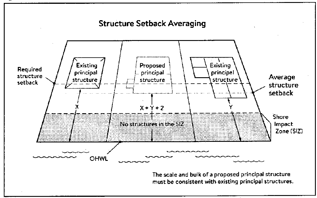
e.
Subsurface sewage treatment systems, including the septic tank and absorption area, must be located at least 75 feet from the ordinary high water level of the Mississippi River and all other public waters.
(4)
Lot size and buildable area.
a.
The width of lots abutting the Mississippi River in the ROS district must be at least 200 feet, unless alternative design methods are used that provide greater protection of the riparian area.
b.
All new lots must have adequate buildable area to comply with the setback requirements of section 106-910(f)(3) so as to not require variances to use the lots for their intended purpose.
(g)
Performance standards for private facilities.
(1)
Purpose. To establish design standards for private facilities that are consistent with best management practices and that minimize impacts to primary conservation areas, public river corridor views and other resources identified in the MRCCA plan.
(2)
General design standards. All private facilities must be developed in accordance with the vegetation management and land alteration requirements in subsections 106-910(i) and 106-910(j).
(3)
Private roads, driveways, and parking areas. Except as provided in section 106-910(l), private roads, driveways and parking areas must:
a.
Be designed to take advantage of natural vegetation and topography so that they are not readily visible;
b.
Comply with structure setback requirements according to section 106-910(f)(3); and
c.
Not be placed within the bluff impact zone or shore impact zone, unless exempt under section 106-910(l) and designed consistent with section 106-910(f)(2).
(4)
Private water access and viewing facilities.
a.
Private access paths must be no more than:
1.
Eight feet wide, if placed within the shore impact zone; and
2.
Four feet wide, if placed within the bluff impact zone.
b.
Private water access ramps must:
1.
Comply with Minnesota Rules, chapters 6115.0210 and 6280.0250; and
2.
Be designed and constructed consistent with the applicable standards in design handbook for recreational boating and fishing facilities.
c.
Design and construction of private stairways, lifts, and landings are subject to the following standards:
1.
Stairways and lifts must not exceed four feet in width on residential lots. Wider stairways may be used for commercial properties and residential facilities held in common, if approved by conditional use permit;
2.
Landings for stairways and lifts on residential lots must not exceed 32 square feet in area. Landings larger than 32 square feet area allowed for commercial properties and residential facilities held in common, if approved by conditional use permit;
3.
Canopies or roofs are prohibited on stairways, lifts, or landings;
4.
Stairways, lifts, and landings must be located in the least visible portion of the lot whenever practical; and
5.
Ramps, lifts, mobility paths, or other facilities for persons with physical disabilities are allowed for achieving access to shore areas according to section 106-910(g)(4)c.1—5, and as provided under section 106-910(c)(9).
d.
One water-oriented accessory structure is allowed for each riparian lot or parcel less than 300 feet in width at the ordinary high water level, with one additional water-oriented accessory structure allowed for each additional 300 feet of shoreline on the same lot or parcel. Water-oriented accessory structures are prohibited in the bluff impact zone and must:
1.
Not exceed 12 feet in height;
2.
Not exceed 120 square feet in area; and
3.
Be placed a minimum of ten feet from the ordinary high water level.
(5)
Decks and patios in setback areas. Decks and at-grade patios may encroach into the required setbacks from the ordinary high water level and blufflines without a variance, when consistent with subsections 106-910(i) and 106-910(j), provided that:
a.
The encroachment of the deck or patio into the required setback area does not exceed 15 percent of the required structure setback;
b.
The area of the deck or patio that extends into the required setback area occupies no more than 25 percent of the total area between the required setback and the 15 percent using the formula: [Required setback depth (feet) × 0.15 × lot width at setback (feet) x 0.25 = maximum total area.]
c.
The deck or patio does not extend into the bluff impact zone. See Figure 7.
Figure 7. Deck and Patio Encroachment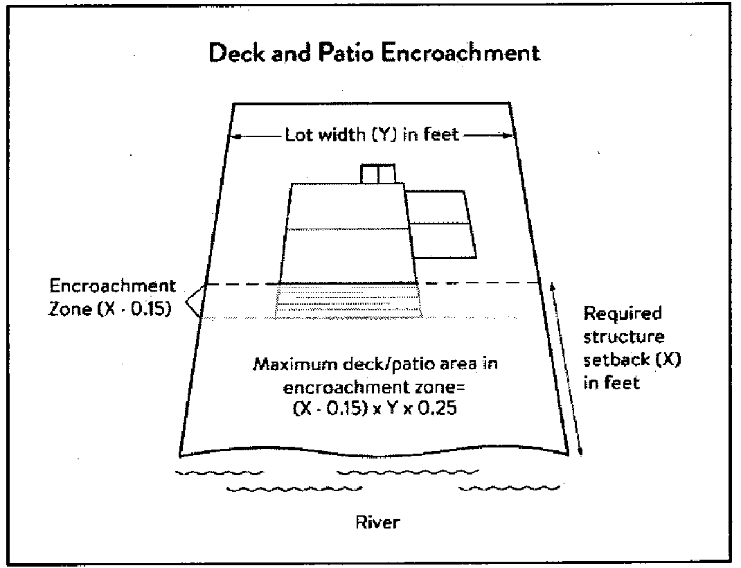
(6)
Off-premise and directional signs.
a.
Off-premise advertising signs must:
1.
Meet required structure placement and height standards in section 106-910 (structure height and placement and lot size).
2.
Not be readily visible.
b.
Directional signs for patrons arriving at a business by watercraft must comply with the following standards:
1.
They must be consistent with Minn. Stats. § 86B.115.
2.
Only convey the location and name of the establishment and the general types of goods and services available, if located in a shore impact zone.
3.
Be no greater than ten feet in height and 32 square feet in surface area; and
4.
If illuminated, the lighting must be shielded to prevent illumination out across the river or to the sky.
(7)
Fences. Fences between principal structures and the river are allowed provided that fences are:
a.
Not higher than six feet.
b.
Not located within 40 feet of slopes greater than 12 percent.
c.
Not located in the regulatory floodplain.
(h)
Performance standards for public facilities.
(1)
Purpose. To establish design standards for public facilities that are consistent with best management practices and that minimize impacts to primary conservation areas, public river corridor views and other resources identified in the MRCCA plan. Public facilities serve the public interest by providing public access to the Mississippi River corridor or require locations in or adjacent to the river corridor and therefore require some degree of flexibility.
(2)
General design standards. In addition to the standards set forth above, all public facilities must be designed and constructed to:
a.
Minimize visibility of the facility from the river to the extent consistent with the purpose of the facility;
b.
Avoid primary conservation areas, unless no alternative exists. If no alternative exists, then disturbance to primary conservation areas must be avoided to the greatest extent practicable, and design and construction must minimize impacts; and
c.
Minimize disturbance of spawning and nesting times by scheduling construction at times when local fish and wildlife are not spawning or nesting.
(3)
Right-of-way maintenance standards. Right-of-way maintenance must comply with the following standards:
a.
Vegetation currently in a natural state must be maintained to the extent feasible;
b.
Where vegetation in a natural state has been removed, native plants must be planted and maintained on the right-of-way; and
c.
Chemical control of vegetation must be avoided when practicable, but when chemical control is necessary, chemicals used must be in accordance with the regulations and other requirements of all state and federal agencies with authority over the chemical's use.
(4)
Crossings of public water or public land. Crossings of public waters or land controlled by the commissioner are subject to approval by the commissioner according to Minn. Stats. §§ 84.415 and 103G.245.
(5)
Public utilities. Public utilities must comply with the following standards:
a.
High-voltage transmission lines, wind energy conversion systems greater than five megawatts, and pipelines are regulated according to Minn. Stats. chs. 216E, 216F, and 216G respectively; and
b.
If overhead placement is necessary, utility facility crossings must minimize visibility of the facility from the river and follow other existing rights-of-way as much as practicable.
c.
The appearance of structures must be as compatible as practicable with the surrounding area in a natural state with regard to height and width, materials used, and color.
(6)
Public transportation facilities. Public transportation facilities shall comply with structure placement and height standards in section 106-910(f). Where such facilities intersect or about two or more MRCCA districts, the least restrictive standards apply. Public transportation facilities must be designed and constructed to give priority to:
a.
Providing scenic overlooks for motorists, bicyclists, and pedestrians;
b.
Providing safe pedestrian crossings and facilities along the river corridor;
c.
Providing access to the riverfront in public ownership; and
d.
Allowing for use of the land between the river and the transportation facility.
(7)
Public recreational facilities. Where such facilities intersect or abut two or more MRCCA districts, the least restrictive dimensional standards apply. Public transportation facilities must be designed and constructed to give priority to:
a.
Roads and driveways associated with public recreational facilities must not be placed in the bluff or shore impact zones unless no other placement alternative exists. If no alternative exists, then design and construction must minimize impacts to shoreline vegetation, erodible soils and slopes, and other sensitive resources.
b.
Trails, access paths, and viewing areas associated with public recreational facilities and providing access to or views of the Mississippi River are allowed within the bluff and shore impact zones if design, construction, and maintenance methods are consistent with the best management practice guidelines in trail planning, design, and development guidelines.
1.
Hard-surface trails are not allowed on the face of bluffs with a slope exceeding 30 percent. Natural surface trails are allowed, provided they do not exceed eight feet in width.
2.
Trails, paths, and viewing areas must be designed and constructed to minimize.
i.
Visibility from the river;
ii.
Visual impacts on public river corridor views; and
iii.
Disturbance to and fragmentation of primary conservation areas.
c.
Public water access facilities must comply with the following requirements:
1.
Watercraft access ramps must comply with Minnesota Rules chapters 6115.0210 and 6280.0250; and
2.
Facilities must be designed and constructed consistent with the standards in design handbook for recreational boating and fishing facilities.
d.
Public signs and kiosks for interpretive or directional purposes are allowed in the bluff or shore impact zones, provided they are placed and constructed to minimize disturbance to these areas and avoid visual impacts on public river corridor views.
(i)
Vegetation management.
(1)
Purpose. To establish standards that sustain and enhance the biological and ecological functions of vegetation; preserve the natural character and topography of the MRCCA; and maintain stability of bluffs and steep slopes and ensure stability of other erosion-prone areas.
(2)
Applicability. This section applies to:
a.
Shore impact zones;
b.
Areas within 50 feet of a wetland or natural drainage way;
c.
Bluff impact zones;
d.
Areas of native plant communities; and
e.
Significant existing vegetative stands identified in the MRCCA plan.
(3)
Activities allowed without a vegetation permit.
a.
Maintenance of existing lawns, landscaping and gardens;
b.
Removal of vegetation in emergency situations as determined by the City of Ramsey;
c.
Right-of-way maintenance for public facilities;
d.
Agricultural and forestry activities;
e.
Selective vegetation removal, provided that vegetative cover remains consistent with the management purpose of the MRCCA district, including:
1.
Vegetation that is dead, diseased, dying, or hazardous;
2.
To prevent the spread of diseases or insect pests;
3.
Individual trees and shrubs; and
4.
Removal of invasive non-native species.
(4)
Activities allowed with a vegetation permit.
a.
The following intensive vegetation clearing activities are allowed with a vegetation permit:
1.
Clearing of vegetation that is dead, diseased, dying, or hazardous.
2.
Clearing to prevent the spread of diseases or insect pests.
3.
Clearing to remove invasive non-native species.
4.
Clearing to prepare for restoration and erosion control management activities consistent with a plan approved by City of Ramsey.
5.
The minimum necessary for development that is allowed with a building permit or as an exemption under section 106-910(l).
b.
Conditions of vegetation permit approval:
1.
Development is sited to minimize removal of or disturbance to natural vegetation;
2.
Soil, slope stability, and hydrologic conditions are suitable for the proposed work as determined by a professional engineer or City of Ramsey;
3.
Clearing is the minimum necessary and designed to blend with the natural terrain and minimize visual impacts to public river corridor views;
4.
Any native plant communities removed are replaced with vegetation that provides equivalent biological and ecological functions consistent with an approved vegetation restoration plan. If replaced, priorities for restoration are stabilization of erodible soils, restoration or enhancement of shoreline vegetation, and revegetation of bluffs or steep slopes visible from the river;
5.
All other vegetation removed is restored with natural vegetation to the greatest extent practicable consistent with an approved vegetation restoration.
6.
Any disturbance of highly erodible soils is replanted with deep-rooted vegetation with a high stem density;
7.
Vegetation removal activities are conducted so as to expose the smallest practical area of soil to erosion for the least possible time;
8.
Areas of vegetation restoration priorities identified in the MRCCA plan are restored, if applicable; and
9.
Any other condition determined necessary to achieve the purpose of this section.
(5)
Prohibited activities. All other intensive vegetation clearing is prohibited.
(6)
Vegetation restoration plan.
a.
Development of a vegetation restoration plan and reestablishment of natural vegetation is required:
1.
As a condition of a vegetation permit;
2.
Upon failure to comply with any provisions in this section; or.
3.
As part of the planning process for subdivisions.
b.
The vegetation restoration plan must.
1.
Include vegetation that provides suitable habitat and effective soil stability, runoff retention, and infiltration capability. Vegetation species, composition, density, and diversity must be guided by nearby patches of native plant communities and by native vegetation establishment and enhancement guidelines;
2.
Be prepared by a qualified individual; and
3.
Include a maintenance plan that includes management provisions for controlling invasive species and replacement of plant loss for three years.
c.
A certificate of compliance will be issued after the vegetation restoration plan requirements have been satisfied.
(j)
Land alteration standards and stormwater management.
(1)
Purpose. To establish standards that protect water quality from pollutant loadings of sediment, nutrients, bacteria, and other contaminants; and maintain stability of bluffs, shorelines, and other areas prone to erosion.
(2)
Land alteration permit.
a.
Within the bluff impact zone, land alteration is prohibited, except for the following which are allowed by permit:
1.
Erosion control consistent with section 106-910(j)(6);
2.
The minimum necessary for development that is allowed as an exception under section 106-910(l); and
3.
Repair and maintenance of existing buildings and facilities.
b.
Within the water quality impact zone, land alteration that involves more than ten cubic yards of material or affects an area greater than 1,000 square feet requires a permit.
(3)
Rock riprap, retaining walls, and other erosion control structures.
a.
Construction, repair, or replacement of rock riprap, retaining walls, and other erosion control structures located at or below the OHWL must comply with Minnesota Rules, chapters 6115.0215, subpart 4, item E, and 6115.0216, subpart 2. Work must not proceed until approved by the commissioner. See Figure 8.
Figure 8. Riprap Guidelines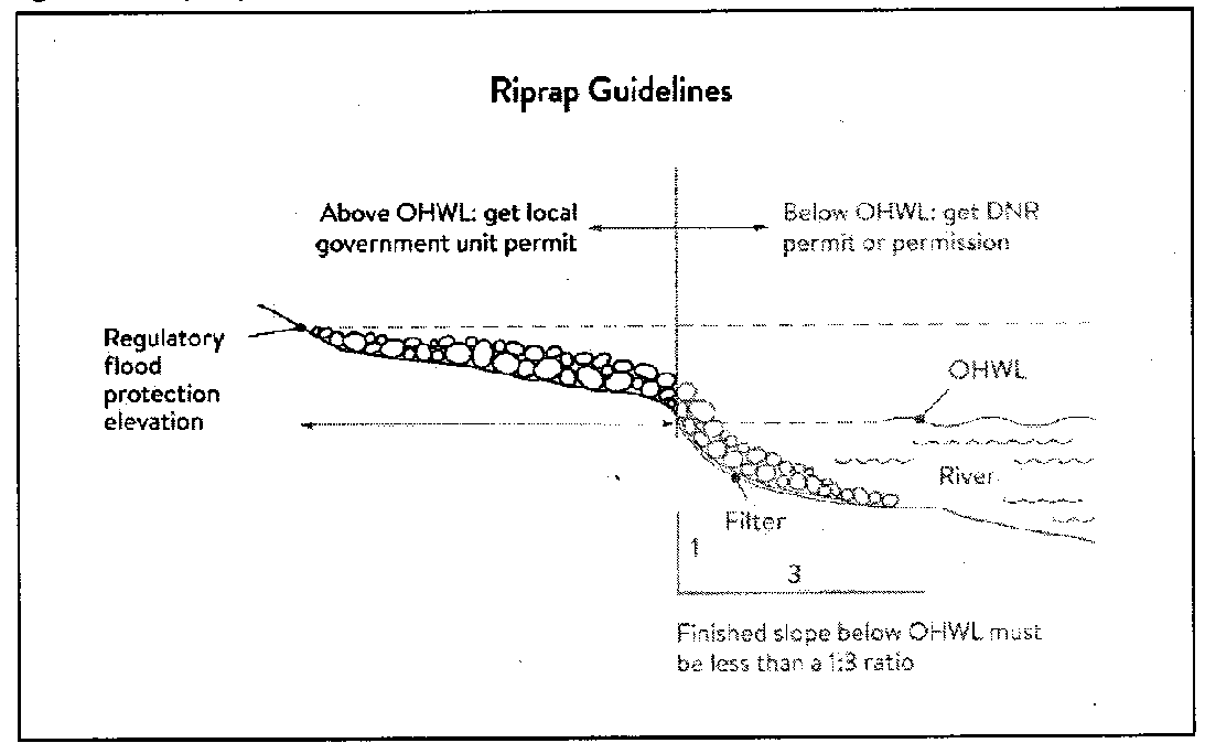
b.
Construction or replacement of rock riprap, retaining walls, and other erosion control structures within the bluff impact zone and the water quality impact zone are allowed with a permit provided that:
1.
If the project includes work at or below the OHWL, the commissioner has already approved or permitted the project.
2.
The structures are used only to correct an established erosion problem as determined by the City of Ramsey.
3.
The size and extent of the structures are the minimum necessary to correct the erosion problem and are not larger than the following, unless a professional engineer determines that a larger structure is needed to correct the erosion problem:
i.
Retaining walls must not exceed five feet in height and must be placed a minimum horizontal distance of ten feet apart; and
ii.
Riprap must not exceed the height of the regulatory flood protection elevation.
c.
Repair of existing rock riprap, retaining walls, and other erosion control structures above the OHWL does not require a permit provided it does not involve any land alteration.
(4)
Stormwater management.
a.
In the bluff impact zone, stormwater management facilities are prohibited except by permit if:
1.
There are no alternatives for stormwater treatment outside the bluff impact zone on the subject site;
2.
The site generating runoff is designed so that the amount of runoff reaching the bluff impact zone is reduced to the greatest extent practicable;
3.
The construction and operation of the facility does not affect slope stability on the subject property or adjacent properties; and
4.
Mitigation based on the best available engineering and geological practices is required and applied to eliminate or minimize the risk of slope failure.
b.
In the water quality impact zone, development that creates new impervious surface, or fully reconstructs existing impervious surface of more than 10,000 square feet requires a stormwater permit or approved stormwater plan. Multipurpose trails and sidewalks are exempt if there is down gradient vegetation or a filter strip that is at least five feet wide.
c.
In all other areas, stormwater runoff must be directed away from the bluff impact zones or unstable areas.
(5)
Development on steep slopes. Construction of structures, impervious surfaces, land alteration, vegetation removal, or other construction activities are allowed on steep slopes if:
a.
The development can be accomplished without increasing erosion or stormwater runoff;
b.
The soil types and geology are suitable for the proposed development; and
(6)
Conditions of land alteration permit approval.
a.
Temporary and permanent erosion and sediment control measures retain sediment onsite consistent with best management practices in the Minnesota Stormwater Manual;
b.
Natural site topography, soil, and vegetation conditions are used to control runoff and reduce erosion and sedimentation;
c.
Construction activity is phased when possible;
d.
All erosion and sediment controls are installed before starting any land disturbance activity;
e.
Erosion and sediment controls are maintained to ensure effective operation;
f.
Best management practices for protecting and enhancing ecological and water resources identified in Best Practices for Meeting DNR General Public Waters Work Permit GP 2004-0001.
(7)
Compliance with other plans and programs. All development must:
a.
Be consistent with Minn. Stats. ch. 103B, and local water management plans completed under [Minnesota Rules] chapter 8410;
b.
Meet or exceed the wetland protection standards under Minnesota Rules, chapter 8420; and
c.
Meet or exceed the floodplain management standards under Minnesota Rules, chapters 6120.5000—6120.6200.
(k)
Subdivision and land development standards.
(1)
Purpose.
a.
To protect and enhance the natural and scenic values of the MRCCA during development or redevelopment of the remaining large sites;
b.
To establish standards for protecting and restoring biological and ecological functions of primary conservation areas on large sites; and
c.
To encourage restoration of natural vegetation during development or redevelopment of large sites where restoration opportunities have been identified in MRCCA plans.
(2)
Applicability.
a.
The design standards in this section apply to subdivisions, planned unit developments and master-planned development and redevelopment of land involving ten or more acres for contiguous parcels that abut the Mississippi River and 20 or more acres for all other parcels, including smaller individual sites within the following developments that are part of a common plan of development that may be constructed at different times:
1.
Subdivisions;
2.
Planned unit developments; and
3.
Master-planned development and redevelopment of land.
b.
The following activities are exempt from the requirements of this section:
1.
Minor subdivisions consisting of three or fewer lots;
2.
Minor boundary line corrections;
3.
Resolutions of encroachments;
4.
Additions to existing lots of record;
5.
Placement of essential services; and
6.
Activities involving river-dependent commercial and industrial uses.
(3)
Design standards.
a.
Primary conservation areas, where they exist, must be set aside and designated as protected open space in quantities meeting the following as a percentage of total parcel area:
1.
CA-ROS district: 50 percent;
2.
CA-RN district: 20 percent;
3.
CA-SR district: Ten percent if the parcel includes native plant communities or provides feasible connections to a regional park or trail system, otherwise no requirement.
b.
If the primary conservation areas exceed the amounts specified in section 106-910(k)(3)a above, then protection of native plant communities and natural vegetation in riparian areas shall be prioritized.
c.
If primary conservation areas exist but do not have natural vegetation (identified as restoration priorities in the MRCCA plan), then a vegetation assessment must be completed to evaluate the unvegetated primary conservation areas and determine whether vegetation restoration is needed.
d.
If primary conservation areas do not exist on the parcel and portions of the parcel have been identified in the MRCCA plan as a restoration area, vegetation must be restored in the identified areas and the area must be set aside and designated as protected open space.
e.
Stormwater treatment areas or other green infrastructure may be used to meet the protected open space requirements if the vegetation provides biological and ecological functions.
f.
Land dedicated under this section for public river access, parks, or other open space, or public facilities may be counted toward the protected open space requirement.
g.
Protected open space areas must connect open space, natural areas, and recreational areas, where present on adjacent parcels, as much as possible, to form an interconnected network.
(4)
Permanent protection of designated open space.
a.
Designated open space areas must be protected through one or more of the following methods:
1.
Public acquisition by a government entity for conservation purposes;
2.
A permanent conservation easement, as provided in Minn. Stats. ch. 84c;
3.
A deed restriction; and
4.
Other arrangements that achieve an equivalent degree of protection.
b.
Permanent protection methods must ensure the long-term management of vegetation to meet its biological and ecological functions, prohibit structures, and prohibit land alteration, except as needed to provide public recreational facilities and access to the river.
(l)
Exemptions
(1)
Purpose. To provide exemptions to structure placement, height and other standards for specific river or water access dependent facilities as provided in Minn. Stats. § 116G.15, subd. 4.
(2)
Applicability. Uses and activities not specifically exempted must comply with this section.
(3)
Use and activity exemptions classification.
a.
Uses and activities in the following tables are categorized as:
1.
Exempt — E. This means that the use or activity is allowed;
2.
Exempt if no alternative — (E). This means that the use or activity is allowed only if no alternatives exist; and
3.
Not exempt — N. This means that a use or activity is not exempt and must meet the standards of this section.
b.
General uses and activities.
c.
Public utilities.
d.
Public recreational facilities.
e.
River-dependent uses.
1 River-dependent commercial, industrial, and utility structures are exempt from height limits only if greater height is required for operational reasons.
f.
Private residential and commercial water access and use facilities.
(Ord. No. 23-14, § 3, 11-14-2023)
Sec. 106-920. - Floodplain overlay districts.
(a)
Statutory authorization. The legislature of the State of Minnesota has, in Minn. Stats. ch. 103F and ch. 462, delegated the responsibility to local government units to adopt regulations designed to minimize flood losses. Therefore, the city council does ordain as follows.
(b)
Purpose.
(1)
This subdivision regulates development in the flood hazard areas of the city. These flood hazard areas are subject to periodic inundation, which may result in loss of life and property, health and safety hazards, disruption of commerce and governmental services, extraordinary public expenditures for flood protection and relief, and impairment of the tax base. It is the purpose of this Section to promote the public health, safety, and general welfare by minimizing these losses and disruptions.
(2)
National Flood Insurance Program compliance. This subdivision is adopted to comply with the rules and regulations of the National Flood Insurance Program codified as 44 Code of Federal Regulations Parts 59—78, as amended, so as to maintain the city's eligibility in the National Flood Insurance Program.
(3)
This subdivision is also intended to preserve the natural characteristics and functions of watercourses and floodplains in order to moderate flood and stormwater impacts, improve water quality, reduce soil erosion, protect aquatic and riparian habitat, provide recreational opportunities, provide aesthetic benefits and enhance community and economic development.
(Ord. No. 23-14, § 3, 11-14-2023)
Sec. 106-921. - Floodplain overlay districts general provisions.
(a)
This subdivision adopts the floodplain maps applicable to the city and includes three floodplain districts: Floodway, Flood Fringe, and General Floodplain.
(1)
Where Floodway and Flood Fringe Districts are delineated on the floodplain maps, the standards in sections 106-923 or 106-924 will apply, depending on the location of a property.
(2)
Locations where Floodway and Flood Fringe Districts are not delineated on the floodplain maps are considered to fall within the General Floodplain District. Within the General Floodplain District, the Floodway District standards in section 106-923 apply unless the floodway boundary is determined, according to the process outlined in section 106-925. Once the floodway boundary is determined, the Flood Fringe District standards in section 106-924 may apply outside the floodway.
(b)
Lands to which this subdivision applies. This subdivision applies to all lands within the jurisdiction of the city shown on the official zoning map and/or the attachments to the map as being located within the boundaries of the Floodway, Flood Fringe, or General Floodplain Districts.
(1)
The Floodway, Flood Fringe and General Floodplain Districts are overlay districts that are superimposed on all existing zoning districts. The standards imposed in the overlay districts are in addition to any other requirements in the underlying zoning district. In case of a conflict, the more restrictive standards will apply.
(c)
Incorporation of maps by reference. The following maps, together with all attached material, are hereby adopted by reference and declared to be a part of the official zoning map and this subdivision. The attached material includes the Flood Insurance Study for Anoka County, Minnesota, and Incorporated Areas and the flood insurance rate maps enumerated below, all dated December 16, 2015 and all prepared by the Federal Emergency Management Agency. These materials are on file in the community development department.
(d)
Regulatory flood protection elevation. The regulatory flood protection elevation (RFPE) is an elevation no lower than one foot above the elevation of the regional flood plus any increases in flood elevation caused by encroachments on the floodplain that result from designation of a floodway.
(e)
Interpretation. The boundaries of the zoning districts are determined by scaling distances on the flood insurance rate map.
(1)
Where a conflict exists between the floodplain limits illustrated on the official zoning map and actual field conditions, the flood elevations shall be the governing factor. The zoning administrator must interpret the boundary location based on the ground elevations that existed on the site on the date of the first National Flood Insurance Program map showing the area within the regulatory floodplain, and other available technical data.
(2)
Persons contesting the location of the district boundaries will be given a reasonable opportunity to present their case to the planning commission and to submit technical evidence.
(f)
Abrogation and greater restrictions. It is not intended by this subdivision to repeal, abrogate, or impair any existing easements, covenants, or other private agreements. However, where this subdivision imposes greater restrictions, the provisions of this subdivision prevail.
(g)
Warning and disclaimer of liability. This subdivision does not imply that areas outside the floodplain districts or land uses permitted within such districts will be free from flooding or flood damages. This subdivision does not create liability on the part of the city or its officers or employees for any flood damages that result from reliance on this subdivision or any administrative decision lawfully made thereunder.
(h)
Severability. If any section, clause, provision, or portion of this subdivision is adjudged unconstitutional or invalid by a court of law, the remainder of this subdivision shall not be affected and shall remain in full force.
(Ord. No. 23-14, § 3, 11-14-2023)
Sec. 106-922. - Establishment of flood zone districts.
(a)
Districts.
(1)
FW Floodway District. The floodway district includes those areas designated as floodway on the flood insurance rate map adopted in section 106-921. For lakes, wetlands, and other basins (that do not have a floodway designated), the floodway district includes those areas designated as zone A or AE on the flood insurance rate map that are at or below the ordinary high water level as defined in Minn. Stats. § 103G.005, subd. 14.
(2)
FF Flood Fringe District. The Flood Fringe District includes those areas designated as floodway fringe on the flood insurance rate map adopted in section 106-921 as being within zone AE but being located outside of the floodway. For lakes, wetlands and other basins (that do not have a floodway designated), the Flood Fringe District includes those areas designated as zone A or AE on the flood insurance rate map panels adopted in section 106-921 that are below the one percent annual chance (100-year) flood elevation but above the ordinary high water level as defined in Minn. Stats. § 103G.005, subd. 14.
(3)
GF General Floodplain District. The General Floodplain District includes those areas designated as zone A or zone AE without a floodway on the flood insurance rate map adopted in section 106-921, but not subject to the criteria in subsections 106-922(a)(1) and (2) above.
(b)
Compliance. Within the floodplain districts established in this subdivision, the use of any land, the use, size, type and location of structures on lots, the installation and maintenance of transportation, utility, water supply and waste treatment facilities, and the subdivision of land must comply with the terms of this subdivision and other applicable regulations. All uses not listed as permitted uses or conditional uses in sections 106-923, 106-924, and 106-925, respectively, are prohibited. In addition, a caution is provided here that:
(1)
New and replacement manufactured homes and certain recreational vehicles are subject to the general provisions of this subdivision and specifically section 106-924.
(2)
Modifications, additions, structural alterations, normal maintenance and repair, or repair after damage to existing nonconforming structures and nonconforming uses of structures or land are regulated by the general provisions of this subdivision and specifically section 106-929.
(3)
All structures must be constructed with electrical, heating, ventilation, plumbing, and air conditioning equipment and other service facilities that are designed and/or located so as to prevent water from entering or accumulating within the components during conditions of flooding.
(4)
As-built elevations for elevated or floodproofed structures must be certified by ground surveys and flood-proofing techniques must be designed and certified by a registered professional engineer or architect as specified in the general provisions of this subdivision and specifically as stated in section 106-928.
(Ord. No. 23-14, § 3, 11-14-2023)
Sec. 106-923. - Floodway District (FW).
(a)
Permitted uses. The following uses, subject to the standards set forth in section 106-923(b), are permitted uses if otherwise allowed in the underlying zoning district or any applicable overlay district:
(1)
General farming, pasture, grazing, outdoor plant nurseries, horticulture, truck farming, forestry, sod farming, and wild crop harvesting.
(2)
Industrial-commercial loading areas, parking areas, and airport landing strips.
(3)
Open space uses, including but not limited to private and public golf courses, tennis courts, driving ranges, archery ranges, picnic grounds, boat launching ramps, swimming areas, parks, wildlife and nature preserves, game farms, fish hatcheries, shooting preserves, hunting and fishing areas, and single or multiple purpose recreational trails.
(4)
Residential lawns, gardens, parking areas, and play areas.
(5)
Railroads, streets, bridges, utility transmission lines and pipelines, provided that the department of natural resources' area hydrologist is notified at least ten days prior to issuance of any permit, and that the standards in sections 106-923(d)(1), 106-923(d)(3) and 106-923(d)(6) are met.
(b)
Standards for floodway permitted uses:
(1)
The use must have a low flood damage potential.
(2)
With the exception of the uses listed in section 106-923(a)(5), the use must not obstruct flood flows or increase flood elevations and must not involve structures, fill, obstructions, excavations or storage of materials or equipment.
(3)
Any facility that will be used by employees or the general public must be designed with a flood warning system that provides adequate time for evacuation if the area is inundated to a depth and velocity such that the depth (in feet) multiplied by the velocity (in feet per second) would exceed a product of four upon occurrence of the regional (one percent chance) flood.
(c)
Conditional uses. The following uses may be allowed as conditional uses following the standards and procedures set forth in section 106-931(d) of this subdivision and further subject to the standards set forth in section 106-923(d), if otherwise allowed in the underlying zoning district or any applicable overlay district.
(1)
Structures accessory to the uses listed in section 106-923(a) and the uses listed in subsections (c)(2) through (9) below.
(2)
Extraction and storage of sand, gravel, and other materials.
(3)
Marinas, boat rentals, docks, piers, wharves, and water control structures.
(4)
Storage yards for equipment, machinery, or materials.
(5)
Placement of fill or construction of fences that obstruct flood flows. Farm fences, as defined in section 106-105, are permitted uses.
(6)
Travel-ready recreational vehicles meeting the exception standards in section 106-927(D)(2).
(7)
Levees or dikes intended to protect agricultural crops for a frequency flood event equal to or less than the ten-year frequency flood event.
(d)
Standards for floodway conditional uses:
(1)
All uses. A conditional use must not cause any increase in the stage of the one percent chance or regional flood or cause an increase in flood damages in the reach or reaches affected.
(2)
Fill; storage of materials and equipment:
a.
The storage or processing of materials that are, in time of flooding, flammable, explosive, or potentially injurious to human, animal, or plant life is prohibited.
b.
Fill, dredge spoil, and other similar materials deposited or stored in the floodplain must be protected from erosion by vegetative cover, mulching, riprap or other acceptable method. Permanent sand and gravel operations and similar uses must be covered by a long-term site development plan.
c.
Temporary placement of fill, other materials, or equipment which would cause an increase to the stage of the one percent chance or regional flood may only be allowed if the city has approved a plan that assures removal of the materials from the floodway based upon the flood warning time available.
(3)
Accessory structures:
a.
Accessory structures must not be designed for human habitation.
b.
Accessory structures, if permitted, must be constructed and placed on the building site so as to offer the minimum obstruction to the flow of flood waters:
1.
Whenever possible, structures must be constructed with the longitudinal axis parallel to the direction of flood flow; and
2.
So far as practicable, structures must be placed approximately on the same flood flow lines as those of adjoining structures.
c.
Accessory structures must be elevated on fill or structurally dry floodproofed in accordance with the FP-1 or FP-2 floodproofing classifications in the Minnesota State Building Code. All floodproofed accessory structures must meet the following additional standards:
1.
The structure must be adequately anchored to prevent flotation, collapse or lateral movement and designed to equalize hydrostatic flood forces on exterior walls; and
2.
Any mechanical and utility equipment in the structure must be elevated to or above the regulatory flood protection elevation or properly floodproofed.
d.
As an alternative, an accessory structure may be internally/wet floodproofed to the FP-3 or FP-4 floodproofing classifications in the Minnesota State Building Code, provided the accessory structure constitutes a minimal investment and does not exceed 576 square feet in size. A detached garage may only be used for parking of vehicles and limited storage. All structures must meet the following standards:
1.
To allow for the equalization of hydrostatic pressure, there must be a minimum of two "automatic" openings in the outside walls of the structure, with a total net area of not less than one square inch for every square foot of enclosed area subject to flooding; and
2.
There must be openings on at least two sides of the structure and the bottom of all openings must be no higher than one foot above the lowest adjacent grade to the structure. Using human intervention to open a garage door prior to flooding will not satisfy this requirement for automatic openings.
(4)
Structural works for flood control that will change the course, current or cross section of protected wetlands or public waters are subject to the provisions of Minn. Stats. § 103G.245.
(5)
A levee, dike or floodwall constructed in the floodway must not cause an increase to the one percent chance or regional flood. The technical analysis must assume equal conveyance or storage loss on both sides of a stream.
(6)
Floodway developments must not adversely affect the hydraulic capacity of the channel and adjoining floodplain of any tributary watercourse or drainage system.
(Ord. No. 23-14, § 3, 11-14-2023)
Sec. 106-924. - Flood Fringe District (FF).
(a)
Permitted uses. Permitted uses are those uses of land or structures allowed in the underlying zoning district(s) that comply with the standards in subsection (b) below.
(b)
Standards for flood fringe permitted uses.
(1)
All structures, including accessory structures, must be elevated on fill so that the lowest floor, as defined, is at or above the regulatory flood protection elevation. The finished fill elevation for structures must be no lower than one foot below the regulatory flood protection elevation and the fill must extend at the same elevation at least 15 feet beyond the outside limits of the structure.
a.
All service utilities, including ductwork, must be elevated or water-tight to prevent infiltration of floodwaters.
b.
As an alternative to elevation on fill, an accessory structure that constitutes a minimal investment and that does not exceed 576 square feet in size may be internally floodproofed in accordance with section 106-923(d)(3).
(2)
The cumulative placement of fill or similar material on a parcel must not exceed 1,000 cubic yards, unless the fill is specifically intended to elevate a structure in accordance with subsection (a) above, or if allowed as a conditional use under section 106-924(c)(3) below.
(3)
The storage of any materials or equipment must be elevated on fill to the regulatory flood protection elevation.
(4)
The storage or processing of materials that are, in time of flooding, flammable, explosive, or potentially injurious to human, animal, or plant life is prohibited.
(5)
Fill must be properly compacted and the slopes must be properly protected by the use of riprap, vegetative cover or other acceptable method.
(6)
All new principal structures must have vehicular access at or above an elevation not more than two feet below the regulatory flood protection elevation, or must have a flood warning/emergency evacuation plan acceptable to the city.
(7)
Accessory uses such as yards, railroad tracks, and parking lots may be at an elevation lower than the regulatory flood protection elevation. However, any facilities used by employees or the general public must be designed with a flood warning system that provides adequate time for evacuation if the area is inundated to a depth and velocity such that the depth (in feet) multiplied by the velocity (in feet per second) would exceed a product of four upon occurrence of the regional (one percent chance) flood.
(8)
Interference with normal manufacturing/industrial plant operations must be minimized, especially along streams having protracted flood durations. In considering permit applications, due consideration must be given to the needs of industries with operations that require a floodplain location.
(9)
Flood fringe developments must not adversely affect the hydraulic capacity of the channel and adjoining floodplain of any tributary watercourse or drainage system.
(10)
Manufactured homes and recreational vehicles must meet the standards of section 106-927.
(c)
Conditional uses. The following uses and activities may be allowed as conditional uses, if allowed in the underlying zoning district(s) or any applicable overlay district, following the procedures in section 106-928(d). Conditional uses must meet the standards in subsections (d)(4) through (10) above and section 106-924(d).
(1)
Any structure that is not elevated on fill or floodproofed in accordance with section 106-924(b)(1)a and b.
(2)
Storage of any material or equipment below the regulatory flood protection elevation.
(3)
The cumulative placement of more than 1,000 cubic yards of fill when the fill is not being used to elevate a structure in accordance with subsection (b)(1) above.
(d)
Standards for flood fringe conditional uses.
(1)
The standards listed in subsections 106-924(b)(4) through (10) apply to all conditional uses.
(2)
Basements, as defined in section 106-105, are subject to the following:
a.
Residential basement construction is not allowed below the regulatory flood protection elevation.
b.
Non-residential basements may be allowed below the regulatory flood protection elevation provided the basement is structurally dry floodproofed in accordance with section 106-924(D)(3).
(3)
All areas of nonresidential structures, including basements, to be placed below the regulatory flood protection elevation must be floodproofed in accordance with the structurally dry floodproofing classifications in the Minnesota State Building Code. Structurally dry floodproofing must meet the FP-1 or FP-2 floodproofing classification in the Minnesota State Building Code, which requires making the structure watertight with the walls substantially impermeable to the passage of water and with structural components capable of resisting hydrostatic and hydrodynamic loads and the effects of buoyancy. Structures wet floodproofed to the FP-3 or FP-4 classification are not permitted.
(4)
The placement of more than 1,000 cubic yards of fill or other similar material on a parcel (other than for the purpose of elevating a structure to the regulatory flood protection elevation) must comply with an approved erosion/sedimentation control plan.
a.
The plan must clearly specify methods to be used to stabilize the fill on site for a flood event at a minimum of the regional (one percent chance) flood event.
b.
The plan must be prepared and certified by a registered professional engineer or other qualified individual acceptable to the city.
c.
The plan may incorporate alternative procedures for removal of the material from the floodplain if adequate flood warning time exists.
(5)
Storage of materials and equipment below the regulatory flood protection elevation must comply with an approved emergency plan providing for removal of such materials within the time available after a flood warning.
(6)
Alternative elevation methods other than the use of fill may be utilized to elevate a structure's lowest floor above the regulatory flood protection elevation. These alternative methods may include the use of stilts, pilings, parallel walls, etc., or above-grade, enclosed areas such as crawl spaces or tuck under garages. The base or floor of an enclosed area shall be considered above-grade and not a structure's basement or lowest floor if:
a.
The enclosed area is above-grade on at least one side of the structure.
b.
It is designed to internally flood and is constructed with flood resistant materials.
c.
It is used solely for parking of vehicles, building access or storage. The above-noted alternative elevation methods are subject to the following additional standards:
1.
Design and certification. The structure's design and as-built condition must be certified by a registered professional engineer or architect as being in compliance with the general design standards of the Minnesota State Building Code and, specifically, that all electrical, heating, ventilation, plumbing and air conditioning equipment and other service facilities must be at or above the regulatory flood protection elevation or be designed to prevent flood water from entering or accumulating within these components during times of flooding.
2.
Specific standards for above-grade, enclosed areas. Above-grade, fully enclosed areas such as crawl spaces or tuck under garages must be designed to internally flood and the design plans must stipulate.
i.
The minimum area of openings in the walls where internal flooding is to be used as a floodproofing technique. There shall be a minimum of two openings on at least two sides of the structure and the bottom of all openings shall be no higher than one foot above grade. The automatic openings shall have a minimum net area of not less than one square inch for every square foot of enclosed area subject to flooding unless a registered professional engineer or architect certifies that a smaller net area would suffice. The automatic openings may be equipped with screens, louvers, valves, or other coverings or devices provided that they permit the automatic entry and exit of flood waters without any form of human intervention; and
ii.
That the enclosed area will be designed of flood resistant materials in accordance with the FP-3 or FP-4 classifications in the Minnesota State Building Code and shall be used solely for building access, parking of vehicles, or storage.
(Ord. No. 23-14, § 3, 11-14-2023)
Sec. 106-925. - General Floodplain District (GF).
(a)
Permitted uses.
(1)
The uses listed in section 106-923(a), Floodway District permitted uses, are permitted uses.
(2)
All other uses are subject to the floodway/flood fringe evaluation criteria specified in section 106-925(b) below. Section 106-923 applies if the proposed use is determined to be in the Floodway District. Section 106-924 applies if the proposed use is determined to be in the Flood Fringe District.
(b)
Procedures for floodway and flood fringe determinations.
(1)
Upon receipt of an application for a permit or other approval within the general Floodplain District, the zoning administrator must obtain, review and reasonably utilize any regional flood elevation and floodway data available from a federal, state, or other source.
(2)
If regional flood elevation and floodway data are not readily available, the applicant must furnish additional information, as needed, to determine the regulatory flood protection elevation and whether the proposed use would fall within the Floodway or Flood Fringe District. Information must be consistent with accepted hydrological and hydraulic engineering standards and the standards in section 106-925(b)(3) below.
(3)
The determination of floodway and flood fringe must include the following components, as applicable:
a.
Estimate the peak discharge of the regional (one percent chance) flood.
b.
Calculate the water surface profile of the regional flood based upon a hydraulic analysis of the stream channel and overbank areas.
c.
Compute the floodway necessary to convey or store the regional flood without increasing flood stages more than one-half foot. A lesser stage increase than one-half foot is required if, as a result of the stage increase, increased flood damages would result. An equal degree of encroachment on both sides of the stream within the reach must be assumed in computing floodway boundaries.
(4)
The zoning administrator will review the submitted information and assess the technical evaluation and the recommended Floodway and/or Flood Fringe District boundary. The assessment must include the cumulative effects of previous floodway encroachments. The zoning administrator may seek technical assistance from a designated engineer or other expert person or agency, including the Minnesota Department of Natural Resources, before presenting the technical evaluation and findings to the city council. The city council must formally accept the technical evaluation and the recommended Floodway and/or Flood Fringe District boundary or deny the permit application. The city council, prior to official action, may submit the application and all supporting data and analyses to the Federal Emergency Management Agency (FEMA), the Minnesota Department of Natural Resources, or the planning commission for review and comment.
(5)
Once the Floodway and Flood Fringe District boundaries have been determined, the city council shall refer the matter back to the zoning administrator to process the permit application consistent with the applicable provisions of sections 106-923 and 106-924.
(Ord. No. 23-14, § 3, 11-14-2023)
Sec. 106-926. - Public utilities, railroads, roads, and bridges in floodplains.
(a)
Public utilities. All public utilities and facilities such as gas, electrical, sewer, and water supply systems to be located in the floodplain must be floodproofed in accordance with the Minnesota State Building Code or elevated to the regulatory flood protection elevation.
(b)
Public transportation facilities. Railroad tracks, roads, and bridges to be located within the floodplain must comply with sections 106-923 and 106-924. These transportation facilities must be elevated to the regulatory flood protection elevation where failure or interruption of these facilities would result in danger to the public health or safety or where such facilities are essential to the orderly functioning of the area. Minor or auxiliary roads or railroads may be constructed at a lower elevation where failure or interruption of transportation services would not endanger the public health or safety.
(c)
On-site water supply and sewage treatment systems. Where public utilities are not provided:
(1)
On-site water supply systems must be designed to minimize or eliminate infiltration of flood waters into the systems; and
(2)
New or replacement on-site sewage treatment systems must be designed to minimize or eliminate infiltration of flood waters into the systems and discharges from the systems into flood waters and they must not be subject to impairment or contamination during times of flooding. Any sewage treatment system designed in accordance with the state's current statewide standards for on-site sewage treatment systems is considered to be in compliance with this section.
(Ord. No. 23-14, § 3, 11-14-2023)
Sec. 106-927. - Manufactured homes, manufactured home parks, and recreational vehicles in floodplains.
(a)
Manufactured homes. New manufactured home parks and expansions to existing manufactured home parks are prohibited in any Floodplain District. For existing manufactured home parks or lots of record located in a Floodplain District, the placement of new or replacement manufactured homes will be treated as a new structure and are subject to the following requirements:
(1)
Placement or replacement of manufactured home units is prohibited in the Floodway District.
(2)
If allowed in the Flood Fringe District, placement or replacement of manufactured home units is subject to the requirements of section 106-924 and the following standards.
a.
New and replacement manufactured homes must be elevated in compliance with section 106-924 and must be securely anchored to an adequately anchored foundation system that resists flotation, collapse and lateral movement. Methods of anchoring may include, but are not limited to, use of over-the-top or frame ties to ground anchors. This requirement is in addition to applicable state or local anchoring requirements for resisting wind forces.
b.
New or replacement manufactured homes in existing manufactured home parks must meet the vehicular access requirements for subdivisions in section 106-927(a)(2).
(b)
Recreational vehicles. New recreational vehicle parks or campgrounds and expansions to existing recreational vehicle parks or campgrounds are prohibited in any Floodplain District. Placement of recreational vehicles in existing recreational vehicle parks or campgrounds in the floodplain must meet the exemption criteria below or be treated as new structures meeting the requirements of this subdivision.
(1)
Recreational vehicles are exempt from the provisions of this section if they are placed in any of the following areas and meet the criteria listed in section 106-927(B)(2):
a.
Individual lots or parcels of record.
b.
Existing commercial recreational vehicle parks or campgrounds.
c.
Existing condominium-type associations.
(2)
Criteria for exempt recreational vehicles:
a.
The vehicle must have a current license required for highway use.
b.
The vehicle must be highway ready, meaning on wheels or the internal jacking system, attached to the site only by quick disconnect type utilities commonly used in campgrounds and recreational vehicle parks.
c.
No permanent structural type additions may be attached to the vehicle.
d.
The vehicle and associated use must be permissible in any pre-existing, underlying zoning district.
e.
Accessory structures are not permitted within the Floodway District. Any accessory structure in the Flood Fringe District must be constructed of flood-resistant materials and be securely anchored, meeting the requirements applicable to manufactured homes in this section.
(3)
Recreational vehicles that are exempt in section 106-927(b)(2) lose this exemption when development occurs on the site exceeding $500.00 for an accessory structure such as a garage or storage building. The recreational vehicle and all accessory structures will then be treated as new structures subject to the elevation and floodproofing requirements of section 106-924. No development or improvement on the parcel or attachment to the recreational vehicle is allowed that would hinder the removal of the vehicle should flooding occur.
(Ord. No. 23-14, § 3, 11-14-2023)
Sec. 106-928. - Administration in floodplains.
(a)
Zoning administrator. A zoning administrator or other official designated by the city council must administer and enforce the provisions of this subdivision.
(b)
Permit requirements.
(1)
Permit required. A permit must be obtained from the zoning administrator prior to conducting the following activities:
a.
The erection, addition, modification, rehabilitation, or alteration of any building, structure, or portion thereof. Normal maintenance and repair also requires a permit if such work, separately or in conjunction with other planned work, constitutes a substantial improvement as defined in section 106-105.
b.
The use or change of use of a building, structure, or land.
c.
The construction of a dam, fence, or on-site septic system. A farm fence would require a zoning permit but is not considered a structure when administering this subdivision.
d.
The change or extension of a nonconforming use.
e.
The repair of a structure that has been damaged by flood, fire, tornado, or any other source.
f.
The placement of fill, excavation of materials, or the storage of materials or equipment within the floodplain.
g.
Relocation or alteration of a watercourse, including new or replacement culverts and bridges), unless a public waters work permit has been applied for.
(2)
Application for permit. Permit applications must be submitted to the zoning administrator on forms provided by the zoning administrator. The permit application must include the following as applicable:
a.
A scaled site plan showing all pertinent dimensions, existing or proposed buildings, structures, and significant natural features having an influence on the permit.
b.
Location of fill or storage of materials in relation to the stream channel.
c.
Copies of any required municipal, county, state or federal permits or approvals.
d.
Other relevant information requested by the zoning administrator as necessary to properly evaluate the permit application.
(3)
Certificate of zoning compliance for a new, altered, or nonconforming use. No building, land or structure may be occupied or used in any manner until a certificate of zoning compliance has been issued by the zoning administrator stating that the use of the building or land conforms to the requirements of this subdivision.
(4)
Certification. The applicant is required to submit certification by a registered professional engineer, registered architect, or registered land surveyor that the finished fill and building elevations were accomplished in compliance with the provisions of this subdivision. Floodproofing measures must be certified by a registered professional engineer or registered architect.
(5)
Record of first floor elevation. The zoning administrator must maintain a record of the elevation of the lowest floor (including basement) of all new structures and alterations or additions to existing structures in the floodplain. The zoning administrator must also maintain a record of the elevation to which structures and alterations or additions to structures are floodproofed.
(6)
Notifications for watercourse alterations. Before authorizing any alteration or relocation of a river or stream, the zoning administrator must notify adjacent communities. If the applicant has applied for a permit to work in public waters pursuant to Minn. Stats. § 103G.245, this will suffice as adequate notice. A copy of the notification must also be submitted to the Chicago Regional Office of FEMA.
(7)
Notification to FEMA when physical changes increase or decrease base flood elevations. As soon as is practicable, but not later than six months after the date such supporting information becomes available, the zoning administrator must notify the Chicago Regional Office of FEMA of the changes by submitting a copy of the relevant technical or scientific data.
(c)
Variances.
(1)
Variance applications. An application for a variance to the provisions of this Subdivision will be processed and reviewed in accordance with applicable state statutes and section 220.
(2)
Adherence to state floodplain management standards. A variance must not allow a use that is not allowed in that district, permit a lower degree of flood protection than the regulatory flood protection elevation for the particular area, or permit standards lower than those required by state law.
(3)
Additional variance criteria. The following additional variance criteria of the Federal Emergency Management Agency must be satisfied:
a.
Variances must not be issued by a community within any designated regulatory floodway if any increase in flood levels during the base flood discharge would result.
b.
Variances may only be issued by a community upon: (i) a showing of good and sufficient cause, (ii) a determination that failure to grant the variance would result in exceptional hardship to the applicant, and (iii) a determination that the granting of a variance will not result in increased flood heights, additional threats to public safety, extraordinary public expense, create nuisances, cause fraud on or victimization of the public, or conflict with existing local laws or ordinances.
c.
Variances may only be issued upon a determination that the variance is the minimum necessary, considering the flood hazard, to afford relief.
(4)
Flood insurance notice. The zoning administrator must notify the applicant for a variance that:
a.
The issuance of a variance to construct a structure below the base flood level will result in increased premium rates for flood insurance up to amounts as high as $25.00 for $100.00 of insurance coverage; and
b.
Such construction below the base or regional flood level increases risks to life and property. Such notification must be maintained with a record of all variance actions.
(5)
General considerations. The city may consider the following factors in granting variances and imposing conditions on variances and conditional uses in floodplains:
a.
The potential danger to life and property due to increased flood heights or velocities caused by encroachments.
b.
The danger that materials may be swept onto other lands or downstream to the injury of others.
c.
The proposed water supply and sanitation systems, if any, and the ability of these systems to minimize the potential for disease, contamination and unsanitary conditions.
d.
The susceptibility of any proposed use and its contents to flood damage and the effect of such damage on the individual owner.
e.
The importance of the services to be provided by the proposed use to the community.
f.
The requirements of the facility for a waterfront location.
g.
The availability of viable alternative locations for the proposed use that are not subject to flooding.
h.
The compatibility of the proposed use with existing development and development anticipated in the foreseeable future.
i.
The relationship of the proposed use to the comprehensive land use plan and flood plain management program for the area.
j.
The safety of access to the property in times of flood for ordinary and emergency vehicles.
k.
The expected heights, velocity, duration, rate of rise and sediment transport of the flood waters expected at the site.
(6)
Submittal of hearing notices to the department of natural resources (DNR). The zoning administrator must submit hearing notices for proposed variances to the DNR sufficiently in advance to provide at least ten days' notice of the hearing. The notice may be sent by electronic mail or U.S. Mail to the respective DNR area hydrologist.
(7)
Submittal of final decisions to the DNR. A copy of all decisions granting variances must be forwarded to the DNR within ten days of such action. The notice may be sent by electronic mail or U.S. Mail to the respective DNR area hydrologist.
(8)
Record-keeping. The zoning administrator must maintain a record of all variance actions, including justification for their issuance, and must report such variances in an annual or biennial report to the administrator of the National Flood Insurance Program, when requested by the Federal Emergency Management Agency.
(d)
Conditional uses.
(1)
Processing. An application for a conditional use permit under the provisions of this subdivision will be processed and reviewed in accordance with section 106-230 of the City Code.
(2)
Factors used in decision-making. In passing upon conditional use applications, the city council will consider all relevant factors specified in other sections of this subdivision, and those factors identified in section 106-928(c)(5).
(3)
Conditions attached to conditional use permits. The city council may attach such conditions to the granting of conditional use permits as it deems necessary to fulfill the purposes of this subdivision. Such conditions may include, but are not limited to, the following:
a.
Modification of waste treatment and water supply facilities.
b.
Limitations on period of use, occupancy, and operation.
c.
Imposition of operational controls, sureties, and deed restrictions.
d.
Requirements for construction of channel modifications, compensatory storage, dikes, levees, and other protective measures.
e.
Floodproofing measures, in accordance with the Minnesota State Building Code and this subdivision. The applicant must submit a plan or document certified by a registered professional engineer or architect that the floodproofing measures are consistent with the regulatory flood protection elevation and associated flood factors for the particular area.
(4)
Submittal of hearing notices to the department of natural resources (DNR). The zoning administrator must submit hearing notices for proposed conditional uses to the DNR sufficiently in advance to provide at least ten days' notice of the hearing. The notice may be sent by electronic mail or U.S. Mail to the respective DNR area hydrologist.
(5)
Submittal of final decisions to the DNR. A copy of all decisions granting conditional uses must be forwarded to the DNR within ten days of such action. The notice may be sent by electronic mail or U.S. Mail to the respective DNR area hydrologist.
(Ord. No. 23-14, § 3, 11-14-2023)
Sec. 106-929. - Nonconformities in floodplains.
(a)
Continuance of nonconformities. A use, structure, or occupancy of land which was lawful before the passage or amendment of this subdivision but which is not in conformity with the provisions of this subdivision may be continued subject to the following conditions. Historic structures are subject to the provisions of only subsections (1) through (5) below.
(1)
A nonconforming use, structure, or occupancy must not be expanded, changed, enlarged, or altered in a way that increases its flood damage potential or degree of obstruction to flood flows except as provided in subsection (2) below. Expansion or enlargement of uses, structures or occupancies within the Floodway District is prohibited.
(2)
Any addition or structural alteration to a nonconforming structure or nonconforming use that would result in increasing its flood damage potential must be protected to the regulatory flood protection elevation in accordance with any of the elevation on fill or floodproofing techniques (i.e., FP-1 thru FP-4 floodproofing classifications) allowable in the Minnesota State Building Code, except as further restricted in subsections (3) and (6) below.
(3)
If the cost of all previous and proposed alterations and additions exceeds 50 percent of the market value of any nonconforming structure, then the entire structure must meet the standards of section 106-923 or 106-924 for new structures depending upon whether the structure is in the Floodway or Flood Fringe District, respectively. The cost of all structural alterations and additions must include all costs such as construction materials and a reasonable cost placed on all manpower or labor.
(4)
If any nonconforming use, or any use of a nonconforming structure, is discontinued for more than one year, any future use of the premises must conform to this subdivision. The assessor must notify the zoning administrator in writing of instances of nonconformities that have been discontinued for a period of more than one year.
(5)
If any nonconformity is substantially damaged it may not be reconstructed except in conformity with the provisions of this subdivision. The applicable provisions for establishing new uses or new structures in sections 106-923 or 106-924 will apply depending upon whether the use or structure is in the Floodway or Flood Fringe, respectively.
(6)
Any substantial improvement to a nonconforming structure requires that the existing structure and any additions must meet the requirements of sections 106-923 or 106-924 for new structures, depending upon whether the structure is in the Floodway or Flood Fringe District.
(Ord. No. 23-14, § 3, 11-14-2023)
Sec. 106-930. - Penalties and enforcement in floodplains.
(a)
Violation constitutes a misdemeanor. Violation of the provisions of this subdivision or failure to comply with any of its requirements (including violations of conditions and safeguards established in connection with grants of variances or conditional uses) constitute a misdemeanor and will be punishable as defined by law.
(b)
Other lawful action. Nothing in this subdivision restricts the city from taking such other lawful action as is necessary to prevent or remedy any violation. If the responsible party does not appropriately respond to the zoning administrator within the specified period of time, each additional day that lapses will constitute an additional violation of this subdivision and will be prosecuted accordingly.
(b)
Enforcement. In responding to a suspected code violation, the zoning administrator and city council may utilize the full array of enforcement actions available to it including but not limited to prosecution and fines, injunctions, after-the-fact permits, orders for corrective measures or a request to the National Flood Insurance Program for denial of flood insurance availability to the guilty party. The city must act in good faith to enforce these official controls and to correct code violations to the extent possible so as not to jeopardize its eligibility in the National Flood Insurance Program.
(Ord. No. 23-14, § 3, 11-14-2023)
Sec. 106-931. - Amendments of floodplains.
(a)
Floodplain designation—Restrictions on removal. The floodplain designation on the official zoning map must not be removed from floodplain areas unless it can be shown that the designation is in error or that the area has been filled to or above the elevation of the regulatory flood protection elevation and is contiguous to lands outside the floodplain. Special exceptions to this rule may be permitted by the commissioner of the department of natural resources (DNR) if the commissioner determines that, through other measures, lands are adequately protected for the intended use.
(b)
Amendments require DNR approval. All amendments to this subdivision must be submitted to and approved by the commissioner of the department of natural resources (DNR) prior to adoption. The commissioner must approve the amendment prior to city approval.
(c)
Map revisions require ordinance amendments. The floodplain district regulations must be amended to incorporate any revisions by the Federal Emergency Management Agency to the floodplain maps adopted in section 106-921(c).
(Ord. No. 23-14, § 3, 11-14-2023)
Sec. 106-940. - Shoreland Management Overlay District.
(a)
Statutory authorization. The ordinance from which this subdivision is derived is adopted pursuant to the authorization and policies contained in Minn. Stats. ch. 103F, Minn. Rules pts. 6120.2500—6120.3900, and the planning and zoning enabling legislation in Minn. Stats. ch. 462.
(b)
Policy. The uncontrolled use of shorelands of the city affects the public health, safety and general welfare not only by contributing to pollution of public waters, but also by impairing the local tax base. Therefore, it is in the best interests of the public health, safety and welfare to provide for the wise subdivision, use, and development of shorelands of public waters. The state legislature has delegated responsibility to local governments of the state to regulate the subdivision, use and development of the shorelands of public waters and thus preserve and enhance the quality of surface waters, conserve the economic and natural environmental values of shorelands, and provide for the wise use of waters and related land resources. This responsibility is recognized by the city.
(c)
Jurisdiction. The provisions of this subdivision shall apply to the shorelands of the public water bodies as classified in section 106-942. Pursuant to Minn. Rules pts. 6120.2500—6120.3900, no lake, pond, or flowage less than ten acres in size in municipalities or 25 acres in size in unincorporated areas need be regulated in a local government's shoreland regulations. A body of water created by a private user where there was no previous shoreland may, at the discretion of the city council, be exempt from this subdivision.
(d)
Compliance. The use of any shoreland of public waters; the size and shape of lots; the use, size, type and location of structures on lots; the installation and maintenance of water supply and waste treatment systems, the grading and filling of any shoreland area; the cutting of shoreland vegetation; and the subdivision of land shall be in full compliance with the terms of this subdivision and other applicable regulations.
(Ord. No. 23-14, § 3, 11-14-2023)
Sec. 106-941. - Shoreland Management Overlay District administration.
(a)
Permits required. A permit authorizing an addition to an existing structure shall stipulate that an identified noncomplying sewage treatment system, as defined by chapter 113, shall be reconstructed or replaced in accordance with the provisions of this subdivision.
(b)
Certificate of zoning compliance. The zoning administrator shall issue a certificate of zoning compliance for each activity requiring a permit as specified in this subdivision. This certificate will specify that the use of land conforms to the requirements of this subdivision. Any use, arrangement, or construction at variance with that authorized by permit shall be deemed a violation of this subdivision and shall be punishable as provided in this subdivision.
(c)
Variances. Variances may only be granted in accordance with section 106-220 and Minn. Stats. ch. 462, as applicable. In addition to the criteria established in section 106-220, the board of adjustment must also determine whether the property is used seasonally or year-round. Conditions may be imposed in the granting of a variance to ensure compliance and to protect adjacent properties and the public interest. For existing developments, the application for variance must include documentation, either through existing records or an inspection report by a licensed Minnesota Pollution Control Agency septic inspector, documenting that a complying individual sewage treatment system is present for the intended use of the property. If a variance is issued that will have the effect of allowing additional bedroom on the property, the property owner shall be required, if necessary, to upgrade the noncomplying individual sewage treatment system in conjunction with the issuance of the variance. If the variance does not have the effect of allowing additional bedrooms, the property owner shall have a maximum of two years to upgrade the noncomplying system.
(d)
Notifications to the Department of Natural Resources.
(1)
Copies of all notices of any public hearings to consider variances, zoning amendments, subdivisions, or conditional uses under local shoreland management controls must be sent to the commissioner or the commissioner's designated representative and postmarked at least ten days before the hearings. Notices of hearings to consider proposed subdivisions/plats must include copies of the subdivision/plat.
(2)
A copy of approved amendments and subdivisions/plats, and final decisions granting variances or conditional uses under local shoreland management controls must be sent to the commissioner or the commissioner's designated representative and postmarked within ten days of final action. When a variance is approved after the Department of Natural Resources has formally recommended denial in the hearing record, the notification of the approved variance shall also include the board of adjustment's summary of the public record/testimony and the findings of fact which supported the issuance of the variance.
(Ord. No. 23-14, § 3, 11-14-2023)
Sec. 106-942. - Shoreland classification system and land use districts; shoreland management.
(a)
Shoreland classification system.
(1)
The public waters of the city have been classified in subsection (a)(2) of this section consistent with the criteria found Minn. Rules pt. 6120.3300, and the public waters inventory map for the county. In order to guide the wise development and utilization of shorelands of public waters for the preservation of water quality, natural characteristics, economic values and the general health, safety and welfare, certain public waters in the city have been given a shoreland management classification.
(2)
These public waters of the city have been classified by the commissioner of natural resources as follows:
(3)
The shorelands of the city in subsection (a)(2) of this section are designated as a Shoreland Overlay District. The purpose of the Shoreland Overlay District is to provide for the wise utilization of shoreland areas in order to preserve the quality and natural character of these public waters of the city. Boundaries of the Shoreland Overlay District shall be as defined by shoreland in section 105.
(b)
Land use district descriptions. Within the shoreland area, land use descriptions and allowable uses therein shall be identified in the respective zoning districts established in this chapter.
(Ord. No. 23-14, § 3, 11-14-2023)
Sec. 106-943. - Shoreland Overlay District development standards.
(a)
Substandard uses. Any uses of shorelands in existence prior to the date of enactment of this Code which are permitted within the applicable zoning district, but do not meet the minimum lot area, setbacks or other dimensional requirements of this Code are substandard uses. Substandard uses, including substandard sanitary facilities, shall be allowed to continue. However, any structural alteration or addition to a substandard use that will increase the substandard dimensions shall not be allowed.
(b)
Zoning provisions; lot area and width standards. The following standards shall apply to all shorelands of the public waters listed in section 106-942 within the city. Where the requirements of the underlying zoning district as shown on the official zoning map are more restrictive than those set forth herein, then the more restrictive standards shall apply. The lot area (in square feet) and lot width standards (in feet) for single, double, triple, and quad unit residential lots created after the date of enactment of the ordinance from which this subdivision is derived for the lake and river/stream classifications are the following:
(1)
Unsewered lakes.
(2)
Sewered lakes.
(3)
Stream lot width standards. There is no minimum lot size requirements for streams. The minimum lot width standards for single-, double-, triple- and four-unit residential developments for the stream classifications are:
(4)
Additional special provisions.
a.
Residential subdivisions with dwelling unit densities exceeding those in the tables in subsections (e)(2) and (3) of this section can only be allowed if designed and approved as residential planned unit developments under section 106-944. Only land above the ordinary high water level of public waters can be used to meet lot area standards, and lot width standards must be met at both the ordinary high water level and at the building line. The sewer lot area dimensions in subsection (e)(2) of this section can only be used if publicly owned sewer system service is available to the property.
b.
Subdivisions of double, triple, and quad unit buildings on natural environment lakes must also meet the following standards:
1.
Each building must be set back at least 200 feet from the ordinary high water level;
2.
Each building must have common sewage treatment and water systems in one location and serve all dwelling units in the building;
3.
Watercraft docking facilities for each lot must be centralized in one location and serve all dwelling units in the building; and
4.
No more than 25 percent of a lake's shoreline can be in duplex, triplex, or quad developments.
c.
Accessory dwelling units (ADU). One ADU may be allowed provided the following standards are met:
1.
Where otherwise allowed by the underlying zoning district, an accessory dwelling unit (ADU) must not cover more than 700 square feet of land surface and must not exceed 15 feet in height; and
2.
An accessory dwelling unit must be located or designed to reduce its visibility as viewed from public waters and adjacent shorelands by vegetation, topography, increased setbacks or color, assuming summer leaf-on conditions.
3.
Lot area and dimensions. The minimum lot area (square feet) required for an accessory dwelling unit is determined by lake classification (riparian/nonriparian).
i.
For NE lakes the minimum area must be 70,000/35,000.
ii.
For RD lakes the minimum area must be 35,000/26,000.
iii.
For GD lakes the minimum area must be 26,000/17,500.
iv.
For tributary streams, a 115-foot lot width is needed (no minimum area for rivers/streams).
d.
Lots intended as controlled accesses to public waters or as recreation areas for use by owners of nonriparian lots within subdivisions are permissible and must meet or exceed the following standards:
1.
They must meet the width and size requirements for residential lots, and be suitable for the intended uses of controlled access lots;
2.
If docking, mooring, or over-water storage of more than six watercraft is to be allowed at a controlled access lot, then the width of the lot (keeping the same lot depth) must be increased by the percent of the requirements for riparian residential lots for each watercraft beyond six, consistent with the following table:
3.
They must be jointly owned by all purchasers of lots in the subdivision or by all purchasers of nonriparian lots in the subdivision who are provided riparian access rights on the access lot; and
4.
Covenants or other equally effective legal instruments must be developed that specify which lot owners have authority to use the access lot and what activities are allowed. The activities may include watercraft launching, loading, storage, beaching, mooring, or docking. They must also include other outdoor recreational activities that do not significantly conflict with general public use of the public water or the enjoyment of normal property rights by adjacent property owners. Examples of the non-significant conflict activities include swimming, sunbathing, or picnicking. The covenants must limit the total number of vehicles allowed to be parked and the total number of watercraft allowed to be continuously moored, docked, or stored over water, and must require centralization of all common facilities and activities in the most suitable locations on the lot to minimize topographic and vegetation alterations. They must also require all parking areas, storage buildings, and other facilities to be screened by vegetation or topography as much as practical from view from the public water, assuming summer, leaf-on conditions.
(c)
Placement, design, and height of structures.
(1)
Placement of structures on lots. When more than one setback applies to a site, structures and facilities must be located to meet all setbacks. Where structures exist on the adjoining lots on both sides of a proposed building site, structure setbacks may be altered without a variance to conform to the adjoining setbacks from the ordinary high water level, provided the proposed building site is not located in a shore impact zone or in a bluff impact zone. Structures shall be located as follows:
a.
Structure and on-site sewage system setbacks (in feet) from ordinary high water level.*
*One water-oriented accessory structure designed in accordance with subsection (2)b of this section may be set back a minimum distance of ten feet from the ordinary high water level.
b.
Additional structure setbacks. The following additional structure setbacks apply, regardless of the classification of the water body:
c.
Bluff impact zones. Structures and accessory facilities, except stairways and landings, must not be placed within bluff impact zones.
d.
Uses without water-oriented needs. Uses without water-oriented needs must be located on lots or parcels without public waters frontage, or, if located on lots or parcels with public waters frontage, must either be set back double the normal ordinary high water level setback or be substantially screened from view from the water by vegetation or topography, assuming summer, leaf-on conditions.
(2)
Design criteria for structures.
a.
High water elevations. Structures must be placed in accordance with any floodplain regulations applicable to the site. Where these controls do not exist, the elevation to which the lowest floor, including basement, is placed or floodproofed must be determined as follows:
1.
For lakes, by placing the lowest floor at a level at least three feet above the highest known water level, or three feet above the ordinary high water level, whichever is higher;
2.
For rivers and streams, by placing the lowest floor at least three feet above the flood of record, if data are available. If data are not available, by placing the lowest floor at least three feet above the ordinary high water level, or by conducting a technical evaluation to determine effects of proposed construction upon flood stages and flood flows and to establish a flood protection elevation. Under all three approaches, technical evaluations must be done by a qualified engineer or hydrologist consistent with Minn. Rules pts. 6120.5000—6120.6200 governing the management of floodplain areas. If more than one approach is used, the highest flood protection elevation determined must be used for placing structures and other facilities; and
3.
Water-oriented accessory structures may have the lowest floor placed lower than the elevation determined in this item if the structure is constructed of flood-resistant materials to the elevation, electrical and mechanical equipment is placed above the elevation and, if long duration flooding is anticipated, the structure is built to withstand ice action and wind-driven waves and debris.
b.
Water-oriented accessory structures. Each lot may have one water-oriented accessory structure not meeting the normal structure setback in this subdivision if this water-oriented accessory structure complies with the following provisions:
1.
The structure or facility must not exceed ten feet in height, exclusive of safety rails, and cannot occupy an area greater than 250 square feet. Detached decks must not exceed eight feet above grade at any point;
2.
The setback of the structure or facility from the ordinary high water level must be at least ten feet;
3.
The structure or facility must be treated to reduce visibility as viewed from public waters and adjacent shorelands by vegetation, topography, increased setbacks or color, assuming summer, leaf-on conditions;
4.
The roof may be used as a deck with safety rails, but must not be enclosed or used as a storage area;
5.
The structure or facility must not be designed or used for human habitation and must not contain water supply or sewage treatment facilities; and
6.
As an alternative for general development and recreational development waterbodies, water-oriented accessory structures used solely for watercraft storage, and including storage of related boating and water-oriented sporting equipment, may occupy an area up to 400 square feet provided the maximum width of the structure is 20 feet as measured parallel to the configuration of the shoreline.
c.
Stairways, lifts, and landings. Stairways and lifts are the preferred alternative to major topographic alterations for achieving access up and down bluffs and steep slopes to shore areas. Stairways and lifts must meet the following design requirements:
1.
Stairways and lifts must not exceed four feet in width on residential lots. wider stairways may be used for commercial properties, public open-space recreational properties, and planned unit developments;
2.
Landings for stairways and lifts on residential lots must not exceed 32 square feet in area. Landings larger than 32 square feet may be used for commercial properties, public open-space recreational properties, and planned unit developments;
3.
Canopies or roofs are not allowed on stairways, lifts, or landings;
4.
Stairways, lifts, and landings may be either constructed above the ground on posts or pilings, or placed into the ground, provided they are designed and built in a manner that ensures control of soil erosion;
5.
Stairways, lifts, and landings must be located in the most visually inconspicuous portions of lots, as viewed from the surface of the public water assuming summer, leaf-on conditions, whenever practical; and
6.
Facilities such as ramps, lifts, or mobility paths for physically handicapped persons are also allowed for achieving access to shore areas, provided that the dimensional and performance standards of the items in subsections (f)(2)c.1 to 5 of this section are complied with in addition to the requirements of Minn. Rules ch. 1340.
d.
Significant historic sites. No structure may be placed on a significant historic site in a manner that affects the values of the site unless adequate information about the site has been removed and documented in a public repository.
e.
Steep slopes. The city engineer must evaluate possible soil erosion impacts and development visibility from public waters before issuing a permit for construction of sewage treatment systems, roads, driveways, structures, or other improvements on steep slopes. When determined necessary, conditions must be attached to issued permits to prevent erosion and to preserve existing vegetation screening of structures, vehicles, and other facilities as viewed from the surface of public waters, assuming summer, leaf-on vegetation.
(3)
Height of structures. All structures in residential districts, except religious institutions and nonresidential agricultural structures, must not exceed 35 feet in height.
(d)
Shoreland alterations. Alterations of vegetation and topography will be regulated to prevent erosion into public waters, fix nutrients, preserve shoreland aesthetics, preserve historic values, prevent bank slumping, and protect fish and wildlife habitat.
(1)
Vegetation alterations.
a.
Vegetation alteration necessary for the construction of structures and sewage treatment systems and the construction of roads and parking areas regulated by this subdivision are exempt from the vegetation alteration standards that follow.
b.
Removal or alteration of vegetation, except for agricultural and forest management uses as regulated in this subdivision is allowed subject to the following standards:
1.
Intensive vegetation clearing within the shore and bluff impact zones and on steep slopes is not allowed. Intensive vegetation clearing for forest land conversion to another use outside of these areas is allowable as a conditional use if an erosion control and sedimentation plan is developed and approved by the soil and water conservation district in which the property is located.
2.
In shore and bluff impact zones and on steep slopes, limited clearing of trees and shrubs and cutting, pruning, and trimming of trees is allowed to provide a view to the water from the principal dwelling site and to accommodate the placement of stairways and landings, picnic areas, access paths, livestock watering areas, beach and watercraft access areas, and permitted water-oriented accessory structures or facilities, provided that.
i.
The screening of structures, vehicles, or other facilities as viewed from the water, assuming summer, leaf-on conditions, is not substantially reduced;
ii.
Along rivers, existing shading of water surfaces is preserved; and
iii.
The provisions of this subsection (g)(1) of this section are not applicable to the removal of trees, limbs, or branches that are dead, diseased, or pose safety hazards.
(2)
Topographic alterations/grading and filling.
a.
Grading and filling and excavations necessary for the construction of structures, sewage treatment systems, and driveways under validly issued construction permits for these facilities do not require the issuance of a separate grading and filling permit. However, the grading and filling standards in this subdivision must be incorporated into the issuance of permits for construction of structures, sewage treatment systems, and driveways.
b.
Public roads and parking areas are regulated by this subdivision.
c.
Notwithstanding subsections (d)(2)a and b of this section, a grading and filling permit will be required for:
1.
The movement of more than ten cubic yards of material on steep slopes or within shore or bluff impact zones; and
2.
The movement of more than 50 cubic yards of material outside of steep slopes and shore and bluff impact zones.
d.
The following considerations and conditions must be adhered to during the issuance of construction permits, grading and filling permits, conditional use permits, variances and subdivision approvals:
1.
Grading or filling in any type 2, 3, 4, 5, 6, 7, or 8 wetland must be evaluated to determine how extensively the proposed activity would affect the following functional qualities of the wetland. This evaluation must also include a determination of whether the wetland alteration being proposed requires permits, reviews, or approvals by other local, state, or federal agencies such as a watershed district, the state department of natural resources, or the united states army corps of engineers. The applicant will be so advised.
i.
Sediment and pollutant trapping and retention;
ii.
Storage of surface runoff to prevent or reduce flood damage;
iii.
Fish and wildlife habitat;
iv.
Recreational use;
v.
Shoreline or bank stabilization; and
vi.
Noteworthiness, including special qualities such as historic significance, critical habitat for endangered plants and animals, or others.
2.
Alterations must be designed and conducted in a manner that ensures only the smallest amount of bare ground is exposed for the shortest time possible;
3.
Mulches or similar materials must be used, where necessary, for temporary bare soil coverage, and a permanent vegetation cover must be established as soon as possible;
4.
Methods to minimize soil erosion and to trap sediments before they reach any surface water feature must be used;
5.
Altered areas must be stabilized to acceptable erosion control standards consistent with the field office technical guides of the local soil and water conservation districts and the united states soil conservation service;
6.
Fill or excavated material must not be placed in a manner that creates an unstable slope;
7.
Plans to place fill or excavated material on steep slopes must be reviewed by qualified professionals for continued slope stability and must not create finished slopes of 30 percent or greater;
8.
Fill or excavated material must not be placed in bluff impact zones;
9.
Any alterations below the ordinary high water level of public waters must first be authorized by the commissioner under Minn. Stats. § 103g.245;
10.
Alterations of topography must only be allowed if they are accessory to permitted or conditional uses and do not adversely affect adjacent or nearby properties; and
11.
Placement of natural rock rip-rap, including associated grading of the shoreline and placement of a filter blanket, is permitted if the finished slope does not exceed three feet horizontal to one foot vertical, the landward extent of the rip-rap is within ten feet of the ordinary high water level, and the height of the rip-rap above the ordinary high water level does not exceed three feet.
e.
Connections to public waters. Excavations where the intended purpose is connection to a public water, such as boat slips, canals, lagoons, and harbors, must be controlled by local shoreland controls. Permission for excavations may be given only after the commissioner has approved the proposed connection to public waters.
(3)
Placement and design of roads, driveways, and parking areas.
a.
Public and private roads and parking areas must be designed to take advantage of natural vegetation and topography to achieve maximum screening from view from public waters. Documentation must be provided by a qualified individual that all roads and parking areas are designed and constructed to minimize and control erosion to public waters consistent with the field office technical guides of the local soil and water conservation district, or other applicable technical materials.
b.
Roads, driveways, and parking areas must meet structure setbacks and must not be placed within bluff and shore impact zones, when other reasonable and feasible placement alternatives exist. If no alternatives exist, they may be placed within these areas, and must be designed to minimize adverse impacts.
c.
Public and private watercraft access ramps, approach roads, and access-related parking areas may be placed within shore impact zones provided the vegetative screening and erosion control conditions of this section are met. For private facilities, the grading and filling provisions of subsection (g)(2) of this section must be met.
(4)
Stormwater management. The following general and specific standards shall apply:
a.
General standards:
1.
When possible, existing natural drainageways, wetlands, and vegetated soil surfaces must be used to convey, store, filter, and retain stormwater runoff before discharge to public waters.
2.
Development must be planned and conducted in a manner that will minimize the extent of disturbed areas, runoff velocities, erosion potential, and reduce and delay runoff volumes. Disturbed areas must be stabilized and protected as soon as possible and facilities or methods used to retain sediment on the site.
3.
When development density, topographic features, and soil and vegetation conditions are not sufficient to adequately handle stormwater runoff using natural features and vegetation, various types of constructed facilities such as diversions, settling basins, skimming devices, dikes, waterways, and ponds may be used. Preference must be given to designs using surface drainage, vegetation, and infiltration rather than buried pipes and manmade materials and facilities.
b.
Specific standards:
1.
Impervious surface coverage of lots must not exceed 25 percent of the lot area.
2.
When constructed facilities are used for stormwater management, documentation must be provided by a qualified individual that they are designed and installed consistent with the field office technical guide of the local soil and water conservation districts.
3.
New constructed stormwater outfalls to public waters must provide for filtering or settling of suspended solids and skimming of surface debris before discharge.
(5)
Special provisions for commercial, industrial, public/semipublic, agricultural, forestry and extractive uses and mining of metallic minerals and peat.
a.
Standards for commercial, industrial, public, and semipublic uses.
1.
Surface water-oriented commercial uses and industrial, public, or semipublic uses with similar needs to have access to and use of public waters may be located on parcels or lots with frontage on public waters. Those uses with water-oriented needs must meet the following standards:
i.
In addition to meeting impervious coverage limits, setbacks, and other zoning standards in this subdivision, the uses must be designed to incorporate topographic and vegetative screening of parking areas and structures;
ii.
Uses that require short-term watercraft mooring for patrons must centralize these facilities and design them to avoid obstructions of navigation and to be the minimum size necessary to meet the need; and
iii.
Uses that depend on patrons arriving by watercraft may use signs and lighting to convey needed information to the public, subject to the following general standards:
(A)
No advertising signs or supporting facilities for signs may be placed in or upon public waters. Signs conveying information or safety messages may be placed in or on public waters by a public authority or under a permit issued by the county sheriff;
(B)
Signs may be placed, when necessary, within the shore impact zone if they are designed and sized to be the minimum necessary to convey needed information. They must only convey the location and name of the establishment and the general types of goods or services available. The signs must not contain other detailed information such as product brands and prices, must not be located higher than ten feet above the ground, and must not exceed 32 square feet in size. If illuminated by artificial lights, the lights must be shielded or directed to prevent illumination out across public waters; and
(C)
Other outside lighting may be located within the shore impact zone or over public waters if it is used primarily to illuminate potential safety hazards and is shielded or otherwise directed to prevent direct illumination out across public waters. This does not preclude use of navigational lights.
2.
Uses without water-oriented needs must be located on lots or parcels without public waters frontage, or, if located on lots or parcels with public waters frontage, must either be set back double the normal ordinary high water level setback or be substantially screened from view from the water by vegetation or topography, assuming summer, leaf-on conditions.
b.
Agriculture use standards.
1.
General cultivation farming, grazing, nurseries, horticulture, truck farming, sod farming, and wild crop harvesting are permitted uses if steep slopes and shore and bluff impact zones are maintained in permanent vegetation or operated under an approved conservation plan (resource management systems) consistent with the field office technical guides of the local soil and water conservation districts or the united states soil conservation service, as provided by a qualified individual or agency. The shore impact zone for parcels with permitted agricultural land uses is equal to a line parallel to and 50 feet from the ordinary high water level.
2.
Animal feedlots are not permitted in the shoreland overlay.
c.
Forest management standards. The harvesting of timber and associated reforestation must be conducted consistent with the provisions of the Minnesota Nonpoint Source Pollution Assessment-Forestry and the provisions of Water Quality in Forest Management "Best Management Practices in Minnesota.".
d.
Extractive use standards.
1.
Site development and restoration plan. An extractive use site development and restoration plan must be developed, approved, and followed over the course of operation of the site. The plan must address dust, noise, possible pollutant discharges, hours and duration of operation, and anticipated vegetation and topographic alterations. It must also identify actions to be taken during operation to mitigate adverse environmental impacts, particularly erosion, and must clearly explain how the site will be rehabilitated after extractive activities end.
2.
Setbacks for processing machinery. Processing machinery must be located consistent with setback standards for structures from ordinary high water levels of public waters and from bluffs.
e.
Mining of metallic minerals and peat. Mining of metallic minerals and peat, as defined in Minn. Stats. §§ 93.44—93.51, shall be a permitted use provided the provisions of Minn. Stats. §§ 93.44—93.51, are satisfied.
(6)
Conditional uses. Conditional uses allowable within shoreland areas shall be subject to the review and approval procedures, and criteria and conditions for review of conditional uses established communitywide. The following additional evaluation criteria and conditions apply within shoreland areas:
a.
Evaluation criteria. A thorough evaluation of the waterbody and the topographic, vegetation, and soils conditions on the site must be made to ensure:
1.
The prevention of soil erosion or other possible pollution of public waters, both during and after construction;
2.
The visibility of structures and other facilities as viewed from public waters is limited;
3.
The site is adequate for water supply and on-site sewage treatment; and
4.
The types, uses, and numbers of watercraft that the project will generate are compatible in relation to the suitability of public waters to safely accommodate these watercraft.
b.
Conditions attached to conditional use permits. The city council, upon consideration of the criteria listed in subsection (g)(6)a of this section and the purposes of this subdivision, shall attach such conditions to the issuance of the conditional use permits as it deems necessary to fulfill the purposes of this subdivision. Such conditions may include, but are not limited to, the following:
1.
Increased setbacks from the ordinary high water level;
2.
Limitations on the natural vegetation to be removed or the requirement that additional vegetation be planted; and
3.
Special provisions for the location, design, and use of structures, sewage treatment systems, watercraft launching and docking areas, and vehicle parking areas.
(7)
Water supply and sewage treatment.
a.
Water supply. Any public or private supply of water for domestic purposes must meet or exceed standards for water quality of the state department of health and the state pollution control agency.
b.
Sewage treatment. Any premises used for human occupancy must be provided with an adequate method of sewage treatment, as follows:
1.
Publicly owned sewer systems must be used where available.
2.
All private sewage treatment systems must meet or exceed the Minn. Rules. ch. 7080, a copy of which is adopted by reference and declared to be a part of this subdivision.
3.
On-site sewage treatment systems must be set back from the ordinary high water level in accordance with the setbacks contained in this subdivision.
4.
All proposed sites for individual sewage treatment systems shall be evaluated in accordance with the criteria in subsections (g)(7)b.4.i through iv of this section. If the determination of a site's suitability cannot be made with publicly available, existing information, it shall then be the responsibility of the applicant to provide sufficient soil borings and percolation tests from on-site field investigations.
Evaluation criteria.
i.
Depth to the highest known or calculated groundwater table or bedrock;
ii.
Soil conditions, properties, and permeability;
iii.
Slope;
iv.
The existence of lowlands, local surface depressions, and rock outcrops.
5.
Nonconforming sewage treatment systems shall be regulated and upgraded in accordance with section 106-945.
(Ord. No. 23-14, § 3, 11-14-2023)
Sec. 106-944. - Shoreland Overlay PUDs.
(a)
Types of PUDs permissible. Planned unit developments (PUDs) are allowed for new projects on undeveloped land, redevelopment of previously built sites, or conversions of existing buildings and land. The land use districts in which they are an allowable use are identified in the land use district descriptions in this subdivision and the official zoning map.
(b)
Processing of PUDs. Planned unit developments must be processed as a conditional use, except that an expansion to an existing commercial PUD involving six or less new dwelling units or sites since the adoption date of the ordinance from which this subdivision is derived is permissible as a permitted use provided the total project density does not exceed the allowable densities calculated in the project density evaluation procedures. Approval cannot occur until the environmental review process (EAW/EIS) is complete.
(c)
Application for a PUD. The applicant for a PUD must submit the following documents prior to final action being taken on the application request:
(1)
A site plan and/or plat for the project showing locations of property boundaries, surface water features, existing and proposed structures and other facilities, land alterations, sewage treatment and water supply systems (where public systems will not be provided), and topographic contours at ten-foot intervals or less. When a PUD is a combined commercial and residential development, the site plan and/or plat must indicate and distinguish which buildings and portions of the project are residential, commercial, or a combination of the two.
(2)
A property owners association agreement (for residential PUDs) with mandatory membership, and all in accordance with the requirements of this subdivision.
(3)
Deed restrictions, covenants, permanent easements or other instruments that:
a.
Properly address future vegetative and topographic alterations, construction of additional buildings, beaching of watercraft, and construction of commercial buildings in residential PUDs; and
b.
Ensure the long-term preservation and maintenance of open space in accordance with the criteria and analysis specified in this subdivision.
(4)
When necessary, a master plan/drawing describing the project and the floor plan for all commercial structures to be occupied.
(5)
Those additional documents as requested by the city that are necessary to explain how the PUD will be designed and will function.
(d)
Site "suitable area" evaluation. Proposed new or expansions to existing planned unit developments must be evaluated using the following procedures and standards to determine the suitable area for the dwelling unit/dwelling site density evaluation.
(1)
The project parcel must be divided into tiers by locating one or more lines approximately parallel to a line that identifies the ordinary high water level at the following intervals, proceeding landward:
(2)
The suitable area within each tier is next calculated by excluding from the tier area all wetlands, bluffs, or land below the ordinary high water level of public waters. This suitable area and the proposed project are then subjected to either the residential or commercial planned unit development density evaluation steps to arrive at an allowable number of dwelling units or sites.
(e)
Residential and commercial PUD density evaluation. The procedures for determining the base density of a PUD and density increase multipliers are as follows. Allowable densities may be transferred from any tier to any other tier further from the waterbody, but must not be transferred to any other tier closer.
(1)
Residential PUD base density evaluation. The suitable area within each tier is divided by the single residential lot size standard for lakes or, for rivers, the single residential lot width standard times the tier depth, unless the local unit of government has specified an alternative minimum lot size for rivers which shall then be used to yield a base density of dwelling units or sites for each tier. Proposed locations and numbers of dwelling units or sites for the residential planned unit developments are then compared with the tier, density, suitability analysis, and the design criteria contained herein.
(2)
Commercial PUD base density evaluation.
a.
Determine the average inside living area size of dwelling units or sites within each tier, including both existing and proposed units and sites. Computation of inside living area sizes need not include decks, patios, stoops, steps, garages, or porches and basements, unless they are habitable space.
b.
Select the appropriate floor area ratio from the following table:
Commercial Planned Unit Development
Floor Area Ratios*; Public Waters Classes
*For average unit floor areas less than shown, use the floor area ratios listed for 200 square feet. For areas greater than shown, use the ratios listed for 1,500 square feet. For recreational camping areas, use the ratios listed at 400 square feet. Manufactured home sites in recreational camping areas shall use a ratio equal to the size of the manufactured home, or if unknown, the ratio listed for 1,000 square feet.
c.
Multiply the suitable area within each tier by the floor area ratio to yield total floor area for each tier allowed to be used for dwelling units or sites.
d.
Divide the total floor area by tier computed in subsection (e)(2)c of this section by the average inside living area size determined in subsection (e)(2)a of this section. This yields a base number of dwelling units and sites for each tier.
e.
Proposed locations and numbers of dwelling units or sites for the commercial planned unit development are then compared with the tier, density and suitability analyses herein and the design criteria.
(3)
Density increase multipliers.
a.
Increases to the dwelling unit or dwelling site base densities previously determined are allowable if the dimensional standards are met or exceeded and the design criteria are satisfied. The allowable density increases in subsection (e)(3)b of this section will only be allowed if structure setbacks from the ordinary high water level are increased to at least 50 percent greater than the minimum setback, or the impact on the waterbody is reduced an equivalent amount through vegetative management, topography, or additional means acceptable to the local unit of government and the setback is at least 25 percent greater than the minimum setback.
b.
Allowable dwelling unit or dwelling site density increases for residential or commercial planned unit developments:
(4)
Maintenance and design criteria.
a.
Maintenance and administration requirements.
1.
Before final approval of a planned unit development, adequate provisions must be developed for preservation and maintenance in perpetuity of open spaces and for the continued existence and functioning of the development.
2.
Open space preservation. Deed restrictions, covenants, permanent easements, public dedication and acceptance, or other equally effective and permanent means must be provided to ensure long-term preservation and maintenance of open space. The instruments must include all of the following protections.
i.
Commercial uses prohibited (for residential PUDs);
ii.
Vegetation and topographic alterations other than routine maintenance prohibited;
iii.
Construction of additional buildings or storage of vehicles and other materials prohibited; and
iv.
Uncontrolled beaching of watercraft prohibited.
3.
Development organization and functioning. Unless an equally effective alternative community framework is established, when applicable, all residential planned unit developments must use an owners association with the following features:
i.
Membership must be mandatory for each dwelling unit or site purchaser and any successive purchasers;
ii.
Each member must pay a pro rata share of the association's expenses, and unpaid assessments can become liens on units or sites;
iii.
Assessments must be adjustable to accommodate changing conditions; and
iv.
The association must be responsible for insurance, taxes, and maintenance of all commonly owned property and facilities.
b.
Open space requirements. Planned unit developments must contain open space meeting all of the following criteria:
1.
At least 50 percent of the total project area must be preserved as open space;
2.
Dwelling units or sites, road rights-of-way, or land covered by road surfaces, parking areas, or structures, except water-oriented accessory structures or facilities, are developed areas and shall not be included in the computation of minimum open space;
3.
Open space must include areas with physical characteristics unsuitable for development in their natural state, and areas containing significant historic sites or unplatted cemeteries;
4.
Open space may include outdoor recreational facilities for use by owners of dwelling units or sites, by guests staying in commercial dwelling units or sites, and by the general public;
5.
Open space may include subsurface sewage treatment systems if the use of the space is restricted to avoid adverse impacts on the systems;
6.
Open space must not include commercial facilities or uses, but may contain water-oriented accessory structures or facilities;
7.
The appearance of open space areas, including topography, vegetation, and allowable uses, must be preserved by use of restrictive deed covenants, permanent easements, public dedication and acceptance, or other equally effective and permanent means; and
8.
The shore impact zone, based on normal structure setbacks, must be included as open space. For residential PUDs, at least 50 percent of the shore impact zone area of existing developments or at least 70 percent of the shore impact zone area of new developments must be preserved in its natural or existing state. For commercial PUDs, at least 50 percent of the shore impact zone must be preserved in its natural state.
c.
Erosion control and stormwater management. Erosion control and stormwater management plans must be developed and the PUD must:
1.
Be designed, and the construction managed, to minimize the likelihood of serious erosion occurring either during or after construction. This must be accomplished by limiting the amount and length of time of bare ground exposure. Temporary ground covers, sediment entrapment facilities, vegetated buffer strips, or other appropriate techniques must be used to minimize erosion impacts on surface water features. Erosion control plans approved by a soil and water conservation district may be required if project size and site physical characteristics warrant; and
2.
Be designed and constructed to effectively manage reasonably expected quantities and qualities of stormwater runoff. Impervious surface coverage within any tier must not exceed 25 percent of the tier area, except that for commercial puds 35 percent impervious surface coverage may be allowed in the first tier of general development lakes with an approved stormwater management plan and consistency with this subdivision.
d.
Centralization and design of facilities. Centralization and design of facilities and structures must be done according to the following standards:
1.
Planned unit developments must be connected to publicly owned water supply and sewer systems, if available. On-site water supply and sewage treatment systems must be centralized and designed and installed to meet or exceed applicable standards or rules of the state department of health and this subdivision. On-site sewage treatment systems must be located on the most suitable areas of the development, and sufficient lawn area free of limiting factors must be provided for a replacement soil treatment system for each sewage system;
2.
Dwelling units or sites must be clustered into one or more groups and located on suitable areas of the development. They must be designed and located to meet or exceed the following dimensional standards for the relevant shoreland classification: Setback from the ordinary high water level, elevation above the surface water features, and maximum height. Setbacks from the ordinary high water level must be increased in accordance with this subdivision for developments with density increases;
3.
Shore recreation facilities, including but not limited to swimming areas, docks, and watercraft mooring areas and launching ramps, must be centralized and located in areas suitable for them. Evaluation of suitability must include consideration of land slope, water depth, vegetation, soils, depth to groundwater and bedrock, or other relevant factors. The number of spaces provided for continuous beaching, mooring, or docking of watercraft must not exceed one for each allowable dwelling unit or site in the first tier (notwithstanding existing mooring sites in an existing commercially used harbor). Launching ramp facilities, including a small dock for loading and unloading equipment, may be provided for use by occupants of dwelling units or sites located in other tiers;
4.
Structures, parking areas, and other facilities must be treated to reduce visibility as viewed from public waters and adjacent shorelands by vegetation, topography, increased setbacks, color, or other means acceptable to the local unit of government, assuming summer, leaf-on conditions. Vegetative and topographic screening must be preserved, if existing, or may be required to be provided;
5.
Accessory structures and facilities, except water oriented accessory structures, must meet the required principal structure setback and must be centralized; and
6.
Water-oriented accessory structures and facilities may be allowed if they meet or exceed design standards contained in this subdivision and are centralized.
(5)
Conversions. Local governments may allow existing resorts or other land uses and facilities to be converted to residential planned unit developments if all of the following standards are met:
a.
Proposed conversions must be initially evaluated using the same procedures for residential planned unit developments involving all new construction. Inconsistencies between existing features of the development and these standards must be identified.
b.
Deficiencies involving water supply and sewage treatment, structure color, impervious coverage, open space, and shore recreation facilities must be corrected as part of the conversion or as specified in the conditional use permit.
c.
Shore and bluff impact zone deficiencies must be evaluated and reasonable improvements made as part of the conversion. These improvements must include, where applicable, the following:
1.
Removal of extraneous buildings, docks, or other facilities that no longer need to be located in shore or bluff impact zones;
2.
Remedial measures to correct erosion sites and improve vegetative cover and screening of buildings and other facilities as viewed from the water; and
3.
If existing dwelling units are located in shore or bluff impact zones, conditions are attached to approvals of conversions that preclude exterior expansions in any dimension or substantial alterations. The conditions must also provide for future relocation of dwelling units, where feasible, to other locations, meeting all setback and elevation requirements when they are rebuilt or replaced.
d.
Existing dwelling unit or dwelling site densities that exceed standards may be allowed to continue but must not be allowed to be increased, either at the time of conversion or in the future. Efforts must be made during the conversion to limit impacts of high densities by requiring seasonal use, improving vegetative screening, centralizing shore recreation facilities, installing new sewage treatment systems, or other means.
(Ord. No. 23-14, § 3, 11-14-2023)
Sec. 106-945. - Shoreland Overlay District nonconformities.
All legally established nonconformities as of the date of the ordinance from which this subdivision is derived may continue, but they will be managed according to applicable state statutes and other regulations of this community for the subjects of alterations and additions, repair after damage, discontinuance of use, and intensification of use; except that the following standards will also apply in shoreland areas:
(1)
Construction on nonconforming lots of record.
a.
Lots of record in the office of the county recorder on the date of enactment of local shoreland controls that do not meet the requirements of this subdivision may be allowed as building sites without variances from lot size requirements provided the use is permitted in the zoning district, the lot has been in separate ownership from abutting lands at all times since it became substandard, was created compliant with official controls in effect at the time, and sewage treatment and setback requirements of this subdivision are met.
b.
A variance from setback requirements must be obtained before any use, sewage treatment system, or building permit is issued for a lot. In evaluating the variance, the planning commission shall consider sewage treatment and water supply capabilities or constraints of the lot and shall deny the variance if adequate facilities cannot be provided.
c.
If, in a group of two or more contiguous lots under the same ownership, any individual lot does not meet the requirements of this subdivision, the lot must not be considered as a separate parcel of land for the purposes of sale or development. The lot must be combined with the one or more contiguous lots so they equal one or more parcels of land, each meeting the requirements of this subdivision as much as possible.
(2)
Additions/expansions to nonconforming structures.
a.
All additions or expansions to the outside dimensions of an existing nonconforming structure must meet the setback, height, and other requirements of this subdivision. Any deviation from these requirements must be authorized by a variance.
b.
Deck additions may be allowed without a variance to a structure not meeting the required setback from the ordinary high water level if all of the following criteria and standards are met:
1.
The structure existed on the date the structure setbacks were established;
2.
A thorough evaluation of the property and structure reveals no reasonable location for a deck meeting or exceeding the existing ordinary high water level setback of the structure;
3.
The deck encroachment toward the ordinary high water level does not exceed 15 percent of the existing setback of the structure from the ordinary high water level or does not encroach closer than 30 feet, whichever is more restrictive; and
4.
The deck is constructed primarily of wood and is not roofed or screened.
(3)
Noncomplying sewage treatment systems.
a.
A sewage treatment system not meeting the requirements of chapter 113, article II must be upgraded, at a minimum, at any time a variance of any type is required for any improvement on, or use of, the property. For the purposes of this provision, a sewage treatment system shall not be considered nonconforming if the only deficiency is the sewage treatment system's improper setback from the ordinary high water level.
b.
The city has adopted the following by reference: Minn. Rules pts. 7080.0020, 7080.0060, 7080.0065, 7080.0110, 7080.0120, 7080.0125, 7080.0150, 7080.0160, 7080.0170, 7080.0175 7080.0176, being the sections containing the technical standards and criteria contained in the "Individual Sewage Treatment Systems Program." The city currently requires and monitors septic system pumping permits that indicate the status of each system. The city will require upgrading or replacement of any nonconforming system within a reasonable period of time, which will not exceed two years following issuance of written notification from the city to the property owner of said nonconforming system. Sewage systems installed according to all applicable local shoreland management standards adopted under Minn. Stats. §§ 103F.201—103F.221 in effect at the time of installation may be considered as conforming unless they are determined to be failing, except that systems using cesspools, leaching pits, seepage pits, or other deep disposal methods, or systems with less soil treatment area separation above groundwater than required by Minn. Rules ch. 7080 for design of on-site sewage treatment systems, shall be considered nonconforming.
(Ord. No. 23-14, § 3, 11-14-2023)
Sec. 106-950. - Scenic River Protection Overlay District.
The purpose of this subdivision is to control bluff land and river land development in order to protect and preserve the outstanding scenic, recreational, natural, historical, and scenic values of the Rum River in Ramsey, Minnesota, in a manner consistent with Minn. Stats. §§ 103F.301—103F.345.84, Minn. Rules pts. 6105.0010—6105.0250, 6105.1400—6105.1500.
(Ord. No. 23-14, § 3, 11-14-2023)
Sec. 106-951. - Scope and interpretation.
(a)
The provisions of this subdivision shall apply within the designated Scenic River Land Use District of the Rum River in accordance with the property descriptions contained in Minn. Rules pt. 6105.1400.
(b)
In their interpretation and application, the provisions of this subdivision shall be held to be minimum requirements, and shall not be deemed a limitation or repeal of any powers or rights granted by Minnesota Statutes.
(c)
It is not intended by this subdivision to repeal, abrogate, or impair any existing easement, covenants, deed restrictions, or land use controls. Where this subdivision imposes greater restrictions, the provisions of this subdivision shall prevail.
(d)
Compliance. The use of any land within the Scenic River Land Use District; the size and shape of lots; the use and location of structures on lots; the installation and maintenance of water supply and waste disposal facilities; the filling, grading, lagooning, or dredging of any river area; the cutting of vegetation or alteration of the natural topography within the district; and the subdivision of land shall be in full compliance with the terms of this subdivision and other applicable regulations. Permits from the zoning authority are required by this Code, for the construction of buildings, public or private water supply and sewage treatment systems, the grading and filling of the natural topography, and erection of signs within the Scenic River Land Use District of the Rum River.
(Ord. No. 23-14, § 3, 11-14-2023)
Sec. 106-952. - District application.
(a)
The Scenic River Land Use District of the Rum River, within the city, is divided into two areas along the line between the North and South half of Section 19, Township 32, Range 24. South of that line shall be classified as an urban district; and north of that line shall be classified as a rural district.
(b)
The Scenic River Land Use District shall be shown on the official zoning map, as shall the urban and rural area portions of the district contained therein.
(c)
The provisions of Minn. Rules pts. 6105.0010—6105.0250 shall apply within the Scenic River Land Use District, as specified in the Minn. Rules pts. 6105.1400—6105.1500. Where the provisions of this Code are in conflict with Minn. Rules pts. 6105.1400—6105.1500, the provisions of Minn. Rules pts. 6105.1400—6105.1500 shall apply. Copies of Minn. Rules pts. 6105.0010—6105.0250 and 6105.1400—6105.1500 shall be kept on file in the office of the administrator.
(Ord. No. 23-14, § 3, 11-14-2023)
Sec. 106-953. - Scenic River Protection Overlay District uses.
(a)
Urban area. The urban area of the Scenic River Land Use District is designated the Urban Area Overlay District.
(1)
Permitted uses are all permitted uses allowed and regulated by the applicable zoning district underlying the urban area overlay district, as indicated on the official zoning map of the city, except that public roads, utility crossings, and all private and commercial recreation uses shall be conditional uses.
(2)
Conditional uses are all conditional uses and applicable attached conditions allowed and regulated by the applicable zoning district underlying the urban area overlay district, as indicated on the official zoning map of the city.
(b)
Rural areas. The uses allowed within the rural area of the Rum River Scenic Land Use District shall be those prescribed for a Scenic River Minn. Rules pt. 6105.0100 as follows:
;adv=6;P* means permitted use
C** means conditional use
(Ord. No. 23-14, § 3, 11-14-2023)
Sec. 106-954. - District provisions.
(a)
The following chart sets forth the minimum dimensional requirements of the urban area overlay district:
*Does not apply to buildings used primarily for agricultural purposes.
**Includes all structures, surfaced roads, parking lots, and other impervious areas.
***Where practical and feasible, all roads and parking areas shall meet the setback requirements established for structures in subsection (9) of this section.
(b)
The following chart sets forth the minimum dimensional requirements for the rural district of the Rum River Scenic Land Use District:
*This requirement shall not apply to buildings used primarily for agricultural uses.
(c)
Trott Brook is a designated tributary of the Rum River and the following setbacks shall also apply:
(1)
Building setback from the OHW level of Trott Brook: 100 feet.
(2)
On-site sewage treatment system setback from OHW level of Trott Brook: 75 feet.
(3)
Controlled vegetative cutting area setback from ordinary high water level of Trott Brook: 100 feet. (See section 106-958(a).)
(Ord. No. 23-14, § 3, 11-14-2023)
Sec. 106-955. - Sanitary provisions; sewage disposal and water supply.
(a)
Any premises intended for human occupancy must provide for an adequate method of sewage treatment. Public or municipal collection and treatment facilities must be used where available and feasible. Where public or municipal facilities are not available, all on-site individual sewer treatment systems shall conform to the minimum standards and administration procedures set forth in other applicable city regulations and the minimum standards of the Minnesota Pollution Control Agency (Minn. Rules ch. 7080) and section 106-954.
(b)
No person, firm, or corporation shall install, alter, repair, or extend any individual sewer disposal system or private well without first obtaining a permit for such action from the zoning authority for the specific installation, alteration, repair, or extension. Prior to issuance of any such permit, the zoning authority may require that soil boring tests be done on the proposed site to determine whether or not the site is capable of supporting a conforming sewage treatment system.
(Ord. No. 23-14, § 3, 11-14-2023)
Sec. 106-956. - Placement of structures.
(a)
Structures proposed within a floodplain area shall be consistent with all floodplain management regulations of the city.
(b)
No structure shall be placed on any slope greater than 12 percent (12 feet vertical rise in 100 feet horizontal distance) unless such structures can be screened. Sewage disposal facilities can be installed so as to comply with the sanitary provisions of section 106-955, and the permit applicant can prove to the zoning authority that any potential erosion or sedimentation problems related to locating such a structure either do not exist, or that adequate measures will be taken to prevent such problems through special construction methods.
(Ord. No. 23-14, § 3, 11-14-2023)
Sec. 106-957. - Subdivision of land in Scenic River Overlay District.
(a)
No land shall be subdivided which is determined by the city, or the commissioner of natural resources, to be unsuitable by reason of flooding, inadequate drainage, soil and rock formations with severe limitations for development, severe erosion potential, unfavorable topography, inadequate water supply or sewage treatment capabilities or any other feature likely to be harmful to the health, safety, or welfare of the future residents of the proposed subdivision or the community. Soil percolation rate tests and soil borings shall be required on each proposed subdivision within the Rum Scenic River Land Use District, to establish the suitability of the land for development. Such testing is required before any final plat may be approved, but may be waived by the zoning administrator when adequate data is already available.
(b)
Planned unit or cluster developments may be allowed in the Scenic River Land Use District if preliminary plans are first approved by the commissioner of natural resources and the applicable provisions of Minn. Rules pts. 6105.0010—6105.0250 pertaining to such development are satisfied, and the provisions of this Code are satisfied.
(Ord. No. 23-14, § 3, 11-14-2023)
Sec. 106-958. - Landscape alterations.
(a)
Vegetative cutting.
(1)
The vegetative cutting provisions of this section shall apply to those areas as specified in section 106-954.
(2)
General provisions within designated setback areas:
a.
Clear-cutting, except for any authorized public services such as roads and utilities, shall not be permitted.
b.
Selective cutting of trees in excess of four inches in diameter at breast height shall be permitted providing cutting is spaced in several cutting operations and a continuous cover is maintained.
c.
The cutting provisions of subsections (a)(2)a and b of this section shall not be deemed to prevent:
1.
The removal of diseased or insect infested trees or of rotten or damaged trees that present safety hazards.
2.
Pruning understory vegetation, shrubs, plants, brushes, grasses, or from harvesting crops, or cutting suppressed trees or trees less than four inches in diameter at breast height.
(3)
Clear-cutting. Clear-cutting anywhere within the Scenic River Land Use District of the Rum River is subject to the following standards and criteria:
a.
Clear-cutting shall not be used as a cutting method where soil, slope, or other watershed conditions are determined by the zoning authority to be fragile and subject to severe erosion and/or sedimentation.
b.
Clear-cutting shall be conducted only where clear-cut blocks, patches or strips are, in all cases, shaped and blended with the natural terrain.
c.
The size of clear-cut blocks, patches or strips shall be kept at the minimum necessary.
d.
Where feasible, all clear cuts shall be conducted between September 15 and May 15. If natural regeneration will not result in adequate vegetative cover, areas in which clear-cutting is conducted shall be replanted to prevent erosion and to maintain the aesthetic quality of the area. Where feasible, replanting shall be performed in the same spring or the following spring.
(b)
Grading, filling, alterations of the bed of public waters.
(1)
Any grading and filling work done within the Scenic River Land Use District of this section shall require a permit and shall comply with the following:
a.
Grading and filling of the natural topography that is not accessory to a permitted or conditional use shall not be permitted in the Scenic River Land Use District.
b.
Grading and filling of the natural topography that is accessory to a permitted or conditional use shall not be conducted without a grading and filling permit from the zoning authority. A grading and filling permit may be issued only if the conditions of the following subsections (b)(1)c and d of this section are properly satisfied.
c.
Grading and filling of the natural topography which is accessory to a permitted or conditional use shall be performed in a manner which minimizes earthmoving, erosion, tree clearing, and the destruction of natural amenities.
d.
Grading and filling in of the natural topography shall also meet the following standards:
1.
The smallest amount of bare ground is exposed for as short a time as feasible.
2.
Temporary ground cover such as mulch is used and permanent ground cover such as sod, is planted.
3.
Methods to prevent erosion and to trap sediment are employed.
4.
Fill is stabilized to accepted engineering standards.
(2)
Excavation of material from, or filling in a wild, scenic or recreational river, or construction of any permanent structures of navigational obstructions therein is prohibited unless authorized by a permit from the commissioner of DNR pursuant to Minn. Stats. § 103G.245.
(3)
Drainage or filling in of wetlands is not allowed within the Scenic River Land Use District designated by this subdivision.
(c)
Utility transmission lines. All utility transmission crossings of land within the Scenic River Land Use District designated by this subdivision shall require a conditional use permit. The construction of such transmission services shall be subject to the standards and criteria of Minn. Rules pt. 6105.0170. No conditional use permit shall be required for high voltage transmission lines under control of the environmental quality council pursuant to Minn. Stats. § 216E.10.
(d)
Public roads. In addition to such permits as may be required by Minn. Stats. § 103G.245, a conditional use permit shall be required for any construction or reconstruction of new public roads within the Scenic River Land Use District of this subdivision. Such construction or reconstruction shall be subject to the standards and criteria of Minn. Rules pt. 6105.0200. A conditional use permit is not required for minor public streets that are streets intended to serve primarily as an access to abutting properties. Public roads include township, county, and municipal roads and highways that serve or are designed to serve flows of traffic between communities or other traffic generating areas.
(Ord. No. 23-14, § 3, 11-14-2023)
Sec. 106-959. - Administration.
(a)
Organization provisions.
(1)
The provisions of this subdivision shall be administered by the city's zoning authority.
(2)
The planning commission shall act upon all questions as they arise in the administration of this subdivision, to hear and decide appeals; and to review any order, requirement, decision or determination made by the zoning authority, who is charged with enforcing this subdivision as provided by Minnesota Statutes.
(3)
Permit fees and inspection fees as may be established by the annual fee schedule shall be collected by the zoning authority for deposit with the city and credited to the appropriate general fund.
(4)
Conditional use permits and planned unit developments require a 30-day notice prior to the public hearing to the department of natural resources.
(b)
Substandard lots and uses, nonconforming uses.
(1)
Substandard lots.
a.
Lots of record in the office of the county recorder on the effective day of enactment of this subdivision that do not meet the dimensional requirements of this Code shall be allowed as building sites; provided that such use is permitted in the land use district; the lot was in separate ownership from abutting lands on the date of enactment of this Code; and all sanitary and dimensional requirements are complied with to the greatest extent practicable.
b.
If in a group of two or more contiguous lots under single ownership any individual lot does not meet the lot width requirements of this Code, such individual lot cannot be considered as a separate parcel of land for purposes of sale or development, but must be combined with adjacent lots under the same ownership so that the combination of lots will equal one or more parcels of land each meeting the lot width requirements of this Code, except that such lots which meet or exceed 60 percent or more of the lot width standards of these regulations may be considered as a separate parcel of land for the purpose of sale or development, if on-site sewage disposal systems can be installed so as to comply with these regulations.
(2)
Nonconforming uses.
a.
Nonconforming uses. Uses which are prohibited by this subdivision but which are in existence prior to the effective date of the ordinance from which this subdivision is derived shall be nonconforming uses. Such uses shall not be intensified, enlarged, or expanded beyond the permitted or delineated boundaries of the use or activity as stipulated in most current permit issued prior to the adoption of the ordinance from which this subdivision is derived.
b.
Nonconforming sanitary systems. All sanitary facilities inconsistent with the performance standards of other applicable local ordinances and the minimum standards of MPCA shall be brought into conformity or discontinued within five years of the date of enactment of the ordinance from which this subdivision is derived or other applicable ordinances.
(3)
Substandard uses. All uses in existence prior to the effective date of enactment or amendment of the ordinance from which this subdivision is derived which meet the allowable use criteria within the newly established land use district provisions of this subdivision, but do not meet the minimum lot area, setback, or other dimensional requirements of this subdivision are substandard uses. All substandard uses, except for substandard signs, shall be allowed to continue subject to the following conditions and exceptions:
a.
Any structural alteration or addition to a substandard use that will increase the substandard dimensions shall not be allowed.
b.
Substandard signs shall be gradually eliminated over a period of time not to exceed five years from the date of enactment of the ordinance from which this subdivision is derived.
c.
Where a setback pattern from the ordinary high water level already has been established on both sides of a proposed building site, the setback of the proposed structure may be allowed to conform to that pattern. This provision shall only apply to lots that do not meet the minimum lot width requirement of section 106-954.
(c)
Plats.
(1)
Copies of all plats within the boundaries of the Scenic River Land Use District shall be forwarded to the commissioner within ten days of final approval by the city.
(2)
Inconsistent plats: Approval of a plat which is inconsistent with this subdivision is permissible only if the detrimental impact of the inconsistency is more than overcome by other protective characteristics of the proposal.
(d)
Amendments.
(1)
This subdivision may be amended whenever the public necessity and the general welfare require such amendments by the procedure specified in this subdivision. Amendments to this subdivision must be certified by the commissioner as specified in subsection (g) of this section.
(2)
Requests for amendments of this subdivision shall be initiated by a petition of the owner of the actual property; or by action of the council.
(3)
An application for an amendment shall be filed with the zoning authority.
(4)
Upon receipt in proper form of the application and other requested materials, the planning commission shall conduct a public hearing in the manner prescribed in article II, division 2 of this chapter.
(6)
To defray the administrative costs of processing requests for an amendment to this subdivision, a fee not exceeding administrative costs shall be paid by the petitioners. Such fee shall be determined by the council.
(e)
Conditional use permit review.
(1)
A copy of all notices of any public hearing, or where a public hearing is not required, a copy of the application to consider issuance of a conditional use permit shall be sent so as to be received by the commissioner at least 30 days prior to such hearings or meetings to consider issuance of a conditional use permit. A copy of the decision shall be forwarded to the commissioner within ten days of such action.
(f)
Enforcement. It is declared unlawful for any person to violate any of the terms and provisions of this subdivision. Violation thereof shall be a misdemeanor. Each day that a violation is permitted to exist shall constitute a separate offense.
(1)
In the event of a violation or a threatened violation of this subdivision, the city or the commissioner of natural resources, in addition to other remedies may institute appropriate actions or proceedings to prevent, restrain, or abate such violations or threatened violations.
(2)
Any taxpayer of the city may institute mandamus proceedings in the district court to compel specific performance by the proper official of any duty required by this subdivision.
(Ord. No. 23-14, § 3, 11-14-2023)
Sec. 106-960. - Tower Overlay District.
The intent of this district is to accommodate the communication needs of residents and business, while protecting the public health, safety, and general welfare of the community. The Tower Overlay District must not be applied to the Wild and Scenic River, Mississippi River Corridor Critical Area, or Shoreland Overlays.
(Ord. No. 23-14, § 3, 11-14-2023)
Sec. 106-970. - Highway 10 Signage Overlay District.
The Highway 10 Signage Overlay District is a district for purposes of allowing additional signage in a specified area due to limited visibility created by overpasses on Highway 10, described as all business zoned property located within 750 feet of the centerline of Highway 10 between the eastern border of the City of Ramsey and the centerline of Llama Street. Parcels located within the COR Zoning District are excluded from this overlay district, as sign regulations for that district are located in a separate section of the City Code.
(Ord. No. 23-14, § 3, 11-14-2023)
Sec. 106-980. - Game Fair Parking Overlay District.
The "GF Game Fair Parking Overlay District," is established as shown on the official zoning map accompanying this chapter. Notwithstanding the provisions of section 460 to the contrary, Game Fair parking on residentially zoned property may be permitted in required side and front yards only during the period of the annual "Game Fair" event conducted by Armstrong Kennels.
(Ord. No. 23-14, § 3, 11-14-2023)
Sec. 106-990. - Wellhead Protection Overlay District.
In order to protect the city's drinking water supply, the following additional standards apply to certain uses located within the Wellhead Protection Overlay District.
(1)
Gas station, CNG fuel sales must have the following:
(1)
Double walled storage tanks with corrosion protection.
(2)
Spill protection to catch spills that may occur during delivery of products.
(3)
Overfill protection including automatic shutoff devices, overfill alarms and ball float valves or approved equal.
(4)
Leak detection, including interstitial monitoring of the double walled tank.
(5)
Product release monitoring, including installation of groundwater monitoring wells and monthly monitoring of these wells will be required only after a reportable leak or spill has been detected.
(6)
Tank tightness testing on an annual basis.
(7)
Annual reports summarizing monthly monitoring results, monthly inventory control, and tank tightness testing.
(Ord. No. 23-14, § 3, 11-14-2023)