Reese City Zoning Code
ARTICLE IV
SUPPLEMENTAL REGULATIONS
Sec. 36-211.- Scope of chapter regulations.
(a)
The provisions of this chapter shall be held to be the minimum requirements and shall apply uniformly to each kind or class of structure or land.
(b)
Where the conditions imposed by any provisions of this chapter upon the use of structures or land are either more or less restrictive than comparable conditions imposed by the provisions of any other lawful ordinance or of any law, resolution, rule or regulation of any kind, the regulations which are more restrictive (or which impose higher standards or requirements) shall govern.
(c)
This chapter is not intended to nullify or lessen any easement, covenant or any other private agreement, provided that where the regulations of this chapter are more restrictive (or impose higher standards or requirements) than such easements, covenants or other private agreements, the regulations of this chapter shall govern.
(d)
Structures or uses which were unlawfully existing at the time of the adoption of the ordinance from which this chapter is derived shall not be lawful solely by reason of adoption of the ordinance from which this chapter is derived.
(e)
All structures erected hereafter, all uses of land or structures established hereafter all structural alterations or relocations of existing structures occurring hereafter and all enlargements of or additions to existing uses occurring hereafter shall be subject to all regulations of this chapter which are applicable to the zoning districts in which such structures, uses or land shall be located.
(f)
Nothing contained in this chapter shall in itself be deemed to be a consent, license or permit to use any property or to locate, construct or maintain any structure or facility or to conduct any trade, industry, occupation, or activity.
(g)
Any building permits issued prior to the effective date of the ordinance from which this chapter is derived shall be considered valid, and any structure may be completed and used or occupied in accordance with plans, provided that use or occupancy is on the basis for which building permit was originally designated and provided that construction is begun within 60 days. Any such use, which would become nonconforming by virtue of the passage of the ordinance from which this chapter is derived, shall thereafter be considered nonconforming and subject to the provisions of this chapter.
(h)
Any structure or use lawfully existing at the time of adoption of the ordinance from which this chapter is derived may be continued except as hereinafter provided in the regulations concerning nonconforming uses in this chapter.
(i)
All land, property or territory hereafter to be annexed to the village shall be considered to be in an R-1 district until otherwise classified.
(j)
Uses not expressly permitted are prohibited unless interpreted as permitted by the ZBA under its authority in section 36-118 of this chapter.
(k)
Uses regulated under this zoning ordinance that are contrary to federal, state or local laws or ordinances are prohibited.
(Ord. No. 66, § 2, 9-14-2015)
Sec. 36-212. - Scope of district regulations.
(a)
No yard or lot existing at the time of passage of the ordinance from which this chapter is derived shall be reduced in dimension or area below the minimum requirements set forth herein. Yards or lots created after the effective date of the ordinance from which this chapter is derived shall meet at least the minimum requirements of this chapter.
(b)
No part of a yard or other open space or off-street parking or loading space required about or in connection with any structure for the purpose of complying with this chapter shall be included as part of a yard, open space or off-street parking or loading space similarly required for any other structure or use.
(c)
No part of any required front yard shall be occupied for any accessory use or structure or for the storage of vehicles unless otherwise provided in this chapter.
(d)
Sight distance.
(1)
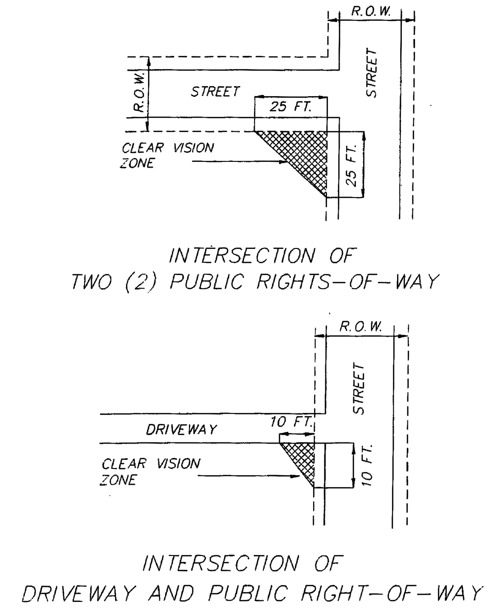
When a driveway intersects a public right-of-way or when the subject property abuts the intersection of public rights-of-way, the corner triangular areas described in subsection (d)(2) of this section shall permit unobstructed cross visibility.
(2)
The triangular areas referred to in subsection (d)(1) of this section are as follows:
a.
The area formed at the corner intersection of a public right-of-way and a driveway, two sides of the triangle area being ten feet in length measured along the right-of-way line and driveway line and the third side being a line connecting these two sides.
b.
The area formed at a corner intersection of two public right-of-way lines, the two sides of the triangular area being 25 feet in length measured along the abutting public rights-of-way lines and the third side being a line connecting these two sides.
(e)
On double frontage lots, a front yard as prescribed for the district as herein established shall be provided on both streets.
(f)
Every structure hereafter erected or relocated shall be on a lot adjacent to a public street or with access to an approved private street and all structures shall be so located on lots as to provide safe and convenient access for servicing, fire protection and required off-street parking.
(g)
In residential zoning districts one principal structure is permitted per lot except in the case of conventional condominiums, planned unit developments and multiple-family dwellings.
(h)
In any R-1 or R-2 district, a permitted dwelling and permitted accessory structure may be constructed or altered on any single lot of record at the effective date of adoption of the ordinance from which this chapter is derived, provided they meet the limitations imposed by other provisions of this chapter, including minimum setback requirements.
(i)
Any uses or buildings permitted in this chapter as accessory buildings or uses shall be clearly incidental to and on the same zoning lot as the principal use to which they are accessory. No accessory building shall be higher than the principal building. Accessory uses or buildings may be located no closer than five feet from either a side lot line or a rear lot line, no closer than ten feet from a principal or another accessory building, and unless otherwise specified in this chapter an accessory use or building shall not be located within a required front yard. The combined area of all permitted principal and accessory buildings or structures shall occupy no more than that proportion of the yard as specified in the schedule of regulations.
(j)
The combined maximum square footage of all accessory structures on a residential lot in the R-1 and R-2 zoning districts shall be 1,000 square feet. However, if the lot exceeds 12,000 square feet the combined maximum square footage may be increased by 4% of the lot area that the property exceeds 12,000 square feet. (For example; if a lot in the R-2 District is 30,000 square feet in area. 30,000 - 12,000 = 18,000. 18,000 * .04 = 720. The combined maximum square footage may be a maximum of 1,720 sq. ft.). In no case shall the combined maximum square footage of accessory structures in the R-1 or R-2 district exceed 2,500 square feet. The maximum number of accessory buildings shall be limited to 3 in the R-1 district and 2 in the R-2 district. In any case the lot must still comply with the maximum lot coverage requirements in the R-1 and R-2 districts in section 36-186 schedule of regulations.
(k)
For all commercial, industrial and multifamily developments, any lighting on the premises for parking areas, yard lighting, sign lighting or other similar types of exterior lighting shall be a steady light with the source which does not impair visibility or cause distraction for pedestrians or drivers off the premises.
(l)
When a property owner proposes to use two or more adjacent lots or portions of adjacent lots as a zoning lot as defined in this article for the purpose of development or use of the lot, the village may require that the zoning lot be combined as one tax parcel.
(m)
Building height being the vertical distance from the grade at the center of the front of the building to tire highest point of the roof surface between eaves and ridge for gable, hip, and gambrel roofs maximum of 23 feet.
(n)
If there is more than a two-foot overhang on any one side of the accessory building, it will be required that overhang will be included as part of the square feet of the accessory building.
(Ord. No. 66, § 2, 9-14-2015; Ord. No. 68, § 2, 12-11-2017; Ord. of 5-2-2022(1), §§ c., d., 5-2-2022)
Sec. 36-213. - Single-family dwelling regulations.
A one-family dwelling and any additions or alterations thereto, erected or placed in the village, other than mobile home park, shall conform to the following regulations in addition to all other regulations of this chapter:
(1)
It shall comply with all pertinent building, construction and fire codes for single-family dwellings.
(2)
The plan outline of the dwelling, including only heated living area, shall be large enough to contain within it a square of 20 feet on a side. This size requirement shall not make any houses existing at the date of amendment nonconforming so that they cannot be enlarged or improved.
(3)
It shall be firmly attached to a permanent foundation constructed on the site in accordance with the state construction code and shall have a wall of the same permitted dimensions of the dwelling and constructed of such materials and type as required in the state construction code for single-family dwellings. In the event that the dwelling is a mobile home, as defined herein, such dwelling shall be installed pursuant to the manufacturer's setup instructions and shall be secured to the premises by an anchoring system or device complying with the rules and regulations of the Michigan Mobile Home Commission and shall have a perimeter wall as required above.
(4)
In the event that a dwelling is a mobile home as defined herein, each mobile home shall be installed with the wheels removed. Additionally, no dwelling shall have any exposed towing mechanism, undercarriage, or chassis.
(5)
It shall be connected to a public sewer and water supply, if available or if connection is required by the village sewer or water ordinances, otherwise they may be connected to private facilities approved by the county health department.
(6)
It shall comply with all pertinent zoning, subdivision, and other ordinances regulating use, floor area, lot size, setback, yards, etc. in the zoning district in which it is located.
(7)
It shall comply with all pertinent building and fire codes. In the case of a mobile home, all construction and all plumbing, electrical apparatus and insulation within and connected to said mobile home shall be of a type and quality conforming to the mobile home construction and safety standards as promulgated by the United States Department of Housing, as amended. Additionally, all dwellings shall meet or exceed all applicable roof snow load and strength requirements.
(8)
It shall be aesthetically compatible in design and appearance to homes in the neighborhood in which it is located. In the first instance, it shall be the responsibility of the zoning administrator to determine whether this standard is met. The village zoning administrator may, at his discretion, refer the matter to the zoning board of appeals for the determination. Any party aggrieved by an adverse decision by the village zoning administrator may appeal to the zoning board of appeals, which board shall make the determination, with findings, based upon its independent judgment, without reference to the standards for the granting of variances. The determination of compatibility shall be based upon the character, design and appearance of residential dwellings located outside of mobile home parks within 300 feet of the subject dwelling where such area is developed with dwellings to the extent of not less than 20 percent of the lots situated within said area; or where said area is not so developed, by the character, design, and appearance of the residential dwellings generally found throughout the village. The determination of compatibility shall also be based upon compliance with the following standards:
a.
The dwelling shall have a combination of roof overhang and pitch comparable to the overhang and pitch of homes typically found in the neighborhood in which it is to be located.
b.
If the dwelling has a chimney, the chimney shall be constructed of a material and style similar to those of other dwellings typically found in the neighborhood in which it is to be located.
c.
The dwelling shall have steps and/or porches which provide access to exterior doors, which are permanently attached to the ground and to the structure, and which are comparable to steps and/or porches of homes typically found in the neighborhood in which it is located.
d.
The dwelling and roof shall be covered with a material which is in composition, color, texture, malleability, direction of joints, and method of fastening to the structure comparable to those typically found in the neighborhood in which it is to be located.
e.
The dwelling shall have windows located on the front sides, and exterior doors either on the front and rear or front and side as generally found in homes in the neighborhood in which it is to be located.
f.
The dwelling shall not have a detached garage, if attached garages are typically found in homes in the neighborhood in which it is to be located.
g.
The orientation of the dwelling's front entrance shall be similar to the orientation of homes in the neighborhood in which it is located.
h.
A dwelling may be approved as aesthetically compatible in design and appearance to homes in the neighborhood in which it is to be located, even if all of the above conditions do not exist, provided it is determined that the dwelling and/or its site has other design features which make it aesthetically compatible to homes in the district. The foregoing shall not be construed to prohibit innovative design concepts involving such matters as energy conscious devices such as solar energy, view, unique land contour or relief from the common or standard designed home.
(Ord. No. 66, § 2, 9-14-2015)
Sec. 36-214. - Fees.
The village council shall establish fees related to the administration of this chapter to offset associated costs. Such fees shall include but not be limited to variance application fee, zoning permit fee, zoning ordinance amendment fee and site plan review fee.
(Ord. No. 66, § 2, 9-14-2015)
Sec. 36-215. - General exceptions.
(a)
Voting place. The provisions of this chapter shall not be so construed as to interfere with the temporary use of any property as a voting place in connection with a municipal or other public elections.
(b)
Height limit. The height limitations of this chapter shall not apply to farm buildings, chimneys, church spires, flagpoles, public monuments or wireless transmission towers.
(c)
Architectural features. Normal architectural features such as chimneys, flues, belt courses, leaders, sills, pilasters, cornices, eaves gutters, aprons and similar features may project into a required front yard.
(d)
The owner of a parcel in the C-1 district may build to the side lot line where the adjacent residentially zoned parcel was zoned C-1 prior to June 1, 2012.
(Ord. No. 66, § 2, 9-14-2015)
Sec. 36-216. - Grading and drainage.
(a)
All structures shall be constructed or located with a ground elevation such as to provide a sloping grade to cause the surface drainage to flow away from the walls of such structures.
(b)
Grades on any lot upon which new construction or earth movement is to be carried out shall be related to existing grades and drainage systems such as to provide adequate drainage and not jeopardize such existing drainage systems, shall not increase drainage on to adjacent parcels and shall be approved by the village engineer.
(Ord. No. 66, § 2, 9-14-2015)
Sec. 36-217. - Performance standards.
No use otherwise allowed shall be permitted within any use district which does not conform to the following standards of use, occupancy and operation, which standards are hereby established as the minimum requirements to be maintained within said area:
(a)
Smoke—It shall be unlawful for any person, firm or corporation to permit the emission of any smoke from any source whatever to a density greater than that density described as No. 1 of the Ringlemann Chart; provided that the following exceptions shall be permitted; smoke, the shade or appearance of which is equal to, but not darker than No. 2 of the Ringlemann Chart for a period, or periods, aggregating four minutes in any 30 minutes.
Method of measurement: For the purpose of grading the density of smoke, the Ringlemann Chart, as now published and used by the United States Bureau of Mines, which is hereby made a part of this chapter, shall be the standard. However, the Umbrascope readings of smoke density may be used when correlated with Ringlemann's Chart Grades.
Dust, Dirt and Ash—No person, firm or corporation shall operate or cause to be operated, maintain or cause to be maintained, any process for any purpose, or furnace or combustion device for the burning of coal or other natural or synthetic fuels, without maintaining and operating, while using said process or furnace or combustion device or contrivance to reduce the quantity of gas-borne or air-borne solids or fumes emitted into the open air, which is operated in conjunction with said process, furnace or combustion device so that the quantity of gas-borne or air-borne solids shall not exceed 0.20 grains per cubic foot of the carrying medium at a temperature of 500 degrees Fahrenheit, as measured by the A.S.M.E. Test Code for dust-separating apparatus.
(b)
Storage—In all commercial and manufacturing districts, the open storage, not including display, of any equipment, vehicles and all materials, including wastes, shall be screened from public view, from a street and from adjoining properties by an enclosure consisting of a wall equal in height to the equipment, vehicles and all materials to be stored. In no instance shall said wall be less in height than 4'-6" measured from the surface of the adjacent building flooring. In all residential districts, the storage of dismantled vehicles shall be within completely enclosed accessory structures.
(c)
Glare and Radioactive Materials—Glare from any process (such as or similar to arc welding or acetylene torch cutting) which emits harmful rays shall be performed in such a manner as not to extend beyond the property line, and as not to create a public nuisance or hazard along lot lines. Radioactive materials and wastes, and including electromagnetic radiation such as X-ray machine operation, shall not be emitted to exceed quantities established as safe by the U.S. Bureau of Standards, when measured at the property line.
(d)
Noise—At no point on the boundary of any nonindustrial district shall the sound pressure level of any operation exceed the described levels in the designated octave bands below:
(e)
Vibrations—No vibration which is discernable to the human sense of feeling shall be perceptible without instruments at any point beyond the lot line.
(f)
Odor—The emission of noxious, odorous matter in such quantities as to be readily detectable at a point along any property line, when diluted in the ratio of one volume of odorous air to four or more volumes of clean air, so as to produce a public nuisance or hazard beyond lot lines is prohibited.
(Ord. No. 66, § 2, 9-14-2015)
Sec. 36-218. - Lot depth/lot width ratio.
For all lots created after the effective date of this chapter, the lot depth to lot width ratio shall not exceed 4:1. That is, the length of the lot shall not exceed four times the width of the lot.
(Ord. No. 66, § 2, 9-14-2015)
Sec. 36-219. - Prohibited dwellings.
Only principal buildings and accessory dwellings which have been issued a conditional use permit for a temporary dwelling shall be used as dwelling units. Garages, recreational vehicles, tents, trailers, sheds, and other similar structures shall not be used as dwelling units.
(Ord. No. 66, § 2, 9-14-2015)
Sec. 36-220. - Satellite dishes.
Satellite dishes shall be considered accessory structures for the purposes of the administration of this chapter.
(Ord. No. 66, § 2, 9-14-2015)
Sec. 36-221. - Permissive zoning.
Land uses are specifically permitted in the various zoning districts of this chapter. Where not specifically permitted, uses are thereby specifically prohibited. No land contained within any zoning district shall be used for any purpose other than those uses specifically permitted in the district in which the building or land is located, except as otherwise provided herein.
(Ord. No. 66, § 2, 9-14-2015)
Sec. 36-222. - Walls and fences.
(a)
Wall or fences shall require review and approval of the zoning administrator through the issuance of a zoning permit. Wall or fences required as screening under the provisions of article VIII of this chapter shall comply with the requirements of section 36-319(b).
(b)
Walls or fences may be located on the lot line except where underground utilities interfere and or where this chapter requires conformance with yard setback lines.
(c)
Fences on all lots of record in all residential districts which enclose property and/or are within a required side or rear yard, shall not exceed six feet in height, measured from the surface of the ground, and may extend toward the front of the lot in the required minimum front yard, at a height not exceeding three feet in height. Fences must be located within property lines.
(d)
Split rail fences are permitted in the front yard up to the front property line provided it does not significantly obstruct the vision of motorist, pedestrians or other users of the sidewalks or streets.
(e)
Fences and other decorative landscaping not more than three feet in height may be permitted in the front setback provided it does not significantly obstruct the vision of motorists, pedestrians or other users of the sidewalks or streets.
(f)
All fencing shall be constructed with materials that are esthetically pleasing, consistent with the neighborhood using current day residential grade or better building materials. The finished side to face neighboring property. Chain link fence shall be constructed with the post on the inside.
(g)
Walls or fences must be maintained in good condition by the property owner.
(Ord. No. 66, § 2, 9-14-2015)
Sec. 36-223. - Side and front yard setback exceptions.
(a)
When a legal nonconforming lot does not meet the minimum requirements for lot width in this ordinance, the side yard setback requirements for that lot shall be reduced by a percentage equal the percentage the lot meets the minimum lot width requirement. For example a lot 80 feet wide in a district requiring a minimum width of 100 and a side yard setback of 10 feet would have a side yard setback of eight feet. In no instance shall a side yard setback be reduced to less than five feet under the terms of this exception.
(b)
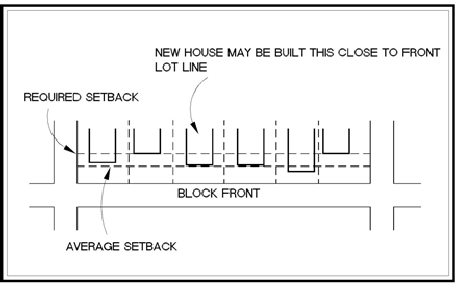
The front yard setback of a lot on a block where 80 percent of the lots are built on may be reduced to the average setback of the existing buildings (See Figure 4-2).
Figure 4-5