
Ridgway City Zoning Code
SECTION 5
Subdivision Regulations
Subsections:
(Renumbered and Restated by Ordinance 03-2023)
Prior history: Ord. 6-2009; Ord. 07-2021; Ord. 02-2022.
7-5-1 - GENERAL PROVISIONS.
(A)
Purpose.
(1)
These Regulations shall be known and may be cited as the Town's "Subdivision Regulations".
(2)
These Regulations shall apply within the corporate limits of the Town.
(3)
The purposes of these Regulations are to:
(a)
Promote and protect the public health, safety, and welfare.
(b)
To ensure that new development bears its fair share of the cost of providing improvements and services resulting from the development of subdivisions.
(c)
To set forth uniform procedures and standards for the handling of subdivisions.
(d)
To ensure adequate and safe public services such as water, sewer, fire protection, streets and storm drainage.
(e)
To ensure compatibility and implement the Town's Master Plan and Land Use Regulations.
(f)
To encourage development which limits hazards due to erosion, flood, soil conditions, and excessive slopes.
(g)
To obtain land for parks, schools, affordable housing, and other public purposes.
(h)
To protect the quality of the water, air and environment.
(i)
To encourage energy conservation, use of solar energy, clustered development, and infilling.
(j)
To encourage development which will not adversely affect adjacent property, or historical or recreational values.
(k)
To discourage development inconsistent with existing services and infrastructures.
(l)
To provide for safe and efficient flow of pedestrians, bicycles, and vehicles.
(4)
These Regulations shall not create any liability on the part of the Town or any officer or employee thereof arising from reliance upon these regulations or any administrative act or failure to act pursuant to these regulations.
(B)
Interpretation.
(1)
In interpreting and applying provisions of these Subdivision Regulations they shall be regarded as a minimum required for the protection of public health, safety, and welfare. They shall be liberally construed to further the purposes specified in Subsection 7-5-1(A) above.
(2)
Whenever a provision of these Regulations and any other provision found in another Town ordinance or applicable law contains any restrictions or regulations covering the same subject matter, the restriction or regulation which is more restrictive or imposes a higher standard or requirement shall govern.
7-5-2 - SUBDIVISION APPLICATIONS AND REVIEW PROCEDURES.
This Section outlines the review procedures that are common to all applications regulated within Section 5, Subdivision Regulations, unless otherwise stated in these Land Development Regulations. Table T-5.1 identifies the various application types and associated review procedures regulated by this article. The submittal requirements, review procedures, and approval criteria for each application type are laid out in subsequent sections of this article as identified in Table T-5.1. All documents and materials identified in this Section, and the particular application type section shall be required.
(A)
Table T-5.1 - Subdivision Application Types and Processes
Table T-5.1, Subdivision Application Types and Processes
(B)
General Application Review Procedures. The following procedures shall apply to all classifications of development applications which are required under this Chapter:
(1)
Pre-Application Meeting. If the applicant or Town Manager or designee, requests a pre-application meeting, or it is required as stated in the table above, the following process shall be followed:
(a)
Prior to the formal submission of the application, the applicant shall contact the Town Manager or designee to schedule and request an informal pre-application meeting. Following receipt of a request, the pre-application meeting should be set for a date within thirty (30) days of the date of the applicant's request. The Town Manager or designee shall advise the applicant of the date and time of the pre-application meeting.
(b)
The applicant shall be prepared to discuss the proposed application with the Town Manager or designee. The applicant is encouraged to present such plats, plans, diagrams, or other preliminary information sufficient to permit the conceptual review of the proposed application.
(c)
The purpose of the pre-application meeting is to assist the applicant in understanding the town's application review processes and to permit the Town Manager or designee to determine the applicable process(es) and regulations for the proposed application.
(2)
Application Submittal Requirements. All of the following information and materials shall be submitted to the Town of Ridgway in a form acceptable to the Town Manager or designee. Additional information and materials required to be submitted for specific application types identified in Table T-5.1 are specified in subsequent sections of this Section and shall also be submitted in order to receive a determination of completeness.
(a)
Basic Application Materials. The following materials are required for all applications regulated by Chapter 7, Section 5, Subdivision Regulations, unless waived by the Town Manager or designee.
(i)
Application Form. An application form for the request shall be obtained from the Town of Ridgway. Completed application forms and accompanying materials shall be submitted to the Town by the owner or applicant.
a.
Authorized Agent. If the applicant is not the owner of the land based on Ouray County Assessor records, the applicant shall submit a letter signed by the owner consenting to the submission of the application.
b.
Applicant is Not the Sole Owner. If the applicant is not the sole owner of the land, the applicant shall submit a letter signed by all owners or an association representing all the owners, by which all owners consent to or join in the application.
(ii)
Fees. All application fees shall be in compliance with Section 7-1-7, Fees and Costs.
(iii)
Proof of Ownership. Proof of Ownership in the form of a copy of the property deed or a title commitment which has been issued within sixty (60) days of the application submittal along with copies of all documents listed in the exceptions.
(iv)
Legal Description. Legal description of the property subject to the development application.
(v)
Mineral Interest Owners. List of all mineral interest owners with interests severed from the subject property.
(vi)
Vicinity Map. A map locating the project limits, parcel(s), and property within Ridgway. The vicinity map shall clearly show the boundaries of the subject property and all property within a three-mile radius of the subject property.
(vii)
General Written Narrative. A general written narrative identifying the development team, existing conditions of the property, proposed uses, density, lot layout, end users, financing, public dedications (including rights-of-way, parks, open space, infrastructure), and describing the purpose of the project, how the request meets the applicable approval criteria, furthers the goals and objectives specified in the Master Plan, and identifying any potential impacts on adjacent properties and public infrastructure and how those impacts are proposed to be mitigated.
(3)
Completeness Review. When a completeness determination is required pursuant to Table T-5.1, Subdivision Application Types and Processes, the following shall apply:
(a)
Within fourteen (14) days following receipt of an application, the Town Manager or designee shall administratively review the application and determine whether it includes all the application content requirements of the Ridgway Municipal Code for the requested application type.
(b)
All plans, reports, maps and other information required for the application must be complete and legible. A failure of the application to meet the requirements of the zoning regulations and this Ridgway Municipal Code may delay the processing of the application until the application is sufficient and complete.
(c)
When the Town Manager or designee determines that the application is complete as submitted, the Town Manager or designee shall schedule the application for review in accordance with the provisions set forth in this Section.
(d)
In the event the Town Manager or designee determines that the application is incomplete, the Town Manager or designee shall inform the applicant in writing of the deficiencies in the application. No further processing of the incomplete application shall be undertaken until the Town Manager or designee determines that the applicant has remedied the application's deficiencies.
(4)
Referral Agencies. In accordance with Table T-5.1, Subdivision Application Types and Processes, applications shall be referred to any of the below referral agencies the Town Manager or designee determines is necessary to the complete and comprehensive review of the request. Referral of applications to other agencies shall be for a time frame of twenty-one (21) days. However, the time frame for review and comment may be extended if the application presents technical issues which require additional review, additional information is provided by the applicant, or the application is modified. Referral agencies include, but are not limited to, the following:
(a)
Bureau of Land Management (BLM)
(b)
Colorado Department of Transportation (CDOT)
(c)
Colorado Division of Reclamation, Mining & Safety
(d)
Colorado Division of Water Resources
(e)
Colorado Parks and Wildlife
(f)
Colorado State Forest Service
(g)
Ditch companies
(h)
Fire Protection District(s) or department(s)
(i)
Ouray County Departments (Assessor, Clerk & Recorder, Attorney, Health Department, Building Department, Road & Bridge, Sheriff Office, etc.), as appropriate
(j)
Town of Ridgway Departments (Town Clerk, Town Attorney, Engineering Department, Building Department, Public Works Department, Police Department, etc.), as appropriate
(k)
Water Conservation District(s)
(l)
San Miguel Power Authority
(m)
School district(s)
(n)
Soil Conservation District
(o)
Utility service providers and districts
(p)
US Army Corp of Engineers
(q)
US Environmental Protection Agency (EPA)
(r)
US Forest Service
(s)
Any other entity or agency deemed necessary by the Town Manager or designee
(5)
Staff Report. The Town Manager or designee shall review the application to determine if the proposal satisfies the applicable standards. Once all review comments have been adequately addressed by the applicant, the Town Manager or designee shall prepare a staff report discussing whether the applicable standards of the Ridgway Municipal Code have been satisfied. The staff report should identify issues raised through staff and referral agency review, potential mitigation requirements, any recommended conditions for approval, and any additional information pertinent to the review of the application.
(6)
Notice Requirements. All public notices of hearings required by these Subdivision Regulations shall include the date, time, place, and purpose of the hearing, a general description of the property affected, and any other information deemed appropriate to apprise the public of the general nature of the action proposed. Errors or inaccuracies in the notice shall not be deemed sufficient cause to postpone or invalidate a hearing except where such errors are substantive in material and are found to have reasonably misled or misinformed the public.
(a)
Notice by Posting. When notice by posting is required for a public hearing by Table T-5.1, Subdivision Application Types and Processes, notice of the hearing shall be posted at Town Hall ten (10) days before the hearing and posted on the subject property in a location that is visible from each street frontage abutting the property, for at least ten (10) days prior to the hearing in addition to any other notice required by Town regulations.
(i)
Mineral Estates Notice. Per 24-65.5-103, C.R.S. if the surface estate and mineral estate are severed, the owners of severed mineral estates shall be entitled to notification of not less than thirty (30) days before the date scheduled for the public hearing for the application. A copy of the notice shall be given to the Town along with the applicant's certification of compliance with said notification requirements. Provided this notice is not required if notice was previously sent and such certification previously provided with respect to the same surface development, or the application is only platting an additional single lot, unless a mineral estate owner has requested notice pursuant to 24-6-402(7), C.R.S.
(7)
Public Hearings. When an application requires a public hearing before the Planning Commission or the Town Council, in accordance with Table T-5.1, Subdivision Application Types and Processes, the following shall apply:
(a)
The Town shall set the date and time of a public hearing. Notice of the public hearing shall be issued in accordance with Table T-5.1, Subdivision Application Types and Processes and Section 7-5-2(B)(6), Notice Requirements.
(b)
At the public hearing, the reviewing body shall review the application for conformance with the applicable review standards and approval criteria for the request.
(c)
Any public hearing or other action of the body may be continued or postponed at any time to a specified date and time in order to permit preparation of additional information for further review by the reviewing body.
(d)
When required, the Planning Commission recommendation shall be forwarded to the Town Council. Following a public hearing, the Town Council shall approve, approve with conditions, or deny the application or continue the matter to a date certain.
(e)
The applicant shall bear the burden of presenting sufficient competent evidence at the public hearing to support the standards for approval set forth by this Ridgway Municipal Code and other governing documents. Any decision by the reviewing body to recommend, or to act to, approve, conditionally approve, or deny an application shall be based upon a consideration of all evidence presented during the public hearing. Where evidence presented is contradictory, the reviewing body shall weigh such evidence and judge the credibility and sufficiency of the evidence prior to rendering a decision.
(8)
Post Approval.
(a)
Review. Prior to recording of the approved documents, the applicant shall submit all final documents reflecting any conditions of approval to the Town Manager or designee for final review and acknowledgement.
(b)
Recording. Ordinances, resolutions, plats, and other documents as stated throughout this section, shall be required to be recorded with the Ouray County Clerk and Recorder shall be fully executed by the applicant and filed for execution by the town and recorded. Recording of all documents shall be completed within ninety (90) days from the date of approval by the approving body.
(c)
Approval of Subdivision Improvement Agreement. A final plat shall not be filed for recording until the Board has approved an Improvement Agreement pursuant to this article.
(d)
Effective Upon Recording. A plat does not become effective until it is properly filed for recording with the Ouray County Clerk and Recorder.
(e)
Public Sale of Lots. A division of land becomes complete and eligible for public sale of lots and development only after the final plat and associated approved documents have been properly recorded with the Ouray County Clerk and Recorder.
(C)
Major Subdivision.
(1)
General Provisions. Division of land applications which are defined as a major subdivision in Chapter 7-9, Definitions, shall be reviewed in compliance with the provisions of this Section 7-5-2(C)(2), Review Procedures. Major subdivisions require three separate stages of approval:
(a)
Sketch Plan Review. The process for sketch plan review is set forth in Section 7-5-2(C)(2)(a), Sketch Plan Review.
(b)
Preliminary Plat. The process for preliminary plat review is set forth in Section 7-5-2(C)(2)(b), Preliminary Plat Review.
(c)
Final Plat. The process for final plat review is set forth in Section 7-5-2(C)(2)(c), Final Plat Review.
(2)
Review Procedures.
(a)
Sketch plan Review. The sketch plan review process is intended to review at a conceptual level the feasibility and design characteristics of the proposed subdivision based on the applicable standards set forth in this Section 5, Subdivision Regulations, and Section 4, Zoning Regulations. The sketch plan review process is set forth in Section 7-5-2(C)(2)(a), Sketch Plan Review, and requires the following:
(i)
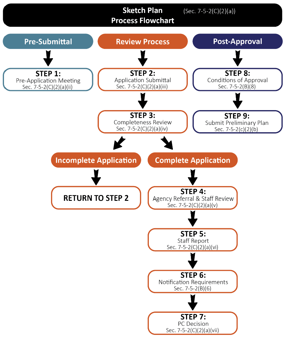
Review Flowchart. Figure F-5.1, Sketch Plan Flowchart, depicts the sketch plan application review process described in greater detail in this section.
Figure F-5.1 Sketch Plan Flowchart
(ii)
Pre-Application Meeting. A pre-application meeting may be held in accordance with the provisions set forth in Section 7-5-2(B)(1), Pre-Application Meeting.
(iii)
Application Submittal Requirements. The following are the application materials required to be submitted for a sketch plan request. The Town Manager or designee may waive or alter any of the submittal requirements if they are determined to be inappropriate or unnecessary to determining if the application satisfies applicable standards.
a.
Basic Application Materials. All materials set forth in Section 7-5-2(B)(2), Basic Application Materials.
b.
Sketch Plan. The applicant shall submit a copy of the sketch plan map at a size and scale legible and suitable for non-technical review of the proposal. The sketch plan map shall include the following information and supplemental materials. The Town Manager or designee may require, or the applicant may wish to submit, a more detailed version of all or part of the sketch plan map.
i.
A title clearly identifying the plat as a "Sketch Plan";
ii.
Standard certificate blocks as provided by the town;
iii.
Legal description of the property;
iv.
North arrow, scale, and legend;
v.
A vicinity map at a suitable scale;
vi.
Boundary lines, corner pins, and dimensions of the subject property, including land survey data to identify the parcel with section corners, distance and bearing to corners, quarter corners, township and range;
vii.
Existing and proposed topographic contours at vertical intervals sufficient to show the topography affecting the development and storm drainage;
viii.
Significant on-site features including: natural and artificial drainage ways, streams, ponds, waterways, wetland areas, irrigation ditches, hydrologic features and aquatic habitat; geologic features and hazards including slopes, alluvial fans, areas of subsidence, rock outcrops and rockfall areas, radiological and seismic hazard areas, soil types and landslide areas; vegetative cover; dams, reservoirs, excavations, and mines; and any other on-site and off-site features that influence the development;
ix.
Existing and proposed parking areas, driveways, emergency turn-outs and emergency turnarounds, sidewalks, and paths and their dimensions;
x.
Existing and proposed roads, railroad tracks, irrigation ditches, fences and utility lines on or adjacent to the parcel and their dimensions;
xi.
Uses and grantees of all existing and proposed easements and rights-of way on or adjacent to the property and their dimensions; and
xii.
Schematic and narrative representation of the proposed land use(s) including:
1.
Existing and proposed zoning of land to be subdivided;
2.
Total proposed subdivision area in acres and a percentage breakdown of areas devoted to specific land uses, with acreage and square footage, (e.g., percentage and area of residential development and/or nonresidential development; percentage and area of open space; percentage and area of parking and driveways, and so forth);
3.
Approximate lot sizes;
4.
Total number, size, general location, and type of proposed dwelling units;
5.
Location, size, and use of major improvements;
6.
Total number of square feet of proposed nonresidential floor space;
7.
Off-street parking areas and anticipated number of spaces;
8.
Recreation areas and open space;
9.
School sites;
10.
Approximate location of wastewater treatment system, including location and size of leach field, service lines, and treatment facilities to serve the proposed use;
11.
Source and capacity of the water supply, including approximate location and size of well(s) and/or water lines to serve the proposed use; and
12.
Location and size of existing and proposed utilities and service facilities.
xiii.
Current and proposed grading and drainage patterns including:
1.
Drainage arrows depicting surface flow;
2.
Drainage facilities and improvements; and
3.
A grading plan depicting existing and proposed site contours at two-foot intervals.
c.
Land Suitability Analysis. The land suitability analysis is a written analysis of conditions on-site and off-site which have an influence on the proposed use of the land. The land suitability analysis shall include the following information:
i.
A description of site features such as streams, areas subject to flooding, lakes, high ground water areas, vegetative cover, and other significant natural and man-made features;
ii.
A description of the existing drainages and impoundments, natural and manmade;
iii.
A description of soil characteristics of the site;
iv.
A description of the geologic characteristics of the area including any potential natural or man-made hazards;
v.
A description of the topography and the slope determination;
vi.
A description of the source of water supply, the existing and future domestic and agricultural requirements, and the capacity of the source of water supply to meet existing and future requirements. The description shall include detail of historic irrigation, tailwater issues, and water demands;
vii.
A description of the relationship of the subject parcel to floodplains, the nature of soils and subsoils and their ability to adequately support waste disposal, the slope of the land, the effect of sewage effluents, and the pollution of surface runoff, stream flow and groundwater;
viii.
A description of the Floodplain and Flood Fringe designations affecting the subject property;
ix.
A description of the existing environmental conditions:
1.
Existing flora and fauna habitat, wetlands, migration routes;
2.
Significant archaeological, cultural, paleontological, and historic resource areas; and
3.
Potential radiation hazard that may have been identified by the state or the Ouray County Public Health Department.
x.
A description of the existing and historic use of adjacent property and neighboring properties within a 300' radius;
xi.
A description of all easements defining, limiting or allowing use types and access;
xii.
Access:
1.
A description of historic public access to or through the site; and
2.
A description of access to adjoining roads and sight distance and intersection constraints.
d.
Conceptual Landscape Plan. The landscape plan shall comply with all requirements in Section 7-4-8, Landscape Regulations.
e.
Supplemental Materials. The following items are required to be submitted to the Town of Ridgway:
i.
Conceptual drainage plan or study calculating historic and proposed surface and stormwater flows and how such flows will be managed.
ii.
Conceptual traffic statement or study identifying current and proposed traffic counts and proposed trip generation along with any needed or anticipated improvements to mitigate the projects use on the public transportation network and infrastructure.
iii.
Proof of minimum guaranteed water supply appropriate for the requested use.
f.
Additional Requirements
i.
Any additional information that may be reasonably requested by the Town Manager or designee and determined to be necessary to enable an adequate and comprehensive evaluation of the application.
(iv)
Completeness Review. The Town Manager or designee shall review the application for completeness in accordance with the provisions of Section 7-5-2(B)(3), Completeness Review.
(v)
Evaluation by Staff and Review Agencies. Upon determination of completeness, the Town Manager or designee shall refer the application to additional reviewing agencies as set forth in Section 7-5-2(B)(4), Referral Agencies, and review the application for conformance with the requirements and standards of this Municipal Code.
(vi)
Staff Report. A staff report shall be prepared and provided to the reviewing body in accordance with Section 7-5-2(B)(5), Staff Report.
(vii)
Review and Action by the Planning Commission.
a.
The Planning Commission shall review the sketch plan application in a manner consistent with Table T-5.1, Subdivision Application Types and Processes to evaluate compliance with applicable standards. The final decision to approve, approve with conditions, or deny a sketch plan shall be made by the Planning Commission in a manner consistent with Table T-5.1, Subdivision Application Types and Processes and be based upon the criteria set forth in Section 7-5-2(C)(3), Approval Criteria.
b.
The Planning Commission may, in its sole discretion, continue or postpone the public hearing to a specified date and time in order to permit preparation of additional information for further review by the Planning Commission prior to making a final decision.
(b)
Preliminary Plat Review. The preliminary plat review process will consider the feasibility and design characteristics of the proposed subdivision based on the applicable standards set forth in Section 7-5-4, Design Standards. The preliminary plat process will also evaluate preliminary engineering documents.
(i)
Review Flowchart. Figure F-5.2, Preliminary Plat Flowchart, depicts the preliminary plat application review process described in greater detail in this section.
Figure F-5.2 Preliminary Plat Flowchart
(ii)
Pre-Application Meeting. A pre-application meeting may be held in accordance with the provisions set forth in Section 7-5-2(B)(1), Pre-Application Meeting.
(iii)
Application Submittal Requirements. The following are the application materials required to be submitted for a preliminary plat request. The Town Manager or designee may waive or alter any of the submittal requirements if they are determined to be inappropriate or unnecessary to determining if the application satisfies applicable standards.
a.
Basic Application Materials. All materials set forth in Section 7-5-1(B)(2), Basic Application Materials.
b.
Preliminary Subdivision Plat. The preliminary subdivision plat shall contain the following information submitted to the Town of Ridgway on 24" x 36" sheets at a scale suitable for technical review of the application.
i.
A title clearly identifying the plat as a "Preliminary Subdivision Plat";
ii.
Standard certificate blocks as provided by the town;
iii.
Legal description of the property;
iv.
North arrow, scale, and legend;
v.
A vicinity map at a suitable scale;
vi.
The name and address of the owner(s) of record of the land being platted and the same information for the applicant(s), if other than the owners;
vii.
The name, address, and seal of the certifying registered land surveyor and the other individuals preparing the preliminary plat;
viii.
The township, range, section and quarter section(s);
ix.
Location and full description of all monuments as required by this article and by Title 38, Article 51, C.R.S.:
1.
Permanent monuments shall be set on the external boundary of the subdivision pursuant to §38-51-101, C.R.S.; and
2.
Block and lot monuments shall be set pursuant to §38-51-101, C.R.S.
x.
Information adequate to locate all monuments shall be noted on the plat;
xi.
The location, layout, dimensions, areas, and uses of all lots and blocks numbered consecutively;
xii.
The location, layout, dimensions, areas and uses of all outlots and tracts labeled consecutively by letters and include a table identifying ownership and maintenance responsibilities;
xiii.
Site data in chart form presenting:
1.
Total area of the proposed subdivision; total area of the developed buildings, driveways and parking areas; total area of nonresidential floor space;
2.
Total number of proposed lots; breakdown of the lot total by number of lots per use (i.e., residential use, business or commercial and industrial use, and other public and nonpublic uses);
3.
Total number of proposed off-street parking spaces;
4.
Total number of dwelling units; total number of dwelling units per structure proposed; and
5.
Total gross density proposed.
xiv.
Boundary lines, corner pins, and dimensions of the subject property, including land survey data to identify the parcel with section corners, distance and bearing to corners, quarter corners, township and range;
xv.
Topography at the following minimum contour intervals:
1.
Subdivision with one or more lots less than two (2) acres in size, topography shown at two (2) foot contour intervals.
2.
Subdivision with all lots two (2) acres or greater in size, topography shown at five (5) foot contour intervals.
3.
Areas having slopes thirty (30) percent or more, or other significant topographic conditions, topography shown at five (5) foot contour intervals.
xvi.
Significant on-site features including: natural and artificial drainage ways, streams, ponds, waterways, wetland areas, irrigation ditches, hydrologic features and aquatic habitat; geologic features and hazards including slopes, alluvial fans, areas of subsidence, rock outcrops and rockfall areas, radiological and seismic hazard areas, soil types and landslide areas; vegetative cover; dams, reservoirs, excavations, and mines; and any other on-site and off-site features that influence the development;
xvii.
Known, identified or designated one hundred (100) year flood plains and localized areas subject to periodic flooding. The distance between the mean identifiable high-water mark of any creeks, streams or rivers and the nearest proposed development within the site shall also be shown;
xviii.
Existing and proposed parking areas, driveways, emergency turn-outs and emergency turnarounds, sidewalks, and paths and their dimensions;
xix.
Public Access to the site, and internal circulation. Location, dimension, alignment and names of all existing and proposed streets, drives, alleys and roads on or adjoining the property. The general location and right-of-way width for all arterials and collectors shall be shown;
xx.
The location of any preliminary engineering for any existing or proposed wastewater systems, water mains, culverts, storm drains, sidewalks, gutters, fire hydrants along with the width and depth of pavement or subgrading to be provided, the depth of burial of all underground lines, pipes and tubing and typical cross sections of the proposed grading of roadways and sidewalks;
xxi.
Uses and grantees of all existing and proposed easements and rights-of-way on or adjacent to the property and their dimensions; and
xxii.
The location, use and gross square footage of proposed structures within the subdivision;
1.
Anticipated number of employees for proposed commercial or industrial uses.
xxiii.
Building envelopes in hazardous areas to protect trees and other natural resources, if deemed appropriate by planning staff;
xxiv.
Location and layout of lots and blocks, with lots and blocks numbered consecutively, and the dimensions and acreage of each lot;
xxv.
Areas for landscaping, and delineation of the type and extent of vegetative cover on the site;
xxvi.
Zoning districts on the site and any zoning changes to be requested;
xxvii.
Existing land uses and zoning on adjoining properties;
xxviii.
Public or private sources of utility services and facilities; and
xxix.
Location and dimension of land to be held in common, open space devoted to community use, and land to be dedicated to town.
c.
Preliminary Landscape Plan. The landscape plan shall comply with all requirements in Section 7-4-8, Landscape Regulations.
d.
Land Suitability Analysis. If updates, amendments, or modifications are needed pursuant on the review and approval of a sketch plan, an updated land suitability analysis may be required. The components which shall be included in such an analysis are set forth in Section 7-5-2(C)(2)(A)(iii)c, Land Suitability Analysis.
e.
Final Construction Documents as outlined in the Town of Ridgway Standard Specification and Typical Drawings for Infrastructure Construction.
f.
Supplemental Materials.
i.
Final drainage plan or study calculating historic and proposed surface and stormwater flows and how such flows will be managed.
ii.
Final traffic statement or study identifying current and proposed traffic counts and proposed trip generation along with any needed or anticipated improvements to mitigate the projects use on the public transportation network and infrastructure.
iii.
Draft covenants, restrictions, and by-laws, if applicable.
iv.
Proof of minimum guaranteed water supply appropriate for the requested use.
v.
Land located within the Uncompahgre River Overlay District. For all parcels located in the Uncompahgre River Overlay District, excluding subdivisions of existing structures that do not include any additional site development, an Ecological Characterization Study completed by a professional qualified in the areas of ecology, wildlife biology or other relevant discipline. The ecological characterization study shall describe, without limitation, the following:
1.
The boundary of wetlands and riparian areas and a description of the ecological functions and characteristics provided by those wetlands and riparian areas;
2.
The pattern, species and location of any significant native trees and other native site vegetation;
3.
The pattern, species and location of any significant non-native trees and non-native site vegetation that contribute to the site's ecological, shade, canopy, aesthetic and cooling value;
4.
The top of bank and High-Water Mark of any perennial stream or body of water on the site;
5.
The wildlife use of the area showing the species of wildlife using the area, the times or seasons that the area is used by those species and the "value" (meaning feeding, watering, cover, nesting, roosting, perching) that the area provides for such wildlife species;
6.
Special habitat features;
7.
Wildlife movement corridors;
8.
The general ecological functions provided by the site and its features;
9.
Any issues regarding the timing of development-related activities stemming from the ecological character of the area;
10.
Any measures needed to mitigate the projected adverse impacts of the development project on natural habitats and features along the Uncompahgre River corridor; and
11.
Twenty-five-foot and 75-foot development setback area from the High-Water Mark.
g.
Additional Requirements. Any additional information that may be reasonably requested by the Town Manager or designee and determined to be necessary to enable an adequate and comprehensive evaluation of the application.
(iv)
Completeness Review. The Town Manager or designee shall review the application for completeness in accordance with the provisions of Section 7-5-2(B)(3), Completeness Review.
(v)
Evaluation by Staff and Review Agencies. Upon determination of completeness, the Town Manager or designee shall refer the application to additional reviewing agencies as set forth in Section 7-5-2(B)(4), Referral Agencies, and review the application for conformance with the requirements and standards of this Municipal Code.
(vi)
Staff Report. A staff report shall be prepared and provided to the reviewing body in accordance with Section 7-5-2(B)(5), Staff Report.
(vii)
Review and Recommendation by Planning Commission.
a.
The Planning Commission shall review the preliminary plat application in a manner consistent with Table T-5.1 to evaluate compliance with applicable standards. Following its review of the application, the Planning Commission shall provide a recommendation to approve, approve with conditions, or deny the application to the Town Council based on the review criteria set forth in Section 7-5-2(C)(3), Approval Criteria.
b.
The Planning Commission may, in its sole discretion, continue or postpone the meeting to a specified date and time in order to permit preparation of additional information for further review by the Planning Commission prior to making a final decision.
(viii)
Review and Action by Town Council.
a.
The final decision to approve, approve with conditions, or deny a Preliminary Plat shall be made by the Town Council in a manner consistent with Table T-5.1 based upon the review criteria set forth in Section 7-5(C)(3), Approval Criteria.
b.
The Town Council may, in its sole discretion, continue or postpone the meeting to a specified date and time in order to permit preparation of additional information for further review by the Town Council prior to making a final decision.
(ix)
Construction of Public Improvements. The Town of Ridgway Standard Specification and Typical Drawings for infrastructure Construction shall be followed, including, but not limited to, a pre-construction meeting. The street base, lights and traffic control devices, and water, sewer, electricity, gas, telephone and drainage systems shall be completed, inspected, approved, and accepted by the Town.
(c)
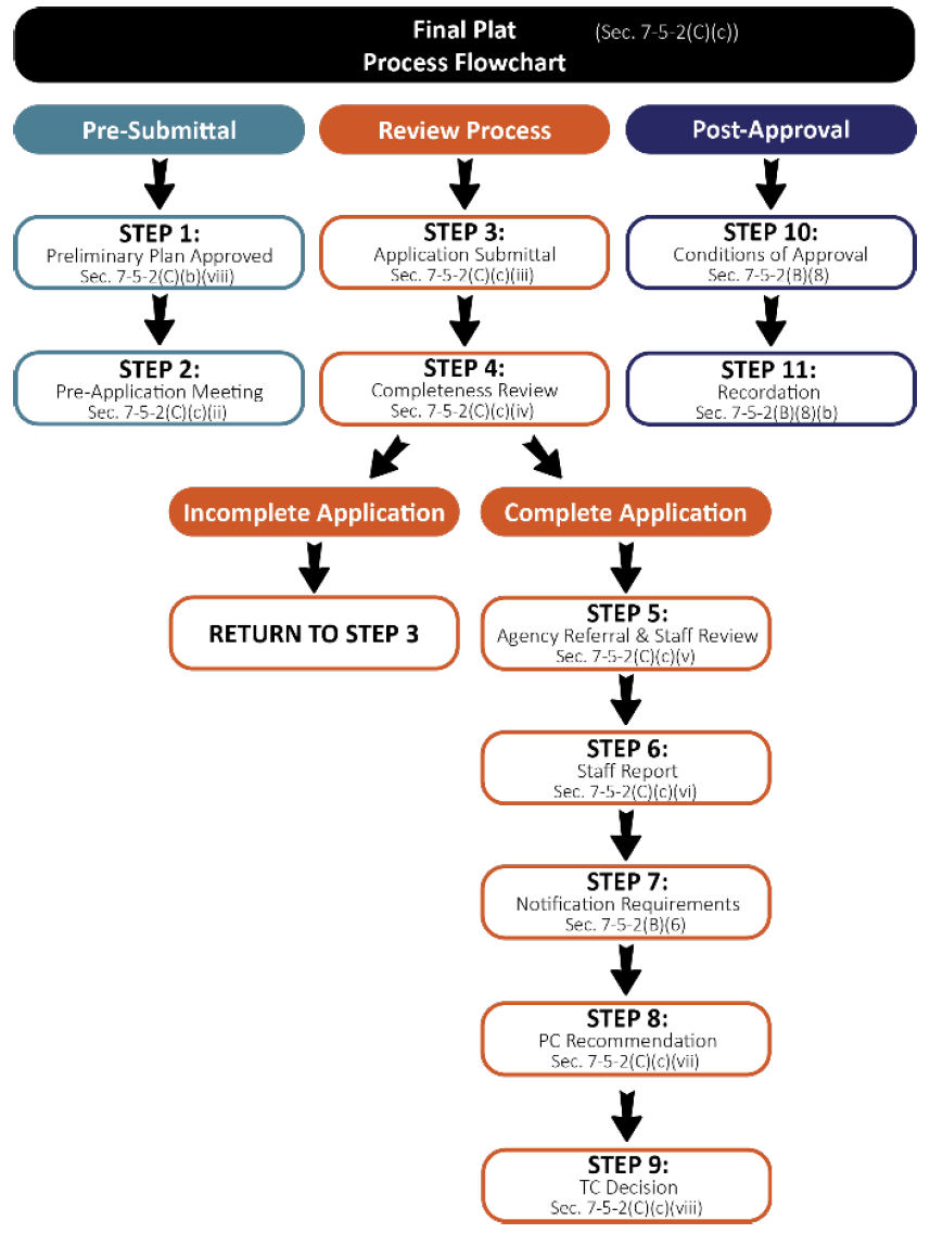
Final Plat Review. Unless otherwise provided by this Ridgway Municipal Code, the applicant must receive preliminary plat approval before beginning the final plat process. Additionally, the street base, lights and traffic control devices, and water, sewer, electricity, gas, telephone and drainage systems, shall have been completed, inspected, approved and accepted by the Town, and received written sign-off from the Town Engineer, prior to submitting a final plat application. The final plat review process will evaluate the final plat to be recorded and associated covenants, bylaws, and restrictions if applicable.
(i)
Review Flowchart. Figure F-5.3, Final Plat Flowchart, depicts the final plat application review process described in greater detail in this section.
Figure F-5.3 Final Plat Flowchart
(ii)
Pre-Application Meeting. A pre-application meeting may be held in accordance with the provisions set forth in Section 7-5-2(B)(1), Pre-Application Meeting.
(iii)
Application Submittal Requirements. The following are the application materials required to be submitted for a final plat request. The Town Manager or designee may waive or alter any of the submittal requirements if they are determined to be inappropriate or unnecessary to determining if the application satisfies applicable standards.
a.
Basic Application Materials. All materials set forth in Section 7-5-2(B)(2), Basic Application Materials.
b.
Final Subdivision Plat. The final subdivision plat shall contain the following information submitted to the Town of Ridgway, in a format prescribed by the Town. The final plat shall be prepared in a clear and legible manner measuring 24" x 36" with clear margins of two (2) inches on the left-hand side and one-half (1/2) inch on the remaining sides at a scale suitable for technical review of the application.
i.
A title clearly identifying the plat as a "Final Subdivision Plat";
ii.
Legal description of the property;
iii.
North arrow, scale, and legend;
iv.
A vicinity map at a suitable scale;
v.
Scaled at one (1) inch to two-hundred (200) feet;
vi.
The name and address of the owner(s) of record of the land being platted and the same information for the applicant(s), if other than the owners;
vii.
The name, address, and seal of the certifying registered land surveyor and the other individuals preparing the final plat;
viii.
The township, range, section and quarter section(s);
ix.
Location and full description of all monuments as required by this article and by Title 38, Article 51, C.R.S.;
x.
Permanent monuments shall be set on the external boundary of the subdivision pursuant to §38-51-101, C.R.S.;
xi.
Block and lot monuments shall be set pursuant to §38-51-101, C.R.S.;
xii.
Information adequate to locate all monuments shall be noted on the plat;
xiii.
Boundary lines, corner pins, and dimensions of the subject parcel(s), including land survey data to identify the subject parcel by section corners, distance and bearing to these corners, quarter corner and township and range;
xiv.
The lengths of all arcs, radii and tangents. Sufficient data shall be shown for all curved lines on the plat to enable reestablishment of the curves in the field;
xv.
Lot location and layout;
xvi.
All lots and blocks shall be numbered consecutively;
xvii.
The dimensions of all lots and acreage of each lot shown to two decimal places;
xviii.
No ditto marks shall be used for dimensions;
xix.
All unidentified angles will be presumed to equal ninety (90) degrees;
xx.
Location and width of existing and proposed roadways, road rights-of-way and parking areas within the site;
xxi.
All street and road names shall be shown;
xxii.
If any road in the subdivision is a continuation or approximately a continuation of an existing public road, the conformity or the amount of conformity of the new road to the existing roads shall be accurately shown;
xxiii.
Names and widths of all existing or recorded streets and roads intersecting the plat boundaries or paralleling them within two hundred (200) feet, the names and map numbers of all bordering subdivisions, and any municipal limits within two hundred (200) feet of the boundaries of the plat. Area of the site, area of individual parcels, and areas of all development including developed driveways, parking and buildings;
xxiv.
The boundary lines and dimensions, shown accurately, of all easements, alleyways, sidewalks or paths, and similar features, including all other rights-of-way not otherwise or explicitly mentioned;
xxv.
The purpose and owner(s) of all easements and statements from all utility companies, as applicable, that the stated services will be provided to the proposed development after platting. A plat note may be necessary to provide complete information regarding the purpose of the easement;
xxvi.
The boundary lines and dimensions, shown accurately, of all property to be reserved and dedicated, with the means of access to such property clearly shown and its intended uses noted;
xxvii.
A legally acceptable land description and dedication block placed on the plat by the applicant dedicating streets, rights-of-way, utility easements, public sites, and other such features. The transfer to the town of dedicated land shall take place by a legally acceptable instrument prior to or concurrent with Final Plat acceptance, but before recording of the final plat;
xxviii.
The names of abutting subdivisions or, in the case of abutting unplatted property, the notation "unplatted" shall appear;
xxix.
All lands within the boundary of the subdivision shall be accounted for as a lot, tract, parcel, open space, street, right-of-way, alley and so forth, and all areas of such lands shall be shown on the plat to the nearest one hundredth of an acre;
xxx.
All plat notes required by the town under preliminary plan approval or as a condition of final plat approval;
xxxi.
Standard certificate blocks as provided by the town.
c.
Final Landscape Plan. The landscape plan shall comply with all requirements in Section 7-4-8, Landscape Regulations.
d.
As-built plans containing information as required by the Town specifications and regulations, for water, sewer, electricity, gas, telephone and drainage systems, along with any other available as built plans. "As-built" plans for any other required improvements not completed at the time the final plat is submitted shall be submitted, reviewed, and approved by the Town prior to final acceptance of the improvements by the Town.
e.
Supplemental Materials. The following items are required to be submitted to the Town of Ridgway:
i.
Final Subdivision Improvement Agreement meeting all standards and requirements set forth in Section 7-5-3(B), Improvement Agreement.
ii.
Covenants, restrictions, and by-laws, if applicable.
iii.
Proof of minimum guaranteed water supply appropriate for the requested use.
f.
Additional Requirements. Any additional information that may be reasonably requested by the Town Manager or designee and determined to be necessary to enable an adequate and comprehensive evaluation of the application.
(iv)
Completeness Review. The Town Manager or designee shall review the application for completeness in accordance with the provisions of Section 7-5-2(B)(3), Completeness Review.
(v)
Evaluation by Staff and Review Agencies. Upon determination of completeness, the Town Manager or designee shall refer the application to additional reviewing agencies as set forth in Section 7-5-2(B)(4), Referral Agencies, and review the application for conformance with the requirements and standards of this Municipal Code.
(vi)
Staff Report. A staff report shall be prepared and provided to the reviewing body in accordance with Section 7-5-2(B)(5), Staff Report.
(vii)
Review and Recommendation by Planning Commission.
a.
The Planning Commission shall review the final plat application in a manner consistent with Table T-5.1, Subdivision Application Types and Processes to evaluate compliance with applicable standards. Following its review of the application, the Planning Commission shall provide a recommendation to approve, approve with conditions, or deny the application to the Town Council based on the review criteria set forth in Section 7-5-2(C)(3), Approval Criteria.
b.
The Planning Commission may, in its sole discretion, continue or postpone the meeting to a specified date and time in order to permit preparation of additional information for further review by the Planning Commission prior to making a final decision.
(viii)
Review and Action by Town Council.
a.
The final decision to approve, approve with conditions, or deny a Final Plat shall be made by the Town Council in a manner consistent with Table T-5.1 based upon the review criteria set forth in Section 7-5-2(C)(3), Approval Criteria.
b.
The Town Council may, in its sole discretion, continue or postpone the meeting to a specified date and time in order to permit preparation of additional information for further review by the Town Council prior to making a final decision.
(ix)
Post Approval. The applicant shall follow the post approval procedures in accordance with Section 7-5-2(B)(8), Post Approval, including recording the final plat with the Ouray County Clerk and Recorder.
(3)
Approval Criteria. The following criteria shall be found to be met by the application and submittal materials in order for the Planning Commission and/or Town Council to recommend approval or approve each stage of a major subdivision:
(a)
All of the required prior approvals for the subdivision and development were issued and remain valid and effective;
(i)
For a sketch plan, no prior approval is required.
(ii)
For a preliminary plat, a finding must be made that a sketch plan was approved or conditionally approved by the Town Council not more than twelve (12) months prior to the date of submission of an application for preliminary plat approval or that the sketch plan is currently valid and effective as the result of the approval of an extension of the effective date of the sketch plan.
(iii)
For a final plat, a finding must be made that a preliminary plat for the subdivision was approved or conditionally approved by the Town Council not more than twelve (12) months prior to the date of submission of an application for final plat approval or that the preliminary plat is currently valid and effective as the result of the approval of an extension of the effective date of the preliminary plat.
(b)
The proposed subdivision complies with all applicable requirements for the zone district(s) in which the property is located;
(c)
The proposed subdivision substantially complies with all other applicable requirements of this code, regulations, standards, and resolutions;
(d)
Adequate capacity of water and wastewater utilities are currently available to serve the entire subdivision and development;
(e)
The proposed subdivision is consistent with the applicable portions of the Master Plan in the reasonable judgement of the approving body; and
(f)
The application:
(i)
For sketch plan approval, meets or satisfies all applicable requirements of the subdivision regulations;
(ii)
For preliminary plat approval, is in substantial conformance with the approved sketch plan and the preliminary plat meets or satisfies all applicable requirements of the subdivision regulations; or
(iii)
For final plat approval, is in substantial conformance with the approved preliminary plat and the final plat meets or satisfies all applicable requirements of the subdivision regulations.
(D)
Minor Subdivision.
(1)
General Provisions. The minor subdivision review process is a procedure used to evaluate proposed subdivisions for divisions of land meeting the definition of minor subdivision as set forth in Section 9, Definitions. A minor subdivision is:
(a)
A subdivision that creates four lots or less; and
(b)
Does not include any proposed public improvements.
(2)
Review Procedures.
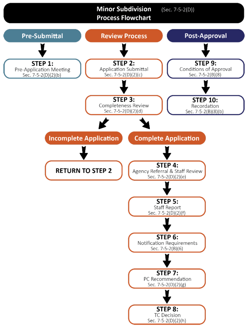
(a)
Review Flowchart. Figure F-5.4, Minor Subdivision flowchart, depicts the Minor Subdivision application review process described in greater detail in this section.
Figure F-5.4 Minor Subdivision Flowchart
(b)
Pre-Application Meeting. A pre-application meeting may be held in accordance with the provisions set forth in Section 7-5-2(B)(1), Pre-Application Meeting.
(c)
Application Submittal Requirements. The following are the application materials required to be submitted for minor subdivision requests. The Town Manager or designee may waive or alter any of the submittal requirements if they are determined to be inappropriate or unnecessary to determining if the application satisfies applicable standards.
(i)
Basic Application Materials. All items set forth in Section 7-5-2(B)(2), Basic Application Materials.
(ii)
Minor Subdivision Plat. The plat shall contain the following information submitted to the Town of Ridgway on 24" x 36" sheets at a scale suitable for technical review of the application.
a.
A title clearly identifying the plat as a "Minor Subdivision Plat";
b.
Standard certificate blocks as provided by the town;
c.
Legal description of the property;
d.
North arrow, scale, and legend;
e.
A vicinity map at a suitable scale;
f.
The name and address of the owner(s) of record of the land being platted and the same information for the applicant(s), if other than the owners;
g.
The name, address, and seal of the certifying registered land surveyor and the other individuals preparing the preliminary plat;
h.
The township, range, section and quarter section(s);
i.
Location and full description of all monuments as required by this article and by Title 38, Article 51, C.R.S.:
i.
Permanent monuments shall be set on the external boundary of the subdivision pursuant to Section 38-51-101, C.R.S.; and
ii.
Block and lot monuments shall be set pursuant to section 38-51-101, C.R.S.
j.
Information adequate to locate all monuments shall be noted on the plat;
k.
The location, layout, dimensions, areas, and uses of all lots and blocks numbered consecutively;
l.
The location, layout, dimensions, areas, and uses of all outlots and tracts labeled consecutively by letters and include a table identifying ownership and maintenance responsibilities.
m.
Site data in chart form presenting:
i.
Total area of the proposed subdivision; total area of the developed buildings, driveways and parking areas; total area of nonresidential floor space;
ii.
Total number of proposed lots; breakdown of the lot total by number of lots per use (i.e., residential use, business or commercial and industrial use, and other public and nonpublic uses);
iii.
Total number of proposed off-street parking spaces;
iv.
Total number of dwelling units; total number of dwelling units per structure proposed; and
v.
Total gross density proposed.
n.
Boundary lines, corner pins, and dimensions of the subject property, including land survey data to identify the parcel with section corners, distance and bearing to corners, quarter corners, township and range;
o.
Topography at the following minimum contour intervals:
i.
Subdivision with one or more lots less than two (2) acres in size, topography shown at two (2) foot contour intervals;
ii.
Subdivision with all lots two (2) acres or greater in size, topography shown at five (5) foot contour intervals;
iii.
Areas having slopes thirty (30) percent or more, or other significant topographic conditions, topography shown at two (2) foot contour intervals;
p.
Significant on-site features including: natural and artificial drainage ways, streams, ponds, waterways, wetland areas, irrigation ditches, hydrologic features and aquatic habitat; geologic features and hazards including slopes, alluvial fans, areas of subsidence, rock outcrops and rockfall areas, radiological and seismic hazard areas, soil types and landslide areas; vegetative cover; dams, reservoirs, excavations, and mines; and any other on-site and off-site features that influence the development;
q.
Known, identified or designated one hundred (100) year flood plains and localized areas subject to periodic flooding. The distance between the mean identifiable high water mark of any creeks, streams or rivers and the nearest proposed development within the site shall also be shown;
r.
Existing and proposed parking areas, driveways, emergency turn-outs and emergency turnarounds, sidewalks, and paths and their dimensions;
s.
Public Access to the site, and internal circulation. Location, dimension, alignment and names of all existing and proposed streets, drives, alleys and roads on or adjoining the property. The general location and right-of-way width for all arterials and collectors shall be shown;
t.
The location of any preliminary engineering for any existing or proposed wastewater systems, water mains, culverts, storm drains, sidewalks, gutters, fire hydrants along with the width and depth of pavement or subgrading to be provided, the depth of burial of all underground lines, pipes and tubing and typical cross sections of the proposed grading of roadways and sidewalks;
u.
Uses and grantees of all existing and proposed easements and rights-of-way on or adjacent to the property and their dimensions;
v.
The location, use and gross square footage of proposed structures within the subdivision;
w.
Anticipated number of employees for proposed commercial or industrial uses.
x.
Building envelopes in hazardous areas to protect trees and other natural resources, if deemed appropriate by planning staff;
y.
Location and layout of lots and blocks, with lots and blocks numbered consecutively, and the dimensions and acreage of each lot;
z.
Areas for landscaping, and delineation of the type and extent of vegetative cover on the site;
aa.
Existing land uses and zoning on adjoining properties;
bb.
Public or private sources of utility services and facilities; and
cc.
Location and dimension of land to be held in common, open space devoted to community use, and land to be dedicated to town.
(iii)
Land Suitability Analysis
a.
A description of site features such as streams, areas subject to flooding, lakes, high ground water areas, vegetative cover, and other significant natural and man-made features;
b.
A description of the existing drainages and impoundments, natural and manmade;
c.
A description of soil characteristics of the site;
d.
A description of the geologic characteristics of the area including any potential natural or man-made hazards;
e.
A description of the topography and the slope determination;
f.
A description of the source of water supply, the existing and future domestic and agricultural requirements, and the capacity of the source of water supply to meet existing and future requirements. The description shall include detail of historic irrigation, tailwater issues, and water demands;
g.
A description of the relationship of the subject parcel to floodplains, the nature of soils and subsoils and their ability to adequately support waste disposal, the slope of the land, the effect of sewage effluents, and the pollution of surface runoff, stream flow and groundwater;
h.
A description of the Floodplain and Flood Fringe designations affecting the subject property;
i.
A description of the existing environmental conditions:
i.
Existing flora and fauna habitat, wetlands, migration routes; and
ii.
Significant archaeological, cultural, paleontological, and historic resource areas.
j.
A description of the existing and historic use of adjacent property and neighboring properties within a 300' radius;
k.
A description of all easements defining, limiting or allowing use types and access; and
l.
Access:
i.
A description of historic public access to or through the site; and
ii.
A description of access to adjoining roads and sight distance and intersection constraints.
(iv)
Final Landscape Plan. The landscape plan shall not include any plants or species identified as noxious weeds or invasive species by the Ouray County Weed District or on the USDA Colorado State Noxious Weed list. When landscaping is proposed, the landscape plan shall include the following elements:
a.
Topographic information at two (2) foot contour intervals;
b.
Location of all lot lines and improvements to the property and location of any easements of record;
c.
Location of all existing and proposed buildings, driveways, parking lots, walkways, sidewalks, and other impervious surfaces to remain or exist on the property;
d.
A plant schedule which identifies plants, species, and minimum size to be installed on the property;
e.
Identification of areas where existing vegetation will be preserved;
f.
Identification of areas where landscaping will be installed; and
g.
If an irrigation system is proposed, an irrigation plan depicting the location of irrigation lines and spray heads, irrigation zones, spray areas of each head, and make and model of irrigation system and sprinkler heads.
(v)
Final Engineering Reports and Plans.
a.
Final plan and profile design of all proposed streets, sidewalks, trails, walkways, and bikeways;
b.
Final plan and profile design of all surface drainage and storm sewer conveyance facilities including, but not limited to, inlet locations, size and location of pipes, retention or detention facilities, and required water quality and erosion control measures;
c.
Final engineering design and construction features for any bridges, culverts, or other drainage structures to be constructed;
d.
Mitigation of any geologic hazard(s) impacting the project site;
e.
Final plan and profile design of all wastewater collection and water supply and distribution system improvements necessary;
f.
Final cost estimates for all public improvements.
(vi)
Supplemental Materials. The following items may be required to be submitted to the Town of Ridgway:
a.
Final improvements agreement meeting all standards and requirements set forth in Section 7-5-3(B), Improvement Agreement;
b.
Final drainage plan or study calculating historic and proposed surface and stormwater flows and how such flows will be managed;
c.
Final traffic statement or study identifying current and proposed traffic counts and proposed trip generation along with any needed or anticipated improvements to mitigate the projects use on the public transportation network and infrastructure;
d.
Covenants, restrictions, and by-laws, if applicable;
e.
Proof of minimum guaranteed water supply appropriate for the requested use;
f.
Traffic statement or study identifying current and proposed traffic counts and proposed trip generation along with any needed or anticipated improvements to mitigate the projects use on the public transportation network and infrastructure.
(vii)
Additional Requirements.
a.
Any additional information that may be reasonably requested by the Town Manager or designee and determined to be necessary to enable an adequate and comprehensive evaluation of the application.
(d)
Completeness Review. The Town Manager or designee shall review the application for completeness in accordance with the provisions of Section 7-5-2(B)(3), Completeness Review.
(e)
Evaluation by Staff and Referral Agencies. Upon determination of completeness, the Town Manager or designee shall refer the application to additional reviewing agencies as set forth in Section 7-5-2(B)(4), Referral Agencies, and review the application for conformance with the requirements and standards of this Municipal Code.
(f)
Staff Report. A staff report shall be prepared and provided to the reviewing body in accordance with Section 7-5-2(B)(5), Staff Report.
(g)
Review and Recommendation by the Planning Commission.
(i)
The Planning Commission shall review the minor subdivision application in a manner consistent with Table T-5.1 to evaluate compliance with applicable standards. Following its review of the application, the Planning Commission may provide either a recommendation to approve, approve with conditions, or deny the application to the Town Council based on the criteria set forth in Section 7-5-2(D)(3), Approval Criteria.
(ii)
The Planning Commission may, in its sole discretion, continue or postpone the public hearing to a specified date and time in order to permit preparation of additional information for further review by the Planning Commission prior to providing a recommendation to the Town Council.
(h)
Review and Action by the Town Council.
(i)
The final decision to approve, approve with conditions, or deny a minor subdivision application shall be made by the Town Council in a manner consistent with Table T-5.1 and be based upon the criteria set forth in Section 7-5-2(D)(3), Approval Criteria.
(ii)
The Town Council may, in its sole discretion, continue or postpone the public hearing to a specified date and time in order to permit preparation of additional information for further review by the Town Council prior to making a final decision.
(i)
Post Approval. The applicant shall follow the post approval procedures in in accordance with Section 7-5-2(B)(8), Post Approval, including recording the resubdivision with the Ouray County Clerk and Recorder.
(3)
Approval Criteria. A minor subdivision may be approved and accepted by the Town Council if the application is found to meet the following criteria:
(a)
The proposed subdivision conforms to all applicable requirements for the zone district(s) in which the property is located.
(b)
The proposed subdivision substantially conforms to all other applicable requirements of this code, ordinances, and resolutions; and
(c)
The proposed subdivision is consistent with the applicable portions of the Master Plan in the reasonable judgement of the approving body.
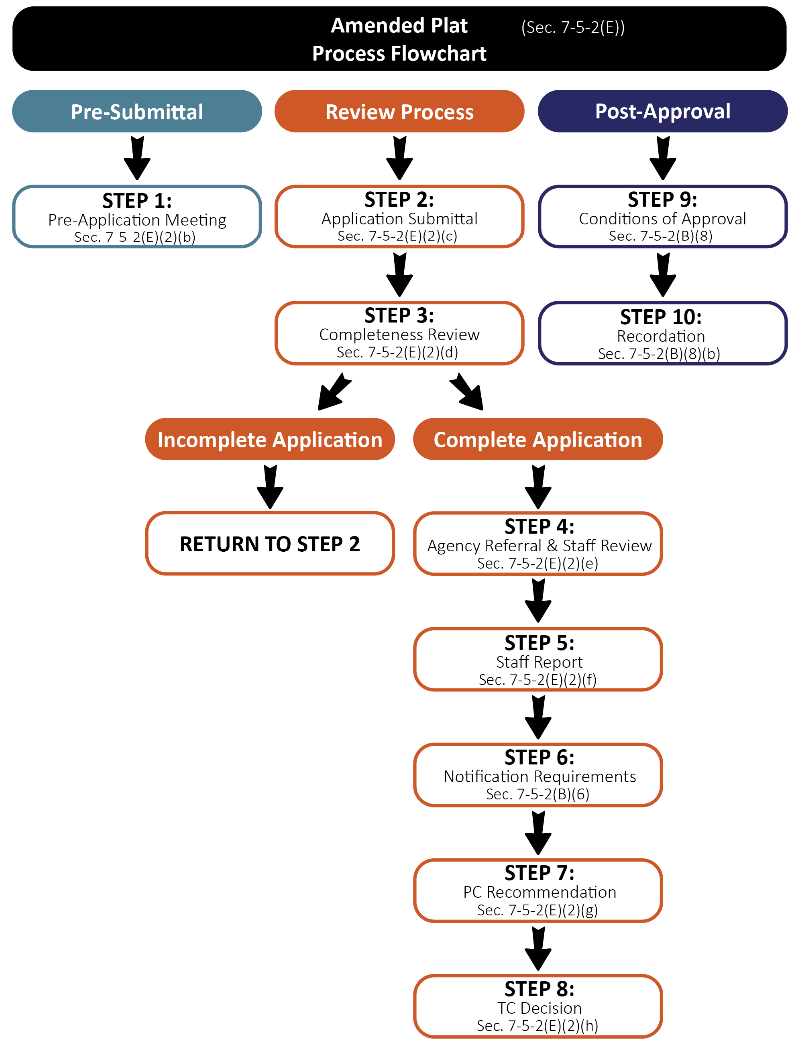
(E)
Amended Plats.
(1)
General Provisions. Amended Plats of subdivision plats previously approved by the Town, or parts of such plats, which do not require a substantial change to the density, development pattern, public improvements, or easements, and are consistent with the Design Standards of these Regulations as determined by the Town Manager, or designee.
(2)
Review Procedures.
(a)
Review Flowchart. Figure F-5.5, Amended Plat flowchart, depicts the application review process described in greater detail in this section.
Figure F-5.5 Amended Plat Flowchart
(b)
Pre-Application Meeting. A pre-application meeting may be held in accordance with the provisions set forth in Section 7-5-2(B)(1), Pre-Application Meeting.
(c)
Application Submittal Requirements. The following are the application materials required to be submitted for amended plat requests. The Town Manager or designee may waive or alter any of the submittal requirements if they are determined to be inappropriate or unnecessary to determining if the application satisfies applicable standards.
(i)
Basic Application Materials. All items set forth in Section 7-5-2(B)(2), Basic Application Materials.
(ii)
Amended Plat shall contain the following information submitted to the Town of Ridgway on 24" x 36" sheets at a scale suitable for technical review of the application.
a.
A title clearly identifying this as a "Amended Plat";
b.
Legal description of the property;
c.
North arrow, scale, and legend;
d.
A vicinity map at a suitable scale;
e.
The name and address of the owner(s) of record of all properties being modified and the same information for the applicant(s), if other than the owners;
f.
The name, address and seal of the certifying registered land surveyor and the other individuals preparing the survey plat;
g.
The township, range, section and quarter section(s);
h.
Location and full description of all monuments as required by this Land Development Code and by Title 38, Article 51, C.R.S;
i.
Permanent monuments shall be set pursuant to Section 38-51-101, C.R.S;
j.
Block and lot monuments shall be set pursuant to Section 38-51-101, C.R.S;
k.
Information adequate to locate all monuments shall be noted on the plat;
l.
The location, layout, dimensions, areas, and uses of all lots and blocks numbered consecutive;
m.
The location, layout, dimensions, areas, and uses of all outlots and tracts labeled consecutively by letters and include a table identifying ownership and maintenance responsibilities;
n.
Boundary lines, corner pins, and dimensions of the subject parcel(s), including land survey data to identify the subject parcel by section corners, distance and bearing to these corners, quarter corner and township and range;
o.
The lengths of all arcs, radii and tangents. Sufficient data shall be shown for all curved lines on the plat to enable reestablishment of the curves in the field;
p.
The dimensions of all lots and the acreage of each lot shown to two decimal places;
q.
Location and width of existing roadways, road rights-of-way and parking areas within the site;
r.
All street and road names shall be shown;
s.
Area of the entire area the revision covers and the current and proposed area of each individual lot;
t.
The boundary lines and dimensions, shown accurately, of all easements, alleyways, sidewalks or paths, and similar features, including all other rights-of-way not otherwise or explicitly mentioned;
u.
The names of abutting subdivisions or, in the case of abutting unplatted property, the notation "unplatted" shall appear;
v.
Delineation of all known, identified or designated one hundred (100) year floodplains and localized areas subject to periodic inundation along the required stream setback lines, if any; and
w.
Standard certificate blocks as provided by the Town.
(iii)
Additional Requirements. Any additional information that may be reasonably requested by the Town Manager or designee and determined to be necessary to enable an adequate and comprehensive evaluation of the application.
(d)
Completeness Review. The Town Manager or designee shall review the application for completeness in accordance with the provisions of Section 7-5-2(B)(3), Completeness Review.
(e)
Evaluation by Staff and Referral Agencies.
(i)
Upon determination of completeness, the Town Manager or designee shall refer the application to additional reviewing agencies as set forth in Section 7-5-2(B)(4), Referral Agencies, and review the application for conformance with the requirements and standards of this Municipal Code.
(f)
Staff Report.
(i)
A staff report shall be prepared and provided to the reviewing body in accordance with Section 7-5-2(B)(5), Staff Report.
(g)
Review and Recommendation by the Planning Commission.
(i)
The Planning Commission shall review the amended plat application in a manner consistent with Table T-5.1 to evaluate compliance with applicable standards. Following its review of the application, the Planning Commission may provide either a recommendation to approve, approve with conditions, or deny the application to the Town Council based on the criteria set forth in Section 7-5-2(E)(3), Approval Criteria.
(ii)
The Planning Commission may, in its sole discretion, continue or postpone the public hearing to a specified date and time in order to permit preparation of additional information for further review by the Planning Commission prior to providing a recommendation to the Town Council.
(h)
Review and Action by the Town Council.
(i)
The final decision to approve, approve with conditions, or deny an amended plat application shall be made by the Town Council in a manner consistent with Table T-5.1 and be based upon the criteria set forth in Section 7-5-2(E)(3), Approval Criteria.
(ii)
The Town Council may, in its sole discretion, continue or postpone the public hearing to a specified date and time in order to permit preparation of additional information for further review by the Town Council prior to making a final decision.
(i)
Post Approval. The applicant shall follow the post approval procedurals in accordance with Section 7-5-2(B)(8), Post Approval, including recording the survey plat with the Ouray County Clerk and Recorder.
(3)
Approval Criteria. An amended plat application may be approved and accepted by the Town Council if the application is found to meet the following criteria:
(i)
The proposed revision conforms to all applicable requirements for the zone district(s) in which the property is located.
(ii)
The proposed revision substantially conforms to all other applicable requirements of this code and town resolutions; and
(iii)
The proposed revision is consistent with the applicable portions of the Master Plan in the reasonable judgement of the approving body.
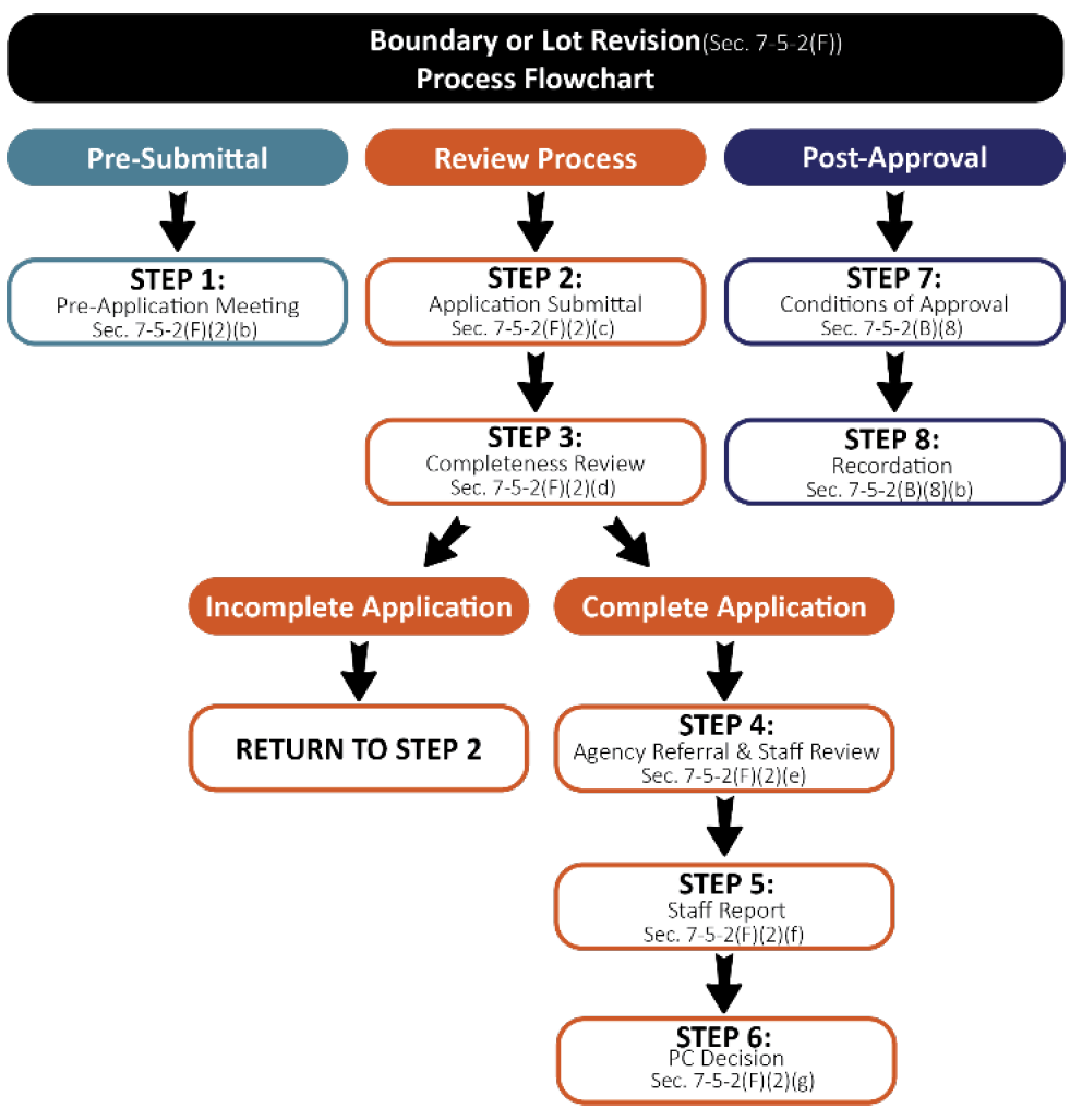
(F)
Boundary or Lot Line Adjustment.
(1)
General Provisions. Boundary or lot line revisions are minor amendments to platted or unplatted property which do not result in any of the following:
(a)
The creation of any additional lot(s);
(b)
The consolidation of any lots;
(c)
The creation of an unbuildable lot; or
(d)
The creation of a lot that does not have legal access from a public right-of-way or perpetual easement.
(2)
Review Procedures.
(a)
Review Flowchart. Figure F-5.6, Boundary or Lot Line Adjustment flowchart, depicts the application review process described in greater detail in this section.
Figure F-5.6 Boundary or Lot Line Adjustment Flowchart
(b)
Pre-Application Meeting. A pre-application meeting may be held in accordance with the provisions set forth in Section 7-5-2(B)(1), Pre-Application Meeting.
(c)
Application Submittal Requirements. The following are the application materials required to be submitted for boundary or lot line revision requests. The Town Manager or designee may waive or alter any of the submittal requirements if they are determined to be inappropriate or unnecessary to determining if the application satisfies applicable standards.
(i)
Basic Application Materials. All items set forth in Section 7-5-2(B)(2), Basic Application Materials.
(ii)
Boundary or Lot Line Adjustment Plat shall contain the following information submitted to the Town of Ridgway on 24" x 36" sheets at a scale suitable for technical review of the application.
a.
A title clearly identifying this as a "Boundary Line Revision Survey Plat";
b.
Legal description of the property;
c.
North arrow, scale, and legend;
d.
A vicinity map at a suitable scale;
e.
The name and address of the owner(s) of record of all properties being modified and the same information for the applicant(s), if other than the owners;
f.
The name, address and seal of the certifying registered land surveyor and the other individuals preparing the survey plat;
g.
The township, range, section and quarter section(s);
h.
Location and full description of all monuments as required by this Land Development Code and by Title 38, Article 51, C.R.S:
i.
Permanent monuments shall be set pursuant to Section 38-51-101, C.R.S.
ii.
Block and lot monuments shall be set pursuant to Section 38-51-101, C.R.S.
i.
Information adequate to locate all monuments shall be noted on the plat;
j.
The location, layout, dimensions, areas, and uses of all lots and blocks numbered consecutively;
k.
The location, layout, dimensions, areas and uses of all outlots and tracts labeled consecutively by letters and include a table identifying ownership and maintenance responsibilities;
l.
Boundary lines, corner pins, and dimensions of the subject parcel(s), including land survey data to identify the subject parcel by section corners, distance and bearing to these corners, quarter corner and township and range;
m.
The lengths of all arcs, radii and tangents. Sufficient data shall be shown for all curved lines on the plat to enable reestablishment of the curves in the field;
n.
The dimensions of all lots and the acreage of each lot shown to two decimal places;
o.
Location and width of existing roadways, road rights-of-way and parking areas within the site;
p.
All street and road names shall be shown;
q.
Area of the entire area the revision covers and the current and proposed area of each individual lot;
r.
The boundary lines and dimensions, shown accurately, of all easements, alleyways, sidewalks or paths, and similar features, including all other rights-of-way not otherwise or explicitly mentioned;
s.
The names of abutting subdivisions or, in the case of abutting unplatted property, the notation "unplatted" shall appear;
t.
Delineation of all known, identified or designated one hundred (100) year floodplains and localized areas subject to periodic inundation along the required stream setback lines, if any; and
u.
Standard certificate blocks as provided by the Town.
(iii)
Additional Requirements. Any additional information that may be reasonably requested by the Town Manager or designee and determined to be necessary to enable an adequate and comprehensive evaluation of the application.
(d)
Completeness Review. The Town Manager or designee shall review the application for completeness in accordance with the provisions of Section 7-5-2(B)(3), Completeness Review.
(e)
Evaluation by Staff and Referral Agencies. Upon determination of completeness, the Town Manager or designee shall refer the application to additional reviewing agencies as set forth in Section 7-5-2(B)(4), Referral Agencies, and review the application for conformance with the requirements and standards of this Municipal Code.
(f)
Staff Report. A staff report shall be prepared and provided to the reviewing body in accordance with Section 7-5-2(B)(5), Staff Report.
(g)
Review and Action by the Planning Commission.
(i)
The Planning Commission shall review the boundary or lot line adjustment application in a manner consistent with Table T-5.1 to evaluate compliance with applicable standards. The final decision to approve, approve with conditions, or deny the application shall be made by the Planning Commission in a manner consistent with Table T-5.1 and be based upon the criteria set forth in Section 7-5-2(F)(3), Approval Criteria.
(ii)
The Planning Commission may, in its sole discretion, continue or postpone the meeting to a specified date and time in order to permit preparation of additional information for further review by the Planning Commission prior to making a final decision.
(iii)
Post Approval. The applicant shall follow the post approval procedurals in accordance with Section 7-5-2(B)(8), Post Approval, including recording the survey plat with the Ouray County Clerk and Recorder.
(3)
Approval Criteria. A boundary or lot line revision may be approved and accepted by the Planning Commission if the application is found to meet the following criteria:
(a)
The proposed revision conforms to all applicable requirements for the zone district(s) in which the property is located;
(b)
The proposed revision substantially conforms to all other applicable requirements of this code and town resolutions; and
(c)
The proposed revision is consistent with the applicable portions of the Master Plan in the reasonable judgement of the approving body.
(G)
Building Footprint Subdivision
(1)
General Provisions. The platting of building footprints shall require review and approval of a building footprint subdivision in accordance with the provisions of this Section 7-5.2(G), Building Footprint Subdivision. A building footprint may be resubdivided per the Town-approved foundation line shown on the site plan at the risk of the subdivider, or it may be resubdivided once the foundation has been poured.
(a)
Notwithstanding the definition of a "Subdivision, Building Footprint" in Chapter 7, Article 9, a building footprint may be subdivided prior to the construction of the foundation for the structure provided that:
(i)
The final plat of any such building footprint shall contain a plat note that provides as follows:
a.
The building footprint identified hereon as "________" has been subdivided prior to the construction of the building, or foundation of the building, to be located on the pad. Pursuant to said section, the owner(s) of the building, as well as the owner(s) of any property that abuts the building must, within ninety (90) days after the construction of the foundation for the building to be located on the pad, have a survey of the foundation prepared and make a subdivision amended plat application to the Town that shall cause the building footprint depicted on the amended plat to be coterminous with the foundation of the building as constructed.
(ii)
Within ninety (90) days after the construction of the foundation for the building to be located on the pad, the owner(s) of the building shall have a survey of the foundation prepared and, along with the owner(s) of any property that abuts the building footprint, shall make and pursue to completion an application to the Town to amend the plat of the building footprint to cause the building footprint depicted on the amended plat to be coterminous with the foundation of the building as constructed.
(b)
With respect to a building footprint that has been subdivided prior to the construction of the building to be constructed on the pad, or its foundation, it is unlawful:
(i)
For the owner(s) of the building to fail to, within ninety (90) days after the construction of the foundation, have a survey of the location of the foundation prepared; and
(ii)
For the owner(s) of the building and the owner(s) of any property that abuts the commercial pad, to fail to, within ninety (90) days after the construction of the foundation, make and pursue to completion an application to the Town to amend the plat of the building footprint to cause the pad to be coterminous with the foundation of the building as constructed.
(2)
Review Procedures.
(a)
Review Flowchart. Figure F-5.7, Building Footprint Subdivision flowchart, depicts the building footprint review process described in greater detail in this section.
Figure F-5.7 Building Footprint Subdivision Flowchart
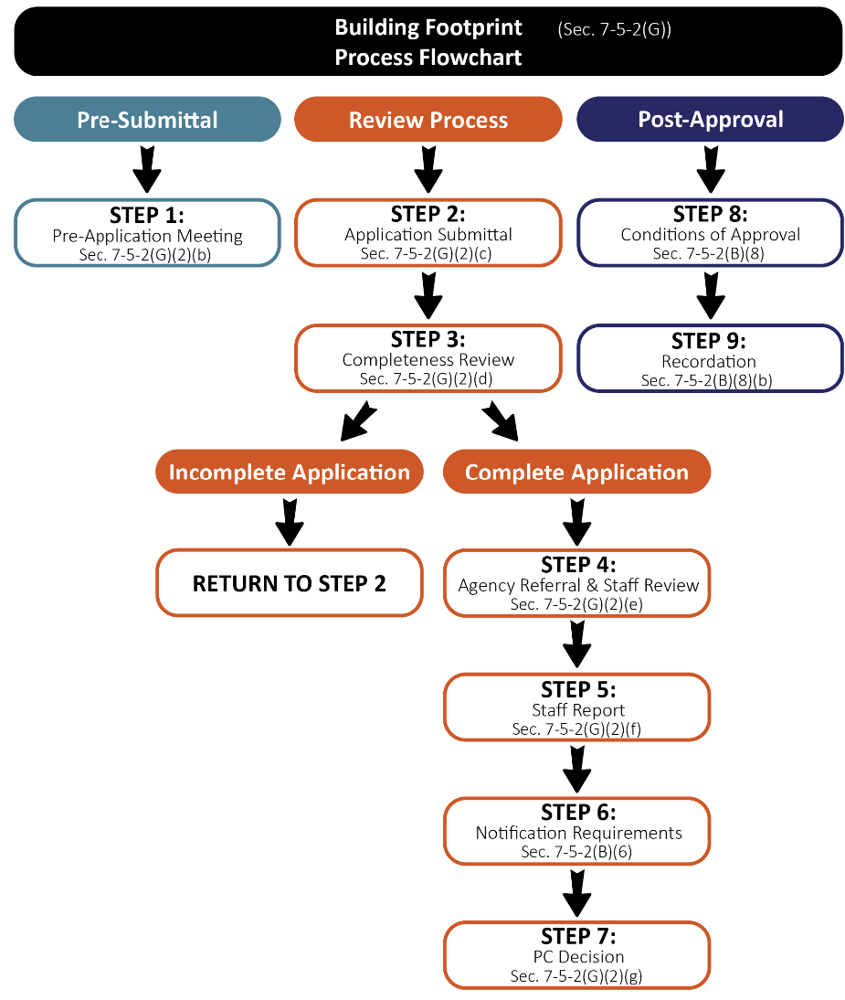
(b)
Pre-Application Meeting.
(i)
A pre-application meeting may be held in accordance with the provisions set forth in Section 7-5-2(B)(1), Pre-Application Meeting.
(c)
Application Submittal Requirements. The following are the application materials required to be submitted for building footprint requests. The Town Manager or designee may waive or alter any of the submittal requirements if they are determined to be inappropriate or unnecessary to determining if the application satisfies applicable standards.
(i)
Basic Application Materials. All items set forth in Section 7-5-2(B)(2), Basic Application Materials.
(ii)
Building Footprint Plat shall contain the following information submitted to the Town of Ridgway on 24" x 36" sheets at a scale suitable for technical review of the application.
a.
A title clearly identifying the plat as a "Building Footprint Plat";
b.
Standard certificate blocks as provided by the town;
c.
Legal description of the property;
d.
North arrow, scale, and legend;
e.
A vicinity map at a suitable scale;
f.
The name and address of the owner(s) of record of the land being platted and the same information for the applicant(s), if other than the owners;
g.
The name, address, and seal of the certifying registered land surveyor and the other individuals preparing the preliminary plat;
h.
The township, range, section and quarter section(s);
i.
Location and full description of all monuments as required by this article and by Title 38, Article 51, C.R.S.;
j.
Permanent monuments shall be set on the external boundary of the subdivision pursuant to Section 38-51-101, C.R.S. and
k.
Block and lot monuments shall be set pursuant to Section 38-51-101, C.R.S.;
l.
Information adequate to locate all monuments shall be noted on the plat;
m.
The location, layout, dimensions, areas, and uses of all lots and blocks numbered consecutively;
n.
The location, layout, dimensions, areas and uses of all outlots and tracts labeled consecutively by letters and include a table identifying ownership and maintenance responsibilities;
o.
Site data in chart form presenting:
i.
Total area of the proposed subdivision; total area of the developed buildings, driveways and parking areas; total area of nonresidential floor space;
ii.
Total number of proposed lots; breakdown of the lot total by number of lots per use (i.e., residential use, business or commercial and industrial use, and other public and nonpublic uses);
iii.
Total number of proposed off-street parking spaces;
iv.
Total number of dwelling units; total number of dwelling units per structure proposed; and
v.
Total gross density proposed.
p.
Boundary lines, corner pins, and dimensions of the subject property, including land survey data to identify the parcel with section corners, distance and bearing to corners, quarter corners, township and range;
q.
Topography shown at a minimum of two (2) foot contour intervals;
r.
Significant on-site features including: natural and artificial drainage ways, streams, ponds, waterways, wetland areas, irrigation ditches, hydrologic features and aquatic habitat; geologic features and hazards including slopes, alluvial fans, areas of subsidence, rock outcrops and rockfall areas, radiological and seismic hazard areas, soil types and landslide areas; vegetative cover; dams, reservoirs, excavations, and mines; and any other on-site and off-site features that influence the development;
s.
Known, identified or designated one hundred (100) year flood plains and localized areas subject to periodic flooding. The distance between the mean identifiable high-water mark of any creeks, streams or rivers and the nearest proposed development within the site shall also be shown;
t.
Existing and proposed parking areas, driveways, emergency turn-outs and emergency turnarounds, sidewalks, and paths and their dimensions;
u.
Public Access to the site, and internal circulation. Location, dimension, alignment and names of all existing and proposed streets, drives, alleys and roads on or adjoining the property. The general location and right-of-way width for all arterials and collectors shall be shown;
v.
The location of any engineering for any existing or proposed wastewater systems, water mains, culverts, storm drains, sidewalks, gutters, fire hydrants along with the width and depth of pavement or subgrading to be provided, the depth of burial of all underground lines, pipes and tubing and typical cross sections of the proposed grading of roadways and sidewalks;
w.
Uses and grantees of all existing and proposed easements and rights-of-way on or adjacent to the property and their dimensions;
x.
The location, use and gross square footage of proposed structures within the subdivision;
y.
Building envelopes in hazardous areas to protect trees and other natural resources, if deemed appropriate by planning staff;
z.
Location and layout of lots and blocks, with lots and blocks numbered consecutively, and the dimensions and acreage of each lot;
aa.
Areas for landscaping, and delineation of the type and extent of vegetative cover on the site;
bb.
Existing land uses and zoning on adjoining properties;
cc.
Public or private sources of utility services and facilities; and
dd.
Location and dimension of land to be held in common, open space devoted to community use, and land to be dedicated to town.
(iii)
Supplemental Materials
a.
The following items may be required to be submitted to the Town of Ridgway:
i.
Drainage plan or study calculating historic and proposed surface and stormwater flows and how such flows will be managed.
ii.
Traffic statement or study identifying current and proposed traffic counts and proposed trip generation along with any needed or anticipated improvements to mitigate the projects use on the public transportation network and infrastructure.
iii.
Proof of minimum guaranteed water supply appropriate for the requested use.
(iv)
Additional Requirements. The following shall be submitted with a condominium subdivision application:
a.
A map showing all common areas (general and limited common elements) and usages of the building and grounds, for the interior division of the building showing horizontal and vertical boundaries of all units, including a distance from a building corner to a property corner or other survey reference.
b.
A copy of the articles of incorporation and bylaws of the owner's association for the project and of the declaration of covenants applicable to the building footprint.
c.
A management plan that states:
i.
The responsible party for managing the common area, lodging reservations, etc.;
ii.
Provisions for selecting, appointing, and securing management; and
iii.
Responsibilities and duties of the management entity.
d.
A maintenance plan that states:
i.
The responsible entity for repair and maintenance of common areas;
ii.
What will be included in the maintenance program, including, but not limited to, provisions for snow removal, trash removal, maintenance of pools, hot tubs, common areas, and other amenities; and
iii.
The mechanism used to fund the management and maintenance activities of the development.
e.
In addition, if there are any restrictive covenants, conditions, or restrictions other than specified in the declaration, they shall be filed concurrently with the filing of the condominium plat.
f.
Any additional information that may be reasonably requested by the Town Manager or designee and determined to be necessary to enable an adequate and comprehensive evaluation of the application.
(d)
Completeness Review. The Town Manager or designee shall review the application for completeness in accordance with the provisions of Section 7-5-2(B)(3), Completeness Review.
(e)
Evaluation by Staff and Referral Agencies. Upon determination of completeness, the Town Manager or designee shall refer the application to additional reviewing agencies as set forth in Section 7-5-2(B)(4), Referral Agencies, and review the application for conformance with the requirements and standards of this Municipal Code.
(f)
Staff Report. A staff report shall be prepared and provided to the reviewing body in accordance with Section 7-5-2(B)(5), Staff Report.
(g)
Review and Action by the Planning Commission.
(i)
The Planning Commission shall review the building foundation application in a manner consistent with Table T-5.1 to evaluate compliance with applicable standards. The final decision to approve, approve with conditions, or deny the application shall be made by the Planning Commission in a manner consistent with Table T-5.1 and be based upon the criteria set forth in Section 7-5-2(G)(3), Approval Criteria.
(ii)
The Planning Commission may, in its sole discretion, continue or postpone the meeting to a specified date and time in order to permit preparation of additional information for further review by the Planning Commission prior to making a final decision.
(h)
Post Approval.
(i)
The applicant shall follow the post approval procedurals in accordance with Section 7-5-2(B)(8), Post Approval, including recording the survey plat with the Ouray County Clerk and Recorder.
(3)
Approval Criteria. A building footprint plat may be approved and accepted by the Planning Commission if the application is found to meet the following criteria:
(a)
The proposed revision conforms to all applicable requirements for the zone district(s) in which the property is located.
(b)
The proposed revision substantially conforms to all other applicable requirements of this code and town resolutions; and
(c)
The proposed revision is consistent with the applicable portions of the Master Plan in the reasonable judgement of the approving body.
(H)
Condominium Subdivision.
(1)
General Provisions. The condominiumization of buildings shall require review and approval of a condominium subdivision in accordance with the provisions of this Section 7-5.2(H), Condominium Subdivision. This section shall apply to all new condominium projects and conversions of existing buildings to condominiums.
(2)
Review Procedures.
(a)
Review Flowchart. Figure F-5.8, Condominium Subdivision flowchart, depicts the condominium application review process described in greater detail in this section.
Figure F-5.8 Condominium Flowchart
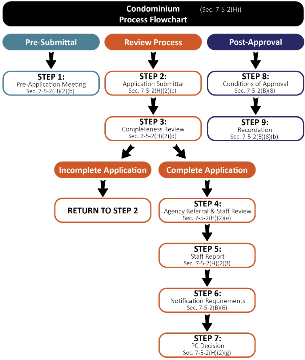
(b)
Pre-Application Meeting.
(i)
A pre-application meeting may be held in accordance with the provisions set forth in Section 7-5-2(B)(1), Pre-Application Meeting.
(c)
Application Submittal Requirements. The following are the application materials required to be submitted for condominium subdivision requests. The Town Manager or designee may waive or alter any of the submittal requirements if they are determined to be inappropriate or unnecessary to determining if the application satisfies applicable standards.
(i)
Basic Application Materials. All items set forth in Section 7-5-2(B)(2), Basic Application Materials;
(ii)
Condominium Subdivision Plat shall contain the following information submitted to the Town of Ridgway on 24" x 36" sheets at a scale suitable for technical review of the application:
a.
A title clearly identifying the plat as a "Condominium Subdivision Plat";
b.
Standard certificate blocks as provided by the town;
c.
Legal description of the property;
d.
North arrow, scale, and legend;
e.
A vicinity map at a suitable scale;
f.
The name and address of the owner(s) of record of the land being platted and the same information for the applicant(s), if other than the owners;
g.
The name, address, and seal of the certifying registered land surveyor and the other individuals preparing the preliminary plat;
h.
The township, range, section and quarter section(s);
i.
Location and full description of all monuments as required by this article and by Title 38, Article 51, C.R.S.;
j.
Permanent monuments shall be set on the external boundary of the subdivision pursuant to section 38-51-101, C.R.S.;
k.
Block and lot monuments shall be set pursuant to Section 38-51-101, C.R.S.;
l.
Information adequate to locate all monuments shall be noted on the plat;
m.
The location, layout, dimensions, areas, and uses of all lots and blocks numbered consecutively;
n.
The location, layout, dimensions, areas and uses of all outlots and tracts labeled consecutively by letters and include a table identifying ownership and maintenance responsibilities;
o.
Site data in chart form presenting:
i.
Total area of the proposed subdivision; total area of the developed buildings, driveways and parking areas; total area of nonresidential floor space;
ii.
Total number of proposed lots; breakdown of the lot total by number of lots per use (i.e. residential use, business or commercial and industrial use, and other public and nonpublic uses);
iii.
Total number of proposed off-street parking spaces;
iv.
Total number of dwelling units; total number of dwelling units per structure proposed; and
v.
Total gross density proposed.
p.
Boundary lines, corner pins, and dimensions of the subject property, including land survey data to identify the parcel with section corners, distance and bearing to corners, quarter corners, township and range;
q.
Topography shown at a minimum of two (2) foot contour intervals;
r.
Significant on-site features including: natural and artificial drainage ways, streams, ponds, waterways, wetland areas, irrigation ditches, hydrologic features and aquatic habitat; geologic features and hazards including slopes, alluvial fans, areas of subsidence, rock outcrops and rockfall areas, radiological and seismic hazard areas, soil types and landslide areas; vegetative cover; dams, reservoirs, excavations, and mines; and any other on-site and off-site features that influence the development;
s.
Known, identified or designated one hundred (100) year flood plains and localized areas subject to periodic flooding. The distance between the mean identifiable high-water mark of any creeks, streams or rivers and the nearest proposed development within the site shall also be shown;
t.
Existing and proposed parking areas, driveways, emergency turn-outs and emergency turnarounds, sidewalks, and paths and their dimensions;
u.
Public Access to the site, and internal circulation. Location, dimension, alignment and names of all existing and proposed streets, drives, alleys and roads on or adjoining the property. The general location and right-of-way widths for all arterials and collectors shall be shown;
v.
The location of any engineering for any existing or proposed wastewater systems, water mains, culverts, storm drains, sidewalks, gutters, fire hydrants along with the width and depth of pavement or subgrading to be provided, the depth of burial of all underground lines, pipes and tubing and typical cross sections of the proposed grading of roadways and sidewalks;
w.
Uses and grantees of all existing and proposed easements and rights-of-way on or adjacent to the property and their dimensions;
x.
The location, use and gross square footage of proposed structures within the subdivision;
y.
Building envelopes in hazardous areas to protect trees and other natural resources, if deemed appropriate by planning staff;
z.
Location and layout of lots and blocks, with lots and blocks numbered consecutively, and the dimensions and acreage of each lot;
aa.
Areas for landscaping, and delineation of the type and extent of vegetative cover on the site;
bb.
Existing land uses and zoning on adjoining properties;
cc.
Public or private sources of utility services and facilities; and
dd.
Location and dimension of land to be held in common, open space devoted to community use, and land to be dedicated to town.
(iii)
Supplemental Materials. The following items may be required to be submitted to the Town of Ridgway:
a.
Drainage plan or study calculating historic and proposed surface and stormwater flows and how such flows will be managed;
b.
Traffic statement or study identifying current and proposed traffic counts and proposed trip generation along with any needed or anticipated improvements to mitigate the projects use on the public transportation network and infrastructure;
c.
Proof of minimum guaranteed water supply appropriate for the requested use.
(iv)
Additional Requirements. The following shall be submitted with a condominium subdivision application:
a.
A map showing all common areas (general and limited common elements) and usages of the building and grounds, for the interior division of the building showing horizontal and vertical boundaries of all units, including a distance from a building corner to a property corner or other survey reference;
b.
A copy of the declaration applicable to the condominium project, as defined in Section 38-33-105, C.R.S. 1973, as amended and/or as may be required pursuant to the Colorado Common Interest Ownership Act, C.R.S. 38-33.3-101 et. seq. as amended;
c.
A copy of the condominium association's Articles of Incorporation, bylaws, and covenants. The bylaws and declaration of covenants shall contain the information required by the Condominium Ownership Act of the State of Colorado and the Colorado Common Interest Ownership Act, if applicable. All condominium projects shall comply with this requirement;
d.
A management plan that states:
i.
The responsible party for managing the common area, lodging reservations, etc.;
ii.
Provisions for selecting, appointing, and securing management;
iii.
Responsibilities and duties of the management entity;
iv.
The responsible party for coordinating the use and rental unit occupancy of those units that are used for short-term lodging.
e.
A maintenance plan that states:
i.
The responsible entity for repair and maintenance of common areas;
ii.
What will be included in the maintenance program, including, but not limited to, provisions for snow removal, trash removal, maintenance of pools, hot tubs, common areas, and other amenities;
iii.
The mechanism used to fund the management and maintenance activities of the development.
f.
In addition, if there are any restrictive covenants, conditions, or restrictions other than specified in the declaration, they shall be filed concurrently with the filing of the condominium plat;
g.
Any additional information that may be reasonably requested by the Town Manager or designee and determined to be necessary to enable an adequate and comprehensive evaluation of the application.
(d)
Completeness Review. The Town Manager or designee shall review the application for completeness in accordance with the provisions of Section 7-5-2(B)(3), Completeness Review.
(e)
Evaluation by Staff and Referral Agencies. Upon determination of completeness, the Town Manager or designee shall refer the application to additional reviewing agencies as set forth in Section 7-5-2(B)(4), Referral Agencies, and review the application for conformance with the requirements and standards of this Municipal Code.
(f)
Staff Report. A staff report shall be prepared and provided to the reviewing body in accordance with Section 7-5-2(B)(5), Staff Report.
(g)
Review and Action by the Planning Commission.
(i)
The Planning Commission shall review the condominium plat application in a manner consistent with Table T-5.1 to evaluate compliance with applicable standards. The final decision to approve, approve with conditions, or deny the application shall be made by the Planning Commission in a manner consistent with Table T-5.1 and be based upon the criteria set forth in Section 7-5-2(H)(3), Approval Criteria.
(ii)
The Planning Commission may, in its sole discretion, continue or postpone the meeting to a specified date and time in order to permit preparation of additional information for further review by the Planning Commission prior to making a final decision.
(h)
Post Approval.
(i)
The applicant shall follow the post approval procedurals in accordance with Section 7-5-2(B)(8), Post Approval, including recording the survey plat with the Ouray County Clerk and Recorder
(3)
Approval Criteria. A condominium subdivision plat may be approved and accepted by the Planning Commission if the application is found to meet the following criteria:
(a)
The proposed revision conforms to all applicable requirements for the zone district(s) in which the property is located;
(b)
The proposed revision substantially conforms to all other applicable requirements of this code and town resolutions; and
(c)
The proposed revision is consistent with the applicable portions of the Master Plan in the reasonable judgement of the approving body.
(I)
Lot Consolidation.
(1)
General Provisions. A lot consolidation is when two or more lots, tracts, or parcels are consolidated into one lot deleting the common boundary line and resulting in one lot. A lot consolidation shall not be allowed for any lot, tract, or parcel more than one time. Furthermore, a lot consolidation shall not result in any of the following:
(a)
The modification or alteration of any public right-of-way;
(b)
The creation of any additional lots;
(c)
The creation of an unbuildable lot; or
(d)
The creation of a lot that does not have legal access from a public right-of-way or perpetual easement.
(2)
Review Procedures.
(a)
Review Flowchart. Figure F-5.9, Lot Consolidation flowchart, depicts the Lot Consolidation application review process described in greater detail in this section.
Figure F-5.9 Lot Consolidation Flowchart
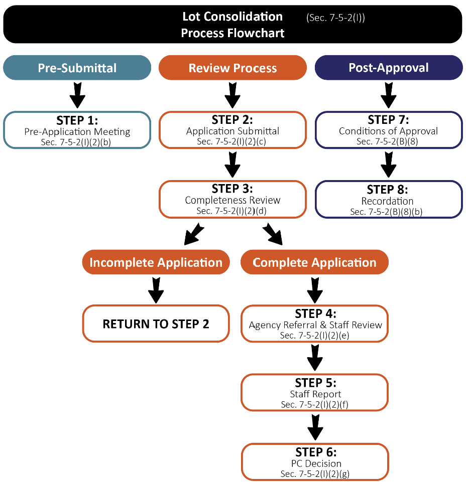
(b)
Pre-Application Meeting. A pre-application meeting may be held in accordance with the provisions set forth in Section 7-5-2(B)(1), Pre-Application Meeting.
(c)
Application Submittal Requirements. The following are the application materials required to be submitted for lot consolidation requests. The Town Manager or designee may waive or alter any of the submittal requirements if they are determined to be inappropriate or unnecessary to determining if the application satisfies applicable standards.
(i)
Basic Application Materials. All items set forth in Section 7-5-2(B)(2), Basic Application Materials.
(ii)
Lot Consolidation Plat. The plat shall contain the following information submitted to the Town of Ridgway on 24" x 36" sheets at a scale suitable for technical review of the application.
a.
A title clearly identifying the plat as a "Lot Consolidation Plat";
b.
Legal description of the property;
c.
North arrow, scale, and legend;
d.
A vicinity map at a suitable scale;
e.
The name and address of the owner(s) of record of all properties being modified and the same information for the applicant(s), if other than the owners,
f.
The name, address and seal of the certifying registered land surveyor and the other individuals preparing the survey plat;
g.
The township, range, section and quarter section(s);
h.
Location and full description of all monuments as required by this Land Development Code and by Title 38, Article 51, C.R.S.;
i.
Permanent monuments shall be set pursuant to Section 38-51-101, C.R.S.;
j.
Block and lot monuments shall be set pursuant to Section 38-51-101, C.R.S.;
k.
Information adequate to locate all monuments shall be noted on the plat;
l.
The location, layout, dimensions, areas, and uses of all lots and blocks numbered consecutively;
m.
The location, layout, dimensions, areas and uses of all outlots and tracts labeled consecutively by letters and include a table identifying ownership and maintenance responsibilities;
n.
Boundary lines, corner pins, and dimensions of the subject property, including land survey data to identify the parcel with section corners, distance and bearing to corners, quarter corners, township and range;
o.
The lengths of all arcs, radii and tangents. Sufficient data shall be shown for all curved lines on the plat to enable reestablishment of the curves in the field;
p.
Location and width of existing roadways, road rights-of-way and parking areas within the site;
q.
All street and road names shall be shown;
r.
Area of each individual lot and the total area of the proposed consolidation;
s.
The boundary lines and dimensions, shown accurately, of all easements, alleyways, sidewalks or paths, and similar features, including all other rights-of-way not otherwise or explicitly mentioned;
t.
The names of abutting subdivisions or, in the case of abutting unplatted property, the notation "unplatted" shall appear;
u.
Significant on-site features including: natural and artificial drainage ways, streams, ponds, waterways, wetland areas, irrigation ditches, hydrologic features and aquatic habitat; geologic features and hazards including slopes, alluvial fans, areas of subsidence, rock outcrops and rockfall areas, radiological and seismic hazard areas, soil types and landslide areas; vegetative cover; dams, reservoirs, excavations, and mines; and any other on-site and off-site features that influence the development;
v.
Known, identified or designated one hundred (100) year flood plains and localized areas subject to periodic flooding. The distance between the mean identifiable high-water mark of any creeks, streams or rivers and the nearest proposed development within the site shall also be shown;
w.
Existing and proposed parking areas, driveways, emergency turn-outs and emergency turnarounds, sidewalks, and paths and their dimensions;
x.
Public Access to the site, and internal circulation. Location, dimension, alignment and names of all existing and proposed streets, drives, alleys and roads on or adjoining the property. The general location and right-of-way width for all arterials and collectors shall be shown;
y.
The location of any engineering for any existing or proposed wastewater systems, water mains, culverts, storm drains, sidewalks, gutters, fire hydrants along with the width and depth of pavement or subgrading to be provided, the depth of burial of all underground lines, pipes and tubing and typical cross sections of the proposed grading of roadways and sidewalks;
z.
Uses and grantees of all existing and proposed easements and rights-of-way on or adjacent to the property and their dimensions;
aa.
The location, use and gross square footage of proposed structures within the subdivision;
bb.
Building envelopes in hazardous areas to protect trees and other natural resources, if deemed appropriate by planning staff;
cc.
Location and layout of lots and blocks, with lots and blocks numbered consecutively, and the dimensions and acreage of each lot;
dd.
Areas for landscaping, and delineation of the type and extent of vegetative cover on the site;
ee.
Existing land uses and zoning on adjoining properties;
ff.
Public or private sources of utility services and facilities;
gg.
Location and dimension of land to be held in common, open space devoted to community use, and land to be dedicated to town; and
hh.
The plat shall include executed certificates, notices, and statements in the standard format provided by the town.
(iii)
Supplemental Materials. The following items may be required to be submitted to the Town of Ridgway:
a.
Final Engineering Reports and Plans;
b.
Final improvements agreement meeting all standards and requirements set forth in Section 7-5-3(B), Improvement Agreement;
c.
Final drainage plan or study calculating historic and proposed surface and stormwater flows and how such flows will be managed;
d.
Final traffic statement or study identifying current and proposed traffic counts and proposed trip generation along with any needed or anticipated improvements to mitigate the projects use on the public transportation network and infrastructure;
e.
Covenants, restrictions, and by-laws, if applicable;
f.
Proof of minimum guaranteed water supply appropriate for the requested use;
g.
Traffic statement or study identifying current and proposed traffic counts and proposed trip generation along with any needed or anticipated improvements to mitigate the projects use on the public transportation network and infrastructure.
(iv)
Additional Requirements.
a.
Any additional information that may be reasonably requested by the Town Manager or designee and determined to be necessary to enable an adequate and comprehensive evaluation of the application.
(d)
Completeness Review. The Town Manager or designee shall review the application for completeness in accordance with the provisions of Section 7-5-2(B)(3), Completeness Review.
(e)
Evaluation by Staff and Referral Agencies. Upon determination of completeness, the Town Manager or designee shall refer the application to additional reviewing agencies as set forth in Section 7-5-2(B)(4), Referral Agencies, and review the application for conformance with the requirements and standards of this Municipal Code.
(f)
Staff Report. A staff report shall be prepared and provided to the reviewing body in accordance with Section 7-5-2(B)(5), Staff Report.
(g)
Review and Action by the Planning Commission.
(i)
The Planning Commission shall review the lot consolidation application in a manner consistent with Table T-5.1 to evaluate compliance with applicable standards. The final decision to approve, approve with conditions, or deny the application shall be made by the Planning Commission in a manner consistent with Table T-5.1 and be based upon the criteria set forth in Section 7-5-2(I)(3), Approval Criteria.
(ii)
The Planning Commission may, in its sole discretion, continue or postpone the meeting to a specified date and time in order to permit preparation of additional information for further review by the Planning Commission prior to making a final decision.
(h)
Post Approval. The applicant shall follow the post approval procedurals in accordance with Section 7-5-2(B)(8), Post Approval, including recording the survey plat with the Ouray County Clerk and Recorder
(3)
Approval Criteria. A lot consolidation may be approved and accepted by the Planning Commission if the application is found to meet the following criteria:
(a)
The proposed consolidation conforms to all applicable requirements for the zone district(s) in which the property is located;
(b)
The proposed consolidation substantially conforms to all other applicable requirements of this code, ordinances, and resolutions; and
(c)
The proposed consolidation is consistent with the applicable portions of the Master Plan in the reasonable judgement of the approving body.
(J)
Resubdivision.
(1)
General Provisions. A resubdivision is required for any request to amend or revise a recorded plat that would not be defined as another type of special land division.
(2)
Review Procedures.
(a)
Review Flowchart. Figure F-5.10, Resubdivision flowchart, depicts the Resubdivision application review process described in greater detail in this section.
Figure F-5.10 Resubdivision Flowchart
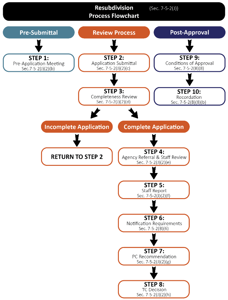
(b)
Pre-Application Meeting. A pre-application meeting may be held in accordance with the provisions set forth in Section 7-5-2(B)(1), Pre-Application Meeting.
(c)
Application Submittal Requirements. The following are the application materials required to be submitted for resubdivision requests. The Town Manager or designee may waive or alter any of the submittal requirements if they are determined to be inappropriate or unnecessary to determining if the application satisfies applicable standards.
(i)
Basic Application Materials. All items set forth in Section 7-5-2(B)(2), Basic Application Materials.
(ii)
Resubdivision Plat. The plat shall contain the following information submitted to the Town of Ridgway on 24" x 36" sheets at a scale suitable for technical review of the application.
a.
A title clearly identifying the plat as a "Resubdivision Plat";
b.
Standard certificate blocks as provided by the town;
c.
Legal description of the property;
d.
North arrow, scale, and legend;
e.
A vicinity map at a suitable scale;
f.
The name and address of the owner(s) of record of the land being platted and the same information for the applicant(s), if other than the owners;
g.
The name, address, and seal of the certifying registered land surveyor and the other individuals preparing the preliminary plat;
h.
The township, range, section and quarter section(s);
i.
Location and full description of all monuments as required by this article and by Title 38, Article 51, C.R.S.:
i.
Permanent monuments shall be set on the external boundary of the subdivision pursuant to Section 38-51-101, C.R.S.; and
ii.
Block and lot monuments shall be set pursuant to Section 38-51-101, C.R.S.
j.
Information adequate to locate all monuments shall be noted on the plat;
k.
The location, layout, dimensions, areas, and uses of all lots and blocks numbered consecutively;
l.
The location, layout, dimensions, areas and uses of all outlots and tracts labeled consecutively by letters and include a table identifying ownership and maintenance responsibilities;
m.
Site data in chart form presenting:
i.
Total area of the proposed subdivision; total area of the developed buildings, driveways and parking areas; total area of nonresidential floor space;
ii.
Total number of proposed lots; breakdown of the lot total by number of lots per use (i.e., residential use, business or commercial and industrial use, and other public and nonpublic uses);
iii.
Total number of proposed off-street parking spaces;
iv.
Total number of dwelling units; total number of dwelling units per structure proposed; and
v.
Total gross density proposed.
n.
Boundary lines, corner pins, and dimensions of the subject property, including land survey data to identify the parcel with section corners, distance and bearing to corners, quarter corners, township and range;
o.
Topography shown at a minimum of two (2) foot contours intervals;
p.
Areas having slopes thirty (30) percent or more, or other significant topographic conditions, topography shown at two (2) foot contour intervals;
q.
Significant on-site features including: natural and artificial drainage ways, streams, ponds, waterways, wetland areas, irrigation ditches, hydrologic features and aquatic habitat; geologic features and hazards including slopes, alluvial fans, areas of subsidence, rock outcrops and rockfall areas, radiological and seismic hazard areas, soil types and landslide areas; vegetative cover; dams, reservoirs, excavations, and mines; and any other on-site and off-site features that influence the development;
r.
Known, identified or designated one hundred (100) year flood plains and localized areas subject to periodic flooding. The distance between the mean identifiable high-water mark of any creeks, streams or rivers and the nearest proposed development within the site shall also be shown;
s.
Existing and proposed parking areas, driveways, emergency turnouts and emergency turnarounds, sidewalks, and paths and their dimensions;
t.
Public Access to the site, and internal circulation. Location, dimension, alignment and names of all existing and proposed streets, drives, alleys and roads on or adjoining the property. The general location and right-of-way widths for all arterials and collectors shall be shown;
u.
The location of any engineering for any existing or proposed wastewater systems, water mains, culverts, storm drains, sidewalks, gutters, fire hydrants along with the width and depth of pavement or subgrading to be provided, the depth of burial of all underground lines, pipes and tubing and typical cross sections of the proposed grading of roadways and sidewalks;
v.
Uses and grantees of all existing and proposed easements and rights-of-way on or adjacent to the property and their dimensions;
w.
The location, use and gross square footage of proposed structures within the subdivision;
x.
Anticipated number of employees for proposed commercial or industrial uses;
y.
Building envelopes in hazardous areas to protect trees and other natural resources, if deemed appropriate by planning staff;
z.
Location and layout of lots and blocks, with lots and blocks numbered consecutively, and the dimensions and acreage of each lot;
aa.
Areas for landscaping, and delineation of the type and extent of vegetative cover on the site;
bb.
Existing land uses and zoning on adjoining properties;
cc.
Public or private sources of utility services and facilities; and
dd.
Location and dimension of land to be held in common, open space devoted to community use, and land to be dedicated to town.
(iii)
Final Landscape Plan. The landscape plan shall not include any plants or species identified as noxious weeds or invasive species by the Ouray County Weed District or on the USDA Colorado State Noxious Weed list. When landscaping is proposed, the landscape plan shall include the following elements:
a.
Topographic information at two (2) foot contour intervals;
b.
Location of all lot lines and improvements to the property and location of any easements of record;
c.
Location of all existing and proposed buildings, driveways, parking lots, walkways, sidewalks, and other impervious surfaces to remain or exist on the property;
d.
A plant schedule which identifies plants, species, and minimum size to be installed on the property;
e.
Identification of areas where existing vegetation will be preserved;
f.
Identification of areas where landscaping will be installed; and
g.
If an irrigation system is proposed, an irrigation plan depicting the location of irrigation lines and spray heads, irrigation zones, spray areas of each head, and make and model of irrigation system and sprinkler heads.
(iv)
Final Engineering Reports and Plans.
a.
Final plan and profile design of all proposed streets, sidewalks, trails, walkways, and bikeways;
b.
Final plan and profile design of all surface drainage and storm sewer conveyance facilities including, but not limited to, inlet locations, size and location of pipes, retention or detention facilities, and required water quality and erosion control measures;
c.
Final engineering design and construction features for any bridges, culverts, or other drainage structures to be constructed;
d.
Mitigation of any geologic hazard(s) impacting the project site;
e.
Final plan and profile design of all wastewater collection and water supply and distribution system improvements necessary;
f.
Final cost estimates for all public improvements.
(v)
Supplemental Materials. The following items may be required to be submitted to the Town of Ridgway:
a.
Final improvements agreement meeting all standards and requirements set forth in Section 7-5-3(B), Improvement Agreement;
b.
Final drainage plan or study calculating historic and proposed surface and stormwater flows and how such flows will be managed;
c.
Final traffic statement or study identifying current and proposed traffic counts and proposed trip generation along with any needed or anticipated improvements to mitigate the projects use on the public transportation network and infrastructure;
d.
Covenants, restrictions, and by-laws, if applicable;
e.
Proof of minimum guaranteed water supply appropriate for the requested use;
f.
Traffic statement or study identifying current and proposed traffic counts and proposed trip generation along with any needed or anticipated improvements to mitigate the projects use on the public transportation network and infrastructure.
(vi)
Additional Requirements. Any additional information that may be reasonably requested by the Town Manager or designee and determined to be necessary to enable an adequate and comprehensive evaluation of the application.
(d)
Completeness Review. The Town Manager or designee shall review the application for completeness in accordance with the provisions of Section 7-5-2(B)(3), Completeness Review.
(e)
Evaluation by Staff and Referral Agencies. Upon determination of completeness, the Town Manager or designee shall refer the application to additional reviewing agencies as set forth in Section 7-5-2(B)(4), Referral Agencies, and review the application for conformance with the requirements and standards of this Municipal Code.
(f)
Staff Report. A staff report shall be prepared and provided to the reviewing body in accordance with Section 7-5-2(B)(5), Staff Report.
(g)
Review and Recommendation by the Planning Commission. The Planning Commission shall review the resubdivision application in a manner consistent with Table T-5.1 to evaluate compliance with applicable standards. Following its review of the application, the Planning Commission may provide either a recommendation to approve, approve with conditions, or deny the application to the Town Council based on the criteria set forth in Section 7-5-2(J)(3), Approval Criteria.
The Planning Commission may, in its sole discretion, continue or postpone the public hearing to a specified date and time in order to permit preparation of additional information for further review by the Planning Commission prior to providing a recommendation to the Town Council.
(h)
Review and Action by the Town Council.
(i)
The final decision to approve, approve with conditions, or deny a resubdivision application shall be made by the Town Council in a manner consistent with Table T-5.1 and be based upon the criteria set forth in Section 7-5-2(J)(3), Approval Criteria.
(ii)
The Town Council may, in its sole discretion, continue or postpone the public hearing to a specified date and time in order to permit preparation of additional information for further review by the Town Council prior to making a final decision.
(i)
Post Approval. The applicant shall follow the post approval procedures in in accordance with Section 7-5-2(B)(8), Post Approval, including recording the resubdivision with the Ouray County Clerk and Recorder.
(3)
Approval Criteria. A resubdivision may be approved and accepted by the Town Council if the application is found to meet the following criteria:
(a)
The proposed subdivision conforms to all applicable requirements for the zone district(s) in which the property is located;
(b)
The proposed subdivision substantially conforms to all other applicable requirements of this code, ordinances, and resolutions; and
(c)
The proposed subdivision is consistent with the applicable portions of the Master Plan in the reasonable judgement of the approving body.
(K)
Townhouse Plat.
(1)
General Provisions. Any division of a single-unit or multi-unit structure or structures into two or more fee simple estates consisting of townhouses for the purpose, whether immediate or future, of sale or building development. A townhouse may be resubdivided per the Town-approved foundation line shown on the site plan at the risk of the subdivider, or it may be resubdivided once the foundation has been poured.
(a)
Notwithstanding the definition of a "Townhouse" in Chapter 7, Article 9, a townhouse lot may be subdivided prior to the construction of the foundation for the townhouse provided that:
(i)
The final plat of any such townhouse lot shall contain a plat note that provides as follows:
a.
Within ninety (90) days after the construction of the foundation for the townhouse, the owner(s) of the townhouse lot shall have a survey of the location of the foundation prepared and, along with the owner(s) of any property that abuts the townhouse lot, shall make and pursue to completion an application to the Town to amend the plat of the townhouse that causes the townhouse lot to be coterminous with the foundation of the townhouse as constructed; and
(ii)
Within ninety (90) days after the construction of the foundation for the townhouse, the owner(s) of the townhouse lot shall have a survey of the location of the foundation prepared and, along with the owner(s) of any property that abuts the townhouse lot, shall make and pursue to completion an application to the Town to amend the plat of the townhouse that cause the townhouse lot to be coterminous with the foundation of the townhouse as constructed.
(b)
With respect to a townhouse lot that has been subdivided prior to the construction of the townhouse or its foundation, it is unlawful:
(i)
For the owner(s) of the lot to fail to, within ninety (90) days after the construction of the foundation, have a survey of the location of the foundation prepared; and
(ii)
For the owner(s) of the lot and the owner(s) of any property that abuts the townhouse lot, to fail to, within ninety (90) days after the construction of the foundation, make and pursue to completion an application to the Town to amend the plat of the townhouse lot that causes the townhouse lot to be coterminous with the foundation of the townhouse as constructed.
(2)
Review Procedures.
(a)
Review Flowchart. Figure F-5.11, Townhouse flowchart, depicts the townhouse application review process described in greater detail in this section.
Figure F-5.11 Townhouse Plat Flowchart
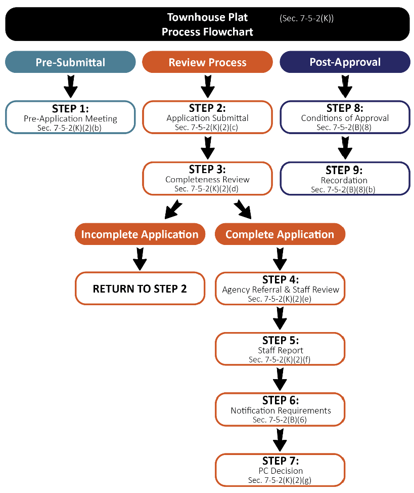
(b)
Pre-Application Meeting. A pre-application meeting may be held in accordance with the provisions set forth in Section 7-5-2(B)(1), Pre-Application Meeting.
(c)
Application Submittal Requirements. The following are the application materials required to be submitted for townhouse requests. The Town Manager or designee may waive or alter any of the submittal requirements if they are determined to be inappropriate or unnecessary to determining if the application satisfies applicable standards.
(i)
Basic Application Materials. All items set forth in Section 7-5-2(B)(2), Basic Application Materials.
(ii)
Written Narrative. A written narrative shall be submitted addressing all of the following items and any other information:
a.
A general written narrative describing the purpose of the project;
b.
Description of the current land use(s) on the property, the characteristics of the land within the property boundaries, and the current land use on all adjoining property; and
c.
A time schedule for development.
(iii)
Townhouse Plat. The townhouse plat shall contain the following information submitted to the Town of Ridgway on 24" x 36" sheets at a scale suitable for technical review of the application.
a.
A title clearly identifying the plat as a "Townhouse Plat";
b.
Standard certificate blocks as provided by the town;
c.
Legal description of the property;
d.
North arrow, scale, and legend;
e.
A vicinity map at a suitable scale;
f.
The name and address of the owner(s) of record of the land being platted and the same information for the applicant(s), if other than the owners;
g.
The name, address, and seal of the certifying registered land surveyor and the other individuals preparing the preliminary plat;
h.
The township, range, section and quarter section(s);
i.
Location and full description of all monuments as required by this article and by Title 38, Article 51, C.R.S.:
i.
Permanent monuments shall be set on the external boundary of the subdivision pursuant to §38-51-101, C.R.S.; and
ii.
Block and lot monuments shall be set pursuant to §38-51-101, C.R.S.
j.
Information adequate to locate all monuments shall be noted on the plat;
k.
The location, layout, dimensions, areas, and uses of all lots and blocks numbered consecutively;
l.
The location, layout, dimensions, areas and uses of all outlots and tracts labeled consecutively by letters and include a table identifying ownership and maintenance responsibilities;
m.
Site data in chart form presenting:
i.
Total area of the proposed subdivision; total area of the developed buildings, driveways and parking areas; total area of nonresidential floor space;
ii.
Total number of proposed lots; breakdown of the lot total by number of lots per use (i.e., residential use, business or commercial and industrial use, and other public and nonpublic uses);
iii.
Total number of proposed off-street parking spaces;
iv.
Total number of dwelling units; total number of dwelling units per structure proposed; and
v.
Total gross density proposed.
n.
Boundary lines, corner pins, and dimensions of the subject property, including land survey data to identify the parcel with section corners, distance and bearing to corners, quarter corners, township and range;
o.
Topography at the following minimum contour intervals:
i.
Subdivision with one or more lots less than two (2) acres in size, topography shown at two (2) foot contour intervals.
ii.
Subdivision with all lots two (2) acres or greater in size, topography shown at five (5) foot contour intervals.
iii.
Areas having slopes thirty (30) percent or more, or other significant topographic conditions, topography shown at five (5) foot contour intervals.
p.
Significant on-site features including: natural and artificial drainage ways, streams, ponds, waterways, wetland areas, irrigation ditches, hydrologic features and aquatic habitat; geologic features and hazards including slopes, alluvial fans, areas of subsidence, rock outcrops and rockfall areas, radiological and seismic hazard areas, soil types and landslide areas; vegetative cover; dams, reservoirs, excavations, and mines; and any other on-site and off-site features that influence the development;
q.
Known, identified or designated one hundred (100) year flood plains and localized areas subject to periodic flooding. The distance between the mean identifiable high-water mark of any creeks, streams or rivers and the nearest proposed development within the site shall also be shown;
r.
Existing and proposed parking areas, driveways, emergency turn-outs and emergency turnarounds, sidewalks, and paths and their dimensions;
s.
Public Access to the site, and internal circulation. Location, dimension, alignment and names of all existing and proposed streets, drives, alleys and roads on or adjoining the property. The general location and right-of-way width for all arterials and collectors shall be shown;
t.
The location of any preliminary engineering for any existing or proposed wastewater systems, water mains, culverts, storm drains, sidewalks, gutters, fire hydrants along with the width and depth of pavement or subgrading to be provided, the depth of burial of all underground lines, pipes and tubing and typical cross sections of the proposed grading of roadways and sidewalks;
u.
Uses and grantees of all existing and proposed easements and rights-of-way on or adjacent to the property and their dimensions;
v.
The location, use and gross square footage of proposed structures within the subdivision;
w.
Building envelopes in hazardous areas to protect trees and other natural resources, if deemed appropriate by planning staff;
x.
Location and layout of lots and blocks, with lots and blocks numbered consecutively, and the dimensions and acreage of each lot;
y.
Areas for landscaping, and delineation of the type and extent of vegetative cover on the site;
z.
Existing land uses and zoning on adjoining properties;
aa.
Public or private sources of utility services and facilities; and
bb.
Location and dimension of land to be held in common, open space devoted to community use, and land to be dedicated to town.
(iv)
Supplemental Materials. The following items may be required to be submitted to the Town of Ridgway:
a.
Drainage plan or study calculating historic and proposed surface and stormwater flows and how such flows will be managed.
b.
Traffic statement or study identifying current and proposed traffic counts and proposed trip generation along with any needed or anticipated improvements to mitigate the projects use on the public transportation network and infrastructure.
c.
Proof of minimum guaranteed water supply appropriate for the requested use.
(v)
Additional Requirements. In addition to the provisions for final townhouse subdivision approval, the following is needed:
a.
A map showing all common areas (general, limited common area), usages of the building and grounds, and the building showing horizontal boundaries for the interior division of all units;
b.
A copy of the Townhouse Association's Articles of Incorporation, bylaws, and covenants;
c.
In addition, if there are any restrictive covenants, conditions, or restrictions other than specified in the declaration, they shall be filed concurrently to filing of the final plat;
d.
A copy of the declaration applicable to the Townhouse project, as defined in Section 38-33-105, C.R.S. 1973, as amended and/or as may be required pursuant to the Colorado Common Interest Ownership Act, C.R.S. 38-33.3-101 et. Seq., as amended;
e.
A maintenance plan that states:
i.
The responsible entity for repair and maintenance of common areas.
ii.
What will be included in the maintenance program, including, but not limited to, provisions for snow removal, trash removal, maintenance of pools, hot tubs, common areas, and other amenities.
iii.
The mechanism used to fund the management and maintenance activities of the development.
f.
A management plan that states:
i.
The responsible party for managing the common area, lodging reservations, etc.
ii.
Provisions for selecting, appointing, and securing management.
iii.
Responsibilities and duties of the management entity.
iv.
The responsible party for coordinating the use and rental unit occupancy of those units that are used for short-term lodging.
g.
Any additional information that may be reasonably requested by the Town Manager or designee and determined to be necessary to enable an adequate and comprehensive evaluation of the application.
(d)
Completeness Review. The Town Manager or designee shall review the application for completeness in accordance with the provisions of Section 7-5-2(B)(3), Completeness Review.
(e)
Evaluation by Staff and Referral Agencies. Upon determination of completeness, the Town Manager or designee shall refer the application to additional reviewing agencies as set forth in Section 7-5-2(B)(4), Referral Agencies, and review the application for conformance with the requirements and standards of this Municipal Code.
(f)
Staff Report. A staff report shall be prepared and provided to the reviewing body in accordance with Section 7-5-2(B)(5), Staff Report.
(g)
Review and Action by the Planning Commission.
(i)
The Planning Commission shall review the condominium plat application in a manner consistent with Table T-5.1 to evaluate compliance with applicable standards. The final decision to approve, approve with conditions, or deny the application shall be made by the Planning Commission in a manner consistent with Table T-5.1 and be based upon the criteria set forth in Section 7-5-2(K)(3), Approval Criteria.
(ii)
The Planning Commission may, in its sole discretion, continue or postpone the meeting to a specified date and time in order to permit preparation of additional information for further review by the Planning Commission prior to making a final decision.
(h)
Post Approval. The applicant shall follow the post approval procedurals in accordance with Section 7-5-2(B)(8), Post Approval, including recording the survey plat with the Ouray County Clerk and Recorder.
(3)
Approval Criteria. A townhouse plat may be approved and accepted by the Planning Commission if the application is found to meet the following criteria:
(a)
The proposed consolidation conforms to all applicable requirements for the zone district(s) in which the property is located;
(b)
The proposed consolidation substantially conforms to all other applicable requirements of this code, ordinances, and resolutions; and
(c)
The proposed consolidation is consistent with the applicable portions of the Master Plan in the reasonable judgement of the approving body.
(L)
Right-of-Way Vacation.
(1)
General Provisions. The vacation of interests in rights-of-way owned or otherwise held by the Town of Ridgway shall be in accordance with the provisions of this Section 7-5-2(L), Right-of-Way Vacation, and Part 3 of Article 2 of Title 43, C.R.S.
(2)
Review Procedures.
(a)
Review Flowchart. Figure F-5.12, Right-of-Way Vacation flowchart, depicts the right-of-way application review process described in greater detail in this section.
Figure F-5.12 Right-of-Way Vacation Flowchart
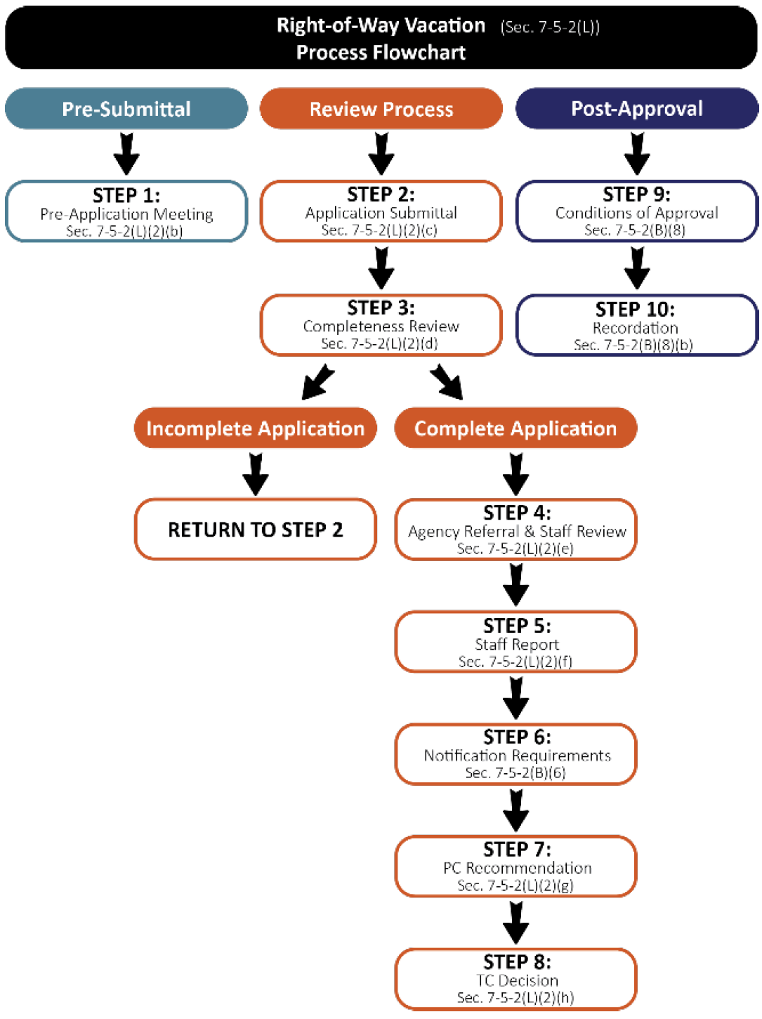
(b)
Pre-Application Meeting. A pre-application meeting may be held in accordance with the provisions set forth in Section 7-5-2(B)(1), Pre-Application Meeting.
(c)
Application Submittal Requirements. The following are the application materials required to be submitted for right-of-way vacation requests. The Town Manager or designee may waive or alter any of the submittal requirements if they are determined to be inappropriate or unnecessary to determining if the application satisfies applicable standards.
(i)
Basic Application Materials. All items set forth in Section 7-5-2(B)(2), Basic Application Materials.
(ii)
Supplemental Materials.
a.
Legal description of the proposed right-of-way or portion thereof to be vacated, prepared, signed and sealed by a Colorado licensed Professional Land Surveyor;
b.
Name and mailing address of all property owners adjacent to or otherwise affected by the request;
c.
A copy of the original, recorded conveyance document in which the right-of-way was dedicated and conveyed for public purposes; and
d.
Narrative describing the reasons for the request for vacation, a description of the planned use(s) for the right-of-way proposed for vacation and description of the means of access to all properties affected by the request.
(iii)
Additional Requirements. Any additional information that may be reasonably requested by the Town Manager or designee and determined to be necessary to enable an adequate and comprehensive evaluation of the application.
(d)
Completeness Review. The Town Manager or designee shall review the application for completeness in accordance with the provisions of Section 7-5-2(B)(3), Completeness Review.
(e)
Evaluation by Staff and Referral Agencies. Upon determination of completeness, the Town Manager or designee shall refer the application to additional reviewing agencies as set forth in Section 7-5-2(B)(4), Referral Agencies, and review the application for conformance with the requirements and standards of this Municipal Code.
(f)
Staff Report. A staff report shall be prepared and provided to the reviewing body in accordance with Section 7-5-2(B)(5), Staff Report.
(g)
Review and Recommendation by the Planning Commission.
(i)
The Planning Commission shall review the right-of-way vacation application in a manner consistent with Table T-5.1 to evaluate compliance with applicable standards. Following its review of the application, the Planning Commission may provide either a recommendation to approve, approve with conditions, or deny the application to the Town Council based on the criteria set forth in Section 7-5-2(L)(3), Approval Criteria.
(ii)
The Planning Commission may, in its sole discretion, continue or postpone the public hearing to a specified date and time in order to permit preparation of additional information for further review by the Planning Commission prior to providing a recommendation to the Town Council.
(h)
Review and Action by the Town Council.
(i)
The final decision to approve, approve with conditions, or deny a right-of-way vacation application shall be made by the Town Council in a manner consistent with Table T-5.1 and be based upon the criteria set forth in Section 7-5-2(L)(3), Approval Criteria.
(ii)
The Town Council may, in its sole discretion, continue or postpone the public hearing to a specified date and time in order to permit preparation of additional information for further review by the Town Council prior to making a final decision.
(i)
Post Approval. Upon approval of a right-of-way vacation by the Town Council, title to the vacated right-of-way shall vest with adjacent property owners or the original grantor or its successors-in-interest as provide by §43-2-301, et seq., C.R.S., as amended.
(3)
Approval Criteria. Prior to making a decision on a right-of-way vacation application, the Town Council, shall consider the following review criteria and find that each criterion has been met or determined to be inapplicable:
(a)
Vacation of the right-of-way will not leave any adjoining land without access to an established public right-of-way or private access easement connecting such land to another established public right-of-way;
(b)
Vacation of the right-of-way is consistent with the applicable portions of the Master Plan in the reasonable judgement of the approving body;
(c)
Vacation of the right-of-way will not have a negative impact on the transportation network and infrastructure of the town; and
(d)
Adequate easements have been reserved for use and/or maintenance by the town or other utility agencies.
7-5-3 - SUBDIVISION REQUIRED IMPROVEMENTS.
(A)
Required Improvements. The following improvements shall be constructed at the expense of the subdivider in accordance with the design standards provided by these Regulations:
(1)
Survey monuments.
(2)
A sewer collection system connected to the Town's sewage system shall be required and dedicated to the Town.
(3)
A domestic water distribution system connected to the Town's system and dedicated to the Town.
(4)
A fire prevention system.
(5)
Electricity, telephone and CATV.
(6)
Streets within and adjacent to the subdivision as necessary to provide access to each lot. Existing streets maintained by the Town for public use shall be improved by the subdivider to the extent necessary to provide access to abutting lots and to provide proper drainage, grade and sidewalk grade. Streets shall be paved in circumstances where required by Town street specifications. Streets shall be dedicated to the Town.
(7)
Street signs, stop signs or similar traffic central devices.
(8)
A storm drainage system.
(9)
Streetlights.
(10)
Curb and gutter shall be provided along paved streets and where required by Town specifications. Concrete sidewalk shall be provided along all abutting streets except when the Planning Commission and Town Council determine that sidewalk is necessary on only one side of a local street because of the shortness of the street, unusual topographical factors or other circumstances which alleviate the need for such sidewalk. In those cases where the proper grade of the sidewalk cannot be determined, the Planning Commission and Town Council may authorize the execution and recording of an agreement on forms provided by the Town to join in an improvement district to install the sidewalk at such time as sidewalk construction becomes feasible instead of immediate construction.
(11)
Public trail easements shall be provided and constructed as described in the Town's Land Use Plan or Parks and Trails Map, as amended from time to time, and including the Uncompahgre River Way Trail. The Town may waive this requirement if the property at issue has existing trail easements dedicated to the Town of Ridgway.
(B)
Subdivision Improvements Agreement.
(1)
Applicability. All applicants granted subdivision approval, or approval of public improvements deemed necessary to comply with required adequate public improvements as set forth in these Land Development Regulations, shall timely, completely, and satisfactorily construct or install all required improvements and infrastructure as called for in these Land Development Regulations and/or as may have been specified as a condition of approval. All improvements and infrastructure intended for public use shall be dedicated and/or transferred to the town, or appropriate agency, free of all liens and encumbrances.
(2)
Agreement and Guarantee. No final division of land shall be executed by the town and no building permits shall be issued for any lot, parcel or property within a division of land as regulated by this Article 5, Subdivision Regulations involving or requiring the installation of public improvements unless and until an improvement agreement is prepared and executed pursuant to this Section 7-5-3(B), Subdivision Improvement Agreement. Such agreement shall be recorded simultaneously with the final division of land with the Ouray County Clerk and Recorder.
(a)
Contents of Agreement. Such agreement shall, at a minimum, set forth:
(i)
Construction specifications for required public and private improvements;
(ii)
A construction and completion schedule;
(iii)
Security and guarantees concerning the timely and satisfactory completion of the improvements; and
(iv)
The terms and conditions for the acceptance of the improvements by the town.
(b)
Timing of Agreement. The improvement agreement shall include a requirement that all improvements be maintained by the developer/subdivider at the cost of the developer/subdivider until such improvements have been fully accepted by the town.
(c)
Agreement to Run with the Land. The improvement agreement shall run with the land and bind all successors, heirs, and assignees of the developer/subdivider.
(d)
Security. The improvement agreement shall include a requirement for the posting of adequate financial security to ensure the timely, complete, and satisfactory construction or installation of all improvements and infrastructure as called for in the agreement.
(i)
Amount of Security. Security shall be in an amount not less than one-hundred and fifteen (115) percent of the engineers cost estimate to complete all improvements or infrastructure and may be provided by letter of credit, cash escrow, or other financial instrument as approved by the Town Council within its sole discretion.
(ii)
Letter of Credit. If a developer/subdivider posts a letter of credit as security, it shall:
a.
Be irrevocable;
b.
Be for a term, inclusive of renewals, sufficient to cover the completion, maintenance, and warranty periods as required in Section 4.14.B.2, Timing of Agreement; and
c.
Require only that the town present the letter of credit on demand and an affidavit signed by the Town Manager attesting to the town's right to draw funds under the letter of credit.
(iii)
Cash Escrow. If a developer/subdivider posts a cash escrow, the escrow instructions shall provide:
a.
That the developer/subdivider shall have no right to a return of any of the funds except as provided in Section 4.14.B.4.d, Reduction of Security; and
b.
That the escrow agent shall have a legal duty to deliver the funds to the town whenever the Town Manager presents an affidavit to the agent attesting to the town's right to receive funds, whether or not the developer/subdivider protests that right.
(iv)
Reduction of Security.
a.
Upon preliminary acceptance of a public improvement or public infrastructure, the town shall release all but fifteen (15) percent of the amount of financial security posted to secure the successful and timely completion of same, so long as the developer is not in default of any provision of the improvement agreement.
b.
The residual fifteen (15) percent retained by the town shall act as security for the developer's/subdivider's guarantee that the public improvements and infrastructure remain free of defect during the applicable warranty period. The developer/subdivider may at any time during the preliminary acceptance or warranty period offer to provide a substitute or supplemental form of financial security to that security as originally posted with and/or retained by the town. The town may accept substitute or supplemental forms of security in its sole discretion.
(v)
Temporary Improvements. The applicant shall build and pay for all costs of temporary improvements required by the town and shall maintain those temporary improvements for the period specified by the Town Council. Prior to construction of any temporary facility or improvement, the developer/subdivider shall file with the town a separate public improvements agreement and a letter of credit or cash escrow in the agreed upon amount for temporary facilities, which agreement and credit or escrow shall ensure that the temporary facilities will be property constructed, maintained, and removed.
(vi)
Special Districts.
a.
Required public improvements shall be made by the developer/subdivider, at its expense, without reimbursement by the town or any improvement district except that, as may be allowed under state law, the developer/subdivider may form or cause to be formed a special district or districts to construct and finance the construction of required public improvements excluding lot improvements on individual lots.
b.
If the developer/subdivider does form or cause to be formed a special district for the purposes identified in this section, the town shall not release the developer/subdivider from its obligations under any public improvements agreement nor shall the town release any security, in whole or in part, until the special district has sold bonds or otherwise certifies to the town that it has an absolute right to raise revenues sufficient to construct, maintain, and warrant the quality of the required public improvements.
(vii)
Failure to Complete Improvements
a.
For developments/subdivisions without an executed agreement or security, improvements shall be completed within a period specified by the town, or the associated development/subdivision application approval shall be deemed to have expired;
b.
In those cases where a public improvements agreement has been executed and security has been posted and required public improvements have not been installed within the terms of the agreement, the town may:
i.
Declare the agreement to be in default and require that all the improvements be installed regardless of the extent of the building development at the time the agreement is declared to be in default;
ii.
Suspend or revoke authorization for subdivision, including without limitation, suspension or revocation of previously issued building permits and suspend issuance of further building permits until the improvements are completed and record a document to that effect for the purpose of public notice.
c.
No certificate of occupancy shall be processed or issued by the town for any lot or building within a development prior to the complete and satisfactory installation of all development improvements or infrastructure required to serve such lot or building, and the payment of any and all development fees then due to the town by the developer/subdivider;
d.
Obtain funds under the security and complete improvements itself or through a third party;
e.
Assign its right to receive funds under the security to any third party, including a subsequent owner of the subdivision for which improvements were not constructed, in whole or in part, in exchange for that subsequent owner's promise to complete improvements in the subdivision; and/or
f.
Exercise any other rights available under the law.
7-5-4 - DESIGN STANDARDS.
(A)
General Provisions:
(1)
All subdivisions shall conform to the minimum design standards of, this Section. The Town Council may allow deviation from these standards if it determines that unusual topography or a hardship exists, or that alternative standards will more effectively protect the quality of the subdivision and the public welfare, or more effectively achieve the purposes of these Subdivision Regulations.
(2)
All subdivisions shall be developed in accordance with the Town's Master Plans, Zoning Regulations, Floodplain Regulations, and other applicable Town ordinances, regulations and specifications.
(B)
Streets, Alleys, Lots and Blocks:
(1)
All streets and alleys shall be constructed and designed in accordance with Town Street and Road Specifications.
(2)
All lots shall have access to a street connected to the public street system. In order to ensure access by emergency service responders, any new subdivision street system must be connected by at least two separate routes to the state highway system.
(3)
Access to any public highway under the jurisdiction of the State Department of Highways shall be subject to the provisions of the State Highway Access Code.
(4)
Driveways and street access shall be subject to Subsection 14-5-15(B).
(5)
Streets shall be aligned to join with planned or existing streets and shall be designed to bear a logical relationship to the topography.
(6)
Intersections shall approximate right angles as closely as possible.
(7)
Cul-de-sacs shall be permitted, provided they are not more than 500 feet in length and have a turn-around diameter of at least 100 feet. Surface drainage shall be toward the intersecting street, or if this is not possible, a drainage easement shall be required through the cul-de-sac.
(8)
Dead-end streets, with the exception of cul-de-sacs, shall be prohibited unless they are designed to connect with future streets in adjacent land that has not been platted, in which cases a temporary turn-around easement of 80 feet shall be required.
(9)
Restriction of access shall be required when a subdivision or portion thereof adjoins an arterial highway. Marginal access streets, reverse frontage with screen planting contained in a non-access reservation, deep lots or similar treatment shall be required to reduce the impact of the traffic on residential properties and to avoid interference with the movement of the traffic on thoroughfares.
(10)
Half streets shall be prohibited.
(11)
Reverse curves on major arterials shall be joined by a tangent at least 200 feet in length.
(12)
Reserve strips controlling access to streets are permitted only if control of such strips is given to the Town.
(13)
Street, alley and easement right-of-way widths and grades shall not be less than the following:
(14)
Alleys shall be provided in commercial and industrial areas, except that this requirement may be waived where other provisions are made and approved for service access.
(15)
Block lengths and widths shall be suitable for the uses contemplated and shall be adequate for requirements pertaining to minimum lot sizes and dimensions.
(16)
Lots with double frontage shall be avoided, except where essential to separation from major arterials or from incompatible land uses.
(17)
No single lot shall be divided by a district (i.e., zoning, sanitation, fire, etc.), municipal or county boundary line.
(18)
Except in the case of condominium building, commercial building, or a property line between duplex or townhouse units, no subdivision shall be approved that creates a property line that runs through a building.
(19)
Side lot lines shall be substantially at right angles or radial to street lines.
(20)
The Town may require any street, sidewalk and related infrastructure, on a steep slope, or where there is any evidence to suspect problems due to instability, or other adverse soil conditions, to be owned and maintained by the lot owners or an owners' association, or may require an extended warranty of maintenance and repair from the subdivider. A slope easement shall be dedicated to the Town to accommodate the area of any cut or fill off of the right-of-way and an additional ten feet beyond the cut or fill. Such easement shall allow the Town to maintain the slope, cut and fill, and street improvements. Additionally, such easements may be accompanied by a plat not holding the Town harmless on account of any sloughing or disturbance due to maintenance, the cut, or the fill.
(C)
Public Utilities and Utility Easements:
(1)
Utility easements shall be a minimum of 20 feet centered on the rear or side lot lines, or where appropriate, ten feet on either side of a street.
(2)
All utilities shall be installed underground unless existing utilities are overhead, and the existing poles can be used.
(3)
Utility easement widths may be reduced through written agreements with Utility Providers and the Town Engineer.
(D)
Water and Sewer Systems: Water, fire prevention and sewer systems shall be designed by a professional engineer and constructed in accordance with good engineering practices to Town design and construction standards and specifications.
(E)
Curb, Gutter and Sidewalks: Curb, gutter and sidewalks shall be designed and constructed in accordance with Town design and construction standards and specifications and good engineering practices.
(F)
Monuments: Monuments shall be placed at the corners of all street intersections, at the intersections of the boundary of the subdivision with street right-of-way lines, at angle points and points of curve in each street, and at points of change and direction of the exterior of the subdivision and at other locations required by statute. The top of the monument shall have a metal cap set flush to identify the location. Lot corners shall be marked as required by law. Monuments shall be constructed as provided in Town street and road specifications.
(G)
Drainage Systems: Drainage systems shall be provided in accordance with the final plat as approved. Drainage easements shall generally direct the flow to the front of the lots or to natural drainage ways as such exist, utilizing a minimum 20-foot easement. Where water courses or ditches traverse the subdivision, lots and improvements shall be designed and provided to protect against flooding in accordance with the Town's Flood Plain Regulations. The drainage system shall be designed to avoid increasing the discharge to property outside the subdivision unless agreed to by the owner of any property affected.
(H)
Other Improvements: Any other improvements provided shall comply with any applicable Town standards and specifications and shall be designed and constructed in accordance with good engineering practices.
(I)
Plat Notes:
(1)
Plat notes and covenants may be required by the Town as appropriate to implement the provisions of these regulations, and to hold the Town harmless from risks associated with natural hazards and conditions or other risks, which should be borne by the subdivider. Plat notes shall be on Town approved forms, run with the land and bind all successors in interest thereto.
(2)
Town standard plat notes shall be obtained at the Ridgway Town Hall.
(3)
Any plat notes on prior Town Subdivision or PUD plats, or plats of survey which created new parcels, including those notes requiring release by the Town Council, shall not be enforceable by the Town, and are superseded unless reiterated on the plat. Plat notes which are intended to benefit lot owners within the subdivision will be reiterated unless such owners sign a document to indicate their concurrence with the proposed plat notes.
(4)
Plat notes on prior Town plats are superseded unless reiterated or incorporated by reference on the plat.
(5)
Plat notes may be required in the following circumstances.
(a)
To set out maintenance requirements of the lot owners, enforceable by the Town, for various improvements such as drainage, detention and retention facilities, commonly owned areas, private streets and other private improvements;
(b)
To require engineered foundations in areas of steep slopes or other questionable soil conditions together with provisions giving notice of, and holding the Town harmless from, potential problems due to slopes, cut and fill areas, adverse soil conditions or other natural hazards.