
Riverside City Zoning Code
CHAPTER 1113
SITE DESIGN AND IMPROVEMENT STANDARDS
1113.01 - Purpose.
Chapter 1113 expands upon the zoning district and subdivision development standards of Chapters 1109 and 1111 by addressing additional details of site planning, project design, and the operation of land uses. The intent of these standards is to ensure that proposed development is compatible with existing and future development on neighboring properties, and produces an environment of stable and desirable character, consistent with the Comprehensive Plan.
(Ord. 17-O-618, Passed 3-16-17)
1113.03 - Applicability.
The requirements of this Chapter 1113 shall apply to all proposed development and new land uses, except as specified in Chapter 1103 (Nonconforming Uses, Lots, Structures, and Combination), and shall be considered in combination with the standards for the applicable zoning district in Chapter 1109 (Zoning Development Standards).
(Ord. 17-O-618, Passed 3-16-17)
1113.05 - Required improvements.
A.
Streets (See Section 1111.05.B.).
B.
Sidewalks (See Section 1111.05.D.).
C.
Water System (See Section 1111.05.E.).
D.
Sanitary Sewer (See Section 1111.05.F.).
E.
Storm Sewer and Drainage (See Section 1113.17).
F.
Monuments (See Section 1111.05.H.5.).
G.
Street Trees (See Section 1113.15).
H.
Traffic Control Devices (See Section 1111.05.H.7.).
I.
Street and Walkway Lighting (See Section 1111.05.H.8.).
J.
Fire Protection (See Section 1111.05.H.9.).
K.
Other Development Improvements (See Section 1111.05.I.).
L.
Guarantee of Construction and Installation of Improvements; Inspections (See Section 1111.11).
(Ord. 17-O-618, Passed 3-16-17)
1113.07 - Landscaping, screening and buffering standards.
Whenever any property is affected by these landscape requirements, the property owner or developer shall prepare a landscape plan for submittal to the Planning Commission or designee for review.
A.
Landscape Plan Content. The contents of the landscape plan shall include the following:
1.
Site plan, drawn to an easily readable scale no smaller than one inch equals 20 feet; showing and labeling by name and dimensions, all existing and proposed property lines, easements, building and other structures, vehicular use areas including parking stalls, driveways, service areas, square footage, etc. locations of structures on adjoining parcels, water outlets and landscape material, including botanical name and common name, installation size, on center planting dimensions where applicable, and quantities for all plants used and all existing trees;
2.
Typical elevations and/or cross sections as may be required;
3.
Title block with the pertinent names and addresses, property owner, person drawing plan, scale, date, north arrow, generally orient plan so that north is to top of plan and zoning district;
4.
Site grading with a minimum of two foot contour intervals must be included.
B.
Implementation of Landscaping Plan. Where landscaping is required, no Certificate of Zoning Compliance shall be issued by the City of Riverside until the required landscaping plan has been submitted and approved by the PPMD. It shall not be legal to use the property (as opposed to the structure) until landscaping is completed as shown on the approved plan.
C.
Posting of Bond or Irrevocable Letter of Credit. After a bond, certified check, cash, or irrevocable letter of credit for the amount of the estimated construction cost of the final installation has been posted, the landscaping material required in the approved landscaping plan shall be installed within six months after the date of posting the bond, certified check, cash, or irrevocable letter of credit. A one month extension of the planting period may be granted by the PPMD upon a demonstration by the property owner or developer that such an extension is warranted because of adverse weather conditions or unavailability of required plant materials. No more than three such one month extensions may be granted. Foreclosure proceedings shall be brought against the bond, certified check, cash, or irrevocable letter of credit if the required landscaping plans have not been complied with by the end of the approved planting period.
D.
Landscape, Screening and Bufferyard Requirements.
1.
Fence or Wall. Any fence or wall that is required for screening purposes or within a bufferyard shall have a minimum height of six feet and may not exceed a maximum height of eight feet, excluding those portions located in a front yard which shall have a height of three feet. Any such fence must also meet the following criteria:
a.
A fence or wall in a B-1 or B-2 district:
i.
Any transparent or non-opaque fence or wall shall have an evergreen hedge. Such hedge shall not be less than three feet in height.
ii.
Any chain link fence shall have a vinyl-coating or similar coating, and shall be installed with no pointed or sharp ends.
iii.
If a solid fence or wall is used for screening purposes it must appear solid with no visible gaps, and consist of design elements and/or materials that give a contrasting appearance.
iv.
A solid fence or wall may be used to substitute for ten feet of bufferyard, and does not require an addition of an evergreen hedge.
b.
A fence or wall in an I-1 district:
i.
The fence or wall shall appear solid with no visible gaps, and consist of design elements and/or materials that give a contrasting appearance.
ii.
Materials must be durable, weather and rust resistant, such as treated-wood, iron, steel, stone, brick or similar material.
2.
Table of Minimum Plant Size. Unless otherwise specifically indicated elsewhere in this ordinance, all plant materials used for screening or within a bufferyard shall meet the following minimum size standards:
3.
Planting Requirements. All trees, shrubs and other plantings shall be installed in accordance to standards established by the American Standard for Nursery Stock (ANSI Z60.1 2004).
4.
Location of Required Screening. All planting, fencing and/or walls required by this ordinance shall be installed within the area established as the bufferyard. However, at the discretion of the approving authority, all or a portion of the required screening may be placed outside of the required bufferyard where, because of topographical or other physical constraint, such location provides the most effective screening.
5.
Bufferyard Requirements. Existing vegetation that meet or exceed the requirements in the Table of Minimum Plant Size or any tree required to be preserved by this or other Ordinance that is located within a required bufferyard shall be counted to satisfy the planting requirements contained in this Ordinance. All improvements made to these areas shall be in accordance to Table 1113.07-1, Bufferyard, Landscaping and Screening Requirements.
6.
Screening of Large Trash Collection Facilities. If a site plan contains a large exterior trash collection facility such as a dumpster, this area shall be screened by using a fence or wall so as to not be visible from a public right-of-way or an adjacent property.
7.
Traffic Hazard. Where located adjacent to a dedicated public right-of-way, landscaping or screening shall not be permitted to obstruct clear vision so as to create a potential traffic hazard.
Table 1113.07-1: Bufferyard, Landscaping and Screening Requirements
(Ord. 17-O-618, Passed 3-16-17)
1113.09 - Nonresidential on-site lighting standards.
A.
Purpose. The intent of the sight lighting standards is to provide a level of illumination necessary for adequate, safe, and efficient movement of vehicles and persons without affecting neighboring properties. Further, the level of illumination may vary according to the type of use on a lot. Prior to the approval of a Certificate of Zoning Compliance, or Certificate of Zoning Occupancy, a plan demonstrating compliance with the following exterior lighting standards will be submitted and approved by the PPMD for nonresidential uses.
1.
Lighting parking or loading and service areas must all be consistent in color, size, height and design.
2.
When field measurements of light readings are made, they are to be taken with a light meter at grade.
3.
All commercial developments with ten or more parking spaces are required to light for the entire area used for vehicles, exterior doorways, and access doorways.
4.
Apartments, townhomes, attached single family, patio homes or residential development accessed by private streets having evenly distributed parking with clusters of five exterior spaces or less shall:
a.
Illuminate all private streets or main traffic circulation aisles in compliance with this section.
b.
Illuminate secondary areas for vehicle use, such as driveways or/and motor courts by post mounted or wall mounted fixtures in keeping with the residential character of the area.
c.
All multi family residential developments with clusters of six exterior parking spaces or more are to be illuminated in compliance with the required standard listed above for commercial developments.
B.
Applicability. All nonresidential developments are required to provide exterior lighting for all exterior doorways, pedestrian pathways, and parking and loading/service areas.
C.
Minimum Site Lighting Criteria. All exterior lighting shall meet the following minimum standards and be demonstrated on all plan submittals:
1.
0.5 Foot candles Minimum Maintained: Measured at grade in all parking and loading areas and pedestrian pathways. Actual site measurement compliance shall not drop below this stated minimum. For design purposes, the light loss factor (LLF) as defined in Chapter 1117 shall be calculated at:
a.
0.7 LLF for Incandescent, Metal Halide, and Mercury Vapor lamp sources.
b.
0.8 LLF for Fluorescent and Sodium lamp sources.
2.
Lighting Uniformity Shall Not Exceed:
a.
10:1 Maximum to minimum light levels.
b.
4:1 Average to minimum light levels.
3.
Pole Mounted Luminaire Overall Height Limitations: Height shall be measured from finished grade to top of fixture unless otherwise limited.
D.
Light Trespass Criteria. Light originating on a site shall not be permitted beyond the site to exceed the following values when measured at grade five feet beyond the property line for the following adjacent properties:
Outdoor Sports Facilities will be reviewed for compliance with regard to the intent of these exterior lighting standards to minimize the impact of light trespass and glare on all surrounding properties and public right-of-way.
Service station and service station/mini mart canopy lighting and outdoor display area lighting used in conjunction with a vehicle sale, rental and ancillary service establishment must not exceed an average lighting level of 25 foot candles as measured horizontally at grade.
E.
Glare Control Criteria.
1.
All exterior lighting used to light parking lots, loading/service areas, and pedestrian pathways shall be "total full cutoff type" as defined by the Illuminating Engineering Society of North America's (IESNA) latest standard.
2.
All other exterior lighting, including but not limited to doorways, architectural, accent, landscape, signage, decorative, security, floodlighting, or area lighting shall be "total cutoff type" or no portion of the lamp, reflector, lens, or refracting system may extend beyond the housing or shield so as to create or allow glare to be visible from off site, except the following:
a.
Lighting required by the Building Code for emergency egress when operating in emergency conditions; or
b.
Light sources which do not exceed 2,300 initial lumens or 4,000 main beam candlepower.
F.
Lighting Plan Submittal Criteria: See Chapter 1105 for submittal requirements.
1.
All other exterior lighting, including but not limited to doorways, architectural, accent, landscape, signage, decorative, security, floodlighting, or area lighting shall be "total cutoff type" or no portion of the lamp, reflector, lens, or refracting system may extend beyond the housing or shield so as to create or allow glare to be visible from off site, except the following:
a.
Lighting required by the Building Code for emergency egress when operating in emergency conditions; or
b.
Light sources which do not exceed 2,300 initial lumens or 4,000 main beam candlepower.
(Ord. 17-O-618, Passed 3-16-17)
1113.11 - Parking and loading standards.
A.
Purpose. The intent of this section to:
1.
Provide for off street parking and loading areas to assure that all developments adequately and safely provide for the parking, loading, and movement of vehicles.
2.
Off street vehicle parking and loading space shall be required for all land uses as specified in the standards in this section.
B.
Off Street Parking Standards.
1.
General Standards.
a.
Off street parking facilities as required on a premises by this ordinance shall be used solely for the parking of motor vehicles in operating condition by patrons, occupants, guests or employees of the premises.
b.
A bicycle, tricycle or other similar small scale, human powered vehicle designed primarily for the recreational use by a child shall be exempt from these provisions.
c.
All vehicle parking areas shall be constructed with a hard paved surface including bituminous asphalt, concrete, paver brick, flagstone of other materials deemed appropriate by the DPPM that creates a defined continuous, solid surface parking area unless otherwise provided for herein.
2.
Requirements Applicable to a Residential Premises.
a.
Where parking areas, including soft shoulder parking, comprised of gravel, crushed limestone, or other similar materials existed prior to the adoption of this UDO; it shall remain the responsibility of a property owner to maintain such parking areas with the following conditions:
1)
That no parking area comprised of gravel, crushed limestone of other such materials may be enlarged or expanded beyond its original footprint area as known at the time of this UDO's adoption.
2)
Such areas will be defined in a distinct manner with delineate borders.
3)
That when any improvements to a residential property having a parking area comprised of gravel, crushed limestone, or other such materials equals or exceeds 25 percent of the assessed value of said property, then such residential property shall be required to comply with the provisions of Section 1113.11.B.2.a of this UDO.
b.
Vehicles may be parked outdoors on an approved parking area of a residential premises provided that:
1)
The vehicle is a self-propelled motor vehicle that is licensed for operation on a public street.
2)
Parking of all other types of vehicles not specifically permitted by this UDO, including Recreational Vehicles, between the front building line and the public right-of-way shall be prohibited. However, any one vehicle, may be temporarily parked between the front building line and the public right-of-way for loading or unloading purposes for no more than two days (48 hours) in any seven-day period beginning the first day the recreational vehicle is parked on the property.
3)
A visitor's recreational vehicle may be parked in the driveway for a time not to exceed seven days in any six-month period beginning the first day the recreational vehicle is parked on the property. At no time shall said recreational vehicle be connected to utilities while parked on the property.
4)
A maximum of two recreational vehicles may be parked outdoors per dwelling unit.
5)
Recreational vehicle shall be parked or stored in the side or rear yard of a residential premises unless otherwise provided for within this section.
c.
Storage of Vehicles.
1)
A vehicle shall be considered to be stored when it is not in general day to day use by the property owner or tenant, or exhibits signs of inactivity.
2)
A maximum of two vehicles may be stored outdoors per dwelling unit.
3)
A stored vehicle shall be on an approved hard surface.
4)
No vehicle shall be stored in a required front yard.
d.
No vehicle shall be used for living, sleeping, housekeeping, or commercial purposes when parked on a residential lot, or in any location not approved for such use.
e.
Parking of commercial vehicles shall be prohibited.
C.
Size and Design.
1.
Off street parking spaces shall meet or exceed the minimum design standards for parking lot layouts as set forth in this section of the UDO. The minimum size for an off street parking space as indicated in Table 1113.11 shall be 18 feet in length by nine feet wide minimum.
2.
All vehicle parking areas shall be constructed with a hard paved surface including bituminous asphalt, concrete, paver brick, flagstone of other materials deemed appropriate by the DPPM that creates a defined continuous, solid surface parking area unless otherwise provided for herein.
3.
Minimum Design and Construction Standards.
a.
Off street parking may be open to the sky, or enclosed in a building or structure, either above or below ground. Off street parking areas shall meet acceptable engineering standards as set forth by the City Engineer for such things as driveway widths, island design, curbs, barriers, grades, turning radii, vertical clearance, stacking and waiting areas and drainage.
b.
Nonresidential Uses (including Multi Family Residential Uses).
1)
Each off street parking space shall open directly into an aisle or driveway of adequate width and design for safe and efficient vehicular access to the parking space. No parking space shall require a vehicle to back out directly onto any public street.
2)
An aisle or driveway shall not be used for parking of vehicles.
3)
A driveway permit shall be required from the Public Services Department for any new driveway opening onto a public street.
c.
Refer to Section 1113.13, Access Control for Streets and Highways, of the UDO for driveway width requirements.
d.
Vehicle Inventory Lot.
1)
The minimum design standards for a parking stall and drive aisle may be reduced for a vehicle inventory lot, as defined by this Ordinance.
2)
The Planning Commission shall approve the design of a vehicle inventory lot.
Figure 1113.11-1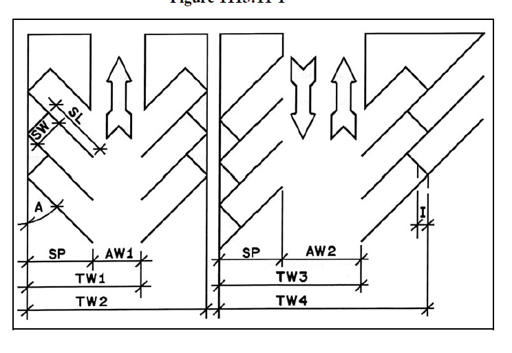
Legend
A Parking Angle
SW Stall Width on Angle
SL Stall Length on Angle
SP Stall Length Perpendicular to the Aisle
AW1 One Way Aisle Width
AW2 Two Way Aisle Width
TW1 Total Width of One Stall with a One Way Aisle
TW2 Total Width of Two Stalls with a One Way Aisle
TW3 Total Width of One Stall with a Two Way Aisle
TW4 Total Width of Two Stalls with a Two Way Aisle
I Reduction per Stall in the Total Width for Inter Locking Stalls
Table 1113.11: Minimum Design Standards for Off Street Parking Areas
Note: All figures are measured in feet unless otherwise noted.
4.
Curbing and Wheel Stops.
a.
Where Required. A continuous curbing and/or the installation of wheel stops shall be required for any parking lot or portion thereof, as determined by the PPMD or his designee, where any of the following conditions exist:
1)
Encroachment of a vehicle into any traffic aisle, pedestrian walkway or sidewalk;
2)
Parking area abuts a wall, light standard, fence, or any structure; or
3)
A severe grade change or embankment at the edge of a parking area.
4)
Parking area abuts a required landscape buffer area as provided in Section 1113.07 of this UDO.
b.
Standards.
1)
All curbing shall be six inches in height above finished pavement and may be made of concrete, stone, or similar material. The use of asphalt as a curb material and extruded curbs shall be prohibited.
2)
Wheel stops shall be made of concrete at least six feet in length and permanently affixed with steel dowels to the paved surface beneath it.
3)
All curbing and wheel stops shall provide a minimum clearance of at least 30 inches from any adjacent sidewalk, traffic aisle, embankment, wall, fence or other structure.
4)
A sidewalk adjacent to a building may be used as a curb or wheel stop providing said sidewalk is a minimum of six and one-half feet in width.
Figure 1113.11-2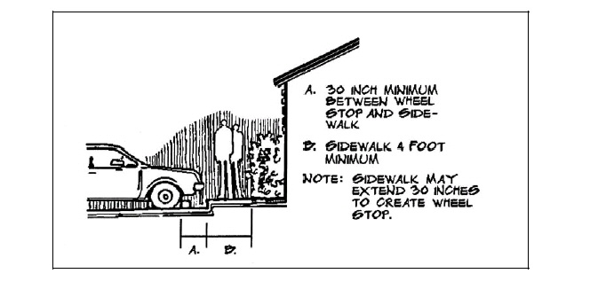
5.
Drainage. All off street parking areas shall meet the standards for stormwater runoff control as adopted by the City of Riverside.
6.
Marking. Designated parking spaces shall be marked on the surface of the parking area with paint or permanent marking materials and maintained in a clearly visible condition. Where driveways intersect the public right-of-way, the paint lines dividing vehicle paths and other pavement marking shall be in accordance with the State of Ohio Uniform Traffic Control Manual.
7.
Landscaping Required.
a.
Any premises having a parking lot or lots with an area of 6,000 square feet or greater shall provide landscape areas within the interior of the parking lot.
b.
Interior landscaping shall be required at the ratio of at least 24 square feet of landscaped area for every 300 square feet or eight percent of the parking lot surface area.
c.
Landscaped areas shall be placed within the perimeter of a parking lot. The perimeter of a parking lot is defined by placing a simple geometric shape around the external edges of the lot. Landscaping areas located in the corners or otherwise set in from the edges of the parking lot where such area would otherwise be paved are considered to be within the parking lot and may be included as a part of the required landscaping.
d.
The required landscaping may be shifted to the perimeter of a vehicle inventory lot in addition to any other setback or landscape area required by this Ordinance.
e.
Required parking or paving setbacks, screening, bufferyard, or other landscaping required by this Ordinance shall not be utilized to meet any requirement of these landscaping provisions.
f.
All landscaping installed shall be aesthetically located to maximize buffering to any adjoining residentially zoned land. A minimum of one canopy tree, one understory tree, and two shrubs shall be installed for every 300 square feet of landscaped area. The landscaped area shall include plantings of a type and size described in Section 1113.07, Screening and Bufferyard Requirements, of this Ordinance.
g.
The use of concrete, asphalt or other paved surface inside the required landscape areas shall be prohibited.
h.
All landscaped areas shall be designed and located to standards acceptable to the Planning Commission that clearly define internal streets, traffic lanes and parking areas and maintain intersection sight distance.
1)
Landscaped areas shall have a minimum width of seven feet.
2)
Raised concrete curbing shall be placed around the perimeter of all landscaped areas.
8.
Parking for Individuals with Disabilities. Parking spaces designated for people with disabilities shall be in compliance with the accessible parking space design set forth in the Americans with Disabilities Act Accessibility Guidelines (ADAAG) for Buildings and Facilities. The number and location of the designated spaces shall be in compliance with the requirements of the ADAAG (ADAAG (4)(1.2).
9.
Mixed Uses. The total requirement for off street parking facilities for mixed occupancies or for parking areas shared by two or more buildings shall be 75 percent of the sum of the requirements for the various uses computed separately or as determined by the PPMD based on the more intense use.
10.
Joint Use of Parking Spaces. The PPMD or his designee may authorize a reduction in the total number of required off street parking spaces for two or more nonresidential uses providing their respective hours of operation do not normally overlap. Examples of these types of uses are restaurants, theaters, churches, school auditoriums, banks, business or professional offices, and retail or personal service establishments.
Reduction of joint use parking shall be subject to the following conditions:
a.
Not more than 25 percent of the total number of off street parking spaces required may be located on other premises. PPMD shall make recommendation on required off street parking which is subject to Planning Commission review.
b.
The applicant shall submit data to indicate that there is no substantial conflict in the principal operating hours of the uses proposing to make use of the joint parking facilities.
c.
With written permission from an adjacent property owner and an executed recordable instrument from Montgomery County reflecting the agreement.
D.
Location.
1.
Single or Two Family Residential Use.
a.
Front, side, or rear yard parking shall be permitted for single or two family residential uses.
b.
The total paved area shall not cover more than 35 percent of the required front yard of a single or two family residential use.
2.
Multi Family Residential or Nonresidential Uses. All off street parking shall be located behind the minimum front, side, or rear setback line for parking or paving.
3.
Proximity to the Use Served.
a.
All required off street parking facilities shall be situated on the same lot as the use it is intended to serve. However, if the PPMD or his appointed designee, determines that it is not feasible for a building or use to fulfill their total parking requirement on the premises, parking may be located off premises provided that:
1)
The farthest public or customer parking space is not more than 400 feet away from the premises;
2)
The farthest employee parking space is not more than 1,000 feet away from the premises; and
3)
Such parking area meets all other requirements of this Ordinance.
b.
In no event shall the required parking for a residential use be located elsewhere than on the premises for which such parking is required.
4.
Parking Provided Under Separate Ownership. If a use requiring parking spaces is in one ownership and all or part of the required parking spaces provided is in another ownership, the property owners involved shall submit a legal agreement, approved by the Law Director, guaranteeing that the required parking spaces shall be maintained so long as the use requiring parking is in existence or unless the required parking is provided elsewhere in accordance with the provisions of this ordinance. Such instrument shall be recorded by the property owner in the office of the corresponding County Recorder and a copy filed with the PPMD.
E.
Computation.
1.
Number of Spaces. When determination of the number of off street parking spaces required by this section results in a fraction less than one-half, may be disregarded and a fraction equal or greater than one-half, shall be counted as one parking space.
2.
Units of Measurement. For the purpose of determining off street parking requirements, the following units of measurement shall apply:
a.
Floor Area. Floor area for nonresidential purposes shall be the sum of the gross horizontal area of all floors of a building measured from the exterior faces of the exterior walls. Basements shall not be included in area calculations.
b.
Hospital Beds. In hospitals, bassinets shall not be counted as beds.
c.
Places of Public Assembly.
1)
Benches. In stadiums, sports arenas, churches and other places of assembly in which those in attendance occupy benches, pews or other similar seating facilities, 24 inches of such seating facilities shall be counted as one seat.
2)
Fixed Seats and Assembly Areas. In cases where a place of assembly has both fixed seats and open assembly area, requirements shall be computed separately for each type and added together.
d.
Employees on the Largest Work Shift. Employees on the largest work shift means the maximum number of employees which could be employed at a facility, regardless of the time period during which this occurs and regardless of whether any such person is a full time employee. The largest work shift may be a particular day of the week or a lunch or dinner period in the case of a restaurant.
e.
Capacity. Capacity means the maximum number of persons which may be accommodated by the use as determined by its design or by fire code regulations, whichever is greater.
F.
Number of Parking Spaces Required. Off street parking spaces shall be required as follows:
G.
Off Street Loading.
1.
Off Street Loading Spaces Required. Any building or structure constructed, structurally altered, enlarged or having a change of use, which requires the receipt or distribution of materials or merchandise by trucks or similar vehicles, shall provide off street loading spaces or berths as required in this section.
2.
Design Standards.
a.
Dimension. Each off street loading space shall be at least ten feet in width by 25 feet in length with a vertical clearance of 15 feet or more and adequate area for ingress and egress.
b.
Access.
1)
Each required loading space shall be served by access to a street, service drive, or alley in a manner that will not interfere with traffic or parking lot circulation.
2)
No loading space shall be located in such a manner as to allow a vehicle to back onto a public street or to extend into the right-of-way while being loaded or unloaded.
3)
All access to loading spaces shall meet the access control requirements of this Ordinance.
c.
Surfacing and Drainage. All loading areas shall be graded as necessary and improved with asphaltic concrete or Portland cement and shall meet the standards for stormwater runoff control as adopted by the City of Riverside.
d.
Location. Off street loading areas shall not be located in any front yard or within 25 feet of any street right-of-way, except for areas used for the occasional drop off or pick up of goods in vans, step vans or panel trucks.
e.
Marking. Designated loading areas shall be marked as such on the surface of the loading area with paint or permanent marking materials and shall be maintained in clearly visible condition.
3.
Utilization.
a.
No storage, motor vehicle repair work or service of any kind other than for an emergency shall be permitted within any required loading berth.
b.
Space allocated to a required loading berth shall not be used to satisfy any requirement of this Ordinance for off street parking spaces.
4.
Number of Loading Spaces Required. The minimum number of loading spaces required per use is shown in Table 1113.11-2.
Table 1113.11-2: Minimum Number of Loading Spaces Required
(Ord. 17-O-618, Passed 2-16-17)
1113.13 - Access control for streets and highways.
A.
Purpose. The intent of this section is to:
1.
Regulate driveway access to public streets to lessen the impact of future development on the City of Riverside's thoroughfare system. These standards are designed to minimize safety hazards, traffic congestion, and other adverse impacts thereby protecting the integrity of the thoroughfare system.
2.
Minimize the number of driveways and access points onto public streets. These regulations should be interpreted to that end whenever possible.
3.
Require that sidewalks be constructed along thoroughfare, collector, local and public access streets to provide for safe and convenient pedestrian access to neighborhoods, businesses and other community facilities.
B.
Access to City by Driveway or Street Located Outside City. These requirements shall specifically apply to a situation where the driveway or street or a portion of the driveway or street to be constructed, altered or the access point for such a driveway or street is within the City of Riverside and the land or a portion of the land to be accessed by the driveway or street is outside the City of Riverside. A Development Approval request in accordance with Section 1105.09 of this UDO shall be required by the developer before any such construction within or access to the City of Riverside shall be permitted.
C.
Roadway Access Standards (See Ohio Department of Transportation Ohio State's Highway Access Management Manual, December 2001).
1.
Driveway Permit Required. A driveway permit shall be required to permit or expand a driveway to intersect any public street.
2.
Driveway and Roadway Surface. All vehicle parking areas shall be constructed with a hard paved surface including bituminous asphalt, concrete, paver brick, flagstone of other materials deemed appropriate by the DPPM that creates a defined continuous, solid surface parking area unless otherwise provided for herein.
3.
Driveway and Roadway Spacing. The minimum spacing of driveways and roadways in relation to other driveways and roadways shall be based on the posted speed limit as illustrated in Table 1113.13. This distance shall be measured from the point formed by the intersection of extended curb lines of each driveway or street.
Table 1113.13 Minimum Driveway Spacing for Nonresidential Uses
| Driveway Spacing | |||
|---|---|---|---|
| Minimum Distance | |||
| Posted Speed (MPH) | Feet | Meters | |
| 25 | 155 | 50 | 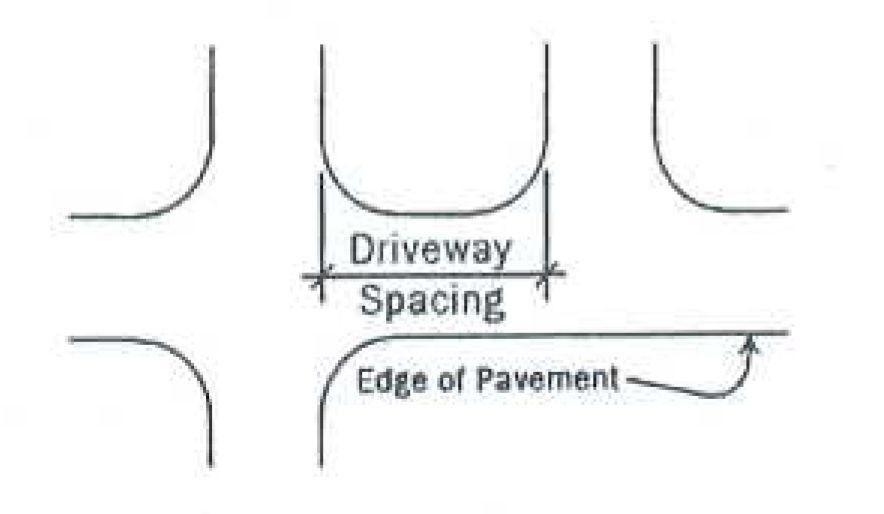 |
| 30 | 200 | 65 | |
| 35 | 250 | 80 | |
| 40 | 305 | 95 | |
| 45 | 360 | 110 | |
| 50 | 425 | 130 | |
| 55 | 495 | 150 | |
| 60 | 570 | 175 | |
| 65 | 645 | 200 | |
Source: Ohio Department of Transportation
a.
The minimum spacing distance between adjacent one way driveways or roadways with the inbound drive upstream from the outbound drive may be reduced by one-half the distance shown in Table 1113.13.
b.
The minimum driveway spacing distance for single family or two family residential uses shall be a minimum of 20 feet; driveways may, however, be joined together.
4.
Alignment Across the Street.
a.
Driveways or roadways shall either be directly opposite other driveway or street intersections or shall be offset by the minimum driveway spacing shown in Table 1113.13 except in locations where there is a raised median in the street. Single family and two family residential uses shall be exempt from this provision.
5.
Corner Lots.
a.
A driveway accessing each street abutting a corner lot may be permitted provided that such driveway locations are not:
1)
Located within the Vertical Intersection Sight Distance area as provided in Section 1113.13.C.9 of this UDO.
2)
Closer than 20 feet to the driveway of an adjoining lot with a single family or two family use.
3)
Closer than the minimum spacing requirements provided for in Table 1113.13 for all nonresidential uses.
6.
Dimensions of a Driveway.
a.
Nonresidential Uses (including Multi Family Residential Uses).
1)
All driveways shall have a minimum width of 24 feet. This provision may be modified by the PPMD or his/her designee to allow for a second entrance lane and/or a left turn exit lane for a large or intensive nonresidential or multi family residential use. In no case shall any driveway exceed 48 feet in width.
2)
Aisle widths for off street parking areas shall be as provided in Table 1113.11-1, Minimum Design Standards for Off Street Parking Areas.
b.
Single Family and Two Family Residential Uses.
1)
A driveway for a single family or two family residence shall have a minimum width of eight feet, a maximum width of 30 feet, and a minimum length of 20 feet. In no case shall any driveway exceed 24 feet in width at the public right-of-way nor cover more than 35 percent of the required front yard area.
2)
At minimum a driveway shall extend from the public right-of-way or curb line of a private street the garage door of any principal detached garage, or to the rear building line where no garage may exist, whichever is greater.
7.
Intersection Angle. A driveway or roadway shall intersect a cross street at, or nearly at, a right, 90-degree angle. In no case shall any intersection have an angle less than 75 degrees.
8.
Grade at Intersection.
a.
A driveway or roadway intersection shall have a maximum vertical grade of two percent, for a distance of 70 feet, for each leg of the intersection. This distance shall be measured from the edge of pavement of the cross street back a distance 70 feet as shown in Figure 1113.13-1.
Figure 1113.13-1 Grade at Intersection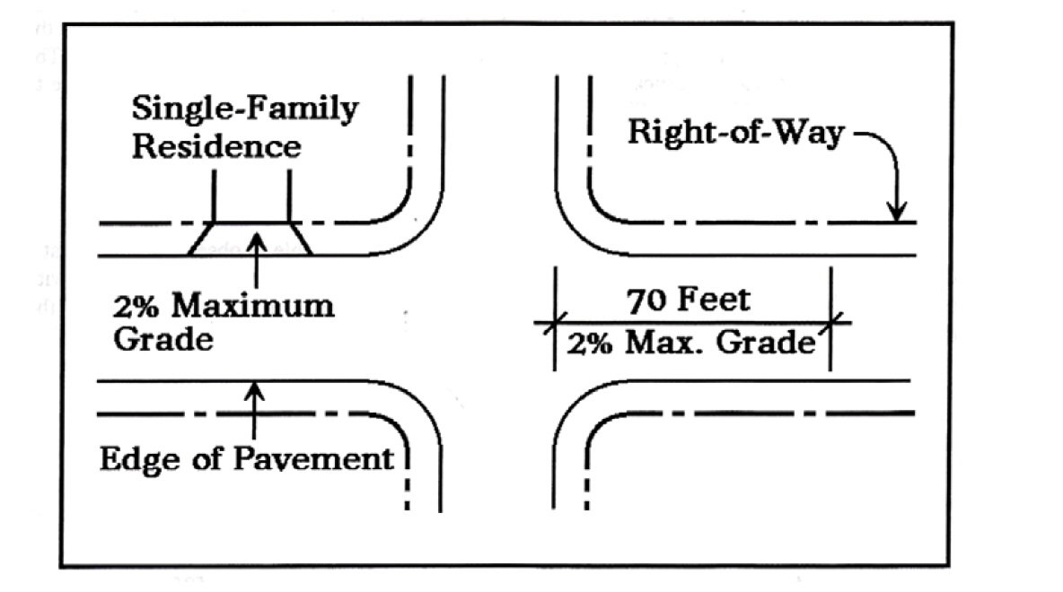
b.
Single family and two family residential uses shall have a maximum vertical grade of two percent for a distance of ten feet or to the public right-of-way whichever is greater.
9.
Visibility at Intersections. On a corner lot in any district, nothing shall be erected, placed, planted, or allowed to grow in such a manner as to materially impede vision between a height of two and one-half and ten feet above the center line grades of the intersecting streets in the area bounded by the right-of-way lines of such corner lots and a line joining points along such street lines 50 feet from the point of intersection.
10.
Median Openings. Openings to medians with a width of four feet or greater shall be permitted only as follows:
a.
Residential Properties. A median opening will be permitted for one driveway to each residential property when the alternate route that would be required to gain access to the driveway is in excess of 2,600 feet.
b.
Nonresidential Properties.
1)
A median opening may be permitted for one driveway to each on corner property.
2)
A median opening will not be permitted for driveways to corner properties where access can be gained by way of the cross street, except as noted below (See Figure 1113.13-2).
Figure 1113.13-2 Median Openings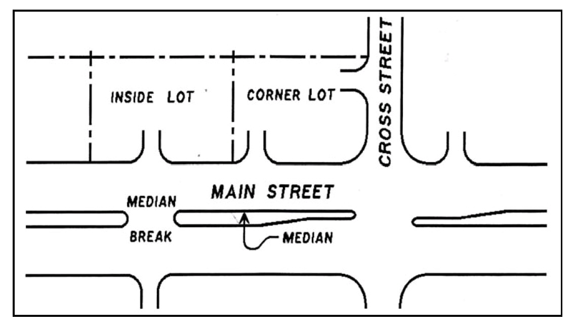
3)
A median opening may be permitted to a corner property only if the alternate turn from the cross street causes unnecessary delay or creates a traffic hazard.
c.
Additional median openings may be permitted to serve high volume parking lot driveways as the need is demonstrated.
d.
Crosswalks. To provide a minimum length of median at crosswalks, openings will not be permitted within 20 feet of a crosswalk.
11.
These access control standards may be modified and increased or decreased upon recommendation of the PPMD or his/her designee, in order to accommodate unique safety or design situations or if indicated by a traffic impact analysis. In cases where these standards are recommended to be modified, the PPMD or his/her designee shall make a report which documents the facts of the case and the rationale for modifying these requirements.
(Ord. 17-O-618, Passed 3-16-17)
1113.15 - Street tree and public tree requirements.
A.
Purpose. The purpose of these street tree and public tree standards is to provide requirements for the planting, pruning and removal of trees within the right-of-way. For the purposes of this section, city owned property shall include all public ways, streets, alleys, parks or other property owned by the City of Riverside.
B.
Requirements for Trees Located on the Right-of-Way.
1.
Should subdividers or developers wish to plant trees along public streets of their developments, such planting shall be in such a manner, type, quantity and location as approved by the Planning Commission and as defined by the following conditions. Final tree locations may be adjusted by the City of Riverside as unusual conditions may warrant.
a.
The minimum spacing between trees shall be 40 feet for large trees, 30 feet for medium trees and 20 feet for small trees.
b.
The maximum spacing between trees shall be 45 feet for large trees, 35 feet for medium trees, and 25 feet for small trees.
c.
The minimum distance between the tree and the edge of the street shall be two and one-half feet for a large tree, two feet for a medium tree and one and one-half feet for a small tree. In areas where a sidewalk exists or is proposed, the minimum distance between the tree trunk and both the edge of the street and the sidewalks shall be two feet for a large tree, two feet for a medium tree and one and one-half feet for a small tree.
d.
The tree location shall be at least 20 feet from street intersections and ten feet from fire hydrants or utility poles.
e.
A small tree shall be used when planting under or within ten lateral feet of overhead utility wires. A small or medium tree shall be used when planting within ten to 20 lateral feet of overhead utility wires.
f.
The developers shall be required to maintain the trees for one year after the trees are planted and to replace any tree which fails to survive or does not exhibit normal growth characteristics of health and vigor within such one year period. A one year guarantee period shall begin at each planting and shall recommence as trees are replaced. Upon completion of a street tree planting, the landscape contractor shall contact the City Public Service Department for a preliminary inspection. The guarantee period shall begin after the approval of the City Public Service Department. A final inspection shall be made at the end of the guarantee period. All trees not exhibiting a healthy, vigorous growing condition, as determined by the City of Riverside's inspection, shall be promptly replaced at the expense of the developer.
g.
The trees should be of one and the same genus and species planted continuously down each street.
h.
The minimum trunk caliper measured at six inches above the ground for all street trees shall be no less than two and one-half inches.
2.
Tree Topping. No person shall, as a normal practice, top any tree within the public right-of-way. Topping is defined as the severe cutting back of limbs to stubs larger than three inches in diameter within the tree's crown to such a degree so as to remove the normal canopy and disfigure the tree.
3.
Height of Limbs over Sidewalks and Streets. Tree limbs extending over a sidewalk shall be trimmed to such an extent that no portion of the same shall be less than seven feet above the sidewalks. Tree limbs extending over streets shall be trimmed to such an extent that no portion of the same shall interfere with the normal flow of traffic.
4.
The City of Riverside shall have the right to plant, prune, maintain and remove trees, plants and shrubs within the lines of public right-of-way and other public grounds as may be necessary to ensure public safety or to preserve or enhance the environmental quality and beauty of such public grounds. The City Manager or an appropriate designee may cause or order to be removed any tree or part thereof which is in an unsafe condition or which by reason of its nature is injurious to sewers, electric power lines, gas lines, water lines or other public improvements, or is, affected with any planting of street trees by adjacent property owners provided that the selection and location.
5.
Reducing Tree Lawn. No person shall by any type of construction reduce the size of a tree lawn without first procuring permission from the City of Riverside.
6.
Removal, Replanting and Replacement in Public Places.
a.
Whenever it is necessary to remove a tree(s) or shrub(s) from a tree lawn or other public place, as defined, in connection with the paving of a sidewalk, or the paving or widening of a portion of a street, alley, or highway used for vehicular traffic, or any other reason, the City of Riverside shall endeavor to remove and replant such trees or shrubs, or replace them.
7.
Abuse or Mutilation of Public Trees.
a.
Unless specifically authorized by the City Manager or an appropriate designee, no person shall intentionally damage, cut, carve, transplant, or remove any tree or shrub; attach any rope, wire, nails, advertising posters, or other contrivance to any tree or shrub, allow any gaseous liquid, or solid substance which is harmful to such trees or shrubs to come in contact with them; or set fire or permit fire to burn when such fire or the heat thereof will injure any portion of any tree or shrub.
8.
Street Tree Care.
a.
The property owner shall be responsible for street tree care.
b.
The City of Riverside shall have the right to plant, prune, maintain and remove trees, plants and shrubs or portions thereof within the right-of-way of all streets, avenues, lanes, and other public grounds, as may be necessary to ensure public safety or to preserve or enhance the health of the plant material or the beauty of such public grounds.
c.
The City Manager or an appropriate designee may remove or cause or order to be removed, any tree or part thereof which is in an unsafe condition or which by reasons of its nature is injurious to sewers, electric power lines, gas lines, water lines, or other public improvements, or is affected with any injurious fungus, insect or other pest. This section does not prohibit the planting of street trees by adjacent property owners.
d.
The City of Riverside shall have the right to enter private property to access trees adjacent to public areas for the purposes of proper pruning, after reasonable prior notice has been given to the property owner.
9.
Dead or Diseased Tree Removal on Private Property. The City of Riverside shall have the right to cause the removal of any dead or diseased tree(s) located on private property within the City of Riverside and/or cause the removal of branches of trees located on private property within the City of Riverside which overhang public property, when such trees constitute a hazard to life and property, or harbor an epiphytotic disease which constitutes a potential threat to other trees within the City of Riverside. The City Manager or an appropriate designee shall notify, in writing, the owners of such trees. Removal shall be done by such owners at their own expense within 30 days after the date of service of written notice, unless a longer period is agreed to in writing by the City Manager or a designee, to allow time to attempt to treat and cure a salvageable diseased tree. In the event of failure of owners to comply with such provisions, the City of Riverside shall have the authority to remove any such tree(s) and charge the cost of removal to the owner's property tax notice.
10.
Removal of Stumps. All stumps of street and public trees shall be removed 12 inches below the surface of the ground. Stumps shall be removed or ground at the site. All residual material shall be removed from the site at the time the tree is removed and the site shall be restored.
(Ord. 17-O-618, Passed 3-16-17)
1113.17 - Stormwater and drainage standards.
A.
Purpose. The purpose of these stormwater drainage standards is to provide adequate facilities to accommodate stormwater runoff created by a development project either through on site or off-site improvements or alterations to the drainage system.
B.
Site Grading and Drainage Development Plans; Waivers.
1.
Any person or persons proposing to develop or redevelop land shall design and implement a site grading and drainage development plan which will:
a.
Yield quantities of surface water runoff from the development site at rates which are the same as or less than those before development occurred and result in rates of gross erosion as specified in this section.
b.
Not result in increasing current potentials for sedimentation of lands, siltation of waters and flooding of watercourses that are at lower elevations off site.
2.
No changes subject to regulation under this chapter shall be made in the existing natural surface composition or subsurface configuration of any land proposed for development or redevelopment within the City of Riverside without prior written approval of a site development plan by the PPMD. Approval of a site development plan required according to Section 1113.17.H shall not be given:
a.
Unless a determination is made by the PPMD that implementation of an approved site grading and drainage development plan would not cause runoff, erosion and sediment impacts that would be harmful or damaging to the lands and waters off site; or
b.
Until a plan for minimizing the harmful and damaging potentials of runoff, erosion and sediment impacts anticipated resulting from the implementation of a proposed site grading and drainage development plan has been approved by the PPMD.
3.
Development situations may exist such that the development will have none of the harmful effects associated with increased runoff rates and volumes or sediment disposition. Such developments are eligible for a waiver from these standards; however, the waiver applies only to the following requirements and may have specific conditions attached by the PPMD, including, but not limited to:
a.
The preparation of plans, maps and/or information specified in Section 1113.17.I.
b.
The installation of sediment abatement control devices until such time as site inspection indicates that they may be unnecessary.
c.
Controlling runoff to predevelopment conditions as specified in Section 1113.17.F except that storm water runoff must be controlled to the maximum volume and minimum rate feasible for the site as determined by the PPMD.
4.
The request for a waiver shall be in writing and shall include sufficient detail to determine that granting a waiver will not be detrimental to abutting properties or to the drainage system. However, the waiver does not in any way imply a relaxation of any of the other standards in this chapter, including the requirement for adequate on site drainage, the ability to accept runoff from land tributary to the development or reasonable control of soil erosion and sediment. Development activities for which waivers may be considered include the following:
a.
Single family residential developments involving improvement of an individual lot in a previously approved subdivision.
b.
Multi-family residential, commercial or industrial developments which total two acres or less.
c.
Modifications to, or redevelopment of, an existing development which will not result in additional impervious areas.
5.
Development activities that are exempt from this chapter include the following:
a.
Additions of less than 250 square feet to existing property, such as driveways, sidewalks, patios, etc.
b.
Regular farming procedures on land designed for such use.
C.
Storm Water and Drainage.
1.
Drainage Plans.
a.
Intent.
1)
To provide a planned guideline for the construction of the development so that the drainage of the whole development and for each lot in the development meets the requirements of all sections of this chapter; and
2)
So that the drainage of the subject plat will be consistent with the existing or planned drainage of all adjacent plats.
b.
General.
1)
An overall map of the development shall be submitted to the City Engineer for approval prior to any work on the development which would alter or increase the original flow of water.
2)
This map shall show all existing and proposed lots, streets, and utilities in the proposed plat and existing lots, streets, and utilities immediately adjacent to the proposed plat.
3)
This map shall show the general drainage plan proposed for the development. A detailed drainage plan for each lot or group of lots shall be formulated when the type of structures to be placed on the lots are determined. The final plan shall include all storm sewers, drains, swales, appurtenances for the development.
4)
Drainage shall be indicated on each plot plan submitted for a building permit and must conform to the overall drainage plan for the development. Plat plans shall indicate the FFE (Finished Floor Elevation) and the adjacent building grade. The plot plan shall show the approximate elevations of the lot corners, final grade. Swales, if any, with the direction of the flow of storm water, shall be indicated. Contour lines may be used to show this final drainage plan.
5)
Plot plans shall include solutions to any unusual problems, such as springs, swamps, ponds, etc., when they are known to exist, either on the proposed development or on adjacent land, if the subject development or lot will be affected.
6)
The drawing showing the proposed overall drainage plan shall contain a statement to the effect that the proposal presented does not interfere with the drainage of adjacent properties.
7)
The covenants on the record plan shall contain a statement to the effect that succeeding owners of portions of the plat shall not erect any structures or change the grading in any manner which would alter the water flow from or to adjacent land unless written permission is obtained from the owners of such adjacent land.
2.
Storm Water Disposal.
a.
All areas shall be sloped to a lower elevation off the lots or to drainage structures on the lot in accordance with the site grading plan. Two or more lots may be considered as one area. Business, industrial and commercial areas may be considered as one lot for storm water disposal purposes.
b.
Unpaved drainage swales shall have adequate width and depth to carry the runoff.
c.
Longitudinal gradients for swales or gutters shall be provided as follows:
1)
For centerlines within 15 feet of buildings, or in a required outdoor area, see Section 1113.17.D.4.
2)
For center lines in other lot areas, see Section 1113.17.D.9.a.
d.
The permanence and maintenance of off-site drainage ways shall be assured by locating such drainage ways in public or private right-of-way or easements, as shown on the record plan.
e.
Where drain inlets or catch basins are installed, emergency surface drainage overflow shall be provided to prevent possible flooding against or within the building in the event of the failure of the underground drainage structures.
3.
Drain Lines.
a.
Storm sewers shall be constructed of concrete pipe in the public right-of-way. Pipe not in the public right-of-way or under a roadway may be constructed with HDPE (High density polyethylene).
b.
Drain lines shall be of adequate size and gradient to provide proper run off and shall be at such depth as to preclude damage to the pipe.
c.
Drain lines for surface drainage shall be sealed where necessary to prevent harmful infiltration of sand, muck and other materials. For substance drainage, perforated or porous pipe shall be backfilled with gravel or crushed rock over the pipe to a point at least six inches below finished grade.
4.
Drain Inlets. The design, size and construction of drain inlets shall be adequate to carry water imposed without overflow.
5.
Drainage Structures.
a.
Intent.
1)
The intent of the requirements in this section is to provide for the collection of surface and subsurface water in order to protect any dwelling or other improvements; and usable lot areas.
b.
General.
1)
Paved gutters, drain lines and inlets or other necessary drainage structures shall be installed where storm water disposal cannot be obtained without their use or where erosion cannot be prevented by finish grading and/or planting. Such drainage structures shall be shown on plat design drawings.
2)
Design, construction and installation of drainage structures shall be in accordance with standard engineering practices and shall be suitable for the use and maintenance contemplated.
3)
Gutters and drain lines shall be connected to suitable outfalls. The permanence and maintenance of off-site drainage ways shall be assured by public or private rights-of-way, by easements or by other acceptable means.
4)
Splash blocks shall be installed at the bottom of each downspout unless the downspout is connected to a drain line. See Section 1113.17.C.7 for construction details.
6.
Paved Gutters.
a.
Gutters shall be constructed of concrete, brick or other durable material.
b.
Gutters shall have an adequate depth, width and longitudinal gradient to carry water without overflow. Gutters shall be connected.
c.
Gutters shall be installed to provide permanent drainage with reasonable maintenance.
7.
Splash Blocks.
a.
Splash blocks shall be constructed of concrete or other durable material.
b.
The minimum width of splash blocks shall be 12 inches. The minimum length shall be 30 inches.
c.
Splash blocks shall be firmly imbedded to prevent displacement.
8.
Dry Wells.
a.
Dry wells for the disposal of water from foundation drains and crawl spaces, etc., are permissible only when the bottom of a dry well projects into a strata of porous soil at a level where the bottom of the dry well is above the ground water table at its seasonal height.
b.
The minimum distance of dry wells from buildings shall be 20 feet. The separation between dry wells and buildings may be reduced to ten feet if the diameter of the dry well does not exceed three feet.
c.
The size and construction of dry wells shall be adequate to dispose of the water.
d.
Sump pumps shall be connected to dry wells or to the nearest point of the drainage system of the plat. Sump pumps and other drains which have water flowing more than 50 percent of the time may not discharge into the gutter.
D.
Grading.
1.
Intent.
a.
Direct water away from buildings;
b.
Prevent standing water and soil saturation detrimental to structures and lot uses;
c.
Provide for disposal of water from a lot;
d.
Preserve such desirable lot features that do not interfere with the proper drainage of the lot or the desired use of the lot;
e.
Provide grades for safe and convenient access to and around buildings and lots for their use and maintenance; and
f.
Protect adjacent properties from excessive water drainage.
2.
In General.
a.
For examples of typical grading design, see illustrations following the text of these regulations.
b.
For regulations pertaining to building foundations or concrete floor slabs on fill, see the current version of the Residential Code of Ohio (RCO), and the OBC Commercial Building Code.
3.
Protective Slopes Around Buildings.
a.
The slope of the ground downward away from building foundations to lower areas shall conform to Section 1113.17.C.2.
b.
The horizontal width of the downward sloping area away from foundations shall be a minimum of ten feet, except where restricted by property lines.
c.
The vertical fall of protective slopes shall be a minimum of six inches in ten feet. However, the vertical fall at the upper end of a swale may be reduced to three inches in ten feet, provided that a long slope from a nearby high bank does not exist.
4.
Minimum Gradient.
a.
For concrete or other impervious surfaces, the minimum gradient shall be one-sixteenth of an inch per foot (one-half of one percent).
b.
For pervious surfaces, the minimum gradient in the first ten feet from the building shall be as provided in Section 1113.17.D.3. Beyond the ten-foot area, the gradient shall comply with the objectives of this chapter.
5.
Maximum Gradient. The maximum gradient shall be two and one-half inches for the first four feet from all building walls, except where restricted by property lines. The balance of the protective slope shall have a maximum gradient of 2:1 (two feet horizontally to one foot vertically). (See Section 1113.17.D.9.b.)
6.
Usable Outdoor Area. The usable outdoor area shall be of such location, size and shape as to provide for outdoor living, for outdoor service functions, such as laundry drying, and for other necessary functions. Usable outdoor areas may overlap or be part of required protective slopes around buildings. The area may be a single area or several adjacent or separate subareas.
7.
Minimum Gradient for Usable Areas. The minimum gradient for usable areas shall be as follows:
a.
For concrete or other impervious surfaces, one-sixteenth of an inch per foot, (one-half of one percent).
b.
For pervious surfaces, one-quarter of an inch per foot (two percent).
8.
Maximum Gradient for Usable Areas. The maximum gradient for usable areas shall be five-eighths of an inch per foot (five percent).
9.
Other Lot Areas.
a.
The minimum gradient for other lot areas shall comply with subsection D.7 hereof, unless lesser gradients are shown on exhibits accepted by the City of Riverside prior to any building construction activity, including grading and/or clearing. To be acceptable, the lesser gradient must be adequate to drain the area without having a detrimental effect upon buildings or upon essential lot usage and improvements. Conditions which would result in prolonged standing of water at any season are not acceptable. Where surface water disposal is proposed by infiltration into the ground, technical exhibits, such as soil gradation analyses and/or infiltration tests, may be required.
b.
The maximum gradient, unless slopes are to be held by satisfactory existing or planned vegetation, rock outcroppings or brick, rock or concrete walls, shall be limited as follows:
1)
If the vertical height of slope is 30 inches or less, the maximum gradient shall be one and one-half feet horizontal to one foot vertical.
2)
For slopes with a vertical height of over 30 inches, the maximum gradient shall be two feet horizontally to one foot vertically.
3)
Slopes of over one and one-half feet to one foot with only grass planned as the retaining vegetation shall not be permitted.
c.
Tops and bottoms of banks at swales, terraces, etc., shall be rounded for convenient maintenance.
10.
Rough Grading.
a.
Preservation of Trees and Shrubs. Natural site assets, such as existing trees, shrubs, ground cover and top soil, shall be preserved and protected whenever practicable, provided that retention of such items does not interfere with the drainage plan of the area.
b.
Compliance with Drainage Plans and Plot Plans; Subgrades. The balance of the lot shall be graded to comply with the grading indicated on the drainage plan and the plot plan submitted for a building permit. The subgrade shall be established by cut and fill, approximately parallel to the finish gradients and at an elevation to allow for sod and other installations.
c.
Filled Areas.
1)
Filled areas under and 15 feet beyond buildings and other structures shall be compacted to meet the requirements of the current version of the Residential Code of Ohio (RCO) One and Two Family Dwelling Code.
2)
For the balance of the area involved, all surface debris detrimental to lot improvements shall be removed.
3)
Tree stumps 18 inches below finished grade shall be removed and cut down.
4)
Original ground exceeding a one to three (1:3) slope shall be scarified and benched if it is to receive fill, in order to prevent slippage of the fill.
5)
Fill material shall be reasonably free of debris or other material detrimental to the lot for the first three feet below the finished grade and shall have reasonable moisture content when placed. Fill in the vicinity of future drainage structures shall be compacted to avoid later settling and damage to the structures.
6)
Fills having a depth of over 60 inches shall be constructed in accordance with standard engineering practices.
11.
Finish Grading.
a.
Lot areas shall be finish graded to the extent necessary to make the entire lot comply with the preceding standards of this chapter.
b.
The subsoil shall be smoothed parallel to the finished grade elevations and scarified where necessary to secure bond with the surface soil or sod.
c.
Where installation of a lawn or planting is required, the surface soil shall be workable, suitable for the support of plant life and free of large stones and other debris detrimental to plant life. For other areas the soil shall be as provided above or shall be soil which the property owner can improve to a comparable quality without difficult or expensive work.
d.
Surface soil shall be soil capable of sustaining plant life.
e.
Surface soil shall be spread uniformly to provide a smooth even surface.
f.
Surface soil shall be compacted lightly to minimize settlement.
E.
Erosion Control: Lawns and Ground Cover.
1.
Intent. Lawns and ground cover shall be provided:
a.
To prevent erosion; and
b.
Where required, to make yards usable.
2.
Required Areas. Appropriate vegetative cover shall be provided for the following areas as follows:
a.
On swales, as follows:
1)
Where the gradient exceeds five-eighths of an inch per foot, five percent.
2)
Minimum width: four feet. (See Section 1113.17, Stormwater and Drainage Standards)
b.
On slopes where the gradient exceeds four feet horizontally to one foot vertically.
c.
On other areas from the street roadway to a point 15 feet behind the building, or as agreed between the builder and purchaser. Planting in undisturbed areas may be omitted when suitable existing vegetation is present to prevent erosion.
3.
Materials.
a.
Lawn materials and ground cover shall be appropriate for the expected use and suitable to the local climate, soil conditions and exposure.
b.
Seed quality shall have a minimum purity of 85 percent, a minimum germination of 80 percent and a weed content not exceeding a maximum of one-half of one percent. The seed mixture shall be not less than 85 percent, by weight, of permanent grass, and 15 percent, by weight, of annual grass.
c.
Sod shall be fresh cut, taken from a thick stand of permanent lawn grass, reasonably free from weeds and coarse grass. It shall be at least one and one-half inches thick, totally, uniform in thickness and cut in strips.
4.
Installation. Installation of lawns and ground cover shall be as follows:
a.
See Section 1113.17.D.11 for finish grading.
b.
The seed or plant bed shall be prepared by scarifying the surface lightly.
c.
Seed shall be broadcasted as recommended by the producer, but at a rate of not less than four pounds per 1,000 square feet. The seeded ground shall be rolled with a light roller and watered thoroughly with a fine spray.
d.
Sod shall be laid in strips, avoiding wide joints. On slopes, sod laying shall be started at the bottom parallel to the contour of the slope. Sod shall be rolled with a light roller and watered thoroughly.
e.
Ground cover shall be planted to provide a dense mat at maturity.
f.
Lawns and ground cover shall be installed only during appropriate seasons and favorable weather and with suitable soil conditions.
g.
Lawns and ground cover shall be watered, replanted and maintained as necessary until possession is taken by the owner.
Figure 1113.17-1 Lot Grading Plan
F.
Storm Water Runoff Control Standards.
1.
In general, drainage systems shall be designed according to locally accepted design practices and sound engineering judgment and shall conform to the following:
a.
Storm sewer design shall be sufficient to convey the design storm discharge with an average recurrence interval of ten years so that the pipe flowing full condition (hydraulic grade line at the top of the pipe) is not extended.
b.
Lot grading, in tract drainage and street improvements for all subdivions shall be designed so that floods having an average recurrence interval of 100 years or less will not cause inundation or damage to any dwellings. A grading plan for each subdivision will be required to define the lot grading and in tract drainage. All developments within areas of special flood hazard or delineated on the official National Flood Insurance Program Flood Insurance Rate Maps, or as determined by the City of Riverside, shall comply with FEMA design requirements.
c.
All drainage channels, conduits and other structures located outside the road right-of-way designed to convey public storm runoff (off site runoff) should be contained in suitable public easements. Easements for open channels shall include sufficient area along the channel banks to permit access for maintenance equipment. Open channels may be fenced along both sides through urban areas where it is necessary to protect the public as well as to prevent encroachment upon needed access areas.
2.
Areas adjacent to open drainage ways and ponds shall be graded to preclude the entrance of storm water, except at planned locations. Where retention/detention areas are located on the project periphery, the developer may be required to provide additional landscaping or screening to adequately protect abutting properties.
3.
Each development shall provide for the on-site or off site detention of excess storm water runoff resulting from that development. For the purpose of this section, "excess storm water runoff " shall include all increases in storm water peak flows and volume resulting from an increase in the impervious surface of the site, including all additions of buildings, roads and parking lots; changes in soil absorption caused by compaction during development; modifications in contours, including the filling or draining of small depression areas, alterations of drainage ways or regrading of slopes; destruction of forests; the alteration of drainage ways or the installation of collection systems to intercept street flows or to replace swales or other drainage ways; or the alteration of subsurface flows, including any groundwater dewatering or diversion practices, such as curtain drains, compared with the site in its natural state.
4.
Any foreseeable increase in rates and volume of site surface drainage water runoff caused by site development shall be controlled so that the post development peak rate of runoff does not exceed that of the predevelopment one year frequency storm for all 24 hour storms between a one year frequency and the critical storm frequency as determined below. A recommended method which may be used to determine changes in rates and volumes of runoff is presented in the U.S. Department of Agriculture, Engineering Division of the Soil Conservation Service (SCS), Urban Hydrology for Small Watersheds, Technical Release No. 55 (Washington, D.C.: USDA, June, 1986), and the Ohio Supplement (April, 1981). To find the critical storm frequency for which additional control will be needed:
a.
The percent increase in runoff volume for a one year frequency, 24-hour storm, shall be determined; and
b.
The critical storm frequency for which additional control is needed shall be determined by using the percent increase in runoff volume, derived in paragraph thereof, in the Table 1113.17 below:
Table 1113.17 Critical Storm Frequency
5.
Storms of less frequent occurrence (longer return period) than the critical storm shall have a peak rate of runoff not greater than for the same storm under predevelopment conditions. For example, if the total volume is shown to be increased by 35 percent, the critical storm is a five year storm. The peak rate of runoff for all storms up to this intensity shall be controlled so as not to exceed the peak rate of runoff from a one year frequency storm under predevelopment conditions in the area. The runoff from a more intense storm need only be controlled so as not to exceed the predevelopment peak rate from the same frequency of storm.
6.
The intent of subsections F.4. and 5. above will be met if the criteria are fulfilled for the one-, two-, five-, 25-, 50- and 100-year storms.
7.
All detention facilities and improvements required by this section shall comply with the following regulations:
a.
Access Easements. An access easement shall be provided to all detention facilities from the nearest public road so that such facilities are accessible in case emergency maintenance work is required. The minimum easement width will be ten feet.
b.
Storage Volumes. Storage may be provided by wet or dry bottom basins or reservoirs.
c.
Maximum Depth. The maximum planned depth of storm water detained shall be five feet, unless site conditions lend themselves to greater depths.
d.
Outlet Control Structures. Outlet control structures shall be designed as simply as possible and shall operate automatically. They will be designed to limit discharges into existing or planned downstream channels or conduits so as not to exceed the existing flow from the site in its natural condition or as further controlled in Section 1113.17.F.4.
e.
Spillways. Emergency overflow facilities shall be provided unless inflow is controlled to divert flows when the basin is at capacity. The spillway shall safely discharge the detention basin overflow without damage to the detention basin. A minimum of one foot freeboard shall be provided for the 100-year 24-hour storm event.
f.
Dry Bottom Basins. For basins designed without permission pools, the following provisions shall apply:
1)
Interior Drainage. Provision must be made to facilitate interior drainage, including the provision of natural grades to outlet structures, longitudinal and transverse grades to perimeter drainage facilities or the installation of subsurface drains.
2)
Multipurpose Features. These may be designed to serve secondary purposes for recreation, open space or other types of use which will not be adversely affected by occasional or intermittent flooding.
3)
Cleaning. The basins shall be designed for periodic cleaning and removal of sediments, which shall be removed from the site or otherwise disposed of in an appropriate manner.
g.
Wet Basins. For basins designed with permanent pools, the following provisions shall apply:
1)
Depth for Fish. If fish are used to help keep the basin clean, at least one-quarter of the area of the permanent pool must have a minimum depth of ten feet.
2)
Facilities for Emptying. For emergency purposes, cleaning or shoreline maintenance, facilities shall be provided or plans prepared for the use of auxiliary equipment to permit emptying and drainage.
3)
Pollution Abatement. Aeration facilities may be required when the quality of the influent and detention time would result in a lowering of dissolved oxygen content in the basin.
4)
Slopes. Approach slopes shall be at least six to one, but not more than three to one, and shall be at least four to six feet wide and slope gently toward the basin. The side slopes shall be of nonerosive material with a slope of one to one or flatter. The ledge shall be four to six feet wide and slope gently toward the shore to prevent people or objects from sliding into deep water. There shall be a freeboard of 12 to 18 inches above the high water elevation on all retention basins. Alternative designs for side slopes may be considered under special circumstances where good engineering practice is demonstrated.
5)
Cleaning. The basins shall be designed to include sediment traps in all inlets. Sediment traps shall be designed to permit periodic cleaning and maintenance. A basin maintenance plan shall be developed to ensure that the design depths of the basin will remain over time.
Figure 1113.17-2 Lot Stormwater Drainage Plan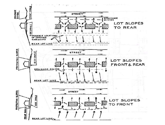
h.
Building Regulations.
1)
Parking Lot Storage. Paved parking lots may be designed to provide temporary detention storage of storm water on a portion of their surfaces. Outlets shall be designed to empty the stored waters slowly, and depths of storage must be limited so as to prevent damage to parked vehicles, and storage areas shall be posted with warning signs.
2)
Detention Storage. All or a portion of the detention storage may also be provided in underground detention facilities, provided that they meet the design regulations of Section 1113.17.F.7.b and c.
3)
Off site Easements. Off site easements for storm water management facilities will be required when either of the following conditions exists:
A)
The discharge is into any man made facility for which the City of Riverside does not have either a drainage easement or right-of-way.
B)
The discharge is into a natural system such that the rate or character (i.e. sheet flow versus concentrated flow) of the flow at the property line has been changed. The easement will be required to a point at which natural conditions are duplicated.
4)
Design Criteria for Off-site Drainage. Off site areas which drain to or across a site proposed for development must be accommodated in the storm water management plans for the development. The storm water management system for the development must be capable of transporting existing off site flows through or around the development without increasing stages or flows upstream or downstream of the development. The estimation of the off-site flows must be done separately from the estimation of on-site pre and post development flows (i.e. separate off site and on site hydrographs must be computed due to the typically significant differences in land use characteristics).
5)
Alternatives to Detention or Retention Ponds. For sites containing less than 10,000 square feet of total impervious surface, alternatives to detention or retention ponds that utilize landscaped buffers and swale drainage as a means of attenuating the rate of runoff are encouraged, provided that it can be shown that applicable design and performance criteria are met.
6)
Protection of Detention and Retention Facilities from Erosion. Measures shall be taken to protect the embankment of detention and retention facilities from erosion and provide a definitive protective flow path downstream of the facility.
G.
Off Site Drainage Facilities.
1.
The City of Riverside may allow or require surface water runoff to be discharged into drainage facilities off the site of development if all of the following conditions are met:
a.
The drainage facilities are constructed and maintained in accordance with the requirements of this chapter.
b.
Adequate provision is made for acquisition, construction and operating costs of the off-site drainage facilities.
c.
A request to use these drainage facilities and all information relating to these proposed drainage facilities is made a part of the developer's application.
2.
The City of Riverside may allow or require payment of a fee for redevelopment activities in lieu of constructing a detention or retention facility as specified in Section 1113.17.F. Payment received in lieu of redevelopment detention or retention shall be used for storm water improvement projects, including the establishment of regional detention systems. The fee shall be based on an amount per square foot of impervious surface (on site).
3.
Whenever deemed practical, necessary and in the public interest, the City of Riverside may acquire land and construct these drainage facilities, and to the greatest extent possible, the fees and charges for such facilities shall be sufficient to cover all costs associated therewith and such facilities shall be self-supporting.
H.
Soil Erosion and Sedimentation Control Plan.
1.
In order to prevent both soil erosion and sedimentation, a soil erosion and sedimentation control plan shall be required whenever a development will involve any clearing, grading, transporting or other form of disturbing the land by the movement of earth.
2.
Sediment deposition caused by accelerated storm water runoff over a development site or by accelerated erosion due to the sloughing or sliding of surface soil that has been exposed by grading, dumping, stockpiling or any other excavation related earth disturbances shall be retarded and confined to within the boundaries of the development site.
3.
The accumulative monthly predicted amounts of gross soil loss anticipated from sheet and rill erosion shall be abated to within an average annual rate of 15 tons per acre during the first year, ten tons per acre for any year thereafter of site development activities and to within five tons per acre per year after site development is completed. The Universal Soil Loss Equation, as referred in the U.S. Department of Agricultural, Soil Conservation Service (SCS), Water Management and Sediment Control for Urbanizing Areas, (Washington, D.C.: U.S. Government Printing Office, June, 1978), or other approved methods, shall be used to predict average annual rates of gross soil loss by month from a development site.
4.
Specifically, the following protection shall be provided for all disturbed areas: minimize velocities of water runoff, maximize protection of disturbed areas from storm water runoff and retain sedimentation within the development site as early as possible following disturbances. A list of major problem areas for erosion and sedimentation control follows. For each one, the purpose of requiring control is described. Soil erosion and sedimentation control measures for all such areas shall be provided with a view toward achieving the specific purpose listed below for which a control plan is required:
a.
Erodible slopes: prevent detachment and transportation of soil particles from such slopes.
b.
Streams, streambeds, stream banks, bodies of water, lake shorelines: prevent detachment and transportation of soil particles.
c.
Drainage ways: prevent detachment and transportation of soil particles (which would otherwise deposit in streams, bodies of water or wetlands); promote deposit of sediment loads (traversing these areas) before they reach bodies of water.
d.
Land adjacent to streams, ponds, lakes and wetlands: prevent detachment and transportation of soil particles.
e.
Enclosed drainage structures: prevent sedimentation in a structure, erosion at the outfall of the system and the deposit of sediment loads within the system or beyond it.
f.
Large flat surface areas (unpaved): prevent detachment of soil particles and their off-site transportation.
g.
Pervious surfaces: prevent the detachment and transportation of soil (in response to an increase in the rate and/or volume of runoff of the site or its concentration caused by impervious surfaces).
h.
Borrow and stockpile areas: divert runoff from the face of slopes which are exposed in the excavation process; convey runoff in stabilized channels to stable disposal points; and leave borrow areas and stockpiles in stable conditions.
i.
Adjacent properties: prevent their erosion and/or the deposit thereon of sediment.
I.
Runoff Control and Sediment Abatement Plans.
1.
Any person seeking approval of a development proposal shall:
a.
Provide mapped information about the location and vicinity of the area proposed for development; and
b.
Furnish the following three types of information and maps about the proposed land development and site location:
1)
An existing characteristics inventory;
2)
A predevelopment conditions assessment; and
3)
An abatement control plan.
c.
Minor additions to existing facilities may be exempted from this requirement by the City Engineer.
2.
Specifically, all proposed land developments shall have plans or maps of an appropriate scale that depict existing and proposed improvements, including, but not limited to:
a.
Structures, streets, sidewalks, driveways, parking lots, storm drainage systems and appurtenances, utilities, poles, etc.
b.
Elevations, contour lines, inverts of sewers and drainage facilities, etc.
c.
The location of the boundary of the 100-year flood plain.
3.
Runoff control and sediment abatement plan content requirements shall be as follows:
a.
A runoff control and sediment abatement plan shall identify how accelerated surface water runoff, increased erosion and sediment deposition induced by site development are to be controlled to within the abatement standards set forth in Section 1113.17.F and Section 1113.17.H. The developer's engineer shall include in the construction plans a master drainage map showing all existing and proposed features. The map is to be prepared on a 24-inch by 36-inch sheet on a scale not to exceed one inch equals 100 feet. Listed below are the features that are to be included on the drainage map:
1)
Drainage boundaries, including all areas draining to the proposed subdivision or development.
2)
Sufficient topographical information with elevations to verify the location of all ridges, streams, etc.
3)
High water data on existing structures upstream and downstream for the subdivision.
4)
Notes indicating sources of high water data.
5)
Notes pertaining to existing standing water areas of heavy seepage, springs, wetlands, streams, etc.
6)
Existing drainage features (ditches, roadways, ponds, etc.). Existing drainage features are to be shown a minimum of 1,000 feet downstream of the proposed development unless the ultimate outfall system is a lesser distance.
7)
Subdivision layouts with horizontal and vertical controls, showing proposed structures with minimum pad elevations.
8)
Proposed drainage features, including locations of inlets, swales, open drainage ways, ponding areas, storm sewers, culverts, etc.
9)
Delineation of drainage sub areas.
10)
Retention/detention areas and ingress/egress areas for retention/detention facilities.
11)
The general type of soils (obtained from the soil survey of Montgomery or Greene County).
12)
Ten-, 25- and 100-year flood elevations for any areas in or within 100 feet of the property. The source of these elevations shall also be shown on the plans.
13)
A description of current ground cover and/or land use.
b.
All proposed drainage features and runoff controls are to be designed in accordance with methods and techniques set forth in the UDO Section 1111.05.
c.
A runoff control and sediment abatement plan shall be comprised of, but not limited to, the following information:
1)
A map rendered on the base which indicates the number, types, dimensions and locations of all runoff, erosion or sediment control devices to be utilized either temporarily or permanently on a development site;
2)
All pertinent computations made to arrive at the final dimensions of each control device, along with plan and section view drawings of the same rendered at an appropriate design scale to be agreed upon between the applicant and the City Engineer; and
3)
Schedules detailing the timing for the installation and maintenance of each control device.
d.
The runoff control and sediment abatement plan shall be prepared by or under the direct supervision of a registered civil engineer.
J.
Liabilities and Responsibilities; Enforcement; Privately Owned Installations.
1.
Performance Liability. No provision of this chapter shall limit, increase or otherwise affect the liabilities of the permitted or impose any liability upon the City of Riverside not otherwise imposed by law.
2.
Responsibilities of Permittee during Site Development. During site development, a permittee is responsible for:
a.
Carrying out all provisions according to approved plans and as required by this chapter;
b.
Promptly removing all soil, miscellaneous debris or other materials that may become spilled, dumped or otherwise deposited on any public thoroughfares during transport to and from the development site; and
c.
Taking precautions to inhibit the deposition of sediment into any sewer system or natural watercourse.
3.
Inspections; Enforcement; Stop Work Order.
a.
The developer's engineer shall be required to inspect all drainage facilities under construction and certify their compliance with approved plans, and in addition, the City of Riverside or designee may inspect all drainage facilities while under construction. When facilities are not constructed according to approved plans, the City of Riverside has the explicit authority to compel compliance and require correction of any situations which are not according to the approved plans.
b.
Site development operations shall be subject to inspections by the City of Riverside to determine whether a site development plan is being implemented in compliance with the provisions of this chapter and any plan approval conditions. The applicant shall arrange with the City of Riverside or their designee for the scheduling of inspections to ensure effective control of erosion and sedimentation and to ensure that all drainage facilities are being completed in accordance to the approved storm water management plan. Prior to final inspection, the developer's engineer shall provide as built plans of the detention facilities and outlet control structures, documenting facilities that are constructed substantially in accordance with approved plans.
c.
After each inspection the inspector shall complete a site development status report. If the inspector finds that operations are being conducted by a permittee in violation of an approved plan or provisions of this chapter, a stop work order may be issued at that time.
4.
Privately Owned Installations.
a.
Design, Inspection and Maintenance. Permanent runoff control and sediment abatement installations which are to be privately owned and maintained by an individual or group of property owners shall be:
1)
Designed and constructed by the permittee with easements sufficient to allow adequate access for inspections, maintenance and corrective actions, if necessary, by the City of Riverside.
2)
Inspected as needed by the City of Riverside to ensure that privately owned installations are being properly maintained. If not, the City of Riverside may compel the owners to make the necessary repairs at the expense of the owner.
3)
Maintained as installed by the permitted according to the approved design and not altered unless such alteration is approved by the City of Riverside.
b.
Legal/Operation Entity Requirements.
1)
Acceptable Entities. The City of Riverside considers the following entities acceptable to operate and maintain runoff and sediment control facilities:
A)
The City of Riverside; and
B)
Non-profit corporations, including homeowners' associations, property owners' associations, condominium owners' associations or master associations.
2)
The property owner or developer is normally not acceptable as a responsible entity, especially when the property is to be sold to various third parties. However, the property owner or developer may be acceptable under one of the following circumstances:
A)
The property is wholly owned by said property owner or developer and is intended to be so retained. This would apply to a farm, corporate office or single industrial facility for example.
B)
The ownership of the property is retained by the owner or developer and is either leased to third parties, such as in some shopping centers, or rented to third parties, such as in some mobile home parks for example. To satisfy this requirement, the owner or developer must provide written documentation.
3)
Association Requirements.
A)
If a homeowners' or property owners' association or master application is proposed, the developer must submit the articles of incorporation for the association and the declaration of protective covenants or deed restrictions, as well as a reference map if such is referred to in the documents. After these are approved, the developer must furnish the certificate of incorporation and the recording information (official book and page number) for the declaration.
B)
If a condominium association is proposed, the developer must supply the articles of incorporation for the condominium association and the declaration of condominium. After the documents are approved by the City of Riverside, including stormwater management plan, it will be necessary for the developer to forward a copy of the letter from the County Recorder's Office stating that the documents are proper for filing. The association, be it either a non-profit association or a condominium association, must comply with the applicable provisions of State law.
C)
The association must have the following general powers which are reflected in the articles of incorporation:
i.
Own and convey property.
ii.
Operate and maintain common property, specifically the surface water management system as permitted by the City of Riverside, including all lakes, retention areas, culverts and related appurtenances.
iii.
Establish rules and regulations.
iv.
Assess members and enforce said assessments.
v.
Sue and be sued.
vi.
Contract for services (if the association contemplates employing a maintenance company) to provide the services for operation and maintenance.
vii.
Have as members all the homeowners, lot owners, property owners or unit owners.
viii.
Exist in perpetuity. However, if the association is dissolved, the articles of incorporation must provide that the property consisting of the surface water management system shall be conveyed to an appropriate agency of local government. If it is not accepted, then the surface water management system must be dedicated to a similar non-profit corporation.
ix.
All other powers necessary for the purposes for which the association is organized.
D)
The declaration of protective covenants, deed restrictions or declaration of condominium must set forth the following:
i.
That it is the responsibility of the association to operate and maintain the surface water management system.
ii.
That the surface water management system is owned by the association or described therein as common property.
iii.
That there is a method of assessing and collecting the assessment for the operation and maintenance of the surface water management system.
iv.
That any amendment which would affect the surface water management system, including the water management portions of the common areas, must have the prior approval of the City of Riverside.
v.
That the declaration of protective covenants be in effect for at least 25 years with automatic renewal periods thereafter.
E)
If the documents are not submitted with the original application, they must be submitted and approved prior to construction. It is advised that the documents be submitted prior to recording to allow comment by the Municipal Attorney. Modification of these requirements can only be based upon:
i.
Intervening local government requirements of a more stringent nature, such as the requirement of a maintenance agreement and posting of bond by the developer.
ii.
The uniqueness of the project requiring an alternative entity. Such alternative entity must be evaluated upon an individual basis with any and all necessary agreements or easements in effect before approval will be given.
(Ord. 17-O-618, Passed 3-16-17)
1113.19 - Floodplain design standards.
A.
Purpose. It is the purpose of these regulations to promote the public health, safety and general welfare, and to:
1.
Protect human life and health;
2.
Minimize expenditure of public money for costly flood control projects;
3.
Minimize the need for rescue and relief efforts associated with flooding and generally undertaken at the expense of the general public;
4.
Minimize prolonged business interruptions;
5.
Minimize damage to public facilities and utilities such as water and gas mains, electric, telephone and sewer lines, streets and bridges located in areas of special flood hazard;
6.
Help maintain a stable tax base by providing for the proper use and development of areas of special flood hazard so as to protect property and minimize future flood blight areas;
7.
Ensure that those who occupy the areas of special flood hazard assume responsibility for their actions;
8.
Minimize the impact of development on adjacent properties within and near flood prone areas;
9.
Ensure that the flood storage and conveyance functions of the floodplain are maintained;
10.
Minimize the impact of development on the natural, beneficial values of the floodplain;
11.
Prevent floodplain uses that are either hazardous or environmentally incompatible; and
12.
Meet community participation requirements of the National Flood Insurance Program.
B.
Methods of Reducing Flood Loss. In order to accomplish its purposes, these regulations include methods and provisions for:
1.
Restricting or prohibiting uses which are dangerous to health, safety, and property due to water hazards, or which result in damaging increases in flood heights or velocities;
2.
Requiring that uses vulnerable to floods, including facilities which serve such uses, be protected against flood damage at the time of initial construction;
3.
Controlling the alteration of natural floodplains, stream channels, and natural protective barriers, which help accommodate or channel flood waters;
4.
Controlling filling, grading, dredging, excavating, and other development which may increase flood damage; and
5.
Preventing or regulating the construction of flood barriers which will unnaturally divert flood waters, or which may increase flood hazards in other areas.
C.
Lands to Which Regulations Apply. These regulations shall apply to all areas of special flood hazard within the jurisdiction of the City of Riverside as identified in Section 1113.19.D, including any additional areas of special flood hazard annexed by the City of Riverside.
D.
Basis for Establishing the Areas of Special Flood Hazard. For the purposes of these regulations, the following studies and/or maps are adopted:
1.
Flood Insurance Study, Montgomery County, Ohio and Incorporated Areas, and Flood Insurance Rate Map, Montgomery County, Ohio and Incorporated Areas, both effective October 27, 2022.
2.
Other studies and/or maps, which maybe relied upon for establishment of the flood protection elevation, delineation of the 100-year floodplain, floodways, or delineation of other areas of special flood hazard, include:
3.
Any hydrologic and hydraulic engineering analysis authored by a registered Professional Engineer in the State of Ohio which has been approved by the City of Riverside as required by Section 1113.19.X3, Subdivisions and Other New Developments.
4.
Any revisions to the aforementioned maps and/or studies are hereby adopted by reference and declared to be a part of these regulations. Such maps and/or studies are on file at the City of Riverside, Public Services Department.
E.
Abrogation and Greater Restrictions. These regulations are not intended to repeal any existing ordinances including subdivisions regulations, zoning or building codes. In the event of a conflict between these regulations and any other ordinance, the more restrictive shall be followed. These regulations are not intended to repeal, abrogate, or impair any existing easements, covenants, of deed restrictions. However, where this ordinance and another ordinance, easement, covenant, or deed restriction conflict or overlap, whichever imposes the more stringent restrictions shall prevail.
F.
Interpretation. In the interpretation and application of these regulations, all provisions shall be:
1.
Considered as minimum requirements;
2.
Liberally construed in favor of the governing body; and,
3.
Deemed neither to limit nor repeal any other powers granted under state statues. Where a provision of these regulations may be in conflict with a state or Federal law, such state or Federal law shall take precedence over these regulations.
G.
Warning and Disclaimer of Liability. The degree of flood protection required by these regulations is considered reasonable for regulatory purposes and is based on scientific and engineering considerations. Larger floods can and will occur on rare occasions. Flood heights may be increased by manmade or natural causes. These regulations do not imply that land outside the areas of special flood hazard or uses permitted within such areas will be free from flooding or flood damage. These regulations shall not create liability on the part of the City of Riverside, any officer or employee thereof, or the Federal Emergency Management Agency (FEMA), for any flood damage that results from reliance on these regulations, or any administrative decision lawfully made thereunder.
H.
Severability. Should any Section or provision of these regulations be declared by the courts to be unconstitutional or invalid, such decision shall not affect the validity of the regulations as a whole, or any part thereof, other than the part so declared to be unconstitutional or invalid.
I.
Definitions. Unless specifically defined below, words or phrases used in these regulations shall be interpreted so as to give them the meaning they have in common usage and to give these regulations the most reasonable application.
1.
Accessory Structure. A structure on the same lot with, and of a nature customarily incidental and subordinate to the principal structure.
2.
Appeal. A request for review of the floodplain administrator's interpretation of any provision of these regulations or a request for a variance.
3.
Base Flood. The flood having a one percent chance being equaled or exceeded in any given year. The base flood may also be referred to as the one percent chance annual flood or 100-year flood.
4.
Base (100-Year) Flood Elevation (BFE). The water surface elevation of the base flood in relation to a specified datum, usually the National Geodetic Vertical Datum of 1929 or the North American Vertical Datum of 1988, and usually expressed in feet mean sea level (MSL). In Zone AO areas, the base flood elevation is the lowest adjacent natural grade elevation plus the depth number (from one to three feet).
5.
Basement. Any area of the building having its floor subgrade (below ground level) on all sides.
6.
Development. Any manmade change to improved or unimproved real estate, including but not limited to buildings or other structures, mining, dredging, filling, grading, paving, excavation, or drilling operations or storage of equipment or materials.
7.
Enclosure Below the Lowest Floor. See "Lowest Floor."
8.
Executive Order 11988 (Floodplain Management). Issued by President Carter in 1977, this order requires that no federally assisted activities be conducted in or have the potential to affect identified special flood hazard areas, unless there is no practicable alternative.
9.
Federal Emergency Management Agency (FEMA)- the agency with the overall responsibility for administering the National Flood Insurance Program (NFIP).
10.
Fill. a deposit of earth material placed by artificial means.
11.
Flood or Flooding. A general and temporary condition of partial or complete inundation of normally dry land areas from:
a.
The overflow of inland or tidal waters, and/or
b.
The unusual and rapid accumulation or runoff of surface waters from any source.
12.
Flood Hazard Boundary Map (FHBM). Usually the initial map, produced by the Federal Emergency Management Agency, or U.S. Department of Housing and Urban Development, for a community depicting approximate special flood hazard areas.
13.
Flood Insurance Rate Map (FIRM). An official map on which the Federal Emergency Management Agency or the U.S. Department of Housing and Urban Development has delineated the areas of special flood hazard.
14.
Flood Insurance Risk Zones. Zone designated on FHBMs and FIRMs that indicate the magnitude of the flood hazard area in specific areas of a community. Following are the zone definitions:
Zone A — Special flood hazard areas inundated by the 100-year flood in any given year; base flood elevations are not determined.
Zones A1-30 and Zone AE — Special flood hazard areas inundated by the 100-year flood in any given year; base flood elevations are determined.
Zone AO — Special flood hazard areas inundated by the 100-year flood in any given year; with flood depths of one to three feet (usually sheet flow on sloping terrain); average depths are determined.
Zone AH — Special flood hazard areas inundated by the 100-year flood in any given year; flood depths of usually one to three feet (usually areas of ponding); base flood elevations are determined.
Zone A99 — Special flood hazard areas inundated by the 100-year flood to be protected from the 100-year flood by a federal flood protection system under construction; no base flood elevations are determined.
Zone B and Zone X (shaded) — Areas of 500-year flood; subject to the 100-year flood with average depths of less than one foot or with contributing drainage area less than one square mile; and areas protected by levees from the base flood elevation.
Zone C and Zone X (unshaded) — Areas determined to be outside of the 500-year floodplain.
15.
Flood Insurance Study (FIS). The official report in which the Federal Emergency Management Agency or the U.S. Department of Housing and Urban Development has provided flood profiles, floodway boundaries (sometimes shown on the Flood Boundary and Floodway Maps), and the water surface elevations of the base flood.
16.
Floodproofing. Any combination of structural and non-structural additions, changes, or adjustments to structures which reduce or eliminate flood damage to real estate or improved real property, water and sanitary facilities, structures, and their contents.
17.
Flood Protection Elevation. The Flood Protection Elevation or FPE is the base flood elevation of freeboard. In areas where no base flood elevations exist from any authoritative source, the flood protection elevation can be historical flood elevations, or base flood elevations determined and/or approved by the floodplain administrator.
18.
Floodway. A floodway is the channel of a river or other watercourse and the adjacent land areas that have been reserved in order to pass the base flood discharge. A floodway is typically determined through a hydraulic and hydrologic engineering analysis such that the cumulative increase in the water surface elevation of the base flood discharge is no more than a designated height. In no case shall the designated height be more than one foot at any point within the community.
The floodway is an extremely hazardous area and is usually characterized by any of the following: Moderate to high velocity flood waters, high potential for debris and projectile impacts, and moderate to high erosion forces.
19.
Freeboard. A factor of safety usually expressed in feet above a flood level for the purposes of floodplain management. Freeboard tends to compensate for the many unknown factors that could contribute to flood heights greater than the height calculated for a selected size flood and floodway conditions, such as a wave action, obstructed bridge openings, debris, and ice jams, and the hydrologic effect of urbanization in a watershed.
20.
Historic Structure. Any structure that is:
a.
Listed individually in the National Register of Historic Places (a listing maintained by the U.S. Department of Interior) or preliminarily determined by the Secretary of the Interior as meeting the requirements for individual listings on the National Register;
b.
Certified or preliminarily determined by the Secretary of the Interior as contributing to the historical significance of a registered historic district or a district preliminarily determined by the Secretary to qualify as a registered historic district; or
c.
Individually listed on the State of Ohio's inventory of historic places maintained by the Ohio Historic Preservation Office.
d.
Individually listed on the inventory of historic places maintained by the City of Riverside's historic preservation program, which program is certified by the Ohio Historic Preservation Office.
21.
Hydrologic and Hydraulic Engineering Analysis. An analysis performed by a professional engineer, registered in the State of Ohio, in accordance with standard engineering practices as accepted by FEMA, used to determine flood elevations and/or floodway boundaries.
22.
Letter of Map Change (LOMC). A letter of Map Change is the official FEMA determination, by letter, to amend or revise effective Flood Insurance Rate Maps, Flood Boundary and Floodway Maps, and Flood Insurance Studies. LOMCs are broken down into the following categories:
Letter of Map Amendment (LOMA) — A revision based on technical data showing that a property was incorrectly included in a designated special flood hazard area. A LOMA amends the current effective Flood Insurance Rate Map and establishes that a specific property is not located in a special flood hazard area.
Letter of Map Revision (LOMR) — A revision based on technical data that, usually due to manmade changes, shows changes to flood zones, flood elevations, floodplain and floodway delineations, and planimetric features. One common type of LOMR, a LOMR-F, is a determination concerning whether a structure or parcel has been elevated by fill above the base flood elevation and is, therefore, excluded from the special flood hazard area.
Conditional Letter of Map Revision (CLOMR) — A comment by FEMA regarding a proposed project that would, upon construction, affect the hydrologic or hydraulic characteristics of a flooding source and thus result in the modification of the existing regulatory floodway, the effective base flood elevations, of the special flood hazard area. A CLOMR does not amend or revise effective Flood Insurance Rate Maps, Flood Boundary and Floodway Maps, or Flood Insurance Studies.
23.
Lowest Floor. The lowest floor of the enclosed area (including basement) of a structure. This definition excludes an "enclosure below the lowest floor" which is an unfinished or flood resistant enclosure usable solely for parking of vehicles, building access or storage, in an area other than a basement area, provided that such enclosure is built in accordance with the applicable design requirements specified in these regulations for enclosures below the lowest floor.
24.
Manufactured Home. A structure, transportable in one or sections, which is built on a permanent chassis and is designed for use with or without a permanent foundation when connected to the required utilities. The term "manufactured home" does not include a "recreational vehicle." For the purposes of these regulations, a manufactured home includes manufactured homes and homes as defined in Ohio R.C. Chapter 4781.
25.
Manufactured Home Park. As specified in the Ohio Admin. Code 4781-12-01(K), a manufactured home park means any tract of land upon which three or more manufactured homes, used for habitation are parked, either free of charge or for revenue purposes, and includes any roadway, building, structure, vehicle, or enclosure used or intended for use a part of the facilities of the park. Atract of land that is subdivided and the individual lots are nor for rent or rented, but for sale or sold for purpose of installation of manufactured homes on the lost is not a manufactured home park, even though three or more manufactured home are parked thereon, if the roadways are dedicated to the local government authority. Manufactured home park does not include any tract of land used solely for the storage or display of manufactured homes.
26.
Mean Sea Level. For the purposes of the National Flood Insurance Program, the National Geodetic Vertical Datum (NGVD) of 1929 or other datum, to which base flood elevations are shown on a community's Flood Insurance Rate Map are referenced.
27.
National Flood Insurance Program (NFIP). Is a Federal Program enabling property owners in participating communities to purchase insurance protection against flood losses from flooding. This insurance is designed to provide an insurance alternative to disaster assistance to meet the escalating costs of repairing damage to buildings and their contents caused by floods. Participation in the NFIP is based on an agreement between local communities and the Federal government that states if a community will adopt and enforce floodplain management regulations to reduce future flood risks to all development in special flood hazard areas, the Federal government will make flood insurance available within the community as a financial protection against flood loss.
28.
New Construction. Structures for which the "start of construction" commenced on or after the effective date of a floodplain regulation adopted by the City of Riverside and includes any subsequent improvements to such structures. For the purposes of determining insurance rates, structures for which the "start of construction" commenced on or after the effective date of an initial FIRM [December 15, 1981] or after December 31, 1974, whichever is later and includes any subsequent improvements to such structures.
29.
Person. Includes any individual or group of individuals, corporation, partnership, association, or any other entity, including state and local governments and agencies. Any agency is further defined in the Ohio R.C. 111.15(A)(2) as any governmental entity of the state and includes, but is not limited to any board, department, division, commission, bureau, society, council, institution, state college or university, community college district, technical college district, or state community college. "Agency" does not include the general assembly, the controlling board, the adjutant general's department, or any court.
30.
Recreational Vehicle. A vehicle which is (1) built on a single chassis, (2) 400 square feet or less when measured at the largest horizontal projection, (3) designed to be self-propelled or permanently towable by a light duty truck, and (4) designed primarily not for use as a permanent dwelling but as temporary living quarters for recreational, camping, travel, or seasonal use.
31.
Registered Professional Architect. A person registered to engage in the practice of architecture pursuant to Ohio R.C. 4703.01 and 4703.19.
32.
Registered Professional Engineer. A person registered as a professional engineer pursuant to Ohio R.C. Chapter 4733.
33.
Registered Professional Surveyor. A person registered as a professional surveyor pursuant to Ohio R.C. Chapter 4733.
34.
Special Flood Hazard Area. Also known as "Areas of Special Flood Hazard", it is the land in the floodplain subject to a one percent or greater chance of flooding in any given year. Special flood hazard areas are designated by the Federal Emergency Management Agency on Flood Insurance Rate Maps, Flood Insurance Studies, Flood Boundary and Floodway Maps and Flood Hazard Boundary Maps as Zones A, AE, AH, AO, Al-30, or A99. Special flood hazard areas may also refer to areas that are flood prone and designated from other federal state or local sources of data including but not limited to historical flood information reflecting high water marks, previous flood inundation areas, and flood prone soils associated with a watercourse.
35.
Start of Construction. The date the building permit was issued, provided the actual start of construction, repair, reconstruction, rehabilitation, addition, placement, or other improvement was within 180 days of the permit date. The actual start means either the first placement of permanent construction of a structure on a site, such as the pouring of slab or footings, the installation of piles, the construction of columns, or any work beyond the stage of excavation; or the placement of a manufactured home on a foundation. Permanent construction does not include land preparation, such as clearing, grading, and filling; nor does it include the installation of streets and/or walkways; nor does it include excavation for a basement, footings, piers, or foundations or the erection of temporary forms; nor does it include the installation on the property of accessory buildings, such as garages or sheds not occupied as dwelling units or not part of the main structure. For a substantial improvement, the actual start of construction means the first alteration of any wall, ceiling, floor, or other structural part of a building, whether or not that alteration affects the external dimensions of a building.
36.
Structure. A walled and roofed building, manufactured home, or gas or liquid storage tank that is principally above ground.
37.
Substantial Damage. Damage of any origin sustained by a structure whereby the cost of restoring the structure to the 'before damaged' condition would equal or exceed 50 percent of the market value of the structure before the damage occurred.
38.
Substantial Improvement. Any reconstruction, rehabilitation, addition, or other improvement of a structure, the cost of which equals or exceeds 50 percent of the market value of the structure before the "start of construction" of the improvement. This term includes structures, which have incurred "substantial damage," regardless of the actual repair work performed. The term does not, however, include:
a.
Any project for improvement of a structure to correct existing violations of state or local health, sanitary, or safety code specifications which have been identified by the local code enforcement official and which are the minimum necessary to assure safe living conditions; or
b.
Any alteration of a "historic structure," provided that the alteration would not preclude the structure's continued designation as a "historic structure".
39.
Variance. A grant of relief from the standards of these regulations.
40.
Violation. The failure of a structure or other development to be fully compliant with these regulations.
J.
Designation of the Floodplain Administrator. The Zoning Administrator and their designee, such as technical consultants or agencies authorized by the City Manager, is hereby appointed to administer, and implement these regulations and is referred to herein as the Floodplain Administrator. All documented costs incurred in the administration and enforcement of this ordinance shall be passed on the property owner.
K.
Duties and Responsibilities of the Floodplain Administrator. The duties and responsibilities of the Floodplain Administrator shall include but are not limited to:
1.
Evaluate applications for permits to develop in special flood hazard areas.
2.
Interpret floodplain boundaries and provide flood hazard and flood protection elevation information.
3.
Issue permits to develop in special flood hazard areas when the provisions of these regulations have been met or refuse to issue the same in the event of noncompliance.
4.
Inspect buildings and lands to determine whether any violations of these regulations have been committed.
5.
Make and permanently keep all records for public inspection necessary for the administration of these regulations including Flood Insurance Rate Maps, Letters of Map Amendment and Revision, records of issuance and denial of permits to develop in special flood hazard areas, determinations of whether development is in or out of special flood hazard areas for the purpose of issuing floodplain development permits, elevation certificates, variances, and records of enforcement actions taken for violations of these regulations.
6.
Enforce the provisions of these regulations.
7.
Provide information, testimony, or other evidence as needed during variance hearings.
8.
Coordinate map maintenance activities and FEMA follow up.
9.
Conduct substantial damage determinations to determine whether existing structures, damaged from any source and in special flood hazard areas identified by FEMA, must meet the development standards of these regulations.
L.
Floodplain Development Permits. It shall be unlawful for any person to begin construction or other development activity including but not limited to filling; grading; construction; alteration, remodeling, or expanding any structure; or alteration or any watercourse wholly within, partially within or in contact with any identified special flood hazard area, as established in Section 1113.19.F until a floodplain development permit is obtained from the Floodplain Administrator. Such floodplain development permit shall show that the proposed development activity is in conformity with the provisions of these regulations. No such permit shall be issued by the Floodplain Administrator until the requirements of these regulations have been met.
M.
Application Required. An application for a floodplain development permit shall be required for all development activities located wholly within, partially within, or in contact with an identified special flood hazard area. Such application shall be made by the owner of the property or his or her authorized agent, herein referred to as the applicant, prior to the actual commencement of such construction on a form furnished for that purpose. Where it is unclear whether a development site is in a special flood hazard area, the Floodplain Administrator may require an application for a floodplain development permit to determine the development's location. Such applications shall include, but not be limited to:
1.
Site plans drawn to scale showing the nature, location, dimensions, and topography of the area in question; the location of existing or proposed structures, fill, storage of materials, drainage facilities, and the location of the foregoing.
2.
Elevation of the existing, natural ground where structures are proposed.
3.
Elevation of the lowest floor, including basement, of all proposed structures.
4.
Such other material and information as may be requested by the Floodplain Administrator to determine conformance with and provide enforcement of these regulations.
5.
Technical analyses conducted by the appropriate design professional registered in the State of Ohio and submitted with an application for a floodplain development permit when applicable:
a.
Flood proofing certification for nonresidential flood proofed structure as required in Section 1113.19.X5.
b.
Certification that fully enclosed areas below the lowest floor of a structure not meeting the design requirements of Section 1113.19.X4.e are designed to automatically equalize hydrostatic flood forces.
c.
Description of any watercourse alteration or relocation that the flood carrying capacity of the watercourse will not be diminished, and maintenance assurances as required in Section 1113.19.X9.c.
d.
A hydrologic and hydraulic analysis demonstrating that the cumulative effect of proposed development, when combined with all other existing and anticipated development will not increase the water surface elevation of the base flood by more than one foot in special flood hazard areas where the Federal Emergency Management Agency has provided base flood elevations, but no floodway as required by Section 1113.19.X9.b.
e.
A hydrologic and hydraulic engineering analysis showing impact of any development on flood heights in an identified floodway as required by Section 1113.19.X9.a.
f.
Generation of base flood elevation(s) for subdivision and other new developments as required by Section 1113.19.X3.
N.
Review and Approval of a Floodplain Development Permits Application.
1.
Review.
a.
After receipt of a complete application, the Floodplain Administrator shall review the application to ensure that the standards of these regulations have been met. No floodplain development permit application shall be reviewed until all information required in Section 1113.19.M has been received by the Floodplain Administrator.
b.
The Floodplain Administrator shall review all floodplain development permit applications to assure that all necessary permits have been received from those federal, state, or local governmental agencies from which prior approval is required. The applicant shall be responsible for obtaining such perm its as required including permits issued by the U.S. Army Corps of Engineers under Section 10 of the Rivers and Harbors Act and Section 404 of the Clean Water Act, and the Ohio Environmental Protection Agency under Section 401 of the Clean Water Act.
2.
Approval. Within 30 days after the receipt of a complete application, the Floodplain Administrator shall either approve or disapprove the application. If an application is approved, a floodplain development permit shall be issued. All floodplain development permits shall be conditional upon the commencement of work within one year. A floodplain development permit shall expire one year after issuance unless the permitted activity has commenced and is thereafter pursued to completion.
O.
Inspections. The Floodplain Administrator shall make periodic inspections at appropriate times throughout the period of construction in order to monitor compliance with permit conditions.
P.
Post Construction Certifications Required. The following as built certifications are required after a floodplain development permit has been issued:
1.
For new or substantially improved residential structures, or nonresidential structures that have been elevated, the applicant shall have a Federal Emergency Management Agency Elevation Certificate completed by a registered professional surveyor to record as built elevation data. For elevated structures in Zone A and Zone AO areas without a base flood elevation, the elevation certificate may be completed by the property owner or owner's representative.
2.
For all development activities subject to the standards of Section 1113.19.T.1, a letter of map revision.
3.
For new or substantially improved nonresidential structures that have been floodproofed in lieu of elevation, where allowed, the applicant shall supply a completed Floodproofing Certificate for Non-Residential Structures completed by a registered professional engineer or architect together with associated documentation.
Q.
Revoking a Floodplain Development Permit. A floodplain development permit shall be revocable, if among other things, the actual development activity does not conform to the terms of the application and permit granted thereon. In the event of the revocation of a permit, an appeal may be taken to the Board of Zoning Appeals as provided in Section 1105.17, Appeal Procedure of this UDO.
R.
Exemption from Filing a Development Permit.
1.
An application for a floodplain development permit shall not be required for maintenance work such as roofing, painting, and basement sealing, or for small nonstructural development activities (except for filling and grading) valued at less than two thousand five hundred dollars ($2500.00).
S.
State and Federal Development.
1.
Development that is funded, financed, undertaken, or preempted by state agencies shall comply with minimum NFIP criteria.
2.
Before awarding funding or financing or granting a license, permit, or other authorization for a development that is or is to be located within a 100-year floodplain, a state agency shall require the applicant to demonstrate to the satisfaction of the agency that the development will comply with the minimum NFIP criteria, and any applicable local floodplain management resolution or ordinance as required by Ohio R.C. 1521.13. This includes but is not limited to:
a.
Development activities in an existing or proposed manufactured home park that are under the authority of the Ohio Department of Commerce and subject to the flood damage reduction provisions of the Ohio Administrative Code Section 4781-12.
b.
Major utility facilities permitted by the Ohio Power Siting Board under Ohio R.C. 4906.
c.
Hazardous waste disposal facilities permitted by the Hazardous Waste Siting Board under Ohio R.C. 3734.
3.
Development activities undertaken by a federal agency, and which are subject to Federal Executive Order 11988 - Floodplain Management.
a.
Each federal agency has a responsibility to evaluate the potential effects of any actions it may take in a floodplain; to ensure that its planning programs and budget request reflect consideration of flood hazards and floodplain management; and to prescribe procedures to implement the policies and requirements of EO 11988.
T.
Map Maintenance Activities. To meet National Flood Insurance Program minimum requirements to have flood data reviewed and approved by FEMA, and to ensure that City of Riverside flood maps, studies and other data identified in Section 1113.19.D accurately represent flooding conditions so appropriate floodplain management criteria are based on current data, the following map maintenance activities are identified:
1.
Requirement to Submit New Technical Data.
a.
For all development proposals that impact floodway delineations or base flood elevations, the community shall ensure that technical data reflecting such changes be submitted to FEMA within six months of the date such information becomes available. These development proposals include:
1)
Floodway encroachments that increase or decrease base flood elevations or alter floodway boundaries;
2)
Fill sites to be used for the placement of proposed structures where the applicant desires to remove the site from the special flood hazard area;
3)
Alteration of watercourses that result in a relocation or elimination of the special flood hazard area, including the placement of culverts; and
4)
Subdivision or other new development proposals requiring the establishment of base flood elevations in accordance with Section 1113.19.X3.
b.
It is the responsibility of the applicant to have technical data, required in accordance with subsection T.1.a of this section, prepared in a format required for a Conditional Letter of Map Revision or Letter of Map Revision, and submitted to FEMA. Submittal and processing fees for these map revisions shall be the responsibility of the applicant.
c.
The Floodplain Administrator shall require a Conditional Letter of Map Revision prior to the issuance of a floodplain development permit for:
1)
Proposed floodway encroachments that increase the base flood elevation; and
2)
Proposed development which increases the base flood elevation by more than one foot in riverine areas where FEMA has provided base flood elevations but no floodway.
d.
Floodplain development permits issued by the Floodplain Administrator shall be conditioned upon the applicant obtaining a Letter of Map Revision from FEMA for any development proposal subject to subsection T.1.a of this section.
2.
Right to Submit New Technical Data. The Floodplain Administrator may request changes to any of the information shown on an effective map that does not impact floodplain or floodway delineations or base flood elevations, such as labeling or planimetric details. Such a submission shall include appropriate supporting documentation made in writing by the City Manager of the City of Riverside and may be submitted at any time.
3.
Annexation/Detachment. Upon occurrence, the Floodplain Administrator shall notify FEMA in writing whenever the boundaries of the City of Riverside have been modified by annexation or the community has assumed authority over an area, or no longer has authority to adopt and enforce floodplain management regulations for a particular area. In order that the City of Riverside's Flood Insurance Rate Map accurately represents the City of Riverside boundaries, include within such notification a copy of a map of the City of Riverside suitable for reproduction, clearly showing the new corporate limits or the new area for which the City of Riverside has assumed or relinquished floodplain management regulatory authority.
U.
Data Use and Flood Map Interpretation. The following guidelines shall apply to the use and interpretation of maps and other data showing areas of special flood hazard:
1.
In areas where FEMA has not identified special flood hazard areas, or in FEMA identified special flood hazard areas where base flood elevation and floodway data have not been identified, the Floodplain Administrator shall review and reasonably utilize any other flood hazard data available from a federal, state, or other source.
2.
Base flood elevations and floodway boundaries produced on FEMA flood maps and studies shall take precedence over base flood elevations and floodway boundaries by any other source that reflect a reduced floodway width and/or lower base flood elevations. Other sources of data, showing increased, base flood elevations and/or larger floodway areas than are shown on FEMA flood maps and studies, shall be reasonably used by the Floodplain Administrator.
3.
The Floodplain Administrator shall make interpretations, where needed as to the exact location of the flood boundaries and areas of special flood hazard. A person contesting the determination of the location of the boundary shall be given a reasonable opportunity to appeal the interpretation to the Board of Zoning Appeals as provided in Section 1105.17, Appeal Procedure.
4.
Where an existing or proposed structure or other development is affected by multiple flood zones, by multiple base flood elevations, or both, the development activity must comply with the provisions of this ordinance applicable to the most restrictive flood zone and the highest base flood elevation affecting any part of the existing or proposed structure; or for other developments, affecting any part of the area of the development.
V.
Use of Preliminary Flood Insurance Rate Map and/or Flood Insurance Study Data
1.
Zone A:
a.
Within Zone A areas designated on an effective FIRM, data from the preliminary FIRM and/or FIS shall be reasonably utilized as best available data.
b.
When all appeals have been resolved and a notice of final flood elevation determination has been provided in a Letter of Final Determination (LFD), BFE and floodway data from the preliminary FIRM and/or FIS shall be used for regulating development.
2.
Zones AE, A1-30, AH and AO:
a.
BFE and floodway data from a preliminary FIS or FIRM restudy are not required to be used in lieu of BFE and floodway data contained in an existing effective FIS and FIRM. However,
1)
Where BFEs increase in a restudied area, communities have the responsibility to ensure that new or substantially improved structures are protected. Communities are encouraged to reasonably utilize preliminary FIS or FIRM data in instances where BFEs increase, and floodways are revised to ensure the health, safety, and property of their citizens are protected.
2)
Where BFEs decrease, preliminary FIS or FIRM data should not be used to regulate floodplain development until the LFD has been issued or until all appeals have been resolved.
b.
If a preliminary FIRM or FIS has designated floodways where none had previously existed, communities should reasonably utilize this data in lieu of applying the encroachment performance standard of Section 1113.19.X9.b since the data in the draft or preliminary FIS represents the best data available.
3.
Zones B, C and X:
a.
Use of BFE and floodway date from preliminary FIRM and FIS are not required for areas designated as Zone B C, or X on the effective FIRM which are being revised to Zone AE, A1-30, AH or AO. Communities are encouraged to reasonably utilize preliminary FIS or FIRM data to ensure that the health, safety, and property of their citizens are protected.
W.
Substantial Damage Determinations.
1.
Damages to structures may result from a variety of causes including flood, tornado, wind, heavy snow, fire, etc. After such a damage event, the Floodplain Administrator shall:
a.
Determine whether damaged structures are located in special flood hazard areas;
b.
Conduct substantial damage determinations for damaged structures located in special flood hazard areas; and
c.
Require owners of substantially damaged structures to obtain a floodplain development permit prior to repair, rehabilitation, or reconstruction.
2.
Additionally, the Floodplain Administrator may implement other measures to assist with the substantial damage determination and subsequent repair process. These measures include issuing press releases, public service announcements, and other public information materials related to the floodplain development permits and repair of damaged structures; coordinating with other federal, state, and local agencies to assist with substantial damage determinations; providing owners of damaged structures materials and other information related to the proper repair of damaged structures in special flood hazard areas; and assist owners of substantially damaged structures with increased cost of compliance insurance claims.
X.
Use and Development Standards for Flood Hazard Reduction. The following use and development standards apply to development wholly within, partially within, or in contact with any flood hazard area as established in Section 1113.19.D, U.1, or V.
1.
Use Regulations.
a.
Permitted Uses. All uses not otherwise prohibited in this section or any other applicable land use regulation adopted by the City of Riverside are allowed provided they meet the provisions of these regulations.
2.
Water and Wastewater Systems. The following standards apply to all water supply, sanitary sewerage, and waste disposal systems in the absence of any more restrictive standard provided under the Ohio Revised Code or applicable state rules:
a.
All new and replacement water supply systems shall be designed to minimize or eliminate infiltration of flood waters into the system;
b.
New and replacement sanitary sewerage systems shall be designed to minimize or eliminate infiltration of flood waters into the systems and discharge from the system into flood waters; and
c.
On site waste disposal systems shall be located to avoid impairment to or contamination from them during flooding.
3.
Subdivisions and Other New Developments.
a.
All subdivision proposals and all other proposed new development shall be consistent with the need to minimize flood damage and are subject to all applicable standards in these regulations;
b.
All subdivision proposals and all other proposed new development shall have public utilities and facilities such as sewer, gas, electrical, and water systems located and constructed to minimize flood damage;
c.
All subdivision proposals and all other proposed new development shall have adequate drainage provided to reduce exposure to flood damage; and
d.
In all areas of special flood hazard where base flood elevation data are not available, the applicant shall provide a hydrologic and hydraulic engineering analysis that generates base flood elevations for all subdivision proposals and other proposed developments containing at least 50 lots or five acres, whichever is less.
e.
The applicant shall meet the requirement to submit technical data to FEMA in Section 1113.19.T.l.a.4, when a hydrologic and hydraulic analysis is completed that generates base flood elevations as required by subsection d above.
4.
Residential Structures. The requirements of Section X4 apply to new construction of residential structures and to substantial improvements of residential structures in zones A, A1-30, AE, AO, and AH, when designated on the community's effective FIRM, and when designated on a preliminary or final FIRM issued by FEMA under the circumstances provided in Section V.
a.
New construction and substantial improvements shall be anchored to prevent flotation, collapse, or lateral movement of the structure resulting from hydrodynamic and hydrostatic loads, including the effects of buoyancy. Where a structure, including its foundation members, is elevated on fill to or above the base flood elevation, the requirements for anchoring (this subsection X4. and construction materials resistant to flood damage (subsection X4.b below) are satisfied.
b.
New construction and substantial improvements shall be constructed with methods and materials resistant to flood damage.
c.
New construction and substantial improvements shall be constructed with electrical, heating, ventilation, plumbing and air conditioning equipment and other services facilities that are designed and/or elevated so as to prevent water from entering or accumulating within the components during conditions of flooding.
d.
New construction and substantial improvement of any residential structure, including manufactured homes, shall have the lowest floor, including basement, elevated to or above the flood protection elevation. In AO areas with no elevations specified, the structure shall have the lowest floor including basement, elevated at least two feet above the highest adjacent natural grade.
e.
New construction and substantial improvements, including manufactured homes that do not have basements and that are elevated to the flood protection elevation using pilings, columns, posts, or solid foundation perimeter walls with openings to allow the automatic equalization of hydrostatic pressure may have an enclosure below the lowest floor provided the enclosure meets the following standards:
1)
Be used only for the parking of vehicles, building access, or storage; and
2)
Be designed and certified by a registered professional engineer or architect to automatically equalize hydrostatic flood forces on exterior walls by allowing for the entry and exit of flood waters; or
3)
Have a minimum of two openings on different walls having a total net area not less than one square inch for every square foot of enclosed area, and the bottom of all such openings being no higher than one foot above grade. The openings may be equipped with screens, louvers, or other coverings or devices provided that they permit the automatic entry and exit of floodwaters.
f.
Manufactured homes shall be affixed to a permanent foundation and anchored to prevent flotation, collapse or lateral movement of the structure resulting from hydrodynamic and hydrostatic loads, including the effects of buoyancy. Methods of anchoring may include, but are not limited to, use of over the top or frame ties to ground anchors.
g.
Repair or rehabilitation of historic structures upon a determination that the proposed repair or rehabilitation will not preclude the structure's continued designation as a historic structure and is the minimum necessary to preserve the historic character and design of the structure, shall be exempt from the development standards of Section X.
h.
In AO and AH Zones, new construction and substantial improvement shall have adequate drainage paths around structures on slopes to guide flood waters around and away from the structure.
5.
Nonresidential Structures. The requirements of Section X5 apply to new construction and substantial improvements of nonresidential structures in zones A, A1-30, AE, AO and AH when designated on the community's effective FIRM, and when designated on a preliminary or final FIRM issued by FEMA under the circumstances provided in Section V.
a.
New construction and substantial improvement of any commercial, industrial, or other nonresidential structure shall meet the requirements of subsection X4.a-c and e-g.
b.
New construction and substantial improvement of any commercial, industrial, or other nonresidential structure shall either have the lowest floor, including basement, elevated to or above the level of the flood protection elevation; or, together with attendant utility and sanitary facilities, shall meet all of the following standards:
1)
Be dry flood proofed so that the structure is watertight with walls substantially impermeable to the passage of water to the level of the flood protection elevation;
2)
Have structural components capable of resisting hydrostatic and hydrodynamic loads and effects of buoyancy; and
3)
Be certified by a registered professional engineer or architect, through the use of a Federal Emergency Management Floodproofing Certificate, that the design and methods of construction are in accordance with subsections X5.b.1) and 2).
c.
In Zone AO areas with no elevations specified, the structure shall have the lowest floor, including basement, elevated at least two feet above the highest adjacent natural grade.
6.
Accessory Structures. Structures that are 600 square feet or less which are used for parking and storage only are exempt from elevation or dry floodproofing standards within zones A, A1-30, AE, AO and AH designated on the community's FIRM. Such structures must meet the following standards:
a.
They shall not be used for human habitation;
b.
They shall be constructed of flood resistant materials;
c.
They shall be constructed and placed on the lot to offer the minimum resistance to the flow of flood waters;
d.
They shall be firmly anchored to prevent flotation;
e.
Service facilities such as electrical and heating equipment shall be elevated or floodproofed to or above the level of the flood protection elevation; and
f.
They shall meet the opening requirements of subsection X4.e.3).
7.
Recreational Vehicles. Recreational vehicles on sites within zones A, A1-30, AE, AO and AH must meet at least one of the following standards:
a.
They shall not be located on sites in special flood hazard areas for more than 180 days, or
b.
They must be fully licensed and ready for highway use, or
c.
They must be placed on the site pursuant to a floodplain development permit issued under Sections 1113.19.L, M, and meet all the standards of Section X4.
8.
Gas or Liquid Storage Tanks. Within zone A, A1-30, AE, AO, or AH, new or substantially improved above ground gas or liquid storage tanks shall be anchored to prevent flotation or lateral movement resulting from hydrodynamic and hydrostatic loads.
9.
Assurance of Flood Carrying Capacity. Pursuant to the purpose and methods of reducing flood damage stated in these regulations, the following additional standards are adopted to assure that the reduction of the flood carrying capacity of watercourses is minimized:
a.
Development in Floodways.
1)
In floodway areas, development shall cause no increase in flood levels during the occurrence of the base flood discharge. Prior to issuance of a floodplain development permit, the applicant must submit a hydrologic and hydraulic analysis, conducted by a registered professional engineer, demonstrating that the proposed development would not result in any increase in the base flood elevation; or
2)
Development in floodway areas causing increases in the base flood elevation may be permitted provided all of the following are completed by the applicant:
A)
Meet the requirements to submit technical data in Section 1113.19.T.1;
B)
An evaluation of alternatives which would not result in increased base flood elevations and an explanation why these alternatives are not feasible;
C)
Certification that no structures are located in areas which would be impacted by the increased base flood elevation;
D)
Documentation of individual legal notices to all impacted property owners within and outside the community, explaining the impact of the proposed action on their property; and
E)
Concurrence of the City Manager of the City of Riverside and the Chief Executive Officer of any other communities impacted by the proposed actions.
b.
Development in Riverine Areas with Base Flood Elevations but No Floodways.
1)
In riverine special flood hazard areas identified by FEMA where base flood elevation data are provided but no floodways have been designated, the cumulative effect of any proposed development, when combined with all other existing and anticipated development, shall not increase the base flood elevation more than one foot at any point. Prior to issuance of a floodplain development permit, the applicant must submit a hydrologic and hydraulic analysis, conducted by a registered professional engineer, demonstrating that this standard has been met; or
2)
Development in riverine special flood hazard areas identified by FEMA where base flood elevation data are provided but no floodways have been designated causing more than one foot increase in the base flood elevation may be permitted provided all of the following are completed by the applicant:
A)
An evaluation of alternatives which would result in an increase of one foot or less of the base flood elevation and an explanation why these alternatives are not feasible;
B)
Subsection X9.a.2) above, items A) and C) through E).
c.
Alterations of a Watercourse. For the purpose of these regulations, a watercourse is altered when any change occurs within its banks. The extent of the banks shall be established by a field determination of the "bank full stage" shall be based on methods presented in Chapter 7 of the USDA Forest Service General Technical Report RM 245, Stream Channel Reference Sites: An Illustrated Guide to Field Technique or other applicable publication available from a Federal, State, or other authoritative source. For all proposed developments that alter a watercourse, the following standards apply:
1)
The bankfull flood carrying capacity of the altered or relocated portion of the watercourse shall not be diminished. Prior to the issuance of a floodplain development permit, the applicant must submit a description of the extent to which any watercourse will be altered or relocated as a result of the proposed development, and certification by a registered professional engineer that the bankfull flood carrying capacity of the watercourse will not be diminished.
2)
Adjacent communities, the U.S. Army Corps of Engineers, and the Ohio Department of Natural Resources, Division of Water, must be notified prior to any alteration or relocation of a watercourse. Evidence of such notification must be submitted to the Federal Emergency Management Agency.
3)
The applicant shall be responsible for providing the necessary maintenance for the altered or relocated portion of said watercourse so that the flood carrying capacity will not be diminished. The Floodplain Administrator may require the permit holder to enter into an agreement with the City of Riverside specifying the maintenance responsibilities. If an agreement is required, it shall be made a condition of the floodplain development permit.
4)
The applicant shall meet the requirements to submit technical data in Section 1113.19.T.1.a when an alteration of a watercourse results in the relocation or elimination of the special flood hazard area, including the placement of culverts.
Y.
Compliance Required.
1.
No structure or land shall hereafter be located, erected, constructed, reconstructed, repaired, extended, converted, enlarged, or altered without full compliance with the terms of these regulations and all other applicable regulations which apply to uses within the jurisdiction of these regulations, unless specifically exempted from filing for a development permit as stated in Section 113.19.R.
2.
Failure to obtain a floodplain development permit shall be a violation of these regulations and shall be punishable in accordance with Sections 1103.99 and 1331.99 of this UDO.
3.
Floodplain development permits issued on the basis of plans and applications approved by the Floodplain Administrator authorize only the use, and arrangement, set forth in such approved plans and applications or amendments thereto. Use, arrangement, or construction contrary to that authorized shall be deemed a violation of these regulations and punishable in accordance with Sections 1103.99 and 1331.99 of this UDO.
Z.
Notice of Violation. Whenever the Floodplain Administrator determines that there has been a violation of any provision of these regulations, he or she shall give notice of such violation to the person responsible therefore, and order compliance with these regulations as hereinafter provided. Such notice and order shall:
1.
Be put in writing on an appropriate form;
2.
Include a list of violations, referring to the section or sections of these regulations that have been violated and order remedial action which, if taken, will effect compliance with the provisions of these regulations;
3.
Specify a reasonable time for performance;
4.
Advise the owner, operator, or occupant of the right to appeal;
5.
Be served on the owner, occupant, or agent in person. However, this notice and order shall be deemed to be properly served upon the owner, occupant, or agent if a copy thereof is sent by registered or certified mail to the person's last known mailing address, residence, or place of business, and/or a copy is posted in a conspicuous place in or on the dwelling affected.
AA.
Appeals.
1.
Any person affected by any notice and order, or other official action of the Floodplain Administrator may request and shall be granted a hearing on the matter before the Board of Zoning Appeals provided that such person shall file, within 10 days of the date of such notice and order, or other official action, a brief statement of the grounds for such hearing or for the mitigation of any item appearing on any order of the Floodplain Administrator's decision per Section 1105.17 of this UDO.
2.
Those aggrieved by the decision of the Board of Zoning Appeals may appeal such decision to the Montgomery County Court of Common Pleas, as provided in Ohio R.C. Chapter 2506.
BB.
Variance Requirements.
1.
In addition to Section 1105.15, Variance Procedure, the following factors shall be applied:
a.
The danger that materials onto other lands to the injury of others.
b.
The danger to life and property due to flooding or erosion damage.
c.
The susceptibility of the proposed facility and its contents to flood damage and the effect of such damage on the individual owner.
d.
The importance of the services provided by the proposed facility to the community.
e.
The availability of alternative locations for the proposed use which are not subject to flooding or erosion damage.
f.
The necessity to the facility of a waterfront location, where applicable.
g.
The compatibility of the proposed use with existing and anticipated development.
h.
The relationship of the proposed use to the comprehensive plan and floodplain management program for that area.
i.
The safety of access to the property in times of flood for ordinary and emergency vehicles.
j.
The expected heights, velocity, duration, rate of rise, and sediment transport of the flood waters and the effects of wave action, if applicable, expected at the site.
k.
The costs of providing governmental services during and after flood conditions, including maintenance and repair of public utilities and facilities such as sewer, gas, electrical, and water systems, and streets and bridges.
2.
A showing of good and sufficient cause.
3.
A determination that failure to grant the variance would result in exceptional hardship due to the physical characteristics of the property. Increased cost or inconvenience of meeting the requirements of these regulations does not constitute an exceptional hardship to the applicant.
4.
A determination that the granting of a variance will not result in increased flood heights beyond that which is allowed in these regulations; additional threats to public safety; extraordinary public expense, nuisances, fraud on or victimization of the public, or conflict with existing local laws.
5.
A determination that the structure or other development is protected by methods to minimize flood damages.
6.
A determination that the variance is the minimum necessary, considering the flood hazard to afford relief.
Upon consideration of the above factors and the purposes of these regulations, the Board of Zoning Appeals may attach such conditions to the granting of the variances, as it deems necessary to further the purposes of these regulations.
CC.
Other Conditions for Variances
1.
Variances shall not be issued within any designated floodway if any increase in flood levels during the base flood discharge would result.
2.
Generally, variances may be issued for new construction and substantial improvements to be erected on a lot of one-half acre or less in size contiguous to surrounded by lots with existing structures constructed below the base flood level, providing items in Section 1113.19.AA.1.a to k have been fully considered. As the lot size increases beyond one-half acre, the technical justification required for issuing a variance increases.
3.
Any applicant to whom a variance is granted shall be given written notice that the structure will be permitted to be built with a lowest floor elevation below the base flood elevation and the cost of flood insurance will be commensurate with the increased risk resulting from the reduced lowest floor elevation.
(Ord. 17-O618, Passed 3-16-17, Ord. No. 22-O-806, § 1(Exh. A), 9-15-22)