
Santa Rosa County Unincorporated
City Zoning Code
City Zoning Code
CHAPTER 4
- DESIGN AND DEVELOPMENT STANDARDS
4.01.00 - Generally.
Chapter 4 contains the site design and development standards for all development within the County. The provisions set forth in this chapter apply to all development within the County.
(Ord. No. 2021-13, § 3(Attch. B), 8-19-21)
4.02.00 - Design standards.
4.02.01 Generally.
A.
The purpose of this chapter is to provide site design and development standards applicable to both public and private development.
B.
The principal building on any lot or parcel of land shall be erected within the area bound by the required setbacks. Accessory buildings shall be subject to front and side setbacks established for the principal building but may be located in required rear yards subject to limitations established in this LDC.
C.
The minimum setbacks and other open spaces required in this LDC shall apply to each and every building existing at the time of the adoption of this LDC and to any building hereafter erected, or altered, unless exempted by Section 9.02.00 and except as authorized pursuant to the LDC.
D.
All newly established or non-grandfathered, permanent uses in any Commercial or Industrial district involving human occupancy secured or protected from the elements in a structure must be secured or protected within a building integrally attached to a permanent, supporting structural foundation, which building is incapable of being moved without specialized heavy equipment and professional expertise, and which building and foundation meet the requirements of the latest version of the Florida Building Code, including, but not limited to, general design, wind load and exposure category requirements for structures located within the Wind-borne Debris Region.
E.
A structure originally designed to be mobile may not be altered (by removal of tongue, axel, wheels or all such features and subsequent anchoring to permanent foundation) to become a building intended to contain a permanent use involving human occupancy.
4.02.02 Scenic corridor design requirements.
Scenic Corridor design and performance standards are established throughout this LDC, including, but not limited to, the following provisions:
A.
In the HCD zoning district or an non-residential development requiring site plan approval, standing seam, or ribbed metal siding facade is not permitted on any side of a structure that is parallel to or is less than a 90 degree angle to any roadway listed below unless it is part of national branding or up to twenty-five percent (25). This requirement does not apply to development within the Rural Protection Zone as identified in the 2007 Rural Development Plan and as subsequently revised.
Table 4.02.02.A Scenic Corridors
4.02.03 Performance standards for zoning districts.
The performance standards set forth in this section apply to all zoning districts unless otherwise stated.
A.
Existing Residential Lots.
1.
All lots four (4) acres or less must provide an engineered drainage plan (to scale) pursuant to Section 4.04.00 prior to (or concurrent) with building permit or land clearing submittal application, unless otherwise exempt The engineered drainage plans shall comply with the Stormwater Requirements in section 4.04.00.
B.
Noise. Every use shall be so operated as to comply with the Santa Rosa County Code of Ordinances, Section 14; "Nuisance Noise."
C.
Vibration. Every use shall be so operated that ground vibration inherently and recurrently generated is not perceptible, without instruments at any point on the property line of the property on which the use is located. This shall not apply to onsite installation of infrastructure related to an approved Development Order or Site Plan.
D.
Glare. No operation or activity shall be conducted so as to cause or create glare in excess of the amounts permitted below:
1.
All Commercial and Manufacturing Districts. Any operation or activity producing glare shall be conducted so that direct or indirect light from the source shall not cause illumination in excess of 0.5 foot candles when measured in a residential district.
2.
Lighting shall be installed so as not to shine directly onto adjacent residentially zoned property, residences located in agricultural districts, or onto rights-of-way from non-residential uses to include commercial and multi-family developments.
E.
Exterior Lighting. Exterior lighting in and around buildings and in parking lots is permitted in all districts. Lighting is to be located for safety and visual effect. It shall be installed so as not to shine directly on adjacent property, or on to rights-of-way. Lighting shall avoid annoyance from brightness and glare.
1.
Exterior lighting in and around buildings and in parking lots is permitted in all districts. Lighting is to be located for safety and visual effect. In addition to the requirements contained in Section 4.02.03.E lighting shall be installed so as not to shine directly onto adjacent residentially zoned property, residences located in agricultural districts, or onto rights-of-way from non-residential uses to include commercial and multi-family developments.
2.
Where it is determined by the Planning and Zoning Department that it is not technically feasible by redesign, shielding, or other method to completely prevent necessary lighting from shining directly onto adjacent residential property or rights-of-way, provisions shall be made to minimize said light to the extent technically feasible.
3.
This section is not intended to regulate lighting between residences within residential districts.
F.
Access. All new development and redevelopment shall comply with the access standards in section 4.05.01.
G.
Additional Standards for Residential Districts.
1.
Number of buildings per lot in Single Family Districts. In single family districts every building hereafter erected or structurally altered shall be located on a lot as herein defined and in no case shall there be more than one dwelling unit and three (3) accessory buildings on one lot except while constructing a new dwelling on said lot in which case the old dwelling must be removed prior to permanent power or certificate of occupancy issuance or no longer than twelve (12) months after applying for initial building permit.
2.
Uses and parking of recreational vehicles. The use of recreational vehicles as permanent living quarters is forbidden, except in licensed campgrounds, Agriculturally Zoned property 5 acres or greater and in P-2 districts. Unoccupied recreational vehicles may be stored in residential districts on the same lot as the principal residential structure. RVs must be fully licensed and ready for highway use, which means the recreational vehicle is on wheels or jacking system, is attached to the site only by quick-disconnect type utilities and security devices, and has no permanent attachments such as additions, rooms, stairs, decks and porches. In addition, recreational vehicles may be used as living quarters in accordance with the following:
a.
The use of recreational vehicles (RVs) located in Rural Residential Agriculture, Estate Residential Agriculture or Agriculture-2 districts is permitted on parcels of at least five (5) acres in size, subject to the following requirements:
i.
The property owner shall provide for the lawful disposal of all waste.
ii.
Commercial use of recreational vehicles in Agriculture or Agriculture-2 districts is prohibited. RVs or RV space may not be leased.
iii.
The recreational vehicle must adhere to the setback requirements for accessory building and structures found in Section 5.02.01.D.
iv.
The number of recreational vehicles per parcel shall be limited to one (1) per five (5) acres.
b.
The use of recreational vehicles located in the Rural Residential Agriculture, Estate Residential Agriculture or Agriculture-2 districts is permitted as a special exception on parcels less than five (5) acres in size, subject to the requirements found in Section 5.06.02.
c.
Conditional Use may be granted for recreation vehicles to be temporarily used as living quarters during a construction project for which a single family residential building permit has not been issued.
d.
The temporary use of a recreational vehicle as living quarters while a single family residence is being constructed is permitted if a single family residential building permit has been issued. The maximum time limit is one (1) year from the date the single family residential building permit is issued.
3.
Combination of Mobile Home Prohibited. No mobile home unit may be combined with or connected to another mobile home for the purpose of forming a single-family residence, unless both units are designed and manufactured for the purpose of being so combined.
4.
Derelict Mobile Homes. Mobile homes placed on property with the intent of repair to a habitable state, must be repaired to a point to a point of habitability within sixty (60) days from the date of placement, issuance of correction notice, or final disposition of insurance claim.
5.
Livestock. "Livestock" shall include all animals of the equine, bovine, or swine class, including goats, sheep, mules, horses, hogs, cattle, ostriches, and other grazing animals.
a.
Livestock shall not be kept in any recorded subdivision located in a residentially zoned district.
b.
Livestock shall not be kept on vacant property within a residentially zoned district without a primary dwelling unit or a vacant lot contiguous to a primary dwelling unit.
c.
Livestock Exceptions:
i.
Horses
a)
The keeping of horses shall be allowed in a recorded subdivision where restrictive covenants provide for the keeping of horses.
b)
Horses may be kept in any recorded subdivision on a parcel two acres in size or greater, providing that the restrictive covenants do not prohibit the keeping of horses.
ii.
Miniature Pigs. Miniature Pigs may be kept in any recorded subdivision providing that the restrictive covenants do not prohibit them and that the following restrictions are met:
a)
All such miniature pigs be neutered or spayed to easily prevent behavioral and/or health problems;
b)
No more than two domesticated miniature pigs may be kept or maintained in any one dwelling unit;
c)
Miniature pigs can be no more than 24 inches tall;
d)
Miniature pigs will be tagged and registered if/when County requires for all other pets.
H.
Refuse Collection.
1.
Multifamily and commercial buildings are required to have containerized solid waste collection facilities, shall have container(s) sized appropriately as to provide sufficient capacity and prevent containers from being overfilled in between collect service. Further, all containers shall be screened from adjacent properties and public ways by "effective" screening. Containerized service areas shall provide access for a front end loading refuse collection truck, which requires a thirty-five (35) foot high unobstructed access a minimum opening of twelve (12) feet.
2.
Each residential complex without containerized service shall provide for each unit, one (1) 96 gallon cart and shall be screened from adjacent properties and public ways to the greatest extent practical.
3.
A residential complex required to have a containerized service, shall have containers with a capacity or service frequency that will provide each dwelling unit with one (1) cubic yard of disposal per month and shall be screened from adjacent properties and public ways to the greatest extent practical.
I.
Fire protection shall be provided in accordance with the following:
1.
Fire Hydrants shall be provided for detached one and two family dwellings shall meet the current NFPA requirements.
2.
Fire Hydrants for buildings other than detached one and two family dwellings shall meet the current NFPA requirements.
3.
No Public Water Utility System.
a.
Residential developments will be exempt from these requirements
b.
Commercial development shall provide the necessary fire flow per the requirements set forth in NFPA 1 or the local fire district regulations (whichever is more stringent)
4.02.04 Planned Unit Development (PUD) District standards.
A.
A Planned Unit Development (PUD) is a zoning district intended to provide flexible site design. The purpose and intent of establishing the PUD district art to provide procedures and standards that encourage a mixture of uses anywhere in the County that are functionally integrated and that encourage innovation and imagination in the planning, design and development or redevelopment of tracts of land under single unified ownership or control.
B.
The County shall approve a PUD Master Plan only when it has determined that the applicant has demonstrated, to the satisfaction of the County, that the PUD Master Plan provides a sufficient public benefit to justify allowing the property owner to deviate from otherwise applicable minimum requirements of the LDC.
When the Planning Director has received the application and submittals, and is satisfied that the application and submittals are complete, the application shall be processed as any other zoning application in accordance with the provisions of the zoning regulations which includes public hearings, public notification and adoption by the BOCC.
C.
It is the purpose of this section to permit PUDs which are intended to encourage the development of land as planned communities, encourage flexible and creative concepts of site planning; preserve the natural amenities of the land by encouraging scenic and functional open areas; accomplish a more desirable environment that would not be possible through the strict application of the minimum requirements of these regulations; provide for an efficient use of land resulting in smaller networks of streets and utilities where access to regional systems is impractical and thereby lowering development and housing costs; and provide a stable environmental character compatible with surrounding areas.
1.
Definitions see section 1.07.02.
2.
Development Standards for Planned Unit Developments. All terms, conditions and stipulations made at the time of approval for PUDs shall be binding upon the applicant or any successors in interest. Deviations from approved plans not approved as a minor or substantial change as set forth in this ordinance or failure to comply with any requirement, condition or safeguard shall constitute a violation of these zoning regulations.
a.
Relation to Zoning Districts. An approved PUD shall be considered to be a separate zoning district in which the development plan, as approved established the restrictions and regulations according to which the development shall occur. Upon approval, the official Zoning Map will be changed to indicate the area as PUD.
b.
Density. The average density permitted in each PUD shall be established by the Planning Director by examining the existing surrounding density, adequacy of existing and proposed public facilities and services and site characteristics. However, the maximum density allowed in any PUD shall be one hundred and fifty (150) percent of the highest permitted density of any residential district, to a maximum of eighteen (18) units per acre.
i.
Within the Rural Protection Zone the maximum density is one dwelling unit per acre excluding wetlands.
c.
Dimensional and Bulk Regulations. The location of all proposed building sites shall be shown on the Final Development Plan.
d.
Common Open Space. Common open spaces shown on a Final Development Plan shall be usable, common open space owned and operated by the developer or dedicated to a homeowner association or similar group.
e.
Access and Parking. All streets, thoroughfares and access ways shall be paved and designed to effectively relate to the major thoroughfares of Santa Rosa County. Adequate off-street parking shall meet the off-street parking requirements as set forth in Section 4.06.02 of the LDC for similar uses unless otherwise approved. Streets shall conform to County Subdivision Ordinance Requirements.
f.
Perimeter Requirements. The Zoning Board or Planning and Zoning Department may impose the requirement that structures, buildings and streets located at the perimeter of the development be effectively screened to protect the privacy of the adjacent existing uses.
g.
Setbacks Along Collector or Arterial Roads. The minimum required building setback along a collector or arterial road, as described in Table 4.05.02.A shall be as follows:
i.
Along a collector road, the minimum required building setback shall be twenty-five (25) feet.
ii.
Along an arterial road, the minimum required building setback shall be fifty (50) feet.
If any other setback requirement of this Code conflicts with the above requirements, the more restrictive requirements will apply.
h.
Building Height. No building or structure shall exceed thirty-five (35) feet in height above the lowest habitable floor elevation, exclusive of elevator shafts, air conditioning condensing units or cooling towers.
D.
Permitted Uses.
1.
Residential units, including single-family attached and detached dwelling, two-family dwellings, group homes, and multiple-family dwellings.
2.
Churches, schools, community or club buildings and similar public and semi-public facilities.
3.
Non-residential uses, including commercial or retail uses, (as secondary uses serving the development only) offices, clinics and professional uses.
E.
A PUD district shall be established by rezoning and simultaneous approval of a PUD Master Plan for the entire area rezoned, both according to the procedures established in Chapter 10. In order to approve a PUD Master Plan or any revision thereto the Zoning Board must determine that the following requirements are met by the applicant.
The procedure for obtaining a change in zoning district for the purpose of undertaking a PUD shall be as follows:
The applicant shall submit to the Planning Director, an application for the PUD zoning classification and shall submit the following exhibits at the same time.
1.
A statement of objectives or narrative describing the general purpose and character of the proposed development including type structures and uses. The intent of the narrative is to explain in detail everything that is proposed on the site. This includes, but is not limited to, what will be constructed, driveway access, stormwater management, utilities, setbacks, parcel layout, proposed structures, parking, roadways, landscaping, etc. The development narrative should inform the reader of the entire proposed development.
2.
A Vicinity Map showing the location of the proposed development.
3.
Boundary survey and legal description of the property.
4.
Provide Topographic information necessary to determine the feasibility of the site layout. At a minimum, provide the location and information of the following:
a.
The location of existing buildings, water courses, mean high water elevations, transmission lines, sewers, bridges, water mains and any public utility easements.
b.
Wooded areas, streams, lakes, marshes, wetlands and any other physical conditions affecting the site.
5.
A Master Development Plan. The master development plan drawing should be a supplement that depicts what is in the narrative. The masterplan drawing should include everything applicable listed in the LDC checklist. A master development plan, drawn at a scale suitable for presentation, showing and/or describing the following:
a.
The boundaries of the site.
b.
Proposed Land Uses Including Type Structures.
c.
Surrounding land uses to include current zoning, Future Land Use and Existing Land Use.
d.
Proposed streets and other vehicular and pedestrian circulation systems including off-street parking.
e.
Location of open spaces, to include developed recreation common open space and natural areas.
f.
Lot Sizes.
g.
Building Setbacks. Setbacks should include both parcel perimeter and interior lot setbacks if applicable. Proposed building setbacks shall be noted and shall define the distance buildings will be setback from:
i.
Surrounding property lines.
ii.
Proposed and existing streets.
iii.
Other proposed buildings.
iv.
The center line of rivers, streams and canals.
v.
The high water line of lakes.
vi.
Other manmade or natural features.
h.
Maximum height of Buildings.
i.
Screening, Buffering and Landscaped Areas.
j.
Location, height and material for walks, fences, walkways, and other manmade landscape features.
6.
A table showing acreage for each category of land use.
7.
A table of proposed maximum and average densities for residential land uses.
8.
A Preliminary Utility Service Plan including sanitary sewers, storm drainage, and potable water supply to include, but not limited to:
a.
Existing and proposed drainage and sewer lines.
b.
The disposition of sanitary sewer and stormwater.
c.
The source of potable water.
d.
Solid waste management locations.
e.
Location and width of all utility easements or rights-of-way.
9.
A statement indicating the type of legal instruments that will be created to provide for management of common areas.
F.
Final Master Development Plan. If rezoning approval for the PUD is granted, the applicant shall submit either a site plan or a preliminary plat, whichever is required per the development type, in accordance with 4.03.00 or 4.02.00 prior to the expiration of the approved PUD in accordance with Section 4.02.04.I.
G.
No building permit shall be issued for any portion of a proposed PUD until the final Master Development Plan has been approved.
H.
Revision of a Planned Unit Development. Any proposed major and substantial change in the approved Planned Unit Development
Master Plan which affects the intent and character of the development, the density or land use pattern, the location or dimensions of arterial or collector streets, or similar substantial changes, shall be reviewed by the Zoning Board (ZB) in the same manner of the initial Zoning Application. A request for a revision of the Preliminary Planned Unit Development Master Plan shall be supported by a written statement and by revised plans. Minor changes, and/or deviations from the Preliminary Planned Unit Development Master Plan, which do not affect the intent or character of the development, shall be reviewed by the Planning Director.
Examples of substantial and/or minor changes are:
1.
Substantial Changes.
a.
Perimeter changes;
b.
Major street relocation;
c.
Change in building height, density, or land use pattern.
2.
Minor Changes.
a.
Change in alignment, location direction, or length of local street;
b.
Adjustments or minor shifts in dwelling unit mixes, not resulting in increased overall density;
c.
Reorientation or slight shifts in building locations.
I.
Planned Unit Development Time Limitations. If substantial construction, as determined by the Planning Director, has not begun within five (5) years after approval of the PUD, the approval of the PUD will lapse. A five (5) year extension is available upon request by the by the developer or engineer of record.
The Planning Director may extend the period for beginning construction, at the request of the owner. If the PUD lapses under this provision, the Planning Director shall cause the PUD district to be removed from the official zoning map, mail a notice to the owner and reinstate the zoning district which was in effect prior to the approval of the PUD.
4.02.05 Planned Business District (PBD) standards.
A.
A Planned Business District (PBD) is a zoning district intended to provide flexible site design. The purpose and intent of establishing the PBD district are to provide procedures and standards that encourage a mixture of uses anywhere in the County that are functionally integrated and that encourage innovation and imagination in the planning, design and development or redevelopment of tracts of land under single unified ownership or control.
B.
A property owner has no legal right for approval of a Master Plan. Rather, the County shall approve a PBD Master Plan only when it has determined that the applicant has demonstrated, to the satisfaction of the County, that the PBD Master Plan provides a sufficient public benefit to justify allowing the property owner to deviate from otherwise applicable minimum requirements of the LDC.
When the Planning Director has received the application and submittals, and is satisfied that the application and submittals are complete, the application shall be processed as any other zoning application in accordance with the provisions of the zoning regulations which includes public hearings, public notification and adoption by the BOCC.
C.
It is the purpose of this section to permit Planned Business developments along major arterials and to encourage the development of this land with highway frontage as planned communities, and business and commercial centers; encourage flexible and creative concepts of site planning; preserve the natural amenities of the land by encouraging functional open areas; accomplish a more desirable environment that would not be possible through the strict application of the minimum requirements of these regulations; provide for an efficient use of land resulting in smaller networks of streets and utilities where access to regional systems is impractical and thereby lowering development and housing costs; and providing a stable environmental character compatible with surrounding areas; limit access on to major arterials to central locations in order to reduce safety hazards posed by unlimited or uncontrolled access.
1.
Definitions see section 1.07.02.
2.
Development Standards for Planned Business District.
All terms, conditions and stipulations made at the time of approval for Planned Business District shall be binding upon the applicant or any successors in interest. Deviations from approved plans not approved as a minor or substantial change as set forth in this ordinance or failure to comply with any requirement, condition or safeguard shall constitute a violation of these zoning regulations.
a.
Relation to Zoning Districts. An approved Planned Business Development Plan shall establish the restrictions and regulations according to which the development shall occur. Upon approval, the official Zoning Map will be changed to indicate the uses in the Planned Business Development.
b.
Density. The average density permitted in each Planned Business Development shall be established by the Planning Director by examination of existing surrounding density, adequacy of existing and proposed public facilities and services and site characteristics. However, the maximum density allowed in any PBD shall be one hundred and fifty (150) percent of the highest permitted density of any residential district, to a maximum of eighteen (18) units per acre.
i.
Within the Rural Protection Zone the maximum density is one dwelling unit per acre excluding wetlands.
c.
Dimensional and Bulk Regulations. The location of all proposed building sites shall be shown on the Final Development Plan.
d.
Common Open Space. At least fifteen percent (15%) of the area covered by a Final Development Plan shall be usable, common open space owned and operated by the developer or dedicated to a homeowner association or similar group. Provided, that in establishing the density per gross acre, the Planning Director may increase the percentage of common open space in order to carry out the intent and purposes as set forth in Section C hereof.
e.
Access and Parking. All streets, thoroughfares and access ways shall be paved and designed to effectively relate to the major thoroughfares of Santa Rosa County. Adequate off-street parking shall meet the off-street parking requirements as set forth in Section 4.06.02 of the LDC for similar uses unless otherwise approved. Streets shall conform to County Subdivision Ordinance Requirements.
f.
Perimeter Requirements.
i.
The Planning and Zoning Department may impose the requirement that structures, buildings and streets located at the perimeter of the development be permanently screened to protect the privacy of the adjacent existing uses.
ii.
Frontage streets and limited access-ways are required where proposed development would otherwise have district access to major and minor arterials to protect the health, safety and welfare of the motoring public.
g.
Setbacks Along Collector or Arterial Roads. The minimum required building setback along a collector or arterial road, as described in Table 4.05.02.A shall be as follows:
i.
Along a collector road, the minimum required building setback shall be twenty-five (25) feet.
ii.
Along an arterial road, the minimum required building setback shall be fifty (50) feet.
If any other setback requirement of this Code conflicts with the above requirements, the more restrictive requirements will apply.
h.
Building Height. No building or structure shall exceed fifty (50) feet in height above the required minimum finished floor elevation, exclusive of elevator shafts, air conditioning condensing units or cooling towers.
i.
The minimum size parcel shall have a minimum frontage width of one hundred (100) feet on a major or minor arterial to be considered for Planned Business Development.
D.
Permitted Uses.
1.
Residential units, including single-family attached and detached dwelling, two-family dwellings, group homes, and multiple-family dwellings.
2.
Churches, schools, community or club buildings and similar public and semi-public facilities.
3.
Non-residential uses, including commercial or retail uses; offices, clinics and professional uses.
4.
Towers and Telecommunications facilities are allowed as a conditional use.
E.
A PBD district shall be established by rezoning and simultaneous approval of a PBD Master Plan for the entire area rezoned, both according to the procedures established in Chapter 10. In order to approve a PBD Master Plan or any revision thereto the Zoning Board must determine that the following conditions (among others it deems appropriate) are met by the applicant.
The procedure for obtaining a change in zoning district for the purpose of undertaking a PBD shall be as follows:
The applicant shall submit to the Planning Director, an application for the PBD zoning classification and shall submit the following exhibits at the same time.
1.
A statement of objectives or narrative describing the general purpose and character of the proposed development including type structures and uses. The intent of the narrative is to explain in detail everything that is proposed on the site. This includes, but is not limited to, what will be constructed, driveway access, stormwater management, utilities, set-backs, parcel layout, proposed structures, parking, roadways, landscaping, etc. The development narrative should inform the reader of the entire proposed development.
2.
A Vicinity Map showing the location of the proposed development.
3.
Boundary survey and legal description of the property.
4.
Provide Topographical information necessary to determine the feasibility of the site layout. At a minimum, provide the location and information of the following:
a.
The location of existing buildings, water courses, mean high water elevations, transmission lines, sewers, bridges, water mains and any public utility easements.
b.
Wooded areas, streams, lakes, marshes, wetlands and any other physical conditions affecting the site.
5.
A Master Development Plan. The master development plan drawing should be a supplement that depicts what is in the narrative. The masterplan drawing should include everything applicable listed in the LDC checklist. A master development plan, drawn at a scale suitable for presentation, showing and/or describing the following:
a.
The boundaries of the site.
b.
Proposed Land Uses Including Type Structures.
6.
A table showing acreage for each category of land use.
7.
A table of proposed maximum and average densities for residential land uses.
8.
A Preliminary Utility Service Plan including sanitary sewers, storm drainage, and potable water supply to include, but not limited to:
a.
Existing and proposed drainage and sewer lines.
b.
The disposition of sanitary waste and stormwater.
c.
The source of potable water.
d.
Solid waste management locations.
d.
Location and width of all utility easements rights-of-way.
9.
A statement indicating the type of legal instruments that will be created to provide for management of common areas.
F.
Final Development Master Plan. If rezoning approval for the PBD is granted, the applicant shall submit either a site plan or a preliminary plat, whichever is required per the development type, in accordance with Chapter 4 prior to the expiration of the approved PBD in accordance with Section 4.02.04.I.
G.
No building permit shall be issued for any portion of a proposed PBD until the final Development Plan has been approved.
H.
Revision of a Planned Business District. Any proposed major and substantial change in the approved Planned Business Development Master Plan which affects the intent and character of the development, the density or land use pattern, the location or dimensions of arterial or collector streets, or similar substantial changes, shall be reviewed by the Planning and Zoning Department in the same manner of the initial site plan approval. A request for a revision of the Preliminary Planned Business Development Master Plan, shall be supported by a written statement and by revised plans demonstrating the reasons and revisions are necessary or desirable.
Minor changes, and/or deviations from the Planned Business Development Master Plan, which do not affect the intent or character of the development, shall be reviewed and identified by the Planning Director and approved by the same.
Examples of substantial and/or minor changes are:
1.
Substantial Changes.
a.
Perimeter changes;
b.
Major street relocation;
c.
Change in building height, density, or land use pattern.
2.
Minor Changes.
a.
Change in alignment, location direction, or length of local street;
b.
Adjustments or minor shifts in dwelling unit mixes, not resulting in increased overall density;
c.
Reorientation or slight shifts in building locations.
I.
Planned Business Development Time Limitations. If substantial construction, as determined by the Planning Director, has not begun within five (5) years after approval of the Planned Business Development, the approval of the Planned Business Development will lapse. A five (5) year extension is available upon request by the by the developer or engineer of record.
The Planning Director may extend the period for beginning construction, at the request of the owner. If the Planned Development lapses under this provision, the Planning Director shall mail a notice, of revocation to the owner.
4.02.06 Planned Industrial Development (PID) District standards.
A.
This district is designed to accommodate a wide range of industrial uses while providing certainty to the public regarding permitted uses and site design. A master plan detailing the potential uses of the site, along with site design details must be approved as part of any rezoning to PID.
All subsequent development will be required to be consistent with the approved master plan.
B.
A property owner has no legal right for approval of a Master Plan. Rather, the County shall approve a PID Master Plan only when it has determined that the applicant has demonstrated, to the satisfaction of the County, that the PID Master Plan provides a sufficient public benefit to justify allowing the property owner to deviate from otherwise applicable minimum requirements of the LDC.
A Master Plan must accompany rezoning applications. The PID Master Plan will be reviewed as any other site plan prior to processing the rezoning application. Staff comments related to the PID Master Plan must be addressed prior to processing the rezoning application.
All terms, conditions and stipulations made at the time of approval for Planned Industrial Development District shall be binding upon the applicant or any successors in interest. Deviations from approved plans not approved as a minor or substantial change as set forth in this ordinance or failure to comply with any requirement, condition or safeguard shall constitute a violation of these zoning regulations.
C.
Development Standards for Planned Industrial Development.
1.
Lot Coverage. The maximum combined area occupied by all principle and accessory structures shall not exceed 50% of the total area. Also, the amount of impervious surface shall not exceed 75% of the lot area.
2.
All development must meet the following criteria:
a.
The site must be five (5) acres or more in size.
b.
The operation shall not utilize ingress and egress through any recorded subdivision. Routes shall be chosen as to have the least impact on residential areas.
c.
The Public Works Department shall review and determine if the ingress and egress routes are suitable for the vehicles and loads to be used and if there are any adverse impacts on County right-of-way or roadways.
3.
All development shall provide paved ingress/egress entrances from the right-of-way to all parking and shall pave all vehicular circulation on the site to reduce the impact of noise to the surrounding community.
4.
All activity within two hundred (200) feet of a residential district boundary shall be conducted within completely enclosed buildings. All storage within two hundred (200) feet of a residential district boundary may be outdoors but shall be effectively screened by a solid wall, fence or planting so that the materials shall not be visible from the residential district. This requirement shall not apply for the outside storage of aircraft.
5.
Landscaped buffers shall be required consistent with Section 4.07.04
6.
Setbacks Along Collector or Arterial Roads. The minimum required building setback along a collector or arterial road, as described in Table 4.05.02, shall be as follows:
a.
Along a collector road, the minimum required building setback shall be twenty-five (25) feet.
b.
Along an arterial road, the minimum required building setback shall be fifty (50) feet.
If any other setback requirement of this Code conflicts with the above requirements, the more restrictive requirements will apply.
7.
Building Height. No building or structure shall exceed fifty (50) feet in height above the required minimum finished floor elevation.
D.
Permitted Uses.
1.
Any use permitted in M-1 or M-2 may be allowed; however, the specific proposed use(s) must be identified on the approved master plan.
2.
Any conditional use permitted in M-1 or M-2 may be allowed; however, the specific proposed use(s) must be identified on the approved master plan.
E.
A PID district shall be established by rezoning and simultaneous approval of a PID Master Plan for the entire area rezoned, both according to the procedures established in Chapter 10. In order to approve a PID Master Plan or any revision thereto the Zoning Board must determine that the following conditions (among others it deems appropriate) are met by the applicant.
The procedure for obtaining a change in zoning district for the purpose of undertaking a PID shall be as follows:
The applicant shall submit to the Planning Director, their application for the PID zoning classification and shall submit the following exhibits at the same time.
1.
A statement of objectives or narrative describing the general purpose and character of the proposed development including type structures and uses. The intent of the narrative is to explain in detail everything that is proposed on the site. This includes, but is not limited to, what will be constructed, driveway access, stormwater management, utilities, set-backs, parcel layout, proposed structures, parking, roadways, landscaping, etc. The development narrative should inform the reader of the entire proposed development.
2.
A Vicinity Map showing the location of the proposed development.
3.
Boundary survey and legal description of the property.
4.
Provide Topographical information necessary to determine the feasibility of the site layout. At a minimum, provide the location and information of the following:
a.
The location of existing buildings, water courses, mean high water elevations, transmission lines, sewers, bridges, water mains and any public utility easements.
b.
Wooded areas, streams, lakes, marshes, wetlands and any other physical conditions affecting the site.
5.
A Master Development Plan. The master development plan drawing should be a supplement that depicts what is in the narrative. The masterplan drawing should include everything applicable listed in the LDC checklist. A master development plan, drawn at a scale suitable for presentation, showing and/or describing the following:
a.
The boundaries of the site.
b.
Proposed Land Uses Including Type Structures.
6.
A table showing acreage for each category of land use.
7.
A table of proposed maximum and average densities for residential land uses.
8.
A Preliminary Utility Service Plan including sanitary sewers, storm drainage, and potable water supply to include, but not limited to:
a.
Existing and proposed drainage and sewer lines.
b.
The disposition of sanitary waste and stormwater.
c.
The source of potable water.
d.
Solid waste management locations.
d.
Location and width of all utility easements rights-of-way.
9.
A statement indicating the type of legal instruments that will be created to provide for management of common areas.
F.
Final Development Master Plan. If rezoning approval for the PID is granted, the applicant shall submit either a site plan or a preliminary plat, whichever is required per the development type, in accordance with Chapter 4 prior to the expiration of the approved PID in accordance with Section 4.02.04.I.
G.
No building permit shall be issued for any portion of a proposed PID until the final Development Plan has been approved.
H.
Revision of a Planned Industrial Development District. Any proposed major and substantial change in the approved Planned Industrial Development Master Plan which affects the intent and character of the development, the density or land use pattern, the location or dimensions of arterial or collector streets, or similar substantial changes, shall be reviewed by the Planning and Zoning Department in the same manner of the initial site plan approval. A request for a revision of the Preliminary Planned Industrial Development Master Plan, shall be supported by a written statement and by revised plans demonstrating the reasons and revisions are necessary or desirable.
Minor changes, and/or deviations from the Planned Industrial Development Master Plan, which do not affect the intent or character of the development, shall be reviewed and identified by the Planning Director and approved by the same.
Examples of substantial and/or minor changes are:
1.
Substantial Changes.
a.
Perimeter changes;
b.
Major street relocation;
c.
Change in building height, density, or land use pattern.
2.
Minor Changes.
a.
Change in alignment, location direction, or length of local street;
b.
Adjustments or minor shifts in dwelling unit mixes, not resulting in increased overall density;
c.
Reorientation or slight shifts in building locations.
I.
Planned Industrial Development Time Limitations. If substantial construction, as determined by the Planning Director, has not begun five (5) years after approval of the Planned Industrial Development, the approval of the Planned Industrial Development will lapse. A five (5) year extension is available upon request by the by the developer or engineer of record.
The Planning Director may extend the period for beginning construction, at the request of the owner. If the Planned Development lapses under this provision, the Planning Director shall mail a notice, of revocation to the owner.
J.
Site Plan Approval. Site plan review as provided in Section 4.02.07 et. seq., is required for all uses in this district.
4.02.07 Commercial and multi-family development standards.
A.
Wherever in this ordinance site plan approval is required, the following procedures and requirements shall be followed; except where an interior use change does not result in exterior additions, provided, however, that when additional parking is required pursuant to this ordinance, as a prerequisite to any change of use, or the addition to any multiple family or commercial building or structure, site plan approval shall be required.
B.
Conformance with Ordinance and Comprehensive Plan Required. Any building, structure or use shall be erected, altered, installed and/or maintained in full conformity with the provisions of this ordinance, with the site plan approved by the Planning and Zoning Department and with the Adopted Comprehensive Plan of Santa Rosa County.
C.
Site Location and Character of Use. The zoning districts including bulk regulations, general provisions and the list of permitted accessory and conditional uses, the adequate provision for public services, off-street parking, landscaping, required open spaces, yards and building setbacks and conformance to performance standards shall collectively be the principal guide in determining the suitability of the location of the proposed use. However, the density or intensity of the proposed use shall be compatible with adjacent uses, and the following factors shall be considered as well:
1.
Residential Density. The gross density (i.e. units per gross land area of site) of specific site plans and subdivisions shall be compatible with the established range of densities within the impacted area and as established by the adopted Comprehensive Plan. Densities in the higher limits of respective ranges are reserved for sites with the following characteristics:
a.
Sites within highly accessible portion of the district nearest major thoroughfares or minor collectors as opposed to internal residential streets;
b.
Sites abutting the boundary of less restrictive districts where development of relatively higher intensity is permitted. (Similarly, lower densities should be maintained near the boundary of more restrictive districts in order to provide for orderly land use transition and to protect the character of established neighborhoods);
c.
Sites serviced by a sufficient system of public service including, but not limited to, improved streets, sanitary sewerage, and storm sewers or other effective system for managing stormwater run-off; and
d.
Sites having natural features including topography, soils, hydrology, and other natural features which are adaptive in the more intense development.
2.
Intensity of Non-Residential Development. In reviewing non-residential development the intensity of the use shall be determined by applying bulk regulations, performance standards and by limiting the amount of impervious cover to a maximum of 85 percent.
3.
Project Parcels. Where the project involves the creation of multiple parcels the project will have to comply with Section 4.03.00.
Exception: The County Engineer or Planning and Zoning Director may withdraw the requirement for the Preliminary Plat Approval for Commercial Subdivisions and Multi-family Subdivisions provided they meet the requirements and follow the Commercial Development Approval Process.
D.
Appearance of Site. Architectural style or design is not restricted. Evaluation of a project shall be based on the quality of its design and relationship to the impacted area considering the following factors:
1.
Mechanical equipment or other utility hardware (including satellite receiving dishes) other than antennas and stacks on roofs shall be harmonious with the building or they shall be located and/or effectively screened so as not to be visible from any public ways within the impacted area.
2.
Refuse and waste removal areas shall be effectively screened from adjacent properties and public ways by appropriate fences, wall or hedges. In cases where dumpsters must be located in areas highly visible from any public right-of-way, the Planning Director shall be authorized to require appropriate vegetative or structural screen to shield an unsightly condition.
3.
All businesses, services or manufacturing or processing shall be conducted within completely enclosed buildings in the M-1 district and more restrictive districts. If the Planning and Zoning Department determines that a demonstrated necessity exists for outside storage or display due to the impracticality and unreasonableness of enclosure of such service, then such storage and display areas or yards shall be screened in compliance with Section 5.02.02 et. seq. of this Ordinance.
4.
Exterior lighting shall be so arranged as to shield or deflect the light from adjoining properties and public streets. Performance standards of this Ordinance shall be complied with.
E.
Flood Prone Land. Construction in flood prone areas shall comply with the County Flood Hazard Prevention Regulations as defined within Section 3.02.00 of this ordinance.
F.
Provision of Adequate Public Services. Appropriate facilities for providing potable water, sanitary sewerage collection, solid waste disposal, surface water drainage and fire protection shall be incorporated in the site plan. These facilities shall be reviewed by appropriate County Departments. The evaluative comments of department heads shall be provided to the Planning Director to facilitate the Department review. An engineered plan for drainage of stormwater run off supplied by the applicant shall be approved by the County Engineer prior to approval of a site plan by the County Planning Department. On site retention facilities shall be required to meet stormwater requirements. Refer to Section 4.04.00 Stormwater Design Requirements For exemptions to the requirement refer to Section 4.02.07.J.
G.
Additional Consideration. The County Planning and Zoning Department may require additional information to be provided by the petitioner for site plan review in order to carry out a review process which is necessary to fulfill the purpose, intent and spirit of this Ordinance. The County Engineer or Planning Director may require a detailed drainage plan or certified boring and soils tests prior to final action in order to avoid adverse environmental impacts, particularly in large scale development proposals.
H.
All proposed commercial and multifamily developments located in unincorporated areas of Santa Rosa County south of East River, and on Garcon Point, that are expected to generate wastewater flows of at least 750 gallons per day are subject to the following:
1.
A sanitary sewer collection system and transmission system meeting FDEP and local utility requirements shall be installed if sanitary sewer facilities are located within 500 feet in an abutting right-of-way or easement.
a.
In areas other than Garcon Point, where sanitary sewer is not currently available de to the lack of system capacity, a "Dry Collection System" shall be permitted and installed in accordance with the local utility and FDEP requirements. Permits for construction of structures can be issued for development with Dry Collection Systems provided the following:
b.
An onsite disposal system permit is issued by HRS,
c.
An agreement is executed by the developer that guarantees that the structure will be tied to the central collection system within thirty (30) days after notification by the utility that sewer is available,
d.
The developer shall provide an escrow account to the county for the development in an amount to be determined by the county not less than $3,500.00 and sufficient to secure; the complete and proper removal of the onsite disposal system, physical connection of the structure to the central collection system, payment of tap fees, and restoration of all disturbed areas. The tap fee payment may be made directly to the utility and the escrow amount may be reduced by the tap fee payment.
e.
If the cost of constructing the sewer system extension to the utility involves extraordinary costs such as waterway crossings, wetland crossings, extensive land clearing, etc., the developer or the utility may petition the Board of County Commissioners for an exemption from the requirement to connect the development to utility.
I.
Minor Changes of Site Plans.
1.
Minor changes that do not require review include:
a.
Addition of awnings, canopies or ornamental structures, redesign and different location of pools parking spaces, drives and driveways, modifications in stairs or elevations of decks, porches, terraces and fencing;
b.
Addition of parking spaces not to exceed twenty-five percent (25%), including fractions thereof, of the total number of existing parking spaces or twenty (20) spaces, whichever is the lesser amount and where it can be demonstrated that existing stormwater drainage retention facilities can accommodate additional runoff generated by such addition to the parking area;
c.
Attached or detached additions to buildings which do not increase the floor area in excess of eight percent (8%) of the ground floor area of the principal structure or five hundred (500) square feet, whichever is the lesser amount; and/or
d.
Installation of utility system improvements including buildings not exceeding five hundred (500) square feet.
Approval of said changes prior to issuance of a Certificate of Occupancy requires authorization by the Building Official and Planning Director after review and approval of the Building Official and the Planning Director. If approved as a minor change, the site plan shall not be required to be returned to the Planning and Zoning Department for resubmission.
J.
Major changes that will require a site plan review include:
1.
All site development or alteration not meeting the criteria above will be required to submit a site plan for review.
2.
An Owner/Developer site plan submittal will be required for development or alterations that have been determined to not need updated stormwater retention facilities or exceeds the five hundred (500) square feet threshold as listed above but has less than fifteen (1500) square feet.
3.
For structures and uses of fifteen hundred (1500) square feet or more of floor area or impervious surface area, whichever is greater, all architectural and/or engineered designs must be prepared by a professional architect or engineer registered in the State of Florida. All other structures and uses must still meet the site plan requirements, however, such plans need not be designed by a professional architect and/or engineer.
4.
Existing legal non-conforming developed sites applying for a change of use or change of occupancy will be allowed to request an exemption review from the Engineering Department for the engineered site plan requirement. If it is determined that the additions to the site will not pose a flood hazard to the neighboring properties, and the additions do not cause the site to exceed a maximum threshold of 40% coverage, pervious or impervious, of developed area, then the requirement for an engineered site plan can be reduced to an Owner/Developer submittal.
K.
Processing and Storage.
1.
Within all Districts (except the M-1 and M-2 District) all businesses, services, or manufacturing or processing of materials, goods or products shall be conducted within completely enclosed buildings. Storage may be permitted outdoors upon demonstration of need, but shall be effectively screened by a wall, fence or planting so that such materials will not be visible from a public way. However, in all instances such outside storage areas shall be screened from adjacent residential areas. All outdoor storage must be behind an effective screen.
2.
Processing and Storage Within the "M-1" and the "M-2" District. In either district any use is permitted either indoors or outdoors, but in conformance with the applicable performance standards. Within these districts, all business, servicing, manufacturing or processing within two hundred (200) feet of a residential district boundary shall be conducted within completely enclosed buildings. All storage in an "M-2" district within two hundred (200) feet of a residential district boundary may be outdoors but shall be effectively screened by a solid wall, fence or planting so that the materials shall not be visible from the residential district. The requirement shall not apply for the outside storage of aircraft.
L.
Solar Electrical Generating Facilities.
1.
The minimum parcel size for a solar electrical generating facility shall be 10 acres.
2.
Except for security fencing, project signs, and access paths, no solar electrical generating facility structure, equipment, or building shall be located within twenty five (25) feet of the property line when abutting residential uses.
3.
The area of the solar panels and the transmission lines shall be considered open space for purposes of calculating floor area ratio and impervious surface coverage.
4.
A minimum twenty-five (25) foot natural vegetative buffer shall be provided between all upland activities and wetlands. However, impacts to the wetlands may be allowed to the extent permitted by the state, regional, and federal agencies, provided impacts are offset by mitigation consistent with said agencies.
5.
Solar electrical generation facilities shall be allowed in floodplains if authorized in an Environmental Resource Permit from the Florida Department of Environmental Protection or Northwest Florida Water Management District and all construction is consistent with Chapter 44 of the Code of Federal Regulations as well as Santa Rosa County floodplain management regulations.
6.
State or federally listed plant or animal species shall be protected pursuant to the requirements of the Florida Fish and Wildlife Conservation Commission or the United States Fish and Wildlife Service.
7.
Except for security fencing, project signs and access paths, no solar electrical generating facility structure or equipment, shall be located within twenty five (25) feet of the property line. Buffers shall not be required between abutting solar facilities. Maintenance buildings and administrative offices shall not be located less than twenty-five (25) feet.
8.
Except for required landscaping abutting residential uses, solar electrical generation facilities shall be exempt from all other landscape requirements as described in Section 4.07.00.
9.
Within the first ten (10) feet of the twenty five (25) feet setback to residential uses or residential zones, native grasses and shrubs shall be retained to provide a minimum six (6) foot high, fifty (50) percent opaque screen of vegetation. If existing native vegetation is not sufficient to meet this requirement, then supplemental native shrubs may be utilized to meet this requirement with vegetation. Plantings shall be of a size and type to ensure meeting of the fifty (50) percent opacity requirement at the time of installation.
10.
Retention of existing vegetation and/or temporary fencing and screening may be required where appropriate to minimize impacts during construction.
11.
The following maximum height provisions shall apply:
a.
Security fencing: Eight (8) feet.
b.
Project signs: Nine (9) feet.
c.
Solar Panels or modules: Fifteen (15) feet.
d.
Buildings: Twenty-five (25) feet.
e.
There are no maximum height provisions for transmission lines, substations, and collector yards. However, any structure, including transmission lines, substations, or collector yards more than one hundred (100) feet in height must be approved by the Aviation Advisory Committee.
12.
The area of the solar panels and the transmission lines shall not be considered in the calculation of the Floor Area Ratio provided, however, that the area encumbered by supporting structures shall be considered in stormwater calculations and management plans.
13.
Development order approval in accordance with Section 4.02.07 is required prior to the construction of a solar electrical generation facility. Building permits are not required for structures of facilities of electrical utilities which are directly involved in the generation, transmission or distribution of electricity pursuant to Section 553.73, Florida Statutes.
14.
To the extent that any associated or related facilities may be addressed elsewhere in this code, the County shall review and consider for approval such associated or related facilities as part of its review of the solar electrical generation facility under this Section.
15.
All proposed solar electrical generating facilities shall be reviewed by the United States Navy and United States Air Force for mission compatibility prior to a development order approval by Santa Rosa County.
M.
Information Included on Site Plan. For structures and uses of fifteen hundred (1500) square feet or more of floor area or impervious surface area, whichever is greater, all architectural and/or engineered designs must be prepared by a professional architect or engineer registered in the State of Florida. All other structures and uses must still meet the site plan requirements, however, such plans need not be designed by a professional architect and/or engineer A site plan, for the purposes of this section, shall include, but not necessarily be limited to, the following requirements:
1.
Site plan with grades, finished ground floor elevations, contours, number of dwelling units, square footage of site, building coverage, square footage of paved areas, and open area.
2.
A scaled drawing of the sides, front, and rear of the building or structure, generalized floor plan uses and square footage of each proposed use of all buildings or structures.
3.
Location and character of all outside facilities for waste disposal (including dumpsters), storage areas, display, or utilities.
4.
All pedestrian walks, malls, yards and open spaces.
5.
Location, size, character, height or orientation of all signs as required in this ordinance.
6.
Location and general character of landscaped areas based on the criteria and Performance Standards set forth herein, including the location of any protected or preserved trees.
7.
Location and general character of all existing curb cuts, driveways, parking areas, within one hundred (100) feet of any proposed curb cuts, driveways or parking areas.
8.
Location, height and general character of perimeter or ornamental walls, fences or other screening devices.
9.
Stormwater Design prepared by a Florida Professional Engineer. Stormwater plan shall include locations of all new infrastructure and supporting calculations. Calculations shall include, but not limited to, ponds, inlets, pipe, gutter spread and culverts at a minimum. Refer to Section 4.04.00 Stormwater Design Requirements
10.
Location of existing easements and rights-of-way.
11.
Land survey with complete legal description prepared and certified by a registered surveyor. All architecture or engineering designs must be prepared by a professional architect or engineer registered in the State of Florida pursuant to Florida Statutes [ch.] 471 as exists or hereafter amended and which require an appropriate seal on the subject plan prior to issuance of a building permit and also prohibit a Florida registered architect or engineer from placing a seal on a plan not prepared or directly supervised by such a registered professional.
12.
For protective shoreline structures, in addition to the above, a scaled plan and an anti-erosion impact statement, certified by an engineer registered in the State of Florida with experience in beach erosion problems and solutions, shall be submitted showing the following:
a.
The scaled plan shall show topographic contours, identification of significant topographic discontinuities, location of existing easements, location of seaward structures on adjacent properties, and specifications of the proposed structure including:
i.
Cross sections of all construction including subgrade construction and excavation with elevations.
ii.
Specific location and alignment of the proposed protective shoreline structure relative to mean high water line upland structures, water-ward structures, with measurements denoting distances separating the mean high-water level, the proposed structures, and upland and adjacent structures.
iii.
Points of tie in with adjacent properties and water-ward structures and proposed return walls.
iv.
Anti-erosion design features including, but are not limited to: toe protection (i.e. sub graded revetment to minimize scour); wing walls and tie in with appropriate toe protection to protect wall from interior erosion; angle and alignment of wall surfaces to effectively dissipate energy of wave impact; tie backs designed to provide effective reinforcement; drainage system including use of filter cloth and weep holes; type of material to be used in construction and assurance that wood products are appropriately treated for long term preservation and stability; and sand and vegetative covers including source and sand, frequency of replenishment, anticipated quality and texture, together with location and type of vegetative cover to be used to stabilize the water front area impacted by proposed development.
v.
A description of the features of the site plan and proposed measures to be undertaken by the developer in order to prevent or minimize erosion of adjacent and down drift properties. This statement shall include any anticipated adverse impacts of the proposed structure and shall be thoroughly elaborated. The anti-erosion impact statement shall be certified by an engineer registered in the State of Florida with experience in waterfront erosion.
vi.
In cases where developer does not propose to cover the wall with sand and undertake a sand replenishment program, a statement is required by an engineer registered in the State of Florida certifying that a sand cover is not possible or practical and describing conditions supportive to the judgment.
vii.
An agreement by the Department or County Engineer construction activity shall be conducted in a way which minimizes the adverse impact on the waterfront anti erosion program.
viii.
The County Planning and Zoning Department or County Engineer may request other information as is necessary for proper evaluation of a waterfront development proposal.
ix.
An agreement by the developer that the County, its officers and employees shall be held harmless from any damages to persons or property which might result from work or activity undertaken by the developer and authorized by the County.
13.
All plans shall be drawn to a scale of one (1) inch equals twenty (20) feet, unless the Planning Director or their designee, determines a different scale is sufficient or necessary for proper review of the proposal.
14.
For all multi-family residential and all non-residential development proposals, the trim-line sheet size shall be at least 22 inches by 34 inches. A ½ inch margin shall be provided on all sides except for the left binding side(s) where a 2" margin shall be provided if multiple sheets are used. PZ Director or designee may allow 11 x 17 sheets if warranted.
15.
If multiple sheets are used, the sheet number and total number of sheets must be clearly indicated on each.
16.
The front cover sheet of each site plan shall include:
a.
A general vicinity or location map drawn to scale showing the position of the proposed development in the section, township and range, together with the principal roads, county limits, or any other pertinent orientation information.
i.
A complete legal description of the property pursuant to Subpart (11) above.
ii.
The name(s), address(es) and telephone number(s) of the owner(s) of the property.
iii.
The name, business address and telephone number of those individuals responsible for the preparation of the drawing(s).
17.
The area of the property shown in square feet and/or acres.
18.
The 100-year flood elevation boundaries, the CCCL, CHHA, and Shoreline Protection Zone, where appropriate or applicable.
19.
Total area calculation with percentage of total site to be covered by impervious surface(s) and landscaping.
20.
And other information as may be required by the Planning and Zoning Department.
21.
Military Airport Zones and Public Airport Zones. If the parcel, either part or whole, lies within any Military Airport Zone, Public Airport Zone, Clear Zone, Runway Protection Zone, or Accident Potential Zone, the boundaries of such zone shall be delineated on the parcel. If the entire parcel lies inside any such zone, the parcel shall incorporate a statement that declares all property within its legal description lies within the applicable zone. If contiguous property is owned by a military installation or public airport, the name of the installation or airport shall be so designated.
Any parcel or portion thereof that lies within any Military Airport Zone, Public Airport Zone, Clear Zone, or Accident Potential Zone shall include substantially similar language as that appearing in the following statement, as may apply to the property:
"On the date this parcel recorded, all or a portion of the property appearing within this plat lies within a Military Airport Zone, Public Airport Zone, Runway Protection Zone, Clear Zone, or Accident Potential Zone. Use of or construction upon lands or waters within this parcel may have additional restrictions set forth in ordinances of the Santa Rosa County Board of Commissioners or in covenants recorded in the official records of the Clerk of the Circuit Court for Santa Rosa County."
22.
Borrow pits and disposal facilities. Site Plans for such activities shall include:
a.
The identification, location, and proximity of any community or private potable water wells permitted by the Northwest Florida Water Management District; and
b.
The identification, location, and proximity of the nearest residential structure, paved roadway, and proposed access to the site.
4.02.08 PIT 1 and PIT 2 development standards.
The purpose of the PIT 1 and PIT 2 districts is to provide policies, standards, requirements, and procedures to regulate and control the location and expansion of borrow pits, construction and demolition debris (C&D) and land clearing (LCD) disposal facilities and ensure that all such facilities are located in a manner that will promote public health, safety, general welfare and the physical and economic development of the area.
A.
Consistency with Comprehensive Plan. Lands to be designated as or rezoned to a PIT 1 or PIT 2 zoning district may be located only within the following comprehensive Plan Future Land Use Map Categories: Agriculture Rural Residential, Agriculture, Agriculture Estate Residential or Industrial
B.
Variances. Variances to the requirements of this District may be granted by the Board of County Commissioner following a recommendation by the Zoning Board
C.
Subdivision Conformance. Any land or lot within a plat or record (or not) on the effective date of this amendment shall not be re-divided into two (2) or more lots unless the provisions of the Subdivision Regulations of Santa Rosa County, Florida (Section 4.03.00 et seq.) have been met.
D.
Applicability.
1.
This section shall apply to all development activities for new, conversions to and expansions of excavation/mining activities, borrow pits, LCD and C&D debris disposal facilities and operations proposed after adoption of Ordinance 2011-19 July 28, 2011), except as described in subpart 2 below. The provisions of this Chapter shall supersede all conflicting requirements of other ordinances of Santa Rosa County regarding the location and permitting of gravel, dirt, excavation, mining, borrow pits, LCD and C&D disposal facilities.
2.
As described in Section 9.02.08 apply to development activities related to certain legally existing or previously approved excavation/mining activities, borrow pits, LCD, and C&D debris disposal facilities as of adoption of Ordinance 2011-19 (July 28, 2011).
3.
Those facilities which have an approved and unexpired site plan on file with the County may develop and operate to the extent approved on said site plan without such activity being subject to the standards of this Section.
4.
Standards established herein for setbacks, fences, gates, screening and landscape buffers shall not apply to any property boundary line or portion thereof between adjacent legally permitted excavation/mining sites, borrow pits, or disposal facilities actively operating from the same excavation or disposal area.
E.
Zoning Location Criteria. All requests to rezone to the PIT 1 or PIT 2 zoning district must meet the following criteria. The intent of these location criteria are to ensure the compatibility of the site with adjacent properties and with the surrounding general area while imposing appropriate performance standards (i.e. setbacks, buffering, etc.) to allow suitable development of the site. For the purposes of this section, "sites" shall be defined as the entire property, or specified portion thereof, for which this zoning district is requested or applied.
1.
Sites shall be located no closer than one thousand (1000) feet to the nearest recorded or approved residential subdivision. For purposes of this section, an approved subdivision is a subdivision that has received construction plan approval.
2.
Sites shall be located no closer than one thousand (1000) feet to the nearest residential zoning district. For the purposes of this section AG and AG2 are not considered residential zoning districts.
3.
Rezoning requests approved for properties within any Military Airport Zone (MAZ) or Public Airport Zone (PAZ) shall be specifically conditioned to allow only borrow pit facilities and to prohibit future conversions of these borrow pit facilities to any type of disposal facility, with the exception of that portion of NOLF Choctaw MAZ located east of Highway 87S.
4.
Sites shall be located no less than one thousand (1,000) feet from any public potable water well, as measured from the center of the wellhead. Similar protection is provided to private potable water wells via the locational criteria in 1, 2, and 3 above.
5.
Sites shall not be located within the 5 year wellhead capture zone of any public potable water well if a capture zone has been identified.
6.
Ingress and egress to the site must be no less than one thousand (1,000) feet from the closest residence, this is measured from the edge of the driveway to the nearest corner of the residence.
F.
Access. The operation shall not utilize ingress and egress through any recorded subdivision. Routes shall be chosen so as to have the least impact on residential areas. The Public Works and Engineering Departments shall review the ingress and egress routes to determine if they are suitable for the vehicles and loads to be used and if there are any adverse impacts on County rights-of-way or roadways. The County shall also coordinate with FDOT, as necessary, regarding any adverse impacts to federal or state roadways.
G.
Fences and Gates. The outer perimeter of any gravel, dirt, earth material excavation/mining activity, borrow pit, C&D or LCD disposal facility shall be surrounded by a fence and/or wall measuring at least five (5) feet in height above finished grade. Fences and walls shall be constructed, erected and maintained in accordance with the provisions established by Section 5.02.02. Required access gates connected to fences or walls shall provide a continuous effective barrier. Access gates shall be locked at all times during non-operating hours. Vegetation overgrowth adjacent to perimeter fences, walls, and access gates shall be adequately cleared and/or maintained a minimum of fifteen (15) feet in width with a roadway constructed to provide a safe pathway for inspections thereof. "No trespassing" signs should be posted every 250 feet of fence length or pit perimeter.
Existing pits as of the date of this ordinance can provide a continuous perimeter fence with a minimum height of five (5) feet with all fence wire strands and components shall be no greater than six inches apart or a heavy, thick, natural, impassable vegetative barrier may be used in lieu of a fence.
H.
Screening Buffers. All disposal facilities shall be screened from view from adjacent rights-of-way and adjacent properties using a combination of existing vegetation, planted landscaping and landscaped berms.
1.
The minimum width of the buffer area shall be fifty (50) feet.
2.
All existing vegetation shall be preserved within this buffer area. However, if the existing vegetation is not sufficient to provide the required visual opacity, additional landscaping and berms shall be installed. The minimum height of a berm shall be four (4) feet and landscaping shall be installed on and along the front of the berm in a manner to achieve opacity.
3.
Any type of facility operations, activities or vehicle/equipment storage shall not be permitted within the required buffer areas.
4.
This screening requirement is intended to supersede all other landscape and buffer requirements located elsewhere in this code.
I.
Setbacks. Minimum setbacks from borrow pit, C&D and LCD disposal facility activities shall be as follows:
1.
All activity shall be setback a minimum of 100 feet from any property boundary, LCD and C&D debris disposal activities setback from property boundary shall be measured from the toe of the proposed final cover slope.
2.
All activity shall be located no less than one thousand (1,000) feet from any public potable water well, as measured from the center of the wellhead.
3.
All activity shall not be located within the 5 year wellhead capture zone of any public potable water well if a capture zone has been identified.
J.
Lot Size. The minimum width of any lot developed for a borrow pit, C&D, or LCD disposal facility shall have a minimum width at the street right-of-way line of not less than one hundred (100) feet to allow for adequate ingress and egress.
K.
Debris vertical height limit. Debris disposed at C&D and LCD disposal facilities may exceed ground level, but shall not be viewable from any single family residentially zoned properties (RR-1, R-1, R-1M, R-1A, or HR-1)
L.
Drainage and Stormwater Management. Stormwater shall be retained on-site. Drainage and stormwater control measures for uses incidental to debris disposal operations (e.g. parking, accessory buildings and the like) shall prevent soil erosion and comply with Chapter 4.
M.
Regulation of Nuisances. Nuisances such as noise, air pollution, odor, dust, etc., typically associated with excavation/mining, borrow pit, and/or disposal facility operations shall be retained on-site as reasonably possible per the provisions established by Section 3.06.08 "Standards Regulating Environmental Nuisances."
N.
Reclamation. A reclamation plan meeting the following minimum criteria must be submitted with the site plan and shall be implemented within 12 months of cessation of excavation activity.
1.
All upland areas disturbed by excavation operations must be revegetated in quantities and densities necessary to prevent and control erosion and to provide stability to the slope. Unvegetated, vertical slopes may remain so long as the slopes are stable and required safety fencing is maintained. Topsoil or natural organic material shall be placed in all planting areas to provide soils enrichment necessary for healthy plant growth.
2.
The littoral zone, or zone of fluctuation, or reclaimed lakes shall be vegetated with native wetland species. Lakes shall be stocked with native freshwater fish in order to more quickly establish a wildlife habitat.
4.02.09 Navarre Beach.
A.
The provisions set forth are designed to protect the quality of life, health, safety, and welfare of the residents of Navarre Beach, while recognizing the unique and distinguishing characteristics of the barrier island that protects the mainland areas of the County from the hazardous and damaging effects of hurricanes and storm surges and serves as an important economic resource for the citizens of Santa Rosa County.
B.
Lease Agreements. In addition to this ordinance all development on Navarre Beach shall be subject to the relevant lease agreement between the leaseholder and Santa Rosa County and all other regulations established by Santa Rosa County. The allowance of any building or use under this ordinance shall not establish a property interest or be considered as approval for a leaseholder to construct or develop said building or use.
All development on Navarre Beach must also be provided for in the lease agreement between Santa Rosa County and the leaseholder.
All lease agreement amendments on Navarre Beach will be processed through the Planning and Zoning Department to the BOCC including a public hearing and notification to surrounding property owners.
C.
Maintenance Associations. All multiple owner residential or commercial projects are required to have Maintenance Associations approved by the County.
D.
Mobile homes are prohibited on Navarre Beach.
E.
Sidewalks and other labor intensive transportation facilities, as appropriate, shall be required for the entire length of the project.
F.
Landscaped Open Space. All commercial and multifamily (5 units or more) properties shall devote at least twenty (20) percent of the parcel to landscaped open space. Landscaped open space includes a ten (10) foot wide front perimeter strip, landscaped islands in parking lots, drainage areas, preserved wetlands, and side and rear buffers. Improved parking and driveways are not considered landscaped open space. Landscaping compatible with the location shall be required, including xeriscape treatments.
G.
Screening Adjacent to Residential Districts. Where commercial districts abuts the side or rear lot line of any residential district, any open storage of equipment, materials or commodities shall be screened from the residential lot line. The screen may be in the form of walls, fences or landscaping and shall be at least six (6) feet in height and shall be at least fifty (50) percent opaque as viewed from any point along the residential lot line. When landscaping is used as screening, the height and opacity requirements shall be attained within eighteen (18) months after open storage uses are established.
4.02.10 Itinerant vendors.
A.
Itinerant Vendors shall be defined as all persons, firms and corporations who engage in the business of selling, offering for sale or exhibiting for sale, any goods, wares or merchandise from a fixed location, and in the course of carrying on such business, do not operate from a permanent building or in conjunction with a lawful commercial use which utilizes a permanent building. Itinerant vendors shall not include persons, firms, or corporations making sales by visiting individual homes or businesses.
B.
Itinerant Vendors are allowed by right in the Highway Commercial Development and Industrial district. Only one (1) vendor per business/parcel will be allowed unless otherwise approved by the Director of Planning and Zoning.
C.
Itinerant Vendors or multiple vendors on the same parcel may be allowed in certain locations or other zoning districts with approval by the Director of Planning and Zoning. The locations will be reviewed, and the following criteria considered:
1.
Sites must have limited proximity to existing residential uses.
2.
Sites must have existing access to a major thoroughfare.
3.
The scale, intensity, and operation of the use shall not generate unreasonable noise, traffic, congestion or other potential nuisances or hazards to surrounding properties.
D.
On Navarre Beach.
1.
All Itinerant Vendors must be at a fixed commercially zoned property with a commercial lease, or a sublease approved by the Board of County Commissioners.
2.
No accessory structures will be used for stand-alone business or by itinerant Vendors.
E.
Site Requirements.
1.
Sites must have existing access to a major thoroughfare.
2.
All structures shall comply with the setback requirements of the zoning district.
3.
Parking requirements for food trucks/trailers will be calculated per Section 4.05.02.B.2 per drive up window in addition to one (1) space per employee for a max.
4.
Parking requirements for tents will be calculated per Section 4.05.02.B.2 for the specified use of the tent.
F.
Additional requirements and restrictions.
1.
All trucks/trailers must be tagged and road ready.
2.
All tents must be compliant with building code and/or fire and life safety code requirements.
3.
No accessory structures will be permitted on the site to be used in conjunction with the approved vendor.
4.
All material used for seating and shade must be temporary in nature and able to be removed or stowed for inclement weather events.
G.
Exemptions.
1.
The sale of agricultural products when the products are sold by the person who grew said products.
2.
The sale of merchandise by a charitable, religious, fraternal, youth, civic, service or other such organization when the sale is made by the members thereof and the proceeds are used exclusively in the charitable, religious, fraternal, youth, civic and service activities of the organization.
3.
The sale of merchandise at fairs, festivals, celebrations or other special events sponsored or permitted by the appropriate governing body.
H.
Expiration.
1.
An Itinerant Vendor permit shall be valid for a period of one (1) year.
I.
Renewal.
1.
Prior to the expiration date of the permit, the owner/applicant will be allowed to request a renewal of the Itinerant Vendor permit. The request must be submitted via email or signed letter.
2.
Approval of the renewal request will be based on the following criteria:
a.
A site inspection must be performed prior to the approval of a renewal request.
b.
The vendor site must be compliant with the previously approved site plan.
c.
If the previously approved site plan no longer meets current LDC requirements, the site plan must be updated to meet current code to the greatest extent possible.
d.
If the previously approved site has not been in use, and meets the criteria set forth in LDC Section 9.02.06, the site plan must be updated to fully meet current code standards.
e.
An approved renewal will be valid for an additional one (1) year.
3.
There will be a renewal review fee of $100 to be paid prior to issuing a new permit.
J.
Transferability.
1.
An Itinerant Vendor permit may be transferred between ownerships to allow the existing vendor to continue to operate.
2.
No Itinerant Vendor permit shall be transferred to a different vendor to be located at that same location. All new vendors must obtain their own permit.
K.
Continuing Obligation. Violations.
1.
Any Itinerant Vendor permit and approved site plan pursuant to this ordinance carries with it a continuing obligation to abide by such site plan. Failure to comply and continually maintain all approved elements of an approved site plan, including appearance and other site requirements/restrictions shall be a violation of this section and subject to termination of the approved Itinerant Vendor permit.
4.02.11 Marina and yacht club performance standards.
A.
There shall be no permanent docking within thirty (30) feet of fuel pumps or other fueling equipment.
B.
Except as provided in this section (below), there shall be no dry land storage of watercraft or trailers, except under a permanent roof. No watercraft shall be stacked upon the other except under a permanent roof. Parking facilities shall be provided on the basis of one (1) space for each (3) watercraft storage slots and, in addition, all other parking requirements and design specifications in shall be satisfied.
C.
All docks and structures erected over the water shall be on piers permitting the free flow of water; no bulkhead shall be permitted to extend in public water to such a distance as to interfere with navigation and commerce.
D.
No on shore engine repair shall be allowed except in designated repair areas screened from the public view.
E.
No fish (except bait) shall be kept or sold.
F.
Facilities such as restaurants and bait and tackle shops shall be situated on uplands, except where the location of such facilities over public lands is found to be clearly in the public interest.
G.
Roofed dockage (which for emphasis does not include vertical walls) and wet storage of marine pleasure craft when roof does not exceed one-half of the total dockage area. Roofs over all slips in any marina shall be of uniform height not to exceed thirty-five (35) feet above mean high water line and shall only cover the end of the pier nearest shore.
H.
Major repairs such as construction or rebuilding of watercraft, installation of new bottoms or substantial structural additions or alterations are prohibited as these are industrial in nature.
I.
Storage of all motors not attached to watercraft shall be within buildings. Storage of watercraft on trailers, with or without outboard motors, shall be permitted only for sale or rental purposes without permanent roofing or screening. Trailers with or without watercraft thereon for sale, rental or repairs shall be located within a parking area screened from the public view by ornamental fence, wall or landscape enclosure not to exceed six (6) feet in height. Parking areas shall be approved through site plan approval process by the County Planning and Zoning Department.
J.
All new marinas shall provide adequate capacity to handle sewage in accordance with state standards, either by means of on-site pump-out and treatment facilities or connection to a treatment plant. Marinas shall have available the above sewage facilities with the capacity to handle the anticipated volume of wastes. All marinas with fueling facilities shall provide pump-out facilities at each fuel dock. Commercial marinas and those which serve live aboard or overnight transient traffic shall provide upland sewage facilities. Facilities of 100 slips or more shall provide permanent pump-out facilities.
K.
All marinas shall have the capability to respond to contain any spills of petroleum or other hazardous materials within the boundaries of the leased area.
L.
New docking facilities or existing leased facilities shall provide ways to improve, mitigate, or restore unacceptable environmental conditions or eliminate impacts caused by their proposed facilities. This may include shallowing dredged areas, restoring wetland or submerged vegetation, or making navigational channels.
M.
Immediate access (ingress and egress) points shall be delineated by channel markers, indicating speed limits and any other applicable regulations.
N.
Preference will be given to facilities which will be open to the public on a "first come, first served" basis.
O.
On sites with historically erosion prone shorelines, marinas shall ensure that appropriate shoreline protection measures (as determined by Army Corps of Engineers and Department of Environmental Regulations) will be taken.
P.
Marinas should have the capacity to provide maximum practicable protection of the contents of the proposed premises from damage caused by wind and wave forces resulting from hurricanes. Structures shall comply with all applicable coastal construction codes. Marinas shall also have the ability to evacuate persons and vessels by area roadways (by documenting traffic capacities) and by area waterways.
Q.
Marinas shall maintain water quality standards as provided by Chapter 403, Florida Statutes.
R.
Docking facilities shall be sited in locations having adequate water depths to accommodate the proposed boat use without disturbing bottom habitats.
S.
Docking facilities should require minimal or no dredging or filling to provide access by canal, channel, or road. This restriction shall also apply to widening or deepening any existing canal or channel, but not to regular maintenance dredging and filling to meet depth standards of existing canals or channels. Preference will be given to marina sites with natural channels.
4.02.12 Termination, extension and transferability.
Site plan approval shall terminate five (5) years after being granted if no building permit has been issued by the Building Department with a five (5) year extension upon request by the developer or engineer of record, provided construction has commenced. Site plan approval shall also automatically terminate upon revocation or expiration of a building permit issued by the Building Official, or upon revocation or expiration of a permit issued by the Environmental Manager. In the event the property receiving site plan approval is transferred, the site plan approval for an approved site plan shall be transferable.
Site plan approval for all PIT activity shall terminate five (5) years after being granted if no permit has been granted by the Environmental Department. Site plan approval shall also automatically terminate upon the revocation or expiration of a permit issued by the Environmental Department. In the event the property receiving site plan approval is transferred, the site plan approval for an approved site plan shall be transferable.
4.02.13 Approval, disapproval and procedure.
A.
Time Limit. If the application for site plan approval is complete to the satisfaction of the Planning Director, and all other reviewing departments, the applicant shall be notified in writing.
The process for site plan review shall be complete within ten working days if all information has been supplied by the applicant at the time of submission of their application.
B.
Upon the approval of any site plan by the Planning and Zoning Department, a building permit may be issued by the County Building Department.
C.
Development activity, including, but not limited to, clearing of property may not be commenced without a building permit. No building, excavation/mining, borrow pit, or disposal facility permit shall be issued without a final development order or land development certificate issued by the Planning Director or their designee.
4.02.14 Continuing obligation. Violations.
Any site plan approved pursuant to this ordinance carries with it a continuing obligation to abide by such site plan. Failure to comply and continually maintain all approved elements of an approved site plan, including landscape, appearance and other site development performance standards shall be a violation of this ordinance subject to enforcement and penalties as provided herein.
(Ord. No. 2021-13, § 3(Attch. B), 8-19-21)
4.03.00 - Subdivision design and layout.
4.03.01 Generally.
A.
The public health, safety, and general welfare require the orderly and progressive development of land within Florida and its incorporated municipalities and counties. In furtherance of this general purpose, counties, by Chapters 125, 163, and 177 of the Florida Statutes, are authorized and empowered to adopt, amend or revise and enforce measures relating to land subdivision. It is the intent of this ordinance to secure or to ensure:
1.
The establishment of standards of subdivision design and innovation which will encourage and lead to the development of sound and economically stable communities, and the creation of healthful living environments;
2.
Installation by the land developer to prescribed standards, those necessary improvements which shall not become a charge on the citizens and taxpayers in other portions of the County;
3.
The efficient, adequate, and economic supply of services to existing and new land developments;
4.
The prevention of traffic hazards and the establishment of safe and convenient means for the circulation of traffic, both vehicular and pedestrian, within new land developments and from new land developments into and from established communities;
5.
And subject to periodic or seasonal flooding, subdivision and development shall include provision for protective flood control measures and drainage facilities as required by this LDC.
6.
Regulation of land subdivision is intended to aid in promoting land development in accordance with orderly physical patterns; to encourage orderly, timely, optimum and compatible land development. It is the further intent of the Santa Rosa County Board of County Commissioners to cooperate with developers working in the County in providing mechanism by which adequate community facilities can be provided for all citizens.
7.
The long-term operational viability of military installations and public airports shall be protected by discouraging placement of incompatible land uses within designated Military Airport Zones or Public Airport Zones to protect public health and safety by directing residential uses to areas exposed to lower risks or impacts from airfield or military installation operations and activities.
B.
No person shall subdivide any land within the County nor shall any person begin any land disturbing activity or construction work in any subdivision, with the exception of exclusions indicated in Section 4.03.13 of this Ordinance, unless the requirements of this Ordinance are met.
C.
In any subdivision for which compliance with this Ordinance is required, no certificate of land use, no building, electrical, or plumbing permit, and no setback permit shall be issued by any public official until the subdivision has been approved, Final Plat recorded, and complies with the facilities requirements of Section 4.03.08, or in any minor subdivision until any required access management plan has been approved.
D.
No road, right-of-way, or easement on or across divided property, shall be accepted or maintained by the County unless a final plat conveying such road is approved as provided herein. Any road across such land which connects two portions of the County road system and which is necessary for inclusion into the County road program and not predominately for the benefit of the owners, may be exempted from the provisions of this paragraph upon determination by the County Engineer that the road is constructed for street construction under this Ordinance.
E.
For lots located on any of the corridors shown in Table 4.04.02.A access spacing standards for roadway connections must meet the standards established in Chapter 4.05.01.B.
F.
Any person who sells or offers to sell any parcel of land not in compliance with this Ordinance (except as provided in Section 4.03.13), violates or refuses to comply with, or resists enforcement of this Ordinance or statutory requirements of Chapter 125, 163, 177 of Florida Statutes shall be subject to the penalties specified in Section 11.04.03.B of this Ordinance.
G.
The requirements of this Ordinance are in addition to any applicable Federal and State regulations.
H.
All Preliminary Plats and Construction Plans are valid for five (5) years from the date of the BOCC approval. A five (5) year extension is available upon request by the developer or engineer of record.
I.
On multi-phase projects for which a preliminary plat and construction plans have been approved and construction has begun, the preliminary plat has no expiration date and any approved setbacks shall remain in place through the life of the project.
4.03.02 Preliminary plat approval process.
A.
Pre-application Conference. Before preparing the preliminary plat, the developer may request a conference with the County Engineer (CE) to discuss plans for a subdivision. If a preliminary plat is proposed for property that lies in whole or part within a Military Airport Zone or Public Airport Zone, as defined in Chapter 8, a pre-application conference is mandatory and shall be scheduled with the County Engineer. The County Planning Director and the military representative, who serves as an ex officio member of the Zoning Board, shall be notified of the pre-application conference.
Exception: The County Engineer or Planning and Zoning Director may withdraw the requirement for the Preliminary Plat Approval for Commercial Subdivisions provided they meet the requirements and follow the Commercial Development Approval Process.
NOTE: No comment made by any persons associated with the County during any pre application conference or discussion shall be considered either as approval or rejection of the proposed development or development plans.
B.
Application Process.
1.
The developer or owner shall file with the County Engineer written application for approval of the Preliminary Plat and appropriate review fees as established by resolution of the BOCC. The submittal shall include the following in order to deem the submittal complete for review:
a.
Subdivision Application.
b.
Development narrative requesting the review and describing the proposed stormwater management system, wetlands protection provisions, potable water supply, sanitary sewer, fire protection, traffic impact and circulation.
c.
Seven (7) Preliminary Plats (signed/sealed).
d.
Two (2) Current Boundary Survey.
e.
Approval letter from. addressing for the proposed subdivision name and street names
f.
Correspondence with the US Postal Service to coordinate the mailbox kiosk.
g.
Utility availability letters from the local utility providers (water and sewer) or correspondence with the Florida Department of Health for Septic Tank construction.
2.
The County Engineer shall date-stamp all submittal copies and distribute appropriately. The distribution shall include the Planning and Zoning Department for its review and comment. NOTE: Submittals package that do not include all required documents will not be stamped in until all documents are received. Incomplete packages will be returned. The Engineering Department will not be responsible for incomplete packages left at the engineering office.
3.
The County Engineer shall approve the Preliminary Plat or return it disapproved with written comments and/or marked prints within fourteen (14) working days from the date of submission of a complete application as noted above.
4.
An applicant for a preliminary plat located in whole or part within a Military Airport Zone shall submit a copy of the preliminary plat and any supporting documents to the military representative who serves as an ex officio member to the Zoning Board at the time application is delivered to Santa Rosa County. The County Engineer shall not approve or recommend to approve any preliminary plat until they have received and reviewed written comments prepared by the military representative.
4.03.03 Minimum requirements for the layout of subdivisions.
In laying out a subdivision the developer shall comply with the following design principles and requirements:
A.
Dedications.
1.
Ingress and Egress. A developer shall provide adequate ingress and egress to the tract to be subdivided, including all necessary roads, easements, swales and rights-of-ways, as well as drainage structures. An all-weather access shall lead to an established and publicly maintained road system. The developer shall prepare necessary deeds, agreements, and easements for the ingress and egress system and shall attempt to acquire such rights of easements.
B.
Subdivision Layout.
1.
A traffic study must be provided which estimates trip generation, internal traffic volumes and circulation, and projected traffic volumes at external access points of the subdivision.
a.
The traffic study shall project daily trip generation using the latest data available from the Institute of Transportation Engineers (ITE) Trip Generation manual latest edition.
b.
Internal traffic volumes and circulation shall be estimated using modeling techniques and/or professional judgment and shall be approved by the Planning Director and the County Engineer.
c.
Potential through traffic shall be included in the traffic study if construction of the subdivision will provide a connection between two existing streets.
2.
The internal subdivision roadways and subdivision roadway layout shall be designed based on the Street (or Road) functional classification of each roadway as defined in Chapter 1 of this Ordinance in accordance with the projected traffic volumes and circulation as demonstrated in the traffic study.
a.
Residential streets shall not be designed to carry through traffic, except for when a residential street is required to continue an existing roadway as described in 4.03.03(B)(3)(a) below or to extend to a boundary line to provide interconnectivity as described in 4.03.03(B)(3)(c) below. Street patterns shall minimize the possibility of excessive vehicular travel but shall maximize, to the extent possible, the opportunity for alternate traffic routes to any given destination. Projected traffic volumes for residential streets shall not exceed 1,500 vehicles per day. Residential streets shall be designed according to the Santa Rosa County Subdivision Roadway Design Manual.
b.
Residential collector streets shall be utilized when projected traffic volumes are greater than 1,500 vehicles per day, but no more than 2,500 vehicles per day. Whenever possible, residential access shall not be provided from a residential collector. If residential frontage along a residential collector is proposed and approved, the frontage shall be limited to the following:
* Listed as a percentage of total residential collector street length
c.
Minor collectors shall be utilized when projected traffic volumes exceed 2,500 vehicles per day but are no more than 5,000 vehicles per day. Platted residential lots shall not have access to a minor collector. Access to non-platted residential lots or non-residential lots may be provided in accordance with the Access Management provisions of Section 4.04.03.D. Minor collectors shall be designed according to the Santa Rosa County Subdivision Roadway Design Manual.
d.
Major collectors shall be utilized when projected traffic volumes exceed 5,000 vehicles per day. Major collectors shall be designed using a four-lane section, as specified in the Santa Rosa County Subdivision Roadway Design Manual, when projected traffic volumes exceed 9,000 vehicles per day. Platted residential lots shall not have access to a major collector. Access to non-platted residential lots or non-residential lots may be provided in accordance with the Access Management provisions of Table 4.04.02.A. Major collectors shall be designed according to the Santa Rosa County Subdivision Roadway Design Manual.
e.
Existing streets abutting or affecting the design of a subdivision or land development shall be classified according to its function, design, and use, and the projected impact of the development. The classification of existing streets shall take into account the hierarchy outlined in this section. Modifications to existing streets within or abutting a proposed subdivision may be required and must meet, to the extent possible, the design requirements of the Santa Rosa County Subdivision Roadway Design Manual.
3.
Street Layout. The street layout of the subdivision shall be in general conformity with a plan for the most advantageous development of adjoining areas and the entire neighborhood. Specifically, the layout of subdivision roadways and external access points shall be based upon internal circulation and the projected internal traffic volumes of the subdivision, the possibility to connect to or extend existing roadways, the development potential of the adjacent property and surrounding vicinity, and the orderly development, operation, and preservation of the existing roadway network. This requirement shall apply to all proposed streets, including private streets.
a.
Extensionco;normal;normalntinuation of Existing Roadways. Where appropriate to site geometry, projected traffic volumes and the classification of existing roadways, proposed streets shall be continuous and in alignment with and shall extend and continue existing, planned, or platted streets. The design of the extension required by the County will be based upon traffic circulation, projected traffic volumes, the classification of the existing roadway, public safety issues and compatibility of adjacent land uses.
b.
Minimum Number of External Access Points. In a proposed subdivision of fifty (50) lots or more, there shall be at least two entrance streets into the proposed subdivision. If only one entrance is possible due to site constraints, a boulevard section shall be required as shown in the Santa Rosa County Subdivision Roadway Design Manual. The boulevard section shall extend to the first looped street or to the point where there are a maximum of fifty (50) lots beyond the termination of the boulevard. If access to individual lots is to be provided to the boulevard section, then pavement striping may be used in lieu of a raised median.
c.
Extension of the Roadway Network to Adjacent Areas. In order to facilitate the extension of the roadway network to surrounding areas, roadways and roadway stub-outs shall be provided for in new development.
i.
When a roadway extension is required under this provision, the right-of-way for the roadway shall be extended to the boundary of the property or other approved boundary for phased development and, at minimum, a roadway stub-out shall be required.
ii.
A roadway stub-out shall be constructed by extending the roadway pavement and curbing to at least the terminus of the twenty-five (25) foot (minimum) radius of the extended roadway stub-out. If a roadway stub-out is extended beyond the depth of a single lot, a temporary turning circle shall be required at the end of that roadway with a minimum outside diameter of fifty (50) feet.
iii.
If any adjacent parcels to the proposed subdivision has an existing stub-out, the proposed subdivision roadway layout shall align with the existing stub-out and construct the roadway connection to the existing stub-out.
iv.
The roadway to be extended shall be constructed and classified in accordance with the following:
a)
The development potential of adjacent parcels shall be calculated to determine the requirements of the roadway to be extended. Development potential shall be quantified by multiplying the size of the adjacent parcel by the greater of either the allowable density of the zoning or future land use of that parcel. When determining development potential, consideration shall be given to other existing or possible access points for the adjacent parcel and the overall traffic flow potential. If two (2) or more parcels are contiguous and under the same ownership, this will not limit connectivity requirements to only a single access point. Each adjacent parcel may be required to have an access point from the proposed development if the calculations warrant.
b)
If the adjacent parcel(s) to which the roadway extends has the existing development potential to require a higher classified roadway than what would be required by the proposed development under review, then the right-of-way necessary for the higher classified roadway shall be extended through the property to the common boundary of the property under review and the adjacent parcel(s). However, the pavement cross section shall be classified as determined by the projected traffic volumes for the proposed development under review only and any lot frontage restrictions and setbacks will be based on that classification, exclusive of the offsite traffic projections.
d.
Dedication of Additional Right-of-Way. If an existing public or private street or other right-of-way easement is of insufficient width for the projected classification of the roadway and is parallel and contiguous with the boundary of a proposed subdivision, then right-of-way of a sufficient size to create a half-width right-of-way will be dedicated in the proposed subdivision along the entire boundary of the proposed subdivision. If an existing public or private street or other right-of-way easement traverses the proposed subdivision and is of insufficient width for the projected classification of that roadway, then right-of-way of a sufficient size to create a full-width right-of-way will be dedicated in the proposed subdivision along the entire length of the roadway. If the additional right-of-way required to continue the existing dedicated road or other easement in a continuous, orderly manner is not in the proposed subdivision, the developer will prepare the agreement or easement for dedicating the additional right-of-way required and will attempt to obtain such right-of-way.
e.
Cul-de-Sac Length. A cul-de-sac or local dead-end street shall not exceed thirteen hundred and twenty (1320) feet in length.
f.
Traffic Calming. Streets shall be designed to incorporate traffic calming elements, to include roundabouts, median islands, speed tables, raised crosswalks, low speed curves and lateral shifts, in accordance with the following and as provided in the Santa Rosa County Subdivision Roadway Design Manual.
i.
Traffic calming elements shall be required on residential streets, and residential collector streets where access is provided to residences, when the distance between speed control points is equal to or greater than 1,320 feet. For residential collector streets, the traffic calming elements shall only be located where residential frontage is provided.
ii.
Traffic calming elements shall be constructed as specified in the Santa Rosa County Subdivision Roadway Design Manual and the Florida Department of Transportation (FDOT) Design Manual.
iii.
Speed bumps/humps or unwarranted stop signs are prohibited as traffic calming options and shall not be considered as speed control points.
iv.
Traffic calming is not permitted on major or minor collectors or on residential collectors where no access to residences is provided unless an engineering study has been done to model the traffic and a professional engineer signs and seals the recommendation. However, roundabouts and median islands are permissible for these street classifications.
g.
Sidewalks. Sidewalks shall be incorporated into the design of subdivision streets in accordance with requirements below and the requirements of the Santa Rosa County Subdivision Roadway Design Manual.
i.
Sidewalks shall be constructed on one side of residential collector roads and on both sides of major and minor collector roads. Sidewalk construction shall be in accordance with the requirements of Section 4.03.06(E) of this Code. Sidewalks shall be located as specified in the Santa Rosa County Subdivision Roadway Design Manual.
ii.
In order to promote pedestrian connections from proposed developments to school sites, in addition to and in conjunction with the sidewalk requirements, sidewalks shall be required in the vicinity of schools as follows:
a)
For developments which are adjacent to an existing or planned school site, the development must provide a pedestrian route within the development and a direct pedestrian connection to the school site as well as a connection to any adjacent parcel for which a roadway connection is required per Section 4.03.03.B.3.c. Sidewalks will be required will be required on both sides of a boulevard entrance and on at least one side of all streets to provide a continuous system throughout the development. In addition, the pedestrian route must be provided across the development's entire frontage along the corridor that has a direct connection to the school. Additional connections to the school site are encouraged. If a roadway separates the development from the school site, a crosswalk must be installed to connect the sidewalk systems.
b)
Within a two (2) mile radius from any point along the subdivision boundary within the subdivision of an existing or planned school site, a pedestrian route must be provided within any proposed development. Sidewalks will be required on at least one side of all streets to provide a continuous system throughout the development. In addition, the pedestrian route must be provided across the development's entire frontage along any corridor that serves the school as well as a connection to any adjacent parcel for which a roadway connection is required per Section 4.03.03.B.3.c. If a roadway separates the developments, a crosswalk must be installed to connect the sidewalk systems.
c)
If the proposed subdivision is adjacent to a subdivision, whether existing or having an approved preliminary plat, with existing sidewalks, then the proposed subdivision must connect to the existing sidewalk system either through the internal roadways or along the main entrances to the subdivisions.
iii.
Where a sidewalk exists on a public right-of-way for which a subdivision includes any access point, a sidewalk connection shall be provided. If the existing sidewalk is on the adjacent side of the roadway, a crosswalk must be installed to connect the sidewalk systems. All projects providing access points to a roadway where a planned expansion is under development for which a sidewalk system is planned, a sidewalk connection shall be provided at each access point of that roadway. For all sidewalks required under this section, the sidewalks must extend internally to the first main intersection of the street providing the sidewalk.
4.
Blocks.
a.
Blocks shall have sufficient width to provide for two (2) tiers of lots of appropriate depth, unless prevented by exceptional topography or other physical conditions. In the case of primary and secondary highways and collector streets, where it may be desirable to limit direct access to those roads through lots may be approved provided that a suitable non-access easement is recorded on that portion of the lots directly adjacent to the primary, secondary, or collector street. The length of blocks shall not exceed one thousand three hundred twenty (1320) feet.
b.
In any block over six hundred (600) feet in length and where necessary for a school or other pedestrian generator, the County Engineer (CE) may require that a pedestrian way, not less than twenty (20) feet wide, be dedicated near the center and entirely across such block.
C.
Minimum Right-of-Way Widths of Streets, Alleys, and Easements for Utilities and Drainage.
1.
Highways and primary thoroughfares; not less than one hundred (100) feet wide.
2.
Local streets, easements, and temporary cul-de-sacs or dead-end streets; sixty (60) feet wide, curb and gutter streets; fifty (50) feet wide.
3.
Turning circles (permanent) at the end of cul-de-sacs or dead-end streets; one hundred (100) feet wide.
4.
Easements for utilities, where required, shall be at least fifteen (15) feet wide, and shall be centered on rear or side lot lines, where practical.
5.
Alleys shall be platted to a width of not less than twenty (20) feet. Alley turnaround lengths to be determined by the NFPA.
6.
Drainage easements shall be platted to a width of twenty (20) feet or more if required according to Section 4.03.07.E.7.
7.
Vertical clearance over subdivision roadways shall be a minimum of 14'6".
D.
Minimum Pavement Width. The portion of pavement required to be installed at the developer's expense is set forth below, provided that the developer shall not be responsible for paving on any non-access highway or primary thoroughfare, secondary or collector street which has been accepted for maintenance by the Board of County Commissioners. If the road was not accepted for maintenance by the Board of County Commissioners, the developer shall bring the road into compliance with County standards. The developer shall bring the road in compliance with County standards as determined by the County Engineer.
1.
Streets. For Residential Streets, twenty two (22) feet in width, excluding curbing for local collector or below. For all other street classifications, the minimum required width shall be provided in the Santa Rosa County Subdivision Roadway Design Manual, but shall be no less than twenty-four (24) feet in width, excluding curbing. If soil and topographic conditions indicate that drainage problems will be created or aggravated, satisfactory drainage control (which may include curb and gutter) shall be required. The determination of whether drainage problems will be created or aggravated will be made by the County Engineer (CE).
2.
Turning Circles. The pavement of a turning circle at the end of a cul-de-sac or dead-end street shall have a minimum outside radius of thirty (30) feet with a return radius of twenty-five (25) feet.
3.
Alleys. Alleys, shall have a minimum twenty (20) feet right-of-way and be paved to a width of sixteen (16) feet. Alley turnaround lengths to be determined by the NFPA1.
4.
One-Way Street. Sixteen (16) feet in width, excluding curbing.
E.
Intersections.
1.
Proposed street pavements shall intersect one another within ten (10) degrees of right angles as topography and other limiting factors of design permit, and shall be rounded by a radii of twenty-five (25) feet minimum. The County Engineer may require larger radii at intersections with arterial and collector streets.
2.
Street right-of-way intersections shall be rounded by radii of twenty-five (25) feet minimum. The CE may require larger radii at intersections with arterial and collector streets.
3.
All development proposals shall provide turning lanes as required according to county specifications.
F.
Lots. Every lot shall conform with the appropriate requirements of Chapter 2 of this Code and with the following:
1.
Platted residential lots may only have a side or rear yard on an existing collector or arterial roadway as defined in Section 4.05.02.
2.
Access to proposed non-residential lots or outparcels must be provided in accordance with the provisions of Section 4.04.02.
3.
A platted subdivision may not exclude land from the plat which is under common ownership and/or is located along an existing collector or arterial roadway as defined in Section 4.04.02.
G.
Design Innovations. Upon receipt of certification by developer's registered professional engineer, the County Engineer may recommend to the Board of County Commissioners experimental methods in the design of a subdivision and in installation of improvements. Where such experimental methods and design innovations are authorized, the developer may be required to post a maintenance bond, or equal, covering any maintenance for improvements which may be accepted by the County. Such bonds shall become effective upon acceptance of the Final Plat and shall be in an amount determined by the County Engineer to be sufficient to cover up to one hundred (100) percent of the initial cost of the improvements and other expenses such as as-builts, certifications, etc. Maintenance bonds, or equal, shall run for a period determined by the County Engineer of no less than one year on street paving, water, sewer or storm drainage improvements.
H.
Development around Wetlands and High Groundwater.
1.
Where the permanent water table is less than two (2) feet below ground surface, or is uncertain, the County Engineer shall require a typical boring for each lot in a proposed subdivision. These heights shall be shown on the Preliminary Plat and shall be certified by the developer's registered professional engineer licensed in Florida.
2.
No building shall be constructed on a lot in a subdivision where the permanent water table is less than two (2) feet at the building site on that lot unless a special engineering report is submitted and so noted on the construction plans. The report as prepared by a registered professional engineer licensed in Florida shall address subsurface conditions and construction methods to ensure provision of adequate foundations and safe, stable construction of all buildings, driveways, streets, sewage disposalco;normal;normalllection systems in the subdivision.
If a special engineering report is required, no building permit shall be issued for any construction except in conformity with the requirements of that report. A copy of the special engineering report shall be transmitted to the County Building Official by the County Engineer after approval of the construction plans by the Board of County Commissioners.
NOTE: The measurements of the water table referenced in subparts 1 and 2 above, do not constitute the definition of wetlands within Santa Rosa County.
3.
The developer who submits a Preliminary Plat of a proposed subdivision or any part thereof to be platted in a wetland area as defined by the Florida Department of Environmental Protection (FDEP), or the U.S. Army Corp of Engineers (ACOE), shall:
a.
Comply with all relevant rules and regulations promulgated by regulatory agencies (including Chapter 17-312, F.A.C.) and show proof of such compliance.
b.
Provide Information on Natural Water Courses. A natural water course (live flowing creek) shall be shown on the Preliminary and Final Plat. The existence of control and regulation of the Florida Department of Environmental Protection, E.P.A. or the Army Corps or Engineers over such areas shall be approximately shown or noted on the Preliminary and Final Plat. The parties responsible for the wetland delineations shall be identified on the Preliminary Plat.
c.
Comply with the State Department of Health and Rehabilitative Services, Chapter 10D-6, Standards for Individual Sewage Disposal Facilities, if applicable, and show proof of such compliance.
d.
The Preliminary Plat shall follow the process outlined in Section 4.03.02. For proposed subdivisions or any part thereof to be platted in a wetland area the additional provisions shall be included:
i.
Covenants, conditions, restrictions, agreements, permits which govern the continued protection of the wetlands in which the proposed subdivision is located.
ii.
No lots shall include jurisdictional wetlands as determined by a wetlands delineation as defined by FDEP or USACE.
iii.
All jurisdictional wetlands shall include a minimum 15 foot buffer.
iv.
All wetlands and wetlands buffers shall be located with a common area of the development and protection of the wetlands shall be included in the covenants and restrictions of the development.
v.
All residential lots shall have adequate upland access areas and adequate upland building areas conforming to appropriate setbacks to accommodate standard construction methods for driveways, dwellings, and on-site wastewater disposal systems as required.
I.
Special Residential Subdivision Design Standards Applicable to Military Airport Zones (MAZ).
1.
If the proposed residential subdivision is located within the NAS Whiting Field, Harold, Pace, Site X, and Choctaw (southwest area only) MAZs and is 20 acres or greater in size, the Cluster Subdivision Design standards detailed below apply unless a minimum lot size of five (5) acres is maintained. If the proposed subdivision is located within the Santa Rosa MAZ, and is 20 acres or greater in size, the Cluster Subdivision Design standards apply unless a minimum lot size of four (4) acres is maintained.
2.
Cluster Subdivision Standards.
a.
Any proposed division of land for residential development, unless otherwise exempt, shall be designed in a manner that places residential lots away from military installation property lines, Accident Potential Zones, and Clear Zones while leaving a conservation or agriculture preservation area between proposed residential lots and the military installation. Directing the location of residential lots to portions of a parcel furthest from a military installation can be achieved by clustering as described in (e) below.
b.
Agricultural Preservation or Conservation Easements. For any proposed subdivision in which single family residential development is allowed, at least fifty (50%) percent of the property appearing in the subdivision plan shall be preserved in a single contiguous agricultural preservation or conservation area. For properties abutting the military installation, the agricultural preservation or conservation area shall include all portions of the property abutting the military installation. To reduce potential threat to public safety and welfare from air and ground activities associated with the military installation, the shape and delineation of the designated agricultural or conservation area shall take into consideration proximity to Accident Potential Zones, Clear Zones, 65 decibel (DNL) Noise Zones, military installation property lines, landing and take-off flight paths, as well as the location of ground activities and buildings within the military installation.
c.
Dedication of Conservation or Agricultural Preservation Area. The proposed subdivision plan shall dedicate the agricultural preservation or conservation area through an easement or tract appearing within the recorded final plat.
d.
Permissible Uses within Designated Agricultural Preservation or Conservation Areas. For those portions of a proposed cluster subdivision plan assigned as a conservation or an agricultural preservation area, permissible uses shall be limited to silviculture, cattle grazing, or similar agrarian uses, or for recreation activities such as subdivision parks, golf courses, publicly-owned parks or sports facilities, or similar outdoor recreation activities; and infrastructure necessary to support the clustered development such as roadways and dry stormwater ponds.
e.
Residential Density and Lot Size. Residential density assigned to the conservation or agricultural preservation area is allowed to be clustered onto the residential portion of the proposed subdivision. Where residential density is clustered onto the residential portion of the subdivision plan, the maximum density for the residential area shall not exceed the density allowed by zoning for the entire land area of the proposed subdivision, which includes the agricultural preservation or conservation area. [For example, a 200-acre property with an assigned residential density of one unit per acre could develop with a maximum of 200 units, subject to other provisions of the County's Code and Comprehensive Plan. All 200 units would be placed on the portion of the property not assigned as a conservation or agricultural preservation area.]
Except on the perimeter of a clustered subdivision, minimum lot sizes and street frontage widths are not established. However, all proposed lots must have adequate buildable area for a residential structure with no variances to setbacks or accessory structures allowed. On the perimeter of a clustered subdivision where the parcel abuts an Agriculture zoning district, a minimum lot size of 21,780 square feet (½ acre) is required. In all cases, the setback requirements of the zoning district will apply.
When a cluster subdivision project involves split zoning designations, the gross density of the overall project area located within the MAZ may be transferred within the overall project area, provided that all dwelling units are clustered as described above.
For parcels straddling an MAZ Boundary, the clustering regulations of this section only apply to the area lying within the MAZ boundary. Densities cannot be transferred into the non-MAZ boundary area.
3.
Number of Residential Units Per Lot. Notwithstanding the density limitations detailed below, one dwelling unit may be constructed or placed upon lot of record as of April 14, 2005.
J.
Mailbox Cluster (Kiosk) Requirements.
1.
New Subdivisions.
a.
Mailbox Cluster (Kiosk) Requirements.
i.
The mailbox cluster should be on the departure lane of the subdivision and a minimum of 300-feet from the entrance.
ii.
Provide a pull over lane that will accommodate a delivery truck and one vehicle at a minimum. Additional area may be required for subdivisions with 50 lots or greater.
iii.
The mailbox cluster area must meet all ADA standards. Stripping and signage for ADA is not required, but the geometry must meet the requirements.
iv.
The mailbox cluster must be on a concrete pad. The concrete pad must be 5'x10' at a minimum. Other dimensions may be allowed pending coordination with the US Postal Service.
b.
Mailbox Clusters located outside the right-of-way.
i.
Provide a parking area concrete pad for the mailbox cluster, and handicap accessibility that meets ADA standards. Stripping and signage for ADA is not required, but the geometry must meet the requirements. All parking stalls shall be stripped and dimensions shall meet the requirements in this code.
ii.
The parking area will be labeled as common area and will be the responsibility of the Homeowners Association.
2.
Approved Subdivisions not Constructed or Platted prior to February 8, 2018.
a.
Mailbox Clusters In the right-of-way.
i.
The mailbox cluster should be located a minimum of 300-feet from the subdivision entrance.
ii.
The mailbox cluster area must meet all ADA standards. Stripping and signage for ADA is not required, but the geometry must meet the requirements.
iii.
The mailbox cluster must be on a concrete pad. The concrete pad must be 5'x10' at a minimum. Other dimensions may be allowed pending coordination with the US Postal Service.
4.03.04 Preliminary plat requirements.
A.
Preliminary Plat Preparation. The Preliminary Plat of a proposed residential or non-residential subdivision shall be prepared and sealed by a Professional Surveyor and Mapper (PSM) and Florida Professional Engineer (PE). The sheet size shall be 22" x 34" or 24" x 36".
B.
Vicinity Sketch. A Vicinity Map of a legible scale shall appear on the face of the Preliminary Plat. The map shall be referenced to easily recognized physical features.
C.
Scale. The plans shall be printed in black and white monochrome and grey scale. Maps may be in color.
D.
Preliminary Plat Information. The Preliminary Plat shall include at a minimum, and show the following features and information:
1.
The name of the proposed subdivision, including street names, which shall not duplicate or closely approximate the name of any other subdivision or street. Subdivision and street names shall be pre-approved by Santa Rosa County Addressing prior to submittal.
2.
The plat shall have a title printed on each sheet in bold legible letters the name of the subdivision, printed above and in letters larger than the balance of the title; County and State; section, township and range; if in a land grant, so state.
3.
When the plat is a replat of or addition to an existing plat of record the words "section," "unit," "replat," etc.; and when the plat encompasses lands in a planned unit development, the abbreviation "PUD." Likewise, all other planned developments shall contain the appropriate abbreviation for such designation within the title.
4.
Provide a complete legend of symbols, abbreviations and line types matching the scale of the drawing.
5.
The names and addresses of the owners of record, the developer, the engineer and the land surveyor who prepared the Plat. Also, the telephone numbers of the developer, engineer and land surveyor are required.
6.
Legal description of the property, which is so complete that from it, without reference to the Plat, the starting point and boundary can be determined. The description should be referenced to the section, township, and range as applicable. If in a land grant, the Plat will so state. The initial point in the description shall be tied to the nearest government corner or other recorded and well established corner, Section lines and forty acre section lines occurring in the platted land shall be indicated by lines drawn upon the Plat, with appropriate words and figures.
7.
All rezoning, conditional use or variance allowances to include the date and time of approval shall be included on the cover sheet.
8.
The boundary lines, based on an accurate survey in the field, of the tract to be subdivided. Recording or survey discrepancies of adjoining or referenced tracts are to be shown in detail.
9.
The location, widths and names of all existing or platted streets or roads and all easements within and immediately adjacent to the tract and other important features such as water courses, railroad lines, wetlands, zoning, apparent land use, etc.
10.
The lot lines, rights-of-way and recording data (Plat Book and Page) of adjoining subdivisions.
11.
Contours with intervals of one (1) foot, or as needed for clarity, referenced to USC&G Datum.
12.
The layout and widths of proposed rights-of-way, alleys and easements and the layout, number and approximate dimensions of proposed lots including the area of each in square feet when required.
13.
The total number of lots and the density calculations for the development.
14.
Lots shall be numbered in consecutive numerical order, and blocks also numbered or lettered in consecutive order.
15.
Tabulation of Survey Data is not permitted without prior approval by the County Surveyor.
16.
Provide Note when applicable. Where the height of the water table is less than two (2) feet below ground level or is uncertain and the County Engineer requires a typical boring for each lot, these heights shall be shown.
17.
Proposed front yard and corner side yard building setbacks and note all other setback lines to include setbacks that run concurrent with easements. The setback data may require both perimeter parcel setbacks and interior lot setbacks if applicable.
18.
All parcels of land intended to be dedicated or reserved for public use; to be reserved in the deeds for the common use of property owners in the subdivision, or to be reserved for the common ownership of property owners in the subdivision; with the purposes, conditions, or limitations of such dedication or reservation indicated.
19.
North-point, scale, and date on every sheet.
20.
Proposed retention and distribution of storm water in accordance with County, State, and Federal laws, ordinances and regulations.
21.
Special flood hazard areas shall be shown where the proposed subdivision or any part thereof is in an area subject to 100 year flooding.
22.
Provide location of the Mailbox Cluster in coordination with the US Postal Service if provided in a separate parcel. See Section 4.03.03.K
23.
Zoning classification, Future Land Use category, and parcel number of all adjacent properties.
24.
The location and classification of any required buffer(s) within the subdivision.
25.
Proposed streets, with typical cross-sections, shall be shown.
26.
Proposed sidewalks to be constructed by the developer.
27.
Military Airport Zones and Public Airport Zones. If the plat, either part or whole, lies within any Military Airport Zone, Public Airport Zone, Clear Zone, Runway Protection Zone, or Accident Potential Zone, the boundaries of such zone shall be delineated on the plat. If the entire plat lies inside any such zone, the plat shall incorporate a statement that declares all property within its legal description lies within the applicable zone. If contiguous property is owned by a military installation or public airport, the name of the installation or airport shall be so designated.
Any plat or portion thereof that lies within any Military Airport Zone, Public Airport Zone, Clear Zone, or Accident Potential Zone shall include substantially similar language as that appearing in the following statement, as may apply to the property:
"On the date this plat was recorded, all or a portion of the property appearing within this plat lies within a Military Airport Zone, Public Airport Zone, Runway Protection Zone, Clear Zone, or Accident Potential Zone. Use of or construction upon lands or waters within this plat may have additional restrictions set forth in ordinances of the Santa Rosa County Board of Commissioners or in covenants recorded in the official records of the Clerk of the Circuit Court for Santa Rosa County."
E.
Military Airport Zone and Public Airport Zone Code, Covenants, and Restrictions. Any residential subdivision located in whole or part within a Military Airport Zone or Public Airport Zone, as defined in Chapter 8, shall submit a Codes, Covenants, and Restrictions document that requires a property owner of property located within a Military Airport Zone or Public Airport Zone, to disclose to any prospective buyer or tenant the property's proximity to a military installation or public airport. The Codes, Covenants, and Restrictions shall be recorded concurrent with the recording of the plat. Sample language for inclusion in such Codes, Covenants, and Restrictions, will be provided to the applicant by the Planning and Zoning Department.
4.03.05 Subdivision construction plans approval process (required improvements).
A.
After approval of the preliminary plat (or concurrently), the developer shall submit to the County Engineer no more than five (5) years after approval of the Preliminary Plat (regardless of Land Development Code version), the construction plans conforming to the requirements of Section 4.03.06 of this ordinance and appropriate review fees as established by the resolution of the BOCC. The County Engineer shall approve the construction plans or return it disapproved with written comments and/or marked prints within thirty (30) working days from the date of submission of a complete application. A five (5) year extension is available upon request by the developer or engineer of record.
Exception: The County Engineer or Planning and Zoning Director may withdraw the requirement for the Construction Plan Approval for Commercial and Multi-family Subdivisions provided they meet the requirements and follow the Commercial Development Approval Process.
These Developments will still be required to follow the subdivision requirements stated in this ordinance.
The initial submittal shall include the following in order to deem the submittal complete for review:
1.
Construction plan application.
2.
Request Letter which includes the name of the subdivision, number of lots, developers name and engineer of record contact information.
3.
Two (2) Sets of Construction Plans (signed/sealed by Professional Engineer).
4.
Two (2) sets of the Stormwater Management Plan with Drainage Calculations (signed/sealed by Professional Engineer).
5.
One (1) Geotechnical Report (signed/sealed by Professional Engineer).
6.
One (1) Set of Technical Specifications (signed/sealed by Professional Engineer).
The Final submittal shall include:
1.
Three (3) final sets of construction plan (signed/sealed and labeled as "Issued for Construction."
2.
Two (2) Sets of the Lot Grading Plan (signed/sealed).
3.
Digital Copy of all plans, calculations, specifications and geotechnical report.
4.
Copy of all Federal State and Local Permits (must be received prior to commencement of construction).
The procedure for approval of the construction plans shall be the same as the procedure for approval of preliminary plats as set forth in Section 4.03.02 above.
4.03.06 Construction plans. Minimum requirements.
A.
Construction plans shall be prepared by an Professional Engineer licensed in the State of Florida, whose embossed seal and wet signature shall appear on such plans as required by the Florida Administrative Code (FAC).
B.
Subdivision designs, both residential and non-residential, shall utilize the latest editions of the following at a minimum:
1.
Santa Rosa County Subdivision Design Manual, latest edition.
2.
Florida Department of Transportation (FDOT), Standard Plans for Road and Bridge Construction, FDOT Design Manual, FDOT Standard Specifications for Road and Bridge Construction, and other FDOT standard reference manuals as needed. All manual shall the be the latest edition.
3.
The Manual of Uniform Minimum Standards for Design, Construction and Maintenance of Streets and Highways (aka, The Florida Greenbook), latest edition.
4.
Northwest Florida Water Management District (NWFWMD) Environment Resource Applicant's Handbook Volumes 1 and 2.
5.
Florida Department of Environmental Protection (FDEP) regulations for stormwater, potable water, wastewater, erosion control and environmental regulations.
6.
US Army Corp of Engineers (ACOE), environmental regulations.
7.
Manual on Uniform Traffic Control Devices (MUTCD).
8.
Florida Pedestrian Facilities Planning Design Handbook.
9.
ADA Standards for Accessible Design, latest edition.
10.
Additional technical manuals may be required and will be implemented at the direction of the County Engineer as necessary.
C.
Residential and Non-Residential Construction plans shall include the following at a minimum and the sheet size shall be 22" x 34" or 24" x 36":
1.
Vicinity Sketch referenced to an easily recognized landmark.
2.
An overall site layout with street names, block numbers and lot numbers which shall match the preliminary plat exactly.
3.
Plans and Profiles. Plans and profiles of each proposed street, including private streets, at a horizontal scale of fifty (50) feet or less to the inch, and vertical scale of five (5) feet or less to the inch, with existing and tentative grades indicated along with the seasonal high groundwater elevations; including plans and profiles of proposed sanitary sewers, swales, water mains, storm sewers, with grades, length and sizes indicated for each.
D.
Streets and Utilities. Roadway cross sections of each proposed street, including private streets, at a horizontal scale of ten (10) feet or less to the inch, and vertical scale of five (5) or less to the inch at a minimum interval of two hundred (200) feet or less, and all critical areas showing the width of pavement, the rights-of-way, the location and width of sidewalks when installed, and the location of the utility mains, storm sewers, swales and existing grade. The County Engineer may reduce the required number of cross sections in subdivisions utilizing curb and gutter.
E.
Grading and Drainage Plans. A complete grading and drainage plan shall be included of the construction plans. The plan shall include existing and final grading, spot elevations and drainage features including location of inlets, swales, retention/detention areas, and related features.
F.
Clearing. A complete clearing/grubbing plan showing the limits of the clearing that will be included as part of the installation of the infrastructure. The plan shall also include any lots that will be cleared as part of the construction and shall show the location of trees to be protected.
G.
Erosion Control Plan. Provide an erosion control plan that specifies in detail the erosion and sedimentation control measures to be used during all phases of construction. These plans shall be in accordance with the FDEP's "Erosion and Sediment Control Designer and Reviewers Manual," latest edition. At a minimum the plan shall include the type, detail and location of the control measure used.
H.
Bench Marks. A minimum of three bench marks referenced to USC&G datum shall be shown on the plans and record plats, not more than fifteen hundred (1500) feet apart. Bench marks shall not be required at closer intervals than six hundred (600) feet. Plans shall indicate the location, elevation and description of all bench marks to include section, township, and range reference with departures and distances to location. Benchmarks that are damaged, destroyed, or moved during construction must be replaced by a Professional Surveyor and Mapper.
I.
Sidewalks. All sidewalks constructed in Santa Rosa County shall meet the following requirements:
1.
Location shall have a minimum strength of two thousand five hundred (2,500) pounds per square inch (PSI).
2.
The minimum width of sidewalks shall not be less than five (5) feet.
3.
The sidewalk shall not be less than four (4) inches thick. At driveways a minimum thickness of six (6) inches or four (4) inches with woven wire fabric reinforcement shall be required.
4.
All sidewalks shall be constructed with 2% cross slope maximum.
5.
One-half (½) inch expansion joints shall be at thirty (30) foot intervals or less, with control joints at ten (10) foot intervals.
6.
Location of proposed improvements such as sidewalks, bikeways, or bridle paths shall be included on construction plans.
7.
If sidewalks are required or proposed along lot frontages, the sidewalks shall be constructed at the time of home construction for each residential lot. In all other locations where sidewalks are required or proposed, the sidewalk shall be constructed by the Developer during the installation of subdivision improvements.
8.
Sidewalks shall be constructed to the requirements of the latest editions of the Florida Pedestrian Facilities Planning Design Handbook; the Manual on Uniform Traffic Control Devices (MUTCD); the appropriate indices of the Florida Department of Transportation (FDOT) Design Standards for Design, Construction, Maintenance and Utility Operation on the State Highway System and The Manual of Uniform Minimum Standards for Design, Construction and Maintenance for Streets and Highways (the Florida Greenbook).
J.
Drainage Plans. See Section 4.04.00 for detailed information.
K.
Finished Floor Elevations.
1.
Minimum finished habitable floor elevations (excluding basements) shall be eight (8) inches above finished grade. If no sod is installed, elevation shall be ten (10) inches above finished grade. Finished grade shall be sloped downward from the foundation six (6) inches within ten (10) feet or less including sidewalks, patios and driveways and then sloped a minimum one-sixteenth (1/16) inch per foot to a positive drainage outfall.
2.
In all new subdivisions a sealed professional engineer's evaluation shall be required. The engineer's evaluation will include design data, calculations, drawings and applicable assumptions to establish the 100 year water surface profile for the area and shall be submitted to the County Engineer. Upon review by the County Engineer, a minimum finished habitable floor elevation of fourteen inches (14") above the expected 100 year water surface profile will be established and forwarded to the Building Inspection Department where required.
3.
In areas determined by Santa Rosa County to be flood-prone with documented high water elevations, a minimum finished habitable floor elevation of eighteen inches (18") above the high water mark will be established by the County Engineer. Finished floor elevation requirements shall be verified prior to issuance of a Certificate of Occupancy by a certified elevation letter from a registered land surveyor or registered engineer.
These regulations are adopted to attempt to reduce flooding to habitable areas of single family residences. It is recognized that no regulation will guarantee that such flooding will occur. These regulations shall not be construed to impose any duty or liability against Santa Rosa County in relation to the enforcement of these regulations or in relation to any flooding which may occur.
L.
Final Construction Plan.
1.
Public/Private Subdivisions. Dedication to the County, if applicable After installation of improvements, the developer shall submit a letter requesting County acceptance of such improvements for maintenance for all public subdivisions. The submittal shall include the following:
a.
A letter specially stating that all improvements were installed per Santa Rosa County Standards (signed/sealed).
b.
A copy of all Federal, State and Local utility certification letters from FDEP showing the water/sewer has been placed into service and the transfer to operation and maintenance from the NWFWMD.
c.
Two (2) sets of as-built construction plans which shall indicate the work that is actually in the field. (signed/sealed).
d.
One (1) Drainage Mylar that shows all drainage easements, ponds, inlets and pipes. Drawing shall include constructed invert elevations, pipe sizes, slopes, material and benchmarks (signed/sealed). Not required for Private subdivisions.
e.
One (1) certified asphalt core results and density tests for subgrade and base. These results must meet or exceed Santa Rosa County requirements.
f.
Provide a letter stating a list of road names and lengths. Not required for Private subdivisions.
g.
Request for final site inspection or all improvements. The County Engineer will physically inspect the improvements and will approve them or disapprove them as set forth in full in Section 4.03.07. Upon a disapproval of the improvements, the County Engineer will provide the developer a "punch list" of corrections. Upon the approval, the County Engineer will forward their letter, together with any recommendations produced by the Road and Bridge Department and accompanying drawings to the Board of County Commissioners which shall, in any event, act to approve, accept, or reject the improvements within fifteen (15) working days of the complete submittal of the approved system for acceptance.
4.03.07 Minimum design requirements.
A.
General.
1.
All of the improvements required under this Ordinance shall be constructed according to plans approved by the County Engineer with respect to construction details, subject to inspection and certified testing lab data supplied by the developer.
B.
Road and Street Construction. Rights-of-way and drainage easements shall be cleared as required and left in a clean and neat condition and shall be sprigged with grass or shall otherwise be protected as required by the County Engineer. Standard Specifications, where referred to herein, shall mean "Standard Specifications for Road and Bridge Construction, Florida State Department of Transportation," latest edition as they may be amended from time to time. Applicable sections of the Standard Specifications shall apply to all streets. These specifications are on file with the County Engineer and are available online from FDOT's website.
1.
Subgrade. Subgrade stabilization shall be done in accordance with applicable portions of the Standard Specifications. Unsuitable materials such as stumps, roots, muck, etc., will be removed to at least a depth of two (2) feet below the subgrade. The subgrade and shoulders shall be stabilized to a depth of six (6) inches for residential and twelve (12) inches for non-residential and to the width of three (3) feet beyond the curb or pavement edge as appropriate. The subgrade and the curb pad shall be prepared at the same time. The stabilized area shall be free of muck, roots and other objectionable materials. The subgrade and shoulders shall be stabilized to obtain a minimum Limerock Bearing Ratio of forty (40) and compacted to a minimum of ninety-eight (98) percent of maximum density as determined by modified AASHO T 180 unless greater standards are recommended in the Geotechnical Report. In this case, the most stringent requirement will be required.
2.
Excavation and Embankment. Excavation and embankment shall be done in accordance with the appropriate section of the Standard Specifications to lines and grades indicated in the construction plans.
3.
Concrete Curb and Gutter. All roads shall be constructed with concrete curbs. Concrete curb and gutters or lay back curb and gutter shall be required in subdivisions with lot widths less than 200 feet. For residential subdivisions concrete curb and/or gutter shall be of a barrier, mountable or header type, as per detail provided by the County Engineer. FDOT Type "F" curb may be used for medians only. For non-residential subdivisions, the curb and gutter requirement may be varied by the County Engineer. Ribbon Curb will be required at a minimum. The subgrade and the curb pad shall be prepared at the same time.
a.
Forms may be wood or metal having a depth of not less than six (6) inches. These shall be set using sufficient supports to hold the concrete without moving.
b.
Contraction joints shall be constructed every ten (10) feet but no section shall be less than four (4) feet long. Steel templates shall be used for these joints and withdrawn after the initial set. At intervals not to exceed fifty (50) feet and at all structures and inlets and at all radius points, a one-half (½) inch full-depth expansion joint shall be constructed of an approved material. Expansion joints shall be constructed with preformed expansion joint materials cut and shaped to the cross-section of the curb.
c.
Compressive strength for the concrete shall not be less than two thousand, five hundred (2,500) pounds per square inch (PSI) at the end of twenty-eight (28) days. No concrete shall be placed when the air temperature is forty (40) degrees Fahrenheit and falling. Curing methods shall conform to the appropriate section of the Standard Specifications.
d.
Machine placement of concrete curb and gutter may be allowed with the approval of the County Engineer, provided that an acceptable finished product, true to line, grade, and cross section, is consistently produced.
4.
Ribbon Curb.
a.
All roads with a minimum lot width of 200 feet may be constructed utilizing ribbon curb. These lots shall also have a minimum lot size of 1-acre and have a minimum 70-foot right-of-way. Subdivisions not meeting these criteria will be required to install curb and gutter as indicated.
b.
Ribbon Curb required at the connection with existing rural roadway sections.
c.
All subdivision shall have ribbon curb, at a minimum.
d.
Ribbon Curb shall be installed utilizing the same requirements as the Concrete Curb and Gutter.
5.
Sidewalks.
a.
The concrete shall have a minimum strength of two thousand five hundred (2,500) pounds per square inch (PSI).
b.
The minimum width of sidewalks shall not be less than five (5) feet.
c.
The sidewalk shall not be less than four (4) inches thick. At driveways a minimum thickness of six (6) inches or four (4) inches with woven wire fabric reinforcement shall be required.
d.
All sidewalks shall be constructed with 2% cross slope maximum.
e.
One-half (½) inch expansion joints shall be at thirty (30) foot intervals or less, with control joints at ten (10) foot intervals.
6.
Base. Base shall be constructed of the materials shown on the plans, which materials shall conform to the specifications below and as approved by the County Engineer. The minimum thickness of the base material shall be six (6) inches for residential and eight (8) inches in non-residential, unless greater standards are recommended in the Geotechnical Report. In this case, the most stringent requirement will be required. Thickness and density of the base shall be measured under direction of the County Engineer at intervals of not less than two hundred (200) feet, in holes through the base of not less than three (3) inches in diameter. Where the compacted base is deficient by more than one-half (½) inch, the contractor shall correct such areas by scarifying and adding material for a distance of one hundred (100) feet in each direction from the edge of the deficient area, and the affected area shall be brought to the required state of compaction and to the required thickness and cross section. Where the estimated wet seasonal high water table (per Geotechnical Report) is less than 2 ft below the bottom of the subgrade, water proof graded aggregate base material and/or underdrains will be required.
a.
Seasonal High Groundwater Table.
i.
If the seasonal high groundwater table is lower than two (2) feet below the subgrade and two (2) feet of separation between the subgrade and water table can be maintained, then any base material listed below may be used as long as it meets the requirements of the Standard Specifications.
ii.
If the seasonal high groundwater table is within the two (2) feet separation between the sub-grade and the water table, then graded aggregate base must be used as the base material.
iii.
If the seasonal high groundwater table is within the subgrade, then graded aggregate base and underdrains shall be used.
iv.
Absolutely no seasonal high groundwater table is allowed within the base material.
b.
Sand-Clay Base. The material shall conform to the appropriate section of the Standard Specifications and shall be primed and constructed according to the appropriate section of the Standard Specifications.
c.
Shell Stabilized Base. The materials shall conform to the appropriate section of the Standard Specifications and shall be primed and constructed according to the appropriate section of the Standard Specifications.
d.
Limerock Stabilized Base. The material shall conform to the appropriate section of the Standard Specifications and shall be primed and constructed according to the appropriate section of the Standard Specifications.
e.
Graded Aggregate Base. The material shall conform to the appropriate section of the Standard Specifications and shall be primed and constructed according to the appropriate section of the Standard Specifications
f.
Soil Cement. The material used shall conform to the appropriate section of the Standard Specifications and shall be primed and constructed in accordance with the appropriate section of the Standard Specifications and shall be approved by the County Engineer.
6.
Type SP-12.5 Surfacing Asphalt. An asphaltic-concrete surface material shall be required on all roads and shall be a minimum of one-quarter (0.25) inch above the curb lip after compaction. The surface shall be Type SP-12.5 Asphaltic Concrete and shall meet all specifications as given in the appropriate section of the Standard Specifications, or equivalent, as determined by the County Engineer. The surface shall be constructed in accordance with the appropriate section of the Standard Specifications.
a.
Residential Subdivisions. The surface shall be Type SP-12.5 Asphaltic Concrete and shall be one and one-half (1-½) inches thick after compaction. No tolerance is allowed for less than 1-½" thickness.
b.
Non-Residential Subdivisions. The surface shall be Type SP-12.5 Asphaltic Concrete and shall be three (3) inches this after compaction. No tolerance is allowed for less than 3" thickness.
7.
Other Surfacing. Other materials may be used, subject to approval of specifications by the County Engineer.
8.
Inspection. During the construction, a field inspection of each phase will be made by the County Engineer, or their designee. It is the developer's responsibility to notify the County Engineer twenty-four (24) hours before a phase of construction will be ready for inspection and testing.
9.
Required Inspection Notifications.
a.
Erosion Control Measures.
b.
Subgrade.
c.
Pond berm/Clay cores.
d.
Anti-seep collars.
e.
Base and Prime.
f.
Curbing and Pavement.
g.
Pipe after joints are cemented or secured.
h.
Pipes at backfill.
i.
Headwall footings.
j.
Final.
C.
Street Name Markers and Traffic Control Devices. Street name markers and traffic control devices shall be installed in accordance with specifications of the County Engineer available in the Engineering Department. All pavement markings shall be thermoplastic.
D.
Water Supply and Sewerage.
1.
Water Distribution Systems. Where a central system is provided, the subdivision shall be provided with a complete water distribution system, including fire hydrants, on water lines adequate to serve the area being platted. In areas that have, or plan to have, two (2) or more dwelling units per acre, a distribution system capable of delivering the equivalent of a 6" PVC pipe shall be installed and connected to an existing 6" water main (or larger).
a.
Fire protection shall meet NFPA 1 Section 18.5 of the National Fire Protection Association Fire Code Handbook or the local fire district regulations (whichever is more stringent).
b.
Nominal 6" hydrants with standard threads shall be installed at the spacing indicated.
Where a water utility system exists or will exist upon completion of the subdivision or development, within one-half (½) mile of the subdivision or development, a central distribution system to serve the development shall be installed by the developer for connection to the water utility system. The developer shall be responsible for the construction of the first ¼ mile of the water system from the development. The developer shall only be responsible for the construction of a water system with a capacity meeting minimum standards for the capacity generated by the development. The utility shall be responsible for construction or funding of the construction of up to but not exceeding ¼ mile of the additional line if necessary. However, the utility shall be responsible for construction costs only to the extent such costs do not exceed the dollar amount of water taps to be generated from the subdivision.
2.
Sewage System. In every subdivision, provision shall be made for the satisfactory disposal of sanitary sewage. Where a sewer utility system exists or will exist upon completion of the subdivision, within one-half (½) mile of the subdivision, a central collection system to serve the development shall be installed by the developer for connection to the sewer utility system. The developer shall be responsible for construction of the first ¼ mile of the sewer system from the development. The developer shall only be responsible for construction of a sewer system with a capacity meeting minimum standards for the capacity generated by the development. The utility shall be responsible for construction or funding of the construction of up to but not exceeding ¼ mile of additional line if necessary. However, the utility shall be responsible for construction costs only to the extent such costs do not exceed the dollar amount of sewer taps to be generated from the subdivision.
a.
The utility may satisfy its obligation, as set out in this subsection (b.), by crediting to the developer a number of sewer taps, equal in value to the cost of constructing any necessary line extension not to exceed ¼ mile sewer system construction, or its obligation may be satisfied by any other mutually agreed upon arrangement between the developer and the utility. In the event the utility exercises its right to satisfy its obligation by the crediting of taps, the developer shall be responsible for constructing the ½ mile of sewer system.
b.
If the cost of constructing the sewer system extension to the utility involves extraordinary costs such as water way crossings, wetland crossings, extensive land clearing, etc., the developer or the utility may petition the Board of County Commissioners for an exemption from the requirement to connect the subdivision to utility.
c.
If the developer constructs the system beyond the first ¼ mile, then the utility shall within thirty (30) days of the developer completing the construction, credit the developer the required amount with cash or sewer taps in cash equivalents.
i.
Minimum standards for sewer lines shall be as follows and shall follow FDEP installation requirements: Gravity lines—8" PVC.
a)
Manholes shall be offset from the centers of intersections and cul-de-sacs where Permanent Control Points (PCPs) are to be placed.
ii.
Force mains—4" PVC.
a)
All components of the system crossing public rights-of-way are buried at least 48 inches below finished grade.
b)
The main line is contained within a Utility Easement outside the right-of-way.
c)
All lines (main lines and laterals) that cross public rights-of-way to be sleeved and have a tracer wire.
iii.
Low Pressure Sewer.
a)
All components of the system crossing public rights-of-way are buried at least 48 inches below finished grade.
b)
The main line is contained within a Utility Easement outside the right-of-way.
c)
All lines (main lines and laterals) that cross public rights-of-way to be sleeved and have a tracer wire.
d.
The determination of whether a sewer utility system will exist upon completion of the subdivision shall be made at the time of preliminary plat approval. In conjunction with the submittal of preliminary plat, the developer shall submit a letter from the franchised sewer utility committing whether or not a sewer utility system will exist within one-half mile of the subdivision upon completion of construction. All determinations shall be effective for a one year period. If a final plat has not been submitted within one year of a determination, a new determination of whether a sewer utility system will exist upon completion of construction of the subdivision will be made.
e.
All proposed subdivisions to be platted in the unincorporated areas of Santa Rosa County south of East River, and on Garcon Point are subject to the following:
i.
A sanitary sewer collection system shall be permitted through the local utility and the Florida Department of Environmental Protection (FDEP). The systems shall be installed along with the other required improvements. Each lot shall be served a central collection system.
ii.
In areas others than Garcon Point where sanitary sewer is not currently available due to the lack of system capacity, a "Dry Collection System" shall be permitted and installed in accordance with the local utility and FDEP requirements. Permits for construction of residential structures can be issued for subdivisions with Dry Collection Systems provided the following are met:
a)
An onsite disposal permit is issued by HRS.
b)
The "onsite" disposal system is constructed entirely on the property other than the lot for which the residential structure permit is sought.
c)
An easement is provided allowing the exclusive use of the disposal system by the specified residential structure.
d)
An agreement is executed by the home builder and homeowner that guarantees that the residence will be tied to the central collection system within thirty (30) days after notification to the homeowner by the utility that sewer is available.
e)
The homebuilder shall provide an escrow account to the county for the individual residence in an amount to be determined by the County not less than $3,500.00 and sufficient to secure; the complete and proper removal of the onsite disposal system, physical connection of the residence to the central collection system, payment of the tap fee and restoration of all disturbed areas. The tap fee payment may be made directly to the utility and the escrow amount reduced by the tap fee amount.
iii.
If the cost of constructing the sewer system extension to the utility involves extraordinary costs such as water way crossings, wetland crossings, extensive land clearing, etc., the developer or the utility may petition the Board of County Commissioners for an exemption from the requirement to connect the subdivision to utility.
c.
Level of Service Standard. It is the responsibility of the applicant for subdivision approval and/or developer of such subdivision to provide the CE with documentation on forms provided by the county, and such documentation will illustrate the impact the subdivision will have on water and sewer level of service standards. In addition, on forms provided by the county, the applicant/developer shall provide calculations acceptable to the CE which calculations indicate the projected impact on the water and sewer system serving the subdivision.
3.
Stubs. Where sewer services are required by this Ordinance, stubs on sewer services for each lot shall be provided to a point at least ten (10) feet beyond the curb. Stubs shall be provided at a reasonable depth. The utilities contractor shall record measurements of stubs from the nearest manhole to each lateral and provide these measurements to the County Engineer or the appropriate utility company servicing the area. Stubs shall be inspected and approved by the County Engineer or appropriate utility company prior to covering with soil. Locations of laterals shall be indicated by temporary markings on the curb or pavement.
E.
Drainage System.
1.
The developer shall provide an adequate drainage system for any subdivision, including all necessary swales, ditches, canals, green-belts, outfalls, bridges, pipe, retention basins, etc. The drainage system shall be designed in accordance to the stormwater requirements in Section 4.04.00 and to accommodate off-site and on-site contributions. The system shall lead to a positive drainage outlet. Evidence of such positive discharge shall be provided as a part of the construction plan submittal. If there is no existing creek, stream, ditch, wetlands, or other water course on the subject developments property to discharge to after treatment the developer shall prepare the necessary hold harmless agreements and easements for disposition of surface waters beyond the limits of the subdivision and shall attempt to acquire necessary rights of easements. No drainage system shall provide for the use of ponds, lakes, settling basins, or other such structures unless the developer has obtained prior approval from the County Engineer. They shall be constructed in accordance with sound engineering practices and standards adopted of this code. The developer may dedicate such structure to the County, or to owners of property within the subdivision. The fact of such dedications shall be noted on the face of the plat.
A Homeowner's Association or similar body shall be created and given responsibility for maintaining such drainage structure and for paying the property taxes due upon the land upon which the structure is located. The County shall not be deemed to be responsible for the maintenance for the structure, and the County will not be deemed to be the owner of an easement upon the structure; however, the developer shall execute, on their behalf and on behalf of the landowners within the subdivision who are ultimately to have ownership of the structure, a hold harmless agreement, holding Santa Rosa County harmless from the effects of any waters which may flow into or about the structure, and such other provisions as the County may require. The Homeowner's Agreement or document creating the Association or body mentioned above, or other appropriate agreements mentioned above, will vest in Santa Rosa County the authority to assess reasonable fees upon the owners of lots designated in the subdivision as owning the structure, or upon the owners of lots designated as part of the Homeowner's Association, or other similar body, for payment of costs of maintenance and for payment of property taxes for lands designated as ponds or other drainage structures, in the event that such structure is not maintained or that taxes are not paid. These provisions shall also be set forth in any restrictive covenants binding the property.
2.
Filling. Low lying land on a building site shall be filled with suitable soil approved by the County Engineer. Minimum elevation of the crown of subdivision roads shall be four (4) feet above mean sea level (U.S.C. and G.S. Datum).
3.
Storm Sewers and Manholes. Materials and installation procedures for storm sewers and manholes shall be in accordance with the appropriate sections of the Standard Specifications or as noted below or as approved equivalents.
a.
Storm Pipes.
i.
Pipes allowed under streets: Reinforced Concrete Pipe, Class III (ASTM C-76), A-2000 Double Gasket (ASTM F949) or HP Storm Polypropylene (ASTM F2881) or other brands meeting the ASTM requirements as noted for each approved material.
ii.
Other Pipes allowed (not allowed under streets): Metal (restrictions), HDPE or ADS. Other pipe materials may allowed with approval from the County Engineer.
iii.
No metal pipe is allowed in the South End of the County.
iv.
Minimum Pipe Size shall be is 15" diameter or elliptical equivalent.
v.
ADS (HDPE) pipe must be installed per manufacturers recommendation and the underground contractor shall provide proof of installation certification by the manufacturer to install the ADS pipe. No deflections shall be allowed in the ADS pipe once installed.
vi.
Pipes installation requirements:
a)
Backfill in 6-inch lifts.
b)
Minimum cover of 12 inches.
c)
Density testing is required every 2 vertical feet up to the bottom of the subgrade.
d)
Density is to be a minimum of 95% per AASHTO T180.
e)
All joints are to be wrapped in woven filter fabric.
f)
ADS (HDPE) pipe must be installed per manufacturers recommendation and the underground contractor shall provide proof of installation certification by the manufacturer to install the ADS pipe. No deflections shall be allowed in the ADS pipe once installed.
vii.
Maximum Spacing between manhole is 400 feet.
viii.
All pipes to extend to the bottom of stormwater ponds or to the permanent pool for wet ponds.
ix.
Pipe connections to structures shall include concrete collars.
b.
Pipe Inspection. The contractor must perform video pipe inspection for all pipe systems to be dedicated to the County. Prior to conducting the inspection, submit to the County Engineer a video recording schedule for videoing, dewater installed pipe, and remove all silt, debris and obstructions. Submit pipe videoing and reports to the County for review prior to the continuation of paving.
The video pipe inspection submittal must include a digital video along with a pipe observation summary report for each pipe run. The report must include:
i.
Rigid Pipes:
a)
Actual recorded length and width measurements of all cracks within the pipe.
b)
Actual recorded separation measurement of all rigid pipe joints.
c)
Detailed written observations of leaks, debris, or other damage or defects.
ii.
Flexible Pipes:
a)
Actual recorded length.
b)
Representative diameter of the pipe.
c)
Pipe deformation/deflections measurements with the County requirements and/or manufactures recommendation.
d)
Detailed written observations of leaks, debris, or other damage or defects.
The CE may waive this requirement for side drains and cross drains which are short enough to inspect from each end of the pipe.
Re-inspection. At any time after reviewing the submitted pipe inspection reports, the County Engineer may direct additional inspections. If defects are observed, the re inspection and all work performed to correct the defects will be done at no cost to the County. Acceptance of all replacements or repairs will be based on video documentation of the completed work prior to Final Completion.
c.
Manholes and Inlets.
i.
Material:
a)
Concrete Minimum compressive strength required at twenty-eight (28) days is two thousand, five hundred (2,500) pounds per square inch (PSI).
b)
Reinforcing Steel. Shall be Billet-Steel Bars for Concrete Reinforcement (ASTM Designation A615) of intermediate or hard grades, or equivalent.
c)
Brick shall be hard, solid, burned brick meeting AASHTO Specification No. M-114, Grade MW.
d)
Other approved materials as approved by the County Engineer.
ii.
Frames, covers and Grates. Cast iron frames, covers and grates shall conform to the drawings in all essentials of design. All castings shall be made of clean, even grain, tough, gray cast iron. The quality of iron in the castings shall conform to the current ASTM Specifications for Class 20 Gray Iron Castings. The castings shall be smooth, true to pattern and free from projections, sand holes or defects. The portion of the frame, cover or grates which are in contact shall be machined so that no rocking is possible. The castings shall be coated with coal tar pitch varnish.
iii.
Steps Manhole steps shall be Clow-National Cast Iron Manhole Steps No. A-1483, or other approved material.
4.
Canals and Lakes.
a.
For canals or lakes designed to have bank slopes 6:1, or flatter, slope protection or seawalls are not generally required.
b.
For canals or lakes designed to have bank slopes steeper than 6:1, but flatter than 2:1, the entire bank slope from the design water surface to a point three (3) feet beyond the berm line shall be grassed in a manner to guarantee a healthy growth of Pangola, Bahia or Bermuda, Centipede and/or other suitable grass.
c.
Bank slopes designed to be steeper than 2:1 will be considered on an individual basis taking into consideration the type of soil; a seawall designed in accordance with good engineering practice and meeting the approval of the County Engineer will be required.
d.
All canals shall be excavated to a width and depth sufficient to eliminate interruption to navigation or drainage that may result from minor shoaling caused by bank erosion.
5.
Drainage Easements and Rights-of-Way. The use of open ditches or swale drainage, where practical, should be limited to road rights-of-way or drainage easements. When open ditches are utilized on a drainage easement an access area for the maintenance of these ditches shall be provided with a sufficient width to carry cleanup equipment.
In any case, a minimum width necessary for the water course plus fifteen (15) feet shall be provided. The fifteen (15) feet shall all be on one side of the water course area and no drainage easements shall be less than twenty (20) feet in width.
6.
Erosion Control. Erosion control measures shall be provided to prevent sedimentation and/or erosion of wetlands, County rights-of-way, or adjacent property. Refer to Section 3.04.05 for additional erosion control requirements
7.
Sub-drains, Subsoil Drains and Trench Drains. Sub-drains, subsoil drains, and trench drains shall be required where soil and water conditions warrant.
8.
Fire Hydrants shall be provided for detached one and two family dwellings must meet the current National Fire Protection Association Fire Code Handbook NFPA 1 section 18.5.
F.
Utilities. Where appropriate to the design of the subdivision, the developer is encouraged to consider placing all utilities underground.
G.
Inspection. The County Engineer will cause improvements to be inspected from time to time. Such inspections will be accomplished at a cost to be established by resolution of the BCC.
H.
Turn Lanes Required. Development proposals shall provide turning lanes as required according to County specifications and shall be coordinated with the Florida Department of Transportation, as appropriate. Volume warrants for turn lanes shall be as follows:
4.03.08 Acceptance and maintenance of infrastructure.
After preliminary plat and construction plan approval by the County Engineer and Board of County Commissioners, and after the submittal of all Federal, State and Local permits, the applicant may begin the installation of required improvements. Before any final plat may be approved by the County, and before any lot may be sold or any building permit issued in the proposed subdivision, one of the following must be satisfactorily completed:
A.
The developer may secure any necessary permits and install all required improvements as approved in the preliminary plat and construction plans and certified to the County Engineer; or
B.
The developer may post with the County Engineer a performance bond in the form recommended by the County Attorney sufficient to cover the full cost of improvements required in the preliminary plat (or part thereof if developed in accordance with Section 4.03.09.C below), and construction plans; the amount to be based on estimates provided to and approved by the County Engineer. The bond shall be released upon satisfactory installation and certification of all improvements;(bond shall be provided for a maximum of 2 years); or
C.
The developer may post with the County Engineer a cashiers' check or an acceptable letter of credit for an amount necessary to complete all improvements required in the preliminary plat (or part thereof if developed in accordance with Section 4.03.09, below), and construction plans; the amount to be based upon estimates approved by the County Engineer; a cashiers' check or a letter of credit to be released upon satisfactory installation and certification of all improvements; Note: The amount of the check or letter of credit may be reduced at the discretion of the County Engineer based upon completed and certified improvements; or
D.
The developer may recommend to the County Attorney and the County Engineer any method of assuring proper installation of improvements in a subdivision not heretofore specifically permitted. The Board of County Commissioners may accept any such alternate procedure provided that it unquestionably guarantees installation and certification of all required improvements.
All bonds, cashiers checks, letter of credit or other securities will only be good a maximum period of 2-years. After two years and the installation of improvements are not completed, the county will proceed with completing the improvements with the funds provided.
E.
The developer shall be responsible for correcting any and all defects in, or damage to, the required improvements which occur within a two year period following acceptance for maintenance by the County of the required improvements. The developer shall execute a warranty agreement as prepared by the County.
F.
No lot may be sold or building permit issued until the final plat is approved by the County and the plat is recorded.
4.03.09 Final plat—Approval process.
A.
After satisfactory compliance with one of the requirements in Section 4.03.08 above, the developer shall submit a letter to the County Engineer requesting approval of the final plat. This plat should conform in every respect with the requirements specified in Section 4.03.10 of this Ordinance and shall be submitted within five (5) years from the date of approval of the construction plans with a five (5) year extension upon request by the developer or engineer of record, provided construction has commenced; unless for sufficient cause the time has been extended or major design changes have been made to this ordinance related to the design or installation of improvements. Otherwise, full resubmission of the preliminary plat shall be required. Any request for extension should be made to the County Engineer prior to the expiration date.
B.
Each final plat shall be signed by all those required pursuant to Florida Statute Chapter 177 (the Plat Act).
C.
If the developer wishes to submit a final plat for a portion of an approved preliminary plat, they may do so, provided that one or more of the requirements of Section 4.03.08 above has been met for the area included in the final plat. The portion of the preliminary plat included in the phased portion shall be such that all of the infrastructure to support the phase of the development is fully installed to the satisfaction of the County Engineer and shall be submitted within five (5) years of the Construction Plans for the phased portion of the plat with a five (5) year extension upon request by the developer or engineer of record, provided construction has commenced. There shall be a five (5) year extension allowed for the phased portion submitted upon request by the developer or engineer of record.
D.
The developer shall file with the County Engineer a written application for approval of the Final Plat (or portion thereof) and appropriate review fees as established by resolution of the BOCC. The final plat submittal requirements are as follows:
1.
Final Plat Application.
2.
Seven (7) Final plats (signed/sealed).
3.
One (1) original and one (1) copy of the Covenants and Restrictions.
4.
One (1) original and one (1) copy of the Tax Letter (from the Tax Collectors Office).
5.
One (1) original and one (1) copy of the Title Opinion (or include on the face of the plat).
6.
One (1) original of the two-year warranty agreement.
7.
After final review, provide the following:
a.
One (1) Digital format of all the required submittal documents, including an AutoCAD formatted drawing of the final plat line work and coordinates which shall be in State Plan Coordinates.
b.
One (1) original Mylar with all required developer and surveyor signatures. Once the Mylar is submittal, the Mylar shall be retained at the Engineering office until BOCC approval.
E.
The County Engineer shall date stamp all copies and retain the original Mylar and the executed original of any Covenants and Restrictions.
F.
The County Engineer, County Attorney, and County Surveyor, shall approve the final plat for submission to the Board of County Commissioners for final approval or return it disapproved with written comments, and/or marked prints within fifteen (15) working days from the date of submission of a complete application.
G.
If the County Engineer approved the plat for presentation to the Board of County Commissioners, the County Engineer shall forward vicinity and location maps, and copies of easements, on their recommendation to the Board of County Commissioners for action. No final plat shall be forwarded for Board approval until such time as all items required by this section have been submitted to the County Engineer.
H.
If the developer has previously subdivided and sold lots, whether platted or un-platted, and has failed to correct defects in improvements as required by Section 4.03.08.E and the County has been required to expend funds to correct said defects or damage, the BOCC shall be notified and subsequent actions shall be provided by the BOCC.
4.03.10 Final plat requirements.
A.
When improvements have been installed, or otherwise provided for in accordance with this Ordinance, the Final Plat shall be submitted not more than five (5) years after approval of the Construction Plans or Development Order with a five (5) year extension upon request by the developer or engineer of record, provided construction has commenced; and shall clearly show the following features and information on Mylar sheets 22" x 34" or 24" x 36": The plans shall be printed in black and white monochrome and grey scale. Maps may be in color.
B.
Vicinity Sketch. A Vicinity Map of a of a legible scale shall appear on the face of the Preliminary Plat. The map shall be referenced to easily recognized physical features.
C.
The plat shall have a title printed on each sheet in bold legible letters the name of the subdivision, printed above and in letters larger than the balance of the title; County and State; section, township and range; if in a land grant, so state
D.
When the plat is a replat of or addition to an existing plat of record the words "section," "unit," "replat," etc.; and when the plat encompasses lands in a planned unit development, the abbreviation "PUD." Likewise, all other planned developments shall contain the appropriate abbreviation for such designation within the title.
E.
Provide a complete legend of symbols, abbreviations and line types matching the scale of the drawing
F.
Legal description of the property which is so complete that from it, without reference to the Plat, the starting point and boundary can be determined. The description should be referenced to the section, township, and range applicable. If in a land grant, the Plat will so state. The initial point in the description shall be tied to the nearest government corner or other recorded and well established corner. Section lines and corners, and forty acre section lines occurring in the plat shall be indicated by lines drawn upon the Plat, with appropriate words and figures. In the case of irregular boundaries, a survey closing-line shall be included.
G.
All Plat boundary lines with lengths of courses to hundredths of a foot and bearings in degrees, minutes and seconds, based on an accurate survey in the field.
H.
The exact location and the widths along the property lines and names of all existing or recorded streets intersecting or paralleling the boundaries of the tract.
I.
Bearings and distance to nearest established street bounds, other established survey lines, or other official monuments, which monuments must be located or accurately described on the Plat. Any established survey or corporation lines shall be accurately monument-marked and located on the Plat, and their names shall be lettered on them.
J.
The accurate location of all permanent reference markers and all markers, specified by Chapter 177 of the Florida Statutes, shall be located and of such material as required by Chapter 177. A minimum of three benchmarks referenced to published NAVD88 datum shall be established on concrete permanent referenced markers and shown on the face of the recorded plat. In addition, all other lot corners shall be marked with metal rods, pipes, or concrete monuments meeting Florida Standards of Practice as outlined in the Florida Administrative Code. The requirement for lot corner markers may be postponed provided that a letter of agreement from the developer's surveyor guaranteeing installation of lot corner markers as specified after construction accompanies the Final Plat. All Plat boundary corners shall be marked with 4 inch concrete monuments with the surveyor or company identification cap or disk. Any exceptions will need an approval from the county surveyor.
K.
The exact layout with all survey data required by the Florida Plat Act, including:
1.
Street and alley lines. Location, bearings, names, angles of intersection and width (including widths along the line of any obliquely-intersecting street).
2.
The lengths of all arcs, chords, radius points of curvature and tangent bearings.
3.
All easements or rights-of-ways should be shown, and their intended use shall be clearly stated. Proposed street names shall be included.
4.
All lot lines will be shown with bearings and distances in feet and decimals to the hundredth of a foot. If a straight lot line joins a curve it will be labeled as R (radial) or NR (non-radial). A line table can be used when necessary to show lot line information.
L.
Lots shall be consecutively numbered in numerical order, and blocks also consecutively numbered or lettered in order.
M.
Tabulation of Survey Data is not permitted without prior approval by the County Surveyor
N.
The accurate outline of all property which is offered for dedication for public use, and all property that may be reserved by covenant in the deeds for the common use of the property owners in the subdivision with the intended use indicated.
O.
All building or beach setback lines stipulated in deed restrictions or County Ordinances shall be shown or noted.
P.
Private restrictions, if any:
1.
Boundaries of any type or use restriction.
2.
Any private restrictions for each definitely restricted section of the subdivision.
3.
Restrictive covenants, if any, will be submitted with the Final Plat, if not previously submitted for early review.
Q.
Name of the subdivision and name or number of any larger subdivision or tract of which the tract being subdivided forms a part. The words, "Santa Rosa County, Florida" shall appear under the name of the subdivision.
R.
Names of adjoining subdivisions. If contiguous property is un-platted, it shall be so designated.
S.
If the subdivision is a re-subdivision of a part or the whole of a previously recorded subdivision, sufficient ties shall be shown to controlling lines appearing of the earlier plat to permit an overlay to be made, and the fact of its being a subdivision shall be stated as a subtitle following the name of the subdivision wherever it appears on the plat.
T.
Names and addresses of the owner or owners of record, the developer, and of the registered Florida Surveyor and Mapper who prepared the plat.
U.
North arrow, scale, and date. Bearing or azimuth reference shall be clearly stated on the face of the plat in the notes or legend.
V.
Certification by the Florida Surveyor and Mapper who prepared the plat to the effect that the plat is a true and correct representation of the lands surveyed; that the survey was made under their responsible direction and supervision; that the survey data complies with all the provisions of the Florida Plat Act; Chapter 177, Florida Statutes, that all monuments and markers indicated thereon actually exist and their location, size, and material are correctly shown. Any monument destroyed or disturbed by construction shall be replaced by the developer's surveyor: 1) prior to acceptance of improvements and release of bond, or 2) prior to acceptance of the Final Plat, whichever maybe later. The embossing seal of the Surveyor and Mapper shall appear on the plat.
W.
All dedications, approvals and certificates required by law, including a current title opinion by an attorney or a certification by an abstracter or a title insurance company showing ownership of all land included in the subdivision, and certifications by the County Engineer.
X.
Special flood hazard areas where the proposed subdivision or any part thereof is in an area subject to 100 year flooding. Flood Insurance Rate Maps (FIRM) for Santa Rosa County will be used to determine the 100 year flood hazard areas. This notation will be made on the Final Plat by the developer.
Y.
Any restrictive covenants which may have been required by the County for maintenance of privately owned improvements, such as subdivision entrance markers and private recreation areas or sites.
Z.
If certification of developer's engineer was required as to any item set forth in these regulations, the engineer's signature and appropriate certification will also appear on the face of the Final Plat.
AA.
Subdivision boundaries must be tied to the "Santa Rosa County, GPS Network" or other GPS network and that network must be noted on the plat.
1.
A minimum of two (2) control monuments must be tied to.
2.
Attach a note or table to plat, that indicates the control monuments used, their coordinate values and how to convert grid distances to ground distances.
3.
A minimum of two (2) permanent reference monuments (PRMs) on the subdivision boundary must be tied to and labeled. Their coordinate values shall be shown and referenced to the Florida State Plane Coordinate System.
4.
Surveys shall be performed in compliance with 3 rd Order, Class I procedures with a minimum accuracy requirement of 1:12,000. All ties to the Control Monuments will include a closed loop traverse or a traverse closing on a minimum of two (2) control points established by GPS observations through procedures meeting or exceeding the above stated accuracy requirements.
5.
The final plat shall have a statement that indicates the source GPS network that is the basis of the State Plane Coordinates, Latitude and Longitude shown, if used, that ties to the "Santa Rosa County GPS Network" in accordance with the above requirements.
6.
Once the final plat is approved by all the reviewing county departments, an AutoCAD dwg file will be provided to the County Engineer and County Property Appraiser.
4.03.11 Final plat—Filing process.
A.
Prior to approval by the Board of County Commissioners, the original Mylar shall be reviewed and signed by the County Surveyor.
B.
Following approval by Board of County Commissioners, the original Mylar shall be signed by the County Engineer and County Attorney.
C.
The County Engineer shall transmit the signed original linen/Mylar, fees, and other required documents to the Clerk of Circuit Court, who shall sign the plat certifying that it meets the requirements of the Plat Act, and shall reserve Plat Book and page number for recording.
D.
The County Clerk shall retain the signed Mylar.
4.03.12 Fees.
Appropriate fees shall be charged for processing the preliminary plat. At the time of filing the final plat, the developer shall pay fees to the County by a schedule as established by resolution of the Board of County Commissioners.
The developer shall pay all recording fees. These fees shall be deposited in the appropriate fund of the County.
4.03.13 Exemptions and exceptions to platted subdivisions.
A.
The modifications to standards shall be allowed only upon certification of the developer's registered professional engineer and recommendation of the County Engineer and approval by the Board of County Commissioners.
B.
Minor Subdivisions. Minor Subdivisions as herein defined, need not comply with the platting requirements and specifications of this Ordinance. Proposed minor subdivisions meeting any of the following criteria must be reviewed for consistency with applicable Land Development Code and Comprehensive Plan regulations prior to subdivision of the land:
1.
If the property being divided is located on an Access Management corridor;
2.
If the property being divided is located in a Military or Public Airport Zone as specified in Chapter 8;
3.
If the property being divided is located in the Garcon Point Protection Area identified in the Santa Rosa County Comprehensive Plan; or
4.
If the property being divided is less than 4 acres.
The application must include a site plan, drawn to scale, showing the configuration and acreage or square footage of the original parcel(s) and proposed division. The application for subdivisions meeting requirement four (4) above must also include drainage plans as required by Section 4.04.00.
C.
Model Home/Sales Office. For each parcel subject to an approved subdivision construction plan, the construction of no more than two (2) principal residential structures for use as a model home and/or on-site sales office provided that such structures may not be sold, occupied for residential purposes or issued a Certificate of Occupancy until the Final Plat is approved and recorded.
D.
Variances. In any particular case where the developer can show that by reason of exceptional topographic or other conditions, strict compliance to this ordinance would cause practical difficulty or exceptional and undue hardship, the requirements causing such practical difficulty or hardship may be relaxed through recommendation of the County Engineer and approval of the Board of County Commissioners provided that such relief can be granted without detriment to the public good and without impairing the intent and purpose of this Ordinance. Rights-of-way and street widths shall not be varied for safety and public good.
The Clerk of Circuit Court shall not accept for recording deeds or other legal instruments conveying divisions of property for conveyance to Santa Rosa County unless said instruments have been accepted by the Board of County Commissioners.
E.
Paving Exemptions. The paving requirements of this Ordinance shall not be applicable to the paving of any dirt street that is a part of those dirt streets which are parts of the County road system and are being maintained by the County on the effective date of this Ordinance, unless the dirt street is included as part of a larger development or subdivision.
F.
Boundary Line Exemptions. Conveyances which are executed solely to resolve boundary line disputes or to increase or decrease the size of adjoining parcels of property and which do not create developable parcels of property separate and apart from the existing parcels are exempted from the platting requirements of this Ordinance.
G.
Large Parcel Exemptions. Subdivisions of land into parcels fifteen (15) acres or greater in size need not comply with the platting and road frontage requirements of this Ordinance so long as no new County roads are created or no new lot or parcel is created within Accident Potential Zone or Clear Zone. Prior to the adoption of Ordinance 91-24, the subdivision of land into parcels greater than four acres in size was exempt from platting requirements. Any residential development which sold lots pursuant to said four acre provision prior to August 22, 1991, may continue the subdivision and development of lots greater than four acres in size without complying with platting requirements. Such continued subdivision of parcels greater than four acres in size shall be allowed only on roads which physically existed prior to August 22, 1991.
H.
Large Parcel Subdivisions. The subdivision of land into individual parcels of four (4) acres or more, but less than fifteen (15) acres, may be accomplished pursuant to the following provisions:
1.
A preliminary plat shall be filed which meets the requirements established by Section 4.03.04 this Code and any supplemental requirements as may be imposed by the Santa Rosa County Engineering Department.
2.
No new County roads shall be created. All roads shall be private roads and shall have a sixty (60)-foot right-of-way with a thirty (30)-foot all-weather road.
3.
The fact that the roads are "private roads" shall be indicated on the final plat and within the restrictive covenants of the deeds.
4.
Subdivision and road names shall be approved by County Addressing prior to submittal of the preliminary plat.
5.
The final plat shall meet all requirements of the Florida Plat Act and Section 4.03.10 of this Ordinance.
6.
Drainage plans prepared by a Florida Professional Engineer shall include a stormwater management plan, and such management plan shall be based upon the stormwater requirement. The stormwater requirements noted in Section 4.04.00 may be modified such that the stormwater design allows treatment and attenuation in roadside swales.
7.
The final plat may not be approved until the County has been supplied proof of establishment of a homeowners association which has been legally formed and filed with the Secretary of State.
8.
All private roads shall be owned by the homeowners association, with all landowners becoming a partner as a condition of ownership. The association shall have right of lien foreclosure against an owner's property for non-payment of property assessment which has been assessed by the homeowners association's elected board of directors when such assessments are for drainage and/or road maintenance.
9.
Deed restrictions shall be included which prohibit the re-subdivision of the parcels or property into lots or parcels less than four (4) acres in size.
I.
Alternative Subdivisions. This ordinance is intended to allow for flexibility and creativity for developments by allowing more open space and park areas through the subdivision of lands into residential and non-residential lots, which will not possess the required road frontage, lot size, or internal setbacks required by the Santa Rosa County Zoning Map and Santa Rosa County Future Land Use Map without exceeding the allowable density as provided by the Santa Rosa County Zoning Map and Santa Rosa County Future Land Use Map If the two maps differ, the lesser density shall prevail.
1.
A final plat must be submitted and shall follow the provisions of section 4.03.00 of this Ordinance.
2.
A preliminary plat shall be filed which meets the requirements established by Section 4.03.00 in this Code and any supplemental requirements as may be imposed by the Santa Rosa County Engineering Department.
3.
No new roads or infrastructure will be accepted for County maintenance.
a.
All new roads created shall be private roads. All roads and other improvements and infrastructure shall be privately owned and maintained.
4.
The perimeter setbacks of the project must maintain the minimum setbacks of the zoning district.
5.
Construction plans shall be filed which meets the requirements established by Section 4.03.00 in this code.
6.
The final plat may not be approved until the County has been supplied proof of establishment of a homeowners association which has been legally formed and filed with the Secretary of State.
7.
All private roads shall be owned by the homeowners association, with all landowners becoming a partner as a condition of ownership. The association shall have right of lien foreclosure against an owner's property for non-payment of property assessment which has been assessed by the homeowners association's elected board of directors when such assessments are for drainage and/or road maintenance.
8.
Park areas will need to comprise 25% of the project parcel. Park areas can include walking trails (in addition to sidewalks), grassed open space, areas with wetlands that cannot be developed and recreational amenities. This is not meant to include holding ponds in that calculation, unless they are used as a recreational amenity as evidenced by walking trails surrounding the water feature, a fountain or other such obvious aquatic recreational amenities.
9.
There shall be no minimum setbacks required for each lot within the project boundary.
10.
There shall be no minimum lot size for the project provided the allowable density for the parcel shown on the Santa Rosa County Zoning Map and Santa Rosa County Future Land Use Map are not exceeded. If the two maps differ, the lesser density shall prevail.
J.
Reservations. Notwithstanding any other provision of this Ordinance, a developer may establish a reservation program for prospective purchasers with the following conditions:
1.
The developer must establish an escrow or trust account as follows:
a.
The sub-divider shall, within three (3) business days of receipt, pay all reservation deposits into an escrow account established with a trust company, or a bank having trust powers, located within this state. The sub-divider shall give the prospective purchaser a receipt for any reservation deposit.
b.
Within seven (7) days of receipt of a reservation deposit, the escrow agent shall send to the prospective purchaser for whom the reservation deposit was received a notice that such deposit has the funds are being held and will be released only in accordance with this section.
c.
The funds may be placed in an interest-bearing or non-interest bearing account, provided, the funds shall at all reasonable times be available for withdrawal in full by the escrow agent.
d.
The sub-divider shall maintain, for each reservation program, separate records within their books and records in accordance with generally accepted accounting standards, as defined by rule of the Board of Accountancy.
e.
Upon the written request of a prospective purchaser, the escrow agent shall immediately and without qualification refund in full all moneys deposited by the prospective purchaser. Upon such refund, any applicable interest shall be paid to the prospective purchaser, unless otherwise provided in the reservation agreement.
f.
The escrow agent may release specific deposits from the reservation account to the sub-divider only upon adequate showing that the prospective purchaser has entered into a binding contract or agreement for purchase of the subject lot, parcel, or unit. Upon such release, any applicable interest shall be paid to the prospective purchaser, unless otherwise provided in the reservation agreement.
g.
The developer must comply with any other applicable state and federal regulations.
K.
Parent Parcel Subdivisions. A Parent Parcel subdivision as specified in Section 5.06.02 and 2.06.03 need not comply with the platting requirements of this Ordinance. Applications must be submitted and approved prior to subdivision of the land in accordance with the requirements as listed in the Sections above. Applications for Parent Parcel subdivisions which are less than four (4) acres in size must also include drainage plans as required by Section 4.04.00, prior to (or concurrent with building permit or land clearing submittal application.
(Ord. No. 2021-13, § 3(Attch. B), 8-19-21)
4.04.00 - Stormwater design requirements.
4.04.01 Drainage and stormwater management plan.
A.
All development not exempt from the requirements of this Code shall provide for adequate drainage and stormwater management. The term "Adequate drainage and stormwater management" means the design and construction of drainage systems that will not cause flood damage to the property involved or surrounding properties, and will meet the criteria specified in Chapter 62-330, FAC and the criteria specified herein. Specifically, drainage and stormwater management systems shall provide for maintenance of surface water quality and flood attenuation.
B.
Owners or developers of all developments not exempt from the requirements of this Chapter shall submit a proposed drainage and stormwater management plan conforming to the requirements of this chapter and signed and sealed by a Professional Engineer registered in the State of Florida prior to receiving a development order or building permit for any such development, and such development order or building permit shall be conditioned upon full compliance with that plan and this Chapter. No development subject to the requirements of this chapter shall be made except in conformity with this chapter and such plan. The plan shall consist of engineering drawings, calculations, narrative et cetera.
C.
All Developments, Subdivisions and Site Plans. The developer shall submit drainage calculations and plans for the collection, control, and disposal of run-off. The calculations and plans shall be in accordance with specifications as required by this Code and shall include design and performance standards pursuant to the Florida Administrative Code. On-site retention and detention storage shall be provided for the increased stormwater run-off from the proposed development and off-site contributing. The drainage facilities shall provide a release mechanism to limit the stormwater run-off peak rate and timing from the storage facility to that which would have been expected from the development site under natural or pre-developed conditions. The plans shall include all necessary calculations and documentation demonstrating the adequacy of the facilities to accommodate off-site and on-site stormwater runoff contributions. Drainage plans shall include provisions which incorporate natural drainage features into the overall drainage pattern when such incorporation does not negatively impact sensitive natural resources. Channeling runoff directly into water bodies or functioning wetlands is prohibited.
D.
Drainage Plans for all lots of record located within the area of Santa Rosa County south of Yellow River.
1.
Lots within platted subdivisions without an approved lot grading plans. Engineered Drainage Plans shall include:
a.
Finish Floor Elevation of the structure.
b.
Indicate how the stormwater will reach the designed stormwater infrastructure with the subdivision.
c.
Provide spot elevations around the perimeter of the lot along the property lines.
d.
Provide flow arrows to indicate the direction of the flow.
e.
Show all infrastructure on the site necessary to convey the runoff (swales, ditches, culverts, inlets, etc.
2.
Lots not within a platted subdivision. Engineered Drainage Plans shall include:
a.
Finish Floor Elevation of the structure.
b.
Provide a stormwater storage pond to treat and attenuate the stormwater in accordance with the stormwater regulations.
c.
Provide spot elevations around the perimeter of the lot along the property lines.
d.
Provide flow arrows to indicate the direction of the flow.
e.
Show all infrastructure on the site necessary to convey the runoff (swales, ditches, culverts, inlets, etc.
3.
All lots will require a certified as-built prior to issuance of the Certificate of Occupancy.
E.
Drainage Plans for all newly created non-platted lots located within the area of Santa Rosa County North of Yellow River.
1.
All new lots that front on an existing public or private street, paved or unpaved, shall provide an easement that is 30 feet in width from the centerline of roadway on the side of the new lot in order to facilitate the installation of future drainage improvements.
2.
All new lots that are less than 1 acre in size shall direct runoff away from the primary structure to avoid impervious surfaces such as driveways and patios to the greatest extent possible to encourage infiltration into the yard area and minimize runoff. If the lot contains a paved driveway, the pavement should be graded to direct as much runoff as possible to the surrounding yard area to encourage infiltration and minimize runoff to the greatest extent as is practical.
F.
Velocity of Runoff. Maximum velocity of drainage in open unpaved channels shall not exceed three (3) feet per second.
G.
Open Ditches or Swales. The use of open ditches or swales, for conveyance purposes only, may be allowed, provided the following conditions are met:
1.
In Easements.
a.
All ditches and/or swales shall be stabilized, grassed or paved. If the easement is County maintained, all swales therein shall be concrete with a rough raked finish regardless of velocities.
b.
Bank slopes shall be six (6) to one (1) or flatter, unless permanent concrete stabilization is provided.
c.
Velocity of water shall not exceed three (3) feet per second in grassed swales or six (6) feet per second in paved ditches. Velocities greater than six (6) feet per second may be allowed with appropriate energy dissipates.
2.
In Road Rights-of-Way.
a.
Swales shall be kept to a minimum depth.
b.
Bank slopes shall be six (6) to one (1) or flatter with a four (4) foot shoulder at a slope of .06' to 1'.
H.
Minimum Slopes. The slope for ditches, roadway center lines, swales, and gutters shall be three-tenths (.3) percent.
I.
Stormwater Design Requirements.
1.
A stormwater management plan (aka engineered drainage plan) shall be submitted with all development applications including, subdivisions, commercial site plans, building permits, land clearing permits and single/multi-family permits unless otherwise noted in the ordinance. The stormwater management plan shall be designed by a Professional Engineer licensed in the State of Florida.
2.
Submittal requirement for a stormwater management plan include:
a.
Grading and Drainage Plans (to scale) for the collection, control and disposal of stormwater runoff. The plans shall indicate the location and details of all improvements in accordance with standard engineering practices.
b.
Calculations to support the design for the stormwater management plan which shall include, but not be limited to, ponds, inlets, pipes, swales, ditches, gutters and culverts.
c.
Pre-development and Post Development Basin Maps, including off-site areas, along with sub-basin maps for all individual drainage components.
d.
Geotechnical Report.
e.
All documents submitted shall be signed/sealed.
3.
Stormwater Treatment Ponds.
a.
The retention and detention ponds shall provide for the increase in stormwater run-off from the proposed development and off-site contributing areas. The design shall include post developments rates to be less than pre-development rates for the critical duration storms for the 2, 10, 25, 50 and 100-year storm events for the 1-hour, 2-hour, 4-hour, 8-hour and 24-hour frequency storms based on the FDOT Zone 1 IDF Curve. This criterion is for dry and wet retention ponds.
b.
The County Engineer may decrease the allowed release rate for those developments which have documented significant downstream stormwater impacts to pre-developed stormwater runoff rate from a ten (10) year storm, based on the FDOT Zone 1 IDF Curve.
c.
The County Engineer may reduce the detention storage requirement for developments that provide a direct stormwater discharge to the Gulf of Mexico, Santa Rosa Sound, Escambia Bay, East Bay, Blackwater Bay, East River, Yellow River, and Blackwater River and provide 1" retention volume and recovery.
d.
Drainage systems in areas with no positive drainage outlet, via public right-of-way or onsite flowing ditch, shall be designed to more stringent criteria to include retention of the twenty-four (24) hour, one hundred (100) year frequency storm (13.44 inches over the entire site) with no offsite discharge, based on the FDOT Zone 1 IDF Curve.
e.
Drainage system in closed basins as determined by the County Engineer shall be designed to more stringent criteria to include retention of the twenty-four (24) hour, one hundred (100) year frequency storm (13.44 inches over the entire site) with no offsite discharge and shall use a runoff coefficient of one (1).
f.
Under-drain and side drain systems shall be in conformance with NWFWMD criteria and shall be designed to percolate and filter the one-inch (1") retention volume in thirty-six (36) hours.
g.
All treatment ponds intended for public ownership shall be fenced in accordance with Santa Rosa County Fence standards with adequate access provided for County maintenance.
h.
One-half (½) foot of freeboard, above the maximum calculated high-water elevation for the applicable design storm, shall be provided in all ponds
i.
All treatment ponds intended for public ownership shall provide a five (5) foot maintenance berm around the perimeter of the pond and shall be sloped toward the pond at 1:8 or flatter.
j.
Ponds with bank slopes designed to be steeper than 3:1 or with impoundments greater than eight (8) feet in height, as measured from the lowest point on the downstream toe, to the design top elevation of the pond, shall be considered on an individual basis and may be required to install five (5) foot wide bench inside the pond for maintenance as required by the County Engineer. Design criteria shall be in accordance with sound engineering practice and the approval of the County Engineer will be required.
k.
Wet Detention ponds shall be designed in accordance with the NWFWMD Applicant's Handbook, Volume 2 utilizing the Santa Rosa County treatment volume and attenuation criteria as noted in above.
4.
Treatment. The drainage system shall include practical means of reducing the amount of pollution generated by the project.
a.
Dry Retention/Detention Ponds. Reducing pollution shall be accomplished by retaining one (1) inch of rainfall over the entire site to be disposed of by percolation within seventy-two (72) hours and the entire retention volume (max stage) shall be recovered with two hundred forty (240) hours. Stormwater systems utilizing filter systems shall provide the recovery within thirty-six (36) hours. Only the pond bottom surface area shall be considered the infiltration area.
b.
Wet Detention Ponds. Reducing pollution shall be accomplished by retaining one (1) inch of rainfall over the entire site to be disposed of by drawing down one-half (½) of the required treatment volume between forty-eight (48) and sixty (60) hours. These calculations shall be in accordance with the NWFWMD Handbook Volume 2.
c.
Other methodologies for treatment of stormwater, such as Vegetated Natural Buffers (VNBs) may be considered with the approval of the County Engineer. These methodologies must be an approved method by the NWFWMD and must follow the same design criteria.
5.
All discharge structures shall include a skimming device.
6.
Geotechnical Report.
a.
Any infiltration data utilized must include a safety factor of 2, no matter the source.
b.
For projects proposing less than 9,000 square feet of impervious area, the engineer of record (EOR) may use data obtained from the NRCS Soil Survey Map.
c.
For projects proposing 9,000 square feet or more of impervious area, the geotechnical report shall be provided percolation tests for the right-of-way and shall meet the requirements of the Environmental Resource Permitting Applicants Handbook, Volume II.
(Ord. No. 2021-13, § 3(Attch. B), 8-19-21)
4.05.00 - Access management standards.
4.05.01 Generally.
No Access Connection shall be constructed on any public road without a permit issued by Santa Rosa County pursuant to this section. Requirements for review are established in Chapter 11.
4.05.02 Access management.
A.
Legislative Intent. The purpose of this section is to provide and manage access to land development, while preserving the regional flow of traffic in terms of safety, capacity and speed. Major thoroughfares, including highways and other arterials serve as the primary network for moving people and goods. These transportation corridors provide access to businesses and dwellings and have served as the focus for commercial and residential development. If access systems are not properly regulated, these thoroughfares will be unable to accommodate the access needs of development and retain their primary transportation function. This ordinance balances the right of reasonable access to private property, with the right of the citizens of Santa Rosa County and the State of Florida to safe and efficient travel.
B.
Access Standards and Permitting. The following standards shall apply to all properties fronting on roadways that have been assigned an access management corridor designation shall be entitled to reasonable access to public thoroughfares. "Reasonable access" means the minimum number of connections necessary to provide safe and efficient ingress and egress to the roadway. All lots of record or parcels subject to a contract for deed or purchase, as of the respective effective date of this Section, and fronting on those thoroughfares designated in the above table, shall be entitled one (1) drivewayco;normal;normalnnection per parcel on said public thoroughfare(s) unless side street access from a public right-of-way is attainable. For purposes of this section, contiguous lots under single ownership shall be considered a single parcel. Lot ownership shall be traced back to the effective date of this Section and if, under one ownership at any time since the effective date, those lots will only be entitled to the one (1) driveway connection.
When a lot or parcel is subdivided, either as metes and bounds parcels or as a recorded plat, all access to newly created lots shall be internalized using a shared circulation system via the permitted access connection(s). The number of connections to the roadway shall be the minimum number necessary to provide reasonable access, not the maximum available for that frontage. The Planning Director may consider these factors in determining the need for multiple access connections for a development: 1) separation of standard vehicles from heavy trucks or emergency vehicles; 2) two one-way connections that in combination serve ingress and egress to the development; and 3) multiple connections enhance the safety of the abutting roadway and improve the on-site traffic circulation. Single family residential or duplex development, whether on existing lots of record or on newly created lots, shall provide for a turnaround area if a direct driveway connection is permitted to an access management roadway and deemed necessary by the local fire authority.
All access to outparcels shall be as direct as possible, avoiding excessive movement across parking aisles and queuing across surrounding parking and driving aisles. Access points shall not be located on major access drive aisles. Outparcels shall be served by a private access and shall provide for joint and cross access, shared parking and pedestrian interconnectivity. In addition, the developer shall make improvements to common driveways in accordance with the development's impact as needed.
1.
Access Management System and Standards. The following access management system has been developed for roadways under state and local jurisdiction.
a.
Access management standards shall be applied in accordance with the functional classification of a roadway in the table 4.05.01.A
b.
The spacing requirements for driveway connections for parcels located on access management corridors will be as follows:
i.
All roadways under State jurisdiction will meet the access management spacing requirements of the State of Florida and of Santa Rosa County. If the State of Florida requirements are less restrictive, then the requirements of Santa Rosa County may be waived at the discretion of the Planning Director and the County Engineer.
ii.
All roadways under County jurisdiction will meet the following spacing requirements:
2.
Connection spacing shall be measured from the closest edge of the pavement to the next closest edge of the pavement. Where construction plans are available for the widening, relocation, or other improvement is indicated in an adopted transportation plan or the Florida Department of Transportation Five Year Work Program, the projected future edge of the pavement of the intersecting road shall be used in measuring connection spacing.
The access classification system and standards of the Florida Department of Transportation shall apply to all roadways on the State Highway System. The designated roadways as shown in the table below may be amended by resolution of the Board of County Commissioners.
* Turn lane analysis required for portion inside the City Limits of Milton/Town Limits of Jay that is maintained by Santa Rosa County.
Table 4.05.01.A Access Management Roadways
3.
Corner Clearance.
a.
New connections shall not be permitted within the functional area of an intersection or interchange. Where no other alternative accesses exist, such as joint use driveways or cross access, the Planning Director may allow construction of an access connection along the property line furthest from the intersection. In such cases, directional connections may be required. Site plans for developments which are located near intersections shall demonstrate the functional area of the intersection.
b.
In addition to the required minimum lot size, all corner lots created after the effective date of this Section shall be of adequate size to provide for required front yard setbacks and corner clearance on street frontage.
4.
Joint and Cross Access.
a.
Development which meets either condition below shall provide a system of joint use driveways, cross access easements and pedestrian pathways to allow circulation between sites. Commercial or multifamily development which is adjacent to vacant property shall make provision for cross access to the vacant property.
i.
Development or subdivision of commercial or multifamily parcels; or
ii.
Residential minor subdivisions when the frontage for the resultant lots or parcels is not large enough to meet the required connection spacing.
b.
For development which is required to provide joint and cross access under this section the building site shall incorporate the following:
i.
A system of joint use driveways or cross access drives to provide for the spacing and separation consistent with the access management system and standards. Cross access drives shall consist of a continuous service drive or cross access corridor extending the entire length of each parcel of the development. For commercial and multifamily development, the service drive shall have appropriate turn lanes with storage and visible areas for pedestrian access;
ii.
A system of joint use driveways or cross access drives to provide for the spacing and separation consistent with the access management system and standards. Cross access drives shall consist of a continuous service drive or cross access corridor extending the entire length of each parcel of the development. For commercial and multifamily development, the service drive shall have appropriate turn lanes with storage and visible areas for pedestrian access;
iii.
Stub-outs and other design features to make it visually obvious that the abutting properties may be tied in to the cross access or joint use drive;
iv.
A development may request a temporary allowance to block joint access points to the Planning Director. Factors for consideration are reasons for safety or security or other governing agency requirements for site design. If allowance is granted, the joint access points would be allowed to be gated, blocked with chain and bollard or other mechanisms of temporary nature. The temporary blockage of the joint access point will only be valid for the specified use as stated in the request. At no time shall a granted temporary blockage be extended to a different use for the property.
c.
A unified access and circulation system plan that includes coordinated or shared parking areas is encouraged wherever feasible. Shared parking shall be in accordance with Section 4.06.02.C.7.
d.
Pursuant to this section, property owners shall:
i.
Record an easement with the deed allowing cross access to and from other properties served by the joint use driveways and cross access or service drive.
ii.
Record a joint maintenance agreement with the deed defining maintenance responsibilities of property owners.
iii.
Record a non-access easement along the access management roadway.
e.
Joint and cross-access easements and service drives as required under this section are not intended to be publicly maintained.
5.
Bicycle and Pedestrian Access. Pathways shall be required to provide a safe and convenient system of facilities for bicycle and pedestrian travel. Commercial and multifamily development shall be designed to support bicycle and pedestrian mobility in accordance with the following:
a.
Circulation pathways shall be provided both internally and between abutting commercial properties through the use of sidewalks, walkways or similar pedestrian-oriented facilities, bike lanes or multi-use pathways.
b.
Internal connections shall include facilities to inter-link all: parking areas, building entrances, planned outparcels, abutting commercial properties and existing streets.
c.
Facilities may be incorporated into a required landscape buffer.
d.
Pedestrian facilities shall be separated from vehicle driveways and clearly identified by curbs, pavement markings, planting areas, fences or similar features designed to promote pedestrian safety.
e.
If an existing street contains a sidewalk that is on the adjacent side of the roadway, a crosswalk must be installed to connect the sidewalk systems.
f.
Sidewalks are to be constructed along any front or side street of a development unless the existing roadway has a planned expansion under development for which a sidewalk system is planned by an outside agency.
g.
All sidewalks shall be constructed in accordance with Section 4.03.06.H. Open drainage ditches in the right-of-way shall be piped or relocated at developer expense where necessary to provide sidewalks in the right-of-way.
h.
Existing sidewalks and bikeways damaged during the development of a property shall be repaired or replaced by the owner of such property.
i.
Development within the Rural Protection Zone is exempt from this section.
6.
Interchange Areas will be subject to special access management requirements to protect the safety and operational efficiency of the limited access facility. The distance to the first connection shall be at least 660 feet where the posted speed limit is greater than 45 mph or 440 feet where the posted speed limit is 45 mph or less. The minimum distance to the first median opening shall be at least 1320 feet. This distance shall be measured from the end of the taper for that quadrant of the interchange.
7.
Site Plan Information. A site plan for all properties within designated access management corridors shall supply the following information in addition to all other requirements:
a.
Location of all existing and proposed driveways, curb cuts and median openings within the minimum connection distance specified for the roadway's access management classification, to be measured from any property corner which is located along the right-of-way for any designated access management corridor.
b.
The following distances shall be noted: Distance between driveways, corner clearance and median opening spacing.
c.
The posted speed limit for all roadway segments which abut the development parcel(s).
8.
Non-Conforming Access Features. Permitted access connections, which exist as of the date of adoptions of this ordinance that do not conform with the standards herein shall be designated as non-conforming features and shall be brought into compliance with applicable standards under any of the following conditions:
a.
When new access connection permits are requested.
b.
When the cumulative square footage of all enlargements or improvements are at least 50% of the existing floor area or impervious surface area.
c.
When a change in use, addition of square footage or remodel will result in a 25% increase in trip generation.
d.
As roadway improvements allow.
9.
Intergovernmental Coordination. Any application that involves access to the State Highway System shall be reviewed by the Florida Department of Transportation (FDOT) for conformance with state access management standards. A Notice of Intent to Permit an access connection is not a final connection permit and does not constitute approval from Santa Rosa County, in coordination with FDOT, may require modifications to property access during development review in accordance with County policies and regulations governing land development and inter-parcel circulation.
10.
Variance Standards. Variances to these standards may be granted by the Zoning Board where the effect would be to enhance the safety or operation of the roadway. Examples include, but are not limited to, a pair of one-way driveways in lieu of a two-way driveway, or alignment with a median opening(s).
C.
Access Internal Circulation and Off-Street Parking for Projects requiring a Development Order.
1.
In determining whether the criteria of this Section are met, the County Planner shall consult with the Florida Department of Transportation, the County Public Works Director, the County Engineer, and any other relevant County Departments or state and federal agencies as deemed necessary. Driveways and areas for the parking and internal circulation of vehicles shall be located, designed and controlled so as to provide for safe and convenient access to and from adjoining public and private streets and rights-of-way. The applicant for site plan approval shall provide vehicular access in accordance with Florida's Department of Transportation Standards and Santa Rosa County standards. In addition to the requirements of this Section, the requirements of Section 4.06.02 shall be applied for off-street parking and loading. Among factors to be considered shall be the number and location of access drives connecting to adjacent streets, the location and width of driveways and access aisles to parking spaces, the arrangement of parking areas, turning lanes at appropriate locations and means of access to buildings for fire-fighting apparatus and other emergency vehicles.
2.
Parking areas and driveways shall be clearly identified and separated from principal pedestrian routes by curbs, pavement markings, planting areas, fences or similar features designed to promote pedestrian safety.
Parking lot aisle widths shall be a minimum of 16 feet for a one-way aisle and a minimum of 24 feet for a two-way aisle. The Planning Director may determine that another width is more conducive to public safety.
Principle pedestrian routes within a parking lot shall be identified using pavement markings, signage, or special pavers.
The turning radii on all landscape islands shall be at least 4.0 feet, and the turning radii of all internal drives shall be no less than 10 feet. Parking islands may be delineated with landscape timbers without consideration for the required radius in Impact Fee Area 1 (Rural).
Stop signs, painted pavement messages, directional arrows and/or other pavement markings shall be used to control circulation and the direction of travel within a parking lot. Such pavement markings related to the circulation shall be made using thermoplastic paint.
3.
Corner lots shall provide vehicular access to adjoining lesser classified roadways when the following conditions are met:
a.
Granting the access point will improve safety or traffic circulation along the higher classified road for vehicles, pedestrians, and/or bicycles; and
b.
The access point will not create a safety hazard or significantly impact vehicles, pedestrians, and/or bicycles utilizing the lesser classified street; and
c.
The access point will not direct traffic onto a primarily residential portion of the lesser classified road.
When access is granted pursuant to these conditions, improvements to the lesser classified road shall be required in accordance with the impact of the proposed development. These improvements can include, but are not limited to, pavement enhancement and reinforcement, signal retiming and turn lane additions and/or extensions. For the purpose of this section, classification shall follow the following hierarchy from highest to lowest; arterial roads (major and minor), collector roads (major and minor), and local roads.
4.
Turn Lanes. Development proposals shall provide turning lanes as required according to County specifications and shall be coordinated with the Florida Department of Transportation, as appropriate. Volume warrants for turn lanes shall be based on total peak hour trips generated by the development's use as follows:
See LDC Table 4.05.01.A for specific roadways that will require turn lane analysis.
5.
In order to reduce turning movements on roadways, that have not been designated as an access management corridor in Table 4.05.01.A, connection spacing to development sites shall be shown below
6.
Driveway Standards. Driveway design features shall be considered as shown in the graphic below:
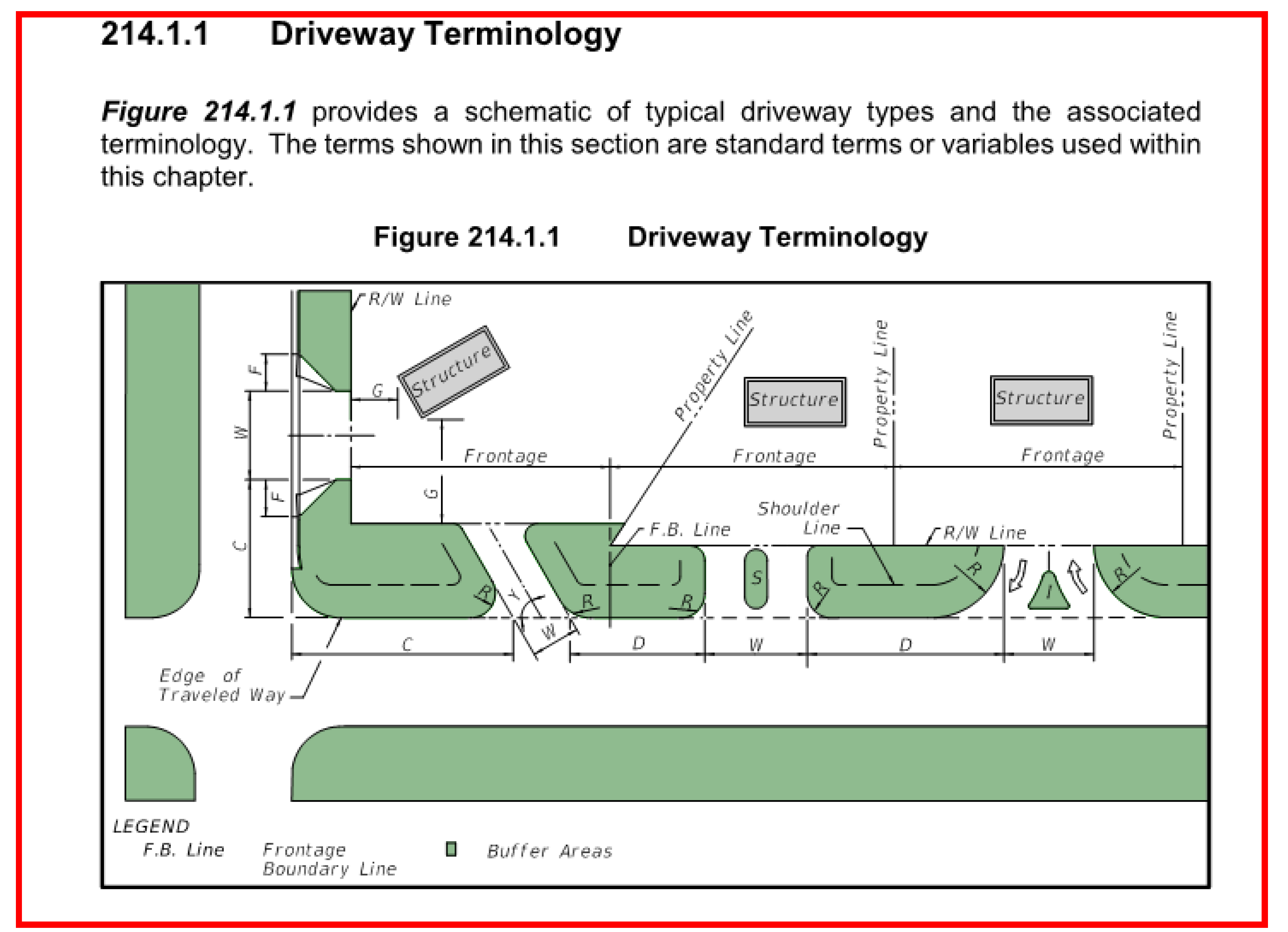
Source: Adopted from FDOT Driveway Handbook, November 2019
a.
All commercial and multi-family uses that require submittal of a site plan shall provide a paved driveway apron extending from the edge of the existing roadway to the right-of-way line. The paving may be composed of asphalt and/or concrete and be in accordance with structural/geometric standards on file in the office of the County Engineer. Non-conforming accesses shall be subject to the provisions of Section 4.05.01.B.8.
b.
If the driveway is a one way in or one way out drive, then the driveway shall have a minimum width of 14 feet and maximum width of 16 feet. All one-way driveways shall have appropriate signage designating the driveway as a one-way connection.
c.
For an unsignalized two-way connection to a public thoroughfare, each lane shall have a width of 12 feet and a maximum of four lanes shall be allowed. Whenever more than two lanes are proposed, entrance and exit lanes shall be divided by a median. The median shall have a minimum area of 75 square feet and shall be a minimum of 4 feet wide.
d.
Driveways that enter the public thoroughfare at traffic signals must have at least two outbound lanes (one for each turning direction) of at least 12 feet in width, and one inbound lane with a 12 foot width.
e.
Driveway grades shall conform to the requirements of FDOT Standard Index #515, Roadways and Traffic Design Standards Indices, latest edition.
f.
Driveway approaches must be designed and located to provide an exiting vehicle with an unobstructed view. In order to provide a clear view of intersecting streets to the motorist, there shall be a visibility triangle formed by two (2) intersecting streets, or the intersection of a driveway and a street, as shown in the graphic below. Nothing shall be erected, placed, parked, planted or allowed to grow in such a manner as to materially impede vision for a height of three (3) feet above the grade within the sight visibility triangle.
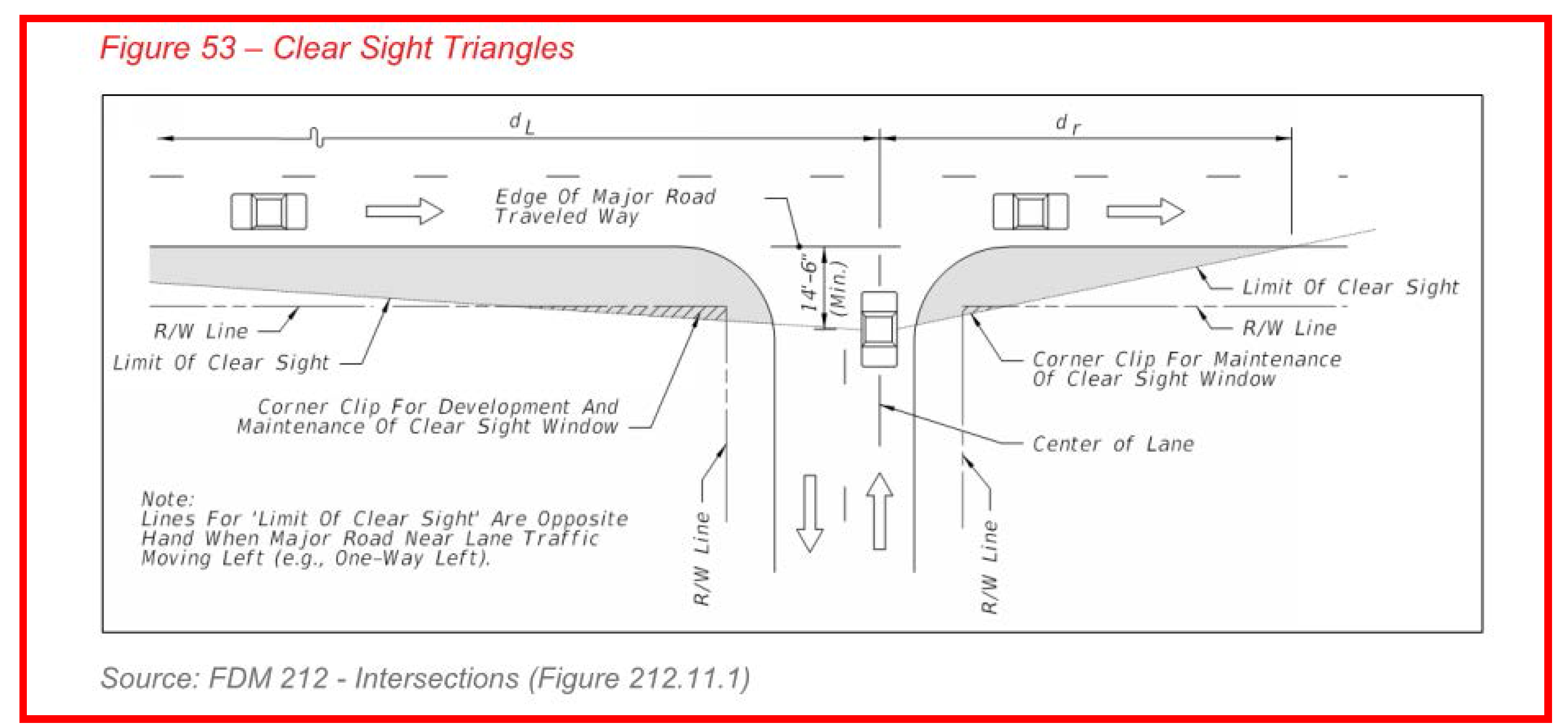
Source: FDOT Design Manual 212 November 2019
g.
Sight distance from a driveway intersection shall be protected, as illustrated in the graphic above. The length of the sight distance shall be determined by the posted speed limit for the roadway as shown in the table below:
;adv=6qq;The sight distance requirements on roadways under State jurisdiction shall comply with the requirements developed by the Florida Department of Transportation (FDOT).
h.
Driveways should not interfere with acceleration or deceleration lands and tapers.
i.
Parking areas should not interfere with the functional area of the driveway.
j.
Driveway radius, width, flare and angle shall be adequate to serve the volume of traffic and provide for rapid movement of vehicles off of the public thoroughfare, but shall not be so excessive as to pose safety hazards for pedestrians, bicycles or other vehicles.
k.
Ingress/egress driveways shall follow the standards shown in the table below, unless the Planning Director deems a variation is necessary to enhance public safety.
Channelizing medians shall be required for two-way driveways with a radius greater than 35 feet and/or with a width of 36 feet or greater. For the purposes of this Section, "urban" shall mean curb and gutter roadway design and "rural" shall mean flush shoulder roadway design.
l.
Driveway Throat Length shall be designed in accordance with the standards listed below. The intent of these standards is to prevent vehicles from backing to the flow of traffic on the public street or causing unsafe conflicts with on-site circulation. The measures provided in the table below are to be applied to the principle access to a property and are not intended for minor driveways.
m.
Driveways with directional restrictions, such as right in/right out driveways shall have raised channelizing islands and appropriate internal directional signage. These channelizing islands shall have a minimum area of 75 square feet and shall be a minimum of 4 feet wide.
n.
New driveways on undivided roadways shall be aligned with existing and planned driveways across the roadway if physically possible. If alignment is not physically possible, then the new driveway shall be offset to the maximum extent possible. Minimum offset distances are provided below and should be adhered to unless lot layout along the road frontage makes such distances impossible to meet. In such cases the Planning Director, in consultation with the Engineering Department and the Florida Department of Transportation, if applicable, shall make a determination as to how the driveways shall be configured to optimize safety.
a = speed limit > 45 b = speed limit < 45
o.
New driveways on divided roadways shall align with existing median openings when feasible.
p.
Corner clearance shall be one hundred twenty (120) feet unless it is not physically possible, then the new driveway shall be placed at the maximum extent possible away from the intersection.
q.
All exit driveways shall have traffic control devices including stop signs, stop bars, and double yellow divider lines on the centerline of the driveways as appropriate. All pavement markings shall be made using thermoplastic paint.
7.
Emergency Access. In addition to minimum side, front, and rear yard setback and building requirements specified in this code, all buildings and other development activities such as landscaping shall be arranged on site so as to provide safe and convenient access for emergency vehicles.
8.
All development including single family residential construction and driveway construction, connecting to county roads shall obtain a permit from Santa Rosa County prior to construction of a driveway connection.
Failure to obtain a driveway permit prior to construction of any drive-way connection or failure to construct a driveway connection in compliance with said permit shall constitute a violation of this ordinance.
Nothing in this section shall be deemed to deny access to any private property.
(Ord. No. 2021-13, § 3(Attch. B), 8-19-21)
4.06.00 - Off-street parking and loading.
4.06.01 Generally.
The design of off-street parking spaces shall ensure that no part of the vehicle shall overhang any pedestrian or bicycle way or path, public easement, public road or public right-of-way. Required parking shall not be used for storage, seasonal sales, promotional sales or other retail or wholesale activities. Required parking shall be used for parking purposes only. Parking areas shall be designed to discourage right-of-way parking.
4.06.02 Off-street parking and loading requirements.
A.
Minimum Criteria for Parking Lots and Other Vehicular Use Areas. Trees are not to be minimized in either height or quantity. Signs designating entrances and exits, are to be of tasteful design and subject to permitting requirement of Section 4.10.00. Trash and refuse containers and all mechanical/utility equipment, including satellite and microwave dishes must be shielded from view from all public rights-of-way.
1.
All areas used for the display or parking of any and all types of vehicles, boats or heavy construction equipment, whether such vehicles, boats or equipment are self-propelled or not, and all land upon which vehicles traverse the property as a function of the primary use, herein described as "other vehicular uses," including, but not limited to, activities of a drive-in nature such as filling stations, grocery and dairy stores, banks, restaurants, and the like, shall conform to the minimum landscaping requirements herein provided. Planter areas within parking areas are to be devoted to living landscaping, which includes grass, ground cover, plants, shrubs and trees.
B.
Off street parking and loading requirements. When the parking standards in this Section are not sufficient in determining the required spaces for a specific land use, the most recent publication of the American Planning Association's "Off-Street Parking Requirements" may be used.
1.
Intent Parking shall be provided in all districts at the time any building or structure is erected or enlarged or increased in capacity by a change of use or the addition of dwelling units, floor area, seats, or other factors determinative of parking demand as stated in this Section.
2.
Parking Space Required by Use.
;adv=6qq;C.
Computation of Parking Spaces. In computing the number of required parking spaces, the following rules shall govern:
1.
Floor area means the gross floor area of a particular use.
2.
Where fractional spaces result, the number of spaces required shall be construed to be the next whole number.
3.
The parking requirements for any use not specified shall be the same as that required for a use of a similar nature as recognized herein or where not recognized herein, shall be based on criteria published by the American Society of Planning Officials and approved by the County Planning Director.
4.
In the case of mixed uses not to include strip centers, the parking shall be equal to the sum of the several uses computed separately.
5.
Whenever a building or use is enlarged in floor area, number of employees, number of dwelling units, seating capacity or in any other manner so as to create a need for a greater number of parking spaces than that existing, such spaces shall be provided in accordance with this Section. Any parking deficiency shall be brought into conformity concurrently with the enlargement or change of use.
6.
All parking spaces required herein shall be located on the same lot with the building or use served, or not to exceed three hundred (300) feet from a building served, measured along lines of public access. However, a parking area designated for "employee parking only" may be located not more than one thousand (1,000) feet from any building served, measured along lines of public access. Such parking area situated more than three hundred feet (300) from a building must be approved by the County Zoning Board.
7.
Shared parking areas shall be permitted in multi-use projects. A reduction in required parking spaces may be allowed if peak demand periods for proposed land uses do not occur at the same time periods. An established Shared Parking model may be proposed to the Planning Director; and if approved, will form the basis for parking requirements for a specific project. The Planning Director may require an Overflow Parking Agreement to be recorded prior to issuing a Development Order for a project requesting a Shared Parking reduction.
D.
Parking in Yard and Landscaping. Unenclosed parking spaces may be located within a required yard, except as provided in this Section under open space/landscaping. All parking areas other than for single family homes and duplexes shall conform to the landscape requirements of the respective zoning district.
E.
Design and Specifications for Parking and Loading Areas.
1.
Stalls, Aisles and Driveways. Parking stalls shall be nine (9) feet wide by eighteen (18) long for angle parking; and shall be nine (9) feet wide by twenty-three (23) feet long for parallel parking stalls. Aisle dimensions shall be in accordance with standard specifications on file in the Planning and Zoning Department and the County Engineer's office. Angle shall be restricted to angles of ninety (90) degrees, sixty (60) degrees, or forty-five (45) degrees. Handicap parking stalls/spaces shall conform to the current design standards of the Americans with Disabilities Act. The following criteria applicable to all parking spaces, except single family homes and duplexes:
a.
No parking shall be allowed in the county right-of-way.
b.
Parking lot islands must be utilized every twelve (12) parking spaces.
c.
Each parking stall shall be accessible from an aisle or driveway and designed so that no automobile shall back into a public street in order to exit a parking stall. The internal design of the parking lot shall be designed to facilitate vehicular circulation and avoid conflict between pedestrian and vehicular movements.
d.
No door or pedestrian entrance at ground level shall open directly upon any driveway or access aisle unless the doorway or pedestrian entrance is at least three (3) feet from said driveway or access aisle.
e.
All parking spaces in paved lots shall have lines between spaces to indicate individual stalls. Wheel stops for stalls adjacent to landscaped strips, structures or sidewalks with no raised curb shall be located two and one-half (2-½) feet from the front end of the stall and prevent encroachment into required landscaped areas. The front two (2) feet of the stall may be kept as a maintained vegetative ground cover area although no credit will be extended toward the open space or landscape requirements of the respective district.
f.
Parking lots with twenty (20) or more spaces may be comprised of a maximum of fifteen percent (15%) compact car parking stalls but only if approved by the County Planning Director or their designee. Such compact car stalls shall be eight feet wide by sixteen (16) feet long and marked for use by small vehicles. All marking shall be on the pavement surface where possible. These spaces shall be evenly distributed throughout the parking area and not grouped together.
2.
Loading Spaces. Every building or part thereof erected or occupied for commercial and industrial uses, shall provide and maintain loading spaces in accordance with the following formula:
a.
One loading space for each ten thousand (10,000) square feet or fraction thereof floor area.
b.
Each loading space shall not be less than twelve (12) feet in width, thirty-five (35) feet in depth and fourteen (14) feet in height.
c.
Loading spaces shall not impede normal vehicular circulation for the parking lot.
d.
For establishments which primarily use small delivery trucks (non-semi) for delivery services, an overflow parking (parking not required by this code) area may be utilized to satisfy the loading zone requirements if approved by the Planning Director or their designee.
e.
In no case shall loading/unloading of any vehicular type be allowed from any public right-of-way.
3.
Modifications. The Planning Director may approve modifications to the design specifications upon demonstrated need by the applicant.
4.06.03 Off-street parking on Navarre Beach.
Off-street parking shall be required in all districts. Temporary parking may be permitted in street right-of-way; however, such parking shall be in addition to the minimum requirements of this section. When the parking standards in this section are not sufficient in determining the required spaces for a specific land use the most recent publication of the American Planning Association's "Off-Street Parking Requirements" may be used.
Where the use is mixed, total requirements for off street parking shall be the sum of the requirements for the various uses computed separately.
Off street loading and unloading for establishments receiving and distributing goods by motor vehicle shall provide such facilities on the premises.
No motor vehicle shall be allowed to extend onto a public street right-of-way, sidewalk or alley while loading or unloading.
A.
Construction projects for commercial, hotel, and high density residential shall make provisions for adequate onsite and offsite parking for all construction related and construction worker vehicles. Such parking may not be on a public right-of-way. This requirement shall apply to all future projects and all projects in existence as of the date of adoption of the section.
(Ord. No. 2021-13, § 3(Attch. B), 8-19-21)
4.07.00 - Landscaping and buffering requirements.
4.07.01 Generally.
A.
Purpose. The purpose of these regulations is to:
1.
Protect the quality of water resources;
2.
Provide shade;
3.
Reduce heat and glare;
4.
Abate noise pollution;
5.
Provide habitat;
6.
Enhance aesthetics; and
7.
Buffer incompatible uses.
B.
Applicability. The requirements of this section 4.07.00 shall apply to all new development, redevelopment and additions to off street parking lots and vehicular use areas. Land clearing shall be permitted only upon an approved Land Clearing Permit or Building Permit.
Any use established or changed to, and any buildings, structures or tracts of land developed, constructed or used for any permitted or permissible principal or accessory use shall comply with all the performance standards herein set forth for the district involved.
If any existing use or building or other structure is extended, enlarged, moved, structurally altered or reconstructed; or any existing use of land is enlarged or moved, the performance standards for the district involved shall apply with respect to such extended, enlarged, moved, structurally altered or reconstructed building or other structure or portion thereof to the greatest extent possible.
After the effective date of this regulation, all new uses, buildings or other structures shall comply with the performance standards herein set forth for the district involved.
C.
Except as otherwise provided herein, all uses in all zoning districts shall conform to the standards of performance described within this Section and shall be so constructed, maintained and operated so as not to be injurious or offensive to the occupations or residents of adjacent premises.
D.
Landscaping General. The purpose of this Section is to protect the quality of water resources from future degradation by maintaining vegetative cover and controlling disturbances to vegetation, to encourage the selection of native plant species for vegetation, to reduce the impact of urban and suburban development on remaining stands of vegetation, to provide shade thereby reducing energy costs by reducing heat, to reduce glare and to abate noise pollution, to provide habitat for living things, and to buffer incompatible land uses. This purpose is accomplished with perimeter landscaping adjacent to public rights-of-way, parking area interior landscaping, landscaped buffers, and tree protection as detailed in section 4.07.00.
E.
Exemptions. Lots or parcels of land on which single family residential homes are constructed and used as residences shall be exempt from the provisions of these landscaping regulations with exception of the Heritage tree protection regulations. The property owner of a residential property verifies compliance with F.S. 163.045 by obtaining documentation from an arborist certified by the International Society of Arboriculture or a Florida licensed landscape architect that the tree presents a danger to persons or property. This exemption shall not be construed to apply to residential subdivisions or other residential developments that require site plan approval.
1.
For development at Peter Prince Airport and NAS Whiting Aviation Park, existing trees are not required to be protected and new trees are not required to be planted.
F.
Landscape Plan Required. The landscaping plan shall be included as part of the project site plan or subdivision plat submittal and shall include the following for living plant materials:
1.
Locations of required planting areas containing grass, shrubs, and/or trees;
2.
Calculations for required landscaping;
3.
Required landscape buffer boundaries graphically shown on the landscape plan;
4.
Species of all plant material;
5.
Height, diameter, and spacing of shrubs and trees proposed to be planted.
6.
Locations of all proposed planting to be used shown on the landscape plan;
7.
Landscape material used to satisfy a requirement of this code must identify what requirement they are satisfying;
8.
Planting details including all necessary soil amendments, mulching and staking. The following planting details shall be included in all landscape plans;
a.
Shrub Detail.
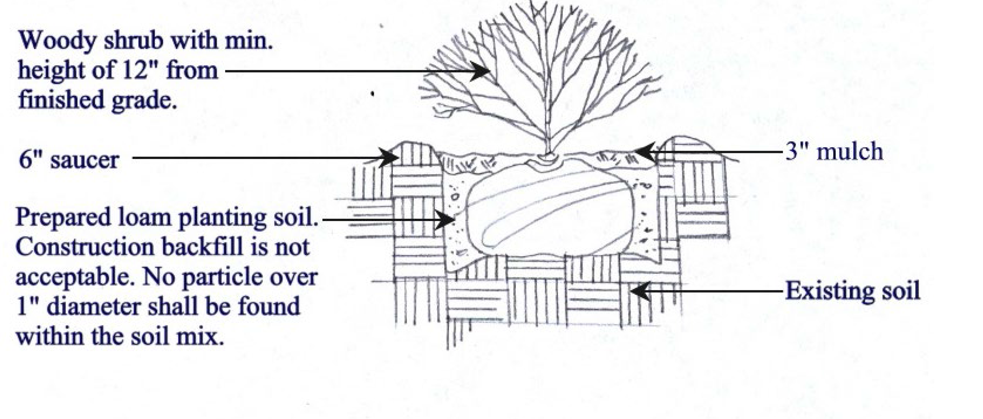
b.
Tree Detail.
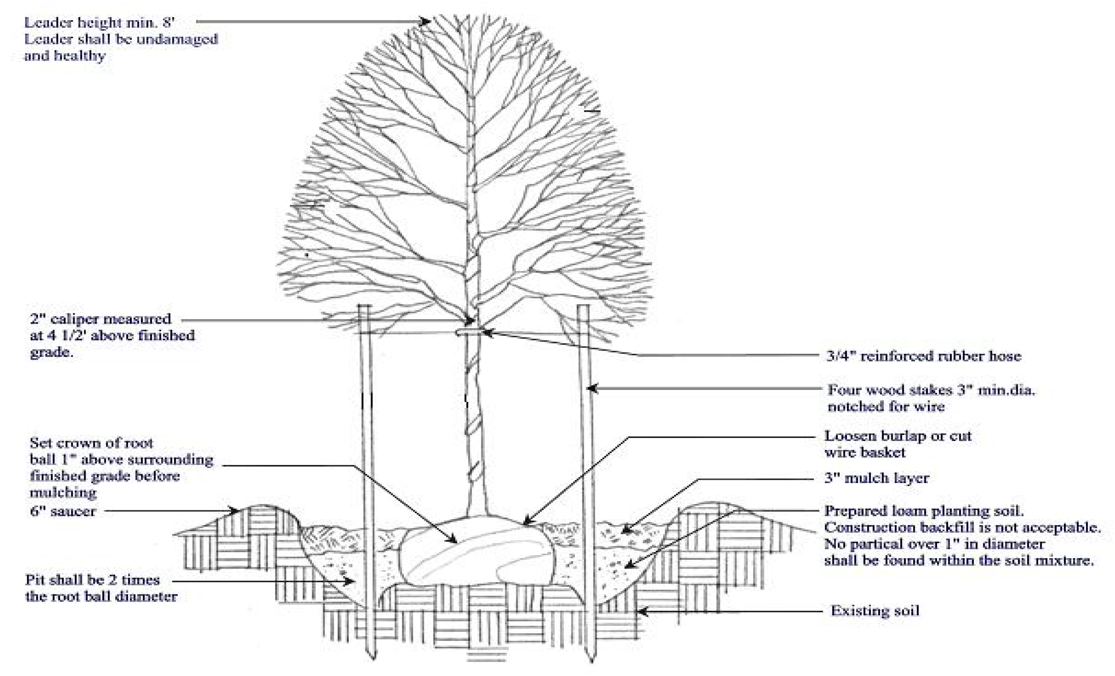
9.
Locations of existing vegetation to be protected;
10.
Protected and preserved tree inventory. All protected, preserved, heritage and champion trees shall be identified on the site plan or other development plan submitted as part of the application for development approval. The plan shall include all such trees that are to remain on site and all such trees that are proposed to be removed. At a minimum, the plan shall identify the following:
a.
Location,
b.
Species, and
c.
Diameter (DBH) at 4.5 feet above grade.
11.
Protection plans for existing tree preservation during and after construction including, but not limited to, fencing, root pruning and irrigation system installation in planting islands where existing trees are to be preserved and are surrounded by impervious surfaces;
12.
Location of irrigation system or other means of watering plans.
G.
Landscape Materials. Diversity of plantings should be strived for in all required landscape plantings, and in no case should one species constitute more than fifty percent (50%) of total planting on site. Landscaping shall utilize native species as recommended by the Florida Friendly Landscaping (FFL) program and the University of Florida. Landscaping shall not utilize any exotic vegetation which is likely to out-compete or otherwise displace native vegetation as identified in the Florida Exotic Pest Plant Council Invasive Plant Lists.
1.
Installation. All landscaping shall be installed in a sound workmanship manner and according to accepted good planting procedures consistent with the details of the approved site plan or plat. Adequate wind and water erosion control measure shall be put into effect prior to commencing site alteration on each increment of a project.
2.
Plants whose physical characteristics may be injurious to the public shall not be specified in areas such as parking lots, along walkways, etc.
3.
Canopy tree species shall be a minimum of eight feet overall height immediately after planting with at least a two inch diameter measured at 4.5 feet above grade (DBH). To determine the DBH of multi-trunk trees, the DBH measurements for each trunk will be added together. Trees having average, eventual mature crown spread of less than fifteen feet may be substituted by grouping the same so as to create the equivalent of a fifteen foot crown spread. A grouping of three large growing palms will be the equivalent to one required canopy tree. All trees shall be located no closer than three feet from the edge of any designated planting area.
4.
Understory tree species shall be a minimum of four feet overall height immediately after planting with at least a one inch diameter measured at 4.5 feet above grade (DBH). To determine the (DBH) of multi-trunk trees, the DBH measurements for each trunk will be added together.
5.
Shrubs shall be a minimum of twelve (12) inches in height when measured immediately after planting.
6.
Grass areas shall be planted in species normally grown as permanent lawns in Santa Rosa County, Florida. Grass may be sodded, sprigged, plugged or seeded except that solid sod shall be used in swales or other areas subject to erosion. When grass areas are to be seeded, sprigged or plugged, specifications must be submitted. One hundred percent coverage must be achieved within one hundred and eighty (180) days. Nurse grass shall be sown for immediate effects and protection until coverage is otherwise achieved.
H.
Prohibited Plants. Plants shall not be installed as a landscape material as if identified in the Florida Exotic Pest Plant Council Invasive Plant Lists.
I.
Irrigation. All required planting areas shall be provided with an irrigation system or other means of watering plants. A system known as a drip system to conserve water is strongly encouraged where deemed practical. Irrigation is not required for xeriscape landscape plans designed by a landscape architect.
J.
Maintenance. The owner, lessor, or party responsible for a building or grounds maintenance or the respective agent of each, if any, shall be jointly and severally responsible for the maintenance of all landscape plant materials and all irrigation equipment. Landscaping shall be maintained in a healthy, orderly appearance at least equal to the original installation and shall be kept free of refuse and debris. Any dead vegetation and landscape material shall be promptly replaced with healthy living material consistent with the Land Development Code.
K.
Vehicular Encroachment. Planted areas on private property shall require protection from vehicular encroachment. No type of parked or moving vehicle, boat, mobile home, travel trailer, or heavy equipment shall encroach on any planted or landscaped area. Encroachment shall be prevented through the use of curbs, wheel stops, or other acceptable means located so as to prevent damage to any trees, fences, shrubs, or other landscaping.
L.
Corner-Visibility Required. When an access way intersects a public right-of-way or when subject property abuts the intersection of two or more public rights-of-way, all landscaping within the triangular areas described below shall provide unobstructed corner-visibility at a level not to exceed three feet. The triangular areas referred to are:
1.
The areas of property on both sides of an access way formed by the intersection of each side of the access way with the public right-of-way with two sides of each triangle being ten (10) feet in length from the point of intersection and the third side being a line connecting the ends of the two other sides.
2.
The area of property located at a corner formed by the intersection of two or more public rights-of-way with two sides of the triangular area being twenty-five feet in length along the abutting public rights-of-way lines, measured from their point of intersection, and the third side being a line connecting the ends of the other two lines.
M.
Landscaping Of Existing Developed Or Redeveloped Properties. Whenever an existing site or structure is altered in any way that exceeds minor change approval as described in Section 4.06.00, landscaping, if not in accordance with present criteria requirements, shall be upgraded to meet those requirements, unless in the opinion of the Planning Director such upgrading is impractical or would have an adverse impact on the applicant's or adjacent property. A voluntary change in landscaping that result in an improvement of the appearance of the property is allowed without approval as long as the approved landscaping requirements are still met.
N.
Final Inspection Required. The Planning Director or their designee shall inspect all required landscaping; and no certificates of occupancy or similar authorization will be issued unless the landscaping meets the requirements herein set forth or unless the owner, developer, landscaper, or their designated agent submits a letter of intent to complete the required landscaping. Such letter must include estimated completion date.
O.
Landscaping Definitions can be found in Section 1.07.02.
P.
Alterations. Any existing development may make changes to their existing landscaping provided that it complies with the current Land Development code without the requirement to apply for a permit or submit a new or revised site plan.
Q.
Incentives. Development Order review fees can be reduced by 20% if a licensed landscape architect is part of the project design team as demonstrated on the site plan by a signature and seal. All development projects of 10,000 square feet or greater must utilize a licensed landscape architect as demonstrated on the site plan by a signature and seal.
R.
Landscaped Open Space. All commercial or multifamily (5 units or more) properties shall devote at least twenty (20) percent of the parcel to landscaped open space. Landscaped open space includes a ten (10) foot wide front perimeter strip, landscaped islands in parking lots, drainage areas, preserved wetlands, and side and rear buffers. Improved parking and driveways are not considered landscaped open space. Landscaping compatible with the location shall be required, including xeriscape treatments.
S.
Screening Adjacent to Residential Districts. Where commercial districts abuts the side or rear lot line of any residential district, any open storage of equipment, materials or commodities shall be screened from the residential lot line. The screen may be in the form of walls, fences or landscaping and shall be at least six (6) feet in height and shall be at least fifty (50) percent opaque as viewed from any point along the residential lot line. When landscaping is used as screening, the height and opacity requirements shall be attained within eighteen (18) months after open storage uses are established.
4.07.02 Required perimeter landscaping adjacent to public rights-of-way.
On the site of a building or open lot use along any abutting right-of-way there shall be provided landscaping between such area and such right-of-way as follows:
A.
A strip of land at least ten feet in depth located adjacent to the abutting right-of-way shall be landscaped with grass, ground cover, or other landscape treatment.
B.
Understory trees are required on the development site based upon the amount of right-of-way frontage. The required number of trees planted shall be equal to one (1) tree every forty (40) linear feet of right-of-way frontage, or fraction thereof and must consist of species from the Florida Friendly Landscape list. These trees should be planted within the ten-foot strip unless either parts C or D of this section apply. This section is not intended to require trees to be equally spaced along the right-of-way, but rather creative design and spacing is encouraged.
C.
Canopy Trees should not be planted within twenty feet (20') of overhead utility lines. When overhead utility lines are present, canopy trees may be substituted using a mixture of understory trees and shrubs. Understory trees may be substituted for trees at a ratio of two (2) to one (1), and shrubs may be substituted for trees at a ratio of four (4) to one (1). Substituted understory trees must maintain a minimum clearance of ten (10) feet from any overhead utility. In no case shall the substituted understory trees be a species that can reach a mature height to exceed fifteen (15) feet.
D.
When, as determined by the Planning Director, or their designee required perimeter landscaping would limit the visibility of a business, shrubs may be substituted for trees at a ratio of four (4) to one (1).
E.
All necessary access ways from the public right-of-way through all such landscaping shall be permitted to service the parking for other vehicular use areas. Such access ways will be subtracted from the linear dimension used to determine the number of trees required.
F.
Trees in the landscape strip do not count as credit towards the parking or buffer tree requirements.
G.
Development within the Rural Protection Zone is exempt from this section.
4.07.03 Required parking area interior landscaping.
Paved parking lots shall be landscaped with trees, shrubs, grass, groundcover or other landscaped treatment located so as to best relieve the expanse of paving.
A.
The minimum number of canopy trees required to be planted within or adjacent to paved parking areas shall be one (1) tree for every twelve (12) parking spaces or fraction thereof. One (1) tree shall be required for those parking areas having fewer than twelve (12) spaces. These trees may be planted within the islands or adjacent to paved parking areas; creative design and spacing is encouraged to accomplish the intent to relieve the expanse of paving.
B.
When standard parking lot islands are required, the minimum size of a planter island must be eight feet wide by the length of the parking space. When planting strips are used within or adjacent to paved parking areas, the planting area shall be no less than eight (8) feet wide. All planter islands and other interior landscape areas must be effectively protected to prevent vehicular encroachment.
C.
Trees in the planter islands do not count as credit towards the required perimeter or buffer trees.
D.
In an industrial project, the overall number of interior landscape areas may be reduced when necessary to avoid conflicts with truck traffic. This reduction would apply only to the interior requirements. Landscaped buffer minimums are not subject to modifications or reductions.
E.
When as determined by the Director of Planning and Zoning, required parking area trees would limit the visibility of a business, and alternative locations are not feasible, shrubs may be substituted for trees at a ratio of four (4) to one (1).
4.07.04 Landscape buffers.
A.
Purpose and Intent. This section requires landscaped buffers to be provided and maintained when certain land uses are adjacent to each other in order to protect uses from the traffic, noise, glare, trash, vibration and odor likely to be associated with a more intensive land use. For purposes of this section, adjacent uses include uses directly across a local road right-of-way of 40 feet or less. Landscape buffers are also required to conserve the values of land and buildings and to provide adequate light and air. The width of the buffer and the required plantings within the buffer vary depending upon the relative intensities of the abutting or adjacent uses. The buffer requirements are intended to be flexible; the developer may choose among a number of combinations of buffer widths and buffer plantings to satisfy the requirement.
B.
How to Determine Landscape Buffer Requirements. Landscape buffers shall be located at the perimeter of the development for any given use and shall not be located in any portion of a public right-of-way unless so desired by the state of Florida or the County. The following procedure shall be followed to determine the type of landscape buffer required:
1.
Identify the proposed use and identify the adjacent land uses by on site survey or the adjacent zoning districts if the adjacent property is vacant.
2.
Identify whether the proposed and adjacent land uses or zoning districts for adjacent undeveloped property are high impact, medium impact, or low impact, Residential Class I or Residential Class II uses by referring to Section 4.07.04.E.
3.
Determine the landscape buffer required on each development boundary (or portion thereof) by referring to Section 4.07.04.F.
4.
Select the desired landscape buffer option from those set forth in Section 4.07.04.G. Any of the listed options shall satisfy the requirement of buffering between adjacent land uses.
5.
The lesser classified use category is not required to provide a buffer from the higher classified use. The intent of this section is to require a higher classified use to provide a buffer from the lesser classified use category.
C.
Landscape Buffer Design and Materials.
1.
Existing Native Plant Materials. The use of existing native species of plant material is required in landscape buffers when possible. Such existing natural vegetation must be of sufficient height and thickness or must be augmented so as to reach the required number of plantings in order to reach a sufficient height and opacity to provide an effective visual and acoustical buffer giving consideration to the existing and proposed uses. If native plant materials are unavailable or not feasible, then non-invasive non-native varieties must be utilized. Existing natural ground cover should be retained where possible by avoiding scraping, grading and sodding within the landscape buffer. Where the planting requirements of Section 4.07.04.G require additional trees or shrubs to be installed in an existing natural area utilized as a buffer, it should be done in a manner which minimizes disturbances to native species.
2.
Where the planting requirements of Section 4.07.04.G require additional plantings to be installed in the landscaped buffer, required canopy plantings may be selected from of Florida Friendly Landscape List at the option of the developer.
3.
Mixed Use Development. Where a building site is used for a single mixed use development, landscaped buffers shall not be required between the various constituent uses. Landscaped buffers required at the perimeter of the development shall be based upon the individual uses on each portion of the property.
D.
Use of Landscaped Buffers.
1.
Open Space. Landscaped buffers may be counted towards satisfying open space or impervious surface requirements and may be used for passive recreation. They may contain pedestrian or bike trails, provided that the total width of the buffer yard is maintained. In no event, however, shall the following uses be permitted in landscaped buffers: playfields, stables, swimming pools, tennis courts, parking lots and vehicular use areas, dumpsters, equipment storage and other open storage, buildings or overhangs.
2.
Stormwater Retention/Detention Facilities. Stormwater retention/detention facilities may encroach into landscaped buffers a maximum of 40% of buffer width, when all planting requirements of this section are met and the visual screen provided by the landscaped buffer will be fully achieved.
E.
Classification of Uses for Determining Buffer Requirements.
1.
Non-residential Uses. For the purposes of determining landscaped buffer requirements, non-residential land uses are classified as either high, medium, or low impact uses as follows:
a.
High Impact Uses. High impact uses are particular uses of land that, because of their operational and physical characteristics are expected to have a strong effect on adjacent uses. High impact uses include, but are not limited to, the following examples:
i.
Industrial uses as defined as Permitted, Conditional uses or Special Exceptions within the following zoning categories CT, M-1, M-2 and PID;
ii.
Excavation/mining activities, borrow pits, and disposal facilities as Permitted in PIT 1 and PIT 2;
iii.
Water and wastewater treatment plants;
iv.
Commercial outdoor amusements as defined as a Conditional Use in HCD;
v.
Feedlots and;
vi.
All accessory uses associated with the above uses.
b.
Medium Impact Uses. Medium impact uses are particular uses of land that, because of their operational and physical characteristics are expected to have a moderate effect on adjoining or adjacent uses. Medium impact uses include but are not limited to the following examples:
i.
General commercial uses, as defined as Permitted or Conditional Uses in HCD except for professional office uses and neighborhood commercial uses such as those found in the Neighborhood Commercial (NC) district;
ii.
Public and private utility and facility uses, except for water and wastewater treatment plants; and
iii.
All accessory uses associated with the above uses.
c.
Low Impact Uses. Low impact uses are particular uses of land that, because of their operational and physical characteristics are expected to have a limited effect on abutting or adjacent uses. Low impact uses include but are not limited to the following examples:
i.
Institutional uses;
ii.
Outdoor recreation uses as defined as Permitted uses in P-1 and P-2, excluding commercial outdoor amusements as described as a Conditional Use in HCD;
iii.
Professional service and office uses, as Permitted uses in NC and HCD;
iv.
Neighborhood commercial uses as defined as Permitted and Conditional Uses in NC;
v.
Public and private utility and facility uses, except for public utility rights-of-way;
vi.
Low intensity agricultural uses as defined as Permitted, Special Exceptions, and Conditional Uses in AG-2, AG-1, and AG-RR;
vii.
Silvicultural uses;
viii.
Billboards;
ix.
All accessory uses associated with the above uses.
2.
Residential Uses. For the purposes of determining landscaped buffer requirements residential uses are classified as follows:
a.
Residential Class I.
i.
All single family and duplex residential uses on a single lot; and
ii.
All accessory uses associated with the above uses.
b.
Residential Class II.
i.
All multi-family development; and
ii.
All accessory uses associated with the above uses.
F.
Table of Landscaped Buffer Requirements.
G.
Landscaped Buffer Options.
1.
Use these specifications to select the desired landscaped buffer option for the building site. These buffer requirements are stated in terms of the width of the buffer yard in linear feet. To determine the total number of plants required, the length of each side of property requiring a buffer shall be divided by one hundred (100) and multiplied by the number of plants described below and the following illustration.
a.
Landscaped Buffer Options Standard A Planting Requirements per 100'.
b.
Landscaped Buffer Options Standard B Planting Requirements per 100'.
c.
Landscaped Buffer Options Standard C Planting Requirements per 100'.
d.
Landscaped Buffer Options Standard D Planting Requirements per 100'.
e.
Landscaped Buffer Options Standard E Planting Requirements per 100'. On the site of a building a buffer may be installed in the form of screening consisting of a wall six feet in height and constructed of concrete block, brick, stone, cement or another similar material and specifically excluding chain link, metal, or wood. Shrubs must be installed between the wall and the adjacent lesser classified use property; or a soil berm four feet in height accompanied by shrubs which will reach a combined minimum height of six feet. The soil berm option may only be utilized in cases where the installation of such berm would not be in conflict with the stormwater management requirements found elsewhere in this Code.
2.
The buffer is normally calculated as parallel to the property line. However, design variations, especially when used to incorporate native vegetation into the buffer area, are allowed. The edges of the landscaped buffer may meander provided that:
a.
The total area of the buffer is equal to or greater than the total area of the required landscaped buffer; and
b.
The landscaped buffer measures at least five feet in width at all points along the perimeter of the property line of the site requiring buffer.
3.
When the requirements of this section result in a fractional number of plantings, the fraction shall be counted as one plant unit.
4.
These diagrams shall serve as a legend for the following diagrams of landscaped buffer options.

5.
A 6-foot privacy fence or masonry wall may be substituted for shrubs within all landscape buffer options except for option E.
H.
Maintenance of Landscaped Buffers. The maintenance of all landscaped buffers and the provision of healthy effective plantings shall be the responsibility of the property owner. Failure to maintain and keep thriving such landscaped buffers in an attractive and healthy state shall be considered a violation of this Section subject to enforcement.
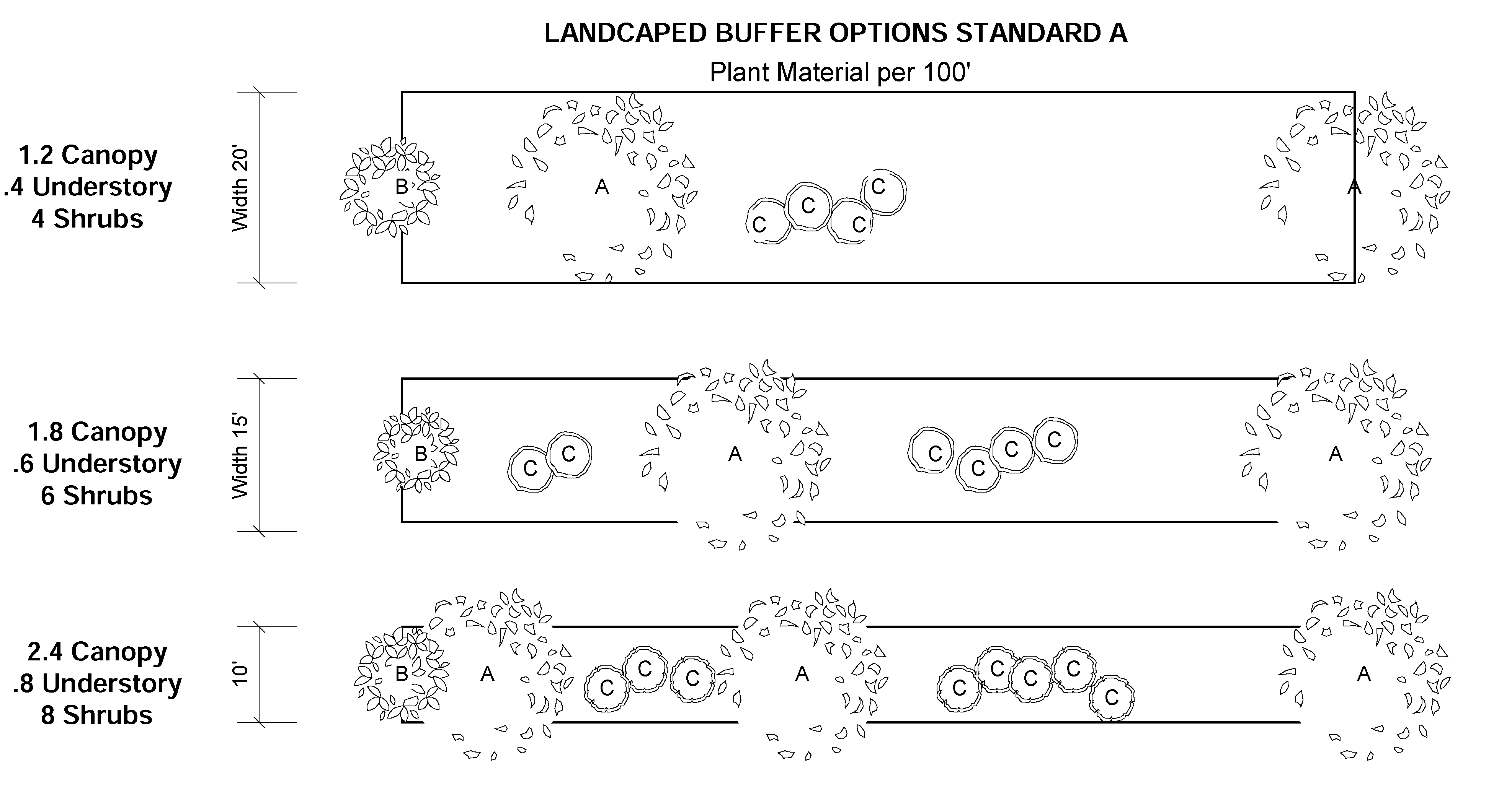
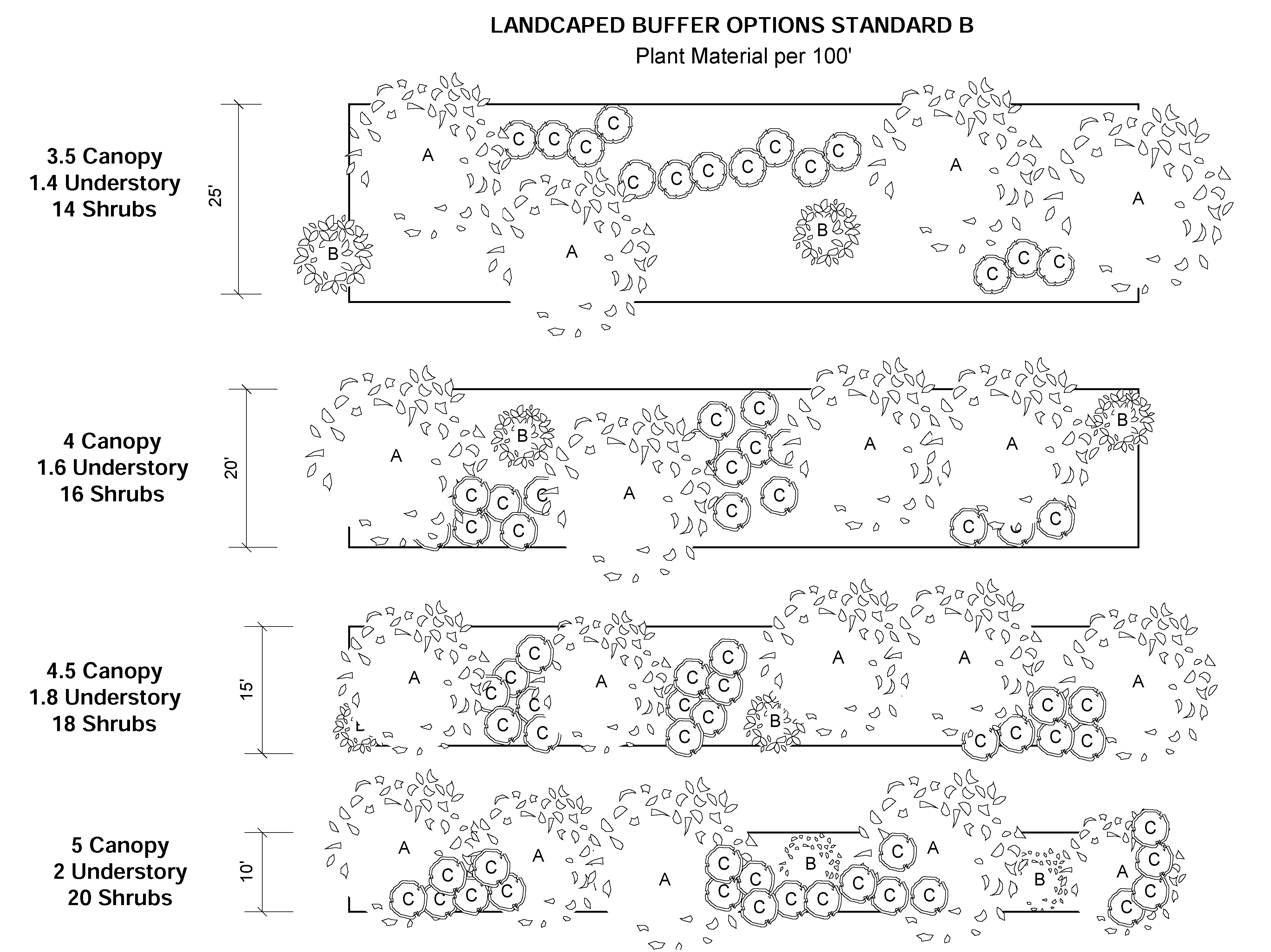
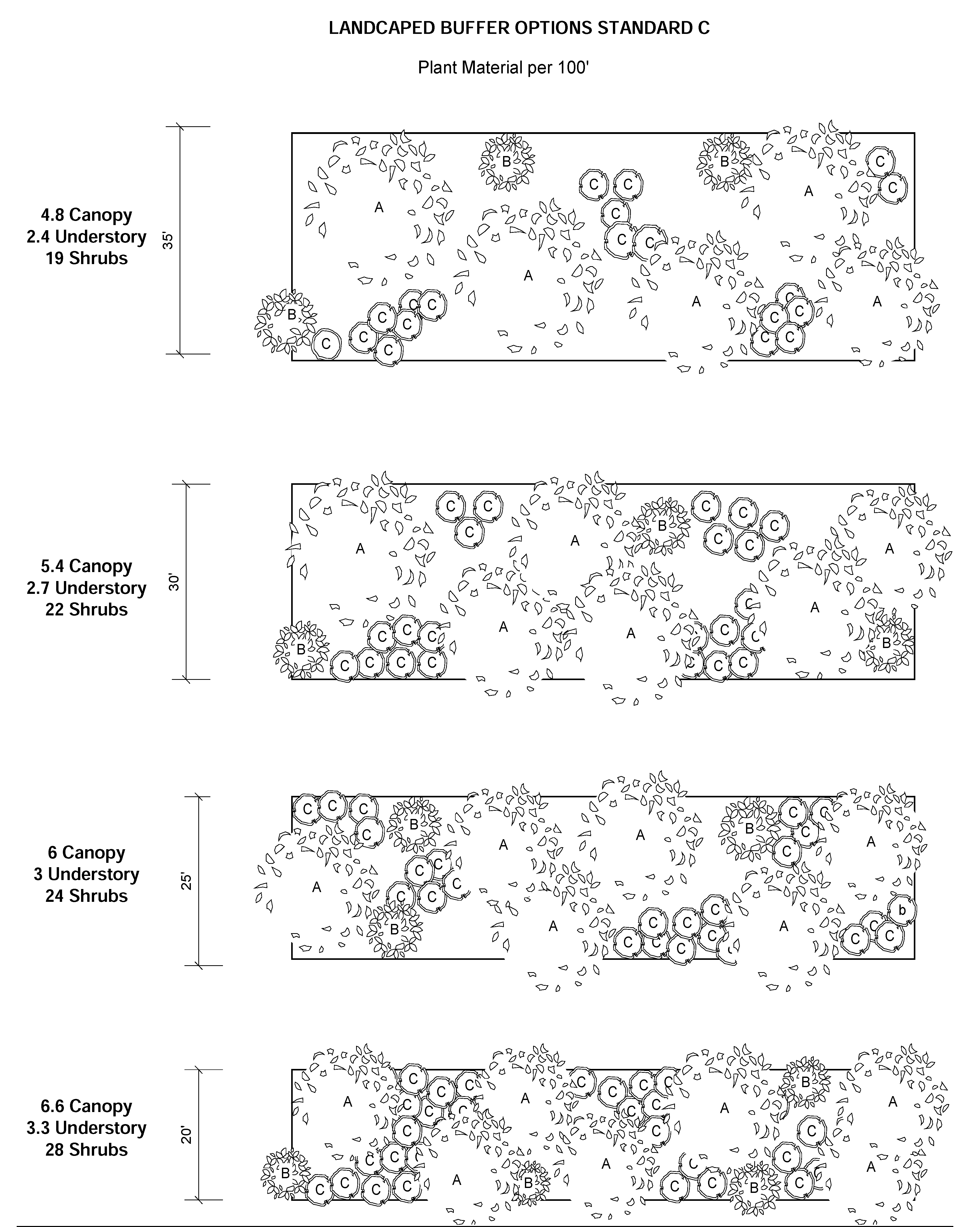
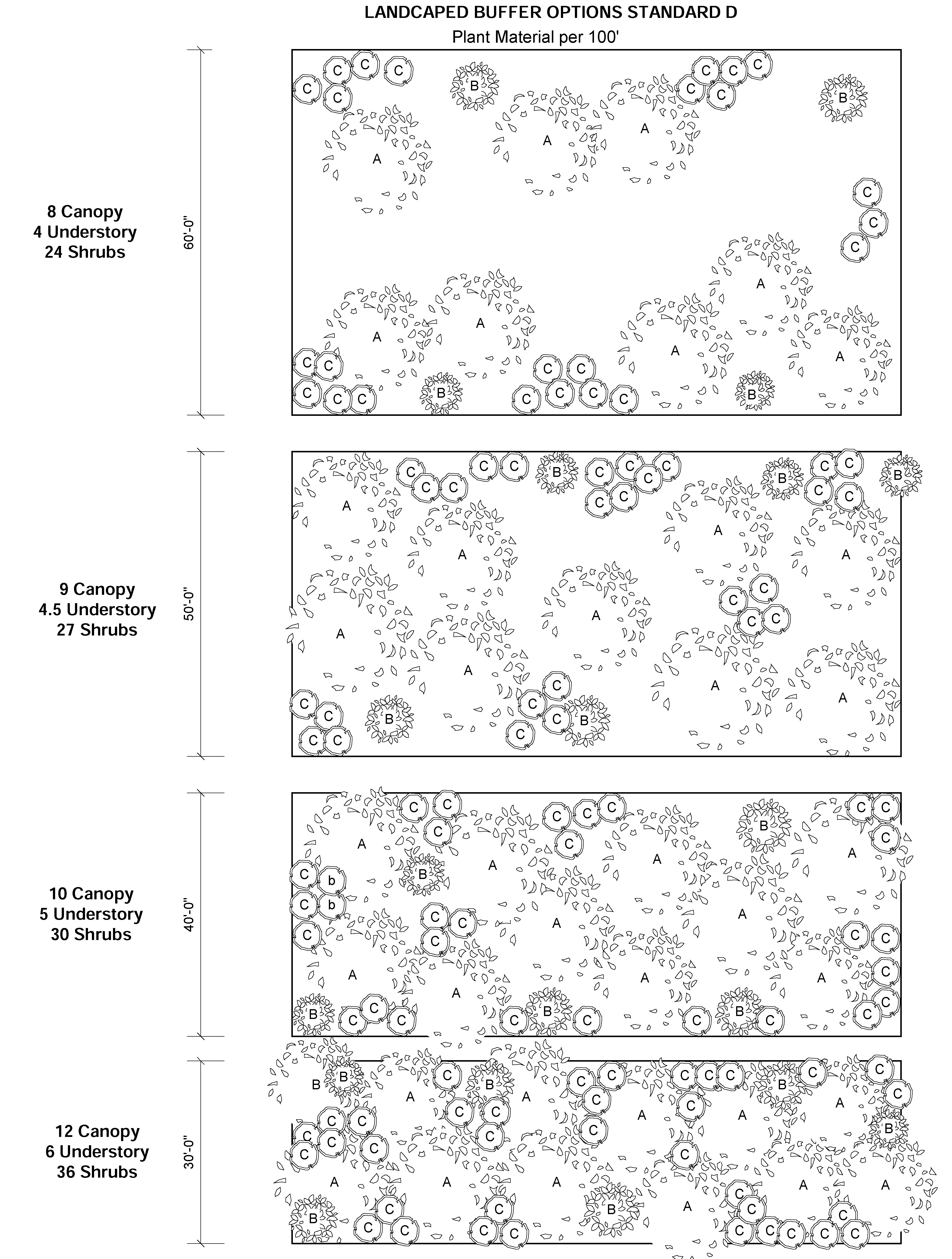
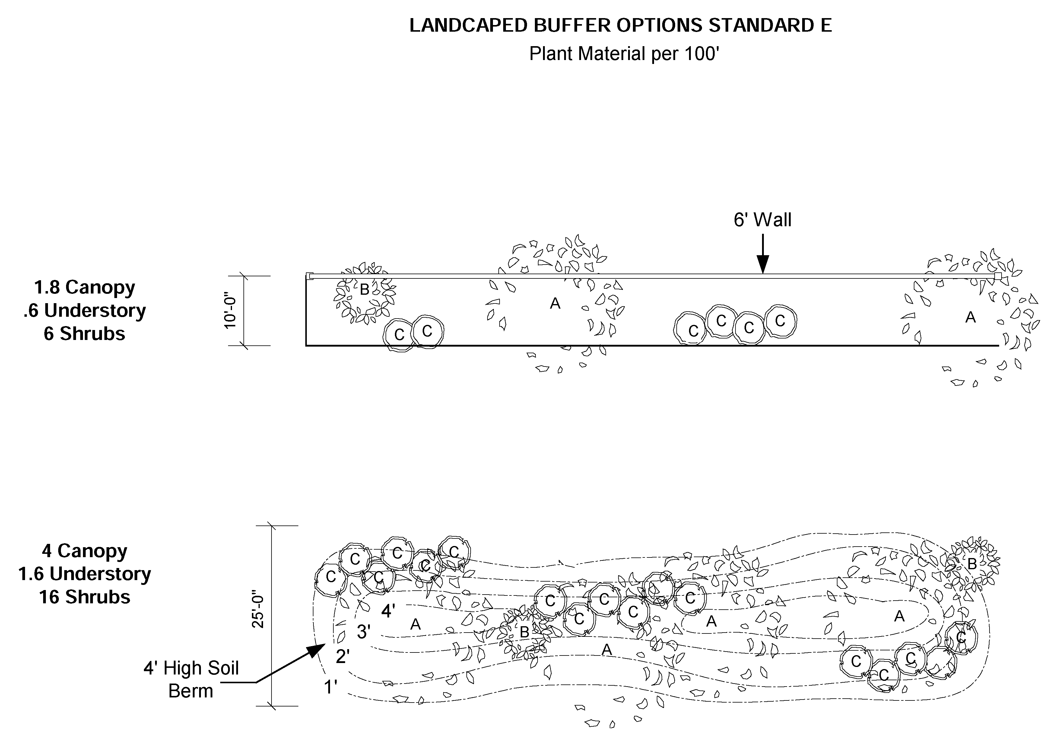
(Ord. No. 2021-13, § 3(Attch. B), 8-19-21)
4.07.05 Tree protection.
A.
Existing Single Family Residential. Santa Rosa County will not require a tree removal permit for the removal of a tree on a parcel that has an existing single family residential structure located onsite.
Santa Rosa County chooses not to require residential tree removal permits for existing single family residential structures based on F.S. 163.045 with the exception of item "C" below.
B.
This section shall not apply to agriculturally zoned property or silviculture activity in an agriculture zoning district or silviculture activity that has a Florida Division of Forestry Management Plan.
C.
Within the Bagdad Historic Overlay Districts, any tree with a DBH of four (4) inches or more (measured 3 feet above grade) shall also require a Certificate of Appropriateness from the Bagdad Architectural Advisory Board.
D.
Permit Required. Protected or preserved trees shall not be removed or damaged without first obtaining a tree removal permit from the County. The Planning Director or their designee, shall review all plans for conformance with the tree protection and landscape requirements of this Ordinance. Non-protected trees may be removed upon approval of a major land clearing permit per Section 4.08.01 or a minor land clearing permit per Section 4.08.00.
1.
Residential tree protection requirements are limited to the following:
a.
Heritage Trees 48 inches in diameter or greater at four and one-half (4 ½) feet above grade (DBH) in areas of Santa Rosa County north of Yellow River including the Garcon Point Peninsula.
b.
Heritage Trees 24 inches in diameter or greater at four and one-half (4 ½) feet above grade (DBH) in areas of Santa Rosa County south of Yellow River.
c.
Champion Trees defined by the University of Florida and the Division of Forestry, Florida Department of Agriculture and Consumer Services.
E.
For all Residential Subdivision Plats and Multifamilyco;normal;normalmmercial Site Plans Development.
In considering the applications for the removal of protected trees, the Planning Director or their designee, may exempt or approve such requests based upon the following standards:
1.
The property owner obtains documentation from an arborist certified by the International Society of Arboriculture or a Florida licensed landscape architect that the tree presents a danger to persons or property.
2.
The applicant demonstrates that reconfiguration of the proposed development is impractical or infeasible based upon characteristics of the site, including site dimensions and topography; or
3.
The location of the tree will constitute a hazard upon completion of development (i.e. traffic hazard, impair visibility at intersections or driveways, etc.); and the applicant demonstrates that such hazards cannot be avoided and such development is consistent with good engineering practices; or
4.
The tree, if left on the site, will constitute a potential hazard to principal or accessory structures or adjoining structures or property as verified by a qualified specialist; or
5.
The tree or its root system will interfere with or damage required infrastructure, including water and sewer lines and laterals and the applicant demonstrates that such impacts cannot be avoided and such development is consistent with good engineering practices; or
6.
The tree is located in the area of the principal structure or would result in the loss of a buildable lot and the applicant demonstrates that such impact cannot be avoided and such development is consistent with good engineering practices. When designing the layout of a proposed development, all Heritage trees must be given special consideration over smaller protected trees and it must be specifically demonstrated and fully explained as to why the saving of a Heritage tree cannot be accomplished.
7.
Champion trees shall not be removed unless specifically deemed to be a danger to the public by an arborist certified by the International Society of Arboriculture or a Florida licensed landscape architect.
F.
Tree Protection Performance Standards Required. Trees shall be protected as follows:
1.
During development activity, protected trees shall be safeguarded from activities which may injure or kill them. Tree protection fencing shall be installed prior to any land disturbing activities within fifty percent (50%) of the drip zone of the protected tree, or one hundred percent (100%) of a Heritage tree, unless otherwise approved by Planning and Zoning Department. At no time shall materials, equipment, or construction offices be stored within this area.
2.
When a protected tree must be removed or relocated, indigenous canopy trees shall replace it according to the mitigation table in this section. Trees shall be a minimum of eight feet overall height immediately after planting and be two (2) inches in DBH measured at four and one-half (4 ½) feet above grade. Replacement trees must be selected from the Santa Rosa County List of Recommended Florida Friendly Landscape Plants.
3.
A minimum of fifty percent (50%) of the area within the drip line of protected trees or one hundred percent (100%) of a Heritage tree, shall be maintained in either vegetative landscape material grading, filling, and ditching cannot take place within fifty percent (50%) dripline of a Heritage tree, but may not encroach any further to the tree base. This does not apply to single family residential lot.
4.
Unless otherwise approved by the Planning Director, or their designee, grading filling and ditching cannot take place within the fifty percent (50%) dripline the protected tree, or one hundred percent (100%) of a Heritage tree. This does not apply to single family residential lot.
5.
If approved by the Planning Director, or their designee, pervious surface cover may be used within the drip line of protected trees but shall be limited to an area no closer than five (5) feet of the tree base. Pervious surface cover may be used up to the fifty percent (50%) dripline of a Heritage tree, but may not encroach any further to the tree base.
6.
All pruning, limbing up or maintenance of any type of a Heritage tree within a multifamily, commercial or industrial development must be approved by Planning Director, or their designee. The approval request will require an original signed letter from a certified arborist or certified by the International Society of Arboriculture or a Florida licensed landscape architect stating the need for the alteration and the manor for which the work should be accomplished to ensure the continued health of the tree.
G.
The removal of protected trees that were previously required to remain per an approved site plan without first obtaining a permit from the County shall be considered a violation of this ordinance and the fee for the removal shall be $500 per inch of mitigation required. This fee will be deposited into the County Tree Fund as found in Section 4.07.05.E.
H.
Protected Trees. The following trees are protected and require a permit for removal.
1.
Small Trees at a diameter of four (4) inches and greater at four and a half (4 ½) feet above grade:
2.
Large Trees at a diameter of eight (8) inches and greater at four and a half (4½) feet above grade:
3.
Heritage Tree. Any living tree with the exception of identified invasive species of special protected status, 48 inches in diameter or greater at four and one-half (4 ½') feet above grade (DBH) in areas of Santa Rosa County north of Yellow River including Garcon Point and 24 inches in diameter in areas of Santa Rosa County south of Yellow River.
4.
Champion Tree. A living tree measured to be the largest specimen of its species in the state as recorded in the champion tree registry of the University of Florida and the Division of Forestry, Florida Department of Agriculture and Consumer Services.
I.
Protected Tree Mitigation. As noted in Section 4.07.04.B.2, when a protected tree is removed, indigenous canopy trees shall replace it. The total diameter of such replacement trees shall be determined based on the following Mitigation and Credit Schedules:
Tree Mitigation Schedule
One additional inch of mitigation will be required for each additional 6" or fraction thereof of diameter beyond 36".
All healthy trees which are preserved shall received credit for the tree planting requirements according to the following schedule:
Tree Credit Schedule
One additional credit can be obtained for each additional 6" or fraction thereof, of diameter beyond 36". Credits for the protection and preservation of native shrubs, hedges and ground cover can be established by the Planning Department.
To determine the total amount of tree inches to be planted for mitigation of protected tree removal, first determine the required mitigation inches using the Tree Mitigation Schedule. Next, determine the number of inches credits using the Tree Credit Schedule. Subtract the caliper credits from the required mitigation inches to determine the total inches in DBH of trees to be planted.
Mitigation can be achieved by planting multiple trees of varying diameter until the mitigation requirements are met. Mitigation trees must meet the minimum size requirements found in Section 4.07.04.D.
J.
Payment in lieu of Mitigation. The Tree Mitigation Fee shall be $130.00 per inch of mitigation required.
Tree mitigation fees will be deposited into the County Tree Fund and may be used for the purposes of purchasing, planting and maintaining trees on public property. Funds may also be used for the creation of landscape plans involving the planting of trees on public property, and for any other tree conservation or planting activity approved by the Board of County Commissioners.
K.
Incentives. The Planning and Zoning Department may grant limited administrative variances to the requirements of this Ordinance to accommodate the protection of existing trees. Examples of requirements that may be varied administratively include: number of required parking spaces, landscape requirements, and perimeter buffer width.
For single family residential subdivisions, the developer will have the option of mitigation fees in lieu of meeting the tree protection requirements.
(Ord. No. 2021-13, § 3(Attch. B), 8-19-21)
4.08.00 - Land clearing and exceptions.
4.08.01 Land clearing of an undeveloped lot is prohibited except:
To the extent reasonably necessary to accomplish the improvement or development of land authorized by a valid Building Permit or Development Order.
A.
Minor Land Clearing. The Planning Director or their designee shall issue a minor land clearing permit for undeveloped properties, prior to the approval of a site plan or subdivision plat, for the purpose of minor land clearing under the following conditions:
1.
The applicant shall submit a non-engineered site plan or sketch showing the following:
a.
The property boundary, with dimensions, and location of existing improvements;
b.
The general location of any protected trees and the graphical indication of the area to be cleared and areas to remain undisturbed. No minor land clearing will be allowed within twenty (20) feet of an incompatible land use;
c.
Size of the property, shown in square feet and/or acres; and
d.
The type and location of erosion control measures. Erosion control measures are required and must be maintained until such time that the lot is developed, or a healthy, vegetative cover is in place to prevent ANY surface erosion.
2.
A minor land clearing permit is not required for the following:
a.
Agriculture or silviculture activity in an agriculture zoning district that have obtained an Agriculture Silviculture designation from the Property Appraiser or silviculture activity that has a Florida Division of Forestry Management Plan;
b.
Lots or parcels of land for the construction of one single family or duplex structure provided a building permit has been issued;
c.
Property maintenance activity such as bush hogging, mowing or tree trimming.
d.
Property with a single family residence or duplex in existence.
e.
For any minor land clearing located within any of the Agriculture zoning districts.
3.
A minor land clearing permit does not authorize major land clearing, or soil disturbing as defined herein.
4.
A minor land clearing permit is required for canal front properties and waterfront properties.
5.
No clearing, grading, excavating, filling, or other disturbance of the natural terrain shall occur until County-approved erosion and sedimentation control measures have been installed, except those operations needed to implement these measures. All erosion and sedimentation control measures shall be maintained throughout the length of construction activity.
B.
Major Land Clearing. The Planning Director or their designee shall issue a major land clearing permit for a residential lot prior to a valid residential building permit being issued, and prior to the approval of a subdivision plat construction documents, for the purpose of major land clearing under the following conditions:
1.
For all residential sites up to five (acres) in size, the applicant shall submit site plan or sketch showing the following:
a.
The property boundary, with dimensions, and location of existing improvements;
b.
The general location of any protected Heritage trees and the graphical indication of the area to be cleared and areas to remain undisturbed. A valid reasoning as outlined in section 4.07.05.A must be provided for all Heritage trees that are proposed to be removed;
c.
All vegetation must remain within the minimum buffer requirements of a common boundary of an incompatible land use;
d.
All wetland and/or floodplain areas must be identified;
e.
Size of the property, shown in square feet and/or acres; and
f.
The type and location of erosion control measures. No clearing, grading, excavating, filling, or other disturbance of the natural terrain shall occur until County-approved erosion and sedimentation control measures have been installed, except those operations needed to implement these measures. All erosion and sedimentation control measures shall be maintained throughout the length of construction activity. For lots exceeding one (1) acre in size a SWPPP permit must accompany the application.
2.
For all sites greater than five (5) acres in size, the permit shall also include:
a.
A sediment basin of 3,600 CF of storage area per acre is required along with other appropriate sediment retention measures mentioned above. These will be sited on their survey/aerial. Where conditions dictate, smaller basins totaling the required storage may be situated on the site appropriately.
b.
This permit will not relieve the applicant for applicable state and federal permit requirements.
3.
A major land clearing permit is not required for the following:
a.
Agriculture silviculture activity in an agriculture zoning district or silviculture activity that has a Florida Division of Forestry Management Plan not required to obtain a NPDES (National Pollution Discharge Elimination System) Permit for the activity being done.
b.
Property maintenance activity such as bush hogging, mowing or tree trimming.
c.
All parcels for which a single family residence has been built, or for which a permit has been obtained, and is active.
d.
All parcels for which an approved development order has been obtained.
e.
For subdivisions going through the platting process a wetland delineation line would be required when submitting construction plans.
f.
For any major land clearing activity located within any Agriculture zoning district.
4.
All major land clearing activity for commercial or multi-family developments are not eligible for a major land clearing permit and must obtain an approved site plan development order for any major land clearing activity.
C.
Land Clearing Requirements for which a Development Order or Land Clearing permit has been given.
1.
The developer shall limit all land clearing activities to the area approved within the development order.
2.
Clearing activity one (1) acre or greater requires an NPDES permit and a SWPPP. See requirements listed in Section 3.04.05 Erosion and Sediment Control.
3.
Before site disturbance occurs, perimeter controls, sediment traps, basins, and diversions should be in place to control runoff and capture sediments. Prioritize disturbed areas in the vicinity of waterbodies, wetlands, steep grades, long slopes, etc., for effective stabilization within seven days of disturbance. Graded areas that will not be worked on should be seeded and mulched as required by NPDES permit, rather than waiting until all project grading is done. A well-planned and well-maintained construction entrance with stabilized construction roads can prevent offsite sedimentation, keep sediments off roads, minimize complaints from neighbors, and reduce future expenses and aggravation.
4.
Protected trees shall be marked and protected during clearing activities.
5.
Contractor shall control odor, dust and noise during construction.
(Ord. No. 2021-13, § 3(Attch. B), 8-19-21)
4.09.00 - Alcohol sales regulations.
4.09.01 Standards regulating vendors selling liquor, beer or wine for on-premises consumption.
A.
Permit Required. No vendor shall sell liquor, beer or wine for on-premises consumption in the unincorporated areas of the County without first obtaining a Certificate of Zoning Compliance from the Planning Department.
1.
No Certificate of Zoning Compliance shall be granted to a vendor for the sale of liquor, beer or wine for on-premises consumption in any area of Santa Rosa County, lying without the limits of incorporated cities or towns, when said place of business is within 2,500 feet of an established church or school. However, this section shall not apply to licenses defined in s. 563.02(1)(a) and s. 564.02(1)(a), F.S., or any restaurant equipped to serve at least thirty-five (35) persons full-course meals at tables at one time, and deriving at least 51% of its gross revenues from food and non-alcoholic beverages.
2.
A Certificate of Zoning Compliance shall not be denied to the transferee of the license holder if the transferee operates the business at the same location and applies for the Certificate of Zoning Compliance within sixty (60) days of the last day of business of the transferor at said location.
B.
Distance Measurements. The distance as set forth in subpart A above shall be measured by following the shortest route of ordinary pedestrian travel along the public thoroughfare from the main entrance of said place of business to the main entrance of the church or, in the case of a school, to the nearest point of the school grounds in use as part of the school facilities.
C.
Establishment of New Churches or Schools. Whenever a licensee has procured a license permitting the sale of liquor, beer or wine and thereafter a church or school is established within a distance otherwise prohibited by this Ordinance, of the place of business of the licensee, the establishment of such church or school shall not be cause for the revocation of such licensee and shall not prevent the subsequent renewal of such license. However, no existing license may be transferred to within the distance from churches or schools prohibited by this Ordinance. An existing licensee that is within 2500 feet of a church or school may relocate its certificate of zoning to a location within said 2500 feet if the distance from the relevant church or school is increased and said relocation does not bring the business within 2500 feet of another church or school.
D.
Application Fee. Any application for a Certificate of Zoning Compliance under this section shall be accompanied by a fee.
(Ord. No. 2021-13, § 3(Attch. B), 8-19-21)
4.10.00 - Sign regulations.
4.10.01 Generally.
The sign regulations set forth in this Section shall apply to all signs erected within the Santa Rosa County or Navarre Beach Planning Areas. The purpose of reasonable, content-neutral, non-discriminatory sign regulation through time, place, and manner of use. It is the intent of these standards to protect and enhance the economic vitality and physical appearance of the county as a place to live, vacation and conduct business, more specifically, this section is intended to:
A.
Enable the proper scale quantity, period, and placement of signs to effectively promote commerce to identify places of residence and business, and to orient, to direct, and inform the public.
B.
Require that signs be adequately designed and constructed, and be removed when unauthorized or inadequately maintained, to protect the public from conditions of blight and the dangers of unsafe signs.
C.
Lessen visual confusion and hazards caused by improper height, placement, illumination, or animation of signs, and assure that signs do not obstruct the view of vehicles and pedestrians traveling public streets or create nuisance conditions.
D.
Protect the interests of sign owners in continuing to use lawfully established and maintained signs while providing the community with a gradual remedy for existing undesirable conditions resulting from non-conforming signs.
E.
Sign and sign face defined. Any device attached or freestanding structure, or any combination of device or structure, made or any material, with or without a written message, figure, painting, drawing, logo symbol or other form, designed, placed, intended, or used to inform or attract attention. Including, but not limited to, all flags, banners, streamers, excluding flags and insignia of any government, state, county, city or agency thereof. Any surface which displays such elements is a sign face.
F.
Permits required. Unless specifically authorized in this section by an exemption from permitting, no person shall place, post, display, construct, alter, or relocate any sign without having first obtained all necessary permits. Regardless of any exemption from county permitting, all signs remain subject to article standards of design, construction, placement, and maintenance.
G.
Non-conforming signs. Any sign which does not comply with the regulations of this Ordinance, or subsequent amendments. Modification or replacement of any non-conforming sign must follow the following:
1.
Lawfully established and maintained signs that no longer comply with one or more current requirements of the LDC may continue as non-conforming signs in use, but the expansion of any non-conformance is prohibited. An existing non-conforming sign shall not be structurally altered so as to prolong the life of the sign, or so as to change the shape, size, type or design of the sign.
2.
If a non-conforming sign is relocated for any reason, the sign shall be brought fully into compliance with the standards of this section, regardless of any estimated cost to replace the sign at its former location
3.
An existing non-conforming sign shall not be repaired after being damaged if the repair of the sign would cost more than fifty percent (50%) of the cost of the sign.
4.
If a non-conforming sign is removed or destroyed, it may be replaced only by a sign that is in conformance with this Ordinance. Except that if insufficient space is available to comply with the setback regulations, the replacement sign may vary from said regulations to the minimum extent necessary to allow its placement.
5.
An existing non-conforming on-premises sign may be changed by modifying the words or symbols used, the message displayed or any other change to the advertising display area. However, in the case of more than one non-conforming on-premises sign per business only one (1) on-premises sign shall be allowed to be facially changed. This sign shall be the one most conforming, excessive square footage and/or height being a greater non-conformity than inadequate set-backs.
An existing non-conforming wall sign may be changed by modifying the words or symbols used, the message displayed or any other change to the advertising display area (with the exception of those listed in Section 4.10.01.G). In the case where two (2) or more wall signs exist, only one (1) wall sign shall be allowed to be facially changed. This sign shall be the one most conforming.
H.
Sign Types. For the purposes of this section, signs are defined and identified as follows and may be further characterized within the standards of the article:
1.
Freestanding signs. A freestanding sign is any sign that stands on its own, not attached to a building.
a.
Pole signs. A pole or pylon sign is any freestanding sign that is elevated above the adjacent grade and mounted on one or more poles, pylons, or similar vertical supports from the ground.
b.
Monument signs. A monument or ground sign is any freestanding sign with its entire base placed directly on the ground.
c.
Portable signs. A portable sign is any freestanding sign that is not permanently attached to the ground or a permanent structure, or a sign that is designed to be transported.
d.
Vehicle and trailer signs. A vehicle or trailer sign is any sign that is made portable by permanent or temporary attached to or placement in any manner on a registered, operable, and lawfully parked motor vehicle or trailer.
2.
Wall signs. A wall sign is any sign that is attached to or painted on the exterior wall of a building in such a manner that the wall is the supporting structure for the sign or forms the background surface of the sign. For the allocation of sign area and other purposes of this section, wall signs include awning, canopy, fascia, marquee, and murals.
a.
Awning, canopy, fascia, and marquee signs. An awning, canopy, fascia, or marquee sign is any sign that is mounted or painted on, or attached to an awning, canopy, fascia, or marquee respectively, but not projecting above, below, or beyond the awning, canopy, fascia, or marquee.
b.
Projecting signs. A projecting sign is any sign supported by a building wall and extending outward from the wall with the sign display surface perpendicular to the wall.
c.
Murals. A mural is any sign that is an original, one-of-a-kind work of visual art tiled or painted by hand directly upon the facade of a building.
3.
Changeable message signs. A changeable message sign is any sign that is designed to allow frequent changes in its displayed message. Messages may be changed through any of the following means, but a change in message does not constitute a different sign:
a.
Manual. A periodic manual change on the sign face, typically by rearrangement of letters along horizontal tracks, by replacement of printed substrates, or by redrawing, all without otherwise altering the sign.
b.
Mechanical. Different messages automatically displayed intermittently on the same sign face by mechanical means, as on the slatted face of a "tri-vision" sign that allows three different messages to revolve and appear at recurring intervals.
c.
Electronic. An electronic message display made up of internally illuminated components (e.g., LEDs) of the sign face controlled by a programmable electronic device allowing remote or automatic display of multiple messages in various formats and at varying intervals.
d.
Projection. A message display created by the projection of an image onto a building wall or other display surface from a distant device.
4.
Electronic Reader Board (ERB) Signs. Electronic display and projected image signs shall comply with the following additional standards:
a.
Movement. Only as authorized within this section may displays and projected images include dynamic messages that appear or disappear through dissolve, fade, travel, or scroll modes, or similar transitions and frame effects; or have text, animated graphics, or images that appear to move or change in size, or are revealed sequentially. None shall flash or pulsate.
b.
Display times. Each message shall be displayed or projected a minimum of six consecutive seconds.
5.
Temporary signs. A temporary sign is any sign that is not intended to be permanently located or anchored to a fixed location. Temporary signs include balloon, air-activated, banner, flags and other wind signs. Temporary signs may also include free standing signs such as portable or vehicle and trailer signs. All temporary signs, with exception of a vehicle sign, are required to be removed and stowed if a tropical storm or hurricane warning is issued for Santa Rosa County.
a.
Air-activated signs. An air-activated sign is any temporary sign with one or more parts given form or animation by mechanically forced air
b.
Balloon signs. A balloon sign is any temporary sign that is air or gas inflated.
c.
Banners. A banner is any temporary sign that is made of lightweight, non-rigid, and typically non-durable material such as cloth, paper, or plastic, and that is designed to be secured to a structure along two or more sides or at all corners by cords or similar means, or to be supported by stakes in the ground. A banner is not a wind sign. No banners shall be attached to a fence.
d.
Flags and other wind signs. A wind sign is any sign that is designed and fashioned to move when subjected to winds, including wind socks, wind spinners, whirligigs, and flags. A flag is any wind sign made of a continuous sheet of fabric or other flexible material, designed to be supported along one edge and typically flown from a pole or staff.
6.
On-premises sign. A sign, billboard, device or structure of any material, or portable (trailer) sign which directs attention to or has as its subject matter a business, commodity, service entertainment, or any other subject matter conducted, sold, or offered on the premises where the sign is located.
7.
Off-premises sign. A sign, billboard, device or structure of any material, or portable (trailer) sign which directs attention to or has as its subject matter a business, commodity, service entertainment, or any other subject matter conducted, sold, or offered at a location other than on the premises where the sign is located.
8.
Exempt. An exempt sign is any sign that is relieved by the provisions of this section from the requirement to obtain a sign permit.
9.
Roof signs. means any sign erected upon or above a roof or parapet wall of a building or placed above the apparent flat roof or eaves of a building.
I.
Illumination. Where authorized, signs may be illuminated by internal or external artificial light sources that comply with the following standards:
1.
Luminance. Illuminated signs, are not permitted in residential districts or the Neighborhood Commercial District. Sign luminance, the light emitted by a sign or reflected from its surface, shall not be greater than necessary to reasonably allow the sign to be viewed by its primary audience (e.g., passing vehicles).
2.
Source and direction. Lighting directed toward a sign shall be shielded so that it illuminates only the face of the sign and does not shine directly into public right-of-way or residential premises.
3.
Glare. Lighting shall not create excessive glare for pedestrians, motorists or adjacent uses, or obstruct the view of traffic control devices or signs.
J.
Sign Placement.
1.
No signs other than those authorized by the Board of County Commissioners are allowed on or over public right-of-way; except as provided herein.
2.
No signs shall project over public property except those signs authorized by the appropriate public agency.
3.
No sign shall be located to restrict the view of drivers at an intersection, or while entering and leaving a public right-of-way.
K.
Installation Requirements. All freestanding permanent signs shall be supported by uprights or braces in or upon the ground furnished by the installer of said sign. In no case will signs be supported by utility company poles, trees, or any other structure not furnished specifically for the particular sign.
L.
Maintenance. All signs shall be maintained in a safe, presentable, and good structural condition at all times, including the replacement of defective parts, painting, repainting, cleaning, and other acts required for the maintenance of said sign.
M.
Owner responsibility. All property owners, and leaseholders of property on Navarre Beach, are responsible for the proper permitting, placement, construction, and maintenance of any signs on their property. The owner or leaseholder shall be equally responsible for conditions of the area in the vicinity of the sign, and shall be required to keep this area clean, free from overgrowth of vegetation, sanitary and free from noxious or offensive substances, rubbish, and flammable waste materials. Additional responsibilities include compliance with all applicable provisions of the LDC and the state building code, any required state department of transportation permitting for signs along state maintained roads, and the timely elimination of temporary or inadequately maintained signs.
N.
Overlay Districts. In addition to the provisions of this article, signs shall comply with any prohibitions, limitations, or other sign standards of applicable overlay zoning districts.
O.
Administration and Enforcement. The standards of this section shall be enforced by county code enforcement officers. Any party or parties in violation of these standards shall be subject to notices of violation, citations, and civil penalties.
1.
All signs on public lands of any type, including public rights-of-way, in violation of the provisions of this section are subject to removal and disposal by code enforcement officers or other county-authorized personnel without notice or compensation. Such removal does not preclude citations or imposition of penalties for the violation.
2.
If the condition of any authorized sign becomes unsafe in the opinion of those authorized to enforce the provisions of this section, the owner shall remove the sign or secure it in a manner complying with this section and applicable building codes within ten days after receiving written notice from the county. Where the danger is immediate, the condition shall be corrected without delay. If the unsafe condition is not corrected, the county shall be authorized to correct the condition at the owner's expense, including removal of the sign.
4.10.02 Sign area calculations.
A.
The sign face is the area of any regular continuous geometric shape which contains the entire surface area of a sign upon which copy may be placed. In the case of the freestanding or awning signs, the sign face consists of the entire surface area of the sign on which copy could be placed and does not include the supporting or bracing structure of the sign unless such structure or bracing is made a part of the sign message. Where a sign has two display faces back to back, the area of the largest face shall be calculated as the sign face area. Where a sign has more than one display face, all areas which can be viewed simultaneously shall be considered in the calculation of the sign face area.
B.
V-type signs using a common support member with an angle between them of not more than ninety (90) degrees shall be considered one sign.
C.
For signs other than freestanding or awning signs whose message is applied to a background which provides no border or frame, the sign face area shall be the smallest regular geometric shape which can encompass all words, letters, figures, emblems, and other elements of the sign message.
4.10.03 Prohibited signs.
It shall be unlawful to erect or maintain the following signs in any district:
A.
Motion, light, and sound. Any sign that moves or changes, that contains mirrors or other reflective surfaces, that produces excessive glare, flashes or exhibits other noticeable changes in lighting intensity, or that emits visible vapors, particulates, sounds, or odors, except as specifically authorized in this section for changeable message signs.
B.
Obscenity. Any sign displaying words, pictures, or messages that are obscene as defined by F.S. ch. 847, and in application of contemporary community standards of the county.
C.
Obstruction and interference. Any sign constructed or maintained in any manner that endangers or obstructs any firefighting equipment or any fire escape, window, door, or other means of egress. Any sign that interferes with any opening required for ventilation, prevents free passage from one part of a roof to any other part, or blocks a public sidewalk or required pedestrian walkway. Any sign that obstructs intersection site lines.
D.
Roof top signs. Any sign erected upon or above a roof or parapet wall of a building or placed above the apparent flat roof or eaves of a building.
E.
Traffic hazards. Any sign that creates a traffic hazard or a detriment to pedestrian safety. Such hazards include any sign that projects into the line of sight of a traffic signal and disrupts the minimum required sight distance; any sign that obstructs vision between pedestrians and vehicles using public rights-of-way; and any sign that imitates, resembles, or interferes with the effectiveness of an official traffic sign, signal, or other traffic control device.
F.
Unauthorized. Any sign not authorized by the provisions of this section, including handbills, posters, and notices attached to trees, utility poles, fence, park benches, or other objects and structures not designed or authorized for the attachment of signs to include signs mounted on a chassis not specifically designed for the sign. Product I.D. and/or public safety signs shall be permitted on fences to a maximum of two (2) square feet per sign per fence.
G.
On Navarre Beach, unless specifically authorized by the BOCC: searchlights, balloons, air activated signs, wind signs, and similar devices or ornamentation designed for the purposes of attracting attention, promotion, or advertising; bare bulb illumination around a sign perimeter; back-lighted or plastic signs; projected image signs; signs on benches; banners; murals or other signs painted directly on rocks, fences, walls, or any exterior parts of a building; portable signs, either free-standing or trailer mounted; and roof signs.
Non-accessory signs attached to any craft or structure in or on a water body designed or used for the primary purpose of displaying advertisements. Provided, however, that this section shall not apply to any craft or structure which displays advertisement or business notice of its owner, so long as such craft of structure is engaged in the usual business or regular work of the owner, and not used merely, mainly or primarily to display advertisement.
4.10.04 Exempt signs and activities.
Some sign types or activities will be allowed without a permit if they meet any of the following exemptions:
A.
General sign exemption. Signs not visible from a public right-of-way or other public land are exempt from the requirement to obtain county sign permits. This general exemption does not apply to signs that are simply illegible. As further established in this section, additional exemptions are authorized specific to work done on signs, sign type, and parcel use. The following conditions apply to all authorized exemptions:
1.
Exempt signs shall be designed, constructed, placed, and maintained in compliance with the provisions of this section, other applicable provisions of the LDC, and the state building code.
2.
No sign exemption supersedes or cancels any prohibitions or restrictions on the display of signs established in this section, any restrictive covenants adopted for a development, or any executed lease agreements.
3.
Exempt signage does not modify or limit the availability of non-exempt signage authorized in this section. Additionally, the allocations for exempt signs are separate from those for non-exempt signs, and neither shall be used to supplement the other in the authorization of an individual sign.
B.
Sign face replacement exemption. The face of a conforming or non-conforming sign may be replaced without a permit if no other alterations are made to the sign, including modifications to the size or configuration of supporting cabinets or frames.
C.
Sign repair and maintenance exemption. Repairs and maintenance performed as necessary to maintain conforming or non-conforming signs in good and safe condition as originally authorized is exempt from sign permits.
D.
Sign-specific exemptions. In addition to the general exemptions established in this section, the following specific signs are exempt from county sign permits with the conditions noted:
1.
Accessory device signs. Signs manufactured as standard, permanent, and integral parts of mass-produced devices accessory to authorized non-residential uses, including vending machines, fuel pumps, and similar devices customarily used outdoors.
2.
Cemetery monuments. Permanent monuments placed within cemeteries.
3.
Government or public signs. Signs placed or required to be placed by agencies of county, state, or federal government, including, but not limited to: traffic control signs, street address numbers, building permits, flags, notices of any court or law enforcement officer, redevelopment area gateway signs, public monuments, hazard warnings, and public information signs. These signs may deviate from the type, quantity, duration, area, color, height, placement, illumination, or other standards of this article as necessary to comply with the law, rule, ordinance, or other governmental authorization by which the signs are placed.
4.
Murals on walls of authorized non-residential buildings, excluding the walls of a building's main street front facade, and provided contains no text designed for advertisement purposes.
5.
Recreational and playground signs. Signs accessory to and within outdoor recreational facilities, only if oriented for view from within the facilities. Such signs include scoreboards, sponsor signs attached to the field side of playing field fences, and concession stand signs.
6.
Temporary decorations accessory to the authorized land use and customarily associated with a short-term event, such as a holiday, garage and yard sales, estate sales, school or church activities.
7.
Vehicle signs on any motor vehicles or trailers actively in transit along public streets, and any of the following signs attached to or placed on registered, operable, and lawfully parked motor vehicles or trailers:
a.
Parked. Signs on a vehicle at the residence of the principal driver of the vehicle, or on a vehicle or trailer at the residence of the individual to whom the unit is registered, or signs on a vehicle or trailer parked a maximum 24 hours at any site.
b.
Signs on a vehicle or trailer in the service of a licensed or otherwise bonafide enterprise, and on the authorized site of that enterprise or on any site where the enterprise is actively providing its goods or services.
c.
Signs on vehicles or trailers stored within parcel areas authorized for such outdoor storage, including parcels authorized for the sale, lease, or rental of vehicles or trailers.
8.
Wall signs mounted for pedestrian view on the walls of authorized principal and accessory buildings, each sign a maximum three (3) square feet in area.
9.
Wind signs accessory to the authorized land use of the parcel, and not otherwise exempt as temporary decorations.
a.
Flags accessory to the authorized land use of the parcel mounted on fixed flagpoles. Flagpole heights are limited to the maximum height allowed within the zoning district for which the flagpole is located.
b.
Other wind signs accessory to the authorized land use that are subjected to winds, including wind spinners and whirligigs limited to signs less than four (4) feet in area and four (4) feet in height. For commercial uses these types of signs shall be limited to display of goods for sale and shall not be placed in the required ten (10) foot landscape strip.
E.
Parcel-specific exemptions. In addition to the general and sign-specific exemptions established in this section, a separate allocation of non-illuminated freestanding signage for each development parcel is exempt from sign permits. This parcel-specific exemption is established primarily to accommodate temporary signs of varying periods of display.
1.
Residential parcels whose authorized principal use is single family or two family (duplex) residential, are allowed a maximum of two (2) signs per dwelling unit. Each sign will be allowed a maximum of six square (6) feet in area and six (6) feet in height allowance. In addition, temporary decorations customarily associated with a short-term event, such as a holiday, garage, yard, or estate sale will be allowed during the event.
2.
Agriculture and group homes housing six (6) or fewer residents parcels whose authorized principal use is not single family or two family (duplex) residential, are allowed a maximum of two (2) signs per site. Each sign will have a maximum of sixteen square (16) feet in area and six (6) feet in height allowance.
3.
Multifamily or subdivision project parcels whose authorized principal use is not single family or two family (duplex) residential, are allowed a maximum of one (1) sign per entrance site and model home/sales office site provided that the sites are located within the project parcel. Each sign will have a maximum of sixteen square (16) feet in area and six (6) feet in height allowance. Each site will be allowed two (2) feather flags.
4.
Commercial, industrial or other non-residential parcels whose authorized principal use is not single family or two family (duplex) residential, multifamily or subdivision parcels, are allowed a maximum of two (2) signs per street front. Lots abutting more than one public street may have sign(s) on each street front. Each sign will have a maximum of sixteen square (16) feet in area and six (6) feet in height allowance. Each site is allowed one feather flag per fifty (50) feet of street frontage.
4.10.05 Temporary signs by permit.
A.
Temporary Signs. Temporary signs not otherwise prohibited or exempt may be authorized by permits under the conditions of this section. All temporary signs remain subject to the design, construction and maintenance standards of this section. Temporary signage by permit does not modify or limit the availability of permanent signage authorized in this section. The following temporary signs are subject to the permit conditions noted:
1.
Balloon and air-activated signs. Balloon signs and air-activated signs not eligible as exempt temporary decorations may be authorized for a single display period of no more than fifteen (15) days when accessory to the authorized land use. Such signs shall be limited to one (1) sign per business, strip or shopping center. Each sign is limited to a setback of no less than the height of the sign from all rights-of-way, parcel lines, and overhead utility lines. All signs shall be adequately secured to the ground to prevent horizontal movement. Relocation for use on a different parcel shall require a new temporary permit, regardless of any remaining period of the prior authorization.
2.
Banners. Banners not eligible as exempt temporary decorations may be authorized for a single display period of no more than thirty (30) days when accessory to the authorized land use. Banners shall be limited to one (1) banner not to exceed thirty-two (32) square feet per business. For developments with two (2) or more tenant spaces, one (1) banner per one hundred (100) feet of street frontage will be permitted. No banner may be attached to a fence, no ground-mounted banner shall exceed four (4) feet in height, and no banner attached to a building shall be displayed above the roof line.
3.
Portable, vehicle and trailer signs. One (1) portable, vehicle or trailer sign may be authorized when accessory to the authorized land use. Such signs shall be limited to one (1) sign per business. The sign is limited to a maximum of one hundred (100) square feet in area and ten (10) feet in height. Relocation for use on a different parcel shall require a new temporary permit, regardless of any remaining period of the prior authorization.
B.
Offsite Subdivision Sign. The purpose of offsite subdivision signs is to direct the traffic related to new residential subdivisions in a manner that minimizes visual clutter, reduces unnecessary traffic through established neighborhoods, and provides an orderly, attractive, high quality image of the county. When originally placed, signs will require a sign permit as required by this title and their locations approved outside of the county's right-of-way. This section is not intended to supersede state regulations regarding signage on State right-of-way.
1.
There may be one offsite subdivision sign per connection to adjacent roadways per residential subdivision not to exceed a total of three signs. Multiple phases do not increase the number of offsite signs per overall development.
2.
Offsite subdivision signs shall not exceed thirty two (32) square feet in sign area, fifteen feet (15') in height, and eight feet (8') in width with signage at least thirty six inches (36") off the ground. Proposed offsite subdivision signs exceeding these dimensions require approval through the conditional use permit process.
3.
No directional offsite subdivision signs may be located within five hundred feet (500') of another directional offsite subdivision sign except in the case of signs on different corners of an intersection, unless an unusual situation causes the need for a deviation as determined by the county.
4.
All directional offsite subdivision signs placed on private property shall have the written consent of the property owner.
5.
The review of a proposed directional offsite subdivision signs will include size, height, design, materials, and colors.
6.
The directional offsite subdivision sign may only be located in a manner that does not obstruct the view of traffic or safety signs, encroach within the clear visibility area, or otherwise pose a traffic or safety hazard.
7.
There shall be no additions, tag signs, streamers, balloons, flags, devices, display boards, or appurtenances added to the subdivision offsite subdivision signs as originally approved.
8.
Offsite subdivision signs must be removed after a subdivision developer has completed the sale of all units in the development. Each developer shall be responsible for their removal.
4.10.05 Permanent on-premises signs.
A.
Unless authorized in this section as temporary or exempt, permanent on-premises signs placed in commercial, industrial and agriculture districts shall conform to the following standards:
1.
Advertising Display Area.
a.
One freestanding or projecting sign not to exceed one hundred (100) square feet per street front. Lots abutting more than one public street may have one sign on each street front. Such signs must be separated by a minimum distance of 100 feet between signs. Signs located within the Neighborhood Commercial District shall not exceed thirty-two (32) square feet.
b.
Each single occupancy premises shall be entitled to wall sign(s) the sign face area of which, in the aggregate, shall not exceed 10 percent of the building's main street front elevation Allowance for wall signs can be divided for multiple sign locations and building elevations so long as the maximum allowable face area as calculated above is not exceeded. Each building elevation shall be limited to a sign area of ten (10) percent of the elevation's aggregate area.
2.
Sign Height. The maximum height for freestanding signs shall be thirty (30) feet. No attached sign shall extend above the eave line of a building to which it is attached. Roof surfaces constructed at an angle of 75 degrees or more from horizontal shall be regarded as wall space. The maximum height for freestanding ground mounted signs located within the Neighborhood Commercial District shall be six (6) feet.
3.
Set Back. Five (5) feet from any property line measured from the leading edge of the sign or supporting upright which ever protrudes farthest out towards the property line.
B.
Shopping Center/Malls. Permanent on-premises signs advertising a group of commercial establishments comprised of seven (7) or more stores which are planned, developed, owned or managed as a unit shall conform to the following requirements.
1.
Advertising Display Area.
a.
One freestanding sign noting the name of the mall or center and/or its tenants as determined by the owner shall be one square foot of sign area per one linear foot of street frontage not to exceed three hundred (300) square feet per face of sign. Lots abutting more than one public street may have one sign on each street front. Such signs must be separated by a minimum distance of 100 feet between signs.
b.
Each building shall be entitled to wall sign(s) the sign face area of which, in the aggregate, shall not exceed 10 percent of the building's main street front elevation. Allowance for wall signs can be divided for multiple sign locations and building elevations so long as the maximum allowable face area as calculated above is not exceeded. Each building elevation shall be limited to a sign area of ten (10) percent of the elevation's aggregate area.
2.
Sign Height. The maximum height for freestanding signs shall be thirty (30) feet. No attached sign shall extend above the eave line of a building to which it is attached. However, roof surfaces constructed at an angle of 75 degrees or more from horizontal shall be regarded as wall space.
3.
Set Back. Five (5) feet from any property line measured from the leading edge of the sign or supporting upright which ever protrudes farthest out toward the property line.
C.
Strip Center/Project Parcel. Permanent on-premises signs advertising a group of commercial establishments comprised of between two (2) and up to six (6) stores or businesses which are planned, developed, owned or managed as a unit shall conform to the following requirements.
1.
Advertising Display Area. One freestanding sign noting the name of the center and/or its tenants as determined by owner shall be one square foot of sign area per on linear foot of primary street frontage not to exceed two hundred (200) square feet. Freestanding signs located within the Neighborhood Commercial District shall not exceed forty-six (46) square feet. Lots abutting more than one public street may have one sign on each street front. Such signs must be separated by a minimum distance of one hundred (100) feet between signs.
2.
Each building shall be entitled to wall sign(s) the sign face area of which, in the aggregate, shall not exceed 10 percent of the building's street front elevation. Allowance for wall signs can be divided for multiple sign locations and building elevations so long as the maximum allowable face area as calculated above is not exceeded. Each building elevation shall be limited to a sign area of ten (10) percent of the elevation's aggregate area. Wall sign area for any individual tenant space within a multi-tenant building shall be in proportion to the exterior wall of that space's aggregate area. Unused sign area on one building or tenant wall is not available to any other building or tenant wall.
3.
Sign Height. For freestanding signs not to exceed thirty (30) feet. Freestanding signs located within the Neighborhood Commercial District shall not exceed twelve (12) feet.
4.
Setback. Five (5) feet from any property line measured from the leading edge of the sign or supporting up right which ever protrudes farthest out toward the property line.
D.
Residential Zones. The following permanent on-premises signs shall be permitted in residential zones.
1.
One (1) sign per lot for uses commercial entities allowed in residential zoning categories serving as identification and/or bulletin boards, not to exceed thirty-two (32) square feet in area. A sign may be placed flat against the wall of the building or may be freestanding provided that it be no closer to any property lines than ten (10) feet and not to exceed six (6) feet in height.
2.
Two signs per residential subdivision entrance, identifying said subdivision, of not more than thirty-two (32) square feet of advertising surface and shall not exceed six (6) feet in height, identifying the residential subdivision. Where two or more residential subdivisions share the same entrance to a major thoroughfare one sign for each subdivision will be permitted at this entrance not to exceed sixty-four (64) square feet combined. Subdivision entrance sighs shall be allowed on the right-of-way when approval is obtained from the Planning and Zoning Department, Engineering and Road and Bridge Department.
3.
One non-illuminated name plate per street frontage designating the owner or the occupant and address of the property. The name plate shall not be larger than two hundred (200) square inches and may be attached to the dwelling or be freestanding. No permit shall be required for such signs.
E.
Manufacturing/Industrial Parks (Applies to parks in one compound). Permanent Accessory sign advertising an Industrial Park shall meet the following requirements.
1.
Advertising Display Area Per Firm.
a.
Inside park or compound Same as 4.10.06.A.
b.
Park Entrance Sign Noting the name of the park or compound.
i.
Same as 4.10.06.C without wall signs.
F.
Navarre Beach. All signs constructed on Navarre Beach shall, in addition to other requirements in this Section shall conform to the requirements herein below:
1.
The maximum allowable sign face shall be fifty (50) square feet.
2.
The maximum allowable sign height shall be twenty (20) feet.
3.
Earth tones shall be emphasized with primary colors being minimized and used only for accent.
G.
Other Permanent Signs. Other signs permitted in conjunction with signs permitted in Sections 4.10.06.A through F include:
1.
On-premises menu signs at restaurant ordering stations not in excess of forty five (45) square feet. A maximum of one (1) menu board per ordering station will be allowed. Vehicle clearance markers are allowed with the drive through lane, but no additional signs can be placed or attached their support structure.
2.
Directional/information signs guiding traffic and parking on commercially developed property. Such signs that are located within twenty (20) feet of a public right-of-way shall not exceed four (4) square feet in size or three (3) feet in height. All other such signs located within the development will have no maximum square size but will have a maximum height allowance of five (5) feet.
3.
Signs on a commercial canopy. Each single canopy shall be entitled to a sign(s). The sign face area of which, in the aggregate, shall not exceed ten (10) percent of the canopy's combined elevations. Allowance for can be divided for multiple locations or canopy sides so long as the maximum allowable area as calculated above is not exceeded.
4.10.07 Permanent off-premises signs.
Permanent off-premises signs shall be permitted in the commercial zoning districts (excluding the Neighborhood Commercial District), industrial zoning districts and agriculture zoning districts south of Willard Norris Road and shall conform to the requirements below. No off-premises signs shall be allowed on Navarre Beach.
A.
No signs permitted along a State Highway without approval from FDOT or without meeting the criteria for exemption per F.S. 479.16.
B.
Advertising Display Area
1.
Along the Highway 98, 87, Avalon Boulevard Corridors and Highway 90. The advertising display area of a permanent off-premises sign shall not exceed four hundred (400) square feet per individual advertising surface.
2.
All other areas:
a.
Four-Lane Thoroughfares. The advertising display area of a permanent off-premises sign in these areas shall not exceed four hundred (400) square feet per individual advertising surface.
b.
Two-Lane Thoroughfares. The advertising display area of a permanent off-premises sign in these areas shall not exceed one hundred (100) square feet per individual advertising surface.
C.
Sign Height.
1.
Along the Highway 98, 87, Avalon Boulevard Corridors and Highway 90. No permanent off-premises sign in these corridors shall exceed an overall height of fifty (50) feet measured from the crown of the road for which the sign permitted to the top of the sign.
2.
All other areas:
a.
Four-Lane and Two-Lane Thoroughfares. No permanent off-premises sign in these areas shall exceed an overall height of thirty-five (35) feet measured from the crown of the road for which the sign is permitted to the top of the sign.
D.
Spacing.
1.
Along the Highway 98, Highway 87, Avalon Boulevard Corridors and Highway 90. No off-premises sign shall be placed within two thousand (2,000) feet of any other off-premises sign on the same side of the street right-of-way within a three hundred (300) foot radius of another off-premises sign.
2.
All other areas:
a.
Four-Lane and Two-Lane Thoroughfares. No off-premises sign shall be placed within one thousand (1,000) feet of any other off-premises sign on the same side of the right-of-way within these areas, nor shall any off-premises sign be placed within a three hundred (300) foot radius of another off-premises sign. For off-premises signs located within the agriculture zoning districts the minimum spacing between any off-premises signs located on the same side of the right-of-way shall be one thousand three hundred and twenty (1,320) feet.
3.
Proximity to residential. No billboard shall be located within one hundred (100) feet of an existing residence.
E.
Setbacks.
1.
Four-Laned Thoroughfares. Twenty-five (25') feet from the nearest right-of-way line; measured from the leading edge of the sign or supporting up right whichever protrudes farthest out toward the right-of-way.
2.
Two-Laned Thoroughfares. Fifteen (15) feet from the nearest right-of-way line measured from the leading edge of the sign or supporting up right whichever protrudes farthest out toward the right-of-way line.
3.
Five feet (5) from any side property line measured from the leading edge of the sign or supporting up right whichever protrudes farthest out.
F.
The maximum number of advertising surfaces per sign structure, facing in one direction, is one (1). Stacked, off-premises signs shall be prohibited.
G.
The following areas are designated as scenic zones. Off-premises signs are prohibited in these zones.
1.
Beginning at the west right-of-way line of Woodbine Road at the intersection of Highway 90 and Woodbine Road proceeding west on both the north and south sides of Highway 90 to the county line in the Escambia River.
2.
On Avalon Boulevard beginning at the southerly right-of-way line of Coronado Street, proceeding south along Avalon Boulevard on both the east and west sides of the highway to the intersection of Garcon Point Road and Avalon Boulevard.
3.
On Garcon Point Road and beginning at Jake's Bayou, proceeding south along Garcon Point Road on both east and west sides of the highway to the north end of the Garcon Point Bridge, on both the east and west to the south end of the bridge. Then from the south end of the bridge proceeding south, on both the east and west sides of the highway to the north right-of-way line of Highway 98.
4.
Beginning five hundred (500) feet west of the Interstate 10 Bridge going over Blackwater River, on both the north and south sides of the Interstate and continuing over the bridges to a point five hundred (500) feet east of the bridge.
5.
Pea Ridge Connector. Beginning on the northern right-of-way line of Highway 90 proceeding north to Hamilton Bridge Road.
H.
For off-premises signs located in areas of Santa Rosa County south of Yellow River there shall be a cap and replace provision.
I.
Permanent Off-Premises Directional Signs. Permanent off-premises directional signs shall be permitted and shall conform to the following requirements.
1.
No signs permitted along the State Highways (unless permitted by the State).
2.
The advertising display area shall not exceed thirty-two (32) square feet.
3.
Sign height shall not exceed fifteen (15) feet.
4.
Signs shall not be placed within the road right-of-way and no closer than twenty (20) feet to the curb, edge of pavement or corner of an intersection.
5.
Written and notarized permission from the property owner will be required.
6.
Three off-premises directional signs will be permitted for any one entity.
7.
No off-premises directional sign shall be placed within five hundred (500) feet of any other off-premises directional sign on the same side of the right-of-way.
J.
Priority of Signs. Where the location of two or more permanent off-premises signs conflict under the requirements of this ordinance, the sign meeting the requirements of this ordinance, and having the earliest dated permit for its erection shall have priority over other sign in conflict therewith.
4.10.08 Special zoning and overlay district sign regulations.
A.
Bagdad Historic and Conservation Districts. Signs within these Districts must be consistent with the standards detailed in "Bagdad Historic and Conservation District Design Standards" (June 16, 2008) adopted herein by reference.
B.
Navarre Beach. All signs constructed on Navarre Beach shall, in addition to other requirements in this Section shall conform to the requirements for wind load specifications per Florida Building Code.
Unless specifically authorized by the Navarre Beach Director: searchlights, balloons, air activated signs, wind signs, and similar devices or ornamentation designed for the purposes of attracting attention, promotion, or advertising; bare bulb illumination around a sign perimeter; back-lighted or plastic signs; projected image signs; signs on benches; banners; murals or other signs painted directly on fences, walls, or any exterior parts of a building; and roof signs.
4.10.09 Substitution of non-commercial speech for commercial speech.
Notwithstanding anything contained in this Section or Code to the contrary, any sign erected pursuant to the provisions of this Section or Code may, at the option of the owner, contain a non-commercial message in lieu of a commercial message and the non-commercial copy may be substituted at any time in place of the commercial copy. The non-commercial message (copy) may occupy the entire sign face or any portion thereof. The sign face may be changed from commercial to non-commercial messages, or from one non-commercial message to another non-commercial message, as frequently as desired by the owner of the sign, provided that the size, height, setback and other dimensional criteria contained in this Section and Code have been satisfied.
4.10.10 Content neutrality as to sign message (viewpoint).
Notwithstanding anything in this Section or Code to the contrary, no sign or sign structure shall be subject to any limitation based upon the content (viewpoint) of the message contained on such sign or displayed on such sign structure.
4.10.11 Severability.
A.
In general. If any part, section, subsection, paragraph, subparagraph, sentence, phrase, clause, term, or word of this Section is declared unconstitutional by the valid judgment or decree of any court of competent jurisdiction, the declaration of such unconstitutionality shall not affect any other part, section, subsection, paragraph, subparagraph, sentence, phrase, clause, term, or word of this Section.
B.
Severability where less speech results. Without diminishing or limiting in any way the declaration of severability set forth above in section 4.10.11, or elsewhere in this Section, this Code, or any adopting ordinance, if any part, section, subsection, paragraph, subparagraph, sentence, phrase, clause, term, or word of this Section is declared unconstitutional by the valid judgment or decree of any court of competent jurisdiction, the declaration of such unconstitutionality shall not affect any other part, section, subsection, paragraph, sentence, phrase, clause, term, or word of this Section, even if such severability would result in a situation where there would be less speech, whether by subjection previously exempt signs to permitting or otherwise.
C.
Severability of provisions pertaining to prohibited signs. Without diminishing or limiting in any way the declaration of severability set forth above in Section 4.10.11, or elsewhere in this Section, this Code, or any adopting ordinance, if any part, section, subsection, paragraph, subparagraph, sentence, phrase, clause, term, or word of this Section or any other law is declared unconstitutional by the valid judgment or decree of any court of competent jurisdiction, the declaration of such unconstitutionality shall not affect any other part, section, subsection, paragraph, subparagraph, sentence, phrase, clause, term, or word of this Section that pertains to prohibited signs.
(Ord. No. 2021-13, § 3(Attch. B), 8-19-21)