
Santa Rosa County Unincorporated
City Zoning Code
City Zoning Code
CHAPTER 7
- SPECIAL OVERLAY DISTRICTS
7.01.00 - Generally.
It is the intent and purpose of this Chapter to establish and adopt zoning overlay districts to govern the use of land and water within such districts.
(Ord. No. 2021-13, § 3(Attch. B), 8-19-21)
7.02.00 - Establishment of special overlay districts.
The following overlay districts are established. The uses allowable by the underlying zoning district shall apply, except as limited by the use requirements of the overlay district.
7.02.01 Special overlay districts.
A.
Bagdad Historic Overlay District.
B.
East Milton Wellfield Protection Zone.
C.
Rural Protection Zone.
D.
Garcon Point Protection Area.
E.
Navarre Beach Commercial Core Area.
F.
Rosemary Sound Overlay.
(Ord. No. 2021-13, § 3(Attch. B), 8-19-21)
7.03.00 - Bagdad Historic Overlay District.
7.03.01 Generally.
It is hereby declared a matter of public policy that the protection, enhancement, perpetuation and use of structures or sites of special character or special architectural, archeological, or historic interest or value is a public necessity and is required in the interest of the health, prosperity, safety and welfare of the people. The purpose of this Land Development Code section is to:
a)
Effect and accomplish the protection, enhancement and preservation of such improvements, sites and districts which represent or reflect elements of Bagdad's cultural, social, political and architectural history;
b)
Safeguard Bagdad's historic and cultural heritage, as embodied and reflected in such historic structures, sites and districts;
c)
Stabilize and improve property values, and enhance the visual and aesthetic character of Bagdad; and
d)
Protect and enhance Bagdad's attractions to residents, tourists and visitors, and serve as a support and stimulus to business and industry.
It is also recognized that some areas of Bagdad are more significant historically and architecturally than others. Consequently, two types of overlay districts are available. Overlay districts only regulate design issues and are separate from the underlying base zones, which regulate land use and densities.
7.03.02 Bagdad Historic Overlay District.
The Historic Overlay District is intended for Bagdad's most historically and architecturally significant areas. Such areas have the highest percentage of significant and contributing resources, and the highest level of visual cohesiveness.
7.03.03 Bagdad Conservation Overlay District.
The Conservation Overlay District is similar to the Historic Overlay District, except they have a lower percentage of significant and contributing resources, and a lower level of visual cohesiveness. The Conservation Overlay District emphasizes the overall preservation of structures and compatible new development and places less emphasis on architectural elements than does the Historic Overlay District.
7.03.04 Bagdad Architectural Advisory Board Review Required.
All new development, demolitions, building relocations, building alterations and similar activities for properties located within Bagdad's designated Historic and Conservation Overlay Districts requires review and approval by the Bagdad Architectural Advisory Board (BAAB) as specified in 10.04.00.
7.03.05 Design standards.
All development within the Historic and Conservation Overlay Districts must be consistent with the standards detailed in "Bagdad Historic and Conservation District Design Standards" (June 16, 2008) adopted herein by reference.

(Ord. No. 2021-13, § 3(Attch. B), 8-19-21)
7.04.00 - East Milton Area Wellfield Protection Overlay District.
7.04.01 Generally.
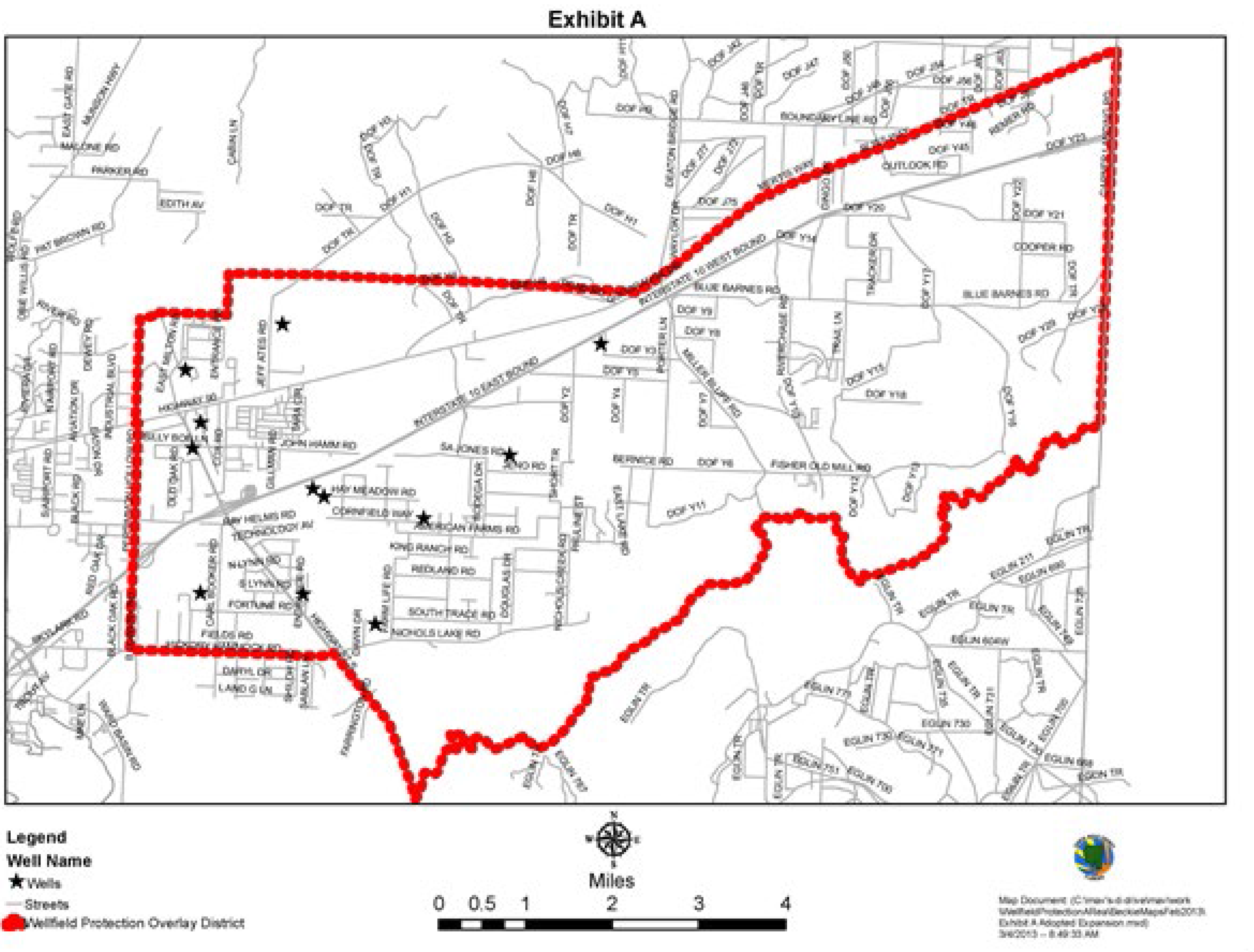
The purpose of this overlay district, as shown on the map in Exhibit A, is to provide an added degree of protection for the aquifer recharge area in the vicinity of the Fairpoint Regional Utility System and East Milton Water System wellfield which is an important resource in providing potable water for the Fairpoint peninsula and the East Milton Area. It is the intent of this overlay district to protect present and future public potable water supply wells and wellfields from water quality degradation by contamination from regulated substances.
7.04.02 Wellfield Protection Overlay District Boundaries.
The East Milton Area Wellfield Protection Overlay District, shown on the map in Exhibit "A," is described as follows:
Point of Beginning: Intersection of State Highway 87 South and Hickory Hammock Road; then follow Hickory Hammock Road westerly to the western boundary of section 17-1N-27W; then follow the western boundary of Sections 17-1N-27W, 8-1N-27W, 5-1N-27W, and 32-2N-27W, then commencing at the southwest corner of section 29-2N-27W continue N0°for 2302.06 feet to the northern edge of the Gulf Power easement then N79°on the northern right-of-way for 1184.7 feet to the western edge of a Gulf Power easement, then proceed N23°03"30"W along the right-of-way for 143.6 feet to the southern boundary of the northern ½ of section 29-2N-27W, then continue East along the southern half section line to the eastern boundary of section 29-2N-27W, then north to the northeast corner of section 29-2N-27W, then follow the northern section line of sections 28-2N-27W, 27-2N-27W, 26-2N-27W, 25-2N-27W and 30-2N-26W easterly to the intersection with Highway 90; then follow Highway 90 easterly to the intersection of the east line of section 01-2N-26W, then south along the east section line of sections 01-2N-26, 12-2N-26W, 13-2N-26W, 24-2N-26W, 25-2N-26W and 36-2N-26W to the point of intersection with the Yellow River, then westerly along the Yellow River to the point of intersection of State Highway 87 South; then North along State Highway 87 South to the Point of Beginning.
7.04.03 Definitions (see section 1.07.02).
7.04.04 Applicability.
A.
The provisions of this chapter shall apply to all new, non-residential development within the East Milton Area Wellfield Protection Overlay District.
B.
In addition, the provisions of Section 3.06.07.K shall apply to all new development within Wellhead Protection Zones, which are the 500-foot radius around public supply potable water wells, measured from the center of the wellhead. Where there is a conflict between Section 3.06.07 and this section, the more restrictive regulation applies.
7.04.05 Permitted uses.
The uses allowed within the overlay district are those listed as permitted and conditional uses in the underlying zoning districts with the exception of those listed as prohibited in Section 7.04.06.
7.04.06 Prohibited uses.
Uses prohibited within the overlay district include:
A.
Solid Waste Disposal and Solid Waste Management Facilities as defined by the Florida Department of Environmental Protection in Rule 62-701, Florida Administrative Code (F.A.C.).
B.
Hazardous waste treatment, storage, disposal, and transfer facilities requiring permits under Chapter 62-730, F.A.C. (this does not apply to generators of hazardous waste who are subject to the performance standards in 7.04.08).
C.
Underground storage facilities. The replacement of an existing underground storage tank system regulated under Chapter 62-761, F.A.C., within the same excavation, is exempt from this provision, provided that the replacement underground storage tank system is installed with secondary containment as required in Chapter 62-761, F.A.C.
D.
Resource extraction activities, mines or mining activities.
7.04.07 Permitting requirements.
An applicant for any permitted non-residential use that involves the use, storage, handling or disposal of regulated substances is required to meet the development standards found in Section 7.04.08, or receive a General Exception approval, or a Special Exception approval from the County.
General Exception approval will be granted concurrent with Site Plan approval upon demonstration of compliance with Section 7.04.09.
Special Exception approval may be granted by the Zoning Board upon demonstration of compliance with Section 7.04.10.
7.04.08 Development standards.
In addition to other applicable provisions of this code, an applicant must meet the following development standards as applicable:
A.
The use of secondary containment is required for all bulk storage of regulated substances. Such containment systems must be easy to inspect and designed to intercept any leak or release from the primary containment vessel or structure. Secondary containment must be sized to accommodate 110% of the largest primary container volume. Bulk storage does not include materials packaged for individual retail sale. Secondary containment does not apply to materials applied in an outdoor setting as part of an approved activity's landscaping maintenance plan.
B.
No non-residential facility shall discharge any regulated substance, either directly or indirectly, into the soil or groundwater.
C.
New underground facilities for transportation of regulated substances within the Wellfield Protection Overlay District shall be constructed with double-walled pipe to ensure no leakage into the soil or groundwater.
D.
All permitted facilities must adhere to appropriate federal and state standards for storage, handling, transportation and disposal of any hazardous materials. Where there is a conflict between the federal and state standards and this section, the most restrictive regulation applies.
E.
Areas where regulated substances are stored shall not drain to the soil, a stormwater system, water body, or a sewage disposal system. This does not apply to discharges to a public sewer utility system that are approved by the sewer utility, consistent with FDEP regulations.
F.
The washing of vehicles used to transport unpackaged regulated substances and equipment used in processing of regulated substances must be done in a self contained area (e.g. with recycling system) designed to ensure that hazardous materials do not reach the soil, a water body or a sewage disposal system. This does not apply to discharges to a public sewer utility system that are approved by the sewer utility, consistent with FDEP regulations.
G.
All new commercial and industrial land uses that involve the use, handling, or storage of regulated materials shall be required to prevent contact between the aforementioned materials and stormwater.
H.
Sites where fuel is dispensed from above-ground tanks shall be designed to contain fuel spills on site without contaminating stormwater systems, sewage disposal systems, soil, surface water or groundwater.
I.
Fuel tanks or storage as part of permanently installed equipment (such as generators) shall be placed in a secondary containment device such that a fuel spill or leak will not reach the soil or a water body.
J.
Wastewater treatment plants must meet FDEP requirements. Effluent or biosolids disposal cannot be located within the 5-year travel time area. Reuse of reclaimed water that has received high-level disinfection is allowed when permitted under Part III of Chapter 62-610, F.A.C.
7.04.09 General exceptions.
Facilities qualifying for General Exception approval are exempt from the permitting requirements of Section 7.04.08.
A.
Facilities and activities qualifying for a general exception include residential uses, public utilities (except effluent disposal from a wastewater treatment facility), parks, maintenance of office facilities, retail sales, agriculture, silviculture, transportation facilities such as roads and rail lines (loading and offloading of regulated substances is not exempt), distribution of materials packaged for retail sale, substances regulated by the Food and Drug Administration; and substances use in a research laboratory or hospital or other medical facility under the direct supervision of a technically qualified individual.
B.
A general exception application shall be required for any non-residential activity claiming a general exception under this section.
C.
Such application shall be submitted as part of a Site Plan application and must contain a concise statement by the applicant detailing the circumstances upon which the applicant believes they would be entitled to a General Exception.
D.
Temporarily-located emergency equipment necessary to provide power to ensure a continuous supply on an emergency basis of water supply, electrical power, sewer service, telephone service, or other essential services are exempt consistent with Chapter 62-521.400(3), F.A.C. and do not require a general exception application.
E.
Discharge to groundwater from Florida Department of Environmental Protection approved remedial corrective actions for contaminated sites are exempt consistent with Chapter 62-521.400(3), F.A.C. and do not require a general exception application.
7.04.10 Special exceptions.
The Board of County Commissioners may grant a special exemption from the requirements of Section 7.04.08, subject to the following requirements:
A.
Special Exception applications will be process as outlined in Section 5.06.02.
B.
The applicant must provide substantial scientific evidence that special or unusual circumstances and adequate technology exist to isolate the facility or activity from the potable water supply.
C.
In granting the special exception, the Board may prescribe any additional appropriate conditions and safeguards which are necessary to protect the wellfield.
7.04.11 Non-conforming uses, sites or facilities.
Non-conforming uses, sites or facilities in operation at the time of adoption of this ordinance are allowed to continue operation. Any expansion, modification or alteration of non-conforming uses, sites or facilities shall be required to meet current Land Development Code requirements including the requirements of this section.
7.04.12 Variances.
The Board of County Commissioners may grant a variance from one or more of the above requirements upon finding that the proposed facility would not create a risk to ground water quality. Variances will be processed consistent with Section 9.04.00.
7.04.13. Trade secrets.
The County shall not disclose any trade secrets of the permittee under this chapter that are exempted from such disclosure by federal or state law; provided, however, that the burden shall be on the permittee to demonstrate entitlement to such non-disclosure.
(Ord. No. 2021-13, § 3(Attch. B), 8-19-21)
7.05.00 - Rural Protection Zone.
7.05.01 Generally.
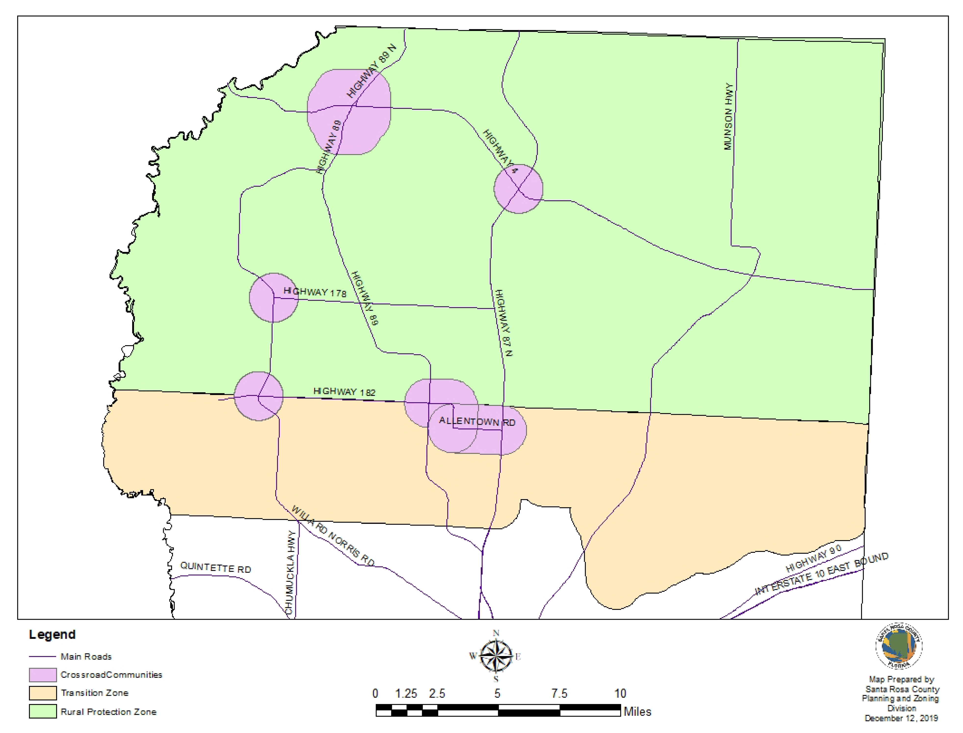
The Rural Protection Zone is designed to protect the rural character, agricultural viability, and natural resources of Northern Santa Rosa County. Within the Rural Protection Zone the creation of new communities will be allowed, but urban sprawl will be avoided and development performance standards will reflect the rural character of the area.
7.05.02 Definitions (see section 1.07.02).
7.05.03 Development standards.
A.
Planned Unit Development (PUD) and Planned Business District (PBD) zoning districts should be considered provided the following conditions are met:
1.
Gross residential should not exceed one dwelling unit per acre (excluding jurisdictional wetland acreage)
2.
The total area of undeveloped land should be at least fifty (50) percent of the total land area in the proposed development. The undeveloped area may be used for agriculture, conservation or recreation purposes.
3.
Buffer zones of at least 50 feet in width shall be required between residential and agriculture uses and shall be thickly planted with fast-growing native vegetation to create an effective barrier separating yards from fields and pastures.
4.
Lots shall be laid out, to the greatest extent feasible, to maintain the rural character of the area.
B.
Rural Activity Centers (Commercial) should be established within one mile of identified crossroads and the Town of Jay.
C.
Crossroad Communities (Residential) to allow residential development up to four (4) units per acre within 1 mile of identified crossroads and the Town of Jay.
D.
Buffer zones of at least 50 feet in width will be required between residential and agriculture uses and should be thickly planted with fast growing native vegetation to create an effective barrier separating yards from pastures. It is the responsibility of the residential developer to create these buffers.
E.
Riparian buffers are land buffers along streams and rivers that reduce the impact of adjacent uses on the body of water. The buffer is an area of trees, shrubs and herbaceous vegetation between the impacted or developed area and the stream or river bank; a minimum buffer width of 50 feet is required. This buffer protects the stream from pollution caused by runoff and debris, improving water quality and habitat. It ensures good downstream water quality, protecting the natural resource for Santa Rosa residents quality of life and for eco-tourism purposes.
7.05.04 Benefits and limitations of zoning.
A.
There are numerous benefits to zoning, many ways in which it is an effective tool for guiding development and protecting the public. Some of these benefits include:
1.
Protecting public and private property from harmful and inconsistent uses.
2.
Providing orderly and systematic transition in uses that benefit all users.
3.
Protecting current and future industry by informing residents where industry will be allowed to develop.
4.
Assist community economic growth by reserving adequate and desirable sites for industrial and commercial development.
B.
However, as a stand alone tool, Zoning cannot:
1.
Protect the rural character of northern Santa Rosa County.
2.
Protect farming operations.
3.
Preserve open space.
C.
Zoning does not address the types of architecture used, require design to rural standards, force land to stay in agricultural production, require provision of open space or protect natural vistas. These are all components of rural quality of life.
D.
Perhaps most detrimental to rural character is the subdivision of agricultural land into large lots. The AG and AG-2 categories are typical "large lot" zoning districts. While these districts do reduce the number of homes that can be built, they also require that homes be spread out in such a way that none of the remaining land is useable for farming, forestry or recreation. Homesites become "too large to mow, but too small to plow."
(Ord. No. 2021-13, § 3(Attch. B), 8-19-21)
7.06.00 - Garcon Point Protection Area.
7.06.01 Generally.
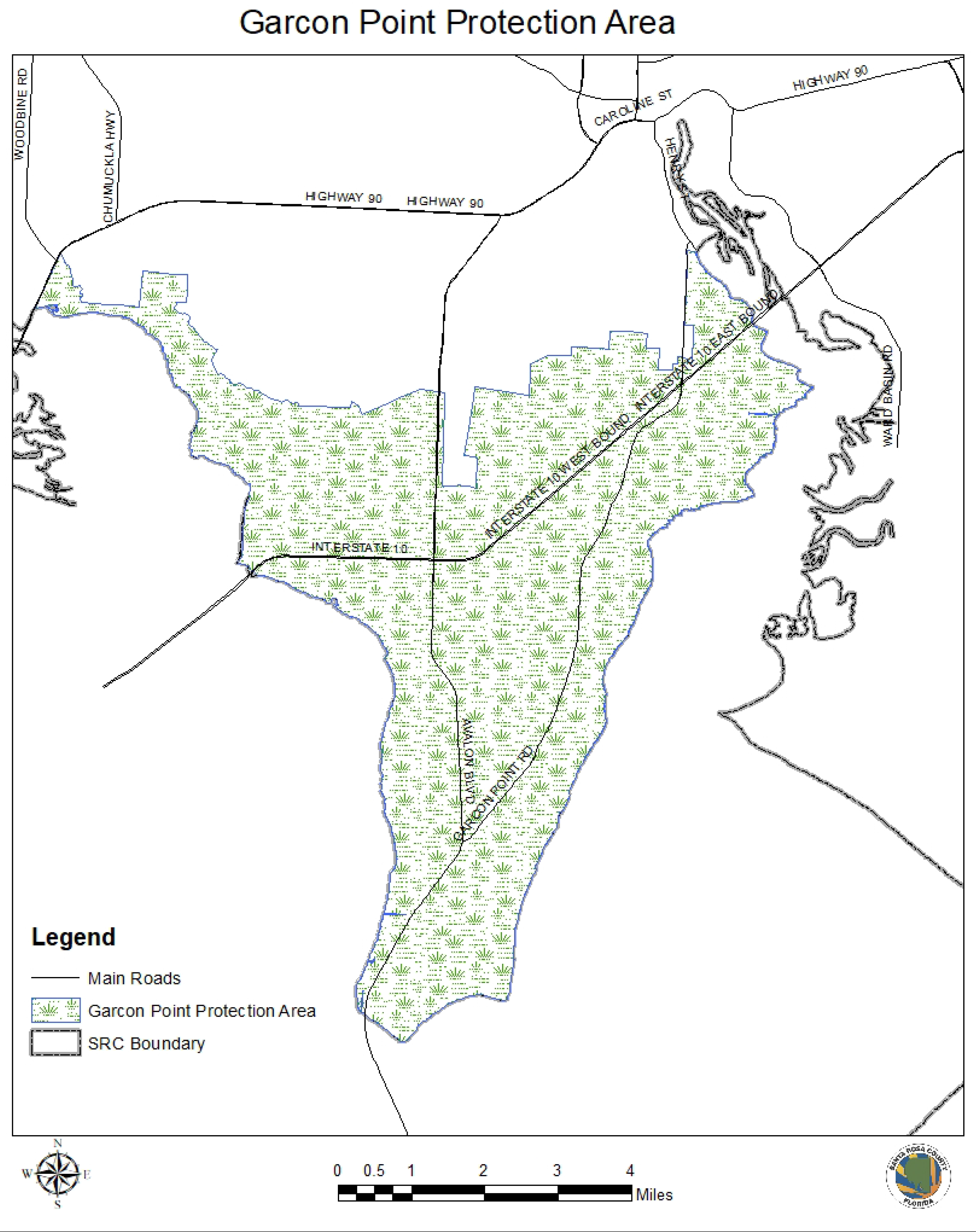
The Garcon Point Protection Area is categorized by environmentally sensitive lands that are not suitable for urban densities.
7.06.02 Garcon Point Protection Area.
The Garcon Point Protection Area was established to recognize the unique environmental characteristics of the area. This area is predominately undeveloped, has a high percentage of possible wetlands and is lacking in central sewer infrastructure. Current Comprehensive Plan policy limits development within the Garcon Point Protection Area to two dwelling units per acre without centralized sewer.
(Ord. No. 2021-13, § 3(Attch. B), 8-19-21)
7.07.00 - Navarre Beach Commercial Core Area.
7.07.01 Generally.
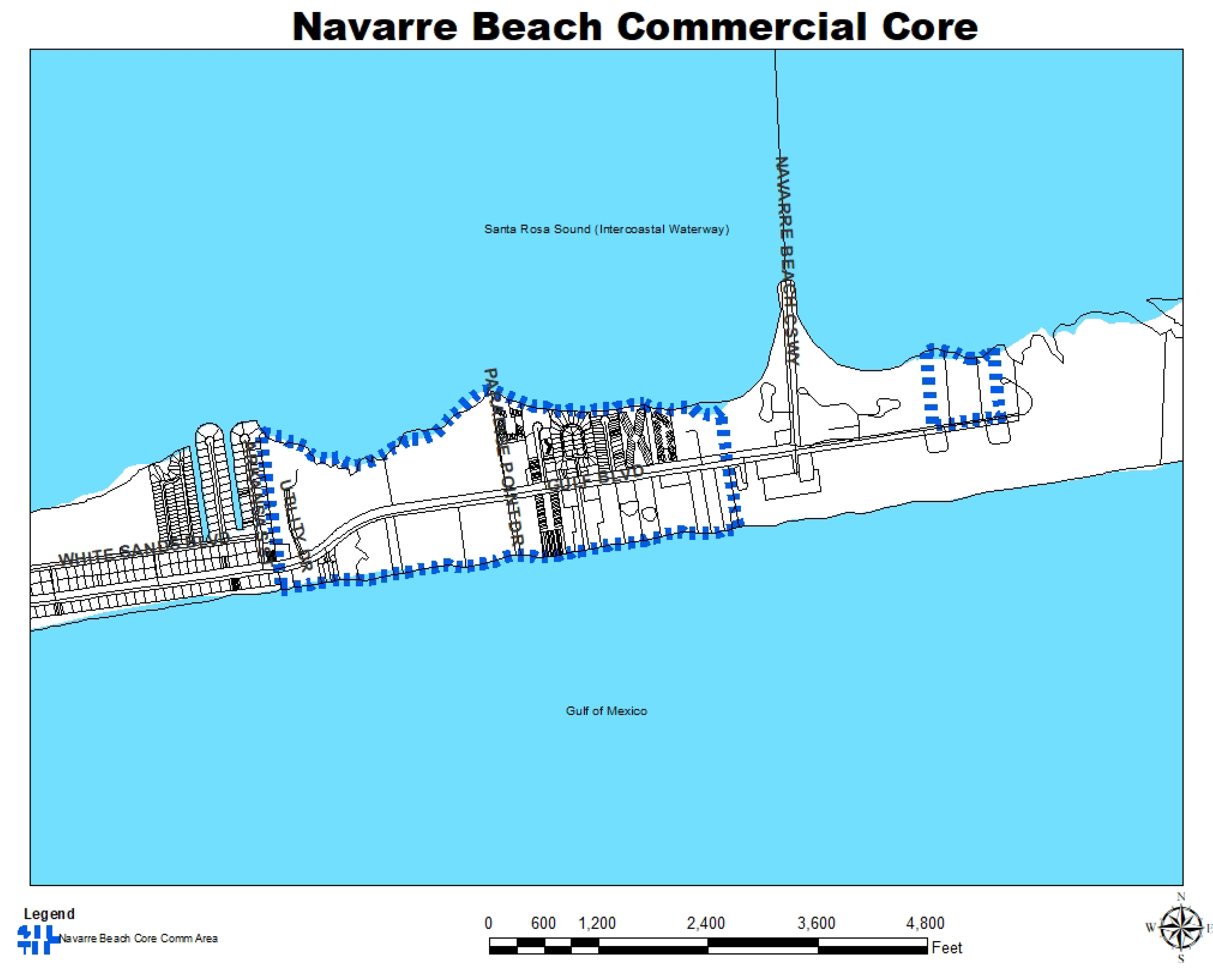
Navarre Beach is a four (4) mile stretch of Santa Rosa Island that is under the jurisdiction of the Santa Rosa County Board of Commissioners. The Commercial Core Area is a subset of that four (4) mile stretch.
7.07.02 Commercial core area.
A Commercial Core Area is hereby established and defined as the area beginning approximately 650 feet to the west of the westerly right-of-way line of Navarre Beach Causeway and extending westerly to a point approximately 170 feet east of the easterly right-of-way line of Arkansas Street. The Commercial Core Area shall be bounded on the north by Santa Rosa Sound and to the south by Gulf of Mexico. The Commercial Core shall include those parcels within the Navarre Beach Commercial zoning district located east of the easterly right-of-way of Navarre Beach Causeway and fronting on Santa Rosa Sound.
(Ord. No. 2021-13, § 3(Attch. B), 8-19-21)
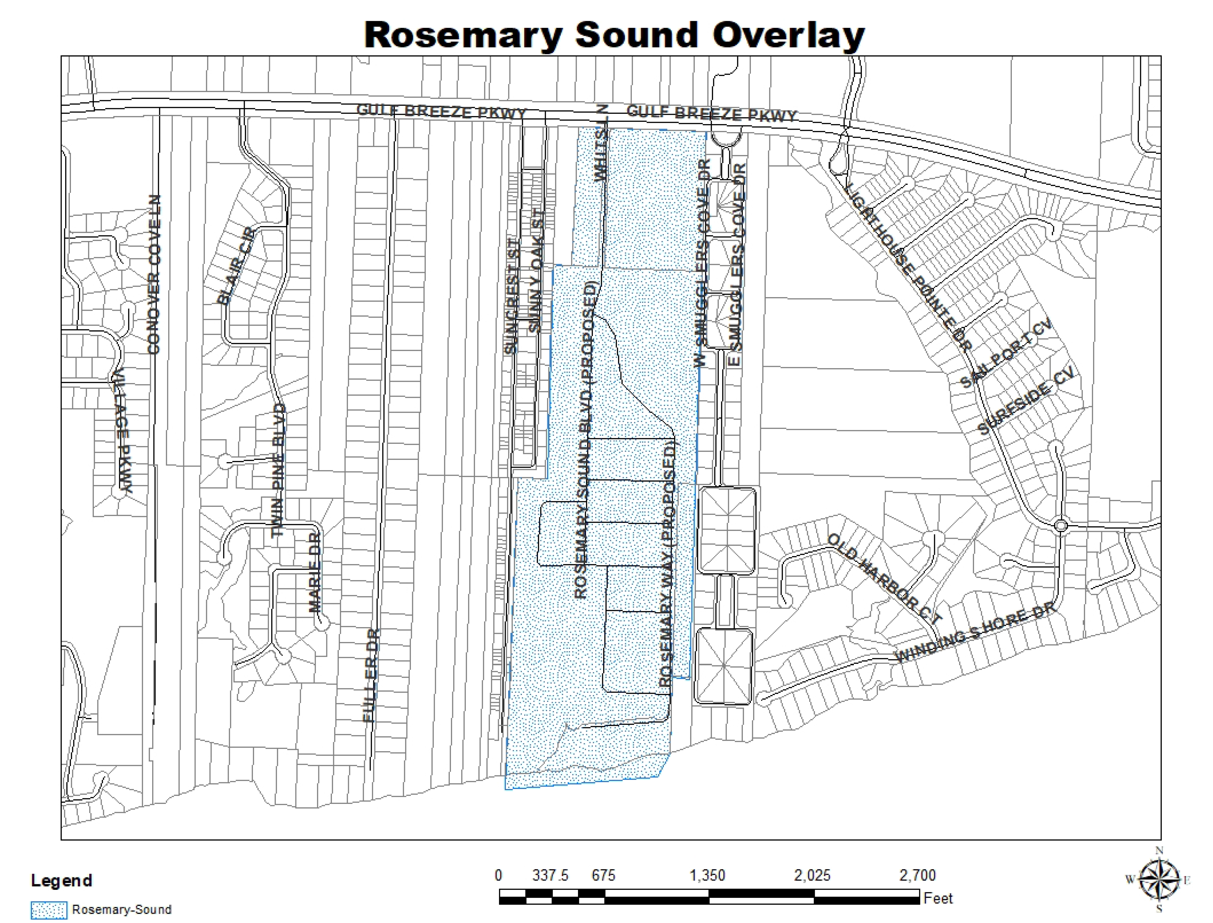
7.08.00 - Rosemary Sound Overlay.
7.08.01 Generally.
The Rosemary Sound Overlay District was established in order to provide flexibility and environmental sensitivity in the application of land uses by allowing single family and multifamily residential and non-residential uses to be blended over several parcels under a common plan of development.
7.08.02 Rosemary Sound Overlay.
The maximum number of residential units in the combined parcels is 715, which is less than the 851 total number of units allowed, within each of the individual parcels. For the Rosemary Sound development, the future land use categories shall be blended within one Overlay boundary, which will allow for the clustering of residential and non-residential uses among three future land use categories. The Rosemary Sound Overlay is not a separate land use category, but serves as an indicator on the Future Land Use Map that the underlying uses have blended their uses and residential densities. In addition to this text amendment, the Overlay shall be adopted as a Future Land Use Map amendment and shall be clearly marked and explained on the County's Future Land Use Map. The Overlay will be implemented through the Planned Unit Development (PUD) zoning process. The southern portion of the site is currently located within the Coastal High Hazard Area (CHHA). Based on recommendations by the Florida Department of Economic Opportunity and the Coastal High Hazard Study Committee Report dated February 2006, the CHHA boundary line is subject to change to reflect accurate environmental features and conditions. The CHHA currently has a future land use category of Single Family Residential with associated development rights of eighty-two (82) dwelling units (20.58 AC x 4 DU/AC=82). Future single-family or multi-family development in the CHHA, therefore, is limited to no more than eighty-two (82) dwelling units. Because the boundaries of the CHHA are subject to change, site design and building typology in the CHHA will be based on the CHHA line in effect at the time of development. Wetland protection will comply with Santa Rosa Comprehensive Plan and all applicable land development regulations.
(Ord. No. 2021-13, § 3(Attch. B), 8-19-21)