
Santaquin City Zoning Code
10.20 ZONES
ESTABLISHED
10.20.010 INTENT
In order to carry out the purposes of this title, Santaquin City, Utah, is hereby divided into zones as follows:
| R-8 | Residential zone |
| R-10 | Residential zone |
| R-12 | Residential zone |
| R-15 | Residential zone |
| R-20 | Residential zone |
| C-1 | Interchange commercial zone |
| PO | Professional office zone |
| I-1 | Industrial zone |
| PC | Planned community zone |
| RC | Residential commercial zone |
| PF | Public facilities zone |
| Main Street business districts zone | |
| Ag | Agriculture zone |
| R-Ag | Residential agriculture zone |
| R-43 | Residential zone |
| Hillside development overlay zone | |
(Ord. 06-01-2011, 6-1-2011, eff. 6-2-2011; amd. Ord. 09-05-2011, 9-21-2011, eff. 9-22-2011; Ord. 03-04-2014, 3-19-2014, eff. 3-20-2014)
10.20.020 OFFICIAL ZONING MAP
The location and boundary of each of the zones are shown on the official zoning map of Santaquin City, Utah, at city hall and said map is hereby declared to be an official record and a part of this title.
Whenever amendments or changes are made in zone boundaries such amendments or changes shall be made on the official zoning map. No amendment or change shall become effective until after proper notice has been given to Utah County and/or Juab County.
Regardless of the existence of purported copies of the official zoning map, which may from time to time be made or published, the official zoning map which shall be located in the office of the Santaquin City recorder shall be the final authority in determining current zoning status. (Ord. 03-03-2014, 3-19-2014, eff. 3-20-2014)
10.20.030 BOUNDARIES OF ZONES
Where uncertainty exists with respect to the boundaries of various zones, the following rules shall apply:
- Where the intended boundaries on the zoning map are approximately street or alley lines, said streets or alleys shall be construed to be the zone boundaries.
- Where the indicated boundaries are approximately lot lines, said lot lines shall be construed to be the zone boundaries, unless otherwise indicated.
- Where land has not been subdivided into lots, the zone boundary shall be determined by the use of the scale of measurement shown on the map.
- Where other uncertainty exists, the zoning administrator, or other authorized officer, shall interpret the map. (Ord. 2-01-2002, 2-5-2002, eff. 2-5-2002)
10.20.040 TRANSITIONAL USE
Uses which are permitted on either portion of a lot which is divided by a zone boundary line or which is coterminous with a zone boundary line may be permitted to extend to the entire lot, but not more than one hundred feet (100') beyond the boundary line of such zone in which such use is permitted. Before a transitional use permit for such a use may be granted, however, the zoning administrator, or other authorized officer, must find that the general plan will be maintained and that a more harmonious mixing of uses will be achieved thereby. (Ord. 2-01-2002, 2-5-2002, eff. 2-5-2002)
10.20.050 REGULATIONS WITHIN ZONES
Within each of the zones, the use, location, height, size of buildings and structures, the use of land, size of lots, yards, courts, and other open spaces, and density of population, are regulated as hereinafter set forth. (Ord. 2-01-2002, 2-5-2002, eff. 2-5-2002)
10.20.060 REZONING
Property owners desiring to change the zoning classification for property which they own, whether individually or as a part of a larger development project, may make application to the community development department for a hearing to rezone their property. The requirements and procedures for such rezoning applications shall comply as stipulated herein.
- Application Requirements: Applications to rezone property shall consist of, but not be limited to, the following:
- A completed Santaquin City rezoning application;
- A concept plan depicting the layout, including, but not limited to, roads, parks, trails, and type of development anticipated within each zoning classification being requested. This plan shall also include a density table which reflects the anticipated development which includes, but is not limited to:
- The anticipated potential number of development units, residential and commercial, within each zoning classification requested; and
- The potential number of development units possible for the same planned development under the current zoning classification.
- Legal description of the property(ies) proposed to be rezoned along with a map and area calculation for each area to be affected;
- Materials for proper notification to adjacent property owners as outlined in SCC 10.68.110; and
- Rezoning application fees, as determined by resolution of the city council and listed in the Santaquin City fee schedule.
- Procedure: Upon receipt of a complete application, the application will be scheduled for review and a public hearing by the planning commission at the next available meeting(s), following proper notice. Upon receiving a recommendation from the planning commission, the application will be scheduled for review by the city council at the next available meeting(s), following proper notice. Following approval from the city council, the property will be rezoned on the official city zoning map and the property owner will be required to comply with any and all regulations applicable within the zoning classification to which the property is rezoned.
- Requirements For Review: Prior to making a recommendation to the city council regarding the rezoning of property, the planning commission shall consider the following criteria:
- How closely rezoning conforms to the intent of the Santaquin City general plan and annexation policy plan;
- Whether rezoning will adversely affect surrounding properties; and
- Whether rezoning will cause property, structures, or uses of the property to unnecessarily become nonconforming according to this title.
The city council should consider the recommendation of, and any findings of fact provided by, the planning commission and the criteria of this paragraph before approving a rezone of property.
- Partial Rezoning: A single property may be rezoned in part. All rezoning approvals by the city council and planning commission of this nature shall be effective only after written notice of the change approval is given to the Utah or Juab County assessor office.
- Corrective Measures: No rezoning shall be permitted as a corrective measure for a property, use, or structure on a property which is found to be in violation of any provision of this title by the building official, zoning administrator, or other authorized officer.
- Resubmission: No application for rezoning which receives a denial from the city council shall be permitted to resubmit the same application for a period of not less than twelve (12) months from the date of denial unless the applicant(s) can provide documentation of information or facts that were not available at the time of review of the original application. (Ord. 03-03-2014, 3-19-2014, eff. 3-20-2014)
10.20.070 R-8 RESIDENTIAL ZONE
- Objectives And Characteristics: The objective of establishing the R-8 Residential Zone is to provide a residential environment within the City which is characterized by smaller lots and somewhat more dense residential development than is characteristic of the R-10 Zone. Nevertheless, this zone is characterized by spacious yards and other residential amenities adequate to maintain desirable residential conditions. The uses permitted in this zone shall be single-family dwellings and certain other public facilities needed to promote and maintain stable residential neighborhoods. (Ord. 04-01-2003, 4-2-2003, eff. 4-3-2003)
In order to accomplish the objective and purpose of this title and to promote the characteristics of this zone, the following regulations shall apply in the R-8 Residential Zone. (Ord. 2-01-2002, 2-5-2002, eff. 2-5-2002) - Permitted Uses: Land uses in the R-8 Residential Zone are permitted as follows. Alphabetic use designations in the table below have the following meanings:
P The listed use is a permitted use within the represented area, based on City development standards and ordinances. C The listed use requires a conditional use permit within the represented area in addition to complying with all applicable development standards and ordinances. N The listed use is a prohibited use within the represented area. (Ord. 07-01-2011, 7-27-2011, eff. 7-28-2011; amd. Ord. 03-02-2014, 4-16-2014, eff. 4-17-2014; Ord. 02-01-2018, 2-7-2018, eff. 2-8-2018; 9-17-2019, eff. 9-18-2019)Use R-8 Adult daycare C Agriculture in accordance with SCC 10.64 P Agriculture building C Agritourism C Assisted living facility - large C Assisted living facility - small in accordance with SCC 10.24.060 P/C Caretaker facilities associated with a permitted or conditional use C Cemeteries P Child daycare centers C Crisis respite C Dwelling, accessory unit attached P Dwelling, accessory unit detached P Dwelling, multiple-unit N Dwelling, single-family detached P Golf courses and golf clubhouses (private and public) P Gravel, sand, earth extraction, and mass grading when necessary to accomplish the intent of a development project permitted within and in association with the R-8 Zone and with City Council approval and Planning Commission recommendation for approval of a plan detailing the scope and time schedule for the work to be done C Home occupations, in accordance with SCC 10.40 P/C Large scale developments C Parks P Recreational vehicle (RV) parks N Religious center P Residential facilities for persons with a disability pursuant to SCC 10.60 P Residential facilities for the elderly pursuant to SCC 10.56 P Residential support facility P Schools P Sheltered workshop C Social or reception centers C Telecommunications sites. See SCC 10.16.340 paragraph D Temporary uses, subject to the provisions of SCC 10.16.300 P Treatment facility N - Area Requirements:
- Standard Lot Size: A land area of not less than eight thousand (8,000) square feet shall be provided and maintained for each lot, tract, or parcel of land within the R-8 Zone. This shall include corner lots.
- Infill Properties: Lot areas for applicable infill development may be reduced according to the infill development standards of this title. (Ord.10-01-2014, 10-1-2014, eff. 10-2-2014)
- Width Requirements:
- Standard Lot Widths:
- Interior Lots: The minimum width of lots in this zone shall be eighty (80) linear feet.
- Corner Lots: All corner lots shall have a minimum of eighty feet (80') width for at least one frontage adjacent to a public street.
- Infill Properties: Lot widths for applicable infill development may be reduced according to the infill development standards of this title. (Ord. 10-1-2014, 10-1-2014, eff. 10-2-2014)
- Standard Lot Widths:
- Location Requirements:
- SetbacksNotes:
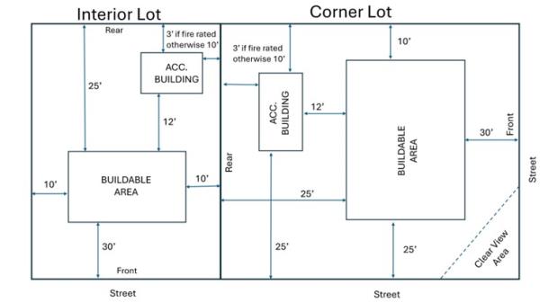
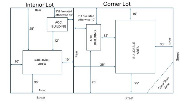
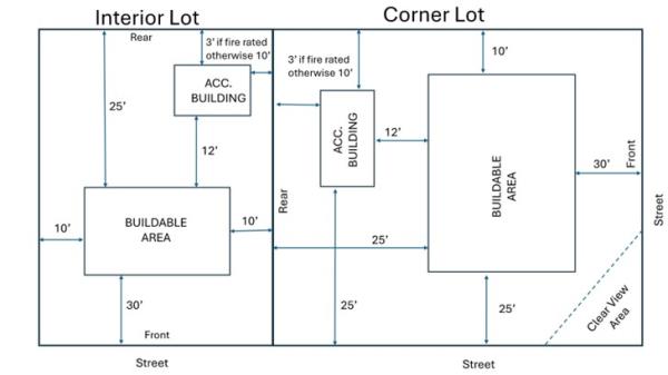
R-8 Setback Requirements Front Street Side Side Rear Main Building To living area 20'1, garage doors 25'1, covered porches 15'1 20' 8' 25' Accessory Structure Not permitted 20'2 8'3 10'3 Nonresidential Use Parking 20' 20' 5' 5' Accessory structure shall be located at least twelve feet (12') from the dwelling or main structure and shall not be in any utility easements without written consent from those affected entities.
1 A property which fronts onto an urban or multiuse, nonequestrian trail corridor, as shown in the adopted Parks, Recreation and Open Space Master Plan, may reduce the front setback along such corridor. The setback reduction may not exceed the width of such corridor, as measured from back of curb, and a minimum ten foot (10') setback must be maintained. The modification must still provide for twenty four feet (24') of parking between the structure and the lot line. 2 A three-foot (3') setback along the secondary frontage shall be permitted for an accessory structure less than two hundred (200) square feet. 3 A three-foot (3') side or rear setback shall be permitted for accessory structure if the accessory structure walls closest to the side or rear property line are constructed with one hour or more fire-resistant walls - Clear View: All structures must be placed in conformance with the clear view standards found in SCC 10.16.090.
- Setbacks
- Dwelling Size: Minimum dwelling size shall be nine hundred (900) square feet floor area on the main floor (excluding garages and basement areas) for single-story structures. Similarly, multi-story dwellings shall have a minimum of one thousand two hundred (1,200) square feet. (Ord. 10-01-2014, 10-1-2014, eff. 10-2-2014)
- Parking And Access Standards: Each dwelling is required to have a minimum of two (2) parking spaces per dwelling unit located on the property unless otherwise specified. (Ord. 10-01-2014, 10-1-2014, eff. 10-2-2014)
- Property Development Standards:

Amended by Ord. 07-02-2010 on 7/21/2010
Amended by Ord. 10-02-2010 on 10/20/2010
Amended by Ord. 07-01-2011 on 7/27/2011
Amended by Ord. 10-01-2014 on 10/1/2014
Amended by Ord. 05-05-2015 on 5/6/2015
Amended by Ord. 02-01-2018 on 2/7/2018
Amended by Ord. 09-03-2019 on 9/17/2019
Amended by Ord. 09-05-2020 on 9/1/2020
Amended by Ord. 07-01-2021 on 7/20/2021
Amended by Ord. 02-02-2025 on 2/4/2025
Amended by Ord. 08-01-2025 on 8/19/2025
10.20.080 R-10 RESIDENTIAL ZONE
- Objectives And Characteristics: The objective in establishing the R-10 Residential Zone is to encourage the creation and maintenance of residential areas within the City which are characterized by smaller to medium sized lots on which single-family dwellings are situated, surrounded by well kept lawns, trees, and other plantings. A minimum of vehicular and pedestrian traffic and quiet residential conditions favorable to family living are also characteristic of this zone. The uses permitted in this zone shall be single-family dwellings and certain other public facilities needed to promote and maintain stable residential neighborhoods. (Ord. 04-01-2003, 4-2-2003, eff. 4-3-2003)
In order to accomplish the objectives and purposes of this title and to promote the characteristics of this zone, the following regulations shall apply in the R-10 Zone. (Ord. 2-01-2002, 2-5-2002, eff. 2-5-2002) - Permitted Uses: Land uses in the R-10 Residential Zone are permitted as follows. Alphabetic use designations in the table below have the following meanings:
P The listed use is a permitted use within the represented area, based on City development standards and ordinances. C The listed use requires a conditional use permit within the represented area in addition to complying with all applicable development standards and ordinances. N The listed use is a prohibited use within the represented area. (Ord. 07-01-2011, 7-27-2011, eff. 7-28-2011; amd. Ord. 03-02-2014, 4-16-2014, eff. 4-17-2014; Ord. 02-01-2018, 2-7-2018, eff. 2-8-2018)Use R-10 Adult daycare C Agriculture in accordance with SCC 10.64 P Agriculture building C Agritourism C Assisted living facility - large C Assisted living facility - small P/C Caretaker facilities associated with a permitted or conditional use C Cemeteries P Child daycare centers C Dwelling, accessory unit attached P Dwelling, accessory unit detached P Dwellings, single-family detached P Golf courses and golf clubhouses (private and public) P Gravel, sand, earth extraction, and mass grading when necessary to accomplish the intent of a development project permitted within and in association with the R-10 Zone and with City Council approval and Planning Commission recommendation for approval of a plan detailing the scope and time schedule for the work to be done C Home occupations, in accordance with SCC 10.40 P/C Large scale developments C Parks P Public and quasi-public buildings P Recreational vehicle (RV) parks N Religious center P Residential facilities for persons with a disability pursuant to SCC 10.60 P Residential facilities for the elderly pursuant to SCC 10.56 P Residential support facility P Schools P Sheltered workshop C Telecommunications sites. See SCC 10.16.340 paragraph D Temporary uses, subject to the provisions of SCC 10.16.300 P Treatment facility N - Area Requirements: A land area of not less than nine thousand six hundred (9,600) square feet shall be provided and maintained for each existing lot, tract, or parcel of land within the R-10 Zone. All lots, tracts or parcels created after adoption of this paragraph C shall have a minimum of ten thousand (10,000) square feet provided and maintained for each lot. (Ord. 03-01-2006, 3-1-2006, eff. 3-2-2006; amd. Ord. 07-01-2011, 7-27-2011, eff. 7-28-2011)
- Width Requirements: The minimum width of lots in this zone shall be eighty (80) linear feet. All corner lots shall have a minimum of ninety five feet (95') width for all property lines adjacent to a public street. (Ord. 2-01-2002, 2-5-2002, eff. 2-5-2002; amd. Ord. 07-01-2011, 7-27-2011, eff. 7-28-2011)
- Location Requirements:
- SetbacksNotes:1 A property which fronts onto an urban or multiuse, nonequestrian trail corridor, as shown in the adopted Parks, Recreation and Open Space Master Plan, may reduce the front setback along such corridor. The setback reduction may not exceed the width of such corridor, as measured from back of curb, and a minimum ten foot (10') setback must be maintained. The modification must still provide for twenty four feet (24') of parking between the structure and the lot line.2 A three-foot (3') setback along the secondary frontage shall be permitted for an accessory structure less than two hundred (200) square feet.3 A three-foot (3') side or rear setback shall be permitted for accessory structure if the accessory structure walls closest to the side or rear property line are constructed with one hour or more fire-resistant walls
R-10 Setback Requirements Front Street Side Side Rear Main Building 30'1 25' 10' 25' Accessory Structure Not permitted 25'2 10'3 10'3 Nonresidential Use Parking 20' 20' 5' 5' Accessory structures shall be located at least twelve feet (12') from the dwelling or main building and shall not be in any utility easements without written consent from those affected entities. - Clear View: All structures must be placed in conformance with the clear view standards found in SCC 10.16.090.
- Setbacks
- Dwelling Size: Minimum dwelling size shall be nine hundred (900) square feet floor area on the main floor. (Ord. 2-01-2002, 2-5-2002, eff. 2-5-2002; amd. Ord. 07-01-2011, 7-27-2011, eff. 7-28-2011)
- Property Development Standards:
(Ord. 4-02-2005, 4-20-2005, eff. 4-21-2005; amd. Ord. 07-01-2011, 7-27-2011, eff. 7-28-2011)
Amended by Ord. 07-02-2010 on 7/21/2010
Amended by Ord. 07-01-2011 on 7/27/2011
Amended by Ord. 10-01-2014 on 10/1/2014
Amended by Ord. 05-05-2015 on 5/6/2015
Amended by Ord. 02-01-2018 on 2/7/2018
Amended by Ord. 07-01-2021 on 7/20/2021
Amended by Ord. 12-03-2022 on 12/20/2022
Amended by Ord. 02-02-2025 on 2/4/2025
Amended by Ord. 08-01-2025 on 8/19/2025
10.20.090 R-12 RESIDENTIAL ZONE
- Objectives And Characteristics: The objectives of establishing the R-12 Residential Zone are to encourage the creation and maintenance of residential areas within the City which are characterized by medium sized lots on which single-family dwellings are situated, surrounded by well kept lawns, trees, and other plantings. A minimum of vehicular and pedestrian traffic and quiet residential conditions favorable to family living are also characteristic of this zone.
In order to accomplish the objectives and purposes of this title and to promote the characteristics of this zone, the following regulations shall apply in the R-12 Zone. (Ord. 2-01-2002, 2-5-2002, eff. 2-5-2002) - Permitted Uses: Land uses in the R-12 Residential Zone are permitted as follows. Alphabetic use designations in the table below have the following meanings:
P The listed use is a permitted use within the represented area, based on City development standards and ordinances. C The listed use requires a conditional use permit within the represented area in addition to complying with all applicable development standards and ordinances. N The listed use is a prohibited use within the represented area. (Ord. 07-01-2011, 7-27-2011, eff. 7-28-2011; amd. Ord. 03-02-2014, 4-16-2014, eff. 4-17-2014; Ord. 02-01-2018, 2-7-2018, eff. 2-8-2018)Use R-12 Adult daycare C Agriculture in accordance with SCC 10.64 P Agriculture building C Agritourism C Assisted living facility - large C Assisted living facility - small P/C Caretaker facilities associated with a permitted or conditional use C Cemeteries P Child daycare centers C Golf courses and golf clubhouses (private and public) P Gravel, sand, earth extraction, and mass grading when necessary to accomplish the intent of a development project permitted within and in association with the R-12 Zone and with City Council approval and Planning Commission recommendation for approval of a plan detailing the scope and time schedule for the work to be done C Home occupations, in accordance with SCC 10.40 P/C Large scale developments C Parks P Public and quasi-public buildings P Recreational vehicle (RV) parks N Religious center P Residential facilities for persons with a disability pursuant to SCC 10.60 P Residential facilities for the elderly pursuant to SCC 10.56 P Residential support facility P Schools P Sheltered workshop C Single-family dwellings and related accessory uses P Telecommunications sites. See SCC 10.16.340 paragraph D Temporary uses, subject to the provisions of SCC 10.16.300 P Treatment facility N - Area Requirements: A land area of not less than twelve thousand (12,000) square feet shall be provided and maintained for each lot, tract, or parcel of land within the R-12 Zone. Corner lots shall contain a minimum of thirteen thousand two hundred twenty five (13,225) square feet. (Ord. 7-04-2002, 7-17-2002, eff. 7-23-2002; amd. Ord. 07-01-2011, 7-27-2011, eff. 7-28-2011)
- Width Requirements: The minimum width of lots in this zone shall be one hundred (100) linear feet. All corner lots shall have a minimum width of one hundred fifteen feet (115') along all property lines adjacent to a street. (Ord. 2-01-2002, 2-5-2002, eff. 2-5-2002; amd. Ord. 07-01-2011, 7-27-2011, eff. 7-28-2011)
- Location Requirements:
- SetbacksNotes:1 A property which fronts onto an urban or multiuse, nonequestrian trail corridor, as shown in the adopted Parks, Recreation and Open Space Master Plan, may reduce the front setback along such corridor. The setback reduction may not exceed the width of such corridor, as measured from back of curb, and a minimum ten foot (10') setback must be maintained. The modification must still provide for twenty four feet (24') of parking between the structure and the lot line.2 A three-foot (3') setback along the secondary frontage shall be permitted for an accessory structure less than two hundred (200) square feet.3 A three-foot (3') side or rear setback shall be permitted for accessory structure if the accessory structure walls closest to the side or rear property line are constructed with one hour or more fire-resistant walls
R-12 Setback Requirements Front Street Side Side Rear Main Building 30'1 25' 10' 25' Accessory Structure Not permitted 25'2 10'3 10'3 Nonresidential Use Parking 20' 20' 5' 5' Accessory structures shall be located at least twelve feet (12') from the dwelling or main structure and shall not be in any utility easements without written consent from those affected entities. - Clear View: All structures must be placed in conformance with the clear view standards found in SCC 10.16.090.
- Setbacks
- Dwelling Size: Minimum dwelling size shall be one thousand (1,000) square feet floor area on the main floor. (Ord. 2-01-2002, 2-5-2002, eff. 2-5-2002; amd. Ord. 07-01-2011, 7-27-2011, eff. 7-28-2011)
- Property Development Standards:
Amended by Ord. 07-02-2010 on 7/21/2010
Amended by Ord. 07-01-2011 on 7/27/2011
Amended by Ord. 10-01-2014 on 10/1/2014
Amended by Ord. 05-05-2015 on 5/6/2015
Amended by Ord. 02-01-2018 on 2/7/2018
Amended by Ord. 02-02-2025 on 2/4/2025
Amended by Ord. 08-01-2025 on 8/19/2025
10.20.100 R-15 RESIDENTIAL ZONE
- Objectives And Characteristics: The objectives of establishing the R-15 Residential Zone are to encourage the creation and maintenance of residential areas within the City which are characterized by medium sized lots on which single-family dwellings are situated, surrounded by well kept lawns, trees, and other plantings. A minimum of vehicular and pedestrian traffic and quiet residential conditions favorable to family living are also characteristic of this zone.
In order to accomplish the objectives and purposes of this title and to promote the characteristics of this zone, the following regulations shall apply in the R-15 Zone. (Ord. 2-01-2002, 2-5-2002, eff. 2-5-2002) - Permitted Uses: Land uses in the R-15 Residential Zone are permitted as follows. Alphabetic use designations in the table below have the following meanings:
P The listed use is a permitted use within the represented area, based on City development standards and ordinances. C The listed use requires a conditional use permit within the represented area in addition to complying with all applicable development standards and ordinances. N The listed use is a prohibited use within the represented area. (Ord. 07-01-2011, 7-27-2011, eff. 7-28-2011; amd. Ord. 03-02-2014, 4-16-2014, eff. 4-17-2014; Ord. 02-01-2018, 2-7-2018, eff. 2-8-2018)Use R-15 Adult daycare C Agriculture in accordance with SCC 10.64 P Agriculture building C Agritourism C Assisted living facility - large C Assisted living facility - small P/C Caretaker facilities associated with a permitted or conditional use C Cemeteries P Child daycare centers C Dwelling, accessory unit attached P Dwelling, accessory unit detached P Dwellings, singe-family detached P Golf courses and golf clubhouses (private and public) P Gravel, sand, earth extraction, and mass grading when necessary to accomplish the intent of a development project permitted within and in association with the R-15 Zone and with City Council approval and Planning Commission recommendation for approval of a plan detailing the scope and time schedule for the work to be done C Home occupations, in accordance with SCC 10.40 P/C Large scale developments C Parks P Public and quasi-public buildings P Recreational vehicle (RV) parks N Religious center P Residential facilities for persons with a disability pursuant to SCC 10.60 P Residential facilities for the elderly pursuant to SCC 10.56 P Residential support facility P Schools P Sheltered workshop C Telecommunications sites. See SCC 10.16.340 paragraph D Temporary uses, subject to the provisions of SCC 10.16.300 P Treatment facility N - Area Requirements: A land area of not less than fifteen thousand (15,000) square feet shall be provided and maintained for each lot, tract, or parcel of land within the R-15 Zone. Corner lots shall contain a minimum of fifteen thousand six hundred twenty five (15,625) square feet. (Ord. 7-04-2002, 7-17-2002, eff. 7-23-2002; amd. Ord. 07-01-2011, 7-27-2011, eff. 7-28-2011)
- Width Requirements: The minimum width of lots in this zone shall be one hundred ten feet (110'). All corner lots shall have a minimum width of one hundred twenty five feet (125') along all property lines adjacent to a street. (Ord. 7-04-2002, 7-17-2002, eff. 7-23-2002; amd. Ord. 07-01-2011, 7-27-2011, eff. 7-28-2011)
- Location Requirements:
- SetbacksNotes: 1 A property which fronts onto an urban or multiuse, nonequestrian trail corridor, as shown in the adopted Parks, Recreation and Open Space Master Plan, may reduce the front setback along such corridor. The setback reduction may not exceed the width of such corridor, as measured from back of curb, and a minimum ten foot (10') setback must be maintained. The modification must still provide for twenty four feet (24') of parking between the structure and the lot line. 2 A three-foot (3') setback along the secondary frontage shall be permitted for an accessory structure less than two hundred (200) square feet. 3 A three-foot (3') side or rear setback shall be permitted for accessory structure if the accessory structure walls closest to the side or rear property line are constructed with one hour or more fire-resistant walls Clear View: All structures must be placed in conformance with the clear view standards found in SCC 10.16.090.
R-15 Setback Requirements Front Street Side Side Rear Main Building 30'1 25' 10' 25' Accessory Structure Not permitted 25'2 10'3 10'3 Nonresidential Use Parking 20' 20' 5' 5' Accessory structures shall be located at least twelve feet (12') from the dwelling or main structure and shall not be in any utility easements without written consent from those affected entities.
- Setbacks
- Dwelling Size: Minimum dwelling size shall be one thousand (1,000) square feet floor area on the main floor. (Ord. 2-01-2002, 2-5-2002, eff. 2-5-2002; amd. Ord. 07-01-2011, 7-27-2011, eff. 7-28-2011)
- Property Development Standards:

Amended by Ord. 07-02-2010 on 7/21/2010
Amended by Ord. 07-01-2011 on 7/27/2011
Amended by Ord. 10-01-2014 on 10/1/2014
Amended by Ord. 05-05-2015 on 5/6/2015
Amended by Ord. 02-01-2018 on 2/7/2018
Amended by Ord. 02-02-2025 on 2/4/2025
Amended by Ord. 03-02-2025 on 3/4/2025
Amended by Ord. 08-01-2025 on 8/19/2025
10.20.110 R-20 RESIDENTIAL ZONE
- Objectives And Characteristics: The objective of establishing the R-20 Residential Zone is to encourage the creation and maintenance of residential areas within the City which are characterized by larger lots on which single-family dwellings are situated, surrounded by well kept lawns, trees, and other plantings. A minimum of vehicular and pedestrian traffic and quiet residential conditions favorable to family living are also characteristic of this zone. (Ord. 04-01-2003, 4-2-2003, eff. 4-3-2003)
In order to accomplish the objectives and purposes of this title and to promote the characteristics of this zone, the following regulations shall apply in the R-20 Zone. (Ord. 2-01-2002, 2-5-2002, eff. 2-5-2002) - Permitted Uses: Land uses in the R-20 Residential Zone are permitted as follows. Alphabetic use designations in the table below have the following meanings:
P The listed use is a permitted use within the represented area, based on City development standards and ordinances. C The listed use requires a conditional use permit within the represented area in addition to complying with all applicable development standards and ordinances. N The listed use is a prohibited use within the zone. (Ord. 07-01-2011, 7-27-2011, eff. 7-28-2011; amd. Ord. 03-02-2014, 4-16-2014, eff. 4-17-2014; Ord. 02-01-2018, 2-7-2018, eff. 2-8-2018)Use R-20 Adult daycare C Agriculture in accordance with SCC 10.64 P Agriculture building C Agritourism C Assisted living facility - large C Assisted living facility - small P/C Caretaker facilities associated with a permitted or conditional use C Cemeteries P Child daycare centers C Golf courses and golf clubhouses (private and public) P Gravel, sand, earth extraction, and mass grading when necessary to accomplish the intent of a development project permitted within and in association with the R-20 Zone and with City Council approval and Planning Commission recommendation for approval of a plan detailing the scope and time schedule for the work to be done C Home occupations, in accordance with SCC 10.40 P/C Large scale developments C Parks P Public and quasi-public buildings P Recreational vehicle (RV) parks N Religious center P Residential facilities for persons with a disability pursuant to SCC 10.60 P Residential facilities for the elderly pursuant to SCC 10.56 P Residential support facility P Schools P Sheltered workshop C Single-family dwellings and related accessory uses P Telecommunications sites. See SCC 10.16.340 paragraph D Temporary uses, subject to the provisions of SCC 10.16.300 P Treatment facility N - Area Requirements: A land area of not less than twenty thousand (20,000) square feet shall be provided and maintained for each lot, tract, or parcel of land within the R-20 Zone. Corner lots shall contain a minimum of twenty one thousand twenty five (21,025) square feet. (Ord. 7-04-2002, 7-17-2002, eff. 7-23-2002; amd. Ord. 07-01-2011, 7-27-2011, eff. 7-28-2011)
- Width Requirements: The minimum width of lots in this zone shall be one hundred thirty (130) linear feet. All corner lots shall have a minimum of one hundred forty five feet (145') along all property lines adjacent to a street. (Ord. 2-01-2002, 2-5-2002, eff. 2-5-2002; amd. Ord. 07-01-2011, 7-27-2011, eff. 7-28-2011)
- Location Requirements:
- SetbacksNotes: 1 A property which fronts onto an urban or multiuse, nonequestrian trail corridor, as shown in the adopted Parks, Recreation and Open Space Master Plan, may reduce the front setback along such corridor. The setback reduction may not exceed the width of such corridor, as measured from back of curb, and a minimum ten foot (10') setback must be maintained. The modification must still provide for twenty four feet (24') of parking between the structure and the lot line. 2 A three-foot (3') setback along the secondary frontage shall be permitted for an accessory structure less than two hundred (200) square feet. 3 A three-foot (3') side or rear setback shall be permitted for accessory structure if the accessory structure walls closest to the side or rear property line are constructed with one hour or more fire-resistant walls
R-20 Setback Requirements Front Street Side Side Rear Main Building 30'1 25' 10' 25' Accessory Structure Not permitted 25'2 10'3 10'3 Nonresidential Use Parking 20' 20' 5' 5' Accessory structures shall be located at least twelve feet (12') from the dwelling or main structure and shall not be in any utility easements without written consent from those affected entities. - Clear View: All structures must be placed in conformance with the clear view standards found in SCC 10.16.090.
- Setbacks
- Dwelling Size: Minimum dwelling size shall be one thousand two hundred (1,200) square feet floor area on the main floor. (Ord. 2-01-2002, 2-5-2002, eff. 2-5-2002; amd. Ord. 07-01-2011, 7-27-2011, eff. 7-28-2011)
- Property Development Standards:
Amended by Ord. 07-02-2010 on 7/21/2010
Amended by Ord. 07-01-2011 on 7/27/2011
Amended by Ord. 10-01-2014 on 10/1/2014
Amended by Ord. 02-01-2018 on 2/7/2018
Amended by Ord. 02-02-2025 on 2/4/2025
Amended by Ord. 08-01-2025 on 8/19/2025
10.20.120 COMMERCIAL ZONES
- Objectives And Characteristics: Santaquin desires to promote and strengthen the community's quality of life, city's tax base necessary for sustaining essential government services, tourism and general commerce. Residential development does not generally provide enough tax revenue to cover the costs associated with these efforts. City revenue generators usually include job centers, retail and office development, product manufacturing and warehousing, agribusiness and high technology industries. These economic opportunities are necessary for the city's long term financial sustainability and viability. Commercial zones are therefore appropriate to guide business activities to locations which will be advantageous to local residents, general consumers and businesses themselves while accomplishing the goals and policies of the city's general plan.
Commercial zones within Santaquin City should accomplish the following:- These zones should be characterized by a harmonious grouping of a variety of stores, specialty shops, office buildings, or other permitted uses to meet the shopping needs of the community and surrounding areas.
- These zones should facilitate business retention and expansion while attracting businesses compatible with the city identity and which will further the goals and policies of the city's general plan.
- These zones shall promote new development which is characterized by well landscaped frontages, safe access and egress, proper parking design, coordinated site planning, and building architecture.
- Emphasis within commercial zones shall be to protect the appearance of the entrances to the city and the overall image and identity of Santaquin as a community prospering in country living.
- Commercial zones should be located adjacent to major thoroughfares or collector streets which provide ease of access for automobile traffic without passing through residential areas and any impacts to existing neighborhoods should be mitigated by new development.
- Commercial uses should be widely accessible, clustered near the center of their service areas and developed compatibly with the uses and character of surrounding districts.
- Commercial areas shall have safe and convenient pedestrian access to and from shopping and service areas. (Ord. 03-04-2014, 3-19-2014, eff. 3-20-2014)
- Commercial Zones Established: The following commercial zones are established within the city. Parenthetical notations shown for each zone shall mean to represent such zone and all applicable parts where utilized within this code.
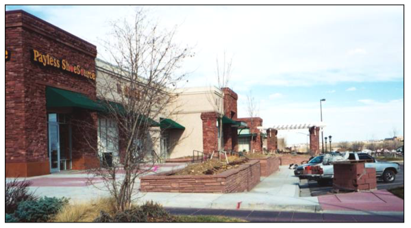
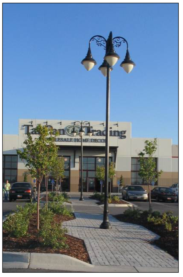
- Interchange Commercial (C-1): This zone is created for application around and near those major transportation routes and nodes which offer visitors, tourists, and residents their first impressions of Santaquin. Additionally, the area would serve to promote and facilitate travel oriented businesses. Businesses within this zone will generally stand alone but some medium size box stores with satellite commercial buildings will be allowed where such is shown to complement the identity of the city and surrounding residential neighborhoods will not be unreasonably disrupted. Special emphasis is to be placed on the properties near the Main Street freeway interchange and along Highway 198.
- Professional Office (PO): This zone is created for application around and near major and minor transportation nodes, which may function as gateways to the city's residential areas, but be conducive to professional office uses. Buildings and uses within this zone should have limited impacts on adjacent residential uses through appropriate hours of operation, noise buffering, aesthetic considerations, and little intrusion of traffic into residential neighborhoods. (Ord. 03-04-2014, 3-19-2014, eff. 3-20-2014)
- Permitted Uses: General land uses within commercial zones shall complement the city's general plan for their respective areas. Those uses allowed in the city's commercial zones are listed in the following matrix. Abbreviations and alphabetic use designations in the matrix have the following meanings:
P The listed use is a permitted use within the represented area, based on city development standards and ordinances. C The listed use requires a conditional use permit within the represented area in addition to complying with all applicable development standards and ordinances. A The listed use is only permitted as an accessory use within the represented area. N The listed use is a prohibited use within the represented area. (Ord. 03-04-2014, 3-19-2014, eff. 3-20-2014; amd. Ord. 02-01-2018, 2-7-2018, eff. 2-8-2018)Use C-1 PO Accessory building A A Adult daycare C P Agribusiness P N Agriculture in accordance with SCC 10.64 P P Agriculture building P P Agritourism C C Alcoholic beverage class A license (store; beer only) P N Alcoholic beverage class B license (bars) N N Alcoholic beverage class C license (restaurants/clubs) P N Alcoholic beverage class D license (hotel/conventions) P P Alcoholic beverage class E license (liquor store, etc.) P N Arcade C N Art gallery P P Auto, truck, RV, and equipment sales or rental P N Auto, truck, RV, and equipment storage N N Automotive service and repair P N Automotive service station P N Bakery, commercial P N Brewpub C N Car wash service C N Caretaker facilities associated with a permitted or conditional use P P Commercial, ancillary P N Commercial, convenience store P N Commercial parking lot or garage N N Commercial, repair services P N Commercial, retail sales and services P N Day treatment N C Daycare center A P Drive-in, retail P N Dwelling, multiple-family N N Engraving, publishing, and printing P C Financial, insurance, and real estate offices P P Furniture and appliance stores P N Healthcare facility (large) P C Healthcare facility (small) P P Hotels P N Institutions N P Kennels N N Mortuaries, funeral home N P Motels P N Multiple-unit dwellings as part of a mixed use development N N New and used car sales P N Pawnshops C N Permanent makeup establishment P N Professional offices or financial services P P Public and quasi-public buildings P P Public park, private park or playground P P Public safety buildings including, but not limited to, police, fire, and ambulance stations, and their associated structures P P Recreational activity businesses P C Recreational vehicle (RV) parks N N Religious center P P Research and development and related offices space N C Resident healthcare facility N P Restaurant P N Restaurant with drive-through facilities P N School, commercial (art, music, hair, massage) P P Schools, public or quasi-public C P Seasonal businesses, subject to SCC 10.16.300 P P Sexually oriented business N N Social or reception center C P Stone and monument sales P P Storage unit facilities N N Tattoo parlor N N Taxidermy shops N N Telecommunications sites. See SCC 10.16.340 paragraph D Temporary businesses, subject to the provisions of SCC 10.16.300 P P Theaters C N Tire recapping N N Treatment facility (large) N C Treatment facility (small) N P Truck stop N N Veterinarian hospital, small animal P P Wedding chapels N P Wholesale stores P N - Applicability of Standards:
- General City Standards: Within these Commercial Zones, all Santaquin City ordinances, policies, regulations and plans shall apply. Where conflicts occur regarding development requirements, these standards shall supersede those of the general Santaquin development standards (e.g., compliance with landscaping and parking standards shall be as found in the applicable sections of this Code).
- Existing Business Or Redevelopment: These standards shall be considered the minimum for all new or redevelopment within Commercial Zones. Any exterior changes (e.g., paint, material change, building addition, etc.) to an existing business must be reviewed by the City's Architectural Review Committee for compliance with these standards on that portion of the building being modified. If a remodel or addition exceeds forty percent (40%) of the exterior then the entire structure exterior shall become compliant with these standards. General maintenance of materials and building exteriors will not be required to be reviewed by the City's Architectural Review Committee. (Ord. 03-04-2014, 3-19-2014, eff. 3-20-2014)
- Review Of Development Applications: All applications within the Commercial Zones affected by these standards shall be reviewed by the City's Architectural Review Committee (ARC) and Development Review Committee (DRC). Compliance with the building architectural standards shall be determined by the ARC. The DRC shall be the Land Use Authority and will determine compliance with the site standards set forth below.
Appeals of final decisions based upon these standards or the underlying zone shall be subject to Appeal Authority review in accordance with the procedures of the Santaquin City Zoning and Appeal Authority Ordinances, as appropriate. (Ord. 04-02-2019, 4-16-2019, eff. 4-17-2019) - Site Standards: In general, buildings should be located so as to be visible from major roadways and entries, to provide clear orientation and access for vehicular and pedestrian traffic alike. Likewise, structures should be located in consideration of the existing built context, the location of adjoining uses, and the location of major roadways. Appropriately located pedestrian courtyards, common gathering areas and accessible, well landscaped environments that encourage pedestrian movement both within the new commercial development and among adjacent land uses are encouraged.
- Lot Standards: No minimum lot area and width standards are specified for parcels within commercial zones, except that an area sufficient to accommodate building location requirements, off street parking, loading and unloading, and vehicular access shall be provided and maintained by the owner.
- Building Location Standards: The following standards shall apply to structure locations within the respective commercial zones.
- Submittal Of Plan: Where a development is to be completed in phases and with multiple buildings, a plan showing the overall commercial development, including all building and improvement locations must be submitted to the planning commission for concept review and approval prior to any site plan approvals for an individual building site or location. Construction of buildings on pad sites may not commence until construction has begun on the major anchor tenants of the property, without architectural review committee approval.
- Setback Requirements: Notes:
C-1 PO Front setbacks: From primary public frontage to building/ parking 10/10 20/10 From secondary public frontage to building/ parking1 10/10 20/10 From private frontage 0 10 Side setbacks2: Minimum from adjacent property to building/ parking 0 or 10'/0 if shared or 5' 10' plus 5' per building stories above 1/5' If side abuts a residential zone 15' Minimum from private street/drive aisle curb 10' 10' Rear setbacks: Minimum from adjacent property to building/ parking 10'/0 if shared or 5' 20/5 If rear abuts a residential zone 15' 20' Minimum from private street/drive aisle curb 10' 10'
1 Secondary frontage shall be the frontage on the lower classification of road if the development fronts onto 2 streets of differing classification. Where both fronted streets are equally classified, the secondary frontage shall be the street with lower traffic volumes.
2 Commercial buildings may be designed and constructed to be conjoined or share a common wall along a side or rear property line, with a neighboring commercial building if the adjoining building is planned as a part of the same commercial development or plan, whether or not in subsequent phases and as long as all other applicable standards are still met. If no wall is to be shared along the side or rear property lines, then the greater setback shall be required. - Accessory Structures: Accessory structures (e.g., trash enclosures, storage buildings, etc.) may not be located in required front yard setback or landscape yard areas and must comply with all applicable landscape requirements found within SCC 10.52.050. Trash enclosures shall be located so as to minimize disturbance to adjacent residential development.
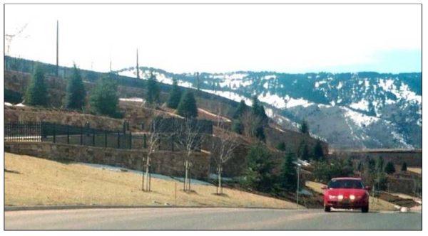
- Grading Standards: Site planning must take into consideration the existing grade and slope of the site. Grading of property should be sensitive to and compatible with surrounding properties and public streets. Commercial properties adjacent to existing or future residential properties will be restricted in raising or cutting the elevation of the commercial site near property lines unless approved by the city with appropriate buffering measures.
- The use of landscaped, sloped areas is usually preferable to retaining walls. The use of terraced parking lots, stepped building pads, retaining walls and larger setbacks may be necessary to achieve this.
- Retaining wall heights are limited to a maximum height of four feet (4') measured from the highest point of grade, unless otherwise authorized by the architectural review committee. Cast in place concrete walls may not be utilized for retaining purposes unless a decorative stone or other approved veneer material and/or elements will be placed on the visible portions of the wall.
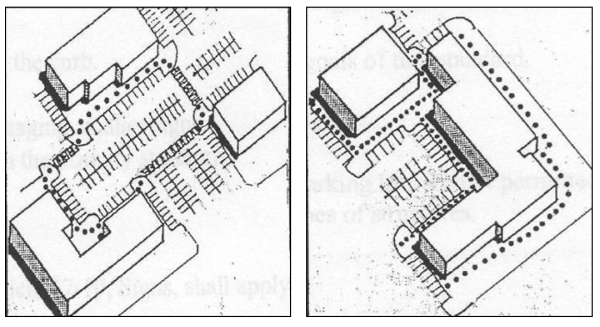
Appropriate use of landscape terraces and retaining walls to address topographic differences between parking areas and stores (top) and along commercial perimeters (bottom).
- Site Amenities: Site amenities shall be provided in accordance with the following guidelines. All such amenities shall be owned and maintained by the property owner or property owners' association.
- A sense of entry or arrival should be created at primary entryways into the development. Building placement, landscaping, gates, entry monuments, specialty lighting and other design elements may be used to create this design effect.
- Public art promotes the cultural and historic characteristics of Santaquin City and the surrounding areas. It also encourages pedestrian activity and contributes to the visual experience of residents and business patrons. Public art (which may include artists' work integrated into the design of the building, landscaping, sculpture, painting, murals, glass, mixed media or work by artisans), that is accessible or directly viewable to the general public is encouraged to be included in all projects.
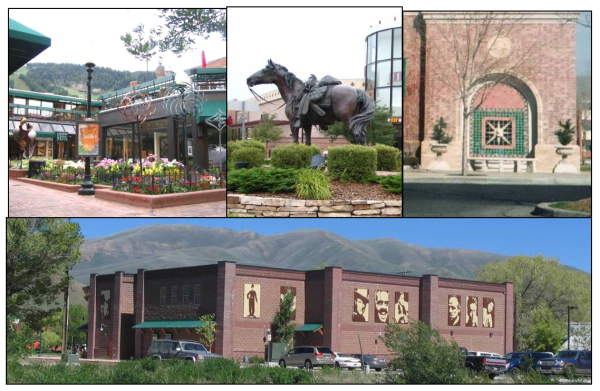
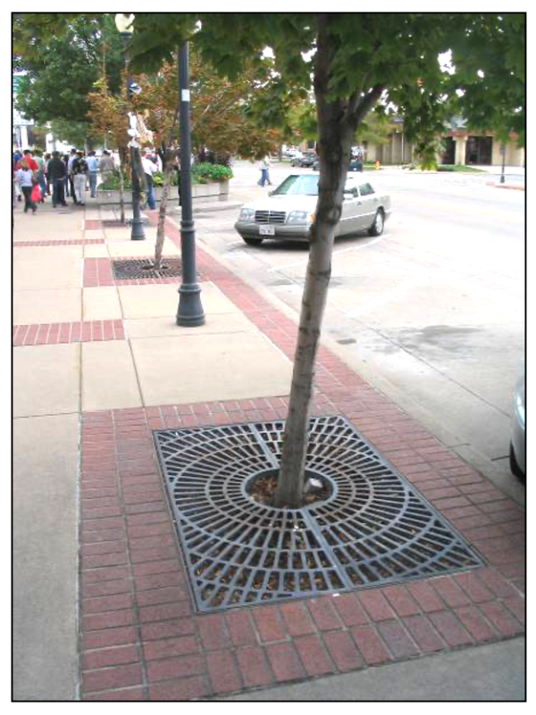
Examples of public art around and on commercial buildings. - Areas devoted to pedestrian use should be delineated through the use of accent paving (e.g., stamped and colored concrete, pavers, etc.), landscaping, lighting and/or outdoor furniture. Elements such as benches, fountains, play areas and other amenities should be designed and where feasible are usable throughout the year (e.g., buffered from the elements, open to sunshine).
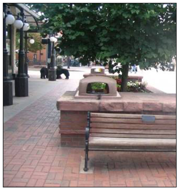
 Examples of paving materials and features used to delineate pedestrian traffic or use areas.
 - Within master planned developments over five (5) acres, amenities such as courtyards or plazas shall be included within the overall and individual site plans, and shall be functional and designed as part of the overall project, as opposed to being relegated to "ancillary" spaces unsuitable for other purposes. Such courtyards or plazas, at the city's discretion, may be included within the open space requirement.
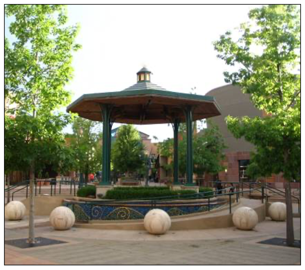
Examples of plaza areas and courtyard features.
- Fencing And Screening Standards:
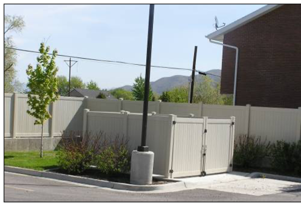
- Construction: Fences and perimeter or screen walls should be constructed from durable material such as stone, brick, vinyl, metal having a dark finish (e.g., wrought iron), or any combination approved through the architectural review process. Perimeter screening may also include landscaping elements (e.g., hedges, windrows, etc.) as approved through the architectural review process. Chainlink and related fencing shall not be used, except in areas where it is not highly visible to the public. Any chainlink materials must be vinyl coated. Concrete walls should be finished with masonry, stone, scoring with texturing or other approved finishes. Precast walls must have a finished stain with sealant.
- Minimal View Of Service Areas: Loading docks and similar service areas shall be oriented in such a way as to be minimally viewed from generally accessible public areas. Where site conditions do not enable this, screening of service areas shall be provided. This may include a wall with minimum height of six feet (6') having materials, finishes, and similar or complementary architectural treatments as the main building, landscaping, or other city approved method.
 Appropriate use of wall design and landscaping elements to screen a loading dock area (above).
 - Outside Storage Or Display Areas: Permanent outside storage or display areas shall be considered those areas utilized for more than six (6) months in a calendar year for display or storage purposes. These should be screened with walls or other barriers of a sufficient height to screen the top of the materials stored. Such enclosures should utilize materials and design features which are similar to the associated building(s). Permanent outside storage or display areas shall be consistent with the rest of the project in design and location.
- Utility Equipment Screened From View: All ground or wall mounted utility equipment, meters, transformers, and HVAC equipment shall be screened from view with fencing, walls, landscaping, paint application or combination of the four (4) where viewable from customer travel areas. Equipment screening in areas not generally visible to the public shall be designed and constructed in a manner that is consistent with the rest of the project, but should include at least paint applications.
- Visual Relief: Screening walls and fencing should have visual relief a minimum of every fifty feet (50').
- Antigraffiti Protections: All wall types must utilize antigraffiti protections up to nine feet (9') or the maximum height of the wall whichever is less.
- Vehicular And Pedestrian Circulation:
Example of pedestrian connection from a local street, in background, to business front.- Access points along collector or arterial roads should be limited in number and location; driveways should be planned and, when feasible, shared between properties.
- All commercial developments shall provide access to and between adjacent commercial or mixed use properties and their associated parking areas where reasonably possible. Such access shall be designed based on the adjacent or anticipated site layout of the adjoining property. Barriers that limit circulation between developments and parking lots are not permitted. Examples include fences, walls, topographic changes, or other similar types of obstructions.
- Site planning must provide for a separation of pedestrians from vehicular circulation. Pedestrian circulation must be provided along frontages, from the perimeter of the site to buildings, and provided to connect all buildings within the site in an obvious and consistent manner.
- Pedestrian walks and crossings should be located to minimize the number of interruptions by creating a continuous walking environment along and between buildings. Where pedestrian crossing areas exist, minimize the distance across the street, drive aisle, or similar walking interruption by use of extended sidewalks, bulb outs, etc.
 Example of a conflicting auto and pedestrian routes design (left) and a more separated pedestrian and automotive circulation plan (right).
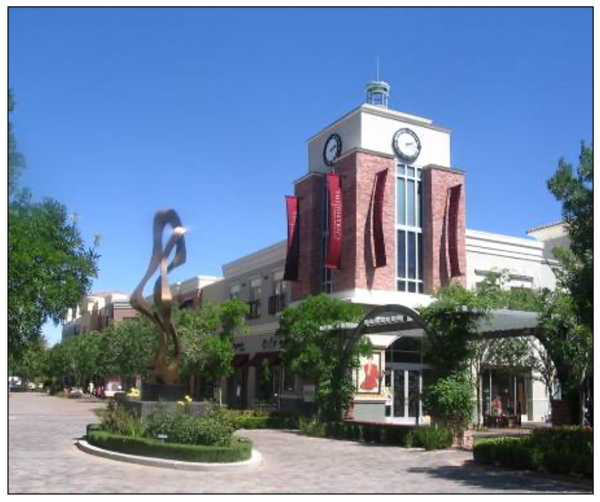
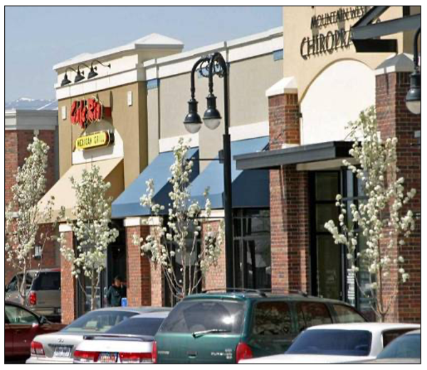
 - Pedestrian areas adjacent to buildings exceeding two hundred feet (200') in length should be designed with a Main Street look and relational feel by incorporating landscaping, street furniture, pedestrian scale lighting, etc.
 Example of Main Street style streetscape.
- Lighting: In addition to the provisions of SCC 10.48.070 the following shall apply:
- All poles and fixtures shall be aesthetically compatible with all other fixtures on site.
- Separate pedestrian scale lighting should be provided for all pedestrianways through parking lots and building mounted decorative fixtures provided for pedestrianways along buildings.
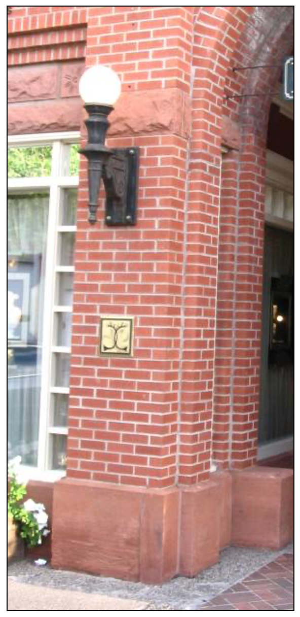
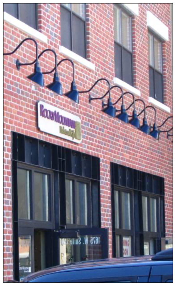
Examples of site and building lighting designed to promote business and development character as well as provide pedestrian scale lighting.
(Ord. 03-04-2014, 3-19-2014, eff. 3-20-2014)
- Building Architectural Standards:
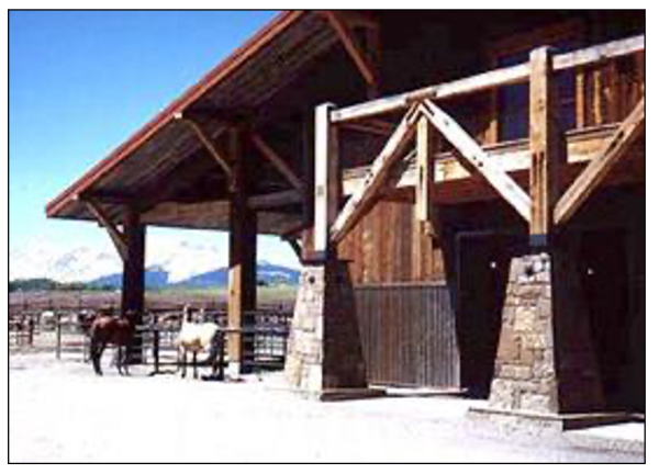
- Development Theme: The architectural standards of this code are intended to focus on the rural character and theme of the area and the community's desire to maintain and promote its agricultural and equestrian components. Building designers should consider the natural colors and materials of the surrounding area in concert with agrarian, craftsman, and other similar rural forms when preparing plans for new building construction. The following standards should serve as the minimum to which new developments can adhere and designers are encouraged to incorporate other elements which may further the city's desires and intent.
- Minimum Building Footprint: No minimum square foot requirements are specified in these zones.
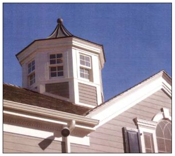
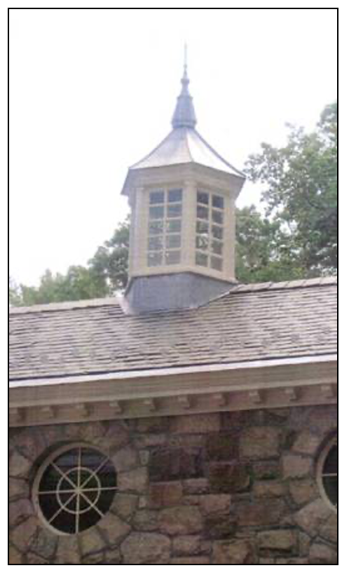
- Maximum Heights: The maximum height of buildings in commercial zones shall be forty eight feet (48'). However, architectural elements (e.g., domes, towers, spires, crosses, cupolas, finials, etc.) may exceed the maximum height limit for the district, when specifically approved through the architectural review process.
- Buildings Materials:
- Primary Exterior Materials:
- Primary exterior finish materials shall make up at least sixty percent (60%) of the building after the transparent area is deducted. The percentage shall be based on the entire area of the building. Rear elevations regularly visible to customers or visible from adjacent public rights of way should have at least forty percent (40%) primary materials, but may have twenty five percent (25%) otherwise. Rear elevation or service area visibility considerations shall take into account planned landscaping, fencing and topographic viewing limitations.
- Primary exterior finish materials shall be low reflectance and have natural textures. Examples of permitted primary exterior materials include: stone, brick, split faced block, cut stone and low maintenance wood or masonry siding products. The use of all glass exterior, smooth faced concrete gray block, prefabricated steel panels, EIFS (stucco) shall be prohibited as a primary building material.
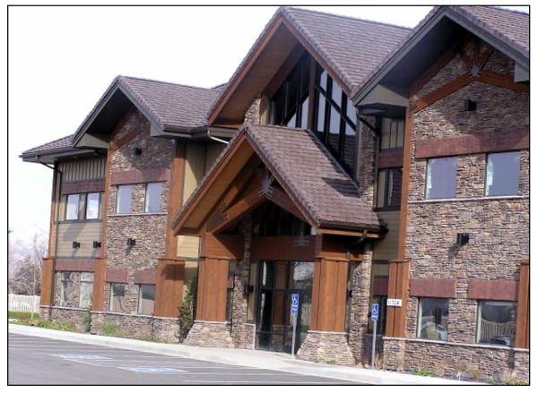

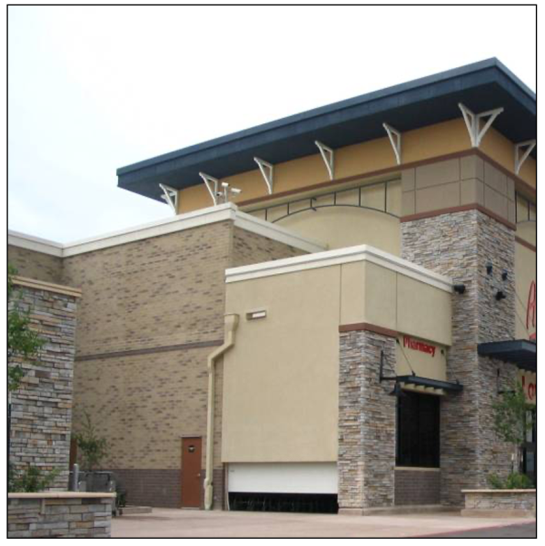
Examples of appropriate building design and use of materials including stone, wood and hardy board products on an office building (top) and commercial building (bottom).
- Secondary Materials And Trim Materials: Secondary materials and trim materials shall complement the primary materials in texture and scale and provide enough contrast to be visible. EIFS materials may be utilized. Vinyl or aluminum materials may only be used for soffit or fascia elements unless otherwise approved by the architectural review committee on less than twenty five percent (25%) of the building area.
- Accessory Structures: Accessory structures, such as gasoline pump canopies, utilities (gas, electric), and other accessory structures shall incorporate similar architectural elements or types of primary materials and colors as the associated structure.
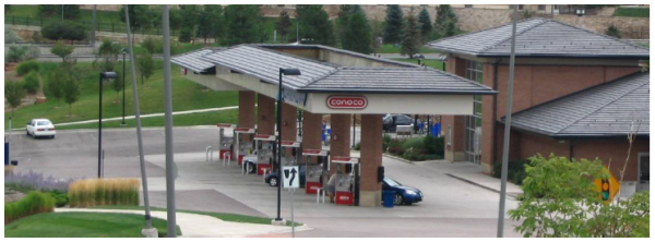
Example of accessory structure (i.e., gas island canopy) utilizing similar materials and design elements as the primary building. - Material Colors: Material colors should consist of earth tones, and colors as can be readily or were historically found around the Santaquin area, e.g., natural shades of wood, stone or brick. The use of high intensity colors, primary colors, metallic colors, black or fluorescent colors is not permitted for primary exterior materials. Secondary materials and trim materials shall complement the primary material colors.
- Primary Exterior Materials:
- Building Entrances:
- Entrances must be well defined from access drives, pedestrian links, public plazas and major parking areas with one or more of the following:
- Roof elements such as gable ends,
- Canopy, awnings, overhang or arch above the entrance (columns and pillars),
- Recesses or projections in the building facade surrounding the entrance,
- Display windows surrounding the entrance.
- Public entrances, patios, faux windows or dining areas appropriate to the establishment should be provided on any building side facing a public street. Secondary public/customer entrances on the rear or side of buildings should be given architectural consideration similar to the primary entrances. Service and employee only entrances not visible from a publicly utilized area are excluded from similar consideration requirements.
- Entrances must be well defined from access drives, pedestrian links, public plazas and major parking areas with one or more of the following:
- Building Elevations:
- Building faces must incorporate architectural features or treatments every thirty to fifty feet (30 - 50') to diminish building mass. The following techniques should be used to accomplish this requirement; additional techniques proposed by the applicant may be considered by the architectural review committee:
- Variations in facade color, texture, or both.
- Variations in roof forms and heights of roof elements.
- Compositions that emphasize floor lines, or otherwise express rhythms and patterns of windows, columns, and other architectural features.
- Express the position of each floor in the external design. Terracing, articulated structural elements, a change in materials, or the use of belt courses or similar horizontal trim bands of contrasting color and/or materials can be used to define floor lines.
- Use windows, trellises, wall articulation, arcades, material changes, awnings or other features to avoid blank walls at ground floor levels.
- The use of materials relatable to human proportions, such as brick, tile, modular stone, stucco, glass and decorative tiles.
- Columns, pilasters, canopies, porticoes, awnings, brackets, arches or other such architectural features.
- Additional landscaping elements along building walls.
- Building heights should be minimized and of compatible scale with existing or planned development; the base of each building should appear to be "weightier" or "anchored" closely to the ground through the use of heavier, larger or darker building materials, although actual building heights are expected to vary, in particular adjacent to major public roadways and, possibly, along the perimeter of the development. Exposed foundation walls must be finished with appropriate brick, stone, plaster or similar materials noted above.
- Material elements such as banding, cornice elements, pilasters, pillars, canopies, etc., must be continued around building corners and only terminate at interior wall corners or as part of a logical terminus feature.
Example of appropriate termination and wrapping of materials and design elements on a commercial building.
- Building faces must incorporate architectural features or treatments every thirty to fifty feet (30 - 50') to diminish building mass. The following techniques should be used to accomplish this requirement; additional techniques proposed by the applicant may be considered by the architectural review committee:
- Windows: The design and amount of window area on a building can minimize the expanse of blank walls and encourage a pedestrian friendly atmosphere. In order to provide a more human scale and open shopping experience, windows and/or faux glazing materials should be utilized along building fronts where pedestrian traffic will occur. The following standards shall apply:
- All windows should be designed with three-dimensional relief or material highlighting elements which accent the window locations and provide visual breaks to the facade of the building (e.g., dormers, sills, etc.). Where appropriate, varying window designs, such as bay windows, corner windows, circle tops, or windows having grille patterns, shutters, etc., should be considered to add visual interest and character to buildings.
- Use of clerestory or faux windows should be considered where facades exceed twenty five feet (25') in height. Functionality and architectural integrity should be maintained in addition to addressing the articulation of upper level facades.
- Use Of Awnings, Canopies, And Arbors: Awnings, canopies and arbors shall be designed to fit within the architecture of the buildings to which they are attached or located adjacent to and serve to enhance the exterior of the building as an articulation and aesthetic element.
- Awnings or canopies shall project at least 3.0 feet from the building when located over a pedestrian traffic area and no less than two feet (2') otherwise.
- A minimum clearance above sidewalk grade of eight feet (8') to the bottom of the framework shall be maintained when located over a pedestrian traffic area. The bottom of the framework shall not be more than eight feet (8') above covered grade or the maximum height of the protected window, door, or recessed building entry otherwise.
- The top of the framework may not extend above a vertical wall terminus nor cover any architectural elements.
- All awnings that do not contain sign copy shall be made of woven cloth or architectural metal materials; glossy materials are not allowed.
Appropriate use of canvas and metal awnings.
- Roof Designs And Parapets:
- Where gable or gambrel elements are utilized as part of the roof structure or as entry features, decorative brackets, exposed timbers or similar features shall be applied to roof ends. Eaves should extend at least eighteen inches (18").
- Elements along flat roofs should be extended around building corners and follow changes in wall plane. Elements such as corner towers, pillars, cornice elements, etc., should be provided along and at the edges of walls to hide or reduce the "box like" form of a building.
- Where roof mounted equipment is present:
- Screening such as parapets, architecturally designed enclosures, etc., shall be provided to reasonably screen all roof equipment from being visible three hundred feet (300') away from the building. Special consideration should be given to the varied topographic conditions around Santaquin when designing such screening.
- Where approved screening of roof equipment is provided and the potential exists for roof equipment to still be visible from neighboring major transportation corridors, the equipment should be clustered and painted the same color as the adjacent building/roof colors so as to minimize the visibility of the equipment. Additional screening at site boundaries may also be an appropriate mitigation measure in this instance.
- Where no roof mounted equipment is present, the top of the exterior wall should have cap features (e.g., cornice elements, cap finishes, etc.).
- Sloped roofs or forms should have a minimum four to twelve (4:12) pitch. (Ord. 03-04-2014, 3-19-2014, eff. 3-20-2014)
- Development Theme: The architectural standards of this code are intended to focus on the rural character and theme of the area and the community's desire to maintain and promote its agricultural and equestrian components. Building designers should consider the natural colors and materials of the surrounding area in concert with agrarian, craftsman, and other similar rural forms when preparing plans for new building construction. The following standards should serve as the minimum to which new developments can adhere and designers are encouraged to incorporate other elements which may further the city's desires and intent.
- Special Provisions:
- Storage of junk, partially or completely dismantled automobiles, or salvage materials shall be prohibited in any commercial zone. (Ord. 03-04-2014, 3-19-2014, eff. 3-20-2014)
- Storage of junk, partially or completely dismantled automobiles, or salvage materials shall be prohibited in any commercial zone. (Ord. 03-04-2014, 3-19-2014, eff. 3-20-2014)
Amended by Ord. 07-01-2011 on 7/27/2011
Adopted by Ord. 03-04-2014 on 3/19/2014
Amended by Ord. 02-01-2018 on 2/7/2018
Amended by Ord. 04-02-2019 on 4/16/2019
Amended by Ord. 04-01-2020 on 4/7/2020
Amended by Ord. 03-03-2022 on 3/15/2022
Amended by Ord. 12-01-2022 on 12/20/2022
Amended by Ord. 08-01-2025 on 8/19/2025
10.20.130 I-1 INDUSTRIAL ZONE
- Objectives And Characteristics: The I-1 Industrial Zone has been established for the primary purpose of providing a location where manufacturing, processing, warehousing, and fabrication of goods and materials can be carried on most appropriately and with minimum conflict or deleterious effects upon surrounding properties.
Other objectives in establishing the zone are to promote the economic well being of the people and to broaden the City's tax base. This zone is characterized by a mixture of industrial, manufacturing, warehousing, and processing establishments with intermittent open land served by streets, power, water, and other utilities and facilities or where such facilities can be readily provided. (Ord. 2-01-2002, 2-5-2002, eff. 2-5-2002) - Permitted Uses: Land uses in the I-1 Industrial Zone are permitted as follows. Alphabetic use designations in the table below have the following meanings:
P The listed use is a permitted use within the represented area, based on City development standards and ordinances. C The listed use requires a conditional use permit within the represented area in addition to complying with all applicable development standards and ordinances. N The listed use is a prohibited use within the represented area. (Ord. 07-01-2011, 7-27-2011, eff. 7-28-2011; amd. Ord. 03-02-2014, 4-16-2014, eff. 4-17-2014; Ord. 02-01-2018, 2-7-2018, eff. 2-8-2018)Use I-1 Accessory buildings and parking lots P Agribusiness P Agriculture in accordance with SCC 10.64 P Agriculture building P Agritourism C Caretaker dwellings P Commercial, recreation P Crisis respite P Gravel, sand, earth extraction, and mass grading when necessary to accomplish the intent of a development project permitted within and in association with the I-1 Zone and in accordance with SCC 10.16.280 P Commercial, Heavy P Manufacturing, compounding, processing, packing, fabrication, and warehousing of goods and materials, except the processing of animal byproducts, livestock feed yards, oil refineries, wallboard manufacturing, and similar establishments which emit offensive fumes, smoke, noise, odor, etc. P Public and quasi-public buildings P Public safety buildings P Recreational vehicle (RV) parks N Research and development and related offices space P Retail commercial uses when related to the product being manufactured P Sheltered workshop P Storage unit facilities P Telecommunications sites. See SCC 10.16.340 paragraph D Temporary businesses, subject to the provisions of SCC 10.16.300 P Treatment facility C - Reserved: (Ord. 03-01-2007, 3-7-2007, eff. 3-8-2007)
- Area Requirements: In the I-1 zone, there shall be no land area requirements, except that an area sufficient to accommodate location requirements, off street parking, loading and unloading, and vehicular access shall be provided and maintained. (Ord. 2-01-2002, 2-5-2002, eff. 2-5-2002)
- Width Requirements: The minimum width of lots in this zone has not been specified. (Ord. 2-01-2002, 2-5-2002, eff. 2-5-2002)
- Location Requirements:
- SetbacksNotes: 1three-foot (3') side setback shall be permitted for accessory buildings located at least twelve feet (12') from the side or rear of any building having fire resistant walls of two (2) hours or more. 2 A two-foot (2') rear setback shall be permitted for accessory buildings located at least twelve feet (12') from the side or rear of any building having fire resistant walls of two (2) hours or more. 3 If the property is adjacent to a residential zone, an additional five-foot (5') setback is required for all structures and parking areas.4 Landscaping yards are not required within storage or material yards unless adjacent to a residential zone.
I-1 Setback Requirements Front Street Side Side3 Rear3 Main Building 35' 25' 10' 10' Accessory Building 35' 25' 10'1 10'2 Parking 20' 20' 10'4 10'4 Accessory buildings shall be located at least twelve feet (12') from the dwelling or main structure and shall not be in any utility easements without written consent from those affected entities. - Clear View: All structures must be placed in conformance with the clear view standards found in SCC 10.16.090
- Setbacks
- Size Of Buildings: The ground floor area of all buildings has not been specified. (Ord. 2-01-2002, 2-5-2002, eff. 2-5-2002)
- Height And Size Requirements: There are no height or size requirements in the I-1 zone. (Ord. 2-01-2002, 2-5-2002, eff. 2-5-2002)
- Special Provisions:
- Development landscaping shall be in accordance with SCC 10.52, "Landscaping Standards".
- Materials placed in screened outside storage areas shall be stacked no higher than the screening fence, wall, or hedge. (Ord. 12-02-2006, 12-6-2006, eff. 12-7-2006)
Amended by Ord. 07-01-2011 on 7/27/2011
Amended by Ord. 11-03-2014 on 11/5/2014
Amended by Ord. 02-01-2018 on 2/7/2018
Amended by Ord. 04-02-2022 on 4/19/2022
Amended by Ord. 02-02-2025 on 2/4/2025
Amended by Ord. 08-01-2025 on 8/19/2025
10.20.140 PC PLANNED COMMUNITY ZONE
- Definitions: As used in this section, the following terms have the meanings ascribed to them, unless the context requires otherwise:
DESIGN GUIDELINES: Documentation that is submitted with an application for PC district zoning and that identifies in the proposed PC district the requirements and standards for residential densities, building height, bulk and setback requirements by land use type, signage, landscaping, parking, open space, site plan review procedures, and procedures for modifying the planned community program.
DEVELOPMENT PLAN: A map or maps that are submitted with an application for PC district zoning and that identifies in the proposed PC district general land use designations, transportation plans, open space, and community facilities.
PLANNED COMMUNITY PROGRAM: The development plan and design guidelines that are submitted with an application for PC district zoning. (Ord. 2-01-2002, 2-5-2002, eff. 2-5-2002) - Purpose:
- The planned community (PC) district is established to permit and encourage the development of comprehensively planned communities, with a minimum of eight hundred (800) contiguous acres of land under one ownership or control, which can flourish as unique communities as a result of the comprehensive planning required for this size of development. The reclassification of property to the PC district is appropriate only if the planned community program, with respect to such property, will accomplish the objectives set forth in paragraph B,3.
- The PC district designation is intended to permit a greater amount of flexibility to the developer of a planned community because of the extended period of time necessary for development. The PC district regulations are intended to provide to the developer, and its successors and assigns, the rights described herein and to expressly set forth the procedures for obtaining review and approval of zoning and related site plans. The PC district regulations are also intended to provide opportunity and incentives to the developer to achieve excellence in physical, social, and economic planning.
- In order for property to qualify for PC district zoning, the master developer, including its successors and assigns, must demonstrate the potential for achievement of the following specific objectives throughout the planning, design, and development stages:
- Providing for an orderly and creative arrangement of land uses with respect to each other, to the entire planned community, and to all adjacent land;
- Providing for a variety of housing types, employment opportunities, and commercial services to achieve a balanced community for families of a wide variety of ages, sizes, and levels of income;
- Providing for a planned and integrated comprehensive transportation system for pedestrian and vehicular traffic, which may include provisions for mass transportation, roadways, bicycle or equestrian paths, pedestrian walkways, and other similar transportation facilities;
- Providing for cultural, educational, medical, religious, and recreational facilities;
- Locating and sitting structures to take maximum advantage of the natural and manmade environment and to provide view corridors; and
- Providing for adequate, well located, and well designed open space and community facilities. (Ord. 2-01-2002, 2-5-2002, eff. 2-5-2002)
- Design Guidelines: Development in the PC district may consist of any use or combination of uses that are specifically approved for the property in the planned community program. The developer shall include in the planned community program a listing of the uses proposed and the general arrangement thereof for each land use category within the proposed PC district. The listing and general arrangement of the approved land uses shall be shown in the planned community program that is adopted as part of the PC district approval. (Ord. 2-01-2002, 2-5-2002, eff. 2-5-2002)
- Density: The number of dwelling units permitted per gross acre in the PC district shall be determined at the time the planned community program is approved. The approved planned community program shall establish the maximum number of dwelling units per gross acre for each residential category, as well as for the entire property. (Ord. 2-01-2002, 2-5-2002, eff. 2-5-2002)
- Minimum Site Area For Reclassification: The minimum site area that is eligible for reclassification to the PC zoning district is eight hundred (800) acres. Additional tracts which contain less than the minimum site area and which are contiguous to property previously zoned PC may also be zoned PC by the city council if they otherwise qualify for the PC zoning designation. The reclassification of any such additional property shall be made subject to an approved planned community program applicable to that property. (Ord. 2-01-2002, 2-5-2002, eff. 2-5-2002)
- Presubmission Conference; Rezoning Application Requirements:
- Before submitting an application for PC district zoning, the prospective developer, or its authorized representative, shall engage in a presubmission conference with the staff of the city to discuss preliminary land planning, including land use relationships, residential density, transportation systems, community facilities, and landscaping and open space provisions.
- Plans and documentation which must accompany a rezoning application are as follows:
- A development plan for the property, including general land use designations, transportation plans, and plans for open space and community facilities. A general phasing plan shall be included to indicate the intended timing of development;
- Design guidelines that set forth densities, building height, bulk and setback requirements, requirements for signage, landscaping, parking, and open space; and procedures for site plan review, modification, and deviation from the planned community program;
- Storm drainage information, which shall consist of a preliminary drainage study completed by a registered professional engineer on a map with a minimum contour interval of two feet (2');
- Conceptual utility layout that includes tentative sewer and water main corridors;
- Proposed conditions, covenants, and restrictions, including design guidelines; and
- Culinary and secondary water plan including source, type, and quantity of water shares or rights. (Ord. 2-01-2002, 2-5-2002, eff. 2-5-2002)
- Review, Recommendation, And Approval:
- The initial zoning approval of a PC district shall consist of a review and recommendation by the planning commission and approval by the city council, in accordance with the provisions of this title. The approval of a PC district by the city council shall be accomplished directly by ordinance and shall include the approval and adoption of a planned community program. An approved planned community program shall be a matter of record and shall be made available in the city offices.
- The developer, and its successors and assigns, may develop property in the PC district in accordance with, but only in accordance with, the approved planned community program and any approved modifications thereto or deviations therefrom. No modification or deviation shall be effective unless and until it is approved in accordance with paragraph G,3 and the procedures set forth in the planned community program. The city planner may request modification of a program in accordance with the modification procedures set forth in the program.
- A planned community program shall contain procedures to provide for modification of and deviation from the program pursuant to review by the development review committee, the planning commission, and the city council, and such procedures shall be exclusive of any other procedure, other than the procedures for notification of public hearings, that is provided in this title for the approval of any reclassification, variance, or conditional use permit. Modification or deviation may be approved only upon a finding by the planning commission or city council, as the case may be, that:
- The requested modification or deviation, if approved, will not affect the rights of property owners or residents within the PC district to maintain and enforce previously approved conditions, covenants, and restrictions and other rights in the planned community program; and
- The requested modification or deviation, if approved, will be consistent with the planning objectives and goals of the approved planned community program. (Ord. 2-01-2002, 2-5-2002, eff. 2-5-2002)
- Submission And Approval Requirements: The subdivision review process for this zone shall be in accordance with SCC 11.20.020 and the site plan review process shall be in accordance with SCC 10.68.060.
- Preliminary Plans and Documents:
- Vicinity Plan: The developer shall prepare a vicinity plan which shows a simple concept of the major features of the development in relation to existing conditions and developments within one-fourth (1/4) mile of the outside boundaries of the development. Five (5) twenty-four inch by thirty-six-inch (24" x 36") copies and ten (10) eleven inch by seventeen-inch (11" x 17") copies of the vicinity plan, the required fee, and the environmental impact statement shall be submitted to the Community Development department.
- Environmental Review: The environmental review shall describe the impact the development will likely have on the natural features of the immediate area. The statements shall also indicate the measures that will be taken to mitigate any negative conditions that will occur as a result of the project with respect to those items listed in the definition of "Environmental Review", in SCC 10.08.020.
- Preliminary Plan: The developer shall prepare a preliminary plan and shall submit five (5) twenty-four inch by thirty-six-inch (24" x 36") copies and ten (10) eleven inch by seventeen-inch (11" x 17") copies of the plan to the Planning Commission for approval. The plan must be submitted at least forty-five (45) days prior to the meeting of the Planning Commission at which the plan will be considered. The preliminary plan shall be drawn to a scale not smaller than one inch to one hundred feet (1":100'), or as recommended by the Planning Commission. The plan shall show the following information:
- Type(s) of development;
- Name of development;
- Name, address, and phone number of the property owner(s) and the developer;
- Name, address, and phone number of the engineer and land surveyor;
- A site plan showing location of proposed streets and building sites;
- Proposed open space areas, i.e., parks, play equipment, dimensioned side, rear, and front yards, and the general location and description of all recreational and open space areas and facilities;
- Size and type of recreational buildings and other structures proposed for the common use of the residents with an indication of building materials to be used in the construction of buildings;
- Typical lot layout;
- North arrow and scale;
- Legal description with section tie;
- Zone boundaries and designations;
- Tabulation showing:
- Area of land within the residential development;
- Number of residential lots proposed;
- Percent of area to be devoted to parks and playgrounds; and
- Number of off street visitor parking spaces;
- Proposed location of off street parking spaces;
- Typical street cross sections;
- Adjacent property owners;
- Existing and proposed easements, waterways, utility lines, canals, and ditches;
- A plan for accommodating waterways, ditches, and canals;
- Existing and proposed sewage disposal facilities;
- Existing and proposed storm drain system with the related runoff calculations for the development site;
- Existing and proposed water system indicating size of water lines and fire hydrant locations;
- An indication of the capacity of the water system as it relates to the project;
- Preliminary landscape plan indicating areas of landscaping and the various types of landscape materials to be used; and
- Any other information the City Engineer, City Planner, Development Review Committee, Planning Commission, may determine necessary relating to the particular site of the proposed project. (Ord. 2-01-2002, 2-5-2002, eff. 2-5-2002)
- Agreements: The developer shall submit to the city an agreement between the developer and the city stating among other things:
- That in the event of failure or neglect on the part of the owners, successors, or assigns to maintain the water and sewage facilities, common areas, landscaping, or other improvements in good condition, the city may perform the necessary work and for that purpose may enter upon the land and do the work and charge the cost thereof, including reasonable attorney fees, to the owners or their successors or assigns;
- That the owners, successors, or assigns will reimburse the city for all costs which the city incurs as a result of performing the necessary work;
- That the terms of the contract shall be binding upon the heirs, assigns, receivers, and successors of the project for the life of the project or development; and
- Any other conditions that the planning commission and/or city council deems to be reasonably necessary to carry out the intent of this title. (Ord. 2-01-2002, 2-5-2002, eff. 2-5-2002)
- Development Review Committee Conformance Review; Appeal:
- Each site plan that is submitted in connection with the implementation of a planned community program shall be reviewed for conformance therewith by the development review committee. The committee may require modifications that bring the site plan into conformance with applicable standards of health, safety and welfare and may recommend design adjustments to better fulfill the intent of the planned community program approval and the purposes of the PC district.
- An applicant that is aggrieved by the decision of the development review committee with respect to a proposed site plan may request a review of such decision by the planning commission. An applicant that is aggrieved by the decision of the planning commission may appeal such decision to the city council by filing a written request for appeal with the city recorder within fifteen (15) calendar days after the date of the planning commission's decision. (Ord. 2-01-2002, 2-5-2002, eff. 2-5-2002)
- Filing Fee:
- The applicant shall pay the fees that are set forth in the fee schedule for filing applications, requests for review and appeals under this chapter.
- With respect to any review or appeal that is described in this section and that will involve a public hearing, the notification of public hearing shall be in conformity with the procedure set forth in this title. (Ord. 2-01-2002, 2-5-2002, eff. 2-5-2002)
- Open Space And Landscape Area Requirements: A minimum of twenty percent (20%) of the gross property area in the PC district shall consist of open space, recreation facilities, pedestrian and bikeway facilities, other common community facilities and landscaped areas in public rights of way. Any private recreation facility which serves more than one individual lot may be counted as a part of the minimum requirement. Specific open space and landscaped area requirements shall be set forth in the planned community program. (Ord. 2-01-2002, 2-5-2002, eff. 2-5-2002)
- Street And Subdivision Design Requirements: All development shall conform to the standard street and subdivision design requirements set forth in this title and the construction and design guidelines of the city, except as otherwise provided for specifically in an approved planned community program. (Ord. 2-01-2002, 2-5-2002, eff. 2-5-2002)
- Sign Regulations:
- Freestanding Signs Allowed: Within the PC zone a maximum of six (6) freestanding signs shall be allowed between Interstate 15 and any collector or higher class road. The following standards shall apply to these signs:
- Maximum height shall be twenty five feet (25') above the closest freeway travel lane.
- Maximum sign area shall be five hundred (500) square feet.
- All illumination shall be internal or directed exterior lighting which does not spill off of the sign faces.
- No one business may occupy more than seventy percent (70%) of the maximum allowable sign area per sign. The intent of this provision is that signs shall be multi-tenant signs. (Ord. 02-02-2009, 2-18-2009, eff. 2-19-2009)
- Freestanding Signs Allowed: Within the PC zone a maximum of six (6) freestanding signs shall be allowed between Interstate 15 and any collector or higher class road. The following standards shall apply to these signs:
- Gravel, Sand, Earth Extraction, And Mass Grading: Gravel, sand, earth extraction, and mass grading operations may be approved by the city council with recommendation for approval by the planning commission as a part of a larger development project under the provisions applicable within the planned community zoning classification and those of SCC 10.16.280. Any such development shall be required to put forth a bond with the city for the reclamation of the site following the site's project completion. Such bonding may be waived by the city subject to provisions of bonding for the overall project. (Ord. 2-01-2002, 2-5-2002, eff. 2-5-2002; amd. Ord. 02-02-2009, 2-18-2009, eff. 2-19-2009)
- Nonapplicability Of Other Provisions; Analogous Applications:
- Except as otherwise specifically provided for the planned community program, variances from the provisions of the program outlined herein shall not be permitted within the PC zone.
- With regard to any issue and land use regulation that may arise in connection with the PC district and that is not addressed or provided for specifically in this chapter or in an approved planned community program, the governing body may apply by analogy the general definitions, principles and procedures set forth in this title, taking into consideration the intent of the approved planned community program. (Ord. 2-01-2002, 2-5-2002, eff. 2-5-2002; amd. Ord. 02-02-2009, 2-18-2009, eff. 2-19-2009)
- Default Land Use Regulations: Any property that comes to not be subject to land use regulations in the development plan through either expiration of the agreement or some other action shall become subject to default land use regulations. Those areas that were primarily designated as residential in the development plan shall become subject to land use regulations contained within the Residential R-10 zone. Those areas that were primarily designated as commercial in the development plan shall become subject to land use regulations contained within the Interchange Commercial (C-1) zone. The City Council maintains the authority to zone property at their discretion as they see necessary for the best interest of Santaquin City.
10.20.150 RC RESIDENTIAL COMMERCIAL ZONE
- Objectives And Characteristics: The RC zone allows for a mixture of residential and commercial uses as permitted uses. The purpose of the RC zone is to provide for and encourage a mix of compatible land uses which offer opportunities to live, work, and shop. It also is to provide the opportunity for compatible commercial development while preserving residential uses. Goals of this zone include the efficient use of land, reduced reliance on the automobile, and creative opportunities for the economical preservation and adaptive reuse of existing structures. A mixture of residential, office, personal service, and retail shopping opportunities are encouraged within this zone. (Ord. 04-01-2003, 4-2-2003, eff. 4-3-2003)
The RC zone is intended to provide a transition between residential and commercial areas. Uses should not conflict with the objectives and characteristics of either the R-8 or C-2 zone, or with the general plan. Bulk standards are intended to maintain a residential scale of development. Development within the RC zone should have good access to collector streets. (Ord. 2-01-2002, 2-5-2002, eff. 2-5-2002) - Permitted Uses: General land uses within the residential commercial zone shall complement the city's general plan for their respective areas. Those uses allowed in the RC zone are listed in the following matrix. Abbreviations and alphabetic use designations in the matrix have the following meanings:
P The listed use is a permitted use within the represented area, based on city development standards and ordinances. C The listed use requires a conditional use permit within the represented area in addition to complying with all applicable development standards and ordinances. A The listed use is only permitted as an accessory use within the represented area. N The listed use is a prohibited use within the represented area. (Ord. 5-03-2015, 6-3-2015, eff. 6-4-2015; amd. Ord. 02-01-2018, 2-7-2018, eff. 2-8-2018)Use RC Accessory apartments P Agribusiness C Agriculture in accordance with SCC 10.64 P Agriculture building P Agritourism C Alcohol dispensing establishment C Automotive service and repair C Automotive service station C Cemeteries P Child daycare center C Commercial, recreation P Commercial, retail sales and service P Drive-in retail P Dwelling, accessory unit attached P Dwelling, accessory unit detached N Dwelling, caretaker P Dwelling, single-family detached P Dwellings, multiple-family, subject to SCC 10.16.060 P Engraving, publishing, and printing P Furniture and appliance stores P Golf courses and golf clubhouses (private and public) P Gravel, sand, earth extraction, and mass grading when necessary to accomplish the intent of a development project permitted within and in association with the RC Zone and with City Council approval and Planning Commission recommendation for approval of a plan detailing the scope and time schedule for the work to be done C Healthcare facility C Home occupations, subject to SCC 10.40 P/C Hotels and motels C Institutions P Kennel, as a home occupation under SCC 10.40 and subject to animal licensing requirements in SCC 5 P/C Kennel, as a stand alone commercial business, subject to animal licensing requirements in title 5 of this Code P Mobile home parks N Mortuary, funeral home P Parking lot P Parks P Pawnshops C Professional office or financial services P Public and quasi-public buildings P Recreational vehicle (RV) parks N Religious center P Residential facilities for persons with a disability pursuant to SCC 10.60 and the Utah Code § 10-9-605 P Residential facilities for the elderly pursuant to SCC 10.56 and the Utah Code § 10-9-502 P Schools P Seasonal businesses on properties of a commercial use and subject to the provisions of SCC 10.16.300 P Seasonal businesses on properties of a residential use and subject to the provisions of SCC 10.16.300 C Stone and monument sales P Storage unit facilities P Taxidermy shops P Telecommunications sites subject to SCC 10.16.340 P/C Theaters C Tire recapping C Veterinarian services P Wedding chapel P Wholesale stores P - Area Requirements; Commercial: A minimum land area for commercial developments in RC Zone is not specified, except that an area sufficient to accommodate location requirements, off street parking, loading and unloading, and vehicular access shall be provided and maintained. (Ord. 7-04-2002, 7-17-2002, eff. 7-23-2002; amd. Ord. 5-03-2015, 6-3-2015, eff. 6-4-2015)
- Area Requirements; Residential: A land area of not less than eight thousand (8,000) square feet shall be provided and maintained for each lot, tract, or parcel of land within the RC Zone. Corner lots shall contain a minimum of nine thousand twenty five (9,025) square feet. (Ord. 7-04-2002, 7-17-2002, eff. 7-23-2002; amd. Ord. 5-03-2015, 6-3-2015, eff. 6-4-2015)
- Width Requirements; Commercial: The minimum width of lots for commercial development in this zone is not specified. (Ord. 2-01-2002, 2-5-2002, eff. 2-5-2002; amd. Ord. 5-03-2015, 6-3-2015, eff. 6-4-2015)
- Width Requirements; Residential: The minimum width of lots for residential uses in this zone shall be eighty feet (80'). All corner lots shall have a minimum of ninety five feet (95') along all property lines adjacent to a street. (Ord. 2-01-2002, 2-5-2002, eff. 2-5-2002; amd. Ord. 5-03-2015, 6-3-2015, eff. 6-4-2015)
- Location Requirements; Commercial:
- Setback TablesNotes: 1 A three-foot (3') side setback shall be permitted for accessory buildings located at least twelve feet (12') from the side or rear of any building having fire resistant walls of two (2) hours or more. 2 A two-foot (2') rear setback shall be permitted for accessory buildings located at least twelve feet (12') from the side or rear of any building having fire resistant walls of two (2) hours or more. 3 The minimum setback for all structures and parking areas from any residential zone or use shall be an additional five feet (5')
RC (Commercial) Setback Requirements Front Street Side Side3 Rear3 Main Building 10' 15' 10' or may share common wall if requirement is 10.20.150.G.2 are met 10' Accessory Building 10' 15' 10'1 10'2 Parking 15' 10' 10' 10' Accessory buildings shall be located at least twelve feet (12') from the dwelling or main structure and shall not be in any utility easements without written consent from those affected entities. - Side Setbacks Exceptions:
- Interior Lots: Commercial buildings may be designed and constructed to be conjoined or share a common wall along a side property line, with a neighboring commercial building if:
- The adjoining building is planned as a part of the same commercial development or plan, whether or not in subsequent phases;
- A plan showing the overall commercial development, including all phases, is submitted to the community development department as a part of the applicant's commercial development application;
- An architectural design theme is maintained across all conjoined buildings;
- All specifications and regulations of the international building code (IBC) and the international fire code (IFC), or subsequently adopted codes, are accounted for and satisfied;
- Adequate parking facilities, as outlined in this title, are satisfied in full; and
- All other applicable provisions of this code are satisfied. Existing commercial buildings located within a commercial zone which have been built with a setback may be remodeled or expanded to incorporate a conjoined situation only if the provisions herein are met in full, however, no building seeking a conjoined approval may overlap a property line to form a conjoined building with an established building containing a setback.
- Two (2) or more commercial buildings may be continually conjoined, as determined herein, provided that no such strip is continued for more than three hundred feet (300') of continual linear building frontage without an easement and/or accessway of at least fifteen feet (15') in width being established to provide emergency access to the rear of the property(ies). Any gap in building frontage of less than ten feet (10') shall be considered continued building frontage. All such commercial strips shall meet the provisions of conjoined buildings as provided in paragraph G,2,1.
- Interior Lots: Commercial buildings may be designed and constructed to be conjoined or share a common wall along a side property line, with a neighboring commercial building if:
- Clear View: All structures must be placed in conformance with the clear view standards found in SCC 10.16.090. (Ord. 11-03-2014, 11-5-2014, eff. 11-6-2014; amd. Ord. 5-03-2015, 6-3-2015, eff. 6-4-2015)
- Fuel Pumps: Fuel pumps shall be located no closer than thirty feet (30') from any street.
- Building Heights:
- The minimum allowable height shall be eight feet (8'), measured from the interior ceiling to the exterior grade.
- The maximum allowable height shall be forty eight feet (48'), measured from the interior ceiling to the exterior grade. (Ord. 2-01-2002, 2-5-2002, eff. 2-5-2002; amd. Ord. 5-03-2015, 6-3-2015, eff. 6-4-2015)
- Setback Tables
- Location Requirements; Residential:
- Setbacks Notes: 1 A property which fronts onto an urban or multiuse, nonequestrian trail corridor, as shown in the adopted Parks, Recreation and Open Space Master Plan, may reduce the front setback along such corridor. The setback reduction may not exceed the width of such corridor, as measured from back of curb, and a minimum ten foot (10') setback must be maintained. The modification must still provide for twenty four feet (24') of parking between the structure and the lot line. 2 A three-foot (3') setback along the secondary frontage shall be permitted for an accessory structure less than two hundred (200) square feet. 3 A three-foot (3') side or rear setback shall be permitted for accessory structure if the accessory structure walls closest to the side or rear property line are constructed with one hour or more fire-resistant walls
RC (Residential) Setback Requirements Front Street Side Side Rear Main Building 30'1 25' 10' 25' Accessory Structure Not permitted 25'2 10'3 10'3 Parking Lot (Multi-Family) 15' 10' 10' 10' Accessory structures shall be located at least twelve feet (12') from the dwelling or main building and shall not be in any utility easements without written consent from those affected entities. - All structures must be placed in conformance with the clear view standards found in SCC 10.16.090.
- Setbacks
- Size Of Building and Lot: Minimum lot area is 8,000 square feet (9,025 square feet for corner lots). All residential structures within this zone shall be a minimum of nine hundred (900) square feet floor area on the main floor. (Ord. 2-01-2002, 2-5-2002, eff. 2-5-2002; amd. Ord. 5-03-2015, 6-3-2015, eff. 6-4-2015)
- Special Provisions:
- All materials and merchandise, except vehicles in running order, shall be stored in an enclosed building or within an enclosure surrounded by a sight obscuring fence or wall of not less than six feet (6') and no materials or merchandise shall be stored to a height of more than the enclosing fence or wall.
- Storage of junk, partially or completely dismantled automobiles, or salvage materials shall be prohibited.
- No solid waste container shall be located in the front yard setback area, nor thirty feet (30') from any public street. All dumpsters shall be screened from the public view by a six foot (6') sight obscuring wall or fence. The floor of the trash enclosure shall be a concrete pad which shall extend five feet (5') beyond the opening of the trash enclosure. Trash enclosures shall be located so as to minimize disturbance to residential development. Trash enclosures shall be at least fifty feet (50') away from any residential use. (Ord. 2-01-2002, 2-5-2002, eff. 2-5-2002; amd. Ord. 5-03-2015, 6-3-2015, eff. 6-4-2015)
- Development landscaping shall be in accordance with SCC 10.52, "Landscaping Standards". (Ord. 12-02-2006, 12-6-2006, eff. 12-7-2006; amd. Ord. 5-03-2015, 6-3-2015, eff. 6-4-2015)
Amended by Ord. 07-02-2010 on 7/21/2010
Amended by Ord. 10-01-2014 on 10/1/2014
Amended by Ord. 11-03-2014 on 11/5/2014
Amended by Ord. 05-05-2015 on 5/6/2015
Amended by Ord. 05-03-2015 on 6/3/2015
Amended by Ord. 02-01-2018 on 2/7/2018
Amended by Ord. 10-02-2021 on 10/5/2021
Amended by Ord. 02-02-2025 on 2/4/2025
Amended by Ord. 08-01-2025 on 8/19/2025
10.20.160 LARGE SCALE DEVELOPMENTS
- Intent: The intent of this section is to provide for the construction of certain large scale developments which will permit increased flexibility in land development, increased efficiency in the use of land, and a more satisfactory living environment than can be obtained under traditional lot by lot development, and to establish minimum standards and procedures for the construction and maintenance of such developments. (Ord. 2-01-2002, 2-5-2002, eff. 2-5-2002)
- Permitted Large Scale Developments: The following large scale developments shall be permitted upon compliance with the regulations set forth herein but only in the zones in which such large scale developments are specifically permitted:
Mobile home parks.
Planned unit developments. (Ord. 2-01-2002, 2-5-2002, eff. 2-5-2002) - Submission and Approval Requirements: The subdivision review process in this zone shall be in accordance with SCC 11.20.020 and the site plan review process shall be in accordance with SCC 10.68.060
- Preliminary Plans And Documents:
- Vicinity Plan: The developer shall prepare a vicinity plan which shows a simple concept of the major features of the development in relation to existing conditions and developments within one-fourth (1/4) mile of the outside boundaries of the development. Five (5) twenty-four inch by thirty-six-inch (24" x 36") copies and ten (10) eleven inch by seventeen-inch (11" x 17") copies of the vicinity plan, the required fee, and the environmental impact statement shall be submitted to the Community Development Department.
- Environmental Review: The environmental review shall describe the impact the development will likely have on the natural features of the immediate area. The statements shall also indicate the measures that will be taken to mitigate any negative conditions that will occur as a result of the project with respect to those items listed in the definition of "Environmental Review", in SCC 10.08.020.
- Preliminary Plan: Upon approval of the vicinity plan by the Planning Commission, the developer shall then prepare a preliminary plan and shall submit five (5) twenty four inch by thirty six inch (24" x 36") copies and ten (10) eleven inch by seventeen inch (11" x 17") copies of the plan to the Planning Commission for approval. The plan must be submitted at least forty five (45) days prior to the meeting of the Planning Commission at which the plan will be considered. The preliminary plan shall be drawn to a scale not smaller than one inch to one hundred feet (1":100'), or as recommended by the planning commission. The plan shall show the following information:
- Type(s) of development;
- Name of development;
- Name, address, and phone number of the property owner(s) and the developer;
- Name and address of the engineer and land surveyor;
- A site plan showing location of proposed streets and mobile home or building sites;
- Proposed open space areas, i.e., parks, play equipment, dimensioned side, rear, and front yards, and the general location and description of all recreational and open space areas and facilities;
- Size and type of recreational buildings and other structures proposed for the common use of the residents with an indication of building materials to be used in the construction of buildings;
- Layout of typical lots or mobile home spaces;
- North arrow and scale;
- Legal description with section tie;
- Zone boundaries and designations;
- Tabulation showing:
- Area of land within the PUD or mobile home park;
- Number of lots or mobile homes proposed;
- Percent of area to be devoted to parks and playgrounds; and
- Number of off street visitor parking spaces;
- Proposed location of off street parking spaces;
- Typical street cross sections;
- Adjacent property owners;
- Existing and proposed easements, waterways, utility lines, canals, and ditches;
- A plan for accommodating waterways, ditches, and canals;
- Existing and proposed sewage disposal facilities;
- Existing and proposed storm drain system with the related runoff calculations for the development site;
- Existing and proposed water system indicating size of water lines and fire hydrant locations;
- An indication of the capacity of the water system as it relates to the project;
- Preliminary landscape plan indicating areas of landscaping and the various types of landscape materials to be used; and
- Any other information the City Engineer, City Planner, Development Review Committee, Planning Commission, may determine necessary relating to the particular site of the proposed project. (Ord. 2-01-2002, 2-5-2002, eff. 2-5-2002)
- Standards, Requirements, And Conditions: The following standards, requirements, and conditions shall apply to all large scale developments:
- The project must be prepared by a design team of at least a licensed civil engineer, land planner, and a licensed land surveyor.
- All lots and mobile home units shall be served by a public sewer and a city approved water supply.
- All utilities within the large scale development shall be placed underground, including telephone, power, and television.
- The area proposed for a mobile home park shall be in one ownership during development to provide for full supervision and control of said development and to ensure conformance with these provisions and all other conditions imposed by the planning commission and/or city council upon the preliminary and final plans.
- The minimum initial site size for a mobile home park shall be four (4) acres.
- An individual mobile home lot shall not be less than four thousand five hundred (4,500) square feet in size. Lot sizes for PUD developments shall be determined as stipulated herein.
- Each mobile home lot shall have a minimum frontage on an access road of fifty feet (50'). In the event a lot is located on a cul-de-sac circle, minimum frontage on the access road shall be thirty feet (30') measured at the front setback line. Frontage for lots within a PUD shall be determined by the planning commission and city council with said determination being based on the specified lot sizes for the development.
- In the event that the land contained within a large scale development is traversed by a proposed arterial or collector street, the development shall be designed in accordance therewith and the right of way across the development for said arterial or collector streets shall be dedicated to the public with improvements.
- All areas not covered by buildings, parking, streets, or drives shall be planted with grass, shrubs or other plant materials as approved by the planning commission in the submittal of a final landscape plan. A permanent sprinkler system shall be installed in all landscaped areas to provide irrigation of planted areas.
- The required yard space as a result of setbacks from the public streets shall not be used for public parking, but shall be landscaped.
- Two (2) parking spaces shall be provided on site for each mobile home with an additional one parking space for every two (2) mobile homes provided for guest parking. Guest parking shall be located not more than three hundred feet (300') from the home it serves.
- Each mobile home lot shall have a minimum of sixty (60) square feet of outside storage (storage unit) located to the rear of each lot. All storage units shall be uniform in appearance and location and kept in good repair.
- All streets, drives, and parking areas shall be hard surfaced as indicated in the development plans.
- Not less than ten percent (10%) of the gross area of the mobile home park shall be landscaped and maintained as common area for the use of all individuals living in the park. The open space shall be, to the greatest extent possible, located centrally, offering easy access to residents of the mobile home park.
- No mobile home or add on in a rental park shall be located closer than fifteen feet (15') from the nearest portion of any other mobile home or add on.
- No mobile home or storage building shall be located closer than fifteen feet (15') from the rear property line.
- No mobile home shall be located closer than ten feet (10') from the front property line. The tongue of the mobile home shall be removed.
- A club house for resident use shall be provided with finished square footage appropriate to the size and intent of the mobile home park in which it is located.
- All areas not covered by mobile homes, buildings, parking spaces, or driveways shall be planted and landscaped within one year from the recording date of the final plat.
- A strip of land at least fifteen feet (15') wide surrounding the mobile home park, except for public streets, shall be left unoccupied by mobile homes and shall be planted and maintained in lawn, shrubs, and trees designed to afford privacy to the development.
- All mobile homes shall be located at least thirty feet (30') back from any public street and the resulting setback must be landscaped except for permitted roadways. The area between the curb and the gutter along all public streets and the sidewalk or street right of way line must also be landscaped.
- Occupancy in a rental park shall be by written lease which shall be made available to city officials upon request.
- Roadways in a mobile home park shall be of adequate width to accommodate anticipated traffic as follows:
- Minor Streets: Thirty eight feet (38') in width consisting of a two foot (2') rolled curb and gutter on both sides, four foot (4') sidewalk on one side and thirty feet (30') of asphalt.
- Entrance Streets: Forty three feet (43') in width with the same specification above with thirty five feet (35') of asphalt. The use of a divided entrance with appropriate landscaping and cross section is encouraged.
- A mobile home park shall provide at least one formal entrance and an additional entrance. All entrances shall be at least two hundred feet (200') apart and located not closer than one hundred twenty feet (120') from an intersection.
- Yard lighting shall be provided for each mobile home lot. Lighting for lots within a PUD shall be of sufficient nature, as determined by the development review committee, planning commission, and city council, to provide adequate ground cover and avoid potentially perilous situations for residents.
- A minimum of one hundred eighty (180) square feet shall be provided for each mobile home site in the park for storage of recreational vehicles. The RV storage area shall be hard surfaced and fenced with a six foot (6') site obscuring decorative fence or wall and shall be lighted.
- Dead end streets, excluding cul-de-sacs, shall not be permitted within a mobile home park.
- When it is necessary in order to implement the intent of this section, the planning commission may impose development standards in excess of the minimums identified herein. (Ord. 2-01-2002, 2-5-2002, eff. 2-5-2002)
- Preliminary Documents: The developer of a large scale development shall submit to the city an agreement between the developer and the city stating among other things:
- That in the event of failure or neglect on the part of the owners, successors, or assigns to maintain the water and sewage facilities, common areas, landscaping or other improvements in good condition, the city may perform the necessary work and for that purpose may enter upon the land and do the work and charge the cost thereof, including reasonable attorney fees, to the owners, their successors, or assigns.
- That the owners, successors, or assigns will reimburse the city for all costs which the city incurs as a result of performing the necessary work.
- That the terms of the contract shall be binding upon the heirs, assigns, receivers, and successors of the project for the life of the project or development.
- Any other conditions that the planning commission and/or city council deems to be reasonably necessary to carry out the intent of this title. (Ord. 2-01-2002, 2-5-2002, eff. 2-5-2002)
- Defaults: In the event that the developer defaults, fails or neglects to satisfactorily install the required improvements within one year from the date of final approval of the development plans by the city council or to pay all liens in connection therewith, the city council may declare the bonds or escrow account forfeited and the city may install or cause the required improvements to be installed using the proceeds from the collection of the bond or escrow account to defray the expenses thereof. (Ord. 2-01-2002, 2-5-2002, eff. 2-5-2002)
- Final Disposition And Release: The developer shall be responsible for the quality of all materials and workmanship. At the completion of the work, or not less than ten (10) days prior to the ninety percent (90%) release date of the bond or escrow account, the city representative shall make a preliminary inspection of the improvements and shall submit a report to the city council setting forth the conditions of such facilities. If all liens are paid and other conditions thereof are found to be satisfactory, the authorized city representative shall release the bond or escrow account. If the condition of materials or workmanship shows unusual depreciation or does not comply with the acceptable standards of durability or if any outstanding liens are not paid, the city council may declare the developer in default. The city may require a title search be submitted at the developer's sole expense to verify no liens exist. (Ord. 2-01-2002, 2-5-2002, eff. 2-5-2002)
- Total Compliance With All Regulations: In the case of failure or neglect to comply with any or all conditions, as established during the approval process, or regulations as identified in this section, the city may refuse additional building permits and stop construction of all work at the site until such violations or noncompliance conditions have been eliminated. In this event, the developer shall meet with the city council as soon as a meeting can be scheduled to resolve any issues of concern. (Ord. 2-01-2002, 2-5-2002, eff. 2-5-2002)
- Mobile Home Parks: The intent of this section is to provide regulations that will further the objectives of the general plan relating to mobile home units, harmony between new development and the surrounding area, superior maintenance and appearance of structures, and premises and an overall project atmosphere that occurs with goals for a more attractive city. These regulations are intended to create a mobile home park living environment that approaches the standard of living achieved through regular lot by lot development. It is understood that inherent features of a mobile home park are that density is greater and open space is less than a standard subdivision. However, development plans for mobile home parks should create other features such as the amenities package, quality of open space, design of entrance, outward appearance, street design and streetscape that will compensate for the lack of open space and increased density.
Upon approval of a mobile home park, the approved site plan shall then constitute the zoning restrictions and regulations of the zoning district as applied to the territory shown on the plan. (Ord. 2-01-2002, 2-5-2002, eff. 2-5-2002)
10.20.170 PLANNED UNIT DEVELOPMENT (PUD)
- Purpose: The purpose of the planned unit development (PUD) is to allow and encourage a flexible, efficient, and imaginative development pattern. Planned unit developments can:
- Provide flexible development options where a standard lot pattern is not practical or desirable due to physical constraints.
- Promote attractive architectural design, creative lot configuration, provide open spaces, and ensure efficient delivery of services.
- Promote usable public and private recreation areas, parks, trails, and open space with assurance of maintenance through a homeowners' association.
- Reduce development costs and ongoing maintenance costs to the city.
- Provide high quality affordable housing which can accommodate a variety of demographic needs.
- Provide a mix of residential and compatible nonresidential uses. (Ord. 08-01-2008, 8-6-2008, eff. 8-7-2008)
- Intent: The intent of this section is to provide regulations that further the objectives of the general plan relating to residential developments. It is the intent to achieve an excellent balance between open space and buildings, harmony between new development and the surrounding area, longer life expectancy for buildings, superior maintenance and appearance of buildings and premises, and an overall project atmosphere that concurs with the goals for a more attractive city. The regulations are intended to create residential development which offers a better living environment than is obtained through standard lot by lot development while assuring that the character of the underlying district is maintained and the requirements of the design guidelines and standard specifications are satisfied. Upon approval of a planned unit development, the approved site plan shall establish the lot development standards, restrictions and regulations applied to the territory shown on the plan. It is also the intent of this section to require the developer to demonstrate by the application submitted for approval that the objectives and goals of the general plan will be fostered. If this cannot be shown, approval of the density increases allowed through these regulations shall not be given. (Ord. 08-01-2008, 8-6-2008, eff. 8-7-2008)
- PUD Designation: Only developments having more than five (5) acres and which are located within the RC, R-10, R-12, R-15, or R-20 zones are eligible to be designated as a PUD. Any designation as a PUD shall be subject to the applicant's demonstration of ability to comply with all open space, architectural, or site improvement standards outlined in this section and adequate acreage to develop a project that is beneficial to both the residents of the project and the city as a whole. Designation of a PUD shall be considered a rezoning, subject to all fees and procedures associated with that process. The rezoning shall not take affect without a city council approved development agreement first being in place. Development agreements should include all approved amenities and open spaces to be associated with the development, housing types (including elevations) and exterior dwelling materials, perimeter fencing and screening standards, any density bonus based on provision of the approved amenities, and timing of amenity installation. (Ord. 07-02-2016, 10-20-2016, eff. 10-20-2016)
- Minimum Standards:
- Open Spaces: Each planned unit development is required to contain at least fifteen percent (15%) of the net developable acreage of the development in permanent open space. The fifteen percent (15%) acreage must meet the following guidelines:
- Such acreage must be nonencumbered except for utility easements and nonsensitive lands.
- The open space must be improved by the developer and contain recreation activity areas, picnic pavilions, gazebos, water features, playgrounds, or privately maintained landscape areas as stipulated in the development agreement.
- Where a development will be constructed in phases, the ratio of improved and dedicated open space to the total platted property must always meet or exceed the required open space amounts for the entire development.
- The fifteen percent (15%) open space requirement may not be used to obtain increased density bonuses under the provisions of paragraph E.
- A maximum of fifty percent (50%) of the open space may be utilized for storm drain detention or retention.
- All open space areas must be accessible by emergency vehicles and personnel.
- Preservation, maintenance, and/or ownership of required and amenity open spaces within a PUD development shall be accomplished by:
- Dedication of the land as a public park or parkway system if agreed to and accepted in writing by the City;
- Establish and operation of a condominium project in compliance with the provisions of the Condominium Ownership Act of 1963, Utah Code 57-8, as amended, which provides for the payment of common expenses for the upkeep of the common areas and facilities;
- Creation of a homeowners' association by which common areas shall be owned and maintained; or
- Other arrangement devised by the applicant, which is found to be acceptable and approved by the City Council prior to preliminary plat approval. (Ord. 08-01-2008, 8-6-2008, eff. 8-7-2008)
- Parking: Parking shall be provided in accordance with SCC 10.48 as well as the following minimum standards:
- Parking Spaces: Parking shall meet the requirements described in SCC 10.48.040. Apartment or stacked condominium style housing may have uncovered parking but each unit shall have at least one covered parking stall.
- Guest Parking: Where guest parking is provided, such shall be located within two hundred feet (200') of the dwelling entrances served.
- Covered Parking: The architecture of any covered parking structures shall complement the architectural materials and design elements of the structures within the PUD. Such must include metal columns, colors must match those primary colors on the associated buildings, and roof materials being standing seam or be similar to the associated building.
- RV Parking: Owners shall not park or store recreational vehicles or trailers in front of the associated dwelling. Such must be screened from public view and located behind the front of the home or in an approved and development provided RV storage area. This requirement, with appropriate enforcement provisions, shall be included in all covenants, conditions and restrictions, that run with the property; homeowners' association bylaws; leases; rental agreements; etc. (Ord. 11-02-2017, 11-21-2017, eff. 11-22-2017)
- Dwellings And Development Structures: Dwellings and development structures must comply with the following minimum standards:
- The following dwelling types are allowed within a PUD and must meet the associated minimum lot standards listed:
Dwelling Type Minimum Lot Area Detached single-family 70% of the underlying zone for those lots abutting developments without a PUD designation. Otherwise, the minimum lot size is 6,000 sq. ft. Clustered single-family (aka common drive detached patio home) 4,000 sq. ft. Attached single-family 250 sq. ft. of private/limited common open space shall be attached to each unit Live/work residences Minimum necessary to comply with all applicable site, parking and landscaping regulations of this title and other conditions established by the city council in accordance with paragraph C Stacked apartments/condominiums - The following material standards are required for the following dwelling types: Note:
Dwelling Type Elevation Facing Public Street Facing Private Street Side Rear Detached single-family 30% masonry1 coverage of ground floor
Vinyl products may only be used in gable pediment areas and must be decorative in nature (e.g., shake, board and baton, etc.)30% masonry1 of ground floor, except where the only building entrance from private street is a garage entrance then a minimum 3' wainscot is sufficient
Vinyl products may only be used in gable pediment areasMinimum 3' wrap of masonry1 from rear or front
Vinyl products are permitted to the extent that ground floor and pediment areas are materially distinct (e.g., material type and style) from upper stories. Separation bands between material types must be providedNo minimum masonry1 coverage
Vinyl products are permitted to the extent that ground floor and pediment areas are materially distinct (e.g., material type and style) from upper stories. Separation bands between material types must be providedClustered single-family (a.k.a. common drive detached patio homes) Attached single-family Stacked apartments/ condominiums All standards in SCC 10.16.060, multi-family, shall apply with the following differences: A minimum 3' masonry wainscot on all sides shall be part of the minimum masonry1 requirement in SCC 10.16.060, vinyl materials may not be plain horizontal siding on more than 35% of any elevation
1 Masonry coverage includes brick, stone, concrete siding products, etc. EIFS products are not considered masonry material for purposes of this section, but may be used for trim and highlight purposes. For calculation purposes, coverage area does not include window and door surface areas. - Roof pitches shall be a minimum five to twelve (5:12) for gabled and multi-story buildings and four to twelve (4:12) for hipped single-story homes.
- No building footprint, its reverse or front elevation may be repeated within the five (5) closest lots on the same street. Multi-unit structures, including townhomes, shall have similar variations between adjacent structures. A change of building materials does not constitute a differing building or elevation. Developers must provide at least six (6) different conceptual building plans and elevations for approval and construction within the PUD. Consideration shall be given to the following elements:
- Facade Modulation: Stepping portions of the facade to create shadow lines and changes in volumetric spaces,
- Engaged Columns: Use of engaged columns or other expressions of the structural system,
- Projections: Providing projections such as balconies, cornices, covered entrances, porte-cocheres, trellises, pergolas, arcades and colonnades (providing such trellises and awnings extend outward from the underlying wall surface at least 36 inches),
- Variation In Rooflines: Variation in the rooflines by use of dormer windows, overhangs, arches, stepped roofs, gables or other similar devices,
- Wraparound Porches: Wraparound porches, particularly on corner lots.
- Building elevations, materials and colors must be consistent with the natural, rural setting in which the structures will be built.
- All outside storage areas, except RV storage areas, and all solid waste receptacles which are not located within a building, shall be enclosed on at least three (3) sides with the same materials as used on the exterior of the main structures within the PUD. All gates and access points shall be opaque.
- Living units shall have the following minimum finished floor areas:
- Single-story detached single-family/patio units: One thousand two hundred (1,200) square feet.
- Multi-level detached single-family/patio units: One thousand four hundred (1,400) square feet.
- Attached single-family: One thousand two hundred (1,200) square feet.
- Live/work units: One thousand two hundred (1,200) square feet of residential space.
- Stacked condominiums/apartments must meet the following average minimum livable unit areas with no unit(s) having less than ninety percent (90%) of the average:
- Studio units: Five hundred (500) square feet.
- One bedroom units: Seven hundred fifty (750) square feet.
- Two (2) bedroom units: Nine hundred (900) square feet. (Ord. 07-02-2016, 10-20-2016, eff. 10-20-2016)
- The following dwelling types are allowed within a PUD and must meet the associated minimum lot standards listed:
- Trail And Open Space Connections: Where developments abut, include, or encompass trails, parks, or other public facilities outlined within the city's general plan or parks and recreation capital facilities plan, such amenities are to be provided and constructed by the developer. Any associated lands for these facilities will be counted toward the fifteen percent (15%) open space requirement above. Costs for installation may be reimbursed to the developer in accordance with the capital facilities plan schedule and any development agreement clauses.
- Landscaped Front And Side Yards: Developments must provide completely landscaped front yards and side yards, where such are visible from the public or private street, including grass or other acceptable ground cover, at least four (4) 1-gallon shrubs, and two (2) trees (deciduous trees with at least a 1.5 inch caliper or 5 feet tall minimum evergreen trees). Acceptable ground cover may include a gravel parking area on the side of a garage, and access thereto, with a width not to exceed sixteen feet (16'). Gravel parking areas and its applicable access must be constructed in accordance with the Santaquin City Standards, Specifications, and Drawings.
- Establishment Of Homeowners' Associations: A homeowners' association (HOA) shall be established for every PUD containing common or limited common property between more than one owner. The HOA shall be established for the general maintenance, upkeep and enforcement of those areas held in common or limited common ownership. The following standards must be met in establishing an HOA:
- A feasibility study shall be provided to the city which evaluates:
- A maintenance plan for all common or limited common areas within the development and areas for which the HOA is responsible.
- Estimated annual maintenance costs of common or limited common areas.
- Cost of replacing common or limited common structures, facilities, roads, amenities, etc., in a five (5), ten (10), and fifteen (15) year period.
- Recommended minimum HOA fees per unit necessary to handle annual maintenance and replacement costs.
- Upfront capital necessary for a maintenance fund to be sustained until sixty percent (60%) of the planned units are owner occupied/leased.
- The developer shall provide the upfront capital to the HOA, which is necessary for the maintenance fund to be sustained through project development and for a period of at least one year upon completion. This is in addition to any bonding requirements for the development.
- The HOA must maintain the common or limited common areas within the PUD in accordance with the approved development plan or agreement. Failure to do so will constitute a violation of this section. Furthermore, no deviation by the HOA from the approved development plan can be made without prior approval from the city, including termination of the HOA.
- Codes, covenants, and restrictions (CC&Rs) for the development must be approved by the city to assure compliance with the above standards.
- A feasibility study shall be provided to the city which evaluates:
- Completion And Maintenance Of PUD: Every PUD shall conform to the approved site plan. The applicant or any other person or entity shall not add any structures or make any improvements or changes to a PUD that did not appear on the approved site plan or allowed in accordance with the development CC&Rs. The applicant and subsequent owners and applicable associations shall maintain all improvements shown on the site plan in a neat and attractive manner. Failure to complete or maintain a PUD in accordance with this section and with the approved site plan is a violation of the terms of this chapter. The city may initiate criminal and/or civil legal proceeding against any person, firm, entity or corporation, whether acting as principal, agent, property owner, lessee, lessor, tenant, landlord, employee, and employer or otherwise, for failure to complete or maintain a PUD in accordance with this section and with the approved site plan.
- Nonresidential Uses: Nonresidential uses that are compatible with the surrounding development may be approved within the PUD. Anticipated uses include professional offices, corner markets, small retail and eateries, salons, religious, cultural, or civic institutions. These uses must be reviewed under the city's development review process, however, required parking and landscaping provisions may be reduced in accordance with city council approved development plan for the PUD. A nonresidential zoning for these uses would not be necessary.
- Proximity To Agricultural Uses: Where a proposed PUD abuts or is located within one-fourth (1/4) mile of an active agriculture use designated for preservation in the city's general plan, or which has been zoned for agricultural uses, the following additional standards shall apply:
- A buffer zone of one hundred fifty feet (150') shall be established along all property boundaries abutting applicable agriculture uses. Uses allowed within this buffer area include PUD natural open space or landscaped greenway and trail system, pasture or turnout areas, or restricted rear yard areas for individual property owners (the buffer area shall not count toward setback requirements or lot area requirements). This buffer area shall be owned and maintained by the PUD homeowners' association or adjacent property owners and subject to any applicable city weed control, drainage or nuisance regulations. This buffer zone may count toward the fifteen percent (15%) open space requirement of paragraph D,1 if all the standards for such are met.
- Areas of a PUD adjacent to or across a public street from agriculture uses shall be designed to retain and complement the agrarian uses of neighboring properties. This may include, but not be limited to, larger (1 - 2 acre) single-family lots, greater setbacks from streets and other dwellings, allowance for large animal rights, complementary landscaping elements or features, visual corridors and open spaces, or agrarian architectural standards. At least two (2) of the above methods must be used to be compliant with this requirement.
- Landscaping plans must be sensitive to any agricultural operations within the vicinity and may include windrows consistent with the area or formal plantings and visual breaks between uses.
- Open style fencing such as vinyl coated chainlink, split rail, etc., shall be installed and maintained by the HOA along agriculture boundaries for the purpose of general public safety and welfare.
- Wild Land-Urban Interface Areas: Any plat adjacent to a natural open space area shall comply with the applicable wild land-urban interface standards, including, but not limited to, landscaping, home materials, structure spacing, fencing, and fire suppression techniques. (Ord. 08-01-2008, 8-6-2008, eff. 8-7-2008)
- Open Spaces: Each planned unit development is required to contain at least fifteen percent (15%) of the net developable acreage of the development in permanent open space. The fifteen percent (15%) acreage must meet the following guidelines:
- Density Bonuses: An applicant for a PUD is eligible for a density bonus based on additional amenities provided in the project approval. Density in excess of the base density may be considered for projects which satisfy the requirements of one or more of the density bonus amenities listed below:
- Base Density: For purposes of this section, the base density for a development shall be based upon a yield plan prepared by the developer. Yield plans are to be reviewed by the Community Development Director and Planning Commission as part of the PUD designation proposal and be finalized prior to a recommendation on the development for PUD designation to the City Council. The resulting yield plan shall represent the total number of base units appropriate for the development site. Yield plans are to be prepared under the following requirements:
- Yield Plan Layout: Yield plans must be prepared as conceptual layout plans in accordance with the standards of the subdivision ordinance, containing proposed lots, streets, rights of way, and other pertinent features. Although it must be drawn to scale, it need not be based on a field survey. However, it must be a realistic layout reflecting a development pattern that could reasonably be expected to be implemented, taking into account the presence of floodplains, geologic hazard areas, steep slopes, drainage channels, existing easements or other encumbrances.
- Yield Plan Dimensional Standards: Yield plans must reflect the dimensional standards for lots in the underlying zone. No more than fifty percent (50%) of the minimum required lot area may consist of sensitive lands, including wetlands, slopes greater than thirty percent (30%), and land under high tension electrical transmission lines (69 kV or greater). (Ord. 08-01-2008, 8-6-2008, eff. 8-7-2008)
- Yield Plan Lot Buildability Standards: The determined buildable area on lots must be contiguous, unencumbered, and contain nonsensitive lands. Minimum buildable areas, not including underlying zone setbacks, shall be as follows:
Zone Minimum Buildable Area On Lots RC 2,900 square feet R-10 3,500 square feet R-12 4,100 square feet R-15 5,000 square feet R-20 8,000 square feet
- Density Bonus Amenities: An application for a planned unit development may include one or more of the following amenities in the design of the subdivision and be considered for a density bonus in accordance with this section. Each amenity is followed by a percentage increase in total project density for providing the amenity. The density increases for the amenities outlined herein shall be cumulative with a maximum density bonus equal to a forty five percent (45%) increase in dwelling units above the base density. The density increases listed represent the maximum allowed, and the city council, after receiving recommendation from the planning commission, is entitled to approve less than the maximum amount listed.
- Active Recreation: Active recreation facilities which are provided for residents of the planned unit development, or the citizens of Santaquin City, are entitled to a density bonus. Active recreation areas may include swimming pools, sports courts, spas, common buildings or facilities constructed for use by the residents of the project, or citizens of the community, for meetings, indoor recreation, receptions, classes, or other similar uses and other similar areas are eligible for up to a twenty percent (20%) density increase based on the following table:
Amenity Per 100 Units Or Equivalent Percent Increase Tot lot sized for ages 12+ 2.0 30,000 square foot sports court or similar 3.0 400 square foot bowery with tables and barbecue areas 4.0 Community clubhouse (per thousand square feet) 2.0 Community size swimming pool and clubhouse 6.0 Equestrian facilities (stabling, exercise arena, etc.) for up to 20 horses 6.0 Others subject to approval by city council proportionate to above increases - Design Theme: Developments which incorporate design elements into the project consistent with an architectural style or motif encouraged by the city in a manner compatible with surrounding or planned development are eligible for up to a four percent (4%) density increase.
- Fencing: Developments which incorporate fencing throughout the project in harmony with the architectural features of the structures such as brick columns with vinyl or wood fencing, decorative iron, or cast in place walls and have provisions for the perpetual maintenance of such are eligible for up to a six percent (6%) density increase based on the following table. Chainlink fencing is not permitted. Vinyl coated chainlink is not allowed unless utilized around sports courts or similar facilities, or along natural open space/sensitive lands boundaries. All fencing and decorative materials or treatments must be approved by the city.
Fencing Type Percent Increase Vinyl or wood slat fencing 0.5 Decorative vinyl or wood fencing (e.g., split rail, partial trellis, etc.) 1.0 Decorative vinyl or wood fencing with masonry pillars maximum 24 foot spacing 2.0 Cast in place concrete wall (must be color treated and have antigraffiti coating) 4.0 Decorative fencing (i.e., decorative iron, full brick masonry, real stone, etc., but excluding CMU products) 5.0 Decorative fencing with masonry pillars maximum 10 foot spacing and half walls along fence 6.0 - Open Space In Addition To Fifteen Percent Minimum: Developments which provide either active or passive open space which meets the same standards for open space as outlined above, in addition to the fifteen percent (15%) minimum requirement are eligible for an equal percentage of density increase as illustrated in the following table:
Additional Open Space Above Required 15 Percent Minimum Percent Increase 5 percent (equal to 20 percent total) 5.0 15 percent (equal to 30 percent total) 15.0 25 percent (equal to 40 percent total) 25.0
Lands being reserved as additional open space do not have to be improved for recreation purposes. However, if open spaces are to remain in a natural state, then such must be owned, managed, administered, and maintained by Santaquin City, or a recognized land trust or conservancy, or any other entity approved by the city council and have permanent conservation easements established upon them to prevent future development in such areas.
All improved open space areas for recreation purposes shall be maintained by the owner of the project if held in single ownership, a homeowners' association if sold separately, or dedicated to and accepted by the city for maintenance purposes. However, the city shall be under no obligation to accept such dedication. - Special Features: Developments which provide special features such as fountains, streams, architectural features, design themes, or other features that are used commonly and are highly visible in the project are eligible for up to a five percent (5%) density increase based on the following table:
Special Feature Percent Increase Landscaped entry sign/feature area 1.0 Stream or other water feature, fountain, pond, etc. 2.0 Themed lighting throughout the development which is superior to city standard lighting 2.0 Public art consistent with the natural or rural setting of the development 3.0 - Nonresidential Uses: Nonresidential uses such as schools, religious centers, care facilities, etc., which may be located within a project area typically provide additional amenities or cultural opportunities to area residents and thus increase the quality of life and experiences in a project area. As such, some site elements associated with these uses and which are generally accessible to the public may be counted toward bonus density eligibility under the following standards:
- Religious or cultural sites may be eligible for bonus density based on the following:
- The amount of bonus density shall be the number of residential units that could be built on the site, as calculated by the number of units possible under the base zoning.
- No additional bonus density is available for on site amenities provided by the nonresidential uses.
- Uses under this paragraph E,2,f shall have a minimum three (3) acre site and be owned, operated and maintained by a public or tax exempt entity.
- Written acknowledgment and intent to accept the site by the anticipated public or tax exempt entity is required to receive the bonus density under this section.
- School sites may be eligible for bonus density based on the following:
- Half of any grass playing field areas may be counted as additional open space under paragraph E,2,d.
- The amount of bonus density shall also include the number of residential units that could be built on half of the school site, as calculated by the number of units possible under the base zoning.
- Written acknowledgment and intent to accept the site by a school entity is required to receive bonus density under this section.
- Because some religious, cultural or educational facilities use more water than the potential number of homes on a similar area, sufficient water shall be dedicated to cover the anticipated usage of the nonresidential use under this paragraph E,2,f.
- Religious or cultural sites may be eligible for bonus density based on the following:
- Moderate Incoming Housing:
- Developments which provide moderate income housing for at least six percent (6%) of the total residential units are eligible for a six percent (6%) density increase. Units will only be identified as moderate income housing when a deed restriction is recorded with the Utah County Recorder's office on a subdivision plat or other appropriate deed restriction means which states that the "units must be reserved for occupancy by households with a gross household income equal to or less than eighty percent (80%) of the median gross income for households of the same size in Utah County ; or
- Developments that build ten percent (10%) of the total residential units to the minimum unit size requirement are eligible for a six percent (6%) density increase.
- Active Recreation: Active recreation facilities which are provided for residents of the planned unit development, or the citizens of Santaquin City, are entitled to a density bonus. Active recreation areas may include swimming pools, sports courts, spas, common buildings or facilities constructed for use by the residents of the project, or citizens of the community, for meetings, indoor recreation, receptions, classes, or other similar uses and other similar areas are eligible for up to a twenty percent (20%) density increase based on the following table:
- Total Project Density: Total project density is determined by increasing the base density by the total percent of density increase earned through the approval and implementation of amenities into the development. In no case will the total project density exceed forty five percent (45%) more than the base density (i.e., if the base density for a project is 50 units and a density increase of 35 percent is earned, the maximum total project density shall be 67 units). (Ord. 07-02-2016, 10-20-2016, eff. 10-20-2016)
- Base Density: For purposes of this section, the base density for a development shall be based upon a yield plan prepared by the developer. Yield plans are to be reviewed by the Community Development Director and Planning Commission as part of the PUD designation proposal and be finalized prior to a recommendation on the development for PUD designation to the City Council. The resulting yield plan shall represent the total number of base units appropriate for the development site. Yield plans are to be prepared under the following requirements:
- Relationship Of PUD To Other Development Ordinances: This section is intended to be supplementary to the other provisions of this title. Unless specifically indicated in this section, all requirements of this title and any other development ordinances or standards of Santaquin City must be satisfied with the following exceptions:
- The setback requirements are to be determined by the city council upon recommendation from the planning commission for all structures within the planned unit development, and shall not fall below the requirements of the international building code nor less than ten feet (10') between separated dwellings.
- The frontage requirements shall be determined by the city council upon recommendation from the planning commission for all lots or parcels within the PUD except those located across a public street from a development which has standard frontage requirements as outlined in the Santaquin zoning ordinance. Such PUD single-family lots shall not have public frontage reduced below the required frontage for the underlying zone less the percent of density bonus earned for the project. (Ord. 08-01-2008, 8-6-2008, eff. 8-7-2008)
- Coordination Of PUD Application With Subdivision Approval: The proposed PUD designation shall receive approval by the City Council before the subdivision review process can begin.
Amended by Ord. 07-02-2016 on 10/20/2016
Amended by Ord. 04-02-2020 on 4/7/2020
Amended by Ord. 06-01-2023 on 6/20/2023
Amended by Ord. 11-01-2023 on 11/7/2023
Amended by Ord. 05-01-2025 on 5/6/2025
10.20.180 PF PUBLIC FACILITIES ZONE
A. Objectives and Characteristics: The PF public facilities zone has been established for the primary purpose of providing a place where facilities designed and designated for the service of the community in whole and the citizens of Santaquin may be located. Such uses are typically either governmentally owned and operated or owned and operated by a private utility company, although private property dedicated to the use and benefit of the community in whole may also be designated within the PF public facilities zone as determined in this section. (Ord. 12-01-2002, 12-4-2002, eff. 12-5-2002
B. Permitted Uses: Land Uses in the PF Public Facilites Zone are permitted as follows. Alphabetic use designations in the table below have the following meanings:
| P | The listed use is a permitted use with the represented area, based on City development standards and ordinances. |
| C | The listed use requires a conditional use permit within the represented area in addition to complying with all applicable development standards and ordinances. |
| USE | PF |
| Caretaker facilities associated with a permitted or conditional use. | C |
| Cemeteries | P |
| Convalescent home, rest home, or nursing home | C |
| Culinary water facilities, i.e. pumps and pump houses, service facilities, well sites, storage tanks, and associated structures. | P |
| Golf courses and golf clubhouses (private and public) | P |
| Governmental offices including, but not limited to, maintenance and equipment storage facilities. | P |
| Hospitals, excluding independent clinics. | P |
| Public and quasi-public buildings | P |
| Public safety buildings including, but not limited to, police, fire, and ambulance stations, and their associated structures. | P |
| Public utility facilities including, but not limited to, electrical substations and natural gas pressure regulatory stations, and their associated structures. | P |
| Public utility offices and their associated structures. | P |
| Regional type park complexes, amusement facilities, fairgrounds, similar facilities, and their associated structures. | P |
| Religious centers | P |
| Schools | P |
| Solid waste disposal sites | P |
| Telecommunications sites subject to SCC 10.16.340 | P |
| Television, telephone, and cellular transmission towers and their associated structures, subject to the provisions for industrial zones within ordinance 12-2-99, the Santaquin City telecommunications ordinance, its amendments and/or successors. | P |
| Temporary Concrete Batch Plant only for the construction of federal, state, or local government capital improvement projects consistent with the use of the property. | C |
| Transportation hubs and collector point facilities. | P |
| Wastewater treatment facilities, i.e. treatment facilities, storage ponds, etc., and associated structures and uses. | P |
C. Area Requirements: In the PF public facilities zone, there shall be no land area requirements, except that an area sufficient to accommodate location requirements, off street parking, loading and unloading, and vehicular access, as necessary, shall be provided and maintained. (Ord. 12-01-2002, 12-4-2002, eff. 12-5-2002)D.
D. Width Requirements: The minimum width of lots in this zone has not been specified except that the width shall be sufficient to accommodate the proposed or existing land use. (Ord. 12-01-2002, 12-4-2002, eff. 12-5-2002)
E. Location Requirements:
- Setbacks
PF Setback Requirements Front Street Side Side Rear Buildings 20' 25' 10' 10' - Clear View: All structures must be placed in conformance with the clear view standards found in SCC 10.16.090
F. Size of Buildings: The ground floor area of all buildings has not been specified. (Ord. 12-01-2002, 12-4-2002, eff. 12-5-2002)
G. Height and Size Requirements: There are no height or size requirements in the PF public facilities zone. (Ord. 12-01-2002, 12-4-2002, eff. 12-5-2002)
H. Special Provisions:
- Development landscaping shall be in accordance with SCC 10.52, "Landscaping Standards".
- Materials placed in screened outside storage areas shall be stacked no higher than the screening fence, wall, hedge, or berm surrounding such area. (Ord. 12-02-2006, 12-6-2006, eff. 12-7-2006)
- Temporary Batch Plant Requirements:
- the following items shall be submitted to the Community Development Department.
- A conditional use application and application fee.
- A site plan showing the location of the batch plant, all temporary structures, improvements, access routes, egress routes, on-site travel routes, and plans to address surface water issues.
- A site reclamation plan. The project will be expected to comply with such plan during the time for which a permit is issued. This plan shall include a complete set of written and drawn plans outlining the applicant's intentions for reclamation of the land after the expiration of the conditional use permit. No reclamation project shall be permitted to extend more than twelve (12) months beyond the end of the conditional use permit, or any extension thereof, whichever is later.
- A nuisance mitigation plan. The project will be expected to comply with such plans during the time for which a permit is issued. These plans should provide written and drawn details of the applicant's intentions to control:
- Dust;
- Noise;
- Odors; and
- Any other possible nuisances that could originate from the site, any other possible nuisance recognized by the city, and/or any pertinent nuisance contained within the city's nuisance ordinance.
- The approval of a temporary batch plan is valid for one (1) year. A one-time extension of the one (1) year can be requested.
- A written request for an extension must be submitted to the Community Development Department and approved by the Planning Commission before the one (1) year approval expires.
- The extension shall be approved by the Planning Commission if all conditions of the Conditional Use are being met.
- Location: A temporary batch plant shall not be located closer than 500 feet from any existing dwelling.
- Hours of Operation: The operating hours for a temporary batch plant shall be from six o'clock (6:00) A.M. to ten o'clock (10:00) P.M. Under special circumstances this time period may be modified by the mayor.
- Storm Drain:
- Track Out: When rock, mud or debris are spilled upon a public roadway, it shall be the responsibility of the permitted operator to remove such material immediately.
- Perimeter Berm: All storm water must be retained on site.
- Road Access: All sites shall have direct access to a City, County or State road.
- the following items shall be submitted to the Community Development Department.
I. Rezoning and Designation:
- Rezoning: Rezoning of property existing within the city's boundaries and the designation of property being annexed into the city to the PF public facilities zoning classification shall only be done upon demonstration by the applicant that the property is strictly in conformity to the intent and characteristics of the zoning classification, as determined and approved by the city council with recommendation from the planning commission.
J. Supplementary Requirements: See SCC 10.16, "Supplemental Provisions Applicable Within All Zones". (Ord. 12-01-2002, 12-4-2002, eff. 12-5-2002)
Amended by Ord. 07-02-2010 on 7/21/2010
Amended by Ord. 11-03-2014 on 11/5/2014
Amended by Ord. 02-02-2024 on 2/20/2024
Amended by Ord. 02-02-2025 on 2/4/2025
10.20.190 MAIN STREET BUSINESS DISTRICTS ZONE
- Definition, Objectives And Characteristics: The Main Street Business Districts Zone consists of the Central Business District (CBD), the Main Street Commercial District (MSC), and the Main Street Residential District (MSR). The objective of the Main Street Business Districts Zone (district) is to create a mixed use shopping and financial center for the City and surrounding territory which is often characterized as "the center of town". The intensity of uses within this area should increase with proximity to the intersection of Center Street and Main Street. Though this district is applied to areas which have developed as "strip commercial", it shall not be used to promote or establish areas in which such development can be promulgated or encouraged.
Developments on the southern half of the blocks between Main Street and 100 South or the northern half of the blocks between Main Street and 100 North should complement the businesses facing Main Street. These developments may include professional services, offices, mixed use developments and multi-family residential.
Characteristics of the district should include:- A mixed use shopping and financial center for Santaquin and surrounding territory; and
- Business interests should be balanced with the interests of adjacent neighborhoods; and
- The integrity and viability of the adjacent residential neighborhoods will be maintained while expanding development opportunities by permitting multifamily residential uses within the district when combined with commercial uses (mixed use); and
- The Main Street corridor's significance to the region and area history will be preserved and highlighted through site and building design; and
- The district will demonstrate and promote appropriate urban scale, walkability, pedestrian orientation, business viability and success, streetscape, community character, and the limiting of negative effects on adjacent residential properties. (Ord. 08-02-2008, 8-20-2008, eff. 8-21-2008)
- Permitted Uses: General land uses within the Main Street Business Districts shall complement the Main Street overlay map found in the economic element of the City's General Plan.
Abbreviations and alphabetic use designations in the matrix and throughout this chapter have the following meanings:(Ord. 08-02-2008, 8-20-2008, eff. 8-21-2008)CBD The area represented as the Central Business District. MSC The area represented as the Main Street Commercial District. MSR The area represented as the Main Street Residential District . P The listed use is a permitted use within the represented area, based on City development standards and ordinances. C The listed use requires a conditional use permit within the represented area in addition to complying with all applicable development standards and ordinances. A The listed use is only permitted as an accessory use within the represented area. N The listed use is a prohibited use within the represented area. (Ord. 09-01-2007, 9-5-2007, eff. 9-7-2007; amd. Ord. 08-02-2008, 8-20-2008, eff. 8-21-2008; Ord. 02-01-2010, 2-17-2010, eff. 2-18-2010; Ord. 07-02-2010, 7-21-2010; Ord. 07-01-2011, 7-27-2011, eff. 7-28-2011; Ord. 03-02-2014, 4-16-2014, eff. 4-17-2014; Ord. 07-01-2016, 7-6-2016, eff. 7-7-2016; Ord. 02-01-2018, 2-7-2018, eff. 2-8-2018)Use CBD MSC MSR Accessory building A A A Adult daycare N P P Alcoholic beverage class A Establishment P P N Alcoholic beverage class B Establishment C C N Alcoholic beverage class C Establishment P C N Alcoholic beverage class D Establishment P P N Alcoholic beverage class E Establishment N C N Arcade A A N Art gallery P P P Automotive car wash service N P N Automotive service and repair N P N Automotive service station C P N Bakery, commercial C P C Bed and breakfast home N C P Brewpub P C N Commercial, ancillary P P P Commercial, convenience store C P N Commercial, cosmetology P P P Commercial, heavy N N N Commercial, recreation P P C Commercial, retail sales and services P P N Conference and convention facility C N N Dance hall, discotheque C C N Daycare center A P C Drive-in retail N P N Dwelling, Accessory Unit Attached N N A Dwelling, Accessory Unit Detached N N A Dwelling, Bachelor N N P Dwelling, Bunkhouse N N A Dwelling, caretaker N N A Dwelling, multiple-family C C C Dwelling, single-family detached N N P Feedlot N N N Healthcare facility, assisted living facilities N P P Hotel P P C Impound Yard N N N Institutions P P P Junkyard N N N Mixed use development C C C Mobile Home Park N N N Mortuary, funeral home N P C Park P P P Parking lot N P P Permanent makeup establishment P P P Private club P C N Professional office or financial services P P P Public buildings P P P Recreational vehicle court (RV parks) N N N Religious center P P P Residential facility for persons with a disability See 10.60 N N P Residential facility for the elderly See 10.56 N N P Residential support facility N N C Restaurant P P C Restaurant, drive-through N P N School, commercial P P C School, public or quasi-public C C C Sexually oriented business See 3.24 N N N Slaughterhouse N N N Social or reception center P C C Storage Units Facilities N N N Street vendors P P N Tattoo parlor C P N Temporary Uses See 10.16.300 C P N Telecommunications sites. See SCC 10.16.340 paragraph D Tobacco specialty shop in accordance with Utah State Code P C N Transitional treatment home - large N N C Transitional treatment home - small N N C Truck stop N N N Veterinary hospital, large animal N N N Veterinary hospital, small animal N P C Wedding chapels P P C - Scope Of Development Standards: The development standards of this district shall apply to all new developments for office, commercial, multi-family, mixed use or service oriented properties on the blocks adjacent to Main Street between 500 West and 400 East.
These standards shall be applied to redevelopment, or exterior modifications including, but not limited to, building additions, facade alterations or changes to exterior materials or colors. When projects involve only a partial redevelopment such as a facade improvement, parking lot reconfiguration, or other rehabilitation, these standards shall apply to the particular portion of the project being changed. However, when a cumulative increase in development square footage (buildings or parking) as of the date of adoption of this section of at least forty percent (40%) occurs, all of the district standards shall apply.
These standards shall not be applied when general maintenance and upkeep of existing buildings or properties is being performed. (Ord. 09-01-2007, 9-5-2007, eff. 9-7-2007) - Application Of Standards: Within this district, all Santaquin City ordinances, policies, regulations and plans shall apply. Where conflicts occur regarding development requirements in this zone, these standards shall supersede those of the general Santaquin development standards.
These standards shall be considered the minimum for all new or redevelopment within the zone. The Santaquin Architectural Review Committee shall be the Land Use Authority for determining compliance with the architectural standards set forth below. The Santaquin Development Review Committee (DRC) shall be the Land Use Authority for determining compliance with all site standards set forth in this Code. Appeals of final decisions based upon these standards or the underlying zone shall be subject to Appeal Authority review in accordance with the procedures of the Santaquin City zoning and Appeal Authority ordinances, as appropriate. (Ord. 07-01-2016, 7-6-2016, eff. 7-7-2016) - Site Layout Standards: The location and orientation of buildings, pedestrian walkways and parking areas helps define the street edge, promote a pedestrian oriented street environment for walking and shopping, and limits impacts of taller buildings on the adjacent residences north or south of the district. (Ord. 08-02-2008, 8-20-2008, eff. 8-21-2008)
FIGURE 1 Appropriate building design and placement in Boulder, Colorado (picture taken by George Shaw).
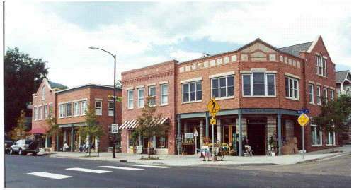
(Ord. 09-01-2007, 9-5-2007, eff. 9-7-2007)- Building Locations And Setbacks:
- Buildings on corner parcels should be adjacent to both street fronts to help frame intersections. Architectural consideration should be given to corner visibility areas.
- Buildings fronting Main Street should utilize party walls or zero setbacks along side property lines. Parking areas and drive accesses should not disrupt the continuity of storefronts; however, plazas, green spaces or pedestrian connections may be appropriate.
- Setbacks: Note:
CBD MSC MSR Front and Street Side: Minimum Building1 10' 10' 10' Maximum Building1 Main Street - 10' 10' 15' Center Street - 10' n/a n/a Other streets - 10' 10' 15' Parking 10' 10' 10' Side: Minimum Building2 0' or 8' if not built to the property line if mixed use or nonresidential structure with building code rated firewall 10' to nonresidential or mixed use structures 8' if nonrated firewall with windows 5' accessory buildings and structures 10' loading dock, with approved screening Maximum Building2 0' or 8' if not built to the property line None None Parking2 5' 5' 5' Rear: Minimum Building2 0' if building code rated firewall 20' to primary structure 20' if nonrated firewall with windows 5' accessory buildings and structures 10' loading dock, with approved screening Parking2 5' 5' 5'
1 In the CBD area 90 percent of the primary building must fall on the build-to line (front setback). Architectural elements such as pilasters, columns, cornices, box or bay windows, or other typical ornamentations may protrude into the required setback a maximum of 2 feet. However, primary building wall planes are not allowed to extend or be cantilevered into the required setbacks.
2 If property is adjacent to a residential zone, an additional five-foot (5') setback is required for all structures. - Open areas between buildings shall be designed as a public plaza, business access areas, courtyards, etc., to enhance and better utilize business properties. (Ord. 07-01-2016, 7-6-2016, eff. 7-7-2016)
- Pedestrian Connectivity: Sites shall be designed to allow for safe pedestrian access from parking areas to the associated building, between buildings, to adjacent developments and public sidewalks. Pedestrian connections within and between sites should follow the following standards:
- Pedestrian walks and crossings should be located to minimize the number of interruptions by creating a continuous walking environment along and between buildings. Where pedestrian crossing areas exist, minimize the distance across the street, drive aisle, or similar walking interruption by use of extended sidewalks, bulb outs, etc.
- Pedestrian walkways across internal drive aisles shall be distinguished from driving surfaces with durable, low maintenance materials. Examples include: pavers, bricks, scored concrete, raised walkways, or other materials that provide a similar texture and character.
- Sites shall be designed to minimize the need to walk within the parking lot among cars.
FIGURE 2 Interrupted pedestrian routes.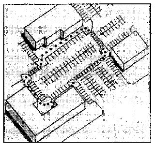
FIGURE 3 Appropriate pedestrian connectivity.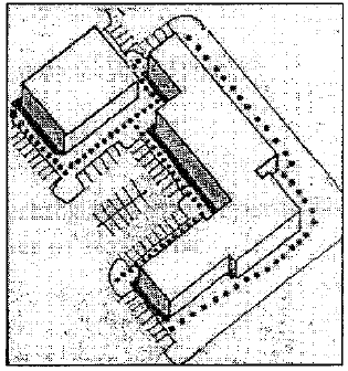 (Ord. 09-01-2007, 9-5-2007, eff. 9-7-2007)
- Building Entrances: Primary structures shall be oriented with their main entrance facing the street to which the site fronts. The main building entrance shall be on a street-facing wall and relate to top back of curb elevations. (Ord. 08-02-2008, 8-20-2008, eff. 8-21-2008)
- Building Locations And Setbacks:
- Parking Standards:
- Location Of Parking Areas: Within the CBD area, parking should be located to the rear of the building. Other development parcels should locate parking to the sides and/or rear of buildings. Use of underground parking is strongly encouraged, especially where daylight basements can be reasonably constructed based on site topography. (Ord. 08-02-2008, 8-20-2008, eff. 8-21-2008)
- Boundaries: Parking areas for different uses should be interconnected with boundaries defined with landscaped areas, rather than become one large parking area. Parking areas shall be located to encourage shared use.
- Barriers: Barriers that limit circulation between developments and parking lots are not permitted. Examples include fences, walls, topographic changes, or other similar types of obstructions.
- Landscaping: Landscaping within and around parking areas shall be consistent with SCC 10.52. (Ord. 09-01-2007, 9-5-2007, eff. 9-7-2007)
- Number Of Parking Stalls:
- Vehicular Parking:
- Required number of parking stalls per use, including ADA stalls, shall be as listed in SCC 10.48. Spaces required for the residential units shall be the same as for multi-family dwellings. Additional parking shall be required for the nonresidential uses in accordance with specified ratios in SCC 10.48 and such shall be visibly designated for only commercial tenant customer parking during regular business hours.
- Mixed use developments may have shared parking facilities based on the city's review criteria in SCC 10.48. However, allowable building floor area increases may be granted up to thirty percent (30%) based on use of underground parking or parking structures which complement the surrounding buildings.
- For review purposes only, any parking required for residential uses must be provided off street with nonresidential uses being allowed to be on street where permitted in accordance with SCC 10.48.
- Bicycle Parking:
- Buildings whose primary use consists of medical or other professional services, general business offices, financial services, or general business services shall provide parking space for at least two (2) bicycles for every twenty thousand (20,000) square feet or fraction over thereof, not to exceed twelve (12) parking stalls.
- Buildings whose primary use consists of retail, eating and drinking or personal services shall provide parking space for at least three (3) bicycles for every twenty five thousand (25,000) square feet or fraction over thereof, not to exceed twelve (12) parking stalls.
- Bicycle parking shall consist of decorative bicycle racks which permit the locking of the bicycle frame and one wheel to the rack, and which support the bicycle in a stable position without damage to wheels, frame or components.
FIGURE 4 Bicycle racks in front of retail.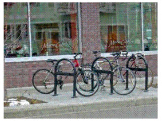
(Ord. 07-01-2016, 7-6-2016, eff. 7-7-2016)
- Vehicular Parking:
- Ground Floor Storefronts Encouraged: If parking structures are utilized, ground floor storefronts along elevations adjacent to public streets are highly encouraged. (Ord. 09-01-2007, 9-5-2007, eff. 9-7-2007)
- Secondary Access Points: Developments having parking lots which accommodate more than ten (10) equivalent residential units (ERU) must provide a secondary access point for ingress/egress. Connection through adjacent properties to a public road would be appropriate, but connection to or stubbing a drive aisle to adjacent properties would not be considered a secondary access point. (Ord. 07-01-2016, 7-6-2016, eff. 7-7-2016)
- Landscaping And Streetscape Standards:
- Site Landscaping:
- Special consideration shall be given to impacts of new development on adjacent properties. Site landscaping standards are listed in SCC 10.52.
- Each nonresidential or mixed use development shall have at least twenty percent (20%) of the site landscaped.
- There shall be a minimum sixty (60) square feet of additional usable open space per residential unit. This open space may be private area attached to each unit, such as a patio or balcony area, or consolidated open area for the use and enjoyment of all building tenants. Patio or balcony areas must have a minimum of forty (40) square feet.
- Mixed use developments having residential tenants may provide playground and site amenities as outlined in paragraph K,3. (Ord. 07-01-2016, 7-6-2016, eff. 7-7-2016)
- Streetscapes: The streetscapes within the district will consist of urban and suburban designs. Developments in the district shall work proportionally with the city to implement these streetscapes in order to maintain continuity of elements and appropriate locations for features such as lighting, sidewalks, street furniture, etc.
- Urban Streetscape: Within the CBD area of the zone, developments shall install an urban design consistent with city and, where applicable, UDOT standards. The design shall be broken down into zones specifically identified as the "display zone", "clear zone", and "furniture zone". Developments in this area must consider the following design features: (Ord. 08-02-2008, 8-20-2008, eff. 8-21-2008)
FIGURE 5 Urban streetscape in Durango, CO.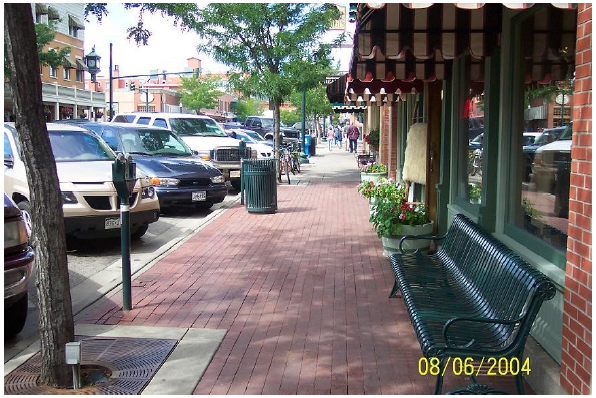
FIGURE 6 Urban streetscape in Ephraim, UT.
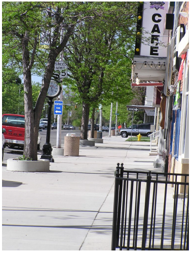
(Ord. 09-01-2007, 9-5-2007, eff. 9-7-2007)
FIGURE 7 Urban streetscape cross section.
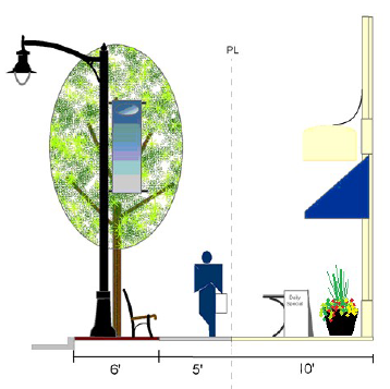
- Display zone (minimum 10 feet adjacent to buildings):
- Display of goods, special sales, promotions, decorations for festivals, holidays, etc.
- Outdoor seating or eating areas, as appropriate.
- Approved newspaper racks, community bulletin boards, etc.
- Limited greenscape, i.e., potted plants, foundation plantings, water wise plantings, etc.
- First floor canopy/awning overhangs meeting building code minimum clearance standards.
- Access to store entrances from sidewalk grade. (Ord. 07-01-2016, 7-6-2016, eff. 7-7-2016)
- Clear zone (minimum 5 feet):
- Walking zone for pedestrians.
- No obstacles.
- Furniture zone (6 feet - next to curb line):
- Street trees with tree wells or ground covers.
- Streetlights with banner attachments.
- Street furniture, e.g., benches, trash receptacles, bike racks, drinking fountains.
- Additional outdoor seating or eating areas, as appropriate.
- Other limited greenscape, i.e., potted plants and water conservation plantings, etc.
- Display zone (minimum 10 feet adjacent to buildings):
- Suburban Streetscape: In the MSC and MSR areas a suburban design shall be utilized. This streetscape is greener in its appearance, having a park strip behind street curb, a sidewalk, and a landscape buffer between any parking or buildings and the sidewalk.
- Landscaping within the park strip and buffer areas shall be in accordance with the city's adopted landscaping standards.
- Street furniture (e.g., benches, bike racks, flowerpots, etc.) is encouraged within green spaces. (Ord. 09-01-2007, 9-5-2007, eff. 9-7-2007)
FIGURES 8 AND 9 Suburban streetscapes in Santaquin.
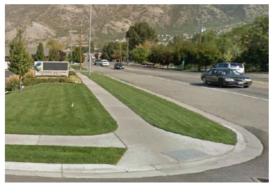
(Ord. 07-01-2016, 7-6-2016, eff. 7-7-2016)
- Other Provisions: Those roads not specified above shall utilize the street cross sections approved in the city's standard specifications and drawings. (Ord. 09-01-2007, 9-5-2007, eff. 9-7-2007)
- Urban Streetscape: Within the CBD area of the zone, developments shall install an urban design consistent with city and, where applicable, UDOT standards. The design shall be broken down into zones specifically identified as the "display zone", "clear zone", and "furniture zone". Developments in this area must consider the following design features: (Ord. 08-02-2008, 8-20-2008, eff. 8-21-2008)
- Site Landscaping:
- Building Massing: Building massing and architecture should complement the pedestrian environment to create a lasting image for Main Street. The intent of this section is to create an 1890-1920 period Americana Main Street architectural experience. Characteristics of the period included human scale, attention to detail, and materials and colors that related to the natural features of the region. The following architectural standards are established to realize the community's desire for high quality architecture, materials, and character as well as limit the impacts of building mass on nearby residential properties.
- Floor Area Ratios (FARs): FARs are an acceptable ratio of constructed building area (i.e., occupiable space above ground) to the lot area. The FAR is calculated by dividing the constructed building area by the lot area. These help to establish appropriate massing of buildings in relation to sites and their surroundings. Properties in the CBD area should have FARs that range between 0.70 to 1.00. Properties within the MSC and MSR areas should have FARs that range between 0.35 and 0.80.
- Building Height: Heights are measured from the average sidewalk elevation along the frontage of the adjacent major road to the midpoint of the roof on sloped roofs or to the highest point of a parapet. Roof midpoints shall be measured halfway between the highest ridgeline of the roof and the top of the fascia. Small architectural elements such as finials, cupolas, etc., may exceed heights listed. Steeples and towers shall be considered based on relational size and design. The following table outlines minimum and maximum building heights in the CBD, MSC and MSR areas of the zone: (Ord. 08-02-2008, 8-20-2008, eff. 8-21-2008)
Use CBD MSC MSR Minimum height: Nonresidential 30 feet 25 feet 20 feet Mixed use developments 40 feet 20 feet 20 feet Multi-family n/a 20 feet 20 feet Townhomes n/a 20 feet 20 feet Maximum height: Nonresidential 60 feet 60 feet 40 feet Mixed use developments 60 feet 60 feet 50 feet Multi-family n/a 50 feet 50 feet Townhomes n/a 40 feet 40 feet - Bulk Plane: To ensure that new buildings adequately relate in scale to adjacent neighborhoods and the street, bulk plane lines are implemented (see figure 10 of this section). The following standards apply:
- Neighborhood Facing: A bulk plane of forty five degrees (45°) will be used for multi-story nonresidential and mixed use structures. The bulk plane will be measured from the property line of the adjacent residential use.
- Street Facing: A bulk plane of sixty degrees (60°) measured at the minimum street facing setback, thirty feet (30') above the curb is recommended.
- Multi-Family Developments: Multi-family developments may not exceed two (2) stories within thirty feet (30') of an adjacent single-family dwelling.
FIGURE 10 Graphic representation of bulk plane standards.
(Ord. 09-01-2007, 9-5-2007, eff. 9-7-2007)
- Mixed Use/Nonresidential Architectural Standards:
- Architectural Theme: The architectural standards of the Main Street zones are intended to evoke a downtown reminiscent of late 1800 period architectural forms. This area should provide residents and visitors an inviting and pleasing environment in which to shop, stroll, experience, and enjoy a small town central business area. Careful attention to detail at a pedestrian viewing scale rather than an auto oriented application of simplistic design shall be utilized. Building designers should consider the natural colors and materials of the surrounding area in concert with historic agrarian, craftsman, and other similar rural forms when preparing plans for new building construction. The following standards should serve as the minimum to which new developments can adhere and designers are encouraged to incorporate other elements which may further the city's desires and intent.
- Building Facade: Facades should not be long expanses of blank walls. They should create a human scale and provide a pedestrian friendly shopping environment. All sides of a building must receive equal architectural consideration of the following:
- Visual Breaks: Building facades and walls must have visual breaks every thirty feet (30') in width at a maximum. Examples of visual breaks include the use of three-dimensional architectural features such as columns, projecting windows, a minimum twelve inch (12") change in plane or an equivalent element that articulates the wall. See figure 11 of this section.
FIGURE 11 Facade articulation in Ogden, UT (picture taken by Bill Wright).
- Building Entrances: By creating a clearly identified system of entry points, the pedestrian environment and the vehicular environment will be enhanced.
- Entrances must be well defined from access drives, pedestrian links, public plazas and major parking areas with one or more of the following:
- Canopy, awnings, overhang or arch above the entrance (columns and pillars),
- Recesses or projections in the building facade surrounding the entrance,
- Display windows surrounding the entrance,
- Coved entrances.
- Secondary entrances on the rear or side of buildings should be given architectural consideration equal to the primary entrances.
- Entrances must be well defined from access drives, pedestrian links, public plazas and major parking areas with one or more of the following:
- Fenestration: The design and amount of window area on a building can minimize the expanse of blank walls and encourage a pedestrian friendly atmosphere. The following standards shall apply:
FIGURE 12 Building in Ephraim, UT. Appropriate use of entry points and window area.
- Ground floor facades:
- Facades that face public streets or provide a primary entry to the building shall have display windows or similar transparent area comprising forty (40) to seventy five percent (75%) of the first floor facade area.
Facade area is calculated by multiplying the facade length by the ground floor height. Transparency ratio equals the total ground floor transparent area divided by ground floor facade area. - Shopping windows or other expanses of glass on the ground floor should begin no more than 2.5 feet above adjacent grade and should have a traditional kick plate under them. Maximum horizontal spacing between windows and doors is ten feet (10') (see figure 13 of this section).
FIGURE 13 Shopping windows in Richfield, UT.
- Facades that face public streets or provide a primary entry to the building shall have display windows or similar transparent area comprising forty (40) to seventy five percent (75%) of the first floor facade area.
- Upper floor facades:
- Facades above the ground floor shall be thirty (30) to sixty percent (60%) transparent using a similar calculation method as for ground floor areas.
- Windows above ground floors should be designed with three-dimensional relief. Finish work around the windows should accent the location and provide visual breaks to the facade of the building (see figures 14 and 24 of this section). Varying window designs, such as bay windows, corner windows, circle tops, or windows having grille patterns, shutters, etc., should be utilized to add visual interest and character to buildings.
FIGURE 14 Use of three-dimensional treatments around windows and varied window styles to provide character and facade relief; Central City, CO.
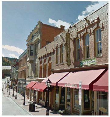
- Ground floor facades:
- Distinct Ground Floor: The ground level of the primary structure shall be visually distinct from upper stories (see figures 15 and 17 of this section). This separation may be provided by a cornice above the ground level, an arcade, changes in material and texture or other means.
- Ground floor spaces shall have a minimum floor to ceiling height of eleven feet (11'). First floor transom and clerestory windows are encouraged.
- Careful attention to human scale and detail shall be provided. This may include ornamental masonry patterns and/or woodwork and finishes, etc. (see figure 13 of this section).
- No HVAC equipment or other air venting elements shall be permitted at street level nor readily visible on the building from the adjacent public right of way. Below surface systems may be permitted within front setbacks.
- Building foundations should terminate no more than thirty six inches (36") above grade. Exposed foundation walls must be finished with appropriate brick, stone, or other primary materials noted below (see figures 15 and 16 of this section).
FIGURES 15, 16 AND 17 Appropriate foundation design and ground floor distinction.
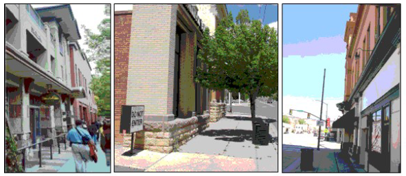
- Visual Breaks: Building facades and walls must have visual breaks every thirty feet (30') in width at a maximum. Examples of visual breaks include the use of three-dimensional architectural features such as columns, projecting windows, a minimum twelve inch (12") change in plane or an equivalent element that articulates the wall. See figure 11 of this section.
- Use Of Awnings And Canopies: Awnings and canopies shall be designed to fit within the architecture of the buildings to which they are attached and serve to enhance the exterior of the building as an articulation and aesthetic element, not as an advertising medium.
FIGURE 18 Appropriate use of awnings in South Jordan, UT.
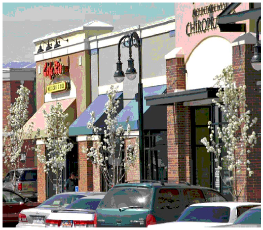
FIGURE 19 Appropriate use of awnings in Aspen, CO.
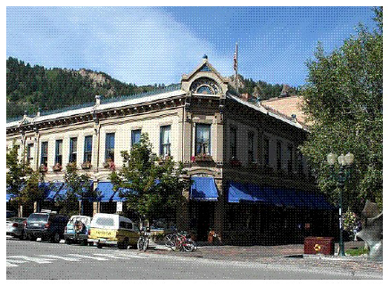
- Awnings or canopies must function as true awnings or canopies by being placed over a doorway or window and under certain circumstances over a walkway or outdoor seating area. All awnings or canopies must be attached to a vertical wall. Canopies must lead to a bona fide business entrance.
- Awnings or canopies shall project at least 4.0 feet from the building when located over a pedestrian traffic area and no less than two feet (2') otherwise.
- Awnings or canopies shall maintain a minimum clearance above sidewalk grade of eight feet (8') to the bottom of the framework when located over a pedestrian traffic area. The bottom of the framework shall not be more than eight feet (8') above covered grade or the maximum height of the protected window, door, or recessed building entry otherwise.
- The top of the framework may not extend above a vertical wall terminus nor cover any architectural elements.
- All awnings that do not contain sign copy shall be made of woven cloth or architectural metal materials. Backlighting of awnings is not permitted. Design, color, and materials shall be compatible with the building to which it is attached.
- Roof Designs And Parapets:
- Flat roofs shall be screened with parapets on all sides of the building adjacent to or visible from the street. The parapet shall be of height sufficient to screen all rooftop mechanical equipment (e.g., HVAC units). If no rooftop mechanical equipment exists, the parapet shall be a minimum of thirty six inches (36") in height.
- All parapets shall feature three-dimensional architrave, frieze and cornice treatments (see figures 21 through 24 of this section).
- Hipped roofs without a gabled end are not allowed. Mansard roofs are only allowed with buildings having three (3) or more stories. Mansard roofs must contain fenestration with dormered or other window finishes appropriate to the architecture of the building.
- Gabled ends shall face toward adjacent public streets.
FIGURE 20 Window treatments on a mansard roof.
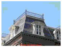
FIGURES 21, 22 AND 23 Parapets in Spanish Fork, UT (left), and Aspen, CO.
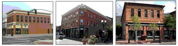
FIGURE 24 Parapets in Provo, UT.
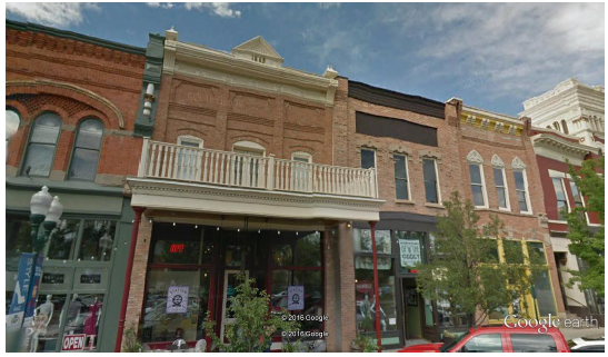
- Building Materials:
- Primary Exterior Materials:
- Primary exterior finish materials shall make up at least the percentages of building elevations shown in the table below, after the transparent area, defined in this section, is deducted:
Building Area/Elevations CBD MSC MSR Single-family main floor facing a public street n/a n/a 50% Single-family upper floors facing a public street n/a n/a 30% Multi-family main floor n/a 100% 100% Multi-family upper floors n/a 30% 30% Commercial single-story buildings n/a 50% 50% Ground floor of a mixed use or commercial multi-story building 80% 80% 80% Upper floors of a mixed use or commercial building visible from public rights-of-way 50% 30% 30% Upper floors of a mixed use or commercial building not visible from public rights-of-way 30% 30% 30% - Primary exterior finish materials shall be low reflectance, have natural textures, and utilize natural earth tone colors. Examples of permitted materials include: brick, stone, natural split faced block, or cut stone. The use of all glass exterior, smooth faced concrete block, prefabricated steel panels, corrugated metal, and EIFS (stucco) shall be prohibited as primary building materials. Nonmasonry siding is prohibited.
- Concrete siding products (i.e., hardie board) 1s considered a primary exterior finish but can only cover a maximum of 75% of each elevation, or 75% of the area defined in the table above, and must be accompanied by at least one other primary exterior finish.
- Primary exterior finish materials shall make up at least the percentages of building elevations shown in the table below, after the transparent area, defined in this section, is deducted:
- Secondary Materials And Trim Materials: Secondary materials and trim materials shall complement the primary materials in texture and scale and provide enough contrast to be visible. EIFS materials may only be utilized for accents.
- Accessory Structures: Accessory structures, such as gasoline pump canopies, utilities (gas, electric), trash enclosures and other accessory structures shall use the same architectural elements and types of materials and colors as the primary structure.
- Material Colors: Material colors should consist of earth tones, e.g., muted shades of red or brown. The use of high intensity colors, primary colors, metallic colors, black or fluorescent colors is not permitted for primary exterior materials. Secondary materials and trim materials shall complement the primary material colors.
- Wrapping: Where the two (2) sides of an extruding corner element are visible, materials and design elements shall wrap the visible corner and may only terminate at an interior corner location or the terminus of the visible wall plane.
- Primary Exterior Materials:
- Tenant Space Design:
- All ground floor tenant spaces for nonresidential uses shall have a minimum of eight hundred (800) square feet. Live/work units with residential areas on a separate floor from the business entrance must have at least one thousand six hundred (1,600) square feet.
- Each tenant space should be provided distinction from adjacent tenant spaces through use of differing colors, materials, signage, design elements or combinations of such.
- Residential units shall comply with the multi-family requirements outlined below.
- All sides of a building or buildings within a larger development, which face a public street must be designed to accommodate nonresidential tenants on the ground floor. (Ord. 07-01-2016, 7-6-2016, eff. 7-7-2016)
- All buildings within the Central Business District and Main Street Commercial areas must include non-residential use(s). If a building includes residential use(s), all tenant spaces on the ground floor, must be reserved for non-residential use(s) and shall have a minimum floor to ceiling height of eleven feet (11'). Non-residential use(s) must have independent access and may be directly accessible by residential tenants in the development. (Ord. 09-03-2017, 9-6-2017, eff. 9-7-2017)
- Building Lighting: All lighting on the exterior of buildings shall be shielded and directed downward. The intent of this is to limit the amount of light spill and night sky pollution. (Ord. 07-01-2016, 7-6-2016, eff. 7-7-2016)
- Signs: The intent of district sign regulations is to reduce visual clutter on buildings, enhance the street environment and views by encouraging smaller signs constructed of similar, high quality materials used on the primary structures, and treat signs as architecture, not as an afterthought.
- Sign Integration: Signage is encouraged to be integrated into the architectural design of the buildings. Stick on signs (signs that clearly cover architectural features of the building) will not be allowed.
- Sign Areas: Sign "areas" shall be designated on building elevations (for elevations that will utilize signs) to show that signage has been taken into account in the overall design of the building facade. (Ord. 09-01-2007, 9-5-2007, eff. 9-7-2007)
- Sign Types: Regulations stated in SCC 10.44, "Sign Regulations", apply as appropriate, with the following additional standards:
- Wall signs within the CBD area are to be constructed of individual lettering and be externally illuminated by direct system with no direct light spill occurring off the sign (see figure 25 of this section). All lighting must be directed downward. Internal illumination is not appropriate; however, halo illumination is permissible. Wall signs in the MSC or MSR shall comply with the city's sign regulations, but may not have exposed or visible neon tubing.
FIGURE 25 Externally illuminated wall signs.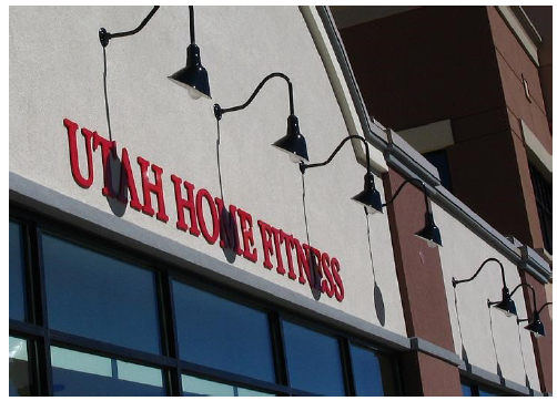
- Any monument sign must be set back at least three feet (3') from the public right of way or drive aisle and not impede visibility at intersections or driveways. The maximum size of any monument sign shall be fifty (50) square feet outside of the CBD area. Monument signs in the CBD area may not exceed twenty four (24) square feet but may exceed the maximum height limits up to eight feet (8'). Each project may only have one sign per street frontage with the intent that multiple tenant centers will share the sign space. (Ord. 07-01-2016, 7-6-2016, eff. 7-7-2016)
- Signs on awnings shall be limited to street level businesses only (see figure 26 of this section). Signage on an awning shall be limited to forty percent (40%) of the awning face. The signage on the awning and other permanent business signage on the same elevation shall not exceed fifteen percent (15%) of that elevation. Translucent letters or accents sewn into opaque canvas or acrylic awnings are permitted. Any illumination under awnings shall be for safety lighting under the sign and not for backlighting of the awning.
FIGURE 26 Appropriate awning signs.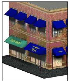
- Projecting signs are allowed under the following standards:
- The sign should blend with the aesthetics of the building and surrounding natural and manmade environment. The color, style, size, scale and proportion of the sign should enhance the exterior of the building and not place too much bulk nor be an excessive external distraction on the building's exterior. Equal treatment and design consideration should be given to any mounting and supporting structure for the sign (see figure 27 of this section).
FIGURE 27 Projecting signs (picture taken by George Shaw).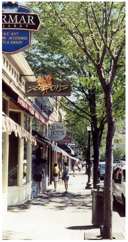
- No sign shall be larger than twenty (20) square feet.
- Projecting signs shall not extend more than six feet (6'), nor have less than four inch (4") spacing from the attached vertical wall. They shall have a minimum clearance of ten feet (10') from the sidewalk or finished grade and shall be no more than twelve inches (12") thick.
- Projecting signs must be externally illuminated by direct system with no light spill occurring off the sign.
- Electronic message centers or changeable copy are not allowed.
- Projecting signs are allowed only for street level tenants in multi-story buildings and there shall be a minimum horizontal distance of twenty feet (20') between projecting signs.
- The sign should blend with the aesthetics of the building and surrounding natural and manmade environment. The color, style, size, scale and proportion of the sign should enhance the exterior of the building and not place too much bulk nor be an excessive external distraction on the building's exterior. Equal treatment and design consideration should be given to any mounting and supporting structure for the sign (see figure 27 of this section).
- Approvals for multiple sign types on the same elevation will only be considered where the developer can show that the architectural design of the development warrants the use of multiple sign types.
- Signage will not be allowed on roof equipment screening or rooftop equipment penthouses, above the roofline, or on sloped roofs. (Ord. 09-01-2007, 9-5-2007, eff. 9-7-2007)
- Wall signs within the CBD area are to be constructed of individual lettering and be externally illuminated by direct system with no direct light spill occurring off the sign (see figure 25 of this section). All lighting must be directed downward. Internal illumination is not appropriate; however, halo illumination is permissible. Wall signs in the MSC or MSR shall comply with the city's sign regulations, but may not have exposed or visible neon tubing.
- Multi-Family Development Standards: The maximum density allowed for multi-family developments shall be conditioned upon the architectural design of the development and its ability to meet the following zone standards. The following housing and open space and amenities standards shall also be applied to mixed use developments unless addressed in the general standards above.
- Density and Unit Size:
- The maximum density in the Main Street Residential (MSR) area shall be 8 units/acre.
- The average minimum livable unit area in the Main Street Residential (MSR) and the Main Street Commercial (MSC) areas shall be four hundred (400) square feet for a studio unit,six hundred fifty (650) square feet for a single bedroom unit, and eight hundred (800) square feet for a two (2) bedroom unit. No unit shall have less than ninety percent (90%) of the required average. Units with more than two (2) bedrooms shall provide an additional one hundred fifty (150) square feet per additional bedroom.
- Parking:
- Parking design and layout standards shall comply with the city's parking and circulation standards.
- Garages may be back loaded detached with alley access, front loaded detached or attached but set back from the front line of the home by at least five feet (5'), side entry attached, or a combination of the above.
FIGURE 28 Appropriate garage design in a multiple-unit development.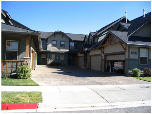
- Open Space And Amenities:
- There shall be a minimum sixty (60) square feet of open space per unit. This open space may be a patio or balcony area, for the use and enjoyment of the associated tenant or consolidated open area for the use and enjoyment of all building tenants.
- Thirty percent (30%) of the site shall be landscaped including required building setbacks. At least one-half (1/2) of the required open space shall be unobstructed for general tenant recreation purposes, including sidewalks and paths which run through landscape yards to building entrances or recreation amenities.
- One tot lot area shall be provided for each development consisting of at least eight (8) residential units except when developments are located within a publicly traversable distance of one thousand (1,000) linear feet of a public park that has a tot lot. In such cases, a tot lot may be replaced with another amenity (e.g., barbeque pavilion, gazebo, sports court, etc.) as approved by the Planning Commission. Each tot lot or approved amenity shall be at least six hundred (600) square feet. The size of playground equipment should accommodate and be designed for five (5) to twelve (12) year old children. An additional tot lot or approved amenity shall be provided for each additional twenty (20) units. The required tot lots and approved amenities can count towards the open space requirement.
- Entrances: Where appropriate, based on site layout, entrances to buildings or ground floor units shall be oriented toward the public right-of-way with entry sidewalks that connect directly to public sidewalks. Entrances should be identifiable by an architectural treatment such as a covered portico or a different roofline treatment.
- Fenestration: Each elevation shall have at least one window per unit on such elevation. Window openings shall be designed with three-dimensional relief, which may include a combination of pop outs, shutters, keystone features, etc.
- Building Articulation: Exterior walls shall be articulated through combinations of the following techniques:
- Facade modulation: Stepping portions of the facade to create shadow lines and changes in volumetric spaces,
- Use of engaged columns or other expressions of the structural system,
- Providing projections such as balconies, cornices, covered entrances, porte-cocheres, trellises, pergolas, arcades and colonnades (providing, such trellises and awnings extend outward from the underlying wall surface at least 36 inches),
- Variation in the rooflines by use of dormer windows, overhangs, arches, stepped roofs, gables or other similar devices,
- Wraparound porches, particularly on corner lots.
FIGURE 29 Appropriate articulation on a multi-family structure.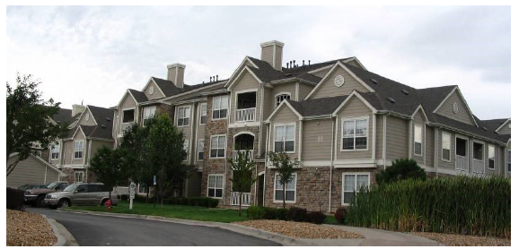
- Landscaping: Requirements shall be the same as those outlined in SCC 10.52.
- Rooftop Equipment: Rooftop equipment shall be screened from view of public rights of way and, except solar energy equipment, completely enclosed on all sides. Venting systems on roofs should be designed to blend into the structure, such as incorporated within faux chimneys, colored to match roofing materials, screened by parapet walls, etc.
FIGURE 30 Appropriate rooftop equipment treatments.
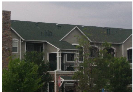
- Fences And Walls: Developments shall install a six-foot (6') decorative wall, to be reviewed and approved by the architectural review committee (ARC), constructed of stone, masonry, or concrete, along the perimeter of the development. City suggested walls include the following:
FIGURE 31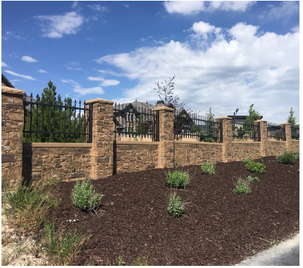
FIGURE 32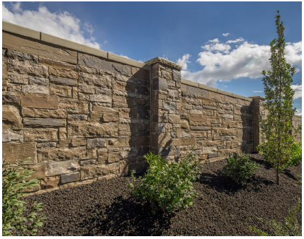
FIGURE 33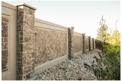
FIGURE 34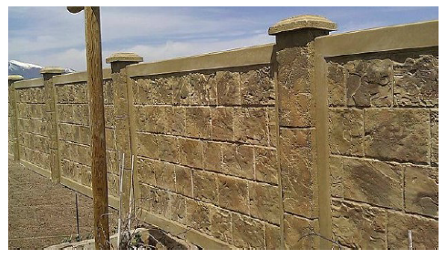
- Perimeter landscaping must be in accordance with the city adopted buffering standards. Chainlink and vinyl are not allowed as fencing materials. The architectural review committee may grant exceptions to fencing requirements on a case-by-case basis if it finds that the exception is in the best interest of the city.
- Fences And Walls: Developments shall install a six-foot (6') decorative wall, to be reviewed and approved by the architectural review committee (ARC), constructed of stone, masonry, or concrete, along the perimeter of the development. City suggested walls include the following:
- Building Materials:
- Primary Exterior Materials: Primary exterior finish materials shall be the same as found in paragraph I,5.
- Secondary Materials And Trim Materials: Secondary materials and trim materials shall complement the primary materials in texture and scale and provide enough contrast to be visible. EIFS materials may be utilized sparingly. Aluminum siding is prohibited. Architectural vinyl siding (e.g., shake or board and baton) may be allowed but only in roofline dormer areas and if they have a minimum thirty (30) year life guarantee. Hardy-board type products may be appropriate.
- Material Colors: Material colors must be similar to those required for mixed use and commercial buildings.
FIGURE 35 Mixed use residential on Main Street, Golden, CO.
- Accessory Structures: Accessory structures, such as storage sheds, community facilities, garages, trash enclosures and other accessory structures shall use the same types of materials and colors, and design elements as the primary structure.
- Property Management: Prior to final approvals of any multi-family development under this section, developers/owners of the development shall provide to the city a copy of CC&Rs, declarations or other management protocols and policies that will be used to address property maintenance, problem tenants, emergency and project contact information. (Ord. 09-01-2007, 9-5-2007, eff. 9-7-2007; amd. Ord. 08-02-2008, 8-20-2008, eff. 8-21-2008; Ord. 07-01-2016, 7-6-2016, eff. 7-7-2016; Ord. 03-02-2018, 3-21-2018, eff. 3-22-2018; Ord. 08-01-2019, 8-6-2019, 8-7-2019; Ord. 10-02-2019, 10-15-2019, eff. 10-16-2019)
- Density and Unit Size:
- Detached Single-Family Development Standards:
- Lot Standards:
- Lot size shall not be less than six thousand five hundred (6,500) square feet.
- Lot widths shall not be less than fifty five feet (55').
- Setbacks:
- Notes:
Single Family Setback Requirements Front Street Side Side Rear Main Building 25' to garage door 15' to living area 10' to covered porch 25' to garage doors 15' living area 5' 25' Accessory Structure Not permitted 25'1 10'2 10'2 Accessory structures shall be located at least twelve feet (12') from the dwelling or main building and shall not be in any utility easements without written consent from those affected entities. 1 A three-foot (3') setback along the secondary frontage shall be permitted for an accessory structure less than two hundred (200) square feet. 2 A three-foot (3') side or rear setback shall be permitted for accessory structure if the accessory structure walls closest to the side or rear property line are constructed with one hour or more fire-resistant walls
- Building Standards:
- Floor Area: The minimum floor area (excluding garages and basement areas) for single-story structures shall not be less than nine hundred (900) square feet. Similarly, multi-story dwellings shall have a minimum floor area of one thousand two hundred (1,200) square feet.
- Architectural Style: Architectural styles indicative of the 1890-1920 period shall be utilized. These include Queen Anne, folk Victorian, shingle style, craftsman (arts & crafts), bungalow, American foursquare, or neoclassical. (Ord. 08-02-2008, 8-20-2008, eff. 8-21-2008)
- Materials:
- Elevations facing public rights of way must meet the minimum masonry requirements found in paragraph I,5. The use of smooth faced concrete block, prefabricated steel panels, EIFS (stucco) or concrete siding materials will not count toward the minimum masonry requirement unless consistent with the architectural style of home proposed. Vinyl or aluminum siding is prohibited.
- Brick and masonry materials must wrap building corners and only terminate at inside corners of a building.
- Material colors should complement the area surroundings and agrarian lifestyle. (Ord. 07-01-2016, 7-6-2016, eff. 7-7-2016)
- Landscaping: All front and visible side yard landscaping and maintenance systems shall be installed prior to a certificate of occupancy being granted. Where landscaping cannot be completed before October in the same year construction begins, a certificate of occupancy may be granted if a cash bond for completion of the landscaping is provided to Santaquin City. Bond amounts shall be determined by the city engineer consistent with the city development bonding regulations. Landscaping must be installed within six (6) months of bond posting.
- Parking:
- A two (2) car garage is required per dwelling.
- Shared driveways are allowed where adequate easements and maintenance agreements will be recorded to assure long term maintenance of the shared access. Shared driveway access from the street may not exceed twenty four feet (24') in width. (Ord. 08-02-2008, 8-20-2008, eff. 8-21-2008)
- Lot Standards:
- Public Art: Public art promotes the cultural and historic characteristics of Santaquin City and the surrounding areas. It also encourages pedestrian activity and contributes to the visual experience of residents and business patrons. Public art (which may include artists' work integrated into the design of the building, landscaping, sculpture, painting, murals, glass, mixed media or work by artisans), that is accessible or directly viewable to the general public is encouraged to be included in all projects. (Ord. 09-01-2007, 9-5-2007, eff. 9-7-2007; amd. Ord. 08-02-2008, 8-20-2008, eff. 8-21-2008)
Amended by Ord. 07-02-2010 on 7/21/2010
Amended by Ord. 07-01-2011 on 7/27/2011
Amended by Ord. 10-01-2014 on 10/1/2014
Amended by Ord. 07-01-2016 on 7/6/2016
Amended by Ord. 02-01-2018 on 2/7/2018
Amended by Ord. 03-02-2018 on 3/21/2018
Amended by Ord. 08-01-2019 on 8/6/2019
Amended by Ord. 10-02-2019 on 10/15/2019
Amended by Ord. 07-01-2020 on 7/7/2020
Amended by Ord. 09-04-2020 on 9/1/2020
Amended by Ord. 06-01-2022 on 6/8/2022
Amended by Ord. 08-01-2022 on 8/9/2022
Amended by Ord. 08-02-2022 on 8/9/2022
Amended by Ord. 01-01-2023 on 1/17/2023
Amended by Ord. 04-01-2024 on 4/2/2024
Amended by Ord. 02-02-2025 on 2/4/2025
Amended by Ord. 04-03-2025 on 4/1/2025
Amended by Ord. 04-04-2025 on 4/15/2025
Amended by Ord. 08-02-2025 on 8/19/2025
10.20.200 AGRICULTURE PROTECTION AREAS
- Objectives And Characteristics: Utah state law allows property owners to establish agricultural protection areas to further agricultural pursuits and gain legal protections for operations conducted with such areas. State law further allows municipalities to establish the application means, appropriate fees to establish such areas, and establish the minimum number of continuous acres required for an agriculture protection area within the municipality. Santaquin recognizes these lands and uses as viable and of paramount importance in maintaining the culture and identity of Santaquin. The city objectives in establishing agriculture protection areas include, but are not limited to, the following:
- Buffering and protecting agricultural operations and lands from encroachment of urban development.
- Permitting uses that enable agricultural operations to function and remain viable in the area but which are incidental thereto and do not change the basic character of the zone. These uses may include farm based businesses to supplement farm income, e.g., experiential farming businesses (i.e., bed and breakfast inns, farm themed commercial uses similar to the Red Barn, farmers' markets, pick your own fruit markets, etc.).
- Limiting those land uses and activities that could conflict with agricultural uses or adversely affect the long term investment in the land and improvements in areas designated for farmland preservation.
- Assuring that farm related housing can be adequately serviced by necessary utilities.
- Maintaining as much as possible the agricultural heritage of Santaquin City as further indicated by recognition of Santaquin as the Utah farming heritage district for the state of Utah. (Ord. 11-02-2008, 11-12-2008, eff. 11-13-2008)
- Application Standards: Each application for an agriculture protection area must meet the following requirements:
- Applications shall be signed by a majority in number of all owners of real property and the owners of a majority of the land area in agricultural production within the proposed agriculture protection area.
- Applications shall be accompanied by a written proposal, which identifies the following:
- The boundaries of the land proposed to become part of an agriculture protection area prepared by a licensed surveyor;
- Any limits on the types of agriculture production to be allowed within the agriculture protection area; and
- For each parcel of land:
- The names of the owners of record of the land proposed to be included within the agriculture protection area or industrial protection area;
- The tax parcel number or account number identifying each parcel; and
- The number of acres of each parcel.
- An agriculture protection area may include within its boundaries land used for a roadway, dwelling site, park, or other nonagricultural use if that land constitutes a minority of the total acreage within the agriculture protection area. (Ord. 11-02-2008, 11-12-2008, eff. 11-13-2008)
- Required Fees: The fees required to file an application for an agriculture protection area shall be established by resolution of the city council. (Ord. 11-02-2008, 11-12-2008, eff. 11-13-2008)
- Minimum Area Requirements:
- The minimum number of continuous acres allowed for the creation of an agriculture protection area should be five (5). However, a protection area may be smaller dependent upon the type of operation being conducted and based on the recommendations from the county advisory board and city planning commission. The criteria for evaluating the minimum size shall be as follows:
- Whether or not the land is currently being used for agriculture production;
- Whether or not the land is zoned for agriculture;
- Whether or not the land is viable for agriculture production;
- The extent and nature of existing or proposed farm improvements; and
- Anticipated trends in agricultural and technological conditions. (Ord. 11-02-2008, 11-12-2008, eff. 11-13-2008)
- The minimum number of continuous acres allowed for the creation of an agriculture protection area should be five (5). However, a protection area may be smaller dependent upon the type of operation being conducted and based on the recommendations from the county advisory board and city planning commission. The criteria for evaluating the minimum size shall be as follows:
- Review Process:
- Establishment Of A Protection Area: The process for establishing an agriculture protection area shall be the same as outlined by Utah Code Annotated (1953, as amended).
- Removal Of Land From A Protection Area: The process for establishing an agriculture protection area shall be the same as outlined by Utah Code Annotated (1953, as amended). (Ord. 11-02-2008, 11-12-2008, eff. 11-13-2008)
- Notice Of Protection Area Designation:
- Development Within Three Hundred Feet Of A Protection Area: Any new subdivision development located in whole or in part within three hundred feet (300') of the boundary of an agriculture protection area, shall provide notice on any plat filed with the county recorder the following notice:
"Agriculture Protection Area"
This property is located in the vicinity of an established agriculture protection area in which normal agricultural uses and activities have been afforded the highest priority use status. It can be anticipated that such agricultural uses and activities may now or in the future be conducted on property included in the agriculture protection area. The use and enjoyment of this property is expressly conditioned on acceptance of any annoyance or inconvenience which may result from such normal agricultural uses and activities. - Posted Notice: Where an agriculture protection area is adjacent to or includes a public road, the property owners included within the protection area should, for every five hundred feet (500') of frontage along such road, post a sixteen (16) square foot sign which includes the following information:
"Agriculture Protection Area"
The agricultural operations being conducted on these lands have been protected under Utah State Code, § 17-41 and Santaquin City Code (SCC) § 10.20.200. This area is subject to normal, everyday sounds, odors, sights, equipment, facilities, and other aspects associated with an agricultural operation and have been afforded the highest priority use status.
(Ord. 11-02-2008, 11-12-2008, eff. 11-13-2008)
- Development Within Three Hundred Feet Of A Protection Area: Any new subdivision development located in whole or in part within three hundred feet (300') of the boundary of an agriculture protection area, shall provide notice on any plat filed with the county recorder the following notice:
10.20.210 AGRICULTURE ZONES
- Objectives And Characteristics: Santaquin recognizes agriculture lands and uses as viable and of paramount importance in maintaining the culture and identity of Santaquin. The city objectives in establishing agriculture zones include, but are not limited to, the following:
- Buffering and protecting agricultural operations and lands from encroachment of urban development.
- Permitting uses that enable agricultural operations to function and remain viable in the area but which are incidental thereto and do not change the basic character of the district. These uses may include farm-based businesses to supplement farm income, e.g., experiential farming businesses (i.e., bed and breakfast inns, farm themed commercial uses similar to farmers' markets, pick your own fruit markets, etc.).
- Limiting those land uses and activities that could conflict with agricultural uses or adversely affect the long-term investment in the land and improvements in areas designated for farmland preservation.
- Creating public awareness of impacts associated with common agricultural practices and requirements that new development mitigate those impacts to and from the adjacent agriculture operations.
- Assuring that farm related housing can be adequately serviced by necessary utilities.
- Maintaining as much as possible the agricultural heritage of Santaquin City as further indicated by recognition of Santaquin as the Utah farming heritage district for the state of Utah. (Ord. 11-03-2008, 11-12-2008, eff. 11-13-2008)
- Agriculture Zones Established: The following agriculture zones are established within the city:
- Agriculture Zone (Ag): The agriculture zone is established to highlight those agriculture operations and lands most suitable for agriculture operations within the city while allowing housing and other accessory uses necessary for such operations to remain viable. Development within this zone will be limited and only allowed where the above objectives and characteristics are furthered.
- Residential Agriculture Zone (R-Ag): The residential agriculture zone is established to allow limited development within and near agricultural operations which would allow property owners to develop a portion of their property while maintaining a rural and agrarian character in the city through clustering development, preserving open spaces and view corridors, and limiting infrastructure costs. (Ord. 11-03-2008, 11-12-2008, eff. 11-13-2008)
- Permitted Uses: General land uses within the agriculture zone shall complement agrarian uses on properties within this zone. All land uses and future development decisions should be based on the goals and policies of the city's general plan land use element.
Abbreviations and alphabetic use designations in the matrix have the following meanings:P The listed use is a permitted use within the represented area, based on city development standards and ordinances. C The listed use requires a conditional use permit within the represented area in addition to complying with all applicable development standards and ordinances. A The listed use is only permitted as an accessory use within the represented area. N The listed use is not a permitted use within the represented area (Ord. 11-03-2008, 11-12-2008, eff. 11-13-2008; amd. Ord. 02-01-2010, 2-17-2010, eff. 2-18-2010; Ord. 03-02-2010, 3-17-2010, eff. 3-18-2010; Ord. 07-02-2010, 7-21-2010; Ord. 07-01-2011, 7-27-2011, eff. 7-28-2011; Ord. 03-02-2014, 4-16-2004, eff. 4-17-2014; Ord. 02-01-2018, 2-7-2018, eff. 2-8-2018)Use Ag R-Ag Accessory building P P Accessory building without dwelling structure P N Agribusiness P P Agriculture in accordance with SCC 10.64 P P Agriculture building P P Agritourism C C Assisted living facility - large N C Assisted living facility - small N P Bed and breakfast homes C C Boarding facility P C Commercial, ancillary P C Dwelling, caretaker P P Dwelling, guest cottage P P Dwelling, single-family detached P P Feedlot C N Gravel, sand, earth extraction, and mass grading C N Home occupations, in accordance with SCC 10.40 P/C P/C Institutions C C Outdoor youth program C C Public or quasi-public buildings C C Public park, private park or playground P P Public safety buildings P P Recreational vehicle (RV) parks N N Religious center P P Resident healthcare facility N C Residential facility for persons with a disability N P Residential facility for the elderly N P Residential support facility P P School, public or quasi-public P C Seasonal businesses P P Sexually oriented business N N Sheltered workshop N C Slaughterhouse N N Social or reception center C C Telecommunications sites. See SCC 10.16.340 paragraph D Treatment facility - large N N Treatment facility - small N C Veterinary hospital, large animal P P Veterinary hospital, small animal P P - Parcel Requirements: The following table outlines the parcel standards within the respective agriculture zones:
(Ord. 11-03-2008, 11-12-2008, eff. 11-13-2008)Zone Ag R-Ag Maximum density 1 unit per 20 acres 1 unit per 5 acres Minimum lot area 1/2 acre 5 acres Minimum lot frontage 30 100 - Structure Requirements:
- Setbacks: The following table outlines the setback requirements for primary dwellings within the respective agriculture zones: (Ord. 03-02-2010, 3-17-2010, eff. 3-18-2010)
Yard Ag R-Ag Front yard 50 feet from public road 50 feet from public road 60 feet from centerline of private road 60 feet from centerline of private road Secondary front yard 25 feet 50 feet Side yard 25 feet 20/30 feet with at least 50 feet between dwellings Rear yard 30 feet 30 feet Nonfarm related dwellings 50 feet from any agriculture boundary - Accessory Buildings: All accessory buildings and structures shall be located behind the primary dwelling front yard setbacks and comply with all applicable building code standards for placement near dwellings and property lines. If an accessory dwelling is located on a property without a dwelling all primary dwelling setbacks and site development standards would apply to the structure.
- Guest Cottages: A detached guest cottage may be developed upon issuance of a building permit if the following conditions are met:
- The lot contains an existing, legal single-family dwelling unit;
- The square footage of the living area of the guest cottage does not exceed the square footage of the living area of the main dwelling unit. However, in no event shall the living area of the guest cottage exceed one thousand (1,000) square feet as measured from the inside of the exterior walls;
- The proposed building site is not located in an environmentally sensitive area unless the property owner submits information acceptable to the department showing that the proposed guest cottage would not result in or be subject to any significant environmental impacts;
- The cottage must be detached from the primary dwelling. The community development director may waive the requirement that the structure be stand alone if an alternative design (such as a single level to be built on top of an existing structure) provided by the applicant includes design features which preclude future expansion of the structure beyond the allowable living area of the unit. Examples of such features include: a) use of external staircases rather than internal staircases to access a second floor unit; b) exclusion of common walls which could be penetrated to create additional living space; or c) exclusion of attached areas that can be easily converted to additional living space (such as substantially enclosed porches);
- The guest cottage shall be within five hundred feet (500') of the main or secondary residence. The planning director may waive the five hundred foot (500') limit if the applicant presents substantial evidence that an environmental or agricultural constraint prevents meeting this requirement and/or if a greater distance is required to meet the standards of the department of environmental management relating to private water or sewer systems;
- Any construction shall conform to height, setback, lot coverage, site plan review, fees (including impact fees for an additional dwelling), charges and other zoning requirements applicable to residential construction in the zone in which the property is located;
- All approvals are granted by the appropriate government entities regarding environmental health where either a private sewage or disposal system or private water system is to be used;
- Access from a public/private road to the cottage must be the same as to the primary dwelling. Separate driveway entrances will not be permitted. (Ord. 11-03-2008, 11-12-2008, eff. 11-13-2008)
- Setbacks: The following table outlines the setback requirements for primary dwellings within the respective agriculture zones:
- Dwelling Size: The minimum dwelling size for a primary, stand alone, single-family dwelling shall be nine hundred (900) square feet of floor area on the main floor. (Ord. 11-03-2008, 11-12-2008, eff. 11-13-2008)
- Property Development Standards:
- Water Systems: Sufficient culinary and irrigation water rights and/or systems must be provided to each new lot created within this zone. Public or private water sources may be utilized dependent upon delivery means and proximity to public sources. If public sources will be utilized, water rights shall be dedicated and infrastructure constructed to handle any new demands on the system. All proposed systems and/or water rights must be approved for adequacy by the city engineering department prior to acceptance by the city council. (Ord. 09-04-2011, 9-21-2011, eff. 9-22-2011)
- Sewer Systems: Individual or communal septic tanks may be utilized for new homes based on compliance with all applicable city, state and federal provisions, including, but not limited to, water source protection areas. Homes within three hundred feet (300') of a public sewer system must connect to the public system. Provision must be made with any new development for the eventual connection of dwellings to a public system. This may include installing dry sewer lines and stubs lines.
- Utilities: Due to the potential conflicts with agricultural operations (e.g., discing, tilling, root and crop growth, etc.) power, cable, and phone utilities may be allowed aboveground where traversing agriculture operations. Residential dwellings shall have utility connections underground.
- Nonresidential Or Mixed Use Developments: All landscaping, parking and other applicable development standards shall apply.
- Sensitive Lands:
- Environmentally sensitive lands (e.g., natural stream channels, floodplains, steep slopes, etc.) may not be included with lots as buildable areas. Such lands may be included with lots but shall not count toward the minimum lot area. The city council may accept these lands as permanent open space for general city recreation, scenic, or cultural purposes.
- Lands which are part of a clustered development, which are to remain in agricultural operations or as open space for the development, shall be conserved in one of the following ways:
- Dedication of the land as a public park or parkway system if agreed to and accepted in writing by the city;
- Creation of a homeowners' association by which common areas shall be owned and maintained;
- Placement of the land within a conservation easement in favor of the city or other city approved land trust organization. This option may include use of the property as a single-family lot to be used primarily for agricultural purposes;
- Other arrangement devised by the applicant, which is found to be acceptable and approved by the city council prior to preliminary plat approval.
- Access: All properties must be accessed from improved public or private roads that comply with all public safety accessibility standards. Private roads may only be approved where documentation of a permanent maintenance and funding plan is provided. Though private roads are not encouraged, they are allowed with city council approval, whether or not a public road could be constructed with property development constraints.
- Development Agreements: Any property owner(s) wanting to develop within this zone must enter into a development agreement with the city prior to final development approvals being granted. Such agreements should address the above development standards and any other criteria deemed appropriate by the property owner or city.
- Property Divisions For Agriculture Purposes: In accordance with Utah state law, a bona fide division or partition of agricultural land for the purpose of joining one of the resulting separate parcels to a contiguous parcel of unsubdivided agricultural land shall not constitute a subdivision. Neither the resulting combined parcel nor the parcel remaining from the division or partition may violate any city ordinances.
- Bed And Breakfast Facilities: Bed and breakfast facilities may have a maximum of ten (10) guestrooms. (Ord. 11-03-2008, 11-12-2008, eff. 11-13-2008)
Amended by Ord. 07-02-2010 on 7/21/2010
Amended by Ord. 07-01-2011 on 7/27/2011
Amended by Ord. 09-04-2011 on 9/21/2011
Amended by Ord. 10-01-2014 on 10/1/2014
Amended by Ord. 02-01-2018 on 2/7/2018
Amended by Ord. 08-01-2025 on 8/19/2025
10.20.220 R-43 RESIDENTIAL ZONE
- Objectives And Characteristics: The objective of establishing the R-43 Residential Zone is to encourage the creation and maintenance of residential areas within the City which are characterized by large lots on which detached single-family dwellings are situated, surrounded by well kept lawns, trees, and other plantings. This zone is established to help transition between agricultural areas of the City and those areas of higher intensity uses. It is also intended to be used to regulate development densities in areas that are determined to have geologic hazards or constraints or where the City has determined needs for increased open spaces or land preservation. (Ord. 06-01-2011, 6-1-2011, eff. 6-2-2011)
- Permitted Uses: Land uses in the R-43 Residential Zone are permitted as follows. Alphabetic use designations in the table below have the following meanings:
P The listed use is a permitted use within the represented area, based on City development standards and ordinances. C The listed use requires a conditional use permit within the represented area in addition to complying with all applicable development standards and ordinances. N The listed use is a prohibited use within the represented area. (Ord. 06-01-2011, 6-1-2011, eff. 6-2-2011; amd. Ord. 03-02-2014, 4-16-2014, eff. 4-17-2014; Ord. 02-01-2018, 2-7-2018, eff. 2-8-2018)Use R-43 Accessory building P Accessory building without dwelling structure N Agribusiness N Agriculture in accordance with SCC 10.64 P Agriculture building C Agritourism C Assisted living facility - large N Assisted living facility - small P/C Bed and breakfast homes N Boarding facility N Dwelling, caretaker N Dwelling, guest cottage N Dwelling, single-family detached P Gravel, sand, earth extraction, and mass grading N Home occupations, in accordance with SCC 10.40 P/C Institutions N Public park, private park or playground P Public safety buildings P Recreational vehicle (RV) parks N Religious center P Residential facility for persons with a disability P Residential facility for the elderly P Residential support facility P School, public or quasi-public C Sheltered workshop C Social or reception center N Telecommunications sites. See SCC 10.16.340 paragraph D Temporary uses, subject to the provisions of SCC 10.16.300 P Treatment facilities N - Area Requirements: A land area of not less than one acre shall be provided and maintained for each lot, tract, or parcel of land within the R-43 Zone. (Ord. 06-01-2011, 6-1-2011, eff. 6-2-2011)
- Width Requirements: The minimum width of lots in this zone shall be one hundred (100) linear feet per street frontage, except on cul-de-sacs or private lanes. Properties with frontage on cul-de-sacs must have a minimum of fifty feet (50') of frontage along front property lines. (Ord. 06-01-2011, 6-1-2011, eff. 6-2-2011)
- Structure Requirements:
- Setbacks:
- Notes: 1 A three-foot (3') setback along the secondary frontage shall be permitted for an accessory structure less than two hundred (200) square feet. 2 A three-foot (3') side or rear setback shall be permitted for accessory structure if the accessory structure walls closest to the side or rear property line are constructed with one hour or more fire-resistant walls.
R-43 Setback Requirements Front Street Side Side Rear Main Building 50' public road or centerline of private road 40' shared driveway 30' 20' 30' Accessory Structure Not permitted 30'1 10'2 10'2 Nonresidential Use Parking 20' 20' 5' 5' Accessory Structures shall be located at least twelve feet (12') from the dwelling or main structure and shall not be in any utility easements without written consent from those affected entities.
- Clear View: All structures must be placed in conformance with the clear view standards found in SCC 10.16.090.
- Setbacks:
- Dwelling Size: Minimum dwelling size shall be one thousand two hundred (1,200) square feet floor area on the main floor. (Ord. 06-01-2011, 6-1-2011, eff. 6-2-2011)
- Property Development Standards:
- Water Systems: Sufficient culinary and irrigation water rights and/or systems must be provided to each new lot created within this zone. Private water systems are not allowed if the buildings serviced in the development are within one thousand feet (1,000') of an existing public water system. (Ord. 09-04-2011, 9-21-2011, eff. 9-22-2011)
- Sewer Systems: Individual or communal septic tanks may be utilized for new homes based on compliance with all applicable City, State and Federal provisions, including, but not limited to, water source protection areas. Homes within three hundred feet (300') of a public sewer system must connect to the public system. Provision must be made with any new development for the eventual connection of dwellings to a public system. This may include installing dry sewer lines and stubs lines.
- Sensitive Lands: Environmentally sensitive lands (e.g., natural stream channels, floodplains, steep slopes, etc.) may not be included with lots as buildable areas. Such lands may be included with lots but shall not count toward the minimum lot area. The City Council may accept these lands as permanent open space for general City recreation, scenic, or cultural purposes.
- Access:
- Roads: All properties must be accessed from improved public or private roads that comply with all public safety accessibility standards. Private roads may only be approved where documentation of a permanent maintenance and funding plan is provided. Though private roads are not encouraged, they are allowed with City Council approval, whether or not a public road could be constructed with property development constraints.
- Driveways: Properties may utilize shared driveways for access up to two (2) lots. Shared driveways may only be approved where documentation of a permanent maintenance and funding plan is provided as well as appropriate deeds establishing unilateral control and responsibility for the driveway between the benefited properties.
- Development Agreements: Any property owner(s) wanting to develop within this zone must enter into a development agreement with the City prior to preliminary development approvals being granted. Such agreements should address the above development standards and any other criteria deemed appropriate by the property owner or City. (Ord. 06-01-2011, 6-1-2011, eff. 6-2-2011)
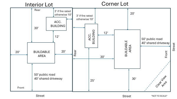
Adopted by Ord. 06-01-2011 on 6/29/2011
Amended by Ord. 09-04-2011 on 9/21/2011
Amended by Ord. 10-01-2014 on 10/1/2014
Amended by Ord. 02-01-2018 on 2/7/2018
Amended by Ord. 02-02-2025 on 2/4/2025
Amended by Ord. 08-01-2025 on 8/19/2025
10.20.230 HILLSIDE DEVELOPMENT OVERLAY ZONE
- Purpose: The purpose of the hillside development zone is to establish standards for development in environmentally sensitive or geologically hazardous areas associated with foothill or steep terrain areas within the city. Additional goals in establishing this zone are as follows:
- Promote sustainable design criteria for new developments which address long term impacts of development in sensitive areas.
- Provide flexible development options where a standard lot pattern is not practical or desirable due to natural topographic constraints or conditions caused by mass grading or excavation activities on a site.
- Provide for the preservation of wildlife corridors, and natural drainage channels or systems and use of measures to protect future property owners from geologic and fire hazards as development occurs in sensitive areas.
- Provide for the reestablishment of vegetation and reclamation of barren areas caused by mass grading or excavation activities caused by development in sensitive areas.
It is also the intent of this section that the hillside zone be an overlay zone with densities and land uses being established by underlying zoning. It is also intended that any developer demonstrate by the applications submitted for approval that the objectives and goals of the general plan, the underlying zone and this section will be fostered. (Ord. 09-05-2011, 9-21-2011, eff. 9-22-2011)
- Development Within The Hillside Zone: Any parcel which is included wholly or partially within the hillside overlay zone shall be subject to the standards outlined in this section. Development agreements shall be established with the city prior to preliminary approvals being given for new developments in this zone. Such agreements must be based on concept plans reviewed by city staff, the planning commission and approved by the city council. Developments will only be permitted upon demonstration of ability to comply with the standards of the hillside overlay zone and development agreement requirements. (Ord. 09-05-2011, 9-21-2011, eff. 9-22-2011)
- Terms And Definitions: As used in this chapter, the following terms and associated definitions shall be applicable:
AVERAGE SLOPE: Average slope of a parcel is determined by the following formula:
S = (100)(I)(L)/(A)
Where: S is the average slope of the parcel, in percent
I is the contour interval, in feet (not to exceed 2 feet)
L is the total length of all the contour lines in the parcel, in feet
A is the area of the parcel, in square feet
SENSITIVE AREA: Sensitive areas shall be considered those areas which are prone to geologic hazards, within state identified potential surface fault rupture zones, exceed thirty percent (30%) slopes, are designated wetlands, watershed or water source protection areas, areas of historical significance, or as may otherwise be determined to be necessarily protected by official action of the city, county, state or a federal agency.
THIRTY PERCENT SLOPE: In order to be considered a legitimate thirty percent (30%) slope, one of the two (2) following criteria must be met:- Height Criteria: There must be a vertical rise (measured perpendicular to the contours) within the thirty percent (30%) slope area of at least ten feet (10').
- Area Criteria: There must be a contiguous thirty percent (30%) slope area (including all contiguous areas of 30 percent slope, irregular as the boundary may be) of at least two thousand (2,000) square feet, and the vertical rise of the area must be at least six feet (6') (measured perpendicular to the contours). (Ord. 09-05-2011, 9-21-2011, eff. 9-22-2011)
- Permitted Uses: Land uses allowed within the hillside development zone are listed in the respective underlying zones. Permitted nonresidential uses must be reviewed under the city's development review process and applicable development standards. (Ord. 09-05-2011, 9-21-2011, eff. 9-22-2011)
- Open Space And Landscaping Requirements:
- Recreation Open Space: Each development within this zone is required to contain at least ten percent (10%) of the net developable acreage of the development in permanent recreation open space. The ten percent (10%) acreage must meet the following guidelines:
- Such acreage must be nonencumbered except for utility easements or public uses.
- Sensitive areas may be considered toward the ten percent (10%) requirement if utilized for city approved public trails or park systems.
- Recreation open space must be improved by the developer. Improvements may include recreation activity areas, picnic pavilions, gazebos, water features, playgrounds, or privately maintained landscape areas or other elements as stipulated in an approved development agreement for the project.
- Recreation open space should be designated where bands of open space and contiguous recreation areas can be developed or expanded as abutting properties develop.
- Where a development will be constructed in phases, the amount of improved and dedicated recreation open space must always meet or exceed the required recreation open space minimum ratio for the entire development (e.g., if a development is required to have a total of 10 percent open space, then each phase of the development must include open space equal to at least 10 percent or more of the phase until the total required open space and improvements is provided).
- A maximum of fifty percent (50%) of the recreation open space may be utilized for storm drain detention or retention unless it is determined by the city that following this standard will significantly reduce the functionality and recreation potential of the property.
- Parking areas constructed solely for dedicated recreation areas may count toward the ten percent (10%) requirement.
- Where developments in this zone abut, include, or encompass trails, parks, or other public facilities outlined within the city's general plan or parks and recreation capital facilities plan, such amenities are to be provided and constructed by the developer. Any associated lands for these facilities will be counted toward the ten percent (10%) recreation open space requirement. Costs for installation of these facilities may be reimbursed to the developer in accordance with capital facilities plan schedules.
- Required Development Landscaping: Where applicable, the following landscape plans are required. Such must be reviewed and approved by the city's development review committee and bonded for with developments in this zone. All plans required in this section shall be prepared by a landscape architect or engineer registered in the state of Utah. All plans shall be designed at a scale of one inch equals sixty feet (1" = 60') or larger.
- Reclamation Plan: A reclamation plan shall be provided for any areas to be disturbed by development activities. This plan shall address remediation of any environmental contamination caused by the development, final grading and contouring of the site, slope stabilization around roads and lots, surface water diversions and impoundments, the provision of topsoil and subsoil where needed, and revegetation.
- Common Area Landscape Plan: A landscape plan shall be provided for those portions of a development which will remain as common area. Such plan should incorporate pathways, gathering areas, common greens, year round aesthetics, shade trees, gardens, etc. A minimum of thirty five percent (35%) of the nonstructurally covered common areas should be shaded at vegetation maturity.
- Landscaping Of Residential Lots:
- Residential lots must have completely landscaped front yards and visible side yards prior to receiving a certificate of occupancy for a dwelling on such lot, where such yard areas are visible from a public or private street. Rear yards must meet fire department standards if not landscaped before occupancy.
- Landscaping around homes need not be designed by a landscape architect or engineer, but shall meet guidelines for firewise protection and be approved by the city's fire department prior to occupancy of the home.
- Any grading work associated with landscaping around the home must comply with paragraph H.
- Nonresidential, Mixed Use Or Multi-Family Developments: Landscape plans shall meet firewise guidelines, grading standards in paragraph H, and the city's landscaping standards as found in SCC 10.52.
- General Open Space And Landscaping Standards:
- Preservation, maintenance, and/or ownership of required and amenity open spaces or sensitive areas shall be accomplished by one or more of the following methods:
- Dedication of improved lands as a public park or parkway system if agreed to and accepted in writing by the city. However, the city shall be under no obligation to accept such dedication;
- Establishment and operation of a condominium project in compliance with the provisions of the condominium ownership act of 1963, Utah Code 57-8, as amended, which provides for the payment of common expenses for the upkeep of the common areas and facilities;
- Creation of a homeowners' association by which common areas shall be owned and maintained; or
- If open spaces are to remain in a natural state, then such must be owned, managed, administered, and maintained by Santaquin City, or a recognized land trust or conservancy, or any other entity or combination of entities, as approved by the city council and have conservation easements established to allow public access and enjoyment while preventing future development in such areas.
- All open space areas must be accessible by emergency vehicles and personnel to protect and provide surveillance to improved properties and structures.
- All required landscaping and maintenance systems pertinent to open space areas shall be installed prior to a certificate of occupancy being granted for any structures located on the property or within the phase in which the open space is located. Where landscaping can not be completed before October in the same year construction begins, a certificate of occupancy may be granted if a cash bond for completion of the landscaping is provided to Santaquin City. Bond amounts shall be determined by the city engineer consistent with the city development bonding regulations. Landscaping must be installed within six (6) months of bond posting weather permitting. (Ord. 09-05-2011, 9-21-2011, eff. 9-22-2011)
- Preservation, maintenance, and/or ownership of required and amenity open spaces or sensitive areas shall be accomplished by one or more of the following methods:
- Recreation Open Space: Each development within this zone is required to contain at least ten percent (10%) of the net developable acreage of the development in permanent recreation open space. The ten percent (10%) acreage must meet the following guidelines:
- Sensitive Area Mitigation And Analysis:
- Mitigation: Sensitive areas may not be developed unless all potential hazards are effectively mitigated and it is demonstrated by the developer that the health, safety, and welfare of current or future residents of the city or their property, including those not within the development boundaries, is protected. Demonstration by the developer must include, but not be limited to, conducting of applicable analysis under paragraph F,2, providing documentation to the city of financial resources and their integrity for construction of any recommended mitigation facilities, and provision of city acceptable guarantees for any analysis recommended mitigation facilities.
- Required Analysis: The following analysis shall be conducted prior to preliminary approvals being granted for any development covered under this zone. All costs of said studies shall be the sole responsibility of the applicant.
- Flood And Watershed Protection Study: A flood and watershed protection study shall be prepared by a professional engineer, licensed in the state of Utah and approved by the city. Said study shall include:
- data and analysis concerning the possibility of future flooding and/or soil erosion in the project area;
- data and analysis concerning the potential effects of the development of the project on adjacent areas with respect to future flooding and/or soil erosion; and
- recommendations for the mitigation of potential adverse effects of flooding and/or soil erosion on the project and adjacent properties.
- Geological Hazard Mitigation: A geological hazard assessment shall be conducted to identify and provide permanent mitigation for fault areas (including surface fault rupture hazards), rockfalls, debris flow/alluvial fan hazards, slope stability, and any other hazards which may be associated with or impact a subject property. A firm or individual with expertise/competence in this type of hazard assessment and licensed in the state of Utah must perform the work. The report must include, but not be limited to, a discussion of the geologic conditions, a description of the method of study including field investigation, alluvial fan investigation, estimates of debris volume and peak flow, hazard mitigation with a preferred mitigation recommendation, and any development or area limitations including recommended structure setbacks from hazard areas.
- Wildlife Habitat And Corridors: Applicants shall submit each application for development to the Utah department of wildlife resources (DWR) for analysis of impacted wildlife and habitat areas. Development proposals must include mitigation strategies to address comments provided by the DWR.
- Wildland-Urban Interface Areas: Development proposals shall conduct an analysis of fire hazard due to proximity to natural open space areas. This study must be coordinated through the city, county, and federal lands fire officials. Recommendations from such study must address alteration of existing vegetation and/or topography and limitations on landscaping, home materials, structure spacing, fencing, and fire suppression techniques appropriate to the area.
- Flood And Watershed Protection Study: A flood and watershed protection study shall be prepared by a professional engineer, licensed in the state of Utah and approved by the city. Said study shall include:
- Construction Of Protection Facilities: All recommendations from the studies required under this section must be followed and the resulting protection measures bonded for and constructed with a proposed development. Prior to the issuance of a building permit within a development, all required protection facilities must be constructed by the applicant and inspected by the city engineer and the person or entity which recommended the facility be built. Such construction and inspection costs, including any necessary acquisition of property, rights of way and/or easements, shall be the sole responsibility of the applicant.
- Notification Of Potential Hazards: All items identified as potential hazards or sensitive areas through the above studies must be noted and illustrated on final development plans and plats. This shall include delineation of applicable areas of nondisturbance on parcels to be platted. (Ord. 09-05-2011, 9-21-2011, eff. 9-22-2011)
- Lot Standards:
- Lot Area Requirements: Minimum lot area requirements shall be as outlined in the underlying zone.
- Frontage Requirements: Minimum frontage requirements shall be as outlined in the underlying zone with the following exceptions:
- Lots with frontage along a cul-de-sac bulb may have thirty feet (30') of frontage as measured along the front property line.
- Lots with frontage along a cul-de-sac bulb may have thirty feet (30') of frontage as measured along the front property line.
- Setback Requirements: The setback requirements shall be as outlined in the underlying zone.
- Sensitive Areas: Sensitive areas may be included with individual parcels in a development under the following guidelines:
- Parcels with less than twelve thousand (12,000) square feet may not include sensitive areas.
- Single-family lots with an average slope greater than fifteen percent (15%) must have a minimum buildable area of eight thousand (8,000) contiguous, nonsensitive, square feet.
- Sensitive areas may not exceed fifty percent (50%) of individual lots for uses other than detached single-family dwellings.
- Where a parcel includes sensitive areas, the buildable areas of the lot shall be delineated on final plats with the exclusion of sensitive areas and required setbacks.
- Shared Driveways: Shared drives or private lanes are allowed where adequate easements and maintenance agreements will be recorded to assure long term maintenance of the shared access. Shared driveway access from the street may not exceed twenty four feet (24') in width. (Ord. 09-05-2011, 9-21-2011, eff. 9-22-2011)
- Cuts And Fills: The following standards shall be met when designing street layouts, subdivision improvements, presale lot grading and home construction plans:
- Slopes: Slopes caused by either an excavation or fill shall not be steeper than one vertical to two horizontal (1:2). Slopes shall not be steeper than one vertical to four horizontal (1:4) within fifteen feet (15') of abutting dwelling lot property lines unless a developer provided retaining wall is installed consistent with the retaining wall standards outlined below.
- Permanent Fill: Permanent fill shall be located so that settlement or erosion shall not damage or cover any street, curb, gutter, sidewalk, or building.
- Standards: All fill and degrees of compaction shall comply with the standards established by the city engineer in accordance with applicable codes and standards adopted by the city.
- Water Diversion: Water diversion systems shall be installed to channel water runoff away from cut or fill slopes and retaining walls. Protection of such systems is to be noted on any development plats.
- Slope Edges: The top or bottom edges of slopes caused by an excavation or fill up to ten (10) vertical feet shall be at one vertical to three (3) horizontal feet for a distance of six feet (6') from the property line and/or street right of way lines. Cut and/or fills greater than ten (10) vertical feet shall be set back an appropriate distance as determined by the city engineer.
- Vertical Height: The maximum vertical height of any nonretained cut or fill slope exceeding one vertical to three horizontal (1:3) shall be ten feet (10').
- Setback: Any structure, except a retaining wall or soil stabilization improvement, shall have a setback from the crest/base of a cut or fill a minimum distance equal to the depth of the fill or the height of the cut, unless an engineered retaining wall is built for the cut or fill slope. Retaining walls may be a part of a dwelling unit.
- Nonretained Slope: The distance from any structure to the toe of a natural or development caused nonretained slope shall be at least the height of the slope divided by two (H/2), up to fifteen feet (15').
- Retaining Walls:
- Required: Retaining walls shall be required in any area of disturbance where the grade exceeds a 2.5:1 slope.
- Design; Approval: Any retaining wall that is four feet (4') in height or taller shall be designed by a licensed engineer and approved by the city building official in accordance with applicable codes adopted by the city.
- Wall Heights: Retaining wall heights shall be measured from the bottom of the foundation of the wall to the top of the wall vertically above the bottom point of measurement. No retaining wall shall exceed ten feet (10') in height.
- Separation: Retaining walls shall have a minimum horizontal separation equal to the height of the nearest uphill retaining wall.
- Consistency: Retaining walls within this overlay area shall be consistent in design and materials across property lines (e.g., no rock walls abutting masonry unit walls).
- Retaining Walls Along Property Lines:
- Retaining walls may be constructed along property lines up to a maximum height of eight feet (8').
- The developer shall be responsible for the installation of retaining walls along residential property lines prior to sale of lots within the development. Where such retaining walls are to be installed, the costs of such shall be included in the bonds for the development.
- After the sale of a lot, no new retaining walls shall be located within five (5) horizontal feet of rear property lines or property lines trending perpendicular to affected slopes unless:
- Adjoining property owners have entered into a written agreement and prepared a joint submittal for construction of the retaining wall, and
- A six foot (6') tall fence is installed on top of any retaining wall exceeding six feet (6') in height along the property line, and
- An irrigation and landscaping plan is submitted to show how water will be handled around the top of the retaining wall.
- Approval Required: Retaining walls constructed as a requirement to the presale of a property within the hillside overlay zone may not be altered, expanded, or built upon without prior city engineer and building official approvals.
- Single-Family Home Construction: All lots having average slopes of fifteen percent (15%) or greater within the hillside overlay zone are required to complete and submit a lot grading and drainage plan ("the plan") with any application for a building permit. Each lot grading and drainage plan must include the following information:
- Date, north arrow, and scale on the plan (1 inch = 50 feet or larger).
- Name, address, and professional seal of engineer or surveyor responsible for preparation of the plan.
- Name and address of property owner and builder.
- Address and recorded lot number.
- All property lines with bearings and distances.
- All required building setbacks and easements according to final subdivision plat.
- Existing grade contours for the entire lot and a fifty foot (50') surrounding area at a maximum interval of two feet (2').
- Location of all existing structures, natural features, drainage courses and all existing grades exceeding twenty percent (20%).
- Location, dimensions, and spot elevations of all existing and proposed structures and improvements on the lot including driveways, sidewalks, patios, and retaining walls.
- All retaining walls must be identified by height and material and comply with the standards outlined under paragraph H,9. All backfilled areas must be retained.
- Identify finished floor(s) elevation, finished grade elevations adjacent to structure, garage floor elevation, and finished grade at all lot corners.
- Finish grade contours at a maximum interval of two feet (2'), which demonstrate the following:
- Ability to maintain a minimum two percent (2%) slope away from any structure for a minimum distance of ten feet (10').
- Slope of driveway not to exceed twelve percent (12%).
- Drainage pattern for final lot grading.
- No finish slope shall exceed fifty percent (50%).
- Stormwater and management details including size and location of roof drains and adequate detail to demonstrate no drainage discharge to adjacent lots.
- Demonstration that the proposed grading and drainage plan meets the requirements of the IRC as adopted by Santaquin City.
- Erosion control details demonstrating ability to control erosion on slopes greater than four horizontal to one vertical (4:1) (25 percent). These controls may include landscaping, retaining walls, terracing, drainage soils, catchment areas, or other reasonable methods. Prior to excavation, silt fencing must be installed along all property lines trending perpendicular to a down slope. The silt fencing must remain in place until all rough grading around the structure and construction of retaining walls are completed. (Ord. 09-05-2011, 9-21-2011, eff. 9-22-2011)
- Streets, Roadways, And Private Access: Streets, roadways, and private accessways shall follow as nearly as possible the natural terrain. The following additional standards shall apply:
- Points of access shall be provided to all developed and undeveloped areas for emergency and firefighting equipment. Any driveway located upon a lot extending from a public street shall have at any point a maximum grade of fifteen percent (15%) as measured along the centerline of the driveway, and a minimum width of twenty feet (20'), and shall be of a sufficient width and design to admit and accommodate firefighting equipment.
- Maximum cul-de-sac lengths shall be one thousand feet (1,000') as measured from adjacent road to beginning of bulb. An intermediate turnaround, compliant with city adopted fire codes, must be installed mid length if the cul-de-sac exceeds seven hundred fifty feet (750').
- Variations of street design standards developed to solve special hillside visual and functional problems may be presented to the city council for consideration. Examples of such variations may be the use of split roadways to avoid deep cuts, modifications of surface drainage treatments, or sidewalk design/elimination.
- Any road or right of way for vehicular access dedicated for public use shall be subject to the following limitations:
- The maximum grade of such road or rights of way shall be twelve percent (12%) except as provided in paragraph H,10,l(2). Roads with a centerline aspect within eighty degrees (80°) of north shall not exceed ten percent (10%).
- The city council, after receiving a recommendation from the planning commission and development review committee, may grant approval for the construction of a straight section of road or right of way having a grade exceeding twelve percent (12%), but the grade of such streets shall not, in any event, exceed fifteen percent (15%) or three hundred feet (300').
- Intersections shall be designed to accommodate public safety and snow removal movements into and out of the intersection. (Ord. 09-05-2011, 9-21-2011, eff. 9-22-2011)
- Relationship To Other Development Ordinances: This section is intended to be supplementary to the other provisions of this title. Unless specifically indicated in this section, all requirements of this title and any other development ordinances or standards of Santaquin City must be satisfied. (Ord. 09-05-2011, 9-21-2011, eff. 9-22-2011)
10.20.240 CLM COMMERCIAL LIGHT MANUFACTURING ZONE
- Objectives And Characteristics: The CLM zone allows for a mixture of commercial and light manufacturing uses. The purpose of the CLM zone is to provide for and encourage a mix of compatible land uses which offer opportunities to work and shop. It also is to provide the opportunity for compatible commercial and light manufacturing development. Goals of this zone include the efficient use of land and creative opportunities for the economical preservation and adaptive reuse of existing structures. A mixture of office, personal service, retail shopping, and light manufacturing opportunities are encouraged within this zone. Uses should not conflict with the objectives and characteristics of either the C-1, MSC or I-1 zones, or with the general plan. Development within the CLM zone should have good access to collector streets.
- Area Requirements: There shall be no land area requirements, except that an area sufficient to accommodate location requirements, off street parking, loading and unloading, and vehicular access shall be provided and maintained. Permitted Uses and Conditional Uses: General land uses within the CLM zone shall complement the city's general plan for their respective areas. Those uses allowed in the CLM zone are listed in the following matrix. This code considers applicable uses in the zone, and uses not identified as permitted or conditional to be prohibited. Abbreviations and alphabetic use designations in the matrix have the following meanings:
P The listed use is a permitted us within the represented area, based on city development standards and ordinances. C The listed use requires a conditional use permit within the represented area in addition to complying with all applicable development standards and ordinances. A The listed use is only permitted as an accessory use within the represented area. N The listed use is a prohibited use within the represented area. Use CLM Agriculture, excluding livestock activities P Agriculture, including livestock activities N Alcohol dispensing establishment C Automotive Service Station C Cabinet Making/Woodworking C Cold Storage Refrigeration Warehouse P Commercial, industrial equipment sales C Commercial, recreation P Commercial, retail sales and service P Data Center P Drive-in retail P Dwelling, caretaker C Dwelling, single-family N Dwelling, multi-family, subject to SCC 10.16.060 N Engraving, publishing, and printing P Fulfillment Center C Furniture and appliance stores P Healthcare facility C Home occupations, subject to SCC 10.40 P/C Hotels and motels C Industry, Light P Industry, Medium N Institutions P Kennels N Laboratory for Assay of Precious Metals C Laboratory, Medical C Large scale developments C Parking lot P Parks P Pharmaceutical Manufacturing C Planned unit developments N Power Generation, Onsite P Professional office or financial services P Public and quasi-public buildings P Recreational vehicle (RV) parks N Religious center P Residential facilities for persons with a disability pursuant to SCC 10.60 and Utah Code § 10-9-605 P Residential facilities for the elderly pursuant to SCC 10.56 and the Utah Code § 10-9-502 P Schools P Seasonal businesses on properties of a commercial use and subject to the provisions of SCC 10.16.300 P Seasonal businesses on properties of a residential use and subject to the provisions of SCC 10.16.300 C Slaughterhouses N Stand-Alone Solar Power Generation N Stone and monument sales P Storage unit facilities N Telecommunications sites subject to SCC 10.16.340 P/C Theaters C Veterinarian services P Wedding chapel P Wholesale stores P - Width Requirements: The minimum width of lots for commercial and light manufacturing development in this zone is not specified.
- Location Requirements; Commercial:
- Setback Table
CLM (Commercial) Setback Requirements Front Street Side Side3 Rear3 Main Building 10' 15' 10' or may share common wall if requirements in SCC 10.20.240.D.2 are met 10' Accessory Structure 10' 15' 10'1 10'2 Parking 15' 10' 10' 10' Accessory Structures shall be located at least twelve feet (12') from the dwelling or main structure and shall not be in any utility easements without written consent form those affected entities.
Notes: 1 A three-foot (3') side setback shall be permitted for accessory buildings located at least twelve feet (12') from the side or rear of any building having fire resistant walls of two (2) hours or more. 2 A two-foot (2') rear setback shall be permitted for accessory buildings located at least twelve feet (12') from the side or rear of any building having fire resistant walls of two (2) hours or more. 3 The minimum setback for all structures and parking areas from any residential zone or use shall be an additional five feet (5') - Side Setback Exceptions:
Interior Lots: Commercial buildings may be designed and constructed to be conjoined or share a common wall along a side property line, with a neighboring commercial building if: The adjoining building is planned as a part of the same commercial development or plan, whether or not in subsequent phases; A plan showing the overall commercial development, including all phases, is submitted to the community development department as a part of the applicant's commercial development application; All specifications and regulations of the International Building Code (IBC) and the International Fire code (IFC), or subsequently adopted codes, are accounted for and satisfied; Adequate parking facilities, as outlined in this title, are satisfied in full; All other applicable provisions of this code are satisfied. Existing commercial buildings located within a commercial zone which have been built with a setback may be remodeled or expanded to incorporate a conjoined situation only if the provisions herein are met in full. No building seeking a conjoined approval may overlap a property line to form a conjoined building with an established building containing a setback. Commercial Strips: Two (2) or more commercial buildings may be continually conjoined, as determined herein, provided that no such strip is continued for more than three hundred feet (300') of continual linear building frontage without an easement and/or accessway of at least fifteen feet (15') in width being established to provide emergency access to the rear of the property(ies). Any gap in building frontage of less than ten feet (10') shall be considered continued building frontage. All such commercial strips shall meet the provisions of conjoined buildings as provided in paragraph G,2,a.
Clear View: All structures must be placed in conformance with the clear view standards found in SCC 10.16.090. Fuel Pumps: Fuel pumps shall be located no closer than thirty feet (30') from any street Building Heights: - The minimum allowable height shall be eight feet (8'), measured from the interior ceiling to the exterior grade.
- The maximum allowable height shall be forty-eight feet (48'), measured from the interior ceiling to the exterior grade.
- Setback Table
Location Requirements; Light Manufacturing: - SetbacksNotes: 1 A three-foot (3') side setback shall be permitted for accessory buildings located at least twelve feet (12') from the side or rear of any building having fire resistant walls of two (2) hours or more. 2 A two-foot (2') rear setback shall be permitted for accessory buildings located at least twelve feet (12') from the side or rear of any building having fire resistant walls of two (2) hours or more. 3 If property is adjacent to a residential zone, an additional five-foot (5') setback is required for all structures and parking areas.4 Landscaping yards are not required within storage or material yards unless adjacent to a residential zone.
CLM (Light Industrial) Setback Requirements Front Street Side Side3 Rear3 Main Building 35' 25' 10' 10' Accessory Structure 35' 25' 10'1 10'2 Parking 20' 20' 10'4 10'4 Accessory Structure shall be located at least twelve feet (12') from the dwelling or main structure and shall not be in any utility easements without written consent from those affected entities. - Clear View: All structures must be placed in conformance with the clear view standards found in SCC 10.16.090.
- Size Of Building: The ground floor area of all buildings has not been specified.
- Building Heights:
- The minimum allowable height shall be eight feet (8'), measured from the interior ceiling to the exterior grade.
- The maximum allowable height shall be forty-eight feet (48'), measured from the interior ceiling to the exterior grade.
- The minimum allowable height shall be eight feet (8'), measured from the interior ceiling to the exterior grade.
- Setbacks
- Special Provisions:
- All materials and merchandise, except vehicles in running order, shall be stored in an enclosed building or within an enclosure surrounded by a sight obscuring fence or wall of not less than six feet (6') and no materials or merchandise shall be stored to a height of more than the enclosing fence or wall.
- Storage of junk, partially or completely dismantled automobiles, or salvage materials shall be prohibited.
- No solid waste container shall be located in the front yard setback area, nor thirty feet (30') from any public street. All dumpsters shall be screened from the public view by a six-foot (6') sight obscuring wall or fence. The floor of the trash enclosure shall be a concrete pad which shall extend five feet (5') beyond the opening of the trash enclosure. Trash enclosures shall be located so as to minimize disturbance to residential development. Trash enclosures shall be at least fifty feet (50') away from any residential use.
- Development landscaping shall be in accordance with SCC 10.52, "Landscaping Standards".
- An architectural design theme is maintained across all buildings as practicable, or as negotiated as set forth in a development agreement.
- All materials and merchandise, except vehicles in running order, shall be stored in an enclosed building or within an enclosure surrounded by a sight obscuring fence or wall of not less than six feet (6') and no materials or merchandise shall be stored to a height of more than the enclosing fence or wall.
Adopted by Ord. 09-02-2021 on 9/7/2021
Amended by Ord. 10-01-2024 on 10/1/2024
Amended by Ord. 02-02-2025 on 2/4/2025