
Scio Township City Zoning Code
ARTICLE 36
XI NATURAL RESOURCE PROTECTION AND ENHANCEMENT REGULATIONS
State Law reference— Natural resources and environmental protection act, MCL 324.101 et seq.
Sec 36-340 Purpose
The purpose of this article is to ensure that property is used in a manner which is consistent with the goals and objectives of the master plan and is designed in a manner which protects and enhances natural resources and features. The regulations of this article are intended to achieve the mutually compatible objectives of reasonable use of land and protection of the township's natural resource and features.
(Ord. No. 275, § 12.01, 10-21-2003)
Sec 36-341 Stormwater Management
- Purpose. It is the intent of this chapter to encourage the use of structural, vegetative, or managerial practices, commonly referred to as best management practices (BMPs), designed to treat, prevent, or reduce degradation of water quality due to stormwater runoff. All development projects subject to review under the requirements of this chapter shall be designed, constructed, and maintained using BMPs to prevent flooding, protect water quality, reduce soil erosion, maintain and improve wildlife habitat, and contribute to the aesthetic value of the project. The particular facilities and measures proposed on site shall reflect and incorporate the existing grade, natural features, wetlands, and watercourses on the site to the maximum extent feasible.
- Stormwater drainage/erosion control. All stormwater drainage and erosion control plans shall meet the standards of the Office of the Washtenaw County Water Resource Commissioner (WCWRC) and shall, to the maximum extent feasible, utilize nonstructural control techniques, including, but not limited to the following:
- Limitation of land disturbance and grading;
- Maintenance of vegetated buffers and natural vegetation;
- Minimization of impervious surfaces;
- Use of terraces, contoured landscapes, runoff spreaders, grass or rock-lined swales;
- Use of infiltration devices.
- General standards.
- Stormwater management systems shall be designed to prevent flooding and the degradation of water quality related to stormwater runoff and soil erosion from the proposed development. The Office of the Washtenaw County Water Resource Commissioner (WCWRC) shall provide review comments on the stormwater management system(s) of all development proposals that fall within their jurisdiction for the consideration of the planning commission. Where the WCWRC has jurisdiction for stormwater management, site plan approval shall not be granted by the Scio Township Board of Trustees until approval of the stormwater management plan is granted by the WCWRC.
The township engineer shall review all stormwater management plans based on the standards of the WCWRC with the following exception: sites that increase total impervious surface by less than five percent of the total pervious surface or 1,500 square feet, whichever is less, may be exempt or partially exempt from these standards based upon the recommendation of the township engineer and the approval of the planning commission. - All properties that are platted subdivisions, site condominiums, or private road lot splits and have more than five lots shall submit for their plan to the Office of the Washtenaw County Water Resource Commissioner (WCWRC) for review and shall be subject to the establishment of a county drainage district. Lot splits resulting in five or less lots will be evaluated by the township engineer on a case-by-case basis and may be required to submit to the WCWRC for review.
- All properties which are subject to this chapter shall provide for on-site stormwater management and storage facilities. Facilities shall be designed to provide pretreatment, infiltration, detention or retention, and discharge rates that meet the standards of the WCWRC.
- Priority shall be placed on site design which maintains natural drainage patterns. Alterations to natural drainage patterns shall not create flooding or degradation in water quality for adjacent or downstream property owners.
- The use of swales and buffer strips vegetated with desirable native materials, in accordance with the standards of the WCWRC is encouraged as a method of stormwater conveyance so as to decrease runoff velocity, allow for bio-filtration, allow suspended sediment particles to settle, and to remove pollutants. Tolerance for water saturation, sunlight, pesticides, metals, and salts shall be required in determining appropriate plantings in these areas.
- Drainage systems shall be designed to be visually attractive. The integration of stormwater conveyance systems and retention or detention ponds in the overall landscape concept is recommended. Ponds with a naturally contoured design and appearance shall be required.
- Where large amounts of fats, oils, and/or grease may accumulate, as in the case of commercial/industrial developments, the use of mechanical separators (i.e., an oil/water separator) shall be required and may be required to be tied into the sanitary sewer system. Parking lot runoff adjacent to these areas shall be pre-treated with a mechanical separator prior to reaching a pond or BMP.
- For sites that store or use chemicals, a spill response plan shall be submitted and approved by the township.
- Stormwater management systems shall be designed to prevent flooding and the degradation of water quality related to stormwater runoff and soil erosion from the proposed development. The Office of the Washtenaw County Water Resource Commissioner (WCWRC) shall provide review comments on the stormwater management system(s) of all development proposals that fall within their jurisdiction for the consideration of the planning commission. Where the WCWRC has jurisdiction for stormwater management, site plan approval shall not be granted by the Scio Township Board of Trustees until approval of the stormwater management plan is granted by the WCWRC.
- Use of wetlands. Wetlands may be used for stormwater management if all of the following conditions are met:
- Wetlands shall be protected from impairment due to the discharges of stormwater. Measures shall be taken to reduce erosive velocities of stormwater and to remove sediment and other pollutants prior to discharge to a wetland. All regulations of the WCWRC shall be met, including the use of forebays to address sedimentation, as noted above.
- Wildlife, fish, or other beneficial aquatic organisms and their habitat within the wetland will not be impaired.
- The wetland has sufficient holding capacity for stormwater, based upon calculations prepared by the proprietor and reviewed and approved by the township.
- On-site erosion control shall be provided to protect the natural function of the wetland.
- Provisions approved by the township shall be established so as to ensure that the wetland is not disturbed or impaired in the future relative to the needed storage capacity.
- Applicable permits from the Michigan Department of Environmental Quality are obtained.
- Impervious surface reduction/infiltration enhancement.
- The township recognizes that, due to the specific requirements of any given development, inflexible application of the design standards may result in development with excessive paving and stormwater runoff and a waste of space which could be left as open space.
- Either through procedures prescribed by ordinance or creative land development techniques permitted by ordinance, the township may permit deviations from the requirements allowing for reduction in impervious surfaces whenever it finds that such deviations are more likely to meet the intent and standards of this chapter and to accommodate the specific characteristics of the use in question.
- The township may attach conditions to the approval of a deviation that bind such approval to the specific use in question. Measures that reduce impervious surface and increase infiltration may include, but are not limited to, the following:
- Streets and access.
- Design residential streets with the minimum required pavement width needed to support travel lanes, on-street parking, and emergency, maintenance, and service vehicle access and function based on traffic volumes.
Decrease the total length of residential streets by examining alternative street layouts to determine the best option for increasing the number of homes per unit length. - Minimize the number of street cul-de-sac and where cul-de-sacs do exist, provide landscaped center islands.
- Use vegetated open channels in the street right-of-way/private road easements to convey and treat stormwater runoff.
- Use alternative driveway surfaces and materials and/or shared driveways that connect two or more sites.
- Design residential streets with the minimum required pavement width needed to support travel lanes, on-street parking, and emergency, maintenance, and service vehicle access and function based on traffic volumes.
- Parking.
- Base parking requirements on the specific characteristics of the use and/or land bank parking in open space areas as required to satisfy chapter requirements.
- Reduce the overall imperviousness associated with parking lots by providing compact car spaces, minimizing stall dimensions, incorporating efficient parking lanes, and using pervious materials in the spillover parking areas where possible.
- Encourage shared parking between compatible users.
- Site design.
- Direct rooftop runoff to pervious areas such as yards, open channels, or vegetated areas and avoid routing rooftop runoff to paved surfaces and the directly to the stormwater conveyance system downstream of a BMP or detention/retention pond.
- Create a naturally vegetated buffer system which may vary in width as determined by the township along all drainage ways. Critical environmental features such as the 100-year floodplain, steep slopes, and wetlands shall be considered.
- Minimize clearing and grading of woodlands and native vegetation to the minimum amount needed to build lots, allow access, and provide fire protection.
- Conserve trees and other vegetation at each site by planting additional vegetation, clustering tree areas, and promoting the use of native plants.
- Streets and access.
- Maintenance. Whenever a landowner is required to provide on-site stormwater retention and/or surface drainage to wetlands, or whenever other protective environmental measures, including monitoring devices, are required, such measures or facilities shall be provided and maintained at the landowner's expense. The landowner shall provide assurance to the township that the landowner will bear the responsibility and cost of providing and maintaining such methods or facilities, by written agreement, suitable for recording at the office of the county register of deeds, that will act as a perpetual restriction on the land, the form and content of which shall be approved by the township attorney. A maintenance plan shall be provided, including notation and description of maintenance requirements and timelines.
(Ord. No. 275, § 12.02, 10-21-2003; Ord. No. 3381, § 6, 4-19-2005)
State Law reference— Soil conservation districts law, MCL 324.9301 et seq.; soil erosion and sedimentation control, MCL 324.9101 et seq.
Amended by Ord. 2016-3 on 6/28/2016
Sec 36-342 Water Feature And Wetland Buffer Protection
- Authority. This regulation is enacted pursuant to the authority of the natural resources and environmental protection act, Public Act No. 451 of 1994 (MCL 324.101 et seq.); the Michigan zoning enabling act, Public Act No. 110 of 2006 (MCL 125.3101 et seq.); Mich. Const. art. 4, § 52; and Mich. Const. art. 7, § 34, to protect the public health, safety, property, and welfare of the citizens of the township, and to preserve and enhance the environmental, ecological, and aesthetic values of waterbodies in the township, the Huron River Watershed, and the Lake Erie Drainage of the Great Lakes Basin.
- Intent. It is the intent of this section to require a minimum buffer adjacent to water features and wetlands, and to regulate property within such buffer, in order to prevent physical harm, impairment and/or destruction of or to a water feature or wetland. It is also the intent of this section to establish and preserve a minimum buffer adjacent to water features and wetlands in order to preserve the relationship between them and the buffer area in terms of plant species, animal species, surface and subsurface hydrology, water table, and water quality. If a greater buffer or prohibition is required by other ordinances, or other provisions of this chapter, such a greater buffer or prohibition shall apply.
- Applicability.
- The provisions of this section shall apply to all lands that are within the jurisdiction of the township and that border water features and wetlands as indicated on the water feature and wetland buffer map unless, and to the extent, it is determined to be in the public interest not to maintain such buffer. This map is diagrammatic, and may not show all water features and wetlands subject to this section, particularly intermittent and ephemeral streams. Actual water and wetland features require field verification to ensure that they meet the definitions in this section.
- The provisions of this section shall apply to any land development or any earth disturbance activity resulting from or in connection with activities or uses requiring any of the following:
- Township board approval.
- Planning commission approval.
- Zoning compliance.
- The following land uses are exempt from this section:
- Existing land uses, except when changes are proposed that require township approval through the township board, planning commission and/or zoning compliance.
- Maintenance, repair or operation of gas or oil pipelines, electric transmission and distribution lines and construction of gas or oil pipelines having a diameter of six inches or less, and maintenance or repair of designated county drains, if the pipelines or drains are constructed, maintained or repaired in a manner to ensure that any adverse effect on the water feature/wetland buffer will be otherwise minimized.
- Construction of a single-family residence that is part of a plat for a subdivision or approved site plan prior to the adoption of the ordinance from which this section is derived.
- Other uses permitted under the natural resources and environmental protection act or the federal Clean Water Act, section 404, provided that they are consistent with all best management practices established by the state department of environmental quality and the U.S. Environmental Protection Agency.
- Notwithstanding the above, all exempted uses, structures or activities shall comply with the requirements of part 91, pertaining to soil erosion and sedimentation control, of the natural resources and environmental protection act, Public Act No. 451 of 1994 (MCL 324.9101 et seq.) and all applicable best management practices and shall not diminish water quality as defined by the state natural resources and environmental protection act and federal Clean Water Act.
- Authorization and prohibition.
- In conjunction with the approval and/or compliance processes listed in subsection (c) of this section, a buffer area as set forth in subsection (e) of this section for a water feature and subsection (f) of this section for a wetland shall be required.
- Within an established water feature/wetland buffer, unless and only to the extent determined to be in the public interest by the body responsible for approval and/or compliance as described in subsection (c) of this section, there shall be no construction, removal, or deposit of any structures or soils, including dredging, filling or land balancing. This prohibition shall not apply to permitted or exempted activities set forth in subsections (i) and (j) of this section.
- In determining whether proposed construction or operations are in the public interest, the benefit which would reasonably be expected to accrue from the proposal shall be balanced against the reasonably foreseeable detriments of the construction or other operation. The following general criteria shall be applied in making a determination:
- The relative extent of the public and private need for the proposed activity.
- The availability of feasible and prudent alternative locations and methods to accomplish the expected benefits from the activity.
- The extent and permanence of the beneficial or detrimental effects which the proposed activity may have on the public and private use to which the area is suited, including the benefits the water feature, wetland, and/or water feature/wetland buffer provides.
- The probable impact of the proposed construction and/or operation in relation to the cumulative effect created by other existing and anticipated activities in the water features and/or wetlands to be protected.
- The probable impact on recognized historic, cultural, scenic, ecological, or recreational values, and on fish, wildlife and the public health.
- The size and quantity of the water feature/wetland buffer being considered.
- The amount and quantity of the remaining water feature/wetland buffer.
- Proximity of the proposed construction or operation to the water feature and/or wetland, taking into consideration the degree of slope, general topography in the area, soil type and the nature of the feature to be protected.
- Economic value of the proposed construction or operation.
- The necessity for the proposed construction and/or operation.
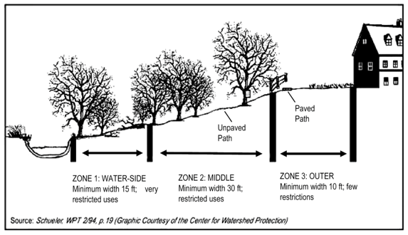
- Water feature buffer zones. Unless otherwise determined by the body responsible for approval and/or compliance as described in subsection (c) of this section, a water feature buffer zone shall be located adjacent to a water feature as defined in section 36-5, as identified on the water feature and wetland buffer map, and as determined by required field investigation and/or natural feature inventories as required in article VI of this chapter. The water feature buffer zone shall consist of three distinct areas requiring the following minimum widths and vegetative targets:
- Zone 1—Water-side zone.
- Undisturbed vegetated area aims to protect the physical and ecological integrity of the particular water ecosystem.
- Begins at the edge of the stream bank of the channel, lake or pond shore, and extends a minimum distance of 15 feet, measured horizontally on a line perpendicular to the watercourse or water body.
- The vegetative target for the water-side zone is undisturbed native woody species with native plants forming canopy, understory, and ground layer; where such forest does not grow naturally, then native vegetative cover appropriate for the area (such as grasses, forbs or shrubs) is the vegetative target.
- Zone 2—Middle zone.
- This managed area of native vegetation protects key components of the water ecosystem and provides distance between upland development and the water-side zone.
- Extends immediately from outer edge of zone 1 for a minimum distance of 30 feet.
- The vegetative target for the middle zone is either undisturbed or managed native woody species or, in its absence, native vegetative cover of shrubs, grasses or forbs. Undisturbed forest, as in zone 1, is encouraged strongly to further protect water quality and the water ecosystem.
- Zone 3—Outer zone.
- This zone prevents encroachment into the buffer area, filters runoff from adjacent land, and encourages sheet flow of runoff into the buffer.
- Extends a minimum of ten feet immediately from outer edge of zone 2.
- The vegetative target for the outer zone is native woody and herbaceous vegetation to increase the total width of the buffer. While native grasses and forbs are preferred, mown lawn is permitted, but not encouraged.
- Where land uses such as agriculture or silviculture within the area of the buffer are proposed to be converted to other uses, the full three-zone buffer shall be reestablished in accordance with this subsection (e) and subsection (g) of this section. In reestablishing the buffer, management measures shall be undertaken to provide native woody, shrub, and/or herbaceous vegetation that ensures the buffer functions as set forth in this section. For specifications on plant type, spacing and density, refer to the USDA NRCS Technical Guide, section IV, Statewide Riparian Forest Buffer 391, available from the township offices.
- Zone 1—Water-side zone.
- Wetland buffer zone. Unless otherwise determined by the body responsible for approval and/or compliance as described in subsection (c) of this section, a wetland buffer zone shall be located adjacent to wetlands identified on the water feature and wetland buffer map, and shall consist of the following minimum width and vegetative targets:
- Undisturbed vegetated area aims to protect the physical and ecological integrity of the particular water ecosystem.
- Begins at the wetland edge and extends a minimum distance of 30 feet, measured horizontally on a line perpendicular to the wetland boundary.
- The vegetative target for the wetland buffer is undisturbed native woody species with native plants forming canopy, understory, and ground layer; where such forest does not grow naturally, then native vegetative cover appropriate for the area (such as grasses, forbs or shrubs) is the vegetative target.
- Width requirements of the water feature buffer. The width of the water feature buffer shall be established as the greatest of the following:
- The total combined width of zones 1, 2, and 3 shall be no less than 55 feet on each side of a water feature as defined in section 36-5, with minimum required distances as given in subsection (e) of this section.
- The buffer width shall be modified if there are steep slopes which are within 200 feet of a water feature. In those cases, zone 3 of the buffer width shall be adjusted, as given in the table below:
WIDTH FOR ZONE 3 VEGETATION IN A WATER FEATURE BUFFERPercent Slope Width (feet) 0—8 10 9—15 15 > 15 20
- Existing nonconforming structures and uses in buffer. All nonconforming uses and structures existing at the effective date of the ordinance from which this section is derived located within a buffer that are not permitted under this regulation may be continued but shall not be changed or enlarged unless in accordance with article XIII of this chapter, pertaining to nonconforming uses, structures and lots of record.
- Permitted uses. Where buffers are required or regulated, the following activities shall be permitted within the water feature/wetland buffer areas as follows:
- The buffer, including wetlands and floodplains, shall be managed to enhance and maximize the unique value of these resources.
- Zone 1—Water-side zone and wetland buffer.
- Open space uses that are passive primarily in nature, such as wildlife sanctuaries, nature preserves, forest preserves, fishing areas, and educational/public awareness signs. The area encompassed for any such use on a lot shall not include buildings and shall not result in disturbance of soil or vegetation that exceeds 20 percent of the area of the buffer on that lot.
- Reforestation and stream stabilization.
- Removal of dead or diseased trees, and those causing safety concerns.
- Water quality monitoring and stream gauging.
- Designated historic building reconstruction.
- Flood control structures and utility rights-of-way.
- Installation of seasonal recreational structures for water use.
- Zone 2—Middle zone.
- Uses listed in subsection (i)(2) of this section.
- Public and/or private biking and hiking paths constructed with pervious materials. While not required, property owners are encouraged to consider providing public trails for passive recreation activities such as biking, walking, and jogging within this zone.
- Public access easements.
- Stormwater management facilities.
- Recreational uses that do not involve impervious surfaces or encourage concentrated flow of stormwater into the buffer.
- Limited forestry management techniques and timber harvesting.
- Zone 3—Outer zone.
- Uses listed in subsections (i)(2) and (i)(3) of this section.
- There shall be no septic systems, permanent structures or impervious cover, with the exception of paths that measure eight feet or less in width and overhead clearance of eight feet or less.
- Fences; provided that such fences must be constructed so as not to impede floodwaters.
- Exemptions. The following activities shall be exempted:
- Maintenance of previously established lawn areas.
- Grading and filling necessary in order to conform to express requirements imposed by the township engineer.
- Planting of native trees and other indigenous vegetation.
- Removal of exotic invasive vegetation including buckthorn, honeysuckle, and multiflora rose, or noxious vegetation including poison ivy, poison sumac, and poison oak. See section 36-345(b)(10) for a list of prohibited invasive plant species.
- Selected trimming of indigenous vegetation for filtered sight lines. Note that clearcutting, cutting down, or removal of existing native tree, shrub, and ground layer species is not allowed within the water feature and wetland buffer zones.
- Application form. If the activity is associated with a proposal that will require consideration by the planning commission and/or township board, no application in addition to materials already required for review of the proposal (such as site plan review or others) shall be required. If the proposed activity requires zoning compliance review only, application for activities proposed within the water feature/wetland buffer shall be made under this section on the form approved by the township board and provided by the zoning official.
- Water feature and wetland buffer plan and grading plan requirements.
- As part of any submission that requires planning commission and/or township board consideration, a water feature and wetland buffer plan containing the following information must be provided:
- Water feature and wetland buffers, field-delineated and surveyed by professional environmental consultants.
- Steep slopes greater than 12 percent for areas adjacent to and within 200 feet of streams, wetlands, or other waterbodies.
- A narrative describing the species and distribution of existing vegetation within the buffer.
- A note stating, "There shall be no clearing, grading, construction or disturbance of vegetation within the water feature and/or wetland buffer except as permitted through the site plan review process of Scio Township."
- A note stating, "Any water feature and/or wetland buffers shown on this plan are subject to protective covenants that may be found in the land records and that restrict disturbance and use of these areas."
- The buffer plan shall be submitted in conjunction with the required grading plan for any development, and the vegetated buffer shall be delineated clearly on the final grading plan.
- Permanent boundary markers, in the form of educational signage or other forms as approved by the township shall be installed every 200 feet prior to final approval of the required grading plan. Signs and/or markers shall be placed at the transitional edge of zone 2 and zone 3 of a water feature buffer (see subsection (e) of this section) or at the edge of the wetland buffer (see subsection (f) of this section).
- As part of any submission that requires planning commission and/or township board consideration, a water feature and wetland buffer plan containing the following information must be provided:
- Buffer maintenance requirements.
- Where approval by the planning commission and/or township board is required, the following shall apply. Note that these requirements do not apply to zoning compliance for single-family residential use permits. All buffers established through the required review processes by the planning commission and/or township board, except as noted above, shall be maintained as described in subsections (e), (f) and (g) of this section through either:
- Deed restrictions, which are required to be submitted for approval by the township board. The covenant shall be recorded in the land records and shall run with the land and continue in perpetuity; or
- A conservation easement with a local land conservancy as approved by the township board. The easement shall be recorded in the land records and shall run with the land and continue in perpetuity. Terms of such an easement shall be at least as restrictive as those included in this chapter.
- All lease and sales agreements must contain a notation regarding the presence and location of protective covenants for buffers, and which shall contain information on the management and maintenance requirements for the buffer for the new property owner.
- An offer of dedication of a buffer area by conservation easement to a land conservancy shall not be interpreted to mean that this offer automatically conveys to the general public the right of access to this area.
- The land conservancy to whom the buffer is dedicated shall inspect the buffer annually and immediately following severe storms for evidence of sediment deposition, erosion, or concentrated flow channels and identify corrective actions to be taken to ensure the integrity and functions of the forest buffer.
- Where approval by the planning commission and/or township board is required, the following shall apply. Note that these requirements do not apply to zoning compliance for single-family residential use permits. All buffers established through the required review processes by the planning commission and/or township board, except as noted above, shall be maintained as described in subsections (e), (f) and (g) of this section through either:
- Inspection of approved plan.
- Authorized representatives of the township shall have the authority to conduct investigations as it may reasonably deem necessary to carry out its duties as prescribed in this section, and for this purpose to enter at reasonable times upon any property, public or private, for the purpose of investigating and inspecting the sites of any land disturbing or forestry activities within the protection area.
- The zoning official may make periodic inspections during the course of land development and shall make a final inspection following completion of the work. The permittee shall assist the zoning official in making such inspections, if need be.
- The zoning official may make periodic inspections following completion of the land development to determine buffer intactness.
- Violations. Violations of these regulations are subject to section 36-38, pertaining to violations and penalties.
(Ord. No. 275, § 12.03, 10-21-2003; Ord. No. 2009-01, § VI, 1-27-2009)
State Law reference— Inland waters, MCL 324.30101 et seq.
Sec 36-343 Floodplain Management
- Intent. It is the intent of the township in adopting the ordinance from which this chapter is derived to significantly reduce hazards to persons and damage to property as a result of flood conditions in the township; to comply with the provisions and requirements of the National Flood Insurance Program; to protect human life, health and property from dangerous and damaging effects of flood conditions; to minimize public expenditures for flood control projects, rescue and relief efforts in the aftermath of flooding, repair of flood damage public facilities and utilities, and the redevelopment of flood damaged homes, neighborhoods, commercial and industrial areas; to maintain stable development patterns not subject to the blighting influence of flood damage; to designate floodplains and institute floodplain development regulations and general development standards; to establish regulations concerning the same; and to provide for the administration of this article and to provide penalties for violation.
- Delineation of the flood hazard area overlay zone.
- The flood hazard area zone shall overlay existing zoning districts delineated on the official township zoning map. The boundaries of the flood hazard area zone shall coincide with the boundaries of the areas indicated as within the limits of the 100-year flood on the federal flood insurance rate map currently in effect for the township. The flood insurance rate map is adopted by reference, appended and declared to be a part of this chapter. The term "flood hazard area," as used in this chapter, shall mean the flood hazard area zone.
- Disputes as to the location of a flood hazard area zone boundary shall be resolved by the zoning board of appeals.
- In addition to other requirements of this chapter applicable to development in the underlying zoning districts, compliance with the requirements of this section shall be necessary for all development occurring within the flood hazard area zone. Conflicts between the requirements of this section and other requirements of this chapter or any other ordinance shall be resolved in favor of this section, except where the conflicting requirement is more stringent and would further the objectives of this section to a greater extent than the requirements of this section. In such cases, the more stringent requirement shall be applied.
- Principal and accessory uses permitted.
- Within the flood hazard area overlay zone, no land shall be used except for one or more of the following principal uses.
- Agriculture, pastureland and animal grazing.
- Parks and recreation facilities provided no permanent structures are constructed.
- Swimming beaches, fishing and boating docks in accordance with the provisions of the inland lakes and streams regulations, part 301 of Public Act No. 451 of 1994 (MCL 324.30101 et seq.).
- Required open space or lot area for structural uses that are landward of the overlay zone.
- The following accessory structures and uses are permitted, provided they are also permitted in the underlying zoning district. Off-street parking, streets, roads, bridges, outdoor play equipment, sheds and garages, boathouses, boat hoists, utility lines, pumphouses, bleachers, bank protection structures, signs, fences, gazebos and similar outdoor equipment and appurtenances; provided each of the following requirements are met:
- The structure would not cause an increase in water surface elevation, obstruct flow or reduce the impoundment capacity of the floodplain.
- All equipment and structures shall be anchored to prevent flotation and lateral movement.
- Compliance with these requirements is certified by an engineering finding by a registered engineer.
- Within the flood hazard area overlay zone, no land shall be used except for one or more of the following principal uses.
- Filling and dumping. Dredging and filling and/or dumping or backfilling with any material in any manner is prohibited unless through compensating excavation and shaping of the floodplain, the flow and impoundment capacity of the floodplain will be maintained or improved, and unless all applicable state regulations are met, including but not limited to approvals pursuant to: part 31 of Public Act No. 451 of 1994 (MCL 324.3101 et seq.); part 91 of Public Act No. 451 of 1994 (MCL 324.9101 et seq.); part 301 of Public Act No. 451 of 1994 (MCL 324.30101 et seq.); and part 303 of Public Act No. 451 of 1994 (MCL 324.30301 et seq.).
- General standards for flood hazard reduction.
- No building or structure shall be erected, converted or substantially improved or placed, and no land filled or structure used in a flood hazard area unless permission is obtained from the township. Approval shall not be granted until a permit from the state department of environmental quality under authority of part 31 of Public Act No. 451 of 1994 (MCL 324.3101 et seq.) has been obtained.
- All public utilities and facilities shall be designed, constructed and located to minimize or eliminate flood damage.
- Land shall not be divided in a manner creating parcels or lots which cannot be used in conformance with the requirements of this article.
- Available flood hazard data from federal, state or other sources shall be reasonably utilized in meeting the standards of this section.
- Disclaimer of liability. The degree of flood protection required by this article is considered reasonable for regulatory purposes and is based upon engineering and scientific methods of study. Larger floods may occur on rare occasions. Flood heights may be increased by manmade or natural causes. Thus, approval of the use of land under this article shall not be considered a guarantee or warranty of safety from flood damage. This article does not imply that areas outside the flood hazard area will be free from flood damage. This article does not create liability on the part of the township or any officer or employee thereof for any flood damage that results from reliance on this article, or any administrative decision lawfully made.
- Flood hazard area variances.
- Variances from the provisions of this section shall only be granted by the zoning board of appeals upon a determination of compliance with the general standards for variances contained in article XIV of this chapter and each of the following specific standards:
- A variance shall be granted only upon:
- A showing of good and sufficient cause;
- A determination that failure to grant the variance would result in exceptional hardship to the applicant;
- A determination that the granting of a variance will not result in a harmful increase in flood heights, additional threats to public safety, extraordinary public expense, create nuisances, cause fraud on or victimization of the public, or conflict with existing laws or ordinances; and
- A determination that the granting of a variance will not result in any violations of applicable state or federal laws.
- The variance granted shall be the minimum necessary, considering the flood hazards, to afford relief to the applicant.
- A variance shall be granted only upon:
- The zoning board of appeals may attach conditions to the granting of a variance to ensure compliance with the standards contained in this chapter.
- Variances may be granted for the reconstruction, rehabilitation or restoration of structures listed on the National Register of Historic Places or the Michigan Historic Markers listing of historic sites, or any other state register of historic places without regard to the requirements of this section governing variances in flood hazard areas.
- Variances from the provisions of this section shall only be granted by the zoning board of appeals upon a determination of compliance with the general standards for variances contained in article XIV of this chapter and each of the following specific standards:
- Mapping disputes.
- Where disputes arise as to the location of the flood hazard area boundary or the limits of the floodway, the zoning board of appeals shall resolve the dispute and establish the boundary location. In all cases, the decision of the zoning board of appeals shall be based upon the most current floodplain studies issued by Federal Emergency Management Agency. Where Federal Emergency Management Agency information is not available, the best available floodplain information shall be utilized.
- Where a dispute involves an allegation that the boundary is incorrect as mapped and Federal Emergency Management Agency floodplain studies are being questioned, the zoning board of appeals shall modify the boundary of the flood hazard area or the floodway only upon receipt of an official letter of map amendment issued by the Federal Emergency Management Agency.
- All parties to a map dispute may submit technical evidence to the zoning board of appeals.
(Ord. No. 275, § 12.04, 10-21-2003)
State Law reference— Water resources protection, MCL 324.3101 et seq.; soil erosion and sedimentation control, MCL 324.9101 et seq.; soil conservation districts law, MCL 324.9301; inland lakes and streams, MCL 324.30101 et seq.; wetlands protection, MCL 324.30301 et seq.; building and construction in floodplain, MCL 324.3108; subdivision within or abutting floodplain, MCL 560.138; subdivision within floodplain, conditions for approval, MCL 560.194.
Sec 36-344 Natural Rivers Setback And Maintenance Regulations
- Intent.
- The regulations of this section are intended to protect and enhance the portions of the Huron River and Mill Creek in the township in accordance with the natural resources commission's designation:
- To prevent economic and ecological damages due to unwise development patterns along the natural river, and to preserve the values of the natural river areas for the benefit of present and future generations;
- To protect the natural river's free flowing river conditions, fish, and wildlife resources, water quality, scenic and aesthetic qualities, and historical and recreational values;
- To prevent flood damages due to interferences with natural floodplain characteristics by excluding from the natural river area property and uses which are vulnerable to flood damages, during times of flood, thereby protecting the local tax base and avoiding increased economic burdens.
- The regulations of this section shall apply to all natural river areas and shall be in addition to other regulations set forth in this chapter. The regulations of this section do not permit any uses or structures which are prohibited in any zoning district underlying a natural river area.
- The regulations of this section are intended to protect and enhance the portions of the Huron River and Mill Creek in the township in accordance with the natural resources commission's designation:
- Designation of the natural rivers area.
- Natural Rivers Area I is designated as all land and water areas within the Huron River or within 400 feet of the edge of the Huron River and included within the following description:
All that portion of the following described premises situated in the township of Scio, County of Washtenaw, State of Michigan, and lying east of the centerline of Zeeb Road, to wit:
Lands lying in the northeast Quarter of Section 9, and in the north half of Section 10, Town 2 South, Range 5 East, Scio Township, Washtenaw County, Michigan described as: All that parcel of land bounded north by the north line of Section 10, and the south line of the Michigan Central Railroad right-of-way; on the south and east by the Huron River; and on the west by the westerly line of the Scio Mill property, so called, which line was marked by a fence at the time of surveys made by Gardner S. Williams in 1908 and 1909, and which fence ran in a southwesterly direction from a point on the southerly line of the Michigan Central Railroad right-of-way, being 890 feet westerly of, and measured perpendicular to the easterly line of the Section 9 and running to a point on the left bank of the Huron River, approximately 1,050 feet westerly of said Section line. - Natural Rivers Area R is designated as all of the remainder of the Huron River and Mill Creek and all other land lying within 400 feet of either edge of the Huron River or Mill Creek within the unincorporated portions of the township.
- Natural Rivers Area I is designated as all land and water areas within the Huron River or within 400 feet of the edge of the Huron River and included within the following description:
- Prohibited structures and uses in Natural Rivers Area R.
- New industrial and commercial structures and uses shall not be permitted within 400 feet of the Huron River and of Mill Creek. Restoration, reconstruction, extension, expansion and substitution of existing industrial and commercial structures and uses shall be prohibited unless approval is granted by the board of appeals following consultation with the division of land resource programs of the state department of natural resources. The proposed action shall be approved if the board of appeals determines that all of the following standards are met:
- The land upon which the proposed action is situated is not in a floodplain;
- The proposed action will not lead to accelerated bank erosion or other material degradation of the river resource;
- The proposed action conforms to all local codes and ordinances, and approval is granted from appropriate officials; and
- The proposed action does not contravene the intent and purposes of this chapter in general, or of this section in particular.
- All new structures as described herein shall require a certificate of zoning compliance in accordance with section 36-31 of the Zoning Ordinance.
- New buildings and appurtenances shall be set back at least 75 feet from the top of a bluff.
- No building or filling shall take place in a floodplain or wetland.
- The minimum riverfront lot width shall be 150 feet measured at the minimum building setback line.
- Minimum setback of a septic system drainfield shall be 125 feet.
- Natural river one private river access stairway per parcel may be allowed, the following standards apply:
- A stairway is not permitted unless no other reasonable and safe access to the river exists.
- A stairway shall be low profile, not more than four feet wide and constructed without stairs being recessed into the ground surface, except if site and soil conditions dictate that a recessed stairway is appropriate.
- A landing shall not be constructed unless required by building code, in which case the landing shall be the minimum number and size required by building codes.
- A stairway shall be constructed using natural materials.
- A stairway shall be located and maintained to blend with the natural surroundings, and where removal of vegetation in the natural vegetation strip can be minimized.
- All stairways shall meet the current building codes and obtain necessary building permits.
- New development, exploration or production of oil, gas, salt brine, sand and gravel or other minerals except groundwater shall not be permitted within 300 feet of the designated portions of the Huron River and Mill Creek.
- Signs of the sale of products or services shall be prohibited, except that an existing business may advertise on lands on which it is established. Signs and outdoor advertising devices within the Natural River Area R (300 feet) shall be related to permitted uses; not illuminated; not attached to any tree or shrub; and in conformance with the following standards:
- For residential uses, signs may not be larger than one square foot in area posted not more than one per 100 feet or one sign posted at upstream and downstream corners of lot, however, one temporary real estate "for sale" sign not to exceed four square in area shall be allowed on a parcel of land.
- For commercial uses, one sign per establishment is allowed, not to exceed four square feet in area.
- Utility lines to service permitted uses shall originate from the landward site of the structure, and shall be located landward of the 50-foot natural vegetation strip, set forth in subsection (d) of this section.
- Site or route location, construction or enlargement of: utility transmission lines; publicly provided recreational facilities; access sites, highways, roads, bridges, or other structures; and publicly developed water management projects are permitted only with approval of the state pursuant to administrative rules adopted to implement part 305 of Public Act No. 451 of 1994 (MCL 324.30501 et seq.) and entitled Utilities and Publicly Provided Facilities in Natural River Areas.
- No trees or other vegetation shall be cut or removed within 100 feet of the river's edge except as permitted in subsection (d) of this section.
- Any land alteration shall conform to all the following requirements:
- Any land alteration shall be in conformance with all local, county, state, and/or federal requirements. All applicable permits shall be obtained prior to issuance of a zoning compliance by the township.
- Land alteration shall not occur with the natural vegetation strip, except placement of woodchips for a foot path, on the face or crest of a bluff, in a wetland, in a floodplain, or below the ordinary high-water mark of the river unless associated with bank stabilization or fisheries habitat improvement activities.
- Draining a wetland is prohibited.
- A pond may be constructed if the pond meets the building setback, spoils are placed in a non-wetland, non-floodplain area landward of the natural vegetation strip, and the pond is not connected to the river by any surface of sub-surface drainage system. A pond shall be constructed in a wetland or the 100-year floodplain.
- Bank stabilization or fisheries habitat activities shall comply with all of the following:
- Bioengineering practices shall be the preferred alternative for bank stabilization. Bioengineering practices used to stabilize stream banks utilize a combination of native plantings and natural or biodegradable materials to engineer shoreline protection that mimic and or enhance the natural landscape.
- Rock used for bank stabilization above the seasonal low-water level of the stream shall be rounded cobble (fieldstone).
- Quarried limestone or other natural angular stone shall not be exposed by seasonal low water level of the stream.
- An in-stream fisheries habitat structure, such as a lunker, an overhead cover platform or similar structure shall be, upon completion, indistinguishable from the natural surrounding landscape.
- A seawall, vertical bulkhead, gabion basket, concrete bag riprap, broken concrete, and other similar structures are prohibited.
- The proposed bank stabilization or fisheries habitat shall fulfill an identifiable need for erosion protection, bank stabilization, or fisheries habitat improvement.
- New industrial and commercial structures and uses shall not be permitted within 400 feet of the Huron River and of Mill Creek. Restoration, reconstruction, extension, expansion and substitution of existing industrial and commercial structures and uses shall be prohibited unless approval is granted by the board of appeals following consultation with the division of land resource programs of the state department of natural resources. The proposed action shall be approved if the board of appeals determines that all of the following standards are met:
- Natural rivers natural vegetation strip. A natural vegetation strip 100 feet wide bordering each side of the designated portions of the mainstream, and tributaries shall be maintained in trees, shrubs and other vegetation native to the area subject to the following provisions:
- Dead, disease, unsafe or fallen trees and noxious weeds and shrubs may be removed.
- Trees and shrubs may be pruned to afford a view of the river.
- Clear-cutting will not be allowed in the 100-foot vegetation strip, however, selective removal of trees for commercial timber harvest or landscaping shall be permitted upon approval of the zoning official or the department of natural resources. Any tree clearing shall be in accordance with section 36-346.
- Mowing is prohibited in the natural vegetation strip except in an area maintained in a mowed condition before the effective date of this section or to establish a single footpath to the river not to exceed four feet wide.
- Camping, except for tent camping, is not permitted in the natural vegetation strip.
- A motorized vehicle shall not be operated off-road in the natural vegetation strip.
- Regulations governing use and development of land in Natural Rivers Area I.
- The use and development of land in Natural Rivers Area I is subject to all of the regulations of the use and development of other land in the I-1 district. In addition, a natural vegetation strip 50 feet wide bordering each side of the Huron River shall be maintained in trees, shrubs and other vegetation native to the area, provided that dead, diseased, unsafe or fallen trees and noxious weeds may be removed. Vegetation may be removed within five feet of any security fence existing at the time of adoption of the ordinance from which this chapter is derived, and vegetation may also be removed for the construction and maintenance of water supply and treatment facilities.
- No buildings or other structures shall be erected within either the natural vegetation strip or on the floodplain except for expansion or replacement of existing water supply and treatment facilities. Such expansion or replacement shall be accomplished in a manner which is consistent with the purpose and objectives of the natural vegetation strip and floodplain protection.
- No expansion of a principal structure in Natural Rivers I and in existence at the time of adoption of the ordinance from which this chapter is derived shall be permitted closer than 150 feet to the edge of the river.
- Relationship of underlying district regulations to those of the overlay zone for Natural River Area R. Buildings and structures existing at the time of the adoption of the ordinance from which this chapter is derived and lawfully permitted in underlying districts, if nonconforming, are hereby deemed nonconforming only to the extent of conflict with the provisions of the Natural River Area R overlay zone. The regulations governing the use and development of land established in districts underlying the Natural River Area R shall apply in addition to those of this section, except where a conflict exists, the provisions of this section shall supersede to the extent of the conflict and not further. Such a determination shall be based upon the intent of this section and the Huron River Natural River Plan.
- Reporting.
- A copy of all special use and variance applications received by the local unit of government shall be provided to the state natural rivers zoning administrator not less than 15 days before the application will be considered by the zoning board of appeals or the planning commission. A copy of the local zoning administrator's decision for a minor variance application, with permit and approved site plan, if applicable, shall be sent to the state natural rivers zoning administrator.
- An annual report to the state natural rivers zoning administrator shall be provided by March 1 of each year for the preceding year natural rivers zoning activity. The annual report shall include, at minimum, all of the following information:
- Total number of natural river district land/use zoning permit applications submitted to the local unit of government during the calendar year.
- Total number of natural river district variance application received during the calendar year.
- Total number of natural river district special use applications received during the calendar year.
- Summary of all decisions made by the zoning board of appeals or planning commission on applications for projects in the natural rivers district during the calendar year.
- Summary of all outstanding violations of natural rivers' standards and the actions taken by the local unit of government to gain compliance at the site during the calendar year.
(Ord. No. 275, § 12.05, 10-21-2003; Ord. No. 3381, § 7, 4-19-2005)
State Law reference— Natural rivers, MCL 324.30501 et seq.
Sec 36-345 Landscaping, Greenbelt, Buffers And Screening
- The intent of this section is to promote the public's health, safety, and general welfare by: counteracting noise, improving air quality and counteracting visual blight; improving the appearance of off-street parking and other vehicular use areas; requiring buffering between noncompatible land uses; regulating the appearance of property abutting public rights-of-way; protecting and preserving the appearance, character, and value of the community and its residential neighborhood areas; preventing soil erosion and soil depletion; and, promoting soil water retention.
- To the greatest extent possible, applicants are encouraged to satisfy chapter requirements through the preservation of existing trees and natural vegetation. Where appropriate, the use of landscape materials native to the county is encouraged.
- Application. These requirements shall apply to all uses for which site plan review is required under article VI of this chapter. No site plan shall be approved unless it shows landscaping, greenbelt buffers, and screening consistent with the requirements set forth in this section.
- Landscape plan required. A separate detailed landscape plan shall be submitted as part of the site plan review process. On sites of greater than one acre, landscape plans shall be prepared and sealed by a registered landscape architect, licensed in the state. The landscape plan shall include, but not necessarily be limited to, the following items:
- Location, spacing, size, root type and descriptions for each plant and type proposed for use within the required landscape area.
- Minimum scale: one inch equals 40 feet for property less than five acres, or one inch equals 100 feet for property five acres or more. A different scale may be used provided it is sufficient to properly illustrate the landscape plan concept and that chapter requirements are met.
- On parcels of more than one acre, existing and proposed contours on site and 50 feet beyond the site at intervals not to exceed two feet.
- Significant construction details to resolve specific site conditions, such as tree wells to preserve existing trees or culverts to maintain natural drainage patterns.
- Planting and staking details in either text or drawing form to ensure proper installation of proposed plant materials.
- Identification of existing wetlands, forested areas, trees and vegetative cover to be preserved.
- Identification of grass and other ground cover and method of planting.
- Identification of mulch in planting beds.
- Typical straight cross section, including slope, height and width of berms.
- Buffering between land uses and buffering along I-94 and M-14.
- Upon any improvement for which a site plan is required, a landscape buffer shall be required to create a visual screen at least six feet in height along all adjoining boundaries whenever a nonresidential use or a residential use of higher density abuts residentially zoned property. A landscape buffer may consist of earthen berms and plant materials, or plant materials only, so as to maintain a minimum opacity of at least 80 percent. Opacity shall be measured by observation of any two square yard area of landscape screen between one foot above the established grade of the area to be concealed and the top or the highest point of the required screen. Provided the minimum size of plant material as set forth in subsection (b)(11) of this section at the time of installation, the opacity standard shall be met based upon reasonably anticipated growth over a period of three years. The applicant shall agree in writing to install additional plantings after the expiration of three years, in the event that the landscaping has not screened the view of areas as required. (See Figure 13 in appendix A.)
- Where there is a need to provide a greater visual, noise or dust barrier or to screen more intense development, a solid wall or fence may be required. Such wall or fence shall be a minimum of six feet in height as measured on the side of the proposed wall having the higher grade, and shall be constructed on both sides with textured concrete, split-face concrete block, wood, brick or stone. Precast panels and formed concrete structures may be used if they provide surface detail and texture equal to or greater than, the materials just named. In addition, a minimum of one tree and six shrubs meeting the minimum size requirements set forth in subsection (b)(11) of this section shall be planted adjacent to and for each 30 lineal feet of wall or fence.
- Sites which are adjacent to I-94 and M-14. Sites which are adjacent to I-94 and M-14 shall maintain a minimum 50-foot undisturbed buffer measured from the right-of-way. If existing vegetation is not sufficient to provide a landscape screen, the planning commission may require additional landscaping in accordance with this subsection (b)(3).
- Parking lot landscaping.
- Interior areas. Each separate landscaped area within a parking lot shall be adequately planted and maintained and shall be located in such a manner as to promote the following: divide and break up the expanse of pavement; define parking areas; designate vehicular circulation; and separate parking lots from off-street parking. The following specific standards shall apply (see Figure 14 in appendix A):
- Separate landscaped islands shall be required within parking lots of 16 spaces or greater. No more than a row of 24 spaces are permitted without an island. Where size and configuration of a parking lot would prevent maintenance or impede traffic flow as a result of requiring landscaped areas within parking lots, the planning commission may approve alternative landscaping along the perimeter of the parking lots.
- There shall be one canopy tree meeting the minimum size requirements set forth in subsection (b)(11) of this section for every eight parking spaces, landscaped islands within a designated parking area shall be a minimum of 150 square feet in area and nine feet in width.
- A minimum distance of three feet shall be established between proposed tree or shrub plantings and the backside of the curb or edge of the pavement.
- Perimeter areas. In order to reduce the visual impact, minimize conflicts between neighboring uses and reduce the effect of headlight glare and parking lot lighting on adjacent uses and public roadways, the perimeter of parking lots shall be screened in accordance with the following standards (see Figure 15 in appendix A):
- Parking lots which are adjacent to residentially zoned or used property, which serve a nonresidential use or a residential use of higher density shall be screened from that residential use in accordance with the standards set forth in subsection (b)(3) of this section.
- Parking lots which are visible from a public road shall be screened from view with a landscaped berm varied in height from between two to three feet along the perimeter of those sides which are visible. The berm shall be planted with a minimum of one deciduous or evergreen tree and six deciduous or evergreen shrubs, meeting the minimum size requirements set forth in subsection (b)(11) of this section for every 30 lineal feet, or major portion thereof. The planning commission, at its discretion, may approve alternative landscape plantings, such as a solid hedge, or a solid wall in lieu of a landscape berm.
- Landscape strips. Minimum of three-foot-wide landscape strips (not including vehicle overhangs) should be provided between paved parking surfaces and buildings, fences, and property lines wherever possible. Trees and shrubs shall be planted clear of the vehicle overhang area.
- Interior areas. Each separate landscaped area within a parking lot shall be adequately planted and maintained and shall be located in such a manner as to promote the following: divide and break up the expanse of pavement; define parking areas; designate vehicular circulation; and separate parking lots from off-street parking. The following specific standards shall apply (see Figure 14 in appendix A):
- Front greenbelt landscaping.
- A landscaped greenbelt equivalent in depth to the required front yard setback shall be required for any lot or any portion of a lot fronting on a public or private road, and shall be landscaped with a minimum of one deciduous tree or one evergreen tree, plus six deciduous and/or evergreen shrubs meeting the minimum size requirements set forth in subsection (b)(11) of this section for each 30 lineal feet, or major portion thereof, of frontage abutting said public right-of-way. The remainder of the greenbelt shall be landscaped in grass, ground cover, shrubs and/or other living plant material. (See Figure 16 in appendix A.)
- Accessways from public rights-of-way through required landscape strips shall be permitted, but such accessways shall not be subtracted from the lineal dimension used to determine the minimum number of trees required unless such calculation would result in a spacing arrangement which is detrimental to plant development.
- Subdivision and site condominium landscaping. Landscaping for subdivisions and site condominiums, which shall include, but not be limited to, residential, office, commercial, and industrial development, shall be provided in accordance with the following requirements:
- Street trees. The frontage of all internal public or private streets shall be landscaped on both sides with the equivalent of one tree for every 40 lineal feet, or fraction thereof. Such street trees shall meet the minimum size requirements set forth in subsection (b)(11) of this section and shall be an appropriate species for a street environment. The planning commission may determine that existing trees which are preserved within the road right-of-way or easement may meet all or part of the street tree requirement.
- Screening from public roads. Where a subdivision or site condominium abuts a public right-of-way located outside of the proposed subdivision or site condominium, the screening requirements set forth in subsection (b)(3) of this section shall be met.
- Other site improvements. A landscape plan for a subdivision or site condominium development shall also include landscaping details of the entrance to the development, stormwater retention and/or detention areas, community buildings and other recreational areas, and any other site improvement which would be enhanced through the addition of landscaping.
- Foundation landscaping. Foundation plantings shall be provided along the front or sides of any buildings which faces a public road and/or is adjacent to a parking lot or other area which provides access to the building by the general public. Foundation planting areas shall be integrated into the sidewalk system (between the front and sides of the building and the parking area and/or associated driveways) adjacent to the building. Foundation planting areas shall contain, at a minimum, one ornamental tree and six shrubs per 30 lineal feet of applicable building frontage. Individual planting areas shall be a minimum of eight feet in width.
- General site landscaping. In addition to any required screening, front greenbelt, foundation landscaping and/or parking lot landscaping required by this section, 25 percent of the site area, excluding existing public road right-of-way, or private road easement shall be landscaped. Such site landscaping shall include preservation of existing plant material, grass, ground cover, trees, shrubs and/or other living plant material, but shall not be solely grass. In meeting general site landscaping requirements, particular attention shall be paid to such site elements as transformers, mechanical equipment, ground sign bases, entry ways, and/or retention and detention areas. In particular, the integration of stormwater retention and detention ponds in the overall landscape concept is recommended. Ponds with a natural, rather than square or rectangular, design and appearance shall be encouraged. Fenced retention/detention ponds within a front yard shall be strictly prohibited.
- Refuse containers. Refuse containers shall be required for all uses other than single-family uses subject to the following standards (see Figure 17 in appendix A):
- Outside trash disposal containers shall be screened on all sides with an opaque masonry wall, and gate at least as high as the container, but not less than six feet in height, and shall be constructed of material which is compatible with the architectural materials used in the site development.
- Containers shall be consolidated to minimize the number of collection sites.
- Containers and enclosures shall meet all required setbacks, shall be located behind the front face of the building, and shall be located away from public view insofar as possible.
- Containers and enclosures shall be situated so that they do not cause excessive nuisance or offense to occupants of nearby buildings.
- Concrete pads of appropriate size and construction shall be provided for containers or groups of containers having a capacity of 30-gallons or more. Aprons shall be provided for loading of bins with capacity of 1.5 cubic yards or more. The minimum size of an enclosure shall be eight feet in depth and 12 feet in width to accommodate a single container and eight feet in depth and 20 feet in width to accommodate two containers.
- For storage of recyclable materials, the enclosure area and pad size shall be increased to amply accommodate the extra materials and their containers.
- Screening and gates shall be of a durable construction. Gates shall be constructed of heavy-gauge metal or of a heavy-gauge metal frame with covering of wood or other suitable material. Gates shall be secured with sturdy hinges or sliders, and latches. If the enclosure is situated directly adjacent to parking spaces or drives, it shall be protected at its base by concrete curb blocks.
- Equipment screening.
- Where required. The standard set forth in this section shall apply to all uses for which mechanical equipment including, but not limited to, generators, heating, ventilation, and air conditioning, is placed upon a roof of any building or on the ground outside of the building.
- Screening requirements. All equipment shall be screened as follows:
- Rooftop screening.
- Rooftop equipment shall be screened with architectural materials matching or harmonious with the building.
- Screens provided to obscure mechanical equipment shall be an opaque barrier at least as high as the equipment being screened.
- Rooftop equipment shall be located on the rear of a pitched-roof building screened from public view.
- Rooftop equipment shall be situated so that it does not cause excessive nuisance or offense to occupants of nearby buildings.
- At-grade equipment.
- At-grade equipment should only be considered if rooftop screening cannot be accommodated.
- Transformer pad and method of screening shall be provided on site plan submittals.
- At-grade equipment shall be screened with architectural and/or landscape materials matching or harmonious with the building or landscape materials provided elsewhere on site.
- Landscape materials shall be evergreen in species so as to provide a six-foot screen year-round.
- Walls provided to screen mechanical equipment shall be an opaque fence or wall matching existing or proposed building materials with or without a gate, at a minimum of six feet in height or 12 inches higher than the tallest piece equipment being screened.
- At-grade equipment shall be located in a side or rear yard, screened from public view.
- Rooftop screening.
- Miscellaneous landscape requirements. The following minimum standards shall apply:
- Quality. Plant materials and grasses shall be of generally acceptable varieties and species, free of insects and diseases, hardy to the county, shall conform to the current minimum standard of the American Association of Nurserymen, and shall have proof of any required governmental regulations and/or inspections.
- Composition. A mixture of plant material, having no more than 10% of any one species, 20% of any one genus, and 30% of any one family, is required to discourage insect and disease infestation; however, a limited mixture of hardy species is recommended in order to unify the design and visually blend with neighboring plants. Where plantings are adjacent to a road right-of-way, selection of plant materials that are tolerant of road salt spray and air pollutants are recommended.
- Berms. Berms shall be constructed with slopes not to exceed a 1:3 gradient and shall be planted to prevent erosion. Berm slopes shall be protected with grass, shrubs or other form of natural ground cover. The highest point of the berm, extending along the length of the berm, shall be sufficiently rounded to avoid scalping by maintenance equipment.
- Existing trees.
- If existing plant material is labeled "To Remain" on site plans by the applicant or required by the township, protective techniques, such as, but not limited to, fencing or barriers placed at the dripline around the perimeter of the plant material shall be installed prior to construction. No vehicle or other construction equipment shall be parked or stored within the dripline of any plant material intended to be saved. Other protective techniques may be used provided such techniques are approved by the township.
- In the event that healthy trees which are used to meet the minimum requirements of this chapter, or those labeled to remain, are cut down, destroyed, damaged, or excavated at the dripline, as determined by the township, the property owner shall replace them with trees which meet chapter requirements.
- Installation, maintenance, and completion.
- All landscaping required by this chapter shall be planted prior to obtaining a certificate of occupancy. In the alternative, a surety bond, letter of credit, and/or certified check shall be placed in escrow in the amount of the cost of landscaping, to be released only after landscaping is completed.
- All landscape elements shall be installed, and earth moving or grading performed according to accepted good planting and grading procedures.
- The owner of property required to be landscaped by this chapter shall maintain such landscaping in a reasonably healthy condition, free from refuse and debris. All unhealthy and dead material shall be replaced within one year of damage or death or the next appropriate planting period, whichever comes first.
- Prohibited plantings.
Native Species: The following plants native to southeast Michigan are prohibited due to their
potential to disrupt infrastructure or susceptibility to disease and/or insect damage.Common Name
Latin Name Plant Type
All ash species
Fraxinus spp. Tree
All willow species
Salix spp. Tree
All poplar species
Populus spp. Tree
Boxelder
Acer negundo Tree
Silver Maple (pure species only)
Acer saccharinum Tree
Northern catalpa
Catalpa speciosa Tree
American Elm (disease resistant
hybrids acceptable)
Ulmus spp. Tree
Prickly ash
Zanthoxylum americanum Tree
Exceptions may be requested allowing for any of the above listed prohibited native species during site plan review. The applicant will be required to provide information relative to the requested native species and exceptions will be granted by the Planning Commission on a case-by-case basis. Non-native Species: The following plants are not native to southeast Michigan and are Known to pose an invasive threat and /or potential harm to infrastructure and the environment.
Common Name Latin Name Plant Type Amur maple Acer ginnala, Acer tataricum ssp Tree Norway maple Acer platanoides Tree Tree-of-Heaven Ailanthus altissima Tree Back alder Alnus glutinosa
Tree Porcelain berry Amplelopsis brevipendunculata
Vine Japanese angelica tree Aralia elata
TreeBarberry (Japanese, c Barberry (Japanese, common) Berberis thunbergii, B. Vulgaris
Shrub Round-leaf bittersweet Celastrus orbiculatus
Vine Olive (Russian, Autumn) Eleagnus angustifolia, E. umbellate
Shrub Burning bush Euonymus alatus
Shrub Wintercreeper Euonymus fortune
Vine Buckthorn (all species) Frangula alnus/Rhamnus frangula,R cathartica
Tree/shrub English Ivy Hedera helix
Vine Japanese hops Humulus japonicus
Vine Privet (all species) Ligustrum amurense, L. japonica, L. obtusifolium, L. ovalifolium, L. sinense
Shrub Honeysuckle (note: native species Diervilla linicera and Lonicra canadensis are exempt) Loicera frangrantissima, L. japonica, L. maackii, L
Vine White mulberry (note: native species M. rubra is exempt) Morus alba
Tree Princess tree Paulownia tomentosa
Tree Amur cork tree Phellodendron amurense
Tree Callery pear, Bradford pear Pyrus calleryana
Tree Japanese knotweed Reynoutria japonica / Polygonum
cuspidatum / Fallopia japonica
Shrub Locust, Bristly or Black Robinia hispida, R. pseudoacacia
Tree Multiflora rose Rosa multiflora
Shrub Wineberry, Wine raspberry Rubus phoenicolasius
Shrub Japanese spirea Spirea japonica
Shrub Saltcedar Tamarix Ramosissima
Tree Elm (non-native) Ulmus glavra, U. parviflora, U. pumila
Tree Wisteria (note: native Wisteria frutescens is exempt) Wisteria floribunda, W. sinensis
Vine
- Minimum size and spacing requirements. Where landscaping is required, the following schedule sets forth minimum size and spacing requirements; for representative landscape materials:
- The following trees are representative:
Minimum Size Allowable Height Caliper Trees 6' 3'-4' 1.75" 2.5" Evergreen trees Fir X Spruce X Pine X Hemlock X Douglas Fir X Narrow evergreen trees Red Cedar X Arborvitae X Juniper (selected varieties) X Large deciduous canopy trees Oak X Maple X Beech X Linden X Ash X Ginko (male only) X Honeylocust (seedless, thornless) X Birch X Sycamore X Small deciduous ornamental trees Flowering Dogwood X Flowering Cherry, Pear X Hawthorn X Redbud X Magnolia X Flowering Crabapple X Serviceberry X Hornbeam X - The following shrubs are representative:
Minimum Size Allowable Height/Spread Shrubs 6' 3'-4' 24"-36" 18"-24" Evergreen shrubs Pyramidal Yew X Hicks Yew X Brown and Wards Yew X Alberta Spruce X Chinensis Juniper Varieties X Sabina Juniper X Mugho Pine X Horizontal Juniper Varieties X Boxwood X Euonymous varieties X Deciduous shrubs Honeysuckle X Lilac X Sumac X Pyracantha X Weigela X Flowering Quince X Dogwood X Viburnum varieties X Spirea X Fragrant Sumac X Potentilla X
- The following trees are representative:
- Exceptions to requirements.
- Buildings abutting property lines. Required screening may be omitted along any lot line where a building wall exists immediately abutting the lot line.
- Location adjustments. Where property line screening is required, the location may be adjusted at the discretion of the planning commission so that the screening may be constructed at or within the setback line, provided the areas between the screening and the property lines are landscaped, or in rural areas, retain their natural vegetative state.
- Existing screening. Any fence, screen, wall or hedge which does not conform to the provisions of this section and legally exists at the effective date of the ordinance from which this chapter is derived may be continued and maintained, provided there is no physical change other than necessary maintenance and repair in such fence, screen, wall, or hedge except as permitted in other sections of this chapter.
- Planning commission modification. Any of the requirements of this section may be waived or modified through site plan approval, provided the planning commission first makes a finding:
- That the topographic features or special characteristics of the site create conditions so that the strict application of the provisions of this section will result in less effective screening and landscaping than alternative landscape designs.
- That the public benefit intended to be secured by this section will exist with less than the required landscaping or screening.
(Ord. No. 275, § 12.06, 10-21-2003; Ord. No. 3381, § 8, 4-19-2005)
Sec 36-346 Tree And Woodland Resource Preservation
- Intent and declaration. It is the intent of these regulations to help prevent unregulated and, in many cases, unnecessary removal of trees and related natural resources. The protection of trees, woodlands and woodland resources will promote the preservation of important physical, aesthetic, recreational and economic assets for both present and future generations. Specifically, it is found that:
- Trees and woodlands provide for public welfare and safety through the reduction of erosion, siltation, and flooding;
- Trees and woodlands help protect the water supply and water quality by protecting groundwater recharge areas, reducing risk of groundwater contamination and maintaining base flows in streams and rivers, thus reducing the risk of degrading vegetation, wildlife, wetlands and surface water systems throughout the township;
- Trees and woodlands increase the economic value of land for most uses;
- Tree and woodland growth protects public health through the absorption of air pollutants and contamination and reduces carbon dioxide content of the ambient air.
- Tree and woodland growth serve as an essential component of the general welfare of the township by maintaining natural beauty, recreation, and natural heritage.
- Purpose. The purpose of this section is as follows:
- To encourage the preservation of trees and related natural resources of the woodland ecosystem on undeveloped land and in connection with the development of land;
- To provide for the protection, preservation, proper maintenance and use of trees and woodlands in order to minimize damage from erosion and siltation, loss of wildlife and vegetation, and/or from the destruction of the natural habitat;
- To protect trees and woodlands (including woodland resources) for their economic support of local property values when allowed to remain uncleared and/or unharvested in whole or in significant part, and for their natural beauty, character, and ecological or historical significance;
- To provide for the paramount public concern for these natural resources in the interest of the health, safety and general welfare of the residents of the township, in keeping with Article IV, Section 52 of the Michigan Constitution of 1963 and the intent of the Michigan Natural Resources and Environmental Protection Act, PA 451 of 1994.
- Exemptions. The following shall be exempt from the requirements of these regulations (section 36-346):
- Parcels of land (including subdivision and site condominium lots) of 2.5 acres or less, that are not subject to site plan review as defined in article VI of this chapter.
- Tree removal on parcels greater than 2.5 acres in area where no more than 20 percent of the total DBH inches of all protected trees on the parcel are removed during any five-year time period. This exemption does not include the removal of landmark trees, which is governed by subsection (e)(1)b. below.
- All farms and farming operations as defined by this chapter (including production of fruit) and commercial nursery/tree farm operations.
- Timber or forestry operations conducted in compliance with an approved Woodland Stewardship Plan that has been filed with the township zoning administrator prior to the start of any tree harvesting on the parcel.
- Tree clearing by public utilities.
- Tree clearing within an existing public road right-of-way or an existing private road easement.
- The removal of any tree which is demonstrated by the property owner to the zoning administrator's satisfaction to have a health and condition standard factor of less than 50 percent based upon the standards established by the International Society of Arboriculture.
- Removal of trees that have become a potential danger to human life or property.
- The removal of invasive trees as defined by these regulations.
- Approval for tree removal. The provisions of this chapter shall apply to all parcels in the township that (1) require site plan review as defined in article VI, or (2) are greater than 2.5 acres in area.
- For site plan review.
- A tree/woodland survey showing all protected and landmark trees is required as a component of the site plan review submission information (see article VI). All trees and woodlands to be removed, and all trees and woodlands to remain shall be clearly indicated on the site plan.
- A tree replacement plan (see subsection (e) below) shall be submitted as part of the final site plan review submission information.
In the case of heavily wooded parcels, the plotting of protected and landmark trees that are outside of the area of the parcel proposed to be disturbed may be waived at the discretion of the planning commission and/or zoning administrator. In the case of a waiver of the plotting of every tree the applicant must provide an estimate of the total DBH on site based on a sample area found to be acceptable by the planning commission and/or zoning administrator. - For zoning compliance certification. For parcels that do not require site plan review, zoning compliance certification must be obtained.
A certificate of zoning compliance shall be required in each of the circumstances below:- For the removal of protected trees on parcels that are greater than 2.5 acres in area submission for a certificate of zoning compliance is required when more than 20 percent of the total DBH inches of all protected trees on the parcel are to be removed within a five-year period. The township zoning administrator may require that the applicant submit a Tree/Woodland Survey in circumstances where it is not clear that 20 percent or more of the total DBH inches of all protected trees are being removed within a five-year period; otherwise a tree/woodland survey is not required.
- For the removal of landmark trees on parcels that are greater than 2.5 acres in area submission for a certificate of zoning compliance is required. A plot plan as defined in subsection 36-31(i) of this chapter may be submitted instead of a tree/woodland survey as part of the application for a certificate of zoning compliance. The plot plan shall provide the location, size and type of all landmark trees to be removed as well as a tree replacement plan and tree protection method where necessary.
- For site plan review.
- Tree removal and replacement regulations.
- Tree removals requiring replacement.
- Protected trees. No more than 20 percent of the total DBH inches of all protected trees on a parcel may be removed within a five-year period without tree replacement. When more than 20 percent of the total DBH of all protected trees is to be removed within a five-year period, or forestry operations are not conducted in compliance with an approved Woodland Stewardship Plan, then replacement trees are required.
- Landmark trees. All landmark trees are regulated, and if removed, replacement trees are required.
- Tree replacement options. The tree replacement requirements herein are separate from and in addition to the landscape requirements set forth in section 36-345.
- Tree replacement. For each six inches of total DBH inches of all protected trees removed in excess of the 20 percent of the total DBH inches pursuant to subsection 36-346(e), one tree (with a minimum of 2.5-inch caliper for deciduous or six feet in height for coniferous) shall be planted on the parcel. The planning commission may allow for tree replacement off-site at the request of the applicant when site factors including the size of the parcel (no available area for planting), tree condition or development requirements may make conformity to this section difficult or undesirable.
EXAMPLE:
Protected trees = 1,000 DBH inches
Trees to be removed = 350 DBH inches
1,000 x 20% = 200 DBH inches of removal allowed without replacement
350 DBH - 200 DBH = 150 DBH inches of replacement required.
One replacement tree per six inches of DBH removal = 150/6 = 25 replacement trees required.
If an approved Woodland Stewardship Plan recommends removal of more than 20 percent of the total DBH inclusive of all protected trees within any given year for the health of the woodland, or due to the species of tree within the woodland or due to harvesting timber, tree replacement requirements in this ordinance do not apply. - Landmark tree replacement. For every two inches DBH of landmark trees removed, one inch DBH of replacement trees shall be planted on the parcel, each of which replacement trees shall have a 2.5-inch minimum caliper.
- Tree fund. The planning commission shall be authorized to waive a portion or all of the tree replacement requirements when site factors including the size of the parcel (no available area for planting), tree condition or development requirements may make conformity to this section difficult or undesirable and the applicant shall propose a contribution to the tree fund as an alternative, which contribution shall be in an amount reasonably related to the cost of the tree replacement waived including the cost of installation.
The tree fund shall be a segregated fund within the township financial system and shall serve as the depository for all contributions proposed by applicants in lieu of tree replacement, as provided in this section.
The township board shall administer and use the tree fund for the purpose of planting and maintaining trees and woodland resources within the township.
- Tree replacement. For each six inches of total DBH inches of all protected trees removed in excess of the 20 percent of the total DBH inches pursuant to subsection 36-346(e), one tree (with a minimum of 2.5-inch caliper for deciduous or six feet in height for coniferous) shall be planted on the parcel. The planning commission may allow for tree replacement off-site at the request of the applicant when site factors including the size of the parcel (no available area for planting), tree condition or development requirements may make conformity to this section difficult or undesirable.
- Tree removals requiring replacement.
- Tree protection during construction.
- No activity within critical root zone. No person may conduct any activity within the critical root zone of any protected tree designated to remain as shown on the tree/woodland survey or plot plan.
- Protective barrier. The applicant, his agents and successors shall erect and maintain suitable barriers as approved by the township to protect trees designated to remain as shown on the approved site plan or plot plan. Protective barriers shall be placed at the outer limits of the critical root zone if a tree/woodland survey is required, and shall remain in place until the township authorizes their removal or issues a final certificate of zoning compliance, whichever occurs first. See figure 18 for an example of a suitable barrier approved by the township.
- Inspections. The township reserves the right to periodically inspect the site during site plan review, land clearing, and/or construction to ensure compliance with this section.
- Appeals and variances. All appeals or requests for variances from the provisions of this section shall be made to the Scio Township Zoning Board of Appeals in accordance with article XIV of the Scio Township Zoning Ordinance.
- Violations and penalties. Violations of the provisions of this section are violations of the Scio Township Zoning Ordinance and subject to section 36-38 of the zoning ordinance.
(Ord. No. 275, § 12.07, 10-21-2003; Ord. No. 281, 5-18-2004; Ord. No. 2010-01, § 1, 2-23-2010)
State Law reference— Municipal forests, MCL 324.52701 et seq.
Sec 36-347 Overlay For Preservation And Enhancement Of Natural Features (OPEN)
- Purpose. The purpose of the OPEN overlay district is to recognize the sensitive natural character of those properties within Scio Township identified as and in association with the recreation conservation designation in the current township master plan. This overlay district is intended to preserve the township's significant natural resources while encouraging an appropriate use of the land that recognizes these resources and encourages their interconnection. According to the township master plan, land designated as recreation-conservation includes all areas identified as priority 1 and priority 2 bioreserves by the Huron River Watershed Council. Bioreserves are defined as areas of potential ecological significance that are ranked based on size, presence of water, presence of wetlands, groundwater recharge potential, potential for rare remnant plant community, topographical diversity, glacial diversity, connectivity to other natural areas, restorability potential, and quality of vegetation. In addition it is the purpose of this district to accomplish the following:
- Promote the preservation of land and waterways which, because of location or natural features, have a unique character for open space and/or recreation purposes, and to facilitate and provide for the conservation of significant natural resources.
- Encourage the retention of open space, natural resources, and lands in and around the major water features of the township such as the Huron River, Honey Creek, and Mill Creek corridors, which constitute a unique and important natural resource of the township.
- Promote the retention of woodlands and forested areas that conserve other important resources, moderate the effects of winds and storms, absorb pollutants and reduce noise, serve as a shelter for wildlife, and provide a diverse environment for the township.
- Promote the preservation of township groundwater recharge areas as identified in the township master plan and consider county wellhead protection zones in the development of property.
- Promote access to existing preserved adjacent open space, recreation, and conservation lands and encourage access through appropriate legal mechanisms during the development review process.
- Promote the coordination of new open space, recreation, and conservation areas with existing preserved areas, including those areas protected through appropriate legal mechanisms, and to existing or potential "open space" areas on adjacent tracts to assure consistency of use and lack of conflict between adjacent areas.
- To help create an interconnected system of open space within the township and throughout the region that supports ecological function, biodiversity, water quality, productive farmland, recreational opportunity and scenic character for current and future residents.
- Establishment of district. The OPEN overlay district shall overlay the existing zoning districts as shown on the zoning map. As such, the provisions for the district shall take precedence over those of the underlying district. Where there is a conflict between the provisions of this district and other provisions of this chapter, the more restrictive shall apply.
- Application of standards.
- Site plan and conditional use review. The standards of this section apply for those projects requiring site plan review pursuant to article VI of this chapter, and conditional use review pursuant to article VII.
- Planned unit development. Projects reviewed as a planned unit development (PUD) pursuant to article VIII are also subject to subsection (e), development standards, and subsection (f), open space.
- Exemptions. The division of property outside of a site condominium or platted subdivision, and in accordance with Chapter 20, Land Divisions and Subdivisions, Article II—Land Divisions (simple land division) are exempt from these provisions.
- Permitted uses. Uses shall be limited to those permitted and conditional uses as outlined in the underlying zoning designation.
- Residential development. All residential developments requiring site plan review shall be developed as a rural open space development subject to the density restrictions and the provisions of section 36-130, open space development. Residential open space development under the OPEN overlay district shall be considered a permitted use, not subject to the conditional use process. All residential developments within the overlay shall be open space developments in order to help preserve significant natural features and open space. Density shall be limited to that described in subsection (e)(7) of this section and as specified in section 36-75, schedule of regulations, for the district in which the property is located.
- Nonresidential development. Nonresidential development shall be limited to those permitted and conditional land uses of the underlying zoning designation.
- The following however shall be prohibited anywhere within the overlay zone as they do not meet the purpose of this section:
- Mineral mining and extractive operations.
- Bulk feed and fertilizer outlets.
- Accessory or ancillary oil and gas well use or structures.
- New and used vehicle sales and recreational vehicle sales.
- Large scale retail establishments.
- Development standards. The following standards shall be confirmed by the planning commission during the development review process.
- Natural feature assessment. As recommended by the Scio Township Master Plan, a natural feature assessment shall be required for all developments requiring site plan approval. The assessment shall be provided on a separate plan sheet and shall show all significant natural features prior to the development of the site. The following information shall be required and reviewed by the township during the development review process:
- The boundary of wetlands in the area and a description of the ecological functions and characteristics provided by those wetlands;
- Any prominent views from or across the site;
- The pattern, species and location of any significant species as identified by the MNFI, native trees, and other native site vegetation;
- The bank, and ordinary high-water mark of any inland lake or stream on the site; and
- The general ecological functions provided by the site and its features.
- Additional data. Additional data and information may be required to be submitted with the impact assessment upon the recommendation of the planning commission or zoning administrator for ensuring that the intent and objectives of this section will be observed.
- Open space character. The buildings and/or uses shall preserve to the maximum extent possible all floodplains, stream valleys, steep slopes, wooded areas, prime agriculture soils, and similar environmentally sensitive areas as identified in the Natural Feature Inventory noted above, and shall be planned to minimize the intensity of development; after development the site shall retain an open character.
- Connectivity (non-motorized). Public access easements, deed restrictions, or other legal mechanisms to permit access to or through the subject property for such purposes as hunting, fishing, hiking, horseback riding, or bicycling are strongly encouraged. Access to adjacent protected lands should also be considered where applicable.
- Commercial activity. No commercial activity shall be permitted except as permitted within the underlying zoning districts and as limited above. Each permitted commercial activity shall be located or screened in accordance with the provisions of this section.
- Off-street parking. The provisions of section 36-278, off-street parking, shall apply to all uses in this district. Pervious surfaces for parking areas and access drives are strongly encouraged in this district.
- Parking setbacks. All parking areas or driveways shall be set back from all property lines by a minimum distance of 20 feet, except for providing access to the property.
- Paved surfaces. Where open-space single-family residential development is proposed, pervious pavement including gravel drives are encouraged to minimize stormwater impacts and retain rural character. Pervious pavement including gravel drives shall be considered permitted in the OPEN overlay and shall not require variance from the township. All gravel drives must be constructed using the township's Class B Private Road Ordinance standard for gravel surface.
- Refer to section 36-75, schedule of regulations, for determination of actual allowable lot size(s) and for all other requirements.
- Natural feature assessment. As recommended by the Scio Township Master Plan, a natural feature assessment shall be required for all developments requiring site plan approval. The assessment shall be provided on a separate plan sheet and shall show all significant natural features prior to the development of the site. The following information shall be required and reviewed by the township during the development review process:
- Open space. Open space shall be permanently preserved through appropriate legal mechanisms as approved by Scio Township. Preserved open space may be dedicated to the township land preservation commission.