
Sea Ranch Lakes City Zoning Code
ARTICLE IV
RESOURCE PROTECTION STANDARDS
4.00.00.- PURPOSE AND OBJECTIVES[2]
Editor's note— Ord. No. 2017-04, § 2.1, adopted Oct. 11, 2017, repealed the former subtitle 4.00.00 and enacted a new subtitle 4.00.00 as set out herein. The former subtitle 4.00.00 pertained to purpose and derived from the original code.
4.01.00. - SPECIAL MAGISTRATE ENFORCEMENT[3]
This chapter shall be the minimum standards applied to within the Village of Sea Ranch Lakes and shall be enforced by the Village Code Enforcement Special Magistrate when a case is brought forward by the Village Code Enforcement Officer.
(Ord. No. 2017-04, § 2, 10-11-17)
Editor's note— Ord. No. 2017-04, § 2.2, adopted Oct. 11, 2017, repealed the former subtitle 4.01.00, §§ 4.01.00[.01]—4.01.09, preserving § 4.01.10, commercial district, and enacted a new subtitle 4.01.00 as set out herein. The former subtitle 4.01.00 pertained to trees [and vegetative cover] and derived from Ord. No. 92-2, §§ 2(4.01.00—4.01.05, 4.01.07, 4.01.09, 4.01.10), adopted Mar. 10, 1992; and Ord. No. 2014-05, §§ 2, 3, adopted Jan. 14, 2015.
4.03.00. - FLOODPLAIN MANAGEMENT[4]
Editor's note— Ord. No. 2014-04, § 2, adopted May 21, 2014, repealed the former Art. IV, §§ 4.03.01—4.03.05, and enacted a new Art. IV as set out herein. The former Art. IV pertained to similar subject matter and derived from Ord. No. 88-4, §§ 5—8, adopted Aug. 9, 1988.
4.00.01. - Purpose and Objectives.
(a)
Purpose. The Village Council finds that the perpetuation of the unique characteristics and aesthetic qualities of the lifestyle of the Village of Sea Ranch Lakes justify the regulation of landscape design and the physical development that will occur within the Village so as to continue this aesthetic appeal throughout the Village. The purpose of the landscape chapter is to set forth minimum standards only. The Village Council reserves the right to waive specific requirements of this chapter when in its judgment equal or superior landscaping solutions can be achieved through good landscape design.
(b)
Objectives. The objectives of this chapter are as follows:
(1)
To improve the appearance of certain yard areas and swale areas.
(2)
To protect, nurture, enhance and to provide for the sustainability of the existing trees located in the Village; and
(3)
To create minimum requirements for tree preservation and landscape environmental protection within the Village.
(Ord. No. 2017-04, § 2, 10-11-17)
4.01.01. - Definitions.
For the purpose of this article, the following terms and words shall have the meaning herein prescribed, unless the context clearly requires otherwise:
(a)
Caliper. Diameter of a dicot or conifer tree trunk as measured at the heights as follows:
Six (6) inches from the ground on trees up to and including four (4) inches in caliper.
Twelve (12) inches above the ground for trees larger than four (4) inches in caliper.
Caliper of a monocot is the diameter of the tree trunk measured one (1) foot above the ground.
(b)
Canopy tree. See shade/canopy tree.
(c)
Conifer. Cone bearing seed plant.
(d)
Conspicuously flowering. A plant that exhibits a contrasting display of reproductive parts in size, quantity and duration.
(e)
Dicotyledonous (dicot) tree. A tree having a woody stem and branches and leaves with net venation and having a separate, distinct outer bark that can be peeled from the tree.
(f)
Dripline. The natural outside end of the branches of a tree or shrub projected vertically to the ground.
(g)
Equivalent replacement. A tree (or trees) whose condition, size, and location is determined by the Village Council to be equivalent to the tree (or trees) which it replaces.
(h)
Equivalent value. An amount of money, which reflects the cost of replacing a dicot, monocot or conifer tree, as determined by the Village Council based on species, structure, health, location, other environmental factors and/or industry fair market value.
(i)
Excavation. To make a hole, unearth, scrape, or dig out for the purpose of construction, demolition, or removal with specific relation to a tree drip line and root system.
(j)
Ground cover. A planting of low growing plants that is evergreen and provides a permanent covering.
(k)
Hatracking. To flat-cut the top or sides of a tree or both; severing the leader or leaders; or internodal cutting within the tree's canopy; or trimming to a degree as to remove the normal tree canopy and disfigure the tree.
(l)
Hedge. A close planting of shrubs which forms a compact, dense, visually opaque, living barrier when mature.
(m)
Internodal cut. A pruning cut that is located between two (2) growth nodes.
(n)
Irrigation. To supply with water by a mechanical sprinkler system.
(o)
Landscape architectural plans. Any landscaped plans required to be submitted under this Section for approval by the Village Council may only be submitted by the actual person owning the property or by a person registered as a landscape architect in Florida under Chapter 481, Part II, Florida Statutes. All plans, specifications, or reports prepared or issued by a registered landscape architect and filed for public record shall be signed by the registered landscape architect, dated, and stamped with his/her seal. The signature, date and seal constitute evidence of the authenticity of that to which they are affixed and their compliance with this Village's comprehensive landscape ordinance requirements.
(p)
Landscaping. Living plant material purposely installed for functional or aesthetic reasons at ground level and open to the sky.
(q)
Lawn/turf/sod. Upper layer of soil bound by grassy plant roots.
(r)
Live crown ratio. The relative portion of green crown to overall tree height.
(s)
Monocotyledonous (monocot) tree. A plant having fronds with parallel venation and an indistinct, tightly held trunk surface; e.g., Palm.
(t)
Mulch. An organic soil additive or topping such as compost, wood chips, wood shavings, seasoned sawdust, bark, leaves, used to reduce evaporation, prevent erosion, control weeds, enrich the soil and lower soil temperature.
(u)
Overlifting. The removal of more than one-half (½) of the foliage on branches arising in the lower two-thirds (⅔) of the tree which unevenly distributes weight and wind stress along the trunk.
(v)
Overthinning. The removal of the majority of the inner lateral branches and foliage thereby displaying weight and mass to the ends of the branches. The alteration of the tree's live crown ratio may be considered as evidence of overlifting.
(w)
Pervious area. That surface area of land that allows passage of air and water to the subsurface area, which shall consist of natural sod and landscaping or artificial turf that permits the same.
(x)
Protected tree. A tree which due to its size, shape, character, age, and/or aesthetic value is declared by the Village Council to be a locally unique example of the species.
(y)
Prune or trim. Means to cut away, remove, cut off or cut back parts of a tree or plant using proper arboricultural techniques as defined in the most current edition of American National Standard for Tree Care Operations, Tree Shrub and Other Woody Plant Maintenance Standard Practices, ANSI A300 or such other publication or standard acceptable to the Village Council.
(z)
Relocation. The transplanting of plant material from one location to another location that is acceptable to the Village Council following proper horticultural and arboricultural procedures which includes but is not limited to root pruning for a period of at least six (6) weeks, providing adequate irrigation from the act of root pruning to relocation and providing care and irrigation for a period of one (1) year or until the plant material is established.
(aa)
Right-of-way. Lands set aside for public traverse, movement of public utilities or swales.
(bb)
Shock. A physiological state of or degeneration of the vital processes resulting from but not limited to root damage, wounds, impact, partial or total girdling, or improper cutting.
(cc)
Shade/canopy tree. A single or multi-trunked dicot or conifer tree that by virtue of its natural shape provides at maturity a minimum shade canopy of thirty (30) feet in diameter.
(dd)
Shrub. A multi-stemmed woody plant with several permanent stems, instead of a single trunk, which is used as a hedge, massing element or accent that typically is sheared or kept at a certain height.
(ee)
Standard. A woody perennial plant with a number of stout stems, all but one (1) of which have been removed. The remaining stem then has been trained into an upright, small, tree-like form having a rounded crown usually supported by a stake.
(ff)
Swales in general: Swales shall be located in the front area of the subject lot and immediately adjacent to the edge of the paved road surface extending to the right-of-way line. Swales are primarily intended for the drainage of the paved roadway by percolation of the water through the soil. Swale areas shall not be used for parking vehicles. Swale areas shall not be obstructed or altered in any manner except as permitted pursuant to this Code. Swales shall be maintained by abutting property owners. Maintenance to existing swales shall include the preservation of adequate sod and adequate dimensions, defined as 6 feet in width and 4 inches in depth from the edge of the adjacent roadway. All swales shall follow the location and line of existing swales on adjacent neighboring lots, if such swales exist.
(1)
All swales shall not be modified without the approval of the Village Council and shall be maintained as set forth herein.
(2)
Swales previously modified by the Beach Club on any lot or lots shall maintain the dimensions as modified unless previous approval is received by the Village Council.
(gg)
Tree. A woody perennial plant, possibly shrubby when young, with one (1) or more main stems or trunks that naturally develop characteristics of a particular species.
(hh)
Tree abuse. Any action or inaction that causes the decline or death of a tree. Abuse includes, but is not limited to, improper trimming, damage inflicted upon any part of the tree by machinery, changing the natural grade within the drip line, destruction of the natural shape or any action which may causes infection, infestation, decay, damage or destruction of the natural landscape functions and/or processes of the tree, or death.
(ii)
Service/arborist. Any licensed person, company, corporation or service which does regularly, for a compensation or fee, transplant, remove, prune, trim, repair, inject, or perform procedures surgery upon a tree.
(jj)
Tree removal. To change the location of a tree, or to cause damage to or destruction of a tree or its root system so as to cause a tree to die.
(kk)
Trim. To reduce, shorten or diminish gradually a plant or parts of a plant without altering the natural shape using proper horticultural and arboricultural techniques.
(ll)
Vehicular use area. Any area used by vehicles except public thoroughfares, including but not limited to areas for parking, display, storage or traverse of any and all types of motor vehicles, bicycles, watercraft, trailers, or construction equipment.
(mm)
Vine. A plant whose natural growth characteristic produces climbing stems.
(Ord. No. 2017-04, § 2, 10-11-17; Ord. No. 2019-01, § 2, 2-20-19; Ord. No. 2023-02, § 3, 5-17-23)
4.01.02. - Landscape Materials and Standards.
(a)
Plant materials used in conformance with the provisions of this article shall conform to the grades and standards for Florida No. 1 or better as described in Grades and Standards for Nursery Plants by the Florida Department of Agriculture and Consumer Services, Division of Plant Industry, most current edition or such other publication or standard acceptable to the Village Council.
(b)
Topsoil shall be clean and reasonably free of construction debris, weeds, rocks, and noxious pests and disease. The topsoil for all planting areas shall be amended with horticulturally acceptable organic material. The minimum topsoil depth shall be six (6) inches for groundcover areas, four (4) inches for seeded grass areas and two (2) inches for sodded grass areas.
(c)
Paved or architectural surfaces shall be reasonably free of weeds, pests, and diseases.
(d)
All trees required under the provisions of this chapter shall be allowed to grow to their natural height, size and shape. All reasonable efforts shall be made to use native Florida species. The approval and acceptance of any and all trees planted in accordance with this chapter shall be based on their growth habits and characteristics and their suitability in the specific planting location proposed.
(e)
Shade trees at the time of installation shall have a minimum trunk diameter (caliper) of three (3) inches, a minimum height of twelve (12) feet; and a minimum crown spread of five (5) feet.
(f)
Shrubs at the time of installation shall not be less than two and one-half (2½) feet in height unless the Village Council determines that some are not available, in which case height will be determined by availability. Shrubs, when installed as a hedge, shall be planted with a spacing between the plants so that the plants are touching at time of installation.
(g)
Vines at the time of installation shall be not less than two and one-half (2½) feet in height, with at least three (3) runners.
(h)
Ground cover areas at the time of installation shall be planted with a minimum of seventy-five (75) percent coverage with one hundred (100) percent coverage occurring within three (3) months of installation.
(i)
All grass areas shall be sodded with a species of grass that will survive as a permanent lawn provided with appropriate and adequate watering and fertilization. Sod provided must be true to type, viable, reasonably free of weeds, insects, and disease, and capable of growth and development. Sod shall be aligned with tightly fitted joints and no overlap of butts or sides. Sod pieces shall have adequate soil backing for continuous root growth and irrigation retention. Subgrade of lawn areas shall be reasonably free of all stones, sticks, rocks, roots and other matter prior to the placement of sod. The subgrade must be covered with a suitable soil composite that permits viable sod growth.
(j)
Sod shall be placed on all areas not covered by main and accessory structures, walks, vehicular use areas and other landscape areas. Sod shall extend to any abutting street pavement edge, swale and swale rights-of-way and to the mean water line of any abutting lake or waterway.
(k)
Synthetic Turf.
(1)
Synthetic turf may be permitted on all residential lots, shall comply with Rule 64E-6 of the Florida Administrative Code governing septic tanks, as may be amended, and shall be subject to the requirements and procedures set forth in this section.
(2)
Synthetic Turf shall be counted towards the minimum required landscaped areas, buffers, foundation plantings or landscape islands.
(3)
Synthetic turf shall comply with all of the following design standards and shall:
a.
Simulate the appearance of live turf, organic turf, grass, sod or lawn, and shall have a minimum eight-year "no fade" warranty.
b.
Be of a type known as cut pile infill with pile fibers of a minimum height of 1.75 inches and a maximum height of 2.5 inches.
c.
Have a minimum face weight of 75 ounces per square yard.
d.
Be manufactured from polyethylene monofilament, and dual yarn system.
e.
Be permeable.
f.
Be lead free and flame retardant.
(4)
Synthetic turf shall comply with all of the following installation standards and shall:
a.
Be installed by a state-licensed general contractor or specialty licensed contractor in a manner prescribed by the manufacturer.
b.
Be installed over a subgrade prepared to provide positive drainage and an evenly graded, porous crushed rock aggregate material that is a minimum of three inches in depth.
c.
Be anchored at all edges and seams consistent with the manufacturer's specifications.
d.
Not have visible seams between multiple panels.
e.
Have seams that are joined in a tight and secure manner.
f.
Have an infill medium consisting of clean silica sand or other mixture, pursuant to the manufacturer's specifications that shall:
1.
Be brushed into the fibers to ensure that the fibers remain in an upright position;
2.
Provide ballast that will help hold the turf in place; and
3.
Provide a cushioning effect.
(5)
Synthetic turf shall comply with all of the following additional standards:
a.
Areas of living plant material shall be installed and/or maintained in conjunction with the installation of synthetic turf. Living plant material shall be provided per the minimum code requirements.
b.
Synthetic turf shall be separated from planter areas and tree wells by a concrete mow strip, bender board or other barrier to prevent the intrusion of living plant material into the synthetic turf.
c.
Irrigation systems proximate to the synthetic turf shall be directed so that no irrigation affects the synthetic turf.
(6)
Synthetic turf shall comply with all of the following maintenance standards and shall:
a.
Be maintained in an attractive and clean condition, and shall not contain holes, tears, stains, discoloration, seam separations, uplifted surfaces or edges, heat degradation or excessive wear.
b.
Be maintained in a green fadeless condition and free of weeds, debris, and impressions.
(7)
The following uses are prohibited:
a.
Synthetic turf in the public rights-of-way or swales, without right-of-way or swale owner's consent.
b.
Synthetic turf shall not be used as a screening material where screening is required by this Code.
(8)
All uses of synthetic turf shall require a building permit. The building permit application shall include, at a minimum, all of the following information:
a.
A complete landscape plan showing the area of synthetic turf, area of living plant material, and area and method of separation between these areas. Minimum landscape requirements shall be required.
b.
Details regarding existing or proposed irrigation proximate to the synthetic turf.
c.
Brand and type of synthetic turf, including all manufacturer specifications and warranties.
d.
A scaled cross section and details of the proposed materials and installation, including but not limited to subgrade, drainage, base or leveling layer, and infill.
e.
A survey of the property with a signed affidavit from the property owner that no changes have occurred since the date of the survey.
(Ord. No. 2017-04, § 2, 10-11-17; Ord. No. 2021-02, § 2, 9-22-21; Ord. No. 2023-03, § 2, 6-14-23)
4.01.03. - Landscape Installation and Maintenance.
(a)
All landscaping and irrigation shall be installed in a sound workmanship-like manner and according to accepted and proper planting procedures. Once properly installed, the landscape and irrigation shall be continuously maintained and protected.
(1)
Installation:
a.
All planting holes for trees shall be two (2) times the width of the root ball of the plant material. A maximum of three (3) inches of clean mulch shall be installed around each tree planting and throughout planting beds. Mulched areas around trees shall have a minimum of a two-foot radius. Mulch shall be kept three (3) inches away from the trunks and stems of plants.
b.
All trees shall be properly guyed and staked at the time of planting to ensure establishment and erect growth. Trees shall be restaked in the event of blowovers or other failure of the staking and guying. Nail staking or other methods which cause cosmetic or biological damage to the tree are prohibited. All guying and staking material should be removed when the tree is stable and established but in no case more than one (1) year after initial planting of tree. The use of plastic or non-biodegradable staking material is prohibited except in certain site conditions.
c.
All plantings shall be fertilized at the time of installation with an appropriate fertilizer consistent with site conditions or at such higher standard as may be determined by the Village Council.
(2)
Maintenance:
a.
The owner shall be responsible for maintenance of all landscaping, which shall be maintained using accepted horticultural practices to insure a healthy condition. All lots shall be kept free of refuse and debris. It shall be the Village Code Enforcement Officer's responsibility to notify the property owner in writing of a nonconformance with the provisions of this chapter especially, but not limited to, conditions of severe damage, death, or of improper maintenance of the landscaped materials installed in accordance with this chapter.
b.
If served with a notice of violation, the owner shall have thirty (30) days to replace missing or damaged plant material, or restore landscaped areas to an acceptable level of maintenance. The owner shall be required to notify the Village Code Enforcement Officer in writing that the existing violation has been remedied. The Village Code Enforcement Officer shall inspect the property in question and notify the owner in writing that the property is in conformance with this chapter.
(Ord. No. 2017-04, § 2, 10-11-17)
4.01.04. - Minimum Requirements Applicable to Affected Residences Not Requiring Site Plan Approval.
(a)
Affected Properties. Properties that will be affected by these standards are any of the following:
(1)
Those requesting to remove trees with an eighteen-inch caliper or larger specimen trees existing single-family residential not requiring site plan approval.
(2)
All new construction, modifications, or renovations (not including re-roofing) to any existing single-family residence exceeding fifteen (15) percent of the Just/Market Value as determined by the Broward County Property Appraiser's office.
(3)
All residential lots within the Village by July 1, 2025.
(b)
Tree Requirements:
(1)
Each lot as identified in the Plat of Sea Ranch Lakes as filed in Plat Book 40 at Page 29 as recorded in the Public Records of Broward County as well as each lot identified in the SEMPERVIRIDIS Plat as recorded in Plat Book 175 at Page 70 of the Public Records of Broward County, Florida shall contain a minimum of three (3) trees. They shall consist of an equivalent of one (1) category 1 tree and two (2) category 2 trees. At least one (1) category 1 tree must be planted in the front of the single family residence.
(2)
Three (3) palm trees (category 4) can be used as an equivalent of one (1) category 2 or one (1) category 3 tree and not more than thirty (30) percent of the required trees shall be palms.
(3)
For mitigation purposes and in order to fulfill this standard, all existing trees on the property must be healthy, vigorous, and meet the minimum tree size requirement.
(4)
Trees used for mitigation to meet the minimum requirement standard shall not be removed unless the tree(s) are in poor health or condition or it is determined the tree(s) are creating an unsafe situation. Mitigated tree(s) that are removed for such a situation must be replaced with trees of equal size and/or value.
(c)
Minimum size specifications of mitigated trees shall be as follows:
(1)
Category 1 (large shade tree)—Minimum of twelve (12) feet in height, five-foot spread, and three-inch caliper at time of planting.
(2)
Category 2 (medium shade tree)—Minimum of ten (10) feet in height, three-foot spread and one and one half (1½) inches of caliper.
(3)
Category 3 (small shade tree)—Minimum of eight (8) feet in height, three-foot spread and one and one half inch (1½) of caliper.
(4)
Category 4 (palms)—Minimum of twelve (12) feet overall height.
(Ord. No. 2017-04, § 2, 10-11-17; Ord. No. 2018-01, § 2, 5-23-18; Ord. No. 2019-01, § 2, 2-20-19; Ord. No. 2023-03, § 3, 6-14-23)
4.01.05. - Submission of Site Plan and Landscape Plan Approval.
(a)
The following list of proposed plans shall be submitted with the application for site plan approval:
(1)
Proposed layout plan (site plan) scale indicated.
(2)
Proposed conceptual grading plan.
(3)
Proposed planting plan with existing plant material noted and scale indicated.
(4)
Proposed elevation plan with dimensions.
(b)
All plan form drawing submittals shall be drawn to a reasonable scale and bear the name and address and signature of the Landscape Architect. Additionally, the drawing size shall not exceed two (2) feet by three (3) feet.
(c)
Full responsibility for the design, installation, maintenance, implementation and compliance with all applicable Village codes of all the items on the landscape drawings shall fall upon the owner of the project. All plans shall be executed in a professional manner acceptable to the Village Council and shall contain:
(1)
Proposed layout plan (site plan). The proposed layout plan shall show the dimensions and radii of the landscape elements of the proposed development, including the location of plant material, surface material; existing and proposed landscape features and furnishings, including walls and fences; property lines, easements, right-of-way, drain fields and fire hydrant locations, and site lighting should also be shown.
(2)
Proposed planting plan. The proposed planting plan shall identify the species, size and location of all plant materials. A plant list shall be included on the drawing and for each species shall include the scientific name, the common name, the installed size and height and relevant horticultural notes, such as spread and trunk diameter for trees, planting and staking technique, top soil depth as required by this chapter, mulching material and depth for trees and shrub areas, initial fertilizer application, etc. A surface materials list shall be included on the drawing and contain the materials used, such as asphalt, concrete, stone, mulch, etc., with a description of each. All landscape furnishings, such as planters, benches, trellises, fountains, etc., shall be described through drawings and specifications to illustrate their construction, method of attachment, etc. Existing trees over two-inch caliper shall be shown. A number or symbol shall identify each tree. A tabular list of the existing trees shall include botanical name, common name, caliper, spread, height, general condition and disposition of tree(s).
(3)
Proposed elevation plan. The proposed elevation plan shall show architectural and landscaped elements in their proper relationship with enough detail to determine the impact of the proposed landscape treatment at the time of the planting installation. The drawing must be accurate and to a noted scale. Approximate size of plantings after fifth year of growth shall be indicated by dashed lines.
(d)
Approved Landscape Plan Application. As of the effective date of a Development Order approving a Landscape Plan, the property owner shall have ninety calendar (90) days to install all trees and plant material as set forth in the approved Landscape Plan, unless extended by the Village Council. In the event the Landscape Plan Application is received by the Village in conjunction with a construction permit or Site Plan Approval, the property owner shall comply with the Landscape Plan Development Order prior to issuance of certificate of occupancy or final inspection, unless extended by the Village Council.
(e)
In the event the property owner fails for whatever reason to perform in accordance with the Landscape Plan Development Order within the timeframe described in this section, the Landscape Plan Development Order shall automatically expire without any further action to be required of the Village. At such time as the rights under the Landscape Plan Development Order expire, the property owner shall be required to submit a new application and pay all applicable fees.
(Ord. No. 2017-04, § 2, 10-11-17; Ord. No. 2019-03, § 2, 11-13-19)
4.01.06. - Tree Preservation.
(a)
Purpose. The purposes of this section are to establish rules and regulations governing the protection of trees and vegetative cover within the Village, to encourage the proliferation of trees and vegetation within the Village as well as their replacement, in recognition of their importance and their meaningful contribution to a healthy, beautiful, and safer community attributable to their carbon dioxide absorption, oxygen production, dust filtration, wind and noise reduction, soil erosion prevention, surface drainage improvement, beautification and aesthetic enhancement of improved and vacant lands and the general promotion of the health, safety, and well-being of the Village of Sea Ranch Lakes.
(b)
Tree Removal.
(1)
General Conditions. Properties where a minimum number of trees per lot are required by this article shall require a tree removal permit regardless of its caliper. Monocots with an overall height of eight (8) or more feet to the terminal bud or 6 inch caliper or greater shall require a tree removal permit. Except as provided under applicable law, it shall be unlawful to remove such tree without first obtaining a tree removal permit.
(2)
On all developed property it shall be unlawful to remove:
a.
Any dicot or conifer tree with a caliper of one and one-half (1½) inches or more;
b.
A monocot with a height of eight (8) or more feet to the terminal bud;
c.
A tree required by code or as a condition of a site plan without first obtaining a tree removal permit from the Village Council.
(3)
On undeveloped property, it shall be unlawful to remove any dicot or conifer tree with a caliper of two (2) inches or more or a monocot with a height of eight (8) feet or more. No permit shall be required for the removal of Australian Pines, Melaleuca, Florida Holly and Poisonwood. Moving a tree from one location to another in the Village will not be considered removal; however, a permit shall be required.
(4)
Application for Permit. Application for a tree removal or tree relocation permit shall be made to the Village Council. Upon receipt of an application for tree removal, the Village Council will determine the species size, condition, and replacement requirement.
(5)
Any and all trees removed in accordance with the applicable code sections herein shall also require the removal of any stump to a level of eight (8) inches below grade.
(6)
Permit Eligibility. An applicant may be eligible to receive a tree removal permit if the following considerations are present:
a.
If a proposed single family residence cannot be located on the site without tree removal; and if the proponent has made every reasonable effort to incorporate existing trees in the development project and to minimize the number of trees removed; or
b.
If a tree proposed to be removed is of poor quality and condition; or
c.
If a tree proposed to be removed is obstructing safe vehicular cross visibility; or
d.
If a tree proposed to be removed is damaging existing improvements and every reasonable effort to cease further damage through proper arboricultural and horticultural practices has been exhausted; or
e.
If a tree proposed to be removed is creating ongoing safety problems for existing single family residence; or
f.
If the growth of a tree proposed to be removed is being suppressed by dominant tree canopy that inhibits the natural growth and development of the affected tree(s); or
g.
Other circumstances as may be determined by the Village Council from time to time.
(7)
Permit Conditions. The Village Council shall issue a tree removal/relocation permit when the applicant for such permit has agreed to fulfill one (1) of the following conditions:
a.
That the tree, if transplanted, will be moved, established and maintained using proper arboricultural and horticultural practices accepted by the industry in South Florida. New location shall provide adequate space to allow the tree to attain its natural growth characteristics. The replacement size and planting location shall be designated by the Village Council and guaranteed by the property owner for one (1) year from the planting (or replanting) date.
b.
That the tree(s), if destroyed, be substituted with an equivalent replacement or replacements, approved by the Village Council, planted on the site from which the destroyed tree(s) were removed. The replacement size and planting location shall be designated by the Village Council and guaranteed by the property owner for one (1) year from the planting (or replanting) date.
c.
That the tree(s), if destroyed, will be replaced by equivalent replacement trees, approved by the Village Council. The replacement size and planting location shall be designated by the Village Council and guaranteed by the donor for one (1) year from the planting (or replanting) date.
d.
Swale Trees. The removal or relocation of certain species of swale trees, that are determined to be in good condition and health by the Village Council at the adjacent property owner's request because of the existence of adverse secondary effects such as leaf staining, root protrusion, etc. The property owner will bear all removal or relocation costs on approval of a tree removal permit or relocation permit. Mitigation will be based on the area of the canopy that is removed. Replacement tree species approved by the Village Council and appropriate for the planting site will be required to be replanted in the swale from where trees were removed.
e.
Trees Damaged By Natural Events. All reasonable efforts should be made to preserve trees damaged by a hurricane, windstorm, flood, or like event. All trees required by code or approved site plan that are destroyed and/or removed due to such event shall be replaced in accordance with the tree replacement requirements set forth herein in Section A.
(8)
Permit Fee. Each application for a tree removal/relocation permit shall be accompanied by a permit fee for each tree sought to be removed or relocated. Each application for a permit to remediate tree abuse or "hat racking" shall be accompanied by a violation fine for each tree abused or hat racked. The fine for the permit shall be $500.00 per tree.
(9)
Denial of Tree Removal Permits. Requests for tree removal permits that are denied by the Village Council may be appealed to the Court in and for Broward County.
(10)
Approved Tree Removal/Relocation Application. At such time as a tree removal/relocation permit or Development Order has been issued in accordance with this Article, the property owner shall have ninety calendar (90) days to exercise the rights under the permit or Development Order, unless extended by the Village Council. In the event the property owner fails for whatever reason to perform in accordance with the permit or Development Order within ninety (90) days of issuance, the permit or Development Order shall automatically expire without any action to be required of the Village. At such time as the rights under the permit or Development Order expire, the property owner shall be required to submit a new application and pay all applicable fees.
(A)
Tree Replacement Requirements.
(1)
Except as provided herein, all trees must be replaced based on tree canopy replacement.
(2)
The tree canopy coverage of a site shall be determined using any combination of the following methods:
a.
Review of aerial photography;
b.
On-site inspection; and/or
c.
Review of a tree survey.
(3)
The number of required replacement trees shall be based upon the size of the canopy removed and the category of replacement trees selected by the applicant. The following table shall be used to determine the number of required replacement trees:
(4)
Minimum size specifications of replacement trees where no site plan approval was required shall be as follows;
a.
Category 1—Minimum of twelve (12) feet in height, five-foot spread, and three-inch caliper at time of planting.
b.
Category 2—Minimum of ten (10) feet in height, three-foot spread and one and one-half (1½) inches of caliper.
c.
Category 3—Minimum of six (6) feet in height, three (3) foot spread and one and one half-inch (1½) of caliper.
d.
Category 4—Minimum of twelve (12) feet overall height.
(5)
Notwithstanding the foregoing, the Village Council may issue a tree removal permit with a reduction to the canopy replacement or without replacement(s), provided the tree removal permit applicant's property meets or exceeds the minimum tree requirements of this Article, after the proposed removal.
(6)
Equivalent Replacement. Any tree removed without a permit shall be replaced by an equivalent replacement. If the removed tree is so large that replacement is impossible by one (1) equivalent replacement, trees with equivalent canopy area shall be planted on the site by the violator, at a location determined by the Village Council and guaranteed for one (1) year or as determined Village Council. In the event that insufficient trunk of the removed tree exists so that equivalency may not be determined thereby, size and equivalency shall be estimated by the Village Council based upon trees of the same species existing in the vicinity and in making such determination, the Village Council shall consider, among other things, aerial photographic records and the available data related to the area.
(7)
Code Violation. Failure of an owner to make restoration for a removed tree as required by paragraph (6) within sixty (60) days after being notified by the Village Council shall constitute a violation of the Code of Ordinances of the Village. Removals necessitated by permitted construction may be replaced after the sixty-day limit, but prior to the issuance of the certificate of occupancy or final use approval.
(B)
Tree Trimming and Cutting.
(1)
Tree Services and Arborists. Vehicles used by tree services/arborists operating within the Village shall be clearly marked with the name and telephone number of the tree service/arborist. Tree services/arborists shall display the Broward County certified logo and registration number, as required by the county. A photocopy of the local business tax receipt shall be available for inspection at each job site. In all instances, pruning or repair to dicotyledonous, monocotyledonous and conifer species, shall be made according to most current edition of American National Standard Institute for Tree Care Operations Tree, Shrub and Other Woody Plant Maintenance Standard Practices (ANSI A300-1995) or such other publication or standard acceptable to the Village Council, a copy of which is on file in the office of the Village Clerk. The exception is the trimming of palms as described by ANSI A300, section 5.6.1.1. Except as provided under applicable law, no removal shall be permitted of live palm fronds whose petiole initiates in a direction above a plane parallel to the ground plane below, thereby leaving less than a one hundred eighty (180) degree head of fronds. This removal should not constitute more than twenty-five (25) percent of fronds. Persons engaged in the business of tree service in the Village shall adhere at all times to these standards.
(2)
The owner or tree services/arborists engaged to trim trees on lands located within the Village, except as provided under applicable law, shall neither remove, top, or trim back more than twenty-five (25) percent of the total area of any tree canopy. In the event tree services/arborist removes, tops, or trims back more than twenty-five (25) percent of the total area of any tree canopy, such action shall constitute, for purposes of the Code of Ordinances, to be hat racking and shall be subject to fines as set forth herein.
(Ord. No. 2017-04, § 2, 10-11-17; Ord. No. 2019-02, § 2, 8-14-19; Ord. No. 2019-03, § 3, 11-13-19)
4.01.07. - Tree Protection.
(a)
Any tree which has been declared by resolution of the Village Council to be a "protected tree" shall not be removed unless such removal has been approved by resolution of the Village Council. When a protected tree is on a site which cannot be put to any significant use without the removal of the protected tree, removal of the protected tree will be allowed with all such conditions being imposed as are appropriate pursuant to the guidelines applying to the removal of non-protected trees and to the special status of the protected tree. When a protected tree is on a site to be developed or redeveloped, the owner, developer, or contractor shall take all reasonable measures to prevent damage to the tree and root system out to the natural drip line. The extent of the drip line will be based on caliper and species without respect to previous pruning activities.
(b)
All trees retained on a site shall be protectively barricaded before and during construction activities. The minimum barricade shall be a temporary fence constructed of a minimum of two-by-four-inch posts, forty-eight (48) inches high with three (3) two-by-four-inch rails equally spaced.
(c)
Installation of fences and walls shall take into consideration the root systems of existing trees. Post holes and trenches located close to trees shall be dug by hand and adjusted as necessary to avoid damage to major roots. Continuous footers for masonry walls shall be ended at the point larger roots are encountered and the roots bridged.
(d)
Any owner who fails to provide tree protection as stated herein shall be guilty of tree abuse.
(Ord. No. 2017-04, § 2, 10-11-17)
4.01.08. - Tree Abuse.
(a)
Tree Abuse is Prohibited. Abused trees may not be counted toward fulfilling landscape requirements and may be required to be replaced. Tree abuse shall include:
(1)
Significant damage inflicted upon any part of a tree, including the root system, including but not limited to, damage by machinery, or pruning equipment, storage of materials, soil compaction, excavation, vehicle accidents, chemical application or change to the natural grade.
(2)
Damage inflicted to or cutting or pruning a tree which permits infection or pest infestation.
(3)
Pruning a tree in such a manner which reduces the natural functions and biological processes of the tree or puts it into stress or shock conditions or kills the tree.
(4)
Pruning a tree in a manner which destroys the natural habit of growth.
(5)
Hat racking.
(6)
Stem base or root damage that occurs in the bottom four (4) feet of the trunk and/or in the root zone area which extends from the trunk to ten (10) feet outside of the dripline. This may be by mechanical actions or chemical applications or other activities, which results in vertical cracks, torn bark, wounded or damaged roots, excessive soil compaction, excessive soil or mulch covering surface roots, or root restriction.
(7)
Tears and splitting of limb ends or peeling and stripping of bark.
(8)
Use of climbing spikes on any species of tree for any purpose other than total tree removal.
(9)
Girdling a tree with use of mechanical or manual equipment (e.g., use of a weedeater, mower damage, guy wires, etc.).
(10)
Overlifting.
(11)
Overthinning.
(12)
Other activities which cause physical and biological damage to a tree or palm.
(b)
Poisonwood, Australian Pine, Florida Holly, and Melaleuca trees are not protected by this section.
(c)
Remedial measures for tree abuse: action taken should be one (1) of the following:
(1)
Remedial pruning as determined by the Village Council, to protect public safety and property, and/or corrective pruning to improve the health and form of affected trees.
(2)
Removal as determined by the Village Council shall be as a result of severely abused trees that compromise the health of the tree and the safety of the public and property or who's aesthetic natural habit has been destroyed. Said plant material shall be removed and stump ground within sixty (60) days of notice.
(3)
Install replacement trees pursuant to Appendix 1 as set forth herein if the natural habit of growth of the abused tree is destroyed.
(Ord. No. 2017-04, § 2, 10-11-17)
4.01.09. - Planting of Prohibited Trees.
(a)
No person shall plant or cause to be planted anywhere within the Village limits, any Black Olive, Australian Pine (Casuarina spp.), Melaleuca (Melaleuca quinquenervia), Florida Holly (Schinus terebinthifolius), Bischofia (Bischofia javanica), Earleaf Acacia (Acacia auriculaeformis), Carrotwood (Cupaniopsis anacardiopsis) or Lead Tree (Leucaena leucocephala) except where specifically and conditionally approved. Weeping Fig (Ficus Benjamina) shall be prohibited to be planted or caused to be planted anywhere within the Village limits. All Weeping Fig trees or hedges shall be cut down and removed from all residential lots and commercial parcels located within the Village by July 1, 2025, unless an extension is approved by the Village Council. Any extension approved by the Village Council shall not exceed one (1) year.
(Ord. No. 2017-04, § 2, 10-11-17; Ord. No. 2023-03, § 4, 6-14-23)
4.01.10. - Removal of Dead, Severely Diseased or Damaged Trees Required.
(a)
Any tree which is dead or severely diseased or damaged by lightning or other causes and which is located within a distance equal to the height of said tree to an adjacent property line, utility easement or public right-of-way must be removed.
(b)
In the case of severely diseased trees or dead trees known to have died from infestation or infection by a contagious plant pest or pathogen, the dead tree must be disposed of in a proper manner as set by the Village Council no later than forty-five (45) calendar days subsequent to the approval of the Village Council.
(c)
Diseased trees shall include, but shall not be limited to, palms clearly showing symptoms of lethal yellowing disease.
(Ord. No. 2017-04, § 2, 10-11-17)
4.01.11. - Fences.
All fence material located adjacent to any road within the Village shall be obscured by a hedge or other plant material capable of growing to a height which obscures the fence within a twenty-four-month period. All existing fences not in compliance with this section shall be required to be in compliance on or before June 1st, 2020.
(Ord. No. 2018-01, § 2, 5-23-18)
4.01.12. - Bioswales.
All landscaping plans submitted for approval by the Village Council shall ensure compliance with all sections set forth herein and shall provide for the maintenance of all existing bio- swales or in the alternative provide for the creation of a bio-swale in the existing Beach Club right-of-way in compliance with the Sea Ranch Lakes Village Bioswale Cross Section illustration dated July 5th, 2017 incorporated herein.
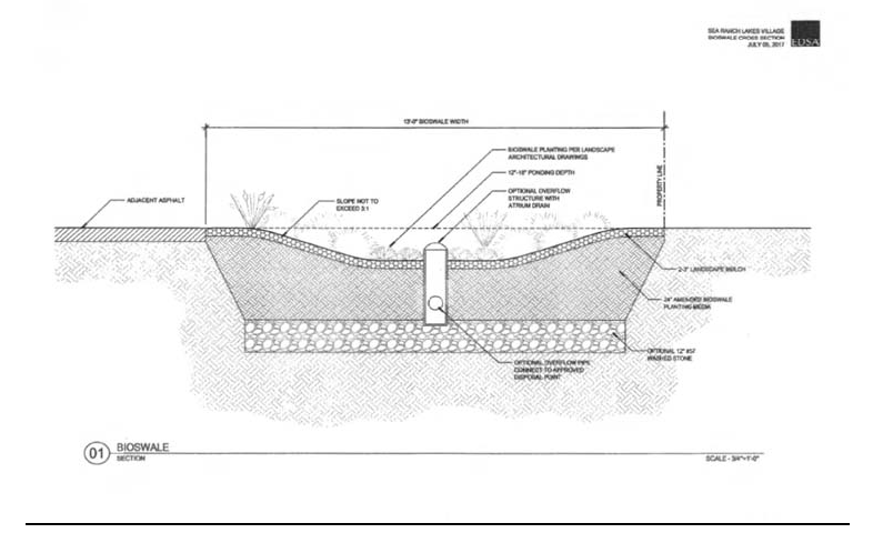
(Ord. No. 2018-01, § 2, 5-23-18)
4.01.13. - Commercial District.
1.
Any owner of real property designated commercial by the Village of Sea Ranch Lakes Comprehensive Plan, as defined the Code of Ordinances of the Village of Sea Ranch Lakes, and upon which there is located a vehicular use area (VUA), prior to receiving a development order as set forth in the Land Development Regulations shall submit a site plan to the Village of Sea Ranch Lakes for its review and approval. The site plan submitted shall show all traffic ways and landscaping. The landscaping plan as submitted with the site plan shall identify the location and type of plant materials to be installed. Installation of the landscaping shall be completed within ninety (90) days following the approval of the site plan by the Village Council. For purposes of this section, Vehicular Use Area shall include all areas used for the display or parking of motor vehicles plus the access drives thereto or on side streets. For purposes of this section, all plant material shall be graded Florida Number One or better, in accordance with "Grades and Standards of Nursery Plants," published by the Division of Plant Industry, Florida Department of Agriculture.
(A)
Maintenance. The owner, tenant and their agent, if any, shall be jointly and severally responsible for the maintenance of all landscaping which shall be maintained in a healthy growing condition and shall be kept free of refuse and debris. "Hatracking" or trimming more than thirty (30%) percent of the foliage from a tree or creating numerous branch stubs more than three (3) inches in diameter is prohibited and shall be considered a violation of this Chapter [Ordinance].
(B)
Enforcement.
(i)
The landscaping maintained within a commercial district may be inspected periodically by the Village Code Enforcement Officer to ensure proper maintenance. The owner, tenant, or their agent shall be notified by the Code Enforcement Officer, in writing, of any areas which are not properly maintained and shall, within fifteen (15) days from the time of notification, restore the landscape to a healthy condition. All notices shall be provided in accordance with the procedures set forth in Section 4.01.09.
(ii)
It shall be unlawful for any owner, tenant or their agent to fail to restore the landscaping within fifteen (15) calendar days after notice has been given, so that said landscaping conforms to the plans submitted to and approved by the Code Enforcement Officer. The failure to comply with the notice provided by the Code Enforcement Officer shall result in the offense being brought before the Village Code Enforcement Board for its consideration and enforcement consistent with the provisions set forth herein.
(C)
All site plans shall be considered by the Village Council following a public hearing. If the Village Council finds, that the landscaping and traffic ways shown thereon will improve the appearance of the commercial district and/or the VUA and protect and preserve the appearance, character and value of the surrounding neighborhood, that it will further promote better air quality and thereby promote the general welfare by providing for installation and maintenance of landscaping screening and aesthetic qualities, then in that event the Village Council may approve the site plan.
(D)
All trees which shall be installed in a commercial district or VUA shall be selected from a list on file and maintained with the Village Clerk. Substitutions may be made from such list without further approval. Any reconfiguration of the landscaping shall be permitted only after approval is obtained from the Village Council.
(E)
In the event of an expansion of the building area located in the Commercial District or served by the VUA by seven and one half (7.5%) percent, a new site plan shall be submitted and approved before any such expansion will be permitted.
(Ord. No. 92-2, § 2(4.01.10), 3-10-92)
Editor's note— Ord. No. 2017-04, § 2.2, adopted Oct. 11, 2017, repealed §§ 4.01.00[.01]—4.01.09, which pertained to trees [and vegetative cover] and renumbered former § 4.01.10, commercial district, as § 4.01.11. Ord. No. 2018-01, § 2, adopted May 23, 2018, added new §§ 4.01.11, fences, and 4.01.12, bioswales, as set out herein and renumbered former § 4.01.11 as § 4.01.13. The historical note of said section has been preserved for reference purposes.
Appendix 1
Recommended tree list for canopy replacement including Category 1, 2, 3 and 4 trees.
Category 1
Replacements will be twelve-foot minimum height, 3.0-inch caliper at the time of planting.
Category 2
Replacements will be ten-foot minimum height, 1½-inch caliper at time of planting.
Category 3
Replacements will be eight-foot minimum height, 1½-inch caliper at the time of planting.
Category 4—Palm Trees
Replacements will be a minimum of twelve (12) feet overall.
(Ord. No. 2017-04, § 2, 10-11-17)
4.02.01. - General Provisions.
In addition to meeting the following protection of environmentally sensitive lands requirements, development plans shall comply with applicable federal, state and water management district regulations relating to environmentally sensitive lands. In all cases the strictest of the applicable standards shall apply.
4.02.02. - Definitions.
Adverse Effects: Any modifications, alterations, or effects on waters, or shorelands, including their quality, quantity, hydrology, surface area, species composition, or usefulness for human or natural uses which are or may potentially be harmful or injurious to human health, welfare, safety or property, to biological productivity, diversity, or stability or which unreasonably interfere with the reasonable use of property, including outdoor recreation. The term includes secondary and cumulative as well as direct impacts.
Beneficial Functions of a Protected Environmentally Sensitive Area: Those functions, described in the Conservation Element of the Comprehensive Plan, that justify designating an area as environmentally sensitive.
Clearing: The removal of trees and brush from the land, not including the ordinary mowing of grass.
Pollutant: Any substance, contaminant, noise, or manmade or man-induced alteration of the chemical, physical, biological, or radiological integrity of air or water in quantities or at levels which are or may be potentially harmful or injurious to human health or welfare, animal or plant life, or property, or which unreasonably interfere with the enjoyment of life or property, including outdoor recreation.
Protected Environmentally Sensitive Area: An environmentally sensitive area designated for protection in the Conservation Element of the Village Comprehensive Plan.
Significant Adverse Effect: Any modification, alteration, or effect upon a Protected Environmentally Sensitive Area which measurably reduces the Area's beneficial functions as delineated in the Conservation Element of the Village Comprehensive Plan.
Water or Waters: Includes, but is not limited to, water on or beneath the surface of the ground or in the atmosphere, including natural or artificial watercourses, streams, rivers, lakes, ponds, or diffused surface water and water percolating, standing, or flowing beneath the surface of the ground.
Water Body: Any natural or artificial pond, lake, reservoir, or other area with a discernible shoreline which ordinarily or intermittently contains water.
Watercourse: Any natural or artificial channel, ditch, canal, stream, river, creek, waterway or wetland through which water flows in a definite direction, either continuously or intermittently, and which has a definite channel, bed, banks, or other discernible boundary.
4.02.03. - Creation of Protected Environmentally Sensitive Zones.
A.
Shoreline Protection.
1.
No removal of any native coastal vegetation will be permitted.
2.
All applications for development approval will require a site plan review to protect against any adverse effects or harm to beneficial functions of the shoreline.
3.
All applications for development will be reviewed to insure minimum negative environmental impact on the Lakes in regards to soil erosion, water quality and stormwater management.
B.
Beach Club and Recreation and Open Space.
1.
The Beach Club area and all areas designated as recreation and open space on the Future Land Use Map of the Village Comprehensive Plan shall be protected.
2.
All applications for development approval will require a site plan review to protect against any adverse effects or harm to the beneficial functions of the oceanfront and beach area.
3.
All applications for recreational development will be reviewed to insure minimal environmental impact, and must also demonstrate no adverse impact to the beach area or the Village's natural environment.
4.
No public funds will be spent on any project which will cause beach erosion or cause negative impacts on water quality.
4.02.04. - Protection of Lakes from the Discharge of Hazardous Materials.
A.
Activities in the residential areas that contribute hazardous materials to the water that is discharged into the lakes are prohibited.
B.
In residential areas, no toxic or hazardous materials shall be stored in outside containers.
C.
Fertilizers, pesticides, and herbicides used in residential areas shall be applied sparingly and at appropriate rates and time intervals.
4.03.01. - General Provisions.
(a)
Title. These regulations shall be known as the Floodplain Management Ordinance of the Village of Sea Ranch Lakes, hereinafter referred to as "this ordinance."
(b)
Scope. The provisions of this section shall apply to all development that is wholly within or partially within any flood hazard area, including but not limited to the subdivision of land; filling, grading, and other site improvements and utility installations; construction, alteration, remodeling, enlargement, improvement, replacement, repair, relocation or demolition of buildings, structures, and facilities that are exempt from the Florida Building Code; placement, installation, or replacement of manufactured homes and manufactured buildings; installation or replacement of tanks; placement of recreational vehicles; installation of swimming pools; and any other development.
(c)
Intent. The purposes of this section and the flood load and flood resistant construction requirements of the Florida Building Code are to establish minimum requirements to safeguard the public health, safety, and general welfare and to minimize public and private losses due to flooding through regulation of development in flood hazard areas to:
(1)
Minimize unnecessary disruption of commerce, access and public service during times of flooding;
(2)
Require the use of appropriate construction practices in order to prevent or minimize future flood damage;
(3)
Manage filling, grading, dredging, mining, paving, excavation, drilling operations, storage of equipment or materials, and other development which may increase flood damage or erosion potential;
(4)
Manage the alteration of flood hazard areas, watercourses, and shorelines to minimize the impact of development on the natural and beneficial functions of the floodplain;
(5)
Minimize damage to public and private facilities and utilities;
(6)
Help maintain a stable tax base by providing for the sound use and development of flood hazard areas;
(7)
Minimize the need for future expenditure of public funds for flood control projects and response to and recovery from flood events; and
(8)
Meet the requirements of the National Flood Insurance Program for community participation as set forth in the Title 44 Code of Federal Regulations, Section 59.22.
(d)
Coordination with the Florida Building Code. This section is intended to be administered and enforced in conjunction with the Florida Building Code. Where cited, ASCE 24 refers to the edition of the standard that is referenced by the Florida Building Code.
(e)
Warning. The degree of flood protection required by this section and the Florida Building Code, as amended by the Village Council, is considered the minimum reasonable for regulatory purposes and is based on scientific and engineering considerations. Larger floods can and will occur. Flood heights may be increased by man-made or natural causes. This section does not imply that land outside of mapped special flood hazard areas, or that uses permitted within such flood hazard areas, will be free from flooding or flood damage. The flood hazard areas and base flood elevations contained in the Flood Insurance Study and shown on Flood Insurance Rate Maps and the requirements of Title 44 Code of Federal Regulations, Sections 59 and 60 may be revised by the Federal Emergency Management Agency, requiring this community to revise these regulations to remain eligible for participation in the National Flood Insurance Program. No guaranty of vested use, existing use, or future use is implied or expressed by compliance with this section.
(f)
Disclaimer of Liability. This section shall not create liability on the part of the Village Council of Village of Sea Ranch Lakes or by any officer or employee thereof for any flood damage that results from reliance on this section or any administrative decision lawfully made thereunder.
(Ord. No. 2014-04, § 2, 5-21-14)
4.03.02. - Applicability.
(a)
General. Where there is a conflict between a general requirement and a specific requirement, the specific requirement shall be applicable.
(b)
Areas to Which this Section Applies. This section shall apply to all flood hazard areas within the Village of Sea Ranch Lakes, as established in Section 4.03.02(c).
(c)
Basis for Establishing Flood Hazard Areas. The Flood Insurance Study for Broward County, Florida and Incorporated Areas dated July 31, 2024, and all subsequent amendments and revisions, and the accompanying Flood Insurance Rate Maps (FIRM), and all subsequent amendments and revisions to such maps, are adopted by reference as a part of this section and shall serve as the minimum basis for establishing flood hazard areas. Studies and maps that establish flood hazard areas are on file at the Office of the Building Official.
(d)
Submission of Additional Data to Establish Flood Hazard Areas. To establish flood hazard areas and base flood elevations, pursuant to Section 4.03.05 the Floodplain Administrator may require submission of additional data. Where field surveyed topography prepared by a Florida licensed professional surveyor or digital topography accepted by the community indicates that ground elevations:
(1)
Are below the closest applicable base flood elevation, even in areas not delineated as a special flood hazard area on a FIRM, the area shall be considered as flood hazard area and subject to the requirements of this section and, as applicable, the requirements of the Florida Building Code.
(2)
Are above the closest applicable base flood elevation, the area shall be regulated as special flood hazard area unless the applicant obtains a Letter of Map Change that removes the area from the special flood hazard area.
(e)
Other Laws. The provisions of this section shall not be deemed to nullify any provisions of local, state, or federal law.
(f)
Abrogation and greater restrictions. This section supersedes any ordinance in effect for management of development in flood hazard areas. However, it is not intended to repeal or abrogate any existing ordinances including but not limited to land development regulations, zoning ordinances, stormwater management regulations, or the Florida Building Code. In the event of a conflict between this section and any other section, the more restrictive shall govern. This section shall not impair any deed restriction, covenant or easement, but any land that is subject to such interests shall also be governed by this section.
(g)
Interpretation. In the interpretation and application of this section, all provisions shall be:
(1)
Considered as minimum requirements;
(2)
Liberally construed in favor of the governing body; and
(3)
Deemed neither to limit nor repeal any other powers granted under state statutes.
(Ord. No. 2014-04, § 2, 5-21-14; Ord. No. 2024-01, § 2, 7-10-24)
4.03.03. - Duties and Powers of the Floodplain Administrator.
(a)
Designation. The Village Building Official is designated as the Floodplain Administrator. The Floodplain Administrator may delegate performance of certain duties to other employees.
(b)
General. The Floodplain Administrator is authorized and directed to administer and enforce the provisions of this section. The Floodplain Administrator shall have the authority to render interpretations of this section consistent with the intent and purpose of this section and may establish policies and procedures in order to clarify the application of its provisions. Such interpretations, policies, and procedures shall not have the effect of waiving requirements specifically provided in this section without the granting of a variance pursuant to Section 4.03.07.
(c)
Applications and Permits. The Floodplain Administrator, in coordination with the Village Council, shall:
(1)
Review applications and plans to determine whether proposed new development will be located in flood hazard areas;
(2)
Review applications for modification of any existing development in flood hazard areas for compliance with the requirements of this section;
(3)
Interpret flood hazard area boundaries where such interpretation is necessary to determine the exact location of boundaries; a person contesting the determination shall have the opportunity to appeal the interpretation;
(4)
Provide available flood elevation and flood hazard information;
(5)
Determine whether additional flood hazard data shall be obtained from other sources or shall be developed by an applicant;
(6)
Review applications to determine whether proposed development will be reasonably safe from flooding;
(7)
Issue floodplain development permits or approvals for development other than buildings and structures that are subject to the Florida Building Code, including buildings, structures and facilities exempt from the Florida Building Code, when compliance with this section is demonstrated, or disapprove the same in the event of noncompliance; and
(8)
Coordinate with and provide comments to the Building Official to assure that applications, plan reviews, and inspections for buildings and structures in flood hazard areas comply with the applicable provisions of this section.
(d)
Substantial Improvement and Substantial Damage Determinations. For applications for building permits to improve buildings and structures, including alterations, movement, enlargement, replacement, repair, change of occupancy, additions, rehabilitations, renovations, substantial improvements, repairs of substantial damage, and any other improvement of or work on such buildings and structures, the Floodplain Administrator, in coordination with the Building Official, shall:
(1)
Estimate the market value, or require the applicant to obtain an appraisal of the market value prepared by a qualified independent appraiser, of the building or structure before the start of construction of the proposed work; in the case of repair, the market value of the building or structure shall be the market value before the damage occurred and before any repairs are made;
(2)
Compare the cost to perform the improvement, the cost to repair a damaged building to its pre-damaged condition, or the combined costs of improvements and repairs, if applicable, to the market value of the building or structure;
(3)
Determine and document whether the proposed work constitutes substantial improvement or repair of substantial damage; and
(4)
Notify the applicant if it is determined that the work constitutes substantial improvement or repair of substantial damage and that compliance with the flood resistant construction requirements of the Florida Building Code and this section is required.
(e)
Modifications of the Strict Application of the Requirements of the Florida Building Code. The Floodplain Administrator shall review requests submitted to the Building Official that seek approval to modify the strict application of the flood load and flood resistant construction requirements of the Florida Building Code to determine whether such requests require the granting of a variance pursuant to Section 4.03.07.
(f)
Notices and Orders. The Floodplain Administrator shall coordinate with appropriate local agencies for the issuance of all necessary notices or orders to ensure compliance with this section.
(g)
Inspections. The Floodplain Administrator shall make the required inspections as specified in Section 4.03.06 for development that is not subject to the Florida Building Code, including buildings, structures and facilities exempt from the Florida Building Code. The Floodplain Administrator shall inspect flood hazard areas to determine if development is undertaken without issuance of a permit.
(h)
Other Duties of the Floodplain Administrator. The Floodplain Administrator shall have other duties, including but not limited to:
(1)
Establish, in coordination with the Building Official, procedures for administering and documenting determinations of substantial improvement and substantial damage made pursuant to Section 4.03.03(d);
(2)
Require that applicants proposing alteration of a watercourse notify adjacent communities and the Florida Division of Emergency Management, State Floodplain Management Office, and submit copies of such notifications to the Federal Emergency Management Agency (FEMA);
(3)
Require applicants who submit hydrologic and hydraulic engineering analyses to support permit applications to submit to FEMA the data and information necessary to maintain the Flood Insurance Rate Maps if the analyses propose to change base flood elevations, flood hazard area boundaries, or floodway designations; such submissions shall be made within 6 months of such data becoming available;
(4)
Review required design certifications and documentation of elevations specified by this section and the Florida Building Code and this Code to determine that such certifications and documentations are complete;
(5)
Notify the Federal Emergency Management Agency when the corporate boundaries of Village of Sea Ranch Lakes are modified; and
(6)
Advise applicants for new buildings and structures, including substantial improvements, that are located in any unit of the Coastal Barrier Resources System established by the Coastal Barrier Resources Act (Pub. L. 97-348) and the Coastal Barrier Improvement Act of 1990 (Pub. L. 101-591) that federal flood insurance is not available on such construction; areas subject to this limitation are identified on Flood Insurance Rate Maps as "Coastal Barrier Resource System Areas" and "Otherwise Protected Areas."
(i)
Floodplain Management Records. Regardless of any limitation on the period required for retention of public records, the Floodplain Administrator shall maintain and permanently keep and make available for public inspection all records that are necessary for the administration of this section and the flood resistant construction requirements of the Florida Building Code, including Flood Insurance Rate Maps; Letters of Change; records of issuance of permits and denial of permits; determinations of whether proposed work constitutes substantial improvement or repair of substantial damage; required design certifications and documentation of elevations specified by the Florida Building Code and this section; notifications to adjacent communities, FEMA, and the state related to alterations of watercourses; assurances that the flood carrying capacity of altered watercourses will be maintained; documentation related to appeals and variances, including justification for issuance or denial; and records of enforcement actions taken pursuant to this section and the flood resistant construction requirements of the Florida Building Code. These records shall be available for public inspection at the office of the Building Official.
(Ord. No. 2014-04, § 2, 5-21-14)
4.03.04. - Permits.
(a)
Permits Required. Any owner or owner's authorized agent (hereinafter "applicant") who intends to undertake any development activity within the scope of this section, including buildings, structures and facilities exempt from the Florida Building Code, which is wholly within or partially within any flood hazard area shall first make application to the Floodplain Administrator, and the Building Official if applicable, and shall obtain the required permit(s) and approval(s). No such permit or approval shall be issued until compliance with the requirements of this section and all other applicable codes and regulations has been satisfied.
(b)
Floodplain Development Permits or Approvals. Floodplain development permits or approvals shall be issued pursuant to this section for any development activities not subject to the requirements of the Florida Building Code, including buildings, structures and facilities exempt from the Florida Building Code. Depending on the nature and extent of proposed development that includes a building or structure, the Floodplain Administrator may determine that a floodplain development permit or approval is required in addition to a building permit.
(c)
Buildings, Structures and Facilities Exempt from the Florida Building Code. Pursuant to the requirements of federal regulation for participation in the National Flood Insurance Program (44 C.F.R. Sections 59 and 60), floodplain development permits or approvals shall be required for the following buildings, structures and facilities that are exempt from the Florida Building Code and any further exemptions provided by law, which are subject to the requirements of this section:
(1)
Railroads and ancillary facilities associated with the railroad.
(2)
Nonresidential farm buildings on farms, as provided in F.S. § 604.50.
(3)
Temporary buildings or sheds used exclusively for construction purposes.
(4)
Mobile or modular structures used as temporary offices.
(5)
Those structures or facilities of electric utilities, as defined in F.S. § 366.02, which are directly involved in the generation, transmission, or distribution of electricity.
(6)
Chickees constructed by the Miccosukee Tribe of Indians of Florida or the Seminole Tribe of Florida. As used in this paragraph, the term "chickee" means an open-sided wooden hut that has a thatched roof of palm or palmetto or other traditional materials, and that does not incorporate any electrical, plumbing, or other non-wood features.
(7)
Family mausoleums not exceeding 250 square feet in area which are prefabricated and assembled on site or preassembled and delivered on site and have walls, roofs, and a floor constructed of granite, marble, or reinforced concrete.
(8)
Temporary housing provided by the Department of Corrections to any prisoner in the state correctional system.
(9)
Structures identified in F.S. § 553.73(10)(k), are not exempt from the Florida Building Code if such structures are located in flood hazard areas established on Flood Insurance Rate Maps.
(d)
Application for a Permit or Approval. To obtain a floodplain development permit or approval the applicant shall first file an application in writing on a form furnished by the Village Council. The information provided shall:
(1)
Identify and describe the development to be covered by the permit or approval.
(2)
Describe the land on which the proposed development is to be conducted by legal description, street address or similar description that will readily identify and definitively locate the site.
(3)
Indicate the use and occupancy for which the proposed development is intended.
(4)
Be accompanied by a site plan or construction documents as specified in Section 4.03.05.
(5)
State the valuation of the proposed work.
(6)
Be signed by the applicant or the applicant's authorized agent.
(7)
Give such other data and information as required by the Floodplain Administrator.
(e)
Validity of Permit or Approval. The issuance of a floodplain development permit or approval pursuant to this section shall not be construed to be a permit for, or approval of, any violation of this section, the Florida Building Codes, or any other ordinance of this community. The issuance of permits based on submitted applications, construction documents, and information shall not prevent the Floodplain Administrator from requiring the correction of errors and omissions.
(f)
Expiration. A floodplain development permit or approval shall become invalid unless the work authorized by such permit is commenced within 180 days after its issuance, or if the work authorized is suspended or abandoned for a period of 180 days after the work commences. Extensions for periods of not more than 180 days each shall be requested in writing and justifiable cause shall be demonstrated.
(g)
Suspension or Revocation. The Floodplain Administrator is authorized to suspend or revoke a floodplain development permit or approval if the permit was issued in error, on the basis of incorrect, inaccurate or incomplete information, or in violation of this section or any other ordinance, regulation or requirement of this community.
(h)
Other Permits Required. Floodplain development permits and building permits shall include a condition that all other applicable state or federal permits be obtained before commencement of the permitted development, including but not limited to the following:
(1)
The South Florida Water Management District; F.S. § 373.036.
(2)
Florida Department of Health for onsite sewage treatment and disposal systems; F.S. § 381.0065 and Chapter 64E-6, F.A.C.
(3)
Florida Department of Environmental Protection for construction, reconstruction, changes, or physical activities for shore protection or other activities seaward of the coastal construction control line; F.S. § 161.141.
(4)
Florida Department of Environmental Protection for activities subject to the Joint Coastal Permit; F.S. § 161.055.
(5)
Florida Department of Environmental Protection for activities that affect wetlands and alter surface water flows, in conjunction with the U.S. Army Corps of Engineers; Section 404 of the Clean Water Act.
(6)
Federal permits and approvals.
(Ord. No. 2014-04, § 2, 5-21-14)
4.03.05. - Site Plans and Construction Documents.
(a)
Information for Development in Flood Hazard Areas. The site plan or construction documents for any development subject to the requirements of this section shall be drawn to scale and shall include, as applicable to the proposed development:
(1)
Delineation of flood hazard areas, floodway boundaries and flood zone(s), base flood elevation(s), and ground elevations if necessary for review of the proposed development.
(2)
Where base flood elevations, or floodway data are not included on the FIRM or in the Flood Insurance Study, they shall be established in accordance with Section 4.03.05(b)(2) or (3).
(3)
Where the parcel on which the proposed development will take place will have more than 50 lots or is larger than 5 acres and the base flood elevations are not included on the FIRM or in the Flood Insurance Study, such elevations shall be established in accordance with Section 4.03.05(b)(1).
(4)
Location of the proposed activity and proposed structures, and locations of existing buildings and structures; in coastal high hazard areas, new buildings shall be located landward of the reach of mean high tide.
(5)
Location, extent, amount, and proposed final grades of any filling, grading, or excavation.
(6)
Where the placement of fill is proposed, the amount, type, and source of fill material; compaction specifications; a description of the intended purpose of the fill areas; and evidence that the proposed fill areas are the minimum necessary to achieve the intended purpose.
(7)
Delineation of the Coastal Construction Control Line or notation that the site is seaward of the coastal construction control line, if applicable.
(8)
Extent of any proposed alteration of sand dunes or mangrove stands, provided such alteration is approved by the Florida Department of Environmental Protection.
(9)
Existing and proposed alignment of any proposed alteration of a watercourse.
(10)
Proposed elevations along property boundaries, matching those of adjacent lands.
The Floodplain Administrator is authorized to waive the submission of site plans, construction documents, and other data that are required by this section but that are not required to be prepared by a registered design professional if it is found that the nature of the proposed development is such that the review of such submissions is not necessary to ascertain compliance with this section.
(b)
Information in Flood Hazard Areas Without Base Flood Elevations (Approximate Zone A). Where flood hazard areas are delineated on the FIRM and base flood elevation data have not been provided, the Floodplain Administrator shall:
(1)
Require the applicant to include base flood elevation data prepared in accordance with currently accepted engineering practices.
(2)
Obtain, review, and provide to applicants base flood elevation and floodway data available from a federal or state agency or other source or require the applicant to obtain and use base flood elevation and floodway data available from a federal or state agency or other source.
(3)
Where base flood elevation and floodway data are not available from another source, where the available data are deemed by the Floodplain Administrator to not reasonably reflect flooding conditions, or where the available data are known to be scientifically or technically incorrect or otherwise inadequate:
(a)
Require the applicant to include base flood elevation data prepared in accordance with currently accepted engineering practices; or
(b)
Specify that the base flood elevation is two (2) feet above the highest adjacent grade at the location of the development, provided there is no evidence indicating flood depths have been or may be greater than two (2) feet.
(4)
Where the base flood elevation data are to be used to support a Letter of Map Change from FEMA, advise the applicant that the analyses shall be prepared by a Florida licensed engineer in a format required by FEMA, and that it shall be the responsibility of the applicant to satisfy the submittal requirements and pay the processing fees.
(c)
Additional Analyses and Certifications. As applicable to the location and nature of the proposed development activity, and in addition to the requirements of this section, the applicant shall have the following analyses signed and sealed by a Florida licensed engineer for submission with the site plan and construction documents:
(1)
For development activities proposed to be located in a regulatory floodway, a floodway encroachment analysis that demonstrates that the encroachment of the proposed development will not cause any increase in base flood elevations; where the applicant proposes to undertake development activities that do increase base flood elevations, the applicant shall submit such analysis to FEMA as specified in Section 4.03.05(d) and shall submit the Conditional Letter of Map Revision, if issued by FEMA, with the site plan and construction documents.
(2)
For development activities proposed to be located in a riverine flood hazard area for which base flood elevations are included in the Flood Insurance Study or on the FIRM and floodways have not been designated, hydrologic and hydraulic analyses that demonstrate that the cumulative effect of the proposed development, when combined with all other existing and anticipated flood hazard area encroachments, will not increase the base flood elevation more than one (1) foot at any point within the community. This requirement does not apply in isolated flood hazard areas not connected to a riverine flood hazard area or in flood hazard areas identified as Zone AO or Zone AH.
(3)
For alteration of a watercourse, an engineering analysis prepared in accordance with standard engineering practices which demonstrates that the flood-carrying capacity of the altered or relocated portion of the watercourse will not be decreased, and certification that the altered watercourse shall be maintained in a manner which preserves the channel's flood-carrying capacity; the applicant shall submit the analysis to FEMA as specified in Section 4.03.05(d).
(4)
For activities that propose to alter sand dunes or mangrove stands in coastal high hazard areas (Zone V), an engineering analysis that demonstrates that the proposed alteration will not increase the potential for flood damage.
(d)
Submission of Additional Data. When additional hydrologic, hydraulic or other engineering data, studies, and additional analyses are submitted to support an application, the applicant has the right to seek a Letter of Map Change from FEMA to change the base flood elevations, change floodway boundaries, or change boundaries of flood hazard areas shown on FIRMs, and to submit such data to FEMA for such purposes. The analyses shall be prepared by a Florida licensed engineer in a format required by FEMA. Submittal requirements and processing fees shall be the responsibility of the applicant.
(Ord. No. 2014-04, § 2, 5-21-14; Ord. No. 2023-02, § 3, 5-17-23)
4.03.06. - Inspections.
(a)
Inspections—General. Development for which a floodplain development permit or approval is required shall be subject to inspection.
(b)
Development Other Than Buildings and Structures. The Floodplain Administrator shall inspect all development to determine compliance with the requirements of this section and the conditions of issued floodplain development permits or approvals.
(c)
Buildings, Structures and Facilities Exempt from the Florida Building Code. The Floodplain Administrator shall inspect buildings, structures and facilities exempt from the Florida Building Code to determine compliance with the requirements of this section and the conditions of issued floodplain development permits or approvals.
(d)
Buildings, Structures and Facilities Exempt from the Florida Building Code, Lowest Floor Inspection. Upon placement of the lowest floor, including basement, and prior to further vertical construction, the owner of a building, structure or facility exempt from the Florida Building Code, or the owner's authorized agent, shall submit to the Floodplain Administrator:
(1)
If a design flood elevation was used to determine the required elevation of the lowest floor, the certification of elevation of the lowest floor prepared and sealed by a Florida licensed professional surveyor; or
(2)
If the elevation used to determine the required elevation of the lowest floor was determined in accordance with Section 4.03.05(b)(3)(b), the documentation of height of the lowest floor above highest adjacent grade, prepared by the owner or the owner's authorized agent.
(e)
Buildings, Structures and Facilities Exempt from the Florida Building Code, Final Inspection. As part of the final inspection, the owner or owner's authorized agent shall submit to the Floodplain Administrator a final certification of elevation of the lowest floor or final documentation of the height of the lowest floor above the highest adjacent grade; such certifications and documentations shall be prepared as specified in Section 4.03.06(d).
(f)
Manufactured Homes. The Floodplain Administrator or designee shall inspect manufactured homes that are installed or replaced in flood hazard areas to determine compliance with the requirements of this section and the conditions of the issued permit. Upon placement of a manufactured home, certification of the elevation of the lowest floor shall be submitted to the Floodplain Administrator or designee.
(Ord. No. 2014-04, § 2, 5-21-14)
4.03.07. - Variances and Appeals.
(a)
General. The Village Council shall hear and decide on requests for appeals and requests for variances from the strict application of this section. Pursuant to F.S. § 553.73(5), the Village Council shall hear and decide on requests for appeals and requests for variances from the strict application of the flood resistant construction requirements of the Florida Building Code. This section does not apply to Section 3109 of the Florida Building Code, Building.
(b)
Appeals. The Village Council shall hear and decide appeals when it is alleged there is an error in any requirement, decision, or determination made by the Floodplain Administrator in the administration and enforcement of this section. Any person aggrieved by the decision of Village Council may appeal such decision to the Circuit Court, as provided by Florida Statutes.
(c)
Limitations on Authority to Grant Variances. The Village Council shall base its decisions on variances on technical justifications submitted by applicants, the considerations for issuance in Section 4.07(g), the conditions of issuance set forth in Section 4.07(h), and the comments and recommendations of the Floodplain Administrator and the Village Council. The Board of Adjustment has the right to attach such conditions as it deems necessary to further the purposes and objectives of this section.
(d)
Restrictions in Floodways. A variance shall not be issued for any proposed development in a floodway if any increase in base flood elevations would result, as evidenced by the applicable analyses and certifications required in Section 4.05(c).
(e)
Historic Buildings. A variance is authorized to be issued for the repair, improvement, or rehabilitation of a historic building that is determined eligible for the exception to the flood resistant construction requirements of the Florida Building Code, Existing Building, Chapter 11 Historic Buildings, upon a determination that the proposed repair, improvement, or rehabilitation will not preclude the building's continued designation as a historic building and the variance is the minimum necessary to preserve the historic character and design of the building. If the proposed work precludes the building's continued designation as a historic building, a variance shall not be granted and the building and any repair, improvement, and rehabilitation shall be subject to the requirements of the Florida Building Code.
(f)
Functionally Dependent Uses. A variance is authorized to be issued for the construction or substantial improvement necessary for the conduct of a functionally dependent use, as defined in this section, provided the variance meets the requirements of Section 4.07(d), is the minimum necessary considering the flood hazard, and all due consideration has been given to use of methods and materials that minimize flood damage during occurrence of the base flood.
(g)
Considerations for Issuance of Variances. In reviewing requests for variances, the Village Council shall consider all technical evaluations, all relevant factors, all other applicable provisions of the Florida Building Code, this section, and the following:
(1)
The danger that materials and debris may be swept onto other lands resulting in further injury or damage;
(2)
The danger to life and property due to flooding or erosion damage;
(3)
The susceptibility of the proposed development, including contents, to flood damage and the effect of such damage on current and future owners;
(4)
The importance of the services provided by the proposed development to the community;
(5)
The availability of alternate locations for the proposed development that are subject to lower risk of flooding or erosion;
(6)
The compatibility of the proposed development with existing and anticipated development;
(7)
The relationship of the proposed development to the comprehensive plan and floodplain management program for the area;
(8)
The safety of access to the property in times of flooding for ordinary and emergency vehicles;
(9)
The expected heights, velocity, duration, rate of rise and debris and sediment transport of the floodwaters and the effects of wave action, if applicable, expected at the site; and
(10)
The costs of providing governmental services during and after flood conditions including maintenance and repair of public utilities and facilities such as sewer, gas, electrical and water systems, streets and bridges.
(h)
Conditions for Issuance of Variances. Variances shall be issued only upon:
(1)
Submission by the applicant, of a showing of good and sufficient cause that the unique characteristics of the size, configuration, or topography of the site limit compliance with any provision of this section or the required elevation standards;
(2)
Determination by the Village Council that:
(a)
Failure to grant the variance would result in exceptional hardship due to the physical characteristics of the land that render the lot undevelopable; increased costs to satisfy the requirements or inconvenience do not constitute hardship;
(b)
The granting of a variance will not result in increased flood heights, additional threats to public safety, extraordinary public expense, nor create nuisances, cause fraud on or victimization of the public or conflict with existing local laws and ordinances; and
(c)
The variance is the minimum necessary, considering the flood hazard, to afford relief;
(3)
Receipt of a signed statement by the applicant that the variance, if granted, shall be recorded in the Office of the Clerk of the Court in such a manner that it appears in the chain of title of the affected parcel of land; and
(4)
If the request is for a variance to allow construction of the lowest floor of a new building, or substantial improvement of a building, below the required elevation, a copy in the record of a written notice from the Floodplain Administrator to the applicant for the variance, specifying the difference between the base flood elevation and the proposed elevation of the lowest floor, stating that the cost of federal flood insurance will be commensurate with the increased risk resulting from the reduced floor elevation (up to amounts as high as $25 for $100 of insurance coverage), and stating that construction below the base flood elevation increases risks to life and property.
(Ord. No. 2014-04, § 2, 5-21-14)
4.03.08. - Violations.
(a)
Violations. Any development that is not within the scope of the Florida Building Code but that is regulated by this section that is performed without an issued permit, that is in conflict with an issued permit, or that does not fully comply with this section, shall be deemed a violation of this section. A building or structure without the documentation of elevation of the lowest floor, other required design certifications, or other evidence of compliance required by this section or the Florida Building Code is presumed to be a violation until such time as that documentation is provided.
(b)
Authority. For development that is not within the scope of the Florida Building Code but that is regulated by this section and that is determined to be a violation, the Floodplain Administrator is authorized to serve notices of violation or stop work orders to owners of the property involved, to the owner's agent, or to the person or persons performing the work.
(c)
Unlawful Continuance. Violation of the provisions of this Code or failure to comply with any of its requirements, including violation of conditions and safeguards established in connection with grants of variance or special exceptions, shall constitute a misdemeanor. Any person who violates this Code or fails to comply with any of its requirements shall be subject to the criminal penalties set forth in F.S. § 775.082(4)(b). Any person found to have violated this Code shall be responsible for all costs and expenses incurred by the Village of Sea Ranch Lakes, Florida in enforcing the Code. Each day a cited violation continues shall be considered a separate offense. Nothing herein contained shall prevent the Village of Sea Ranch Lakes, Florida, from taking such other lawful action as is necessary to prevent or remedy any violation.
(Ord. No. 2014-04, § 2, 5-21-14)
4.03.09. - Definitions.
(a)
Scope. Unless otherwise expressly stated, the following words and terms shall, for the purposes of this Code, have the meanings shown in this section.
(b)
Terms Defined in the Florida Building Code. Where terms are not defined in this section and are defined in the Florida Building Code, such terms shall have the meanings ascribed to them in that code.
(c)
Terms Not Defined. Where terms are not defined in this section or the Florida Building Code, such terms shall have ordinarily accepted meanings such as the context implies.
(d)
Definitions.
(1)
Alteration of a watercourse. A dam, impoundment, channel relocation, change in channel alignment, channelization, or change in cross-sectional area of the channel or the channel capacity, or any other form of modification which may alter, impede, retard or change the direction and/or velocity of the riverine flow of water during conditions of the base flood.
(2)
Appeal. A request for a review of the Floodplain Administrator's interpretation of any provision of this section or a request for a variance.
(3)
ASCE 24. A standard titled Flood Resistant Design and Construction that is referenced by the Florida Building Code. ASCE 24 is developed and published by the American Society of Civil Engineers, Reston, VA.
(4)
Base flood. A flood having a 1-percent chance of being equaled or exceeded in any given year. The base flood is commonly referred to as the "100-year flood" or the "1-percent-annual chance flood."
(5)
Base flood elevation. The elevation of the base flood, including wave height, relative to the National Geodetic Vertical Datum (NGVD), North American Vertical Datum (NAVD) or other datum specified on the Flood Insurance Rate Map (FIRM).
(6)
Basement. The portion of a building having its floor subgrade (below ground level) on all sides.
(7)
Coastal construction control line. The line established by the State of Florida pursuant to F.S. § 161.053, and recorded in the official records of the community, which defines that portion of the beach-dune system subject to severe fluctuations based on a 100-year storm surge, storm waves or other predictable weather conditions.
(8)
Coastal high hazard area. A special flood hazard area extending from offshore to the inland limit of a primary frontal dune along an open coast and any other area subject to high velocity wave action from storms or seismic sources. Coastal high hazard areas are also referred to as "high hazard areas subject to high velocity wave action" or "V Zones" and are designated on Flood Insurance Rate Maps (FIRM) as Zone V1-V30, VE, or V.
(9)
Design flood. The flood associated with the greater of the following two areas:
(1)
Area with a floodplain subject to a 1-percent or greater chance of flooding in any year; or
(2)
Area designated as a flood hazard area on the community's flood hazard map, or otherwise legally designated.
(10)
Design flood elevation. The elevation of the "design flood," including wave height, relative to the datum specified on the community's legally designated flood hazard map. In areas designated as Zone AO, the design flood elevation shall be the elevation of the highest existing grade of the buildings perimeter plus the depth number (in feet) specified on the flood hazard map. In areas designated as Zone AO where the depth number is not specified on the map, the depth number shall be taken as being equal to 2 feet.
(11)
Development. Any man-made change to improved or unimproved real estate, including but not limited to, buildings or other structures, tanks, temporary structures, temporary or permanent storage of equipment or materials, mining, dredging, filling, grading, paving, excavations, drilling operations or any other land disturbing activities.
(12)
Encroachment. The placement of fill, excavation, buildings, permanent structures or other development into a flood hazard area which may impede or alter the flow capacity of riverine flood hazard areas.
(13)
Existing building and existing structure. Any buildings and structures for which the "start of construction" commenced before February 16, 1977.
(14)
Existing manufactured home park or subdivision. A manufactured home park or subdivision for which the construction of facilities for servicing the lots on which the manufactured homes are to be affixed (including, at a minimum, the installation of utilities, the construction of streets, and either final site grading or the pouring of concrete pads) is completed before February 16, 1977.
(15)
Expansion to an existing manufactured home park or subdivision. The preparation of additional sites by the construction of facilities for servicing the lots on which the manufactured homes are to be affixed (including the installation of utilities, the construction of streets, and either final site grading or the pouring of concrete pads).
(16)
Federal Emergency Management Agency (FEMA). The federal agency that, in addition to carrying out other functions, administers the National Flood Insurance Program.
(17)
Flood or flooding. A general and temporary condition of partial or complete inundation of normally dry land from:
(1)
The overflow of inland or tidal waters.
(2)
The unusual and rapid accumulation or runoff of surface waters from any source.
(18)
Flood damage-resistant materials. Any construction material capable of withstanding direct and prolonged contact with floodwaters without sustaining any damage that requires more than cosmetic repair.
(19)
Flood hazard area. The greater of the following two areas:
(1)
The area within a floodplain subject to a 1-percent or greater chance of flooding in any year.
(2)
The area designated as a flood hazard area on the community's flood hazard map, or otherwise legally designated.
(20)
Flood Insurance Rate Map (FIRM). The official map of the community on which the Federal Emergency Management Agency has delineated both special flood hazard areas and the risk premium zones applicable to the community.
(21)
Flood Insurance Study (FIS). The official report provided by the Federal Emergency Management Agency that contains the Flood Insurance Rate Map, the Flood Boundary and Floodway Map (if applicable), the water surface elevations of the base flood, and supporting technical data.
(22)
Floodplain Administrator. The office or position designated and charged with the administration and enforcement of this section (may be referred to as the Floodplain Manager).
(23)
Floodplain development permit or approval. An official document or certificate issued by the community, or other evidence of approval or concurrence, which authorizes performance of specific development activities that are located in flood hazard areas and that are determined to be compliant with this section.
(24)
Floodway. The channel of a river or other riverine watercourse and the adjacent land areas that must be reserved in order to discharge the base flood without cumulatively increasing the water surface elevation more than one (1) foot.
(25)
Floodway encroachment analysis. An engineering analysis of the impact that a proposed encroachment into a floodway is expected to have on the floodway boundaries and base flood elevations; the evaluation shall be prepared by a qualified Florida licensed engineer using standard engineering methods and models.
(26)
Florida Building Code. The family of codes adopted by the Florida Building Commission, including: Florida Building Code, Building; Florida Building Code, Residential; Florida Building Code, Existing Building; Florida Building Code, Mechanical; Florida Building Code, Plumbing; Florida Building Code, Fuel Gas.
(27)
Functionally dependent use. A use which cannot perform its intended purpose unless it is located or carried out in close proximity to water, including only docking facilities, port facilities that are necessary for the loading and unloading of cargo or passengers, and ship building and ship repair facilities; the term does not include long-term storage or related manufacturing facilities.
(28)
Highest adjacent grade. The highest natural elevation of the ground surface prior to construction next to the proposed walls or foundation of a structure.
(29)
Historic structure. Any structure that is determined eligible for the exception to the flood hazard area requirements of the Florida Building Code, Existing Building, Chapter 11 Historic Buildings.
(30)
Letter of Map Change (LOMC). An official determination issued by FEMA that amends or revises an effective Flood Insurance Rate Map or Flood Insurance Study. Letters of Map Change include:
Letter of Map Amendment (LOMA): An amendment based on technical data showing that a property was incorrectly included in a designated special flood hazard area. A LOMA amends the current effective Flood Insurance Rate Map and establishes that a specific property, portion of a property, or structure is not located in a special flood hazard area.
Letter of Map Revision (LOMR): A revision based on technical data that may show changes to flood zones, flood elevations, special flood hazard area boundaries and floodway delineations, and other planimetric features.
Letter of Map Revision Based on Fill (LOMR-F): A determination that a structure or parcel of land has been elevated by fill above the base flood elevation and is, therefore, no longer located within the special flood hazard area. In order to qualify for this determination, the fill must have been permitted and placed in accordance with the community's floodplain management regulations.
Conditional Letter of Map Revision (CLOMR): A formal review and comment as to whether a proposed flood protection project or other project complies with the minimum NFIP requirements for such projects with respect to delineation of special flood hazard areas. A CLOMR does not revise the effective Flood Insurance Rate Map or Flood Insurance Study; upon submission and approval of certified as-built documentation, a Letter of Map Revision may be issued by FEMA to revise the effective FIRM.
(31)
Light-duty truck. As defined in 40 C.F.R. 86.082-2, any motor vehicle rated at 8,500 pounds Gross Vehicular Weight Rating or less which has a vehicular curb weight of 6,000 pounds or less and which has a basic vehicle frontal area of 45 square feet or less, which is:
(1)
Designed primarily for purposes of transportation of property or is a derivation of such a vehicle, or
(2)
Designed primarily for transportation of persons and has a capacity of more than 12 persons; or
(3)
Available with special features enabling off-street or off-highway operation and use.
(32)
Lowest floor. The lowest floor of the lowest enclosed area of a building or structure, including basement, but excluding any unfinished or flood-resistant enclosure, other than a basement, usable solely for vehicle parking, building access or limited storage provided that such enclosure is not built so as to render the structure in violation of the non-elevation requirements of the Florida Building Code or ASCE 24.
(33)
Manufactured home. A structure, transportable in one or more sections, which is eight (8) feet or more in width and greater than four hundred (400) square feet, and which is built on a permanent, integral chassis and is designed for use with or without a permanent foundation when attached to the required utilities. The term "manufactured home" does not include a "recreational vehicle" or "park trailer."
(34)
Manufactured home park or subdivision. A parcel (or contiguous parcels) of land divided into two or more manufactured home lots for rent or sale.
(35)
Market value. The value of buildings and structures, excluding the land and other improvements on the parcel. Market value is the Actual Cash Value (in-kind replacement cost depreciated for age, wear and tear, neglect, and quality of construction) determined by a qualified independent appraiser, or tax assessment value adjusted to approximate market value by a factor provided by the Broward County Property Appraiser.
(36)
New construction. For the purposes of administration of this section and the flood resistant construction requirements of the Florida Building Code, structures for which the "start of construction" commenced on or after February 16, 1977, and includes any subsequent improvements to such structures.
(37)
New manufactured home park or subdivision. A manufactured home park or subdivision for which the construction of facilities for servicing the lots on which the manufactured homes are to be affixed (including at a minimum, the installation of utilities, the construction of streets, and either final site grading or the pouring of concrete pads) is completed on or after February 16, 1977.
(38)
Park trailer. As defined in F.S. § 320.01, transportable unit which has a body width not exceeding fourteen (14) feet and which is built on a single chassis and is designed to provide seasonal or temporary living quarters when connected to utilities necessary for operation of installed fixtures and appliances.
(39)
Recreational vehicle. As defined in F.S. § 320.01, vehicle, including a park trailer, which is:
(1)
Built on a single chassis;
(2)
Four hundred (400) square feet or less when measured at the largest horizontal projection;
(3)
Designed to be self-propelled or permanently towable by a light-duty truck; and
(4)
Designed primarily not for use as a permanent dwelling but as temporary living quarters for recreational, camping, travel, or seasonal use.
(40)
Sand dunes. Naturally occurring accumulations of sand in ridges or mounds landward of the beach.
(41)
Special flood hazard area. An area in the floodplain subject to a 1 percent or greater chance of flooding in any given year. Special flood hazard areas are shown on FIRMs as Zone A, AO, A1-A30, AE, A99, AH, V1-V30, VE or V.
(42)
Start of construction. The date of issuance for new construction and substantial improvements to existing structures, provided the actual start of construction, repair, reconstruction, rehabilitation, addition, placement, or other improvement is within 180 days of the date of the issuance. The actual start of construction means either the first placement of permanent construction of a building (including a manufactured home) on a site, such as the pouring of slab or footings, the installation of piles, the construction of columns.
Permanent construction does not include land preparation (such as clearing, grading, or filling), the installation of streets or walkways, excavation for a basement, footings, piers, or foundations, the erection of temporary forms or the installation of accessory buildings such as garages or sheds not occupied as dwelling units or not part of the main buildings. For a substantial improvement, the actual "start of construction" means the first alteration of any wall, ceiling, floor or other structural part of a building, whether or not that alteration affects the external dimensions of the building.
(43)
Substantial damage.> Damage of any origin sustained by a building or structure whereby the cost of restoring the building or structure to its before-damaged condition would equal or exceeds 50 percent of the market value of the building or structure before the damage occurred.
(44)
Substantial improvement. Any repair, reconstruction, rehabilitation, addition, or other improvement of a building or structure, the cost of which equals or exceeds 50 percent of the market value of the building or structure before the improvement or repair is started. If the structure has incurred "substantial damage," any repairs are considered substantial improvement regardless of the actual repair work performed. The term does not, however, include any project for improvement of a building required to correct existing health, sanitary, or safety code violations identified by the building official and that are the minimum necessary to assure safe living conditions. For historic structures, please see Section 4.03.07(e).
(45)
Variance. A grant of relief from the requirements of this section, or the flood resistant construction requirements of the Florida Building Code, which permits construction in a manner that would not otherwise be permitted by this section or the Florida Building Code.
(46)
Watercourse. A river, creek, stream, channel or other topographic feature in, on, through, or over which water flows at least periodically.
(Ord. No. 2014-04, § 2, 5-21-14; Ord. No. 2024-01, § 3, 7-10-24)
4.03.10. - Buildings and Structures.
(a)
Design and Construction of Buildings, Structures and Facilities Exempt from the Florida Building Code. Pursuant to Section 4.03.04(c), buildings, structures, and facilities that are exempt from the Florida Building Code, including substantial improvement or repair of substantial damage of such buildings, structures and facilities, shall be designed and constructed in accordance with the flood load and flood resistant construction requirements of ASCE 24. Structures exempt from the Florida Building Code that are not walled and roofed buildings shall comply with the requirements of Section 4.03.16.
(b)
Buildings and Structures Seaward of the Coastal Construction Control Line. If extending, in whole or in part, seaward of the coastal construction control line and also located, in whole or in part, in a flood hazard area:
(1)
Buildings and structures shall be designed and constructed to comply with the more restrictive applicable requirements of the Florida Building Code, Building Section 3109 and Section 1612 or Florida Building Code, Residential Section R322.
(2)
Minor structures and non-habitable major structures as defined in F.S. § 161.54, shall be designed and constructed to comply with the intent and applicable provisions of this section and ASCE 24.
(c)
Specific Methods of Construction and Requirements. Pursuant to Broward County Administrative Provisions for the Florida Building Code, the following specific methods of construction and requirements apply:
(1)
Limitations on Enclosed Areas Below Elevated Buildings. For dwellings in special flood hazard areas, the following limitations apply to enclosed areas below elevated buildings:
a.
Access shall be the minimum necessary to allow for only parking of vehicles (garage door), limited storage of maintenance equipment in connection with the premises (standard exterior door), or entry to the living area (stairway or elevator).
b.
The interior portion shall not be temperature controlled, partitioned, or finished into separate rooms.
(Ord. No. 2014-04, § 2, 5-21-14)
4.03.11. - Subdivisions.
(a)
Subdivision Minimum Requirements. Subdivision proposals, including proposals for manufactured home parks and subdivisions, shall be reviewed to determine that:
(1)
Such proposals are consistent with the need to minimize flood damage and will be reasonably safe from flooding:
(2)
All public utilities and facilities such as sewer, gas, electric, communications, and water systems are located and constructed to minimize or eliminate flood damage; and
(3)
Adequate drainage is provided to reduce exposure to flood hazards; in Zones AH and AO, adequate drainage paths shall be provided to guide floodwaters around and away from proposed structures.
(b)
Subdivision Plats. Where any portion of proposed subdivisions, including manufactured home parks and subdivisions, lies within a flood hazard area, the following shall be required:
(1)
Delineation of flood hazard areas, floodway boundaries and flood zones, and design flood elevations, as appropriate, shall be shown on preliminary plats;
(2)
Where the subdivision has more than 50 lots or is larger than 5 acres and base flood elevations are not included on the FIRM, the base flood elevations determined in accordance with Section 4.03.05(b)(1); and
(3)
Compliance with the site improvement and utilities requirements of Section 4.03.12.
(Ord. No. 2014-04, § 2, 5-21-14)
4.03.12. - Site Improvements, Utilities, and Limitations.
(a)
Minimum Requirements. All proposed new development shall be reviewed to determine that:
(1)
Such proposals are consistent with the need to minimize flood damage and will be reasonably safe from flooding;
(2)
All public utilities and facilities such as sewer, gas, electric, communications, and water systems are located and constructed to minimize or eliminate flood damage; and
(3)
Adequate drainage is provided to reduce exposure to flood hazards; in Zones AH and AO, adequate drainage paths shall be provided to guide floodwaters around and away from proposed structures.
(b)
Sanitary Sewage Facilities. All new and replacement sanitary sewage facilities, private sewage treatment plants (including all pumping stations and collector systems), and on-site waste disposal systems shall be designed in accordance with the standards for onsite sewage treatment and disposal systems in Chapter 64E-6, F.A.C. and ASCE 24 Chapter 7 to minimize or eliminate infiltration of floodwaters into the facilities and discharge from the facilities into flood waters, and impairment of the facilities and systems.
(c)
Water Supply Facilities. All new and replacement water supply facilities shall be designed in accordance with the water well construction standards in Chapter 62-532.500, F.A.C. and ASCE 24 Chapter 7 to minimize or eliminate infiltration of floodwaters into the systems.
(d)
Limitations on Sites in Regulatory Floodways. No development, including but not limited to site improvements, and land disturbing activity involving fill or regrading, shall be authorized in the regulatory floodway unless the floodway encroachment analysis required in Section 4.03.05(c)(1) demonstrates that the proposed development or land disturbing activity will not result in any increase in the base flood elevation.
(e)
Limitations on Placement of Fill. Subject to the limitations of this section, fill shall be designed to be stable under conditions of flooding including rapid rise and rapid drawdown of floodwaters, prolonged inundation, and protection against flood-related erosion and scour. In addition to these requirements, if intended to support buildings and structures (Zone A only), fill shall comply with the requirements of the Florida Building Code.
(f)
Limitations on Sites in Coastal High Hazard Areas (Zone V). In coastal high hazard areas, alteration of sand dunes and mangrove stands shall be permitted only if such alteration is approved by the Florida Department of Environmental Protection and only if the engineering analysis required by Section 4.03.05(c)(4) demonstrates that the proposed alteration will not increase the potential for flood damage. Construction or restoration of dunes under or around elevated buildings and structures shall comply with Section 4.03.16(h)(3).
(Ord. No. 2014-04, § 2, 5-21-14)
4.03.13. - Manufactured Homes.
(a)
Manufactured Homes; General. Installation of new manufactured homes (mobile homes) shall not be permitted except in an existing manufactured homes (mobile homes) park or subdivision. All manufactured homes installed in flood hazard areas shall be installed by an installer that is licensed pursuant to F.S. § 320.8249, and shall comply with the requirements of Chapter 15C-1, F.A.C. and the requirements of this section. If located seaward of the coastal construction control line, all manufactured homes shall comply with the more restrictive of the applicable requirements.
(b)
Foundations. All new manufactured homes and replacement manufactured homes installed in flood hazard areas shall be installed on permanent, reinforced foundations that:
(1)
In flood hazard areas (Zone A) other than coastal high hazard areas, are designed in accordance with the foundation requirements of the Florida Building Code, Residential Section R322.2 and this section.
(2)
In coastal high hazard areas (Zone V), are designed in accordance with the foundation requirements of the Florida Building Code, Residential Section R322.3 and this section.
(c)
Anchoring. All new manufactured homes and replacement manufactured homes shall be installed using methods and practices which minimize flood damage and shall be securely anchored to an adequately anchored foundation system to resist flotation, collapse or lateral movement. Methods of anchoring include, but are not limited to, use of over-the-top or frame ties to ground anchors. This anchoring requirement is in addition to applicable state and local anchoring requirements for wind resistance.
(d)
Elevation. Manufactured homes that are placed, replaced, or substantially improved shall comply with Section 4.03.13(e) or 4.03.13(f) of this Code, as applicable.
(e)
General Elevation Requirement. Unless subject to the requirements of Section 4.03.13(f), all manufactured homes that are placed, replaced, or substantially improved on sites located: (a) outside of a manufactured home park or subdivision; (b) in a new manufactured home park or subdivision; (c) in an expansion to an existing manufactured home park or subdivision; or (d) in an existing manufactured home park or subdivision upon which a manufactured home has incurred "substantial damage" as the result of a flood, shall be elevated such that the bottom of the frame is at or above the elevation required, as applicable to the flood hazard area, in the Florida Building Code, Residential Section R322.2 (Zone A) or Section R322.3 (Zone V).
(f)
Elevation Requirement for Certain Existing Manufactured Home Parks and Subdivisions. Manufactured homes that are not subject to Section 4.03.13(e), including manufactured homes that are placed, replaced, or substantially improved on sites located in an existing manufactured home park or subdivision, unless on a site where substantial damage as result of flooding has occurred, shall be elevated such that either the:
(1)
Bottom of the frame of the manufactured home is at or above the elevation required, as applicable to the flood hazard area, in the Florida Building Code, Residential Section R322.2 (Zone A) or Section R322.3 (Zone V); or
(2)
Bottom of the frame is supported by reinforced piers or other foundation elements of at least equivalent strength that are not less than 36 inches in height above grade.
(g)
Enclosures. Enclosed areas below elevated manufactured homes shall comply with the requirements of the Florida Building Code, Residential Section R322 for such enclosed areas, as applicable to the flood hazard area, and Section 4.03.10(c).
(h)
Utility Equipment. Utility equipment that serves manufactured homes, including electric, heating, ventilation, plumbing, and air conditioning equipment and other service facilities, shall comply with the requirements of the Florida Building Code, Residential Section R322, as applicable to the flood hazard area.
(Ord. No. 2014-04, § 2, 5-21-14)
4.03.14. - Recreational Vehicles and Park Trailers.
(a)
Temporary Placement. Recreational vehicles and park trailers placed temporarily in flood hazard areas shall:
(1)
Be on the site for fewer than 180 consecutive days; or
(2)
Be fully licensed and ready for highway use, which means the recreational vehicle or park model is on wheels or jacking system, is attached to the site only by quick-disconnect type utilities and security devices, and has no permanent attachments such as additions, rooms, stairs, decks and porches.
(b)
Permanent Placement. Recreational vehicles and park trailers that do not meet the limitations in Section 4.03.14(a) for temporary placement shall meet the requirements of Section 4.03.13 for manufactured homes.
(Ord. No. 2014-04, § 2, 5-21-14)
4.03.15. - Tanks.
(a)
Underground Tanks. Underground tanks in flood hazard areas shall be anchored to prevent flotation, collapse or lateral movement resulting from hydrodynamic and hydrostatic loads during conditions of the design flood, including the effects of buoyancy assuming the tank is empty.
(b)
Above-Ground Tanks, Not Elevated. Above-ground tanks that do not meet the elevation requirements of Section 4.03.15(c) shall:
(1)
Be permitted in flood hazard areas (Zone A) other than coastal high hazard areas, provided the tanks are anchored or otherwise designed and constructed to prevent flotation, collapse or lateral movement resulting from hydrodynamic and hydrostatic loads during conditions of the design flood, including the effects of buoyancy assuming the tank is empty and the effects of flood-borne debris.
(2)
Not be permitted in coastal high hazard areas (Zone V).
(c)
Above-Ground Tanks, Elevated. Above-ground tanks in flood hazard areas shall be attached to and elevated to or above the design flood elevation on a supporting structure that is designed to prevent flotation, collapse or lateral movement during conditions of the design flood. Tank-supporting structures shall meet the foundation requirements of the applicable flood hazard area.
(d)
Tank Inlets and Vents. Tank inlets, fill openings, outlets and vents shall be:
(1)
At or above the design flood elevation or fitted with covers designed to prevent the inflow of floodwater or outflow of the contents of the tanks during conditions of the design flood; and
(2)
Anchored to prevent lateral movement resulting from hydrodynamic and hydrostatic loads, including the effects of buoyancy, during conditions of the design flood.
(Ord. No. 2014-04, § 2, 5-21-14)
4.03.16. - Other Development.
(a)
General Requirements for Other Development. All development, including man-made changes to improved or unimproved real estate for which specific provisions are not specified in this section or the Florida Building Code, shall:
(1)
Be located and constructed to minimize flood damage;
(2)
Meet the limitations of Section 4.03.12(d) if located in a regulated floodway;
(3)
Be anchored to prevent flotation, collapse or lateral movement resulting from hydrostatic loads, including the effects of buoyancy, during conditions of the design flood;
(4)
Be constructed of flood damage-resistant materials; and
(5)
Have mechanical, plumbing, and electrical systems above the design flood elevation, except that minimum electric service required to address life safety and electric code requirements is permitted below the design flood elevation provided it conforms to the provisions of the electrical part of building code for wet locations.
(b)
Fences in Regulated Floodways. Fences in regulated floodways that have the potential to block the passage of floodwaters, such as stockade fences and wire mesh fences, shall meet the limitations of Section 4.03.12(d).
(c)
Retaining Walls, Sidewalks and Driveways in Regulated Floodways. Retaining walls and sidewalks and driveways that involve the placement of fill in regulated floodways shall meet the limitations of Section 4.03.12(d).
(d)
Roads and Watercourse Crossings in Regulated Floodways. Roads and watercourse crossings, including roads, bridges, culverts, low-water crossings and similar means for vehicles or pedestrians to travel from one side of a watercourse to the other side, that encroach into regulated floodways shall meet the limitations of Section 4.03.12(d). Alteration of a watercourse that is part of a road or watercourse crossing shall meet the requirements of Section 4.03.05(c)(3).
(e)
Concrete Slabs Used as Parking Pads, Enclosure Floors, Landings, Decks, Walkways, Patios and Similar Nonstructural Uses in Coastal High Hazard Areas (Zone V). In coastal high hazard areas, concrete slabs used as parking pads, enclosure floors, landings, decks, walkways, patios and similar nonstructural uses are permitted beneath or adjacent to buildings and structures provided the concrete slabs are designed and constructed to be:
(1)
Structurally independent of the foundation system of the building or structure;
(2)
Frangible and not reinforced, so as to minimize debris during flooding that is capable of causing significant damage to any structure; and
(3)
Have a maximum slab thickness of not more than four (4) inches.
(f)
Decks and Patios in Coastal High Hazard Areas (Zone V). In addition to the requirements of the Florida Building Code, in coastal high hazard areas decks and patios shall be located, designed, and constructed in compliance with the following:
(1)
A deck that is structurally attached to a building or structure shall have the bottom of the lowest horizontal structural member at or above the design flood elevation and any supporting members that extend below the design flood elevation shall comply with the foundation requirements that apply to the building or structure, which shall be designed to accommodate any increased loads resulting from the attached deck.
(2)
A deck or patio that is located below the design flood elevation shall be structurally independent from buildings or structures and their foundation systems, and shall be designed and constructed either to remain intact and in place during design flood conditions or to break apart into small pieces to minimize debris during flooding that is capable of causing structural damage to the building or structure or to adjacent buildings and structures.
(3)
A deck or patio that has a vertical thickness of more than twelve (12) inches or that is constructed with more than the minimum amount of fill necessary for site drainage shall not be approved unless an analysis prepared by a qualified registered design professional demonstrates no harmful diversion of floodwaters or wave run-up and wave reflection that would increase damage to the building or structure or to adjacent buildings and structures.
(4)
A deck or patio that has a vertical thickness of twelve (12) inches or less and that is at natural grade or on nonstructural fill material that is similar to and compatible with local soils and is the minimum amount necessary for site drainage may be approved without requiring analysis of the impact on diversion of floodwaters or wave runup and wave reflection.
(g)
Other Development in Coastal High Hazard Areas (Zone V). In coastal high hazard areas, development activities other than buildings and structures shall be permitted only if also authorized by the appropriate federal, state or local authority; if located outside the footprint of, and not structurally attached to, buildings and structures; and if analyses prepared by qualified registered design professionals demonstrate no harmful diversion of floodwaters or wave runup and wave reflection that would increase damage to adjacent buildings and structures. Such other development activities include but are not limited to:
(1)
Bulkheads, seawalls, retaining walls, revetments, and similar erosion control structures;
(2)
Solid fences and privacy walls, and fences prone to trapping debris, unless designed and constructed to fail under flood conditions less than the design flood or otherwise function to avoid obstruction of floodwaters; and
(3)
On-site sewage treatment and disposal systems defined in 64E-6.002, F.A.C., as filled systems or mound systems.
(h)
Nonstructural Fill in Coastal High Hazard Areas (Zone V). In coastal high hazard areas:
(1)
Minor grading and the placement of minor quantities of nonstructural fill shall be permitted for landscaping and for drainage purposes under and around buildings.
(2)
Nonstructural fill with finished slopes that are steeper than one unit vertical to five units horizontal shall be permitted only if an analysis prepared by a qualified registered design professional demonstrates no harmful diversion of floodwaters or wave runup and wave reflection that would increase damage to adjacent buildings and structures.
(3)
Where authorized by the Florida Department of Environmental Protection or applicable local approval, sand dune construction and restoration of sand dunes under or around elevated buildings are permitted without additional engineering analysis or certification of the diversion of floodwater or wave run-up and wave reflection if the scale and location of the dune work is consistent with local beach-dune morphology and the vertical clearance is maintained between the top of the sand dune and the lowest horizontal structural member of the building.
(Ord. No. 2014-04, § 2, 5-21-14)
4.04.01. - Intent and Purpose.
It is the intent and purpose of this Article to implement procedures that promote water conservation through the more efficient use of landscape irrigation.
(Ord. No. 2021-01, § 2, 2-10-21)
4.04.02. - Definitions.
For the purpose of this Article the following terms, phrases, words, and their derivatives shall have the meaning given herein. When not inconsistent with the context, words used in the present tense include the future, words in the plural include the singular, and words in the singular include the plural.
(1)
"Address" means the "house number" (a numeric or alphanumeric designation) that, together with the street name, describes the physical location of a specific property.
(2)
"Consumptive Use Permit (CUP)" means a permit issued pursuant to Chapter 40E-2, F.A.C., authorizing the consumptive use of water.
(3)
"District" means the South Florida Water Management District, a government entity created under Chapter 373, Florida Statutes.
(4)
"Even Numbered Address" means an address, ending in the numbers 0, 2, 4, 6, 8, or rights-of-way or other locations with no address, or the letters A-M.
(5)
"Existing landscaping" means any landscaping which has been planted and in the ground for more than ninety (90) days.
(6)
"Landscaping" means shrubbery, trees, lawns, sod, grass, ground covers, plants, vines, ornamental gardens, and such other flora, not intended for resale.
(7)
"Low Volume Hand Watering" means the watering of landscape by one person, with one hose fitted with a self-canceling or automatic shutoff nozzle.
(8)
"Low Volume Irrigation" means the use of equipment and devices specifically designed to allow the volume of water delivered to be limited to a level consistent with the water requirement of the plant being irrigated and to allow that water to be placed with a high degree of efficiency in the root zone of the plant. The term also includes water used in mist houses and similar establishments for plant propagation. Overhead irrigation and flood irrigation is not included.
(9)
"Landscape Irrigation" means the outside watering of shrubbery, trees, lawns, grass, ground covers, plants, vines, ornamental gardens, and such other flora not intended for resale.
(10)
"Micro-irrigation" means the application of small quantities of water on or below the soil surface as drops or tiny streams of spray through emitter or applicators placed along a water delivery line. Micro-irrigation includes a number of methods or concepts such as bubbler, drip, trickle, mist or microspray, and subsurface irrigation.
(11)
"New landscaping" means any landscaping which has been planted and in the ground for ninety (90) days or less.
(12)
"Odd Numbered Address" means an address ending in the numbers 1, 3, 5, 7, 9 or the letters N-Z.
(13)
"Reclaimed Water" means wastewater that has received at least secondary treatment and basic disinfection and is reused after flowing out of a wastewater treatment facility as defined by Rule 62-40.210, F.A.C.
(14)
"User" means any person, individual, firm, association, organization, partnership, business trust, corporation, company, agent, employee or other legal entity whether natural or artificial, and the State and all political subdivisions, regions, districts, municipalities, and public agencies thereof, which directly or indirectly takes water from the water resource, including uses from private or public utility systems, uses under water use permits issued pursuant to Chapter 40E-2 or 40E-20, F.A.C., or uses from individual wells or pumps.
(15)
"Wasteful and unnecessary" means allowing water to be dispersed without any practical purpose to the water use; for example, excessive landscape irrigation, leaving an unattended hose on a driveway with water flowing, allowing water to be dispersed in a grossly inefficient manner, regardless of the type of water use; for example, allowing landscape irrigation water to unnecessarily fall onto pavement, sidewalks and other impervious surfaces; allowing water flow through a broken or malfunctioning water delivery or landscape irrigation system.
(16)
"Water Shortage" means when the District determines there is the possibility that insufficient water will be available to meet the present and anticipated needs of the users, or when conditions are such as to require temporary reduction in total use within a particular area to protect water resources from serious harm.
(17)
"Water Shortage Emergency" means when the District has determined that the provisions listed in Part II of Chapter 40E-21, F.A.C., are not sufficient to protect the public health, safety, or welfare, the health of animals, fish, or aquatic life, a public water supply, or commercial, industrial, agricultural, recreational, or other reasonable beneficial uses.
(Ord. No. 2021-01, § 2, 2-10-21)
4.04.03. - Year-Round Landscape Irrigation Restrictions.
The Village of Sea Ranch Lakes, Florida hereby adopts the rules of the South Florida Water Management District, Chapter 40E-24.201(1)—(6), F.A.C., and subsequent additions or corrections thereto; and the same are hereby adopted and incorporated as if fully set out at length.
(Ord. No. 2021-01, § 2, 2-10-21)
4.04.04. - Declaration of a Water Shortage or Water Shortage Emergency.
The declaration of a water shortage condition and/or water shortage emergency within all or parts of the Village of Sea Ranch Lakes, Florida by the Governing Board or Executive Director of the District shall invoke the provisions of this article, and shall supersede mandatory year-round water irrigation measures described in Article 4.04.03 until the more restrictive measure is rescinded by the District. Upon such a declaration all water use restrictions or other measures adopted by the District applicable to the Village of Sea Ranch Lakes, Florida, or any portion thereof, shall be subject to enforcement action pursuant to this article. Any violation of the provisions of Chapter 40E-21, F.A.C., or any order issued pursuant thereto, shall be a violation of this article.
(Ord. No. 2021-01, § 2, 2-10-21)
4.04.05. - Variances.
(1)
A variance from specific day or days identified in Section 4.04.03 above may be granted if strict application of the restrictions would lead to unreasonable or unfair result in particular instances, provided that the applicant demonstrates with particularity that compliance with the schedule will result in substantial economic, health, or other hardship on the applicant requiring a variance or those served by the applicant, including the instances listed in 40E-24.501. If granted, the applicant shall be required to post a notice at each parcel to which the variance pertains. However, no single zone may be irrigated more than two days per week unless a user maintains an irrigation system that uses soil moisture sensors or weather-based irrigation controllers.
(2)
The Village of Sea Ranch Lakes, Florida hereby recognizes any and all variances issued by the South Florida Water Management District.
(Ord. No. 2021-01, § 2, 2-10-21)
4.04.06. - Application of Section.
The provisions of this section shall apply to each user within the Village of Sea Ranch Lakes, Florida.
(Ord. No. 2021-01, § 2, 2-10-21)
4.04.07. - Enforcement Officials.
Law and code enforcement officials having jurisdiction in the area governed by this article are hereby authorized to enforce the provisions of this article.
(Ord. No. 2021-01, § 2, 2-10-21)
4.04.08. - Penalties.
Violations of any provision of this article may be punished pursuant to Chapter 162, Florida Statutes, as amended, as a violation set forth in the Village of Sea Ranch Lakes, Florida, Code of Ordinances, as may be amended from time to time.
(Ord. No. 2021-01, § 2, 2-10-21)